GIS DATA MANAGEMENT AND NEEDS ASSESSMENT Clark County, Nevada Final Project Report - Deliverable D03 Project Number 2011-TSG-901 Prepared for: 4701 W Russell Road, Suite 200 Las Vegas, NV 89118 Prepared By: 2700 East Sunset Road, STE A-10 Las Vegas, NV 89120 Final Version February 22, 2016
Transcript
D03-Project 2011-TSG-901C February 2016
i
GIS DATA MANAGEMENT AND NEEDS
ASSESSMENT
Clark County, Nevada
Final Project Report - Deliverable D03 Project Number 2011-TSG-901
Prepared for:
4701 W Russell Road, Suite 200 Las Vegas, NV 89118
Prepared By:
2700 East Sunset Road, STE A-10 Las Vegas, NV 89120
Final Version February 22, 2016
D03-Project 2011-TSG-901C February 2016
ii
.
Acknowledgements
The author of this report (Larry Tinney) would like to thank Kimberley Jenkins, Lee Bice, John Brekke, Scott Cambrin, Stefanie Ferrazzano, Heather Green, Trudy Lindstrom, and Larry Mata of the Desert Conservation Program for their participation in the User Needs Assessment and Interviews. Kimberly, Lee, and Larry also provided useful review comments prior to finalization of the report.
This work was supported by the Clark County Desert Conservation Program and funded by the Southern Nevada Public Land Management Act as Project #2011-TSG-901C.
D03-Project 2011-TSG-901C February 2016
iii
Table of Contents
LIST OF TABLES ............................................................................................................................................................. iii ACRONYMS AND ABBREVIATIONS ................................................................................................................................ iv EXECUTIVE SUMMARY ................................................................................................................................................... v 1.0 INTRODUCTION ................................................................................................................................................. 1-1
1.1 Background ............................................................................................................................ 1-1 1.2 Goals and Objectives .............................................................................................................. 1-3
2.0 APPROACH ........................................................................................................................................................ 2-1 3.0 RESULTS AND DISCUSSION ................................................................................................................................ 3-1
3.1 Strategic Purpose ................................................................................................................... 3-1 3.2 Build the Foundation .............................................................................................................. 3-3 3.3 Requirements and Needs ....................................................................................................... 3-3 3.4 Survey Results ........................................................................................................................ 3-4 3.5 Information Products ............................................................................................................. 3-7 3.6 Additional Observations and Path Forward ........................................................................... 3-9
APPENDIX A – GEOSPATIAL DATA MANAGEMENT GUIDELINES APPENDIX B – DESERT CONSERVATION PROGRAM ORGANIZATION CHART APPENDIX C - SURVEY RESULTS
LIST OF TABLES
Table 1. Example of Potential Information Product Inventory List. .......................................................... 3-8 Table 2. Example of Potential Information Product Description. .............................................................. 3-8
D03-Project 2011-TSG-901C February 2016
iv
ACRONYMS AND ABBREVIATIONS
AMP Adaptive Management Plan BCCE Boulder City Conservation Easement BLM Unites States Bureau of Land Management DCP Desert Conservation Program DEM Digital Elevation Model DOD Department of Defense GIS Geographic Information System GISMO Geographic Information System Management Office GPS Global Positioning System IT Information Technology MOA Memorandum of Agreement MOU Memorandum of Understanding NPS Unites States National Park Service MSHCP Multiple Species Habitat Conservation Plan TSG TerraSpectra Geomatics US United States USFS United States Forest Service USFWS United States Fish and Wildlife Service
D03-Project 2011-TSG-901C February 2016
v
EXECUTIVE SUMMARY
The purpose of this project was to conduct a basic program level assessment of the geospatial data sets and geographic information system (GIS) software used by the Clark County Desert Conservation Program (DCP). The DCP serves as the Administrator of the Clark County Multiple Species Habitat Conservation Plan (MSHCP) on behalf of six local and one state organization. Most of the project activities supporting the MSHCP involve the collection or analysis of geospatial data. Common examples include the recording of map coordinates for observation or environmental sample locations, mapping of vegetation types or conditions, and developing spatial models of species habitats. Of special significance is the inherently long-term nature of many MSHCP activities, such as species trend analyses. This requires careful attention to a long-term lifecycle approach to geospatial data management.
The current MSHCP is based on a 30-year permit from the US Fish and Wildlife Service. The permit identifies an initial set of over 600 conservation actions that may be implemented. The goal is no net unmitigated loss or fragmentation of habitat and to maintain stable or increasing populations of 78 covered species. MSHCP activities involve geospatial data from several local, state, and federal organizations. The potential volume of data that needs to be accessed to support MSHCP activities is rapidly growing. The information products that are required for planning, research, and permit-related activities determines the data resources that should to be available for effective program operations. How these data resources are developed, organized, and maintained is important to the program’s long-term success. DCP initiated this project to further their development of geospatial data and software.
A standard GIS planning review approach was used for this assessment. As developed and outlined by Tomlinson1, a full approach for GIS implementation is a 9-step process. The scope of this project was for initial steps which begin to address the requirements definition-related phases. Specific deliverables for this project included: 1) a geospatial data needs assessment, covered in this report, and; 2) recommended geospatial data management guidelines. Some general observations collected during the user needs assessment are discussed in the summary section of this report. Also included in the summary are recommendations for how DCP might systematically proceed with the remaining steps for implementing additional GIS applications. Primary recommendations from the project assessment include the following:
• Clark County DCP should develop a MSHCP geospatial data management plan.• Further expansion and integration of DCP geospatial databases appears warranted.• DCP geospatial data accessibility should be simplified for both internal and public users.• Additional GIS Training would improve the use of geospatial data by DCP personnel.• Further development of a pilot web map applications is recommended.
The review determined that nearly all MSHCP activities are inherently geospatial in nature. Further integration and development of the DCP geospatial database and applications could improve programmatic performance for both short-term and long-term requirements. If undertaken, the full costs of development and maintenance of an expanded system need to be recognized and planned.
1 Thinking About GIS: Geographic Information System Planning for Managers, Fifth edition. Roger Tomlinson, 2013.
D03-Project 2011-TSG-901C February 2016
1-1
1.0 INTRODUCTION
A basic program level assessment of the geospatial data sets and geographic information system (GIS) software used by the Clark County Desert Conservation Program (DCP) has been completed. Both geospatial data requirements and more general user needs for geospatial data that support DCP activities were reviewed for the assessment. This Introduction section provides a brief summary of DCP activities as background, followed by specific goals and objectives for the project. Subsequent sections address the: Approach used for the assessment, Results and Discussion of the results, and a Summary that includes recommendations for the path forward.
1.1 Background
The DCP serves as the Administrator of the Multiple Species Habitat Conservation Plan (MSHCP) on behalf of six local and one state organization, collectively the Clark County MSHCP Permittees:
City of Las Vegas City of Boulder City City of North Las Vegas Clark County City of Henderson Nevada Department of Transportation (NDOT) City of Mesquite
Clark County serves as the implementing agent for the MSHCP and the DCP serves as the Plan Administrator. The MSHCP is a long-term and evolving plan supporting a 30-year permit (2001 TO 2031) from the US Fish and Wildlife Service under the Endangered Species Act of 19732 . The 1989 emergency listing of the Desert Tortoise as a threatened species eventually led to the development of the current Clark County MSHCP, which was finalized in September 2000. The history and collection of guiding documents are well described and available on the DCP website3. The implementing agreement4 for the current permit covers data collection for 78 species, requires Permittees to collect a $550 per acre disturbance fee, and involves geospatial data transfers among the following federal and state organizations:
US Fish and Wildlife Service (USFWS) Nevada Division of Wildlife US Bureau of Land Management (BLM) Nevada Division of Forestry US Forest Service (USFS) Nevada Division of State Parks US National Park Service (NPS)
The implementing agreement also specifies significant public outreach for education and public advisory input for development and operation of the program, as well as periodic status reporting to USFWS.
2 In accordance with Section 10(a)(1)(B) Habitat Conservation Plans and Incidental Take Permits. Such plans are prepared by nonfederal parties wishing to obtain permits for incidental take of threatened and endangered species. The plans must describe the anticipated effects of proposed take and how these effects will be minimized and mitigated. 3 http://www.clarkcountynv.gov/airquality/dcp/Pages/about.aspx 4 Clark County Multiple Species Habitat Conservation Implementing Agreement, November 2000.
Most of the science-related project activities supporting the MSHCP involve the collection or analysis of geospatial data. Common examples include the recording of map coordinates for observation or sample locations, mapping of vegetation types or conditions, and developing species habitat models. The long-term nature of many MSHCP activities requires special attention to a long-term lifecycle approach to geospatial data management. Geospatial data is recognized as a critical resource supporting DCP project activities and decision-making. The initial development and implementation agreements for the MSHCP recognized the significant role of geospatial data for plan success. Example statements include:
“A critical element of the [MSHCP] AMP [Adaptive Management Plan] is the database upon which management decisions are made. This database would provide the basis for evaluating species, ecosystem, and/or landscape status and trends, and would be used to evaluate management actions directed at conservation of biological resources… Specifically, the AMP would (a) provide an analysis of all land-use trends in Clark County to ensure that take and habitat disturbance is balanced with solid conservation, (b) monitor population trends and ecosystem health, (c) evaluate effectiveness of management actions at meeting MSHCP goals of conservation and recovery, and (d) track habitat loss by ecosystem…. The AMP would gauge the effectiveness of existing conservation measures and propose additional or alternative conservation measures, as the need arises, and deal with changed or unforeseen circumstances.”5
“In addition, adaptive management activities funded in the first biennium include development of the spatial analysis/database/geographic information system (GIS)…”6
“MSHCP Develop Project includes … interagency GIS capacity coordination and enhancement…”7
A similar example about data sharing and the need for compatible standard formats was noted:
“All data collected shall be made available for evaluation and analysis as part of the AMP process and shall be collected and maintained in a manner and form compatible with the AMP database and GIS format which shall be established and maintained … in collaboration with the County and the Federal Land Management Agencies.”
The MSHCP identifies over 600 conservation measures, most of which have specific geospatial data components. Based on the above background, the MSHCP can be broadly described as involving:
• Many themes or types of geospatial data – 78 individual species and their habitats• Many organizations – 6 local, 4 State, and 4 Federal, plus academic and public involvement• Many type of activities – over 600 potential conservation measures• Long Timeframe – 30 year permit (2001 to 2031) and an additional 50 years under discussion
These characteristics present obvious and major challenges for development and use of geospatial data for the DCP. Potential issues are readily apparent in functional areas such as data discovery, data quality standards, documentation about the data (metadata), data sharing and access options, and long-term data storage and recall. The long-term challenges of monitoring trends and coordination among organizations, since nearly 90% of Clark County falls under federal land management, were also noted.
5 MSHCP Biological Opinion, by USFWS, November 2000, pg. 2.11 6 Ibid, pg. 2.16 7 Adaptive Management Implementation MOA Final Signed, pg. 10
D03-Project 2011-TSG-901C February 2016
1-3
1.2 Goals and Objectives
The overall goal of this project was to conduct a basic program level assessment of the geospatial datasets and geographic information system (GIS) software used by the Clark County Desert Conservation Program (DCP). Specific objectives for the project were to develop the following deliverables:
1. Develop and deliver a set of Geospatial Data Management Guidelines applicable to DCP staffactivities that involve geospatial data. DCP has an existing DCP Data Management Guidelinesdocument (dated November 2012) that is provided to contractors supporting MSHCP projects.The objective of this task was to update and expand the guidelines to include internal DCPproject activities.
2. Develop and deliver a Geospatial Data Requirements and User Needs Assessment report for theDCP. This assessment material is included in this final report. The final report was also definedto summarize any general observations developed during the assessment and provide somespecific path forward recommendations.
The next section provides a brief description of the approach used to develop these deliverables.
D03-Project 2011-TSG-901C February 2016
2-1
2.0 APPROACH
The initiation of this project involved a “Kick-off” meeting on 19 August 2015 with the DCP Project Manager, Kimberley Jenkins, and Senior GIS Analyst, Lee Bice. TerraSpectra Geomatics (TSG) was represented by Elaine Ezra, TSG Program Manager, and Larry Tinney, Task Lead. Kimberley Jenkins is supervisor of the DCP technical groups and a lead advocate for development of a DCP programmatic GIS database and web-based applications for public outreach. Lee Bice has been involved with most of the DCP GIS database development projects and expressed interest in several improvement topics. The kick-off meeting addressed basic expectations for the project deliverables. TSG provided an overview of the planned approach to develop the deliverables. The following steps were discussed:
• A technical review meeting with Lee Bice to discuss the existing GIS environment and functions.• Review of key guiding documents and various reports available on the DCP web site.• Development and conduct of a web-based user survey of DCP staff.• Follow-up individual interviews with all of the technical staff survey respondents.• A meeting with representatives of Clark County GIS Management Office.• Preparation of the DCP geospatial data management guidelines document.• Preparation of a final report (this document) summarizing the geospatial needs assessment with
recommendations for the path forward.
The initial project effort involved a review and expansion of the existing DCP Data Management Guidelines document (November 2012). The existing document is oriented towards DCP contractors providing data, whereas the expanded Geospatial Data Management Guidelines document (February 2016) was developed with an orientation towards DCP staff project activities. A primary emphasis was the use of a full data life cycle approach to geospatial data management.
The approach used by TerraSpectra Geomatics for the needs assessment portion of the project followed a systematic methodology that has been validated by decades of successful GIS implementations. Adapted from Tomlinson (2013), the full approach would be a 9-step process, as shown below. The scope of work for this project included only the initial needs assessment involved in steps 1 through 4:
1. Consider the Strategic Purpose2. Build the Foundation3. Review Requirements and Needs8
4. Describe the Information Products5. Consider the Data Design6. Choose a Logical Database Model7. Determine the System Requirements8. Consider the Benefit-Cost, Migration, and Risk Analysis9. Plan the Implementation
8 Tomlinson’s methodology recommends a technology seminar at this stage for most organizations to promote a broader understanding of key GIS concepts and the process for implementing GIS databases and applications.
D03-Project 2011-TSG-901C February 2016
3-1
3.0 RESULTS AND DISCUSSION
The existing DCP Data Management Guidelines document (November 2012) was reviewed and used as the basis for an expanded Geospatial Data Management Guidelines document (February 2016). The expanded guidelines document was developed with an orientation towards DCP staff project activities. The primary restructuring was based on use of a full data life cycle approach to geospatial data management. The draft document was reviewed by DCP and the final version is attached as Appendix A – Geospatial Data Management Guidelines. The following sub-sections summarize the results of the needs assessment survey. They are organized by the initial four GIS planning steps noted earlier.
3.1 Strategic Purpose
The project kick-off meeting identified the primary organizational mission of DCP as being driven by the Clark County Multiple Species Habitat Conservation Plan (MSHCP) and related agreements. The DCP web site includes copies of guiding documents that provide detailed descriptions of these program requirements9. These include:
• MSHCP and Environmental Impact Statement – June 2000 • MSCHP Biological Opinion – November 2000 • MSHCP Implementing Agreement – November 2000 • MSHCP Permit – January 2001 • Adaptive Management Program MOU – December 2002 • Guiding Principles and Recommendations from the Committee for the Amendment of the Clark
County MSHCP – October 2010
These guiding documents were reviewed to identify examples of geospatial data requirements and needs for the DCP. Superseded DCP guiding documents are also available on the web site, which provides a useful history of the program’s development. As recorded in the history section, the development of the program was initiated in response to the August 1989 emergency listing of the desert tortoise (Gopherus agassizii) by the U.S. Fish and Wildlife Service (USFWS) as an endangered species10.
DCP identifies their program activities into categories shown below:
Non-Discretionary Items Boulder City Conservation Easement Public Information and Education Riparian Property Management Wild Tortoise Assistance Line Tortoise Fencing General Administration
Discretionary Items Research Protective Measures Inventory Restoration and Enhancement Monitoring Land Use Policies and Actions
The USFWS Permit for the MSHCP, the Implementing Agreement (2000), and the Adaptive Management Plan, each identify the need for substantial amounts of interagency coordination and sharing of science quality geospatial data related to ecosystem habitats.
Almost all of the DCP activities reviewed were considered to have existing and well-defined geospatial data components that could benefit from further GIS database integration. The integration and use of geospatial data from multiple organizations is one of the major challenges for DCP. It was noted in this review that DCP has both coordination and compliance responsibilities, as well as specific project activities supporting the MSHCP. As Plan Administrator, Clark County acts on behalf of itself and fellow permittees11. Also of special note was that nearly 90% of Clark County falls under Federal and State stewardship. The primary Federal land stewards in Clark County are: the US Bureau of Land Management (BLM), US National Park Service (NPS), US Fish and Wildlife Service (USFWS), Department of Defense (DOD), and US Forest Service (USFS). Each of these organizations has a substantial geospatial data program. Aligning the DCP geospatial data activities with these programs to minimize redundancy and ensuring use of best available data is critical and recognized by DCP. Considered most pertinent to the MSHCP Administrator role of DCP are the GIS programs and activities of BLM and USFWS.
MSHCP Projects Recent individual project reports available on the DCP web site were reviewed for the period 2010 through 2015 (45 reports). Of these, 35 reports included GIS-based maps showing sample locations, habitat models, or project area locations, indicative of the significance of geospatial data to MSHCP projects. Of those not including map products, the themes were generally administrative or oriented towards equipment or data management issues (including one GIS and data management project).
The document reviews verified that geospatial data is recognized as a standard if not a critical and key component of MSHCP project activities. Delivery of GIS-formatted products is a standard deliverable for most DCP contractor projects. Guidelines regarding format and metadata have been developed and appear to be routinely checked during QA/QC reviews of project data submittals.
11 Cities of Las Vegas, Henderson, North Las Vegas, Boulder City, Mesquite and the Nevada Department of Transportation
D03-Project 2011-TSG-901C February 2016
3-3
3.2 Build the Foundation
Management and technical staff commitment is recognized as important to the success of any program. The Kick-off meeting participants included two key principals involved in developing and potentially expanding the DCP GIS program – Kimberly Jenkins, the overall supervisor of the DCP technical group, and Lee Bice, the senior GIS analyst responsible for the DCP GIS database. All of the staff interviewed indicated an interest and support for development of an expanded DCP GIS database. The current organizational structure of the DCP is included as Appendix B.
Demonstrations of DCP’s existing GIS database and related elements of the Clark County Information Technology (IT) infrastructure were provided by Lee Bice on August 27 and September 30, 2015. These sessions included a review of existing datasets and general discussions of geospatial work flows and procedures currently used by DCP.
A presentation was provided by representatives (Robert Vega and Brian Bulduc) of the Clark County Geographic Information Systems Management Office (GISMO) on 5 October 2015. Clark County operates GISMO to: 1) Facilitate coordination of GIS capabilities in the local community; 2) Develop and maintain GIS resources for County Departments; and 3) Maintain the emergency response 911 dispatch base file (Street Centerline Database). GISMO has developed and maintains an Enterprise GIS application for Clark County and has recently provided support for a BCCE web-based GIS viewer using their OpenDoor application as well as ArcGIS Online.
3.3 Requirements and Needs
A web-based survey was developed and reviewed with the DCP Project Manager and GIS Manager. The survey was then conducted between 28 September 2015 and 6 October 2015. Participants and position titles for those who provided survey inputs were:
• Kimberley Jenkins Principal Environmental Specialist • Trudy Lindstrom Administrative Specialist • Heather Green Management Analyst • Scott Cambrin Senior Biologist • Stefanie Ferrazzano Biologist • Lee Bice Senior GIS Analyst • Larry Mata Environmental Specialist • John Brekke Project Coordinator
Results were provided by 100% of the survey participants. The web-based user survey allowed for an efficient summarization and graphical presentation of the survey results. Individual one-on-one interviews were then conducted by Larry Tinney with participants during October 2015. These interviews averaged one hour in length. This allowed for any necessary clarifications or expansions of the answers provided, as well as the exploration of some additional topics.
D03-Project 2011-TSG-901C February 2016
3-4
3.4 Survey Results
The DCP Geospatial Data Management Survey was conducted between September 28 and October 6, 2015, with participation by all 8 members surveyed. Full tabulations and graphic presentation of the results are provided in Appendix C – Survey Results. A summary review of the individual questions and results are provided below12. Q2: DCP or Similar Environmental Program/Project Experience Over half of the survey group has over 5 years of DCP or related experience. Less than half of the group has over 10 years of DCP experience. Overall the organization is considered to have a full range of experience levels with the program or similar environmental programs. Q3: Organizational Role(s) Two members cited Program Management roles; all 8 survey members cited Project Management roles; 5 cited Environmental Specialist roles, and; 4 cited Geospatial Analyst roles. The 100% response for Project Management roles was considered noteworthy, indicating a substantial proportion of the group’s activities involve oversight and administrative matters. Q4: What geospatial software have you used? Which do you prefer? Both Google Maps and Google Earth were used by all members of the survey group, with Google Maps the most frequently used package (7 of 8 respondents), followed in order by ArcGIS Desktop (5), Google Earth (4), and Clark County “Open Door” (4). Top preferences were equally split between Google Earth (2), ArcGIS Desktop (2), and Clark County “Open Door” (2). The results are indicative of the spit between simple and user friendly viewing packages (Google Map and Google Earth) and the more technical packages (ArcGIS Desktop and Clark County “Open Door”) required for many DCP projects. Q5: What geospatial data-related manipulation or presentation software do you use? The most frequently used (4 of 8) and overall most used (7) geospatial data manipulation software was identified as spreadsheets. Presentation software was also widely used (7), as was Graphing/Charting, but less frequently than spreadsheets. Database software was used less frequently (6). Modeling software was used by a majority of the group (5), but not used at all by (3). Q6: Involvement with Geospatial Data Handling Responses for Geospatial Data Development, Analysis, and Product Generation were generally similar: 6 of 8 responding positively as involved in these activities. Frequency of use favored Geospatial Data Development (4 responded with Frequently) over Data Analysis and Product Generation (both with 2 responses for Frequently).
12 Question 1 (Q1) was related to survey respondent contact information and is not presented.
D03-Project 2011-TSG-901C February 2016
3-5
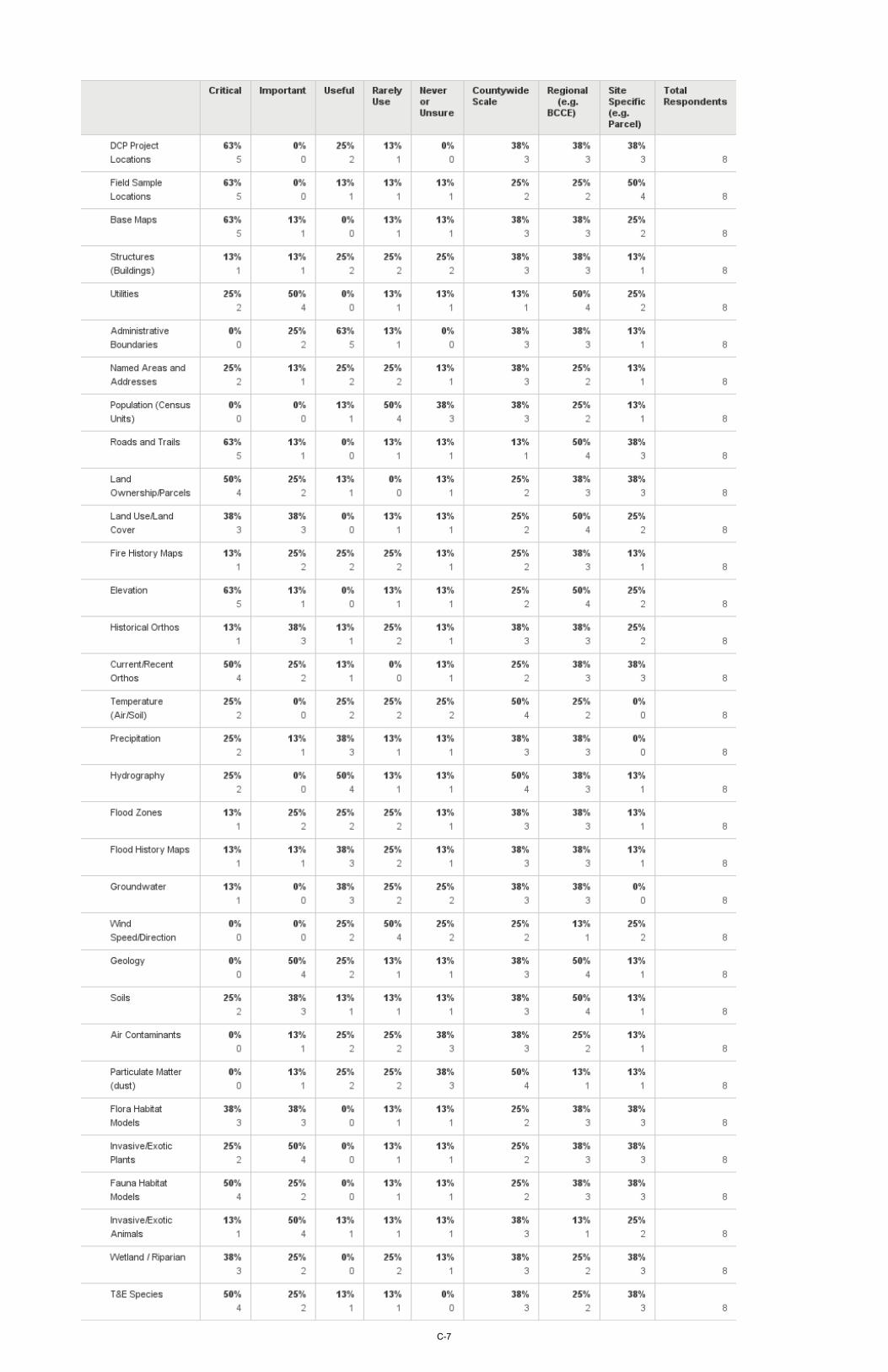
Q7: Characterize the importance of your current or anticipated use of geospatial data and scale. This question provided a list of 32 types of typical geospatial data themes that were categorized in terms of importance for the respondent’s DCP activities. These were identified by the respondents as either Critical, Important, Useful, Rarely Use, Never or Unsure. For each theme, the most common scale of use was also identified as Countywide, Regional, or Site Specific.
Three basic themes were identified by all respondents as always having some level of usage for their tasks. These themes were DCP Project Locations, Administrative Boundaries, and Threatened and Endangered (T&E) Species. The lists below identify different rankings and groups of the top rankings, with data types that might be considered most uniquely and directly tied to the MSHCP noted in bold blue.
CRITICAL THEMES 5 Responses (63%) DCP Project Locations Field Sample Locations Roads and Trails Base Maps Elevation
4 Responses (50%) Fauna Habitat Models T&E Species Land Ownership Current/Recent Orthos Utilities
3 Responses (38%) Land Use/Land Cover Flora Habitat Models Wetland/Riparian
CRITICAL OR IMPORTANT 6 Responses (75%) Roads and Trails Land Use/Land Cover Fauna Habitat Models Flora Habitat Models Invasive/Exotic Plants T&E Species Base Maps Utilities Land Ownership Elevation Current/Recent Orthos
CRITICAL, IMPORTANT, OR USEFUL 7 Responses (88%) DCP Project Locations T&E Species Administrative Boundaries Land Ownership Current/Recent Orthos
6 Responses (75%) Field Sample Locations Roads and Trails Land Use/Land Cover Fauna Habitat Models Invasive/Exotic Animals Flora Habitat Models Invasive/Exotic Plant Base Maps Utilities Elevation Precipitation Hydrography Geology Soils
D03-Project 2011-TSG-901C February 2016
3-6
All of the themes listed in the survey received responses indicating some level of existing or expected use. A detailed review of the full set of responses and these rankings can be used to assist the prioritization of ongoing maintenance and refinement of existing themes. It would also assist the prioritization for potential development of additional themes to meet anticipated needs for future applications (examples are noted later in responses to Q9). Several of these themes, such as Wetland/Riparian, Land Use/Land Cover, Roads and Trails, and T&E Species, have major involvement if not lead responsibility assigned to other organizations. DCP already cooperates with some of these other organizations for joint development, data transfers and/or web-based map services. Further development of these cooperative arrangements as part of a DCP Geospatial Data Management Plan is recommended.
The responses for the most applicable scale for each of the data themes showed little significant pattern. All of the data types were considered appropriate for DCP applications at both County-wide and Regional scale use, with all but three themes (Temperature, Precipitation, and Groundwater) also considered applicable to site specific use. Q8: Most important or most common geospatial information products that you currently use. Responses to this question were diverse and appeared focused upon each individual’s project related activities; no distinct patterns were readily apparent. Three of the respondents mentioned their general resource data collection activities and two of these specified data analyses for inventory or identification of patterns in the geospatial data. Q9: Describe geospatial information products that you would like to have available. This question also resulted in a wide range of responses, some of which were specific to individual project management responsibilities. These included:
• An application or tools to assist tracking of grading permits, as an example of products that would help streamline and/or automate the mitigation fee process and calculation of impacts.
• Web-based mapping application that would allow ready identification of species potentially impacted by development or conservation projects.
• Maps of Reserve project features such as signs, roads and their status, barriers, desert tortoise guards, informational kiosks, et cetera.
• More broadly, additional geospatial database development for the MSHCP program was desirable, along with better data access and distribution methods for both maps and data.
• Providing more public access to maps and data was also noted at both a general level and the application specific examples noted above.
It is recommended for the development of any geospatial information product noted above that required inputs, processing steps, and overall work flows be defined. Definition of “use cases” can help ensure that the final product meets expectations and provides the benefits that the requestors anticipate.
D03-Project 2011-TSG-901C February 2016
3-7
Q10: Workflow or process issues you consider to be most significant impediments.
The following provides a rank ordering by importance of the seven potential workflow impediment issues included in the survey:
• Training on Use of GIS Analysis Tools was considered the most critical issue for the organization(3 of 8 responses as critical, 2 additional as important).
• Identifying Suitable DCP Data Sets was also very highly ranked (3 critical, 1 important).
• Simplified Access to GIS Data and Analysis Tools ranked third (1 critical, 4 important, 1 minor).
• Availability of Good Metadata ranked next (1 critical, 4 important).
• Identifying Outside Organization Data was a somewhat lower concern (1 critical, 3 important).
• Availability of More Advanced Analytical Tools was fairly similar (5 important).
• Identifying Other County Data was lowest ranked (1 critical, 1 important, 2 minor concern).
3.5 Information Products
DCP activities involve a wide range of geospatial information products. The process for systematic development of geospatial information products is often best addressed by beginning with descriptions of the end products. For example, is it a specific map, chart, list, et cetera? How frequently is it needed? What accuracy levels are required or desired? Then, what types of input data are needed? What are the work flows and processing steps necessary to generate the final products? Standardizing this process to some degree can improve operational efficiencies. This would involve the use of information product description forms that fully describe each product and address the types of questions noted above. The effort required to develop a comprehensive set of these descriptions can be substantial and was beyond the scope of this review.
For each of the DCP activities, an inventory of information products should be developed. This inventory should include both the existing products that have been routinely or periodically prepared, as well as proposed products that will enhance or provide a new capability for the DCP. This initial inventory of information products should be a list of descriptive titles, organized by DCP activity. It may be useful to consider developing categories of products into functional groups, such as: map, web-site map, web-map, schematic, tabular data, report, report map, report table, chart, imagery, 3-D visualization, data, map-service or web-application. The status of the information product is useful during the initial prioritization. Table 1 below provides an example format for compiling the initial inventory.
D03-Project 2011-TSG-901C February 2016
3-8
Table 1. Example of Potential Information Product Inventory List.
DCP Activity(s)
Information Product Number and Title / (Requestor)
Category Status
Admin #1 – MSHCP Projects Map (Henson) Interactive Web Map
Existing
Tortoise Fencing
#2 – Clark County roads with Tortoise Fencing (Brekke) Static Web-Site Map
Existing
BCCE #3 – BCCE Management Plan - BCCE Detail Map (Henson) Report Map Existing BCCE #4 – BCCE Management Plan - BCCE Land Ownership (Bice) Report Map Existing
AMP #5 – Annual Adaptive Management Report – Acres/ Type of Habitat loss within Clark County (Cambrin)
Report Table Existing
Public Info #6 – Map display of species potentially impacted by a development or conservation project (Jenkins)
Interactive Web Map
Proposed
Following the development of a full list, the list should be prioritized for further review and expansion of details for those items considered most suitable for additional development. The example below shows a brief follow-up description for a potential product.
Table 2. Example of Potential Information Product Description.
DCP Activity(s)
Information Product Number and Title / (Requestor)
Category Status
Public Info #6 – Map display of species potentially impacted by a development or conservation project (Jenkins)
Interactive Web Map
Proposed
General Description: Interactive web map allowing user to define a development or project location (point or polygon) using current aerial imagery or topographic map base. Query results provide a list of species whose habitat is potentially affected and recommended mitigation actions.
Data Needed: Base imagery and topographic map. Habitat models for MSHCP covered species and possibly others of potential concern.
Processing Steps: Development of custom GIS map service viewer with basic drawing and measurement tools. Development of geoprocessing tool to overlay defined area over habitat models (possibly collapsed to a single composite layer) and display list of intersecting species; also specifically recommended mitigation actions.
Frequency: Estimated usage by public is difficult to estimate; anticipated usage is less than current parcel specific Open Web application, which could be used to develop upper limit on estimate.
Costs: Labor - Existing data collection and preparation: 1 week; Map service development, testing, and documentation: 6 to 8 weeks. Computer Services – additional costs to be determined upon further review.
Benefits: Ready access to potentially impacted species could provide greater transparency to MSHCP activities and identify possible mitigation actions in early planning stages where alternatives can be more readily incorporated. It may also encourage development in areas of less significance for habitat disturbances.
Further development of these topics would be appropriate for any products prioritized for potential development. Additional details in all of the above areas would be appropriate for a final cost and benefit analysis.
D03-Project 2011-TSG-901C February 2016
3-9
3.6 Additional Observations and Path Forward
Several general observations regarding options for implementing specific database themes and standard operating procedures were developed during this project. Some of these topics should be further addressed in detail during subsequent planning steps (Tomlinson steps 5 through 9). An internal review of this initial needs assessment by DCP staff is also recommended. Any follow-on implementation activities would require detailed information product specifications. This would require a substantial amount of time and effort by DCP staff and management. Two related DCP database activities directly related to the MSHCP were noted during this assessment:
• MSHCP Implementation Database• Species Status Database
Given the significance of their content to the MSHCP, both of these appear to warrant further review from a geospatial perspective. A primary objective of this review would be to assess their potential for either full integration, or minimally linkages to a more comprehensive GIS database.
Following an internal review of this assessment, the following summarizes the additional planning activities that DCP should consider for further development of the DCP geospatial data program. The detailed nature of these activities would necessitate major involvement of DCP staff.
Inventory: Conduct a more detailed inventory with brief descriptions of existing and proposed geospatial information products, including maps, tables, lists, and other derived products.
Prioritize: Develop an initial set of priorities that meet near-term project and long-term programmatic needs that support the MSHCP.
Descriptions: Provide more detailed descriptions for selected items, including data inputs, functional processes, outputs, accuracy, frequency, and similar criteria discussed earlier.
Database Design: Review database design requirements and options; select an appropriate data model that can be used to generate the selected information products.
System Requirements: Confirm that requirements can be met by existing or proposed system configuration.
Review Options: Review basic benefits and costs of development of system options.
Implementation: Prepare an implementation plan and initiate data and application development.
As an alternative to this this basic “waterfall” sequence of development, the selection of one or two priority projects could be used for a more rapid development cycle. This can provide some useful process experience for the organization, but may require some rework for future modifications.
D03-Project 2011-TSG-901C February 2016
4-1
4.0 SUMMARY
An assessment of existing and some proposed geospatial data needs has been conducted for the DCP. As part of this assessment, geospatial software and data sets used by DCP were examined and a survey of user needs was undertaken. A document providing project recommendations for geospatial data management guidelines applicable to DCP activities was also developed.
Five groups of recommendations were developed around the following topical themes: 1. Clark County MSHCP Geospatial Data Management Plan2. DCP Geospatial Database Development3. DCP Geospatial Database Accessibility4. Web Map Applications5. GIS Training
The following recommendations are considered the primary areas where DCP may most effectively move forward with their geospatial data program:
• Clark County MSHCP Geospatial Data Management PlanDCP should consider developing a programmatic MSHCP plan based on a full life cycle approachto geospatial data management. The large number of organizations involved with MSHCP datamakes this a difficult task, but it also increases the need for one. The plan should systematicallyaddress the key types of geospatial data used by participants and identify in detail the standardinformational products that are required by DCP. Standard information products for bothprogrammatic and project specific needs should be defined in enough detail for prioritization,development, and implementation, which should include web-based access options. Aligninggeospatial database development with MSHCP needs for science quality data to supportresearch, inventory, monitoring, and especially long-term trend analyses is recommended.
• DCP Geospatial Database DevelopmentSurvey respondents noted that additional GIS database development would benefit several DCPactivities. Priorities for additional development and periodic updates of specific data themesshould be identified, preferably in a plan, as discussed above. DCP should review the potentialbenefits of integrating or minimally linking the existing MSHCP Implementation Database andthe Species Status Database into a more comprehensive database design addressing MSHCPneeds. Opportunities for further sharing of geospatial resources with other organizations shouldalso be routinely pursued, including the sharing of web-based map services.
• DCP Geospatial Database AccessibilityThe implementation of simple data discovery tools for both internal and selected public views ofDCP geospatial data is recommended. The use and documentation of standardized directorystructures and file naming conventions can facilitate this, if made readily available, as can moreadvanced tools that can search geospatial metadata clearinghouses. Resources including theexisting DCP web site, GISMO map server, and cloud based web map applications, can also
D03-Project 2011-TSG-901C February 2016
4-2
provide simplified data access and viewing options that should be considered for both data sources and product development.
• Web Map Applications Custom web-based map applications can provide advanced functionality for both internal and public facing views of MSHCP data. Providing more public access to maps and geospatial data was identified as a major programmatic need for DCP. The BCCE application developed using the GISMO map server and ArcGIS Online provide simple examples. Development of more advanced applications should undergo a standard requirements review and system design to ensure that appropriate datasets and functionality are available. A pilot project involving a range of functional requirements (e.g., data entry, geoprocessing, reporting, etc.) is recommended. This would allow the DCP organization to gain experience with the technical issues involved and develop a standardized set of procedures for additional applications.
• GIS Training Additional training on GIS analysis software was top-ranked as a priority need by a majority of the DCP personnel surveyed. Geospatial data and analyses have a significant role in DCP programmatic and project activities. Opportunities for training should be pursued and actively promoted. Noteworthy are expanding options for online training. Periodic attendance at the GIS Community and User Conferences by key GIS staff is also recommended. Additional training is needed for building capacity for a more data driven culture. This requires embedding a stronger geospatial skill set throughout the organization.
Some potential next steps for the path forward were noted in the previous section. As a final note, obtaining programmatic support from higher levels of the County’s DCP management structure is considered important to long-term programmatic success. Major progress will require a substantial amount of DCP personnel time and effort to define in detail the content and processing steps required to develop the specific information products needed to support their activities. It is important that everyone involved understands both the commitment required, as well as the potential benefits of a stronger geospatial program.
D03-Project 2011-TSG-901C February 2016
5-1
5.0 REFERENCES
Clark County, 2000. Final Clark County Multiple Species Habitat Conservation Plan and Environmental
Impact Statement for Issuance of a Permit to Allow Incidental Take of 79 Species in Clark County, Nevada. June, 2000.
DCP, 2012. Desert Conservation Program Data Management Guidelines. Version 2.0. November, 2012.
6 pages. Implementing Agreement, 2000. Implementing Agreement, Clark County Multiple Species Habitat
Conservation Plan. November, 2000. 60 pages. Memorandum of Agreement, 2002. MOA Regarding Adaptive Management and Implementation of the
Clark County Multiple Species Habitat Conservation Plan. December 12, 2002. 27 pages. MSHCP Community Advisory Committee, 2010. Final Report: Guiding Principles and Recommendations
from the Committee for the Amendment of the Clark County MSHCP. October 2010. 128 pages. Sutter, R., Bice, L., Mata, L., Peters, M., and Barnett, A., 2012. Desert Tortoise occupancy covariate
monitoring protocol. Version 1.0. Unpublished Report to Clark County Desert Conservation Program, Project Number 2009-ECO-801A, Las Vegas, Nevada. 82 pages.
Tomlinson, R.F., 2013. Thinking about GIS: Geographic Information System Planning for Managers. 5th
edition, Esri Press. 275 pages. U.S. Fish and Wildlife Service, 2001. Clark County Desert Conservation Plan Permit PRT 801045. January,
2001 U.S. Fish and Wildlife Service, 2000. Intra-Service Biological and Conference Opinion on Issuance of an
Incidental Take Permit to Clark County, Nevada for a Multiple Species Habitat Conservation Plan. File No. 1-5-00-FW-575, November 19, 2000. 237 pages.
D03-Project 2011-TSG-901C February 2016
APPENDIX A – GEOSPATIAL DATA MANAGEMENT GUIDELINES
D02-Project 2011-TSG-901C 8 January 2016
A-1
Desert Conservation Program Recommended Geospatial Data Management Guidelines
Introduction The purpose of this document is to provide general guidelines for geospatial data management activities conducted by DCP staff. Geospatial data is a critical resource supporting DCP project activities and decision-making. The information products that are required for planning, research, and permit-related activities determine the data resources that should be available for effective program operations. The volume of data that may need to be sorted through is growing exponentially, so how these data resources are developed, organized, and maintained is important to the program’s long-term success. Most of the science-related project activities supporting the Clark County Multiple Species Habitat Conservation Plan (MSHCP) involve the collection or analysis of geospatial data. Common examples include the recording of map coordinates for sample locations, mapping of vegetation types or conditions, and developing species habitat models. The long-term nature of many MSHCP activities requires special attention to a long-term lifecycle approach to geospatial data management.
Figure 1 provides a conceptual lifecycle for DCP geospatial data development and use. Also shown are cross-cutting elements (i.e., data description, data quality, and data backup and securing) that should be performed across all stages of the lifecycle to ensure that the data are discoverable, well described, and preserved for both short-term and long-term access and use.
Figure 1. A Conceptual Lifecycle Model for DCP Geospatial Data1.
MSHCP projects that provide conservation benefits (implementation projects) should be demonstrated to be effective, and be documented well enough to support assessment. Projects that provide information to determine the effectiveness of implementation projects or to provide information on species or ecosystem status (information gathering projects) must be documented well enough so that the procedures used can be repeated and the information produced can be used or combined with other datasets to perform the analyses that assess progress toward MSHCP objectives.
DCP has implemented a basic set of Data Management Guidelines applicable to MSHCP project data. As specified in the Guidelines, a Data Management Plan should be initiated in the overall project planning phase. It should also be updated, as appropriate, throughout the data management lifecycle. Plans
1 Modified from USGS Open-File Report 2013-1265 (Figure 1) USGS Science Data Lifecycle Model to better match a typical Desert Conservation Program project sequence.
D02-Project 2011-TSG-901C 8 January 2016
A-2
should be developed for all data production projects, however, the level of detail may vary depending upon the, scope complexity and importance of the project.
The existing Data Management Guidelines are oriented towards supporting contractors. They are also applicable to activities undertaken by DCP staff. This document builds upon the existing Guidelines with the inclusion of additional elements that are specific to DCP staff activities and responsibilities. The development of a tiered or graded approach for data management plans is recommended. The appropriate tier or grade level should be dependent upon the scope, complexity, and importance of the geospatial data involved.
Project Phase Elements
The following sections review specific data management elements using the conceptual lifecycle model presented in Figure 1. For a typical data work flow, the output of each element provides input to the next phase element. There are also cross-cutting elements applicable to all phases of the data lifecycle; these are described after the sequential project phase elements are reviewed.
Plan Projects undertaken under contract to DCP are required to follow the Data Management Guidelines (Version 2.0, dated November 2012). Development and use of a checklist to review compliance with the guidelines is recommended. Appendix A provides an example review checklist of data management planning considerations.
Projects undertaken by DCP staff should include Data Management Plans that describe the project and the methods that will be used to manage any MSHCP project data. An overall description of the project should be developed that briefly describes the project in executive summary style. This should include the MSHCP project number, any contract title(s) and number(s), and all funding sources. Also include the following:
Project Location: Describe the project location using UTM2 (Zone 11), NAD833 meter coordinates representing the outline of your project area. These coordinates need not be exact, but they should represent the project area(s) and not outlines of the county, state, or Mojave Desert. This will facilitate automated geospatial data discovery.
Goals and or Objectives: Describe the project’s purpose and include any goal or objective statements related to the geospatial data that have been proposed for the project.
Roles and Responsibilities: Document the names of all data collection staff, data processing staff, and data management staff. Describe the role and responsibilities of each staff person regarding data collection, quality control, quality assurance, processing, analysis, and management.
DCP Data Management Plans should detail how the geospatial data will be stored during each phase of the data lifecycle. The appropriate DCP policies should be considered, especially in terms of any interim
2 UTM: Universal Transverse Mercator coordinate system. 3 NAD83: North American Datum 1983.
D02-Project 2011-TSG-901C 8 January 2016
A-3
or time limited storage. In general, final DCP project data is expected to be maintained for at least the lifetime of the MSHCP, if not indefinitely.
A draft plan should be subject to either external review or another DCP staff member prior to finalizing.
Acquire Data acquisition can involve either existing or new data collection activities. Proper data descriptions (see Descriptions in the Cross-Cutting Elements section later) are critical to the appropriate use of both existing and any new data acquisitions.
Existing Data
Internet-based data discovery tools have significantly improved for identifying potential geospatial datasets that can be reused for multiple purposes. Noteworthy are the foundational datasets developed by federal geospatial data programs (FGDC National Geospatial Data Asset Management Plan, March 2014) and numerous geo-community provided datasets that can be accessed as web services via vendor applications, such as ArcGIS Online. A Data Management Plan should list existing data that will be used in the project, including appropriate citations and metadata files that specify the source details, especially the data source dates. For example, existing data may include spatial data representing stream reaches from the U.S. Geological Survey (USGS) National Hydrography Dataset (NHD) or soils data from the Natural Resources Conservation Service (NRCS) Soil Survey Geographic (SSURGO) database.
New Data
The data collection methods planned for any new geospatial data acquisitions should be described in the Data Management Plan. Methods: Within the body of the project report, provide a review of the final methods used for collecting geospatial data4. Cite literature references for standard data collection methods where appropriate, noting any deviations from those standard methods. This report should document any changes in data collection and software tools made throughout the project term. Note also the storage location and fate of any samples collected and where voucher specimens have been deposited. A description of the methods used is a required component of the final data deliverable and should be referenced in the metadata.
Spatial Data: Spatial data should be collected with Global Positioning System (GPS5) receivers whenever possible. Resource or mapping grade GPS units are recommended, although recreational grade units can be used for data with lower accuracy requirements, such as wildlife siting locations or generalized habitat maps.
The make and model of each GPS unit used for the project, and record the error for each location or feature collected should be documented. Error should be recorded as Probability Dilution of Precision (PDOP) on mapping grade units and Estimated Positional Error (EPE) on recreational grade units. If your
4 Provide in either Microsoft Word (.docx) or Adobe Acrobat Portable Document Format (.pdf). 5 GPS is the original United States System designation; as other systems have since been developed (e.g., GLONASS, BeiDou, and Galileo) a broader name for this type of system has been developed. This broader designation is Global Navigation Satellite System or GNSS.
D02-Project 2011-TSG-901C 8 January 2016
A-4
GPS data is corrected using any type of satellite-based or ground-based augmentation system, a record the type of correction used (e.g. WAAS6, post-processing, or beacon) should be documented.
Point locations or features should be recorded by averaging positions to increase accuracy. For example, when collecting locations for high accuracy features, such as section corners, a minimum of 180 positions should be averaged at 1 position per second. A minimum of 30 positions should be averaged for all other features. Positions for lines and polygons should typically be collected at a rate of 1 position per second or at a minimum of 10-foot intervals.
When using mapping grade GPS units, a data dictionary should be used on the unit to provide consistency in data collection and reduce data collection errors (see Data Dictionary below). Available GPS metadata should be collected, inspected, and rejected if data do not meet specified requirements.
Aspatial Data: Data that are not spatially linked are also gathered by MSHCP projects. These are often tabular, but may also include voucher specimens, photographs or samples of soil, etc. Examples of aspatial tabular data include data collected in laboratories for research projects, data regarding individual observer's error rates to calibrate monitoring project results, data regarding the results of an educational outreach effort, and data regarding seed fates are all examples of data that may not include spatial location attributes. The associated collection of point or linear locational coordinates with otherwise aspatial data can greatly enhance the multiple uses of the data and is recommended.
Data Dictionary: A data dictionary defines the fields and domains in a database, spatial data file, or GPS data collection file. Data dictionaries may already be prescribed and provided by DCP, or project participants may be required to create their own. Information from the data dictionary will be entered into the Entity Attribute section of the metadata for each dataset. Data dictionaries are generally only available for mapping grade GPS units, so this may be a selection criterion depending on the type of system to be used. See Appendix A for an example of a data dictionary.
Source List: Use of a unique data source identifier (source key) is recommended to document the original source and dates of all data acquisitions. This can be especially important for external data acquisitions, which may periodically update a dataset being used. A simple text list or spreadsheet can be used to maintain pertinent source data details.
Process The preparation of existing or new geospatial data for analysis, often termed either pre-processing or processing, may entail: definition of data elements; integration of disparate datasets; Extraction, Transformation, and Load operations (ETL); and application of calibrations to prepare the data for subsequent analyses. Appropriate work flow processing descriptions should be planned and developed. The outputs of processing become the inputs that are suitable for subsequent analyses.
Recent advances have been made in software tools supporting the creation and management of complex scientific workflows7. Work flow models and identification of associated datasets can help to ensure the ability to replicate data processing and analyses. The repeatability of data processing and analyses is a recognized goal of the MSHCP program. The formats of the work flow processing descriptions vary with
6 WAAS: The Wide Area Augmentation System, operated by the United States Federal Aviation Administration. 7 DataONE Best Practices Primer, page 7, from www.dataone.org, accessed November, 2015.
D02-Project 2011-TSG-901C 8 January 2016
A-5
the specific disciplines and methods of data acquisitions involved. These range from good field notes to detailed processing logs and geospatial data models.
Analyze Analyses involve the activities associated with the exploration and interpretation of processed data. At this stage of the data lifecycle, hypotheses are tested, patterns are revealed, and conclusions may be made. Typical geospatial outputs from this stage are map layers with associated geospatial statistics. These are often documented in subsequent project reports and other document products. As noted above, detailed documentation of the analysis steps involved should be developed to allow the workflow to be replicated by others.
Products Geospatial data may be developed in various formats, including some intermediate products that may warrant delivery with other final products. Developmental guidelines for different formats include the following:
Paper Datasheets: If paper data forms are used during the project, provide digital copies. Digital copies may be provided in Adobe Acrobat (.pdf) format digitally scanned at 300 dpi or greater resolution. Document all scanning settings in the Data Management Plan.
Photos, Sound, and Video Recordings: Describe basic settings used on the camera or other recording device and the file format(s) used for short term and archival storage.
Spatial Data: Spatial data should be stored electronically in a spatial data file format (e.g., Esri shapefile or geodatabase) or as coordinates in a relational database. The accuracy of the collected data will be reported in the metadata. A graded approach for metadata requirements can be used, based on the scope, complexity, and importance of the data being described. If spatial datasets include related tables (e.g., Access .mdb with associated .tbl tables), document all table relationships between tables and spatial data. For all attribute data associated with spatial coordinates, see the Tabular Data section below.
Tabular Data: Tabular data should be stored in electronic format in a relational database or spreadsheet. Use of a database is preferred and allows for data validation as data is entered into the database and for exploratory data analysis (see Data Accuracy and Quality section below).
If multiple related tabular datasets are delivered, provide key fields and describe all linkages of fields in relational tables in the data dictionary and metadata files. Pay particular attention to the use of zero (0) versus <null> values in tabular datasets; zeroes can be interpreted as either no data or zero value. In the data dictionary and metadata sections provide your definition of the use of zero (0) and <null> values in the tabular data. Do not deliver tabular datasets with embedded password protection.
Review Procedures: DCP staff review of geospatial data submitted by contractors could benefit by the development of standard checklists of review criteria. Software tools, such as Esri’s Data Reviewer8 may also facilitate the review process.
8 Data Reviewer consists of a series of tools that support both automated and visual analysis of data. It can be used to automatically scan and identify common geospatial data problems such as topological errors and duplicate records.
D02-Project 2011-TSG-901C 8 January 2016
A-6
Product Identifiers: For products developed by DCP staff, a unique product identifier would be useful, as would maintenance of an online product log and workspace area where copies could be made available.
Product Templates: The development and maintenance of a set of map templates is considered a best practice to standardize the content, sourcing, and DCP brand appearance of map products.
Access Data Sharing: Any project geospatial data that has potential general use should be considered for sharing. Both internal and external data sharing criteria should be defined. Internal sharing can involve a central GIS database location or a project specific directory area that has been identified to potential users. Both internal and external sharing can potentially involve the use of web services for making the geospatial data available. Appropriate tags and standard metadata are generally required for sharing.
Responding to public records request forms comprise a special category of data sharing.
Data Restrictions: Document any portion of the data that are “confidential” or copyrighted as defined by law, regulation, or policy. All other data will be subject to disclosure upon request as per Nevada Public Records Law.
Archive Data Storage: Describe long term data storage requirements and any repositories or archives where data will be deposited for permanent storage.
Cross-Cutting Elements
Each of the primary data lifecycle elements discussed earlier address discrete inputs, activities, and outputs that are unique to that stage. As shown in Figure 1, however, there are also critical cross-cutting activities that must be performed across all stages of the lifecycle to support effective geospatial data management. The three cross-cutting elements noted are described below.
Descriptions (Metadata, Documentation) Metadata: All datasets must include or have associated metadata documentation. The metadata for all project data will describe in detail the data that will be collected and the methods that will be used for collection, field crew training or certification, and equipment calibration. Spatial data and databases must be documented with Federal Geographic Data Committee (FGDC) Content Standard for Digital Geospatial Metadata (CSDGM), version 2.0, FGCC-001-1998 compliant metadata9.
9 Since ISO 19115 and the associated standards have been endorsed by the FGDC, federal agencies have been encouraged to transition to ISO metadata. It is recognized that the transition to ISO metadata may require several years of transition.
D02-Project 2011-TSG-901C 8 January 2016
A-7
Metadata contains information such as: who created the data, data accuracy, what the data are useful for, and how to read the data. Computer programs such as ArcCatalog or other applicable software programs10 can create Esri-compatible metadata for spatial data sets.
Tabular data should include much of the same metadata information required for spatial data. Metadata for voucher specimens, photos, or other samples should include descriptions such as the rules for selection of the sample, camera settings, care during transportation, and the ultimate fate of samples, such as deposit in a repository or a herbarium. Whichever program is used to document metadata, all metadata should be exported in .xml or .txt format for submission with final data deliverables.
Metadata should also include information about access or copyright restrictions (e.g., any proprietary, confidential, private, or copyright limits for redistribution).
Version Control and File Names: Describe a standard digital file naming protocol and a version numbering system for datasets to assist in identifying the various data files during the project and at completion.
Data Quality (QA/QC) This section of the Data Management Plan describes the processes to be used in ensuring the accuracy and quality of the project data, commonly referred to as Quality Assurance and Quality Control (QA/QC). Detail the specific QA/QC procedures to be used for the project. The EPA’s Quality System website (http://www.epa.gov/quality/index.html) can be useful for example guidance on developing quality standards for projects.
At a minimum, QA/QC procedures for your project must address:
• Methods to ensure that field data forms and tables are complete. Standardization of data collectionprocedures may include development and use of data dictionaries, including those for databases andmapping-grade GPS units that require data be entered in all fields before the form can be closed.
• Standardization of data management including development and use of a spatial data files andelectronic databases with data validation procedures.
• Methods for post-collection data verification using display of spatial data to detect location errors,detection of outliers or biologically-nonsensical values for tabular data, statistical reports and graphs,or other procedures.
Backup and Secure Data Storage: Describe short term storage and backup cycles. The County will maintain a copy of the data deliverables according to County Records Management Policies, which may be time limited.
10 The EPA Metadata Editor (EME) is a simple geospatial metadata editor that allows users to create and edit records that meet the Federal Geographic Data Committee (FGDC) Content Standard for Digital Geospatial Metadata (CSDGM) requirements. EME is installed as an extension to Esri’s ArcCatalog.
Appendix A. Data Management Planning Considerations - Review Checklist
A-8
Plan Life Cycle ElementsDoes a formal Data Management Plan need to be developed for this project?Who is responsible for managing the data and the data management plan?Who will review the data management plan?What is the project type (e.g., Information Gathering or Implementation Project)?What is the project location? (boundary using UTM Zone 11 NAD83 meters coordinates)What are the project's goals and/or objectives related to geospatial data?What data are you collecting?What are the data accuracy requirements?Does the data already exist?Have you checked for other possible sources for your data needs? Where will the data and data management plan be stored?What are the roles and responsibilities of DCP staff related to data collection, data QA/QC, processing, and analysis?Who is responsible for creating/updating the metadata?What is the schedule and budget for data collection?
For new spatial data:How will data be collected? (Electronically or on paper? In-house or by contractor?)For data collected using GPS, will the make and model of each GPS unit used for the project be documented with the data? For GPS data, has the error been recorded with the data (e.g., PDOP or EPE)?For GPS data, will any type of correction be used and recorded (e.g., WAAS, post-processing, or beacon)?For GPS data, has the number of logged positions at a point feature been recorded with the data?Will a data dictionary be used to ensure data collection consistency and to reduce data collection errors?Are there any data standards for this data type? Have they been used on this project?How have the final methods used for collecting the project's geospatial data been documented?
For existing spatial data:If you are obtaining data from an outside source, will you be able to store a local copy of the data?If you are accessing someone else’s data, did you document the steps you used in order to obtain the data?If the outside source data is being updated, will you be notified or will you have to manually check?What will you do if the outside data source is no longer available in the future? Have all sources of data, both spatial and aspatial, been assigned a source ID and stored with the project?
What naming conventions are being used for files? What about table columns and rows?Have the software applications used for processing the data been identified (e.g., software application, version, functions)?How have the methods used for processing the project's geospatial data been documented?Have any data problems been identified during the processing that may limit the use of the data for this project? Have these limitations been documented in the metatadata or a report?
AnalyzeHave software applications used for analyzing the data been identified (e.g., software application, version, functions)?Have any data problems been identified during the analyses? Are these documented in metadata or a report?Are the processing and analysis steps adequately documented to allow for potential replication of the work involved?
ProductsWhat kinds of outputs will be needed? (e.g., Electronic or paper? Alphanumeric or spatial?)Who will use the data and what are all the most likely uses for the data? Will it be available to the public?If applicable, have all paper data forms been scanned at 300 dpi or greater and stored with the project data records?Have all photos, Audio and Video Recordings been stored with the project data records?Have all spatial data been stored in a spatial data file format (e.g., Esri geodatabase or shapefile)? Have all tabular data been stored in a relational database or spreadsheet? Has a data dictionary been developed to describe the fields and linkages of data fields?Have product identifiers been assigned to each developed product? Was the product independently reviewed?
Process
Acquire
Data Management Planning Considerations - Review Checklist
A-9
AccessAre there any specific requirements for sharing or storing the data?How do these requirements impact the needs to store, access, and protect the data?Are there any security or sensitivity issues that might limit access or preclude you from sharing the data?Are there any restrictions on sharing data that you have acquired from other sources?When publishing a report, will the data be published as well? If so, which data will be included?Is there a deadline or schedule for sharing your data?Does your project have a specific repository for your data?Are there any policies or plans regarding where you should post your data?
How will non-digital data be preserved, such as field notebooks and maps?Is someone responsible for migrating data sets that are in old/outdated formats?If files are being migrated or converted, is someone performing a check on both files (original and converted files)?
Cross-Cutting Elements
What format will be used to collect the data?Are there any data standards for this data type?What specific file types will be used to store the data?Will you be using a standard file naming format and version control?What formats will the data and metadata be in?What metadata standard will be used?How will the metadata be reviewed to ensure that it is adequate and correct?Have you captured the workflow (data inputs, transformations, and analytical steps to achieve the final data output)?Will a different format be used to share or publish the data?
Data Quality (QA/QC)How will the data be checked and certified? In-house or by contractor? Will in-house review be done by an individual other than the person collecting the data?Is QA/QC occurring throughout the data lifecycle?Are the QA/QC steps being documented?Is data that is transcribed or copied checked for errors against the original data set?Have you reviewed the data, such as selecting a random sample, looking for outliers, graphing and plotting the data?
Backup and SecureHow is the data being stored and backed up?Who is handling the backups?If your data is being stored elsewhere, do they have a backup policy in place?Are the data and backups being stored in multiple places to protect against a single-point failure?Is someone checking to ensure that backups are being done properly and data can be retrieved?Does more than one person know where the data are being stored and how to access them?How long will backups be kept?
Modified for DCP use from: http://www.usgs.gov/datamanagement/plan/dmplans.php (December 2015)
Descriptions (Metadata, Documentation)
Archive
A-10
Appendix B Data Dictionary
The following is a basic example of a data dictionary used for inventorying roads:
Field Domain Field Description Field Type
Name 255 characters of text Official name of road Text
Number 0..n Official road number Number/Integer
Maintenance Responsibility County Agency or individual responsible Text NPS for maintaining the road BLM USFS USFWS Private Other
Maintenance Frequency Annually Frequency with which road is Text Semi-annually maintained Monthly As needed Not maintained
Width 0.00..N.nn Width of road in meters Number/Float
Length 0.00..N.nn Length of road in meters Number/Float
Surface Type Paved Surface condition of road Text Gravel Dirt 4x4 Other
Class of Use Motorized Class of road use Text Equestrian Hiking Other
D03-Project 2011-TSG-901C February 2016
APPENDIX B – DESERT CONSERVATION PROGRAM ORGANIZATION CHART
D03-Project 2011-TSG-901C February 2016
B-1
D03-Project 2011-TSG-901C February 2016
APPENDIX C - SURVEY RESULTS
38% 3
13% 1
25% 2
13% 1
13% 1
Q2 DCP or Similar EnvironmentalProgram/Project Experience
Answered: 8 Skipped: 0
Total 8
# Other (please specify nature of Similar Environmental Program/Project Experience) Date
1 ~ 5 years experience: endangered species surveys; vegetation monitoring; habitat assessments 10/1/2015 4:01 PM
10 years ormore
>5 to 10years
>1 to 5 years Less than 1year
Other(specifysimilarexperience)
0%
20%
40%
60%
80%
100%
38%
13%
25%
13% 13%
Answer Choices Responses
10 years or more
>5 to 10 years
>1 to 5 years
Less than 1 year
Other (specify similar experience)
C-1
Q3 Organizational Role(s) - Multiplesecondary roles are possible. Provide atleast one response for each type of roles
listed (rows).Answered: 8 Skipped: 0
13%1
13%1
75%6
0%0 8 2.63
25%2
75%6
0%0
0%0 8 1.75
13%1
50%4
38%3
0%0 8 2.25
13%1
38%3
38%3
13%1 8 2.50
# Other (please specify and characterize as Primary or Secondary) Date
2 I am in charge of the Adaptive Management Process as my primary resposnibility 9/28/2015 12:37 PM
Primary Secondary Not Applicable Unsure
ProgramManagement orAdministrative
ProjectManagement
EnvironmentalSpecialist
GeospatialAnalyst
0%
20%
40%
60%
80%
100%
13%
25%
13% 13%13%
75%
50%
38%
75%
38% 38%
13%
Primary Secondary Not Applicable Unsure Total Weighted Average
Program Management or Administrative
Project Management
Environmental Specialist
Geospatial Analyst
C-2
Q4 What geospatial software have youused? Also, of any you are familiar with,
which do you prefer?Answered: 8 Skipped: 0
50%4
13%1
25%2
13%1
0%0
25%2 8
63%5
0%0
13%1
25%2
0%0
25%2 8
0%0
0%0
13%1
75%6
13%1
0%0 8
88%7
0%0
13%1
0%0
0%0
13%1 8
50%4
38%3
13%1
0%0
0%0
25%2 8
0%0
0%0
29%2
71%5
0%0
0%0 7
0%0
0%0
43%3
57%4
0%0
0%0 7
0%0
0%0
29%2
71%5
0%0
14%1 7
# Other (please specify and indicate any preference) Date
1 I have infrequently used Fragstats. I used ERDAS 10 years ago. 9/29/2015 10:39 AM
Frequently Use Sometimes Use Infrequently Use Never Use Unsure
Prefer to Use
ClarkCounty"OpenDoor"
ArcGISDesktop
ArcGISOnline
GoogleMaps
GoogleEarth
BingMaps
YahooMaps
MapQuest0
2
4
6
8
10
Frequently Use Sometimes Use Infrequently Use Never Use Unsure Prefer to Use Total Respondents
Clark County "Open Door"
ArcGIS Desktop
ArcGIS Online
Google Maps
Google Earth
Bing Maps
Yahoo Maps
MapQuest
C-3
Q5 What geospatial data-relatedmanipulation or presentation software do
you use?Answered: 8 Skipped: 0
50%4
38%3
0%0
13%1
0%0 8 1.75
25%2
38%3
25%2
13%1
0%0 8 2.25
13%1
38%3
13%1
38%3
0%0 8 2.75
13%1
25%2
38%3
25%2
0%0 8 2.75
13%1
63%5
13%1
13%1
0%0 8 2.25
Frequently Use Sometimes Use Infrequently Use Do Not Use Unsure
Spreadsheets Graphing /Charting
Modeling Database Presentation0%
20%
40%
60%
80%
100%
Frequently Use Sometimes Use Infrequently Use Do Not Use Unsure Total Weighted Average
Spreadsheets
Graphing / Charting
Modeling
Database
Presentation
C-4
Q6 Involvement with Geospatial DataHandling
Answered: 8 Skipped: 0
50%4
13%1
13%1
25%2
0%0 8
25%2
38%3
13%1
25%2
0%0 8
25%2
38%3
13%1
25%2
0%0 8
Frequently Sometimes Infrequently Never Unsure
Geospatial DataDevelopment
Geospatial DataAnalysis
Geospatial DataProduct Generation
0%
20%
40%
60%
80%
100%
50%
25% 25%
13%
38% 38%
13% 13% 13%
25% 25% 25%
Frequently Sometimes Infrequently Never Unsure Total
Geospatial Data Development
Geospatial Data Analysis
Geospatial Data Product Generation
C-5
Q7 Characterize the importance of your current or anticipated use of these types of geospatial data. Also, indicate the most common scale you expect to use.
C-6
C-7
# Other (please specify type, importance, and scale of use) Date
1 Access to data provided by BLM would be useful. For example, mining claims, pending land use authorizations, herdmanagement areas, visual resource management classes. These aren't critical, but would be useful. Also, criticalhabitat designations are important to have access to as well (available from USFWS).
10/5/2015 8:57 AM
C-8
Q8 Given the above examples, please listand describe below the most important or
most common geospatial informationproducts that you currently use to perform
your work. Answered: 8 Skipped: 0
# Responses Date
1 I do not use any of the above. 10/6/2015 12:22 PM
2 Open Door, this program assists me with knowing where the parcel is located, what year construction began andwhether the parcel has been disturbed
10/6/2015 7:45 AM
3 Most common GIS products currently used: Maps that depict the location of various resources in relation to proposedproject sites - looking at/calculating acres of impacts to species habitats and/or ecosystems. Summary of impacts tomodeled species habitats Calculating the area of proposed reserve units (or similar management areas) broken downby resource features and/or land management unit (i.e., How many ares of Mojave desert scrub are managed by BLMor in private ownership across the County? How many acres of the Stump Springs unit contains modeled habitat forspecies x, or consists of Joshua tree habitat?)
10/5/2015 8:57 AM
4 Currently, the most imprtant product for me is probably accurate road layers for navigational purposes. 10/1/2015 4:21 PM
5 Imagery, georeferenced and historical 9/30/2015 9:31 AM
6 All county geospatial data Occurrence (species data) Project data Habitat models Data from BLM, USFWS, NNHP,NDOW, NPS Data downloaded from others; state, private and academia
9/29/2015 10:53 AM
7 The most common things I do is check data comming in from contractors to make sure it is in the correct locations andto look for discrepencies. I will also look for patterns in the data that may be useful in analyzing the data at a later time.I make maps to deciminate the data that has already been collected or a plan for new data collection to contractors sothey will no what is expected of them. The majority of this is done i ArcGIS desktop with creation of new shapefiles inArcCatolog or Arc Tool Box.
9/28/2015 1:03 PM
8 Maps, showing signage and other points with desert tortoise guards, cable barriers, closed roads, open roads andother information pertaining to on-the ground projects.
9/28/2015 12:43 PM
C-9
Q9 Consider the types of questions youwould like to answer using geospatial data
in the future and list and describegeospatial information products that you
would like to have available to perform yourwork.
Answered: 8 Skipped: 0
# Responses Date
1 N/A 10/6/2015 12:22 PM
2 Monitoring the grading permits as they are submitted to the county for running annual reports. 10/6/2015 7:45 AM
3 I am interested in a product that would help streamline and/or automate our mitigation fee process and calculation ofimpacts. For example, when a grading permit of pulled, affected parcel numbers are identified on the map, whichautomatically gets tallied as impacts. Impacts can be identified/sorted by ecosystem, administrative units (cityjurisdiction), or modeled species habitats. From this, one could pull out monthly/yearly/biennial summary of thenumber of acres developed, number of acres of each ecosystem impacted, and number of acres of modeled speciesimpacted. Ideally, this type of system could be carried forward under permit amendment to aid in rapid identification ofmitigation requirements at the time that a grading permit is pulled. Another thing that I would like to see is some sort ofweb-based mapping tool that lets you identify species potentially impacted. This would consist of a few base mapoptions (aerial imagery, topo map), key features that could be turned on/off (city jurisdictions, federal landmanagement units, highways and major roads, reserve unit boundaries), and a project area drawing tool (polygon orbox drawing tools to identify project boundaries). The tool could summarize species and ecosystems impacted. Forexample, draw a box to identify a proposed project site, and the tool can summarize the number of acres of each typeof ecosystem that falls within the project site as well as a list of the species habitat impacts (maybe it identifies acres ofmodeled habitat using species distribution models, or maybe it just identifies presence or potential presence ofspecies using a combination of species distribution models and species occurrence records).
10/5/2015 8:57 AM
4 Unsure. 10/1/2015 4:21 PM
5 Projects with varying scale. Commonality is need for best imagery available. 9/30/2015 9:31 AM
6 A better way for DCP to access data and create maps. A better way for DCP to distribute maps and spatial data. Abetter way to store DCP data. A better way for the public to access DCP maps and data.
9/29/2015 10:53 AM
7 A range of Biotic (veg cover, habitat models) may be useful along with a host of Abiotic data from climate, soils,elevation, slope, wash layer, disturbance, and topography would be useful along with roads and boundary layers.
9/28/2015 1:03 PM
8 1. Number of signs, types of signs and locations of signs. 2. Locations of closed roads and status; restored, barrier orno work. 3. Number and locations of DT guards and locations for future DT guards. 4. Locations and types of currentand future Gabion Kiosks.
9/28/2015 12:43 PM
C-10
Q10 Please identify those workflow orprocess issues you consider to be the most
significant impediments to your moreeffective use of geospatial data for your
DCP work.Answered: 8 Skipped: 0
38%3
13%1
0%0
50%4 8 2.63
13%1
13%1
25%2
50%4 8 3.13
13%1
38%3
0%0
50%4 8 2.88
13%1
50%4
0%0
38%3 8 2.63
13%1
50%4
13%1
25%2 8 2.50
0%0
63%5
0%0
38%3 8 2.75
38%3
25%2
0%0
38%3 8 2.38
# Other (please specify) Date
1 Availability of data to the public 10/5/2015 8:27 AM
Critical Issue Important Issue Minor Concern No Concern or Unsure
Identifying DCPData
Identifying OtherCounty Data
IdentifyingOutsideOrganizationData
Availabilityof Good Metadata
SimplifiedAccess to GIS Data & Analysis Tools
Availability of Advanced Analysis Tools
Training onUse of GIS Analysis Tools
0%
20%
40%
60%
80%
100%
CriticalIssue
ImportantIssue
MinorConcern
No Concern orUnsure
Total WeightedAverage
Identifying suitable DCP data sets for your use
Identifying suitable data sets from other County organizations
Identifying suitable data sets from outside organizations
Availability of good metadata describing data quality (from anysource)
Simplified access to basic geospatial data and analysis tools (i.e.,"user friendly" tools)
Availability of more advanced analytical tools to process geospatialdata