31
Introducing TerrSet for Geospatial Analysis (Actual Demo: Land change modeling) Ronald C. ESTOQUE, PhD Researcher University of Tsukuba, JAPAN 127 th GIS Seminar; 9 th July 2015 1

Introducing TerrSet for Geospatial Analysis
(Actual Demo: Land change modeling)
Ronald C. ESTOQUE, PhD
Researcher
University of Tsukuba, JAPAN
127th GIS Seminar; 9th July 2015
1

Inside the SIS Lab…
ArcGIS
We have…
2

Contents
1. Basic info about TerrSet2. Data format (import/export) 3. Some basic TerrSet modules
a. CROSSTABb. SAMPLE c. ERRMAT
4. TerrSet Modelersa. Land change modeler
- Modeling one-way transition- Modeling multiple transitions
Image Processing – Accuracy assessment
3

Basic info about TerrSet
http://www.clarklabs.org/products/terrset.cfm
Clark University, MA, USA
Prof. Ronald Eastman
Complete Name: TerrSet Geospatial Monitoring and Modeling System
“incorporates the IDRISI GIS and Image Processing tools and offers a constellation of vertical applications focused on monitoring and
modeling the earth system for sustainable development.”
4

Basic info about TerrSet
5

1. Data format (import/export)Raster DataFilename.rst
Vector DataFilename.vct
RS-based LUC Map Road Network Map6
RS – Remote Sensing LUC – Land-Use/Cover
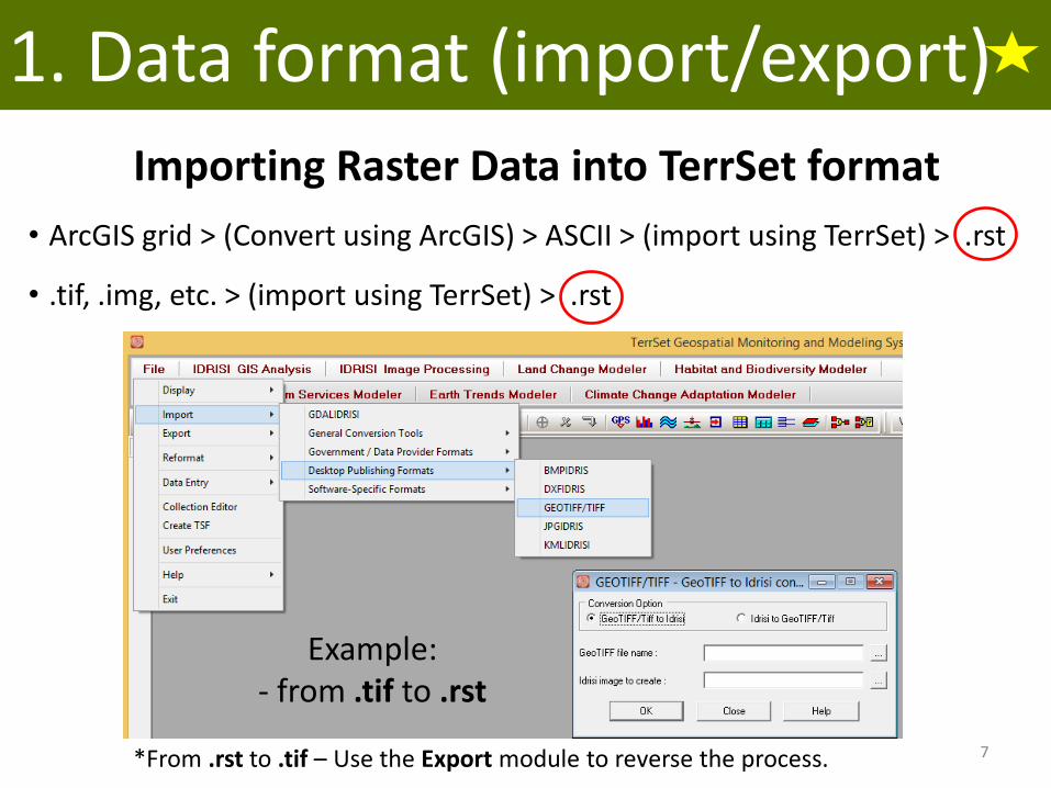
1. Data format (import/export)
Importing Raster Data into TerrSet format
• ArcGIS grid > (Convert using ArcGIS) > ASCII > (import using TerrSet) > .rst
• .tif, .img, etc. > (import using TerrSet) > .rst
Example:- from .tif to .rst
*From .rst to .tif – Use the Export module to reverse the process. 7

1. Data format (import/export)
Importing Vector Data (.shp) into TerrSet format
• ArcGIS .shp > (import using TerrSet) > .vct
Example:- from .shp to .vct
*From .vct to .shp – Use the Export module to reverse the process. 8

2. Basic TerrSet modulesa. CROSSTAB
• cross tabulates two or three images or raster files•used for change analysis between image pairs
LUC 1993 LUC 2001
9
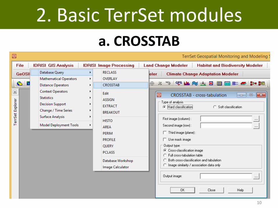
2. Basic TerrSet modulesa. CROSSTAB
10
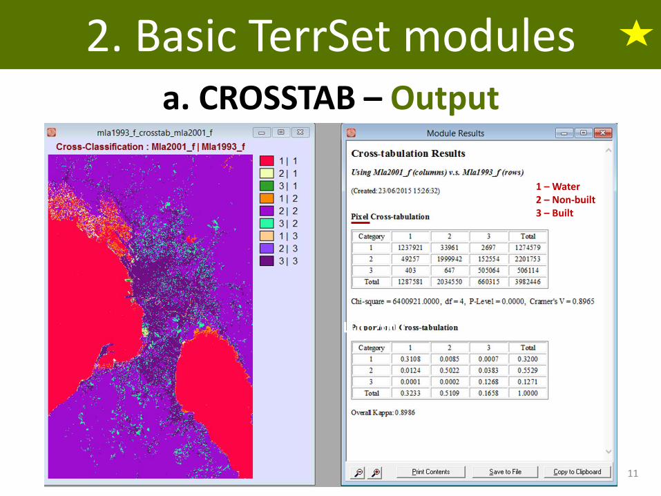
2. Basic TerrSet modulesa. CROSSTAB – Output
LUC 2001
1 – Water2 – Non-built3 – Built
11

2. Basic TerrSet modulesb. SAMPLE
•used to generate sample points for accuracy assessment•based on a random, systematic or stratified random scheme
Stratified random sampling “is usually preferred since it combines the best qualities of the other two – the unbiased character of the random sampling scheme with the even geographic coverage of the systematic scheme.” Source: TerrSet Manual, p. 100
See also: Stehman, S.V., 2009. Sampling designs for accuracy assessment of land-cover. International Journal of Remote Sensing, 30, 5243-5272.
12
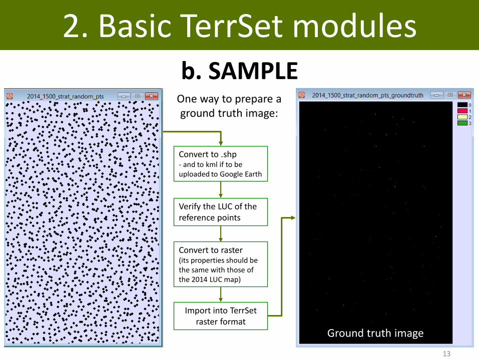
2. Basic TerrSet modulesb. SAMPLE
One way to prepare a ground truth image:
Convert to .shp- and to kml if to be uploaded to Google Earth
Verify the LUC of the reference points
Convert to raster (its properties should be the same with those of the 2014 LUC map)
Import into TerrSetraster format
Ground truth image
13
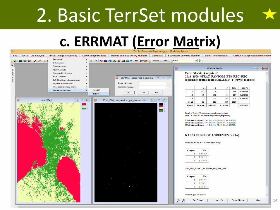
2. Basic TerrSet modulesc. ERRMAT (Error Matrix)
14

2. Basic TerrSet modulesSee also:
15

3. TerrSet Modelersa. Land Change Modeler (LCM)
• for analyzing land-cover change, empirically modelingits relationship to explanatory variables, and projecting future changes
• also includes special tools for the assessment of REDD (Reducing Emissions from Deforestation and forest Degradation) climate change mitigation strategies
• Stepso Change analysiso Transition potential modelingo Change prediction
16

3. TerrSet Modelersa. Land Change Modeler (LCM)
Sample Case Study (One-way transition)Urban land-change modeling in Manila
• Purpose – to simulate/predict built-up expansion from 2001 to 2009
• explanatory variables for urban land change• distance to 1993 built, elevation and slope
• Land-use/cover (LUC) datao 1993, 2001, 2009 o 1993-2001 – calibration; 2001-2009 - validation
Data Source: Murayama Y, Kamusoko C, Yamashita A, Estoque RC (In preparation). Book Project 17

Data: Land-use/cover (LUC) Maps
20011993 2009
18
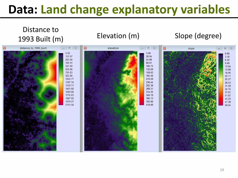
Data: Land change explanatory variables
Elevation (m)Distance to
1993 Built (m) Slope (degree)
19

Transition potential maps
SimWeightMLP Neural Network Logistic Regression
20
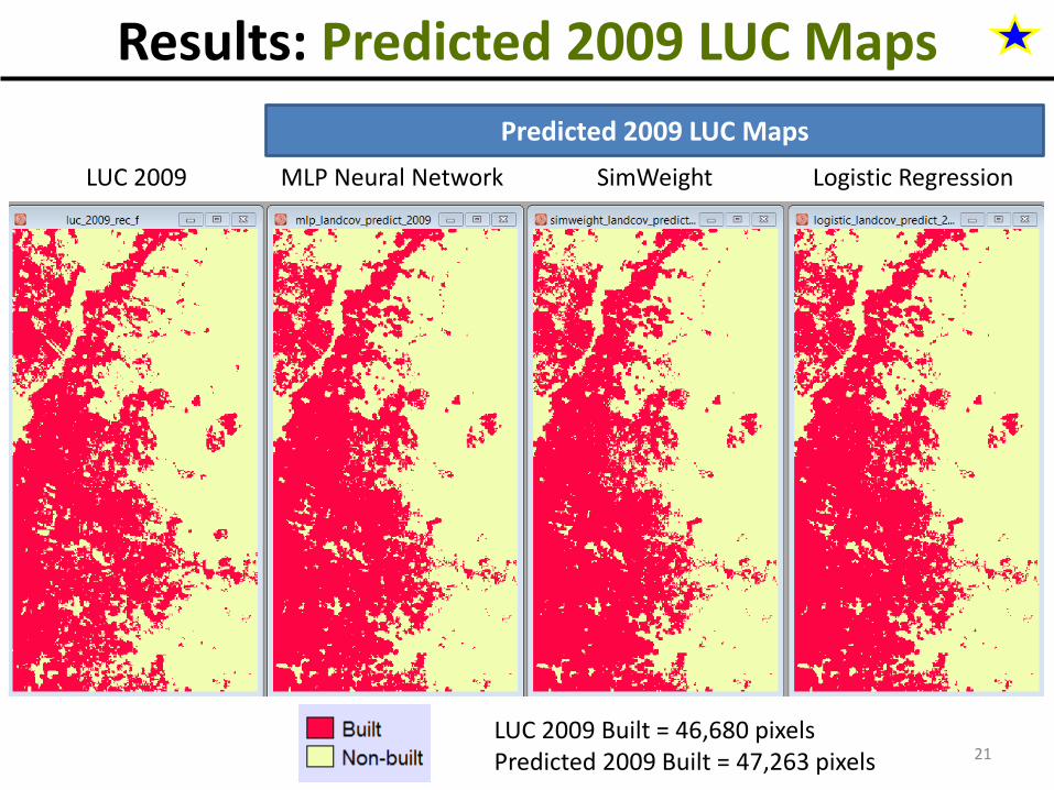
Results: Predicted 2009 LUC Maps
SimWeightMLP Neural Network Logistic RegressionLUC 2009
Predicted 2009 LUC Maps
LUC 2009 Built = 46,680 pixelsPredicted 2009 Built = 47,263 pixels 21

Validation Maps
SimWeightMLP Neural Network Logistic Regression
Figure of Merit (FoM)= (H/(H+M+F))*100
H = 4031M = 4238F = 4811
H = 3563M = 4706F = 5279
H = 4014M = 4255F = 4828
FoM44.55
FoM26.30
FoM30.65
Pixel Count 22
P0901 09
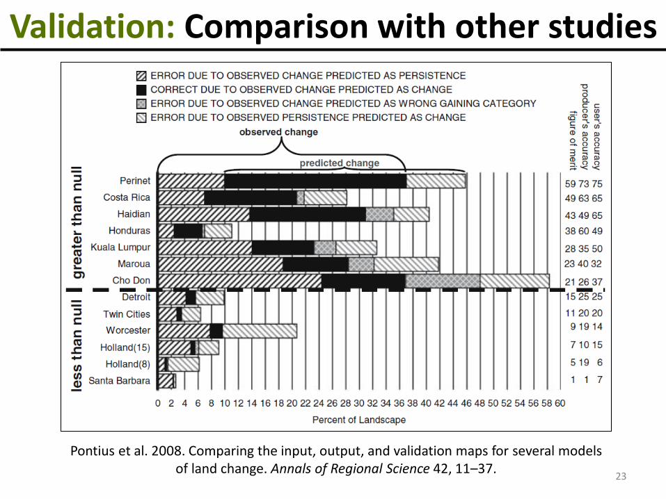
Validation: Comparison with other studies
Pontius et al. 2008. Comparing the input, output, and validation maps for several models of land change. Annals of Regional Science 42, 11–37.
23

FoM = 8.36%
FoM = 19-26%
FoM = 42.80%
Validation: Comparison with other studies
24

3. TerrSet Modelersa. Land Change Modeler (LCM)
Sample Case Study (Multiple transitions)Land-use/cover (LUC) change modeling in Manila
• Purpose – to predict LUC change from 2014 to 2027• explanatory variables for LUC change
• Elevation, slope, and distance maps to 2001 built, forest, cropland, grassland, water, and other land
• Land-cover datao 2001, 2014
LUC Data Source: Murayama Y, Estoque RC, Subasinghe H, Hou H, Gong H (2015) Land-use/land-cover changes in major Asian and African cities. Annual Report on the Multi Use Social and Economic Data Bank, 92, 11-58.
25
2001 2014
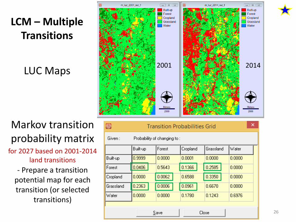
Markov transition probability matrix
- Prepare a transition potential map for each transition (or selected
transitions)
LUC Maps
LCM – Multiple Transitions
for 2027 based on 2001-2014 land transitions
26

LCM – Multiple Transitions
Transition Probability
Maps
- a transition potential map was prepared for each transition using
MLP NN
27
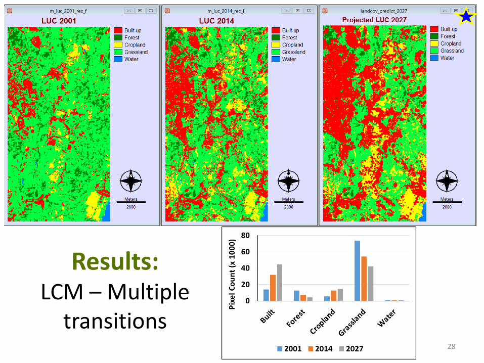
Results: LCM – Multiple
transitions28

Predicted changes from 2014-2027
By using the CROSSTAB module(quantity and location of land changes can be examined)
29
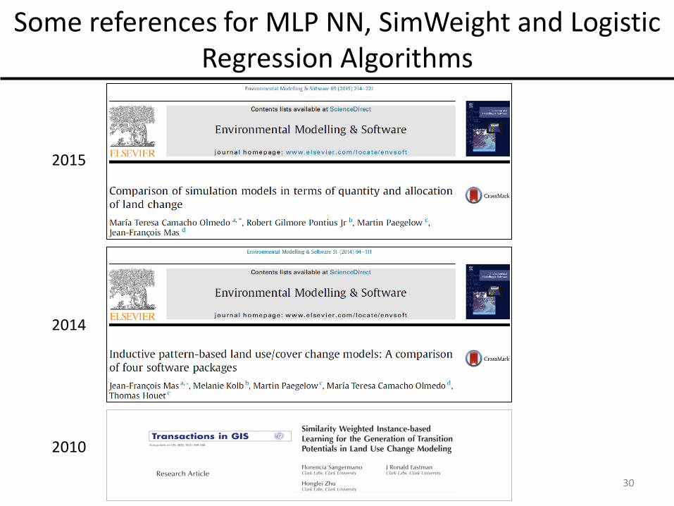
Some references for MLP NN, SimWeight and Logistic Regression Algorithms
2015
2014
2010
30

Summary
1. Basic info about TerrSet2. Data format (import/export) 3. Some basic TerrSet modules
a. CROSSTABb. SAMPLE c. ERRMAT
4. TerrSet Modelersa. Land change modeler
- Modeling one-way transition- Modeling multiple transitions
Image Processing – Accuracy assessment
31


