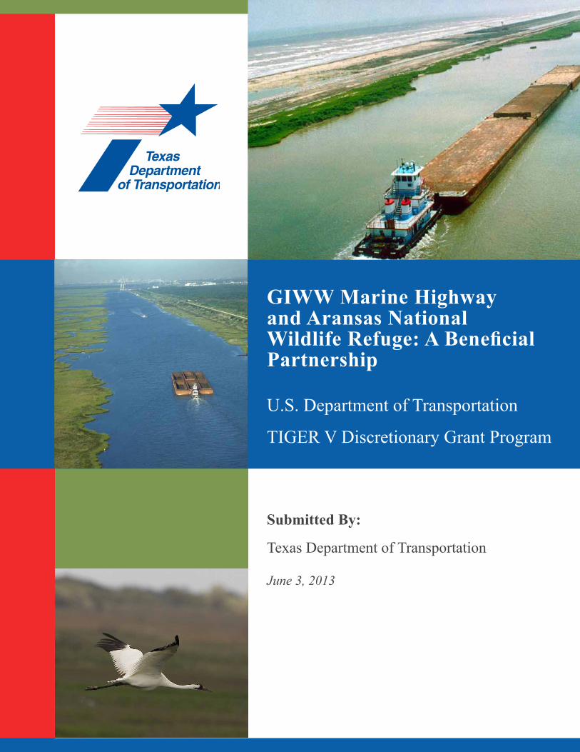
GIWW Marine Highway and Aransas National Wildlife Refuge: A Beneficial Partnership U.S. Department of Transportation TIGER V Discretionary Grant Program Submitted By: Texas Department of Transportation June 3, 2013
Transcript
GIWW Marine Highway and Aransas National Wildlife Refuge: A Beneficial Partnership
U.S. Department of Transportation
TIGER V Discretionary Grant Program
Submitted By:
Texas Department of Transportation
June 3, 2013
Page 6GIWW Marine Highway and Aransas National Wildlife Refuge: A Beneficial Partnership
TABle of CoNTeNTS
I. Project Description .........................................................................................................1II. Project Parties ............................................................................................................. 7III. Grant Funds and Sources/Uses of Project Funds ...................................................... 7IV. Selection Criteria........................................................................................................ 8
a. Primary Selection Criteria (Long-Term Outcomes) .................................... 8i. State of Good Repair ......................................................................... 8ii. Economic Competitiveness .............................................................. 9iii. Livability ......................................................................................... 11iv. Environmental Sustainability ........................................................... 11v. Safety ................................................................................................ 17vi. Project Readiness ............................................................................. 18
c. Benefit-Cost Analysis .................................................................................. 20V. Planning Approvals, NEPA and Other Environmental Reviews/Approvals ............... 25
Federal Wage Rate Certification
AttAchmentsAttachment 1: Letters of SupportAttachment 2: Memorandum of UnderstandingAttachment 3: Proposed Project ScheduleAttachment 4: Preliminary Project BudgetAttachment 5: Benefit-Cost AnalysisAttachment 6: Environmental Information DocumentAttachment 7: Federal Wage Rate Certification
tAblesTable 1: Design and Construction for Rock Breakwater .............................................5Table 2: Project Costs ...................................................................................................7Table 3: Environmental Comparisons of Truck, Rail and Barge Operations ..............13Table 4: Summary of Emissions by Transportation Mode ..........................................15Table 5: Fossil Fuel Emission Levels ..........................................................................15Table 6: Cost Benefit Summary at Discount Rate of 7% .............................................22 Table 7: Cost Benefit Summary at Discount Rate of 3% .............................................23Table 8: GIWW-Galveston to Corpus Christi Volume Summary ................................23Table 9: GIWW-Galveston to Corpus Christi Commodity Summary .........................23
Page 7GIWW Marine Highway and Aransas National Wildlife Refuge: A Beneficial Partnership
mApsMap 1: Texas GIWW Navigable Waterways ...............................................................2Map 2: Eagle Ford Shale Area .....................................................................................3Map 3: Project Area .....................................................................................................4Map 4: Urban Areas .....................................................................................................8Map 5: Economically Distressed Areas ........................................................................10
Acronyms
ANWR Aransas National Wildlife Refuge BCA Benefit-Cost Analysis DMMP Dredged Material Management Plan eIS Environmental Impact Statement ffR Feasibility Report GIWW Gulf Intracoastal Waterway Glo General Land Office ICT Interagency Coordination Team MARAD U.S. Department of Transportation Maritime Administration NePA National Environmental Policy Act NMfS National Marine Fisheries Service SLRT-2035 Statewide Long-Rage Transportation Plan 2035 TPWD Texas Parks and Wildlife Department TRRC The Railroad Commission of Texas TTI Texas Transportation Institute TxDoT Texas Department of Transportation USACe United States Army Corps of Engineers USfWS U.S. Fish and Wildlife Service VMT Vehicle-Miles Travelled
Page 1GIWW Marine Highway and Aransas National Wildlife Refuge: A Beneficial Partnership
I. PRojeCT DeSCRIPTIoN
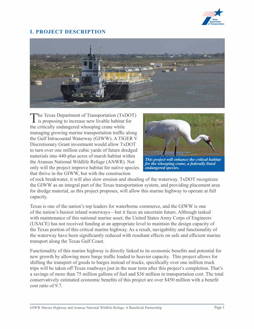
The Texas Department of Transportation (TxDOT) is proposing to increase new livable habitat for
the critically endangered whooping crane while managing growing marine transportation traffic along the Gulf Intracoastal Waterway (GIWW). A TIGER V Discretionary Grant investment would allow TxDOT to turn over one million cubic yards of future dredged materials into 440-plus acres of marsh habitat within the Aransas National Wildlife Refuge (ANWR). Not only will the project improve habitat for native species that thrive in the GIWW, but with the construction of rock breakwater, it will also slow erosion and shoaling of the waterway. TxDOT recognizes the GIWW as an integral part of the Texas transportation system, and providing placement area for dredge material, as this project proposes, will allow this marine highway to operate at full capacity.
Texas is one of the nation’s top leaders for waterborne commerce, and the GIWW is one of the nation’s busiest inland waterways—but it faces an uncertain future. Although tasked with maintenance of this national marine asset, the United States Army Corps of Engineers (USACE) has not received funding at an appropriate level to maintain the design capacity of the Texas portion of this critical marine highway. As a result, navigability and functionality of the waterway have been significantly reduced with resultant effects on safe and efficient marine transport along the Texas Gulf Coast.
Functionality of this marine highway is directly linked to its economic benefits and potential for new growth by allowing more barge traffic loaded to heavier capacity. This project allows for shifting the transport of goods to barges instead of trucks, specifically over one million truck trips will be taken off Texas roadways just in the near term after this project’s completion. That’s a savings of more than 75 million gallons of fuel and $36 million in transportation cost. The total conservatively estimated economic benefits of this project are over $450 million with a benefit cost ratio of 9.7.
This project will enhance the critical habitat for the whooping crane, a federally listed endangered species.
Page 2GIWW Marine Highway and Aransas National Wildlife Refuge: A Beneficial Partnership
In addition, the proposed project will create over 2,000 new jobs in an economically distressed area as well as facilitate additional development in natural gas production of the Eagle Ford Shale formation, a growing sector of Texas’ economy. This project, estimated to cost $46.5 million, will support maintenance of the critically important GIWW for the next 50 years and will be a tangible benefit to the entire transportation system of Texas and the National Inland Waterways Transportation System.
This proposed project will significantly increase the available capacity of dredged material disposal in the Aransas Pass segment of the GIWW, providing long-term sustainability of this portion of the system. The project simultaneously presents a unique opportunity to create environmental value through the construction of beneficial use areas for dredged material placement that will enhance and create critical habitat for the whooping crane. USACE is currently nearing capacity for disposal of dredged material in existing placement areas. Developing additional dredged material placement areas will increase functionality of the GIWW. Investment in additional disposal capacity within ANWR will enable TxDOT and USACE to properly maintain the waterway through this segment of the Texas marine highway.
The individual project components each benefit the functionality and environmental health of the GIWW. The development of the entire project will greatly enhance the overall health in the mid-reach of the GIWW in Texas.
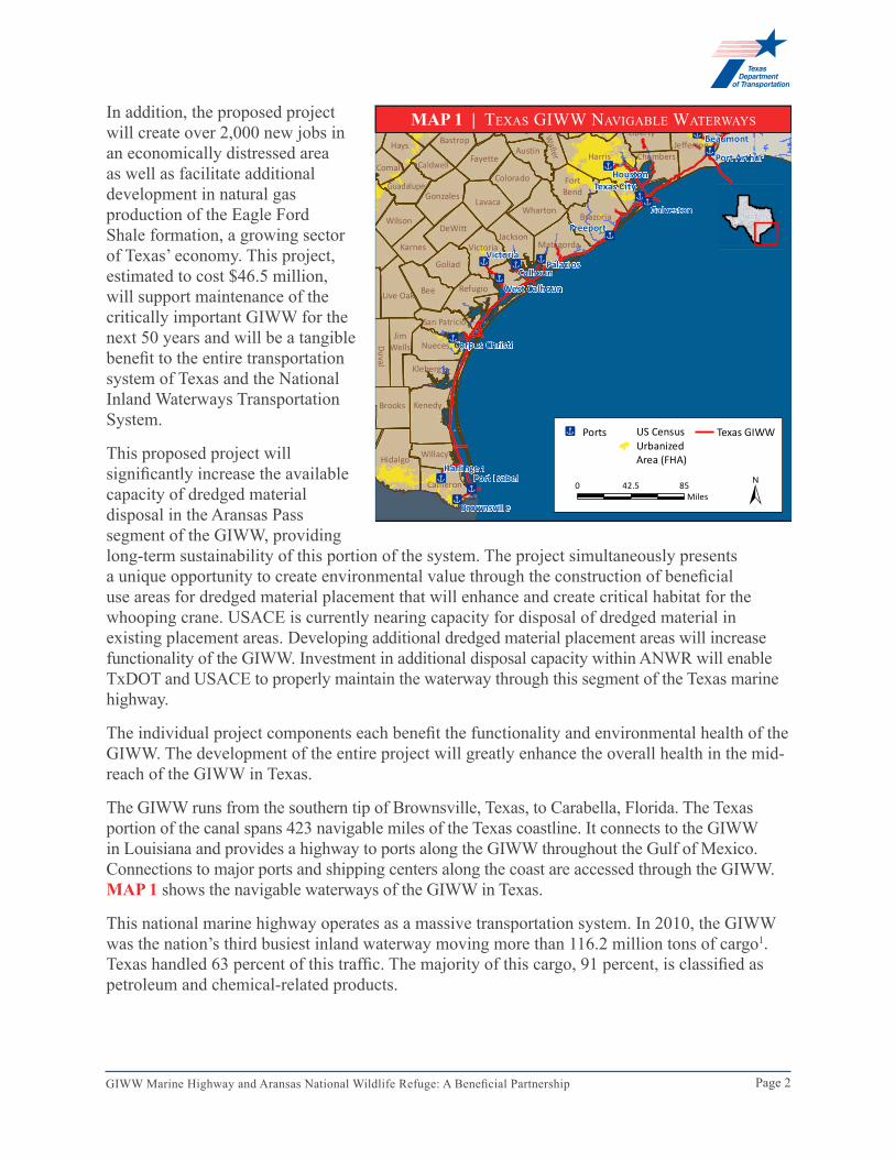
The GIWW runs from the southern tip of Brownsville, Texas, to Carabella, Florida. The Texas portion of the canal spans 423 navigable miles of the Texas coastline. It connects to the GIWW in Louisiana and provides a highway to ports along the GIWW throughout the Gulf of Mexico. Connections to major ports and shipping centers along the coast are accessed through the GIWW. MAP 1 shows the navigable waterways of the GIWW in Texas.
This national marine highway operates as a massive transportation system. In 2010, the GIWW was the nation’s third busiest inland waterway moving more than 116.2 million tons of cargo1. Texas handled 63 percent of this traffic. The majority of this cargo, 91 percent, is classified as petroleum and chemical-related products.
ÆxÆx
Æx
Æx
Æx
Æx
Æx
Æx
Æx
Æx
Æx
Æx
Æx
ÆxÆx
Waller
Duval
Cameron
Williamson Burleson
Travis MontgomeryLeeHardin
LibertyBastrop
Washington
Hays
Orange
JeffersonFayette HarrisAustin
CaldwellComalColorado
Chambers
Guadalupe FortBendGonzales Lavaca
WhartonBrazoriaWilson
DeWittJackson
MatagordaKarnes Victoria
Goliad
Live Oak Bee Refugio
San PatricioJim
Wells Nueces
Kleberg
Brooks Kenedy
Hidalgo Willacy
Texas City
Galveston
Palacios
Houston
Freeport
Beaumont
Port Arthur
Orange
Corpus Christi
Brownsville
Harlingen
Victoria
Port Isabel
CalhounWest Calhoun
Æx Ports US CensusUrbanizedArea (FHA)
Texas GIWW
±0 8542.5Miles
MAP 1 | Texas GIWW NavIGable WaTerWays
Page 3GIWW Marine Highway and Aransas National Wildlife Refuge: A Beneficial Partnership
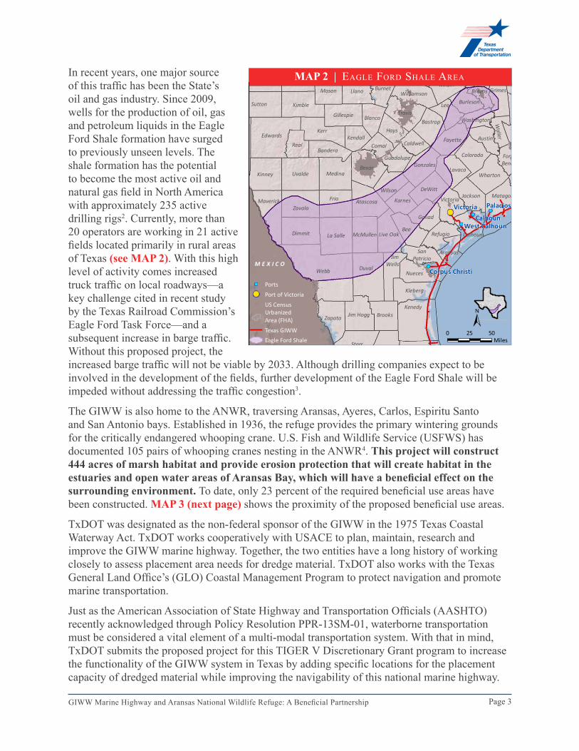
In recent years, one major source of this traffic has been the State’s oil and gas industry. Since 2009, wells for the production of oil, gas and petroleum liquids in the Eagle Ford Shale formation have surged to previously unseen levels. The shale formation has the potential to become the most active oil and natural gas field in North America with approximately 235 active drilling rigs2. Currently, more than 20 operators are working in 21 active fields located primarily in rural areas of Texas (see MAP 2). With this high level of activity comes increased truck traffic on local roadways—a key challenge cited in recent study by the Texas Railroad Commission’s Eagle Ford Task Force—and a subsequent increase in barge traffic. Without this proposed project, the increased barge traffic will not be viable by 2033. Although drilling companies expect to be involved in the development of the fields, further development of the Eagle Ford Shale will be impeded without addressing the traffic congestion3.
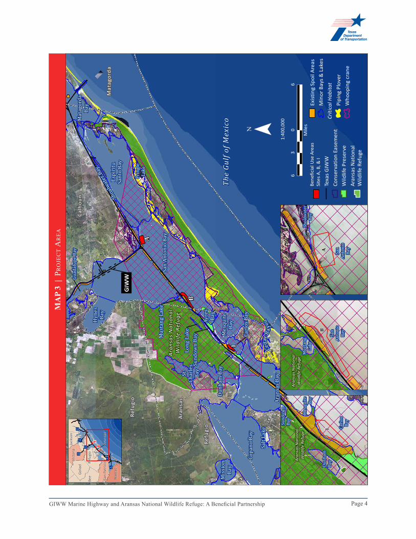
The GIWW is also home to the ANWR, traversing Aransas, Ayeres, Carlos, Espiritu Santo and San Antonio bays. Established in 1936, the refuge provides the primary wintering grounds for the critically endangered whooping crane. U.S. Fish and Wildlife Service (USFWS) has documented 105 pairs of whooping cranes nesting in the ANWR4. This project will construct 444 acres of marsh habitat and provide erosion protection that will create habitat in the estuaries and open water areas of Aransas Bay, which will have a beneficial effect on the surrounding environment. To date, only 23 percent of the required beneficial use areas have been constructed. MAP 3 (next page) shows the proximity of the proposed beneficial use areas.
TxDOT was designated as the non-federal sponsor of the GIWW in the 1975 Texas Coastal Waterway Act. TxDOT works cooperatively with USACE to plan, maintain, research and improve the GIWW marine highway. Together, the two entities have a long history of working closely to assess placement area needs for dredge material. TxDOT also works with the Texas General Land Office’s (GLO) Coastal Management Program to protect navigation and promote marine transportation.
Just as the American Association of State Highway and Transportation Officials (AASHTO) recently acknowledged through Policy Resolution PPR-13SM-01, waterborne transportation must be considered a vital element of a multi-modal transportation system. With that in mind, TxDOT submits the proposed project for this TIGER V Discretionary Grant program to increase the functionality of the GIWW system in Texas by adding specific locations for the placement capacity of dredged material while improving the navigability of this national marine highway.
!(
!(
!( !(
!(
KimbleTravis
Lee
BlancoGillespieBastrop Washington
HaysVal
VerdeEdwards
Kerr
Waller
FayetteKendall AustinReal CaldwellComal
ColoradoBandera
Guadalupe FortBendGonzalesBexar
Medina WhartonLavaca
Kinney Uvalde
Wilson DeWittJackson Matagorda
Atascosa Karnes VictoriaMaverickZavala
Frio
Goliad
Live Oak CalhounBee
McMullenDimmit La Salle Refugio
Aransas
Webb
SanPatricioJim
WellsDuval
Nueces
Kleberg
Jim HoggZapata
KenedyBrooks
Starr
HidalgoWillacy
McCulloch Madison
MilamSchleicher Menard
Burnet BrazosMason Llano Williamson Grimes
BurlesonSutton
Palacios
Corpus Christi
VictoriaCalhoun
West Calhoun
M E X I C O
±0 5025
Miles
!( Ports
!( Port of VictoriaUS CensusUrbanizedArea (FHA)Texas GIWWEagle Ford Shale
MAP 2 | eaGle Ford shale area
Page 4GIWW Marine Highway and Aransas National Wildlife Refuge: A Beneficial Partnership
Æ x
Espir
ituSa
nto B
ay
Hyne
sBa
y
San A
nton
io Ba
y
Shoa
lwater B
ay
St.Ch
arles
Bay
Ayre
sBa
y
Copa
no Ba
y
Miss
ionBa
yMe
squit
eBa
yDu
nham
Bay
Aran
sas B
ay
Salt L
ake
Little
Bay
A
I
B
Aran
sas
Nat
iona
lW
ildlif
e Re
fuge
Ceda
r Bay
ou
Sund
own B
ayLo
ng La
ke
Pring
leLa
ke
The
Gulf
of M
exic
o
Musta
ng La
ke
GIW
W
Missi
on La
keGu
adalu
pe Ba
y
Refu
gio
Ara
nsas
Calh
oun
Refu
gio
Matag
orda
Bay
South
Bay
Redfish Bay
Port Bay
Carlo
s Bay
Mat
agor
da
Aran
sas
Pass
Æ x
Æ x
Æ xÆ x
Æ x
Æ x
Jack
son
Jack
son
AIB
Vict
oria
Vict
oria
Golia
dGo
liad
Calh
oun
Calh
oun
Bee
Bee
Refu
gio
Refu
gio
Aran
sas
Aran
sas
San
Patr
icio
San
Patr
icio
Nue
ces
Nue
ces
¯1:
400,
000
60
63
Mile
sBe
nefic
ial U
se A
reas
Site
s A, B
, & I
Texa
s G
IWW
Cons
erva
tion
Ease
men
tW
ildlif
e Pr
eser
veAr
ansa
s N
atio
nal
Wild
life
Refu
ge
Exis
ting
Spoi
l Are
asM
inor
Bay
s &
Lak
esCr
itica
l Hab
itat
Pipi
ng P
love
rW
hoop
ing
cran
e
Aran
sas N
atio
nal
Wild
life
Refu
ge
Sund
own
Bay
Mesq
uite
Bay
Dunh
amBa
y
Carlo
sBa
y
I
Aran
sas N
atio
nal
Wild
life
Refu
ge
San
Anton
ioBa
y
Musta
ngLa
ke
B
San
Anton
ioBa
y
Shoa
lwate
rBa
y
A
MA
P 3
| P
ro
jec
T a
rea
Page 5GIWW Marine Highway and Aransas National Wildlife Refuge: A Beneficial Partnership
This project will provide additional vital habitat and protect existing habitat for the endangered whooping crane and other native species. This will be accomplished by the construction of rock breakwaters and the creation of new placement areas through the beneficial use of dredged material.
project components
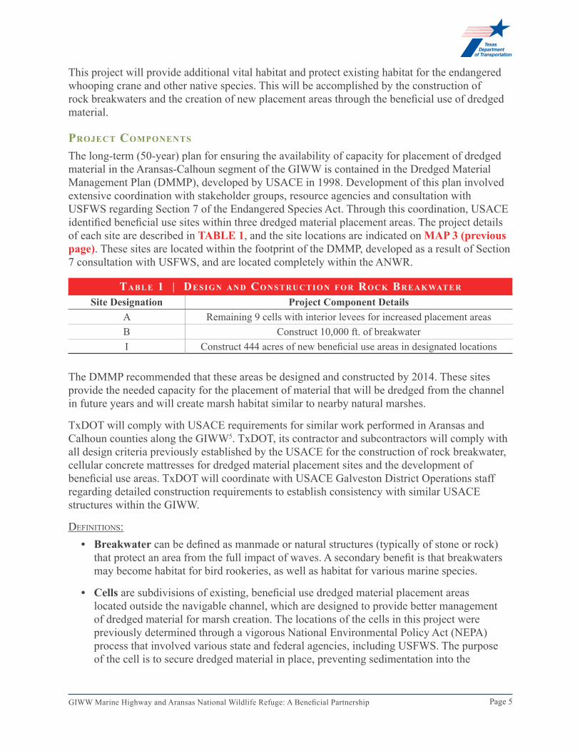
The long-term (50-year) plan for ensuring the availability of capacity for placement of dredged material in the Aransas-Calhoun segment of the GIWW is contained in the Dredged Material Management Plan (DMMP), developed by USACE in 1998. Development of this plan involved extensive coordination with stakeholder groups, resource agencies and consultation with USFWS regarding Section 7 of the Endangered Species Act. Through this coordination, USACE identified beneficial use sites within three dredged material placement areas. The project details of each site are described in TABLe 1, and the site locations are indicated on MAP 3 (previous page). These sites are located within the footprint of the DMMP, developed as a result of Section 7 consultation with USFWS, and are located completely within the ANWR.
The DMMP recommended that these areas be designed and constructed by 2014. These sites provide the needed capacity for the placement of material that will be dredged from the channel in future years and will create marsh habitat similar to nearby natural marshes.
TxDOT will comply with USACE requirements for similar work performed in Aransas and Calhoun counties along the GIWW5. TxDOT, its contractor and subcontractors will comply with all design criteria previously established by the USACE for the construction of rock breakwater, cellular concrete mattresses for dredged material placement sites and the development of beneficial use areas. TxDOT will coordinate with USACE Galveston District Operations staff regarding detailed construction requirements to establish consistency with similar USACE structures within the GIWW.
deFINITIoNs:• Breakwater can be defined as manmade or natural structures (typically of stone or rock)
that protect an area from the full impact of waves. A secondary benefit is that breakwaters may become habitat for bird rookeries, as well as habitat for various marine species.
• Cells are subdivisions of existing, beneficial use dredged material placement areas located outside the navigable channel, which are designed to provide better management of dredged material for marsh creation. The locations of the cells in this project were previously determined through a vigorous National Environmental Policy Act (NEPA) process that involved various state and federal agencies, including USFWS. The purpose of the cell is to secure dredged material in place, preventing sedimentation into the
tA b l e 1 | De s i g n A n D co n s t r u c t i o n f o r ro c k br e A k wAt e r
Site Designation Project Component DetailsA Remaining 9 cells with interior levees for increased placement areasB Construct 10,000 ft. of breakwaterI Construct 444 acres of new beneficial use areas in designated locations
Page 6GIWW Marine Highway and Aransas National Wildlife Refuge: A Beneficial Partnership
channel and to provide for future management of the resulting marsh habitat. The specific construction material of the cells may vary according to the dredged material placement area. Construction material may include a concrete soil material or geotextile tubing.
• Beneficial use placement areas are areas where dredged materials are used to create habitat and provide an added benefit to the ecosystem. These areas employ environmentally and economically responsible methods of using dredged material to benefit local communities and improve eroded coastlines through marsh creation and restoration, beach nourishment and other beneficial uses. These benefits can include the creation of wetlands and other kinds of habitat for numerous species of birds and animals. Wetlands and marshes play a vital role protecting the shoreline from flooding and storm surge.
how the project ADDresses trAnsportAtion chAllenges
Currently, the GIWW transports cargo with an approximate value of $25 billion each year6. This project will extend the ability of USACE to continue or enhance dredging in this segment of the GIWW by providing disposal capacity for future dredged material. It will also extend the life of the GIWW by allowing future USACE funding levels to maintain the GIWW at functional capacity.
Overall, this project supports the increased capacity and functionality of the GIWW system. Each project component provides a service to users of the GIWW. Bulk cargo and petroleum- and chemical-related cargo represent up to 91 percent of the cargo on the GIWW. Increasing accessibility to the GIWW for this important sector will reduce truck traffic on roadways and increase safety. Reliance on this segment of the GIWW marine highway specifically reduces congestion along US Interstate 37 (from the Eagle Ford to Corpus Christi or San Antonio refining centers) and US Interstate 10 (from the Eagle Ford to Houston and Beaumont refineries). The Railroad Commission of Texas (TRRC) task force reported an increase in congestion impacts of up to 86 percent on some portions of I-35.
Oil and gas development has significantly increased road traffic, including heavy trucks in rural areas where most roads were originally designed for light-duty use. TRRC found that the unprecedented level of traffic was leading to congestion on state and county roads in the production area. TxDOT estimates that 1,200 loaded trucks are required to bring one gas well into production, more than 350 are required per year for maintenance of a gas well and almost 1,000 are needed every five years to re-fracture a well7. The service life of highway systems and Farm-to-Market roads has been reduced by an average of 30 percent due to natural gas well operations and by an average of 16 percent due to crude oil operations. Transferring a portion of truck trips to barges will have an immediate impact on the maintenance costs for area highways, and increase roadway safety. Specifically, in the first four months upon completion of the project, over one million truck trips will be transferred to barges. This will also decrease vehicle emissions and greenhouse gases. These benefits are outlined further in the Benefit-Cost Analysis and Environmental Sustainability sections of this document.
In 2011, 16 fatalities involving 18-wheelers occurred in Texas, none of which occurred on intrastate highways8. Accidents most often occurred on Farm-to-Market roadways that were not designed to withstand the heavy-duty truck traffic nor the heavier loads of equipment and product associated with oil-field production. According to a recent TxDOT report9, the increased
Page 7GIWW Marine Highway and Aransas National Wildlife Refuge: A Beneficial Partnership
truck traffic required to bring one well into production is equivalent to 8 million car trips. Over time, the heavy trucks and over-sized loads cause damage to roadways and bridges resulting in unsafe driving conditions and additional maintenance and construction costs.
As a result of the increase in the oil and gas industry and the Panama Canal expansion, TxDOT reviewed activities supported at docks along the GIWW between the Houston Ship Channel and the Port of Corpus Christi10. This project is located within this segment of the GIWW, which will benefit most directly from increased navigability and functionality. Approximately 42 percent of the services at docks in this region are related to the oil industry11. Another 12 percent represents the chemical industry, which includes petroleum-based products. Eight percent of the facilities provide direct service to the commercial fishing industry. Without access to the GIWW marine highway, the transfer of marine cargo to transporting trucks will require additional vehicles, additional lanes and lengthier travel schedules to accommodate the increased traffic.
II. PRojeCT PARTIeS
txDot (grAnt recipient)TxDOT sponsors the Texas stretch of the GIWW. This marine highway is a key part of the department’s multimodal transportation system that uses the state highway system, freight rail system and ports to import and export bulk products and liquid petroleum products around the world. TxDOT understands that the state has a significant marine transportation system that is used for commercial, recreational and tourism purposes, all of which depend on efficient transport through the GIWW.
III. GRANT fUNDS AND SoURCeS/USeS of PRojeCT fUNDS
The TxDOT budget is currently constitutionally and statutorily limited in the types of projects that can be funded. To date there has been no mechanism to fund a project of this type. Within these restrictions, and due to the substantial benefits of the project, TxDOT has identified a considerable amount of funding through innovative sources available for this project.
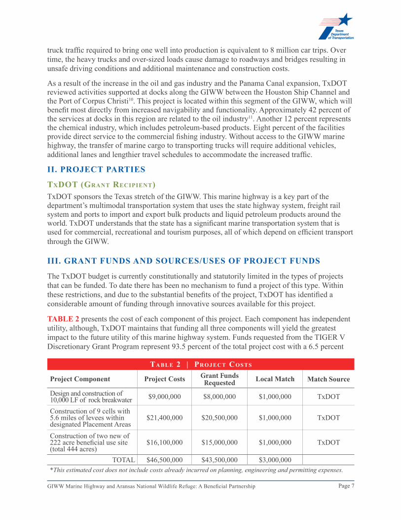
TABLe 2 presents the cost of each component of this project. Each component has independent utility, although, TxDOT maintains that funding all three components will yield the greatest impact to the future utility of this marine highway system. Funds requested from the TIGER V Discretionary Grant Program represent 93.5 percent of the total project cost with a 6.5 percent
tA b l e 2 | pr o j e c t co s t s
Project Component Project Costs Grant Funds Requested Local Match Match Source
Design and construction of 10,000 LF of rock breakwater $9,000,000 $8,000,000 $1,000,000 TxDOT
Construction of 9 cells with 5.6 miles of levees within designated Placement Areas
$21,400,000 $20,500,000 $1,000,000 TxDOT
Construction of two new of 222 acre beneficial use site (total 444 acres)
$16,100,000 $15,000,000 $1,000,000 TxDOT
TOTAL $46,500,000 $43,500,000 $3,000,000*This estimated cost does not include costs already incurred on planning, engineering and permitting expenses.
Page 8GIWW Marine Highway and Aransas National Wildlife Refuge: A Beneficial Partnership
local match. The proposed infrastructure improvement project has been developed in coordination with TxDOT partners. The proposed project is technically feasible and can be obligated by September 30, 2014.
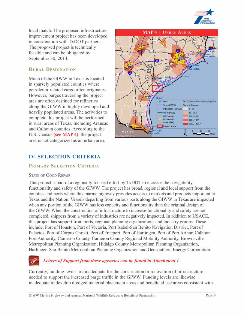
rurAl DesignAtion
Much of the GIWW in Texas is located in sparsely populated counties where petroleum-related cargo often originates. However, barges traversing the project area are often destined for refineries along the GIWW in highly developed and heavily populated areas. The activities to complete this project will be performed in rural areas of Texas, including Aransas and Calhoun counties. According to the U.S. Census (see MAP 4), the project area is not categorized as an urban area.
IV. SeleCTIoN CRITeRIA
primAry selection criteriA
sTaTe oF Good rePaIr
This project is part of a regionally focused effort by TxDOT to increase the navigability, functionality and safety of the GIWW. The project has broad, regional and local support from the counties and ports where this marine highway provides access to markets and products important to Texas and the Nation. Vessels departing from various ports along the GIWW in Texas are impacted when any portion of the GIWW has less capacity and functionality than the original design of the GIWW. When the construction of infrastructure to increase functionality and safety are not completed, shippers from a variety of industries are negatively impacted. In addition to USACE, this project has support from ports, regional planning organizations and industry groups. These include: Port of Houston, Port of Victoria, Port Isabel-San Benito Navigation District, Port of Palacios, Port of Corpus Christi, Port of Freeport, Port of Harlingen, Port of Port Arthur, Calhoun Port Authority, Cameron County, Cameron County Regional Mobility Authority, Brownsville Metropolitan Planning Organization, Hidalgo County Metropolitan Planning Organization, Harlingen-San Benito Metropolitan Planning Organization and Geosouthern Energy Corporation.
Letters of Support from these agencies can be found in Attachment 1
Currently, funding levels are inadequate for the construction or renovation of infrastructure needed to support the increased barge traffic in the GIWW. Funding levels are likewise inadequate to develop dredged material placement areas and beneficial use areas consistent with
!(!(
!(
!(
!(
!(
!(
!(
!(
!(
!(
!(
!(
!(
!(
§̈¦10
§̈¦37
§̈¦35§̈¦10
§̈¦45£¤90
£¤281
£¤96
£¤190
£¤79
£¤90A
£¤77
£¤290
£¤171
£¤183
£¤77A
£¤181
£¤59R
£¤69
£¤57
£¤83
£¤59 Texas CityGalveston
Palacios
Houston
Freeport
BeaumontPort Arthur
Orange
Corpus Christi
Brownsville
Harlingen
Victoria
Port Isabel
CalhounWest Calhoun
M E X I C O
Base Map: ESRI Server
!( PortsTexas GIWWInterstate HighwayUS HighwayUS CensusUrbanizedArea (FHA)Project Area
2010 Census Population/Sq MileNatural Breaks
0 - 8889 - 255256 - 527528 - 13651366 - 2607
± 0 6030Miles
MAP 4 | UrbaN areas
Page 9GIWW Marine Highway and Aransas National Wildlife Refuge: A Beneficial Partnership
the DMMP.
Without the requested TIGER funds, one can anticipate that the GIWW throughout the Aransas Pass will continue to operate at a level less than the design capacity. This could potentially lead to a closure of the area if the waterway cannot be maintained due to lack of infrastructure to dispose of dredged materials.
The success of the project can be established and measured by the following criteria:
• This project provides the necessary infrastructure to support future dredging activities and erosion reduction by creating dredged material placement capacity through the construction of dredged material cells, breakwaters for beneficial use and the construction of beneficial use areas within previously designated placement areas.
A copy of the Memorandum of Understanding outlining the specifics of coordination process for this and other project component can be found in Attachment 2
• Access and utilization of the GIWW will continue to increase as the petroleum, crude and chemical-related industry as well as the natural gas industry in the Eagle Ford Shale continues to grow. Completion of the Panama Canal expansion will also increase GIWW traffic. With these critical economic development opportunities, TxDOT understands the need for ongoing maintenance and has established an annual budget appropriating $826,000 in 2014 and $827,000 in 2015 to contribute toward continued maintenance of the GIWW.
• Additionally, TxDOT will have a project manager on-site with the contractor for the duration of the construction projects to ensure that all methods and materials meet or exceed the plans and specifications for the project.
A proposed project schedule is included in Attachment 3
ecoNomIc comPeTITIveNess
Improved Long-Term efficiency, Reliability, and Cost-CompetitivenessThe GIWW serves as the marine highway system along the Texas Gulf Coast. This marine highway is a critical component to the economy of Texas and the United States. According to a recent USACE presentation12, Texas is the Nation’s second leading state for waterborne commerce. In 2011, the Texas portion of the GIWW represented 22.2 percent of the Nation’s total export tonnage (maritime) and 43.4 percent of imported crude oil (maritime)13. This project must be funded in order for Texas and the Nation to remain competitive in the global market. This project will allow the GIWW to increase its share of the marketplace by providing essential infrastructure to support future maintenance dredging and/or restoration of the design depth and functionality of the GIWW.
This project serves to improve the waterway’s long-term efficiency, reliability and cost competitiveness by reducing the cost of transporting and exporting cargo. It follows that companies will spend less time transporting, unloading and loading cargo, bringing greater levels of productivity.
Page 10GIWW Marine Highway and Aransas National Wildlife Refuge: A Beneficial Partnership
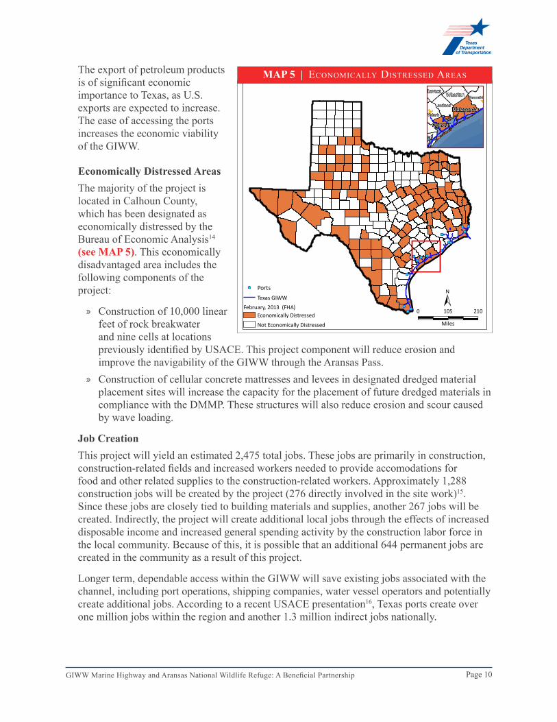
The export of petroleum products is of significant economic importance to Texas, as U.S. exports are expected to increase. The ease of accessing the ports increases the economic viability of the GIWW.
economically Distressed AreasThe majority of the project is located in Calhoun County, which has been designated as economically distressed by the Bureau of Economic Analysis14 (see MAP 5). This economically disadvantaged area includes the following components of the project:
» Construction of 10,000 linear feet of rock breakwater and nine cells at locations previously identified by USACE. This project component will reduce erosion and improve the navigability of the GIWW through the Aransas Pass.
» Construction of cellular concrete mattresses and levees in designated dredged material placement sites will increase the capacity for the placement of future dredged materials in compliance with the DMMP. These structures will also reduce erosion and scour caused by wave loading.
job CreationThis project will yield an estimated 2,475 total jobs. These jobs are primarily in construction, construction-related fields and increased workers needed to provide accomodations for food and other related supplies to the construction-related workers. Approximately 1,288 construction jobs will be created by the project (276 directly involved in the site work)15. Since these jobs are closely tied to building materials and supplies, another 267 jobs will be created. Indirectly, the project will create additional local jobs through the effects of increased disposable income and increased general spending activity by the construction labor force in the local community. Because of this, it is possible that an additional 644 permanent jobs are created in the community as a result of this project.
Longer term, dependable access within the GIWW will save existing jobs associated with the channel, including port operations, shipping companies, water vessel operators and potentially create additional jobs. According to a recent USACE presentation16, Texas ports create over one million jobs within the region and another 1.3 million indirect jobs nationally.
!(!(
!(
!(
!(
!(
!(
!(
!(
!(
!(
!(
!(
!(!(
M E X I C O
Base Map: ESRI Server
!( PortsTexas GIWW
February, 2013 (FHA)Economically Distressed
Not Economically Distressed
Calhoun
Matagorda
Wharton BrazoriaLavaca
Jackson
Victoria
±0 210105
Miles
MAP 5 | ecoNomIcally dIsTressed areas
Page 11GIWW Marine Highway and Aransas National Wildlife Refuge: A Beneficial Partnership
Between 2004 and 2009, over 19,000 seafarer jobs in water transportation and related industries were created in the United States17. This represents an increase of eight percent in job creation. In addition, seafarer wages increased 27 percent during the same time period, compared to the 14 percent increase recognized in other transport jobs.
To the degree that enhanced maintenance resulting from the project allows additional product to transfer to barge traffic, marine employers could expand their businesses and create new jobs. Each additional cargo barge represents new, permanent jobs for the company adding the barge to its fleet. The ports themselves will likely need additional staff to meet growing demands. The proposed project is located in an economically distressed area, which is expected to benefit the greatest in terms of the creation of new, temporary and/or permanent jobs. Such jobs could include captains, mates, pilots, sailors, oilers, marine engineers, shipbuilders, and ship repair personnel.
In addition, the expansion of the wildlife refuge is likely to result in increased tourism, potentially increasing economic activity and jobs in the service and hospitality sector of the local economy. Currently, tourism provides jobs in boat tours, fishing tours, whooping crane tours, lodging, gasoline and supplies. Texas Parks and Wildlife Department (TPWD) estimates that approximately 80,000 people visit the refuge each year18. According to a recent study by the Coastal Bend Council of Governments, nature tourism was the largest component of visitor activities with 42 percent of visitor trips being nature-based. Of the visitor destination, 49 percent or $496.6 million came from nature tourism visitors19.
lIvabIlITy
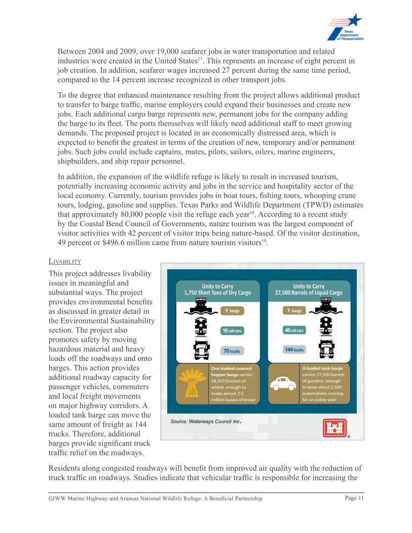
This project addresses livability issues in meaningful and substantial ways. The project provides environmental benefits as discussed in greater detail in the Environmental Sustainability section. The project also promotes safety by moving hazardous material and heavy loads off the roadways and onto barges. This action provides additional roadway capacity for passenger vehicles, commuters and local freight movements on major highway corridors. A loaded tank barge can move the same amount of freight as 144 trucks. Therefore, additional barges provide significant truck traffic relief on the roadways.
Residents along congested roadways will benefit from improved air quality with the reduction of truck traffic on roadways. Studies indicate that vehicular traffic is responsible for increasing the
BUILDING STRONG®
14
One 15-tow barge can remove 1,050 Semi Tractor-Trailers off our roads!
Source: Waterways Council Inc.
Units to Carry1,750 Short Tons of Dry Cargo
Units to Carry27,500 Barrels of Liquid Cargo
One loaded covered hopper barge carries 58,333 bushels of wheat, enough to make almost 2.5 million loaves of bread
A loaded tank barge carries 27,500 barrels of gasoline, enough to keep about 2,500 automobiles running for an entire year
1 barge 1 barge
16 rail cars 46 rail cars
70 trucks 144 trucks
Page 12GIWW Marine Highway and Aransas National Wildlife Refuge: A Beneficial Partnership
level of greenhouse gases in the atmosphere (see TABLe 3 on page 13 for specific levels).
eNvIroNmeNTal sUsTaINabIlITy
One of the most compelling aspects of this project is its profound effect on regional environmental sustainability. Construction of the proposed project facilitates movement of barge commerce along the GIWW. According to available data, approximately 9,323 barge trips will benefit over a four month period within this reach of the GIWW20. Each barge trip represents 144 truck trips. The amount of barge traffic in the reach of the GIWW where the proposed project will be constructed represents potentially 1.3 million truck trips over the representative four-month period that would have been added to the State roadways. Since each barge trip can represent a savings of 70,000 gallons of diesel fuel for a one-way trip, this project would result in a savings of over 75 million gallons of fuel during the four-month period.
Support of endangered SpeciesThis project will be located entirely within the ANWR and will provide habitat for some of the world’s most endangered birds, the whooping crane (Grus americana). As the wintering whooping crane population has increased, competition for available foraging territories has increased as well. The proposed beneficial use areas are described in the 1995 Gulf Intracoastal Waterway – Aransas National Wildlife Refuge, Texas Feasibility Report and Final Environmental Impact Statement and will serve as mitigation for the continued operation and maintenance of the GIWW through ANWR. These beneficial use areas developed through the proposed project will create 444 acres of marsh habitat for the whooping crane and one of its primary forage foods, the blue crab (Callinectes sapidus). In addition, these areas will provide habitat for the myriad wading birds and estuarine and marine fauna that inhabit the bays and estuaries of the Coastal Bend at some stage in their life cycles. The beneficial use areas will ultimately be vegetated by native species and designed to function as foraging and nesting habitat for a wide variety of animal species in addition to the whooping cranes.
Numerous species will benefit from the establishment of these beneficial use areas including such wading birds as the great blue heron (Ardea herodias), great egret (A. alba), snowy egret (Egretta thula), little blue heron (E. caerulea), as well as the reddish egret (E. rufescens) and many others of the more than 390 species known to occur in the ANWR. The 444 acres of wetland habitat that will be constructed within the proposed beneficial use cells will have a value of almost $8,900,000 using typical mitigation bank wetland credit values. Locations of the beneficial use areas are shown on MAP 3 (see page 4).
Water Quality Armoring the proposed beneficial use areas will improve water quality by reducing erosion and sedimentation. While sediment in the appropriate quantities and locations is beneficial to the marine environment, suspended sediment in the water column is detrimental to aquatic life. In addition, the construction of beneficial use areas will improve water quality by providing areas for the growth of beneficial plants such as Spartina alterniflora, which serve to filter sediment from the water and increase dissolved oxygen levels. Beneficial use areas for dredged material placement are preferred over the sea disposal of dredged material. Sea
Page 13GIWW Marine Highway and Aransas National Wildlife Refuge: A Beneficial Partnership
disposal of dredged material is directly harmful to the benthic macroinvertebrate communities in the areas that receive the material and causes turbidity in the water column, which in turn, reduces the primary and secondary productivity in the areas around the disposal site. Fine particles can also clog the gills of marine organisms, interfere with filter feeding organisms, and smother marine spawning areas.
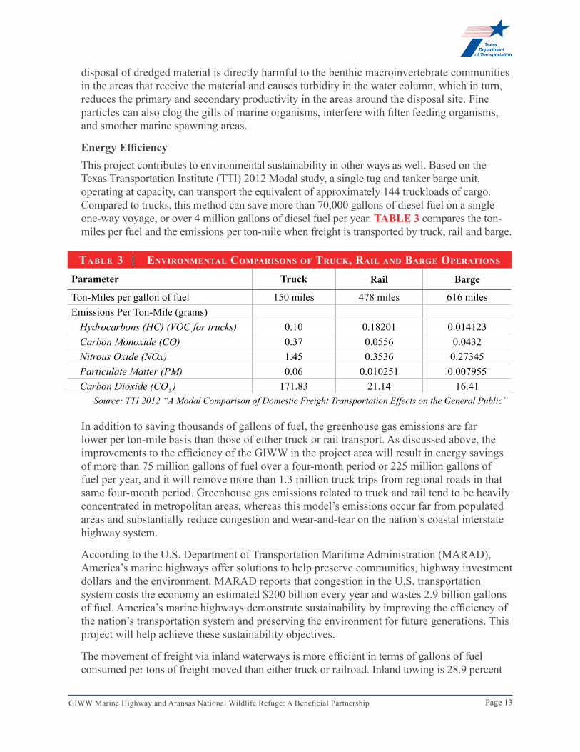
energy efficiencyThis project contributes to environmental sustainability in other ways as well. Based on the Texas Transportation Institute (TTI) 2012 Modal study, a single tug and tanker barge unit, operating at capacity, can transport the equivalent of approximately 144 truckloads of cargo. Compared to trucks, this method can save more than 70,000 gallons of diesel fuel on a single one-way voyage, or over 4 million gallons of diesel fuel per year. TABLe 3 compares the ton-miles per fuel and the emissions per ton-mile when freight is transported by truck, rail and barge.
In addition to saving thousands of gallons of fuel, the greenhouse gas emissions are far lower per ton-mile basis than those of either truck or rail transport. As discussed above, the improvements to the efficiency of the GIWW in the project area will result in energy savings of more than 75 million gallons of fuel over a four-month period or 225 million gallons of fuel per year, and it will remove more than 1.3 million truck trips from regional roads in that same four-month period. Greenhouse gas emissions related to truck and rail tend to be heavily concentrated in metropolitan areas, whereas this model’s emissions occur far from populated areas and substantially reduce congestion and wear-and-tear on the nation’s coastal interstate highway system.
According to the U.S. Department of Transportation Maritime Administration (MARAD), America’s marine highways offer solutions to help preserve communities, highway investment dollars and the environment. MARAD reports that congestion in the U.S. transportation system costs the economy an estimated $200 billion every year and wastes 2.9 billion gallons of fuel. America’s marine highways demonstrate sustainability by improving the efficiency of the nation’s transportation system and preserving the environment for future generations. This project will help achieve these sustainability objectives.
The movement of freight via inland waterways is more efficient in terms of gallons of fuel consumed per tons of freight moved than either truck or railroad. Inland towing is 28.9 percent
tA b l e 3 | environmentAl compArisons of truck, rAil AnD bArge operAtions
Parameter Truck Rail Barge
Ton-Miles per gallon of fuel 150 miles 478 miles 616 milesEmissions Per Ton-Mile (grams)
Source: TTI 2012 “A Modal Comparison of Domestic Freight Transportation Effects on the General Public”
Page 14GIWW Marine Highway and Aransas National Wildlife Refuge: A Beneficial Partnership
more efficient than rail in moving freight and over four times more efficient than trucks21. In 2009, the barge traffic on the GIWW carried the equivalent of over 4 million truck loads and over 8 million truck trips. These barges reduced the number of miles of truck traffic on Texas and U.S. highways by approximately 1.3 billion miles, resulting in a huge savings in energy, increased safety and reduced congestion on the highways, and a substantive reduction in greenhouse gases22.
effects regarding the eagle Ford Shale product movementDevelopment of the Eagle Ford Shale formation in South Texas has been rapid. In 2008, the Eagle Ford Shale formation produced 2 million cubic feet of natural gas per day. By early 2013, the formation was producing 1.8 billion cubic feet of natural gas per day. Similarly, in 2008, the Eagle Ford Shale formation produced 352 barrels of oil per day. By early 2013, the formation was producing 468,000 barrels of oil per day. The GIWW in and around the project area is vital to moving oil, natural gas and petroleum from the production areas in South Texas to the refineries and shipping facilities along the Texas Gulf Coast. By 2016, around 1.1 million barrels of crude oil per day, much of it from the Eagle Ford Shale, will be shipped through the five private liquid terminals at the Port of Corpus Christi23.
effects regarding the efficiency of the operations of the GIWWImprovements to the GIWW will improve energy and operational efficiency directly by reducing the need to light load barges moving along the GIWW. Currently, light-loading of barges greatly reduces the efficiency of barges traversing the GIWW. A 1-foot restriction costs an additional $98 million due to the additional barge trips required to carry the same amount of cargo due to depth restrictions. Much of this cost is the cost of the extra fuel required to push the necessary additional barges. Since approximately 37 percent of the impacted barge traffic on the GIWW occurs on the stretch that will benefit from this project, it is projected that 37 percent of the $98 million or $36 million of the cost impacts occur in this affected stretch of water.
Reducing greenhouse gasesDIRECT:This project will provide dredge placement for dredged material removed from the GIWW in proximity to the area in which the activity occurs. The proximity of these areas will directly reduce greenhouse gases by reducing the amount of fuel required to transport the dredged material to more distant locations or, if adequate dredge material disposal areas were not available, reducing maintenance operations. Without dredge placement areas, the dredging operations necessary for maintenance of the GIWW cannot occur or are reduced in frequency. This means that the GIWW will be maintained at depths shallower than the planned project footprint, causing barges to be light-loaded in order to traverse the affected reaches of the GIWW. The effects of light-loading increases the number of barge trips annually resulting in more trips, increased cost and more greenhouse gas emissions.
This project will also assist in the reduction of emissions by facilitating inland towing along the GIWW. Inland towing has been shown to produce lower emissions than any other mode of vehicular transportation. The 9,323 barges traveling an average trip of 347 miles with a capacity of 1750 tons represent 5.6 billion ton miles24. These same trips would result in the
Page 15GIWW Marine Highway and Aransas National Wildlife Refuge: A Beneficial Partnership
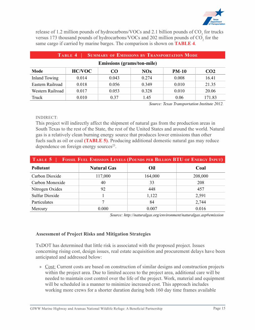
release of 1.2 million pounds of hydrocarbons/VOCs and 2.1 billion pounds of CO2 for trucks versus 173 thousand pounds of hydrocarbons/VOCs and 202 million pounds of CO2 for the same cargo if carried by marine barges. The comparison is shown on TABle 4.
INDIRECT:This project will indirectly affect the shipment of natural gas from the production areas in South Texas to the rest of the State, the rest of the United States and around the world. Natural gas is a relatively clean burning energy source that produces lower emissions than other fuels such as oil or coal (TABLe 5). Producing additional domestic natural gas may reduce dependence on foreign energy sources25.
Assessment of Project Risks and Mitigation Strategies
TxDOT has determined that little risk is associated with the proposed project. Issues concerning rising cost, design issues, real estate acquisition and procurement delays have been anticipated and addressed below:
» Cost: Current costs are based on construction of similar designs and construction projects within the project area. Due to limited access to the project area, additional care will be needed to maintain cost control over the life of the project. Work, material and equipment will be scheduled in a manner to minimize increased cost. This approach includes working more crews for a shorter duration during both 160 day time frames available
tA b l e 5 | fossil fuel emission levels (pounDs per billion btu of energy input)
Page 16GIWW Marine Highway and Aransas National Wildlife Refuge: A Beneficial Partnership
during the grant period by either letting a single large contract specifically designed to be constructed in differing years, or letting multiple contract awards. Procurement specifications can be developed to ascertain the best value to TxDOT by realizing the cost of mobilization, demobilization and the unit pricing of material.
» Design: Due to the advanced state of design and existing environmental coordination efforts, there is currently little concern that the design documents will necessitate large-scale and costly revisions. With a well thought out design stemming from a comprehensive planned approach, the design is likely to be received favorably from the contractor community.
» Real Estate Acquisition: Since this project does not require the purchase of real property, the acquisition of such property is not of concern. However, easements will be required from the Texas GLO on State submerged lands. These easements are generally granted on an expedited basis for environmental restoration projects. We anticipate that this project will represent an expedited schedule favorably.
» Procurement Delays: This project has been developed to represent similar and rather large monetary contract sums. This provides an opportunity to increase the level of interest in the contractor community, especially with contractors who have the resources to self-perform the work. Additionally, since this project will likely be considered a high-profile job founded by a well-thought-out and preplanned design, quality contractors will be more willing to assume additional risk because the project unknowns have been minimized. However, limited access to the project area will require a highly organized approach to the delivery schedule of supplies and equipment. TxDOT will utilize management tools to track supplies, equipment and labor needs for a timely completion of the project.
» Weather: The construction of the project will occur during hurricane season in both 2014 and 2015. The contractor will understand this risk and shall plan accordingly. Should a devastating disaster occur during the construction in either year, there is little mitigation that can be justified if the contractor’s schedule were to be substantially impacted.
» Environmental Risks: Environmental risks associated with the project include the time required to obtain the appropriate permits, specifically Section 10 and Section 404 permits, and the potential for opposition from environmental groups. Prior to applying for a permit to construct breakwaters at ANWR, the team will conduct a pre-application meeting with USACE Galveston District and the Interagency Coordination Team (ICT) for the ANWR. The discussions at this meeting will include citing the Environmental Impact Statement (EIS) and relaying that the proposed construction will be in fulfillment of the USFWS Biological Opinion. At this meeting, input will be requested from the ICT. To counter potential opposition from environmental groups, the project team will elicit the support of staff from the ANWR, as well as the National Oceanic and Atmospheric Administration – National Marine Fisheries Service (NMFS), USFWS, TPWD, USACE and other regulatory agencies. Stakeholder meetings with these agency personnel in support of the project will be held to help garner the support of any environmental groups, or at least reduce opposition. USACE has constructed some of the breakwaters required at ANWR, so any resistance to the proposed activity should be minimal. The whooping crane population is at risk if construction activities occur near nesting sites during the months of October through March each year. TxDOT will not conduct construction activities during this critical time. The schedule (Attachment 3) provides
Page 17GIWW Marine Highway and Aransas National Wildlife Refuge: A Beneficial Partnership
detail of the proposed work period for this project. » Stakeholder Buy-in: TxDOT will coordinate with the ICT and additional stakeholder
groups to conduct public meetings prior to the start of the project. Letters of support, in Attachment 1, have been obtained from various stakeholder groups in an effort to mitigate this issue. The meetings will highlight the benefits of the proposed project to the local GIWW. Participants will be made aware of how the construction of rock breakwater and beneficial use areas will contribute to habitat development for the whooping crane and other marine species. This will benefit local tourism by providing expanded areas for winter whooping crane tours and by increasing opportunities for recreational fishing. The construction of cellular concrete mattresses and levees within identified placement sites will improve navigability of the GIWW through this segment. This decreases the likelihood of accidents that could impact whooping crane habitat. Outreach efforts will likely include, but not be limited to, the following groups:
– USACE Galveston District – National Oceanic and Atmospheric Administration-National Marine Fisheries Service – U.S. Fish and Wildlife Services – Texas General Land Office – Texas Parks and Wildlife Department – Gulf Intracoastal Canal Association – Friends of Aransas & Matagorda Island National Wildlife Refuge – Gulf of Mexico Foundation – Coastal Bend Bays and Estuaries – San Antonio Bay Foundation – Mission Aransas National Estuarine Research Reserve – The Nature Conservancy – International Crane Foundation – Whooping Crane Conservation Association
saFeTy
Safety is of utmost importance to TxDOT. In fact, TxDOT’s mission statement states, “Work with others to provide safe and reliable transportation solutions for Texas.” Maintaining a safe regional transportation system is one of the goals of the agency.
This project will improve safety within the TxDOT multi-modal transportation system. Increasing the transportation of cargo within the GIWW reduces the number of trucks on the roadways. As mentioned earlier, one barge can typically transport the same volume of cargo as 144 trucks. Therefore, each barge using the GIWW reduces the truck traffic on Texas roadways.
According to a recent report submitted to the Texas Legislature26, “The movement of goods by barge is a safe mode of transportation.” This report goes on to state that the spill rate for barges was 53 percent of the rate for railroads and 25 percent of that for trucks. Improving the functionality of the GIWW will decrease the potential for barge accidents through the ANWR, including spills of hazardous materials which could imperil the whooping crane populations.
A 2012 report by TTI compared fatalities and injuries among rail, truck and ship incidences27. Water vessel incidences resulted in significantly lower fatalities and injuries. The American
Page 18GIWW Marine Highway and Aransas National Wildlife Refuge: A Beneficial Partnership
Waterways Operators 2009 Crew Fatalities and Vessel Casualties Report reported only seven fatalities for all commercial vessel operations in the entire Nation. The report also looked at large spills of hazardous materials and found that water vessels again had fewer gallons spilled per million hazardous material ton-miles. In fact, water vessels were the only mode of transportation compared here that had a decline in spills between 2005 and 2009.
This project also provides safety in terms of providing new locations for sites to dispose of dredged materials. By having additional sites to dispose of these materials, the GIWW will continue to be a safe, productive and competitive market place for shipping cargo. Without these new dredged material placement sites, the navigation of the waterway will become more difficult to maneuver, and safety will be negatively impacted. Also, developing the dredged material placement sites provides additional safety on railways and roadways because cargo can be shipped along the GIWW water highway closer to its intended destination, reducing the distance by which goods must travel by road or rail.
ProjecT readINess
The actions outlined for this project have existing NEPA documents, which will be tiered for any required NEPA. Visit www.txdot.gov and search keywords ‘tiger grant application’ for more information. As the local sponsor for the GIWW, TxDOT will be required to obtain appropriate permits from USACE. However, based on the extensive environmental compliance already in place, USACE is of the opinion that needed permits can be issued in the requisite time frame.
Technical FeasibilityUSACE has extensively studied the creation of beneficial use sites within the ANWR. Through environmental coordination for the final EIS and design-related activities for the final Feasibility Report (FFR), a solid design basis, preliminary design and cost estimates have been developed. Plans and specifications at the 65-percent completion level have been developed and can readily be taken to 100 percent. Initial geotechnical data collection and analysis has been performed and a design basis is available from the feasibility study. Similar designs have been designed and constructed throughout the region, including a recently awarded project of similar nature within ANWR. This is a “tried and true” design, and no significant deviations from the 65-percent design are expected.
Financial FeasibilityTxDOT has developed a preliminary budget based on a review of similar current projects underway in the GIWW and a review of the preliminary design criteria. The preliminary budget addresses all project components and addresses mitigation strategies, such as conducting outreach activities prior to construction. Other budget considerations include requirement to mobilize and demobilize for each limited construction timeframe, which is based on nesting habits of the endangered whooping crane.
A detailed preliminary budget can be found in Attachment 4
Project ScheduleThe project schedule complies with U.S. DOT’s requirement that the TIGER V funding must be obligated by September 30, 2014. The sites for the rock breakwaters, cells and beneficial
Page 19GIWW Marine Highway and Aransas National Wildlife Refuge: A Beneficial Partnership
use areas have been identified. Progression of existing design analysis and development of design documents for these components will initiate immediately following the grant award, which is assumed to begin August 1, 2013. The design is anticipated to take four months.
» This project does not require acquisition of land and will not experience any delays due to land acquisition issues.
» Approximately two months into design, the engineer will begin the design document preparation. This step is expected to require five months and will begin two months after the grant is awarded.
» Outreach activities are anticipated to be within 60 days of the signing of the grant award and continue through the first two months of construction.
» Permitting is anticipated to be completed by June 1, 2014. » Review of plans, specs and estimates will be conducted prior to release of bid documents. » The bidding process will begin upon completion of the design documents. The bidding
process is expected to take two months to advertise, accept, review and award bids. This process is anticipated to be completed by April 30, 2014. Notification of forthcoming project opportunities will be made available to the contracting community in advance of completion of design documents.
» The construction of the project will begin immediately after selecting the contractor. Primary construction activity within the ANWR is limited to April 1 through September 30 due to nesting of the whooping crane. TxDOT will execute construction activities during these months during 2014 and 2015. Completion of the project due to this limited work schedule can be accomplished with a single contractor (with multiple crews) or by procuring multiple contracts/contractors.
A proposed project schedule is included in Attachment 3
seconDAry selection criteriA
INNovaTIoN
TxDOT is confident that the agency’s strategic resolve in focusing on the health of the GIWW through the ANWR is a testament of our innovative approach to problem solving. By focusing our efforts on high yielding target areas that strengthen the viability of the entire Texas marine highway and leveraging the positive environmental impacts to the system for the long term, TxDOT is proposing a proactive approach. By developing and preparing the lands to receive future dredged material placement, future costs associated with dewatering and uncertainty of placement locations will be minimized, thus likely reducing project costs for the USACE in the future. Utilization of the GIWW in this segment will be restricted without continued regular maintenance. Creation of placement sites with the construction of cellular concrete mattresses and levees within designated sites will ensure the functionality of this segment of the GIWW. Increasing the navigability and functionality of this portion of the GIWW provides the possibility for increased utilization of the entire GIWW throughout the coast of Texas.
TxDOT’s approach to increasing the functionality and environmental health of the GIWW illustrates an innovative approach to increasing sustainability of endangered species within the
Page 20GIWW Marine Highway and Aransas National Wildlife Refuge: A Beneficial Partnership
ANWR while maintaining the utility of the GIWW within this habitat. Traditionally, activities in a national wildlife refuge have been considered as potential hazards to threatened and endangered species such as the whooping crane. However, this project will increase habitat for the whooping crane and other threatened wildlife through construction of rock breakwater and beneficial use areas. Additionally, environmental compliance allows for continued maintenance of this vital segment of the GIWW. The project maximizes actions to impact the marine highway through Texas by concentrating efforts in the ANWR.
ParTNershIP
Jurisdictional Stakeholder Collaboration Plans for this project were initially developed by the USACE in the mid-1990s. An EIS was developed, as was a 50-year DMMP, which outlined a schedule for and additional definition of site development within identified placement sites. The EIS and DMMP were subject to public review. The long-term project is continuously reviewed by an ICT, which includes federal and state resource agencies. Participants include representatives from:
» Coastal Bend Bay and Estuary Program » National Oceanic and Atmosphere Agency – National Marine Fisheries Service » Texas Commission on Environmental Quality » Texas Department of Transportation » Texas General Land Office » Texas Parks and Wildlife Department » Texas Water Development Board » U.S. Army Corps of Engineers » U.S. Environmental Protection Agency » U.S. Fish and Wildlife Service
Meetings of this group are open to the public and are subject to the Open Meetings Act.
Disciplinary IntegrationTxDOT routinely coordinates with various non-profit and special interest groups throughout the State. USACE is in support of this project. In addition to ports and related facilities, TxDOT has support for this project from various regional planning organizations and commercial users, including Eagle Ford Field Services Group and Geosouthern Energy Corporation. TxDOT also coordinates with GLO and Texas Commission on Environmental Quality regarding activities in the GIWW or the ANWR.
Letters of support can be found in Attachment 1
Page 21GIWW Marine Highway and Aransas National Wildlife Refuge: A Beneficial Partnership
benefit-cost AnAlysis
INTrodUcTIoN
The Benefit-Cost Analysis (BCA) for this project provides a breakdown of project costs and benefits over a 20-year project life. The benefits that have been estimated for this project have been categorized by the long-term outcomes specified in the Selection Criteria section of the Notice of Funding Availability, and a conservative approach has been taken in all cases where judgment was used in estimating the extent of benefits.
The Benefit-Cost Analysis of this project is available as Attachment 5
beNeFIT-cosT aNalysIs sUmmary
As described in the previous sections of this application, this project will ensure USACE’s ability to maintain the design capacity of the Texas portion of the GIWW by creating capacity for dredged material.
For the purposes of the quantitative BCA, the cost of diversion of freight traffic from the current inland waterway to other modes (ocean and over the land modes) will contribute most directly to quantifiable project benefits. However, the other elements of the overall project offer benefits that are less directly quantifiable. The continuation of the current state of the project area, with the ongoing deterioration of waterway and loss of depth, is considered the baseline, or “without project condition.” The full implementation of the project, as described, is considered the “with-project” condition.
Shippers served by the GIWW will face higher freight costs for transporting if dredging capacity is not improved. Other modes of transportation will most likely be utilized, thus increasing cost to shippers. These freight savings for shippers are an economic benefit resulting from the construction of cells for dredged material, beneficial use areas and the rock breakwater. These freight savings (mainly in raw material) will reduce the costs of the U.S.-produced products and make them more competitive in the global market.
By providing a feasible access to inland barges, the with-project condition avoids the diversion of cargo to over-the-land modes, such as truck or rail, and consequently avoids the increase in the number of truck loads on the regional highways. This will prevent the increase of the number of vehicle-miles-travelled (VMT) by heavy trucks on the nation’s highway system and provide economic benefits in terms of avoidance in congestion, accidents, noise, pavement wear, health impacts from criteria pollutant emissions and green-house gas emissions, while also avoiding the increase in the fuel imports. The avoidance of increase in the truck VMT will also prevent the increase in the demand for imported oil, thereby contributing to improved U.S. economic performance.
The total development cost of this project is estimated at $46,500,000. A TIGER V grant of $43.5 million is sought. For the BCA analysis, the full project cost is used in computing the BC ratio, as specified in the Federal Register guidance. No additional operations and maintenance costs have been added to the project development cost.
Page 22GIWW Marine Highway and Aransas National Wildlife Refuge: A Beneficial Partnership
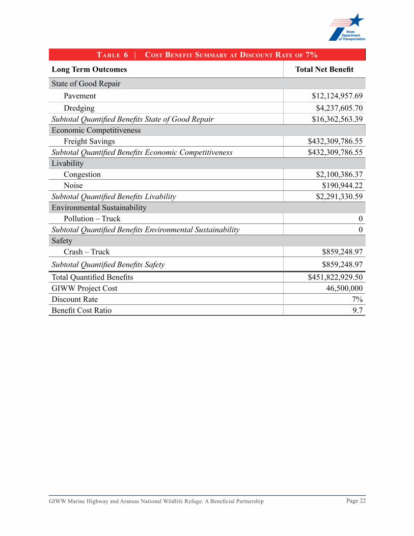
tA b l e 6 | cost benefit summAry At Discount rAte of 7%
Long Term Outcomes Total Net Benefit
State of Good RepairPavement $12,124,957.69 Dredging $4,237,605.70
Subtotal Quantified Benefits State of Good Repair $16,362,563.39 Economic Competitiveness
tA b l e 8 | giww – gAlveston to corpus christi volume summAry
Direction Volumes 1,000 tons (2011)
Inbound Receiving 442
Outbound Shipping 1,057
Thru 24,064
Local 0
Total 25,563
Page 24GIWW Marine Highway and Aransas National Wildlife Refuge: A Beneficial Partnership
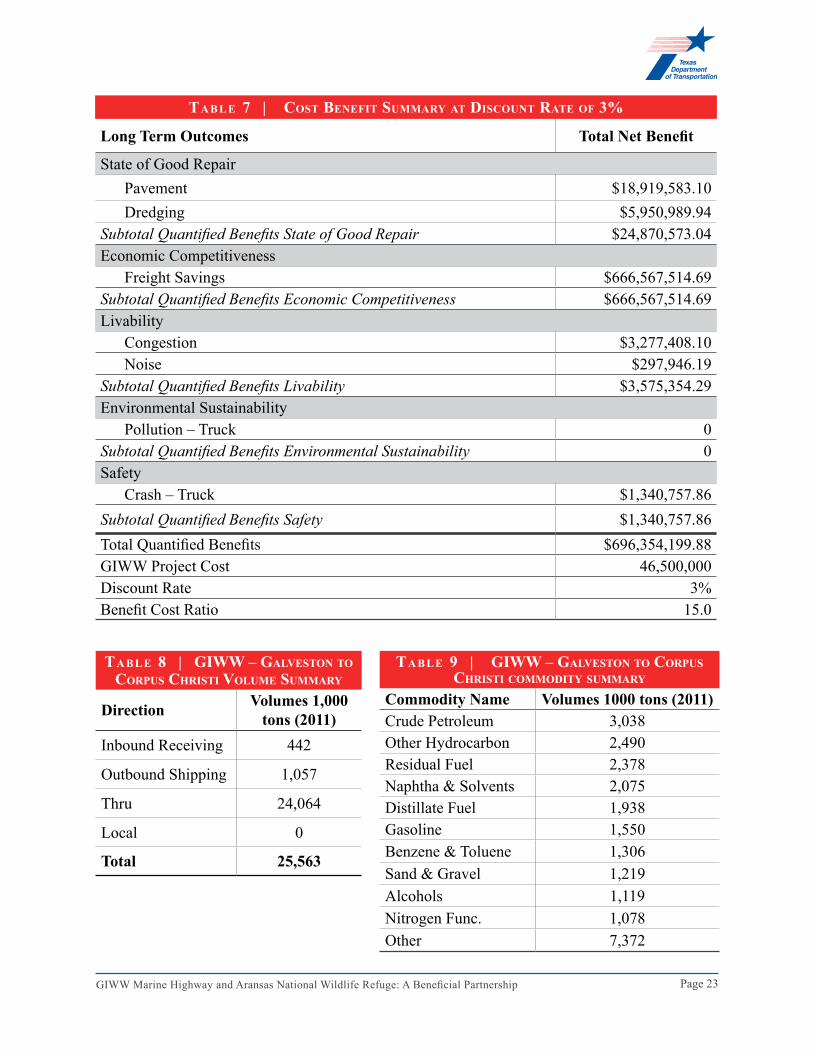
TABLe 6 and TABLe 7 (see pages 22-23) summarize the results of the BCA for a 7-percent and 3-percent discount rate respectively, while the following sections describe the methodology, and the basis of assumptions, including reference to sources, for the development of the BCA. These tables, developed using Veslink Software, can also be found in Attachment 5.
assUmPTIoNs aNd meThodoloGy
Avoiding Freight DiversionAccording to USACE, GIWW – Galveston to Corpus Christi freight volumes in 2011 were equal to 25.5 million tons where most of these commodities were liquid in nature. See TABle 8 and TABle 9 on page 23 for volume and commodity summaries.
The length of the Galveston to Corpus Christi segment of the waterway is equal to 200 miles and if the waterway becomes inaccessible by inland barges due to failure of maintenance, alternate modes of transport will be sought. The rail, truck and ocean distance of Houston to Corpus Christi (which are considered as alternate modes) are equal to 229 miles, 330 miles and 245 nautical miles respectively.
With fewer placement options there is an increasing potential for the GIWW to lose functionality. As the channel becomes shallower and is shoaled in, there will be decrease in the use of the channel. Barges will continue to use the GIWW, although they will have to operate lighter than their design weight. Under these conditions, transportation through the GIWW will eventually lead to a loss of market share for inland barges. The analysis indicates that inland barges will lose up to 50 percent of their market to alternate modes of transportation by 2018. Without completion of the proposed project, the inland barge will continue to lose market share as the GIWW becomes shallower and less navigable.
Benefit Based on Retaining Barge TrafficAside from the lower distances, other modes have higher per ton transportation costs between Houston and Corpus Christi28. Based on USACE publication on operating costs of shallow draft vessels, it has been estimated the per ton transportation cost of the ton freight between Houston and Corpus Christi using the inland barge be equal to $4.67/ton where on the average 3,759 tons of liquid cargo is being carried by the barge. The per ton transportation costs of alternates modes are estimated as:
These diversions will increase the average per ton transportation cost of $4.67/ton in 2013 to $6.89/ton in 2033. This increase in the transportation cost, coupled with increase in volumes, will impose an additional transportation cost of $14.4 million to society in 2015 and will continue to increase to $31.8 million by 2033.
Page 25GIWW Marine Highway and Aransas National Wildlife Refuge: A Beneficial Partnership
Benefits Based on the Reduction in Dredging CostsIn addition to cost savings resulting from the avoidance in freight diversions, this marine highway project will avoid the increase of the dredging cost from its current estimated $400,000 per year to $800,000. This doubles the life of this segment of the GIWW without increasing annual dredging cost in the project area.
bUIld versUs No-bUIld sceNarIos
Without the construction of this project, entire industry segments will be forced to transport product in numerous trucks across long distances. The additional truck miles traveled will result in higher cost to the shipper and ultimately to the consumer of these products.
USACE is required to develop placement sites for beneficial use and to maintain existing placement sites. The actions presented in this document can only be accomplished by TxDOT with some other form of federal funding. Without federal funding assistance, USACE will have difficulties maintaining the depths of the GIWW due to lack of capacity at existing placement sites. This could occur by the year 2033 without action. The construction of rock breakwater and additional placement sites for beneficial use was first outlined in 1999 NEPA documents for USACE. Continued development of the site over a multi-year period was outlined in the DMMP for the project site. If no action is taken, USACE runs the risk of failing to comply with current plans and the terms of the USFWS Biological Opinion. Delays could result in a loss of marshland from erosion, including new marsh, which would be created from beneficial use of the dredged materials. Such a loss could result in loss of habitat for protected species located in the nearby ANWR, which was the primary intent of the Biological Opinion for operation of the GIWW through ANWR.
The following diversion scenario is assumed to take place in “no-build case”:
• The channel depth will reduce from its current 9 to 6 feet by 2033• Once the channel reaches the depth of 6 feet no traffic can go through it• Between 2013 and 2033 inland barges will continue using the channel but they will
operate lighter than their design weight (even lighter than they are previously operating)• Operating under lighter than designed conditions will increase the transportation cost of
the inland barge and make it less desirable compared to the ocean going barge• This increase in the transportation cost will lead to the loss of market share for inland
barges• It is assumed that by 2018 inland barges will lose 50 percent of their market to alternate
modes of transportation (in 2018 transportation costs of inland barge and ocean going barge are almost equal)
• Barge traffic would be reduced from more than 59,000 barge loads per year to less than 30,000 barge loads per year in 2018
• Inland barge will continue to lose 100% of its market share through 2033, if the GIWW continues current levels of dredging.
Page 26GIWW Marine Highway and Aransas National Wildlife Refuge: A Beneficial Partnership
V. PlANNING APPRoVAlS, NePA AND oTHeR eNVIRoNMeNTAl ReVIeWS/APPRoVAlS
This TxDOT project has been a viable need for the continued functionality of the GIWW since the early 1990s. USACE has provided environmental and permitting planning, including the development of an EIS and a 50-year plan for the construction and maintenance of placement areas for the Aransas Pass area in the form of a DMMP. The DMMP identifies locations for the construction of placement areas and rock breakwater. TxDOT will coordinate all activities with USACE and existing plans. Consultation with the USACE Galveston District confirms that the project, as outlined here, is part of on-going activity developed for the 50-year DMMP which outlines the development of beneficial use areas. As the local sponsor, TxDOT will require appropriate permits from USACE to perform project construction. However, the regulatory action will draw upon the extensive environmental documentation and coordination in place and can be expected to be accomplished within the required timeframe for the TIGER V grant (see the tentative project schedule in Attachment 3.)
Additional information regarding NEPA and permitting requirements can be found in the Environmental Information Document, Attachment 6
nAtionAl environmentAl policy Act
NePa sTaTUs
The proposed activity was included in the 1995 Gulf Intracoastal Waterway – Aransas National Wildlife Refuge, Texas Feasibility Report and Final Environmental Impact Statement. The proposed projects are included in this EIS and are part of a 50-year dredged material disposal plan. The beneficial use areas are part of the mitigation discussed in the document for impacts to critical habitat within the ANWR. Include the link to the NEPA document on TxDOT’s website.
addITIoNal sTUdIes
No additional environmental studies are anticipated. Environmental issues have been studied and evaluated as part of the EIS and Record of Decision authorizing this project. Local, state and federal agencies were consulted and consensus reached on environmental issues. Some additional agency coordination may be required to confirm that details of the proposed construction will be in fulfillment of the USFWS Biological Opinion.
legislAtive ApprovAl
TxDOT was designated as the non-federal sponsor of the GIWW in the 1975 Texas Coastal Waterway Act. TxDOT also works with the Texas GLO Coastal Management Program to protect navigation and promote marine transportation. No additional legislative actions are required.
stAte AnD locAl plAnning
The Texas Statewide Long-Range Transportation Plan 2035 (SLRT-2035) identifies the GIWW as a major transportation resource. The plan identified 21 major Texas ports and their status for deep draft, fishing or barge traffic. Six of these ports were identified as primarily utilized for
Page 27GIWW Marine Highway and Aransas National Wildlife Refuge: A Beneficial Partnership
barge traffic although all ports along the GIWW, including fishing ports and ports with deep draft capability, utilize the GIWW. The proposed project complies with the strategic goals established in the SLRT-2035 (1) the need to enhance safety for all Texas transportation system users, (2) enhance system connectivity, (3) promote congestion relief strategies and (4) maintain the existing Texas transportation system. This project addresses safety enhancement, promotes congestion relief strategies and enhances system connectivity.
The GIWW marine highway annually moves more than 100 million tons of cargo29. TxDOT, as the non-federal sponsor, works cooperatively with the USACE to plan, maintain, research and improve the GIWW marine highway. The project is the center piece of the DMMP which has been developed with extensive coordination between state and local stakeholders.
Additional planning for the marine infrastructure has been developed by the GLO in compliance with the Texas Coastal Management Plan and regional plans ranging from collaboration with the Coastal Bend Bay and Estuary Program to assisting with the Port Aransas High School’s Coastal Monitoring program. The TCEQ also provides water quality planning including development of the San Antonio Bay Water Quality Plan. TPWD partners with several agencies and local organizations for the preservation of the ANWR. The ANWR is managed by the USFWS.
VI. feDeRAl WAGe RATe CeRTIfICATIoN
TxDOT has completed a Federal Wage Rate Certification complying with Subchapter IV of Chapter 31 of Title 40 of the United States Code that is provided in Attachment 7
Page 28GIWW Marine Highway and Aransas National Wildlife Refuge: A Beneficial Partnership
SoURCeS1 U.S. Waterway System Transportation Facts & Information, Navigation Data Center, November 2011.2 Texas Rail Road Commission, Eagle Ford Shale Task Force Report, March 2013.3 http://eaglefordshaleblog.com/2011/08/25/future-of-eagle-ford-shale-well-spacing/4 http://www.tpwd.state.tx.us/landwater/water/conservation/txgems/anwr/index.phtml5 USACE Galveston District, Gulf Intracoastal Waterway, Texas Turnstake Island to Sundown Bay in Aransas
and Calhoun Counties, February 2001.6 USACE, Texas Shallow-Draft Navigation Channel Benefits, March 13 2013.7 Texas Transportation Institute in cooperation with National Waterways Foundation, A Modal Comparison of
Domestic Freight Transportation Effects on the General Public: 2001-2009, February 2012. 8 http://ftp.dot.state.tx.us/pub/txdot-info/trf/crash_statistics/2011/11_2011.pdf9 http://www.rita.dot.gov/bts/publications/national_transportation_atlas_database in 201110 Texas Transportation Institute, Preparing Texas Land and Sea, November 2012.11 Texas Department of Transportation, 2013 Educational Series: Energy Sector, 2013.12 USACE, Gulf Intracoastal Waterway – Value to the Nation presentation by Joe Hrametz, P.E., May 10, 2013.13 USACE, Gulf Intracoastal Waterway – Value to the Nation presentation by Joe Hrametz, P.E., May 10, 2013.14 http://hepgis.fhwa.dot.gov/hepgismaps11/#15 U.S. DOT Federal Highway Administration and Boston University Center for Transportation Studies,
JOBMOD2.1: A Comprehensive Model for Estimation Employment Generation from Federal-Aid Highway Projects, July 2006.
16 USACE, Gulf Intracoastal Waterway – Value to the Nation presentation by Joe Hrametz, P.E., May 10, 2013.17 Texas Transportation Institute, Technical Memorandum SPR Project Number 0-5538, The Value of Texas
Seaports in an Environment of Increasing Global Trade, Task 6: Channel Siltation and National Economic Development Benefits of Maintaining Authorized Depths, November 2006.
18 http://www.tpwd.state.tx.us/landwater/water/conservation/txgems/anwr/index.phtml19 http://ceds.yontrack.com/CBCOG/Hospitality-Industry20 Texas Transportation Institute in cooperation with National Waterways Foundation, A Modal Comparison of
Domestic Freight Transportation Effects on the General Public: 2001-2009, February 2012.21 Texas Transportation Institute in cooperation with National Waterways Foundation, A Modal Comparison of
Domestic Freight Transportation Effects on the General Public: 2001-2009, February 2012.22 http://www.rrc.state.tx.us/eagleford/EagleFordGWGProduction.pdf. http://www.rrc.state.tx.us/eagleford/
EagleFordOilProduction.pdf23 Texas Transportation Institute in cooperation with National Waterways Foundation, A Modal Comparison of
Domestic Freight Transportation Effects on the General Public: 2001-2009, February 2012. 24 http://www.rrc.state.tx.us/eagleford/index.php25 Texas Department of Transportation, Gulf Intracoastal Waterway, Legislative Report – 83rd Legislature,
December 2012.26 Texas Transportation Institute in cooperation with National Waterways Foundation, A Modal Comparison of
Domestic Freight Transportation Effects on the General Public: 2001-2009, February 2012.27 USACE, Gulf Intracoastal Waterway – Aransas National Wildlife Refuge Feasibility Report and Final
Environmental Impact Statement, Volumes 1 and 2, November 1995.28 http://planning.usace.army.mil/toolbox/library/EGMs/egm05-06.pdf29 USACE, Gulf Intracoastal Waterway – Aransas National Wildlife Refuge Feasibility Report and Final
Environmental Impact Statement, Volumes 1 and 2, November 1995.