GLACIAL GEOLOGY AND HISTORY OF THE NORTHERN HUDSON BASIN , NEW YORK AND VERMONT DAVID J. DE S IMONE Department of Geology, Rensselaer Polytechnic Institute Troy , New York 12 180-3590 ROBERT G. LA FLEUR Department of Geology, Rensselaer Polytechnic Institute Troy, New York 12180-3590 REGIONAL DEGLACIATION Twelve recessional ice fronts are reconstructed in the northern Hud- son basin (figure 1) from field work (LaFleur , private f iles; DeSimone 1977, 1985) and reinterpretation of existing data (Chadwick 1928; Stewart and MacClintock 1969 , 1 970; Connally 1 973) . Five additional ice fronts , A through E on figure 1 , were modified from LaFleur (1965a, 1979) and Dineen et al (1983) and are included in a suary chart of deglacial e- vents (figure 2) . Lowland Lake Levels and Transitions Tilted water planes identify six significant intervals of water level stability punctuated by intervals of fall ing water level (figure 3) . The six stable water levels are: Lake Albany , Lake Quaker Springs, Lake Coveville, Fort Ann I , Fort Ann I I, and Fort Ann III. The data also support a distinct lowered Albany water level which may have been stable for a short time . The Albany, Quaker Springs, and Coveville water planes are clearly curved and asymptotic southward. The flat Fort Ann water planes probably represent only the most distal portions of similarly curved water planes originating in the northern Champlain Lowland . The low gradients of the Quaker Springs and Coveville water planes are ap- propriate f or the distal portions measured . The gradients of the Al- bany and lowered Albany water planes are 2 . 6 ft/mi and 2 . 7 ft/mi, re- spectively. This compares favorably with tilts calculated by Fair- child (19 17) at 2.4 ft/mi, by Stoller (1922) at 2 .5 ft/mi, and by LaFleur (1965b) at 2.7 ft/mi. The retreating Hudson Lobe defended Lake Albany through ice position 5. Clay deposited at 380-390 f t near Greenwich and the Greenwich out- wash fan at 400 ft record there the maximum level of Lake Albany. A falling or lowered Lake Albany accompanied the retreat ing ice from position 5 through position 6 to position 7 while sediment was contin- uously deposited at the mouth of the Batten Kill. The Hudson Lobe defended a stable Lake Quaker Springs from position 7 through posi- tion 12 and into the Champlain Lowland. Fluvial-lacustrine sand de- posited at tributary mouths , river terraces, terraced clay , and delta morphology delineated the Coveville and Fort Ann water levels, detailed later in the text . 82
Transcript
GLACIAL GEOLOGY AND HISTORY OF THE NORTHERN HUDSON BASIN , NEW YORK AND VERMONT
DAVID J . DE S IMONE Department of Geology , Rensselaer Polytechnic Institute
Troy , New York 12180-3590
ROBERT G. LA FLEUR Department of Geology , Rensselaer Polytechnic Institute
Troy , New York 12180-3590
REGIONAL DEGLACIATION
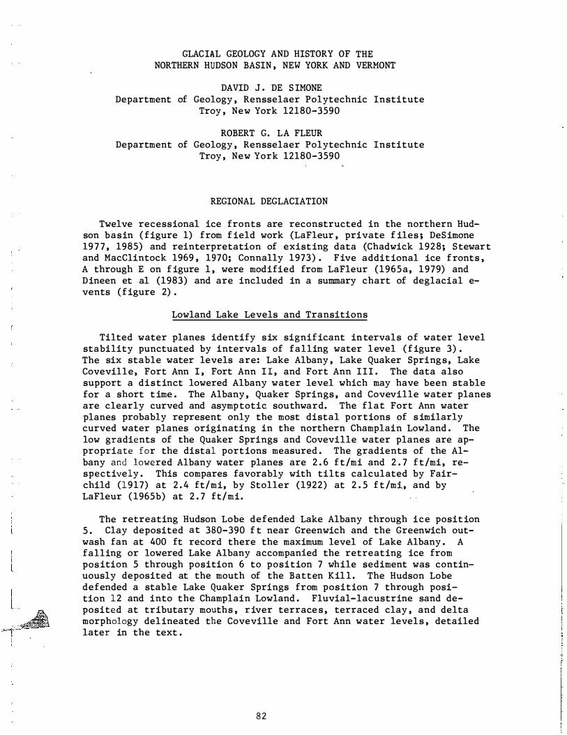
Twelve recessional ice fronts are reconstructed in the northern Hudson basin ( figure 1) from f ield work (LaFleur , private f iles ; DeSimone 19 7 7 , 1985) and reinterpretation of existing data (Chadwick 1928; Stewart and MacClintock 1969 , 1970; Connally 1973) . Five additional ice fronts , A through E on f igure 1 , were modified from LaFleur (1965a, 1979) and Dineen et al (1983) and are included in a summary chart of deglacial events (figure 2) .
Lowland Lake Levels and Transitions
Tilted water planes identify six significant intervals of water level stability punctuated by intervals of falling water level ( f igure 3) . The six stable water levels are: Lake Albany , Lake Quaker Springs, Lake Coveville, Fort Ann I , Fort Ann I I , and Fort Ann III . The data also support a distinct lowered Albany water level which may have been stable for a short t ime . The Albany , Quaker Springs , and Coveville water planes are clearly curved and asymptotic southward. The flat Fort Ann water planes probably represent only the most distal portions of s imilarly curved water planes originating in the northern Champlain Lowland . The low gradients of the Quaker Springs and Coveville water planes are appropriate for the distal portions measured . The gradients of the Albany and lowered Albany water planes are 2 . 6 ft/mi and 2 . 7 ft/mi, respectively . This compares favorably with tilts calculated by Fair-child (1917) at 2 . 4 ft/mi, by Stoller (1922) at 2 . 5 f t /mi, and by LaFleur ( 1965b) at 2 . 7 ft/mi.
The retreating Hudson Lobe defended Lake Albany through ice position 5 . Clay deposited at 380-390 f t near Greenwich and the Greenwich outwash fan at 400 ft record there the maximum level of Lake Albany . A falling or lowered Lake Albany accompanied the retreating ice from position 5 through position 6 to position 7 while sediment was continuously deposited at the mouth of the Batten Kil l . The Hudson Lobe defended a stable Lake Quaker Springs from position 7 through position 12 and into the Champlain Lowland . Fluvial-lacustrine sand deposited at tributary mouths , river terrace s , terraced clay , and delta morphology delineated the Coveville and Fort Ann water levels , detailed later in the text .
82
Figure 1 : Retreatal ice margins in the northern Hudson basin. is reduced to 76� from a 1 : 500, 000 base map .
83
Scale
! '
i I b--7
CXl _,_
TIME-STAAT
UNITS
MACKINAW
INTER-
STADIAL
-
PORT
BRUCE
STADIAL
-- -----
APPRO X YRS BP
13 700
J_�JOO?
LAKE
LEVEL
Q s u p A R K I E N
G R s L A 0 L
B w A E N R y
A
L
B
A
N
y
KM-1Came Moraine K"'f't(ame Terrace KDiXa•e D- i ICE MARGINS SIGNIFICANT EVENTS K llf' kamlc a and I gravel ..... ...
OW Outwaah SF' Subaqueous Ka- Fan --·
Welch Holow (12) Welch Hollow KM KT · Lake Granville 4 2 0 1 • Mettawee & Poultn�_ OW So . Granville t ill & Ksg 600 ' ; Blossoms Corners moraine (Vt) ; Lake
West Pawlet (1 1 ) Pawl et outlet to Black valley
Argyle Valley (10) Argyle esker 3 3 0 ' & KD 320 ' ; minor ice surge; Tamarack Swamp Ksg ; B lack valley kames & esker s ; Lake Pawlet 7 00 ' with ice at Pawlet Glens Falls Delta & matured Batten Kill Delta ; Valley Crossroads SF
Danby (9) 260 ' ; Danby Four Corners moraine (Vt) Early Glens Falls Delta 320 ' ; Patten Mills KT ; Harper Road SF 270 ' ;
Harper Road (8) Barkley Pond kames_.i. Lake Cossay_una Lake Albany fell to 310 ' Lake Quaker Spring s ; Batten Kill Delta 310 ' ;
Black Valley (7) Hoosic Delta 3 00 ' · Black valley moraine· Patten Mills KT Lowered Lake Albany 340 ' ; Greenwich OW; local Batten Kill valley impond-
Carter Swamp (6) ment s ; Hoosic terraces 320 ' -330 ' ; Hudson 380 ' Delta; Glen Lake IB ; Carter Swamp KM; Manchester moraine (Vt) · Lake Sunnys ide KM
MorelllrCiark Pond (5) Greenwich OW FAN 400 ' ; Clark Pond KM; Eldridge Swamp IB; Camden valley KT ' s ; Palmertown KT 4 60 ' to Moreau Pond KM 4 20 ' · Glen Lake Sta_gnat ion
Archdale KM; Arlington moraine (Vt) ; Hoosic Delta 360-370 ' ; Hoo s ic & Archdai&-Comth (3) Round Lake IB ' s ; Woodland Lake KM (Corinth ice) ; Lake Corinth 670 ' ;
Hidden Valley moraine & local impondments of Lake Warrensburg Willow Glen & Country Knolls KD ' s 350 ' ; early Hoos ic Delta 3 7 0 ' ; Hale
Willow Glen (2) Mt moraine (Vt) ; Cor inth ic e @ Porter Corner s ; Lake Sacandaga 7 60 ' ; Milton Delta 420 ' · Ballston IB Waterford SF 200 ' ; Halfmoon & Grooms KD ' s 340 ' ; Hoosic t erraces & OW
Waterford (1) 420-390 ' ; North Hoosick moraine & Lake Hoo s ic ; The Notch & Chestnut Woods Channel s ; Niskayuna IB ; Lake Sacandaga expands to Batchelorvill e ; Clifton Park t ill_.i. Schenecta<iy_ Delta Schen . & Scotia esker s ; ice @ Schen . druml ins; Pollock Rd KD 300+ ' ;
Niskayuna (A) Poest enkill Delta 320-330 ' ; S peigletown-Melrose KT 400 ' ; Lake Tomhannoc� ice @ Nipmoose Hill & W. Hoosick· Hoosick Falls KM & Lake Hoo s ic
Guilderland (B) Gu ilderland KT 350 ' ; McKnownville t il l ; Loudonville Kame Complex 350-390 ' · Rensselaer SF 300 ' · North Greenbush KT 380 ' · Sycaway KT 400 ' ·
Meadowdale (C) Meadowdale moraine 4 00 ' ; Voorheesville KD 350 ' ; Wempl e SF 140 ' ; Hampton SF 300 ' · Wynant skill-Pine Bowl -Po est enkill K<>z 4 50 '
Schodack (D) East Greenbush Schodack KT 350 ' ; Schodack OW Fan 3 20 ' ; West Sand Lake-Burden. Lake Ksg 600 ' · New Salem K� & OW 4 50 '
Pine Swamp (E) Pine Swamp Nassau Lake Ksg & OW 500 ' ; Sand Lake-Glass Lake Ksg & OW BOO ' ; Snake Hill OW 850 ' ; Ives Corner Ksg & OW 900 '
Figure 2. Summary of ice retreat events in the northern Hudson basin
Lake level transitions - intervals of falling water level - were either gradual or rap id . Continuous· sedimentation of the Greenwich outwash fan from 400 ft to 340 f t and the absence of erosional escarpments or dissection features in the northern Hudson Lowland are evidence for a slowly falling Albany water level . Rudimentary calculations using ice retreat rates of 500-1000 ft/yr (Schafer 19 68) suggest an average water decline of 2 ft/yr as the Hudson Lobe retreated from the MoreauClark Pond ice margin to the Black Valley ice margin, a distance of approximately 6 miles as measured on the Schuylerville quadrangle .
There is considerable evidence that the Quaker Springs-Coveville and Coveville-Fort Ann I transitions were initiated by high discharge through the glacial Mohawk Valley and eastern outlet channels , which resulted from water level fluctuations in the Ontario Lowland ( Stoller 1922, LaFleur 1975, 1979 , 1983 , Hanson 1977) . Extensive erosion in the lower Fish Creek valley from Grangerville to Coveville indicates the Grangerville channel carried high discharge during the Coveville-Fort Ann I transition (DeSimone 1 9 7 7 , p35) . The channel topography is strongly fluted in the southeastward flow direction ; lake clay· remnants are preserved in the shadows of eroded drumlins ; and till and bedrock were scoured from 240-200 f t above Coveville .
Clark and Karrow (1984) · correlated falling water levels in the Ontar-io and S t . Lawrence Lowlands (lower Iroquois and post-Iroquois) with drainage around Covey Hill into Lake Fort Ann in the northern Champlain Lowland . This inflow to Lake Fort Ann increased outflow from the southern end of the Champlain Lowland along three Fort Ann channels (Fort Edward , Durkeetown , Winchell) . Accompanying erosion deepened these outlet channels until the water level stabilized at a lower elevation. Accordingly, the Fort Ann I-Fort Ann II transition is correlated with Clark and Karrow ' s Level II-Level III transition and the Fort Ann II-Fort Ann III transition is correlated with their Level III-Level IV transition. The f inal Fort Ann III-Champlain Sea transition, Clark and Karrow ' s Level TVLevel V transition , resulted in abandonment of the Fort Ann channels and establishment of a late glacial-Holocene drainage configuration in the northern Hudson Lowland .
T iming and Rate of Retreat
Hanson (1977) noted a northward sediment volume decrease in kame deltas , which might suggest an increased melting rate of the Hudson Lobe as it retreated northward . Ice Margins E through 6 ( figure 1) are generally well-represented by kame deltas , kame moraines , and kame terraces deposited along the margin of the Hudson Lob e . Kame moraines , kame terraces , and thick outwash sequences accurately delineate these ice margins in the Taconic Highlands . A late Port Bruce age is inferred for these events (LaFleur 1979) .
Ice margins 7 through 1 2 , with the exception of the Argyle Valley ice margin (10) , record accelerated retreat. Thinner outwash sequences with less kamic sediment in the Taconic Highlands , and a general absence of significant ice-marginal sediment along the Hudson Lobe is consistent
85
' � --
l . ,. i l .
[
00 "'
,-------�
7 '/z. - fVt tNUTE G. u A D RfHJ GLE S QUAkER' SP& 5 COSSAYUNA GLENS FALLS
Mf:CHANI C..VIll.E SARilT06-A SP&S. FOP.T M I L LER . . ···. HRRTFOP..D . FORT A N N THORN HILL lscHAGHii C.DKE.. I scuu YLEilVILLE. I 61lNSEVOORT tHuosoN FAttsJ GIMNVILLE. I WIIITE./IALL l PUTNAM
.500
..... l'v � "' vo' 0
450
� � ln
� <:>" "'
...!>. w o" v.
LATI TUDE--" w -· 0
...... . ' w � In
...!>. w 1\," 0
P�rowN �EEJJSQvR.y
� 400 ,, /l.�lLT'!lN z.f> Ft{"'i MMEAU
D!STAIJCE. S. 7 Mi � ....,._ ...!>. -A. '-<l w w M <.v" c.J' Vi <::> v.
rn A tJI.KE. /1. LI6A ,.y -,� "'B
§ 3.50 � rCJ c/ GRE!�IJICJI � UU()SON1
-1 Noos•c. L()Wt:RE.D A U!AIIY Z.'l rt[Jti r--c-J -
0 .300 � LAKE -/_j. G U A KE.R sPRI N G S /. 7 Ft /lli •t;., � �MErTAio/EE.
<;: ts: HOOSIL ZS fi/,GYLL15. Li6LENS �ALLS
;---.., BATTEN l<lll
., .250 , � CO V EVI LLE. :r -=-urn 1.6 Ft{pJ.L !&§!I2'S _ _ _ _ _ - - ::!=' -
f't1 -t1lfi!Qj � HUDSON fALLS
!:§ll T � zoo�-P" FO RT A N N I r. o Ft{l'.i.
� � 0
· � -
I SO! FORT AN N n .........;; ""' �� � "" '/� T -r= -r
m !II1 mri'T" WlliiJ ..., -r
m
- 11111-;m � � � FORT ANN J][ -r tDnl"' T
KE Y WiiU T
r oo 'WlW
50
n
Figure 3 :
KAME TfRRAL£ E3 DELTA � TERAAC.E GRAVEl E.mlil FUN · LAC. SA "'ll OinD TEIU<ACfDCUlY .,MAX. CJ.AY El,fJI r=
T ilted water planes in the northern Hudson and southe rnmos t Champlain Lowlands . The average gradients were measured between the endpoints of each water plane . Addit ional data can be found in Woodworth ( 1 9 0 5 ) , Chapman ( 1 9 3 7 ) , Wagner ( 1 969 , 1 9 7 2 ) , and Parrot and Ston e . ( 1 9 7 2) .
.... w � . v,'
with this view. Each of these later ice margins record a shorter pause in an overall more rapid retreat, as documented by the small subaqueous fans in the Argyle Valley associated with ice margins 8 and 9 . Undoubtedly , this more rapid retreat through the northern Hudson Lowland was , in part, topographically controlled - a consequence of progressively diminished nourishment of the Hudson Lobe from its four feeder sublobes (Caldwell , Queensbury , South Bay , Whitehall) . Ice apparently retreated from the Lake George graben most rapidly because that ice was pinched between the steep bordering highlands at the northern end of the graben . Ice persisted longer in the Taconic foothills and in the South Bay sublobe , both adjacent to the primary Whitehall sublobe . This span of more rapid retreat is tentatively assigned an early Mackinaw age . For the convenience of discussion and in the absence of radiocarbon dates , it may be appropriate to consider the f inal transition from Lake Albany to Lake Quaker Springs at the Black Valley ice margin (7) as the Port BruceMackinaw "boundary" in the Hudson Lowland .
Deglacial Style
Taconic H ighland deglaciat ion was characterized by a thinning ice cover that exposed till-veneered hills and also by active ice tongues in those valleys oriented parallel to the direction of ice flow. Ice tongue margins retreated sporadically through intervals of rapid retreat , slow retrea t , and halted retreat . Topographic control determined the location of distinctive kame moraine sediment bands along the base of mod� erate to high relief slopes against which an ice tongue impinged for a significant interval . Minor kame moraine segments and isolated kames and eskers record pauses of shorter duration . R>reset-type fan or deltaic sediment was deposited from retreating ice margins into local impondments temporarily dammed by sediment and/or ice. Outwash sequences were deposited in more ft:eely drained valleys . Heads of outwash are recognized on the basis of morphology , profiles of depositional gradient s , and te.xtural relationships in the sediment . Abandonment of ice from a valley segment was topographically controlled and had no necessary effect on the retreat of adjacent ice tongues . Hence, continuous stagnation zones were not uniformly present along the ice front .
The retreating Hudson Lobe defended ice-marginal Lakes Albany and Quaker Spring s . Melting ice contributed a large sediment volume to the lake basin and a characteristic lacustrine sequence was deposited (Dineen and Rogers 1979) . A basal facies of interbedded gravel and sand with turbidites and minor flowtill grades and fines upward to clay and silt rhythmites of the middle facies . These rhythmites grade and coarsen upward to silt and sand beds of the upper facies deposited in shallow-water portions of the basin . Discrete meltwater sources in the Hudson Lobe deposited kame deltas, esker deltas , and smaller subaqueous fans, which generally decrease in number and sediment volume to the north . The typical fining upwards sequence in smaller kame deltas and subaqueous fans deposited from retreating meltwater sources contrasts the progradational sequence of maj or kame deltas deposited during intervals of halted retreat . Kame terrace and kame moraine sediment accumulated along the margins of the Hudson Lobe predominantly along the base of high relief escarpments such as the Palmertown Range, the Luzerne Mountains , and the Taconic escarpment .
87
[ '
. ' .
[ L •
[
l --
Major tributaries transported a large sediment volume to the lake basin and significant deltas were deposited at the mouths of the Hudson River , Mohawk River , Batten Kill, Mettawee River , and Hoosic River. The typical stratigraphic profile, as illustrated by the Batten Kill delta, consists of horizontally-stratified to cross-stratified topset gravel and sand beds that prograde over and often truncate predominantly cross-stratified foreset gravel and sand interbeds. This facies · laterally interfingers with and overlies horizontally-bedded , f inely cross-laminated , and ripplelaminated bottomset sand , silt and clay .
No stratigraphic evidence for a major readvance correlative to the Luzerne readvance was observed . All reconstructed ice margins are apparently recessional and record intervals of slowed or halted retreat . Ice positions 1 and 10 approximately coincide, respectively, with the limits of the Shelburne and Burlington drift borders in the Vermont Valley . There is no evidence that these are readvance positions (Larsen 1972 ; Wagner et al 1972; DeSimone 1985) . Minor ice surges probably occurred as indicated at Clifton Park (Dineen et al 1983) and in the Argyle valley (DeSimone 1985) .
DETAILED WOODFORDIAN HISTORY
Woodfordian ice advanced generally southward and southwestward along the bedrock structural grain ( f igure 4) . The Taconic Highlands were abraded and streamlined into a drumlinoid landscape mantled by variablythin till . Deglacial sediment buried a s imilarly abraded and streamlined topography in the Hudson Lowland . Thick till accumulated in several lowland druml in clusters and in isolated upland pockets. A well-compacted unoxidized gray lodgement till facies in both lowland and highland regions is composed of an unstratified silty to clayey matrix ( 75%) with subrounded to rounded pebble, cobble , and boulder clasts (15-30%) of predominantly local lithologies .
88
(9)
1 N2fli: \ \ (11) I HUDSON \NJ7£ � 17)
FA L LS
X N2�; .. /(.5)
N49.U: / NJ-o/' �7) /<u.)
N�oy /<14) N)�� 127)
N,SE
( 1.5)
I '
WE.ST PAWf.LET I NJ4f N22E : )29) (26� I 0
N2.5y /<26) I
N
J--'-----+-���-�-+---:-��-+1 43"15 ' Fo \RT MI LL7ER COSSIIVU�NA SALE M� i
N2r() N27E N2;/,E N21E Nl91i: l (6 8 } s (8) (2J) . (10) (1St t I
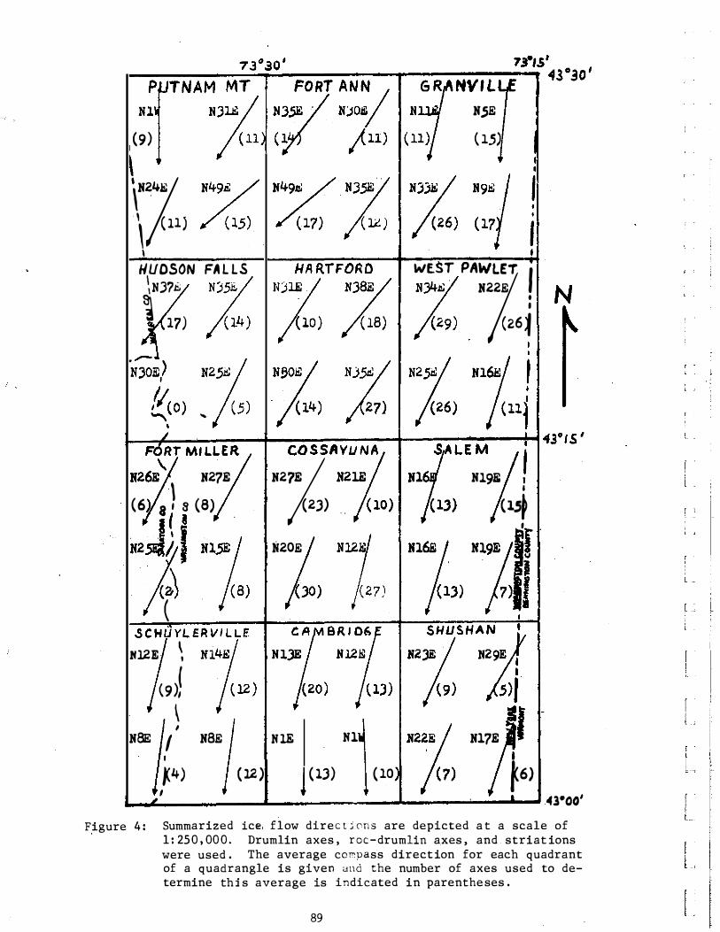
Figure 4 : Summarized ice, flow direc t j ons are depicted a t a scale of 1 : 250 , 00 0 . Drumlin axes , roc-drumlin axes , and striat ions were used . The average co�oass direction for each quadrant of a quadrangle is given und the number of axes used to determine thi s average is indicated in parentheses .
89
r ' l "
[ [ l
I l
Albany Deglacial Phase
Waterford Ice Margin (1) . Small kame deltas or subaqueous fans were successively deposited into Lake Albany at Waterford , Halfmoon , and Grooms Church . The Hudson Lobe. blocked the Hoosic valley east of Schaghticoke and terrace/outwash sediment accumulated f rom Buskirk (420 ft) to Valley Falls (390 ft) , perhaps filling a local impondment ( f igure 5) . The Wampecack valley ice tongue extended through South Cambridge and South Easton and a meltwater channel was incised along Whiteside Creek. The Cambridge valley ice tongue terminated at North Hoosick and defended glacial Lake Hoosic where considerable silt and clay accumulated south of Hoosick Falls . Meltwater flowed through the Notch (1050 ft) and the Chestnut Woods pass (1180 ft) from ice impinged against the Chestnut Woods and Barber Hills ridge and deposited outwash sediment through the White Creek area. The Vermont Valley sublobe approximately coincided with the Shelburne drift border between North Bennington and South Shaftsbury but this is apparently not a readvance pos ition. An ice tongue north of Batchelorville defended glacial Lake Sacandaga and meltwater was contributed from ice that terminated at Hope Falls and Wells on the Harrisburg and Lake Pleasant quadrangle s , respectively .
"'
� :t 0
.. 0 " :z:
30' 15'
Figure 5 : Waterford ice margin
90
C1 I ff 73 7 30 431:15 '
Willow Glen Ice Margin (2) . The Willow Glen and Country Knolls ( south of Round Lake) kame deltas were deposited along the margin of the Hudson Lobe . The lower Hoosic valley was ice-free and the glacial Hoosic River deposited early deltaic sediment (370 ft) into an expanding Lake Albany (figure 6) . The retreating Wampecack and Cambridge valley ice tongues terminated near West Cambridge and Center White Creek, respectively, and deposited outwash sediment and contributed meltwater to the Hoosic River . Glacial Lake Hoosic drained down the Hoosic valley as the Cambridge valley ice tongue retreated northward , Outwash sediment accumulated in the Pencil valley from meltwater originating in ice impinged against Chestnut Ridge and the thin sandy till ridge at the head of the Pencil valley . The Vermont Valley sublobe retreated to the Hale Mountain moraine. The Corinth ice tongue terminated in the Porter Corners area; meltwater flowed down the Kayaderosseras valley and deposited the Milton delta (420 ft) into an ice-marginal impondment . Glacial Lake Sacandaga lowered to 760 f t but was still defended by ice in the lower Sacandaga valley . The Ballston ice block was abandoned in the Ballston channel .
Archdale-Corinth Ice Margin (3) . Sediment northeast of Deans Corners on the Quaker Springs quadrangle and south of Saratoga Lake identified the Hudson Lobe margin as depicted by Chadwick (1928 , p903) . Basal gravel of the lowermost lacustrine facies accumulated along the edge of the Battenkill-Hudson channel near Bemis Heights (Dahl 1978 ; LaFleur 1979) . S ignificant ice blocks were abandoned in the Battenkill-Hudson channel near the mouth of the Hoosic River and in the Colonie channel at Round Lake. Deposition of the Hoosic delta continued and Lake Albany expanded to the area west of Willard Mountain. Meltwater flowed through the pass between Schuyler Mountain and the Willard-Whelden ridge and deposited a small outwash fan into Lake Albany . The Archdale kame moraine accumulated against the flank of Herrington Hill and outwash sediment was deposited downvalley from the terminus of the Wampecack ice tongue near Fly Summit (figure 7) . Outwash sediment accumulated in the Cambridge and Pencil valleys as the ice retreated and minor ice-marginal kamic sediment was deposited southwest of Coila on the Cambridge quadrangle. The higher Taconics of the Shushan quadrangle and southwestern Vermont were deglaciated . Some meltwater flowed through the Bates pass (1280 f t) and deposited outwash gravel in the White valley east of Cambridge. The Vermont Valley sublobe retreated to the kame and kame moraine sediment of the southern end of the Arlington moraine north of Shaftsbury (Stewart and MacClintock 1969 , p85-86; 1970) .
Some ice-marginal sediment accumulated on the slopes of the Palmertown Range above the more extensive Wilton kame moraine of later origin. An extensive stagnation kame moraine accumulated at the margin of the Corinth ice tongue through Randall Corners and Woodland Lake on the Corinth quadrangle . Lake Corinth (670 ft) was impended between this ice margin and accumulated sediment of the previous margin near Greenfield Center . Horizontally-bedded and ripple-laminated sand and silt was deposited into Lake Corinth. The extension of this ice front into the Adirondacks is not precisely known but it may correlate with the Hidden Valley moraine (Connally and Sirkin 1971) . Local impondments amid abandoned ice in the upper Hudson Valley from Stony Creek to Corinth f i l l ed with outwash-terrace gravel and sand and constituted Lake Warrensburg , which emptied into Lake Corinth.
Wilton-Battenville Ice Margin (4) , The Saratoga ice block was abandoned and Kendrick Hill (Chadwick 1928) was deglaciated . The Hudson Lobe blocked the Batten Kill valley at Greenwich and a small kame terrace (420 ft) was deposited against the northern flank of Schuyler Mountain. The Battenville moraine and associated kames accumulated in the Batten Kill valley and outwash gravel with sand was deposited to 420 ft between tillveneered hills westward to Greenwich ( f-igure 8) . Thin ( 20-45 ft) .outwash sediment was deposited from the head of the Lauderdale valley at 540 f t and merged with the extensive (100-150 f t thick) outwash deposited in the Cambridge valley from a head of outwash at Eldridge Swamp . Meltwater from Vermont ' s Green valley , near West Arlington, contributed to outwash sediment that was deposited up to 580 ft elevation through the NY-VT border area . The Vermont Valley sublobe retreated to the Arlington area and kame terrace sediment accumulated northwest of Arlington. Extensive icemarginal sediment was deposited in the Wilton embayment along the base of the Palmertown Range at approximately 450 ft and along the base of the Luzerne Mountains from 450-500 ft (Connally 1973) . The 670 f t Hartman terrace gravel was deposited and represents the last sediment associated with Lake Corinth . Kamic sediment accumulated along the margin of the Caldwell sublobe (Chadwick 1928) at 800 f t and at 900 f t along Warrensburg Road .
Moreau-Clark Pond Ice Margin (5) . The eastern margin of the Hudson Lobe retreated to a position partly located from a water well log which recorded 90 ft of basal gravel beneath later clay in the Battenkill channel southwest of Greenwich. Lake Albany reached its maximum extent as the ice retreated to this position and clay was deposited south of Bald Mountain and in the Hartshorn valley to 390 + f t . Meltwater from the Hartshorn ice tongue and the glacial Batten Kill deposited the Greenwich outwash fan-delta at 400 ft into Lake · Albany ( f igure 9) . The Clark Pond kame moraine accumulated against the flanks of the hills south of East Greenwich and outwash sand and gravel was deposited around minor ice blocks at Hedges Lake , Dead Lake, and Schoolhouse Lake . Ice persisted in the Camden valley and kame terrace sediment accumulated to 850 f t along the NY-VT border and a t similar locations against the eastern flank of this valley in Vermont . Late active ( ? ) ice may have occupied the large circular basin northwest of Mt . Equinox which would account for the kame terrace sediment above 1000 ft in the upper Green valley as interpreted from Stewart and Mac Clintock ( 19 70) . The higher Taconics east of the Camden valley were deglaciated and the Vermont Valley sublobe retreated to the Sunderland area. A local impondment dammed by sediment at Arlington, Lake Batten, may have expanded against the· retreating Vermont Valley ice .
The 460 ft kame terrace at the base of the Palmer town Range just south of the Hudson River and the 420 ft Moreau Pond kame moraine accumulated along the western margin of the Hudson Lobe. The Queensbury sublobe stagnated in the Glen Lake region and sediment accumulated from 500 ft to a 460 f t delta deposited in a temporary irnpondment through Queensbury (Chadwick 1928) . Ice marginal sediment at 600 ft (Interstate 8 7 , exit 21) located the terminus of the Caldwell sublobe.
93
[ .
f l -
; L .
r L.
! l
I l
l
HUDSON LOBE
H U D S O N LO B E
Saratoga ice block .... �;-M;:!f,
30'
Figure 8 : Wilton-Battenville ice margin
oo'
Figure 9 : Moreau-Clark Pond ice margin and maximum Lake Albany
94
Carter Swamp Ice Margin (6) . Lake Albany gradually fell to 340-350 f t measured at Greenwich a s indicated b y continuous deposition o f the Greenwich outwash fan without significant dissection or terrace formation as might be expected if the lake level fell rapidly . The 320-330 f t terrace sediment of the Hoosic River was deposited at the t ime . A Whittaker valley ice tongue terminated across the southern end of Carter Swamp and a small band of kame moraine accumulated west of the swamp . Deltaic gravel and sand prograded into a temporary meltwater impondment dammed by sediment and/or ice at Battenville . A similar ice and sediment dam at Eldridge Swamp diverted meltwater in the upper Batten Kill through the Shushan-Rexleigh channel (figure 10) . The Salem and Black valley ice tongues retreated from their j unction and meltwater from the above three sources deposited extensive deltaic and outwash sediment perhaps into the same isolated impondment dammed at Battenville or a similar one dammed at East Greenwich. Continual retreat of the salem and Black ice tongues would account for the predominant foreset-type deltaic gravel and sand interbeds observed . The distal foreset sand and f ine gravel beds grade southward to ripple-laminated and f inely cross-laminated f ine sand and silt bottomset beds .
The Manchester moraine through Manchester, Manchester Depo t , and Barnumville approximated the terminus of, the Vermont Valley sublob e . Chadwick ' s (1928 , p909) 380 ft terrace of the Hudson west of Glens Falls was correlated with deposition of the Greenwich outwash fan . The Glen Lake ice block was abandoned and the active margin of the Queensbury sublobe retreated to the Lake Sunnyside area.
95
L •
' ' .
r L_
I f
l
30
H U D S O N
L O B E
•
• • 43 30
Figure 1 0 : Carter Swamp ice margin and a lowered Lake Albany
96
Quaker Springs Deglacial Phase
Black Valley Ice Margin ( 7) . Lake Albany continued to fall and stabilized at the 310 ft level of Lake Quaker Springs measured at the latitude of the Batten Kill delta ( figure 11) . Woodworth ( 1905 , pl77) f irst observed the " falling off in altitude of the deltas successively northward from that of the Batten Kill" and noted their failure to coincide with an Albany water plane . He concluded , " • • • these lower deltas were not made in the waters of Lake Albany . " Delta elevations and the distribution of lacustrine sediment in the northern Hudson Lowland confirmed an absence of the higher waters of Lake Albany north of the Black Valley ice margin (DeSimone 1983 , 1985) . The Glens Falls delta (330 f t) , Batten Kill delta (320 ft) , Argyle esker delta ( 3 20 ft) , Mettawee delta (330-340 ft) and perhaps the 360 f t sediment at the junction of the Poultney and Castleton Rivers in Fair Haven, VT , were all deposited into a stable Lake Quaker Springs at or near its maximum level .
Numerous ice tongues protruded into minor valleys in the Taconic Highlands of Washington County and small outwash sequences were deposited from these heads of outwash . The Black ice tongue terminated near Bean Rd where karnic sediment and a: thick till accumulation may be of morainal or1g1n. Minor karnic sediment reworked by ·later outwash sedimentation identified the margins of the West Beaver and Beaver valley ice tongues . A distinct meltwater channel with a threshold at 660 f t perched above the south rim of Scott Lake locates another segment of the ice margin. A change in gradient of the outwash sequence profile identified the margin of the Salem valley ice tongue , and meltwater eroded till along the valley flank. The Vermont Valley sublobe and Mettawee ice tongue terminated along the kame moraine and kame terrace sediment at East Dorset and South Dorse t , respectively .
Previous sediment and/or ice darns at Battenville and perhaps at East Greenwich and Arlington were breached and any local impondrnents drained . Dissection of previously deposited valley fill occurred in response to the lower base level of Lake Quaker Springs and tte unimpeded meltwater flow initiated deposition of the extensive Batten Kill delta . A prevailing lake or longshore current transported sand south from the delta and this sand accumulated as a distinct blanket over clay through the central portion of the Schuylerville quadrangle.
The Hoosic River breached its Albany delta and redeposited sediment in its 300 f t Quaker Springs delta . The western margin of the Hudson Lobe may have followed Palmer Ridge and similar ridges through the Fortsville area. The extensive Patten Mills kame terrace and ice-marginal sediment in the Diamond Point and Trout Lake area west of Lake George were deposited .
97
r . '
l .
j ' �
L
H U D S O N
L O B E
Figure 11: Black Valley ice margin and Lake Quaker Springs
98
Harper Road Ice Margin (B) . Deposition of the Batten Kill delta and the Patten Hills kame terrace continued as the Hudson River initiated its Glens Falls delta at 320 ft (f igure 12) . The western edge of the Hudson Lobe probably retreated to_ the bedrock ridges traversed by Chestnut (Sanford ' s) Ridge Rd on the Glens Falls quadrangle. T.he Hudson Lobe protruded into the Fort Edward channel north of Fort Miller and into a pre-Woodfordian channel east of Gansevoort identified from water well log s , seismic data , and bedrock exposures . Some stratif ied gravel and sand accumulated between and on the flanks of drumlins clustered northeast of Fort Miller while the surface till was reworked by meltwater into a gravel-enriched lag. A retreating meltwater source deposited the small lobate subaqueous fan exposed along Harper' Road in the Argyle valley . The sediments in the section f ines upward from interbedded gravel and sand to lake sand and f inally to lake clay, which draped over and buried the deposit .
The ice front east of Barkley Pond was indicated by several small coalesced kames and outwash sediment deposited into glacial Lake Cossayuna . One water well log from an outwash fan along the western shore of Cossayuna Lake recorded 120 ft of clay beneath 15 ft of sand . Outwash sedi� ment was deposited in the Black valley from 500 ft west of Chamberlin Mills to 480 ft near West Hebron . The distal outwash south of West Hebron at 480 ft is silty .and suggests isolated impondments dammed by the Black valley moraine . Meltwater flowed from the head of the West Beaver valleys at 700 ft south of Chamberlin Mills and Tipla dy , respectively, and eroded a channel to 600 ft at the Hebron-Salem town l ine . The Mettawee ice tongue terminated near East Rupert and the Vermont Valley sublobe retreated to the base of Dorset Mountain as· indicated by kame terrace and or kame moraine sediment (Stewart and MacClintock 1970) . , 1 " 73 7 30
43°30 '
Figure 1 2 : Harper Road ice margin
43°00'
r -l
[ " I l ' r l� r l -
[ '
l_ -
GLENS FALLS DELTA
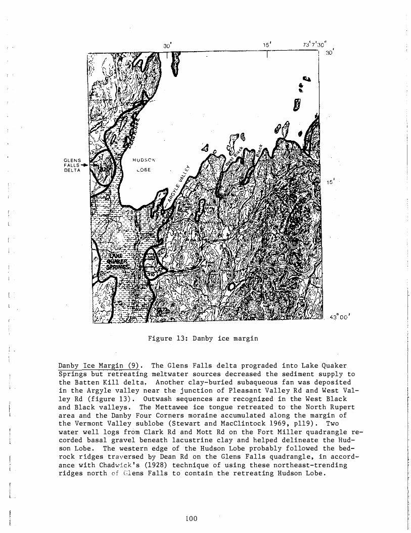
Figure 13 : Danby ice margin
Danby Ice Margin (9) . The Glens Falls delta prograded into Lake Quaker Springs but retreating meltwater sources decreased the sediment supply to the Batten Kill delta. Another clay-buried subaqueous fan was deposited in the Argyle valley near the j unction of Pleasant Valley Rd and West Valley Rd (figure 1 3 ) . Outwash sequences are recognized in the West Black and Black valleys . The Mettawee ice tongue retreated to the North Rupert area and the Danby Four Corners moraine accumulated along the margin of the Vermont Valley sublobe ( S tewart and MacClintock 1969 , pll9 ) . Two water well logs from Clark Rd and Matt Rd on the Fort Miller quadrangle recorded basal gravel beneath lacustrine clay and helped delineate the Hudson Lobe . The western edge of the Hudson Lobe probably followed the bedrock r idges traversed by Dean Rd on the Glens Falls quadrangl e , in accordance with Chadwick ' s (1928) technique of using these northeast-trending ridges north o f C:l ens Falls to contain the retreating Hudson Lobe .
1 0 0
Argyle Valley Ice Margin (10) . An extensive esker and esker delta complex was deposited from a meltwater source in the Argyle ice tongue , and ice-marginal sediment accumulated east of Tamarack Swamp as this ice stagnated ( f igure 14) . The nearly continuous esker at 330-340 ft can be traced fro� the southern end of the swamp through North Argyle to the apex of the delta at 320-330 f t deposited into Lake Quaker Springs . Lacustrine clay onlapped and nearly buried the fluvial-deltaic gravel and sand . Folded , contorted gravel and clay containing pods of a gravel-derived till on the top and flank of the esker may suggest a minor ice surge but not a maj or readvance during this interval . The Argyle ice decayed in Tamarack Swamp and enabled lake waters to invade the swamp while the remainder of the ice front was stable. Meltwater in the highlands east of the swamp incised the channel east and south of Black Mountain and flowed across the present town landfill area where an up-per section of the lodgement till was reworked to a crudely-stratified gravel lag . Coarse-grained sediment is preserved as short esker segments along the Safford Rd meltwater route and deltaic sediment accumulated against and at least partially beneath dead ice in the swamp . Fine-grained pebble gravel and horizontally-bedded sand in the distal portion of the sequence f ine upward to lacustrine silt and clay. The geomorphic expression of this latter
. sequence suggests deposition in a tunnel beneath the
ice or in an open crevasse occupied by Lake Quaker Springs.
A cluster of kames and short esker segments located the margin of the Black ice tongue near Braymer . The Mettawee ice tongue terminated near Pawlet and , to the northeast , along a line approximated by the l imits of the Burlington drift border ( Stewart and MacClintock 1969 , 1970) , but this is not a major readvance position (Larsen 1972, Wagner et al 1972) . Lake sediment near 700 f t between Pawlet and North Rupert was deposited in a local ice-dammed Mettawee valley impondment designated Lake Pawlet .
101
! '
r .
I l .
l ' [ l� l.
301 1 5 1 73° 7 13011 43tl30'
( .. ,, /:1 � '
'
e;
Figure 1 4 : Argyle Valley ice margin
' .
1 02 I
...... -----------------, 45'
H U DSON L O B E
Figure 1 5 : West Pawlet ice margin
West Pawlet Ice Margin ( 1 1 ) , The Hudson Lob e , conf ined to the Whitehall and South Bay sublobes·, retreated more rapidly northward ( f igure 1 5 ) . A ridge of thick lodgement till confined the ice near South Granville. Stratif ied gravel and sand accumulated along the western margin of this ice to 600 f t while outwash was deposited into the Black valley. The Black ice tongue retreated to the valley head at West Pawlet and meltwa-ter eroded an extensive area of till and bedrock from 600-560 f t , pas- l . sibly from the drainage of Lake Pawlet around the ice front to the Black
� , valley . The Mettawee ice tongue retreated to the Blossoms Corners mor-aine through North Pawlet , Wells, and east of Lake S t . Catherine. Kame terrace and morainal sediment in the Vermont Valley at Chippenhook, Clar- [ • . endon, and East Clarendon are correlated to this ice margin. �
1 03 [
Figure 16: Welch Hollow ice margin
Welch Hollow Ice Margin (12) . An extensive kame moraine and kame terrace complex accumulated at the margin of the South Bay sublobe (Connally 1973) . Lake Granville at 410-420 f t , redefined from its earlier use (Behling 1966 , Stewart and MacClintock 1969) occupied the lower Mettawee valley and was probably defended by the Whitehall sublobe a t North Granville or Truthville ( f igure 16) . The Mettawee River deposited outwash into the lake through Granville and meltout of stranded ice in Middle Granville resulted in slumping and faulting of the distal outwash-lacustrine sand and f ine gravel . Meltwater from the Poultney ice tongue deposited outwash into the northern arm of the lake a t Poultney. Clay , silt , and sand accumulated in the central portion of the lake basin from Truthville to Middle Granville to Raceville . Recession of the Whitehall sublobe from North Granville drained Lake Granville and allowed deposition of the Mettawee delta (330-340 ft) into Lake Quaker Springs . The Castleton, Birdseye ( ? ) , and West Rutland ( ? ) moraines of Vermont ( S t ewart and MacCl intock 1969 , pl23) are correlated to this ice margin .
1 04
Lake Coveville
Sediment contribution to Lake Coveville in the Hudson Lowland was limited to the pebble gravel , sand , and silt transported by tributary streams . A stable Lake Coveville was delineated by prominent Batten Kill terrace gravels at 240 ft and the sandy Hudson Falls delta of the Hudson River at approximately 260 ft (figure 1 7 ) . Terraced clay at 240 f t on the S chuylerville quadrangle , at 250 f t on the Fort Miller quadrangl� at 260 f t o n the Hudson Falls quadrangle, and the minor 280-300 f t terrace o f the Mettawee River were coeval with Lake Coveville . Hoosic River terraces at 220 ft and the 220 ft sediment east of Hemstreet Park on the Mechanicville quadrangle are similarly correlated.
Figure 1 7 : Lake Coveville
105
; "
[ [ _ l
f
[ '
Fort Ann Water Levels
Fort Ann Channels . The Fort Ann channels include the primary Fort Edward
p914) , and the Winchell channel . These Champlain Lowland outlet channels
were broadly defined during the Coveville phase and extensively excavated
through clay , till, and bedrock during the Fort Ann phase. The Hudson
Champlain canal and the Hudson River below Fort Edward occupy the Fort
Edward channel . Dead Creek, the distal portion of the Moses Kill, and the headwaters of Wood Creek occupy the broad Durkeetown channel . Winchell Creek and the distal portion of B ig (Mill) Creek occupy the Winchell channel . All of these modern streams are underfit and follow entrenched courses with narrow floodplains on the channel bottoms . Eroded clay , till, and bedrock comprise the channel escarpments with predominantly eroded clay in the channel bottoms .
Fort Ann I . Fort Ann waters in the Hudson Lowland are most appropriately considered a broad shallow river , 10-20 ft deep , with a significant south-flowing current capable of eroding the soft lacustrine bottom sediment and transporting sand . Tributary streams deposited sediment (fluvial-lacustrine . sand) where they joined the Fort Ann waters and the prevailing current transported this sand southward . These thin (<10 ft) sand units were deposited on an eroded clay terrace or till/bedrock surface during times of normal ( stable) Fort Ann discharge . The Fort Ann I
level in the northern Hudson Lowland was indicated by fluvial-lacustrine sand at 200 f t on the Schuylerville quadrangl e , Hoosic River terraces at 180-190 f t , a prominent Hudson River terrace at 210 f t , and Poultney River terraces at 220 ft ( f igure 18) . Terraced clay at 200 ft on the Schuylerville and Fort Miller quadrangles is s imilarly correlated .
Fort Ann II . The stable Fort Ann II level in the northern Hudson Lowland is indicated by fluvial-lacustrine sand at 160-170 f t through the Schuylerville and Fort Miller quadrangles and by prominent terraces of the Hoosic River at 150 ft , the Batten Kill at 1 7 0 f t , and the Hudson River at 180 f t ( f igure 1 9 ) . Terraced clay at 180 f t north of Durham ' s Basin on the Hudson Falls quadrangle is correlated to this level .
Fort Ann I I I . The f inal Fort Ann III level is indicated by the 100-120 f t-level sediment near Reynolds on the Mechanicville quadrangle and by fluvial-lacustrine sand at 130-140 ft on the Schuylerville and Fort Miller quadrangles ( figure 20) . Terraced clay at 130-140 ft on the Schuylerville quadrangle is s imilarly correlated . The Winchell and Durkeetown channels were abandoned when the water level fell below their present sills at 180 ft and 170 f t , respectively . Lake Fort Ann discharge from the Champlain Lowland was confined to the Fort Edward channel , which was deepened to 150 f t at Smith ' s Basin and to 140 ft a t Fort Edward .
106
Figure 1 8 : Fort Ann I
Figure 1 9 : Fort Ann II [ 1 07
r l
l �
f !
Figure 20: Fort Ann III
REFERENCES CITED
Behl ing , R . E . , 1 9 6 6 , Surficial Geology of the Equinox , Londonderry , and Pawlet Quadrangles , Vermont : Unpublished Open File Report , Vermont Geological Survey .
Chadwick, G . H . , 1928 , Ic e Evacuation S tages at Glens Fall s , New York : G . S . A . Bulletin , v . 39 , p 901-9 2 2 .
Chapman , D . H . , 1937 , Late Glacial and Post-glacial History of the Champlain Valley : American Journal of Science, v . 34 , p 89�124 .
Clark, P . , and Karrow, P . F . , 1984 , Late Pleistocene Water Bodies in the S t . Lawrence Lowland , New York , and Regional Correlation : G . S . A . Bulletin , v . 95 , p 805-813 .
Connally , G . G . , 1 9 73 , Surficial Geol ogv o f the Glens Falls Region , New York: N . Y . S . Museum and S cience Survice , Map and Chart Series. # 2 3 .
Connally , G . G . , and Sirkin , L . A . , 1 9 7 1 , Luzerne Readvance Near Glens Fal l s , New York: G . S . A . Bulletin , v . 8 2 , p 989-1008 .
1 08
Dahl , J . K . , 1978 , Surficial Geology of the Mechanicville and Schaghticoke Quadrangles : R .P . I . , Master ' s Thesis .
DeSimone , D .J . , 197 7 , Glacial Geology of the Schuylerville Quadrangle: R .P . I . , Master ' s Thesis , 77 p and map .
, 1983 , A Northern Limit for Glacial Lake Albany : G . S .A . Ab-------s�t-r-acts with Programs , Northeastern Section, v . 1 5 , no . 3 , p178 . ------�--· 1985 , The Late Woodfordian History of Southern Washington
County , New York: R .P . I . , Ph . D . Dissertation, 145 p and maps . Dineen, R . J . , and Rogers , W .B . , 1979 , Sedimentary Environments in Gla
cial Lake Albany in the Albany Section of the Hudson-Champlain Lowlands : N .Y . S . G . A : , Guidebook , 51st Annual Meeting, Trip A3 , p87-119 .
Dineen, R . J . , et al , 1983 , Bedrock Topography and Glacial Deposits of the Colonie Channel Between Saratoga Lake and Coeymans , New York: N . Y . S . Museum, Map and Chart Series # 3 7 .
Fairchild , H .L . , 1917 , Post-glacial features o f the Upper Hudson Valley : N . Y . S . Museum and Science Service, Bulletin 195, p22 .
Hanson, E . L . , 197 7 , Late Woodfordian Drainage History in the Lower Mohawk Valley: R . P . I . , Master ' s Thesis .
LaFleur, R . G . , 1965a, Glacial Lake Sequences in the Eastern Mohawk-Northern Hudson Region: N . Y . S . G . A . , Guidebook, 37th Annual Meeting , Trip C , pC1-C23 .
, 1965b , Glacial Geology of the Troy , New York, Quadrangle: ------�N�.�Y�.�S�.�Museum and Science Service, Map and Chart Series # 7 . ------��--�· 1975 , Sequence of Events in the Eastern Mohawk Lowland
Prior to Waning of Lake Albany : G . S .A . , Abstracts with Programs , Northeastern Section, v . 7 , no . 1 , p 87 .
, 1979, Deglacial Events in the Eastern Mohawk-Northern Hud_______ s_
o_n�L�o�w
-land: N . Y . S . G .A . , Guidebook, 51st Annual Meeting , Trip B 6 ,
p326-350 . --------��· 198 3 , Mohawk Valley Episodic Discharges - The Geomorphic
and Glacial Sedimentary Record: National Association of Geology Teacher s , Guidebook , p45-68 .
Larsen, F .D . , 1972, Glacial History of Central Vermont : N . E . I . G . C . , Guidebook, 64th Annual Meeting, Trip G-1 , p296-316.
Parro t , W .R . , and Stone, B .D . , 1972, Strandline Features and Late Pleistocene Chronology of Northwestern Vermont : N . E . I . G . C . , Guidebook , 64th Annual Meeting, Trip G-3 , p359- 3 7 6 .
Schafer , J .P . , 1968 , Retreat o f the Last I c e Sheet in New England : G . S .A . , Special Paper 115 , p291 .
Stewart , D .P . , and MacClintock, P . , 1969 , The Surficial Geology and Pleistocene History of Vermont : Vermont Geological Survey , Bullet in no . 31 .
Stoller , J . H . , 1922, Late Pleistocene History of the Lower Mohawk and Middle Hudson Region: G . S .A . Bulletin, v . 3 3 , p515-526 .
Wagner , W .P . , 1969 , The Late Pleistocene of the Champlain Valley , Vermont: N .Y . S . G . A . , Guidebook, 41st Annual Meeting, Trip D , p65-80 .
, 197 2 , Ice Margins and Water Levels in Northwestern Ver_______ m_o_n_t_:�N .E . I . G . C . , Guidebook , 64th Annual Meeting, Trip G-2 , p319-342 .
------����· et al , 19 7 2 , Till Studies , Shelburne Vermont : N . E . I . G . C . , Guidebook , 64th Annual Meeting , Trip G-5 , p377-388 .
Woodworth , J .B . , 1905 , Ancient Water Levels of the Champlain and Hudson Valleys , N .Y . S . Museum and Science Service, Bulletin 84, p65-265 .
1 09
i .
[ ' l .
ROAD L O G
Key : u s U n i t e d S t a t e s R o u t e s E = E a s t NY = N ew Y o rk S t a t e R o u t e s w = W e s t we = W a s h i n g t o n C ou n t y R o u t e s N = N o r th
J C N Jun c t i o n
M i l e s M i l e s f r om t r ave l e d l a s t p o i n t
0 . 0 0 . 0
0 . 9 0 . 9
2 . 2 1 . 3
3 . 0 0 . 8
3 . 5 0 . 5
4 . 8 1 . 3
O p t i o n A
4 . 8 0 . 0 5
s = S ou t h
J C N N Y 2 9 a n d U S 4 . F o l l o w N Y E a c r o s s H u d s o n R iv e r . A h e a d i s t h e B a t t en K i l l d e l t a ( 3 1 0- 3 2 0 f t L a k e Q u a k e r S p r in g s ) .
NY 2 9 c l imb s t h e f o r e s l o p e o f t h e d e l t a a p p r o x ima t e l y a l o n g t h e a x i s o f max imum th i ckne s s o f g r ave l and s an d . T h e b an k s a l o n g t h e r o ad r ev e a l t h e c o a r s e n i n g - u p s t r a t i g r a phy .
JCN NY 2 9 and O l d S ch uy l e r v i l l e R o a d -t u r n l e f t ( N ) o n t o O l d S ch uy l e rv i l l e R d . W a t e r w e l l l o g s r e c o r d u p t o 6 5 f t of d e l t a i c g r a v e l a n d s an d in t h e a r e a .
H o l l in g s w o r t h -V a s e l a nd f il l r o a d - t u r n r i g h t.
S T O P 1 : H o l l in g sw o r t h -V a s e l a nd f i l l . D e l t a i c t o p s e t and f o r e s e t b e d s o f t h e B a t t e n K i l l ' s Q ua k e r S p r in g s d e l t a . R e t u r n t o JCN NY 2 �
J C N N Y 2 9 and O l d S c h u y l e r v i l l e R d . -t u r n r i gh t ( W ) o n t o NY 2 9 . I f H o l l in g s w o r th -V a s e l a n d f i l l i s inac c e s s ib l e ( v e ry p o s s ib l e ) c o n t inue 0 . 1 m i l e s p a s t O l d S ch u y l e rv i l l e R d J C N t o J C N N Y 2 9 and W indy H i l l R d . T u r n l e f t ( N ) o n t o W in d y H i l l R d a n d c o n t inue 0 . 8 m i l e s t o T r a c y B r o s . excava t i o n wh e r e d e l t a i c g r a v e l a n d s an d , l ak e c l a y , and l o d g ement t i l l a r e e x p o s ed . R e t u r n t o NY 2 9 and p i ck u p r o a d l o g a t W i l b u r Ave J C N .
J C N NY 2 9 and W i l b u r Ave - t u r n S o n t o W i l b u r Ave . W a t e r wel l l o g s and ex p o s u r e s ind i c a t e d e l t a i c s e d iment t h in s r a p i d l y s o u thwa r d t h r o u g h 3 0 f t t o l e s s t h an 1 0 f t . N o t i c e the c l a y d u g u p f r om
1 1 0
M i l e s M i l e s f ro m t r av e l e d l a s t p o int
6 . 0 1 . 2
6 . 2 0 . 2
7 . 1 0 . 9
7 . 5 0 . 4
7 . 9 0 . 4
8 . 7 0 . 8
8 . 8 0 . 1
1 0 . 0 1 . 2
1 1 . 2 1 . 2
1 1 . 4 0 . 2
1 1 . 7 0 . 3
1 2 . 6 0 . 9
t h e p o n d f a r th e r a l o n g t h e r o a d .
G r oundw a t e r f l ow s o u t a l o n g t h e S G - c l ay c o n t a c t a t t h e h e a d s o f t h e s e g u l l i e s i n F r y e r B r o ok . We o b s e r v e d a p ip e w i t h a d iame t e r j u s t r i g h t f o r y o u r a r m a t t h e h e a d o f o n e g u l l y i n 1 9 7 7 .
N o t i c e t h e c l ay g u l l i e s a s W i l b u r Ave . c r o s s e s F r y e r B r o o k .
We ' r e t r a v e r s i n g t h e d i s s e c t e d c l ay p l a in and d e l t a s a n d i s g o n e s o we c r o s s F l a t e l y B r o o k and t u r n t o the E .
O b s e r v e t h e s h o r e l i n e p r o f i l e o f L ak e Q u a k e r S p r i n g s . N o b e a c h s e d im e n t i s p r e s e r v e d .
JeN NY 4 0 - t u r n r i g h t ( S ) o n t o NY 4 0 . T i l l o n y o u r l e f t and t h e l ake c l ay � l a in o n y o u r r i g h t w i t h t h e t o p s o f a f ew d ruml i n s p o k i n g t h r o u gh .
J e N NY 4 0 and B u r t on Rd . - t u r n l e f t ( E ) o n t o B u r t on R d .
M e l t wa t e r f l owed b e tween S chuy l e r a n d Wh e l d en m o u n t a i n s and d ep o s i t e d an o u t w a s h f an in t o L ake A l b any . M i n o r exp o s u r e s a l on g t h e s t r eam t o y o u r r i g h t ( S ) r e v e a l g r a v e l o v e r l ying c l ay a n d b a s a l l o d g ement t� l l .
J e N B u r t on R d and E a s t o n S t a t i o n R d B ea r r i gh t o n t o E a s t on S t a t i o n R d.
JeN E a s t o n S t a t i o n R d . , I n t e r v a l e R d . , and W a t e r R d . T u r n l e f t and c o n t inue o n E a s t o n S t a t i o n R d .
J e N E a s t o n S t a t i on R d . and we 7 4 - t u r n r i g h t ( S ) o n t o we 7 4
S T O P 2 : A r c h d a l e k ame m o r a ine . Ex------
p o s u r e o f c l in o f o rm s an d and g r a v e l b e d s i n t h e m o r a i n e . M i n o r s l ump ing o f b ed s .
S T OP 3 : N e s s l e B r o s M e a t s p ar k i n g l o t .
1 1 1
L
M i l e s M i l e s f r om t r a v e l e d l a s t p o in t
1 6 . 9 4 . 3
1 7 . 1 0 . 2
1 7 . 4 0 . 3
2 0 . 2 2 . 8
2 1 . 4 1 . 2
2 2 . 0 0 . 6
2 4 . 0 2 . 0
2 4 . 4 0 . 4
Ari ex c e l l en t o v e rv i ew o f th e A r c h d a l e kame m o r a in e d e p o s i t e d a g a i n s t t h e f l ank of H er r in g t on H i l l . T h i s kame m o r a in e b and c a n b e t r a c e d s o u t hwa r d a l on g t h e w e s t s id e o f F l y S wamp a n d a c r o s s t h e valley a t t h e s o u t h e rn e n d o f t h e swamp wh e r e a h e a d o f o u twash is r e c o gn i z e d . R e t u r n N o n WC 7 4 .
J C N we 7 4 and NY 3 7 2 - t u r n l e f t o n t o NY 3 7 2 .
B a t t en K i l l c r o s s in g in G r e enwich.
JCN NY 3 7 2 and NY 29 - t u r n r ig h t ( E ) on NY 2 9 and b e a r r ig h t p a s t t h e t r a f f i c l i g h t t o s t ay o n NY 2 9 .
N o t e t h e t e r r a c e - o u tw a s h g r avel and s an d we ' r e c r o s s in g w i t h t h i n t il l and b e d r o c k u p l a n d s t o t h e n o r th . A t s m a l l r i s e s and ar o u n d c u r v e s in NY 29 t i l l and b e d r o ck a r e o f t e n exp o s e d w h e r e t h e u p land th in t i l l and b e d r o ck t o p o g ra p h y p r o t r u d e s t h r o u g h t h e g r a v e l a n d sand .
N o t e t h e o l d excava t io n i n t o a kame a h e a d on y o u r l e f t . This i s a s s o c ia t e d w i t h t h e B �t t env i l l e mo r a in e .
NY 2 9 u s e d u p t h e t i l l and g ravel of t h e B a t t env i l l e m o r a in e wh e r e t h e m o r a i n e c r o s s e s t h e v a l l ey in B a t t env i l l e . T h e r e i s humm o c ky k a m i c g r avel and sand a h ea d on y o u r l e f t .
T h e f a i r l y f l a t o u twash and t e r r a c e g r av e l a n d s and we ' r e c r o s s in g w a s d ep o s i t e d b y m e l t w a t e r f r o m t h e i c e m ar g in .
S T O P 4 : T r ac y B r o s e x c a v a t io n . H o r iz ont a l ly - s t r a t i f i e d g r a v e l and sand over l ie s c r o s s - s t r a t i f i e d g r a v e l and s and . M e l t wa t e r f r om t h e C a r t e r Swamp i c e ma r g in d ep o s it e d th i s d e l t a i � s e d iment w i t h s e d iment s ou r c e s f r o m t h e N and E . T h e B a t t en K i l l h a s t e r r a c e d t h e S e n d o f t h i s d e p os i t .
1 1 2
M i l e s M i l e s f r om t r a v e l e d l a s t p o i n t
2 4 . 5 0 . 1
2 5 . 2 0 . 7
2 5 . 9 0 . 7
2 7 . 0 1 . 1
2 7 . 3 0 . 3
2 7 . 4 0 . 1
2 7 . 6 0 . 2
2 9 . 0 1 . 4
3 2 . 9 3 . 9
3 3 . 5 0 . 6
3 6 . 6 3 . 1
3 8 . 1 1 . 5
J C N NY 2 9 and NY 3 3 8 - c o n t inue E o n NY 2 �
E a s t G r e enw i c h P o s t O f f i c e - p a r k h e r e and w a l k 0 . 1 m i l e s W on NY 2 9 . S T O P 5 : L o d g em e n t t i l l exp o s u r e N s id e o f NY 2 � B o th l ow l a n d and h i gh l a n d l o d g e m e n t t i l l f a c i e s a r e s im i l a r i n W a s h in g t o n C o un t y . Why ? I n c o n t r a s t , t h e l o d g ement t i l l of the A d i r o n d a c k s is q u i t e d i f f e r en t f r om t h e H u d s o n l ow l a n d t i l l . R e t u r n W a l o n g NY 2 9 .
JCN NY 2 9 and NY 3 3 8 - t u r n r i gh t ( N ) o n t o NY 3 3 8.
JCN NY 3 3 8 a n d F e r g u s o n R d . C on t in u e o n N Y 3 3 8N . T h e r e i s a n e x c a v a t i o n j u s t t o y o u r r i gh t o f f o f F e r g u s on R d whe r e a t h i c k g r a d e d g r a v e l b e d w a s o b s e r v e d . How w o u l d y o u d e s c r i b e t h e s ed imen t a r y e nv i r onm e n t wh i c h p r o d u c e d t h i s f e a tu r e ?
N o t i c e t h e humm o c k y i c e m a r g in a l s e d im e n t o n y o u r l e f t .
C a r t e r ' s P on d N a t u r e T r a il o n your r i gh t .
C a r t e r ' s P on d W i l d l i f e Mana g ement A r e a . L u n c h S t op .
JCN 3 3 8 and B u n k e r H i l l R d . - b ea r l e f t o n N Y 3 3 8 .
JCN NY 3 3 8 and NY 4 0 - t u r n r i g h t ( N ) o n t o NY 4 0 .
N o t i c e t h e smo o t h r ou n d e d d r um l i n o i d t o p o g r aphy d e v e l o p ed in t h e s e t h i n l y v e n e e r e d b e d r o c k h i gh l an d s .
JCN NY 4 0 and NY 1 9 7 - t u r n r i gh t a n d c o n t in u e o n NY 4 0 . T h e v i l l a g e o f A r g y l e s i t s a t o p a mod e s t e s k e r d e l t a d ep o s i t ed i n t o L a k e Q u a k e r S p r in g s . L a k e c l a y n e a r l y b u r i e d t h e d e l t a .
S TOP 6 : E s k e r g r a v e l and l ak e c l ay . NY 4 0 r id e s a t o p t h i s e s k e r wh ich f e d t h e A r g y l e d el t a . L ac u s t r in e c l ay h a s p a r t l y ,
1 1 3
r -
r , '
I l _ r -! l j
I t� r l '
M i l e s M i l e s f r o m t r a v e l e d l a s t p o in t
3 9 . 5 1 . 4
4 0 . 4 0 . 9
4 0 . 9 0 . 5
4 1 . 7 0 . 8
4 4 . 8 3 . 1
4 7 . 5 2 . 7
5 5 . 0 7 . 5
and in p l a c e s c omp l e t e l y , b u r i e d t h e e sk e r g r av e l and s a nd . O b s e rve t h e d e f o rm e d c l ay a n d g r a v e l b e d s h e r e . I s t h e d e f o r ma t i o n c o n s i s t en t w i th wh a t y o u ' d exp e c t f r om me l t o u t o f b u r i e d a n d / o r a d j a c e n t i c e o r wou l d y o u s u g g e s t a m i n o r i c e s u r g e a f t e r d ep o s i t i o n o f t h e c l ay t o a c c o u n t f o r t h e s t r a t i g r a p h y ? C o n t inue N o n N Y 4 0 a l on g t h e c r e s t o f t h e e s k e r .
JCN NY 4 0 and we 4 5 in N o r th A r g y l e t u r n r i g h t { E ) o n t o we 4 5 .
J C N WC 4 5 and C o a c h R d . - b ea r l e f t o n c omb i n e d we 4 5 - C o a ch R d .
T u r n l e ft and c o n t inu e o n C o a c h Rd .
S T O P 7 : H a r r ing t on F a rm e x c av a t io n s exp o s e p a r t of a me l tw a t e r s e d iment comp l ex d ep o s i t e d a t the b a s e of the T a c o n i c f r o n t a l o ns t h e e a s t e r n e d g e o f T am a r a c k Swamp . T h e i c e t on g u e r e s p o n s i b l e f o r t h e e s k e r and d e l t a t h r o u g h N o r t h A r gy l e and A r g y l e s t aR n a t e d in t h e swamp . T h e maj o r m e l t w a t e r s ou r c e f o r t h i s s ed im e n t c a n b e t r a c e d e a s t w a r d a l ong S a f f o r d R d . t o t h e t own l*nd f i l l . C o a � s e r g r a v e l a n d s a n d , h o r i z o n t a l ly - b e d d ed and c r o s s s t r a ti f i e d , i s exp o s ed e a s t o f t h e r o a d . T h e mo r e d i s t a l p o r t i o n o f t h e d e l t a f an exp o s e d h e r e c o n t a in s l am in a t e d and r i p p l el amina t e d s and . A t h i r d e x c av a t io n t o t h e S W in t h e m i d d l e o f t h e swamp c o n t a in s t h e mo s t d i s t a l and f in e s t - g r a ined s and , s i l t , and c l ay b ed s . T h e m o r p h o l o g y o f t h i s l a s t d e p o s i t s u g g e s t s d e p o s i t io n i n a tunnel o r c r e va s s e i n t h e i c e and i n d i c a t e s t h e r o t t in g i c e in T am a r a c k Swamp was inund a t e d by L a k e Q u a k e r S p r ing s .
JCN C o a c h R d and NY 4 0 - t u r n r ig h t { N ) o n t o N Y 4 0.
JCN NY 4 0 and NY 1 4 9 E - t u r n r ig h t { E ) o n t o NY 1 4 9.
JCN NY 1 4 9 and NY 2 2 - t u r n l e f t ( N ) o n t o NY 2 2
!14
M i l e s M i l e s f r o m t r av e l ed l a s t p o in t
5 8 . 1 0 . 4
5 8 . 2 0 . 1
5 8 . 4 0 . 2
5 9 . 1 0 . 7
6 2 . 8 3 . 7
6 3 . 4 0 . 6
7 0 . 7 7 • 3
7 3 . 4 2 . 7
T u r n r i g h t and c r o s s t h e g r ay b r i d g e o v e r t h e M e t t a w e e R iv e 4
T u r n l e f t o n t o D e p o t R d .
T u r n l e f t a t o l d d ep o t o n t o D ump R d ( l a nd f i l l e n t r a n c e ) S T O P 8 : T h e n o r t h - f l ow i n g M e t t aw e e R iv e r d e p o s i t e d t h i s o u tw a s h g ravel and s an d i n a s i g n i f i c a n t l o c a l im�ondmen t . T h e exp o s e d s a n d , s i l t , and c l a y b ed s a c cumul a t ed in t h i s L ak e G r d nv i l l e wh o s e e l evat i o n was a p p r o x ima t e l y 4 2 0 f t . C l ay is a l s o p r e s e rv e d i n the M e t t aw e e v a l l ey f r o m M i d d l e G r a nv i l l e w e s t w a r d t o T ru t h v i l l e w i t h m o r e s i l ty s e d im e n t n o r t h o f R a c ev il l e . T h e r e a r e s om e c o n c r e t i o n s in t h e c l a y h e r e . M i l d l y d e f o r m e d s e d im e n t p ar t i c u l a r l y a t t h e n o r th e n d o f t h e exp o s u r e p r ob a b l y r e su l t ed f r o m m e l t o u t o f aband o n e d i c e i n t h e l ak e . T h e H u d s o n i c e l ob e p r o b ab ly b l o c k e d t h e l ow e r M e t t aw e e v a l l e y a t T ru thv i l l e and c on t a i n e d L ak e G r a nv il l e . R e t r e a t o f t h i s i c e d r a in e d t h e l a k e and the M e t t aw e e . R iv e r d e p o s i t e d i t s d e l t a i n t o L a k e Q u ak e r S p r in g s .
R e t r a c e r o u t e t o J C N NY 2 2A - t u r n r i g h t ( W ) o n t o N Y 2 2.
JCN NY 2 2 a n d WC 1 7 - c o n t in u e o n NY 2 2 T h i s s u r f a c e i s t h e t o p o f t h e M e t t a w e e d e l t a.
J C N NY 2 2 and NY 4 0 - t u r n l e f t ( S ) o n t o NY 4 0.
JCN NY 4 0 and NY 1 4 9W - turn r i g h t ( W ) o n t o N Y 1 4 9.
S T O P 9 : W i n ch e l l channel o v e r l o ok . P ar k a s f a r o f f t h e r o a d a s p o s s i b l e and b e c a r e f ul o f t h e t r a f f i c ! The W i n c h e l l c h a n n e l w a s o n e o f t h r e e channe l s ( th e D u r k e e t own and F t . E dw a r d a r e t h e o th e r t w o ) wh i c h c a r r i e d t h e ou t f l ow o f Lake
,l
r l '
F o r t Ann i n t h e C hamp l a i n v a l l ey t h r ough t h e n o r t h er n Hu d s o n v a l l ey . The p r e s e n t f s u r f a c e s t r e am , B i g ar Mi l l C r e e k , e n t e r s l . t h e channel f r om t h e s o u t h t h r o u g h a b e d -
1 15
r l '
L
M i l e s M i l e s f r om t r a v e l e d l a s t p o in t
7 6 . 3 2 . 9
7 9 . 0 2 . 7
8 4 . 2 5 . 2
8 6 . 6 2 . 4
8 8 . 1 1 . 5
8 8 . 6 0 . 5
8 8 . 8 0 . 2
1 0 1 . 8 1 3 . 0
r o c k g o r g e ( s e e n a s a n o t c h i n t h e d i s t an c e ) a n d m e an d e r s ac r o s s t h e channe l b o t t o m t o S m i t h ' s B a s i n . T h e c h a n n e l b o t t o m c o n s i s t s p r im a r i l y o f l ak e c l a y wh i l e c l a y , t i l l , a n d b ed r o ck a r e a l l exp o s ed o n the f l anks o f the W i n c h e l l chann e l . T h i s p a t t e r n g e n e r a l l y h o l d s f o r t h e o th e r two channe l s a s w e l l e x c e p t the r e i s c o n s i d e r a b l y m o r e e r o d ed b e d r o ck a l o n g t h e p r imary F t . E dw a r d c h a nn e l .
JCN NY 1 4 9 and WC 4 3 - t u r n l e f t ( S ) o n t o w e 4 3
JCN we 4 3 and NY 1 9 6 - c o n t i n u e o n WC4 3
JCN WC 4 3 and NY 1 9 7 - t u r n r i g h t ( W ) o n t o NY 1 9 7
We ' r e c r o s s in g t h e b o t t om o f t h e b r o a d Durk e e t own chann e l a n d w i l l c l imb u p i t s w e s t e r n e s c a r pmen t . N o r t h - f l owing W o o d C r e ek and s o u th - f l ow i n g D e a d C r e ek a r e und e r f i t s t r eams i n t h e b o t t om o f t h e channe l .
We ' r e d e s c en d i n g i n t o t h e F t . E dward chann e l .
H u d s o n - C h amp l a in c an a l c r o s s in g - t h e c a n a l f o l l ow s t h e b o t t om o f t h e F t . E dw a r d chann e l .
JCN NY 1 9 7 and U S 4 - t u r n l e f t ( S ) o n t o u s 4 .
JCN U S 4 and NY 2 9 W - t r i p end s . T u r n r i g h t o n t o N Y 2 9 W t o r e tu r n t o S k i d mo r e camp u s .


![Glacier Surge Mechanism Based on Linked Cavity ...web.gps.caltech.edu › ~tsai › files › glacial › Kamb_JGR1987.pdf[Kamb et al., 1985]. I present here a physical model of the](https://static.documents.pub/doc/80x56/60caaac7b824a25e4145fd37/glacier-surge-mechanism-based-on-linked-cavity-webgps-a-tsai-a-files-a.jpg)


