Glacial geomorphologicalmapping of southernAlberta, Canada, reveals landformassemblages that are diagnosticof terrestrial-terminating ice streams/fastflowing outlet glaciers with lobate snouts. Spatial variability in featuresthat comprise the landform assemblages reflects changes in (a) palaeo-ice stream activity (switch on/off); and(b) snout basal thermal regimes associated with climate sensitive, steady state flow. Palaeo-ice stream tracksreveal distinct inset sequences of fan-shaped flowsets indicative of receding lobate ice stream margins. Formerice lobe margins are demarcated by (a) major, often glacially overridden transverse moraine ridges, commonlycomprising glacitectonically thrust bedrock; and (b) minor, closely spaced recessional push moraines and hum-mocky moraine arcs. Details of these landform types are well exhibited around the former southern margins ofthe Central Alberta Ice Stream, where larger scale, more intensive mapping identifies a complex glacial geomor-phology comprising minor transverse ridges (MTR types 1–3), hummocky terrain (HT types 1–3), flutings, andmeltwater channels/spillways. TheMTR type 1 constitute the summit corrugation patterns of glacitectonic thrustmoraines or major transverse ridges and have been glacially overrun andmoderately streamlined. TheMTR type2 sequences are recessional push moraines similar to those developing at modern active temperate glaciersnouts. The MTR type 3 document moraine construction by incremental stagnation because they occur in asso-ciation with hummocky terrain. The close association of hummocky terrain with push moraine assemblagesindicates that they are the products of supraglacial controlled deposition on a polythermal ice sheet margin,where the HT type 3 hummocks represent former ice-walled lake plains. The ice sheet marginal thermal regimeswitches indicated by the spatially variable landform assemblages in southern Alberta are consistent withpalaeoglaciological reconstructions proposed for other ice stream/fast flow lobes of the southern Laurentide IceSheet, where alternate cold, polythermal, and temperate marginal conditions associated with climate sensitive,steady state flow sequentially gave way to more dynamic streaming and surging activity.
The important role of ice streams in ice sheet dynamics has resultedin them becoming increasinglymore prominent as a focus ofmultidisci-plinary research in process glaciology and palaeoglaciology. Ongoingresearch questions surround the issues of maintenance and regulationof ice flow, temporal and spatial patterns of activation/deactivation,large scale changes in flow regime, and potential linkages/responsesto climate. Some insights into these questions are emerging from thestudies of former ice sheet beds, but the focus of such research hasbeen largely targeted at marine-terminating ice streams. Details onthe marginal activity of terrestrially-terminating ice streams have onlyrecently emerged from the study of the former ice streams of the south-ern Laurentide Ice Sheet, where retreating ice stream margins clearlyconstructed lobate assemblages of closely spaced push moraines andassociated landforms of a style compatible with seasonally driven ice
s).
ights reserved.
flow dynamics (Patterson, 1997, 1998; Jennings, 2006; Evans et al.,2008; Ó Cofaigh et al., 2010; Evans et al., 2012).Whereas inset sequencesof seasonally deposited pushmoraines and flutings are traditionally asso-ciated with active temperate outlet glaciers exhibiting steady state nor-mal (b102 m y−1) to fast (N102 m y−1) flow (cf. Clarke, 1987), such asthe southern Vatnajokull outlet glaciers in Iceland (e.g., Boulton, 1986;Hart, 1999; Evans and Twigg, 2002), the occurrence of such landform as-semblages at themargins of the Laurentide Ice Sheet palaeo-ice streams ismore difficult to reconcile with ice sheet scale fast flow dynamics of themagnitude observed in modern Antarctic ice streams. Hence mappingthe distribution of palaeo-ice stream and active temperate (steady statenormal-fast flow) landsystems has the potential to facilitate spatial andtemporal reconstructions of Laurentide Ice Sheet ice streaming activity.
The western plains of southern Alberta, southwest Saskatchewan,and northern Montana contain a wealth of glacial landforms thatpreviously have beenwidely employed in reconstructions of LaurentideIce Sheet palaeoglaciology (Stalker, 1956, 1977; Christiansen, 1979;Clayton and Moran, 1982; Clayton et al., 1985; Evans and Campbell,1992, 1995; Evans et al., 1999; Evans, 2000; Evans et al., 2006, 2008;
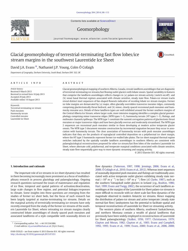
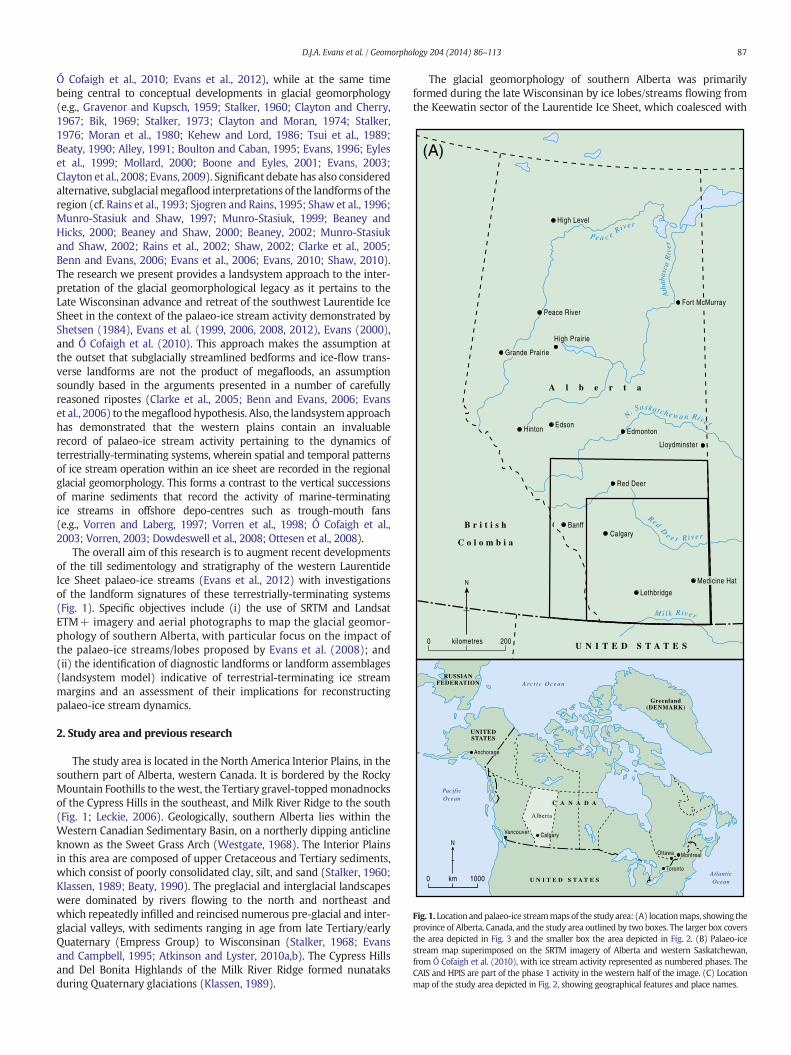
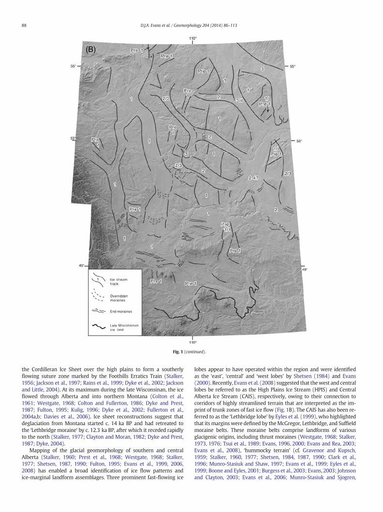
Fig. 1. Location andpalaeo-ice streammaps of the study area: (A) locationmaps, showing theprovince of Alberta, Canada, and the study area outlined by two boxes. The larger box coversthe area depicted in Fig. 3 and the smaller box the area depicted in Fig. 2. (B) Palaeo-icestream map superimposed on the SRTM imagery of Alberta and western Saskatchewan,from Ó Cofaigh et al. (2010), with ice stream activity represented as numbered phases. TheCAIS and HPIS are part of the phase 1 activity in the western half of the image. (C) Locationmap of the study area depicted in Fig. 2, showing geographical features and place names.
87D.J.A. Evans et al. / Geomorphology 204 (2014) 86–113
Ó Cofaigh et al., 2010; Evans et al., 2012), while at the same timebeing central to conceptual developments in glacial geomorphology(e.g., Gravenor and Kupsch, 1959; Stalker, 1960; Clayton and Cherry,1967; Bik, 1969; Stalker, 1973; Clayton and Moran, 1974; Stalker,1976; Moran et al., 1980; Kehew and Lord, 1986; Tsui et al., 1989;Beaty, 1990; Alley, 1991; Boulton and Caban, 1995; Evans, 1996; Eyleset al., 1999; Mollard, 2000; Boone and Eyles, 2001; Evans, 2003;Clayton et al., 2008; Evans, 2009). Significant debate has also consideredalternative, subglacialmegaflood interpretations of the landforms of theregion (cf. Rains et al., 1993; Sjogren and Rains, 1995; Shaw et al., 1996;Munro-Stasiuk and Shaw, 1997; Munro-Stasiuk, 1999; Beaney andHicks, 2000; Beaney and Shaw, 2000; Beaney, 2002; Munro-Stasiukand Shaw, 2002; Rains et al., 2002; Shaw, 2002; Clarke et al., 2005;Benn and Evans, 2006; Evans et al., 2006; Evans, 2010; Shaw, 2010).The research we present provides a landsystem approach to the inter-pretation of the glacial geomorphological legacy as it pertains to theLate Wisconsinan advance and retreat of the southwest Laurentide IceSheet in the context of the palaeo-ice stream activity demonstrated byShetsen (1984), Evans et al. (1999, 2006, 2008, 2012), Evans (2000),and Ó Cofaigh et al. (2010). This approach makes the assumption atthe outset that subglacially streamlined bedforms and ice-flow trans-verse landforms are not the product of megafloods, an assumptionsoundly based in the arguments presented in a number of carefullyreasoned ripostes (Clarke et al., 2005; Benn and Evans, 2006; Evanset al., 2006) to themegafloodhypothesis. Also, the landsystemapproachhas demonstrated that the western plains contain an invaluablerecord of palaeo-ice stream activity pertaining to the dynamics ofterrestrially-terminating systems, wherein spatial and temporal patternsof ice stream operation within an ice sheet are recorded in the regionalglacial geomorphology. This forms a contrast to the vertical successionsof marine sediments that record the activity of marine-terminatingice streams in offshore depo-centres such as trough-mouth fans(e.g., Vorren and Laberg, 1997; Vorren et al., 1998; Ó Cofaigh et al.,2003; Vorren, 2003; Dowdeswell et al., 2008; Ottesen et al., 2008).
The overall aim of this research is to augment recent developmentsof the till sedimentology and stratigraphy of the western LaurentideIce Sheet palaeo-ice streams (Evans et al., 2012) with investigationsof the landform signatures of these terrestrially-terminating systems(Fig. 1). Specific objectives include (i) the use of SRTM and LandsatETM+ imagery and aerial photographs to map the glacial geomor-phology of southern Alberta, with particular focus on the impact ofthe palaeo-ice streams/lobes proposed by Evans et al. (2008); and(ii) the identification of diagnostic landforms or landform assemblages(landsystem model) indicative of terrestrial-terminating ice streammargins and an assessment of their implications for reconstructingpalaeo-ice stream dynamics.
2. Study area and previous research
The study area is located in the North America Interior Plains, in thesouthern part of Alberta, western Canada. It is bordered by the RockyMountain Foothills to the west, the Tertiary gravel-toppedmonadnocksof the Cypress Hills in the southeast, and Milk River Ridge to the south(Fig. 1; Leckie, 2006). Geologically, southern Alberta lies within theWestern Canadian Sedimentary Basin, on a northerly dipping anticlineknown as the Sweet Grass Arch (Westgate, 1968). The Interior Plainsin this area are composed of upper Cretaceous and Tertiary sediments,which consist of poorly consolidated clay, silt, and sand (Stalker, 1960;Klassen, 1989; Beaty, 1990). The preglacial and interglacial landscapeswere dominated by rivers flowing to the north and northeast andwhich repeatedly infilled and reincised numerous pre-glacial and inter-glacial valleys, with sediments ranging in age from late Tertiary/earlyQuaternary (Empress Group) to Wisconsinan (Stalker, 1968; Evansand Campbell, 1995; Atkinson and Lyster, 2010a,b). The Cypress Hillsand Del Bonita Highlands of the Milk River Ridge formed nunataksduring Quaternary glaciations (Klassen, 1989).
The glacial geomorphology of southern Alberta was primarilyformed during the late Wisconsinan by ice lobes/streams flowing fromthe Keewatin sector of the Laurentide Ice Sheet, which coalesced with
Fig. 1 (continued).
88 D.J.A. Evans et al. / Geomorphology 204 (2014) 86–113
the Cordilleran Ice Sheet over the high plains to form a southerlyflowing suture zone marked by the Foothills Erratics Train (Stalker,1956; Jackson et al., 1997; Rains et al., 1999; Dyke et al., 2002; Jacksonand Little, 2004). At its maximum during the late Wisconsinan, the iceflowed through Alberta and into northern Montana (Colton et al.,1961; Westgate, 1968; Colton and Fullerton, 1986; Dyke and Prest,1987; Fulton, 1995; Kulig, 1996; Dyke et al., 2002; Fullerton et al.,2004a,b; Davies et al., 2006). Ice sheet reconstructions suggest thatdeglaciation from Montana started c. 14 ka BP and had retreated tothe ‘Lethbridge moraine’ by c. 12.3 ka BP, after which it receded rapidlyto the north (Stalker, 1977; Clayton and Moran, 1982; Dyke and Prest,1987; Dyke, 2004).
Mapping of the glacial geomorphology of southern and centralAlberta (Stalker, 1960; Prest et al., 1968; Westgate, 1968; Stalker,1977; Shetsen, 1987, 1990; Fulton, 1995; Evans et al., 1999, 2006,2008) has enabled a broad identification of ice flow patterns andice-marginal landform assemblages. Three prominent fast-flowing ice
lobes appear to have operated within the region and were identifiedas the ‘east’, ‘central’ and ‘west lobes’ by Shetsen (1984) and Evans(2000). Recently, Evans et al. (2008) suggested that thewest and centrallobes be referred to as the High Plains Ice Stream (HPIS) and CentralAlberta Ice Stream (CAIS), respectively, owing to their connection tocorridors of highly streamlined terrain that are interpreted as the im-print of trunk zones of fast ice flow (Fig. 1B). The CAIS has also been re-ferred to as the ‘Lethbridge lobe’ by Eyles et al. (1999), who highlightedthat its margins were defined by theMcGregor, Lethbridge, and Suffieldmoraine belts. These moraine belts comprise landforms of variousglacigenic origins, including thrust moraines (Westgate, 1968; Stalker,1973, 1976; Tsui et al., 1989; Evans, 1996, 2000; Evans and Rea, 2003;Evans et al., 2008), ‘hummocky terrain’ (cf. Gravenor and Kupsch,1959; Stalker, 1960, 1977; Shetsen, 1984, 1987, 1990; Clark et al.,1996; Munro-Stasiuk and Shaw, 1997; Evans et al., 1999; Eyles et al.,1999; Boone and Eyles, 2001; Burgess et al., 2003; Evans, 2003; Johnsonand Clayton, 2003; Evans et al., 2006; Munro-Stasiuk and Sjogren,
(C)
Fig. 1 (continued).
89D.J.A. Evans et al. / Geomorphology 204 (2014) 86–113
2006), and recessional push moraines and/or controlled moraine(Evans et al., 1999; Evans, 2003; Johnson and Clayton, 2003; Evanset al., 2006, 2008). Glacially overridden and streamlined moraines alsoappear in the trunk zones of the fast glacier flow tracks (Evans et al.,2008), although their origins and ages remain to be elucidated. Local-ized case studies of large-scale moraine mapping by Evans et al.(1999, 2006, 2008) have identified a spatial variability that potentially
reflects changing thermal regimes at the sheet margin in addition tosurging activity during later stages of recession, similar to the trendsidentified by Colgan et al. (2003) in the northern USA.
During deglaciation of the region, numerous proglacial lakes devel-oped in front of the receding lobate ice stream margins, resulting inthe incision of numerous spillways (Christiansen, 1979; Evans, 2000).These spillways have been either cut through preexisting preglacial
90 D.J.A. Evans et al. / Geomorphology 204 (2014) 86–113
valley fills or have created new flood tracks through the soft Cretaceousbedrock (Evans and Campbell, 1995). Asmeltwaters decanted generallyeastwards they appear to have penetrated beneath the ice sheet marginin some places to produce subglacial meltwater channels (Sjogren andRains, 1995). This pattern of drainage was most likely enhanced bythe northeasterly dip of the glacioisostatically depressed land surfacebeneath the receding ice sheet.
A complex stratigraphy of pre-Quaternary and Quaternary glacialand interglacial deposits exists in the study region (Stalker, 1963, 1968,1969, 1983; Stalker and Wyder, 1983; Evans and Campbell, 1992,1995; Evans, 2000). Of significance to this study are the extensive out-crops of glacigenic sediment relating to the last glaciation, which havebeen employed in palaeoglaciological reconstructions of ice streamsand ice sheet marginal recession patterns by Evans (2000), Evans et al.(2006, 2008, 2012), and Ó Cofaigh et al. (2010; Fig. 1B). These studieshave highlighted themarginal thickening of subglacial traction tills in as-sociation with individual ice streams/lobes, thereby verifying theoreticalmodels of subglacial deforming layers (e.g., Boulton, 1996a,b) beneathice sheets.
The findings of the research outlined above are assimilated in thisstudy with new observations and data on the glacigenic landforms ofthe region in order to assess the regional imprint of ice streammarginalsedimentation. Local variations in the patterns of landform assemblagesin turn facilitate a better understanding of ice stream dynamics duringthe deglaciation of the southwest Laurentide Ice Sheet.
3. Methods
Glacial geomorphological mapping was undertaken by using threedifferent aerial image sources, including the 2000 Shuttle Radar Topog-raphyMission (SRTM 2-arc second data), Landsat 7 Enhanced ThematicMapper Plus (Landsat ETM+) and aerial photograph mosaics flownand compiled by the Alberta Department of Lands and Forest in the1950s. The SRTMdata have been used to create digital elevationmodels(DEMs) of the Alberta landscape.
Global Mapper™ produced a smoothed, rendered pseudo-colourimage of the SRTM data that could be manipulated to accentuate fea-tures, produce three-dimensional images and change sun illuminationangles. Following the procedures of Smith and Clark (2005), multipleillumination angles were also used during mapping. An alternativemethod was employed to compare, verify, and supplement the SRTMmapping. This involved the use of ENVI 4.3 software to open the SRTMdata in a grey-scale format; nearest neighbour sampling was used tocorrect for missing sample points and was automatically applied tothe same missing data points when opening the images in GlobalMapper. Additional geomorphologicalmappingwas conducted throughinterpretation of the high resolution Landsat ETM+panchromatic band(band 8: 0.52–0.90 μm) images.
The SRTM and Landsat ETM+ mapping is at a scale appropriateto the identification of regional scale landform patterns, includingsubglacial bedforms and cross-cutting lineations (Clark, 1999). Onceidentified and mapped, lineations were divided into flowsets usingcharacteristics such as parallel conformity, length, and morphology;they were then simplified by drawing flowlines aligned with andparallel to the lineation direction, following the procedures outlined byClark (1997, 1999), so that each flowset represents a collection of glacialfeatures formed during the same flow phase and under the same condi-tions. Where possible, quantitative analyses examined average lineationlength, orientation, elongation ratios (ER), and average distance betweenlineations in order to identify any similarities or differences betweenflowsets. Such quantitative analyses of subglacial bedforms have beenwidely demonstrated to be critical in the reconstruction of palaeo-icestreams and their dynamics (e.g., Stokes and Clark, 2003; Roberts andLong, 2005; Stokes et al., 2006; Storrar and Stokes, 2007).
A series of ten, 1:63,360 (1 in. to 1 mile) aerial photograph mosaicscaptured in 1951 by the Alberta Department of Lands and Forest
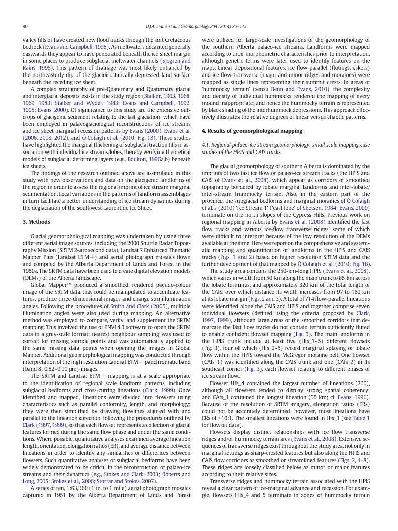
were utilized for large-scale investigations of the geomorphology ofthe southern Alberta palaeo-ice streams. Landforms were mappedaccording to their morphometric characteristics prior to interpretation,although genetic terms were later used to identify features on themaps. Linear depositional features, ice flow-parallel (flutings, eskers)and ice flow-transverse (major and minor ridges and moraines) weremapped as single lines representing their summit crests. In areas of‘hummocky terrain’ (sensu Benn and Evans, 2010), the complexityand density of individual hummocks rendered the mapping of everymound inappropriate; and hence the hummocky terrain is representedby black shading of the interhummockdepressions. This approach effec-tively illustrates the relative degrees of linear versus chaotic patterns.
4. Results of geomorphological mapping
4.1. Regional palaeo-ice stream geomorphology: small scale mapping casestudies of the HPIS and CAIS tracks
The glacial geomorphology of southern Alberta is dominated by theimprints of two fast ice flow or palaeo-ice stream tracks (the HPIS andCAIS of Evans et al., 2008), which appear as corridors of smoothedtopography bordered by lobate marginal landforms and inter-lobate/inter-stream hummocky terrain. Also, in the eastern part of theprovince, the subglacial bedforms and marginal moraines of Ó Cofaighet al.'s (2010) ‘Ice Stream 1’ (‘east lobe’ of Shetsen, 1984; Evans, 2000)terminate on the north slopes of the Cypress Hills. Previous work onregional mapping in Alberta by Evans et al. (2008) identified the fastflow tracks and various ice-flow transverse ridges, some of whichwere difficult to interpret because of the low resolution of the DEMsavailable at the time. Herewe report on the comprehensive and system-atic mapping and quantification of landforms in the HPIS and CAIStracks (Figs. 1 and 2) based on higher resolution SRTM data and thefurther development of that mapped by Ó Cofaigh et al. (2010; Fig. 1B).
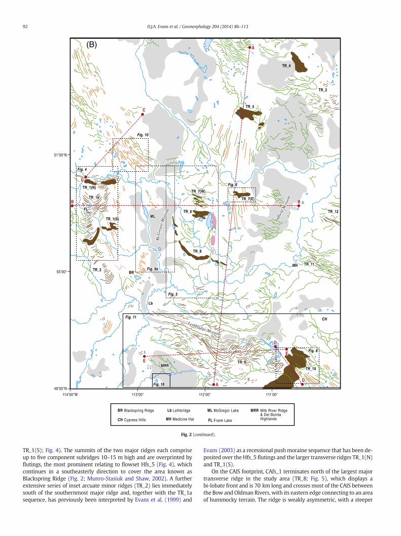
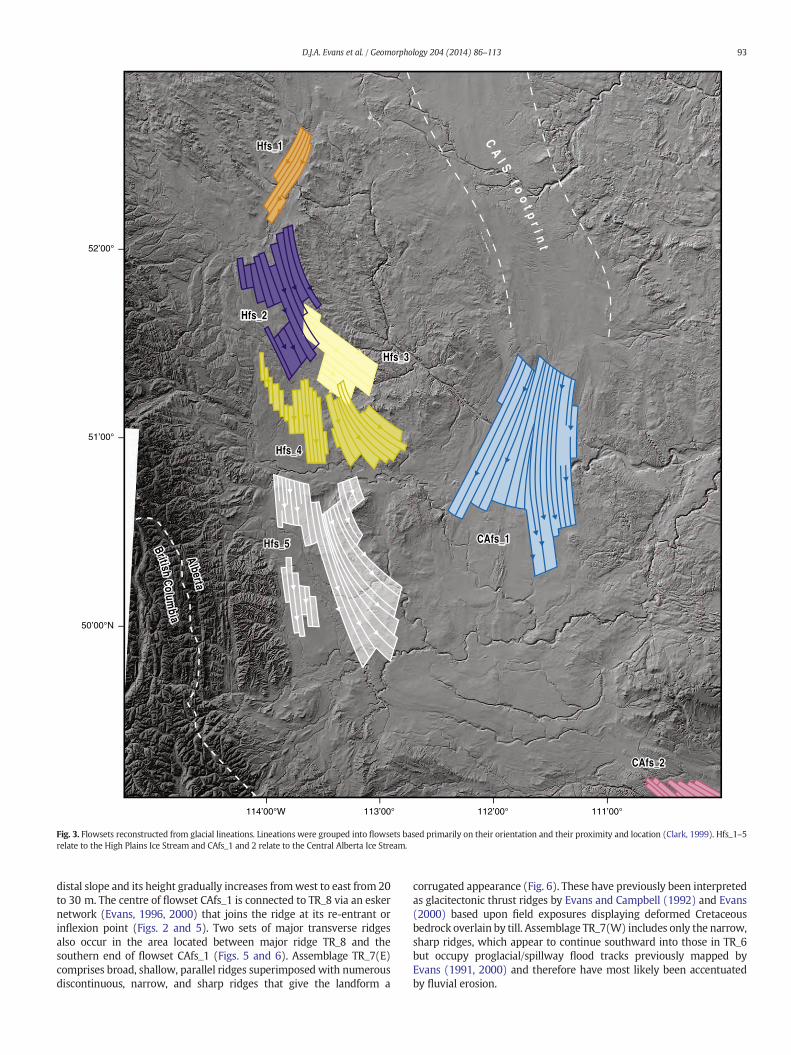
The study area contains the 250-km-long HPIS (Evans et al., 2008),which varies inwidth from50 kmalong themain trunk to 85 kmacrossthe lobate terminus, and approximately 320 km of the total length ofthe CAIS, over which distance its width increases from 97 to 160 kmat its lobatemargin (Figs. 2 and 3). A total of 714flow-parallel lineationswere identified along the CAIS and HPIS and together comprise sevenindividual flowsets (defined using the criteria proposed by Clark,1997, 1999), although large areas of the smoothed corridors that de-marcate the fast flow tracks do not contain terrain sufficiently flutedto enable confident flowset mapping (Fig. 3). The main landforms inthe HPIS trunk include at least five (Hfs_1–5) different flowsets(Fig. 3), four of which (Hfs_2–5) record marginal splaying or lobateflow within the HPIS toward the McGregor moraine belt. One flowset(CAfs_1) was identified along the CAIS trunk and one (CAfs_2) in itssoutheast corner (Fig. 3), each flowset relating to different phases ofice stream flow.
Flowset Hfs_4 contained the largest number of lineations (260),although all flowsets tended to display strong spatial coherency;and CAfs_1 contained the longest lineation (35 km; cf. Evans, 1996).Because of the resolution of SRTM imagery, elongation ratios (ERs)could not be accurately determined; however, most lineations haveERs of N10:1. The smallest lineations were found in Hfs_1 (see Table 1for flowset data).
Flowsets display distinct relationships with ice flow transverseridges and/or hummocky terrain arcs (Evans et al., 2008). Extensive se-quences of transverse ridges exist throughout the study area, not only inmarginal settings as sharp-crested features but also along the HPIS andCAIS flow corridors as smoothed or streamlined features (Figs. 2, 4–8).These ridges are loosely classified below as minor or major featuresaccording to their relative sizes.
Transverse ridges and hummocky terrain associated with the HPISreveal a clear pattern of ice-marginal advance and recession. For exam-ple, flowsets Hfs_4 and 5 terminate in zones of hummocky terrain
91D.J.A. Evans et al. / Geomorphology 204 (2014) 86–113
and/or minor transverse ridges, demarcating lobate ice marginal posi-tions that are compatiblewith theflowsets that terminate on their prox-imal sides (cf. Evans et al., 1999, 2006, 2008). The landform assemblageTR_1a occupies 100 km of the western half of the HPIS track and
(A)
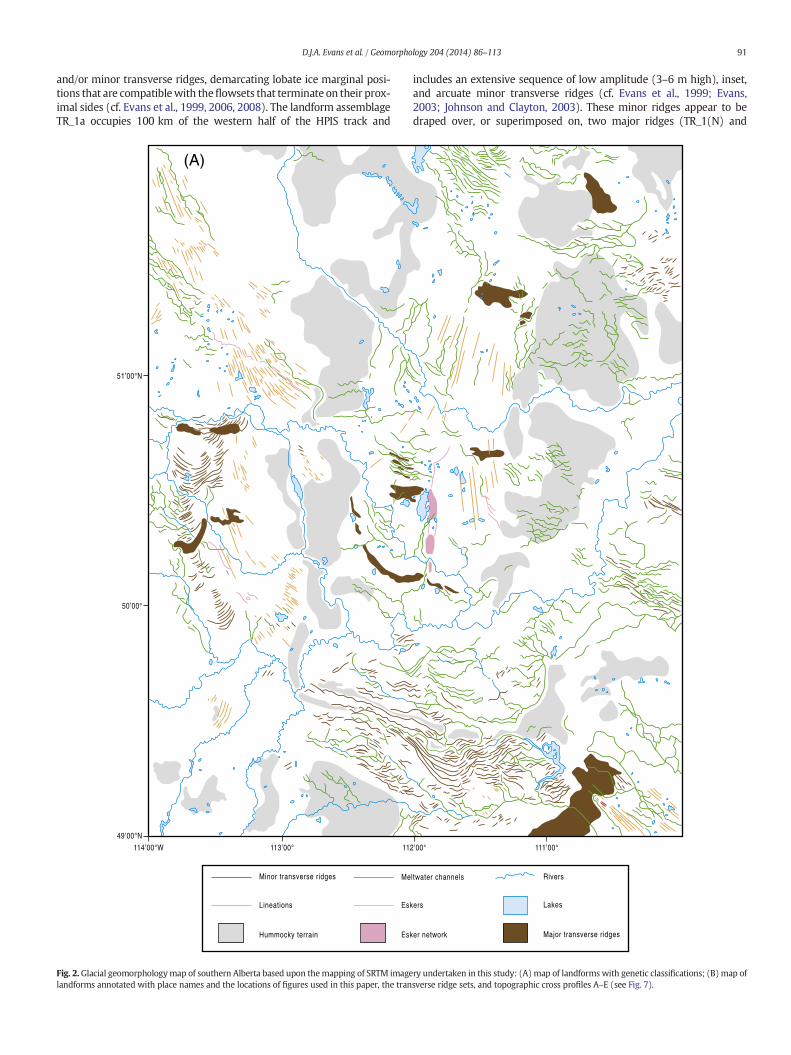
Fig. 2. Glacial geomorphologymap of southern Alberta based upon themapping of SRTM imagelandforms annotated with place names and the locations of figures used in this paper, the tran
includes an extensive sequence of low amplitude (3–6 m high), inset,and arcuate minor transverse ridges (cf. Evans et al., 1999; Evans,2003; Johnson and Clayton, 2003). These minor ridges appear to bedraped over, or superimposed on, two major ridges (TR_1(N) and
ry undertaken in this study: (A)map of landforms with genetic classifications; (B)map ofsverse ridge sets, and topographic cross profiles A–E (see Fig. 7).
(B)
Fig. 2 (continued).
92 D.J.A. Evans et al. / Geomorphology 204 (2014) 86–113
TR_1(S); Fig. 4). The summits of the two major ridges each compriseup to five component subridges 10–15 m high and are overprinted byflutings, the most prominent relating to flowset Hfs_5 (Fig. 4), whichcontinues in a southeasterly direction to cover the area known asBlackspring Ridge (Fig. 2; Munro-Stasiuk and Shaw, 2002). A furtherextensive series of inset arcuate minor ridges (TR_2) lies immediatelysouth of the southernmost major ridge and, together with the TR_1asequence, has previously been interpreted by Evans et al. (1999) and
Evans (2003) as a recessional pushmoraine sequence that has been de-posited over theHfs_5 flutings and the larger transverse ridges TR_1(N)and TR_1(S).
On the CAIS footprint, CAfs_1 terminates north of the largest majortransverse ridge in the study area (TR_8; Fig. 5), which displays abi-lobate front and is 70 km long and crosses most of the CAIS betweenthe Bow and Oldman Rivers, with its eastern edge connecting to an areaof hummocky terrain. The ridge is weakly asymmetric, with a steeper
114’00°W 113’00° 112’00° 111’00°
52’00°
51’00°
50’00°N
CA
I S f o
ot p
r i nt
Hfs_4
Hfs_5
Hfs_3
Hfs_2
Hfs_1
CAfs_1
CAfs_2
Alberta
British Colum
bia
Fig. 3. Flowsets reconstructed from glacial lineations. Lineations were grouped into flowsets based primarily on their orientation and their proximity and location (Clark, 1999). Hfs_1–5relate to the High Plains Ice Stream and CAfs_1 and 2 relate to the Central Alberta Ice Stream.
93D.J.A. Evans et al. / Geomorphology 204 (2014) 86–113
distal slope and its height gradually increases fromwest to east from 20to 30 m. The centre of flowset CAfs_1 is connected to TR_8 via an eskernetwork (Evans, 1996, 2000) that joins the ridge at its re-entrant orinflexion point (Figs. 2 and 5). Two sets of major transverse ridgesalso occur in the area located between major ridge TR_8 and thesouthern end of flowset CAfs_1 (Figs. 5 and 6). Assemblage TR_7(E)comprises broad, shallow, parallel ridges superimposed with numerousdiscontinuous, narrow, and sharp ridges that give the landform a
corrugated appearance (Fig. 6). These have previously been interpretedas glacitectonic thrust ridges by Evans and Campbell (1992) and Evans(2000) based upon field exposures displaying deformed Cretaceousbedrock overlain by till. Assemblage TR_7(W) includes only the narrow,sharp ridges, which appear to continue southward into those in TR_6but occupy proglacial/spillway flood tracks previously mapped byEvans (1991, 2000) and therefore have most likely been accentuatedby fluvial erosion.
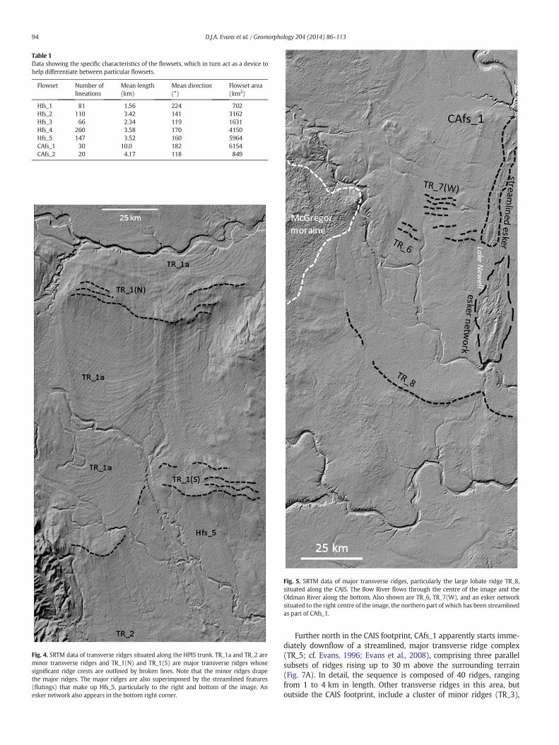
Table 1Data showing the specific characteristics of the flowsets, which in turn act as a device tohelp differentiate between particular flowsets.
Fig. 4. SRTM data of transverse ridges situated along the HPIS trunk. TR_1a and TR_2 areminor transverse ridges and TR_1(N) and TR_1(S) are major transverse ridges whosesignificant ridge crests are outlined by broken lines. Note that the minor ridges drapethe major ridges. The major ridges are also superimposed by the streamlined features(flutings) that make up Hfs_5, particularly to the right and bottom of the image. Anesker network also appears in the bottom right corner.
Fig. 5. SRTM data of major transverse ridges, particularly the large lobate ridge TR_8,situated along the CAIS. The Bow River flows through the centre of the image and theOldman River along the bottom. Also shown are TR_6, TR_7(W), and an esker networksituated to the right centre of the image, the northern part of which has been streamlinedas part of CAfs_1.
94 D.J.A. Evans et al. / Geomorphology 204 (2014) 86–113
Further north in the CAIS footprint, CAfs_1 apparently starts imme-diately downflow of a streamlined, major transverse ridge complex(TR_5; cf. Evans, 1996; Evans et al., 2008), comprising three parallelsubsets of ridges rising up to 30 m above the surrounding terrain(Fig. 7A). In detail, the sequence is composed of 40 ridges, rangingfrom 1 to 4 km in length. Other transverse ridges in this area, butoutside the CAIS footprint, include a cluster of minor ridges (TR_3),
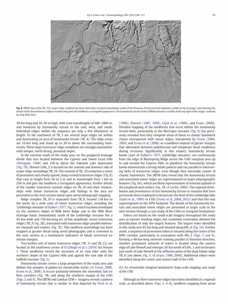
Fig. 6. SRTM data of the TR_7(E) major ridge (outlined by short dash lines) located immediately south of the Dinosaur Provincial Park badlands (visible at top of image) and showing thedetails of the discontinuous ridged crestline that gives the landforma corrugated appearance. Thehummocky terrain of the Suffieldmoraine is visible at the top right of the image (outlinedby long dash line).
95D.J.A. Evans et al. / Geomorphology 204 (2014) 86–113
30 km long and 10–20 m high, with crest wavelengths of 500–1000 m,and bordered by hummocky terrain to the east, west, and south.Individual ridges within the sequence are only a few kilometres inlength. To the northwest of TR_3 are several large ridges set withinand dominating an area of hummocky terrain (TR_4). The ridge crestsare 10 km long and stand up to 20 m above the surrounding hum-mocks. These large transverse ridge complexes are strongly asymmetricwith steeper, north-facing, proximal slopes.
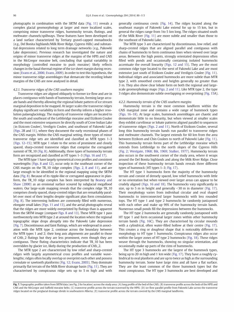
In the extreme south of the study area, on the preglacial drainagedivide that was located between the Cypress and Sweet Grass hills(Westgate, 1968) and 150 m above the Pakowki Lake depression(Fig. 7D), flowset CAfs_2 is located on the summit and downice side ofmajor ridge assemblage TR_10. The summit of TR_10 comprises a seriesof prominent and closely spaced, sharp crested transverse ridges (Fig. 8)that vary in height from 20 to 5 m and in wavelength from 1 km to250 m and give the landform a corrugated appearance. Further detailsof the smaller transverse summit ridges on TR_10 and their relation-ships with minor transverse ridges and flutings in the area arepresented in the next section based upon aerial photograph mapping.
Ridge complex TR_10 is separated from TR_8, located 130 km tothe north, by a wide zone of minor transverse ridges, including the‘Lethbridgemoraine’ of Stalker (1977; Fig. 2),which has been developedon the northern slopes of Milk River Ridge and in the Milk Riverdrainage basin. Immediately south of the Lethbridge moraine lies a45-km-wide and 150-km-long arc of low amplitude, minor transverseridges (TR_9; Fig. 2B), associatedwith numerous ridge-parallel meltwa-ter channels and coulees (Fig. 7E). This landform assemblage has beenmapped at greater detail using aerial photographs and is reviewed inthe next section as a landsystem indicative of lobate terrestrial icestream margins.
Two further sets of minor transverse ridges (TR_11 and TR_12) arelocated at the southwest corner of Ó Cofaigh et al.'s (2010) Ice Stream1. These landforms record the incursion of an ‘east lobe’ onto thenorthern slopes of the Cypress Hills and against the east side of theSuffield moraine (Fig. 2).
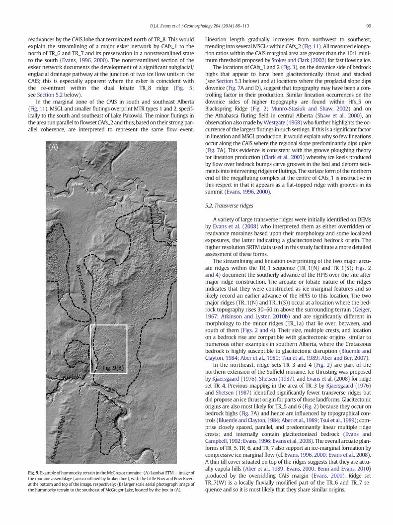
Hummocky terrain covers a large proportion of the study area anddefines the margins of palaeo-ice stream/lobe tracks (cf. Evans, 2000;Evans et al., 2008). It occurs primarily between the smoothed, fast iceflow corridors (Fig. 7B) and along the southern margin of the CAIS(Figs. 2 and 9). The SRTM and Landsat ETM+ imagery reveals a patternof hummocky terrain that is similar to that depicted by Prest et al.
(1968), Shetsen (1987, 1990), Clark et al. (1996), and Evans (2000).Detailed mapping of the landforms that occur within the hummockyterrain belts, particularly in the McGregor moraine (Fig. 9) has previ-ously revealed that they comprise areas of linear to chaotic hummockchains interspersed with minor ridges, interpreted by Evans (2000,2009) and Evans et al. (2006) as a landform imprint of glacier marginsthat alternated between polythermal and temperate basal conditionsduring recession. Significantly in this respect, hummocky terrainbands (part of Stalker's, 1977, Lethbridge moraine) run continuouslyfrom the edge of Blackspring Ridge across the CAIS marginal area upto and around the Cypress Hills. In planform the hummocky terrainbands demonstrate a strong lobate pattern and run parallel to interven-ing belts of transverse ridges, even though they internally consist ofchaotic hummocks. The SRTM data reveal that the hummocky terrainand associated minor ridges are superimposed on larger physiographicfeatures (Fig. 9A),which are likely representative of remnant uplands inthe preglacial land surface (Fig. 1B; cf. Leckie, 2006). The regional distri-bution and prominence of this hummocky terrain or moraine belt havepreviously been employed to demarcate the limit of the Lethbridge lobe(Eyles et al., 1999) or CAIS (Evans et al., 2008, 2012) and that this wassuperimposed on the HPIS footprint. The details of the hummocky ter-rain and associated minor ridges are presented at larger scale in thenext section through a case study of the CAIS ice-marginal landsystem.
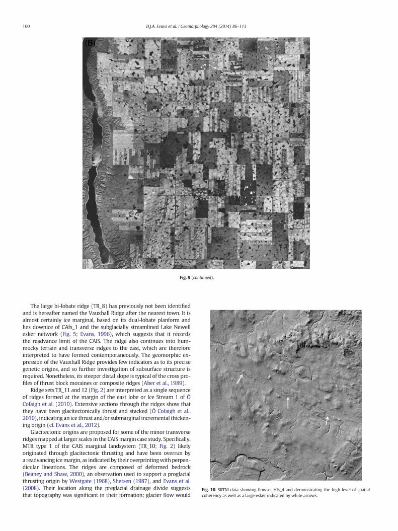
Eskers are found on the small-scale imagery throughout the studyarea as narrow winding ridges, but resolution constraints allowed theidentification of only the largest features. The largest esker identifiedin this study was 45 km long and situated along Hfs_4 (Fig. 10). Furthersouth, a sequence of prominent eskers is situated along the centre of theHPIS corridor, particularly in association with Hfs_5 (Figs. 2 and 4),forming a 40-km-long network running parallel to lineation direction.Another prominent network of eskers is located along the easternedge of LakeNewell and emerges 20 kmsouth of CAfs_1 and terminatesjust south of Lake Newell at the inflexion point of the dual-lobate ridgeTR_8 (see above; Fig. 5; cf. Evans, 1996, 2000). Additional eskers wereidentified along the centre and eastern half of the CAIS.
4.2. Ice stream/lobe marginal landsystem: large-scale mapping case studyof the CAIS
Although ice flow transverse ridges have been identified at a regionalscale, as described above (Figs. 2, 4–8), landform mapping from aerial
96 D.J.A. Evans et al. / Geomorphology 204 (2014) 86–113
photographs in combination with the SRTM data (Fig. 11) reveals acomplex glacial geomorphology at larger and more localized scales,comprising minor transverse ridges, hummocky terrain, flutings, andmeltwater channels/spillways. These features have been developed ona land surface characterized by Tertiary gravel-capped monadnocks(e.g., Del Bonita highlands/Milk River Ridge, Cypress Hills) and substan-tial depressions related to long term drainage networks (e.g., PakowkiLake depression). Previous research has investigated the nature andorigins of minor transverse ridges at the margins of the HPIS and CAISin the McGregor moraine belt, concluding that spatial variability inmorphology (controlled moraine to push moraine) likely reflectschanges in the basal thermal regime of the ice sheetmargin during reces-sion (Evans et al., 2006; Evans, 2009). In order to test this hypothesis, theminor transverse ridge assemblages that demarcate the receding lobatemargins of the CAIS are now analysed in detail.
4.2.1. Transverse ridges of the CAIS southern marginsTransverse ridges are aligned obliquely to former ice flow and are in
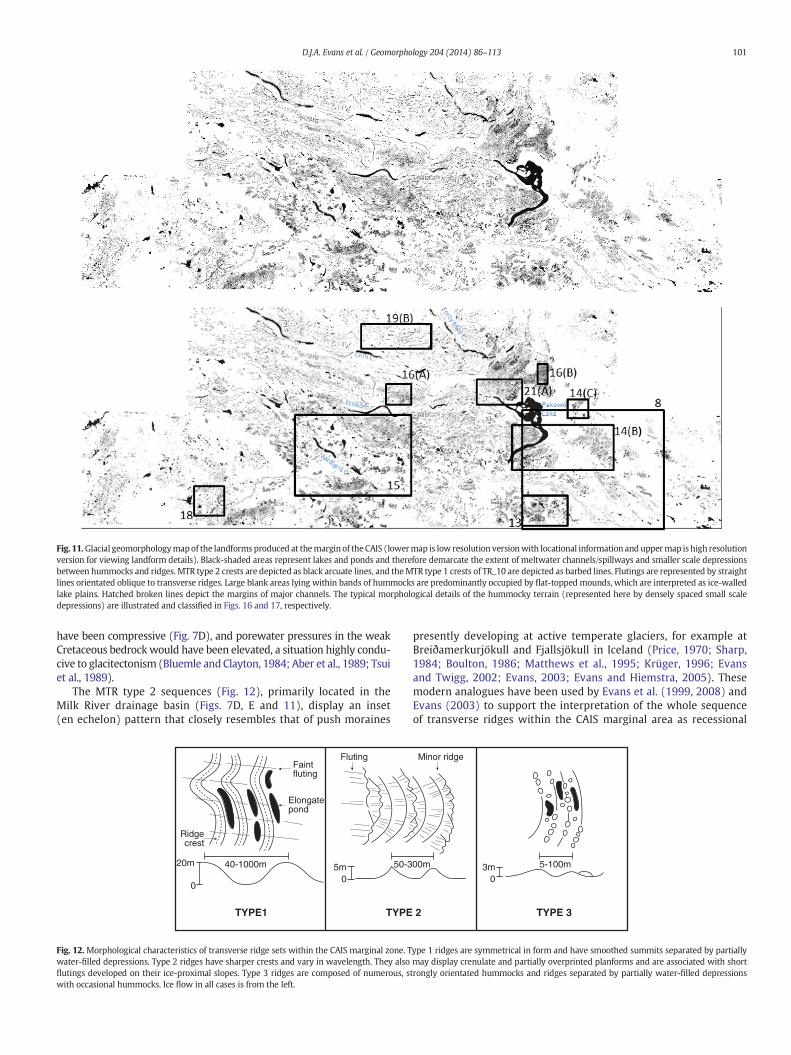
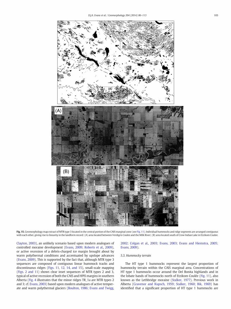
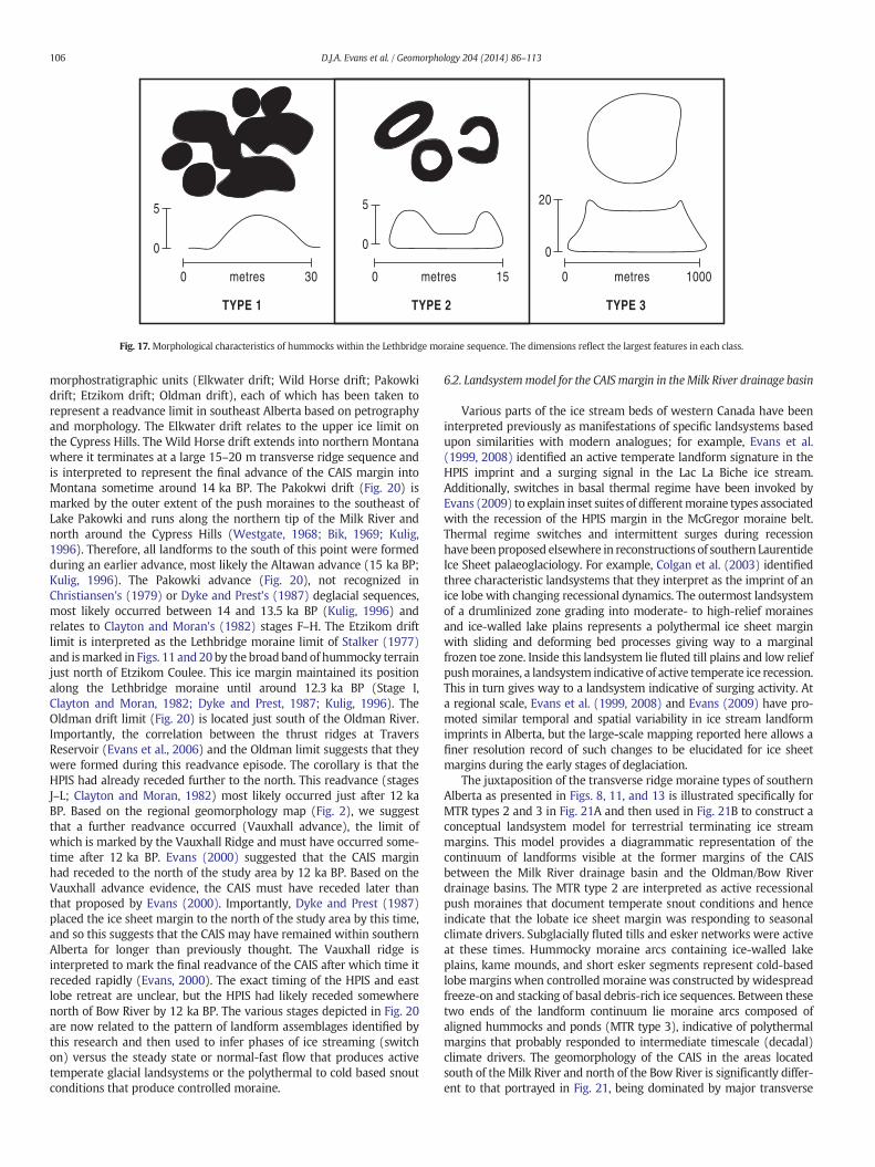
places contiguouswith bands of hummocky terrain, forming large arcu-ate bands and thereby allowing the regional lobate pattern of ice streammarginal deposition to bemapped. At larger scales the transverse ridgesdisplay significant variability in form and thereby inform a higher reso-lution palaeoglaciology. The majority of transverse ridges are located tothe south and southeast of the Lethbridge moraine and Etzikom Couleeand themost extensive sequences lie directly south of Crow Indian Lake(in Etzicom Coulee), Verdigris Coulee, and southeast of Pakowki Lake(Figs. 2B and 11), where they document the early recessional phases ofthe CAIS margin. Within the CAIS marginal setting, three types of minortransverse ridge sets are identified and classified as MTR types 1–3(Figs. 12–15); MTR type 1 relate to the series of prominent and closelyspaced, sharp-crested transverse ridges that comprise the corrugatedsummit of TR_10 (Fig. 8). Additionally, three types of hummocky terrainform are recognized and classified as HT types 1–3 (Figs. 16 and 17).
TheMTR type 1 have largely symmetrical cross profiles and consistentwavelengths (Figs. 8 and 12), occur only in the southeast corner of theCAIS margin on the TR_10 ridge complex (Figs. 2, 8 and 11), and arelarge enough to be identified in the regional mapping using the SRTMdata (Fig. 8). Because of its ripple-like or corrugated appearance in plan-form, the TR_10 ridge complex has been interpreted by Beaney andShaw (2000) as an erosional surface scoured by subglacial megafloodwaters. Our large-scale mapping reveals that the complex ridge TR_10comprises closely spaced, sharp-crested ridges that are remarkably paral-lel over most of their lengths despite significant plan form crenulations(Fig. 8). The intervening hollows are commonly filled with numerous,elongate small lakes (Figs. 11 and 13), and the aerial photographs revealthat the ridges are more widely overprinted by flutings than is apparentfrom the SRTM image (compare Figs. 8 and 13). These MTR type 1 passnorthwesterly into MTR type 2 at around the locationwhere the regionaltopographic slope drops abruptly into the Pakowki Lake depression(Fig. 7). Discontinuous and faint flutings, which arewidespread in associ-ation with the MTR type 2, continue across the boundary betweenthe MTR types 1 and 2; their long axis alignments are parallel to thoseof CAfs_2 flutings but they are less prominent, even though they arecontiguous. These fluting characteristics indicate that TR_10 has beenoverridden by glacier ice, likely during the production of CAfs_2.
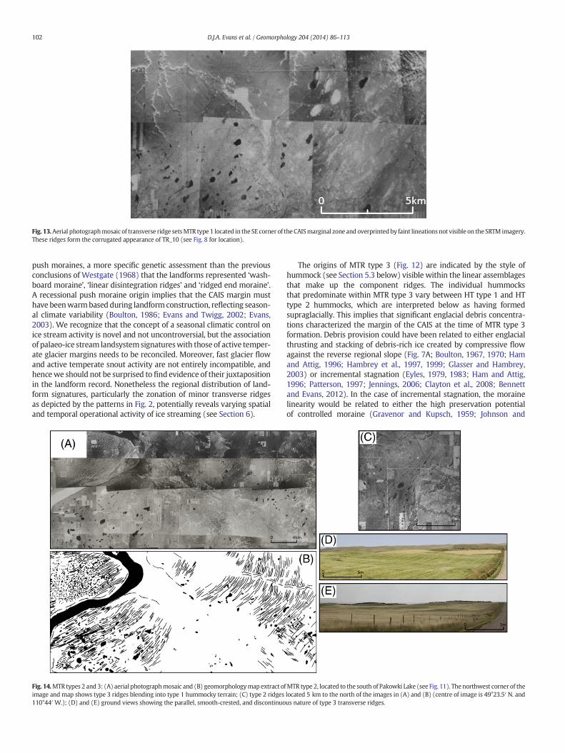
The MTR type 2 are characterized by low relief and sharp-crestedridges with largely asymmetrical cross profiles and variable wave-lengths; ridges often locally overlap or overprint each other and possesscrenulate or sawtooth planforms (Fig. 12; Evans, 2003). They dominateprimarily flat terrain of theMilk River drainage basin (Fig. 11). They arecharacterised by conspicuous ridge sets up to 5 m high and with
Fig. 7. Topographic profiles taken from SRTMdata (see Fig. 2 for location) across the study area:CAIS and the McGregor and Suffield moraine belts; (C) transverse profile across the terrain traridges located on the preglacial drainage divide in southeastern Alberta; (E) transverse profile
generally continuous crests (Fig. 14). The ridges located along thesoutheast margin of Pakowki Lake extend for up to 15 km, but ingeneral the ridges range from 1to 5 km long. The ridges situated southof the Milk River (Fig. 11) are more subtle and smaller than those tothe southeast of Pakowki Lake.
The MTR type 3 are characterized by discontinuous, low relief, andsharp-crested ridges that are aligned parallel and contiguous withchains of hummocks to form continuous lines when viewed over largeareas. Between the high points, strongly orientated depressions oftenfilled with ponds and occasionally containing isolated hummocksaccentuate the overall linearity (Figs. 12 and 15). They are the mostcommon ridge type located to the west of Pakowki Lake and are mostextensive just south of Etzikom Coulee and Verdigris Coulee (Fig. 11).Individual ridges and associated hummocks are more subtle than MTRtype 2, with smoothed crests and heights generally no greater than3 m. They also show clear lobate form on both the regional and large-scale geomorphology maps (Figs. 2 and 11). Like MTR type 2, the type3 ridges also demonstrate subtle overlapping or overprinting (Fig. 15A).
4.2.2. Hummocky terrain of the CAIS southern marginsHummocky terrain is the most common landform within the
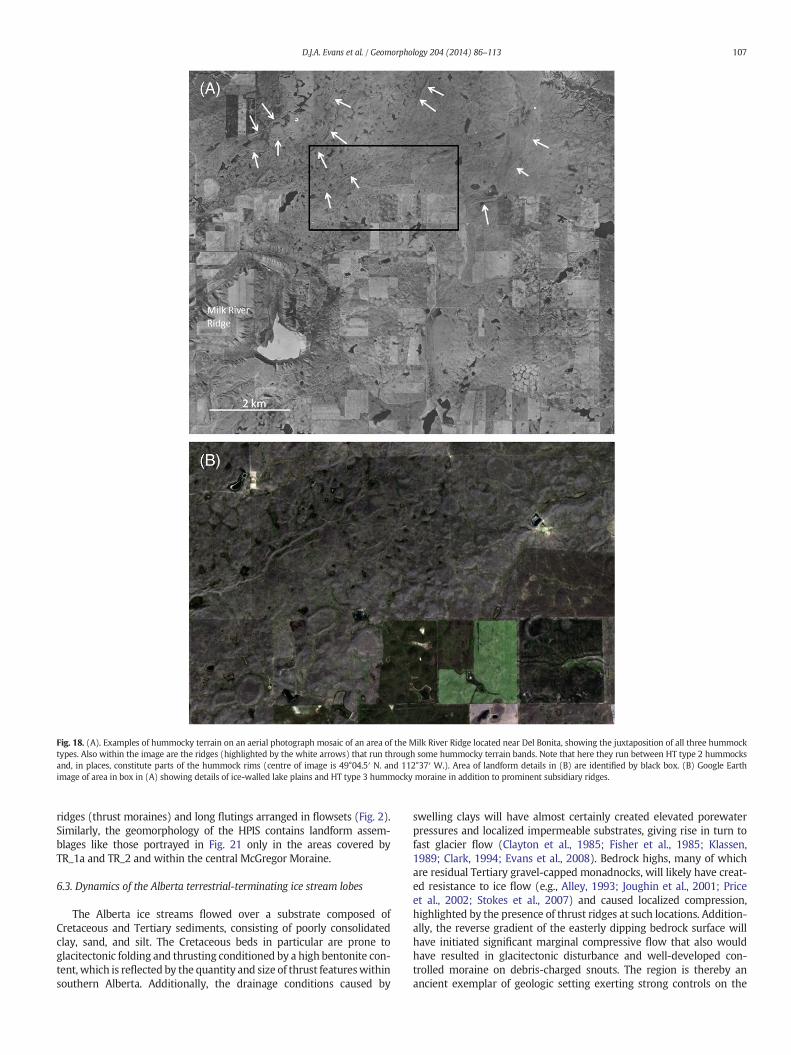
CAIS marginal zone and contains a wide range of hummock types(Figs. 16–18). At large scales, hummock assemblages are chaotic anddemonstrate little to no linearity, but when viewed at smaller scalesthey exhibit curvilinear or lobate patterns aligned parallel to sequencesof transverse ridges (Figs. 2 and 11). North of Etzikom Coulee, severallong thin hummocky terrain bands run parallel to transverse ridgesand meltwater channels. The largest extends for 60 km from the areabetween Etzikom and Chin Coulees to north of Pakowki Lake (Fig. 11).This hummocky terrain forms part of the Lethbridge moraine whichextends from Lethbridge to the north slopes of the Cypress Hills(Fig. 2; Westgate, 1968; Bik, 1969; Stalker, 1977). Hummocky terrainalso occurs in the southwest corner of the study area, where it wrapsaround the Del Bonita highlands and along the Milk River Ridge. Closeinspection of these hummocky terrain bands reveals three differenttypes of hummock (HT types 1–3; Fig. 17).
The HT type 1 hummocks form the majority of the hummockyterrain and consist of densely spaced, low relief hummocks with littleor no orientation but when viewed over larger areas can appear to becrudely aligned (Figs. 16 and 18). The hummocks vary significantly insize, up to 5 m in height and generally b30 m in diameter (Fig. 17).Their morphology varies from individual circular and oval shapedhummocks to interconnected larger hummocks with less roundedtops. The HT type 1 and type 2 hummocks lie randomly juxtaposedwith each other and make up 99% of the hummocky terrain bands.Numerous small ponds fill the depressions between the hummocks.
The HT type 2 hummocks are generally randomly juxtaposed withHT type 1 and form occasional larger zones within other hummockyterrain bands (Fig. 16C). They are characterised by circular moundswith a cylindrical, often water-filled hollow at their centre (Fig. 17).This creates a ring or doughnut shape that is noticeably different inmorphology to HT type 1 hummocks. Conspicuous ridges also occurwithin the larger zones of HT type 2 hummocks (Fig. 18). These ridgesweave through the hummocks, showing no singular orientation, andoccasionally make up parts of the rims of hummocks.
The HT type 3 hummocks are the largest of the hummock types,being up to 20 m high and 1 kmwide (Fig. 17). They have a roughly cy-lindrical to oval planform and are up to twice as high as the surroundinghummocky terrain. Some have large rims and all have a flat surface.They are the least common of the three hummock types but themost conspicuous. The HT type 3 hummocks are best developed and
(A) long profile of the bed of the CAIS; (B) transverse profile across the beds of theHPIS andversed by the HPIS; (D) ice flow parallel profile from Pakowki Lake across the transverseacross the terrain covered by the CAIS marginal landforms.
HPISHPIS
HPISHPIS
CAISCAIS
1000
5000 100 200 300
N
MilkRiverRidge
(A)S
Transverse Ridges
Transverse Ridges
TR_10
OldmanRiver
BowRiver
Etzikom Coulee
Chin Coulee
Ele
vatio
n (m
)
750
1000
0 120 160
W
E
Milk River Ridge
(E)E
Distance (km)
Pakowki Lake
Ele
vatio
n (m
)
1000
500
NW(D)
SE
PakowkiLake
Ele
vatio
n (m
)
1000
500
8040
200 40
0 10 20 30 40 50 60 70 80
SW(C)
NE
BowRiver
Ele
vatio
n (m
)
1000
5000 100 200
W(B)
E
Suffield Moraine
Ele
vatio
n (m
)
McGregor Moraine
McGregorLake
HPIS
CAIS
Verdigris Coulee
Red Deer River
LethbridgeMoraine
HPIS
TR_7e TR_8TR_6
TR_5
97D.J.A. Evans et al. / Geomorphology 204 (2014) 86–113
Fig. 8. SRTM data of the sequence of MTR type 1 ridges in the southeastern corner of Alberta (TR_10). Note the lineations situated just downice of the ridges (CAfs_2) and the smooth flattopography in the northwest corner representing Pakowki Lake. Although the ridges appear nonfluted in this image, they are overprinted by faint flutings, as illustrated by Fig. 13 (see boxfor location).
98 D.J.A. Evans et al. / Geomorphology 204 (2014) 86–113
primarily located in the southwest corner of the study area around theDel Bonita highlands (Fig. 18).
4.2.3. Flutings of the CAIS southern marginsFlutings near the margin of the CAIS are located predominantly
along the eastern portion of the Milk River and south and southeastof Pakowki Lake, and north of Tyrrell Lake (Fig. 11). They range from 1to 9 km in length with an average of 2 km. Flutings located north andsouth of the Milk River clearly overprint MTR type 1 (Figs. 11 and 13)at right angles and are b2 m in amplitude, making them difficult to rec-ognize on the ground (Westgate, 1968). The flutings that constituteflowset CAfs_2 are notably larger than any other lineations in the CAISmarginal zone, individual forms being up to 9 km long and 6 m highand the whole flowset covering an area 30 km long and 5 km wide.As a result, the aerial photographs reveal at least double the amountof flutings compared to the SRTM data. This scale of resolution allowsfurther assessment of fluting dimensions, including elongation ratios,which range from 12:1 up to 85:1 along the CAfs_2 with fluting lengthincreasing in a downflow direction.
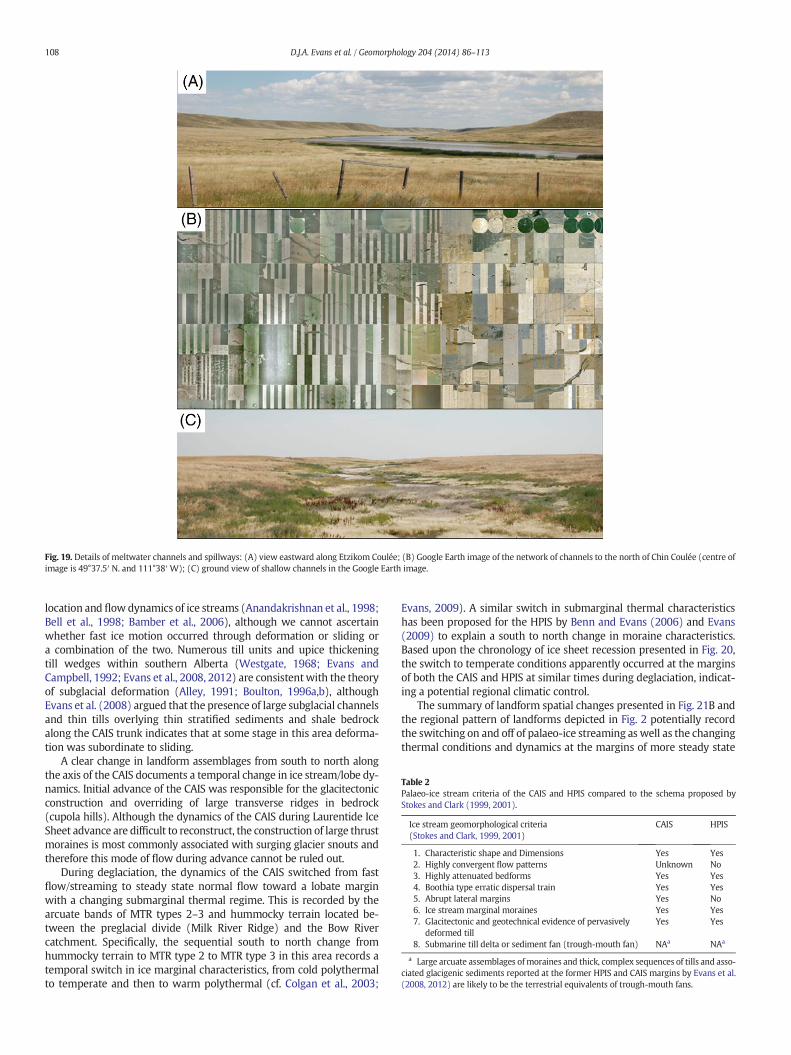
4.2.4. Spillways at the CAIS southern marginsFour major spillways extend across the study area including Forty
Mile Coulee, Chin Coulee, Etzikom Coulee and Verdigris Coulee and lieparallel to the transverse ridges, conforming to the lobate planformdisplayed by the ice-marginal landform record (Fig. 11). They extendacross themajority of the Lethbridgemoraine sequence as dominant fea-tures, reaching up to 500 m wide and 60 m deep (Fig. 19). An extensivenetwork of smaller channels situated north of Chin Coulee (Figs. 11and 19) lies predominantly parallel and perpendicular to the spillway.These shallow channels are up to 10 km long and 200 m wide (Fig. 19).Longer channels up to 20 km long and 100 m wide are found to thenorth of Crow Indian Lake in Etzicom Coulee, dissecting the hummockyterrain band at right angles. Only a few eskers were identified and arelocated chiefly in the northeast corner of the area mapped in Fig. 11.
5. Interpretations of geomorphology mapping
5.1. Smoothed corridors, lineations and flutings
Smoothed corridors of terrain on the plains of western Canada havebeen previously interpreted as palaeo-ice stream tracks (Evans et al.,2008; Ó Cofaigh et al., 2010) based in part upon the geomorphologicalcriteria proposed by Stokes and Clark (1999, 2001; Table 2). The corridorscontainmegascale glacial lineations (MSGL) orflutings and are delineatedby a change in smoothed topography, created by fast ice flow, to hum-mocky terrain associatedwith slowmoving, cold based ice and stagnation(Dyke andMorris, 1988; Stokes and Clark, 2002; Evans et al., 2008; Evans,2009; Ó Cofaigh et al., 2010). Similarly, we compare the lineations andsmoothed topography of southern Alberta to previously identifiedpalaeo-ice streams (Patterson, 1997, 1998; Stokes and Clark, 1999,2001; Clark and Stokes, 2003; Jennings, 2006) and to the forelands of con-temporary ice streams on the Antarctic Shelf (Shipp et al., 1999; Canalset al., 2000;Wellner et al., 2001; Ó Cofaigh et al., 2002), and thereby sub-stantiate propositions for the former occurrence of the HPIS and CAIS inthe southwest Laurentide Ice Sheet. The onset zones of the HPIS andCAIS are unknown, and mapping by Prest et al. (1968) and Evans et al.(2008) does not identify any clear convergent flow patterns. However,we identify divergent flow patterns in the flowsets Hfs_4 and Hfs_5 andCAfs_1. Additionally, pebble lithology data (Shetsen, 1984) demonstratea Boothia type (Dyke and Morris, 1988) dispersal by the HPIS and CAIS.Topographic cross profiles (Fig. 7B) and bedrock topographic maps(Geiger, 1967; Atkinson and Lyster, 2010b) reveal that the CAIS is apure ice stream and that the HPIS is a predominantly topographic icestream (Clark and Stokes, 2003).
Few flowsets were identified along the CAIS track, but a lack ofobvious cross-cutting patterns hampers any identification of changingflow directions. However, the orientation of flowset CAfs_1 appearsto relate to lobate ice flow toward the bi-lobate ridge TR_8 (Figs. 3and 5), indicating that TR_8 could represent the maximum position ofa readvance during which flowset CAfs_1 terminated at a lobate icemargin. Transverse ridge sets TR_6 and TR_7 appear to represent later
99D.J.A. Evans et al. / Geomorphology 204 (2014) 86–113
readvances by the CAIS lobe that terminated north of TR_8. This wouldexplain the streamlining of a major esker network by CAfs_1 to thenorth of TR_6 and TR_7 and its preservation in a nonstreamlined stateto the south (Evans, 1996, 2000). The nonstreamlined section of theesker network documents the development of a significant subglacial/englacial drainage pathway at the junction of two ice flow units in theCAIS; this is especially apparent where the esker is coincident withthe re-entrant within the dual lobate TR_8 ridge (Fig. 5;see Section 5.2 below).
In the marginal zone of the CAIS in south and southeast Alberta(Fig. 11), MSGL and smaller flutings overprint MTR types 1 and 2, specif-ically to the south and southeast of Lake Pakowki. The minor flutings inthe area runparallel toflowset CAfs_2 and thus, based on their strong par-allel coherence, are interpreted to represent the same flow event.
Fig. 9. Example of hummocky terrain in theMcGregormoraine: (A) Landsat ETM+ image ofthemoraine assemblage (areas outlined by broken line), with the Little Bow and Bow Riversat the bottom and top of the image, respectively; (B) larger scale aerial photograph image ofthe hummocky terrain to the southeast of McGregor Lake, located by the box in (A).
Lineation length gradually increases from northwest to southeast,trending into severalMSGLswithin CAfs_2 (Fig. 11). Allmeasured elonga-tion ratios within the CAIS marginal area are greater than the 10:1 mini-mum threshold proposed by Stokes and Clark (2002) for fast flowing ice.
The locations of CAfs_1 and 2 (Fig. 3), on the downice side of bedrockhighs that appear to have been glacitectonically thrust and stacked(see Section 5.3 below) and at locations where the proglacial slope dipsdownice (Fig. 7A and D), suggest that topography may have been a con-trolling factor in their production. Similar lineation occurrences on thedownice sides of higher topography are found within Hfs_5 onBlackspring Ridge (Fig. 2; Munro-Stasiuk and Shaw, 2002) and onthe Athabasca fluting field in central Alberta (Shaw et al., 2000), anobservation alsomade byWestgate (1968)who further highlights the oc-currence of the largestflutings in such settings. If this is a significant factorin lineation andMSGL production, it would explainwhy so few lineationsoccur along the CAIS where the regional slope predominantly dips upice(Fig. 7A). This evidence is consistent with the groove ploughing theoryfor lineation production (Clark et al., 2003) whereby ice keels producedby flow over bedrock bumps carve grooves in the bed and deform sedi-ments into intervening ridges orflutings. The surface formof the northernend of the megafluting complex at the centre of CAfs_1 is instructive inthis respect in that it appears as a flat-topped ridge with grooves in itssummit (Evans, 1996, 2000).
5.2. Transverse ridges
A variety of large transverse ridges were initially identified on DEMsby Evans et al. (2008) who interpreted them as either overridden orreadvance moraines based upon their morphology and some localizedexposures, the latter indicating a glacitectonized bedrock origin. Thehigher resolution SRTMdata used in this study facilitate amore detailedassessment of these forms.
The streamlining and lineation overprinting of the two major arcu-ate ridges within the TR_1 sequence (TR_1(N) and TR_1(S); Figs. 2and 4) document the southerly advance of the HPIS over the site aftermajor ridge construction. The arcuate or lobate nature of the ridgesindicates that they were constructed as ice marginal features and solikely record an earlier advance of the HPIS to this location. The twomajor ridges (TR_1(N) and TR_1(S)) occur at a location where the bed-rock topography rises 30–60 m above the surrounding terrain (Geiger,1967; Atkinson and Lyster, 2010b) and are significantly different inmorphology to the minor ridges (TR_1a) that lie over, between, andsouth of them (Figs. 2 and 4). Their size, multiple crests, and locationon a bedrock rise are compatible with glacitectonic origins, similar tonumerous other examples in southern Alberta, where the Cretaceousbedrock is highly susceptible to glacitectonic disruption (Bluemle andClayton, 1984; Aber et al., 1989; Tsui et al., 1989; Aber and Ber, 2007).
In the northeast, ridge sets TR_3 and 4 (Fig. 2) are part of thenorthern extension of the Suffield moraine. Ice thrusting was proposedby Kjaersgaard (1976), Shetsen (1987), and Evans et al. (2008) for ridgeset TR_4. Previous mapping in the area of TR_3 by Kjaersgaard (1976)and Shetsen (1987) identified significantly fewer transverse ridges butdid propose an ice thrust origin for parts of those landforms. Glacitectonicorigins are also most likely for TR_5 and 6 (Fig. 2) because they occur onbedrock highs (Fig. 7A) and hence are influenced by topographical con-trols (Bluemle andClayton, 1984; Aber et al., 1989; Tsui et al., 1989); com-prise closely spaced, parallel, and predominantly linear multiple ridgecrests; and internally contain glacitectonized bedrock (Evans andCampbell, 1992; Evans, 1996; Evans et al., 2008). The overall arcuate plan-forms of TR_5, TR_6, and TR_7 also support an ice-marginal formation bycompressive ice marginal flow (cf. Evans, 1996, 2000; Evans et al., 2008).A thin till cover situated on top of the ridges suggests that they are actu-ally cupola hills (Aber et al., 1989; Evans, 2000; Benn and Evans, 2010)produced by the overridding CAIS margin (Evans, 2000). Ridge setTR_7(W) is a locally fluvially modified part of the TR_6 and TR_7 se-quence and so it is most likely that they share similar origins.
Fig. 10. SRTM data showing flowset Hfs_4 and demonstrating the high level of spatialcoherency as well as a large esker indicated by white arrows.
100 D.J.A. Evans et al. / Geomorphology 204 (2014) 86–113
The large bi-lobate ridge (TR_8) has previously not been identifiedand is hereafter named the Vauxhall Ridge after the nearest town. It isalmost certainly ice marginal, based on its dual-lobate planform andlies downice of CAfs_1 and the subglacially streamlined Lake Newellesker network (Fig. 5; Evans, 1996), which suggests that it recordsthe readvance limit of the CAIS. The ridge also continues into hum-mocky terrain and transverse ridges to the east, which are thereforeinterpreted to have formed contemporaneously. The geomorphic ex-pression of the Vauxhall Ridge provides few indicators as to its precisegenetic origins, and so further investigation of subsurface structure isrequired. Nonetheless, its steeper distal slope is typical of the cross pro-files of thrust block moraines or composite ridges (Aber et al., 1989).
Ridge sets TR_11 and 12 (Fig. 2) are interpreted as a single sequenceof ridges formed at the margin of the east lobe or Ice Stream 1 of ÓCofaigh et al. (2010). Extensive sections through the ridges show thatthey have been glacitectonically thrust and stacked (Ó Cofaigh et al.,2010), indicating an ice thrust and/or submarginal incremental thicken-ing origin (cf. Evans et al., 2012).
Glacitectonic origins are proposed for some of the minor transverseridgesmapped at larger scales in the CAISmargin case study. Specifically,MTR type 1 of the CAIS marginal landsystem (TR_10; Fig. 2) likelyoriginated through glacitectonic thrusting and have been overrun bya readvancing icemargin, as indicated by their overprintingwithperpen-dicular lineations. The ridges are composed of deformed bedrock(Beaney and Shaw, 2000), an observation used to support a proglacialthrusting origin by Westgate (1968), Shetsen (1987), and Evans et al.(2008). Their location along the preglacial drainage divide suggeststhat topography was significant in their formation; glacier flow would
Fig. 11.Glacial geomorphologymapof the landforms produced at themarginof theCAIS (lowermap is low resolution versionwith locational information and uppermap is high resolutionversion for viewing landform details). Black-shaded areas represent lakes and ponds and therefore demarcate the extent of meltwater channels/spillways and smaller scale depressionsbetween hummocks and ridges. MTR type 2 crests are depicted as black arcuate lines, and theMTR type 1 crests of TR_10 are depicted as barbed lines. Flutings are represented by straightlines orientated oblique to transverse ridges. Large blank areas lying within bands of hummocks are predominantly occupied by flat-topped mounds, which are interpreted as ice-walledlake plains. Hatched broken lines depict the margins of major channels. The typical morphological details of the hummocky terrain (represented here by densely spaced small scaledepressions) are illustrated and classified in Figs. 16 and 17, respectively.
101D.J.A. Evans et al. / Geomorphology 204 (2014) 86–113
have been compressive (Fig. 7D), and porewater pressures in the weakCretaceous bedrockwould have been elevated, a situation highly condu-cive to glacitectonism (Bluemle and Clayton, 1984; Aber et al., 1989; Tsuiet al., 1989).
The MTR type 2 sequences (Fig. 12), primarily located in theMilk River drainage basin (Figs. 7D, E and 11), display an inset(en echelon) pattern that closely resembles that of push moraines
20m
0
40-1000m 5m0
50-3
Faintfluting
Fluting
Elongatepond
Ridgecrest
TYPE1 TYPE
Fig. 12.Morphological characteristics of transverse ridge sets within the CAIS marginal zone. Twater-filled depressions. Type 2 ridges have sharper crests and vary in wavelength. They alsoflutings developed on their ice-proximal slopes. Type 3 ridges are composed of numerous, swith occasional hummocks. Ice flow in all cases is from the left.
presently developing at active temperate glaciers, for example atBreiðamerkurjökull and Fjallsjökull in Iceland (Price, 1970; Sharp,1984; Boulton, 1986; Matthews et al., 1995; Krüger, 1996; Evansand Twigg, 2002; Evans, 2003; Evans and Hiemstra, 2005). Thesemodern analogues have been used by Evans et al. (1999, 2008) andEvans (2003) to support the interpretation of the whole sequenceof transverse ridges within the CAIS marginal area as recessional
00m
Minor ridge
3m0
5-100m
2 TYPE 3
ype 1 ridges are symmetrical in form and have smoothed summits separated by partiallymay display crenulate and partially overprinted planforms and are associated with shorttrongly orientated hummocks and ridges separated by partially water-filled depressions
Fig. 13.Aerial photographmosaic of transverse ridge setsMTR type 1 located in the SE corner of the CAISmarginal zone and overprintedby faint lineationsnot visible on the SRTM imagery.These ridges form the corrugated appearance of TR_10 (see Fig. 8 for location).
102 D.J.A. Evans et al. / Geomorphology 204 (2014) 86–113
push moraines, a more specific genetic assessment than the previousconclusions of Westgate (1968) that the landforms represented ‘wash-board moraine’, ‘linear disintegration ridges’ and ‘ridged end moraine’.A recessional push moraine origin implies that the CAIS margin musthave beenwarmbased during landform construction, reflecting season-al climate variability (Boulton, 1986; Evans and Twigg, 2002; Evans,2003). We recognize that the concept of a seasonal climatic control onice stream activity is novel and not uncontroversial, but the associationof palaeo-ice stream landsystemsignatureswith those of active temper-ate glacier margins needs to be reconciled. Moreover, fast glacier flowand active temperate snout activity are not entirely incompatible, andhencewe should not be surprised to find evidence of their juxtapositionin the landform record. Nonetheless the regional distribution of land-form signatures, particularly the zonation of minor transverse ridgesas depicted by the patterns in Fig. 2, potentially reveals varying spatialand temporal operational activity of ice streaming (see Section 6).
Fig. 14.MTR types 2 and 3: (A) aerial photographmosaic and (B) geomorphologymapextract ofimage and map shows type 3 ridges blending into type 1 hummocky terrain; (C) type 2 ridges110°44′ W.); (D) and (E) ground views showing the parallel, smooth-crested, and discontinuo
The origins of MTR type 3 (Fig. 12) are indicated by the style ofhummock (see Section 5.3 below) visible within the linear assemblagesthat make up the component ridges. The individual hummocksthat predominate within MTR type 3 vary between HT type 1 and HTtype 2 hummocks, which are interpreted below as having formedsupraglacially. This implies that significant englacial debris concentra-tions characterized the margin of the CAIS at the time of MTR type 3formation. Debris provision could have been related to either englacialthrusting and stacking of debris-rich ice created by compressive flowagainst the reverse regional slope (Fig. 7A; Boulton, 1967, 1970; Hamand Attig, 1996; Hambrey et al., 1997, 1999; Glasser and Hambrey,2003) or incremental stagnation (Eyles, 1979, 1983; Ham and Attig,1996; Patterson, 1997; Jennings, 2006; Clayton et al., 2008; Bennettand Evans, 2012). In the case of incremental stagnation, the morainelinearity would be related to either the high preservation potentialof controlled moraine (Gravenor and Kupsch, 1959; Johnson and
MTR type 2, located to the south of Pakowki Lake (see Fig. 11). Thenorthwest corner of thelocated 5 km to the north of the images in (A) and (B) (centre of image is 49°23.5′ N. andus nature of type 3 transverse ridges.
Fig. 15.Geomorphologymap extract ofMTR type 3 located in the central portion of theCAISmarginal zone (see Fig. 11). Individual hummocks and ridge segments are arranged contiguouswith each other, giving rise to linearity in the landform record: (A) area located between Verdigris Coulee and theMilk River; (B) area located south of Crow Indian Lake in EtzikomCoulee.
103D.J.A. Evans et al. / Geomorphology 204 (2014) 86–113
Clayton, 2003), an unlikely scenario based upon modern analogues ofcontrolled moraine development (Evans, 2009; Roberts et al., 2009),or active recession of a debris-charged ice margin brought about bywarm polythermal conditions and accentuated by upslope advances(Evans, 2009). This is supported by the fact that, although MTR type 3sequences are composed of contiguous linear hummock tracks anddiscontinuous ridges (Figs. 11, 12, 14, and 15), small-scale mapping(Figs. 2 and 11) shows clear inset sequences of MTR types 2 and 3,typical of active recession of both the CAIS andHPISmargins in southernAlberta (Fig. 4 illustrates that the minor ridges TR_1a are MTR types 2and 3; cf. Evans, 2003) based uponmodern analogues of active temper-ate and warm polythermal glaciers (Boulton, 1986; Evans and Twigg,
2002; Colgan et al., 2003; Evans, 2003; Evans and Hiemstra, 2005;Evans, 2009).
5.3. Hummocky terrain
The HT type 1 hummocks represent the largest proportion ofhummocky terrain within the CAIS marginal area. Concentrations ofHT type 1 hummocks occur around the Del Bonita highlands and inthe lobate bands of hummocks north of Etzikom Coulée (Fig. 11), alsoknown as the Lethbridge moraine (Stalker, 1977). Previous work inAlberta (Gravenor and Kupsch, 1959; Stalker, 1960; Bik, 1969) hasidentified that a significant proportion of HT type 1 hummocks are
104 D.J.A. Evans et al. / Geomorphology 204 (2014) 86–113
composed of till. A supraglacial origin for HT type 1 hummocks can besupported by simple form analogy (cf. Boulton, 1967; Clayton, 1967;Parizek, 1969; Boulton, 1972; Clayton and Moran, 1974; Eyles, 1979,1983; Paul, 1983; Clayton et al., 1985; Johnson et al., 1995; Ham andAttig, 1996; Patterson, 1997, 1998; Mollard, 2000; Johnson andClayton, 2003; Jennings, 2006), but their juxtaposition with activerecessional moraines in lobate arcs of landform assemblages (Figs. 11and 16) suggests that they were not associated with widespread icestagnation. Differential melting and supraglacial debris reworking bycontinuous topographic reversal can be invoked to explain the irregularshapes and sizes of the hummocks when viewed at larger scales,although subglacial pressing of the soft substrate at the margin of theCAIS as proposed by Stalker (1960), Eyles et al. (1999), and Boone andEyles (2001) could have been operating in the poorly drained conditionsof the reversed proglacial slopes of the region (Klassen, 1989; Mollard,2000). Nevertheless, the lobate arcuate appearance of HT type 1 hum-mocks when viewed at smaller scales has a strong resemblance to thecontrolled moraine reported by Evans (2009) and the hummockassemblages along the southern Laurentide Ice Sheet margins describedby Colgan et al. (2003) and Johnson and Clayton (2003) as their‘Landsystem B’. The corollary is that, during early deglaciation, the edgeof the CAIS was at times cold based and part of a polythermal ice sheetmargin, beyond which there was a permafrost environment (Claytonet al., 2001; Bauder et al., 2005); several generations of ice wedge castsand associated ground ice forms around the Del Bonita highlands(Karlstrom, 1990) and the Cypress Hills (Westgate, 1968) verify groundice development in the region, although the features are undated.
North of the CAISmarginal zone, HT type 1 hummocks are extensiveand well developed, and therefore have been the subject of numerousinvestigations (e.g., Stalker, 1960; Munro-Stasiuk and Shaw, 1997;
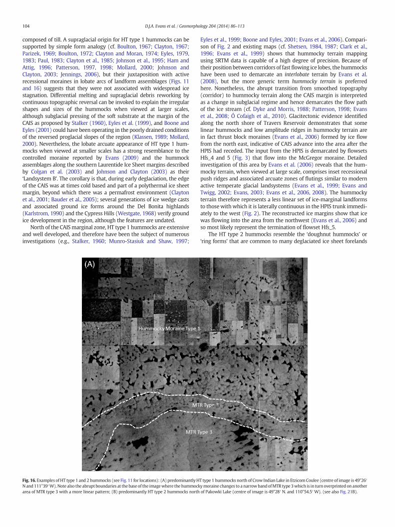
Fig. 16. Examples of HT type 1 and 2 hummocks (see Fig. 11 for locations): (A) predominantlyHN and111°39′W).Note also the abrupt boundaries at the base of the imagewhere the hummockarea of MTR type 3 with a more linear pattern; (B) predominantly HT type 2 hummocks north
Eyles et al., 1999; Boone and Eyles, 2001; Evans et al., 2006). Compari-son of Fig. 2 and existing maps (cf. Shetsen, 1984, 1987; Clark et al.,1996; Evans et al., 1999) shows that hummocky terrain mappingusing SRTM data is capable of a high degree of precision. Because oftheir positionbetween corridors of fastflowing ice lobes, thehummockshave been used to demarcate an interlobate terrain by Evans et al.(2008), but the more generic term hummocky terrain is preferredhere. Nonetheless, the abrupt transition from smoothed topography(corridor) to hummocky terrain along the CAIS margin is interpretedas a change in subglacial regime and hence demarcates the flow pathof the ice stream (cf. Dyke and Morris, 1988; Patterson, 1998; Evanset al., 2008; Ó Cofaigh et al., 2010). Glacitectonic evidence identifiedalong the north shore of Travers Reservoir demonstrates that somelinear hummocks and low amplitude ridges in hummocky terrain arein fact thrust block moraines (Evans et al., 2006) formed by ice flowfrom the north east, indicative of CAIS advance into the area after theHPIS had receded. The input from the HPIS is demarcated by flowsetsHfs_4 and 5 (Fig. 3) that flow into the McGregor moraine. Detailedinvestigation of this area by Evans et al. (2006) reveals that the hum-mocky terrain, when viewed at large scale, comprises inset recessionalpush ridges and associated arcuate zones of flutings similar to modernactive temperate glacial landsystems (Evans et al., 1999; Evans andTwigg, 2002; Evans, 2003; Evans et al., 2006, 2008). The hummockyterrain therefore represents a less linear set of ice-marginal landformsto those with which it is laterally continuous in the HPIS trunk immedi-ately to the west (Fig. 2). The reconstructed ice margins show that icewas flowing into the area from the northwest (Evans et al., 2006) andso most likely represent the termination of flowset Hfs_5.
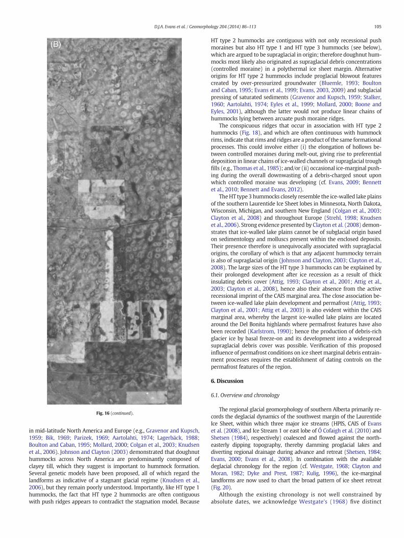
The HT type 2 hummocks resemble the ‘doughnut hummocks’ or‘ring forms’ that are common to many deglaciated ice sheet forelands
T type 1 hummocks north of Crow Indian Lake in Etzicom Coulee (centre of image is 49°26′ymoraine changes to a narrowbandofMTR type 3which is in turn overprinted on anotherof Pakowki Lake (centre of image is 49°28′ N. and 110°54.5′W). (see also Fig. 21B).
105D.J.A. Evans et al. / Geomorphology 204 (2014) 86–113
in mid-latitude North America and Europe (e.g., Gravenor and Kupsch,1959; Bik, 1969; Parizek, 1969; Aartolahti, 1974; Lagerbäck, 1988;Boulton and Caban, 1995; Mollard, 2000; Colgan et al., 2003; Knudsenet al., 2006). Johnson and Clayton (2003) demonstrated that doughnuthummocks across North America are predominantly composed ofclayey till, which they suggest is important to hummock formation.Several genetic models have been proposed, all of which regard thelandforms as indicative of a stagnant glacial regime (Knudsen et al.,2006), but they remain poorly understood. Importantly, like HT type 1hummocks, the fact that HT type 2 hummocks are often contiguouswith push ridges appears to contradict the stagnation model. Because
HT type 2 hummocks are contiguous with not only recessional pushmoraines but also HT type 1 and HT type 3 hummocks (see below),which are argued to be supraglacial in origin; therefore doughnut hum-mocks most likely also originated as supraglacial debris concentrations(controlled moraine) in a polythermal ice sheet margin. Alternativeorigins for HT type 2 hummocks include proglacial blowout featurescreated by over-pressurized groundwater (Bluemle, 1993; Boultonand Caban, 1995; Evans et al., 1999; Evans, 2003, 2009) and subglacialpressing of saturated sediments (Gravenor and Kupsch, 1959; Stalker,1960; Aartolahti, 1974; Eyles et al., 1999; Mollard, 2000; Boone andEyles, 2001), although the latter would not produce linear chains ofhummocks lying between arcuate push moraine ridges.
The conspicuous ridges that occur in association with HT type 2hummocks (Fig. 18), and which are often continuous with hummockrims, indicate that rims and ridges are a product of the same formationalprocesses. This could involve either (i) the elongation of hollows be-tween controlled moraines during melt-out, giving rise to preferentialdeposition in linear chains of ice-walled channels or supraglacial troughfills (e.g., Thomas et al., 1985); and/or (ii) occasional ice-marginal push-ing during the overall downwasting of a debris-charged snout uponwhich controlled moraine was developing (cf. Evans, 2009; Bennettet al., 2010; Bennett and Evans, 2012).
TheHT type 3 hummocks closely resemble the ice-walled lake plainsof the southern Laurentide Ice Sheet lobes in Minnesota, North Dakota,Wisconsin, Michigan, and southern New England (Colgan et al., 2003;Clayton et al., 2008) and throughout Europe (Strehl, 1998; Knudsenet al., 2006). Strong evidence presented by Clayton et al. (2008) demon-strates that ice-walled lake plains cannot be of subglacial origin basedon sedimentology and molluscs present within the enclosed deposits.Their presence therefore is unequivocally associated with supraglacialorigins, the corollary of which is that any adjacent hummocky terrainis also of supraglacial origin (Johnson and Clayton, 2003; Clayton et al.,2008). The large sizes of the HT type 3 hummocks can be explained bytheir prolonged development after ice recession as a result of thickinsulating debris cover (Attig, 1993; Clayton et al., 2001; Attig et al.,2003; Clayton et al., 2008), hence also their absence from the activerecessional imprint of the CAIS marginal area. The close association be-tween ice-walled lake plain development and permafrost (Attig, 1993;Clayton et al., 2001; Attig et al., 2003) is also evident within the CAISmarginal area, whereby the largest ice-walled lake plains are locatedaround the Del Bonita highlands where permafrost features have alsobeen recorded (Karlstrom, 1990); hence the production of debris-richglacier ice by basal freeze-on and its development into a widespreadsupraglacial debris cover was possible. Verification of this proposedinfluence of permafrost conditions on ice sheetmarginal debris entrain-ment processes requires the establishment of dating controls on thepermafrost features of the region.
6. Discussion
6.1. Overview and chronology
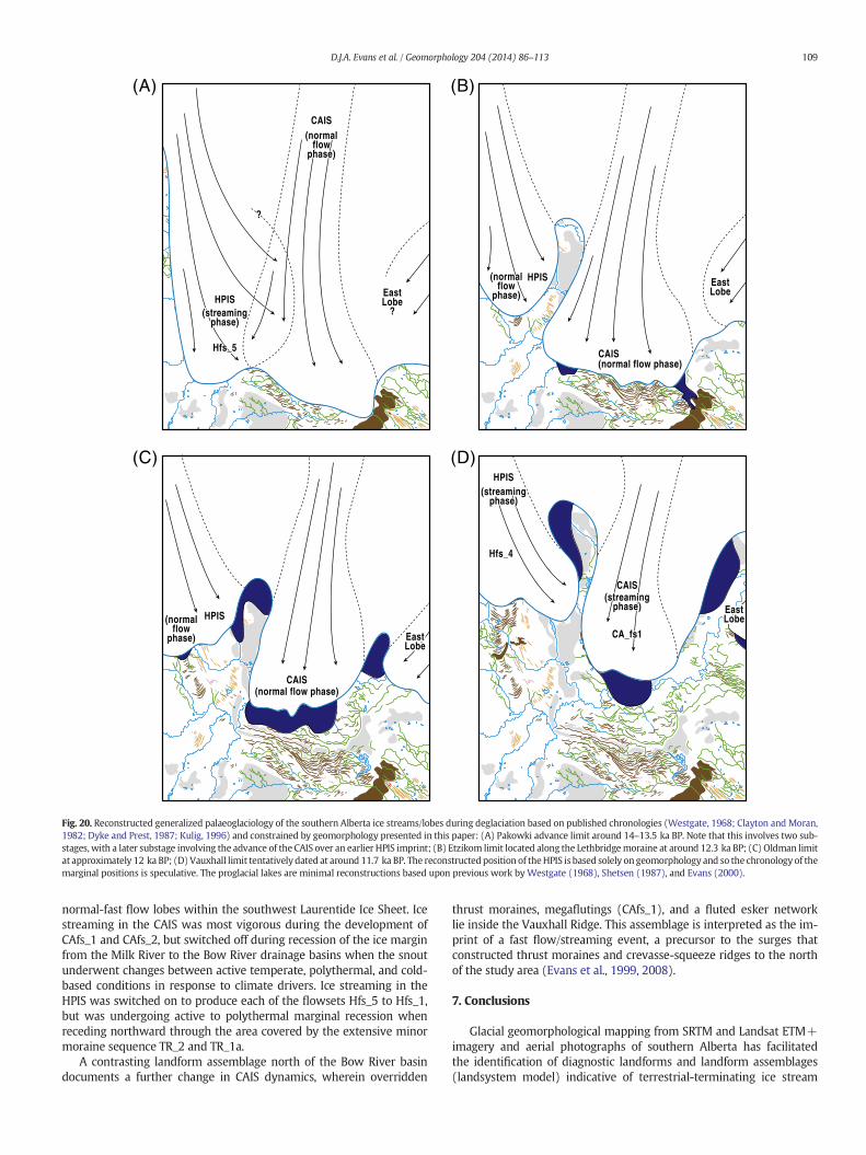
The regional glacial geomorphology of southern Alberta primarily re-cords the deglacial dynamics of the southwest margin of the LaurentideIce Sheet, within which three major ice streams (HPIS, CAIS of Evanset al. (2008), and Ice Stream 1 or east lobe of Ó Cofaigh et al. (2010) andShetsen (1984), respectively) coalesced and flowed against the north-easterly dipping topography, thereby damming proglacial lakes anddiverting regional drainage during advance and retreat (Shetsen, 1984;Evans, 2000; Evans et al., 2008). In combination with the availabledeglacial chronology for the region (cf. Westgate, 1968; Clayton andMoran, 1982; Dyke and Prest, 1987; Kulig, 1996), the ice-marginallandforms are now used to chart the broad pattern of ice sheet retreat(Fig. 20).
Although the existing chronology is not well constrained byabsolute dates, we acknowledge Westgate's (1968) five distinct
5
0
metres sertem030 510
20
0
metres 00010
5
0
3EPYT2EPYT1EPYT
Fig. 17. Morphological characteristics of hummocks within the Lethbridge moraine sequence. The dimensions reflect the largest features in each class.
106 D.J.A. Evans et al. / Geomorphology 204 (2014) 86–113
morphostratigraphic units (Elkwater drift; Wild Horse drift; Pakowkidrift; Etzikom drift; Oldman drift), each of which has been taken torepresent a readvance limit in southeast Alberta based on petrographyand morphology. The Elkwater drift relates to the upper ice limit onthe Cypress Hills. The Wild Horse drift extends into northern Montanawhere it terminates at a large 15–20 m transverse ridge sequence andis interpreted to represent the final advance of the CAIS margin intoMontana sometime around 14 ka BP. The Pakokwi drift (Fig. 20) ismarked by the outer extent of the push moraines to the southeast ofLake Pakowki and runs along the northern tip of the Milk River andnorth around the Cypress Hills (Westgate, 1968; Bik, 1969; Kulig,1996). Therefore, all landforms to the south of this point were formedduring an earlier advance, most likely the Altawan advance (15 ka BP;Kulig, 1996). The Pakowki advance (Fig. 20), not recognized inChristiansen's (1979) or Dyke and Prest's (1987) deglacial sequences,most likely occurred between 14 and 13.5 ka BP (Kulig, 1996) andrelates to Clayton and Moran's (1982) stages F–H. The Etzikom driftlimit is interpreted as the Lethbridge moraine limit of Stalker (1977)and ismarked in Figs. 11 and 20 by the broad bandof hummocky terrainjust north of Etzikom Coulee. This ice margin maintained its positionalong the Lethbridge moraine until around 12.3 ka BP (Stage I,Clayton and Moran, 1982; Dyke and Prest, 1987; Kulig, 1996). TheOldman drift limit (Fig. 20) is located just south of the Oldman River.Importantly, the correlation between the thrust ridges at TraversReservoir (Evans et al., 2006) and the Oldman limit suggests that theywere formed during this readvance episode. The corollary is that theHPIS had already receded further to the north. This readvance (stagesJ–L; Clayton and Moran, 1982) most likely occurred just after 12 kaBP. Based on the regional geomorphology map (Fig. 2), we suggestthat a further readvance occurred (Vauxhall advance), the limit ofwhich is marked by the Vauxhall Ridge and must have occurred some-time after 12 ka BP. Evans (2000) suggested that the CAIS marginhad receded to the north of the study area by 12 ka BP. Based on theVauxhall advance evidence, the CAIS must have receded later thanthat proposed by Evans (2000). Importantly, Dyke and Prest (1987)placed the ice sheet margin to the north of the study area by this time,and so this suggests that the CAIS may have remained within southernAlberta for longer than previously thought. The Vauxhall ridge isinterpreted to mark the final readvance of the CAIS after which time itreceded rapidly (Evans, 2000). The exact timing of the HPIS and eastlobe retreat are unclear, but the HPIS had likely receded somewherenorth of Bow River by 12 ka BP. The various stages depicted in Fig. 20are now related to the pattern of landform assemblages identified bythis research and then used to infer phases of ice streaming (switchon) versus the steady state or normal-fast flow that produces activetemperate glacial landsystems or the polythermal to cold based snoutconditions that produce controlled moraine.
6.2. Landsystemmodel for the CAIS margin in theMilk River drainage basin
Various parts of the ice stream beds of western Canada have beeninterpreted previously as manifestations of specific landsystems basedupon similarities with modern analogues; for example, Evans et al.(1999, 2008) identified an active temperate landform signature in theHPIS imprint and a surging signal in the Lac La Biche ice stream.Additionally, switches in basal thermal regime have been invoked byEvans (2009) to explain inset suites of differentmoraine types associatedwith the recession of the HPIS margin in the McGregor moraine belt.Thermal regime switches and intermittent surges during recessionhave beenproposed elsewhere in reconstructions of southern LaurentideIce Sheet palaeoglaciology. For example, Colgan et al. (2003) identifiedthree characteristic landsystems that they interpret as the imprint of anice lobe with changing recessional dynamics. The outermost landsystemof a drumlinized zone grading into moderate- to high-relief morainesand ice-walled lake plains represents a polythermal ice sheet marginwith sliding and deforming bed processes giving way to a marginalfrozen toe zone. Inside this landsystem lie fluted till plains and low reliefpushmoraines, a landsystem indicative of active temperate ice recession.This in turn gives way to a landsystem indicative of surging activity. Ata regional scale, Evans et al. (1999, 2008) and Evans (2009) have pro-moted similar temporal and spatial variability in ice stream landformimprints in Alberta, but the large-scale mapping reported here allows afiner resolution record of such changes to be elucidated for ice sheetmargins during the early stages of deglaciation.
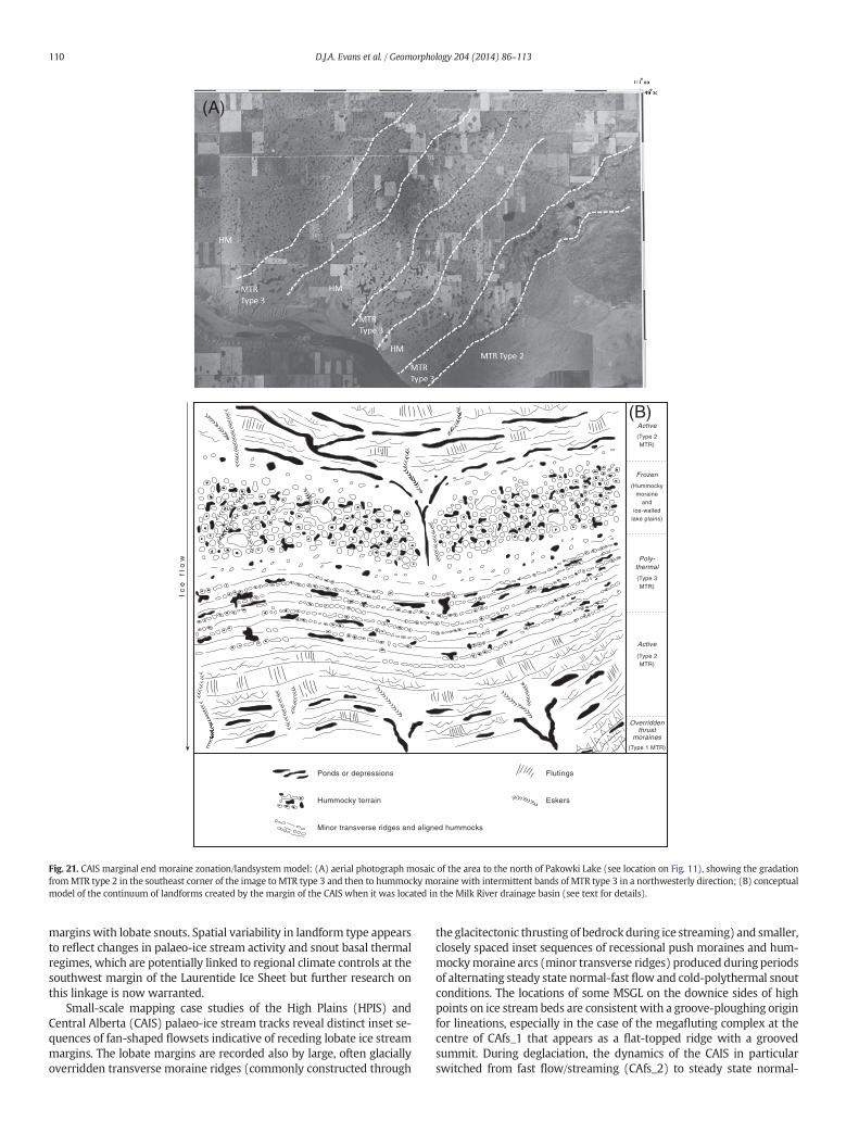
The juxtaposition of the transverse ridge moraine types of southernAlberta as presented in Figs. 8, 11, and 13 is illustrated specifically forMTR types 2 and 3 in Fig. 21A and then used in Fig. 21B to construct aconceptual landsystem model for terrestrial terminating ice streammargins. This model provides a diagrammatic representation of thecontinuum of landforms visible at the former margins of the CAISbetween the Milk River drainage basin and the Oldman/Bow Riverdrainage basins. The MTR type 2 are interpreted as active recessionalpush moraines that document temperate snout conditions and henceindicate that the lobate ice sheet margin was responding to seasonalclimate drivers. Subglacially fluted tills and esker networks were activeat these times. Hummocky moraine arcs containing ice-walled lakeplains, kame mounds, and short esker segments represent cold-basedlobe margins when controlled moraine was constructed by widespreadfreeze-on and stacking of basal debris-rich ice sequences. Between thesetwo ends of the landform continuum lie moraine arcs composed ofaligned hummocks and ponds (MTR type 3), indicative of polythermalmargins that probably responded to intermediate timescale (decadal)climate drivers. The geomorphology of the CAIS in the areas locatedsouth of the Milk River and north of the Bow River is significantly differ-ent to that portrayed in Fig. 21, being dominated by major transverse
Fig. 18. (A). Examples of hummocky terrain on an aerial photograph mosaic of an area of the Milk River Ridge located near Del Bonita, showing the juxtaposition of all three hummocktypes. Also within the image are the ridges (highlighted by the white arrows) that run through some hummocky terrain bands. Note that here they run between HT type 2 hummocksand, in places, constitute parts of the hummock rims (centre of image is 49°04.5′ N. and 112°37′ W.). Area of landform details in (B) are identified by black box. (B) Google Earthimage of area in box in (A) showing details of ice-walled lake plains and HT type 3 hummocky moraine in addition to prominent subsidiary ridges.
107D.J.A. Evans et al. / Geomorphology 204 (2014) 86–113
ridges (thrust moraines) and long flutings arranged in flowsets (Fig. 2).Similarly, the geomorphology of the HPIS contains landform assem-blages like those portrayed in Fig. 21 only in the areas covered byTR_1a and TR_2 and within the central McGregor Moraine.
6.3. Dynamics of the Alberta terrestrial-terminating ice stream lobes
The Alberta ice streams flowed over a substrate composed ofCretaceous and Tertiary sediments, consisting of poorly consolidatedclay, sand, and silt. The Cretaceous beds in particular are prone toglacitectonic folding and thrusting conditioned by a high bentonite con-tent, which is reflected by the quantity and size of thrust featureswithinsouthern Alberta. Additionally, the drainage conditions caused by
swelling clays will have almost certainly created elevated porewaterpressures and localized impermeable substrates, giving rise in turn tofast glacier flow (Clayton et al., 1985; Fisher et al., 1985; Klassen,1989; Clark, 1994; Evans et al., 2008). Bedrock highs, many of whichare residual Tertiary gravel-capped monadnocks, will likely have creat-ed resistance to ice flow (e.g., Alley, 1993; Joughin et al., 2001; Priceet al., 2002; Stokes et al., 2007) and caused localized compression,highlighted by the presence of thrust ridges at such locations. Addition-ally, the reverse gradient of the easterly dipping bedrock surface willhave initiated significant marginal compressive flow that also wouldhave resulted in glacitectonic disturbance and well-developed con-trolled moraine on debris-charged snouts. The region is thereby anancient exemplar of geologic setting exerting strong controls on the
Fig. 19. Details of meltwater channels and spillways: (A) view eastward along Etzikom Coulée; (B) Google Earth image of the network of channels to the north of Chin Coulée (centre ofimage is 49°37.5′ N. and 111°38′W); (C) ground view of shallow channels in the Google Earth image.
Table 2Palaeo-ice stream criteria of the CAIS and HPIS compared to the schema proposed byStokes and Clark (1999, 2001).
Ice stream geomorphological criteria(Stokes and Clark, 1999, 2001)
8. Submarine till delta or sediment fan (trough-mouth fan) NAa NAa
a Large arcuate assemblages ofmoraines and thick, complex sequences of tills and asso-ciated glacigenic sediments reported at the former HPIS and CAIS margins by Evans et al.(2008, 2012) are likely to be the terrestrial equivalents of trough-mouth fans.
108 D.J.A. Evans et al. / Geomorphology 204 (2014) 86–113
location and flowdynamics of ice streams (Anandakrishnan et al., 1998;Bell et al., 1998; Bamber et al., 2006), although we cannot ascertainwhether fast ice motion occurred through deformation or sliding ora combination of the two. Numerous till units and upice thickeningtill wedges within southern Alberta (Westgate, 1968; Evans andCampbell, 1992; Evans et al., 2008, 2012) are consistentwith the theoryof subglacial deformation (Alley, 1991; Boulton, 1996a,b), althoughEvans et al. (2008) argued that the presence of large subglacial channelsand thin tills overlying thin stratified sediments and shale bedrockalong the CAIS trunk indicates that at some stage in this area deforma-tion was subordinate to sliding.
A clear change in landform assemblages from south to north alongthe axis of the CAIS documents a temporal change in ice stream/lobe dy-namics. Initial advance of the CAIS was responsible for the glacitectonicconstruction and overriding of large transverse ridges in bedrock(cupola hills). Although the dynamics of the CAIS during Laurentide IceSheet advance are difficult to reconstruct, the construction of large thrustmoraines is most commonly associated with surging glacier snouts andtherefore this mode of flow during advance cannot be ruled out.
During deglaciation, the dynamics of the CAIS switched from fastflow/streaming to steady state normal flow toward a lobate marginwith a changing submarginal thermal regime. This is recorded by thearcuate bands of MTR types 2–3 and hummocky terrain located be-tween the preglacial divide (Milk River Ridge) and the Bow Rivercatchment. Specifically, the sequential south to north change fromhummocky terrain to MTR type 2 to MTR type 3 in this area records atemporal switch in ice marginal characteristics, from cold polythermalto temperate and then to warm polythermal (cf. Colgan et al., 2003;
Evans, 2009). A similar switch in submarginal thermal characteristicshas been proposed for the HPIS by Benn and Evans (2006) and Evans(2009) to explain a south to north change in moraine characteristics.Based upon the chronology of ice sheet recession presented in Fig. 20,the switch to temperate conditions apparently occurred at the marginsof both the CAIS and HPIS at similar times during deglaciation, indicat-ing a potential regional climatic control.
The summary of landform spatial changes presented in Fig. 21B andthe regional pattern of landforms depicted in Fig. 2 potentially recordthe switching on and off of palaeo-ice streaming as well as the changingthermal conditions and dynamics at the margins of more steady state
Fig. 20. Reconstructed generalized palaeoglaciology of the southern Alberta ice streams/lobes during deglaciation based on published chronologies (Westgate, 1968; Clayton and Moran,1982; Dyke and Prest, 1987; Kulig, 1996) and constrained by geomorphology presented in this paper: (A) Pakowki advance limit around 14–13.5 ka BP. Note that this involves two sub-stages, with a later substage involving the advance of the CAIS over an earlier HPIS imprint; (B) Etzikom limit located along the Lethbridgemoraine at around 12.3 ka BP; (C) Oldman limitat approximately 12 ka BP; (D) Vauxhall limit tentatively dated at around 11.7 ka BP. The reconstructedposition of theHPIS is based solely on geomorphology and so the chronology of themarginal positions is speculative. The proglacial lakes are minimal reconstructions based upon previous work byWestgate (1968), Shetsen (1987), and Evans (2000).
109D.J.A. Evans et al. / Geomorphology 204 (2014) 86–113
normal-fast flow lobes within the southwest Laurentide Ice Sheet. Icestreaming in the CAIS was most vigorous during the development ofCAfs_1 and CAfs_2, but switched off during recession of the ice marginfrom the Milk River to the Bow River drainage basins when the snoutunderwent changes between active temperate, polythermal, and cold-based conditions in response to climate drivers. Ice streaming in theHPIS was switched on to produce each of the flowsets Hfs_5 to Hfs_1,but was undergoing active to polythermal marginal recession whenreceding northward through the area covered by the extensive minormoraine sequence TR_2 and TR_1a.
A contrasting landform assemblage north of the Bow River basindocuments a further change in CAIS dynamics, wherein overridden
thrust moraines, megaflutings (CAfs_1), and a fluted esker networklie inside the Vauxhall Ridge. This assemblage is interpreted as the im-print of a fast flow/streaming event, a precursor to the surges thatconstructed thrust moraines and crevasse-squeeze ridges to the northof the study area (Evans et al., 1999, 2008).
7. Conclusions
Glacial geomorphological mapping from SRTM and Landsat ETM+imagery and aerial photographs of southern Alberta has facilitatedthe identification of diagnostic landforms and landform assemblages(landsystem model) indicative of terrestrial-terminating ice stream
Fig. 21. CAIS marginal end moraine zonation/landsystem model: (A) aerial photograph mosaic of the area to the north of Pakowki Lake (see location on Fig. 11), showing the gradationfromMTR type 2 in the southeast corner of the image toMTR type 3 and then to hummocky moraine with intermittent bands of MTR type 3 in a northwesterly direction; (B) conceptualmodel of the continuum of landforms created by the margin of the CAIS when it was located in the Milk River drainage basin (see text for details).
110 D.J.A. Evans et al. / Geomorphology 204 (2014) 86–113
margins with lobate snouts. Spatial variability in landform type appearsto reflect changes in palaeo-ice stream activity and snout basal thermalregimes, which are potentially linked to regional climate controls at thesouthwest margin of the Laurentide Ice Sheet but further research onthis linkage is now warranted.
Small-scale mapping case studies of the High Plains (HPIS) andCentral Alberta (CAIS) palaeo-ice stream tracks reveal distinct inset se-quences of fan-shaped flowsets indicative of receding lobate ice streammargins. The lobate margins are recorded also by large, often glaciallyoverridden transverse moraine ridges (commonly constructed through
the glacitectonic thrusting of bedrockduring ice streaming) and smaller,closely spaced inset sequences of recessional push moraines and hum-mockymoraine arcs (minor transverse ridges) produced during periodsof alternating steady state normal-fast flow and cold-polythermal snoutconditions. The locations of some MSGL on the downice sides of highpoints on ice stream beds are consistent with a groove-ploughing originfor lineations, especially in the case of the megafluting complex at thecentre of CAfs_1 that appears as a flat-topped ridge with a groovedsummit. During deglaciation, the dynamics of the CAIS in particularswitched from fast flow/streaming (CAfs_2) to steady state normal-
111D.J.A. Evans et al. / Geomorphology 204 (2014) 86–113
fast flow toward a lobate margin, which was subject to changingsubmarginal thermal regimes as recorded by the arcuate bands ofMTR types 2–3 and hummocky terrain located between the preglacialdivide (Milk River Ridge) and the Bow River catchment. Ice streamflow in the CAIS switched on again (CAfs_1) once the margin hadretreated into the Red Deer/Bow River drainage basins.
Large-scale mapping of the southern limits of the CAIS reveals acomplex glacial geomorphology relating to ice lobe marginal recession,comprising minor transverse ridges (MTR types 2–3), hummockyterrain (HT types 1–3), flutings, and meltwater channels/spillways.MTR type 1 likely originated through glacitectonic thrusting and havebeen glacially overrun and moderately streamlined. MTR type 2sequences are recessional push moraines similar to those developingat modern active temperate glacier snouts. MTR type 3 documentmoraine construction by incremental stagnation because they occur inassociation with hummocky terrain. This localized close association ofthe various types of hummocky terrain with pushmoraine assemblagesas well as proglacial permafrost features indicates that they are not icestagnation landforms but rather the products of supraglacial controlleddeposition on a polythermal ice sheet margin, where the HT type 3hummocks represent former ice-walled lake plains.
The ice sheet marginal thermal regime switches indicated by thespatially variable landform assemblages in southern Alberta are consis-tent with palaeoglaciological reconstructions proposed for other icestream lobate margins of the southern Laurentide Ice Sheet, wherealternate cold, polythermal, and temperatemarginal conditions sequen-tially gave way to more dynamic and surging activity. The sequentialsouth to north change from hummocky terrain to MTR type 2 to MTRtype 3 within the Lethbridge moraine and on the northern slopesof theMilk River Ridge records a temporal switch in CAISmarginal char-acteristics, from cold polythermal to temperate and then to warmpolythermal. This is similar to patterns previously identified for theHPIS at approximately the same time based upon the available regionalmorphochronology and hence indicates a potential regional climaticcontrol on ice sheet marginal activity. To the north of the LethbridgeMoraine, the landform assemblage of the Bow and Red Deer riverbasins, comprising overridden thrust moraines, megaflutings (CAfs_1),and a fluted esker complex lying inside the Vauxhall Ridge, records alater fast flow/streaming event. This was the precursor to the later icestream surges that constructed the large thrust moraines and othersurge-diagnostic landforms in central Alberta.
Acknowledgements
Initial research for this paperwas undertaken as part of aM.Sc. thesisatDurhamUniversity byNJPY. Research inAlberta has been funded overa number of years by The Royal Society and the Carnegie Trust. ChrisOrton, Department of Geography, Durham University drafted thefigures. Diligent and enthusiastic reviews by Rod Smith and threeother anonymous reviewers helped us to clarify the results presentedin this paper.
References
Aartolahti, T., 1974. Ring ridge hummocky moraines in northern Finland. Fennia 134,1–21.
Aber, J.S., Ber, A., 2007. Glaciotectonism. Developments in Quaternary Science 6. Elsevier,London.
Alley, R.B., 1991. Deforming-bed origin for southern Laurentide till sheets? Journal ofGlaciology 37, 67–76.
Alley, R.B., 1993. In search of ice-stream sticky spots. Journal of Glaciology 39, 447–454.Anandakrishnan, S., Blankenship, D.D., Alley, R.B., Stoffa, P.L., 1998. Influence of subglacial
geology on the position of a West Antarctic ice stream from seismic observations.Nature 394, 62–66.
Atkinson, N., Lyster, S., 2010a. Thickness of Quaternary and Neogene in Alberta, Canada.Energy Resources Conservation Board, ERCB/AGS Map 551, Scale 1:1,500,000.Edmonton, Canada.
Atkinson, N., Lyster, S., 2010b. Bedrock Topography of Alberta, Canada. Energy ResourcesConservation Board, ERCB/AGS Map 550, Scale 1:1,500,000. Edmonton, Canada.
Attig, J.W., 1993. Pleistocene geology of Taylor County, Wisconsin. Bulletin 90, WisconsinGeological and Natural History Survey.
Attig, J.W., Clayton, L., Johnson, M.D., Patterson, C.J., Ham, N.R., Syverson, K.M., 2003.Ice-walled-lake plains in the mid-continent — what they tell us about late glacialice marginal processes and environments. Geological Society of America Programwith Abstracts 35, 61.
Bamber, J.L., Ferraccioli, F., Joughin, I., Shepherd, T., Rippin, D.M., Siegert, M.J., Vaughan,D.G., 2006. East Antarctic ice stream tributary underlain by a major sedimentarybasin. Geology 34, 33–36.
Bauder, A., Mickelson, D.M., Marshall, S.J., 2005. Numerical modeling investigations of thesubglacial conditions of the southern Laurentide Ice Sheet. Annals of Glaciology 40,219–224.
Beaney, C.L., 2002. Tunnel channels in southeast Alberta, Canada: evidence for catastrophicchannelized drainage. Quaternary International 90, 67–74.
Beaney, C.L., Shaw, J., 2000. The subglacial geomorphology of southeast Alberta: evidencefor subglacial meltwater erosion. Canadian Journal of Earth Sciences 37, 51–61.
Beaty, C.B., 1990. Milk River in southern Alberta: a classic underfit stream. The CanadianGeographer 34, 171–174.
Bell, R.E., Blankenship, D.D., Finn, C.A., Morse, D.L., Scambos, T.A., Brozena, J.M., Hodge,S.M., 1998. Influence of subglacial geology on the onset of aWest Antarctic ice streamfrom aerogeophysical observations. Nature 394, 58–62.
Benn, D.I., Evans, D.J.A., 2006. Subglacial megafloods: outrageous hypothesis or justoutrageous? In: Knight, P.G. (Ed.), Glacier Science and Environmental Change.Blackwell, Oxford, UK, pp. 42–46.
Benn, D.I., Evans, D.J.A., 2010. Glaciers and Glaciation. Arnold, London.Bennett, G.L., Evans, D.J.A., 2012. Glacier retreat and landform production on an
overdeepened glacier foreland: the debris-charged glacial landsystem at Kvíárjökull,Iceland. Earth Surface Processes and Landforms 37, 1584–1602.
Bennett, G.L., Evans, D.J.A., Carbonneau, P., Twigg, D.R., 2010. Evolution of a debris-charged glacier landsystem, Kvíárjökull, Iceland. Journal of Maps 40–67.
Bik, M.J.J., 1969. The origin and age of the prairie mounds of southern Alberta, Canada.Biuletyn Peryglacjalny 19, 85–130.
Bluemle, J.P., 1993. Hydrodynamic blowouts in North Dakota. In: Aber, J.S. (Ed.),Glaciotectonics and Mapping Glacial Deposits. Canadian Plains Research Centre,University of Regina, pp. 259–266.
Bluemle, J.P., Clayton, L., 1984. Large-scale glacial thrusting and related processes in NorthDakota. Boreas 13, 279–299.
Boone, S.J., Eyles, N., 2001. Geotechnical model for great plains hummocky moraineformed by till deformation below stagnant ice. Geomorphology 38, 109–124.
Boulton, G.S., 1967. The development of a complex supraglacial moraine at themargin of Sørbreen, Ny Friesland, Vestspitsbergen. Journal of Glaciology 6,717–735.
Boulton, G.S., 1970. On the origin and transport of englacial debris in Svalbard glaciers.Journal of Glaciology 9, 213–229.
Boulton, G.S., 1972. Modern arctic glaciers as depositional models for former ice sheets.Journal of the Geological Society of London 128, 361–393.
Boulton, G.S., 1986. Push moraines and glacier contact fans in marine and terrestrialenvironments. Sedimentology 33, 677–698.
Boulton, G.S., 1996a. The origin of till sequences by subglacial sediment deformationbeneath mid-latitude ice sheets. Annals of Glaciology 22, 75–84.
Boulton, G.S., 1996b. Theory of glacier erosion, transport and deposition as a consequenceof subglacial sediment deformation. Journal of Glaciology 42, 43–62.
Boulton, G.S., Caban, P.E., 1995. Groundwater flow beneath ice sheets: part II— its impacton glacier tectonic structures and moraine formation. Quaternary Science Reviews14, 563–587.
Burgess, D.O., Shaw, J., Eyton, J.R., 2003. Morphometric comparisons between Rogenterrain and hummocky terrain. Physical Geography 24, 319–336.
Canals, M., Urgeles, R., Calafat, A.M., 2000. Deep sea floor evidence of past ice streams offthe Antarctic Peninsula. Geology 28, 31–34.
Christiansen, E.A., 1979. The Wisconsinan deglaciation of southern Saskatchewan andadjacent areas. Canadian Journal of Earth Sciences 16, 913–938.
Clark, P.U., 1994. Unstable behaviour of the Laurentide Ice Sheet over deforming sedimentand its implications for climate change. Quaternary Research 41, 19–25.
Clark, C.D., 1997. Reconstructing the evolutionary dynamics of former ice sheets usingmultitemporal evidence, remote sensing and GIS. Quaternary Science Reviews 16,1067–1092.
Clark, C.D., 1999. Glaciodynamic context of subglacial bedform generation and preservation.Annals of Glaciology 28, 23–32.
Clark, P.U., Licciardi, J.M., MacAyeal, D.R., Jenson, J.W., 1996. Numerical reconstruction ofa soft-bedded Laurentide Ice Sheet during the last glacial maximum. Geology 24,679–682.
Clark, C.D., Tulaczyk, S.M., Stokes, C.R., Canals, M., 2003. A groove-ploughing theory for theproduction of mega scale glacial lineations, and implications for ice-streammechanics.Journal of Glaciology 49, 240–256.
Clarke, G.K.C., 1987. Subglacial till: a physical framework for its properties and processes.Journal of Geophysical Research 92, 9023–9036.
Clarke, G.K.C., Leverington, D.W., Teller, J.W., Dyke, A.S., Marshall, S.J., 2005. Fresharguments against the Shaw megaflood hypothesis. A reply to comments by DavidSharpe on ‘paleohydraulics of the last outburst flood from glacial Lake Agassiz andthe 8200 BP cold event’. Quaternary Science Reviews 24, 1533–1541.
112 D.J.A. Evans et al. / Geomorphology 204 (2014) 86–113
Clayton, L., 1967. Stagnant-glacier features of the Missouri Coteau in North Dakota. NorthDakota Geological Survey, Miscellaneous Series 30, 25–46.
Clayton, L., Cherry, J.A., 1967. Pleistocene superglacial and ice walled lakes of west-centralNorth America. North Dakota Geological Survey, Miscellaneous Series 30, 47–52.
Clayton, L., Moran, S.R., 1974. A glacial process-form model. In: Coates, D.R. (Ed.), GlacialGeomorphology. State University of New York, Binghamton, pp. 89–119.
Colton, R.B., Fullerton, D.S., 1986. Proglacial lakes along the Laurentide Ice Sheet margin inMontana. Geological Society of America Abstracts with Programs 18, 347.
Colton, R.B., Lemke, R.W., Lindvall, R.M., 1961. Glacial Map of Montana East of the RockyMountains. U.S. Geological Survey Miscellaneous Investigations Series Map I-327,scale 1:500 000, 1 sheet.
Davies, N.K., Locke, W.W., Pierce, K.L., Finkel, R.C., 2006. Glacial Lake Musselshell:Late Wisconsin slackwater on the Laurentide ice margin in central Montana, USA.Geomorphology 75, 330–345.
Dowdeswell, J.A., Ó Cofaigh, C., Noormets, R., Larter, R.D., Hillenbrand, C.D., Benetti, S.,Evans, J., Pudsey, C.J., 2008. A major trough-mouth fan on the continental margin ofthe Bellinghausen Sea, West Antarctica: the Belgica Fan. Marine Geology 252,129–140.
Dyke, A.S., 2004. An outline of North American deglaciation with emphasis on central andnorthern Canada. In: Ehlers, J., Gibbard, P.L. (Eds.), Quaternary Glaciations — Extentand Chronology. Part II: North America. Elsevier, Amsterdam, pp. 373–424.
Dyke, A.S., Morris, T.F., 1988. Drumlin fields, dispersal trains and ice streams in arcticCanada. The Canadian Geographer 32, 86–90.
Dyke, A.S., Prest, V.K., 1987. The Late Wisconsinan and Holocene history of the LaurentideIce Sheet. Géographie Physique et Quaternaire 41, 237–263.
Dyke, A.S., Andrews, J.T., Clark, P.U., England, J.H., Miller, G.H., Shaw, J., Veillette, J.J., 2002.The Laurentide and Innuitian ice sheet during the Last Glacial Maximum. QuaternaryScience Reviews 21, 9–31.
Evans, D.J.A., 1991. A gravel/diamicton lag on the south Albertan prairies, Canada:evidence of bed armoring in early deglacial sheet-flood/spillway courses. GeologicalSociety of America Bulletin 103, 975–982.
Evans, D.J.A., 1996. A possible origin for a megafluting complex on the southern Albertaprairies, Canada. Zeitschrift fur Geomorphologie Supplementband 106, 125–148.
Evans, D.J.A., 2000. Quaternary geology and geomorphology of the Dinosaur ProvincialPark area and surrounding plains, Alberta, Canada: the identification of former glaciallobes, drainage diversions and meltwater flood tracks. Quaternary Science Reviews19, 931–958.
Evans, D.J.A., 2003. Ice-marginal terrestrial landsystems: active temperate glacier margins.In: Evans, D.J.A. (Ed.), Glacial Landsystems. Arnold, London, pp. 12–43.
Evans, D.J.A., 2010. Defending and testing hypotheses: a response to John Shaw's paper ‘indefence of the meltwater (megaflood) hypothesis for the formation of subglacialbedform fields’. Journal of Quaternary Science 25, 822–823.
Evans, D.J.A., Campbell, I.A., 1992. Glacial and postglacial stratigraphy of Dinosaur ProvincialPark and surrounding plains, southern Alberta, Canada. Quaternary Science Reviews 11,535–555.
Evans, D.J.A., Campbell, I.A., 1995. Quaternary stratigraphy of the buried valleys of thelower Red Deer River, Alberta, Canada. Journal of Quaternary Science 10, 123–148.
Evans, D.J.A., Hiemstra, J.F., 2005. Till deposition by glacier submarginal, incrementalthickening. Earth Surface Processes and Landforms 30, 1633–1662.
Evans, D.J.A., Twigg, D.R., 2002. The active temperate glacial landsystem: a model basedon Breiðamerkurjökull, Iceland. Quaternary Science Reviews 21, 2143–2177.
Evans, D.J.A., Lemmen, D.S., Rea, B.R., 1999. Glacial landsystems of the southwest LaurentideIce Sheet: modern Icelandic analogues. Journal of Quaternary Science 14, 673–691.
Evans, D.J.A., Rea, B.R., Hiemstra, J.F., Ó Cofaigh, C., 2006. A critical assessment of subglacialmega-floods: a case studyof glacial sediments and landforms in south-central Alberta,Canada. Quaternary Science Reviews 25, 1638–1667.
Evans, D.J.A., Clark, C.D., Rea, B.R., 2008. Landform and sediment imprints of fast glacier flowin the southwest Laurentide Ice Sheet. Journal of Quaternary Science 23, 249–272.
Evans, D.J.A., Hiemstra, J.F., Boston, C.M., Leighton, I., Ó Cofaigh, C., Rea, B.R., 2012. Till stra-tigraphy and sedimentology at the margins of terrestrially terminating ice streams:case study of the western Canadian prairies and high plains. Quaternary ScienceReviews 46, 80–125.
Eyles, N., 1979. Facies of supraglacial sedimentation on Icelandic and alpine temperateglaciers. Canadian Journal of Earth Sciences 16, 1341–1361.
Eyles, N., 1983. Modern Icelandic glaciers as depositional models for ‘hummockymoraine’in the Scottish Highlands. In: Evenson, E.B. (Ed.), Tills and Related Deposits. Balkema,Rotterdam, pp. 47–59.
Fisher, D.A., Reeh, N., Langley, K., 1985. Objective reconstructions of the Late WisconsinanIce Sheet. Géographie Physique et Quaternaire 39, 229–238.
Fullerton, D.S., Bush, C.A., Colton, R.B., Straub, A.W., 2004a. Map showing spatial andtemporal relations of mountain and continental glaciations on the northern plains,primarily in northern Montana and northwestern North Dakota. U.S. GeologicalSurvey Geologic Investigations Series Map I-2843, scale 1: 1,000,000, 1 sheet withaccompanying text.
Fullerton, D.S., Colton, R.B., Bush, C.A., 2004b. Limits of mountain and continental glacia-tions east of the Continental Divide in northern Montana and north-western NorthDakota, USA. In: Ehlers, J., Gibbard, P.L. (Eds.), Quaternary Glaciations — Extent andChronology Part II: North America. Elsevier, London, pp. 131–150.
Fulton, R.J., 1995. Surficial materials of Canada. Map 1880A, Geological Survey of Canada,Ottawa.
Geiger, R.W., 1967. Bedrock topography of the Gleichen map area, Alberta. ResearchCouncil of Alberta, Edmonton, Report 67-2.
Gravenor, C.P., Kupsch, W.O., 1959. Ice disintegration features in western Canada. Journalof Geology 67, 48–64.
Ham, N.R., Attig, J.W., 1996. Ice wastage and landscape evolution along the southernmargin of the Laurentide Ice Sheet, north-central Wisconsin. Boreas 25, 171–186.
Hambrey, M.J., Huddart, D., Bennett, M.R., Glasser, N.F., 1997. Genesis of ‘hummockymoraine’ by thrusting in glacier ice: evidence from Svalbard and Britain. Journal ofthe Geological Society of London 154, 623–632.
Hambrey, M.J., Bennett, M.R., Dowdeswell, J.A., Glasser, N.F., Huddart, D., 1999. Debrisentrainment and transport in polythermal valley glaciers, Svalbard. Journal of Glaciology45, 69–86.
Hart, J.K., 1999. Identifying fast ice flow from landform assemblages in the geologicalrecord: a discussion. Annals of Glaciology 28, 59–66.
Jackson, L.E., Little, E.C., 2004. A single continental glaciation of the Rocky Mountain Foot-hills, southwestern Alberta. In: Ehlers, J., Gibbard, P.L. (Eds.), Quaternary Glaciations:Extent and Chronology. Part II: North America. Elsevier, Amsterdam, pp. 29–38.
Jackson, L.E., Phillips, F.M., Shimamura, K., Little, E.C., 1997. Cosmogenic 36Cl dating of theFoothills erratics train, Alberta, Canada. Geology 25, 195–198.
Jennings, C.E., 2006. Terrestrial ice streams: a view from the lobe. Geomorphology 75,100–124.
Johnson, M.D., Clayton, L., 2003. Supraglacial landsystems in lowland terrain. In: Evans,D.J.A. (Ed.), Glacial Landsystems. Arnold, London, pp. 228–251.
Johnson, M.D., Mickelson, D.M., Clayton, L., Attig, J.W., 1995. Composition and genesis ofglacial hummocks, western Wisconsin. Boreas 24, 97–116.
Joughin, I., Fahnestock, M., MacAyeal, D., Bamber, J.L., Gogineni, P., 2001. Observationand analysis of ice flow in the largest Greenland ice stream. Journal of GeophysicalResearch 106 (D24), 21–34.
Karlstrom, E.T., 1990. Relict periglacial features east of Waterton-Glacier Parks, Albertaand Montana, and their palaeoclimatic significance. Permafrost and PeriglacialProcesses 1, 221–234.
Kehew, A.E., Lord, M.L., 1986. Origin and large scale erosional features of glacial lakespillways in the northern Great Plains. Geological Society of America Bulletin 97,162–177.
Kjaersgaard, A.A., 1976. Reconnaissance soil survey of the Oyen map sheet-72M(preliminary report). Alberta Institute of Pedology, Report S-76-36.
Klassen, R.W., 1989. Quaternary geology of the southern Canadian Interior Plains. In:Fulton, R.J. (Ed.), Quaternary Geology of Canada and Greenland. Geological Surveyof Canada, Geology of Canada, 1, pp. 138–174.
Knudsen, C.G., Larsen, E., Sejrup, H.P., Stalsberg, K., 2006. Hummocky moraine landscapeon Jæren, SWNorway—implications for glacier dynamics during the last deglaciation.Geomorphology 77, 153–168.
Krüger, J., 1996. Moraine ridges formed from subglacial frozen-on sediment slabs andtheir differentiation from push moraines. Boreas 25, 57–63.
Kulig, J.J., 1996. The glaciations of the Cypress Hills of Alberta and Saskatchewanand itsregional implications. Quaternary International 32, 53–77.
Lagerbäck, R., 1988. The Veiki moraines in northern Sweden widespread evidence of anEarly Weichselian deglaciation. Boreas 17, 469–486.
Leckie, D.A., 2006. Tertiary fluvial gravels and evolution of the Western Canadian Prairielandscape. Sedimentary Geology 190, 139–158.
Matthews, J.A., McCarroll, D., Shakesby, R.A., 1995. Contemporary terminal moraine ridgeformation at a temperate glacier: Styggedalsbreen, Jotunheimen, southern Norway.Boreas 24, 129–139.
Mollard, J.D., 2000. Ice-shaped ring-forms in western Canada: their airphoto expressionsand manifold polygenetic origins. Quaternary International 68, 187–198.
Moran, S.R., Clayton, L., Hooke, R LeB., Fenton, M.M., Andriashak, L.D., 1980. Glacier-bedlandforms of the Prairie region of North America. Journal of Glaciology 25, 457–476.
Munro-Stasiuk, M.J., 1999. Evidence for water storage and drainage at the base of theLaurentide ice-sheet, south-central Alberta, Canada. Annals of Glaciology 28, 175–180.
Munro-Stasiuk, M.J., Shaw, J., 1997. Erosional origin of hummocky terrain in south-centralAlberta, Canada. Geology 25, 1027–1030.
Munro-Stasiuk, M.J., Shaw, J., 2002. The Blackspring Ridge flute field, south-centralAlberta, Canada: evidence for subglacial sheetflow erosion. Quaternary International90, 75–86.
Munro-Stasiuk, M.J., Sjogren, D., 2006. The erosional origin of hummocky terrain, Alberta,Canada. In: Knight, P.G. (Ed.), Glacier Science and Environmental Change. Blackwell,Oxford, pp. 33–36.
Ó Cofaigh, C., Pudsey, C.J., Dowdeswell, J.A., Morris, P., 2002. Evolution of subglacialbedforms along a palaeo-ice stream, Antarctic Peninsula continental shelf. GeophysicalResearch Letters 29 (8). http://dx.doi.org/10.1029/2001GL014488.
113D.J.A. Evans et al. / Geomorphology 204 (2014) 86–113
Ó Cofaigh, C., Taylor, J., Dowdeswell, J.A., Pudsey, C.L., 2003. Palaeo-ice streams, troughmouth fans and high latitude continental slope sedimentation. Boreas 32, 37–55.
Ó Cofaigh, C., Evans, D.J.A., Smith, I.R., 2010. Large-scale reorganistaion and sedimentationof terrestrial ice-streams during a single glacial cycle. Geological Society of AmericaBulletin 122, 743–756.
Ottesen, D., Stokes, C.R., Rise, L., Olsen, L., 2008. Ice sheet dynamics and ice streaming alongthe coastal parts of northern Norway. Quaternary Science Reviews 27, 922–940.
Parizek, R.R., 1969. Glacial ice-contact ridges and rings. Geological Society of AmericaSpecial Paper 123, 49–102.
Patterson, C.J., 1997. Southern Laurentide ice lobes were created by ice streams: DesMoines Lobe in Minnesota, USA. Sedimentary Geology 111, 249–261.
Patterson, C.J., 1998. Laurentide glacial landscapes: the role of ice streams. Geology 26,643–646.
Paul, M.A., 1983. The supraglacial landsystem. In: Eyles, N. (Ed.), Glacial Geology. Pergamon,Oxford, pp. 71–90.
Prest, V.K., Grant, D.R., Rampton, V.N., 1968. Glacial Map of Canada. Map 1253A(1:5,000,000), Geological Survey of Canada, Ottawa.
Price, R.J., 1970. Moraines at Fjallsjökull, Iceland. Arctic and Alpine Research 2, 27–42.Price, S.F., Bindschadler, R.A., Hulbe, C.L., Blankenship, D.D., 2002. Force balance along an
inland tributary and onset to Ice Stream D, West Antarctica. Journal of Glaciology 48,20–30.
Rains, R.B., Shaw, J., Skoye, K.R., Sjogren, D.B., Kvill, D.R., 1993. Late Wisconsin subglacialmegaflood paths in Alberta. Geology 21, 323–326.
Rains, R.B., Kvill, D., Shaw, J., 1999. Evidence and some implications of coalescentCordilleran and Laurentide glacier systems in western Alberta. In: Smith, P.J. (Ed.),AWorld of Real Places: Essays inHonour ofWilliamC.Wonders. University of Alberta,Edmonton, pp. 147–161.
Roberts, D.H., Long, A.J., 2005. Streamlined bedrock terrain and fast ice flow, JakobshavnsIsbrae, West Greenland: implications for ice stream and ice sheet dynamics. Boreas34, 25–42.
Roberts, D.H., Yde, J.C., Knudsen, N.T., Long, A.J., Lloyd, J.M., 2009. Ice marginal dynamicsduring surge activity, Kuannersuit Glacier, Disko Island, West Greenland. QuaternaryScience Reviews 28, 209–222.
Shaw, J., 2002. The meltwater hypothesis for subglacial bedforms. Quaternary International90, 5–22.
Shaw, J., 2010. In defence of the meltwater (megaflood) hypothesis for the formation ofsubglacial bedform fields. Journal of Quaternary Science 25, 249–260.
Shaw, J., Rains, R.B., Eyton, J.R., Weissling, L., 1996. Laurentide subglacial outburst floods:landform evidence from digital elevation models. Canadian Journal of Earth Sciences33, 1154–1168.
Shaw, J., Faragini, D., Kvill, D.R., Rains, R.B., 2000. The Athabasca fluting field, Alberta,Canada: implications for the formation of large scale fluting (erosional lineations).Quaternary Science Reviews 19, 959–980.
Shetsen, I., 1984. Application of till pebble lithology to the differentiation of glacial lobesin southern Alberta. Canadian Journal of Earth Sciences 21, 920–933.
Shetsen, I., 1990. Quaternary Geology, Central Alberta. ARC map (1:500,000), AlbertaResearch Council, Edmonton, Canada.
Shipp, S.S., Anderson, J.B., Domack, E.W., 1999. Late Pleistocene–Holocene retreat ofthe West Antarctic Ice-Sheet system in the Ross Sea: part 1 — geophysical results.Geological Society of America Bulletin 111, 1486–1516.
Sjogren, D.B., Rains, R.B., 1995. Glaciofluvial erosional morphology and sediments ofthe Coronation-Spondin scabland, east-central Alberta. Canadian Journal of EarthSciences 32, 565–578.
Smith, M.J., Clark, C.D., 2005. Methods for the visualization of digital elevation methodsfor landform mapping. Earth Surface Processes and Landforms 30, 885–900.
Stalker, A.MacS., 1956. The erratics train; foothills of Alberta. Geological Survey of Canada,Bulletin 37.
Stalker, A.MacS., 1960. Ice-pressed drift forms and associated deposits in Alberta. GeologicalSurvey of Canada, Bulletin 57.
Stalker, A.MacS., 1963. Quaternary stratigraphy in southern Alberta. Geological Survey ofCanada, Paper 62-34.
Stalker, A.MacS., 1969. Quaternary stratigraphy in southern Alberta. Report II — sectionsnear Medicine Hat. Geological Survey of Canada, Paper 69-26.
Stalker, A.MacS., 1973. The large interdrift bedrock blocks of the Canadian Prairies.Geological Survey Canada, Paper 75-1A. 421–422.
Stalker, A.MacS., 1976. Megablocks, or the enormous erratic of the Albertan Prairies.Geological Survey Canada, Paper 76-1C. 185–188.
Stalker, A.MacS., 1977. The probable extent of the Classical Wisconsin ice in southern andcentral Alberta. Canadian Journal of Earth Sciences 14, 2614–2619.
Stalker, A.MacS., 1983. Quaternary stratigraphy in southern Alberta report 3: the CameronRanch section. Geological Survey of Canada, Paper 83-10.
Stalker, A.MacS., 1968. Identification of Saskatchewan gravels and sands. CanadianJournal of Earth Sciences 5, 155–163.
Stalker, A. MacS, Wyder, J.E., 1983. Borehole and outcrop stratigraphy compared withillustrations from the Medicine Hat area of Alberta. Geological Survey of Canada,Bulletin 296.
Stokes, C.R., Clark, C.D., 1999. Geomorphological criteria for identifying Pleistocene icestreams. Annals of Glaciology 28, 67–74.
Stokes, C.R., Clark, C.D., 2002. Are long bedforms indicative of fast ice flow? Boreas 31,239–249.
Stokes, C.R., Clark, C.D., 2003. The Dubawnt Lake palaeo-ice stream: evidence for dynamicice sheet behaviour on the Canadian Shield and insights regarding the controls onice-stream location and vigour. Boreas 32, 263–279.
Stokes, C.R., Clark, C.D., Winsborrow, M.C.M., 2006. Subglacial bedform evidence for amajor palaeo-ice stream and its retreat phases in the Amundsen Gulf, Canadian ArcticArchipelago. Journal of Quaternary Science 21, 399–412.
Stokes, C.R., Clark, C.D., Lian, O.B., Tulaczyk, S., 2007. Ice stream sticky spots: a review oftheir identification and influence beneath contemporary and palaeo-ice streams.Earth-Science Reviews 81, 217–249.
Storrar, R., Stokes, C.R., 2007. A glacial geomorphological map of Victoria Island, CanadianArctic. Journal of Maps 2007, 191–210.
Strehl, E., 1998. Glazilimnische Kames in Schleswig-Holstein. Eiszeitalter und Gegenwart48, 19–22.
Thomas, G.S.P., Connaughton, M., Dackombe, R.V., 1985. Facies variation in a latePleistocene supraglacial outwash sandur from the Isle of Man. Geological Journal20, 193–213.
Tsui, P.C., Cruden, D.M., Thomson, S., 1989. Ice thrust terrains and glaciotectonic settingsin central Alberta. Canadian Journal of Earth Sciences 26, 1308–1318.
Wellner, J.S., Lowe, A.L., Shipp, S.S., Anderson, J.B., 2001. Distribution of glacial geomorphicfeatures on the Antarctic continental shelf and correlation with substrate. Journal ofGlaciology 47, 397–411.
Westgate, J.A., 1968. Surficial geology of the Foremost-Cypress Hills area, Alberta.Research Council of Alberta, Edmonton, Bulletin 22.