SDI-LAC Newsletter Vol. 7, No.01 Global Spatial Data Infrastructure Latin America and the Caribbean Newsletter SDI-LAC January 2010 Vol. 7, No. 01 Spatial Data Infrastructure-Latin America and the Caribbean (SDI-LAC) is a regional, monthly, and free, electronic newsletter from the Global Spatial Data Infrastructure Association (GSDI). It focuses on aspects related with Spatial Data Infrastructure, and on GIS, remote sensing, and data management issues, related with SDI in Latin America and the Caribbean. It aims to raise awareness, provide useful information to strengthen national SDI initiatives, and support synchronization of regional efforts. The Pan-American Institute of Geography and History (PAIGH), member organization of GSDI, and the Permanent Committee on Geospatial Data Infrastructure for the Americas (PC-IDEA), promote SDI development in the region. The newsletter is prepared by PAIGH for GSDI. Message from the Editor Input to this Issue SDI News, Links, Papers, Presentations Articles and Publications of the Month Geospatial Research and Applications GIS Tools, Software, Data Training Opportunities Funding Opportunities, Awards, Support Employment Opportunities Other Americas: Conferences, SDI Events GSDI Definition Message from the Editor Now, SDI-LAC Newsletter is available in Portuguese! Portuguese Translation of SDI-LAC is possible thanks to Eduardo Freitas-Oliveira, a cartographic engineer, MSc in GIS, editor of MundoGEO Web Portal and InfoGEO Magazine. Due to an increasing volume of information on events, the respective section will be restricted to those events taking place in the Americas. However, for “The Rest of the World: Conferences, SDI Events”, please find a link to upcoming events of global or major international interest in GSDI webpage at: http://www.gsdi.org/events/upcnf.asp We kindly inform that SDI-LAC Newsletter is taking correspondent members in each country of the LAC region. Next issues will include their contributions. If you would like to become a correspondent for your country please contact Nancy Aguirre [email protected]. In principle the only requirement is that you are an active member in the Spatial Data Infrastructure activities of your country. If you have news or information related to GIS, remote sensing, and Spatial Data Infrastructure that you would like to highlight (e.g., projects, conferences, workshop announcements, publications, reports, websites of interest, etc.), kindly send them in. We would be happy to include them in the newsletter. We also encourage you to send to the editor your comments and suggestions for the continuous improvement of SDI-LAC Newsletter. PLEASE share this newsletter with colleagues who may find the information useful, and ideally they will subscribe themselves. Back issues of the newsletter are at the GSDI website: http://www.gsdi.org/newsletters.asp Editor, Nancy Aguirre, Pan-American Institute of Geography and History (PAIGH), http://www.ipgh.org , [email protected]1
Transcript
SDI-LAC Newsletter Vol. 7, No.01
Global Spatial Data Infrastructure Latin America and the Caribbean Newsletter
SDI-LAC January 2010 Vol. 7, No. 01
Spatial Data Infrastructure-Latin America and the Caribbean (SDI-LAC) is a regional, monthly, and free, electronic newsletter from the Global Spatial Data Infrastructure Association (GSDI). It focuses on aspects related with Spatial Data Infrastructure, and on GIS, remote sensing, and data management issues, related with SDI in Latin America and the Caribbean. It aims to raise awareness, provide useful information to strengthen national SDI initiatives, and support synchronization of regional efforts. The Pan-American Institute of Geography and History (PAIGH), member organization of GSDI, and the Permanent Committee on Geospatial Data Infrastructure for the Americas (PC-IDEA), promote SDI development in the region. The newsletter is prepared by PAIGH for GSDI.
Message from the EditorInput to this IssueSDI News, Links, Papers, PresentationsArticles and Publications of the MonthGeospatial Research and ApplicationsGIS Tools, Software, DataTraining OpportunitiesFunding Opportunities, Awards, SupportEmployment OpportunitiesOtherAmericas: Conferences, SDI Events
GSDI Definition
Message from the Editor
Now, SDI-LAC Newsletter is available in Portuguese! Portuguese Translation of SDI-LAC is possible thanks to Eduardo Freitas-Oliveira, a cartographic engineer, MSc in GIS, editor of MundoGEO Web Portal and InfoGEO Magazine. Due to an increasing volume of information on events, the respective section will be restricted to those events taking place in the Americas. However, for “The Rest of the World: Conferences, SDI Events”, please find a link to upcoming events of global or major international interest in GSDI webpage at: http://www.gsdi.org/events/upcnf.asp We kindly inform that SDI-LAC Newsletter is taking correspondent members in each country of the LAC region. Next issues will include their contributions. If you would like to become a correspondent for your country please contact Nancy Aguirre [email protected]. In principle the only requirement is that you are an active member in the Spatial Data Infrastructure activities of your country. If you have news or information related to GIS, remote sensing, and Spatial Data Infrastructure that you would like to highlight (e.g., projects, conferences, workshop announcements, publications, reports, websites of interest, etc.), kindly send them in. We would be happy to include them in the newsletter. We also encourage you to send to the editor your comments and suggestions for the continuous improvement of SDI-LAC Newsletter. PLEASE share this newsletter with colleagues who may find the information useful, and ideally they will subscribe themselves. Back issues of the newsletter are at the GSDI website: http://www.gsdi.org/newsletters.aspEditor, Nancy Aguirre, Pan-American Institute of Geography and History (PAIGH), http://www.ipgh.org, [email protected]
Global Spatial Data Infrastructure Latin America and the Caribbean Newsletter
Input to this Issue
Thank you for their contributions to this issue of the SDI-LAC newsletter to:
José Achache GEO Secretariat Director Santiago Borrero Secretary General, Pan-American Institute of Geography and History, PAIGH; Mexico Camilo Botero Network of Colombian Students Abroad, Colombia Arturo Brun-Martínez Architect, Bogota, Colombia Alexia Massacand GEO Work Plan Coordinator Luisa Fernanda Neira Biodiversity and Sustainable Land Management, Department of Sustainable
Development, Executive Secretariat for Integral Development, OAS, Washington, D.C., USA
Patricia Solís Director of Outreach and Strategic Initiatives, Association of American Geographers, Washington, DIC., USA
Kenneth Young Chair and Professor, Department of Geography and the Environment, University of Texas at Austin, USA
F.Javier Zarazaga-Soria IAAA laboratory, University of Zaragoza, Spain (Back to Top)
SDI News, Links, Papers, Presentations
PAIGH’s Call for Project Proposals, 2011 Source: Santiago Borrero
Based on the "Decalogue for implementation of the Pan-American Agenda 2010-2020", the Pan-American Institute of Geography and History (PAIGH) intends to consolidate itself as the articulator for the advancement of spatial-temporal sciences on the Continent. Is now open the Call for Pan-American Technical Cooperation Projects “PAIGH’s Agenda 2010-2020." First year of implementation is 2011. Deadline for receipt of applications at the General Secretariat of PAIGH is April 30, 2010. Please log on to http://www.ipgh.org/cooperacion-tecnica/ for detailed information about the Call for Projects 2011, and for accessing the following documents: Project Application Form 2011; Courses or training activities Application Forms; and 2011 Funds Disbursement, Accountability, Technical Reports, and Journal Articles Procedures and Requirements. Contact: [email protected] Launch of GEO Work Plan Information Management System Source: José Achache and Alexia Massacand by way of Santiago Borrero
It is our pleasure to announce the official launch of the interactive GEO Work Plan Information Management System. Accessible on-line, this web-based system offers various browsing and querying capabilities to retrieve information
Global Spatial Data Infrastructure Latin America and the Caribbean Newsletter
from and contribute information to the Work Plan. This tool will allow users to search across all of the Task Sheets to collate information on a particular organization, country or theme. It will also allow Task contributors to access, exchange and report information relating to the GEO Work Plan. In this way, it supports Task implementation and promotes the flow of information both within and between Task teams. The Work Plan Information Management System also introduces interactive Task Sheet “pages". Task Sheet pages propose an overview of planned and produced outputs along with a direct link to the GEO 2010 Schedule for Work Plan Reporting and GEO Committee Meetings. These pages will be updated over time to feature information about latest progress, including supporting documents, presentations and links to external web sites. The Information Management System will further develop to include the following features: • Extraction of information across the Work Plan and Task Sheets; • Export of on-line queries to Word documents; • One-click viewing of Task inter-relationships; • Direct links to Task discussion list-serves. New features will be gradually added - building upon feedbacks, inputs and comments received from the GEO community. To begin with a new monitoring tool, built upon the legacy of the GEOSS Road Map by Japan, will be integrated to the system. This tool will track the relationship between Tasks, sub-tasks and the GEOSS Strategic Targets. The new Work Plan Information Management System is accessible at: http://www.earthobservations.org/geoss_imp.shtm. We believe that this new tool will significantly improve the efficiency of GEO activities and lead to rapid progress in GEOSS implementation that can be showcased at the upcoming 2010 Ministerial Summit in Beijing. Seeking for Developing the Argentinean NSDI Source: http://www.ign.gob.ar/ In order to facilitate needed actions to develop the National Spatial Data Infrastructure of Argentina (NSDI), the National Geographic Institute of Argentina (in Spanish IGN) convened a meeting with agencies that are developing relevant inter-agency and/or provincial initiatives. On December 15 IGN’s Director, Ms. Liliana Weisert, and Assistant Director, Mr. Julio Cesar Benedetti, met with representatives of different organization of national and provincial levels. The meeting aimed to summon the will and resources among institutions to address the definition, design, development and implementation of the NSDI. These organizations formalized the meeting with the signing of a Letter of Agreement Intent. They committed themselves to developing a work plan, whose fate is the democratization of access to spatially referenced information and to support decision making on the various State activities. It was also considered the efforts advanced by other institutions and agencies that were not present at the event and that will be invited to participate in the Work Plan schedule. Argentinean SDIs (Source: http://www.sitsantacruz.com.ar/) In recent years initiatives for creating Spatial Data Infrastructures at the provincial level in Argentina have begun to multiply, although the first and only consolidated SDI to date is the IDESF (Province of Santa Fe). There are, however, many interesting initiatives in the making such as Province of Santa Fe, Province of Tucuman, ETISIG Chaco, ETISIG Catamarca, ETISIG Córdoba, PROSIGA-IDERA Project, and other projects underway in the Province of Chubut and Province of Neuquen. On December 2009 was officially launched the GeoPortal v1.1 and the Provincial Map Server v2.0, both products of the Territorial Information System of the Province of Santa Cruz project (SIT SantaCruz). On the other hand, the Province of Formosa adopted its reform of the Law on Cadastre. The new law dictates the creation of the Territorial Cadastral Information System (in Spanish SIT), which will be responsible for territorial cadastral data management. It also creates the Spatial Data Infrastructure of the Province of Formosa (in Spanish IDEF), understood as a set of policies, procedures and technological resources that facilitate the production, acquisition, use and access of geographically referenced information from provincial coverage. [Source: http://www.momarandu.com/amanoticias.php?a=7&b=1&c=97701]
A Meeting of the Colombian Spatial Data Infrastructure (in Spanish ICDE) Coordinating Committee took place on December 2009. Representatives of the various organizations comprising the committee participated in this event. Central theme of the meeting was the presentation of the activities’ progress in 2009. Development, results and main achievements within the consolidation and strengthening of the ICDE, as well as challenges faced in terms of ICDE’s progressive
positioning were also part of the Committee’s agenda. Furthermore, emphasis was given to issues related to policy proposals and the Institutional Nodes incorporated into ICDE’s framework. Very positive results were obtained by the working groups and their members, whose joint effort allowed a significant advancement on the definition of geographic information policy, fundamental data, state of the art on the implementation of geographic information standards, and the current technological level for incorporating additional nodes to ICDE. Brazil’s First Version of Geospatial Metadata Profile is Now AvailableSource: http://www.mundogeo.com.br/ First version of the Geospatial Metadata Profile of Brazil (MGB Profile) was published in the Official Journal of the Union on November 30, 2009. MGB profile is under the Law Decree 6666 instituting the National Spatial Data Infrastructure (NSDI) in Brazil, as a metadata standard to be approved by the National Commission of Cartography (in Portuguese CONCAR), which must be adopted by all producers of geospatial data working within the NSDI. The profile was defined by CONCAR’s Geospatial Metadata Structuring Committee (in Portuguese CEMG). For 45 days, between September and October 2009 the profile was available for public consultation. This step was aimed at giving transparency to what was produced and to minimize any possibility of mistake, since it has been supported by the society’s help and observation. Forum on the "Latin American Metadata Profile New Version’s Impact” Source: http://www.icde.org.co/ The Colombian Spatial Data Infrastructure (in Spanish ICDE) is pleased to announce the launch of the Forum “Latin American Metadata Profile New Version’s Impact" which aims at documenting perceptions of the organizations’ metadata production impacts caused by the new profile version. This documentation seeks to establish a geographical metadata profile and to implement a multilingual registration service that meets ISO 19115 international standard requirements, taking into account the Latin American and Caribbean countries’ progresses and needs on these matters. This initiative is part of an activity advanced since 2007 by the Colombian Geographic Institute “Agustin Codazzi” (IGAC) with support from the Pan-American Institute of Geography and History (PAIGH), to foster the consolidation of Spatial Data Infrastructures (SDI) in America. Upon this Forum, ICDE initiates a new virtual discussion scheme aimed at getting feedback on management processes. You are invited to download the document and to participate with your comments. The Forum will be open until February 15 at: http://www.icde.org.co/web/guest/foros/-/message_boards/message/133283
Global Spatial Data Infrastructure Latin America and the Caribbean Newsletter
The Land Administration Domain Model (LADM) Is Becoming to an International Standard – the Proposal Passed Vote at the ISO TC 211 Meeting - Quebec City, Canada, 2-6 November 2009 Source: FIG e-Newsletter December 2009
FIG submitted in 2008 a proposal to develop an International Standard concerning the Land Administration Domain to the Technical Committee 211 on Geographic Information of the International Organization for Standardization (ISO/TC211). There was a positive vote on the draft at ISO TC 211 plenary meeting in Quebec City in November 2009 on forwarding the ISO 19152 Land Administration Domain Model as a Draft International Standard (DIS). An Editing Committee is working now on the DIS, which is expected to be available in March 2010. The final International Standard is expected in 2011. Read more: www.fig.net/news/news_2009/canada_november_2009.htm Production of official basic cartography of the city of Cusco scale 1:1000 for purposes of land registration.Source: http://www.geoinstitutos.com/ Through an Inter-institutional Cooperation Agreement between the city of Cusco (o Cuzco) and the National Geographic Institute of Peru (in Spanish IGN), signed in June 2006, IGN produced the official topographic cartography of Cusco at scale of 1:1000 covering an approximate area of 4,280 hectares. This mapping scale of 1:1000 was compiled using photogrammetric methods from aerial photographs at scale of 1:5000 collected on July 2006. For the collection, processing and production of spatial data, last generation hardware and software were used. Household Availability and Use of Information Technology 2009, MexicoSource: http://www.inegi.org.mx/
Considering the current importance of Information and Communication Technologies (ICTs), the National Institute of Statistics and Geography of Mexico (in Spanish INEGI) publishes results of the National Survey on Household Information Technology Availability and Use 2009 (ENDUTIH). The ENDUTIH identifies Information and Communications Technology users’ access, number, and applications, in order to understanding ICTs penetration into population, and thus, for having a supporting public policy drafting reference for the benefit of the country's development. For more information please visit INEGI's website (www.inegi.org.mx) at the following address: http://www.inegi.org.mx/inegi/default.aspx?s=est&c=8823. URISA Journal Marks Ten Years of Open Access Publishing Source: http://www.urisa.org/journalpress Ten years after announcing that electronic copies of the URISA Journal would be made freely available to teachers and learners everywhere via the World Wide Web, the Journal’s electronic archives have become one of the richest collections of open educational resources in the geospatial field. As of December 2009 there are 196 peer-reviewed articles in 40 issues of the URISA Journal freely available. The Journal is one of only three journals listed by the Directory of Open Access Journals under
Global Spatial Data Infrastructure Latin America and the Caribbean Newsletter
the keyword “GIS” and it is the only one to be ranked among 46 leading geographic information science (GIScience) journals by Caron and colleagues in 2008. Caron and colleagues’ combined a Delphi study of 40 international experts and a quantitative comparison of journal citation rates to identify and rank leading periodicals in the GIScience field. They ranked the URISA Journal 14th in relative importance among 46 periodicals. Website: http://www.urisa.org/journal_archives GvSIG-5 Presentations, Posters, Articles and Partnership Agreements Source: gvSIG Communication
Presentations, posters and papers presented at the 5th gvSIG Working Days [1], which under the slogan "Still growing" were attended by over five hundred people from 27 countries, are now available. The Open Planet 3 Magazine [2], and the Live-DVD delivered during the Symposium [3] are also available. Videos on presentations and workshops, both in Spanish and English, will be soon published. [1] http://jornadas.gvsig.org/comunicaciones/ponencias [2] http://jornadas.gvsig.org/descargas/revista [3] http://jornadas.gvsig.org/descargas/live-dvd Likewise, signing of official partnership agreements between the gvSIG Association and six companies took place during these International Working Days. Geoopensource was established as the first Latin American partner of gvSIG Association. Based in Argentina, it promoted the early rounds of gvSIG Users Working Days in Latin America and the Caribbean held last October, which were attended by fourteen countries. Geoopensource jointly with “Creativa”, a member of gvSIG Association, integrate the Latin American division of the project. The signing of these agreements marks a new gvSIG milestone framed inside a new stage of the gvSIG Association under the theme: New Ideas for a New Model. More information at: www.gvsig.com Award ceremony celebrates outstanding European Spatial Data InfrastructuresSource: http://unsdihu.blogspot.com/
Twelve outstanding Spatial Data Infrastructures (SDIs) from 9 European countries were highly commended at an International Conference in Turin on November 26th and 27th 2009 in Turin, Italy. The aim of the event was to highlight promising SDI solutions in Europe, to exchange experiences and to learn from each other. The twelve award winners were selected
from 135 regional and local Spatial Data Infrastructures in 26 countries in Europe. The conference was organised by the European project eSDI-Net+ and hosted by Regione Piemonte. It attracted an international audience of about 130 professionals engaged in SDI and related GI activities at the European, national, regional and local levels. The main message for the Award Jury was that "each Spatial Data Infrastructure is a special case." The diversity of experiences made was a fundamental challenge for the Jury. Facing the difficulty of comparing "apple and pears, oranges and potatoes" Jury, consisting of 6 GI experts, decided to highly commend all twelve SDIs. The SDI Best Practice Award is part of the eSDI-Net+ project, a thematic network co-funded by the eContentplus Programme of the European Commission. It aims to bring together key European SDI stakeholders to share knowledge and to provide a platform for communication and knowledge exchange at all levels, from local to global. Further information on the Awards can be seen at http://www.esdinetplus.eu/news/news.html.
Presentations of the recent Stockholm Meeting on PSI & Re-use Source: http://unsdihu.blogspot.com/ The presentations of the Stimulation PSI (Public Sector Information) Reuse: European Progress Meeting held in Stockholm on 24th November 2009 can be downloaded from the Epsiplatform website at http://www.epsiplatform.eu/news/events/epsiplatform_meeting_1/meeting_presentations .
Global Spatial Data Infrastructure Latin America and the Caribbean Newsletter
Articles and Publications of the Month
Geographic Analysis Journal No. 42 on Cadastral Management Excepts from the Presentation by Iván Darío Gómez Guzmán Director “Agustín Codazzi” Geographical Institute This issue of “Análisis Geográficos” (Geographic Analysis Journal) is an update of previously No. 34 issue, published in 2007, and shows results of cadastral management made up by National Cadastre (formed by decentralized cadastre, Cadastre Sub-Directorate of “Agustín Codazzi” Geographical Institute (IGAC) and its branches around the country) in the last decade. The first chapter shows how Real Estate Market Observatories (REMO) in the world has become an important tool in decision making for land management. After this, emphasis is placed on cases describing the progress of Colombian REMO in Medellin, Pereira, Bogota, Cundinamarca, including Environment, Housing and Land Development Ministry’s observatory and IGAC’s observatory, called OSMIGAC. The presentation of REMO has as main objective to promote their valuable work as a regional development tool and source of information for land processes in the country. The second chapter shows the main cadastral statistics of the last decade and emphasize on the efforts in cadastral update. Second section contains real property development and updating of national cadastre, dynamics of real estate value in Colombia and distribution by size and economic destiny of properties under jurisdiction of IGAC. Third chapter presents results in cadastral variables (properties, land area, building area and value) and costs of the last update process, which was conducted by the IGAC during 2008 and came into force on 1 January 2009. Finally, we hope that this editorial effort can be useful to society, to the public policymakers and to the study of phenomena associated with real estate in Colombia. LibroSIG: learning to handle GIS in environmental management By Mancebo Quintana, Santiago and Ortega Pérez, Emilio and Valentín Criado, Ana C. and Martín Ramos, Belén and Martín Fernández, Luis (2008).The authors, Madrid, Spain. ISBN 978-84-691-7370-1 Excerpts From the Abstract This work results of the collection of notes associated with GIS courses’ theory classes taught for over 10 years in the Department of Rural Construction and Roads, of the Montes School of the Polytechnic University of Madrid. These postgraduate courses share the goal of providing theoretical and practical knowledge sufficient to adequately carry out environmental mapping required in many projects on environmental management. The approach is eminently practical as we have not sought to develop a theoretical book covering all aspects of GIS. Instead, it contains supporting material for learning common tools on environmental management. This book is supplemented by a workbook for implementation of these tools. The chapters are arranged in part by the learning difficulty and partly by a natural order, and together cover all the typical phases of a GIS project on environmental management planning. The natural order appears in the chart, in which we tried to make the surface of the boxes proportional to the time that is usually devoted to each task. Chapter 1: GIS and ArcGIS; Chapter 2: Visualization; Chapter 3: Map Design; Chapter 4: Alphanumeric Analysis; Chapter 5: Data Management; Chapter 6: Format Changes; Chapter 7: Reference Systems; Chapter 8: Georeferencing; Chapter 9: Digitizing and Editing; Chapter 10: Scanning with GPS-PDA; Chapter 11: Vector Analysis; Chapter 12: Raster Analysis; Chapter 13: Network Analysis; Chapter 14: Topology; and Chapter 15: information Sources. [Full text is available as PDF - Requires a PDF viewer such as GSview, Xpdf or Adobe Acrobat Reader http://oa.upm.es/1244/1/Mancebo_Quintana_SIG_2008a.pdf] GeoTemporal Reasoning in a Web 3.0 WorldWritten by Jans Aasman for V1 Magazine The Semantic Web envisages software agents that know how to reason over activities, events, locations, people, companies, and their inter-relationships. Learning more about customers through behavioral and Activity Recognition is here today through currently available Semantic Technologies and is a showcase for how these technologies will evolve. This article describes real world examples of Activity Recognition using a combination of
Global Spatial Data Infrastructure Latin America and the Caribbean Newsletter
industry standard RDF and OWL, reasoning with basic Geotemporal primitives and some well-known Social Network Analytics. [The complete article may be found at: http://www.vector1media.com/articles/features/6974-geotemporal-reasoning-in-a-web-30-world] Integrating Metadata Catalogs in Latin America and the Caribbean Published in Revista Análisis Geográfico 41, p. 158-167, IGAC By Orlando Cantor, Diego Andrés Cárdenas y Ana Alexandra Morales Abstract by the Authors This article summarizes the most important advances in the development of geographic information standards which normalize documentation of these products through metadata, which enables interoperability between institutions and users in general. Taking into account that managing geographic information is needed it has been fully documented, the metadata are the ideal mechanism to characterize this information and enable users to make appropriate use of information. In Colombia, the advances on metadata management has been led by the Geographic Institute Agustin Codazzi (IGAC, by its acronym in Spanish), since exercised the Technical Secretariat of the Technical Committee for Standardization-(CTN by acronym in Spanish) and Coordination of Colombian Spatial Data Infrastructure-ICDE. This progress is reflected in the development of management tools, as well as consultants to public and private entities at the national level, developing standard operating procedures, implementation guides, design of regional and national profile of metadata, all based on the generation and constant updating of national standard-NTC4611 Geographic metadata. Key words: geographic metadata, standards, management of geographic information, Colombian Spatial Data Infrastructure, metadata catalog, information technologies, interoperability, NTC 4611, SWAMI, ISO 19115.1 [The complete article may be found at: http://www.cce.gov.co/alfresco2.1-5.1.0.1/d/d/workspace/SpacesStore/6ff47d6c-ba74-11de-aa6d-8102bc0e7c0b/An%C3%A1lisis%20Geogr%C3%A1ficos%2041.pdf]
(Back to Top)
Geospatial Research and Applications
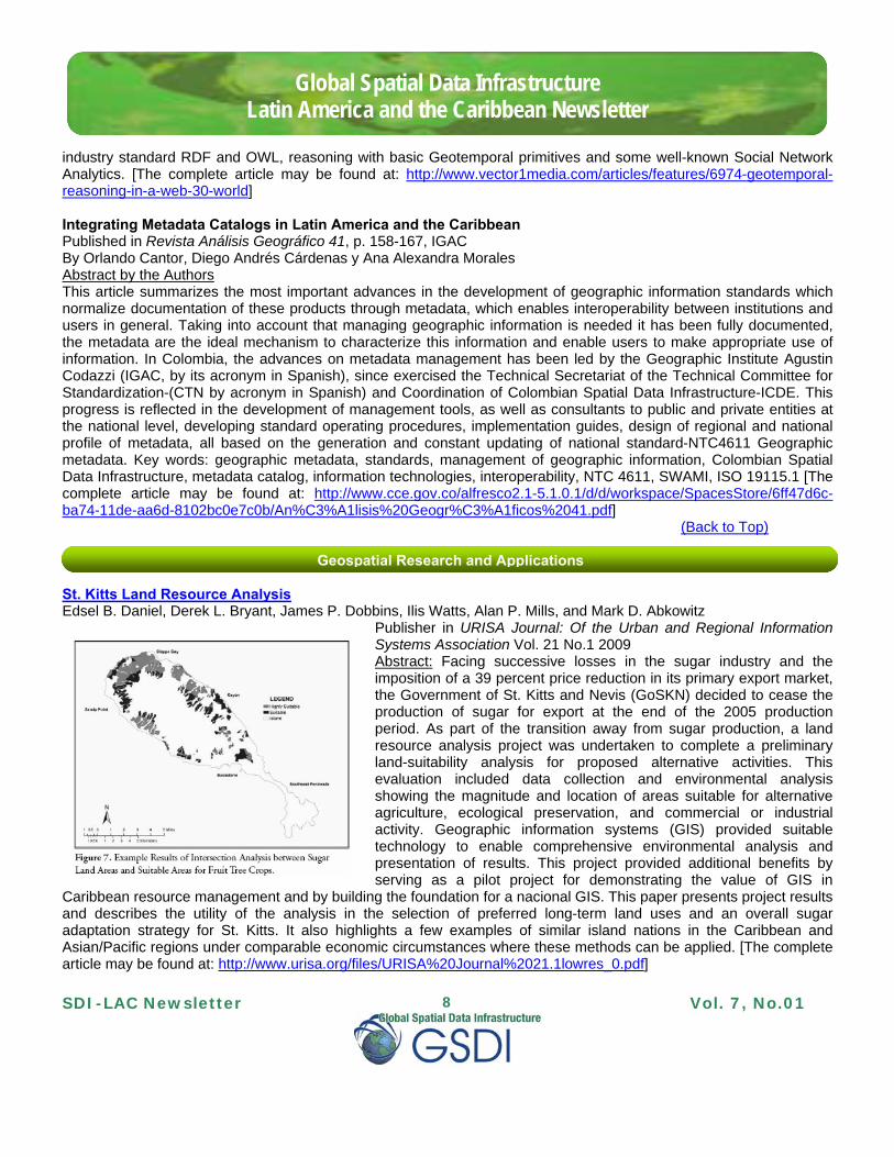
St. Kitts Land Resource AnalysisEdsel B. Daniel, Derek L. Bryant, James P. Dobbins, Ilis Watts, Alan P. Mills, and Mark D. Abkowitz
Publisher in URISA Journal: Of the Urban and Regional Information Systems Association Vol. 21 No.1 2009 Abstract: Facing successive losses in the sugar industry and the imposition of a 39 percent price reduction in its primary export market, the Government of St. Kitts and Nevis (GoSKN) decided to cease the production of sugar for export at the end of the 2005 production period. As part of the transition away from sugar production, a land resource analysis project was undertaken to complete a preliminary land-suitability analysis for proposed alternative activities. This evaluation included data collection and environmental analysis showing the magnitude and location of areas suitable for alternative agriculture, ecological preservation, and commercial or industrial activity. Geographic information systems (GIS) provided suitable technology to enable comprehensive environmental analysis and presentation of results. This project provided additional benefits by serving as a pilot project for demonstrating the value of GIS in
Caribbean resource management and by building the foundation for a nacional GIS. This paper presents project results and describes the utility of the analysis in the selection of preferred long-term land uses and an overall sugar adaptation strategy for St. Kitts. It also highlights a few examples of similar island nations in the Caribbean and Asian/Pacific regions under comparable economic circumstances where these methods can be applied. [The complete article may be found at: http://www.urisa.org/files/URISA%20Journal%2021.1lowres_0.pdf]
Global Spatial Data Infrastructure Latin America and the Caribbean Newsletter
First Atlas of Natural Hazards in the Andean Community of Nations Source: http://www.comunidadandina.org/
The existence of 60 active volcanoes and 355 thousand square kilometers of areas exposed to frost in the Andean sub-region, as well as 13 million people exposed to flooding in the Andean Community of Nations (in Spanish CAN) are, among others, the data contained in the first Atlas of Natural Hazards of the Andean sub-region, which was recently launched in connection with closure of the Cooperation Project CAN-EU " Support for Disaster Prevention in the Andean Community (PREDECAN).” The Atlas includes comprehensive mapping of nine natural phenomena (earthquakes, tsunamis, volcano eruptions, landslides, floods, frosts, droughts and El Niño and La Niña), and their impact histories, potential severity, prone areas to damage, population centers, and infrastructure and strategic activities that may be affected by natural phenomena, among others. Its development was possible thanks to efforts of different organizations of Member Countries of the Andean Community, and the support and cooperation of regional organizations. The European Commission, through the PREDECAN project has supported these efforts over the past five years. Member Countries of the Andean Community have now disaster databases including records of loss by natural phenomena. Between 1970 and 2007 there are about 50 thousand records on varying magnitudes of losses with an accumulated loss of 125 thousand lives, 380 thousand homes destroyed, 8.6 million homeless people and 28 million persons affected indirectly or in a less serious manner, such as in cases of deficits in the provision of public services. The Atlas is available in two formats through the following links: Atlas of the Andean Territory Dynamics (PDF version); Atlas of the Andean Territory Dynamics (Web version) PREDECAN Project Highlights: Five Working Years Results on Disaster Prevention and Attention in the CANSource: http://www.comunidadandina.org/predecan/ As a result of five years of work the Cooperation Project "Support for Disaster Prevention in the Andean Community" (PREDECAN), among the many excellent results highlights the following: The creation of the Andean Information System for Disaster Prevention and Response (in Spanish SIAPAD) with more than 5 thousand documents included; the provision of technology infrastructure (26 servers) for the Andean Committee for Disaster Prevention and Relief (in Spanish CAPRADE) and technical-scientific information producer organizations; and the training of 350 correspondents on the social approach to risk management and prevention, among others. Global Geographic NamesSource: http://www.gelib.com/gnis.htm
The Global Geographic Names database contains the names and location of approximately 6.5 million features of interest throughout the world, recompiled with December 2009 information. The features include mountains, government buildings, forests, parks, and many more. Many of the locations in this database are already included in the default Google Earth installation when you enable the Places of Interest layer; however, they are sometimes difficult to see if you do not have the Google Earth view in exactly the correct location and the Places of Interest layer does not contain all of the entries. This list was created by merging the Geographic Names databases maintained by the USGS and the National Geospatial-Intelligence Agency (both updated as of December, 2009). Only the feature
Global Spatial Data Infrastructure Latin America and the Caribbean Newsletter
names, classification and locations were extracted from the source databases to keep the file sizes manageable in Google Earth. Even with just the basic information, this is almost 300 megabytes of raw data and 1.5 gigabytes of KML code. ESRI Announces Support for Virtual USASource: http://www.esri.com/ Initiative Promotes Enhanced Interoperability and Situational Awareness for Emergency Management. ESRI announces support for Virtual USA, an initiative designed to improve decision making for local, state, tribal, and federal homeland security practitioners. Virtual USA integrates existing resources to provide real-time access to operational information from multiple sources and jurisdictions. Data such as weather, traffic, infrastructure, fuel supplies, emergency shelters, and medical facilities can be fully integrated, analyzed, mapped, and disseminated for emergency response. As more states participate in Virtual USA, the amount of data sharing, communication, and collaboration will improve all aspects of emergency management including mitigation, planning, response, and recovery. A New Generation of USGS Maps Source: U.S. Department of the Interior; http://www.doi.gov/ “US Topo” is the next generation of topographic maps from the U.S. Geological Survey. Digital US Topo maps are designed to look, feel, and perform like the traditional paper topographic maps for which the USGS is so well known. However, in contrast to paper-based maps, US Topo maps provide technical advantages that support faster, wider public distribution and enable basic, on-screen geographic analysis for all users. US Topo maps are available free on the Web. Each map quadrangle is constructed in GeoPDF® format from key layers of geographic data -orthoimagery, roads, geographic names, topographic contours, and hydrographic features- found in The National Map, a nationwide collection of integrated data from local, state, federal, and other sources. Further information about how to download and use US Topo, currently available coverage, and the timetable for production of US Topo maps can be found online at: www.nationalmap.usgs.gov/ustopo.
We are proud to announce the release of SpatiumCube, an Open Source Initiative (GNU Lesser General Public License) developed by GeoSpatiumLab, Zeta Amaltea and the Advanced Information Systems group of the University of Zaragoza, and with the sponsorship of IGN (National Geographic Institute, Spain). SpatiumCube offers an integration framework of software technologies than can help users and programmers with the development of Spatial Data Infrastructures (SDIs) and their services. As a first product to be offered in SpatiumCube, we have just released CatalogCube, a metadata catalog compliant with version 2.0.2 of OGC CSW specification (Catalog Services for the Web, http://www.opengeospatial.org/standards/cat). Its main features are the following: • Multi-platform (Windows, Unix). As it has been developed with J2EE, the service can be deployed on any platform
with the minimum requirements of having previously installed Tomcat and a Java virtual machine. On the client side users only need a web browser with Javascript support.
Global Spatial Data Infrastructure Latin America and the Caribbean Newsletter
• Easy way of metadata loading. The storage of metadata records is managed directly through the file system • The server side of the product supports:
-the compulsory operations GetCapabilities, DescribeRecord, GetRecords and GetRecordById -plus the transactional operations to allow users to add, delete and modify the catalog's contents
• With respect to metadata models, it implements both ISO19115 and DublinCore output schemas- Ranked searching. Metadata are indexed based on Lucene search engine (http://lucene.apache.org/java/docs/), so best results are returned first
• Tested compatibility with other catalog tools such as GI-Cat/GI-Go (http://zeus.pin.unifi.it/cgi-bin/twiki/view/GIcat/WebHome), Geonetwork (http://geonetwork-opensource.org/) or CatalogConnector (http://sourceforge.net/projects/catalogconnecto/)
• Additionally, it integrates a Web Client application to test catalog services compliant with CSW 2.0.2. This client offers a guided interface to facilitate the definition of CSW requests (including maps and other graphic components for query filter expressions) using both KVP, XML and SOAP protocols. This client interface is multilingual (currently available in Spanish, English, French, Portuguese, Catalan, Galician and the Basque language; it can be customized for other languages) and can be configured to request other catalog services compliant with CSW 2.0.2 developed with different technologies like GI-Cat or GeoNetwork.
SpatiumCube will soon include a new product called Services Catalog, a web application focused on the edition and search of metadata for services. This product will be released as a new version of CatMDServices (http://catmdservices.forge.osor.eu/) under the name of ServiceCube More information can be found at http://spatiumcube.sourceforge.net Navtable will be an official gvSIG project Source: gvSIG Comunication During the 5th gvSIG International Conference, the Cartographic Engineering Laboratory (CartoLab) and gvSIG Association arrived at a series of agreements that allow Navtable to be an official gvSIG extension in future versions. NavTable was released in the unofficial list of projects and the good reception given by the community raised the possibility of making it official. NavTable is an extension of gvSIG for displaying records of geographic information vector layers. Its main feature is that you can see an element attributes both individually and vertically. Its functionality has the ability to edit alphanumeric values, as well as to navigate between elements of the information layer. [Cartolab] http://cartolab.udc.es/ [Navtable] http://navtable.forge.osor.eu/index.html Open Source PCIDSK Library Source: http://www.gim-international.com/
PCI Geomatics will make available an open source initiative for the geospatial software development community. The open source library will provide access to the PCI proprietary file format – PCIDSK and is to be included in the Geospatial Data Abstraction Library (GDAL) version 1.7 slated for January 2010 release. The library will offer full support for raster data within the PCIDSK file, including the reading, writing and creation of raster image data, in all storage types (BIP, BIL, BSQ and tiled images) as well as overviews, metadata and projections. The library also includes access to vector data within the PCIDSK file and is available for both Windows and LINUX operating systems.
Global Spatial Data Infrastructure Latin America and the Caribbean Newsletter
MapGuide Open Source 2.1 Released Source: Arturo Brun-Martinez We are pleased to announce that the MapGuide Open Source project team has released MapGuide Open Source 2.1.0. (http://www.osgeo.org/node/976). This release has many improvements in performance, scalability and stability; an improved error reporting system; raster re-projection; and CS-Map as the coordinate system library. ESA member states approve full and open Sentinel data policy principlesSource: GEO News issue #6 The member states of the European Space Agency (ESA) recently approved the new principles for the Sentinel Data Policy. These principles establish full and open access to data acquired by the upcoming Sentinel satellite missions. The Sentinels comprise five new missions being developed by ESA specifically for the operational needs of the Global Monitoring for Environment and Security programme (GMES). The new data policy ensures free-of-charge access to all Sentinel data as well as the products generated via the Internet by anyone interested in using them, mainly for GMES data use but also for scientific and commercial use. Other access modes and the delivery of additional products will be tailored to specific user requests, but not necessarily within ESA’s remit. The policy continues the international trend for full and open access to Earth observation data, in line with the intergovernmental Group on Earth Observations (GEO) data sharing principles. Furthermore, it responds directly to the increasing demand for Earth observation data in the context of climate change initiatives and in support of the implementation of environmental policies. Read more on http://www.esa.int/esaEO/SEMXK570A2G_environment_0.html GOSIC works with GEO Portal to provide climate informationSource: GEO News issue #6
The Global Observing Systems Information Center (GOSIC) is an on-line data portal established in response to the global climate observing community’s need for better access to observational climate data and information. GOSIC’s goal is to provide access to a worldwide set of observations and derived products. Its unique value lies in its ability to quickly link users via a consistent and user-friendly interface to a wide range of data sets residing at multiple data centers. It provides users with links to data, metadata, other search tools, and related climate observing information. Following GOSIC’s initial development and implementation at the University of Delaware in the USA from 1997-2006, the National Oceanic and Atmospheric Administration’s National Climatic Data Center (NCDC) assumed operational responsibility for it on behalf of the international climate observing and data user communities. The GOSIC portal does not itself hold data. Instead, it acts as a data access service by providing a common access point to global and regional data sets and analyses for use in various aspects of climate research. The portal maintains metadata and links to data centers to access data and information. For more detailed information on the GOSIC, please see the following article: Diamond, H. J., and C. J. Lief (2009), A Comprehensive Data Portal for Global Climate Information, Eos Trans. AGU, 90(39), doi:10.1029/2009EO390001 at http://www.agu.org/pubs/crossref/2009/2009EO390001.shtml
Global Spatial Data Infrastructure Latin America and the Caribbean Newsletter
China to Launch Civil HD Survey Satellite Source: http://www.gim-international.com/ China will put into space a civil high-definition survey satellite, the first of its kind in the country, in 2011, the State Bureau of Surveying and Mapping (SBSM) said. The satellite, ZY 3, would be launched from the Taiyuan Satellite Launch Center in northern Shanxi Province on a Long March 4B carrier rocket, according to Xu Deming, director of the SBSM and Vice Minister of Land and Resources.
(Back to Top)
Training Opportunities
Specialization Course on Remote Sensing and Geographic Information Systems Applied to the Study of Natural Resources and Agricultural Production, ArgentinaSource: Arturo Brun-Martinez
This Specialization Course comprise three modules whose objectives include: Deepening the basic knowledge on remote sensing and Geographic Information Systems (GIS); evaluating most widespread applications of remote sensing and GIS in agriculture; evaluating and managing natural resources; and promoting skills for products’ presentation derived from spatial information analysis and for interaction between academia and recipients in different areas (production, government, etc.). Contact: Ing. Maria Eugenia Beget ([email protected]) or Ms. Juliet Straschnoy ([email protected]). Details on the program’s modules and admission requirements here. Courses on Geographic Information Technology (online), Spain Source: http://www.sinfogeo.es/ Geographic Information Technologies (GIT) are key elements in current social fabric, which requires mastery of these tools to facilitate spatial information collection, advanced analysis implementation, development application and management planning. Course description and schedule: http://www.sinfogeo.es/listadocursos/tig.html Indigenous Mapping: A new Google technology workshop for tribal peoplesSource: http://google-latlong.blogspot.com/
Indigenous people worldwide face special challenges in planning, policy and advocacy work. Issues such as cultural preservation, sovereignty, land use management, and handling mineral rights are just a few that they have to tackle. Recognizing this, Google and the Indigenous Mapping Network are teaming up to put on a two day workshop on the Google campus to teach people from native communities how to use Google's mapping technologies. The mission of IMN has been to empower native communities by connecting them with the tools they need to protect, preserve, and
Global Spatial Data Infrastructure Latin America and the Caribbean Newsletter
enhance their way of life within their aboriginal territories. And they endeavor to bridge the gap between traditional "mapping" practices and modern mapping technologies. On February 25th and 26th, 2010, Google and IMN will host a workshop on the Google campus for members and staff of indigenous groups who want to learn about Google geospatial and mobile technologies. This hands-on workshop will approach Google technologies with the special concerns of indigenous communities in mind, and will focus on the technical aspects of using Google Earth, Google Maps, Sketchup, Android mobile phones and Open Data Kit, among other technologies. For more information and to register for this workshop, go to the IMN website. Application deadline is January 24, 2010.
(Back to Top)
Funding Opportunities, Awards, Support
6th Ecosystems Call for ProposalsSource: Luisa Fernanda Neira by way of Santiago Borrero
6th IABIN Ecosystems Thematic Network (ETN) Request for Proposals (RfP) to digitize data on TERRESTRIAL, MARINE OR FRESH WATER ECOSYSTEMS. Please note that the deadline for submitting proposals is January 15th, 2010. We would appreciate your sending the RfPs to interested organizations in your country. For questions, please contact Vincent Abreu ([email protected]) or Luisa
Neira ([email protected]). Reminder January 16 deadline: Call for Applications to attend Institute for Integration of Research on Climate Change and Hazards in the Americas Source: Patricia Solís by way of Santiago Borrero The event, co-organized by the Association of American Geographers (AAG), the Pan-American Institute for Geography and History (PAIGH) of the Organization of American States, the US Geological Survey (USGS), the National Communication Association (NCA), and the United Nations Environment Programme Regional Office for Latin America and the Caribbean (UNEP), will take place in collaboration with the Universidad Tecnológica de Panamá and will be led by an expert interdisciplinary team of 12 lecturers from the US, Panama, Chile, Brazil, and Mexico. The desired result of the program is a clear roadmap and collaborative mechanism for developing and sharing the knowledge necessary for responding to climate change and hazards in the Americas in an integrative way, using geographic tools and methods as a research and communication framework. Funding for the institute comes from the US Department of Energy and US National Science Foundation sponsored Pan American Advanced Studies Institute Program (NSF PASI). Graduate students, post doctoral students, or early career scientists within 6 years of receiving the PhD, and who are US citizens or permanent residents or are currently enrolled in a US university or academic institution in any field may apply to attend as US Participants. Underrepresented groups and students from Historically Black Colleges and Universities, Hispanic-serving institutions, and tribal colleges are encouraged to apply. Graduate students, post doctoral students, or early career scientists within 10 years of receiving the PhD who are citizens of and residents in any country in Latin America may apply as Regional Participants. Selected participants must attend the full two week institute in Panama and will receive airfare, lodging, local transportation to institute events, training materials, and some meals paid for by the program. Application forms, instructions and selection criteria are available on the website at www.aag.org/Grantsawards/pasi.html. Deadline for submissions is January 16, 2010. For questions or additional information, please contact Patricia Solís at [email protected].
Global Spatial Data Infrastructure Latin America and the Caribbean Newsletter
Call for the MAEC-AECI Fellowship Program for Foreign Citizens 2010-2011Source: Camilo Botero Resolution of December 7, 2009, from the President of the Spanish Agency of International Cooperation for Development, calls for the "MAEC-AECID" Fellowship Program of the Ministry of Foreign Affairs and Cooperation, for foreign citizens for the academic year 2010-2011 - PDF (BOE-A-2009-from 20184 - 16 pp. - 355 KB) http://www.boe.es/boe/dias/2009/12/16/pdfs/BOE-A-2009-20184.pdf Map Maker's Global Mapping CompetitionSource: http://google-latlong.blogspot.com/
Google's first Global Mapping Competition runs from December 15 - January 31, 2010. During this period, the mapper who adds the most universities, schools, hospitals, and medical clinics with high quality into Google Map Maker will win a $50,000 UNICEF donation to benefit the country of their choice for work empowering young people through technology. Google Map Maker is available in more than 170 countries and allows users to become "citizen cartographers" by adding and editing map features. To foster participation from countries around the world, we have versions of the site in several languages: English, Spanish, French, Russian, Romanian, and Vietnamese. This global competition comes on the heels of the Latin America mapping competition that recently ended. More than 50 teams
from all over the world registered for the Latin America mapping competition, and we've seen more than 500% mapping activity increases for several Latin American countries during the competition period. We're very excited about this participation level and are looking forward to announcing the competition winners on January 8, 2010.
(Back to Top)
Employment Opportunities
Post-Doctoral Research Associate: Interdisciplinary Geospatial Research Source: Kenneth Young Department of Civil Engineering, Kansas State University, Manhattan, Kansas U.S.A. The successful candidate will work with an interdisciplinary team of researchers to develop the geospatial data infrastructure necessary to study regional hydrology, ecology and the impacts of policy and climate change on water resources. This person will meet regularly with an interdisciplinary team of faculty from 4 colleges and 6 departments to plan and coordinate activities. The candidate will work within a university-wide GIS Commons to integrate these datasets using relevant geodatabase standards, and develop the cyberinfrastructure support to enable modeling tools to access and utilize this data. This position will enable the successful candidate to conduct research and publish within an emerging theme of interdisciplinary modeling of hydrology and ecology. This person is expected to publish findings as both collaborator and lead author. The position will support regional activities of CUAHSI (www.cuahsi.org) and integration of geospatial data within the OpenMI modeling framework of the European Union Water Framework Directive. The successful candidate will have the following qualifications: Ph.D. in Engineering, Geography, or related field; Excellent ArcGIS experience; Demonstrated excellence in computer modeling in the candidate’s area of expertise; and an ability to communicate effectively and interact within a team environment. Additional preferred qualifications include ArcServer and web services. This position will be funded for a minimum of one year, with potential to renew for a second year, subject to satisfactory work performance and availability of funding. Screening of applicants will begin January 13, 2010 and continue until the position is filled. Salary is commensurate with qualifications and experience. Candidates must submit an application packet containing: a letter of application,
Global Spatial Data Infrastructure Latin America and the Caribbean Newsletter
academic resume (c.v.), academic transcripts from all universities and colleges, and names and contact information for three references to: David R. Steward, Ph.D., P.G., Associate Professor, Kansas State University, Department of Civil Engineering, 2118 Fiedler Hall, Manhattan, KS 66506-5000 U.S.A., Phone: (785) 532-1585, E-mail: [email protected]. Website: http://www.ce.ksu.edu Postgraduate at NCAR Source: Kenneth Young
The National Center for Atmospheric Research is seeking a Postgraduate (post-doctoral) Scientist to conduct interdisciplinary research projects in the area of cities and climate change. The scientist will join a multidisciplinary team of researchers in NCAR's Science and Applications Program, Integrated Science Program. The position will include a) compiling of data sets of societal and environmental determinants of urban GHG emissions, impacts and vulnerabilities; and (b) organizing comparative studies of cities' adaptation and mitigation responses. The postgraduate will assist and participate in the design of regression models, meta-analysis and other analytic tools. The National Center for Atmospheric Research (http://www.ncar.ucar.edu) is sponsored by the National Science Foundation and managed by the University Corporation for Atmospheric Research. NCARis located in Boulder, Colorado, in the foothills of the Rocky Mountains. Qualifications include Ph.D. degree in environmental sociology, geography, or environmental sciences with strong mathematical background. Ability to work with and apply the tools and methods of interdisciplinary groups. Strong written and oral communication skills, ability to communicate effectively with scientists, software engineers and the stakeholders on technical details of project. This is a full-time three-year term position with possibility of extension. Contact Patricia Romero Lankao ([email protected]). For further information, see: https://hostedjobs.openhire.com/epostings/submit.cfm?fuseaction=app.jobinfo&id=23&jobid=216646&company_id=15947&version=1&source=ONLINE&JobOwner=962105&level=levelid1&levelid1=45212&parent=Scientific&startflag=2 or
(Back to Top)
Other
Grand Challenges in Global Sustainability Research Source: ICSU Insight Newsletter, December 2009, vol 7 (2)
What are the challenges in Global Sustainability Research for the next decade? The International Council for Science (ICSU) and its partners are inviting organizations and individuals for their input via an online consultation beginning 21 December 2009. Grand Challenges in Sustainability Research is a focused global initiative centered on five grand challenges that must be addressed over the next decade if society is to manage the global environmental change that is now underway and cope with the change that we cannot manage. The proposed initiative is a result of the first step of the Earth system visioning process, which began with an online consultation that yielded more than 300 research priorities and contributions from more than 1000 people from 85 countries. The consultation process is now at a crucial stage and, once again, we seek the opinions of the global community. We would like your reflections on the proposed Grand Challenges, on what current research efforts can be woven into the challenges, and on what international research coordination is needed to get the job done. The draft document and online consultation are available at www.icsu-visioning.org until February 21, 2010.
Global Spatial Data Infrastructure Latin America and the Caribbean Newsletter
Approved Mexican Space Agency Project Source: http://www.mundogeo.com.br/ Commissions of Science and Technology and of Budget and Public Account unanimously approved the draft Decree issuing the Act establishing the Mexican Space Agency (AEXA).
(Back to Top)
Year 2010 January February March April May June July August September October November December
JANUARY 2010 5-7 Cuenca, Ecuador Sixth International Conference on Environmental, Cultural, Economic
and Social Sustainability6-7
*
17
**NNNEEEWWW*** Curitiba, Brazil Second Curitiba Meeting on Cities and Biodiversity
6-8 Redlands CA, USA GeoDesign Summit8-10
***NNNEEEWWW*** Houston TX, USA
SPAR 2010
10-17 ***NNNEEEWWW***
Honolulu HI, USA Emergency communications and disaster management workshop
15-16 ***NNNEEEWWW***
Panama City, Panama Access and Benefit-sharing Regional Consultations for Latin America and Caribbean Countries
20-22 ***NNNEEEWWW***
Markham Ontario, Canada
EDIST - Electricity Distribution Information Systems and Technology
22-23 ***NNNEEEWWW***
Redlands CA, USA Space-Time Modeling and Analysis Workshop
24-28 ***NNNEEEWWW***
Maui HI, USA MAPPS 2010 Winter Conference
27-30 ***NNNEEEWWW***
Fortaleza, Estado do Ceará, Brazil
First Colloquium on Agrarian Geography
FEBRUARY 2010
1-2 ***NNNEEEWWW***
Olympic Valley CA, USA
Accela Partner Summit 2010
3-4 ***NNNEEEWWW***
Redlands CA, USA 2010 CA/HI/NV Regional User Group (CAHINVRUG) Conference
3-5 ***NNNEEEWWW***
Denver CO, USA
ILMF 2010 (International Lidar Mapping Forum)
8-10 ***NNNEEEWWW***
Houston TX, USA SPAR 2010: 3D Imaging & Positioning for Engineering, Construction, Manufacturing
11 ***NNNEEEWWW***
On Line Second Series of Regional Real-time Online Conferences on Risk Assessment and Risk Management: Latin America and the Caribbean
10-15 St. Maarten, Netherlands Antilles
2nd International Conference on Advanced Geographic Information Systems, Applications, and Services / GEOProcessing 2010
17-19
Washington DC, USA 2010 ESRI Federal User Conference
Global Spatial Data Infrastructure Latin America and the Caribbean Newsletter
18-20 ***NNNEEEWWW***
Ecuador Workshop for Indigenous and Local Communities in Latin America and the Caribbean on Information Technologies, Tourism and Biodiversity in Forest Ecosystems – Workshop III: Forest Ecosystems
22-24
Houston TX, USA 2010 ESRI Petroleum User Group Conference
22-25 ***NNNEEEWWW***
Redlands CA, USA Redlands GIS Week
MARCH 2010
3-5 Denver CO, USA International Lidar Mapping Forum Conference and Exhibition3-5
Washington DC, USA International Commercial Remote Sensing Symposium
6-10
Annapolis MD, USA National States Geographic Information Council (NSGIC) Midyear Conference
7-13
Cancún, México First International Conference on Environmental Change Awareness (BIOENVIRONMENT 2010)
8-11 Little Rock AR, USA GIS / CAMA Technologies Conference14-19
Mérida, Mexico
6th European Geosciences Union Alexander von Humboldt International Conference on Climate Change, Natural Hazards, and Societies
15-26
Buenos Aires, Argentina
2010 Southwestern Hemisphere Workshop Series On Climate Change: CO2, the Biosphere and Climate
21-23 ***NNNEEEWWW***
Palm Springs CA, USA 2010 ESRI Worldwide Business Partner Conference (BPC)
21-24 ***NNNEEEWWW***
Orlando, FL, USA
Spring World 2010
22-25 Marbella, Chile Workshop on Urban Dynamics22-25 Miami FL, USA CARIS 201022-25 Palm Springs CA, USA 2010 ESRI Developer Summit22-26 Rio de Janeiro, Brazil World Urban Forum 523-25 Tampa FL, USA DistribuTECH 2010 Conference & Exhibition23-25
***NNNEEEWWW*** Las Vegas NV, USA CTIA Wireless 2010
23-25 ***NNNEEEWWW***
Washington DC, USA FOSE - Technology for Business of Government
24-26 Vancouver, Canada Globe 201029-31 Orlando FL, USA 2010 AWRA Spring Specially Conference
Mar. 30 – Apr. 1 San Jose CA, USA Where 2.0 Conference 2010
APRIL 2010 Mar. 30 – Apr. 1 San Jose CA, USA Where 2.0 Conference 2010
5-9 Orlando FL, USA SPIE Defense, Security, & Sensing 20107-10
*NUEVO* Kansas City MI, USA
ADEC 32nd Annual Conference
12-14 Charleston WV, USA GIS-T 201013-15
***NNNEEEWWW*** Toronto, Ontario, Canada
GeoTec 2010
14-18 Washington DC, USA Association of American Geographers 2010 Annual Meeting15-16
***NNNEEEWWW*** Victoria BC, Canada ESRI Regional User Conference
Global Spatial Data Infrastructure Latin America and the Caribbean Newsletter
15-17 ***NNNEEEWWW***
Curitiba, Paraná, Brazil
5th Brazilian Symposium on Soil Education
18-21 Huntington Beach CA, USA
16th Annual CalGIS Conference
18-22 Kansas City MO, USA MAGIC 2010 Symposium19-23
San Diego CA, USA BAE Systems GXP International User Conference and Professional
Exchange!20-21
***NNNEEEWWW*** Quebec, Canada ESRI Regional User Conference
22 ***NNNEEEWWW***
Toronto ON, Canada Expedition 2010: Navigate Location Intelligence
25-29 Phoenix AZ, USA GITA's 2010 Geospatial Infrastructure Solutions Conference25-29 Phoenix AZ, USA Not Your Father's GIS Conference25-30 Huntsville AL, USA SpaceOps 201026-28
***NNNEEEWWW*** Charlotte NC, USA 2010 Southeast Regional User Group (SERUG) Conference
26-30 Austin TX, USA 2010 NatureServe Conferences: Biodiversity without Boundaries26-30 San Diego CA, USA ASPRS Annual Conference / [email protected]
***NNNEEEWWW*** Sudbury ON, Canada ESRI Regional User Conference
29 ***NNNEEEWWW***
Phoenix , AZ , USA Oracle Spatial User Group Meeting
MAY 2010
10-13 ***NNNEEEWWW***
Banff, Alberta, Canada Disaster Forum 2010: Plan to Succeed
11 ***NNNEEEWWW***
Whitehorse YT, Canada
ESRI Regional User Conference
12-13 ***NNNEEEWWW***
Kamloops BC, Canada ESRI Regional User Conference
16-18 Montego Bay, Jamaica 2010 International Conference on Information Resources Management16-20
Aracaju (SE), Brazil 24th Cartographic Brazilian Congress
17-20
***NNNEEEWWW*** Puebla, Mexico 11th International Digital Government Research Conference
(DGO2010)18-19
***NNNEEEWWW*** Calgary AB, Canada ESRI Regional User Conference
19 Bethesda MD, USA NGA Tech Day
20 Reston VA, USA USGIF Industry Tech Day22
***NNNEEEWWW*** Montreal, Canada International Day for Biological Diversity
24-27 ***NNNEEEWWW***
Toronto, Canada
American Canadian Conference for Academic Disciplines
JUNE 2010
1 ***NNNEEEWWW***
Las Vegas NV, USA Consumer Telematics Show
1-4
Ithaca NY, USA 36th Annual Conference of the International Association for Social Science Information Service and Technology (IASSIST)
Global Spatial Data Infrastructure Latin America and the Caribbean Newsletter
7-9 ***NNNEEEWWW***
Rosemont, IL, USA Sensors Expo & Conference
16-18 Calgary, Canada Commission I Symposium ″Image Data Acquisition - Sensors & Platforms″ Contact: [email protected]
20-24 ***NNNEEEWWW***
Chicago, Illinois, USA
129th Annual Conference and Exposition of the American Water Works Association: Show Me the Water
21-25 Santo Domingo, Dominican Republic
International Meeting “Virtual Educa” – 2010
22-25 ***NNNEEEWWW***
Calgary, Alberta, Canada
103rd Air and Waste Management Association Conference and Exhibition: Energy and the Environment
JULY 2010
3-7
Edmonton Alberta, Canada
24th International Congress for Conservation Biology
10-13 ***NNNEEEWWW***
San Diego CA, USA 2010 ESRI Education User Conference
10-13 ***NNNEEEWWW***
San Diego CA, USA 2010 ESRI Survey & Engineering GIS Summit
10-13 ***NNNEEEWWW***
San Diego CA, USA 2010 ESRI Homeland Security GIS Summit
12-16 ***NNNEEEWWW***
San Diego CA, USA 2010 ESRI International User Conference
12-16 ***NNNEEEWWW***
Houston TX, USA The Fifth International Conference on Environmental Science and Technology 2010
26-30
Honolulu, Hawaii, USA IGARSS'10: IEEE International Geoscience & Remote Sensing Symposium
26-30 Los Angeles CA, USA SIGGRAPH 201027-30
***NNNEEEWWW*** Recife PE, Brazil 3rd Brazilian Symposium on Geodesic Sciences and Geoinformation
Technologies - III SIMGEO
AUGUST 2010 3-6
Buenos Aires, Argentina
Scientific Committee on Antarctic Research (SCAR) Open Science Conference (OSC)
8-13 Foz do Iguassu, Brazil American Geophysical Union (AGU) Joint Assembly
SEPTEMBER 2010 12-16
Minneapolis MN, USA National States Geographic Information Council (NSGIC) Annual
Conference12-16
***NNNEEEWWW*** Vancouver BC, Canada
15th International Union of Air Pollution Prevention and Environmental Protection Association’s World Clean Air Congress: Achieving Environmental Sustainability in a Resource Hungry World
19-24 Montreal, Canada IWA World Water Congress and ExhibitionSep.28-Oct.1
***NNNEEEWWW*** Orlando FL, USA 48th Annual URISA Conference & Exposition
OCTOBER 2010
4-8 Santiago, Chile Latin American Remote Sensing Week18-22
Global Spatial Data Infrastructure Latin America and the Caribbean Newsletter
19-21 *
21
**NNNEEEWWW*** Curitiba Paraná, Brazil IX Updated Seminar on Remote Sensing and Geographic Information
Systems applied to Forestry Engineer
20-22
Santiago, Chile IAOS/Scorus Conference on official statistics and the environment: approaches, issues, challenges and linkages
25-28 ***NNNEEEWWW***
Nashville TN, USA GEOINT Symposium 2010
NOVEMBER 2010
8-12
Guanajuato, Mexico XIV International SELPER Symposium ″Observation & Monitoring of the Earth related to Climate Change″ (An ISPRS Regional Conference) E-mail: [email protected]
15-19 Orlando FL, USA AutoCarto 201016-18 Orlando FL, USA Commission IV Symposium ″Geodatabases & Digital Mapping″ /
Please mention SDI-LAC as source of information in any correspondence you may have on items in this issue
To subscribe to SDI-LAC, please do so online at: http://www.gsdi.org/newslist/gsdisubscribe.asp Nancy Aguirre, PAIGH, Editor [email protected] Global Spatial Data Infrastructure Association, http://www.gsdi.org