GNSS Radio Occultation activities at NOAA Lidia Cucurull Chief, Global Observing Systems Analysis (GOSA) Group NOAA ESRL Global Systems Division, Boulder, CO & NOAA AtlanEc Oceanographic and Meteorological Laboratory, Miami, FL 4 th IROWG Melbourne, Australia, April 2015
Transcript
GNSS Radio Occultation activities at NOAA Lidia Cucurull Chief, Global Observing Systems Analysis (GOSA) Group NOAA ESRL Global Systems Division, Boulder, CO
& NOAA AtlanEc Oceanographic and Meteorological Laboratory, Miami, FL
4th IROWG Melbourne, Australia, April 2015
Outline
§ Introduction to the Global Observing Systems Analysis (GOSA) Group
§ GOSA activities 1) Observing System Simulation Experiments (OSSEs) 2) Observing System Experiments (OSEs) 3) GNSS Radio Occultation algorithm development (in support of
CIRA and CIRES: satellite meteorology and NWP/DA expertise, grad students, postdocs, fellows
Division Overview 4
4
5
Transferring science and technology to the Na6onal Weather Service
5
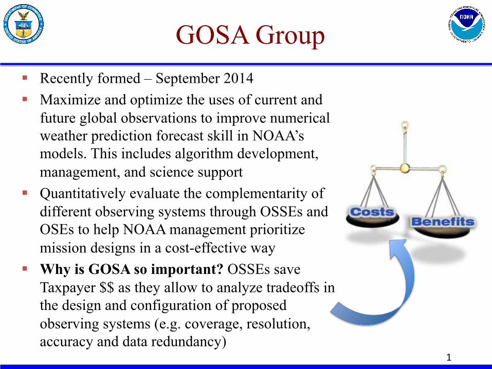
GOSA Group § Recently formed – September 2014 § Maximize and optimize the uses of current and
future global observations to improve numerical weather prediction forecast skill in NOAA’s models. This includes algorithm development, management, and science support
§ Quantitatively evaluate the complementarity of different observing systems through OSSEs and OSEs to help NOAA management prioritize mission designs in a cost-effective way
§ Why is GOSA so important? OSSEs save Taxpayer $$ as they allow to analyze tradeoffs in the design and configuration of proposed observing systems (e.g. coverage, resolution, accuracy and data redundancy)
1
OSEs and OSSEs
§ Observing System Experiments (OSEs) allow the evaluation of the impact of current observations in weather forecasting
§ Observing System Simulation Experiments (OSSEs) provide a rigorous, cost-effective approach to evaluate the potential impact of new observing systems, alternate configurations and deployments of existing systems, and to optimize observing strategies. They are also used to prepare for the utilization of new types of data and to optimize the utilization of existing data
§ Both OSEs and OSSEs are necessary to quantitatively evaluate the benefits of observations in weather forecasting
10
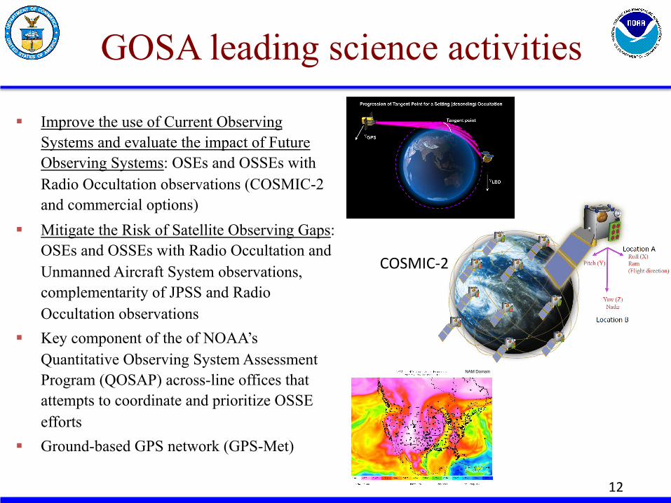
GOSA leading science activities
§ Improve the use of Current Observing Systems and evaluate the impact of Future Observing Systems: OSEs and OSSEs with Radio Occultation observations (COSMIC-2 and commercial options)
§ Mitigate the Risk of Satellite Observing Gaps: OSEs and OSSEs with Radio Occultation and Unmanned Aircraft System observations, complementarity of JPSS and Radio Occultation observations
§ Key component of the of NOAA’s Quantitative Observing System Assessment Program (QOSAP) across-line offices that attempts to coordinate and prioritize OSSE efforts
§ Ground-based GPS network (GPS-Met)
12
COSMIC-‐2
NAM Domain
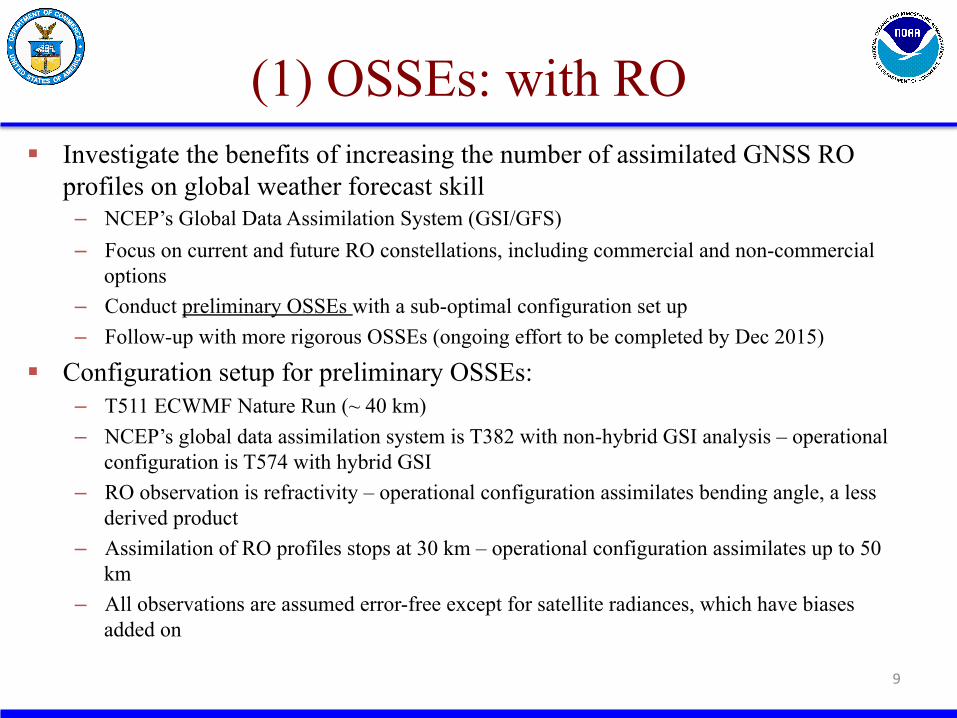
(1) OSSEs: with RO § Investigate the benefits of increasing the number of assimilated GNSS RO
profiles on global weather forecast skill – NCEP’s Global Data Assimilation System (GSI/GFS) – Focus on current and future RO constellations, including commercial and non-commercial
options – Conduct preliminary OSSEs with a sub-optimal configuration set up – Follow-up with more rigorous OSSEs (ongoing effort to be completed by Dec 2015)
§ Configuration setup for preliminary OSSEs: – T511 ECWMF Nature Run (~ 40 km) – NCEP’s global data assimilation system is T382 with non-hybrid GSI analysis – operational
configuration is T574 with hybrid GSI – RO observation is refractivity – operational configuration assimilates bending angle, a less
derived product – Assimilation of RO profiles stops at 30 km – operational configuration assimilates up to 50
km – All observations are assumed error-free except for satellite radiances, which have biases
added on
9
Preliminary OSSEs with RO
§ Experiments ran from 2 July 2005 to 21 August 2005 § Verification covers the period of 16 July – 21 August 2005 § RO missions being considered:
– Current RO constellation: primarily COSMIC (6 satellites) – COSMIC-2, both equatorial (6 satellites) and polar (6 satellites)
components – GeoOptics (commercial, 12 satellites) – further evaluation is ongoing work – Planet IQ (commercial, 12 satellites) – further evaluation is ongoing work
§ Experiments: – OSSENOGPS: control without RO observations (0 RO satellites) – OSSECTRL: control, all observations (6 RO satellites) – C2EQ: control + COSMIC-2 equatorial (12 RO satellites) – C2PO: control + COSMIC-2 equatorial + COSMIC-2 polar (18 RO
satellites) 10
Day 5
NH SH
-‐LiDle impact from full C2 -‐C2-‐EQ makes things slightly worse -‐Results are not sta6s6cally significant
-‐Significant posi6ve impact from C2-‐EQ and full C2 -‐Results are sta6s6cally significant
Anomaly correlation of 500-mb gph
Forecast hour
NH SH Temperature, AC at 250 mb
NOGPS is beDer than CTRL, but adding addi6onal RO reduces bias
Increasing the number of RO satellites reduces bias
Increasing the number of RO satellites reduces rmse, but full C2 slightly worse than C2-‐EQ
Increasing the number of RO satellites reduces rmse
Preliminary RO OSSE results
§ Overall, increasing the number of assimilated RO satellites from 6 to 18 results in better weather forecast skill: 18 satellites is better than 12 satellites; 12 satellites is better than 6 satellites
§ There is a lot of room to optimize the assimilation system § Some cases need to be evaluated with more detail to
understand how results can be improved (e.g. “dropouts”) § Results (not shown here) seem to indicate that with this
sub-optimal OSSE system saturation might be reached with 30 satellites
§ These preliminary studies do not use the state-of-the-art OSSE system
16
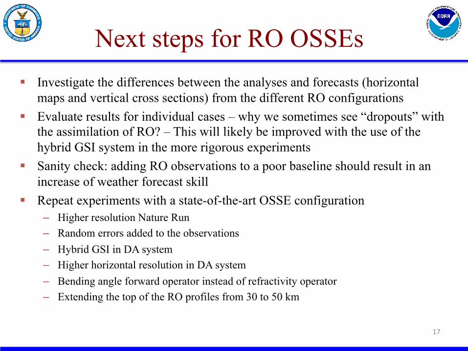
Next steps for RO OSSEs § Investigate the differences between the analyses and forecasts (horizontal
maps and vertical cross sections) from the different RO configurations § Evaluate results for individual cases – why we sometimes see “dropouts” with
the assimilation of RO? – This will likely be improved with the use of the hybrid GSI system in the more rigorous experiments
§ Sanity check: adding RO observations to a poor baseline should result in an increase of weather forecast skill
§ Repeat experiments with a state-of-the-art OSSE configuration – Higher resolution Nature Run – Random errors added to the observations – Hybrid GSI in DA system – Higher horizontal resolution in DA system – Bending angle forward operator instead of refractivity operator – Extending the top of the RO profiles from 30 to 50 km
17
(2) OSEs: Data Gap mitigation activities
18
§ ATMS observations on Suomi-NPP were assimilated into the operational NCEP’s global data assimilation system starting in May 2012
§ Suomi-NPP was placed in early afternoon orbit, providing similar information to the existing polar orbiting satellites with MW sounders (AMSU-A and MHS on NOAA-18/19, AMSU-A on Aqua, and AMSU-A on NOAA-15)
§ As a consequence, previous studies showed in general neutral impact of ATMS in the NCEP’s system
§ Due to the delay in the launch of JPSS-1, a “gap” or significant reduction in the U.S. MW satellite data is possible
§ MW soundings are consistently the number one observing system contributing to NWP forecast accuracy
§ In addition, there might a significant loss of RO observations § RO observations are complementarity to MW and IR observations and have
been shown a significant positive impact on global NWP forecasts worldwide
Motivation
19
§ Goal of the study is to investigate the impacts on the skill of NCEP global forecasts due to a loss of the NOAA and AQUA MW and all RO soundings
§ Two extreme scenarios are considered Ø MW instruments from NOAA-15/18/19 and AQUA have not reached the
end of their life before JPSS-1 is launched Ø MW instruments from NOAA-15/18/19 and AQUA are lost before JPSS-1
is launched § Evaluate the impact of losing all RO observations in both extreme scenarios § Results of the study might be considered pessimistic (worse case) as all systems
are not likely to fail before there are some replacements § Extreme cases will indicate relative importance of these losses – will provide
significant signal
Experiment Design
20
§ All forecasts begin at 00 GMT and ran for 8 days from 21 February to 30 April 2013. The first seven days are used for model spin-up and the forecast comparisons cover the period 28 February – 30 April 2013
§ Horizontal resolution of the operational NCEP’s global data assimilation system at the time of this study is T574 (~ 27 km) with 64 levels in the vertical
§ All the experiments used the hybrid version of the NCEP’s global data assimilation system § RO observations (~ 0.4 M/day) versus U.S. MW observations (~ 2.1 M AMSU-A/day)
AC 250-mb Temperature
21
(a) (b)
Fig. 4. Top: Anomaly correlation score as a function of the forecast length for the 250-mb temperature field in the NH (a) and SH (b) for all six experiments. The differences from the CTL are shown in the lower panels. Bottom: Difference of AC scores with respect to CTL in the (a) NH and (b) SH. Vertical bars indicate limits of statistical significance at the 95% confidence levels; curves within the corresponding bars are not statistically significant.
Largest benefit from MW, but small differences
Largest benefit from RO, and larger differences
Fit to Radiosonde (Temperature)
22
analysis – observations (K) Fig.5. Global temperature biases of analyses relative to radiosondes in all six experiments.
Pres
sure
leve
l (m
b)
(mb(
mb)
(mb)
(a) (b)
Fig.6. Top: Evolution of the magnitude of the global temperature fit to radiosondes at (a) 300-mb and (b) 20-mb. Bottom: Difference of biases with respect to CTL. Vertical bars indicate limits of statistical significance at the 95% confidence levels; curves within the corresponding bars are not statistically significant.
Tem
pera
ture
(K)
(mb(
mb)
(mb)
• MW tend to increase biases, while RO tends to reduce it • The impact of ATMS is mostly neutral
§ A slight loss of accuracy in the NH extratropics forecasts occurs with the loss of all U.S. MW data, and this loss is not mitigated with RO observations
§ In the SH extratropics, the loss of RO data produces a much larger negative impact on the forecast than does the loss of the U.S. MW observations
§ The role of ATMS in mitigating the loss of the other MW sounders is mixed, but generally neutral
§ Thus the potential “gap” in RO may be a more serious risk to global forecasts accuracy than potential gaps in the U.S. MW observations
§ The global biases in analyses and forecasts seem to increase as the number of MW observations increases, particularly in the stratosphere – the modest amount of unbiased RO only partially reduces these biases
§ An increase of RO observations should further ‘anchor’ the model resulting in improved bias corrections of the satellite radiances
§ Cucurull L., and R. A. Anthes, 2015: Impact of Loss of Microwave and Radio Occultation Observations in Operational Numerical Weather Prediction in Support of the US Data Gap Mitigation Activities, Wea. Forecasting, 30, 2, 255-269.
23
Results
(3) COSMIC-2: RO algorithm development
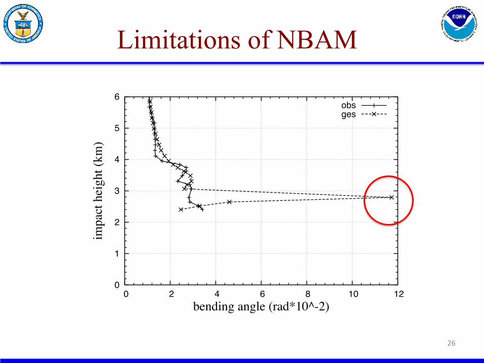
§ Improve the assimilation of the RO observations in the lower troposphere, in particular under super-refraction (SR) conditions (top of the PBL)
§ Is there any useful information in the observations below a SR layer? § Given the indetermination and the larger uncertainty associated with these
observations, can the analysis benefit from their assimilation? § NBAM (NCEP’s bending angle method) is used to assimilate bending angle
observations in the operational configuration § An upgraded version of NBAM (NABAM, “A” for “Advanced”) is being
developed to better address rays that cross a model super-refraction layer, particularly when the tangent point is close to the model super-refraction layer
§ In the meantime, and primarily under this project as well, an additional QC to directly detect and reject observations that might have been affected by SR conditions (either in the model or in the retrieval) were implemented and became operational at NCEP in January 2015
§ Cucurull L., 2015: Implementation of a quality control for GNSS Radio Occultation observations in the presence of large gradients of atmospheric refractivity, Atmos. Meas. Tech., 8, 1275-1285, doi:10.5194/amt-8-1275-2015 24
Introduction to NABAM
25
6.3545e+06
6.3546e+06
6.3547e+06
6.3548e+06
6.3549e+06
6.355e+06
6.3551e+06
6.3552e+06
100 150 200 250 300 350 400 450 500
refra
ctio
nal r
adiu
s (m
)
refractivity (N-units)
1 SR layermodel grid
new grid
6352
6352.2
6352.4
6352.6
6352.8
6353
6353.2
6353.4
6353.6
6353.8
100 150 200 250 300 350 400 450 500
radi
us (k
m)
refractivity (N-units)
1 SR layer
model gridnew grid
NBAM NABAM
Model profile at the loca6on of an observa6on below a model SR layer in model grid and NBAM integra6on grid
discon6nui6es
Limitations of NBAM
26
0
1
2
3
4
5
6
0 2 4 6 8 10 12
impa
ct h
eigh
t (km
)
bending angle (rad*10^-2)
obsges
NABAM vs NBAM
27
0
1
2
3
4
5
6
0 2 4 6 8 10 12
impa
ct he
ight
(km
)
bending angle (rad*10^-2)
obsges (NABAM)
ges (NBAM)
§ GOSA Group has been established (in coordination with NOAA’S QOSAP Program) to coordinate OSSE efforts to help NOAA management prioritize mission designs in a cost-effective way
§ Both OSEs and OSSEs are necessary to quantitatively evaluate the benefits of observations in weather forecasting
§ NOAA is fully committed to Radio Occultation observations – see P. Wilczynski’s talk on COSMIC-2
§ GOSA is engaged in ongoing R&D to quantify impacts of additional GNSS RO measurements on operational forecast models (e.g., what is the saturation point?)
§ GOSA has a formal agreement with NWS and NESDIS to support GNSS RO research and associated R2O
§ GOSA is transitioning its ground based GPS application to the private sector