Golden Trout Wilderness 2008 Summary Report Golden Trout Creek, Siberian Creek, Stokes Stringer, and Mulkey Creek September 17-25, 2008 Heritage and Wild Trout Program The Natural Resources Agency California Department of Fish and Game Prepared by Jeff Weaver and Stephanie Mehalick
Transcript
Golden Trout Wilderness 2008 Summary Report Golden Trout Creek, Siberian Creek, Stokes Stringer, and Mulkey Creek
September 17-25, 2008
Heritage and Wild Trout Program The Natural Resources Agency
California Department of Fish and Game
Prepared by Jeff Weaver and Stephanie Mehalick
Introduction: The Golden Trout Wilderness (southern Sierra Nevada Mountains, Tulare County) was designated by Congress in 1978 largely to enhance habitat protection for California golden trout (Oncorhynchus mykiss aguabonita), the California State Freshwater Fish. Although endemic only to the South Fork Kern River and Golden Trout Creek watersheds, California golden trout have been transplanted outside of their native range to many waters both within and outside of California. California golden trout are highly prized for their brilliant coloration and are considered by many to be the most beautiful of all trout species. Both the South Fork Kern River and Golden Trout Creek watersheds are designated by the California Fish and Game Commission as Wild Trout Waters and are managed by the California Department of Fish and Game’s (DFG) Heritage and Wild Trout Program (HWTP). The Golden Trout Creek drainage is further designated as a Heritage Trout Water from the confluence with the Kern River upstream to its headwaters (including all tributaries); this designation includes approximately 70-miles of stream habitat (Figure 2). The South Fork Kern River designation includes the entire watershed from its headwaters downstream to the southern boundary of the South Sierra Wilderness and encompasses approximately 35-miles of the South Fork Kern River plus an additional 86-miles of tributaries (Figure 2). Fishing in Golden Trout Wilderness is open from the last Saturday in April through November 15 (excluding the main-stem Kern River and the Tule River drainage). Gear use is limited to artificial lures with barbless hooks and there is a five fish bag limit. In 2000, California golden trout were proposed for listing as Endangered under the Federal Endangered Species Act; the persistence and genetic integrity of California golden trout within their native range is tenuous due to a variety of factors. All golden trout readily hybridize with rainbow trout (O. mykiss spp.) and the introduction of rainbow trout into the California golden trout’s native range has contributed to a documented loss of genetic integrity. In addition, the introduction of other non-native fishes (especially brown trout (Salmo trutta) in the South Fork Kern River) has threatened California golden trout via predation and competition. Over the past 100 years, extensive cattle grazing of the upper Kern River plateau has lead to widespread habitat degradation. These risk factors have contributed to population declines and pose an ongoing threat to the persistence of California golden trout within their native range. Currently, the U.S. Fish and Wildlife Service is reviewing the listing proposal for California golden trout and, to date, no formal decisions on its status have been made. A fisheries and habitat assessment in the headwaters of Golden Trout and Mulkey Creeks (Figures 1-4) was conducted by the HWTP in September, 2008. HWTP staff and volunteers conducted Phase 4 (long-term monitoring) multiple-pass electrofishing and habitat assessments on Golden Trout Creek, Siberian Creek, Stokes Stringer, and Mulkey Creek (Figures 3 and 4).
Methods: Multiple pass electrofishing and habitat assessment surveys were conducted from September 17 through 25, 2008 on Golden Trout Creek (Section 1), Stokes Stringer Creek (Section 1), Siberian Creek (Section 1), and Mulkey Creek (Sections 50, 51, and 52) (Figures 3 and 4). Personnel consisted of HWTP staff (from Headquarters and Central Region), DFG Central Region Scientific Aides and volunteers. With the exception of Section 1 on Golden Trout Creek, all sections were newly selected in 2008. Golden Trout Creek Section 1 was first surveyed in 2002. To replicate this effort, we used information from the 2002 survey to locate the section boundaries. New sections were selected, in part, based upon habitat parameters (such as habitat types) that were representative of each stream. Each stream was scouted prior to section selection and major habitat types were noted. A section was then selected that both included the representative habitat type(s) and was feasible and safe to electroshock. Each section was approximately 300-feet in length (measured along the thalweg) and section boundaries were chosen at areas where mesh block nets could effectively be installed and maintained throughout the survey. Three electrofishing sections were chosen on Mulkey Creek, within Mulkey Meadows. One section (Section 50) was located in the northern end of the meadow and two sections were located in the southern end. Grazing is allowed in Mulkey Meadows, with the exception of a small fenced area (cattle exclosure) in the southern end of the meadow where cattle are prevented from grazing the riparian habitat. To compare the effects of grazing on fish habitat and density, we selected one section (Section 51) inside of the cattle exclosure and two sections (Sections 50 and 52) within the active grazing allotment (outside of the exclosure). Multiple pass electrofishing was used to generate population data including species composition, size and age class structure, and estimates of biomass and density. These data can be compared over time to study trends in the population. At each section boundary, nylon mesh block nets were installed across the wetted width, effectively closing the population within the section. Both sides of the nets were secured above bankful width, heavy rocks were placed side by side along the bottom of the nets, and the nets were secured in such a way as to hold the top of the net out of the water. These nets were routinely monitored and inspected throughout the survey to ensure their integrity and to prevent fish from moving outside of the section during the course of the survey. Prior to electrofishing, physical measurements of the stream and environmental conditions were taken, including air and water temperature (in the shade) and conductivity (both specific and ambient). These factors were used to determine appropriate electroshocker settings. GPS coordinates were recorded for both the upstream and downstream boundaries of the survey. Current weather conditions were noted and the area was scouted for any species of concern prior to commencing the survey. Personnel needs were determined based on stream width, habitat complexity, and water visibility. For each of the surveys, individuals were assigned to shock, net, and tend live
cars for the duration of the effort. Surveys were initiated at the lower block net and proceeded in an upstream direction, with netters capturing fish and placing them in five gallon buckets. When the density of fish in the bucket became such that individual fish were unable to move without touching each other (approximately 15 to 20 fish per bucket), fish were transported into live cars stationed outside of the section where they were held until processing. The HWTP generally uses 50-gallon perforated plastic trash cans as live cars. Live cars used in these surveys were collapsible mesh laundry bags that were lightweight and easy to transport into the backcountry via pack stock. Three passes were conducted within each section, with fish from each pass stored separately. Over the course of the survey, fish were handled carefully to minimize injury and stress. Fish were processed separately by pass number. Each fish was identified to species and was measured from head to tail (total length in millimeters). Using a digital scale, weights were recorded (in grams). Fish were then recovered in live cars secured in the stream (with fresh flowing water) and released back into the section. A habitat assessment was conducted to document resource condition by collecting baseline data on habitat types, water conditions, substrate, discharge, bank condition, etc. The HWTP habitat assessment is a pared down synthesis of Rosgen (1994) and the California Salmonid Stream Habitat Restoration Manual (CSSHRM) (Flosi et al 1988). Section length was measured along the thalweg. The length of the section was then divided into five cells of equal length. Wetted widths were measured at the center of each of the five cells. Across each width transect, five depths were taken (also at the center of five evenly divided cells), and both widths and depths were averaged for each section. Stream characteristics, including active erosion (erosion occurring in the present), erosion at bankful, and canopy closure were measured as percentages of either the total stream area (canopy cover) or bank area (erosion). Section percentages were defined for each habitat type (riffle, flatwater, and pool) following Level II protocols as defined by the CSSHRM. Using visual observation, substrate size classes and the percentage of each class relative to the total bottom material within the wetted width were quantified. A rating (between poor and excellent) was given to the instream cover available to fish and cover types were identified and defined as percentages of total instream cover. The change in water surface elevation (section gradient) and streamflow were measured. Representative photographs of the section were taken. Fish measurements were entered into the DFG’s FISH database and were extracted into MicroFish. Based on capture rate (number of fish captured per pass) and the probability of capture, a population estimate for California golden trout was determined in each section. MicroFish also calculated the average fish weight by section. The population estimate was used to determine density (trout per mile) and incorporated in the calculation of biomass (pounds per acre). Fish biomass estimates also incorporate habitat parameters such as section length, average wetted width, and average weight of fish. Density estimates are determined based on the population estimate and section length. For Mulkey Creek, biomass and density estimates were averaged from the three sections surveyed to assess the overall fish population in Mulkey Meadows.
Figure 1. Location of Golden Trout Wilderness (red diamond)
Figure 2. Map of Wild Trout-designated area of Golden Trout Creek and tributaries (red lines) and South Fork Kern River and tributaries (blue lines). The Kern River is represented by green line. Electrofishing section locations are identified by green and orange dots (see key).
Figure 3. Map of 2008 electrofishing sections on Golden Trout Creek, Siberian Creek, and Stokes Stringer
igure 4. Map of 2008 electrofishing sections on Mulkey Creek
F
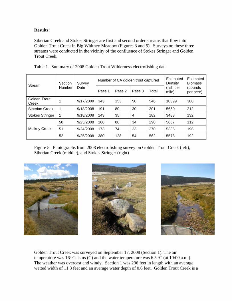
Results:
iberian Creek and Stokes Stringer are first and second order streams that flow into olden Trout Creek in Big Whitney Meadow (Figures 3 and 5). Surveys on these three
stream
SG
s were conducted in the vicinity of the confluence of Stokes Stringer and Golden Trout Creek.
Table 1. Summary of 2008 Golden Trout Wilderness electrofishing data
Golden Trout Creek was surveyed on September 17, 2008 (Section 1). The air temperature was 16º Celsius (C) and the water temperature was 6.5 ºC (at 10:00 a.m.). The weather was overcast and windy. Section 1 was 296 feet in length with an average wetted width of 11.3 feet and an average water depth of 0.6 feet. Golden Trout Creek is a
Figure 5. Photographs from 2008 electrofishing survey on Golden Trout Creek (left), Siberian Creek (middle), and Stokes Stringer (right)
low gradient (<1%) stream with habitat in Section 1 dominated by flatwater (90%) with ne pool (10%); fish cover was rated as fair. Undercut banks accounted for 80% of the
d
n ers and three netters) and the capture total was 546 California golden trout
able 1). Based on the capture rate and section length, we estimated 10399 fish per mile
Siberian Creek Section 1 was surveyed neetters. te re, an r
erature w flatwater (64% 26and pool (10%) habitat with excellent fish c v u t b bould
e cu ains. Er s h in this section with approximately 90% of the am bank u ercut. ad in this section was mea at 3 d th
te width w a e average water depth was 0.6 feet. Flow S tion 1 y i ge o proxim tely th s an r clar
was greater than four feet. In a total of three passes, we captured 301 California golden trout with an estimated density of 5650 fish per mile a appro tely ounds
1
tokes Stringer Section 1 was also surveyed on September 18, 2008 by one shocker and at
cfs and stream gradient was ss than one percent. Water temperature, measured at 10:30 a.m. was 7º C. Substrate
inantly of gravel with so sand. Fish cover consisted of undercut banks and vegetation and, based on lack of co lexity, was rated as fair. Nearly 100% of the streambank was undercut. In three passes, we captured a total of 182 California golden trout (Table 1). Fish of 132 pounds per acre. Three sections were surveyed in Mulkey Creek in Mulkey Meadow fromthrough 25, 2008 (Figures 4 and 6). Air temperature ranged fromtemperatures were between 5º and 6º C, depending on the timfrom the three sections, the average wetted width of Mulkey Creek in Mulkey Meadow was 6.8 feet, the average water depth was 0.7 feet, water visibility wafeet, and stream gradient was less than one percent. Three section with two shockers and two netters.
ofish cover (85 % of the streambank was undercut). Substrate was predominantly sanwith some gravel. Discharge was measured at approximately seven cubic feet per second(cfs) and water clarity was greater than four feet. Three passes were conducted in Sectio1 (three shock(Twith a biomass of 308 pounds per acre in Section 1.
on September 18, 2008 with o measured at 10:00 a.m., was 16º C
shocker and the wate), riffle (
anks,
d %) ers,
three ntemp
The air as 8º C.
mperatuThis 300-foot section consisted of
over pro ided by ndercuand bubblstre
rtnd
osion waStream gr
igh ient sured .3% an e
average wet d as 10 feet nd thmeasured in ec ielded a d schar f ap a ree cf d wate ity
nd xima 212 p per acre (Table ).
Sthree netters. This 277-foot section consisted of flatwater (85%) and riffle (15%) habitwith an average wetted width of 5.2 feet, average water depth of 0.4 feet, and water larity exceeding four feet. Discharge was calculated at 0.5 c
leconsisted predom me
mp
density was calculated at 3488 fish per mile with a biomass
September 23 15º to 17º C and water
e of day. Based on data
s greater than four passes were conducted in each
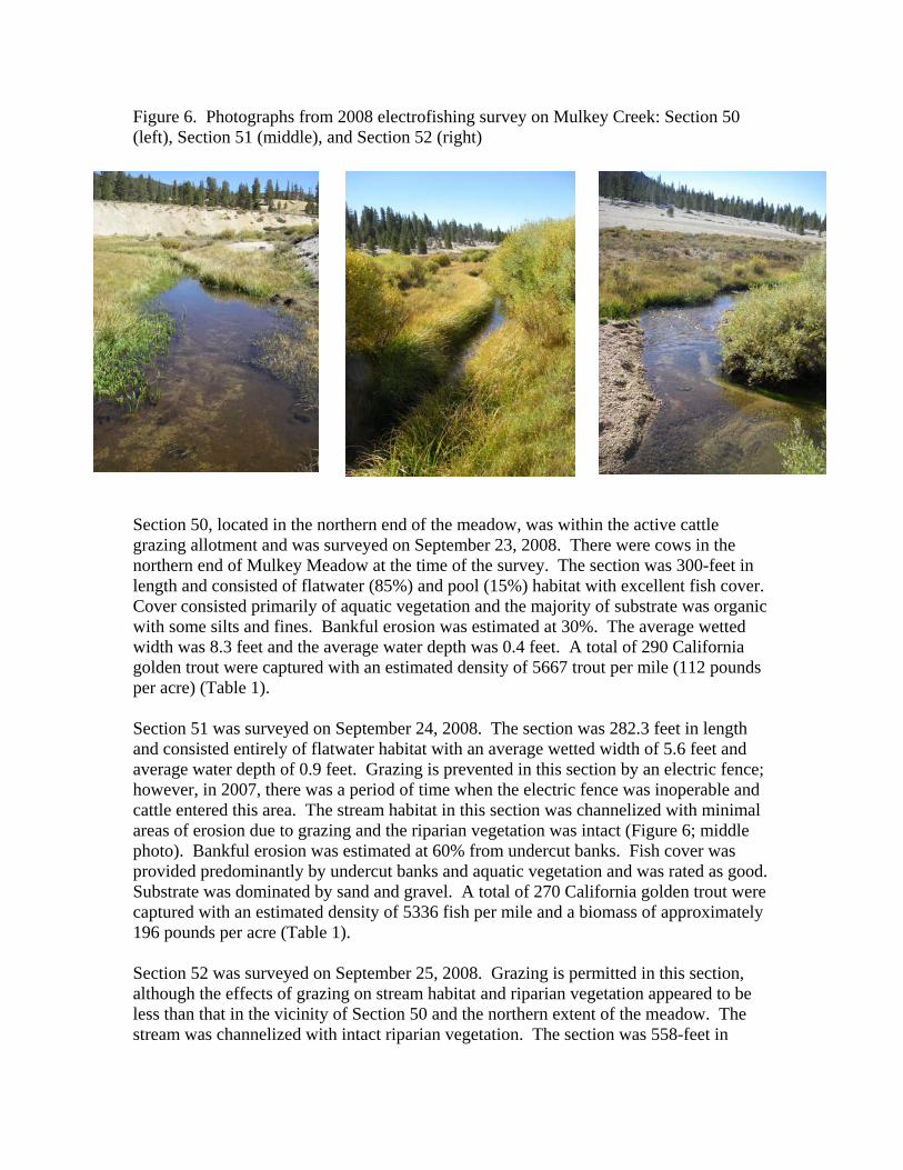
Figure 6. Photographs from 2008 electrofishing survey on Mulkey Creek: Section 50 (left), Section 51 (middle), and Section 52 (right)
Section 50, located in the northern end of the meadow, was within the active cattle
ver.
a
on September 24, 2008. The section was 282.3 feet in length nd consisted entirely of flatwater habitat with an average wetted width of 5.6 feet and
al
. A total of 270 California golden trout were aptured with an estimated density of 5336 fish per mile and a biomass of approximately
196 pounds per acre (Table 1). Section 52 was surveyed on September 25, 2008. Grazing is permitted in this section, although the effects of grazing on stream habitat and riparian vegetation appeared to be less than that in the vicinity of Section 50 and the northern extent of the meadow. The stream was channelized with intact riparian vegetation. The section was 558-feet in
grazing allotment and was surveyed on September 23, 2008. There were cows in the northern end of Mulkey Meadow at the time of the survey. The section was 300-feet in length and consisted of flatwater (85%) and pool (15%) habitat with excellent fish coCover consisted primarily of aquatic vegetation and the majority of substrate was organicwith some silts and fines. Bankful erosion was estimated at 30%. The average wetted width was 8.3 feet and the average water depth was 0.4 feet. A total of 290 Californigolden trout were captured with an estimated density of 5667 trout per mile (112 poundsper acre) (Table 1). Section 51 was surveyedaaverage water depth of 0.9 feet. Grazing is prevented in this section by an electric fence;however, in 2007, there was a period of time when the electric fence was inoperable and cattle entered this area. The stream habitat in this section was channelized with minimareas of erosion due to grazing and the riparian vegetation was intact (Figure 6; middle photo). Bankful erosion was estimated at 60% from undercut banks. Fish cover was provided predominantly by undercut banks and aquatic vegetation and was rated as good. Substrate was dominated by sand and gravelc
length with an average wetted width of 6.4 feet and an average water depth of 0.8 feet.Habitat consisted of flatwater (88%), pool (10%) a
nd riffle (2%) with good instream
over in the form of undercut banks and vegetation. Substrate consisted predominantly ately 65%. A total of 562
California golden trout were captured with an ated density of 5573 fish per mile and a biomass of 192 pounds per acre (Table 1). An average of Sections 50, 51, and 52 de ates yields approximately 5525 California golden trout ile and 166 pounds per acre in Mulkey Creek within Mulkey Meadow. Discussion: Golden Trout Creek is approximdownstream to the Kern River. The Heritage in this drainage include over a dozen small tributar d, which add approximately 47 additional m GIS analysis at a scale of 1:3000). Our surveys in 2008 indicate the population of Ca within Big Whitney Meadow is wild and occurs in high densities, with total lengths ranging between 34 mm
.4 inches). The meadow complex surrounding the riparian
re
ts, the HWTP recommends increasing sampling distribution to clude portions of the main-stem of Golden Trout Creek and tributaries farther
idth which provided limited cover; however, there were w undercut banks and little riparian vegetation (other than grass), especially compared
cof sand and gravel. Bankful erosion was estimated at approxim
estim
nsity and biomass estimper m
ately 20-miles in length, from the headwaters Trout-designated waters
ies, both named and unnameiles (based on
lifornia golden trout
(1.3 inches) and 214 mm (8zone is intact, although grazing is allowed. Stokes Stringer and Siberian Creek alsosupport relatively high densities of California golden trout, especially given that they asmall, second-order headwater tributaries. Golden Trout Creek Section 1 was surveyed in 2002 and estimated the California golden trout population at 16692 fish per mile with a biomass of 506 pounds per acre. These data show a reduction from 2002 to 2008; however, with over 10000 fish per mile estimated in 2008, densities remain high in thispart of the system. For future assessmenindownstream. Limited population data exist at HWTP headquarters for long-term trend monitoring on Golden Trout Creek. The HWTP recommends using random sampling techniques to select new sections throughout the watershed to be established as benchmark locations for long-term population and habitat trend monitoring. Mulkey Meadow appeared to be heavily grazed with degraded stream banks and riparianhabitat, especially in the northern extent of the meadow (in the vicinity of Section 50).Stream widths were wider and water depths were shallower in Section 50 than in Sections 51 and 52. Also noted was a difference in substrate; Section 50 consisted mainly of organics and fines, while Sections 51 and 52 contained sand and gravel. Section 50 had grasses growing in the wetted wfeto the lower two sections where willows lined the stream bank. California golden troututilize pools and undercut banks which are typically reduced or lacking in grazed areas (Matthews 1996). This was supported by our habitat assessment in Section 50. A comparison of fish population data show all three sections to be very similar, with
Section 50 having both the highest density and lowest biomass. Observations in the fieldindicated that fish captured in Section 50 appeared to be thinner (lower condition factthan fish captured in Sections 51 and 52. To better understand differences between grazeand non-grazed sections, the HWTP recommends comparing condition factors and size class structure between sections located both within and outside of the cattle exclosure. In spite of these stressors, the California gold
or)
d
en trout population in Mulkey Meadow xhibits relatively high densities and appears to be self-sustaining.
losi, Gary; S. Downie; J. Hopelain, et al. 1998. California Salmonid Stream Habitat anual. State of California Resources Agency. 3rd Edition. Department of
ish and Game. Vol. 1.
t sheries
e References: FRestoration MF Matthews, Kathleen. 1996. Diel Movement and Habitat Use of California Golden Trouin the Golden Trout Wilderness, California. Transactions of the American FiSociety 125:78-86. Rosgen, D.L., 1994. A Classification of Natural Rivers. Catena Vol. 22 169-199.