A1 1 2 3 4 5 6 7 8 9 10 11 12 13 14 Mississippi Riv Big Lk Lk Winneshiek Haney town 32500 Eastman town 21925 Utica town 82100 Seneca town 72500 Clayton town 15075 Wauzeka town 84750 Prairie du Chien town 65075 Marietta town 49275 Bridgeport town 09550 Freeman town 27700 Scott town 72275 MCD* 74550 MCD* 65050 MCD* 19850 MCD* 28450 MCD* 46675 MCD* 54900 MCD* 77175 MCD* 84725 MCD* 06225 MCD* 21900 MCD* 25725 MCD* MCD* MCD* MCD* MCD* MCD* MCD* MCD* MCD* Mount Hope town Sylvan town Richwood town Franklin town Little Grant town Akan town Liberty town Fennimore town Bloomington town Boscobel town Wyalusing town Woodman town Hickory Grove town North Lancaster town Watterstown town Millville town Marion town Wheatland town Sterling town Kickapoo town Mount Ida town Patch Grove town Lafayette township Iowa township Fairview township Center township Farmersburg township Clayton township Mendon township Giard township Garnavillo township Taylor township Paint Creek township Read township Linton township Lansing township CRAWFORD 023 RICHLAND 103 VERNON 123 AL L A M AKE E 0 0 5 G R A N T 043 C L A Y T O N 043 CLA Y TON 0 43 C RA W FOR D 0 2 3 G R A N T 0 4 3 RI C H L A N D 1 03 CLAYTON 043 ALLAMAKEE 005 RICHLAND 103 VERNON 123 C R A W F O R D 0 2 3 A L L A M AK E E 0 0 5 CRAWFORD 023 VERNON 123 CRA W F O R D 0 2 3 G R A N T 0 4 3 I O W A 1 9 W I S C O N S I N 5 5 I O W A 1 9 WI S C ONS I N 5 5 T1450 T1450 T1450 T1450 T1450 Wauzeka 84725 Prairie du Chien 65050 De Soto 19850 Steuben 77175 Lynxville 46675 Gays Mills 28450 Ferryville 25725 Bell Center 06225 Soldiers Grove 74550 Eastman 21900 Mount Sterling 54900 Boscobel McGregor Clayton Blue River Readstown Bagley Marquette De Soto Waterville Lansing Harpers Ferry Woodman Mount Hope Patch Grove Fennimore 133 27 27 82 9 171 60 364 82 18 60 60 171 27 179 27 171 131 133 60 131 171 133 61 61 61 18 61 18 52 18 14 14 518025502300000000000000 LEGEND SYMBOL DESCRIPTION SYMBOL LABEL STYLE Lee town 41460 Minor Civil Division (MCD) 1 Jemez CCD 91650 Census County Division (CCD) 2 MILFORD 47500 Consolidated City Davis 18100 Incorporated Place 3 Cochiti 16560 Census Designated Place (CDP) 2 L'ANSE RESERVATION (TA 1880) Federal American Indian Reservation T1880 Off-Reservation Trust Land SHONTO (620) American Indian Tribal Subdivision NANA ANRC 52120 Alaska Native Regional Corporation (ANRC) NEW YORK 36 State (or statistically equivalent entity) ERIE 029 County (or statistically equivalent entity) DESCRIPTION SYMBOL DESCRIPTION SYMBOL 3 Interstate Marsh Ln Other Road Cul-de-sac Circle Geographic Offset or Corridor 4WD Trail, Stairway, Alley, Walkway, or Ferry Southern RR Railroad Pipeline or Power Line Ridge or Fence Property Line or Nonvisible Boundary Tumbling Cr Perennial Stream Piney Cr Intermittent Stream Mt. Baker Mountain Peak or Hill Outside Subject Area Pleasant Lake Water Body Okefenokee Swamp Swamp or Marsh Bering Glacier Glacier Oxnard Airport Airport, Airfield, or Helicopter Landing Pad Coll/Univ College or University Fort Belvoir Military P/JDC Prison or Juvenile Detention Center Powell Cmtry Cemetery Pinehurst GlfCrs Golf Course Yosemite NP National Park or Forest St Francis Park Other Park A1 Inset Area 4 State Highway 2 U.S. Highway Where state, county, and/or MCD/CCD boundaries coincide, the map shows the boundary symbol for only the highest-ranking of these boundaries. Where American Indian reservation and American Indian tribal subdivision boundaries coincide, the map shows only the American Indian reservation boundaries. Entity names are followed by either their FIPS code or census code; parentheses indicate a census code. 1 'MCD*' indicates a false MCD. These are for Census Bureau use only. 2 The CCD and CDP boundaries represent statistical entities only and are not updated through the BAS. 3 Incorporated place name color corresponds to the incorporated place fill color. Due to space limitations, some road names, along with other feature and geography names on the map, may not be shown. The Census Bureau stores primary and alternate road names, but only primary road names are used to label the roads on these maps. OFF-RESERVATION TRUST LAND NAMES T1450 Ho-Chunk Nation For Census Use Only NPC PROCESSING SHEET CHANGES State Code: County Code: Changes: (circle) N B C F A J PL AL Late BAS: Y N Other Entity Affected Type of Change (circle) B F A L J B F A L J B F A L J B F A L J Telephone Date Signature Position Print Name The corrected boundaries shown on the map are accurate as of January 1, 2020. BAS SIGNATURE BOX 2019 COUNTY REF MAP (INDEX) Total Sheets: 16 (Index 1; Parent 14; Inset 1) 43.439338N 91.311466W 43.448445N 90.572898W 42.910243N 90.563838W 42.901214N 91.29575W All legal boundaries and names are as reported through the 2019 Boundary and Annexation Survey (BAS). The boundaries shown on this map are for Census Bureau statistical data collection and tabulation purposes only; their depiction and designation for statistical purposes does not constitute a determination of jurisdictional authority or rights of ownership or entitlement. U.S. DEPARTMENT OF COMMERCE U.S. Census Bureau This map supports the following programs: 2020 Boundary and Annexation Survey (BAS) 2020 Initial Boundary Validation Program Created by Geography Division: December 11, 2019 Boundary and Annexation Survey (BAS) ID: 25502300000 BAS Submission Deadline: March 1, 2020 ENTITY TYPE: County or statistically equivalent entity For more information, or to request additional maps, please email [email protected], call 1-800-972-5651, or visit www.census.gov/programs-surveys/bas.html. NAME: Crawford County (023) PDF versions of the maps are available at: www.census.gov/programs-surveys/bas/geographies.html Projection: Albers Equal Area Conic Datum: NAD 83 Spheroid: GRS 80 1st Standard Parallel: 43 18 27 2nd Standard Parallel: 46 30 33 Central Meridian: -89 34 05 Latitude of Projection's Origin: 42 30 25 False Easting: 0 False Northing: 0 Data Source: U.S. Census Bureau's MAF/TIGER database (BAS20), November 2019 ST: Wisconsin (55) 0 2 4 6 8 10 Kilometers 0 1 2 3 4 5 Miles The plotted map scale is 1:81,880 INSET SHEET #: 000000 INDEX OR PARENT SHEET #: 000 GOVERNMENTAL UNIT REFERENCE MAP (2019): Crawford County, WI
Transcript
A1
1 2 3 4
5 6 7 8
9 10 11 12
13 14
MississippiRiv
Big Lk
Lk Winneshiek
Haney town 32500
Eastman town 21925
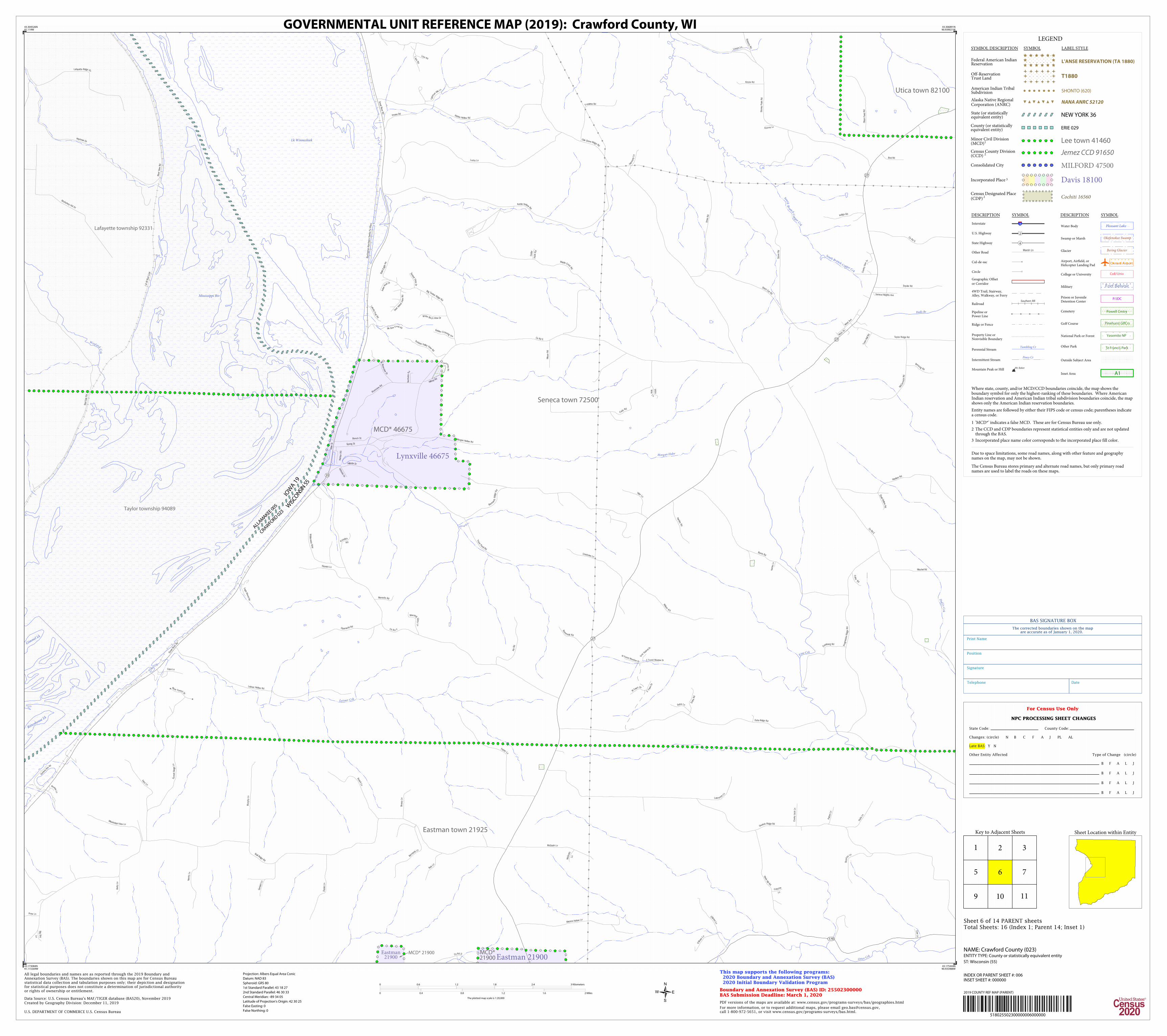
Utica town 82100
Seneca town 72500
Clayton town 15075
Wauzekatown 84750
Prairie du Chientown 65075
Marietta town 49275
Bridgeport town 09550
Freeman town 27700
Scott town72275
MCD* 74550
MCD* 65050
MCD*19850
MCD* 28450
MCD*46675
MCD* 54900
MCD*77175
MCD* 84725
MCD*06225
MCD* 21900
MCD*25725
MCD*
MCD*
MCD*
MCD*
MCD*
MCD*
MCD*
MCD*
MCD*
Mount Hope town
Sylvan town
Richwood town
Franklin town
Little Grant town
Akan town
Liberty town
Fennimore town
Bloomington town
Boscobeltown
Wyalusing town
Woodman town
Hickory Grove town
North Lancaster town
Watterstown town
Millville town
Marion town
Wheatland town Sterling town Kickapootown
Mount Ida town
Patch Grove town
Lafayette township
Iowa township
Fairview township
Centertownship
Farmersburgtownship
Clayton township
Mendon township
Giardtownship
Garnavillo township
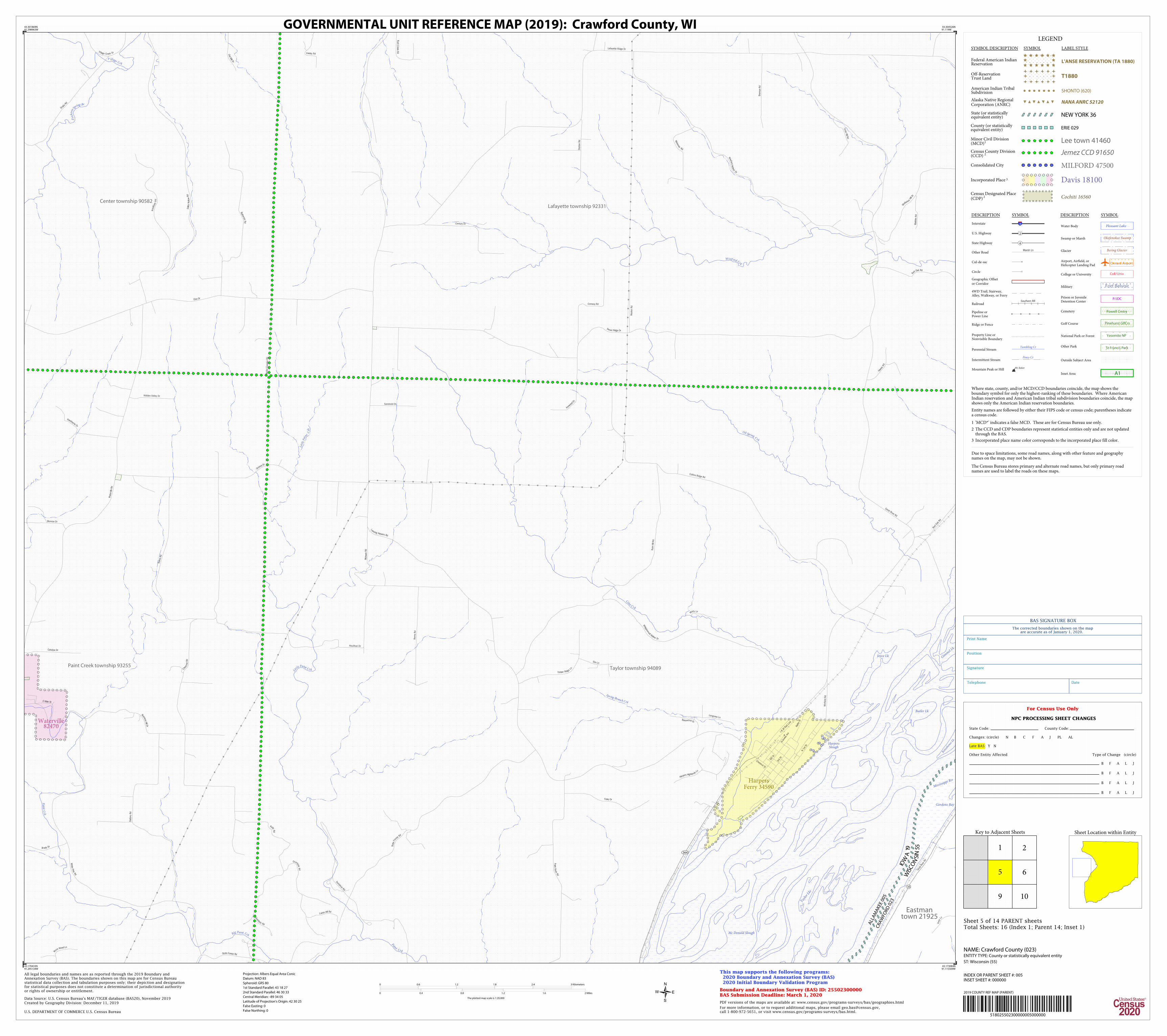
Taylor township
Paint Creek township
Readtownship
Linton township
Lansing township
CR
AW
FO
RD
02
3
RIC
HLA
ND
10
3
VERNO
N 123
ALLA
MAKEE 005
GR
AN
T 04
3
CLA
YT
ON
043
CLA
YT
ON
043C
RA
WFO
RD
023
GRANT 04 3RICHLAND 103
CLAYTON 043
ALLAMAKEE 005
RIC
HLA
ND
10
3
VE
RN
ON
12
3
CR
AW
FOR
D 0
23
ALLA
MA
KEE 005
CRAWFORD 023
VERNON 123
CRA
WFO
RD 0
23
GRA
NT
04
3
IOW
A 19
WIS
CO
NSIN
55
IOWA 19
WISCONSIN 55
T1450
T1450
T1450
T1450
T1450
Wauzeka84725
Prairie duChien 65050
De Soto 19850
Steuben 77175
Lynxville46675
Gays Mills 28450
Ferryville25725
Bell Center 06225
SoldiersGrove 74550
Eastman 21900
Mount Sterling 54900
Boscobel
McGregor
Clayton
BlueRiver
Readstown
Bagley
Marquette
DeSoto
Waterville
Lansing
Harpers Ferry
Woodman
Mount Hope
Patch Grove
Fennimore
133
27
27
82
9
171
60
364
82
18
60
60
171
27
179
27
171
131
133
60
131
171
133
61
61
61
18
61
18
52
18
14
14
518025502300000000000000
LEGEND
SYMBOL DESCRIPTION SYMBOL LABEL STYLE
Lee town 41460Minor Civil Division(MCD)1
Jemez CCD 91650Census County Division(CCD) 2
MILFORD 47500Consolidated City
Davis 18100Incorporated Place 3
Cochiti 16560Census Designated Place(CDP) 2
L'ANSE RESERVATION (TA 1880)Federal American IndianReservation
Oxnard AirportAirport, Airfield, orHelicopter Landing Pad
Coll/UnivCollege or University
Fort BelvoirMilitary
P/JDCPrison or JuvenileDetention Center
Powell CmtryCemetery
Pinehurst GlfCrsGolf Course
Yosemite NPNational Park or Forest
St Francis ParkOther Park
A1Inset Area
4State Highway
2U.S. Highway
Where state, county, and/or MCD/CCD boundaries coincide, the map shows theboundary symbol for only the highest-ranking of these boundaries. Where AmericanIndian reservation and American Indian tribal subdivision boundaries coincide, the mapshows only the American Indian reservation boundaries.
Entity names are followed by either their FIPS code or census code; parentheses indicatea census code.
1 'MCD*' indicates a false MCD. These are for Census Bureau use only.
2 The CCD and CDP boundaries represent statistical entities only and are not updatedthrough the BAS.
3 Incorporated place name color corresponds to the incorporated place fill color.
Due to space limitations, some road names, along with other feature and geographynames on the map, may not be shown.
The Census Bureau stores primary and alternate road names, but only primary roadnames are used to label the roads on these maps.
OFF-RESERVATION TRUST LAND NAMES T1450 Ho-Chunk Nation
For Census Use Only
NPC PROCESSING SHEET CHANGES
State Code: County Code:
Changes: (circle) N B C F A J PL AL
Late BAS: Y N
Other Entity Affected Type of Change (circle)
B F A L J
B F A L J
B F A L J
B F A L J
Telephone Date
Signature
Position
Print Name
The corrected boundaries shown on the mapare accurate as of January 1, 2020.
BAS SIGNATURE BOX
2019 COUNTY REF MAP (INDEX)
Total Sheets: 16 (Index 1; Parent 14; Inset 1)
43.439338N91.311466W
43.448445N90.572898W
42.910243N90.563838W
42.901214N91.29575W
All legal boundaries and names are as reported through the 2019 Boundary andAnnexation Survey (BAS). The boundaries shown on this map are for Census Bureaustatistical data collection and tabulation purposes only; their depiction and designationfor statistical purposes does not constitute a determination of jurisdictional authorityor rights of ownership or entitlement.
U.S. DEPARTMENT OF COMMERCE U.S. Census Bureau
This map supports the following programs: 2020 Boundary and Annexation Survey (BAS) 2020 Initial Boundary Validation Program
Created by Geography Division: December 11, 2019
Boundary and Annexation Survey (BAS) ID: 25502300000BAS Submission Deadline: March 1, 2020
ENTITY TYPE: County or statistically equivalent entity
For more information, or to request additional maps, please email [email protected],call 1-800-972-5651, or visit www.census.gov/programs-surveys/bas.html.
NAME: Crawford County (023)
PDF versions of the maps are available at: www.census.gov/programs-surveys/bas/geographies.html
Projection: Albers Equal Area Conic
Datum: NAD 83
Spheroid: GRS 80
1st Standard Parallel: 43 18 27
2nd Standard Parallel: 46 30 33
Central Meridian: -89 34 05
Latitude of Projection's Origin: 42 30 25
False Easting: 0
False Northing: 0
Data Source: U.S. Census Bureau's MAF/TIGER database (BAS20), November 2019
ST: Wisconsin (55)
0 2 4 6 8 10 Kilometers
0 1 2 3 4 5 Miles
The plotted map scale is 1:81,880
INSET SHEET #: 000000 INDEX OR PARENT SHEET #: 000
GOVERNMENTAL UNIT REFERENCE MAP (2019): Crawford County, WI
Wi Dnr Public Hunting Grounds
Middle Slough
Mississippi Riv
Lk Winneshiek
de SotoBay
Columbus Lk
Lafayette Slough
Chain of Lks
WinneshiekSlough
Mc DonaldSlough
Big Lk
Big S l ough
Clear Crk
Vill age Crk
Cou
lee Crk
Rus
h
Cr
k
Coo
ley
Crk
Clear Crk
Big
Slo
ugh
I & M Rail Link
Burlington Northern Santa Fe Rlwy
Wheatland town 86525
Freeman town 27700
Seneca town72500
MCD* 19850
MCD* 19850
Lafayette township 92331
Iowa township 92049
Center township 90582
Lansing township 92382
Wheatland town 86525
CRAWFORD 023ALLAMAKEE 005
VERNON 123
ALLAMAKEE 005
VERNON 123
CRAWFORD 023
WISCONSIN 55IOWA 19
T1450
T1450
T1450
T1450
Lansing 43275
De Soto 19850
Valley St
Majes
tic V
iew
Ln
Gruber R
idg
e Rd
Dry Ridg
e Dr
S Road Dr
Am
erican
Heritage R
d
Schaffer Hollow Rd
Four Mile Dr
Sandalot Ln
Lans
ing
Har
pers
Rd
Great R
iver Rd
Whalen H
ill Rd
Grea
t River R
d
Village Cre
ek D
r
Village Creek Dr
Hanley R
d
Cedar
Hill
Rd
Taylor Rd
Dalb
y Hollo
w R
d
Old Mill
Dr
Holt Rd
Whisp
ering Pine
s Ln
Eagle Ridg e Ln
Center St
Main St
Valle
y Rd
Colum
bus R
d
Oak Hill R
d
Whitetail Dr
Wildcat Canyon Dr
Spring Valley Dr
Doehler Dr
Kestrel Dr
Kain
's Sw
itch Ln
Wild
Rose
Ln
W
all S
t
Mellem Rd
N 2nd St
Halv
ers
on R
d
Seitz Dr
Kellison Dr
Bench S
t
Gan
der
Hill R
d
N Front St
Mou
nt Ida R d
Hid
eaway H
ills Ln
Point Vista Ln
Sunny View Dr
S 4
th S
t
Blackbird Dr
Views End Ln
Syc
am
ore
Rd
Main S
t
Lawrence R
idge Rd
Air p
ort
Rd
Schill Rd
Paulson Rd
S M
ill Park D
r
Rus
h Cr
eek Rd
Great River Rd
Daven
port R
d
Coulee C
reek Rd
Creek St
Hanson R
d
Marigaard Rd
Chandler Rd
Labrador Rd
Lawrence Hill Rd
Sprin
g St
Cottonw
ood Ln
Ridge St
Grand View Dr
Desoto Ridge Dr
Desoto Bluffs Dr
N View Ln
PointCt
Toge
ther
ness
L
n
Mid
way C
t
Park
Ct
SaradanLn
Schmitz L n
Howath Rd
Mule Hollow Rd
S V
iew
Ln
9
9
82
9
26
35
82
518025502300000001000000
LEGEND
SYMBOL DESCRIPTION SYMBOL LABEL STYLE
Lee town 41460Minor Civil Division(MCD)1
Jemez CCD 91650Census County Division(CCD) 2
MILFORD 47500Consolidated City
Davis 18100Incorporated Place 3
Cochiti 16560Census Designated Place(CDP) 2
L'ANSE RESERVATION (TA 1880)Federal American IndianReservation
Oxnard AirportAirport, Airfield, orHelicopter Landing Pad
Coll/UnivCollege or University
Fort BelvoirMilitary
P/JDCPrison or JuvenileDetention Center
Powell CmtryCemetery
Pinehurst GlfCrsGolf Course
Yosemite NPNational Park or Forest
St Francis ParkOther Park
A1Inset Area
4State Highway
2U.S. Highway
Where state, county, and/or MCD/CCD boundaries coincide, the map shows theboundary symbol for only the highest-ranking of these boundaries. Where AmericanIndian reservation and American Indian tribal subdivision boundaries coincide, the mapshows only the American Indian reservation boundaries.
Entity names are followed by either their FIPS code or census code; parentheses indicatea census code.
1 'MCD*' indicates a false MCD. These are for Census Bureau use only.
2 The CCD and CDP boundaries represent statistical entities only and are not updatedthrough the BAS.
3 Incorporated place name color corresponds to the incorporated place fill color.
Due to space limitations, some road names, along with other feature and geographynames on the map, may not be shown.
The Census Bureau stores primary and alternate road names, but only primary roadnames are used to label the roads on these maps.
OFF-RESERVATION TRUST LAND NAMES T1450 Ho-Chunk Nation
Key to Adjacent Sheets
5
2
6
1
For Census Use Only
NPC PROCESSING SHEET CHANGES
State Code: County Code:
Changes: (circle) N B C F A J PL AL
Late BAS: Y N
Other Entity Affected Type of Change (circle)
B F A L J
B F A L J
B F A L J
B F A L J
Telephone Date
Signature
Position
Print Name
The corrected boundaries shown on the mapare accurate as of January 1, 2020.
BAS SIGNATURE BOX
43.433294N91.302809W
43.435956N91.122446W
43.304526N91.119W
43.301869N91.298963W
All legal boundaries and names are as reported through the 2019 Boundary andAnnexation Survey (BAS). The boundaries shown on this map are for Census Bureaustatistical data collection and tabulation purposes only; their depiction and designationfor statistical purposes does not constitute a determination of jurisdictional authorityor rights of ownership or entitlement.
U.S. DEPARTMENT OF COMMERCE U.S. Census Bureau
This map supports the following programs: 2020 Boundary and Annexation Survey (BAS) 2020 Initial Boundary Validation Program
Created by Geography Division: December 11, 2019
Boundary and Annexation Survey (BAS) ID: 25502300000BAS Submission Deadline: March 1, 2020
ENTITY TYPE: County or statistically equivalent entity
For more information, or to request additional maps, please email [email protected],call 1-800-972-5651, or visit www.census.gov/programs-surveys/bas.html.
NAME: Crawford County (023)
PDF versions of the maps are available at: www.census.gov/programs-surveys/bas/geographies.html
Projection: Albers Equal Area Conic
Datum: NAD 83
Spheroid: GRS 80
1st Standard Parallel: 43 18 27
2nd Standard Parallel: 46 30 33
Central Meridian: -89 34 05
Latitude of Projection's Origin: 42 30 25
False Easting: 0
False Northing: 0
Data Source: U.S. Census Bureau's MAF/TIGER database (BAS20), November 2019
ST: Wisconsin (55)
0 0.6 1.2 1.8 2.4 3 Kilometers
0 0.4 0.8 1.2 1.6 2 Miles
The plotted map scale is 1:20,000
INSET SHEET #: 000000 INDEX OR PARENT SHEET #: 001
GOVERNMENTAL UNIT REFERENCE MAP (2019): Crawford County, WI
Oxnard AirportAirport, Airfield, orHelicopter Landing Pad
Coll/UnivCollege or University
Fort BelvoirMilitary
P/JDCPrison or JuvenileDetention Center
Powell CmtryCemetery
Pinehurst GlfCrsGolf Course
Yosemite NPNational Park or Forest
St Francis ParkOther Park
A1Inset Area
4State Highway
2U.S. Highway
Where state, county, and/or MCD/CCD boundaries coincide, the map shows theboundary symbol for only the highest-ranking of these boundaries. Where AmericanIndian reservation and American Indian tribal subdivision boundaries coincide, the mapshows only the American Indian reservation boundaries.
Entity names are followed by either their FIPS code or census code; parentheses indicatea census code.
1 'MCD*' indicates a false MCD. These are for Census Bureau use only.
2 The CCD and CDP boundaries represent statistical entities only and are not updatedthrough the BAS.
3 Incorporated place name color corresponds to the incorporated place fill color.
Due to space limitations, some road names, along with other feature and geographynames on the map, may not be shown.
The Census Bureau stores primary and alternate road names, but only primary roadnames are used to label the roads on these maps.
OFF-RESERVATION TRUST LAND NAMES T1450 Ho-Chunk Nation
Key to Adjacent Sheets
1
5 6
3
7
2
For Census Use Only
NPC PROCESSING SHEET CHANGES
State Code: County Code:
Changes: (circle) N B C F A J PL AL
Late BAS: Y N
Other Entity Affected Type of Change (circle)
B F A L J
B F A L J
B F A L J
B F A L J
Telephone Date
Signature
Position
Print Name
The corrected boundaries shown on the mapare accurate as of January 1, 2020.
BAS SIGNATURE BOX
43.435956N91.122446W
43.438327N90.942067W
43.306891N90.939021W
43.304526N91.119W
All legal boundaries and names are as reported through the 2019 Boundary andAnnexation Survey (BAS). The boundaries shown on this map are for Census Bureaustatistical data collection and tabulation purposes only; their depiction and designationfor statistical purposes does not constitute a determination of jurisdictional authorityor rights of ownership or entitlement.
U.S. DEPARTMENT OF COMMERCE U.S. Census Bureau
This map supports the following programs: 2020 Boundary and Annexation Survey (BAS) 2020 Initial Boundary Validation Program
Created by Geography Division: December 11, 2019
Boundary and Annexation Survey (BAS) ID: 25502300000BAS Submission Deadline: March 1, 2020
ENTITY TYPE: County or statistically equivalent entity
For more information, or to request additional maps, please email [email protected],call 1-800-972-5651, or visit www.census.gov/programs-surveys/bas.html.
NAME: Crawford County (023)
PDF versions of the maps are available at: www.census.gov/programs-surveys/bas/geographies.html
Projection: Albers Equal Area Conic
Datum: NAD 83
Spheroid: GRS 80
1st Standard Parallel: 43 18 27
2nd Standard Parallel: 46 30 33
Central Meridian: -89 34 05
Latitude of Projection's Origin: 42 30 25
False Easting: 0
False Northing: 0
Data Source: U.S. Census Bureau's MAF/TIGER database (BAS20), November 2019
ST: Wisconsin (55)
0 0.6 1.2 1.8 2.4 3 Kilometers
0 0.4 0.8 1.2 1.6 2 Miles
The plotted map scale is 1:20,000
INSET SHEET #: 000000 INDEX OR PARENT SHEET #: 002
GOVERNMENTAL UNIT REFERENCE MAP (2019): Crawford County, WI
Oxnard AirportAirport, Airfield, orHelicopter Landing Pad
Coll/UnivCollege or University
Fort BelvoirMilitary
P/JDCPrison or JuvenileDetention Center
Powell CmtryCemetery
Pinehurst GlfCrsGolf Course
Yosemite NPNational Park or Forest
St Francis ParkOther Park
A1Inset Area
4State Highway
2U.S. Highway
Where state, county, and/or MCD/CCD boundaries coincide, the map shows theboundary symbol for only the highest-ranking of these boundaries. Where AmericanIndian reservation and American Indian tribal subdivision boundaries coincide, the mapshows only the American Indian reservation boundaries.
Entity names are followed by either their FIPS code or census code; parentheses indicatea census code.
1 'MCD*' indicates a false MCD. These are for Census Bureau use only.
2 The CCD and CDP boundaries represent statistical entities only and are not updatedthrough the BAS.
3 Incorporated place name color corresponds to the incorporated place fill color.
Due to space limitations, some road names, along with other feature and geographynames on the map, may not be shown.
The Census Bureau stores primary and alternate road names, but only primary roadnames are used to label the roads on these maps.
Key to Adjacent Sheets
2
6 7
4
8
3
For Census Use Only
NPC PROCESSING SHEET CHANGES
State Code: County Code:
Changes: (circle) N B C F A J PL AL
Late BAS: Y N
Other Entity Affected Type of Change (circle)
B F A L J
B F A L J
B F A L J
B F A L J
Telephone Date
Signature
Position
Print Name
The corrected boundaries shown on the mapare accurate as of January 1, 2020.
BAS SIGNATURE BOX
43.438327N90.942067W
43.440405N90.761676W
43.308965N90.759029W
43.306891N90.939021W
All legal boundaries and names are as reported through the 2019 Boundary andAnnexation Survey (BAS). The boundaries shown on this map are for Census Bureaustatistical data collection and tabulation purposes only; their depiction and designationfor statistical purposes does not constitute a determination of jurisdictional authorityor rights of ownership or entitlement.
U.S. DEPARTMENT OF COMMERCE U.S. Census Bureau
This map supports the following programs: 2020 Boundary and Annexation Survey (BAS) 2020 Initial Boundary Validation Program
Created by Geography Division: December 11, 2019
Boundary and Annexation Survey (BAS) ID: 25502300000BAS Submission Deadline: March 1, 2020
ENTITY TYPE: County or statistically equivalent entity
For more information, or to request additional maps, please email [email protected],call 1-800-972-5651, or visit www.census.gov/programs-surveys/bas.html.
NAME: Crawford County (023)
PDF versions of the maps are available at: www.census.gov/programs-surveys/bas/geographies.html
Projection: Albers Equal Area Conic
Datum: NAD 83
Spheroid: GRS 80
1st Standard Parallel: 43 18 27
2nd Standard Parallel: 46 30 33
Central Meridian: -89 34 05
Latitude of Projection's Origin: 42 30 25
False Easting: 0
False Northing: 0
Data Source: U.S. Census Bureau's MAF/TIGER database (BAS20), November 2019
ST: Wisconsin (55)
0 0.6 1.2 1.8 2.4 3 Kilometers
0 0.4 0.8 1.2 1.6 2 Miles
The plotted map scale is 1:20,000
INSET SHEET #: 000000 INDEX OR PARENT SHEET #: 003
GOVERNMENTAL UNIT REFERENCE MAP (2019): Crawford County, WI
Oxnard AirportAirport, Airfield, orHelicopter Landing Pad
Coll/UnivCollege or University
Fort BelvoirMilitary
P/JDCPrison or JuvenileDetention Center
Powell CmtryCemetery
Pinehurst GlfCrsGolf Course
Yosemite NPNational Park or Forest
St Francis ParkOther Park
A1Inset Area
4State Highway
2U.S. Highway
Where state, county, and/or MCD/CCD boundaries coincide, the map shows theboundary symbol for only the highest-ranking of these boundaries. Where AmericanIndian reservation and American Indian tribal subdivision boundaries coincide, the mapshows only the American Indian reservation boundaries.
Entity names are followed by either their FIPS code or census code; parentheses indicatea census code.
1 'MCD*' indicates a false MCD. These are for Census Bureau use only.
2 The CCD and CDP boundaries represent statistical entities only and are not updatedthrough the BAS.
3 Incorporated place name color corresponds to the incorporated place fill color.
Due to space limitations, some road names, along with other feature and geographynames on the map, may not be shown.
The Census Bureau stores primary and alternate road names, but only primary roadnames are used to label the roads on these maps.
Key to Adjacent Sheets
3
7 8
4
For Census Use Only
NPC PROCESSING SHEET CHANGES
State Code: County Code:
Changes: (circle) N B C F A J PL AL
Late BAS: Y N
Other Entity Affected Type of Change (circle)
B F A L J
B F A L J
B F A L J
B F A L J
Telephone Date
Signature
Position
Print Name
The corrected boundaries shown on the mapare accurate as of January 1, 2020.
BAS SIGNATURE BOX
43.440405N90.761676W
43.442192N90.581272W
43.310748N90.579025W
43.308965N90.759029W
All legal boundaries and names are as reported through the 2019 Boundary andAnnexation Survey (BAS). The boundaries shown on this map are for Census Bureaustatistical data collection and tabulation purposes only; their depiction and designationfor statistical purposes does not constitute a determination of jurisdictional authorityor rights of ownership or entitlement.
U.S. DEPARTMENT OF COMMERCE U.S. Census Bureau
This map supports the following programs: 2020 Boundary and Annexation Survey (BAS) 2020 Initial Boundary Validation Program
Created by Geography Division: December 11, 2019
Boundary and Annexation Survey (BAS) ID: 25502300000BAS Submission Deadline: March 1, 2020
ENTITY TYPE: County or statistically equivalent entity
For more information, or to request additional maps, please email [email protected],call 1-800-972-5651, or visit www.census.gov/programs-surveys/bas.html.
NAME: Crawford County (023)
PDF versions of the maps are available at: www.census.gov/programs-surveys/bas/geographies.html
Projection: Albers Equal Area Conic
Datum: NAD 83
Spheroid: GRS 80
1st Standard Parallel: 43 18 27
2nd Standard Parallel: 46 30 33
Central Meridian: -89 34 05
Latitude of Projection's Origin: 42 30 25
False Easting: 0
False Northing: 0
Data Source: U.S. Census Bureau's MAF/TIGER database (BAS20), November 2019
ST: Wisconsin (55)
0 0.6 1.2 1.8 2.4 3 Kilometers
0 0.4 0.8 1.2 1.6 2 Miles
The plotted map scale is 1:20,000
INSET SHEET #: 000000 INDEX OR PARENT SHEET #: 004
GOVERNMENTAL UNIT REFERENCE MAP (2019): Crawford County, WI
Oxnard AirportAirport, Airfield, orHelicopter Landing Pad
Coll/UnivCollege or University
Fort BelvoirMilitary
P/JDCPrison or JuvenileDetention Center
Powell CmtryCemetery
Pinehurst GlfCrsGolf Course
Yosemite NPNational Park or Forest
St Francis ParkOther Park
A1Inset Area
4State Highway
2U.S. Highway
Where state, county, and/or MCD/CCD boundaries coincide, the map shows theboundary symbol for only the highest-ranking of these boundaries. Where AmericanIndian reservation and American Indian tribal subdivision boundaries coincide, the mapshows only the American Indian reservation boundaries.
Entity names are followed by either their FIPS code or census code; parentheses indicatea census code.
1 'MCD*' indicates a false MCD. These are for Census Bureau use only.
2 The CCD and CDP boundaries represent statistical entities only and are not updatedthrough the BAS.
3 Incorporated place name color corresponds to the incorporated place fill color.
Due to space limitations, some road names, along with other feature and geographynames on the map, may not be shown.
The Census Bureau stores primary and alternate road names, but only primary roadnames are used to label the roads on these maps.
Key to Adjacent Sheets
1
9
2
6
10
5
For Census Use Only
NPC PROCESSING SHEET CHANGES
State Code: County Code:
Changes: (circle) N B C F A J PL AL
Late BAS: Y N
Other Entity Affected Type of Change (circle)
B F A L J
B F A L J
B F A L J
B F A L J
Telephone Date
Signature
Position
Print Name
The corrected boundaries shown on the mapare accurate as of January 1, 2020.
BAS SIGNATURE BOX
43.301869N91.298963W
43.304526N91.119W
43.173084N91.115569W
43.170433N91.295134W
All legal boundaries and names are as reported through the 2019 Boundary andAnnexation Survey (BAS). The boundaries shown on this map are for Census Bureaustatistical data collection and tabulation purposes only; their depiction and designationfor statistical purposes does not constitute a determination of jurisdictional authorityor rights of ownership or entitlement.
U.S. DEPARTMENT OF COMMERCE U.S. Census Bureau
This map supports the following programs: 2020 Boundary and Annexation Survey (BAS) 2020 Initial Boundary Validation Program
Created by Geography Division: December 11, 2019
Boundary and Annexation Survey (BAS) ID: 25502300000BAS Submission Deadline: March 1, 2020
ENTITY TYPE: County or statistically equivalent entity
For more information, or to request additional maps, please email [email protected],call 1-800-972-5651, or visit www.census.gov/programs-surveys/bas.html.
NAME: Crawford County (023)
PDF versions of the maps are available at: www.census.gov/programs-surveys/bas/geographies.html
Projection: Albers Equal Area Conic
Datum: NAD 83
Spheroid: GRS 80
1st Standard Parallel: 43 18 27
2nd Standard Parallel: 46 30 33
Central Meridian: -89 34 05
Latitude of Projection's Origin: 42 30 25
False Easting: 0
False Northing: 0
Data Source: U.S. Census Bureau's MAF/TIGER database (BAS20), November 2019
ST: Wisconsin (55)
0 0.6 1.2 1.8 2.4 3 Kilometers
0 0.4 0.8 1.2 1.6 2 Miles
The plotted map scale is 1:20,000
INSET SHEET #: 000000 INDEX OR PARENT SHEET #: 005
GOVERNMENTAL UNIT REFERENCE MAP (2019): Crawford County, WI
Oxnard AirportAirport, Airfield, orHelicopter Landing Pad
Coll/UnivCollege or University
Fort BelvoirMilitary
P/JDCPrison or JuvenileDetention Center
Powell CmtryCemetery
Pinehurst GlfCrsGolf Course
Yosemite NPNational Park or Forest
St Francis ParkOther Park
A1Inset Area
4State Highway
2U.S. Highway
Where state, county, and/or MCD/CCD boundaries coincide, the map shows theboundary symbol for only the highest-ranking of these boundaries. Where AmericanIndian reservation and American Indian tribal subdivision boundaries coincide, the mapshows only the American Indian reservation boundaries.
Entity names are followed by either their FIPS code or census code; parentheses indicatea census code.
1 'MCD*' indicates a false MCD. These are for Census Bureau use only.
2 The CCD and CDP boundaries represent statistical entities only and are not updatedthrough the BAS.
3 Incorporated place name color corresponds to the incorporated place fill color.
Due to space limitations, some road names, along with other feature and geographynames on the map, may not be shown.
The Census Bureau stores primary and alternate road names, but only primary roadnames are used to label the roads on these maps.
Key to Adjacent Sheets
1
5
9
2
10
3
7
11
6
For Census Use Only
NPC PROCESSING SHEET CHANGES
State Code: County Code:
Changes: (circle) N B C F A J PL AL
Late BAS: Y N
Other Entity Affected Type of Change (circle)
B F A L J
B F A L J
B F A L J
B F A L J
Telephone Date
Signature
Position
Print Name
The corrected boundaries shown on the mapare accurate as of January 1, 2020.
BAS SIGNATURE BOX
43.304526N91.119W
43.306891N90.939021W
43.175444N90.935988W
43.173084N91.115569W
All legal boundaries and names are as reported through the 2019 Boundary andAnnexation Survey (BAS). The boundaries shown on this map are for Census Bureaustatistical data collection and tabulation purposes only; their depiction and designationfor statistical purposes does not constitute a determination of jurisdictional authorityor rights of ownership or entitlement.
U.S. DEPARTMENT OF COMMERCE U.S. Census Bureau
This map supports the following programs: 2020 Boundary and Annexation Survey (BAS) 2020 Initial Boundary Validation Program
Created by Geography Division: December 11, 2019
Boundary and Annexation Survey (BAS) ID: 25502300000BAS Submission Deadline: March 1, 2020
ENTITY TYPE: County or statistically equivalent entity
For more information, or to request additional maps, please email [email protected],call 1-800-972-5651, or visit www.census.gov/programs-surveys/bas.html.
NAME: Crawford County (023)
PDF versions of the maps are available at: www.census.gov/programs-surveys/bas/geographies.html
Projection: Albers Equal Area Conic
Datum: NAD 83
Spheroid: GRS 80
1st Standard Parallel: 43 18 27
2nd Standard Parallel: 46 30 33
Central Meridian: -89 34 05
Latitude of Projection's Origin: 42 30 25
False Easting: 0
False Northing: 0
Data Source: U.S. Census Bureau's MAF/TIGER database (BAS20), November 2019
ST: Wisconsin (55)
0 0.6 1.2 1.8 2.4 3 Kilometers
0 0.4 0.8 1.2 1.6 2 Miles
The plotted map scale is 1:20,000
INSET SHEET #: 000000 INDEX OR PARENT SHEET #: 006
GOVERNMENTAL UNIT REFERENCE MAP (2019): Crawford County, WI
Oxnard AirportAirport, Airfield, orHelicopter Landing Pad
Coll/UnivCollege or University
Fort BelvoirMilitary
P/JDCPrison or JuvenileDetention Center
Powell CmtryCemetery
Pinehurst GlfCrsGolf Course
Yosemite NPNational Park or Forest
St Francis ParkOther Park
A1Inset Area
4State Highway
2U.S. Highway
Where state, county, and/or MCD/CCD boundaries coincide, the map shows theboundary symbol for only the highest-ranking of these boundaries. Where AmericanIndian reservation and American Indian tribal subdivision boundaries coincide, the mapshows only the American Indian reservation boundaries.
Entity names are followed by either their FIPS code or census code; parentheses indicatea census code.
1 'MCD*' indicates a false MCD. These are for Census Bureau use only.
2 The CCD and CDP boundaries represent statistical entities only and are not updatedthrough the BAS.
3 Incorporated place name color corresponds to the incorporated place fill color.
Due to space limitations, some road names, along with other feature and geographynames on the map, may not be shown.
The Census Bureau stores primary and alternate road names, but only primary roadnames are used to label the roads on these maps.
Key to Adjacent Sheets
2
6
10
3
11
4
8
12
7
For Census Use Only
NPC PROCESSING SHEET CHANGES
State Code: County Code:
Changes: (circle) N B C F A J PL AL
Late BAS: Y N
Other Entity Affected Type of Change (circle)
B F A L J
B F A L J
B F A L J
B F A L J
Telephone Date
Signature
Position
Print Name
The corrected boundaries shown on the mapare accurate as of January 1, 2020.
BAS SIGNATURE BOX
43.306891N90.939021W
43.308965N90.759029W
43.177514N90.756394W
43.175444N90.935988W
All legal boundaries and names are as reported through the 2019 Boundary andAnnexation Survey (BAS). The boundaries shown on this map are for Census Bureaustatistical data collection and tabulation purposes only; their depiction and designationfor statistical purposes does not constitute a determination of jurisdictional authorityor rights of ownership or entitlement.
U.S. DEPARTMENT OF COMMERCE U.S. Census Bureau
This map supports the following programs: 2020 Boundary and Annexation Survey (BAS) 2020 Initial Boundary Validation Program
Created by Geography Division: December 11, 2019
Boundary and Annexation Survey (BAS) ID: 25502300000BAS Submission Deadline: March 1, 2020
ENTITY TYPE: County or statistically equivalent entity
For more information, or to request additional maps, please email [email protected],call 1-800-972-5651, or visit www.census.gov/programs-surveys/bas.html.
NAME: Crawford County (023)
PDF versions of the maps are available at: www.census.gov/programs-surveys/bas/geographies.html
Projection: Albers Equal Area Conic
Datum: NAD 83
Spheroid: GRS 80
1st Standard Parallel: 43 18 27
2nd Standard Parallel: 46 30 33
Central Meridian: -89 34 05
Latitude of Projection's Origin: 42 30 25
False Easting: 0
False Northing: 0
Data Source: U.S. Census Bureau's MAF/TIGER database (BAS20), November 2019
ST: Wisconsin (55)
0 0.6 1.2 1.8 2.4 3 Kilometers
0 0.4 0.8 1.2 1.6 2 Miles
The plotted map scale is 1:20,000
INSET SHEET #: 000000 INDEX OR PARENT SHEET #: 007
GOVERNMENTAL UNIT REFERENCE MAP (2019): Crawford County, WI
Oxnard AirportAirport, Airfield, orHelicopter Landing Pad
Coll/UnivCollege or University
Fort BelvoirMilitary
P/JDCPrison or JuvenileDetention Center
Powell CmtryCemetery
Pinehurst GlfCrsGolf Course
Yosemite NPNational Park or Forest
St Francis ParkOther Park
A1Inset Area
4State Highway
2U.S. Highway
Where state, county, and/or MCD/CCD boundaries coincide, the map shows theboundary symbol for only the highest-ranking of these boundaries. Where AmericanIndian reservation and American Indian tribal subdivision boundaries coincide, the mapshows only the American Indian reservation boundaries.
Entity names are followed by either their FIPS code or census code; parentheses indicatea census code.
1 'MCD*' indicates a false MCD. These are for Census Bureau use only.
2 The CCD and CDP boundaries represent statistical entities only and are not updatedthrough the BAS.
3 Incorporated place name color corresponds to the incorporated place fill color.
Due to space limitations, some road names, along with other feature and geographynames on the map, may not be shown.
The Census Bureau stores primary and alternate road names, but only primary roadnames are used to label the roads on these maps.
Key to Adjacent Sheets
3
7
11
4
12
8
For Census Use Only
NPC PROCESSING SHEET CHANGES
State Code: County Code:
Changes: (circle) N B C F A J PL AL
Late BAS: Y N
Other Entity Affected Type of Change (circle)
B F A L J
B F A L J
B F A L J
B F A L J
Telephone Date
Signature
Position
Print Name
The corrected boundaries shown on the mapare accurate as of January 1, 2020.
BAS SIGNATURE BOX
43.308965N90.759029W
43.310748N90.579025W
43.179293N90.576789W
43.177514N90.756394W
All legal boundaries and names are as reported through the 2019 Boundary andAnnexation Survey (BAS). The boundaries shown on this map are for Census Bureaustatistical data collection and tabulation purposes only; their depiction and designationfor statistical purposes does not constitute a determination of jurisdictional authorityor rights of ownership or entitlement.
U.S. DEPARTMENT OF COMMERCE U.S. Census Bureau
This map supports the following programs: 2020 Boundary and Annexation Survey (BAS) 2020 Initial Boundary Validation Program
Created by Geography Division: December 11, 2019
Boundary and Annexation Survey (BAS) ID: 25502300000BAS Submission Deadline: March 1, 2020
ENTITY TYPE: County or statistically equivalent entity
For more information, or to request additional maps, please email [email protected],call 1-800-972-5651, or visit www.census.gov/programs-surveys/bas.html.
NAME: Crawford County (023)
PDF versions of the maps are available at: www.census.gov/programs-surveys/bas/geographies.html
Projection: Albers Equal Area Conic
Datum: NAD 83
Spheroid: GRS 80
1st Standard Parallel: 43 18 27
2nd Standard Parallel: 46 30 33
Central Meridian: -89 34 05
Latitude of Projection's Origin: 42 30 25
False Easting: 0
False Northing: 0
Data Source: U.S. Census Bureau's MAF/TIGER database (BAS20), November 2019
ST: Wisconsin (55)
0 0.6 1.2 1.8 2.4 3 Kilometers
0 0.4 0.8 1.2 1.6 2 Miles
The plotted map scale is 1:20,000
INSET SHEET #: 000000 INDEX OR PARENT SHEET #: 008
GOVERNMENTAL UNIT REFERENCE MAP (2019): Crawford County, WI
Oxnard AirportAirport, Airfield, orHelicopter Landing Pad
Coll/UnivCollege or University
Fort BelvoirMilitary
P/JDCPrison or JuvenileDetention Center
Powell CmtryCemetery
Pinehurst GlfCrsGolf Course
Yosemite NPNational Park or Forest
St Francis ParkOther Park
A1Inset Area
4State Highway
2U.S. Highway
Where state, county, and/or MCD/CCD boundaries coincide, the map shows theboundary symbol for only the highest-ranking of these boundaries. Where AmericanIndian reservation and American Indian tribal subdivision boundaries coincide, the mapshows only the American Indian reservation boundaries.
Entity names are followed by either their FIPS code or census code; parentheses indicatea census code.
1 'MCD*' indicates a false MCD. These are for Census Bureau use only.
2 The CCD and CDP boundaries represent statistical entities only and are not updatedthrough the BAS.
3 Incorporated place name color corresponds to the incorporated place fill color.
Due to space limitations, some road names, along with other feature and geographynames on the map, may not be shown.
The Census Bureau stores primary and alternate road names, but only primary roadnames are used to label the roads on these maps.
Key to Adjacent Sheets
5
13
6
10
14
9
For Census Use Only
NPC PROCESSING SHEET CHANGES
State Code: County Code:
Changes: (circle) N B C F A J PL AL
Late BAS: Y N
Other Entity Affected Type of Change (circle)
B F A L J
B F A L J
B F A L J
B F A L J
Telephone Date
Signature
Position
Print Name
The corrected boundaries shown on the mapare accurate as of January 1, 2020.
BAS SIGNATURE BOX
43.170433N91.295134W
43.173084N91.115569W
43.041630N91.112153W
43.038984N91.291323W
All legal boundaries and names are as reported through the 2019 Boundary andAnnexation Survey (BAS). The boundaries shown on this map are for Census Bureaustatistical data collection and tabulation purposes only; their depiction and designationfor statistical purposes does not constitute a determination of jurisdictional authorityor rights of ownership or entitlement.
U.S. DEPARTMENT OF COMMERCE U.S. Census Bureau
This map supports the following programs: 2020 Boundary and Annexation Survey (BAS) 2020 Initial Boundary Validation Program
Created by Geography Division: December 11, 2019
Boundary and Annexation Survey (BAS) ID: 25502300000BAS Submission Deadline: March 1, 2020
ENTITY TYPE: County or statistically equivalent entity
For more information, or to request additional maps, please email [email protected],call 1-800-972-5651, or visit www.census.gov/programs-surveys/bas.html.
NAME: Crawford County (023)
PDF versions of the maps are available at: www.census.gov/programs-surveys/bas/geographies.html
Projection: Albers Equal Area Conic
Datum: NAD 83
Spheroid: GRS 80
1st Standard Parallel: 43 18 27
2nd Standard Parallel: 46 30 33
Central Meridian: -89 34 05
Latitude of Projection's Origin: 42 30 25
False Easting: 0
False Northing: 0
Data Source: U.S. Census Bureau's MAF/TIGER database (BAS20), November 2019
ST: Wisconsin (55)
0 0.6 1.2 1.8 2.4 3 Kilometers
0 0.4 0.8 1.2 1.6 2 Miles
The plotted map scale is 1:20,000
INSET SHEET #: 000000 INDEX OR PARENT SHEET #: 009
GOVERNMENTAL UNIT REFERENCE MAP (2019): Crawford County, WI
Oxnard AirportAirport, Airfield, orHelicopter Landing Pad
Coll/UnivCollege or University
Fort BelvoirMilitary
P/JDCPrison or JuvenileDetention Center
Powell CmtryCemetery
Pinehurst GlfCrsGolf Course
Yosemite NPNational Park or Forest
St Francis ParkOther Park
A1Inset Area
4State Highway
2U.S. Highway
Where state, county, and/or MCD/CCD boundaries coincide, the map shows theboundary symbol for only the highest-ranking of these boundaries. Where AmericanIndian reservation and American Indian tribal subdivision boundaries coincide, the mapshows only the American Indian reservation boundaries.
Entity names are followed by either their FIPS code or census code; parentheses indicatea census code.
1 'MCD*' indicates a false MCD. These are for Census Bureau use only.
2 The CCD and CDP boundaries represent statistical entities only and are not updatedthrough the BAS.
3 Incorporated place name color corresponds to the incorporated place fill color.
Due to space limitations, some road names, along with other feature and geographynames on the map, may not be shown.
The Census Bureau stores primary and alternate road names, but only primary roadnames are used to label the roads on these maps.
Key to Adjacent Sheets
5
9
13
6
14
7
1110
For Census Use Only
NPC PROCESSING SHEET CHANGES
State Code: County Code:
Changes: (circle) N B C F A J PL AL
Late BAS: Y N
Other Entity Affected Type of Change (circle)
B F A L J
B F A L J
B F A L J
B F A L J
Telephone Date
Signature
Position
Print Name
The corrected boundaries shown on the mapare accurate as of January 1, 2020.
BAS SIGNATURE BOX
43.173084N91.115569W
43.175444N90.935988W
43.043985N90.932969W
43.041630N91.112153W
All legal boundaries and names are as reported through the 2019 Boundary andAnnexation Survey (BAS). The boundaries shown on this map are for Census Bureaustatistical data collection and tabulation purposes only; their depiction and designationfor statistical purposes does not constitute a determination of jurisdictional authorityor rights of ownership or entitlement.
U.S. DEPARTMENT OF COMMERCE U.S. Census Bureau
This map supports the following programs: 2020 Boundary and Annexation Survey (BAS) 2020 Initial Boundary Validation Program
Created by Geography Division: December 11, 2019
Boundary and Annexation Survey (BAS) ID: 25502300000BAS Submission Deadline: March 1, 2020
ENTITY TYPE: County or statistically equivalent entity
For more information, or to request additional maps, please email [email protected],call 1-800-972-5651, or visit www.census.gov/programs-surveys/bas.html.
NAME: Crawford County (023)
PDF versions of the maps are available at: www.census.gov/programs-surveys/bas/geographies.html
Projection: Albers Equal Area Conic
Datum: NAD 83
Spheroid: GRS 80
1st Standard Parallel: 43 18 27
2nd Standard Parallel: 46 30 33
Central Meridian: -89 34 05
Latitude of Projection's Origin: 42 30 25
False Easting: 0
False Northing: 0
Data Source: U.S. Census Bureau's MAF/TIGER database (BAS20), November 2019
ST: Wisconsin (55)
0 0.6 1.2 1.8 2.4 3 Kilometers
0 0.4 0.8 1.2 1.6 2 Miles
The plotted map scale is 1:20,000
INSET SHEET #: 000000 INDEX OR PARENT SHEET #: 010
GOVERNMENTAL UNIT REFERENCE MAP (2019): Crawford County, WI
Oxnard AirportAirport, Airfield, orHelicopter Landing Pad
Coll/UnivCollege or University
Fort BelvoirMilitary
P/JDCPrison or JuvenileDetention Center
Powell CmtryCemetery
Pinehurst GlfCrsGolf Course
Yosemite NPNational Park or Forest
St Francis ParkOther Park
A1Inset Area
4State Highway
2U.S. Highway
Where state, county, and/or MCD/CCD boundaries coincide, the map shows theboundary symbol for only the highest-ranking of these boundaries. Where AmericanIndian reservation and American Indian tribal subdivision boundaries coincide, the mapshows only the American Indian reservation boundaries.
Entity names are followed by either their FIPS code or census code; parentheses indicatea census code.
1 'MCD*' indicates a false MCD. These are for Census Bureau use only.
2 The CCD and CDP boundaries represent statistical entities only and are not updatedthrough the BAS.
3 Incorporated place name color corresponds to the incorporated place fill color.
Due to space limitations, some road names, along with other feature and geographynames on the map, may not be shown.
The Census Bureau stores primary and alternate road names, but only primary roadnames are used to label the roads on these maps.
Key to Adjacent Sheets
6
10
14
7 8
1211
For Census Use Only
NPC PROCESSING SHEET CHANGES
State Code: County Code:
Changes: (circle) N B C F A J PL AL
Late BAS: Y N
Other Entity Affected Type of Change (circle)
B F A L J
B F A L J
B F A L J
B F A L J
Telephone Date
Signature
Position
Print Name
The corrected boundaries shown on the mapare accurate as of January 1, 2020.
BAS SIGNATURE BOX
43.175444N90.935988W
43.177514N90.756394W
43.046050N90.753771W
43.043985N90.932969W
All legal boundaries and names are as reported through the 2019 Boundary andAnnexation Survey (BAS). The boundaries shown on this map are for Census Bureaustatistical data collection and tabulation purposes only; their depiction and designationfor statistical purposes does not constitute a determination of jurisdictional authorityor rights of ownership or entitlement.
U.S. DEPARTMENT OF COMMERCE U.S. Census Bureau
This map supports the following programs: 2020 Boundary and Annexation Survey (BAS) 2020 Initial Boundary Validation Program
Created by Geography Division: December 11, 2019
Boundary and Annexation Survey (BAS) ID: 25502300000BAS Submission Deadline: March 1, 2020
ENTITY TYPE: County or statistically equivalent entity
For more information, or to request additional maps, please email [email protected],call 1-800-972-5651, or visit www.census.gov/programs-surveys/bas.html.
NAME: Crawford County (023)
PDF versions of the maps are available at: www.census.gov/programs-surveys/bas/geographies.html
Projection: Albers Equal Area Conic
Datum: NAD 83
Spheroid: GRS 80
1st Standard Parallel: 43 18 27
2nd Standard Parallel: 46 30 33
Central Meridian: -89 34 05
Latitude of Projection's Origin: 42 30 25
False Easting: 0
False Northing: 0
Data Source: U.S. Census Bureau's MAF/TIGER database (BAS20), November 2019
ST: Wisconsin (55)
0 0.6 1.2 1.8 2.4 3 Kilometers
0 0.4 0.8 1.2 1.6 2 Miles
The plotted map scale is 1:20,000
INSET SHEET #: 000000 INDEX OR PARENT SHEET #: 011
GOVERNMENTAL UNIT REFERENCE MAP (2019): Crawford County, WI
Oxnard AirportAirport, Airfield, orHelicopter Landing Pad
Coll/UnivCollege or University
Fort BelvoirMilitary
P/JDCPrison or JuvenileDetention Center
Powell CmtryCemetery
Pinehurst GlfCrsGolf Course
Yosemite NPNational Park or Forest
St Francis ParkOther Park
A1Inset Area
4State Highway
2U.S. Highway
Where state, county, and/or MCD/CCD boundaries coincide, the map shows theboundary symbol for only the highest-ranking of these boundaries. Where AmericanIndian reservation and American Indian tribal subdivision boundaries coincide, the mapshows only the American Indian reservation boundaries.
Entity names are followed by either their FIPS code or census code; parentheses indicatea census code.
1 'MCD*' indicates a false MCD. These are for Census Bureau use only.
2 The CCD and CDP boundaries represent statistical entities only and are not updatedthrough the BAS.
3 Incorporated place name color corresponds to the incorporated place fill color.
Due to space limitations, some road names, along with other feature and geographynames on the map, may not be shown.
The Census Bureau stores primary and alternate road names, but only primary roadnames are used to label the roads on these maps.
Key to Adjacent Sheets
7
11
8
12
For Census Use Only
NPC PROCESSING SHEET CHANGES
State Code: County Code:
Changes: (circle) N B C F A J PL AL
Late BAS: Y N
Other Entity Affected Type of Change (circle)
B F A L J
B F A L J
B F A L J
B F A L J
Telephone Date
Signature
Position
Print Name
The corrected boundaries shown on the mapare accurate as of January 1, 2020.
BAS SIGNATURE BOX
43.177514N90.756394W
43.179293N90.576789W
43.047826N90.574562W
43.046050N90.753771W
All legal boundaries and names are as reported through the 2019 Boundary andAnnexation Survey (BAS). The boundaries shown on this map are for Census Bureaustatistical data collection and tabulation purposes only; their depiction and designationfor statistical purposes does not constitute a determination of jurisdictional authorityor rights of ownership or entitlement.
U.S. DEPARTMENT OF COMMERCE U.S. Census Bureau
This map supports the following programs: 2020 Boundary and Annexation Survey (BAS) 2020 Initial Boundary Validation Program
Created by Geography Division: December 11, 2019
Boundary and Annexation Survey (BAS) ID: 25502300000BAS Submission Deadline: March 1, 2020
ENTITY TYPE: County or statistically equivalent entity
For more information, or to request additional maps, please email [email protected],call 1-800-972-5651, or visit www.census.gov/programs-surveys/bas.html.
NAME: Crawford County (023)
PDF versions of the maps are available at: www.census.gov/programs-surveys/bas/geographies.html
Projection: Albers Equal Area Conic
Datum: NAD 83
Spheroid: GRS 80
1st Standard Parallel: 43 18 27
2nd Standard Parallel: 46 30 33
Central Meridian: -89 34 05
Latitude of Projection's Origin: 42 30 25
False Easting: 0
False Northing: 0
Data Source: U.S. Census Bureau's MAF/TIGER database (BAS20), November 2019
ST: Wisconsin (55)
0 0.6 1.2 1.8 2.4 3 Kilometers
0 0.4 0.8 1.2 1.6 2 Miles
The plotted map scale is 1:20,000
INSET SHEET #: 000000 INDEX OR PARENT SHEET #: 012
GOVERNMENTAL UNIT REFERENCE MAP (2019): Crawford County, WI
Oxnard AirportAirport, Airfield, orHelicopter Landing Pad
Coll/UnivCollege or University
Fort BelvoirMilitary
P/JDCPrison or JuvenileDetention Center
Powell CmtryCemetery
Pinehurst GlfCrsGolf Course
Yosemite NPNational Park or Forest
St Francis ParkOther Park
A1Inset Area
4State Highway
2U.S. Highway
Where state, county, and/or MCD/CCD boundaries coincide, the map shows theboundary symbol for only the highest-ranking of these boundaries. Where AmericanIndian reservation and American Indian tribal subdivision boundaries coincide, the mapshows only the American Indian reservation boundaries.
Entity names are followed by either their FIPS code or census code; parentheses indicatea census code.
1 'MCD*' indicates a false MCD. These are for Census Bureau use only.
2 The CCD and CDP boundaries represent statistical entities only and are not updatedthrough the BAS.
3 Incorporated place name color corresponds to the incorporated place fill color.
Due to space limitations, some road names, along with other feature and geographynames on the map, may not be shown.
The Census Bureau stores primary and alternate road names, but only primary roadnames are used to label the roads on these maps.
Key to Adjacent Sheets
9 10
1413
For Census Use Only
NPC PROCESSING SHEET CHANGES
State Code: County Code:
Changes: (circle) N B C F A J PL AL
Late BAS: Y N
Other Entity Affected Type of Change (circle)
B F A L J
B F A L J
B F A L J
B F A L J
Telephone Date
Signature
Position
Print Name
The corrected boundaries shown on the mapare accurate as of January 1, 2020.
BAS SIGNATURE BOX
43.038984N91.291323W
43.041630N91.112153W
42.910163N91.108753W
42.907523N91.287528W
All legal boundaries and names are as reported through the 2019 Boundary andAnnexation Survey (BAS). The boundaries shown on this map are for Census Bureaustatistical data collection and tabulation purposes only; their depiction and designationfor statistical purposes does not constitute a determination of jurisdictional authorityor rights of ownership or entitlement.
U.S. DEPARTMENT OF COMMERCE U.S. Census Bureau
This map supports the following programs: 2020 Boundary and Annexation Survey (BAS) 2020 Initial Boundary Validation Program
Created by Geography Division: December 11, 2019
Boundary and Annexation Survey (BAS) ID: 25502300000BAS Submission Deadline: March 1, 2020
ENTITY TYPE: County or statistically equivalent entity
For more information, or to request additional maps, please email [email protected],call 1-800-972-5651, or visit www.census.gov/programs-surveys/bas.html.
NAME: Crawford County (023)
PDF versions of the maps are available at: www.census.gov/programs-surveys/bas/geographies.html
Projection: Albers Equal Area Conic
Datum: NAD 83
Spheroid: GRS 80
1st Standard Parallel: 43 18 27
2nd Standard Parallel: 46 30 33
Central Meridian: -89 34 05
Latitude of Projection's Origin: 42 30 25
False Easting: 0
False Northing: 0
Data Source: U.S. Census Bureau's MAF/TIGER database (BAS20), November 2019
ST: Wisconsin (55)
0 0.6 1.2 1.8 2.4 3 Kilometers
0 0.4 0.8 1.2 1.6 2 Miles
The plotted map scale is 1:20,000
INSET SHEET #: 000000 INDEX OR PARENT SHEET #: 013
GOVERNMENTAL UNIT REFERENCE MAP (2019): Crawford County, WI
Oxnard AirportAirport, Airfield, orHelicopter Landing Pad
Coll/UnivCollege or University
Fort BelvoirMilitary
P/JDCPrison or JuvenileDetention Center
Powell CmtryCemetery
Pinehurst GlfCrsGolf Course
Yosemite NPNational Park or Forest
St Francis ParkOther Park
A1Inset Area
4State Highway
2U.S. Highway
Where state, county, and/or MCD/CCD boundaries coincide, the map shows theboundary symbol for only the highest-ranking of these boundaries. Where AmericanIndian reservation and American Indian tribal subdivision boundaries coincide, the mapshows only the American Indian reservation boundaries.
Entity names are followed by either their FIPS code or census code; parentheses indicatea census code.
1 'MCD*' indicates a false MCD. These are for Census Bureau use only.
2 The CCD and CDP boundaries represent statistical entities only and are not updatedthrough the BAS.
3 Incorporated place name color corresponds to the incorporated place fill color.
Due to space limitations, some road names, along with other feature and geographynames on the map, may not be shown.
The Census Bureau stores primary and alternate road names, but only primary roadnames are used to label the roads on these maps.
Key to Adjacent Sheets
9
13
10 11
14
For Census Use Only
NPC PROCESSING SHEET CHANGES
State Code: County Code:
Changes: (circle) N B C F A J PL AL
Late BAS: Y N
Other Entity Affected Type of Change (circle)
B F A L J
B F A L J
B F A L J
B F A L J
Telephone Date
Signature
Position
Print Name
The corrected boundaries shown on the mapare accurate as of January 1, 2020.
BAS SIGNATURE BOX
43.041630N91.112153W
43.043985N90.932969W
42.912514N90.929963W
42.910163N91.108753W
All legal boundaries and names are as reported through the 2019 Boundary andAnnexation Survey (BAS). The boundaries shown on this map are for Census Bureaustatistical data collection and tabulation purposes only; their depiction and designationfor statistical purposes does not constitute a determination of jurisdictional authorityor rights of ownership or entitlement.
U.S. DEPARTMENT OF COMMERCE U.S. Census Bureau
This map supports the following programs: 2020 Boundary and Annexation Survey (BAS) 2020 Initial Boundary Validation Program
Created by Geography Division: December 11, 2019
Boundary and Annexation Survey (BAS) ID: 25502300000BAS Submission Deadline: March 1, 2020
ENTITY TYPE: County or statistically equivalent entity
For more information, or to request additional maps, please email [email protected],call 1-800-972-5651, or visit www.census.gov/programs-surveys/bas.html.
NAME: Crawford County (023)
PDF versions of the maps are available at: www.census.gov/programs-surveys/bas/geographies.html
Projection: Albers Equal Area Conic
Datum: NAD 83
Spheroid: GRS 80
1st Standard Parallel: 43 18 27
2nd Standard Parallel: 46 30 33
Central Meridian: -89 34 05
Latitude of Projection's Origin: 42 30 25
False Easting: 0
False Northing: 0
Data Source: U.S. Census Bureau's MAF/TIGER database (BAS20), November 2019
ST: Wisconsin (55)
0 0.6 1.2 1.8 2.4 3 Kilometers
0 0.4 0.8 1.2 1.6 2 Miles
The plotted map scale is 1:20,000
INSET SHEET #: 000000 INDEX OR PARENT SHEET #: 014
GOVERNMENTAL UNIT REFERENCE MAP (2019): Crawford County, WI
Oxnard AirportAirport, Airfield, orHelicopter Landing Pad
Coll/UnivCollege or University
Fort BelvoirMilitary
P/JDCPrison or JuvenileDetention Center
Powell CmtryCemetery
Pinehurst GlfCrsGolf Course
Yosemite NPNational Park or Forest
St Francis ParkOther Park
A1Inset Area
4State Highway
2U.S. Highway
Where state, county, and/or MCD/CCD boundaries coincide, the map shows theboundary symbol for only the highest-ranking of these boundaries. Where AmericanIndian reservation and American Indian tribal subdivision boundaries coincide, the mapshows only the American Indian reservation boundaries.
Entity names are followed by either their FIPS code or census code; parentheses indicatea census code.
1 'MCD*' indicates a false MCD. These are for Census Bureau use only.
2 The CCD and CDP boundaries represent statistical entities only and are not updatedthrough the BAS.
3 Incorporated place name color corresponds to the incorporated place fill color.
Due to space limitations, some road names, along with other feature and geographynames on the map, may not be shown.
The Census Bureau stores primary and alternate road names, but only primary roadnames are used to label the roads on these maps.
For Census Use Only
NPC PROCESSING SHEET CHANGES
State Code: County Code:
Changes: (circle) N B C F A J PL AL
Late BAS: Y N
Other Entity Affected Type of Change (circle)
B F A L J
B F A L J
B F A L J
B F A L J
Telephone Date
Signature
Position
Print Name
The corrected boundaries shown on the mapare accurate as of January 1, 2020.
BAS SIGNATURE BOX
43.078683N91.18771W
43.079800N91.109502W
43.013978N91.107799W
43.012862N91.185921W
All legal boundaries and names are as reported through the 2019 Boundary andAnnexation Survey (BAS). The boundaries shown on this map are for Census Bureaustatistical data collection and tabulation purposes only; their depiction and designationfor statistical purposes does not constitute a determination of jurisdictional authorityor rights of ownership or entitlement.
U.S. DEPARTMENT OF COMMERCE U.S. Census Bureau
This map supports the following programs: 2020 Boundary and Annexation Survey (BAS) 2020 Initial Boundary Validation Program
Created by Geography Division: December 11, 2019
Boundary and Annexation Survey (BAS) ID: 25502300000BAS Submission Deadline: March 1, 2020
ENTITY TYPE: County or statistically equivalent entity
For more information, or to request additional maps, please email [email protected],call 1-800-972-5651, or visit www.census.gov/programs-surveys/bas.html.
NAME: Crawford County (023)
PDF versions of the maps are available at: www.census.gov/programs-surveys/bas/geographies.html
Projection: Albers Equal Area Conic
Datum: NAD 83
Spheroid: GRS 80
1st Standard Parallel: 43 18 27
2nd Standard Parallel: 46 30 33
Central Meridian: -89 34 05
Latitude of Projection's Origin: 42 30 25
False Easting: 0
False Northing: 0
Data Source: U.S. Census Bureau's MAF/TIGER database (BAS20), November 2019