Saraipali Basana Baghbahara MAHASAMUND Pithora For official use GOVERNMENT OF INDIA MINISTY OF WATER RESOURCES CENTRAL GROUND WATER BOARD Regional Director North Central Chhattisgarh Region, Reena Apartment, II nd Floor, NH-43, Pachpedi Naka, Raipur-492001 (C.G.) June 2013 Ph. No. 0771-2413903, 2413689 E-mail: rdnccr- [email protected]GROUND WATER BROCHURE OF MAHASAMUND DISTRICT, CHHATTISGARH 2012-13
Transcript
Saraipali
Basana
Baghbahara
MAHASAMUND
Pithora
For official use
GOVERNMENT OF INDIA MINISTY OF WATER RESOURCES
CENTRAL GROUND WATER BOARD
Regional Director North Central Chhattisgarh Region, Reena Apartment, IInd Floor, NH-43,
GROUND WATER BROCHURE OF MAHASAMUND DISTRICT, CHHATTISGARH
2012-13
GROUND WATER BROCHURE OF MAHASAMUND DISTRICT DISTRICT AT A GLANCE
I. General 1. Location : Located in the central-east part of the
State. Long (East) : 81°59’28’’ to 83°16’55’’ Lat (North) : 20°49’28’’ to 21°33’01’’ 2. Geographical area : 4963 sq.km. 3. Community Development blocks : 5 no. 4. Villages : 1178 no. 5. Population : 10,32,275 (As per Census 2011) 6. Average annual rainfall(Last five years i.e. 2007-2012)
: 1131 mm
7. Major physiographic unit : Chhattisgarh Plain 8. River Basins and major drainage : Mahanadi Basin Major rivers and streams: (Mahanadi, Jonk, Ong etc.) 8. Forest area : Nearly 43% of geographical area II. Major Soils 1. Alfisols : Red loamy/sandy 2. Ultisols : Red and yellow III. Principal crops (2011)
Crop seasons : Two (Kharif and Rabi) 1. Rice : 266738 ha 2. Pulses : 20705 ha 3. Jowar & Maize : 150 ha 4. Wheat : 1328 ha IV. Irrigation (2011)
1. Net sown area :268040 ha 2. Gross irrigated area :100616 ha a) By dug wells :13236 no. (1268 ha) b) By tube wells :8311 no. (40846 ha) c) By tanks/ponds :3836 no. (3382 ha) d) By canals :59 no. (43575 ha) e) By other sources :5019 ha V. Geology
: Dongargarh Group (Granites),Bengpal Group (Gneisses, Migmatite), Sonakhan Group (Ultramafics, Rhyolite, Amphibolites), Basic dykes, quartz veins
VI. Hydrogeology Water bearing formations :Major formations are porous & fractured
limestone, sandstones, shale, Granites with its variants, metasediments etc.
VII. Ground water monitoring (by CGWB)
1. No. of monitoring stations :30 no. a) Dug wells :23 no. b) Piezometers :07 no. 2. Water levels
a) Pre-monsoon water level (2011) :2.12 to 11.74 mbgl(average-4 to 9 mbgl) b) Post-monsoon water level (2011) :1.08 to 9.18 mbgl(average- 3 to 6 mbgl) c) Water level fluctuation : 0.33 to 6.62 m (average- 2 to 4 m) d) Water level trend (2002-2012) :On average no significant rise and fall VIII. Ground water exploration (by CGWB)
1. Total no. of wells drilled :52 no. a) Exploratory wells :38 no. b) Observation wells :7 no. c) Piezometers :7 no. 2. Depth range :100.5 to 292.8 mbgl 3. Discharge :0.1 to 8 lps 4. Specific capacity(lpm/m) :1.43 to 29 IX. Ground water quality
:Fit for all purposes
X. Ground water resources(AsonMarch2009)
1. Annual available resources :57765.49 ham 2. Ground water draft :22684.73 ham 3. Stage of ground water development :39.27% XI. Awareness and Training activity
: Two nos of Mass awareness at District headquarters Mahasamund in the year 2007 and 2011.Creation Water Information Centre in the year 2012.
XII. Artificial recharge and rain water harvesting
1. Projects by CGWB :Nil 2. Projects under technical guidance :Nil XIII. Ground water control and regulation
:Nil (No critical/ notified/Over exploited areas)
XIV. Major ground water problems and issues
:Nil
GROUND WATER BROCHURE OF MAHASAMUND DISTRICT, CHHATTISGARH By
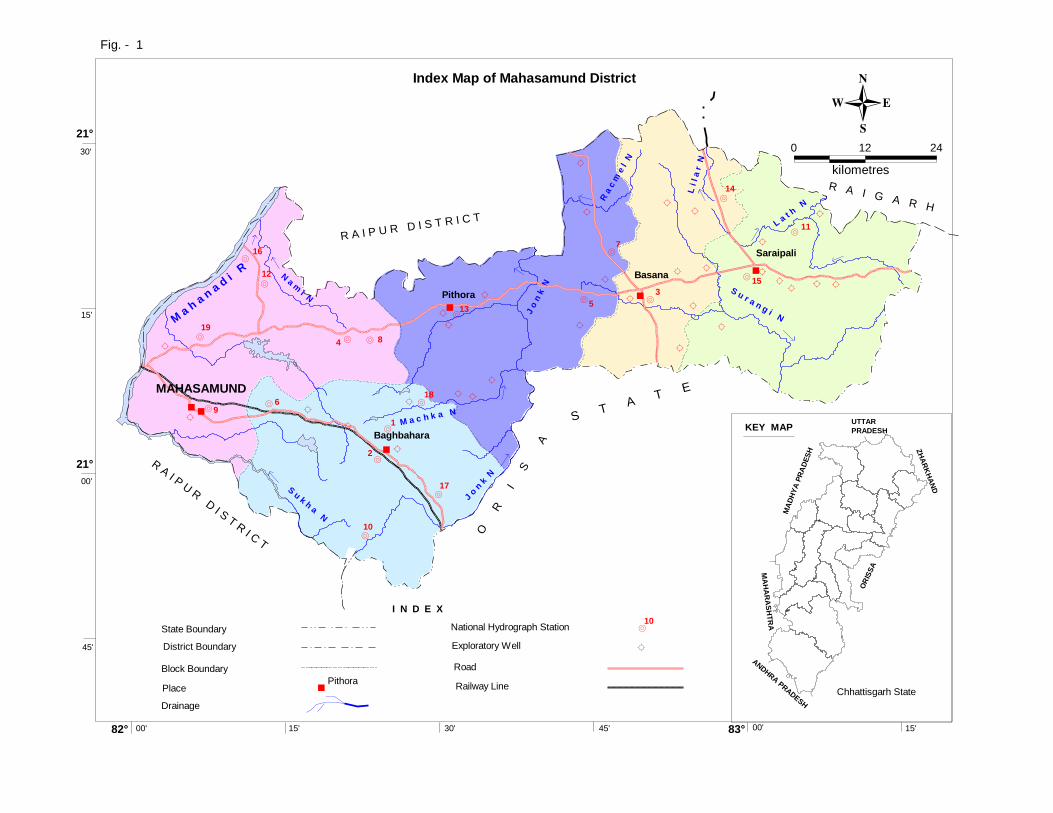
D.Chakraborty, Scientist ‘C’ 1. General The Mahasamund district covers an area of 4963 sq.km. It consists of 1178 no. of villages. For administrative convenience these villages are grouped into 5 no. of community development blocks. Mahasamund is the districts headquarters. The block headquarters are Baghbahera, Basna, Pithora and Saraipalli. Nearly 43% of the total geographical area of the district is covered by forest. Total population of the district is 10,32,275 (As per Census 2011). Fig 1 shows the location of the area along with drainage, block headquarters, Network Hydrograph Stations and location of exploratory wells established and drilled by Central Ground Water Board in the district respectively. The district forms a part of the Mahanadi basin. The general slope on the eastern part of the area is towards south-east, in the central part of the area is towards north and on the western part is towards northwestern direction. The western boundary of the district is running along the Mahanadi River. The Jonk River passes through the central part of the district and is running in northern direction. the Kurar nala, Nami nala, Keswa nala and Sukha nadi forms part of the drainage system for Mahanadi River basin. The Machka nala, Bagh nala, Racme nala, Lath nala forms part of the Jonk River basin. The Kunti nala , Surangi nala andChirar nala form part of Ong basin. The drainage system can be classified as dendritic to sub-dendritic in pattern. The drainage density is very high on the eastern part of the area and is low on the western part. The high drainage density indicates higher run off and less infiltration. The average annual rainfall for the district is 1131 mm. The annual temperature varies from 10°C in winter to 40°C in summer. The relative humidity varies from 75% in rainy season to 30-40% during winter. Physiographically, the major area of the district exhibits pediment/pediplain landforms. The other landforms are structural plain, structural hills and valleys, denudational slope, denudational hills and valleys in the western and eastern part and floodplain including in-filled riverbeds along the course of Mahanadi River. The district forms a part of Mahanadi basin. The general slope of eastern, central and western parts of the district is towards southeast, north and northwest direction respectively. The tributaries of Mahanadi River drain the district. The Mahasamund district forms a part of the Chhattisgarh central plains. Major part of the district exhibits pediment / pediplain landforms. The other landforms are structural plains, structural hills and valleys, denudal slopes, denudal hills and valleys, floodplains etc. The district forms a part of the Mahanadi River basin. The structural plains on Proterozoic formations cover an area of 261.46 sq km and which comes to nearly 6.7% of the total area of the district. The structural hills and valleys cover an area of 296.58 sq km and which comes to 7.6 % of the area in the district. The land forms formed due to the process of differential erosion can be classified into three categories. They are denudational slopes on Proterozoic formations, Pediment / Pediplains, Flood plains formed along Mahanadi
21°
21°
30'
15'
00'
45'
82° 00' 15' 30'
kilometres
0 12
45' 00'83° 15'
24
M a
h a
n a
d i
R
N a m
i N
S u k h a N
J o n
k N
M a c h k a N
J o
n k
N
R a
c m
e l
N
L i l a
r N
S u r a n g i N
L a t
h N
· 9
·19
·16
·12
· 6
·4
·10
·2
· 8
·1
·18
·17
·13
· 5
·7
·3
·14
·11
· 15
Baghbahara
MAHASAMUND
Pithora
Saraipali
Basana
R A I P U R D I S T R I C T
R A I P U R D I S T R I C T
O
R
I
S
A
S T A
T E
R A I G A R H
MA
HA
RA
SH
TR
A
ANDHRA PR
ADESH
MA
DH
YA
PR
AD
ES
H
OR
ISS
A
UTTAR
PRADESH
ZH
AR
KH
AN
D
KEY MAP
Chhattisgarh State
Fig. - 1
Index Map of Mahasamund District
State Boundary
District Boundary
Block Boundary
Place
National Hydrograph Station
Exploratory Well
Road
Railway Line
Pithora
·
10
Drainage
I N D E X
River covering an area of 54.63 sq. km (comes to 1.4 %). The lineaments in the district are mostly due to structural activity in the area. The soils in the district are having wide variations. In all two types of soils are existing in the district and are mostly insitu in nature. They are Red gravely/sandy Alfisols and The Red and yellow Ultisols. 2. Geology and Hydrogeology Mahasamund district is mainly underlain by hard rock belonging to Precambrian age, part from these alluvium and laterite of Quaternary age occur in very isolated pocket with and limited extension. Hard rock mainly include granites and its variants, metasediments, ultramafites, rhyolite etc and also sandstone-shale– limestone / dolomite sequence belonging to Proterozoic Purana rocks of Chhattisgarh super group. The country rocks are intruded by basic and acid intrusive like dolerite dykes and sills and quartz and pegmatite veins. Major part of the district is occupied by granitic rocks belonging to Dongargarh group followed by Purana rocks of Chhattisgarh Supergroup which mainly consists of sandstone, shale, limestone / dolomite sequence. The rock of Chhattisgarh supergroup mainly occupies the eastern and western part of the district. The Chhattisgarh supergroup consists three-group i.e. oldest Singhora group, followed by Chandrapur group and youngest Raipur group. The Singhora group is occur in eastern part of the district, Raipur group occupies western part of the district, while Chandrapur group occur both in eastern and western part, with predominant occurrence in western part. The predominant occurrence of limestone in western part in Raipur group of rocks. The rocks of Bangpal group is occur in central part and rocks of Sonakhan group occur mainly in North eastern part. The Bangpal group of rocks includes high-grade gneiss and schistose rocks and granite etc and Sonakhan group includes metasediments, ultramafics, Rhyolite, Amphibolites etc. The laterite occurs as capping over the country rock in pockets particularly in elevated area in limited thickness. The recent alluvium with limited thickness and extension occur along the major river and stream channels. The granites cover an area of 55 % in the district. The weathered part of the granite and the weatered and fractures constitute the aquifers. Interconnected fractures and joints form potential aquifer system .There are many varieties of granites and granophyres but they are all treated as a single hydrostratigraphic unit since it is not possible to differentiate them on the basis of hydrogeologic characteristics. The fracture zones are encountered in the depth range of 13 to128 mbgl. However the potential fractures are mostly confined to within the depth of 100 m. Depth to a water level in bore wells varies from 3.76 to 9.85 mbgl. The casing depth varies from 7 to 30 mbgl. The casing length also indicates thickness of the weathered formation. Nearly 35 % of wells are showing discharge in the range of 1 to 3 1ps and nearly 30% of wells are yielding more then 3lps. The discharge obtained from the wells drilled in the granites varies from 0.1 to 7.9 lps. The highest discharge of 7.9 lps was obtained atAnkori village in Basna block. The specific capacity value for granites varies from 1.43 to 29 lpm/m. Singhora group is the oldest formation of Chhattisgarh super group ,developed southern part of the baradwar proto basin . The Metasediments occurring in western part of the district consist of Shale, Limestone, sandstone and siltstone. Central Ground Water
District boundary0 - 5
5 - 10
L e g e n d
Depth to Water Level ( mbgl )
National Hydrograph Station
10 - 15
·10
Block HQ
State bondary
Block boundary
Drainage
Surface divide
M a
h a
n a
d i
R
N a m
i N
S u k h a N
J o n
k N
M a c h k a N
J o
n k
N
R a
c m
e l N
L i l a
r N
S u r a n g i N
L a t
h N
· 9
·19
·16
·12
· 6
·4
·10
·2
· 8
·1
·18
·17
·13
· 5
·7
·3
·14
·11
· 15
Baghbahara
MAHASAMUND
Pithora
Saraipali
Basana
R A I P U R D I S T R I C T
R A I P U R D I S T R I C T
O
R
I
S
A
S T A
T E
R A I G A R H
21°
21°
30'
15'
00'
45'
82° 00' 15' 30'
kilometres
0 12
45' 00'83° 15'
24
Fig. - 2
Premonsoon Depth to Water Level ( May 2012 ) in Mahasamund District
3 - 6
0 - 3
Depth to Water Level ( mbgl )
·10
National Hydrograph Station
6 - 9
L e g e n d
District boundary
State bondary
Block boundary
Surface divide
Drainage
Block HQ
R A I P U R D I S T R I C T
R A I P U R D I S T R I C T
O
R
I
S
A
S T A
T E
R A I G A R H
· 9
·19
·16
·12
· 6
·4
·10
·2
· 8
·1
·18
·17
·13
· 5
·7
·3
·14
·11
· 15
Baghbahara
MAHASAMUND
Pithora
Saraipali
Basana
M a
h a
n a
d i
R
N a m
i N
S u k h a N
J o n
k N
M a c h k a N
J o
n k
N
R a
c m
e l N
L i l a
r N
S u r a n g i N
L a t
h N
21°
21°
30'
15'
00'
45'
82° 00' 15' 30'
kilometres
0 12
45' 00'83° 15'
24
Fig. - 3
Postmonsoon Depth to Water Level ( Nov. 2012 ) in Mahasamund District
Baghbahara
MAHASAMUND
Pithora
Saraipali
Basana
21°
21°
30'
15'
00'
45'
82° 00' 15' 30'
kilometres
0 12
45' 00'83° 15'
24
12416.2 7440.21
59.925065.18
16107.73
12224.06
3849.97
23.9
5800.79
10918.76 5077.71
46.5
10115.69
6074.4
4036.75
39.91
Ground water resources for future use (ham)
L e g e n d
Ground water draft(ham)
Stage of ground water development (%)
Net ground water avilability(ham)
5890.06
8207.11
27.78
2280.09
R A I P U R D I S T R I C T
R A I P U R D I S T R I C T
O
R
I
S
A
S T A
T E
R A I G A R H
Fig. - 4
Ground Water Resource (as on March 2009) Map of Mahasamund District
Board has drilled and constructed a total of 9 no. of exploratory wells in this formation in district. For these formations, the discharge varies from 1.3 to 4 .0 lps. The depth of casing varies from 7 to 12 mbgl and the depth to the water level ranges from 2.30 to 7.55 mbgl. The potential fractures are occurring within the depth range of 7 to 54 mbgl. The Sedimentary rocks of Chhattisgarh supergroup are the second most potential aquifers in the district. The occurrence of ground water is restricted to bedding planes, joints and weathered part of the parent rock. In case of limestone formation, the ground water occurs in fractured and cavernous part of the limestone. The thickness of the weathered formation on an average is around 7 to 8 m and the depth to water level varies from 0.5 to 11.5 mbgl. The most common casing length used was from 7 to 12 mbgl. However casing length of 23 mbgl is not uncommon. Occurrence of potential fractures varies from 7 to 52 mbgl. The hydrogeological map prepared for the district is presented in Fig 5. The status of borewells drilled in each block of the district is shown in table 1. Based on the exploration a potential map has been prepared for the district (Fig 6.).
The laterite occurs as capping over the country rock in pockets particularly in elevated
area in limited thickness. The formation wise details of well given in table 2
Table 2 FORMATION WISE DETAILS OF EXPLORATORY WELLS
Formation No of borewells
Depth Range
Zones Encountered
Discharge in lps in no of wells
Drawdown (m)
Remarks
mbgl m bgl <1 1-3 3-5 5-10 >10
Charmuria fm
2 86-150
28-29,64-65,124-126
1 1 30.24
Chandrapur fm
4 61-182
28-30,43-44, 55-60,73-80
1 1 2 33
Singhora gp
9 123-292
30-40,52-55,60-63, 104-105
4 3 1 1 35
Crystallines & Plutonic
23 120-205
22-26,35-40,80-85
9 9 2 3 38
Table 1 Block wise distribution of exploratory well
S.N Block Charmuria fm
Chandrapur fm
Singhora gp Crystallines & Plutonic
Total
1 Basna 1 6 7
2 Bagbahra 7 7
3 Mahasamund 2 4 5 11
4 Pithora 5 5
5 Saraipali 8 8
2 4 9 23 38
The recent alluvium with limited thickness and extension occur along the major river and stream channels. The principal water bearing formations are granites, limestone, shales, sandstone and meta sediments. The occurrence and movement of ground water depends on the depth of weathering, intensity of fractures and their pattern, geomorphologic set-up, formation characteristics and ground water flow.
In all there are 30 no. of observation wells (i.e. National Hydrograph Network Stations); out of which 23 no.s are dug wells and 07 no.s are piezometers were established in the district to monitor the water levels four times a year and water quality once a year. The pre-monsoon ground water level in the district (Fig 2) varies from 2.12 to 11.74 mbgl with an average around 4 to 9 mbgl and the post-monsoon water level (Fig 3) varies from 1.08 to 9.18 mbgl with an average around 3 to 6 mbgl. The water level fluctuation varies from 0.33 to 6.62 with an average around 2 to 4 m. The water level trend (for last 10 years) for pre-monsoon and post-monsoon period on an average indicates no significant rise or fall. 3. Ground water resource (As on March 2009) The ground water resources for Mahasamund district has been estimated based on the GEC.1997 methodology. The estimates indicate that the annual replenishable ground water resource for the district is 63413.06Ham. The net annual ground water availability is 59812.85Ham. The gross annual draft has been estimated as 28236.61Ham and out of which, the draft for irrigation is 24228.14Ham and for domestic & industrial water supply purpose is 4008.47. The ground water resources for Mahasamund district is given in table 3 and fig 4
Table 3 ground water resources for Mahasamund district Assessment Unit / Block/Command /
Non Command 7632.73 7251.09 1762.4 314.09 2076.49 347.36 5141.33 28.64
Block Total 8639.07 8207.11 1931.1 348.99 2280.09 385.95 5890.06 27.78
DISTRICT TOTAL 60805.8 57765.49 19050.77 3633.96 22684.73 3660.23 35054.49 39.27
4. Ground water development The ground water development in the district is being done by dug wells and bore wells. The dug well depth varies from 5 to 14 m and the diameter varies from 1 to 4 m. The bore wells drilled in the area are 60 to 75m deep with diameter of 100 to 150 mm. Diesel or electric operated pumps of 0.25 to 1 HP or traditional teda is used to lift the water from dug wells for irrigation purposes. The electric pump or rope and bucket are used to lift the water for domestic purpose. Submersible electrical pumps of 3 to 5 HP are used for irrigation purpose in case of bore wells in the area. The bore wells in the area can irrigate an area of 0.5 to 1.5 ha for paddy. Ground water is the main source of drinking in the district covering 1178 no. of villages. In all 8311 no. of tube wells and 13236 no. of dug wells exist in the district (2011). Together they irrigate around 42114 ha. The contribution of ground water for irrigation comes to nearly 42% in the district. The use of ground water in non-command area is maximum. The stage of ground water development estimated for Baghbahera block is 23.90%, for Basna block is 39.91%, for Mahasamund block is 59.92%, for Pithora block is 46.50% and for Saraipalli block is 27.78%.The overall stage of development in the district is 39.27%. The district as well as all the blocks fall within the Safe category. The block wise stage of ground water development in the district is depicted in Fig 4. The yield potential and the recommended suitable abstraction structures for the area are shown in Fig 6. 5. Ground water quality The water samples collected from NHNS during the month of May.2011 (Pre-monsoon) were analyzed to determine the quality of ground water in the district. The analysis shows that the concentrations of the major ions are within limit as per BIS Standards and the ground water in the district is suitable for all purposes.
Aquifers with Secondary Intergranular Porosity
and Fractured
1 - 3 1 - 5 1 - 8
Fig. - 6
Ground Water Development Potential and Artificial Recharge Prospects in Mahasamund District
Ground Water Potential
< 1
Regions Generally with Limited Ground Water ,
Compact Formations with less Intergranular porosity
and Fractures
( YIELD, Litres / Sec. )
Recharge
L e g e n d
Area suitable for Dug well
Area suitable for Bore well
Area suitable for Dug cum Bore well
Area suitable for Artificial Ground Water
Baghbahara
MAHASAMUND
Pithora
Saraipali
Basana
21°
21°
30'
15'
00'
45'
82° 00' 15' 30'
kilometres
0 12
45' 00'83° 15'
24
R A I P U R D I S T R I C T
R A I P U R D I S T R I C T
O
R
I
S
A
S T A
T E
R A I G A R H
The plot of Piper Trilinear Diagram and US Salinity Diagram indicates that the ground water in the district is suitable for drinking, irrigation and all other purposes. The EC values ranges between 126 to 754 micro siemens/cm at 25°C (Fig 5) and the pH values ranges between 8.1 to 8.5. The overall composition of ground water indicates that it is moderately alkaline and predominantly CaHCO3 type (calcium bicarbonate). 6. Ground water management strategy There exists a wide scope for ground water development in the district. The available ground water resources for the district are of order of 57765.49 Ham and the ground water draft is 22684.73 Ham. The stage of ground water development is only 39.27%. It is estimated that with the available ground water resources a total of 28883 no.s of bore wells can be constructed in the district. By adapting suitable developmental strategies, the less developed blocks like Baghbahera, Basna, and Saraipalli can be further developed by way of increased irrigation. 7. Water conservation and Artificial Recharge The average annual rainfall for the district is 1131mm. There exist a huge surplus non-committed run off in the district. Rain water harvesting and artificial recharge structures at suitable locations can be constructed to improve the storage capacity of the surface and subsurface reservoirs. Fig 6 is presented to show the area suitable for artificial recharge and future ground water development. 8. Awareness and Training activity So far two nos of Mass awareness were conducted at District headquarters Mahasamund in the year 2007 and 2011.Beside this, Water Information Centre in the year 2012 was also created. NGO.s, Farmers, villagers and nearly 6000 students were awared during these programmes.
Acknowledgement
The author is grateful to Shri Sushil Gupta, Chairman, Central Ground Water Board for giving this opportunity for preparation of the .Ground water Brochure. of Koriya district, Chhattisgarh. The author is thankful to Shri K.C. Naik, Regional Director, Central Ground Water Board, NCCR, Raipur for his guidance and constant encouragement for the preparation of this brochure. Help extended by Shri J.R. Verma, Scientist ‘B’ and Shri M.M. Sonkusare, Sc’C’ is thankfully acknowledged.
D. Chakraborty Scientist ‘C’
399
423280
273
283
401
430
381
430
425
389
348
361
262
494
637
465
348
371
340
474
496
327
393
534
587
362
472449
350
373
412
476459
331
302
415
176
366
477
460
424
491 507
298 277
287
287
472
382
269
478
294
281
435
583
241
672
685
597
664
275
300
350
350
300
350
400
400
300
275
275
275
300 35
0
350
275
275
300
400
Kurar N
Sukha N
M a
h a
n a
d i
R
Nami N
J o
n k
N
Machka N
Kut
ni N
Bagh N
Lilar N
Lath
N
Surangi N
Racmel N
Baghbahara
MAHASAMUND
Pithora
Saraipali
Basana
Chh
attis
garh
Su
perg
roup
Bas
emen
t cry
stal
line
Intr
usiv
e
HYDROGEOLOGICAL MAP OF MAHASAMUND DISTRICT
Fig 5
L G E N D
( Y i e l d , l i t e r / s e c . )G r o u n d W a t e r p o t e n t i a l
1200 Surface water divide
Block bounndry
Ground water contour (mamsl) May 2008.
Isohyet (mm) 2008
Raipur Group-Limestone and Shales
Basic dykes
Quartz vein
Bangpal group-Gneiss and Migmatite
Sonakhan group-Utramafic, Rhyolite, Amphibolite etc.