Diving Locations Table Rock 1. House Foundation / Storm Cellar a. 36.5778852 / 93.529004 1. 36.34.673 / 93.31.740 b. Shallow Cove between Baxtor Springs / Campbell’s Point 2. Goose Island a. 36.6257626 / 93.3350534 1. 36.37.546 / 93.20.104 3. Enchanted Forest a. 36.6194594 / 93.3189441 1. 36.37.168 / 93.19.137 b. 70’ to bottom c. (South End) N. 36* 37.938', W. 93* 19.128' d. (North End) N. 36* 37.248', W. 93* 19.238' 1. This site is a rock bluff about 1/2 mile north of the dam. Descend to 65-80 ft. and find yourself at the base of a grove of large moss-covered oak trees, some of which break the surface. The silhouettes of the trees against the ambient light above produces a beautiful visual effect. Lots of fish around 15 ft. along the ledge, which extends from shoreline about 20 ft. A must-see dive site! 4. Zeb Ferry Boat a. 36.6308481 / 93.335665 1. 36.37.851 / 93.20.140 b. 60’ – 100’ 5. Houseboat a. 36.5901858 / 93.4097744 1. 36.35.411 / 93.24.586 b. Kimberling City c. Shallow d. Green Freon Tank attached as marker on surface
Transcript
Diving Locations
Table Rock
1. House Foundation / Storm Cellar
a. 36.5778852 / 93.529004
1. 36.34.673 / 93.31.740
b. Shallow Cove between Baxtor Springs / Campbell’s Point
2. Goose Island
a. 36.6257626 / 93.3350534
1. 36.37.546 / 93.20.104
3. Enchanted Forest
a. 36.6194594 / 93.3189441
1. 36.37.168 / 93.19.137
b. 70’ to bottom
c. (South End) N. 36* 37.938', W. 93* 19.128'
d. (North End) N. 36* 37.248', W. 93* 19.238'
1. This site is a rock bluff about 1/2 mile north of the dam. Descend
to 65-80 ft. and find yourself at the base of a grove of large
moss-covered oak trees, some of which break the surface. The
silhouettes of the trees against the ambient light above produces
a beautiful visual effect. Lots of fish around 15 ft. along the
ledge, which extends from shoreline about 20 ft. A must-see dive
site!
4. Zeb Ferry Boat
a. 36.6308481 / 93.335665
1. 36.37.851 / 93.20.140
b. 60’ – 100’
5. Houseboat
a. 36.5901858 / 93.4097744
1. 36.35.411 / 93.24.586
b. Kimberling City
c. Shallow
d. Green Freon Tank attached as marker on surface
6. Peninsula / Walls / Shelves
a. 36.6230965 / 93.4668786
1. 36.37.386 / 93.28.013
b. Gradually goes down deep 120’
7. Swimmers Swing
a. 36.6376877 / 93.4898222
1. 36.38.261 / 93.29.389
b. Nice Dive – Watch for boat traffic due to swing
8. Breezy Point:
a. N 36* 33.208', W 93* 18.375'
b. Located 1 mile south of Table Rock Dam. A nice vertical drop-off with
some shallow ledges and interesting rock overhangs. This is a popular spot
for boaters and cliff jumpers, so, keep and eye out for lost stuff!
9. The Saddle:
a. N 36* 33.208', West of 93* 18.375'
b. Adjacent to Breezy Point. This underwater ridge starts at Breezy Point and
continues east across the main channel at depths approaching 90 ft. The
ridge is narrow in spots with visible drop-offs on either side.
Topographically unique and visually stunning.
10. Spoonbill Bluff:
a. N 36* 34.800', W. 93* 18.885'
b. Named for the spoonbill or paddlefish, which inhabit the site. This site is
located north of Point 2 on the west side of the White River channel. See
flat rock "tables" and find the nice shallow rock slope with trees for good
fish watching cover. Fish are spotted around 45ft. Max depth is 100 ft.
11. Zebulon Pike:
a. N 36.37.853 , W093.20.148
1. 80’
b. N 36* 37.859', W. 93* 20.146'
c. Just around the bend from the Table Rock Dam. Boat wreck dive. This 90
ft. long, double-decker excursion boat lies in 75-95 ft. of water. Find the
guideline 15 ft. near shore and follow it down to the boat. A fun dive for
more experienced divers. Take a light along with you.
d. From Jakes Island, go almost straight North past the first cove with docks.
After that just follow the shoreline almost to the mouth of the next cove.
In about 15ft of water you will find a stump sort of by itself with several
pop bottles tied off to it. At the base of this tree is a rope that will lead you
to the Pike. The front railing was at around 65ft. The stern lies in ~80ft.
Hope this helps. These may not be exact as I have only been there once
but I think you can find it. If nothing else, just follow the West shoreline
heading North and you should be able to find the stump with pop bottles
tied to it. There were also a couple of orange buoys floating on the surface
in the area.
12. Jakes Point Island:
a. N 36* 37.485', W. 93* 20.120'
b. Jakes Point Island is a multi level dive suitable for any level of diver. Max.
dept is 130 feet. There is a 30 ft. cabin cruiser stuck in 35 feet of water
directly under GPS coordinates. This site is known for very large Bass.
13. Duck Island:
a. N 36*35.075’, W. 93*19.295’
b. Duck Island right next to the Showboat. This is a shallow dive with large
rock formations and very large schools of fish. Great for all levels of
divers. Max dept recommended for 40 ft.
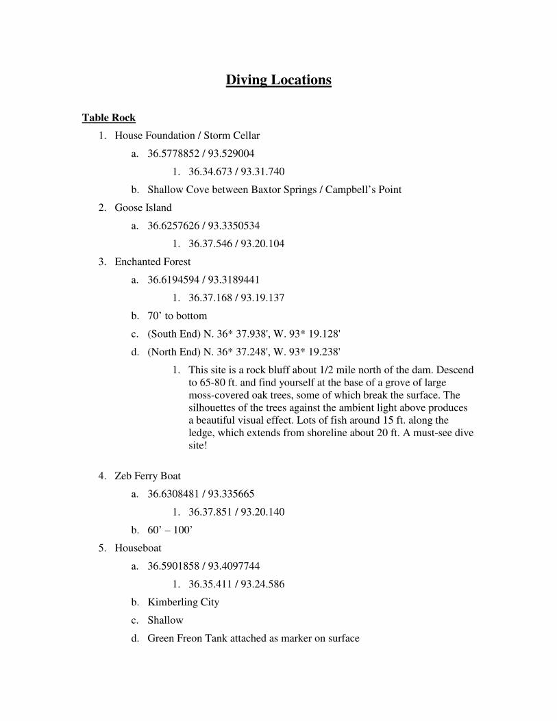
14. Oasis (Several Divers have offered coords for this location)
a. N 36.32.018 , W 93.17.057
b. N 36 32.388, W 093 17.957
c. N 36 32.384, W 93 17.997
d. N 36 32 19, W 93 17 58
1. 80’
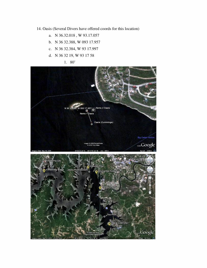
15. Kimberling City Bridge
a. The remains of the older bridge still resides under the “new” bridge.
b. Rumor has it a motorcycle is on the bridge.
c. Deep dive 100’-120’
Beaver Lake
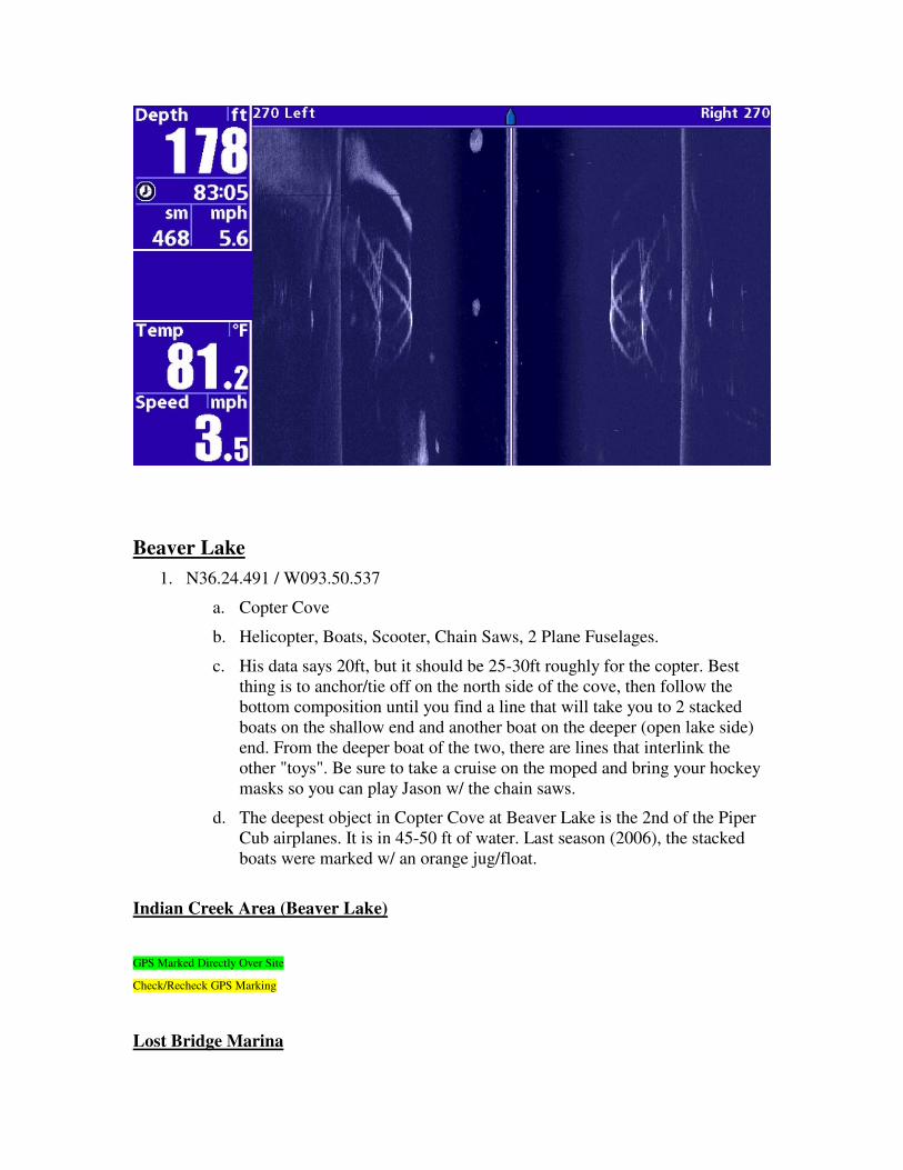
1. N36.24.491 / W093.50.537
a. Copter Cove
b. Helicopter, Boats, Scooter, Chain Saws, 2 Plane Fuselages.
c. His data says 20ft, but it should be 25-30ft roughly for the copter. Best
thing is to anchor/tie off on the north side of the cove, then follow the
bottom composition until you find a line that will take you to 2 stacked
boats on the shallow end and another boat on the deeper (open lake side)
end. From the deeper boat of the two, there are lines that interlink the
other "toys". Be sure to take a cruise on the moped and bring your hockey
masks so you can play Jason w/ the chain saws.
d. The deepest object in Copter Cove at Beaver Lake is the 2nd of the Piper
Cub airplanes. It is in 45-50 ft of water. Last season (2006), the stacked
#14 Russian Sub N36.24.100 W092.36.312 25’ Follow Line from Rotortiller
#15 Sailboat N36.24.094 W092.36.386 45’ Go West From Russian Sub
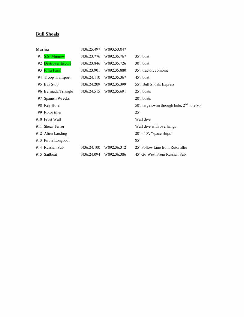
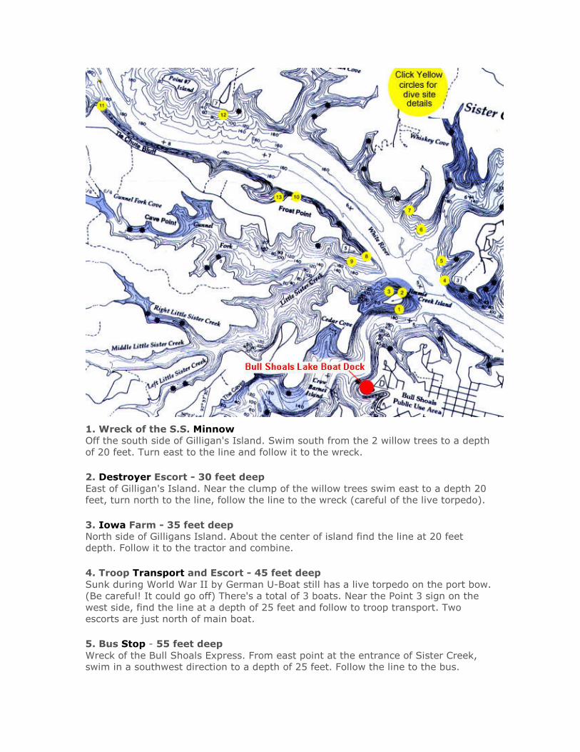
1. Wreck of the S.S. Minnow
Off the south side of Gilligan's Island. Swim south from the 2 willow trees to a depth
of 20 feet. Turn east to the line and follow it to the wreck.
2. Destroyer Escort - 30 feet deep
East of Gilligan's Island. Near the clump of the willow trees swim east to a depth 20 feet, turn north to the line, follow the line to the wreck (careful of the live torpedo).
3. Iowa Farm - 35 feet deep
North side of Gilligans Island. About the center of island find the line at 20 feet depth. Follow it to the tractor and combine.
4. Troop Transport and Escort - 45 feet deep
Sunk during World War II by German U-Boat still has a live torpedo on the port bow.
(Be careful! It could go off) There's a total of 3 boats. Near the Point 3 sign on the
west side, find the line at a depth of 25 feet and follow to troop transport. Two escorts are just north of main boat.
5. Bus Stop - 55 feet deep
Wreck of the Bull Shoals Express. From east point at the entrance of Sister Creek, swim in a southwest direction to a depth of 25 feet. Follow the line to the bus.
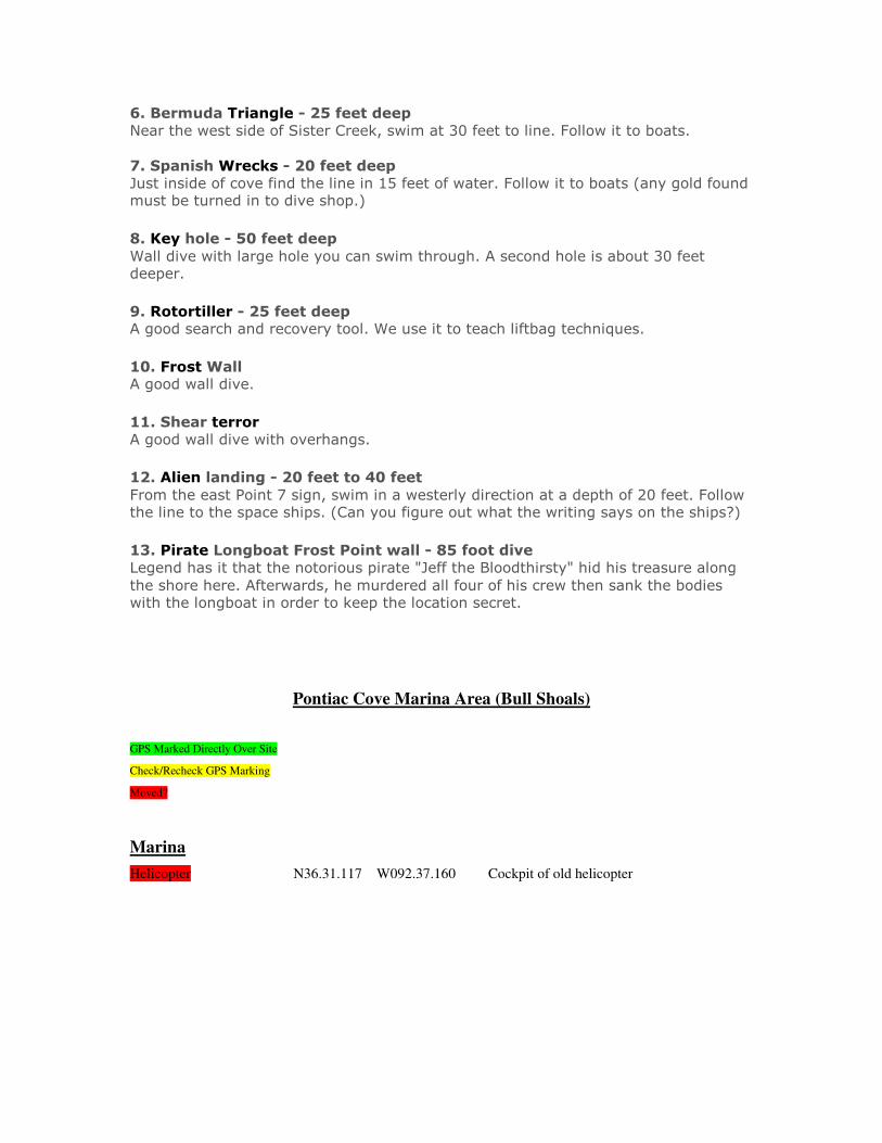
6. Bermuda Triangle - 25 feet deep
Near the west side of Sister Creek, swim at 30 feet to line. Follow it to boats.
7. Spanish Wrecks - 20 feet deep
Just inside of cove find the line in 15 feet of water. Follow it to boats (any gold found must be turned in to dive shop.)
8. Key hole - 50 feet deep
Wall dive with large hole you can swim through. A second hole is about 30 feet deeper.
9. Rotortiller - 25 feet deep A good search and recovery tool. We use it to teach liftbag techniques.
10. Frost Wall A good wall dive.
11. Shear terror
A good wall dive with overhangs.
12. Alien landing - 20 feet to 40 feet
From the east Point 7 sign, swim in a westerly direction at a depth of 20 feet. Follow the line to the space ships. (Can you figure out what the writing says on the ships?)
13. Pirate Longboat Frost Point wall - 85 foot dive
Legend has it that the notorious pirate "Jeff the Bloodthirsty" hid his treasure along
the shore here. Afterwards, he murdered all four of his crew then sank the bodies with the longboat in order to keep the location secret.
Pontiac Cove Marina Area (Bull Shoals)
GPS Marked Directly Over Site
Check/Recheck GPS Marking
Moved?
Marina
Helicopter N36.31.117 W092.37.160 Cockpit of old helicopter
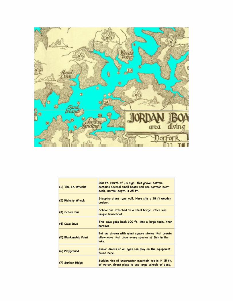
Norfork Lake - Jordan Area
GPS Marked Directly Over Site
Check/Recheck GPS Marking
MARINA N36.16.255 W092.11.483
#1 1A Wrecks N36.16.714 W092.11.243 Small boats one pontoon boat deck, 25’