30
GPS for Teachers
| Date post: | 30-Dec-2015 |
| Category: |
Documents |
| Upload: | charla-white |
| View: | 216 times |
| Download: | 0 times |

GPS for Teachers
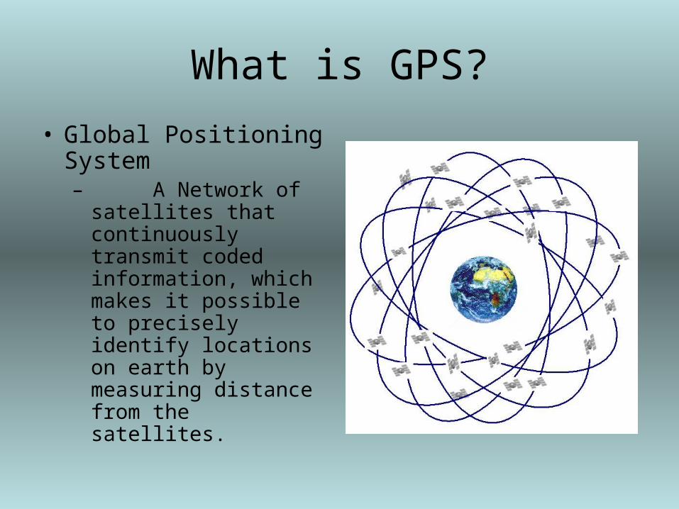
What is GPS?
• Global Positioning System– A Network of
satellites that continuously transmit coded information, which makes it possible to precisely identify locations on earth by measuring distance from the satellites.

How did GPS Start?
• Satellites (24) developed by the U.S. Department of Defense.
• Cost billions of dollars to develop and maintain.
• Originally designed for military use:– Navigation– Troop Deployment– Artillery Fire

Accuracy of GPS
• Basic Units– Accurate up to 1 meter
• Advanced Units– Accurate up to 1 centimeter
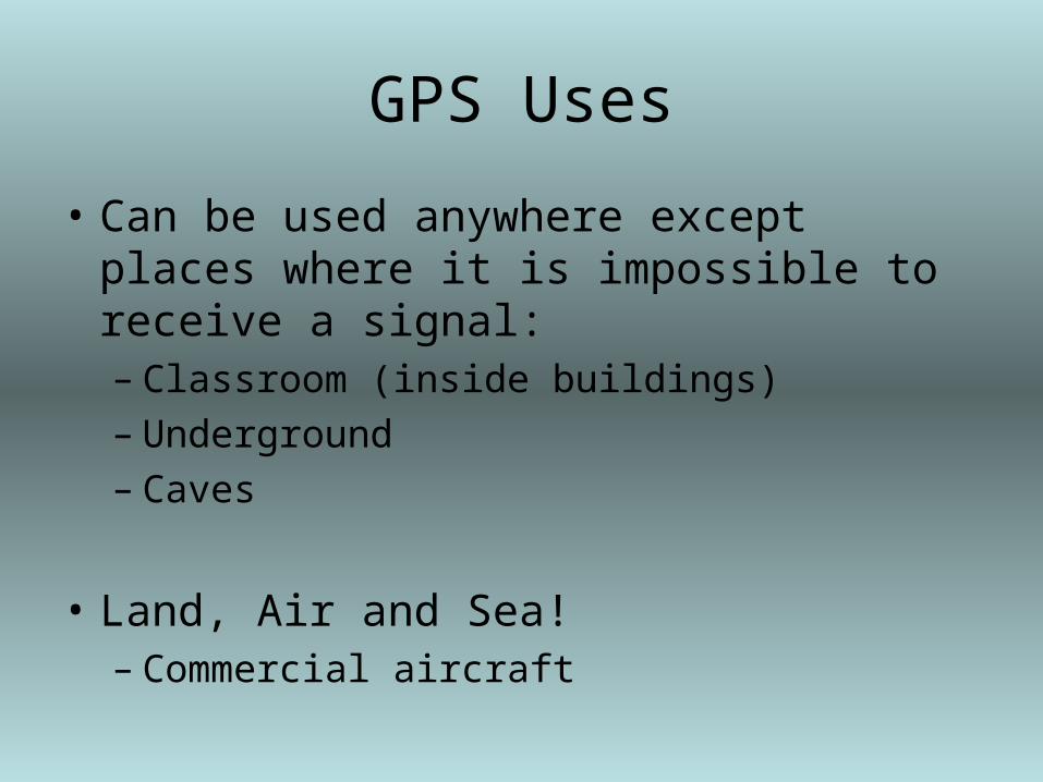
GPS Uses
• Can be used anywhere except places where it is impossible to receive a signal:– Classroom (inside buildings)– Underground– Caves
• Land, Air and Sea!– Commercial aircraft

Three Segments

Three Parts to GPS
• Satellites– 24 satellites (21 are active with 3 spares)– 12,000 miles above the Earth’s surface– Traveling at speeds of 7,000 miles/hour– Circle the Earth every 12 hours– Powered by solar energy with back up battery
(i.e. during solar eclipse)– Small rocket boosters to keep them flying in
the correct path

Satellites Con’t.
• First launched in 1978
• Full 24 satellites by 1994
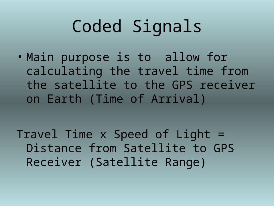
Coded Signals
• Main purpose is to allow for calculating the travel time from the satellite to the GPS receiver on Earth (Time of Arrival)
Travel Time x Speed of Light = Distance from Satellite to GPS Receiver (Satellite Range)

Satellite Information
• The Navigation Message contains:– Satellite orbital information– Clock information– General system status message

Control Segment
• Five Control Stations – Located around the world– 4 unmanned
• Hawaii and Kwajalein in the Pacific Ocean; Diego Garcia in the Indian Ocean; Ascension Island in the Atlantic Ocean.
– 1 master control centre• Colorado Springs, Colorado

Use Segment (GPS)
• You and your GPS unit– Boaters– Pilots– Hikers– Hunters– Military– Recreation (Geocaching)

How it all works together…

Source of Errors

How it works…• 5 seconds to reach unit, 500 km from
Satellite A• 4.5 seconds to reach unit, 450 km from
Satellite B• 4.25 seconds to reach unit, 425 km from
Satellite C• 7 seconds to reach unit, 700 km from
Satellite D
• Distances are calculated by the length of time it takes the signal to reach the satellite
• With these four readings the exact latitude, longitude and altitude can be determined for the GPS Unit location
A
B
C
D

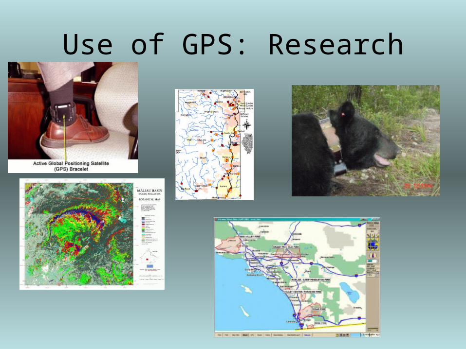
Use of GPS: Research

GPS: Recreation

WaypointsA waypoint is a “position stored in the unit’s memory used for direct
navigation or to build a route”.
How to create a waypoint:1) You can mark your current location as a waypoint:– Press the ENTER/MARK key while present at the location you want to
record as a waypoint, highlight OK and press ENTER to save OR...
2) You can manually enter existing coordinates:– Press and hold ENTER/MARK until “Mark Waypoint” page is displayed– Use ROCKER to highlight location, press ENTER and change the
coordinates using the ROCKER button– Highlight OK and press ENTER to save

Physical Education Outcomes Junior High
• Physical Education - GRADE 7 :
Active Living- participate in activities that enhance cardiovascular fitness, muscular
strength, endurance and flexibilityOutdoor Activities- know and practice safe procedures and routines in a variety of
outdoor activities- find a desired direction of travel by taking a compass bearing- know and understand the concept of reading a map- participate in activities or games that demonstrate sensitivity towards
the environment- participate in at least one land-based and one water-based seasonal
activity that practices environmental safety

Physical Education - GRADE 8 :Active Living- participate in activities that enhance cardiovascular fitness, muscular strength,
endurance and flexibilityOutdoor Activities- practice the sport of orienteering in a controlled environment- know and understand the concept of reading a map- participate in activities or games that demonstrate sensitivity towards the
environment- participate in at least one land-based and one water-based seasonal activity
that practices environmental safety- review and practice the use of a compass
Physical Education - GRADE 9 :Outdoor Activities- create a map and design an orienteering course on their school grounds or in a local park- demonstrate map-reading skills as an aid to navigation- demonstrate compass-reading skills as an aid to navigation- participate in at least one land-based and one water-based seasonal activity that
practices environmental safety

Uses in the ClassroomElementary
• Physical Education Con’t.– Experience and outdoor activity in each of the four
seasons – participate in a walking or jogging program in
preparation for hiking, orienteering, cross country skiing.
– Follow directions and symbols on a map of the school grounds, locating specific landmarks
– Take part in an activity utilizing a community resource (physical or human)
– Participate in games, sports, dance and outdoor pursuits, both in and outside school, based on individual interests and capabilities
– Participate in an orienteering-type activity using a map and compass on the school grounds or at a local park

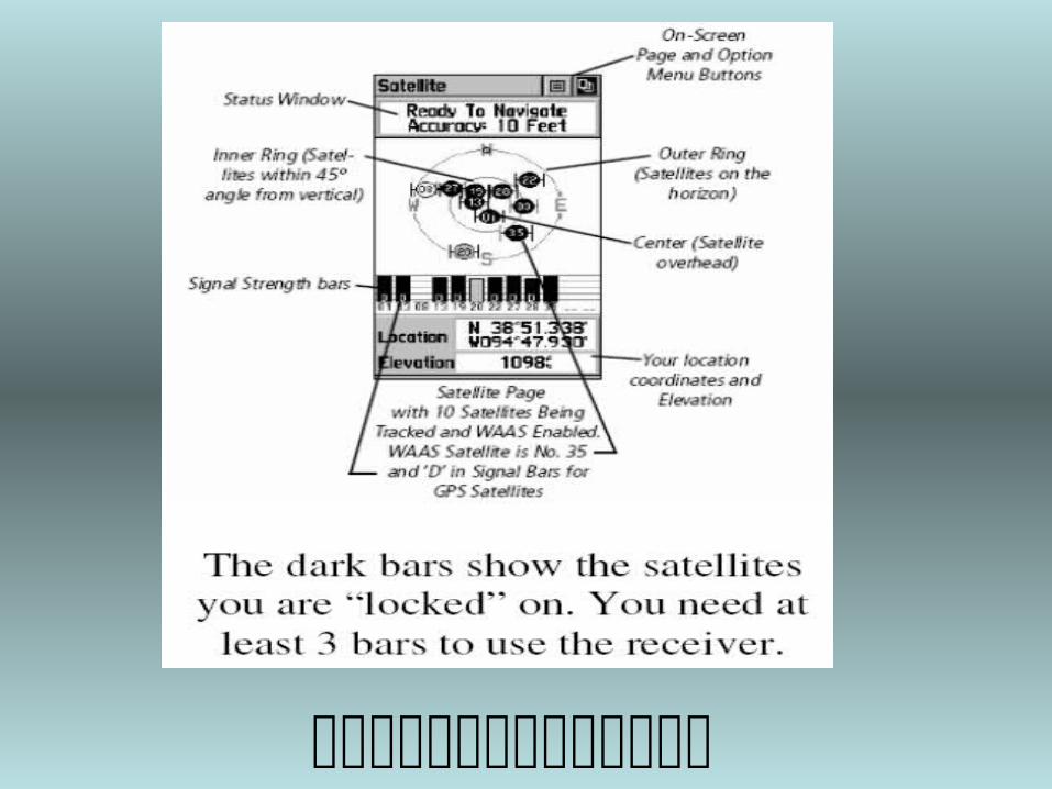
Using the etrex Legend GPS Unit

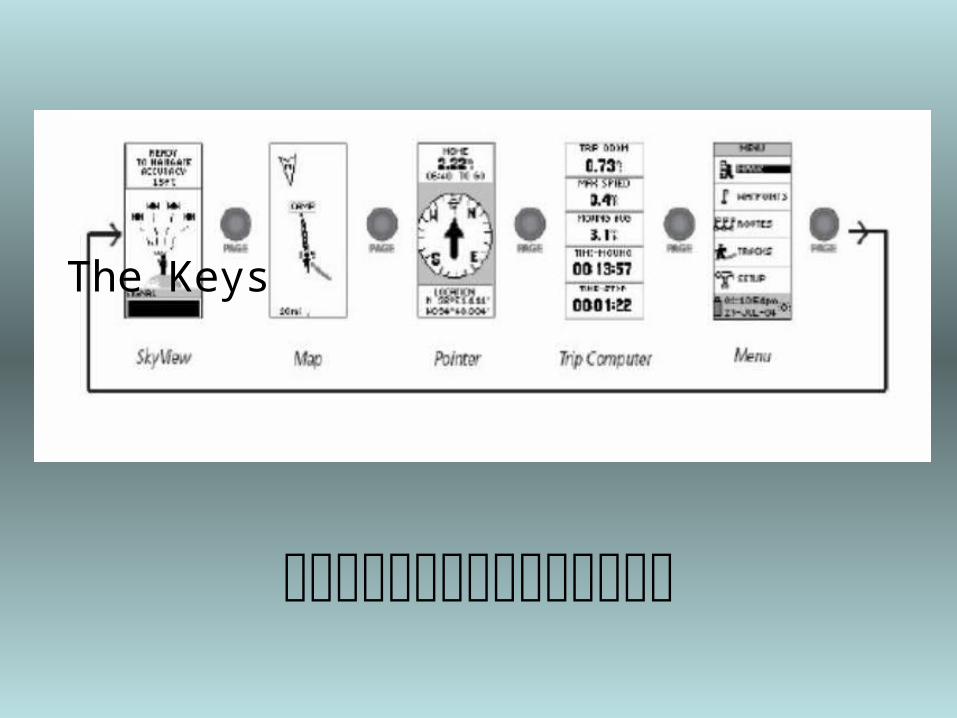
The Keys

Press and hold the Thumb Stick until the Mark Waypoint screen appears with the guy holding a flag
Your waypoint is already assigned a three digit number. To change the name of the waypoint, use the thumb stick button to highlight its name. Use the thumb stick to set a new name for the waypoint.
When you are done use the thumb stick to highlight the ok button and press the thumb stick button once.
To change the waypoint, use the thumb stick to highlight the numbers. Use the thumb stick to navigate the number pad and change the waypoint.

Step 1: Use the PAGE button to find the main menu. Use the THUMB STICK to go to the FIND option and press the same button to select this option.
Step 2: Select WAYPOINTS by pressing the THUMB STICK button.Step 3: Choose NEAREST on the next menu.
Step 4: Select the waypoint you want using the THUMB STICK button.
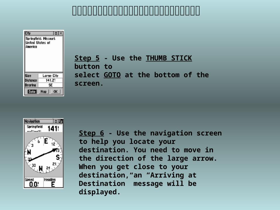
Step 5 - Use the THUMB STICK button toselect GOTO at the bottom of the screen.
Step 6 - Use the navigation screen to help you locate your destination. You need to move in the direction of the large arrow. When you get close to your destination, an “Arriving at Destination” message will be displayed.
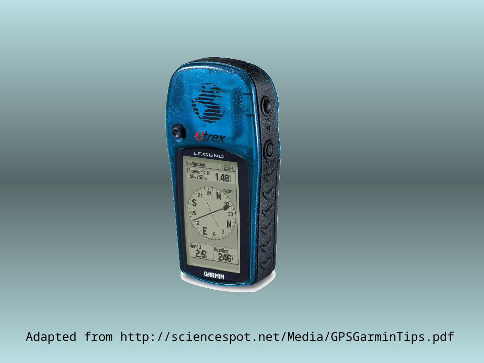
Adapted from http://sciencespot.net/Media/GPSGarminTips.pdf


