1 GPS Space Service Volume (SSV) Ensuring Consistent Utility Across GPS Design Builds for Space Users Frank H. Bauer FBauer Aerospace Consulting Services (FB-ACS) Representing NASA and DoD SSV Team 15 th PNT Advisory Board Meeting June 11, 2015
Transcript
1
GPS Space Service Volume (SSV) Ensuring Consistent Utility Across GPS Design
Builds for Space Users
Frank H. Bauer
FBauer Aerospace Consulting Services (FB-ACS)
Representing NASA and DoD SSV Team
15th PNT Advisory Board Meeting
June 11, 2015
2
Agenda
• Background
• SSV Specification History
• SSV Revisit: Knowledge Gained & Lessons
Learned
• Proposed SSV Specification Updates to
Ensure Minimal Degradation in Signal
Strength/Availability
• Summary and Closing Remarks
3
Background
4
Geosync
Altitude:
35,887 km
GPS Altitude:
20,183 km
First Side
Lobes Earth Umbra
LEO Altitudes
< 3,000 km
3,000 km
HEO
Spacecraft
Reception Geometry for GPS Signals in Space
Main Lobe
(~47°for GPS L1 signal)
First Side
Lobes
5
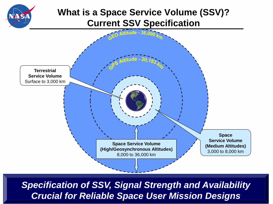
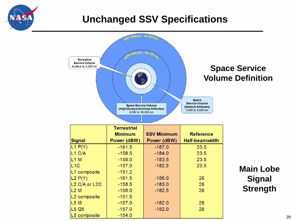
What is a Space Service Volume (SSV)?
Current SSV Specification
Space Service Volume
(High/Geosynchronous Altitudes)
8,000 to 36,000 km
Space
Service Volume
(Medium Altitudes)
3,000 to 8,000 km
Terrestrial
Service Volume
Surface to 3,000 km
Specification of SSV, Signal Strength and Availability
Crucial for Reliable Space User Mission Designs
6
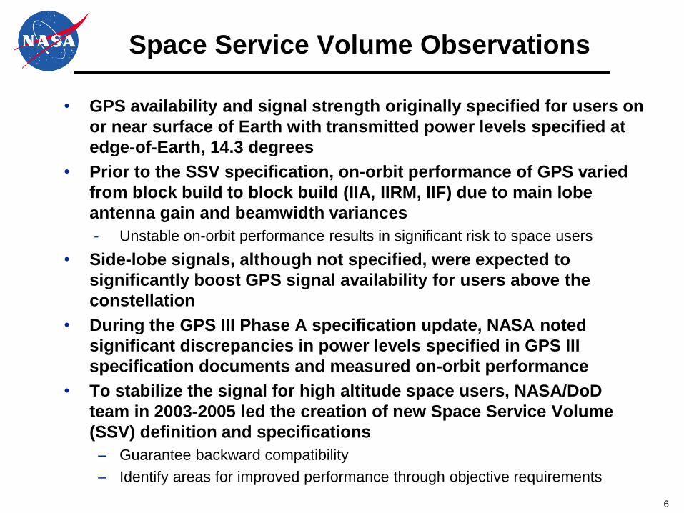
Space Service Volume Observations
• GPS availability and signal strength originally specified for users on
or near surface of Earth with transmitted power levels specified at
edge-of-Earth, 14.3 degrees
• Prior to the SSV specification, on-orbit performance of GPS varied
from block build to block build (IIA, IIRM, IIF) due to main lobe
antenna gain and beamwidth variances
- Unstable on-orbit performance results in significant risk to space users
• Side-lobe signals, although not specified, were expected to
significantly boost GPS signal availability for users above the
constellation
• During the GPS III Phase A specification update, NASA noted
significant discrepancies in power levels specified in GPS III
specification documents and measured on-orbit performance
• To stabilize the signal for high altitude space users, NASA/DoD
team in 2003-2005 led the creation of new Space Service Volume
(SSV) definition and specifications
– Guarantee backward compatibility
– Identify areas for improved performance through objective requirements
7
SSV specifications are crucial for DoD, NASA and Commercial users,
providing real-time GPS navigation solutions in High Earth Orbit
•Supports increased satellite autonomy for missions, lowering mission operations costs
•Significantly improves vehicle navigation performance in these orbits
•Enables new/enhanced capabilities and better performance for HEO and GEO/GSO future
missions, such as:
Why is the Space Service Volume Specification
Important for Missions in High Earth Orbit?
Formation Flying &
Constellation Missions
Improved Weather Prediction using
Advanced Weather Satellites
En-route Lunar
Navigation Support
Space Weather Observations
Closer Spacing of
Satellites in
Geostationary Arc
Astrophysics Observations
8
Use of GPS in the Space Service Volume (SSV)
• GPS signals in High Earth Orbit and Geosynchronous Altitude
utilized by multiple DOD, NASA & NOAA programs
– SBIRS, ANGELS, Classified Programs
– GOES-R, MMS
• Autonomous navigation enables new mission needs and
significantly improves PNT performance over past methods
– GPS Ephemeris and timing data can be provided near real time with collected
satellite products
– Achievable accuracy is greatly improved over typical methods using ground
based ephemeris processing via ranging and angle measurements
• NASA activities have included:
– Conducting flight experiments to characterize GPS performance in SSV
– Development of new weak signal GPS receivers for spacecraft in
Geostationary or highly elliptical orbits
– Working with the GPS Directorate and DoD community to formally document
GPS requirements for space users
– International coordination to encourage other GNSS constellations (e,g,
Galileo, GLONASS, BeiDou) to specify interoperable SSV capabilities
– Developing missions and systems to utilize GPS signals in the SSV
9
Civil Space Missions using GPS
above the GPS Constellation GOES-R Weather Satellite Series
•First public safety use of GPS above the constellation
•Improves navigation performance for GOES-R
•Station-keeping operations on current GOES-N-Q
constellation require relaxation of Image Navigation
Registration for several hours
•GPS supports GOES-R breaking large station-keeping
maneuvers into smaller, more frequent ones
– Quicker Recovery
– Minimal impact on Earth weather science
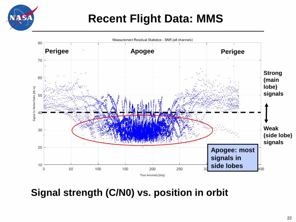
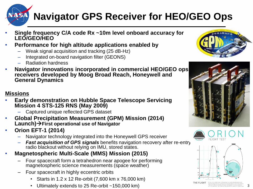
Magnetospheric Multi-Scale (MMS) Mission
•Launched March 12, 2015
•Four spacecraft form a tetrahedron near apogee for
performing magnetospheric science measurements
(space weather)
•Four spacecraft in highly eccentric orbits
– Starts in 1.2 x 12 Re-orbit (7,600 km x 76,000 km)
– Ultimately extends to 25 Re-orbit ~150,000 km)
GOES-R
MMS
11
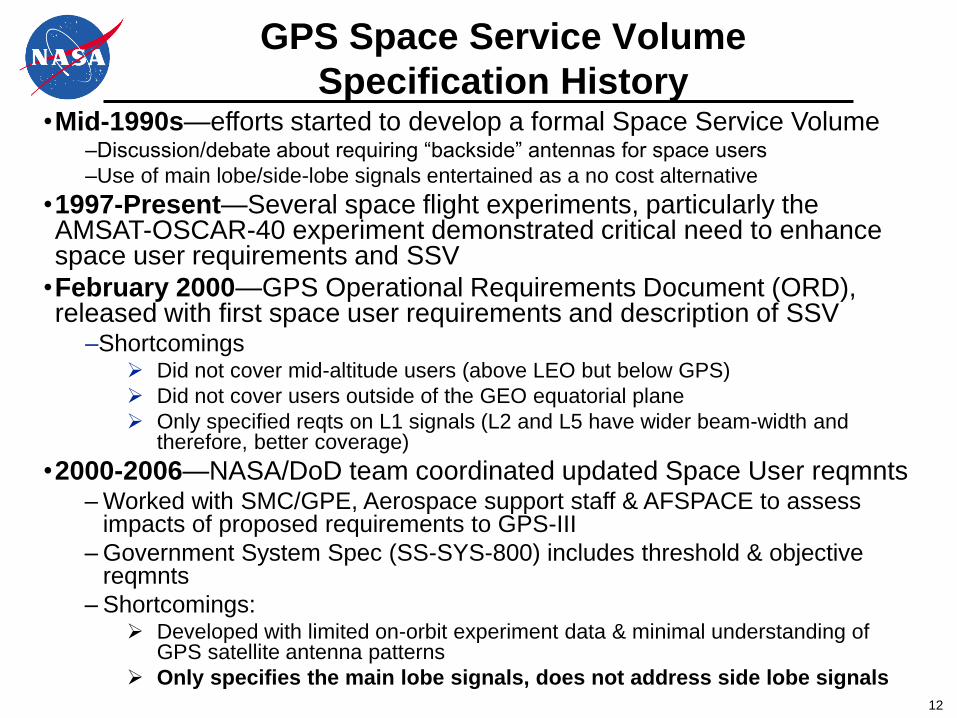
SSV Specification History
12
GPS Space Service Volume
Specification History •Mid-1990s—efforts started to develop a formal Space Service Volume
–Discussion/debate about requiring ―backside‖ antennas for space users
–Use of main lobe/side-lobe signals entertained as a no cost alternative
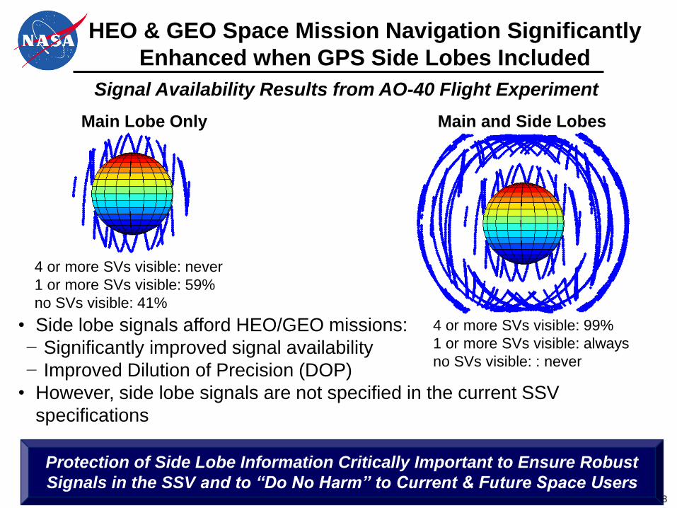
•1997-Present—Several space flight experiments, particularly the AMSAT-OSCAR-40 experiment demonstrated critical need to enhance space user requirements and SSV
•February 2000—GPS Operational Requirements Document (ORD), released with first space user requirements and description of SSV
–Shortcomings Did not cover mid-altitude users (above LEO but below GPS)
Did not cover users outside of the GEO equatorial plane
Only specified reqts on L1 signals (L2 and L5 have wider beam-width and therefore, better coverage)
•2000-2006—NASA/DoD team coordinated updated Space User reqmnts – Worked with SMC/GPE, Aerospace support staff & AFSPACE to assess
impacts of proposed requirements to GPS-III
– Government System Spec (SS-SYS-800) includes threshold & objective reqmnts
– Shortcomings: Developed with limited on-orbit experiment data & minimal understanding of
GPS satellite antenna patterns
Only specifies the main lobe signals, does not address side lobe signals
13
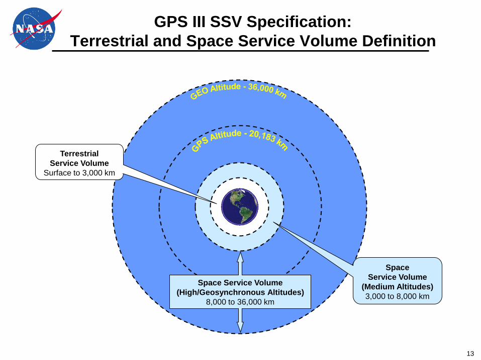
GPS III SSV Specification:
Terrestrial and Space Service Volume Definition
Space Service Volume
(High/Geosynchronous Altitudes)
8,000 to 36,000 km
Space
Service Volume
(Medium Altitudes)
3,000 to 8,000 km
Terrestrial
Service Volume
Surface to 3,000 km
14
GPS III SSV Specification:
Minimum Received Signal Power (dBW)
Signal
Terrestrial
Minimum
Power (dBW)
SSV Minimum
Power (dBW)
Reference
Half-beamwidth
L1 P(Y) -161.5 -187.0 23.5
L1 C/A -158.5 -184.0 23.5
L1 M -158.0 -183.5 23.5
L1C -157.0 -182.5 23.5
L1 composite -151.2
L2 P(Y) -161.5 -186.0 26
L2 C/A or L2C -158.5 -183.0 26
L2 M -158.0 -182.5 26
L2 composite -151.5
L5 I5 -157.0 -182.0 26
L5 Q5 -157.0 -182.0 26
L5 composite -154.0
• SSV minimum power levels were specified based on the worst-case (minimum) gain across the Block IIA, IIR, IIR-M, and IIF satellites
• Some signals have several dB margin with respect to these requirements at reference half-beamwidth point
15
GPS III SSV Specification:
Minimum Availability Requirement
• Assuming a nominal, optimized GPS constellation and no GPS spacecraft failures, signal availability at 95% of the areas at a specific altitude within the specified SSV are planned as:
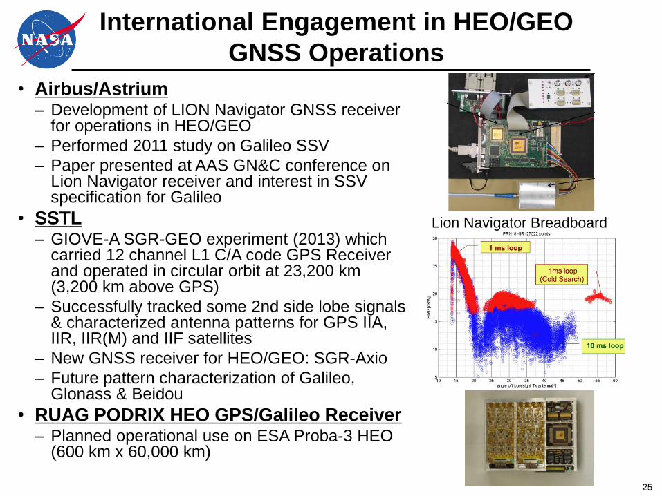
• Airbus/Astrium – Development of LION Navigator GNSS receiver
for operations in HEO/GEO
– Performed 2011 study on Galileo SSV
– Paper presented at AAS GN&C conference on Lion Navigator receiver and interest in SSV specification for Galileo
• SSTL – GIOVE-A SGR-GEO experiment (2013) which
carried 12 channel L1 C/A code GPS Receiver and operated in circular orbit at 23,200 km (3,200 km above GPS)
– Successfully tracked some 2nd side lobe signals & characterized antenna patterns for GPS IIA, IIR, IIR(M) and IIF satellites
– New GNSS receiver for HEO/GEO: SGR-Axio
– Future pattern characterization of Galileo, Glonass & Beidou
• RUAG PODRIX HEO GPS/Galileo Receiver – Planned operational use on ESA Proba-3 HEO
(600 km x 60,000 km)
Lion Navigator Breadboard
26
Lessons Learned Summary
SSV Lessons Learned Over Past Decade:
•GPS side lobe signals critically important for civil and military
space users in HEO/GEO orbits
– Current and future civil and military space missions rely on side lobe
signals to augment and enhance on-board PNT performance, improving
vehicle resiliency
– Side Lobe signals enhance Space and Earth weather prediction through
improved navigation performance; strategically important for civil and
military operations
•Protection of side lobe signals ensures consistent GPS signal
availability to U.S. civil & military missions at HEO/GEO
– No other GNSS constellation specifies SSV and side lobe signals
Protection of GPS Side Lobe Signals through
Specification is Critically Important to “Do No Harm”
to Current and Future Users of the SSV
27
Proposed SSV Specification Updates
to Ensure Minimal Degradation in
Signal Strength/Availability
28
Unchanged SSV Specifications
Main Lobe
Signal
Strength
Space Service
Volume Definition
29
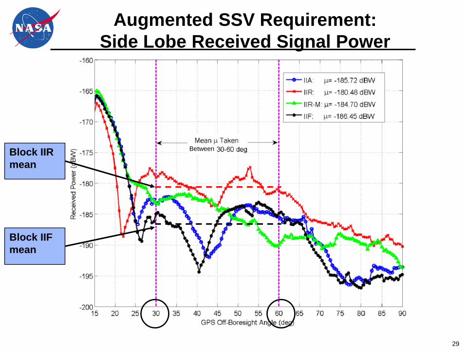
Augmented SSV Requirement:
Side Lobe Received Signal Power
Between Block IIR
mean
Block IIF
mean
30
GPS III Minimum Side Lobe Received Signal Power
(dBW) Requirement
Signal
Mean Power
(dBW)
Mean Power Minus
Standard Deviation
Power (dBW)
Off-Nadir Angle
(degrees)
L1 P(Y) TBD TBD 30 to 60 (TBR)
L1 C/A (TBR) -186.0 -190.0 30 to 60 (TBR)
L1 M TBD TBD 30 to 60 (TBR)
L1C TBD TBD 30 to 60 (TBR)
L1 composite
L2 P(Y) TBD TBD 30 to 60 (TBR)
L2 C/A or L2C TBD TBD 30 to 60 (TBR)
L2 M TBD TBD 30 to 60 (TBR)
L2 composite
L5 I5 TBD TBD 30 to 60 (TBR)
L5 Q5 TBD TBD 30 to 60 (TBR)
L5 composite
• 50% of SSV signals within the off-Nadir angle beamwidth shall be above the mean power
• 84% of SSV signals within the off-Nadir angle beamwidth shall be above the mean power minus standard deviation power
• Assumes 24 satellite constellation & no GPS spacecraft failures
31
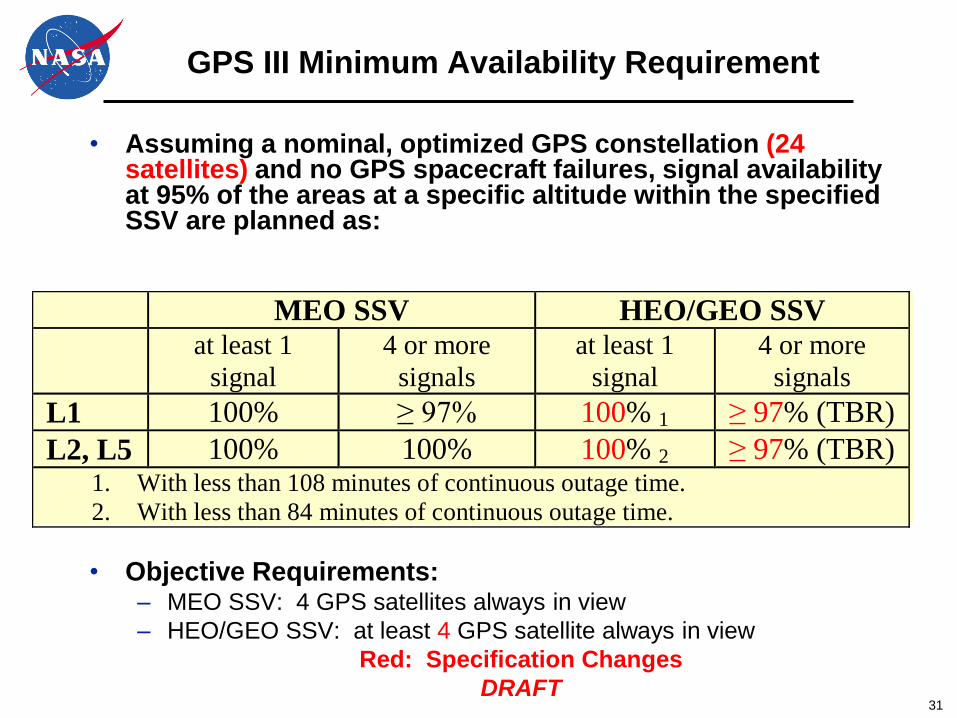
GPS III Minimum Availability Requirement
• Assuming a nominal, optimized GPS constellation (24 satellites) and no GPS spacecraft failures, signal availability at 95% of the areas at a specific altitude within the specified SSV are planned as:
– HEO/GEO SSV: at least 4 GPS satellite always in view
Red: Specification Changes
DRAFT
MEO SSV HEO/GEO SSV
at least 1
signal
4 or more
signals
at least 1
signal
4 or more
signals
L1 100% ≥ 97% 100% 1 ≥ 97% (TBR)
L2, L5 100% 100% 100% 2 ≥ 97% (TBR) 1. With less than 108 minutes of continuous outage time.
2. With less than 84 minutes of continuous outage time.
32
Summary and Closing
Remarks
33
Closing Remarks
• NASA, NOAA, DoD and other space GPS users rely on GPS as critical component of space navigation infrastructure over an expanding range of orbital applications
• Space user community is still vulnerable to GPS constellation design changes because requirements not explicitly stated; specifically the side lobe signals
• Proposed SSV requirements update: – Maintains backward compatibility with current constellation
– Identifies potential areas for improved performance through objective requirements
– Provides a green-light for civil and military space missions considering future operational use of GPS beyond LEO
• Interoperability for all space users will be enhanced if other PNT service providers such as Galileo also implement similar requirements/operational capabilities.
– This issue has been actively worked as part of ICG meetings since 2011
Protection of GPS Side Lobe Signals through
Specification is Critically Important to “Do No Harm”
to Current and Future Users of the SSV
34
Way Ahead
• Flesh out side lobe requirement TBDs via flight
data and analysis
• Socialize SSV requirement changes through Civil
and DoD communities
• Work with GPS Directorate, AF and DoD leadership