28


GR5 Camping guide
First edition
Espoo, Finland 2014
© Antti Rantanen
a.rantsu at hotmail.com
http://longdistancetrail.wordpress.com/
Published under Creative Commons Attribution-NonCommercial 4.0 (CC BY-NC 4.0)
(free to share, copy and remix, but credit always and for non-commercial use only)
Cover, art and photographs: Antti Rantanen
All maps: © OpenStreetMap contributors, tiles courtesy of Andy Allen / CC by 2.0
Base building symbol: Icomoon at flaticon.com / CC by 3.0
Base tent symbol: Freepik at flaticon.com / CC by 3.0
Base caravan symbol: Freepik at flaticon.com / CC by 3.0

INTRODUCTION
The chilly room slowly begins to get cramped as more new faces arrive. They look worn and battered by rain— all strangers. You understand only the loud greetings and that everyone seems to be in a joyful mood. Most of them look like local weekend hikers with small day packs. For you, it's hard to share their enthusiasm; overnighting at a refuge was your last resort and dictated by foul weather. English is rarely spoken and you begin to feel like an outsiders, sitting in your shadowy corner. You silently wish that you would meet a like minded long distance hiker,but there are none. You're alone on your long journey and although respected, you seem a bit odd here at the mountain refuge.
Early evening hours feel long and you wait restlessly for dinner time. You read your guidebook and explore the maps one more time. Your daily journal is already written as well as possible. You notice how hungry you are but there's no sign of dinner yet, even though it's past the announced time. People are gathering together and the talking gets suddenly more loud. And when the dinner is finally served, you know that you're about to face several hours of social challenge, where only the loudest will shine. You respond when asked something and you try to engage in conversation with others. However, the language barrier soon proves to be too much for most of the people and the politeness slowly fades. Even if the food is excellent, it's difficult to enjoy. This is simply not your playground.
It's already late and well past your normal bedtime when you finally crawl into a dark and cold dormitory. You hope to fall asleep before anyone begins snoring. Someone turns on the light, which is followed by a loud conversation. You close your eyes and imagine the surrounding wild landscape and the serenity of your own tent.
Sound familiar? Life in refuges can be great, but some of us obviously like camping more. This free guide is for those, who prefer to hike the GR5 with a tent. Hopefully it will provide some valuable information for you while planning your hike.

THINGS TO CONSIDER
Information in this guide is based on what I saw and heard during my own GR5 hike in early July of 2013. Part of the information gathered here originates from before my trip, while planning my ownhike; the rest is gathered from other people’s experiences.
Since I did my hike early in the season (starting 27th of June), after a heavy and snowy winter, the northern part of the trail still had plenty of snow, making wild camping more difficult. Keep in mindwhile reading this guide that I probably missed many good wild camping spots because of the snow. Also, I would like to point out that I'm definitely picky when selecting a spot; others might more easily find where to sleep.
Remember that each year is different; snow cover varies, cattle move around, businesses close andopen, park rules change, weather fluctuates etc. A wild camp spot that was good one year might not be usable the next year.
THEREFORE, I will hold no responsibility over the information provided in this guide. Use it responsibly and with common sense.
This guide is meant to help your planning process, to give ideas where it might be possible to overnight in a tent. Use this information together with other GR5 guidebooks, paper/digital maps and trip reports etc., in order to assess if going with a tent is the right option for you. I personally felt that the combination of wild camping and official campsites was a good solution. A few times I had to use refuges – and even a hotel – as a last resort.
Here are some other important things to consider:
This guide won't work as a map for the GR5 trail. Always have a proper map and guidebook with you. I have included only the parts that I walked myself; i.e. the start from St. Gingolph, the GR55 variant through the Vanoise national park and the finish at Nice.
In many areas camping might be forbidden, but bivouacking tolerated. Bivouacking means a one night pitch using a small tent, usually allowed between 7pm – 7am.
National parks are tricky because of the camping rules. In the Vanoise even bivouacking is usually forbidden. But in the Mercantour and the Queyras national parks, bivouacking is allowed between 7pm – 7am, if far enough off any trails or roads. Ask for the latest info beforehand, from tourist information offices – and remember to obey the rules!
When planning to wild camp, always know where the nearest refuges or other shelters are located. They are your safe houses if something goes wrong or if the weather turns suddenly nasty and better shelter is needed. Refuges are also the safest places to fill your water bottles. I don't find water from mountain streams particularly safe to drink, since cattle can graze at amazingly high altitudes. Remember to carry enough water for evening cooking and for the morning, too!
Some refuges or gîtes (an upgraded version of a refuge) may allow an overnight pitch near them, but I rarely asked about this.

After an exhausting day it is excruciating to start looking for a campsite and wandering around town. To avoid this unnecessary effort, check beforehand where, exactly, the campsites are located and mark them on your maps. Openstreetmap and Google usually have most campsites marked. If your maps are not accurate enough, print some extra A4-sized sheets with the additional info.
Be aware of grazing cattle; you don't want to wake up surrounded by curious cows, licking and tasting your stuff. This has happened to several people!
SYMBOLS
I have used only a few symbols to mark the key elements. The list of refuges or gîtes is not comprehensive, but I have tried to mention most of them.

WILD CAMP: There's a grassy clearing shortly after houses of La Planche, approximately 1h 15minfrom the trail head at St. Gingolph.
? : Possible spots around col de Bise, but plenty of cows in the area because of the Bise farmhouse.

LA CHAPELLE D´ABONDANCE: All services but no campsite
WILD CAMP: Empty chalet and grassy clearing at Les Crottes crossroads.
? : Gentle slopes when approaching refuge de Chésery.

SAMOËNS: All services
Camping Le Giffre: Nice and spacious campsite south side of Samoëns. A small welcome gift included!
(http://www.camping-samoens.com/)

CHALETS D´ANTERNE: I've heard that the owner might let you to camp near the refuge.
M ANTERNE: The owner let me to pitch my tent next to the refuge, but the space is limited. Magnificent views towards the Mont Blanc massif.
? : Pleasant alpage after Collet d´Anterne. ? : Serene spot at Lac d´Anterne, but the area might have snow late into the summer.

LES HOUCHES: All services CHAMONIX: All services
Camping Bellevue: Simple but busy campsite. No reception; an old lady gathers the fee in the evening. Very
popular among mountain climbers. Excellent views! (http://www.camping-bellevue-leshouches.com/index.html)

LES CONTAMINES-MONTJOIE: All services, the campsite 30min further
WILD CAMP: First free bivouac site is after Nant Borrat and next to a stream.
WILD CAMP: The second free bivouac site (recommended) is located at the end of the valley, nextto the refuge de la Balme. There's also a small public toilet and water source.

WILD CAMP: Grassy slopes between La Petite Berge shelter (locked) and ruins of La Grande Berge. I had difficulties to find a dry spot as the melting snow flows down from the eastern mountain walls. Nice views over the lake Roselend.

LANDRY: Hotel, restaurant, shop, bar and campsite but no sports store
Camping Les Guilles: The campsite is located at the centre of the village, behind a small shop, like a backyard.
Very quiet place in early July. Good facilities but the reception might not be open in the evening or early morning. The owner didn't speak English.

Camping and even an overnight bivouac in the Vanoise National Park is most likely prohibited so plan carefully. I've heard that one might be able to camp next to the refuge Col du Palet but otherwise the next chance is after a hard days march in Pralognan.
VAL-CLARET: Ski resort has all services but no campsite or gîte PRALOGNAN: All services, including a spacious campsite with good facilities

Another difficult stage for campers before exiting the Vanoise near Modane/Fourneaux.
MODANE/FOURNEAUX: All services
Camping Simon Jean Marc (Les Combes): The campsite is located at a street curve, south side of the river and railway line. Good
facilities. (http://camping-modane.chez-alice.fr/index-e.html)

WILD CAMP: I found a nice spot just south from the col.
? : Gentle and grassy slopes when approaching Col de la Vallée Etroite. I've heard people camping also near the lakes west from refuge du Thabor.

? : Lac Chavillon near the Col des Thures is a very idyllic spot.
Camping de la Lame: The campsite is located between the D994 road and a river. Reception opened at five pm.
You need to purchase tokens to take a shower. Nice Italian restaurant and small shop acrossthe street. (http://www.nevache-tourisme.fr/fr/campings/camping-de-la-lame_163.htm)

MONTGENÈVRE: All services but no campsite ? : Some nice, grassy slopes after Chalets des Ascles when approaching Col de
Dormillouse.
Camping Les Gentianes: Well equipped campsite at the centre of tiny village of Vachette (gîte and restaurant). Take
the signposted, 10min off-route. (http://www.campinglesgentianes.com/)

BRIANCON: All services
? : Basic unstaffed refuge of Chalets de Vers le Col and grassy slopes around it might offer a spot for camping.
Camping Le Planet: Campsite in the middle of a forest, good facilities and a tiny shop. A good pizzeria nearby.

QUEYRAS: Shop, restaurants, post office and campsite ? : Sparsely forested slopes looking to Pointe de la Selle twin towers.
CEILLAC: All services
Camping Municipal Les Moutets: Spacious campsite at the edge of Ceillac. Token-showers. (http://www.ceillac.com/campings.htm)

? : Several beautiful spots for wild camping; Lac Miroir, Lac Ste Anne and even a grassy area after descending from Col Girardin.
MALJASSET: Refuge, gîte d´étape, maison d´hôte and restaurant. According to a rumour possibility to camp next to the refuge.
LA BARGE: No services and water from the fountain was not drinkable.

WILD CAMP: I pitched my tent right after the village of Fouillouse. ? : Grassy slopes further from Fouillouse, an idyllic spot at Lac du Vallonnet and inside
the ruins of barracks de Viraysse.
LARCHE: Hotel, gîte d´étape, restaurants and post officeCamping Les Marmottes:
Nice campsite after Larche; an own restaurant and shop. (http://www.camping-marmottes.fr/)

? : Idyllic wild camping spot at Lac du Lauzanier.
BOUSIEYAS: Gîte d´étape, restaurant and basic campsite
The campsite is part of the gîte, but because of the national park rules, you're not allowed to pitch your tent before 7pm. There's a small café next to it.

ST DALMAS: Gîte d´étape, chambres d´hote, shop and restaurant ST ÉTIENNE: All services and campsite ? : Grassy gap before Col de la Colombière, but the area might have lot of sheep.
AURON: All services. The campsite is located close to the tourist information. There's no reception and only a small grass area for tents. The owner should come in the evening to collect the fee.
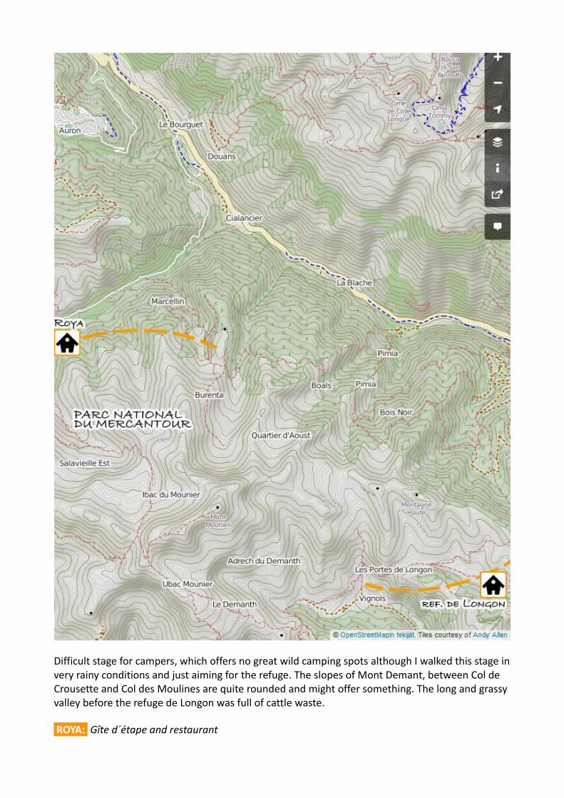
Difficult stage for campers, which offers no great wild camping spots although I walked this stage invery rainy conditions and just aiming for the refuge. The slopes of Mont Demant, between Col de Crousette and Col des Moulines are quite rounded and might offer something. The long and grassy valley before the refuge de Longon was full of cattle waste.
ROYA: Gîte d´étape and restaurant

ST SAUVEAUR SUR TINÉE: Hotel, gîte d´étape, campsite, bank, post office, shop and restaurant ROURE: Gîte d´étape
ST DALMAS: Hotel, gîte d´étape, campsite, shop and restaurantsCamping à La Ferme:
Nice campsite on the main road, 5min before reaching the centre of St Dalmas. Good facilities. (http://camping-ferme.com/)

UTELLE: Hotel, gîte d´étape, farm auberge, post office, shop and restaurants WILD CAMP: The shelter and chapel of St Antoine is located 1h from Utelle. There's a grassy
clearing for your tent, but I slept my last night on trail under the starry Mediterranean sky.
After this point there are no campsites on the way to Nice, and finding a good wild camping spot becomes much harder. My next place to sleep was on the floor of Nice airport.

Check out more useful GR5 info atlongdistancetrail.wordpress.com
HAVE A SAFE JOURNEY!- Antti -


