27
Greater Vancouver GPS Validation Network October 1997 Natural Resources Canada Geodetic Survey Division

Greater VancouverGPS Validation Network
October 1997
Natural ResourcesCanada
Geodetic SurveyDivision

Greater Vancouver GPS Validation
Network
Prepared by
Geodetic Survey Division
Natural Resources Canada
in cooperation with
Geographic Data BC
Ministry of Environment, Lands and Parks
Additional copies of this
document are available from:
Geographic Data BC
Geo-Spatial Reference Unit
Fourth Floor, 1802 Douglas Street
Victoria, British Columbia
V0T 4K6
Tel: (250) 387-3164
Fax: (250) 356-7831

ii
Greater Vancouver GPS Validation Network - October 1997
Foreword
The purpose of this booklet is to provide the basic information requiredfor users to test their GPS equipment and positioning methodology onthe Greater Vancouver GPS Validation Network. Please contactGeographic Data BC, Ministry of Environment, Lands and Parks, forinformation related to this network that is not included in thisdocument.

iii
Greater Vancouver GPS Validation Network - October 1997
Table of Contents
Page1. Introduction to GPS Validation Networks .................................... 1
Background.......................................................................................................1Applications ......................................................................................................1Characteristics...................................................................................................3
2. The Greater Vancouver GPS Validation Network ....................... 4
Description .......................................................................................................4Determination of Network Validation Values.....................................................4
Appendices
A. Station Descriptions and Site Sketches...........................................................7
Notice to Users .................................................................................................7GCM 192740 (NGDB B192740) Surrey Nursery ..............................................8GCM 202697 (NGDB B202697) Green Timbers Nursery..................................9GCM 266148 (NGDB B266148) Tynehead Park.............................................10GCM 326595 (NGDB B326595) Pier 3 West Vancouver Baseline ..................11GCM 336131 (NGDB B336131) Pier 1 Surrey Baseline..................................12GCM 693275 (NGDB B693275) Pier 6 Surrey Baseline..................................13GCM 777771 (NGDB B777771) Fraser River Heritage Park...........................14
B. Tables of Values.............................................................................................15
1. Ellipsoidal Coordinates ..............................................................................152. Geocentric Cartesian Coordinates ..............................................................163. UTM Mapping Plane Coordinates..............................................................164. Interstation Cartesian Coordinate Differences ............................................175. Absolute 95% 3-D Confidence Ellipsoids...................................................186. Absolute 95% Horizontal Confidence Ellipses............................................187. Absolute 95% Vertical Confidence Intervals ..............................................188. Relative 95% 3-D Confidence Ellipsoids ....................................................199. Relative 95% Horizontal Confidence Ellipses.............................................2010. Relative 95% Vertical Confidence Intervals ...............................................20
C. Contacts for Additional Information............................................................21
D. Pier Design - Greater Vancouver GPS Validation Network ForcedCentering Pillars............................................................................................22
1. Cross Section ............................................................................................222. Forced Centering Plate ..............................................................................23

1
Greater Vancouver GPS Validation Network - October 1997
1. Introduction to GPS Validation Networks
Background
The Global Positioning System (GPS) has dramatically reshaped surveying and navigation
in many parts of the world. The use of GPS positioning has become increasingly widespread.
The need for a “truth” against which to test GPS positioning accuracy and precision has led to the
establishment of GPS validation networks across Canada, also known as basenets, to serve as a
physical standard for evaluating GPS equipment, software and positioning methodologies.
The first GPS validation network was established in the Ottawa region in 1988. Since that
time other such networks have been established across the country, in collaboration with the
provincial agencies responsible for geodetic surveying within their jurisdictions. The map that
follows shows the locations of other GPS validation networks in Canada. Geodetic Survey
Division (GSD), Natural Resources Canada (NRCan) maintains sole responsibility of the Ottawa
network, including site maintenance and dissemination of basenet-related information such as
data. For other GPS validation networks, including the Greater Vancouver basenet, this
responsibility is shared with the provincial survey agencies.
Geographic Data BC located, designed and installed the Okanagan and Greater
Vancouver networks in order to serve the needs of provincial users. GSD, NRCan established the
validation coordinates for the network through precise GPS measurements. Each GPS validation
network was initially established using at least two separate measurement campaigns in different
years. Subsequent measurements may be performed periodically to check on pier movement.
Applications
GPS validation networks are mainly used to evaluate results obtained using a specific
combination of GPS equipment, software, and observation procedures. The full range of GPS
equipment, from hand-held C/A code receivers to geodetic quality dual frequency receivers, may
be checked. Similarly, the accuracies obtainable from different observation procedures such as
single point positioning, differential code, kinematic or static positioning techniques may be
assessed.

2
Greater Vancouver GPS Validation Network - October 1997

3
Greater Vancouver GPS Validation Network - October 1997
The validation networks may also be used to evaluate proposals from GPS survey
contractors. A "validation survey" on a GPS basenet may be required to assess the proposed GPS
positioning system, and determine with confidence whether it can meet contract accuracy
requirements. A positioning system in this context includes the equipment and procedures used
for data collection as well as the software and procedures used for the data processing and
adjustment.
Characteristics
A GPS validation network is typically comprised of between 5 and 10 forced centering
pillars or piers. Usually two of these pillars are also part of an Electronic Distance Measurement
(EDM) calibration baseline and form the core of the network. The network design provides GPS
baselines of varying lengths, usually ranging between 1 and 100 kilometres, and the design and
location of pillars is such that:
• forced centering is used to eliminate centering error ;
• sites are easily accessible;
• sites are generally clear of obstructions above 10 degrees from the horizon; and
• for stability and longevity, pillar monumentation is carried out using the same
specifications as for EDM calibration baseline pillars. (See Appendix D.)
The following section contains a description and map of the Greater Vancouver GPS validation
network, and a brief explanation of the determination of coordinates listed in this document.

4
Greater Vancouver GPS Validation Network - October 1997
2. The Greater Vancouver GPS Validation Network
Description
The Greater Vancouver GPS validation network was constructed in 1993 by the B.C.
Ministry of Environment, Lands and Parks, and is comprised of seven concrete forced centering
pillars. Two of these pillars, National Geodetic Data Base (NGDB) numbered stations B336131
(Pier 1) and B693275 (Pier 6), are also coincident with the Surrey EDM baseline, and B326595
(Pier 3) is coincident with the West Vancouver EDM baseline. Pillar B192740 (Surrey Nursery)
was included in the B.C./Washington State GPS on Benchmarks project. A cross reference list for
corresponding provincial Geodetic Control Monument (GCM) numbers is provided in Appendices
A and B.
The network, which is centred in Surrey, spans the entire lower Fraser Valley from Mission
to West Vancouver. The basic configuration of the network, as shown on the following map,
provides baseline lengths ranging from 800 metres to 74 kilometres.
The basenet was first observed with GPS in 1993 by GSD, NRCan, with a second series
of measurements carried out in 1994. Ashtech P-12 and Z-12 GPS receivers were used to collect
the observations.
In addition to the three-dimensional positions established with GPS, all the pillars in the
network have orthometric heights established through first order levelling. Descriptions and site
sketches for each of the pillars, as well as a notice to users of this validation network, are provided
in Appendix A.
Determination of Network Validation Values
Coordinate values for the Greater Vancouver GPS validation network were determined
using data from two complete sets of observations carried out in 1993 and 1994, as shown in the
table that follows. For each epoch, or year, the GPS data was processed in session mode using
the Bernese GPS processing software.
The network validation coordinates appearing in this document were produced by
combining all sessions from the two measurement epochs together in a minimally constrained
three-dimensional least squares adjustment. Station B336131 (Pier 1) was constrained to its
NAD83 Canadian Spatial Reference System (CSRS) coordinates. In tests carried out, to check
for pier movement and statistical compatibility between the epochs, there was no indication of
significant pier movement or distortion.

Abbotsford
Langley City
New Westminster
North Vancouver
Surrey
White Rock
Delta
Vancouver
West Vancouver
Mission
B777771
B192740B336131
B693275
B202697
B266148
B326595
The Greater Vancouver GPS Validation Network
GPS Basenet Station
Municipality
1
23
1A
15
7
1
1
1A
7
99
99A
17
99A
99
Note: Points on this map have been identified by their NGDB* station number. Corresponding GCM** station numbers are provided below:
NGDB Number GCM Number
B192740 192740B202697 202697B266148 266148B326595 326595B336131 336131B693275 693275B777771 777771
* NGDB: National Geodetic Data Base** GCM: Geodetic Control Marker
7 14 21 kilometres0

6
Greater Vancouver GPS Validation Network - October 1997
Measurement History - Greater Vancouver GPS Validation Network
Year ReceiverType
Number ofReceivers
SessionLength(hours)
Number ofSessions
GPS ProcessingSoftware
1993 AshtechP-12
6 5 5 Bernese v3.4
1994 AshtechZ-12
6 6 3 Bernese v3.4
All coordinate values and error estimates can be found in Appendix B. The ellipsoidal,
geocentric Cartesian, and mapping plane coordinates for network piers are given in Tables 1, 2
and 3, respectively. The Cartesian coordinate differences between each of the pillars can be found
in Table 4. Absolute 95% confidence regions are provided in Tables 5, 6, and 7, while relative
95% confidence regions are provided in Tables 8, 9, and 10. Note that corresponding covariance
data is available, as described in Appendix C.
Separate confidence regions are given for the three-dimensional (3-D), horizontal (2-D)
and vertical (1-D) coordinates. This is necessary because the expansion factors used to compute
the 95% confidence regions are different for each case. The 3-D confidence ellipsoids should be
used when validating 3-D results. Similarly, the horizontal confidence ellipses should be used
when validating only horizontal results. The vertical confidence intervals should be used when
validating only vertical results. Separate horizontal and vertical validation tests must not be used
together as a validation of 3-D results.
The coordinates given in this document are to be used for validation purposes only. If
needed, adopted NAD83 survey control values are available from the Geo-Spatial Reference Unit,
Geographic Data BC (see Appendix C).
The descriptions, sketches and coordinate values provided in this booklet are intended to
provide all the basic information needed to use the Greater Vancouver GPS validation network as
a physical standard for testing and validating GPS positioning systems to suit specific applications.
Details on obtaining further information, data or documents are given in Appendix C.

7
Greater Vancouver GPS Validation Network - October 1997
Appendix A
Station Descriptions and Site Sketches
GCM Number NGDB Number Station Name
192740 B192740 Surrey Nursery
202697 B202697 Green Timbers Nursery
266148 B266148 Tynehead Park
326595 B326595 Pier 3 West Vancouver Baseline
336131 B336131 Pier 1 Surrey Baseline
693275 B693275 Pier 6 Surrey Baseline
777771 B777771 Fraser River Heritage Park
Notice to Users
• The Greater Vancouver GPS validation network is located on public property. Any damage to private or public property which may occur during the use of the network is the responsibility of the user.
• Users must obey normal traffic safety laws.
• The network was installed with the cooperation of local residents and common courtesy should be observed during occupations.
• Some of the adjacent roads are not paved; please try to keep dust levels at a minimum by driving at a moderate rate of speed.
• Users may reserve the basenet, for validation purposes only, by contacting the agency specified on the station diagrams.
• Users are also asked to assist in the preservation of the network pillars. Please report any damage or potential dangers to:
Ministry of Environment, Lands and ParksGeographic Data BCGeo-Spatial Reference Unit4th Floor, 1802 Douglas StreetVictoria, British ColumbiaV8T 4K6Tel: (250) 387-3164Fax: (250) 356-7831

8
Greater Vancouver GPS Validation Network - October 1997
GREATER VANCOUVER GPSVALIDATION NETWORKSTATION NAME - SURREY NURSERYGCM NO. 192740 (NGDB B192740)
SCALED COORDINATESLAT:LON:ELEV:
49Þ3'40"122Þ42'7"47 m
Not to scale
t r e e s
Pier 2
Pier 3
Pier 4
Min. of ForestsTree Nursery
N
SeedCenter
gate
Bumper postsx x
••
gate
Pier 6
Pier 5office
gravel road
32nd Avenue
Pier 1
192740
OWNER: Ministry of Forests. Surrey Nursery. Hours of operation:Monday-Friday 08:00-16:00. Any access outside of operating hours please makearrangements with Nursery Superintendent, phone 604-576-9161.
DESCRIPTION: Marked by a cylindrical concrete pillar with a stainless steel forced centeringbaseplate set in the top.
Surrey. From the intersection of 200th Street and 32nd Avenue, proceedEast 1.7 km along 32nd Avenue to 192nd Street. Proceed North 0.9 kmalong 192nd Street to the gate at the "Surrey Nursery and Seed OrchardsLand". Pass through the gate and turn South along access road past theSurrey Baseline to the other side of the nursery. Station is located 10.5 mSouth and 1.5 m East of gate and fence corner to Seed Centre.
ACCESS:
access road
Station 192740 Surrey Nursery (NGDB B192740)
NOTE: Centering pins and wrench must be obtained from Peter Mueller, BCLSDistrict of Surrey (14245-56th Avenue, Surrey, B.C., V3X 3A2, 604-591-4260)

9
Greater Vancouver GPS Validation Network - October 1997
GREATER VANCOUVER GPSVALIDATION NETWORKSTATION NAME - GREEN TIMBERS NURSERYGCM NO. 202697 (NGDB B202697)
SCALED COORDINATESLAT:LON:ELEV:
49Þ10'41"122Þ49'48"85 m
Not to scale
• •
15'15'
treefarm
•
•
•
• PP
PP PP
PP
PP
PP
p v m t
p v m t
p v m t
maingate gate
Fraser Highway (Hwy. 1A)
pvmt = pavementPP = power pole
gate
field
Station 202697 Green Timbers Nursery (NGDB B202697)
202697information
hut
Marked by a cylindrical concrete pillar with a stainless steel forced centeringbaseplate set in the top.
DESCRIPTION:
Surrey. From the intersection of Fraser Highway and King George Highway,take the Fraser Highway East 2 blocks to 140th Street, go North on 140th forapproximately 1 km and take the first turn off to the East. There is a gate. Akey can be borrowed to open the gate. Proceed through the first intersectionand make a right at the next intersection. There should be 5 buildings arounda paved court. Go straight so that you take the road which goes behind thefurthest building from the intersection. Once at the end, you must make a right.The monument is 15 m Southwest from the corner.
ACCESS:
The centering pins and wrench must be obtained from Peter Mueller, BCLSDistrict of Surrey (14245-56th Avenue, Surrey, B.C., V3X 3A2, 604-591-4260).
NOTE:
Ministry of Forests. Surrey Nursery . Hours of operation: Monday-Friday 08:00-16:00.Any access outside of operating hours please make arrangements with NurserySuperintendent, phone 604-930-3325.
OWNER:

10
Greater Vancouver GPS Validation Network - October 1997
GREATER VANCOUVER GPSVALIDATION NETWORK
STATION NAME - TYNEHEAD PARKGCM NO. 266148 (NGDB B266148)
SCALED COORDINATESLAT:LON:ELEV:
49Þ10'41"122Þ44'6"68 m
Not to scalex x x x x x x x
x
fence
trees
bushes
TyneheadPark(horse pasture)
10 m
schoolyard
Highway #1 Trans Canada
True North
Station 266148 Tynehead Park (NGDB B266148)
266148
Tynehead Park - Greater Vancouver Regional DistrictOWNER:
The centering pins and wrench must be obtained from Peter Mueller, BCLSDistrict of Surrey (14245-56th Avenue, Surrey, B.C., V3X 3A2, 604-591-4260).
NOTE:
Surrey. From the intersection of Highway #1 (T rans Canada) and 176 Streetoverpass proceed South on 176 Street 250 m, turn right (West) onto TyneheadDrive. Proceed Northwest on Tynehead Drive 50 m. Monument is located on theWest side of road marked by a forced centering steel plate set in the top ofa concrete pier.
ACCESS:
Marked by a cylindrical concrete pillar with a stainless steel forced centeringbaseplate set in the top.
DESCRIPTION:
11
Greater Vancouver GPS Validation Network - October 1997
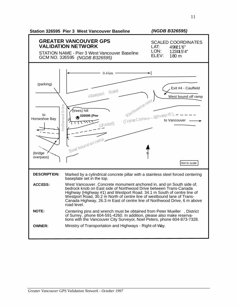
GREATER VANCOUVER GPSVALIDATION NETWORKSTATION NAME - Pier 3 West Vancouver BaselineGCM NO. 326595 (NGDB B326595)
SCALED COORDINATESLAT:LON:ELEV:
49Þ21'6"123Þ15'4"180 m
Not to scale
N
326595 (Pier 3)
(trees) hill
West bound off ramp
Exit #4 - Caulfield
toHorseshoe Bay
(parking)
(bridgeoverpass)
to Vancouver
0.4 km
Station 326595 Pier 3 West Vancouver Baseline (NGDB B326595)
Ministry of Transportation and Highways - Right-of-Way.OWNER:
DESCRIPTION: Marked by a cylindrical concrete pillar with a stainless steel forced centeringbaseplate set in the top.
ACCESS: West Vancouver. Concrete monument anchored in, and on South side of,bedrock knob on East side of Northwood Drive between Trans-CanadaHighway (Highway #1) and Westport Road. 34.1 m South of centre line ofWestport Road, 30.2 m North of centre line of westbound lane of Trans-Canada Highway, 26.3 m East of centre line of Northwood Drive, 6 m aboveroad level.
Centering pins and wrench must be obtained from Peter Mueller , Districtof Surrey , phone 604-591-4260. In addition, please also make reserva-tions with the Vancouver City Surveyor, Noel Peters, phone 604-873-7328.
NOTE:

12
Greater Vancouver GPS Validation Network - October 1997
GREATER VANCOUVER GPSVALIDATION NETWORKSTATION NAME - PIER 1 SURREY BASELINEGCM NO. 336131 (NGDB B336131)
SCALED COORDINATESLAT:LON:ELEV:
49Þ3'36"122Þ41'28"48 m
32nd AvenueNot to scale
t r e e s
Pier2
Pier3
Pier4
Min. of ForestsTree Nursery
336131(Pier 1)
N
SeedCenter
gate
Bumper postsx x
••
gate
Pier6
Pier5office
gravel road
Station 336131 Pier 1 Surrey Baseline (NGDB B336131)
Marked by a cylindrical concrete pillar with a stainless steel forced centeringbaseplate set in the top.
DESCRIPTION:
Surrey. From intersection of 200th Street and 32nd Avenue proceed East 1.7 kmalong 32nd Avenue to 192nd Street. Proceed North 0.9 km along 192nd Street tothe gate at the "Surrey Nursery and Seed Orchards Land". Pass through gate andturn South. The station is 800 m South of the gate. The monument is Pier #1of the Surrey Baseline and is painted white with a black #1 on the West side ofit. Marked by a forced centering steel plate on top of a concrete pier.
ACCESS:
The centering pins and wrench must be obtained from Peter Mueller, BCLSDistrict of Surrey (14245-56th Avenue, Surrey, B.C., V3X 3A2, 604-591-4260).
NOTE:
Ministry of Forests. Surrey Nursery. Hours of operation:Monday-Friday 08:00-16:00. Any access outside of operating hours please makearrangements with Nursery Superintendent, phone 604-576-9161.
OWNER:
13
Greater Vancouver GPS Validation Network - October 1997
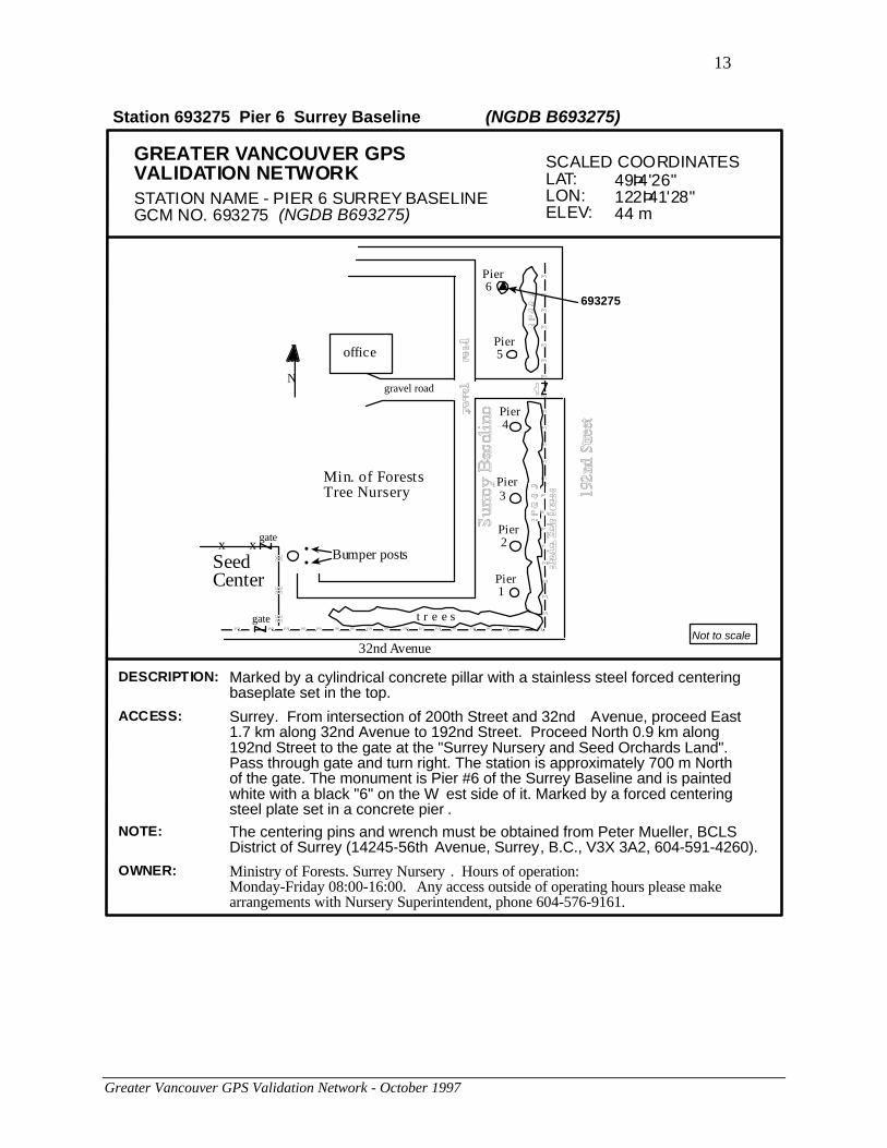
GREATER VANCOUVER GPSVALIDATION NETWORKSTATION NAME - PIER 6 SURREY BASELINEGCM NO. 693275 (NGDB B693275)
SCALED COORDINATESLAT:LON:ELEV:
49Þ4'26"122Þ41'28"44 m
Not to scale
t r e e s
Pier 2
Pier 3
Pier 4
Min. of ForestsTree Nursery
N
SeedCenter
gate
Bumper postsx x
••
gate
Pier 6
Pier 5office
gravel road
32nd Avenue
Pier 1
693275
Station 693275 Pier 6 Surrey Baseline (NGDB B693275)
DESCRIPTION: Marked by a cylindrical concrete pillar with a stainless steel forced centeringbaseplate set in the top.
NOTE: The centering pins and wrench must be obtained from Peter Mueller, BCLSDistrict of Surrey (14245-56th Avenue, Surrey, B.C., V3X 3A2, 604-591-4260).
OWNER: Ministry of Forests. Surrey Nursery . Hours of operation:Monday-Friday 08:00-16:00. Any access outside of operating hours please makearrangements with Nursery Superintendent, phone 604-576-9161.
ACCESS: Surrey. From intersection of 200th Street and 32nd Avenue, proceed East1.7 km along 32nd Avenue to 192nd Street. Proceed North 0.9 km along192nd Street to the gate at the "Surrey Nursery and Seed Orchards Land".Pass through gate and turn right. The station is approximately 700 m Northof the gate. The monument is Pier #6 of the Surrey Baseline and is paintedwhite with a black "6" on the W est side of it. Marked by a forced centeringsteel plate set in a concrete pier .
14
Greater Vancouver GPS Validation Network - October 1997
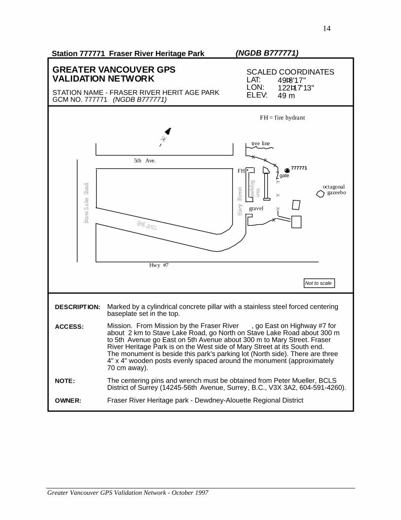
GREATER VANCOUVER GPSVALIDATION NETWORK
STATION NAME - FRASER RIVER HERIT AGE PARKGCM NO. 777771 (NGDB B777771)
SCALED COORDINATESLAT:LON:ELEV:
49Þ8'17"122Þ17'13"49 m
Not to scale
FH = fire hydrant
•FH 777771
tree line
octagonal gazeebo
5th Ave.
Hwy #7
XX
X
X
gravel
gate
Station 777771 Fraser River Heritage Park (NGDB B777771)
Marked by a cylindrical concrete pillar with a stainless steel forced centeringbaseplate set in the top.
DESCRIPTION:
The centering pins and wrench must be obtained from Peter Mueller, BCLSDistrict of Surrey (14245-56th Avenue, Surrey, B.C., V3X 3A2, 604-591-4260).
NOTE:
Fraser River Heritage park - Dewdney-Alouette Regional DistrictOWNER:
Mission. From Mission by the Fraser River , go East on Highway #7 forabout 2 km to Stave Lake Road, go North on Stave Lake Road about 300 mto 5th Avenue go East on 5th Avenue about 300 m to Mary Street. FraserRiver Heritage Park is on the West side of Mary Street at its South end.The monument is beside this park's parking lot (North side). There are three4" x 4" wooden posts evenly spaced around the monument (approximately70 cm away).
ACCESS:

15
Greater Vancouver GPS Validation Network - October 1997
Appendix B
Tables of Values
(Greater Vancouver GPS Validation Network - 1993 & 1994 epochs combined)
Warning to Users: These coordinates are to be used for validation only, and are not to beconsidered survey control values. Control coordinates may be obtained from the Geo-SpatialReference Unit as described in Appendix C. Note that station B336131 was constrained to itsNAD83(CSRS) value in the adjustment that produced these coordinates.
Station Number Cross Reference List
GCM Number NGDB Number Station Name
192740 B192740 Surrey Nursery
202697 B202697 Green Timbers Nursery
266148 B266148 Tynehead Park
326595 B326595 Pier 3 West Vancouver Baseline
336131 B336131 Pier 1 Surrey Baseline
693275 B693275 Pier 6 Surrey Baseline
777771 B777771 Fraser River Heritage Park
Table 1: Ellipsoidal Coordinates
NGDB # LatitudeNorth(d m s)
LongitudeWest
(d m s)
EllipsoidalHeight
(m)
B266148 49 10 44.29305 122 44 06.86721 49.262
B336131 49 03 39.46757 122 41 30.28191 28.976
B202697 49 10 42.77284 122 49 48.48202 65.873
B693275 49 04 27.05088 122 41 30.79476 25.107
B192740 49 03 42.13248 122 42 08.88031 27.248
B326595 49 21 06.17499 123 15 03.72812 161.860
B777771 49 08 16.81459 122 17 15.56325 31.111

16
Greater Vancouver GPS Validation Network - October 1997
Table 2: Geocentric Cartesian Coordinates
NGDB # X (m) Y (m) Z (m)
B266148 -2258975.379 -3513959.729 4803630.448
B336131 -2261659.401 -3524013.294 4795025.822
B202697 -2264817.236 -3510252.594 4803612.318
B693275 -2261066.979 -3523070.938 4795985.963
B192740 -2262284.600 -3523536.723 4795078.460
B326595 -2282575.322 -3481368.720 4816252.770
B777771 -2233291.093 -3534402.780 4800637.234
Table 3: UTM Mapping Plane Coordinates
NGDB # Northing (m) Easting (m) Zone
B266148 5447385.107 519295.661 10
B336131 5434278.569 522519.005 10
B202697 5447318.312 512379.962 10
B693275 5435747.877 522502.629 10
B192740 5434357.732 521735.424 10
B326595 5466585.800 481768.267 10
B777771 5443041.502 551958.313 10
Warning to Users: Distances derived from UTM coordinates are distorted. They cannotbe compared to spatial distances derived from Cartesian or ellipsoidal coordinates withoutapplying the proper scale factors. UTM coordinates and distances should only be comparedto other UTM coordinates and distances. For more information, please contact GeodeticSurvey as described in Appendix C.
17
Greater Vancouver GPS Validation Network - October 1997
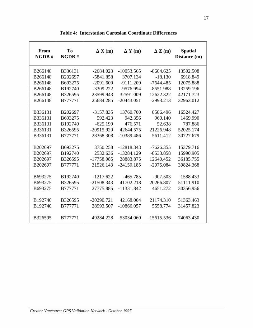
Table 4: Interstation Cartesian Coordinate Differences
FromNGDB #
ToNGDB #
∆∆ X (m) ∆∆ Y (m) ∆∆ Z (m) SpatialDistance (m)
B266148 B336131 -2684.023 -10053.565 -8604.625 13502.508B266148 B202697 -5841.858 3707.134 -18.130 6918.849B266148 B693275 -2091.600 -9111.209 -7644.485 12075.888B266148 B192740 -3309.222 -9576.994 -8551.988 13259.196B266148 B326595 -23599.943 32591.009 12622.322 42171.723B266148 B777771 25684.285 -20443.051 -2993.213 32963.012
B336131 B202697 -3157.835 13760.700 8586.496 16524.427B336131 B693275 592.423 942.356 960.140 1469.990B336131 B192740 -625.199 476.571 52.638 787.886B336131 B326595 -20915.920 42644.575 21226.948 52025.174B336131 B777771 28368.308 -10389.486 5611.412 30727.679
B202697 B693275 3750.258 -12818.343 -7626.355 15379.716B202697 B192740 2532.636 -13284.129 -8533.858 15990.905B202697 B326595 -17758.085 28883.875 12640.452 36185.755B202697 B777771 31526.143 -24150.185 -2975.084 39824.368
B693275 B192740 -1217.622 -465.785 -907.503 1588.433B693275 B326595 -21508.343 41702.218 20266.807 51111.910B693275 B777771 27775.885 -11331.842 4651.272 30356.956
B192740 B326595 -20290.721 42168.004 21174.310 51363.463B192740 B777771 28993.507 -10866.057 5558.774 31457.823
B326595 B777771 49284.228 -53034.060 -15615.536 74063.430

18
Greater Vancouver GPS Validation Network - October 1997
Table 5: Absolute 95% 3-D Confidence Ellipsoids
NGDB # Major Semi-axis
MediumSemi-axis
MinorSemi-axis
length(m)
az.(deg)
inc.(deg)
length (m)
az.(deg)
inc.(deg)
length (m)
az.(deg)
inc.(deg)
B266148 0.03 187 89 0.01 38 1 0.01 128 0
B336131 0.03 196 89 0.01 24 1 0.01 114 0
B202697 0.03 186 89 0.01 27 1 0.01 117 0
B693275 0.03 192 89 0.01 23 1 0.01 113 0
B192740 0.03 201 89 0.02 23 1 0.01 113 0
B326595 0.03 174 89 0.01 22 1 0.01 112 0
B777771 0.04 215 89 0.01 30 1 0.01 120 0
Table 6: Absolute 95%Horizontal Confidence Ellipses
Table 7: Absolute 95%Vertical Confidence Intervals
NGDB # MajorSemi-axis
MinorSemi-axis
NGDB # +/-
length(m)
az.(deg)
length(m)
az.(deg)
length(m)
B266148 0.01 38 0.01 128 B266148 0.02B336131 0.01 24 0.01 114 B336131 0.02B202697 0.01 27 0.01 117 B202697 0.02B693275 0.01 23 0.01 113 B693275 0.02B192740 0.01 23 0.01 113 B192740 0.02B326595 0.01 21 0.01 111 B326595 0.02B777771 0.01 30 0.01 120 B777771 0.02
Note: The semi-axes of the absolute confidence regions are shown to the nearest centimetre (rather thanmillimetre), because absolute accuracy with respect to the reference system NAD83(CSRS) is known only atthe centimetre level.

19
Greater Vancouver GPS Validation Network - October 1997
Table 8: Relative 95% 3-D Confidence Ellipsoids
FromNGDB #
ToNGDB #
MajorSemi-axis
MediumSemi-axis
MinorSemi-axis
length(m)
az.(deg)
inc.(deg)
length(m)
az.(deg)
inc.(deg)
length(m)
az.(deg)
inc.(deg)
B266148 B336131 0.015 200 89 0.003 6 1 0.002 96 0B266148 B202697 0.016 192 89 0.003 13 1 0.002 103 0B266148 B693275 0.015 192 89 0.003 7 1 0.002 97 0B266148 B192740 0.017 209 89 0.003 8 1 0.002 98 0B266148 B326595 0.018 191 89 0.003 347 1 0.003 77 1B266148 B777771 0.019 216 89 0.003 14 1 0.003 104 1
B336131 B202697 0.015 198 89 0.003 0 1 0.002 90 0B336131 B693275 0.015 198 89 0.003 12 1 0.002 102 0B336131 B192740 0.015 216 89 0.003 13 1 0.002 103 0B336131 B326595 0.017 200 89 0.003 332 1 0.003 62 1B336131 B777771 0.017 215 89 0.003 30 1 0.002 120 0
B202697 B693275 0.016 189 89 0.003 2 1 0.003 92 0B202697 B192740 0.016 207 89 0.003 2 1 0.002 92 1B202697 B326595 0.018 202 89 0.003 349 1 0.003 79 1B202697 B777771 0.018 211 89 0.003 15 1 0.003 105 0
B693275 B192740 0.017 207 89 0.003 13 1 0.002 103 0B693275 B326595 0.018 196 89 0.004 338 1 0.003 68 1B693275 B777771 0.018 211 89 0.003 23 1 0.003 113 0
B192740 B326595 0.018 206 89 0.004 338 1 0.003 68 1B192740 B777771 0.019 217 89 0.003 26 1 0.003 116 0
B326595 B777771 0.019 215 89 0.004 114 0 0.003 24 1
20
Greater Vancouver GPS Validation Network - October 1997
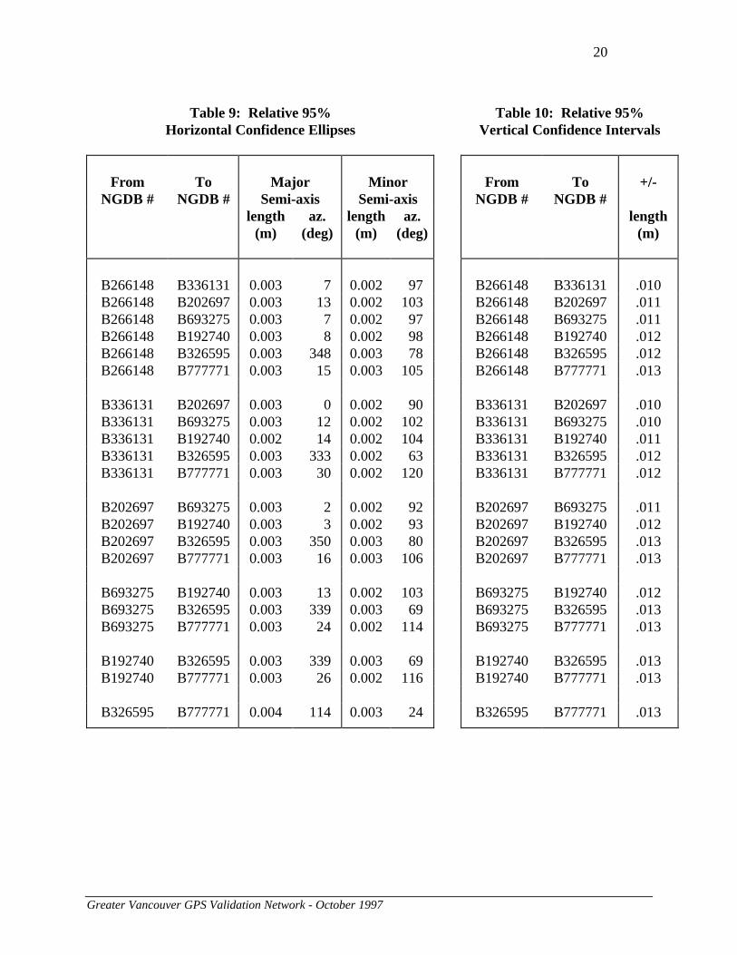
Table 9: Relative 95%Horizontal Confidence Ellipses
Table 10: Relative 95%Vertical Confidence Intervals
FromNGDB #
ToNGDB #
MajorSemi-axis
MinorSemi-axis
FromNGDB #
ToNGDB #
+/-
length(m)
az.(deg)
length(m)
az.(deg)
length(m)
B266148 B336131 0.003 7 0.002 97 B266148 B336131 .010B266148 B202697 0.003 13 0.002 103 B266148 B202697 .011B266148 B693275 0.003 7 0.002 97 B266148 B693275 .011B266148 B192740 0.003 8 0.002 98 B266148 B192740 .012B266148 B326595 0.003 348 0.003 78 B266148 B326595 .012B266148 B777771 0.003 15 0.003 105 B266148 B777771 .013
B336131 B202697 0.003 0 0.002 90 B336131 B202697 .010B336131 B693275 0.003 12 0.002 102 B336131 B693275 .010B336131 B192740 0.002 14 0.002 104 B336131 B192740 .011B336131 B326595 0.003 333 0.002 63 B336131 B326595 .012B336131 B777771 0.003 30 0.002 120 B336131 B777771 .012
B202697 B693275 0.003 2 0.002 92 B202697 B693275 .011B202697 B192740 0.003 3 0.002 93 B202697 B192740 .012B202697 B326595 0.003 350 0.003 80 B202697 B326595 .013B202697 B777771 0.003 16 0.003 106 B202697 B777771 .013
B693275 B192740 0.003 13 0.002 103 B693275 B192740 .012B693275 B326595 0.003 339 0.003 69 B693275 B326595 .013B693275 B777771 0.003 24 0.002 114 B693275 B777771 .013
B192740 B326595 0.003 339 0.003 69 B192740 B326595 .013B192740 B777771 0.003 26 0.002 116 B192740 B777771 .013
B326595 B777771 0.004 114 0.003 24 B326595 B777771 .013

21
Greater Vancouver GPS Validation Network - October 1997
Appendix C
Contacts for Additional Information
The following information is available in various formats and on different media, including
computer diskette, from the Geo-Spatial Reference Unit (see below):
• Adopted NAD83 survey control values for network piers
• Official validation coordinates (in ellipsoidal, mapping plane or Cartesian format) as theyappear in this document
• Coordinates and associated covariance matrix for network piers
Ministry of Environment, Lands and ParksGeographic Data BCGeo-Spatial Reference Unit4th Floor, 1802 Douglas StreetVictoria, British ColumbiaV8T 4K6
Tel: (250) 387-3164Fax: (250) 356-7831WWW: http://www.env.gov.bc.ca/gdbc/
For more information on the Surrey EDM calibration baseline, please contact the above address.
For more information on the Greater Vancouver GPS validation network analysis, anddetermination of coordinate values contained in this guide, contact:
Client Services SectionGeodetic Survey DivisionNatural Resources Canada615 Booth StreetOttawa, OntarioK1A 0E9
Tel. (613) 995-4410 or 992-2061Fax. (613) 995-3215Email: [email protected]

22
Greater Vancouver GPS Validation Network - October 1997
Appendix D
Ministry of Environment, Lands and Parks
Geographic Data BC
Pier Design - Greater Vancouver GPS Validation Network
Forced Centering Pillars
D.1 Cross Section
BEDROCK BEDROCK
S O I L S O I L
2.54 CMREINFORCING RODSEXTENDING INTOBEDROCK
23 CM DIAMETER STAINLESSSTEEL OR BRASS PLATE 2 CMTHICK WITH 5/8 INCH N.C.THREADED PIN
(IF PRESENT)(IF PRESENT)

D-2 Forced Centering Plate
Sel
f C
ente
rin
g P
late
Dep
t. o
f E
ner
gy,
Min
es &
Res
ou
rces
Geo
det
ic S
urv
ey o
f C
anad
aS
urv
eys
and
Map
pin
g B
ran
chS
tain
less
Ste
el o
r B
rass


