64
GREENE COUNTY SUBDIVISION REGULATIONS AMENDED MARCH 1, 2010

GREENE COUNTY SUBDIVISION REGULATIONS
AMENDED MARCH 1, 2010

1
TABLE OF CONTENTS
ARTICLE I. GENERAL PROVISIONS 1
1.1 SHORT TITLE 1 1.2 PURPOSE AND INTENT 1 1.3 AUTHORITY AND JURISDICTION 1 1.4 INTERPRETATIONS, CONFLICTS, AND SEVERABILITY 2 1.5 APPEALS 4 1.6 ENFORCEMENT, VIOLATIONS, AND PENALTIES 5 1.7 MEETING FORMAT 6
ARTICLE II. DEFINITIONS 6
2.1 DEFINITIONS PERTAINING TO GRAMMATICAL USAGE 6 2.2 DEFINITIONS OF SPECIFIC TERMS 7
ARTICLE III. REQUIREMENTS FOR IMPROVEMENTS, RESERVATIONS AND DESIGN 15
3.1 GENERAL REQUIREMENTS 15 3.2 REQUIRED IMPROVEMENTS 16 3.3 DESIGN STANDARDS FOR BLOCKS AND LOTS 18 3.4 DESIGN STANDARDS FOR STREETS 20 3.5 DESIGN GUIDELINES 22 3.6 SLOPES 24 3.7 DRAINAGE 25 3.8 DETENTION DESIGN CRITERIA – GENERAL 28 3.9 DEDICATION OF DRAINAGE EASEMENTS 30 3.10 WATER FACILITIES 31 3.11 INDIVIDUAL WELLS AND CENTRAL WATER SYSTEMS 31 3.12 FIRE HYDRANTS 32 3.13 PRESERVATION OF NATURAL FEATURES AND AMENITIES 32 3.14 CERTIFICATE OF OPPUPANCY 32 3.15 INDIVIDUAL DISPOSAL SYSTEMS REQUIREMENTS 32 3.16 DESIGN STANDARDS 33 3.17 UTILITIES 33 3.18 LOTS 33 3.19 CONSTRUCTION STANDARDS FOR ROADS AND STREETS 35 3.20 NON-RESIDENTIAL SUBDIVISIONS 40 3.21 RESPONSIBILITY FOR IMPROVEMENTS 41
ARTICLE IV. SUBDIVISION APPLICATION PROCEDURE AND APPROVAL PROCESS 42
4.1 GENERAL PROCEDURE 42 4.2 SUBDIVISION REVIEW PROCEDURE 43 4.3 SECTION DOCUMENT SUBMITTAL SCHEDULE 45 4.4 RE-SUBDIVISION (AMENDMENTS As Per 2.2.61) 46 4.5 RESUBDIVISION 46
ARTICLE V. SPECIFICATIONS FOR DOCUMENTS TO BE SUBMITTED 48
5.1 SKETCH PLAT 48
5.2 PRELIMINARY PLAT 50 5.3 CONSTRUCTION PLANS 53 5.4 FINAL PLAT 54 5.5 REVISION 57
2
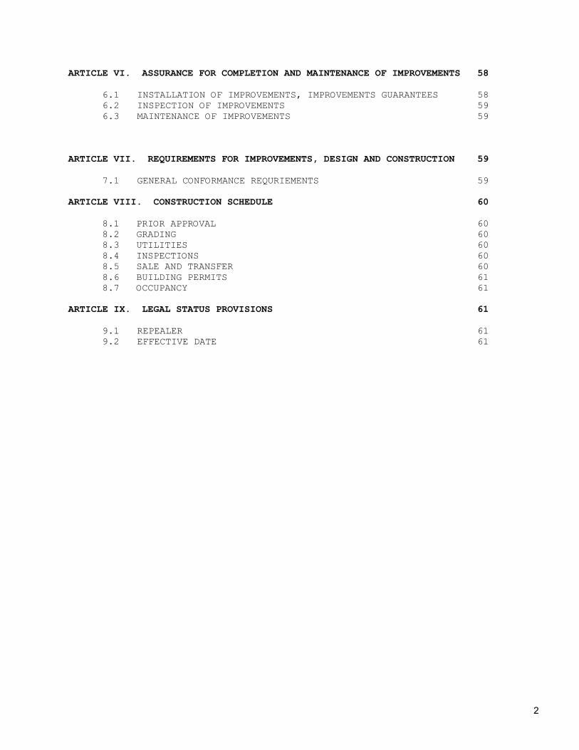
ARTICLE VI. ASSURANCE FOR COMPLETION AND MAINTENANCE OF IMPROVEMENTS 58
6.1 INSTALLATION OF IMPROVEMENTS, IMPROVEMENTS GUARANTEES 58 6.2 INSPECTION OF IMPROVEMENTS 59 6.3 MAINTENANCE OF IMPROVEMENTS 59
ARTICLE VII. REQUIREMENTS FOR IMPROVEMENTS, DESIGN AND CONSTRUCTION 59
7.1 GENERAL CONFORMANCE REQURIEMENTS 59
ARTICLE VIII. CONSTRUCTION SCHEDULE 60
8.1 PRIOR APPROVAL 60
8.2 GRADING 60 8.3 UTILITIES 60 8.4 INSPECTIONS 60 8.5 SALE AND TRANSFER 60 8.6 BUILDING PERMITS 61 8.7 OCCUPANCY 61
ARTICLE IX. LEGAL STATUS PROVISIONS 61
9.1 REPEALER 61 9.2 EFFECTIVE DATE 61

1
ARTICLE I. GENERAL PROVISIONS
1.1 SHORT TITLE
This ordinance shall be known and be cited as the “Subdivision Regulations of Greene County, Georgia”.
1.2 PURPOSE AND INTENT
These regulations are enacted for the following purposes:
1. To encourage economically sound and stable development.
2. To ensure the provision of required streets, utilities, and other facilities and services to land developments. 3. To ensure the adequate provision of safe and convenient traffic access and circulation, both vehicular and pedestrian, in land developments. 4. To ensure the provision of needed public open spaces and building sites in land developments through the dedication or reservation of land for recreational, educational, and other public purposes. 5. To ensure that all development and construction plans will imple-ment proper soil erosion controls. 6. To promote a safe and healthy environment. 7. To ensure adequate identification of property on the public records. 8. To encourage, in general, the wise development of the County in accordance with adopted land use policies. 9. To balance the interest in promoting the public health, safety, or general welfare against the right to the unrestricted use of the property in question and whether the subdivision plat permits a use that is suitable in view of the use and development of adjacent and nearby property and whether it will adversely affect the existing use or usability of adjacent or nearby property.
1.3 AUTHORITY AND JURISDICTION
1. These regulations are adopted in accordance with, and under the power of, the 1983 Constitution of the State of Georgia (Article IX, Section II, Paragraphs I and IV). 2. By the same authority, the Greene County Board of Commissioners

2
grants the Greene County Planning And Zoning Commission the right to review and recommend approving or disapproving plats of land subdivided prior to the recording of said plats in the offices of the Clerk of the Superior Court Of Greene County, Georgia within the unincorporated section of Greene County. 3. By the same authority, the Planning and Zoning Commission does hereby possess and exercise the power and authority to review and recommend to approve or disapprove the development of a platted subdivision of land already recorded in the offices of the Clerk of Superior Court of Greene County, if said plat was recorded after January 26, 1989 without prior approval of the Planning and Zoning Commission and more than fifty (50%) percent of the platted lots have not been sold to individual owners for the purpose of providing residence for the owner, provided that any review, approval, or disapproval shall concern only the lots yet to be sold to individual owners. Subdivisions which are entirely developed or which received preliminary plat approval prior to adoption of these Regulations shall be permitted to proceed in accordance with the standards in effect at the time of approval of the preliminary plat.
1.4 INTERPRETATIONS, CONFLICTS, AND SEVERABILITY
1. Interpretation: In their interpretation and application, the provisions of these regulations shall be held to the minimum requirements for the protection and promotion of the public health, safety, and welfare. 2. Conflict With Public and Private Provisions:
A. Public Provisions: These regulations are not intended to interfere with, abrogate, or annul other ordinances, rules, regulations, statutes, or other provisions of law. Where any provision of these regulations imposes restrictions different from those imposed by any other ordinance, rule, regulation, or provision of law, the more restrictive shall control.
B. Private Provisions: These regulations are not intended to abrogate any easement, covenant, or any other private agreement or restriction, provided that where these regulations are more restrictive or impose higher standards than a private restriction, the provisions of these regulations shall govern.
3. Separability of Provisions: Should any term, part, provision, section, sub-section, paragraph, sentence, or phrases of this ordinance be held unconstitutional, invalid, or ineffective, in whole or in part, such determination shall not be deemed to invalidate the remaining terms, parts, provisions, section, sub-sections, paragraphs, sentences, or phrases of this Ordinance.

3
4. Separability: If any portion or provision of this Ordinance is found unconstitutional, such invalidity shall not affect any other portion of this Ordinance.
A. Saving Provision: These regulations shall not be construed as abating any subdivision development now pending under, or by virtue of, prior existing subdivision regulations, or as discontinuing, abating, modifying, or altering any penalty accruing or about to accrue, or as affecting the liability of any person, firm or corporation, resulting from such development.
B. Repeal of Existing Regulations: Upon the adoption of this Ordinance, the existing Land Subdivision Regulations of Greene County as amended are hereby repealed.
C. Amendments: For the purposes of protecting and providing for the public health, safety, and welfare, the Greene County Board of Commissioners may from time to time amend the provisions of these subdivision regulations. Before enacting any amendment to this ordinance, the Greene County Planning and Zoning Commission, acting for Greene County Board of Commissioners, shall hold a public hearing. Not less than fifteen (15) days, nor more than forty-five (45) days prior to the date of the said public hearing, the Secretary of the Greene County Planning and Zoning Commission shall advertise the date, time, place and purpose of the public hearing in a newspaper of general circulation in Greene County. The Greene County Planning and Zoning Commission shall hold said hearing and make a recommendation to the Greene County Board of Commissioners within thirty (30) days of the public hearing.
D. Re-subdivision Of Land: For any change in a map of an approved or recorded subdivision plat, including variation of, part of, all of any plat, or area reserved thereon for public use, or any lot line, or if it affects any plat legally recorded prior to the adoption of these regulations, such parcel shall be reviewed and approved, or disapproved by the Greene County Board of Commissioners after a public hearing before the Planning and Zoning Commission.
E. Variances:
(1) General: Where the Greene County Board of Commissioners
finds that extraordinary hardships or practical difficulties may result from strict compliance with these regulations or the purpose of these regulations may be served to a greater extent by an alternative proposal, it may, after a public hearing before the Greene County

4
Planning and Zoning Commission, approve a variance to these subdivision regulations; however, such a variance shall not nullify the intent and purpose of these regulations. Each variance must be viewed individually with no previous variance approved being precedent setting. The Greene County Board of Commissioners shall not approve a variance unless it shall find that all the following conditions are met:
(a) The granting of the variance shall not be detrimental to the public safety, health, or injurious to adjacent property value or use. (b) The conditions upon which the request for a variance is based are unique to the property for which the variance is sought and are not generally applicable to adjacent property. (c) The variance shall not in any manner vary the provisions of the Zoning Ordinance of Greene County, Georgia, or Official Zoning Map. (d) A public hearing be held by the Planning and Zoning Commission on the proposed variance and it is advertised in the Legal organ of the County not less then fifteen (15) days and no more than forty five (45) days prior to the public hearing.
(2) Conditions: In approving variances, the Greene County Board of Commissioners may require such conditions as in its judgment, will secure substantially the objectives of the standards or requirements of these regulations. (3) Procedures: A plat of survey and a petition for any variance shall be submitted in writing by the petitioner for the consideration by the Greene County Planning and Zoning Commission. The petition shall state fully the grounds for the request and all of the facts relied upon by the petitioner. The Board of Commissioners shall prescribe a fee.
1.5 APPEALS
1. Any person or persons, jointly or severally aggrieved by any decision (including the failure to decide within sixty (60) days upon submission of all documents required by this ordinance) of the Building Official shall have the right of appeal to the Greene County Planning and Zoning Commission, if such appeal is filed with the Secretary of the Greene County Planning and Zoning Commission within thirty (30) days of the rendering of the decision by the

5
Building Official. 2. Any person or persons, jointly or severally aggrieved by any decision (including the failure to decide within sixty (60) days upon submission of all documents required by this ordinance) of the Greene County Planning and Zoning Commission shall have the right of appeal to the Greene County Board of Commissioners, if such appeal is filed with the Clerk of Greene County Board of Commissioners within thirty (30) days of the rendering of the decision by the Planning and Zoning Commission. 3. Any person or persons, jointly or severally aggrieved by any decision of the Greene County Board of Commissioners shall have the right of appeal to a court of law if such appeal is filed with the Clerk of Court within thirty (30) days of the rendering of the decision by the Greene County Board of Commissioners.
1.6 ENFORCEMENT, VIOLATIONS AND PENALTIES
1. General:
A. It shall be the duty of the Building Official to enforce these regulations, and to bring to the attention of the County Commissioners of Greene County any violation or lack of compliance herewith. B. No owner, or agent of the owner, of any parcel of land located in a proposed subdivision or an existing subdivision meeting the requirements of Article I, Section 1.3 (3) shall transfer or sell any such parcel before a final plat of such subdivision has been approved by the Greene County Board of Commissioners in accordance with the provisions of this Ordinance, and filed with the Clerk of the Superior Court of Greene County. C. No building permits shall be issued for the construction of any building or structure located on a lot or site subdivided or sold in violation of the provisions of these regulations.
2. Penalties: Any person who violates any of the provisions of the Ordinance is subject to trial and possible convictions, and shall upon conviction thereof be punished by a fine not exceeding five hundred ($500.00) dollars or imprisonment for a term not exceeding six (6) months or both provided that each day a violation continues shall constitute a separate offense. 3. Civil Enforcement: Appropriate actions and proceedings may be taken by law or in equity to prevent any violation of these
6
regulations; to prevent unlawful construction; to recover damages; to restrain, correct, or abate a violation; to prevent illegal occupancy of a building, structure, or premises; and these remedies shall be in addition to the penalties described above.
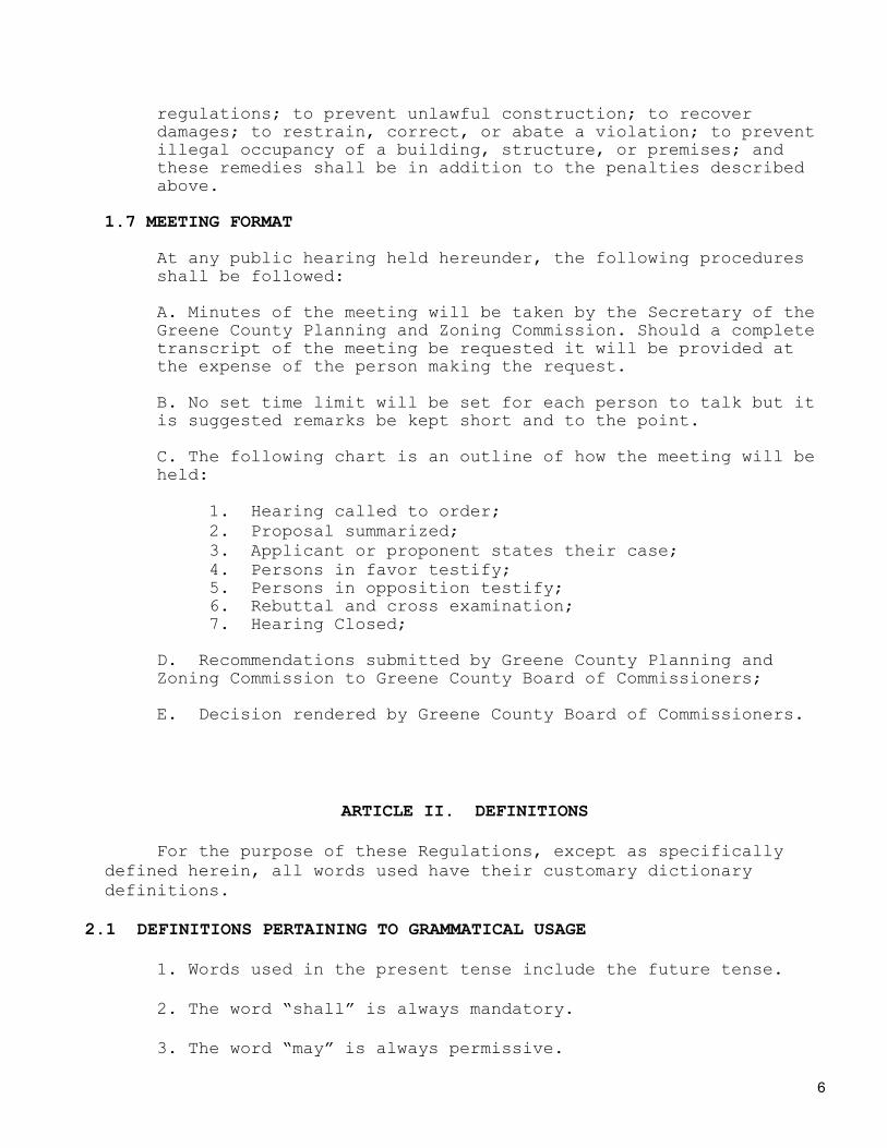
1.7 MEETING FORMAT
At any public hearing held hereunder, the following procedures shall be followed:
A. Minutes of the meeting will be taken by the Secretary of the Greene County Planning and Zoning Commission. Should a complete transcript of the meeting be requested it will be provided at the expense of the person making the request. B. No set time limit will be set for each person to talk but it is suggested remarks be kept short and to the point. C. The following chart is an outline of how the meeting will be held:
1. Hearing called to order; 2. Proposal summarized; 3. Applicant or proponent states their case; 4. Persons in favor testify; 5. Persons in opposition testify; 6. Rebuttal and cross examination; 7. Hearing Closed;
D. Recommendations submitted by Greene County Planning and Zoning Commission to Greene County Board of Commissioners;
E. Decision rendered by Greene County Board of Commissioners.
ARTICLE II. DEFINITIONS
For the purpose of these Regulations, except as specifically defined herein, all words used have their customary dictionary definitions.
2.1 DEFINITIONS PERTAINING TO GRAMMATICAL USAGE
1. Words used in the present tense include the future tense. 2. The word “shall” is always mandatory. 3. The word “may” is always permissive.

7
4. The word “person” includes a firm, association, organization, partnership, trust, company or corporation as well as an individual. 5. The word “temporary” shall mean a period of time not exceeding one hundred and eighty (180) days.
2.2 DEFINITIONS OF SPECIFIC TERMS
1. ALLEY: A platted service way providing a secondary means of access to abutting properties. 2. APPLICANT: The owner of land proposed to be subdivided or his representative. Consent shall be required from the legal owner of the premises. 3. AVERAGE DAILY TRAFFIC (ADT): All traffic projected to travel along a street within one calendar day. 4. BLOCK: A continuous piece or parcel of land entirely surrounded by public highways or streets, but excluding alleys. 5. BUILDING: Any structure, either permanent or temporary, above or below ground, designed, built or used as a shelter or enclosure for persons, animals, or property of any kind. 6. BUILDING, HEIGHT OF: The vertical distance to the highest point of the roof for flat roofs, to the deck line of mansard roofs, and to the average height between the eaves and the ridge for gable, hip, and gambrel roofs, measured from the average grade of the house plan, front to back and end to end. 7. BUILDING INSPECTOR: The authorized Building Official for Greene County, Georgia. 8. BUILDING LINE: A line, parallel to the right of way line, beyond which the foundation wall and any roofed porch, vestibule or other such portion of a building shall not project. 9. BUILDING OFFICIAL: The officer or other designated authority charged with the administration and enforcement of this code, or a duly authorized representative. 10. CENTRAL WATER SYSTEM: A private water system, which serves a new subdivision in an outlying area, It includes water treatment and distribution facilities. 11. CENTRAL SEWAGE SYSTEM: A private sewage system including collection and treatment facilities to serve a new subdivision in an outlying area.
8
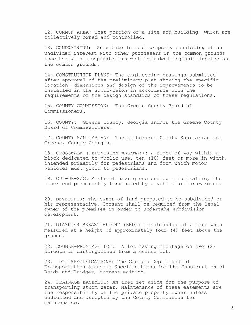
12. COMMON AREA: That portion of a site and building, which are collectively owned and controlled. 13. CONDOMINIUM: An estate in real property consisting of an undivided interest with other purchasers in the common grounds together with a separate interest in a dwelling unit located on the common grounds. 14. CONSTRUCTION PLANS: The engineering drawings submitted after approval of the preliminary plat showing the specific location, dimensions and design of the improvements to be installed in the subdivision in accordance with the requirements of the design standards of these regulations. 15. COUNTY COMMISSION: The Greene County Board of Commissioners. 16. COUNTY: Greene County, Georgia and/or the Greene County Board of Commissioners. 17. COUNTY SANITARIAN: The authorized County Sanitarian for Greene, County Georgia. 18. CROSSWALK (PEDESTRIAN WALKWAY): A right-of-way within a block dedicated to public use, ten (10) feet or more in width, intended primarily for pedestrians and from which motor vehicles must yield to pedestrians. 19. CUL-DE-SAC: A street having one end open to traffic, the other end permanently terminated by a vehicular turn-around. 20. DEVELOPER: The owner of land proposed to be subdivided or his representative. Consent shall be required from the legal owner of the premises in order to undertake subdivision development. 21. DIAMETER BREAST HEIGHT (BHD): The diameter of a tree when measured at a height of approximately four (4) feet above the ground. 22. DOUBLE-FRONTAGE LOT: A lot having frontage on two (2) streets as distinguished from a corner lot. 23. DOT SPECIFICATIONS: The Georgia Department of Transportation Standard Specifications for the Construction of Roads and Bridges, current edition. 24. DRAINAGE EASEMENT: An area set aside for the purpose of transporting storm water. Maintenance of these easements are the responsibility of the private property owner unless dedicated and accepted by the County Commission for maintenance.

9
25. DRIVEWAY: An access way connecting one or more dwelling units and their parking spaces with a street. 26. DWELLING: A building that contains one or two dwelling units used, intended, or designed to be used, rented, leased, or let or hired out to be occupied for living purposes. 27. DWELLING UNIT: a single unit providing complete, independent living facilities for one or more persons including permanent provisions for living, sleeping, eating, cooking and sanitation. 28. EASEMENT: A grant of 1 or more property rights by the owner to, or for the use by, the public, a corporation, or another person or entity. 29. ENGINEER: A registered, professional engineer licensed by the State of Georgia. 30. GRADE: The rate of change in elevation, in feet per 100 feet, between two points along the center line of a road or street and expressed as a percent. 31. GRADING: Altering surfaces to specific elevations, dimen-sions, or slopes; this includes stripping, cutting, filling, stockpiling and shaping or any combination thereof and shall include the land in its cut or filled condition. 32. IMPROVEMENTS GUARANTEE: A guarantee in the form of an irrevocable letter of credit from a bank or a certified check to insure completion of required subdivision improvements. 33. HEALTH DEPARTMENT: The Health Department of Greene County. 34. INDIVIDUAL SEWAGE DISPOSAL SYSTEM: A septic tank, seepage tile sewage disposal system, or any other sewage treatment device approved by the sanitarian. 35. INDIVIDUAL WELL: Wells not covered by EPD standards. Normally this will mean wells that serve no more than three (3) lots. 36. LAND USE PLAN: A development plan or any part thereof, adopted by the County Commission that indicates the general location for the various physical classes of public works, places and structures, and depicts the general planned physical development and land use in Greene County, Georgia. 37. LOT: A portion of, or parcel of land separated from other portions or parcels by description, metes and bounds, intended for transfer of ownership or for building development and having a separate tax parcel reference number designated in the

10
office of Greene County Tax Commissioner or Greene County Tax Assessor. 38. LOT AREA: The service area inside the lot lines. In deter-mining the area and dimensions of a lot, no portion of the right-of-way of a street or crosswalk may be included. 39. LOT, CORNER: A lot abutting on two (2) or more streets at their intersection. 40. LOT COVERAGE: The service area occupied by all buildings within a lot. 41. LOT DEPTH: The average horizontal distance between the front and rear lot lines. 42. LOT IMPROVEMENT: Any building, structure, work of art, or other object, or alteration of the land, constituting a physical betterment of real property. 43. LOT, INTERIOR: A lot other than a corner lot or double frontage lot. 44. LOT WIDTH: The horizontal distance between one side lot line and the other side lot line measured at the minimum front setback line. 45. MINIMUM STOPPING SIGHT DISTANCE: The shortest distance in which a driver, seated in a standard size automobile, can see a six (6) inch high object lying in the same traffic lane and bring to a stop, before striking the object, while traveling at the design or posted rate of speed. 46. NON-RESIDENTIAL SUBDIVISION: A subdivision whose intended use is other than residential. 47. OPEN SPACE: A parcel of land used for recreation, resource protection, amenity, or buffers. In no event must any area of a lot constituting the minimum lot area nor any part of an existing or future road, right-of-way, off street parking, loading space, or area immediately underneath electrical transmission lines be counted as open space. 48. OUTLOT: A lot that is either unbuildable or not intended for development and allocated to be used for esthetic purposes, safety, or common public use. 49. OWNER: Any person who has title to real property. In the case where equitable title is vested in more then one person, authorization by all parties claiming a title to the property in question shall be provided to the governing authority prior to any review and application of the provisions of these

11
Regulations. Owners are not holders of security deeds or mortgages on the property. 50. PARCEL: A plot or plots of land that are shown with a separate identification on the Official Appraisal Maps of Greene County. 51. PERMIT: An official document or certificate issued by the authority having jurisdiction that authorizes performance of a specified activity. 52. PERSON: An individual, heirs, executors, administrators or assigns, and also includes a firm, partnership or corporation, its or their successors or assigns, or the agent of any of the aforesaid. 53. PLANNING AND ZONING COMMISSION: The Planning and Zoning Commission of Greene County Georgia. 54. PLAT: A drawing, map or survey of a lot, tract or parcel of land including lot lines, street rights-of-way and easements, with the dimensions of these features inscribed thereon to scale, and prepared in accordance with the Georgia Plat Act. 55. PLAT, FINAL: The final plan of the subdivision and any accompanying documents as required by these regulations that, once approved by the Greene County Board of Commissioners, will constitute the plat of record that will be the basis for the authorization of building permits. The final plat will be prepared in accordance with the Georgia Plat Act. 56. PLAT, PRELIMINARY: The preliminary drawing or drawings, described in these Regulations, indicating the proposed layout of the subdivision that is to be submitted to the Planning and Zoning Commission for recommendation for approval or disapproval to the Board of Commissioners. 57. PRINCIPAL BUILDING: A building in which is conducted the predominant use of the lot on which it is situated. 58. PUBLIC IMPROVEMENT: Any drainage, ditch, parkway, sidewalk, pedestrian way, tree, lawn, off-street parking area, lot improvement, or other facility for which the County may ultimately assume the responsibility or liability, for maintenance or operation, or which may effect an improvement for which County responsibility and liability is established. 59. PUBLIC STREET: A street over which the general public has acquired the right of use. 60. PUBLIC UTILITY: Any structure or facilities (other than buildings, unless such buildings are used as storage incidental

12
to the operation of such structures or facilities) owned by a governmental entity, a nonprofit organization, a corporation, or any entity defined as a public utility for any purpose by the Georgia Public Service Commission and used in connection with the production, generation, transmission, delivery, collection, or storage of water, sewage, electricity, gas, oil, or electronic signals. 61. RE-SUBDIVISION: A change in an approved or recorded sub-division plat if such change affects any street layout, easement, area reserved for public use, or lot line. In a residential subdivision, no re-subdivided lot can be smaller than the average size of those lots previously approved.
62. RIGHT-OF-WAY: That area, distinguished from an easement, which is recorded in the Clerk of the Superior Court in Greene County, for the present or future use of roads, streets, and highways, together with its drainage facilities and other supporting uses and structures. 63. RIGHT-OF-WAY LINE: The designated limits of a right-of-way, whether such right-of-way is established by usage, recorded easement, deed, and dedication or by an official right-of-way map of Greene County, Georgia. 64. RIGHT-OF-WAY WIDTH: The distance between right-of-way lines measured at right angles. 65. SANITARIAN: A professional sanitarian appointed by the Health Department and authorized to perform health services in Greene County, Georgia. 66. SHOULDER: The portion of a street or road from the outer edge of the paved surface or curb to the inside edge of the ditch, gutter or original ground surface. 67. SIDEWALK: The portion of the right-of-way that is adjacent to a street or road that is intended for pedestrian traffic. 68. SKETCH PLAN: A generalized representation of the proposed subdivision submitted prior to the preliminary plat that will enable the developer to reach general agreement with the Building Official and County Engineer as to the form of the plat and the objectives of these Regulations. 69. SLOPE RATIO: The rise or fall of a side slope expressed as a ratio of horizontal to vertical. 70. SOIL EROSION AND SEDIMENTATION ORDINANCE: The Soil Erosion Ordinance of Greene County, Georgia.

13
71. STREET: A right-of-way for vehicular traffic designated as street, highway, thoroughfare, parkway, expressway, freeway, road, avenue, drive, boulevard, lane place, circle, or otherwise. Various sub classifications are defined as follows:
A. ARTERIAL: A street carrying a high volume of traffic and connecting two or more large areas or populated centers. Direct residential access is prohibited and commercial or industrial lot access is controlled and limited. B. MAJOR COLLECTOR: May carry the volume of at least two Minor Collector Streets in addition to its own volume generated by development along the street.
C. MINOR COLLECTOR: May carry the volume of at least one Local Street in addition to traffic generated by development along the street. D. LOCAL STREET: Carries only the traffic generated on the street itself. E. CUL-DE-SAC: A local street having one (1) end open to traffic, the other being permanently terminated by a vehicular turnaround. F. DEAD END: A stub street in a subdivision that may, at a later time, be continued into another portion of the subdivision.
72. STREET, COUNTY: A street that is owned or maintained by Greene County, Georgia. 73. STRUCTURE: Anything constructed or erected with a fixed location on or in the ground, or attached to something having a fixed location on the ground. Structures include, but are not limited to the following: site built buildings. manufactured, mobile and modular homes, swimming pools, and signs. 74. STRUCTURE, EXISTING: A structure erected prior to the date of adoption of the appropriate code, or one for which a current legal building permit has been issued.
75. SUBDIVISION: Any division of a tract or parcel of land into three or more lots, and the following are not included in this definition:
(a) The sale or exchange of parcels of land between separate or common owners or adjoining properties, provided that additional lots are not thereby created, and that all resulting lots are in accordance with the provisions of this Ordinance.

14
(b) Family Exception: A gift of a parcel or parcels of land for house construction or for other purposes by a land owner to a sibling or to other immediate family members (to include only sons, daughters, grand children, husband or wife) shall not be considered to be a land subdivision under the terms of these regulations. Lot sizes must be in compliance with this ordinance and with all other ordinances of Greene County.
The Developer is required to pave to the specifications of this ordinance all streets in the subdivision including, but not limited to, those streets that lead to a public road, whether or not said public road is paved or unpaved. For the purposes of this ordinance, subdivisions shall be divided into two (2) classifications:
1. Minor Subdivisions: All divisions of land which meet the said definition of “Subdivision” and which have not more than five (5) lots, building sites, or other divisions. 2. Major Subdivisions: All divisions of land which meet the said definition of “Subdivision” but is not a “Minor” Subdivision
76. SURVEYOR: A registered, practicing surveyor licensed by the State of Georgia. 77. VARIANCE: A minimal relaxation or modification of the strict terms of the height, area, placement, setback, yard, buffer, landscape strip, parking and loading ordinances as applied to specific property when, because of particular physical surroundings, shape, or topographical condition of the property, not due to the fault of the owner of said property, compliance would result in a particular hardship upon the owner, as distinguished from a mere inconvenience or a desire to make a profit. 78. YARD: An open space, other than a court, unobstructed from the ground to the sky, except where specifically provided by this code, on the lot on which a building is situated. 79. ZONING ORDINANCE: The Zoning Ordinance of Greene County, Georgia.

15
ARTICLE III: REQUIREMENTS FOR IMPROVEMENTS, RESERVATION AND DESIGN
3.1 GENERAL REQUIREMENTS:
1. Conformance to Applicable Rules and Regulations: In addition to the requirements established herein, all subdivision plats shall comply with the following laws, rules, regulations and ordinances:
A. All applicable statutory provisions, as amended; B. The Zoning Ordinance of Greene County, Georgia, building and housing codes, and all other applicable laws of the appropriate jurisdictions, as amended;
C. The standards balancing the interest in promoting the public health, safety, morality, or general welfare against the right to the unrestricted use of the property in question and whether the subdivision plat permits a use that is suitable in view of the use and development of adjacent and nearby property and whether it will adversely affect the existing use or usability of adjacent or nearby property; D. Any and all rules of the Greene County Health Department or appropriate State Agencies, as amended; E. The regulations of the Georgia Department of Transportation, if the subdivision or any lot contained herein adjoins, or is directly adjacent to a state highway, as amended; F. The Soil Erosion And Sedimentation Ordinance of Greene
County, Georgia, as amended;
2. PLATS STRADDLING POLITICAL BOUNDARIES: Whenever access to a subdivision is required across land in another governmental jurisdiction, the Greene County Planning and Zoning Commission may request assurance from the County Attorney that access is legally established from the other governmental jurisdiction and the access road is adequately improved. 3. SUITABLILTY OF THE LAND: Land subject to flooding, improper drainage, erosion, geological hazards, topographical limitations, for other reasons that classify land as unsuitable

16
for residential use shall not be platted for residential use nor for any other use that will continue or increase the danger to health, safety, or property destruction.
4. REJECTION OF LAND DEDICATED: Whenever a plat proposes the dedication of land for public use and it is determined by the Planning and Zoning Commission that such land is not suitable for the proposed public use, the Planning and Zoning Commission shall refuse to approve either the preliminary or final plat until such dedication is removed from the plat.
5. WATER RETENTION STRUCTURES: No water retention structure shall be shown to be dedicated or accepted by Greene County, Georgia. When the Planning and Zoning Commission finds such structure is recorded on a plat, such dedication shall be stricken from the plat prior to approval. 6. SUBDIVISION NAME: The Planning and Zoning Commission shall have final authority to approve the name of the subdivision, which shall be determined at the time of approval of the preliminary plat. 7. LARGE SCALE DEVELOPMENTS: The requirements of these regulations may be modified in the case of a large scale community, commercial or neighborhood development in excess of fifteen (15) acres that is not subdivided into customary lots, blocks, and streets. Such modifications shall conform to the purpose and intent of these regulations, and shall follow the requirements for a Planned Unit Development (PUD) or Commercial Planned Unit Development (CPUD) as included in the Zoning Regulations of Greene County, Georgia, in effect at the time they are revised.
3.2 REQUIRED IMPROVEMENTS;
1. GENERAL: The requirements of this section shall apply to every subdivision and shall be planned for and provided by the developer, by installation or payment prior to the approval of the final plat. 2. STREET NAMES: All streets shall be named and marked with signs. Street names shall have the approval of the Planning and Zoning Commission and shall not duplicate, nor closely approximate phonetically or visually, the name of any other street in Greene County, Georgia, nor the name of any other street within the applicable postal delivery area. A street that is in alignment with an existing street shall continue the name of the existing street.

17
3. STREETS: All streets shall be designed, constructed and paved in accordance with the standards set forth in these regulations. No street shall be accepted by the County until it has been open for public use for two years or until one-half of the lots in the subdivision, or the section of the subdivision served by that street, have had residences constructed upon them, whichever occurs first. The developer shall be required to furnish and install all necessary traffic control signs prior to opening any street to the public. In addition the developer shall be required to provide a viable ground cover such as grass on all unpaved areas of street rights-of–way or other public areas. Any necessary maintenance or repairs to streets shall be performed by the developer prior to county acceptance.
4. STREET SIGNS AND TRAFFIC CONTROL DEVICES: Street name signs
and traffic control devices of a design approved by the County will be furnished and installed by the Developer. Material and installation costs shall be paid for by the Developer prior to the recording of the final plat and issuance of any building permits.
5. UTILITIES: Except as provided in Section 6.3, this provision shall apply: (Utility requirements must meet the minimums specified in the Zoning Ordinance);
A. All utility lines shall be installed along street rights-of-way. All utilities shall be underground whenever possible. Such utility installations may include water, sanitary sewer, electric power, natural gas, telephone, and cable television. Underground utilities shall be buried at locations not under pavement whenever possible. Where service lines to individual lots are required to cross streets, such lines shall be placed, extended to the opposite right-of-way line and backfilled prior to the placing of any base and pavement. Where local conditions dictate, the Planning And Zoning Commission may approve installation of utilities in other locations.
B. If a public water system can serve the proposed subdivision, (the proposed new subdivision must lie within 1500 feet of an existing public water system), water mains shall be installed by the developer within the subdivision with connections to each lot extended to the lot line. If a public water system is not available, the developer shall provide a water supply through a community water system or allow individual wells in conformity with the regulations of the Greene County Health Department, EPD standards and this ordinance.

18
C. If a public sanitary sewer system can serve the proposed subdivision, sewer mains shall be installed by the developer with connections to each lot extended to the lot line. If a public sewer system is not available, the developer shall provide a community sewage collection system or allow individual septic tank systems in conformity with the regulations of the Greene County Health Department and the Georgia Department of Natural Resources.
6. STORM DRAINAGE:
A. GENERAL: Lots shall be laid out so as to provide positive
drainage away from all buildings. Individual lot drainage shall be coordinated with the general storm drainage pattern for the area. Drainage shall be designed so as to connect to drainage easements.
B. CONNECTION TO EXISTING SYSTEMS: If a public storm water drainage system can serve the proposed subdivision, then the developer must install an underground storm drainage system which will be connected to the public system. Should a storm drainage system not exist, then adequate surface drainage facilities shall be installed.
3.3 DESIGN STANDARDS FOR BLOCKS AND LOTS:
1. BLOCK LENGTHS AND WIDTHS: Block lengths and widths shall be as follows:
A. Blocks shall not be greater than twelve hundred (1200) feet nor less than four hundred (400) feet in length, except in unusual circumstances. B. Blocks shall be wide enough to provide two (2) tiers of lots of minimum depth except where abutting arterial streets or railroads or other situations make these requirements impractical. C. Blocks shall have pedestrian walkways of not less than five (5) feet in width where deemed essential by the Greene County Board of Commissioners to provide circulation or access to schools, playgrounds, shopping centers, transportation, and other community facilities. D. Except where topographical or other conditions make a greater length unavoidable, as determined by the Greene County Commissioners, cul-de-sacs (dead-end streets) shall not be greater than twelve hundred (1200) feet in length. All cul-de-sacs shall be provided at the closed end with a

19
turnaround having a pavement diameter of at least eighty (80) feet. Paved temporary turnarounds shall be provided for dead-end streets, which are scheduled to be extended at a later date.
2. ALLEYS: Alleys, 20 feet in width, may be required at the rear of all lots used for multi-family, commercial, or industrial development. Alleys in single-family residential subdivisions shall not be permitted, unless the developer provides evidence satisfactory to the Greene County Board of Commissioners of the need for such alleys. 3. DEVELOPMENT ALONG ARTERIAL STREET: Where a subdivision abuts an existing arterial street or railroad right-of-way, an access street approximately parallel to and on either or both sides of the existing right-of-way may be required by the Greene County Board of Commissioners. Direct access to the arterial street will not be permitted. A buffer zone restricting access to the arterial right-of-way may be used in conjunction with or in lieu of the access street. 4. LOT SIZE: All lots shall meet the lot requirements of the zoning ordinance. Corner lots shall have adequate width to meet building setback requirements from all abutting streets as defined in the zoning ordinance. 5. LOT LINES: All side lot lines shall be as nearly perpendicular to or radial to street rights-of-way lines as possible, unless topographic or other features of the design require otherwise. 6. DOUBLE AND REVERSE FRONTAGE LOTS: Double frontage and reverse frontage lots shall be avoided except where essential to provide separation of development from arterial streets or to overcome specific disadvantages or topographic and orientation.
7. EASEMENTS: The Greene County Board of Commissioners shall require all easements to have adequate widths and be located along the rear or side lot lines with provision for access from a public way.
8. RESERVE STRIPS: Reserve strips which control access to streets and public grounds shall be permitted only when the control of the reserve strip is placed in the hands of the County.

20
3.4 DESIGN STANDARDS FOR STREETS:
1. GENERAL: In order to provide for roads suitable in location, width, and improvement, and to coordinate roads so as to compose a convenient system and avoid undue hardships to adjoining properties, the following design standards for roads are hereby required and shall be planned for and provided by the developer, prior to the approval of the final plat. Road classifications may be indicated on the comprehensive plan, otherwise they shall be determined by the Greene County Board of Commissioners.
2. CLASSIFICATION OF STREETS: Streets shall be classified into a street hierarchy system and street design standards shall be based on road function and projected Average Daily Trips (ADT), calculated with trip generation rates published in The Trip Generation Manual, 1998 Edition. Residential lots shall require ten (10) trips per day per single family lot and sixteen (16) trips per day per two family lots. Street classes and their corresponding Average Daily Trips (ADT) are:
Classification Maximum Maximum Local Street 25 dwelling units 250 ADT Minor Collector 250 dwelling units 2500 ADT Major Collector 500 dwelling units 5000 ADT Arterial Streets N/A 5000 ADT and More
3. GEOMETRIC DESIGN STANDARDS FOR STREETS: Geometric design standards for roads and streets shall be based on TABLE 3.4.3
GEOMETRIC DESIGN STANDARDS FOR STREETS TABLE 3.4.3 ARTERIAL MAJOR
COLLECTOR MINOR COLLECTOR
LOCAL
AVERAGE DAILY TRIPS (ADT)
5000 OR MORE
4999-2500 2499-250 249 OR LESS
MINIMUM RIGHT OF WAY
100 feet (64 feet with curb & gutter)
80 feet (64 feet with curb & gutter)
60 feet (50 feet with curb & gutter)
60 feet (50 feet with curb & gutter)
MAXIMIM GRADE 6% 8% 12% 12% MINIMUM STOPPING SIGHT DISTANCE
550 feet 450 feet 250 feet 150 feet
DESIGN SPEED 55 MPH 45 MPH 35 MPH 25 MPH MINIMUM CURVE RADIUS AT
850 feet 500 feet 400 feet 250 feet

21
CENTERLINE MINIMUM TANGENT BETWEEN REVERSE CURVES
300 feet 200 feet 100 feet 100 feet
EDGE OF PAVEMENT RADIUS AT INTERSECTIONS
30 feet 30 feet 25 feet 25 feet
MINIMUM FINISHED GRADE
1% 1% 1% 1%
MAXIMUM SIDE SLOPE RATES
3:1 3:1 3:1 3:1
4. BASE AND PAVING DESIGN: Base and paving design standard specifications shall be based on TABLE 3.4.4.
TABLE 3.4.4 MINIMUM BASE AND PAVEMENT DESIGN SPECIFICATIONS ARTERIAL MAJOR
COLLECTOR MINOR COLLECTOR
LOCAL
BASE WIDTH 25 feet 23 feet 23 feet 21 feet GRADED AGREGATE BASE THICKNESS
8 inches 8 inches 6 inches 6 inches
ASPH CONC BASE
6 inches 4 inches N/A N/A
ASPH CONC BINDER
3”, TYPE B 2” TYPE B 2” TYPE B 2” TYPE B
ASPH CONC SURFACE
1 ½” TYPE E
1 ½” TYPE E
1 ½” TYPE E
1 1/4” TYPE F
TRIPLE SURFACE TREATMENT
N/A N/A N/A YES
MINIMUM PAVEMENT WIDTH
24 feet 22 feet 22 feet 20 feet
MINIMUM SHOULDER WIDTH
8 feet 8 feet 8 feet 6 feet
NOTES: 1) Pavement widths do not include curb and gutter 2) All shoulders shall have a minimum slope of ½” per foot away from pavement

22
3) All shoulder widths are measured either from the edge of pavement or back of curb 4) Front slopes on shoulders shall be a maximum of three to one (3:1) 5) Pavement in tangent sections shall have a parabolic crown of at least 1/8” per foot 6) Curves shall contain no reverse super elevation 7) Curb and Gutter shall be Standard 9032B of the Georgia Department of Transportation or roll curbing. 8) If the finished pavement on any street has a total thickness of less than four inches, the underlying base course shall be primed. 3.5 DESIGN GUIDELINES:
A. CONTINUATION OF EXISTING STREETS: Where feasible, existing streets shall be extended for access into the subdivision. Such extensions shall be continued at the same or greater width, but in no case shall be less than the required width.
B. CLEAR SIGHT DISTANCE AT INTERSECTIONS: There shall be a minimum clear sight distance at intersections when measured from a height of six (6) feet, as follows: Arterial Streets – 400 feet Collector Streets – 300 feet Local Streets (non-residential) – 250 feet Local Street (residential) – 200 feet Alleys – 150 feet Where two (2) or more streets of different classifications intersect, the sight distance requirement for the highest classification street shall be used. Where any street intersection will involve slopes or existing vegetation inside any lot corner that would create a traffic hazard by reducing sight distance below specified minimums the developer must cut such ground or vegetation (including trees) in connection with the grading of the public right-of-way to the extent deemed necessary to comply with the sight distance of these regulations.
C. INTERSECTION DESIGN: Street intersections shall be as nearly at right angles as possible. No street intersection shall be at an angle of less than sixty (60) degrees. Street intersections must be separated from each other by at least 125 feet measured along the right-of-way line.
D. CUL-DE-SACS: All cul-de-sacs shall meet street requirements for local streets (residential) except any cul-de-sac approved for a length greater than 1200 feet or more than twenty five (25) dwelling units shall meet design criteria for a Minor Collector Street.
23
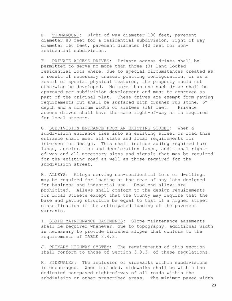
E. TURNAROUND: Right of way diameter 100 feet, pavement diameter 80 feet for a residential subdivision, right of way diameter 160 feet, pavement diameter 140 feet for non-residential subdivision.
F. PRIVATE ACCESS DRIVES: Private access drives shall be permitted to serve no more than three (3) land-locked residential lots where, due to special circumstances created as a result of necessary unusual platting configuration, or as a result of special physical features, the property could not otherwise be developed. No more than one such drive shall be approved per subdivision development and must be approved as part of the original plat. These drives are exempt from paving requirements but shall be surfaced with crusher run stone, 6” depth and a minimum width of sixteen (16) feet. Private access drives shall have the same right-of–way as is required for local streets.
G. SUBDIVISION ENTRANCE FROM AN EXISTING STREET: When a subdivision entrance ties into an existing street or road this entrance shall meet all state and local requirements for intersection design. This shall include adding required turn lanes, acceleration and deceleration lanes, additional right-of-way and all necessary signs and signals that may be required for the existing road as well as those required for the subdivision street.
H. ALLEYS: Alleys serving non-residential lots or dwellings may be required for loading at the rear of any lots designed for business and industrial use. Dead-end alleys are prohibited. Alleys shall conform to the design requirements for Local Streets except that the County may require that the base and paving structure be equal to that of a higher street classification if the anticipated loading of the pavement warrants. I. SLOPE MAINTENANCE EASEMENTS: Slope maintenance easements shall be required whenever, due to topography, additional width is necessary to provide finished slopes that conform to the requirements of TABLE 3.4.3.
J. PRIMARY HIGHWAY SYSTEM: The requirements of this section shall conform to those of Section 3.3.3. of these regulations. K. SIDEWALKS: The inclusion of sidewalks within subdivisions is encouraged. When included, sidewalks shall be within the dedicated non-paved right-of-way of all roads within the subdivision or other prescribed areas. The minimum paved width

24
of sidewalks shall be five (5) feet and a median strip of grassed or landscaped areas shall generally separate all residential sidewalks from adjacent streets except when contiguous to parking areas. Concrete sidewalks shall be constructed to the requirements of Georgia Department of Transportation Construction Standard 9031-W.
3.6 SLOPES:
A. GENERAL REQUIREMENTS: Development of subdivisions is to be accomplished with minimal earth moving and disruption to the natural topography of the site. It is the intent of these regulations that existing or man-made slopes be modified or designed in such a way as to minimize potential for erosion and to maximize ease of maintenance. Subdivision development shall conform to provisions of the Erosion and Sediment Control Ordinance.
B. DESIGN STANDARDS:
(1) Streets shall be planned so that finished slopes, cut or fill, will have a slope no steeper than 3:1. If conditions mandate steeper slopes the following will apply: no finished cut slope shall exceed a rate of slope of two to one (2:1) unless the slope is composed of rock, and no fill slope will exceed a rate of 2:1. All cut and fill shall be within the prescribed right-of-way of the road or slope easements. All grading as provided within this section shall be completed and approved by the Building Official prior to the installation of any utilities. (2) All fill slopes created for the purpose of street construction shall have a compaction of not less than 95% relative density as established engineering practices.
(3) Slopes flatter than those set forth in the foregoing paragraphs may be required when, in the opinion of the Building Official, the general nature of the soil involved warrants a flatter slope. To control surface drainage on existing and proposed slopes, berm ditches may be required at the top and the intersection of the slope and ground line. (4) All man-made slopes within the subdivision shall be planted or otherwise protected from erosion and failure. Such planting or other protection shall commence immediately upon completion of any individual slope and proceed without delay until completed. The type of grass

25
or ground cover shall be in accord with Section 3.5.3 of these regulations. Any other protection used shall be specified by the developer and approved by the Building Official prior to work commencing on the site. In addition, the developer may be required to provide suitable protection along the top of natural slopes within the subdivision that have a slope greater than 2:1 in order to protect children and other residents of the subdivision from falls.
3.7 DRAINAGE:
A. GENERAL REQUIREMENTS: The storm water drainage system and easements shall be separate and independent of any sanitary sewer system and easement. The Planning and Zoning Commission shall not recommend for approval any plat of a subdivision which does not make adequate provision for storm or flood water runoff channels or basins. Storm water runoff and storm sewer or channel design shall be designed and certified by a professional licensed by the State of Georgia to perform such design, and a copy of design computations shall be submitted to the Building Official along with the construction plans. Inlets shall be provided in curbs or in curb and gutter at a maximum spacing of 600 feet. When calculations indicate that curb capacities are exceeded at any point, no further allowance shall be made for flow at that point and water shall be diverted from the street. Natural drainage channels existing within a subdivision shall be improved by the developer to specifications approved by the Building Official (if erosion, flooding, or hazard will be created by the continued existence thereof, as determined by the Building Official). B. NATURE OF STORM WATER FACILITIES:
1) Location: The applicant may be required by the Building Official to carry away by pipe or open ditch any spring or surface water that may exist either previous to, or as a result of the subdivision. Such drainage facilities shall be located in the road right-of-way where feasible, or in perpetual unobstructed easements of appropriate width, and shall be constructed in accordance with the requirements of the Building Official.
2) Accessibility of Public Storm Sewers: When a public storm sewer is accessible, the applicant shall install storm sewer facilities, or if no outlets are within a reasonable distance, adequate provisions shall be made for the disposal of storm water, subject to the specifications of the Building Official. If a connection to a public storm sewer will be provided eventually, as determined by the Building Official, the

26
developer shall make arrangements for future storm water disposal by a public utility system at the time the final plat receives final approval.
3) Accommodation of Upstream Drainage Facilities: A culvert or other drainage facility shall be, in each case, large enough to accommodate potential runoff from its entire upstream drainage area whether inside or outside the subdivision. The Building Official shall provide the necessary requirements, which have been designed by a Professional Engineer, based on 110% of the current storm runoff for the 100-year storm for culverts under streets, and the 25-year storm for all other culverts. Minimum pipe size shall be eighteen (18) inches, inside diameter for streets and fifteen (15) inches, inside diameter for individual residential drives.
4) Effect on Downstream Drainage Areas: The developer shall study and the Building Official shall review and approve the effect of each subdivision on existing downstream drainage facilities outside the area of the subdivision. Drainage studies, together with such other studies deemed appropriate shall serve as a guide to needed improvements. Where it is anticipated that the additional runoff incident to the development of the subdivision will overload an existing downstream drainage facility, the Greene County Board of Commissioners shall withhold approval of the subdivision until provision has been made for the improvement of said condition. No subdivision shall be approved unless adequate drainage is provided to an adequate watercourse or facility.
5) Storm Water Management Report Required:
a) Every project shall provide a Storm Water Management Report prepared by a Professional Engineer currently registered in the State of Georgia. The purpose of this report shall be to formulate a plan to manage storm water runoff so that storm water runoff hazards are not created and existing runoff-related problems are not exacerbated, either upstream or downstream from or within the boundaries of the property being developed.
b) The Storm Water Management Report shall identify the locations and quantities of storm water runoff entering and exiting the site for both pre- and post-development in addition to addressing existing conditions. Analysis of the off-site properties shall anticipate future development in addition to addressing existing conditions, it shall contain drainage area delineation maps and other exhibits at satisfactory scale and sufficient in quantity and scope to define the boundaries of the site relative to

27
water courses, drainage divides, drainage structures, and other pertinent features.
c) The analysis of downstream conditions in the report shall address each and every point or area along the project site’s boundaries at which runoff will exit the property. The analysis shall focus on the portion of the drainage way “immediately” downstream from the project. This area shall generally extend a flow distance of about one-half mile from the project’s boundary line, but shall be longer for projects contributing relatively large amounts of runoff to the study area, and shorter for small runoff contributors. In all cases, the most critical downstream area investigation shall be conducted relative to existing and anticipated land uses on tracts, which adjoin the project site.
6) Storm Detention Required;
a) Whenever a Storm Water Management Report indicates that adverse storm water runoff related impact is expected to result from the development of property, that project shall be required to provide storm water detention facilities such that peak flows from the developed site do not exceed those associated with predevelopment conditions.
b) The following criteria shall be evaluated by the Engineer preparing the Storm Water Management Report, and in determining whether or not detention should be required for any portion of any site:
1. Existing land uses downstream 2. Anticipated future land uses downstream 3. Magnitude of increase in peak flows due to development 4. Presence of existing drainage problems 5. Capacity of existing and anticipated drainage problems 6. Creation of concentrated flows where none had occurred previously 7. Availability of feasible locations for detention facilities 8. Existing flows generated off-site which passes through the project site. 9. Anticipated future flows generated off-site that passes through the project site 10. The nature of the recovering watercourse
c) Storm water drainage facilities shall be required for any portion of any site for which development activities

28
will result in increased flows, unless the registered professional engineer currently registered in the State of Georgia certifies and provides certified documentation supporting the conclusion to the Building Official that the following is true and correct as applicable:
1. The non-detained, post-development runoff will leave the project sites sheet flow, and will not have an adverse impact upon downstream properties. 2. The effect of detention would be to concentrate flows where sheet flow had occurred under pre-developed conditions, and any impact of increase sheet flows upon downstream properties would be less adverse than that which would result from the concentrated flows from a detention facility even if energy dissipation devices were employed. 3. The runoff will flow directly into a floodplain without crossing off-site properties, and the runoff will constitute less than five (5%) percent of the total runoff in the watercourse at the point where the watercourse crosses the project site’s downstream property line. 4. The un-detained flow will pass through downstream properties, in drainage easements obtained by the developer, to an existing detention facility, which has been designed to manage the upstream property’s runoff.
d) In the event that the Professional Engineer has concluded that storm water detention may not be necessary, compliance with Section 6C is anticipated, a pre-design conference with the Building Official shall be required before the submittal of plans.
3.8 DETENTION DESIGN CRITERIA – GENERAL
A) All storm water detention design calculations shall be certified by a Professional Engineer currently registered in the State of Georgia. B) All storm water detention facilities shall be designed to control the peak flow rates associated with storms having 2-year, 10-year and 25-year return frequencies. Where conditions warrant, the 100-year storm shall also be regulated. C) A variety of method of achieving storm water management goals shall be acceptable in providing detention facilities. The type of facility provided shall be based on the following criteria:
1) The type of development for which the detention facility is being provided.
29
2) The type of development, which the detention facility is designed to protect. 3) Volume of storm water to be stored. 4) Origin and magnitude of the flows to be managed. 5) Topographic opportunities and limitations. 6) Safety considerations. 7) Maintenance requirements. 8) Aesthetic considerations. 9) Likelihood of facility operation interfering with access to public or private facilities. 10) Proximity of facility to property lines, utilities, buffers, etc., and 11) Similar site-specific constraints.
D) Detention facilities may be of any of the following types, and two or more types may be used in combination with one another:
1) Normally dry basins, whether excavated or created by damming a natural drainage feature, or a combination of both methods. 2) Lakes and ponds, whether excavated or created by damming a natural drainage feature, or combination of both methods. 3) Parking lot facilities 4) Underground facilities, and 5) Roof top facilities.
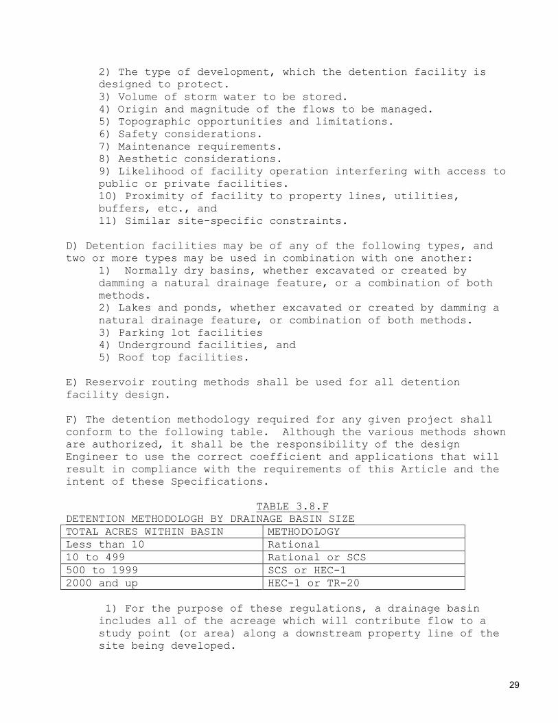
E) Reservoir routing methods shall be used for all detention facility design. F) The detention methodology required for any given project shall conform to the following table. Although the various methods shown are authorized, it shall be the responsibility of the design Engineer to use the correct coefficient and applications that will result in compliance with the requirements of this Article and the intent of these Specifications.
TABLE 3.8.F DETENTION METHODOLOGH BY DRAINAGE BASIN SIZE TOTAL ACRES WITHIN BASIN METHODOLOGY Less than 10 Rational 10 to 499 Rational or SCS 500 to 1999 SCS or HEC-1 2000 and up HEC-1 or TR-20
1) For the purpose of these regulations, a drainage basin includes all of the acreage which will contribute flow to a study point (or area) along a downstream property line of the site being developed.
30
2) All sub-basins draining a project which fall within the same size category above should be analyzed using the same methodology. 3) Under no circumstances will the “bowstring” method be acceptable.
G) If either the Rational Method or the SCS Method is used for detention design, calculations shall be provided showing how all times of concentration or lag times were computed, both for pre-and post-developed conditions. Likewise, adequate support must be provided for all composite runoff coefficients or curve numbers used. H) If a computer program is used for detention design, including generating and routing hydrographs, the output from the program shall be summarized in the Storm water Management Report, and the name and version of the program shall be indicated. Computer output sheets may be attached to the report if desired by the design engineer or if requested by the Planning and Zoning Commission. I) The design of every detention facility of any type shall consider the effects both of inflows in excess of those the facility is designed to accommodate and of malfunctioning of the primary outlet system. A safe path for overflow condition flows shall be provided.
3.9 DEDICATION OF DRAINAGE EASEMENTS:
A) GENERAL REQUIREMENTS: Where a subdivision is traversed by a watercourse, drainage way, channel, or stream, there shall be provided a storm water easement or drainage right-of-way conforming substantially to the lines of such watercourse, and of such width and construction or both as will be adequate for the purpose. Whenever possible, it is desirable that drainage be maintained by appropriate means of adequate width for maximum potential volume or flow. B) Where topography or other conditions are such as to make impractical the inclusion of drainage facilities within road right-of-way, perpetual unobstructed easements at least twenty (20) feet in width for such drainage facilities shall be provided access to the road. Easements shall be indicated on the plat. Drainage easements shall be carried from the road to a natural watercourse or to other drainage facilities. Easements less than twenty (20) feet may be approved by the Building Official. When a proposed drainage system will carry water across private land outside the subdivision and outside a natural drain, appropriate drainage rights must be secured and indicated on the plat. The applicant shall dedicate, either in fee simple or by drainage easement, land on both sides of existing watercourses subject to flooding or overflowing during

31
storm periods, whether or not included in areas for dedication, shall be preserved and retained in their natural state as drainage ways. Final plats for all subdivisions shall show (or include by note) a ten (10) foot wide drainage easement along every property line whether the developer intends to channel water in these easements or not. 3.10 WATER FACILITIES
GENERAL REQUIREMENTS:
1) Necessary action shall be taken by the applicant to extend or create a water-supply district for the purpose of providing domestic water use and fire protection. 2) Water distribution system, either public or private shall conform to the following: Where a public water supply system is proposed, service laterals through the curb line for each parcel and lot, and fire hydrants shall be provided. When a public water line is available within 1500 feet of said subdivision, the subdivision system shall be connected to said public system, based on the provisions of the Utility Services Delivery, Intergovernmental Contract. 3) Detailed information must be provided by the developer that the water and sewer system has adequate capacity to supply water and treat sanitary sewage from the proposed development. 4) To facilitate the above, the location of all fire hydrants, all water supply improvements, and the boundary lines of proposed districts, indicating all improvements proposed to be served, shall be shown on the construction drawings and the costs of installing same shall be included in the improvement guarantee to be furnished by the developer. 5) A copy of the as-built water plans shall be submitted to the Building Official.
3.11 INDIVIDUAL WELLS AND CENTRAL WATER SYSTEMS:
If no public water or sanitary sewer system is available within 1500 feet of the proposed development, lots may be served by individual wells and/or a central water system. Such wells and central water system must meet all applicable local, state and federal requirements for such facilities. Applicant shall furnish copy of EPD permit. Applicant shall also furnish certified documents showing of the number of lots to be served by the permit, the number of lots presently existing and the number of additional lots proposed with the application.

32
3.12 FIRE HYDRANTS:
Fire hydrants or provisions for fire hydrants shall be required for all subdivisions except those served by individual wells. Fire hydrants shall be located no more than nine hundred (900) feet apart for fire insurance rating purposes and within five hundred (500) feet of any structure and shall be approved by the Fire Official. To eliminate future street openings, all underground utilities for fire hydrants, together with fire hydrants themselves and all other water supply improvements shall be installed before placement of any base or pavement on any street within a subdivision. All fire hydrants shall be set plumb with outlets eighteen (18) inches above finished grade or twelve (12) inches above a finished concrete surface. All fire hydrants shall have at least two (2) two and one-half (2 ½ ) inch discharge outlets and one (1) four and one-half (4 ½) inch discharge outlet. All threads shall comply with local and state fire fighting equipment standards. Subdivisions without a water tower must provide fire protection via installing necessary appruantances (i.e. lines, stubs, gates, etc) for future connection to a water tower. These appruantances shall be in compliance with the current International Fire Code. 3.13 PRESERVATION OF NATURAL FEATURES AND AMENITIES:
Existing features, which would add value to residential development or the local government as a whole, such as trees, as herein defined, water courses and falls, beaches, historic spots and similar irreplaceable assets, shall be preserved in the design of the subdivision. 3.14 CERTIFICATE OF OCCUPANCY:
No certificate of occupancy shall be issued until final grading has been completed in accordance with the approved final subdivision plat and all other requirements have complied with. 3.15 INDIVIDUAL DISPOSAL SYSTEM REQUIREMENTS:
If public sewer facilities are not available and individual disposal systems are proposed, minimum lot areas shall conform to the requirements of the Zoning Ordinance and soil analysis study shall be made as directed by the County Sanitarian and the results submitted to the Health Department. The individual disposal system, including the size of the septic tanks and size of the tile fields or other secondary treatment device, is required to be approved by the County Sanitarian prior to installation.

33
3.16 DESIGN STANDARDS:
All plans shall be designed in accordance with the rules, regulations, and standards of the DNR. 3.17 UTILITIES:
A) LOCATION: Overhead utility lines shall be located along the front, side or rear property lines, or such other location as may be approved by the utility companies involved. The facilities for underground utilities or conduits for their construction shall, whenever possible, be in place prior to the construction of any base or paving on streets. All facilities for utilities shall, where possible, be placed in easements provided for that purpose in the subdivision or located as approved by the Building Official.
B) EASEMENTS: Utility easements for electric and telephone service lines, sewerage lines, water lines, or other such utilities located along rear lot lines or side lot lines or passing through a lot shall be a minimum of ten (10) feet wide. Easements along lot lines shall be centered on the lines. Additional width may be required if determined necessary by the Building Official. Where topographical or other conditions are such as to make impractical the installation of utilities along the rear lot lines, perpetual unobstructed easements at least ten (10) feet in width shall be provided along side lot lines with satisfactory access to the road or rear lot lines, Easements shall be indicated on the plat.
3.18 LOTS:
A) GENERAL REQUIREMENTS: All lots shall conform to the Regulations of the Greene County Board of Commissioners including, but not limited to, the provisions of the Zoning Ordinances, specifically those provisions governing minimum area, frontage and setbacks. The lot arrangement shall be such that there will be no foreseeable difficulties, for reasons of topography or other conditions, in securing building permits to build on all lots in compliance with County Regulations and in providing driveway access to buildings on such lots from an approved street.
B) LOT DIMENSIONS: Lot dimensions shall comply with the minimum standards of the Zoning Ordinance. All lots approved under these Regulations shall front on a street or private access drive. Where lots are more than double the minimum required area for the zoning district, the Building Official may require that such lots be arranged so as to allow further

34
subdivision and the opening of future streets where they would be necessary to serve such potential lots, all in compliance with the Zoning Ordinance and the Regulations. In general, side lot lines shall be at right angles to street lines (or radial to curving street lines) unless a variation of this rule will give a better street or lot plan. Dimensions of corner lots shall be large enough to allow for construction of buildings, observing the minimum front yard setbacks. Depth and width of properties reserved or laid out for business, commercial, or industrial purposes shall be adequate to provide for the off-street parking and loading facilities required for the type of use and development contemplated, as established in the Zoning Ordinance. Commercial and industrial lots shall be of adequate size to provide for the intended use and for the yards, buffer areas, and the off-street parking and loading requirements of the Zoning Ordinance.
C) LOT LINES: All lot lines shall be perpendicular or radial to street lines, unless not practicable because of topographic or other features. D) FRONT YARD SETBACKS: A line meeting the front yard setback requirements of the Zoning Ordinance shall be established on all lots. Any projection beyond the front building line such as uncovered porches, steps, eaves, gutters, and similar fixtures shall be subject to provisions of the Zoning Ordinance and approved or disapproved by the appropriate County official for each individual application. E) LOTS ABUTTING PUBLIC STREETS: Each lot shall abut upon a publicly dedicated and maintained street or a private vehicular way designated by the County as providing public access within a development. F) LOT DRAINAGE: Lots shall be laid out so as to provide positive drainage away from all buildings and individual lot drainage shall be coordinated with the general drainage pattern for the area. Drainage shall be designed so as to avoid concentration of drainage water from any lot to adjacent lots. G) DEBRIS AND WASTE: No waste materials of any kind shall be buried.
H) SOIL STABILIZATION: All lots shall have the dirt stabilized from the roadside edge of the unpaved right-of-way to a distance of twenty five (25) feet behind the principle structure on the lot. Sod or any approved grass seed, mulch or other approved method may be used to comply with any requirement of soil stabilization set forth herein.

35
3.19 CONSTRUCTION STANDARDS FOR ROADS AND STREETS:
GENERAL: The following minimum specifications for the construction of roads and streets are hereby required and shall be adhered to by the developer.
1. CLEARING AND GRUBBING: This work shall consist of the removing and disposing of all vegetation and debris within the right-of-way except such objects that may be designated on the plans to remain.
A) Clearing: Clearing consists of the removal and disposal of all visible objectionable matter within the right-of-way. Clearing may be done by any method the developer elects to use provided that no damage results to items selected to remain. B) Grubbing: Grubbing consists of the removal and proper disposal from the right-of-way of stumps, objectionable roots and abandoned objects imbedded within the underlying soil. All stumps having a diameter of four (4”) inches or more, measured six (6”) inches above the ground must be removed from fill sections. Objectionable roots:
a) Matted tree and brush roots regardless of size: b) Individual roots greater than 1” in diameter or
more than 36” in length shall be removed. Abandoned objects: Man made objects within the right-of-way such as fences, underground tanks, old paving, sidewalks, etc shall be removed. Stumps shall be removed to a depth of two (2) feet below the ground line. Areas containing objectionable roots shall be raked to a depth of 6” below ground line. Stump holes and holes caused by removal of objectionable objects shall be backfilled in fill areas with a suitable local material.
2. EROSION CONTROL: This work shall consist of pollution control measures shown on the plans or as ordered by the Building Official during the life of the project to control water pollution through the use of dikes, dams, silt fences, sediment basins, grasses, mulches or other erosion control devices. Temporary erosion control devices shall be shown on the plans and may consist of dikes, dams, silt fences, sediment

36
basins, grasses, mulches or other erosion control devices. Installation of temporary erosion control devices shall begin as soon as clearing and grubbing operations within an area are complete. Some temporary erosion control devices such as silt fences, sediment basins shall be installed prior to any other work after clearing and grubbing operations.
A) An erosion control plan, prepared by a Georgia licensed professional, shall be a part of the construction plans for a subdivision and shall be approved by the Building Official prior to any work other than clearing of rights-of-way and of survey lines. This plan shall specifically indicate the sequence of clearing, grubbing, earthwork operations and the construction of permanent erosion control features. It shall also indicate the proposed use of temporary erosion control features. It shall also specify the permanent grasses to be used. B) The desired ground cover, unless specified otherwise in the plans and approved by the Building Official, will be Common Bermuda Grass. Seed will be applied at the rate of two pounds per one thousand square feet (2 lbs/1000 sq ft). Seeding of Bermuda will take place between February 1 and November 15. Seeding done between September 1 and November 15 will also contain Annual Ryegrass at the rate of one pound per three thousand square feet (1 lb/3000 sq ft).
C) Areas to be seeded will be plowed thoroughly to a depth of six inches (6”), disked until pulverized and all roots and rocks removed and the areas smoothed prior to planting. Fertilizer and lime will be added at the rates indicated by soil tests. D) All seeded areas will be mulched. E) The developer may elect to use sod rather than seeding to establish a permanent ground cover. F) Frequent fording of live streams with heavy equipment will be prohibited.
3. PIPES AND OTHER STRUCTURES: This work will consist of the installation of storm drain pipe and pipe arch culverts of the proper size and type as required to provide for adequate handling of storm water runoff and small stream crossings.

37
A) General-Each pipe installed shall be of the size and type shown on the final construction plans. The pipe size will be determined by a professional licensed by the State of Georgia to perform such duties. Calculations documenting the required size of each pipe will be furnished to the Building Official. No cross drain pipe smaller than 18” inside diameter or side drain pipe of less than 15” inside diameter will be used in any location.
B) Materials-Pipe used will meet the requirements of the Georgia Department of Transportation Standard Specifications, 2001 Edition as shown below: TYPE OF PIPE DOT SPECIFICATION REFERENCE Reinforced Concrete Pipe Section 843.2.01 Bituminous Coated Corrugated Steel Pipe
Section 844.2.02
Bituminous Coated Corrugated Aluminum Alloy Pipe
Section 840.2.02
Non Reinforced Concrete Pipe Section 843.2.02 Corrugated Steel Pipe (driveways only)
Section 844.2.05
Pipe used underneath Minor Collector or higher classification streets will be reinforced concrete. The developer has the option to use either reinforced concrete or a bituminous-coated corrugated steel or aluminum pipe under local streets. Non-reinforced concrete or galvanized corrugated steel pipe can only be used under single-family residential driveways.
C) Installation-All pipe shall be laid in a prepared trench with the socket or bell ends pointing upstream. Concrete pipe sections may be joined with mortar joints or bituminous plastic cement joints with inside of each joint wiped clean. Pipe may also be joined with gasket joints, o-ring joints or coupling bands furnished by the manufacturer. All pipes will be laid on a smooth bed prepared in such a manner that the pipe is uniformly supported throughout its entire length.
D) Foundation Backfill-Natural ground will be undercut throughout the location of all cross drain pipes to a minimum of six inches (6”) below the outside bottom surface of the pipe. The undercut material shall be replaced with backfill material meeting the requirements of Section 812.2.01 (Foundation Backfill Material Type I) or Section 812.2.02 (Foundation Backfill Material Type II)
38
of the Georgia Department of Transportation Standard Specifications, 2001 Edition. Type I backfill is required under pipe placed in dry areas. Type II is required under pipe placed in wet or swampy areas.
E) Double Lines of Pipe-When installation of double lines of pipe are required, the two lines of pipe will have a clearance between the pipes of one inside diameter or thirty six (36”) whichever is smaller. The space between the two lines of pipe will be backfilled in uniform layers not to exceed eight inches (8”). Each layer will be thoroughly compacted by mechanical means before the succeeding layer is placed.
F) Backfill-All pipe will be backfilled with a suitable local material, placed in uniform layers not to exceed eight inches (8”) with each layer being thoroughly compacted prior to the succeeding layer being placed until the top of the pipe is covered. All backfill material will be compacted to 95% of its maximum relative density. No rock greater than four inches (4”) in diameter will be placed within two feet (2’) of pipe being backfilled. G) Cover-No pipe will be placed at an elevation that will not yield one foot (1’) of cover between the top of the pipe and the top of the subgrade. H) Flared end sections, headwalls or other suitable treatments shall be required on all exposed pipe ends.
4. GRADING: This work shall consist of the excavation, hauling and satisfactory placement of all materials within the limits of construction.
A) Excavation-All excavation will conform to the lines, grades and cross sections specified on the plans. B) Embankment-This work consists of the construction of all fill areas within the streets to line, grade and cross section shown on the construction plans. The fill material will be placed as nearly as possible in uniform, parallel layers of eight inches (8”) with each layer being thoroughly compacted before the succeeding layer is placed. Sheepsfoot rollers will be required on fills composed of clay soils. A compaction test shall be required for every two (2) vertical feet of fill. Smooth drum rollers may be used on sandy soils. Boulders larger than two feet (2’) in diameter shall be broken before

39
being placed in fills. A bulldozer or motor grader may be required on the fill areas as they are being constructed to keep the layers smooth and uniform. Fills (embankments) shall be compacted to 95% of the maximum relative density of the material being placed.
5. SUBGRADE-Subgrade is defined as the six inches (6”) of roadbed immediately beneath any base or subbase course. This area will be uniformly mixed, with all rock exceeding four inches (4”) in diameter, roots or other objectionable matter being removed. The subgrade will then be compacted to 95% of its maximum relative density. If the subgrade will not form a firm surface but begins to ravel a stabilizer, material shall be added and blended uniformly into the failing sections. This stabilizer material shall meet the requirements of Section 803.2.01 of the Georgia Department of Transportation Standard Specifications. The finished subgrade shall be test rolled by driving a loaded dump truck along the roadway, making sufficient passes to cover the entire width of the subgrade. If the subgrade shows a pumping movement under the test load, that section shall be plowed up and repaired regardless of any passing compaction tests. The test rolling shall be done under the direct supervision of the Building Official.
6. BASE and PAVING - This work consist of placing of all base material and pavement to the cross section specified in the construction plans. The width and depth (thickness) of any base or paving will meet or exceed the minimums shown in Table 3.4.2 of these regulations.
7. FINSIHING OPERATIONS - All completed streets and roads will be finished to the lines and grades specified on the construction plans. All construction debris will be removed from the site. All temporary erosion devices shall be removed and their locations repaired. Street and traffic control signs shall be in place before the finishing and dressing operations are deemed complete.
8. CERTIFICATION OF WORK-It shall be the responsibility of the developer to ensure that any contractor engaged in the construction of any part of the roads and drainage structure in a subdivision complies fully with requirements of Section 3.5 and all its subsections. The developer shall be prepared to furnish upon the request of the Building Official records, invoices and test results documenting materials used, construction methods, and field tests performed as part of the construction activities. It is also the responsibility of the developer to ensure that his contractor notifies the Building

40
Official of any necessary joint inspections at least one working day before the inspection is to be performed.
3.20 NON-RESIDENTAIL SUBDIVISIONS:
A) If a proposed subdivision includes land that is zoned for commercial or industrial purposes, the layout of the subdivision shall conform to these subdivision regulations. Land zoned for agricultural purposes is excluded from the regulations of this Section. B) A Nonresidential Subdivision shall also be subject to all the requirements of site plan approval set forth in the Zoning Ordinance. Site plan approval and nonresidential subdivision plat approval may proceed simultaneously at the discretion of the Planning and Zoning Commission.
C) In addition to the principles and standards in the Subdivision Regulations, which are appropriate to the planning of all subdivisions, the applicant shall demonstrate to the satisfaction of the Planning and Zoning Commission that the street, parcel and block pattern proposed is specifically adapted to the uses anticipated and takes into account other uses in the vicinity. The following principles and standards shall be observed:
1) A preliminary plat of a commercial or industrial center development shall conform in all respects with the approved master development plan for the project and any conditions associated with the project’s zoning. 2) Proposed industrial parcels shall be suitable in area and dimensions to the types of industrial development associated. 3) Street rights-of-way and pavement shall be adequate to accommodate the type and volume of traffic anticipated to be generated thereupon. 4) Special requirements may be imposed by the Building Official with respect to street, curb, gutter, and sidewalk design and construction. 5) Special requirements may be imposed by the Building Official with respect to the installation of public utilities, including water, sewer and storm water drainage.

41
6) Every effort shall be made to protect adjacent residential areas from potential nuisance from a proposed commercial or industrial subdivision, including the provision of extra depth in parcels backing up on existing or potential residential development and provisions for a permanently landscaped buffer strip when necessary. 7) Streets carrying nonresidential traffic, especially truck traffic, shall not be extended to the boundaries of adjacent existing or potential residential areas.
3.21 RESPONSIBILITY FOR IMPROVEMENTS:
A) GENERAL In lieu of the required improvements in a subdivision, the developer may deposit surety for the completion of such improvements with the County and present a final plat for approval B) REQUIREMENTS-To ensure the construction and installation of required improvements, the developer shall deliver to the County a certified check, surety bond, or other acceptable security in such aggregate amount as is estimated by the County to be double the total cost of the construction and installation of all required improvements. In addition, the developer shall, if applicable, deposit surety for road maintenance for a period of twelve (12) months.
C) CONDITIONS-Bonds, bank letter of credit, or other surety posted shall run to the Greene County Board of Commissioners and provide that the developer, his heirs, successors, assigns, their agents, shall comply with all applicable terms, conditions, provisions, and requirements of these and other regulations and the final plat; will faithfully perform and complete the work of constructing and installing all required improvements; that the developer shall be responsible to the County for any unnecessary expenses incurred through the failure of developer, his heirs, successors, assigns, or their agents, to complete the work of said installations and construction in an acceptable manner, and from any damages growing out of negligence in performing or failing to perform said installation and construction. If a bond is offered, it shall be executed by a surety or guaranty company qualified to transact business in the State of Georgia. Where a bond is required for a road construction project and is to be other than a bond issued by a commercial fidelity bonding company, the surety must meet the following conditions:
1) The surety must be posted by an individual or group of individuals

42
2) The surety or sureties must be worth at least double the estimated cost of all improvements including paving the road. 3) The bond must be accompanied by an affidavit setting forth the facts in 1 and 2 above. 4) If there is more than one surety, all sureties shall be jointly liable and severable liable.
D) DURATION AND RELEASE- Bonds and surety posted pursuant to this ordinance shall be released or returned, as the case may be, at such time as the facilities guaranteed thereby have been installed and accepted. Acceptances shall be in writing accurately identifying the improvements covered. Facilities shall not be accepted unless they conform to the applicable specifications and requirements. The Greene County Board of Commissioners shall make the decision as to whether a proposed bond, bank letter of credit, or other surety offers adequate security for the faithful completion of the required work.
E) DEFAULT PROCEDURES-If the construction or installation of any improvements of facilities for which a bond or other surety is posted is not completed within three (3) months after substantial completion of any buildings or structures which said improvements or facilities are designed to serve, or within three (3) years after the date of recording of final plat, whichever is sooner, or if said construction of installation is not in accordance with the applicable specifications and requirements, the County shall, using proceeds from such surety deposits, pay for such work. Such work may be done under contract or by County personnel. To the extent that any portion of a cash deposit is not required or used, said excess cash shall be repaid to the person making the deposit.
ARTICLE IV. SUBDIVISION APPLICATION PROCEDURE AND APPROVAL PROCESS
4.1 GENERAL PROCEDURE
When any subdivision of land is proposed, before any contract is made for the sale of any lot or part thereof, and before any permit for the erection of a structure in such proposed subdivision shall be granted, the developer, or his authorized agent, shall apply for and secure approval of such proposed subdivision in accordance with
43
the following procedures which includes three (3) steps for a minor subdivision and four (4) steps for a major subdivision:
1. Minor Subdivision
A. Sketch Plan; B. Construction documents and soil erosion plan; C. Final Plat;
2. Major Subdivision
A. Sketch Plan;
B. Preliminary Plat;
C. Construction documents and soil erosion plan;
D. Final Plat.
If such use is for commercial or industrial purposes, then such subdivision shall comply with all applicable provisions of these Regulations. If such use is for agricultural purposes, the provisions of these Regulations shall not apply. All submittals shall be consistent with provisions of the Zoning Ordinance and other codes, ordinances and regulations of the County.
4.2 SUBDIVISION REVIEW PROCEDURE
FEE SCHEDULE: Fee schedule maintained by the Building Official.
The following procedures shall be followed when submitting plats for minor subdivision, or plats and/or construction plans for all subdivisions:
1. Minor Subdivision: The developer shall meet with the Building Official to review a sketch plan of the proposed subdivision and insure compliance with these, and other appropriate County Ordinances and Regulations. After receiving approval of the sketch plat by the Building Official, the developer shall submit:
A. A reproducible original of the final plat and eight (8) copies shall then be submitted to the Building Official and all appropriate fees paid.

44
B. The Building Official shall review the final plat and approve or disapprove said plat within five (5) working days. C. Following the Building Official’s approval, the final plat shall be submitted to the Planning and Zoning Commission and Greene County Board of Commissioners for further action. D. The approved final plat is to be recorded by the developer in the office of the Clerk of Superior Court within thirty (30) days of the date of approval.
2. Major Subdivision:
A. Three (3) copies of the sketch plat shall be submitted to the Planning and Zoning Department. B. The developer and his/her professional representative shall meet with the Building Official to review the sketch plan. Approval of the sketch plan shall constitute permission to prepare a preliminary plat. C. No later than thirty (30) days prior to the meeting date of the Planning and Zoning Commission, the developer shall submit eight (8) copies of a preliminary plat to the Building Official for review, local distribution, and appropriate fees shall be paid.
D. The Building Official shall utilize the thirty (30) day period prior to the Planning and Zoning Commission meeting date to review the preliminary plat. The developer shall be notified if any changes are necessary to achieve compliance with these Regulations. The developer shall be responsible for having all changes made and a revised plat submitted prior to the Planning and Zoning Commission meeting date. E. At the meeting, the Planning and Zoning Commission shall make its recommendation to approve, table, or disapprove the preliminary plat. F. Relying on the information furnished to it, the Greene County Board of Commissioners shall make the decision regarding the preliminary plat and notify the developer of the decision. G. Preliminary plat approval is tentative, pending submission of construction plans and is valid for a period not to exceed twelve (12) months, after which it shall expire.
45
H. A grading permit shall be issued subsequent to preliminary plat and approval of construction plans.
I. Within twelve (12) months from the date of preliminary plat approval, copies of a final plat for one or more phases of the subdivision shall be submitted to the Building Official at least thirty (30) days prior to the date of the meeting of the Planning and Zoning Commission and all appropriate fees paid. The developer shall also provide the necessary improvements guarantees. The County Building Official may approve two separate one year extensions. At the end of three years, the approval of the preliminary plat will expire and the applicant must reapply. Failure to submit within this time period shall void the plat. Said extension must be applied for in writing by the developer.
J. At the meeting, the Planning and Zoning Commission shall determine whether all requirements of these or all other governing laws, ordinances, and regulations have been met and recommend to approve, table, or disapprove the final plat. Relying on the information furnished to it, the Greene County Board of Commissioners shall make the decision regarding the final plat and notify the developer of the decision. K. Recordation: An approved final plat shall be filed by the developer with the Clerk of Superior Court within thirty (30) days after final approval. However, if the final plat is approved during the month of December it shall be filed with the Clerk of Superior Court for recordation no later than 12:00 p.m. on the 31st day of December. Failure to comply with this provision shall void any approved plat.
4.3 SECTION DOCUMENT SUBMITTAL SCHEDULE
In order to process subdivision application, the following schedule shall be adhered to:
1. Minor Subdivision:
A. Sketch Plan: By advance appointment with the Building Official; B. Final Plat: By advance appointment with the Building Official;
2. Major Subdivision
A. Sketch Plan: By advance appointment with the Building
46
Official. B. Preliminary Plat: Thirty (30) days prior to the date of the Planning and Zoning Commission meeting at which the plat shall be reviewed.
C. Construction Plans: Within six (6) months subsequent to preliminary plat approval, but prior to installation of any required Improvements. D. Final Plat: Thirty (30) days prior to the date of the Planning and Zoning Commission meeting at which the final plat shall be reviewed but not later than twelve (12) months from the date of preliminary approval.
4.4 RE-SUBDIVISION (AMENDMENTS as per 2.2.61)
For any change in a plat of an approved and recorded subdivision, if such change affects any street layout shown on such plat, or area reserved thereon for public use, or any lot line, or if it affects any plat or plan legally reached prior to the adoption of any regulations controlling subdivisions, such change shall be submitted to the Planning and Zoning Board for review. The Planning and Zoning Board shall recommend approval or disapproval of this re-subdivision to the Board of Commissioners. 4.5 SUBDIVISION
Whenever a parcel of land is subdivided and the subdivision plat shows one or more lots containing more than one and one half (1.5) acres of land and such lots are re-subdivided into small building sites, the Building Official shall require that such parcel of land allow for the future opening of streets and the ultimate extension of such streets may be made a requirement of the plat. No re-subdivided lot can be smaller than the average size of those lots previously approved.
1. Minor Subdivision: The developer shall meet with the Building Official to review a sketch plat of the proposed subdivision and insure compliance with these, and all other appropriate County ordinances. After receiving approval of the sketch plat by the Building Official the developer shall submit the following:
A. A plat on reproducible material of the final plat and copies shall then be submitted to the Planning and Zoning Commission and all appropriate fees paid. B. The Building Official shall review the final plat and
47
approve or disapprove said plat within five (5) working days. C. The final plat, if approved, shall be submitted to the Planning and Zoning Commission and the Greene County Board of Commissioners for approval or disapproval. D. The approved final plat is to be recorded by the developer in the office of Clerk of Superior Court after approval.
2. Major subdivision:
A. Eight (8) copies of the sketch plat shall be submitted to the Planning and Zoning Commission. B. The developer and his/her professional representative shall meet with the Building Official to review the sketch plat. Approval of the sketch plat shall constitute permission to prepare a preliminary plat. C. No later than thirty (30) days prior to the meeting date of the Planning and Zoning Commission, the developer shall submit copies of a preliminary plat to the Building Official for review, local distribution, and all appropriate fees shall be paid. D. The Building Official shall utilize the thirty (30) day period prior to the Planning and Zoning Commission meeting date to review the preliminary plat. The developer shall be notified if any changes are necessary to achieve compliance with these regulations. The developer shall be responsible for having all changes made and a revised plat submitted prior to the Planning and Zoning Commission meeting date.
E. At the meeting, the Planning and Zoning Commission shall recommend to approve, approve subject to modifications, table, or disapprove the preliminary plat.
F. Relying on the information furnished to it, the Greene County Board of Commissioners shall make the decision regarding the preliminary plat and notify the developer of the decision. G. Preliminary plat approval is tentative, pending submission of construction plans and is valid for a period not to exceed twelve (12) months, after which it shall expire.

48
H. A grading permit shall be issued subsequent to Preliminary plat approval. No Improvement may be installed prior to approval of construction plans.
I. Eight (8) copies of construction plans depicting the design of all required improvements shall be submitted to the Planning and Zoning Commission within six (6) months from the date of approval of the preliminary plat.
J. Within twelve (12) months from the date of preliminary plat approval, copies of a final plat for one or more phases of the subdivision shall be submitted to the Building Official at least thirty (30) days prior to the date of the meeting of the Planning and Zoning Commission and all appropriate fees paid. The developer shall also provide the necessary improvements guarantees. Failure to submit within this time period shall void the plat unless an extension for a period not to exceed six (6) months is granted by the Planning and Zoning Commission. Said extension must be applied for in writing by the developer.
K. At the meeting, the Planning and Zoning Commission shall determine whether all requirements of these or all other governing laws, ordinances, and regulations have been met and recommend to approve, table, or disapprove the final plat. Relying on the information and documentation furnished, the Greene County Board of Commissioners shall make the decision regarding the final plat and notify the developer of the decision. L. Recordation: An approved final plat shall be filed by the developer with the Clerk of Superior Court within thirty (30) days after final approval. However, if the final plat Is approved during the month of December it shall be filed with the Clerk of Superior Court for recordation no later than 12:00 p.m. on the 31st day of December. Failure to comply with this provision shall void any approved plat by the developer.
ARTICLE V. SPECIFICATIONS FOR DOCUMENTS TO BE SUBMITTED
5.1 SKETCH PLAN
The sketch plan shall represent the entire area which the developer contemplates developing, including those units or sections not scheduled for immediate development. Three (3) copies of the sketch plan shall be submitted to the Planning and Zoning Commission

49
for review with the developer and his/her professional representative. The sketch plan shall include as a minimum the following information:
1.Content: The sketch plan submitted to the Planning and Zoning Commission may be prepared in ink or pencil on a reproducible medium and can be a freehand rendering. The sketch plan shall illustrate the ultimate development of the entire parcel owned by the applicant and shall Identify the section for which format plat approval will initially be requested. It shall be prepared at a scale of not more than one (1) inch equal one hundred (100) feet and is to include site topography at a contour interval of five (5) feet or less. The sketch plan shall include at minimum the following information:
A. Subdivision name and unit if within existing subdivision.
B. Proposed name if not within a previously platted subdivision. C. Name, address and telephone number of legal owner or agent of the property. D. Name, address and telephone number of registered professional responsible for subdivision design, design of improvement, and for survey. E. Date, scale, and north arrow. F. Vicinity map. G. Proposed use of property to be subdivided. H. Total acreage.
I. Location of existing property lines, major easements/right-of-ways, water courses, drainage areas and ditches, and distinctive natural features. J. The location and width of all existing or proposed streets or public ways within or directly adjacent to the subject property. K. Existing buildings. L. The approximate location of all proposed or existing lots, and the square footage of the smallest lot.

50
M. The location of flood hazard areas taken from the HUD (FEMA) maps. N. Statement of proposed water/sewer supply or collection method. 0. Zoning of subject property and adjacent property and adjacent properties. P. Any sketch plan of a major subdivision shall contain the locations of all general topographical features and the approximate slopes and gradients, both present and proposed. Additionally, any changes to be made affecting soil erosion and sedimentation that will be caused by grading, including information as to the conditions of soil types within the subdivision showing the relationship between soil limitations and dwelling density within the subdivision. Q. Any sketch plan shall provide information and data relating to surface water runoff as it affects storm water drainage and impact on adjacent areas.
5.2 PRELIMINARY PLAT
The preliminary plat shall represent the entire area, which the developer contemplates developing, including possible unit divisions not scheduled for immediate development. Copies of the preliminary plat shall be transmitted by the developer to the appropriate County agency. The preliminary plat shall be prepared by a licensed land surveyor, registered professional engineer or licensed landscape architect and includes as a minimum the following: 1. Content: The preliminary plat, submitted to the Planning and Zoning Commission shall be in ink on a reproducible medium, prepared in accordance with acceptable professional standards. The submittal copies shall consist of black-line prints or blue-line prints on a white background, and the submittal shall include such documents as necessary to meet the requirements of these regulations. If the preliminary plat is prepared by a registered professional engineer, reference must be made to the legal survey of the parcel. If the preliminary plat is not certified by a licensed land surveyor, a copy of a plat of the legal survey must be attached. The preliminary plat shall be prepared at a scale of one (1) inch equal one hundred (100) feet or larger for a subdivision with a maximum lot size of five (5) acres or smaller. For subdivisions with any lots exceeding five (5) acres in area, the plat shall be prepared at

51
a scale that will show each lot in its entirety on one single page of the plat. Any scale selected must be such as to clearly delineate setbacks, easements, rights of way and other required features of the drawing. Text size shall be no smaller than 0.08” in height and drawn to an accepted engineering scale. The drawings will be prepared on media no larger than twenty four by thirty six inches (24”x36”). If the entire preliminary plat cannot be depicted on one sheet, the plat may be divided and an index provided. The preliminary plat shall contain the following information:
A. Name of subdivision. B. Names and right-of-way width of all proposed streets C. Name, address and telephone number of the owner or owner’s of the land to be subdivided and the name, address and telephone number of the developer. D. The seal, name, and address of the licensed land surveyor or registered professional engineer. E. Date, graphic scale, numeric scale, north arrow and space for revisions. F. Vicinity map indicating streets and highways, railroads and other significant features within, or adjacent to the proposed subdivision. G. Proposed use of property to be subdivided. H. Total acreage, outlet acreage if applicable and the acreage of the smallest lot. I. Present zoning of subject property and adjacent properties. J. The location of property with respect to surrounding streets, and the names of adjoining developments. K. The location and dimensions of all boundary lines of the property to be expressed in feet. L. Unit divisions if known or staged development if proposed by the developer. M. Contour lines at intervals not to exceed two (2) feet, based on mean sea level datum. The basis for development of contour lines shall be indicated on the plat. N. The approximate location and sizes of existing sewers, water

52
mains, drainage or other underground structures within, and immediately adjacent to the subject property.
0. The location of existing and proposed streets, easements, water bodies, flood hazard areas and flooding, streams and other pertinent features such as swamps, railroads, building parks, cemeteries, drainage ditches, bridges and rock outcrops. P. Reference points from proposed intersections to permanent features. Q. The location and scaled dimensions of all proposed or existing lots. The minimum front yard setback on all lots and side lot setback for corner lots.
R. The location and scaled dimensions and acreage of all property proposed to be set aside for park or playground use, or other public or private reservation, with designation of the purpose thereof, and conditions, if any, of the dedication or reservation. S. All maps or plats shall show the direction and distance from a point of reference to a point on the boundary of the individual survey, and such additional data as may be required to relocate the boundary point from the point of reference with the same degree of accuracy required of the parcel surveyed. The point of reference shall be an established, monumental position that can be identified or relocated from maps, plats, or other documents on public record. T. Blocks shall be lettered in alphabetical order. Blocks in numbered additions to the subdivision bearing the same name shall be lettered consecutively throughout the several additions.
U. All lots in each block shall be consecutively numbered in a logical sequence. V. List of proposed utilities to be located underground. W. A statement of the proposed method of water supply, major drainage provisions, detention areas, and proposed sewage disposal plans. If the development is to utilize a private sewer system, all information required by the Health Department shall be provided. X. The total number of units if not a single-family subdivision.

53
Y. All required setback lines for all parcels. Z. The lack of information under any item specified herein, or improper information supplied by the applicant, shall be cause of disapproval of a preliminary plat. NOTE: THIS IS A TEMPORARY PLAT AND SHALL NOT BE USED FOR FINAL RECORDING.
5.3 CONSTRUCTION PLANS
Prior to installation of any required improvements, the developer shall submit eight (8) copies of construction plans to the Planning and Zoning Commission. No improvements shall be installed until the Building Official formally approves the construction plans. Construction plans shall be prepared only by a registered professional engineer, registered land surveyor, or registered landscape architect.
1. Content: All construction plans submitted to the Planning and Zoning Commission shall be prepared in accordance with acceptable professional standards in ink, on a reproducible medium. The submittal copies shall consist of black-line or blue-line prints on a white background. Construction plans shall be prepared in accordance with the design standards contained in these regulations and shall be drawn at a scale of not more than one (1) inch equal one hundred (100) feet with a contour- interval not to exceed two (2) feet. Drawing sheets size shall not exceed twenty-four by thirty-six inches (24” X 36”). Construction plans shall be submitted for all required improvements and amended when necessary. The following shall be depicted:
A. Profiles shall be accompanied by plan views of street intersection, significant cuts and fills end intersections with existing property lines. This includes all known geographical features such as faults and rock formations.
B. Profiles showing existing and proposed elevation along centerlines of all roads. Where a proposed road intersects an existing road or roads, the elevation along the centerline of the existing road or roads shall be shown. The radii of all curves, lengths of tangents and central angles on all streets. C. Where slopes in excess of twenty (20) percent occur on cross slopes, the Building Official may require that cross sections of all proposed streets at fifty foot stations shall be shown at five (5) points as follows:
(1) On a line at right angles to the center- line of

54
the street, and said elevation points shall be at the center line of the street, each property line and points fifty (50) feet inside each property line.
D. Plans end profiles showing the location and typical cross section of street pavements including curbs and gutters, sidewalks if provided, drainage easements, right-of-way, manholes, and catch basins; the location, size and invert elevations of existing and proposed storm sewers, drains, and exact location and size of all existing water, gas or underground utilities or structures. All utilities proposed for location underground shall be duly noted.
E. Location and size of all existing and proposed drainage structures including retention ponds, catch basins, grates, headwalls and any extensions thereof. The acreage of the drainage area and all pipe end ditch sizing calculations shall be provided. F. The engineer preparing the construction plans shall certify the centerline of all streets and drainage ways based upon a field run survey. G. Plans for water systems and plans and profiles for sewer system and storm drainage pipes. H. All information required by Greene County construction standards and specifications.
I. An approved sedimentation and erosion control plan. J. A hydrological study including the drainage plan for the area. K. Title, name, address, stamp, and signature of professional engineer and date, including revision dates. L. Typical street section to include asphalt and base thickness, curb, road width, shoulder slope, and right-of-way width.
5.4 FINAL PLAT
Within twelve (12) months of the date of approval of the preliminary plat, the final plat must be submitted to the Planning and Zoning Commission for review. The final plat shall be prepared by a registered land surveyor. The final plat shall conform to the preliminary plat. It may

55
represent only that portion of the approved preliminary plat that the developer proposed to develop and record at this time. 1. Content: The final plat submitted shall conform to the preliminary plat and shall be in ink on a reproducible medium prepared in accordance with accepted professional standards. The submittal copies shall consist of black-line or blue-line prints on a white background, and the submittal shall include such other documents as necessary to meet the requirements of these regulations. The final plat shall be prepared at a scale of one (1) inch equals one hundred (100) feet or- larger for a subdivision with a maximum lot size of five (5) acres or smaller. For subdivisions with any lots exceeding five (5) acres in area, the plat shall be prepared at a scale that will show each lot in its entirety on one single page of the plat. Any scale selected must be such as to clearly delineate setbacks, easements, rights of way and other required features of the drawing. Text size shall be no smaller than 0.08” in height and drawn to an accepted engineering scale. Sheet size shall be twelve (12) inches by sixteen (16) inches for a minor subdivision and seventeen (17) inches by twenty-one (21) inches for a major subdivision. If the entire final plat cannot be depicted on one sheet, the plat may be divided and an index provided showing the following:
A. Name of subdivision. B. Name, address and telephone number of the developer. C. Date of survey, date of plat drawing, and revision dates, graphic scale; north arrow with reference of bearings to magnetic, true, or grid north; the longitude and latitude end state plane coordinates; and the mean sea level datum. D. Location of tract (land district and land lot) and acreage. E. If part or all of the tract is a portion of a former sub-division, reference shall be made to the former plat, with identification of the former lots and blocks being re-subdivided. F. Index map, when more than one (1) sheet is required to depict plat. G. Courses and distances to the nearest existing street lines, bench marks or other recognized permanent monuments which shall be accurately described on the plat. H. All maps or plats shall show the direction and distance from a point of reference to a point on the boundary of the

56
individual survey, and such additional data as may be required to relocated the boundary point from the point of reference with the same degree of accuracy required of the parcel surveyed. The point of reference shall be an established, monumented, position that can be identified or relocated from maps, plats, or other documents on public record. I. The error of closure, as calculated by latitudes and departures, shall be stated. Surveys shall be coordinated and vertically tied into U.S. Coast and Geodetic Survey Elevations. The benchmark used shall be provided.
J. Municipal, County lines accurately tied to the boundary line of the subdivision by distance and angles, when such lines transverse or are reasonably close to the subdivision, boundary line of the subdivision by distance and angles, when such lines transverse or are reasonably close to the subdivision.
K. Exact location, right-of-way, widths, and names of all streets and alleys within and immediately adjoining the plat, and the exact location and widths of all cross angles of inter-sections, radii, length of tangents, and arcs and degree of curvature with basis of curve data.
L. Lot lines with dimensions to the nearest one hundredth (1/100) foot, necessary internal angles, arcs and chords, and tangents of radii of rounded corners.
M. Building setbacks, with dimension.
N. When lots are located on a curve or when side lot lines arc at angles other than ninety (90) degrees, the lot width at the building lines shall be shown.
0. Blocks lettered alphabetically within each block; lots or sites numbered in numerical order.
P. The acreage of the smallest lot.
Q. Location, dimensions and purposes of:
(1) easements, including slope easements, public service utility right-of-way lines, areas (other- than streets) to be reserved, donated, or dedicated to the public; (2) sites for other than residential use, with notes stating their purposes and limitations; and (3) of any areas to be reserved by deed covenant for common

57
uses of all property owners. R. Accurate location, material and description of monuments and markers. Monuments to be placed after final street improvements shall be designated as “future.”
S. Present zoning of subject property and adjacent properties.
T. Required setback lines for all parcels. U. The following certification: In addition to any other powers that Greene County may have, this subdivision is a special drainage district. See Article 2, Section 2, Paragraph 2, Georgia Constitution, 1953. V. Certifications for final plat approval by the County Manager or Building Official.
W. Owner’s Certification: The final plat shall contain, in addition to a licensed land surveyor’s certification, a statement as fellows:
“I (we) hereby certify that I am (we are) the owner(s) of the property shown and described herein and that I (we) hereby adopt this plan of subdivision with my (our) free consent, establish the minimum building restriction lines, dedicate all streets, easements, alleys, walks, parks and other open spaces to provide directly or indirectly for maintenance of all common areas or outlets.”
This statement shall be signed and dated by the owners, proprietors, or trustees, if any, prior to the final plat submittal. The final plat shall be accompanied by statements of deed restrictions (covenants) that the developer intends to apply to the subdivision, if any. All deed restrictions shall meet or exceed the requirements contained in this regulation and the requirements of the Zoning Ordinance. 5.5 REVISION
No change, erasure, or revision shall be made on any preliminary or final plat, nor on accompanying data sheets after approval of the Greene County Board of Commissioners. In no case shall the Greene County Board of Commissioners approve a revision unless the fact that it is a revised plat is clearly stated thereon.

58
ARTICLE VI. ASSURANCE FOR COMPLETION AND MAINTENACE OF IMPROVEMENTS
6.1 INSTALLATION OF IMPROVEMENTS, IMPROVEMENTS GUARANTEES
Before the final plat is approved by the Board of Commissioners, all applicants shall be required to complete or produce improvement guarantees for all improvements as required in these Regulations:
1) Completion of Improvements: The Building Official must certify that all improvements required by the County have been satisfactorily installed or the installation guaranteed. 2) Improvement Guarantees: The developer shall provide improvement guarantees at the time of application for final plat approval. Said guarantee amount shall be determined by the County Board of Commissioners for the assurance of the satisfactory construction, installation, and dedication of the uncompleted portion of improvements. Improvement guarantees may take the form of either a bond, letter of credit or a certified check. Guarantees shall be structured to permit periodic demands for payment from the issuer in whole or in part for the entire amount of the credit. All checks will be cashed and held in interest bearing accounts with interest accruing to the County. No check accepted as a guarantee will be held. Such improvement guarantees shall be approved by the County Commissioners as to amount and surety. The guarantee shall be released only after the County has accepted the work. 3) Costs of Improvements: All required improvements should be made by the developer, at his expense, without reimbursement by the County. 4) Failure to Complete Improvements: In those instances where an improvement guarantee has been posted and required improvements have not been installed within the terms of such guarantees, the County shall call the improvement due and collect all funds or require that all improvements be immediately installed regardless of the extent of the building development at the time the improvement guarantee is declared to be in default. If the Building Official finds upon inspection that any of the required improvements have not been constructed in accordance with the County’s construction standards and specifications, the developer shall be responsible for removing any defects and completing the improvements or forfeiting the guarantee. 5) Acceptance of Dedication Offers: Acceptance of formal offers of dedication of streets, public area, easements, and parks shall be an act of the Board of Commissioners. The
59
approval by the Planning and Zoning Commission of a subdivision plat shall not be deemed to constitute or imply the acceptance by the County of any street, easement, or park shown on said plat.
6.2 INSPECTION OF IMPROVEMENTS
The Building Official shall provide for inspection of required improvements during and upon completion of installation to ensure satisfactory compliance with provisions of this Regulation. The County shall not accept dedication of required improvements, nor release, or reduce an improvement guarantee, until the Building Official has submitted a letter stating that all required improvements have been satisfactorily completed and a deed submitted. Upon such approval recommendation of the Building Official, the Board of Commissioners shall consider acceptance of the improvements for dedication in accordance with the established procedure. 6.3 MAINTENANCE OF IMPROVEMENTS:
The applicant shall be required to maintain all improvements on the individual lots until acceptance of said improvements by the Board of Commissioners. If there are any Certificates of Occupancy issued on a street not dedicated to the County, the County may on twelve (12) hours notice effect emergency repairs and charge it to applicant. Prior to dedication of improvements, the applicant shall be required to file with the Board of Commissioners a maintenance bond in an amount equal to one-third (1/3) of the total costs of improvements, in order to assure the satisfactory condition of all lot improvements. The bond shall be maintained for a period on one (1) year after the date of their acceptance by the Board of Commissioners and dedication to the County. ARTICLE VII. REQUIREMENTS FOR IMPROVEMENTS, DESIGN AND CONSTRUCTION
7.1 General
The following provisions shall govern the submittal and review of all construction plans or plats:
1. Monuments: Permanent reference monuments shall be placed at block corners and other points such as street intersections, lot corners, curve points and angle points, and shall be marked with a solid iron rod or an iron pipe not less than one-half (1/2) inch in diameter, at least eighteen (18 inches long, driven flush with the ground. Monuments shall be indicated on the final plat. Removal of monuments and

60
resetting by anyone other than a registered Land Surveyor is prohibited.
2. Character of the Land: Land which the Building Official finds
to be unsuitable for subdivision development due to potential for flooding, poor drainage, steep slopes, rock formations, adverse topography or landforms, or other features which could be harmful to the safety, health, and general welfare of the present or future inhabitants of the subdivision shall not be subdivided or developed unless adequate methods to alleviate these problems are formulated by the developer with concurrence of the Building Official.
3. Other Requirements: Compliance with all other County regulations or ordinances including but not limited to those governing subdivision plats both preliminary or final.
ARTICLE VIII. CONSTRUCTION SCHEDULE
8.1 PRIOR APPROVAL
No construction activity of any kind including finished grading, Installation of improvements, or building shall begin on any land subject to these Subdivision Regulations without prior approval of the preliminary plat and construction plans. 8.2 GRADING
Grading operations limited to clearing and grubbing may commence once approval of the preliminary plat is granted. 8.3 UTILITIES
Utility Installation shall not occur until the Building Official has received the certification that the streets were graded as designed by the design engineer and has approved the rough grade of the street and shoulder preparation. 8.4 INSPECTIONS
Periodic inspection during the installation of the required Improve-ments in a subdivision shall be made by the Building Official to insure conformity with the approved plans and specifications. The developer shall notify the Building Official when each phase of the installation is completed and ready for inspection. 8.5 SALE AND TRANSFER
No lot or parcel of land shall be sold or transferred or a building

61
permit issued until the final plat, of which said lot or parcel is a part, shall have been approved and recorded as provided for in these Subdivision Regulations. 8.6 BUILDING PERMITS
The Building Official shall not issue any permit for the construc-tion of any building or structure to be located in any subdivision, a plat whereof is required to be recorded pursuant to the provisions of these Subdivision Regulations, until such plat shall have been approved and recorded as provided for in these subdivision regulations. 8.7 OCCUPANCY
Within each phase of development, no building may be occupied for dwelling or other purposes, nor shall an occupancy permit be issued for any building until required utility installations, including the water supply and sanitary sewer systems, have been completed and approved by the Building Official.
ARTICLE IX. LEGAL STATUS PROVISIONS
9.1 REPEALER
Previous Greene County Subdivision Regulations are hereby repealed. 9.2 EFFECTIVE DATE:
It is hereby ordained by the Board of Commissioners of Greene County, Georgia, that this Ordinance is approved and adopted after a public hearing on the 16th day of February, 2010. This Ordinance shall take effect and shall be in force from the 1st day of March, 2010. __________________________________ Sylvia V. Hill, County Clerk _________________________________ ________________________________ Dene Channell, Chairman W. L. Sanders, Vice-Chairman __________________________________ ________________________________ Marion Rhodes, Commissioner Titus Andrews, Sr., Commissioner __________________________________ Gerald W. Torbert, Commissioner


