45
FRANKFORD CREEK GREENWAY FEASIBILITY STUDY MAY, 2014 PREPARED BY: WITH SUPPORT FROM: SUBMITTED TO:
| Date post: | 11-Apr-2018 |
| Category: |
Documents |
| Upload: | duongkhanh |
| View: | 216 times |
| Download: | 2 times |

FRANKFORD CREEKG R E E N W A Y FEASIBILITY STUDY
MAY, 2014
PREPARED BY:
WITH SUPPORT FROM:
SUBMITTED TO:

Table of Contents Acknowledgements ....................................................................................................................................... 2
Introduction .................................................................................................................................................. 3
I. Existing Conditions Assessment ............................................................................................................ 5
a. Existing Street Right of Ways ............................................................................................................ 6
b. Greenway Segment Descriptions ...................................................................................................... 7
II. Alignment Options .............................................................................................................................. 17
a. Segment Alternatives Descriptions ................................................................................................. 17
b. Gateway Treatments ....................................................................................................................... 31
c. Leiper Street Connection Park ........................................................................................................ 33
d. Formliners ....................................................................................................................................... 35
III. Challenges and Partnership Opportunities ......................................................................................... 36
IV. Implementation Strategies ................................................................................................................. 38
a. Short-Term Plan (1-4 years) ............................................................................................................ 38
b. Medium-Term Plan (4-6 years) ....................................................................................................... 39
c. Long-Term Plan (6-10 years) ........................................................................................................... 39
d. Very long term (10+ years) ............................................................................................................. 39
e. Maintenance, Operations, Security Plan ........................................................................................ 40
f. Operations ...................................................................................................................................... 40
g. Public Feedback .............................................................................................................................. 41
h. Funding Options .............................................................................................................................. 41
V. Cost Estimates..................................................................................................................................... 44
Appendix
A. Property Information B. Detailed Cost Estimate C. Preliminary Plans for Section 1 D. Meeting Documentation E. Site Analysis Map F. Adams Avenue Connector Map
Frankford Creek Greenway Feasibility Study Page 1

Acknowledgements
Special thanks are due to the members of the steering committee who gave their time and effort to make this project possible.
Steering Committee Members: Rob Armstrong (PPR) Dan Biggs (Toole Design Group) Tom Branigan (DRCC) Jeannette Brugger (PCPC) Christine Caggiano (Baker) Charles Carmalt (MOTU) Stephanie Craighead (PPR) Dan Dunphy (Councilwoman Sanchez) Liz Gabor (PIDC) Nicole Hostettler (PWD) Leigh Jones (PRA) Ian Litwin (PCPC) Charles Mottershead (Dept. of Public Property) Clint Randall (PCPC) Julie Slavet (TTFWP) Valessa Souter-Kline (PWD) Chris Stanford (Baker)
Frankford Creek Greenway Feasibility Study Page 2
Introduction
Michael Baker Jr., Inc. (Baker) worked with the Philadelphia City Planning Commission (PCPC) and Philadelphia Parks and Recreation (PPR) from May 2013 to May 2014 on the feasibility of developing the Frankford Creek Greenway. After site visits, meetings with stakeholders, and completing research in this region, this report was developed to layout the feasibility of a shared-use path along the Frankford Creek from Wingohocking Street in the north to Delaware Avenue and the East Coast Greenway in the south.
The Frankford Creek originates northwest of Philadelphia (as Tacony Creek) and drains into the Delaware River adjacent to the Betsy Ross Bridge. Sections of the creek were channelized in the mid-20th century. Green2015: An Action Plan for the First 500 Acres (2010) describes the Frankford Creek area as a region of Philadelphia in highest need of greening to mitigate stormwater issues and provide the surrounding community with green space. Philadelphia Water Department also lists Frankford Creek as a priority for creek restoration. Additionally, the Philadelphia Trail Master Plan (2013) lists a trail in along the creek as a highest priority for the City. The existing green space along the creek needs improvement and access from the adjacent neighborhoods.
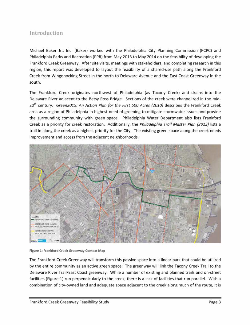
Figure 1: Frankford Creek Greenway Context Map
The Frankford Creek Greenway will transform this passive space into a linear park that could be utilized by the entire community as an active green space. The greenway will link the Tacony Creek Trail to the Delaware River Trail/East Coast greenway. While a number of existing and planned trails and on-street facilities (Figure 1) run perpendicularly to the creek, there is a lack of facilities that run parallel. With a combination of city-owned land and adequate space adjacent to the creek along much of the route, it is
Frankford Creek Greenway Feasibility Study Page 3
possible to build the Frankford Creek Greenway with minimal property acquisition and easements. Some land acquisition/easements will be necessary in the northern section of the greenway.
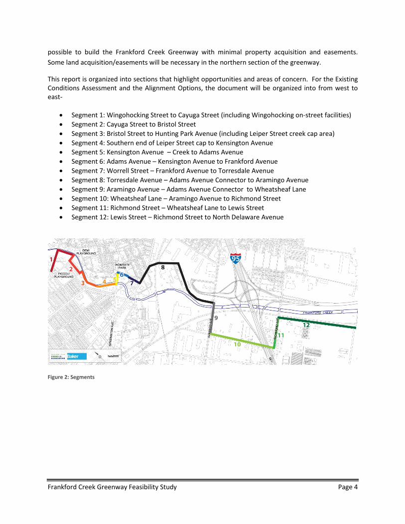
This report is organized into sections that highlight opportunities and areas of concern. For the Existing Conditions Assessment and the Alignment Options, the document will be organized into from west to east-
• Segment 1: Wingohocking Street to Cayuga Street (including Wingohocking on-street facilities) • Segment 2: Cayuga Street to Bristol Street • Segment 3: Bristol Street to Hunting Park Avenue (including Leiper Street creek cap area) • Segment 4: Southern end of Leiper Street cap to Kensington Avenue • Segment 5: Kensington Avenue – Creek to Adams Avenue • Segment 6: Adams Avenue – Kensington Avenue to Frankford Avenue • Segment 7: Worrell Street – Frankford Avenue to Torresdale Avenue • Segment 8: Torresdale Avenue – Adams Avenue Connector to Aramingo Avenue • Segment 9: Aramingo Avenue – Adams Avenue Connector to Wheatsheaf Lane • Segment 10: Wheatsheaf Lane – Aramingo Avenue to Richmond Street • Segment 11: Richmond Street – Wheatsheaf Lane to Lewis Street • Segment 12: Lewis Street – Richmond Street to North Delaware Avenue
Figure 2: Segments
Frankford Creek Greenway Feasibility Study Page 4
I. Existing Conditions Assessment Based on several field view meetings, background research and other documentation, this section documents the existing conditions in the various sections of the corridor.
One of the preliminary tasks for this effort was to determine the existing street curb to curb widths, sidewalk widths and overall right of way widths from the City Plan. The chart on the next page summarizes the results of this investigation.
Frankford Creek Greenway Feasibility Study Page 5
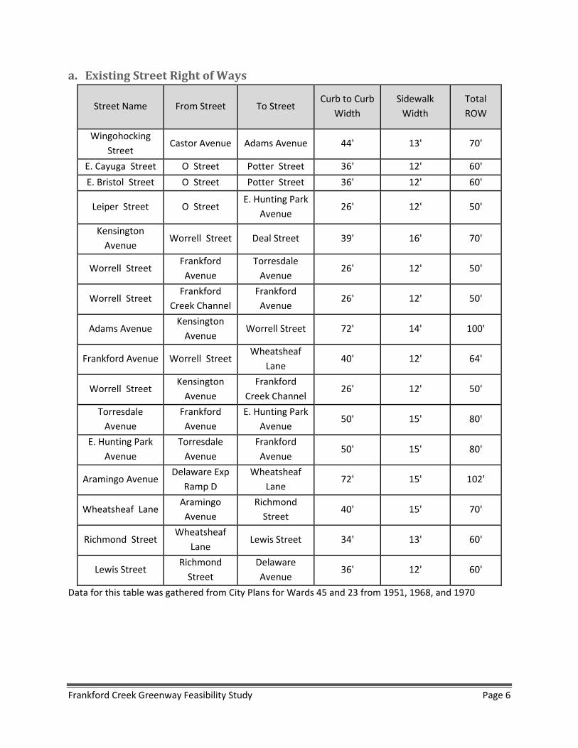
a. Existing Street Right of Ways
Street Name From Street To Street Curb to Curb
Width Sidewalk
Width Total ROW
Wingohocking Street
Castor Avenue Adams Avenue 44' 13' 70'
E. Cayuga Street O Street Potter Street 36' 12' 60' E. Bristol Street O Street Potter Street 36' 12' 60'
Leiper Street O Street E. Hunting Park
Avenue 26' 12' 50'
Kensington Avenue
Worrell Street Deal Street 39' 16' 70'
Worrell Street Frankford Avenue
Torresdale Avenue
26' 12' 50'
Worrell Street Frankford
Creek Channel Frankford Avenue
26' 12' 50'
Adams Avenue Kensington
Avenue Worrell Street 72' 14' 100'
Frankford Avenue Worrell Street Wheatsheaf
Lane 40' 12' 64'
Worrell Street Kensington
Avenue Frankford
Creek Channel 26' 12' 50'
Torresdale Avenue
Frankford Avenue
E. Hunting Park Avenue
50' 15' 80'
E. Hunting Park Avenue
Torresdale Avenue
Frankford Avenue
50' 15' 80'
Aramingo Avenue Delaware Exp
Ramp D Wheatsheaf
Lane 72' 15' 102'
Wheatsheaf Lane Aramingo Avenue
Richmond Street
40' 15' 70'
Richmond Street Wheatsheaf
Lane Lewis Street 34' 13' 60'
Lewis Street Richmond
Street Delaware Avenue
36' 12' 60'
Data for this table was gathered from City Plans for Wards 45 and 23 from 1951, 1968, and 1970
Frankford Creek Greenway Feasibility Study Page 6
b. Greenway Segment Descriptions
Segment 1: Wingohocking Street to Cayuga Street
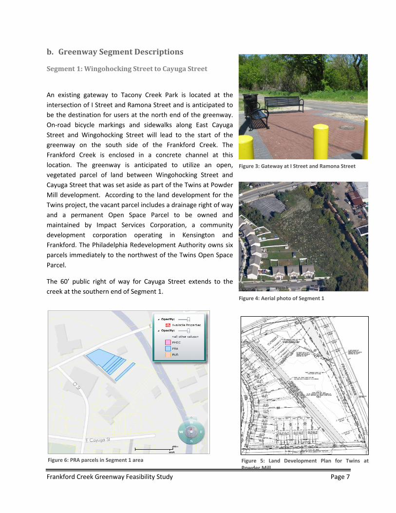
An existing gateway to Tacony Creek Park is located at the intersection of I Street and Ramona Street and is anticipated to be the destination for users at the north end of the greenway. On-road bicycle markings and sidewalks along East Cayuga Street and Wingohocking Street will lead to the start of the greenway on the south side of the Frankford Creek. The Frankford Creek is enclosed in a concrete channel at this location. The greenway is anticipated to utilize an open, vegetated parcel of land between Wingohocking Street and Cayuga Street that was set aside as part of the Twins at Powder Mill development. According to the land development for the Twins project, the vacant parcel includes a drainage right of way and a permanent Open Space Parcel to be owned and maintained by Impact Services Corporation, a community development corporation operating in Kensington and Frankford. The Philadelphia Redevelopment Authority owns six parcels immediately to the northwest of the Twins Open Space Parcel.
The 60’ public right of way for Cayuga Street extends to the creek at the southern end of Segment 1.
Figure 6: PRA parcels in Segment 1 area
Figure 3: Gateway at I Street and Ramona Street
Figure 4: Aerial photo of Segment 1
Figure 5: Land Development Plan for Twins at Powder Mill
Frankford Creek Greenway Feasibility Study Page 7

Segment 2: Cayuga Street to Bristol Street Between Cayuga Street and Bristol Street, there is a triangle parcel of wooded/vegetated area bounded by the channelized portion of the creek and a paved alley serving a section of row homes that front Potter Street. Although the triangle parcel is owned by the City of Philadelphia, the adjacent owners have encroached onto land they do not own, using the parcel as their personal backyards. The uses range from formal gardens to dog runs to locations for a smokehouse. Several fences are present that run perpendicular to the alley toward the Creek. Due to this encroachment, the project team anticipates investigating the use of Potter Street for the alignment as well as the ROW behind the houses. The area includes numerous large diameter trees as well.
Segment 3: Bristol Street to Southern end of Leiper Street Culvert Segment 3 includes a narrow strip of vegetated area behind a former grocery store building adjacent to the concrete channel of Frankford Creek. There is a large paved parking lot that surrounds the former grocery store and extends to the top of bank of the channelized portion of the creek. The parcel located at 1610-32 E. Bristol Street is currently for sale. The existing 1 story block building is approximately 19,000 square feet and is located on a 2.46 acre lot. The asking price is $1,150,000. A copy of the sale information sheet is included in the Appendix of this memo.
Near Leiper Street, a three cell concrete culvert carries the Frankford Creek. The culvert is approximately 50’ side and 500’ long. The area above the culvert is heavily vegetated and includes some existing dirt foot paths.
West of the box culvert, there is a section of two story row homes that front to East Hunting Park Avenue. A paved alley is present behind the homes. Beyond the alley, there is a small strip of trees and grass as well as another area of existing pavement that appears to serve for overflow parking for the homes. This narrow strip, along with the auto body shop located immediately to the southeast, is a
Figure 8: Existing alley parallel to Potter Street Figure 7: Aerial photo of Segment 2
Frankford Creek Greenway Feasibility Study Page 8

single parcel owned by Good Friday Investments, LLC. There is an OPA lien on this property in the amount of $10,102.63. There is also a prevalence of short dumping in this area.
Figure 11: Aerial photo of Segment 3
Figure 10: Existing 3 cell box culvert carrying Frankford Creek near Leiper Street
Figure 9: View from top of box culvert
Frankford Creek Greenway Feasibility Study Page 9
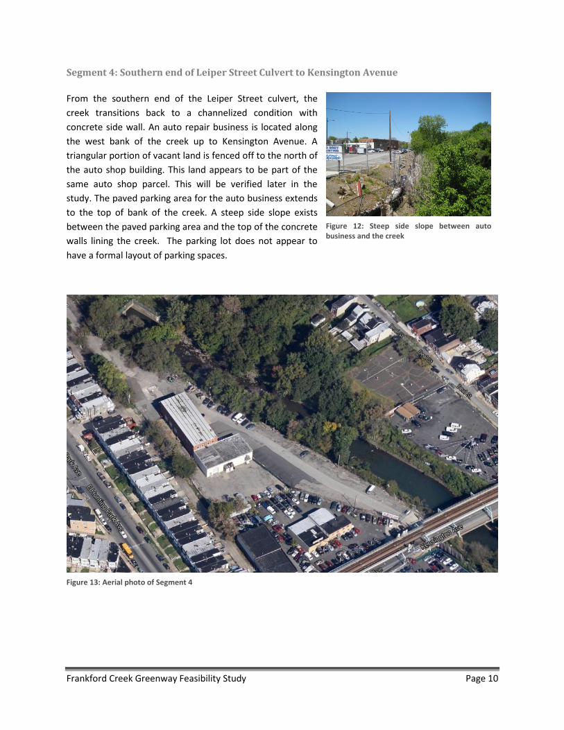
Segment 4: Southern end of Leiper Street Culvert to Kensington Avenue From the southern end of the Leiper Street culvert, the creek transitions back to a channelized condition with concrete side wall. An auto repair business is located along the west bank of the creek up to Kensington Avenue. A triangular portion of vacant land is fenced off to the north of the auto shop building. This land appears to be part of the same auto shop parcel. This will be verified later in the study. The paved parking area for the auto business extends to the top of bank of the creek. A steep side slope exists between the paved parking area and the top of the concrete walls lining the creek. The parking lot does not appear to have a formal layout of parking spaces.
Figure 12: Steep side slope between auto business and the creek
Figure 13: Aerial photo of Segment 4
Frankford Creek Greenway Feasibility Study Page 10

Segment 5: Kensington Avenue – Frankford Creek to Adams Avenue It is currently anticipated that the greenway will follow the north side of Kensington Avenue to the east to reach Adams Avenue at Womrath Park. Kensington Avenue carries one lane of traffic in each direction, one bike lane in each direction, 6’-8’ of paved shoulder, and approximately 5’-8’ sidewalks on each side. The paved shoulder is used as informal parking, as parking on bridges is illegal in Philadelphia. The SEPTA Market Frankford elevated railroad line also is located on structure above Kensington Avenue. In the area of the bridge that carries Kensington Avenue over the Frankford Creek, the sidewalk width is approximately 5’ wide. There is an existing traffic signal and crosswalks at the intersection of Kensington Avenue and Adams Avenue.
Figure 15: Kensington Avenue looking east
Figure 14: Aerial photo of Segment 5 and 6
Frankford Creek Greenway Feasibility Study Page 11
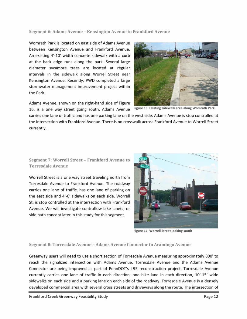
Segment 6: Adams Avenue – Kensington Avenue to Frankford Avenue Womrath Park is located on east side of Adams Avenue between Kensington Avenue and Frankford Avenue. An existing 4’-10’ width concrete sidewalk with a curb at the back edge runs along the park. Several large diameter sycamore trees are located at regular intervals in the sidewalk along Worrel Street near Kensington Avenue. Recently, PWD completed a large stormwater management improvement project within the Park.
Adams Avenue, shown on the right-hand side of Figure 16, is a one way street going south. Adams Avenue carries one lane of traffic and has one parking lane on the west side. Adams Avenue is stop controlled at the intersection with Frankford Avenue. There is no crosswalk across Frankford Avenue to Worrell Street currently.
Segment 7: Worrell Street – Frankford Avenue to Torresdale Avenue Worrell Street is a one way street traveling north from Torresdale Avenue to Frankford Avenue. The roadway carries one lane of traffic, has one lane of parking on the east side and 4’-6’ sidewalks on each side. Worrell St. is stop controlled at the intersection with Frankford Avenue. We will investigate contraflow bike lane(s) or side path concept later in this study for this segment.
Segment 8: Torresdale Avenue – Adams Avenue Connector to Aramingo Avenue Greenway users will need to use a short section of Torresdale Avenue measuring approximately 800’ to reach the signalized intersection with Adams Avenue. Torresdale Avenue and the Adams Avenue Connector are being improved as part of PennDOT’s I-95 reconstruction project. Torresdale Avenue currently carries one lane of traffic in each direction, one bike lane in each direction, 10’-15’ wide sidewalks on each side and a parking lane on each side of the roadway. Torresdale Avenue is a densely developed commercial area with several cross streets and driveways along the route. The intersection of
Figure 16: Existing sidewalk area along Womrath Park
Figure 17: Worrell Street looking south
Frankford Creek Greenway Feasibility Study Page 12

Worrell Street and Torresdale Avenue is not signalized and is not currently stop controlled and does not have crosswalks. Crossings at this location may be a concern for greenway users.
As part of the Adams Avenue Connector project, PennDOT will be constructing a new shared-use path parallel to the new roadway. The new sidepath will extend from Torresdale Avenue to Aramingo Avenue. A new signalized intersection will be installed where Adams Avenue Connector meets Aramingo Avenue. The new intersection will include crosswalks and pedestrian accommodations which will facilitate greenway access.
Segment 9: Aramingo Avenue – Adams Avenue Connector to Wheatsheaf Lane Aramingo Avenue is a high traffic arterial roadway through a large commercial area known as the Aramingo Shopping District. The area to the west of the creek contains several “big box” stores and
Figure 18: Aerial photo of Torresdale Avenue
Figure 19: Aerial photo of Aramingo Avenue between Wheatsheaf Lane and Frankford Creek
Frankford Creek Greenway Feasibility Study Page 13
other commercial businesses. The roadway carries two lanes in each direction and additional turn lanes at major intersections. Bike lanes are present along the roadway and approximately 5’ wide sidewalks are present along both sides of the road. About half of this section of roadway will be reconstructed as a part of the I-95 reconstruction project. This includes replacement of the bridge over Frankford Creek and approximately 0.25 mile of the roadway past Adams Avenue. The existing railroad bridge over Aramingo Avenue to the west of the Creek creates a pinch point, but the existing bike lanes and sidewalks fit under the bridge in the existing condition.
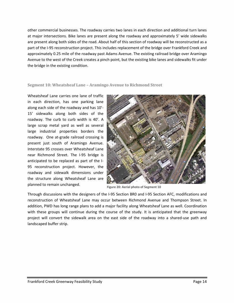
Segment 10: Wheatsheaf Lane – Aramingo Avenue to Richmond Street Wheatsheaf Lane carries one lane of traffic in each direction, has one parking lane along each side of the roadway and has 10’-15’ sidewalks along both sides of the roadway. The curb to curb width is 40’. A large scrap metal yard as well as several large industrial properties borders the roadway. One at-grade railroad crossing is present just south of Aramingo Avenue. Interstate 95 crosses over Wheatsheaf Lane near Richmond Street. The I-95 bridge is anticipated to be replaced as part of the I-95 reconstruction project. However, the roadway and sidewalk dimensions under the structure along Wheatsheaf Lane are planned to remain unchanged.
Through discussions with the designers of the I-95 Section BR0 and I-95 Section AFC, modifications and reconstruction of Wheatsheaf Lane may occur between Richmond Avenue and Thompson Street. In addition, PWD has long range plans to add a major facility along Wheatsheaf Lane as well. Coordination with these groups will continue during the course of the study. It is anticipated that the greenway project will convert the sidewalk area on the east side of the roadway into a shared-use path and landscaped buffer strip.
Figure 20: Aerial photo of Segment 10
Frankford Creek Greenway Feasibility Study Page 14
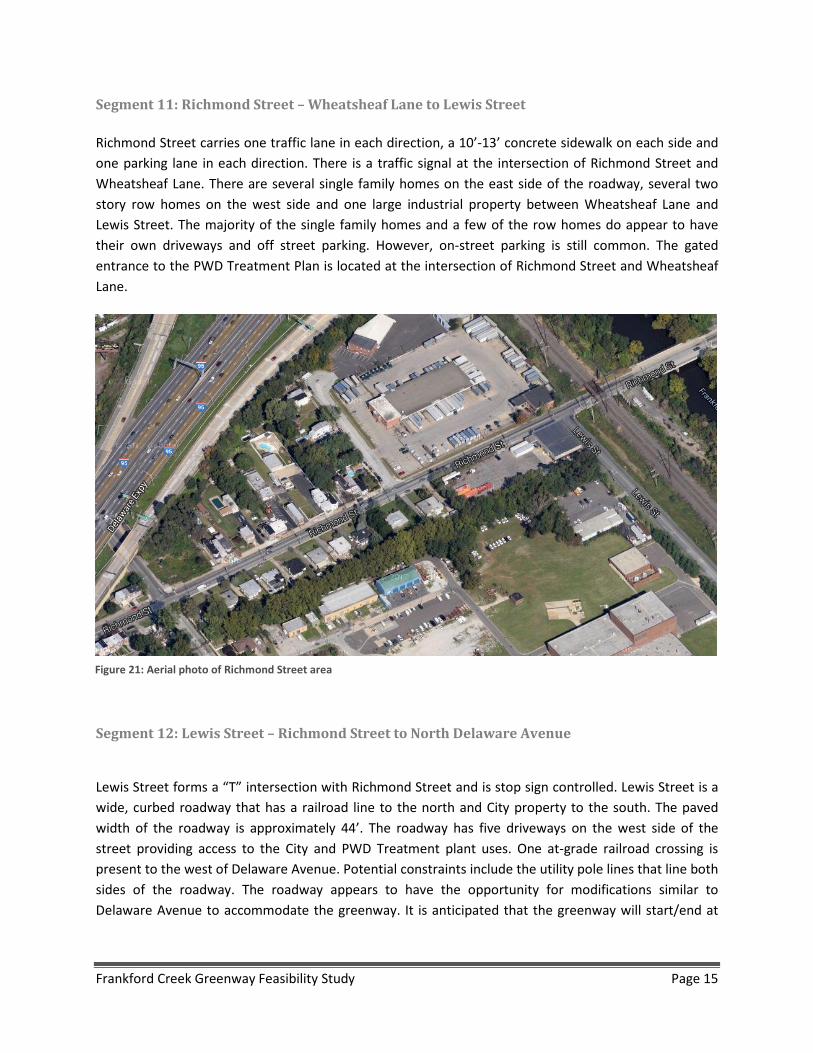
Segment 11: Richmond Street – Wheatsheaf Lane to Lewis Street Richmond Street carries one traffic lane in each direction, a 10’-13’ concrete sidewalk on each side and one parking lane in each direction. There is a traffic signal at the intersection of Richmond Street and Wheatsheaf Lane. There are several single family homes on the east side of the roadway, several two story row homes on the west side and one large industrial property between Wheatsheaf Lane and Lewis Street. The majority of the single family homes and a few of the row homes do appear to have their own driveways and off street parking. However, on-street parking is still common. The gated entrance to the PWD Treatment Plan is located at the intersection of Richmond Street and Wheatsheaf Lane.
Segment 12: Lewis Street – Richmond Street to North Delaware Avenue
Lewis Street forms a “T” intersection with Richmond Street and is stop sign controlled. Lewis Street is a wide, curbed roadway that has a railroad line to the north and City property to the south. The paved width of the roadway is approximately 44’. The roadway has five driveways on the west side of the street providing access to the City and PWD Treatment plant uses. One at-grade railroad crossing is present to the west of Delaware Avenue. Potential constraints include the utility pole lines that line both sides of the roadway. The roadway appears to have the opportunity for modifications similar to Delaware Avenue to accommodate the greenway. It is anticipated that the greenway will start/end at
Figure 21: Aerial photo of Richmond Street area
Frankford Creek Greenway Feasibility Study Page 15
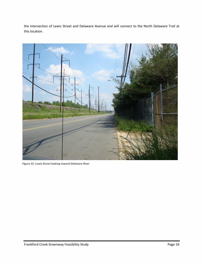
the intersection of Lewis Street and Delaware Avenue and will connect to the North Delaware Trail at this location.
Figure 22: Lewis Street looking toward Delaware River
Frankford Creek Greenway Feasibility Study Page 16

II. Alignment Options
Based on the information provided by the existing conditions memo and input from the steering committee, several alignment alternatives have been explored and analyzed along the proposed corridor.
For each of the segments, all alternatives are described along with the opportunities and drawbacks associated with each. Different alternatives are labeled based on the segment, and then labeled individually using letters which coincide with options in the cost estimate. For example, options in Segment 2 are labeled 2A, 2B, 2C, etc.
All recommendations are in accordance with the “Guide for the Development of Bicycle Facilities” 2012-Fourth Edition developed by the American Association of State Highway and Transportation Officials (AASHTO).
a. Segment Alternatives Descriptions
Segment 1: Wingohocking Street to Cayuga Street
The Frankford Creek Greenway will begin on Wingohocking Street directly west of the Frankford Creek. To make it more visible to the community, the first Gateway installation is planned for this entrance (See Gateway Treatments). To link to the Juniata Golf Course and existing bike facilities on E. Cayuga Street and Castor Avenue to the greenway, share-the-road markings (sharrows) will be placed along Wingohocking Street from Castor Avenue to Adams Avenue. The greenway in this location will run along the creek from Wingohocking Street to Cayuga Street in space that was set aside as part of the Twins at Powder Mill development. For this segment, a paved, 12’ wide shared-use path with fence and a 5’ buffer is planned along the creek. This design (Figure 22) is the typical design for the greenway when it follows the creek. The fence between the shared-use path and the creek is used to prevent users from falling down the embankment which becomes steep in some areas.
Figure 23: Typical greenway section along creek
Frankford Creek Greenway Feasibility Study Page 17
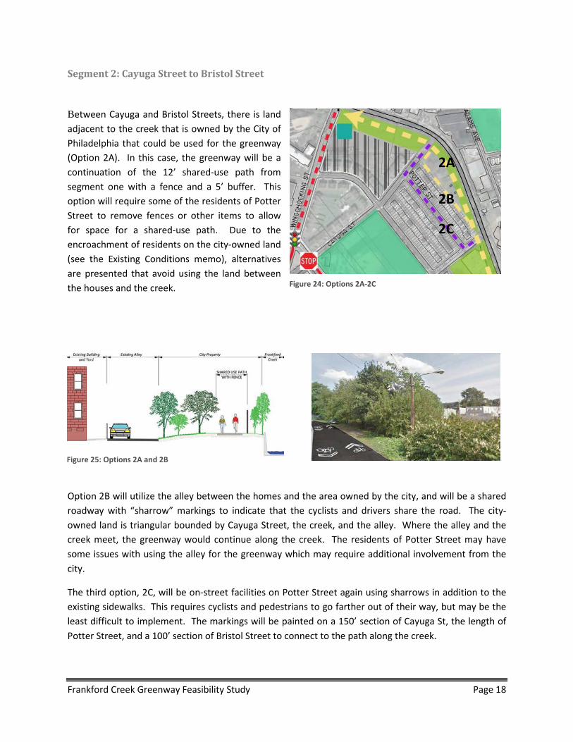
Segment 2: Cayuga Street to Bristol Street
Between Cayuga and Bristol Streets, there is land adjacent to the creek that is owned by the City of Philadelphia that could be used for the greenway (Option 2A). In this case, the greenway will be a continuation of the 12’ shared-use path from segment one with a fence and a 5’ buffer. This option will require some of the residents of Potter Street to remove fences or other items to allow for space for a shared-use path. Due to the encroachment of residents on the city-owned land (see the Existing Conditions memo), alternatives are presented that avoid using the land between the houses and the creek.
Option 2B will utilize the alley between the homes and the area owned by the city, and will be a shared roadway with “sharrow” markings to indicate that the cyclists and drivers share the road. The city-owned land is triangular bounded by Cayuga Street, the creek, and the alley. Where the alley and the creek meet, the greenway would continue along the creek. The residents of Potter Street may have some issues with using the alley for the greenway which may require additional involvement from the city.
The third option, 2C, will be on-street facilities on Potter Street again using sharrows in addition to the existing sidewalks. This requires cyclists and pedestrians to go farther out of their way, but may be the least difficult to implement. The markings will be painted on a 150’ section of Cayuga St, the length of Potter Street, and a 100’ section of Bristol Street to connect to the path along the creek.
2A
2B
2C
Figure 24: Options 2A-2C
Figure 25: Options 2A and 2B
Frankford Creek Greenway Feasibility Study Page 18

Segment 3: Bristol Street to Hunting Park Avenue (including Leiper Street creek cap area)
The segment between Bristol Street and Hunting Park Avenue is a few hundred feet long and has a number of opportunities for park area and a connection between the two sides of the creek (See Leiper Street Connection Park). In this area, the greenway will run along the creek and potentially over it because the creek runs through a culvert. Option 3A requires purchasing the vacant property that is currently for sale at the end of Bristol Street. This would allow the city to create a larger park space along the creek.
If this site is not purchased, Option 3B, an easement will be necessary from the owner to run the greenway through this area. Regardless of the purchase of the vacant property, there is some room for a park area over the creek that would allow for a formal connection between the two neighborhoods on either side of the creek by extending Leiper Street across the creek. The connection over the creek would be placed along the right-of-way for Leiper Street which currently ends on the west side of the creek, but is listed as having a 50’ right-of-way (26’ travel lanes and 12’ sidewalks on either side) on the City’s Street Right-Of-Way Plans. The park can be completed separately from the creek connection or at the same time to potentially reduce total cost.
Figure 26: Artistic rendering of potential shared roadway markings
Figure 27: Segment 3 alignment
Frankford Creek Greenway Feasibility Study Page 19
Segment 4: Southern end of Leiper Street cap to Kensington Avenue
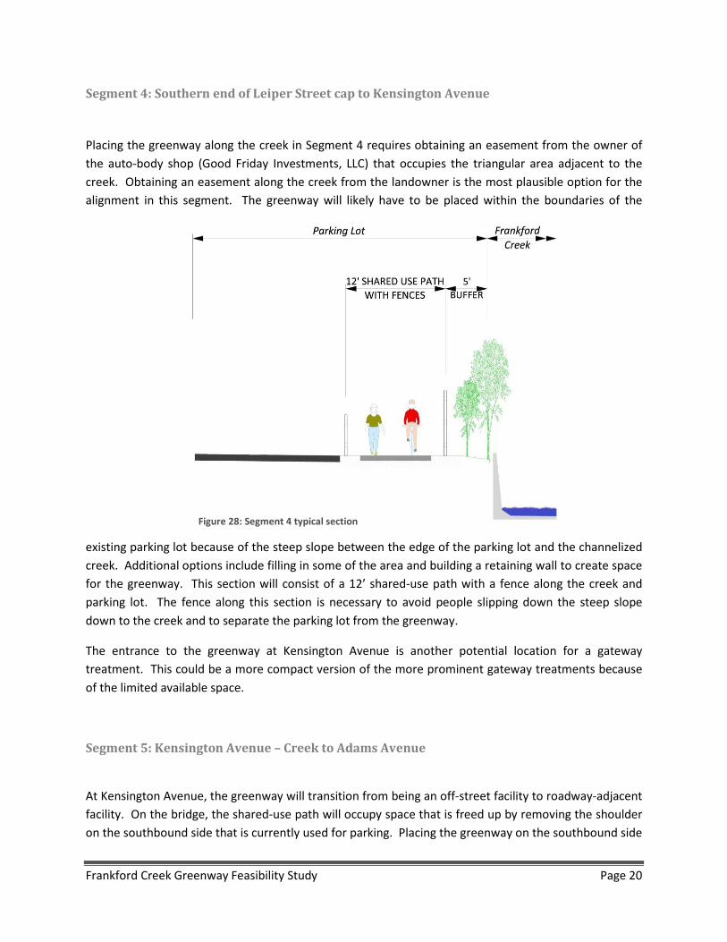
Placing the greenway along the creek in Segment 4 requires obtaining an easement from the owner of the auto-body shop (Good Friday Investments, LLC) that occupies the triangular area adjacent to the creek. Obtaining an easement along the creek from the landowner is the most plausible option for the alignment in this segment. The greenway will likely have to be placed within the boundaries of the
existing parking lot because of the steep slope between the edge of the parking lot and the channelized creek. Additional options include filling in some of the area and building a retaining wall to create space for the greenway. This section will consist of a 12’ shared-use path with a fence along the creek and parking lot. The fence along this section is necessary to avoid people slipping down the steep slope down to the creek and to separate the parking lot from the greenway.
The entrance to the greenway at Kensington Avenue is another potential location for a gateway treatment. This could be a more compact version of the more prominent gateway treatments because of the limited available space.
Segment 5: Kensington Avenue – Creek to Adams Avenue
At Kensington Avenue, the greenway will transition from being an off-street facility to roadway-adjacent facility. On the bridge, the shared-use path will occupy space that is freed up by removing the shoulder on the southbound side that is currently used for parking. Placing the greenway on the southbound side
Figure 28: Segment 4 typical section
Frankford Creek Greenway Feasibility Study Page 20

of the road allows users to transition from Segment 4 to Segment 5 without crossing the street unless they would like to use the bike lane traveling in the north direction. No traffic signal is planned for this location, but there is an opportunity for a small gateway or way-finding treatment to draw attention to the greenway.
Figure 29: Kensington Avenue Cross Section (faces northeast toward Adams Avenue)
Frankford Creek Greenway Feasibility Study Page 21
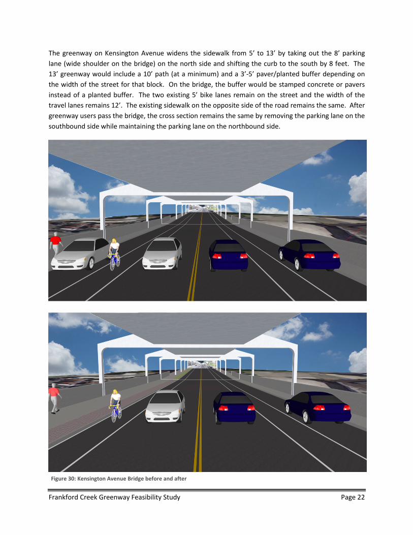
The greenway on Kensington Avenue widens the sidewalk from 5’ to 13’ by taking out the 8’ parking lane (wide shoulder on the bridge) on the north side and shifting the curb to the south by 8 feet. The 13’ greenway would include a 10’ path (at a minimum) and a 3’-5’ paver/planted buffer depending on the width of the street for that block. On the bridge, the buffer would be stamped concrete or pavers instead of a planted buffer. The two existing 5’ bike lanes remain on the street and the width of the travel lanes remains 12’. The existing sidewalk on the opposite side of the road remains the same. After greenway users pass the bridge, the cross section remains the same by removing the parking lane on the southbound side while maintaining the parking lane on the northbound side.
Figure 30: Kensington Avenue Bridge before and after
Frankford Creek Greenway Feasibility Study Page 22
One concern that will need to be addressed in final design is that the elevated rail supports are on the outer edge of the sidewalk along the bridge, and then the distance between supports decreases after the bridge, which places the supports on the inner edge of the sidewalk. While the above plan works well for the majority of this segment, there is a short section that will have to be modified to avoid the elevated track supports. The two primary options are to (5A.1) place the greenway on the north side of the supports where the sidewalk is wider – potentially wide enough to allow for the entire shared-use path – and place the buffer so that the supports occupy buffer space, or to (5A.2) split the shared-use path to allow for westbound traffic on one side of the supports, and the eastbound traffic on the other.
Segment 6: Adams Avenue – Kensington Avenue to Frankford Avenue
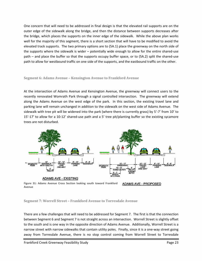
At the intersection of Adams Avenue and Kensington Avenue, the greenway will connect users to the recently renovated Womrath Park through a signal controlled intersection. The greenway will extend along the Adams Avenue on the west edge of the park. In this section, the existing travel lane and parking lane will remain unchanged in addition to the sidewalk on the west side of Adams Avenue. The sidewalk with tree pit will be widened into the park (where there is currently grass) by 5’-7’ from 10’ to 15’-17’ to allow for a 10-12’ shared-use path and a 5’ tree pit/planting buffer so the existing sycamore trees are not disturbed.
Segment 7: Worrell Street – Frankford Avenue to Torresdale Avenue
There are a few challenges that will need to be addressed for Segment 7. The first is that the connection between Segment 6 and Segment 7 is not straight across an intersection. Worrell Street is slightly offset to the south and is one way in the opposite direction of Adams Avenue. Additionally, Worrell Street is a narrow street with narrow sidewalks that contain utility poles. Finally, since it is a one-way street going away from Torresdale Avenue, there is no stop control coming from Worrell Street to Torresdale
Figure 31: Adams Avenue Cross Section looking south toward Frankford Avenue
Frankford Creek Greenway Feasibility Study Page 23
Avenue. This will need to be addressed when bike and pedestrian traffic travels in both directions on Worrell Street.
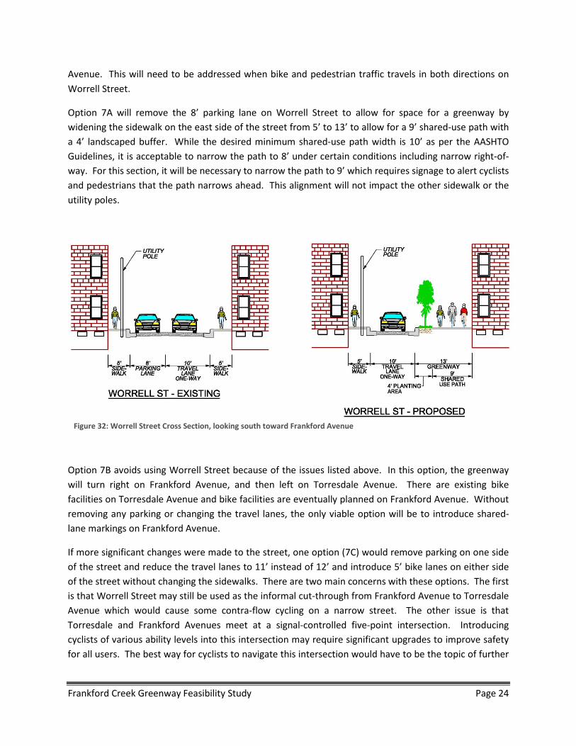
Option 7A will remove the 8’ parking lane on Worrell Street to allow for space for a greenway by widening the sidewalk on the east side of the street from 5’ to 13’ to allow for a 9’ shared-use path with a 4’ landscaped buffer. While the desired minimum shared-use path width is 10’ as per the AASHTO Guidelines, it is acceptable to narrow the path to 8’ under certain conditions including narrow right-of-way. For this section, it will be necessary to narrow the path to 9’ which requires signage to alert cyclists and pedestrians that the path narrows ahead. This alignment will not impact the other sidewalk or the utility poles.
Option 7B avoids using Worrell Street because of the issues listed above. In this option, the greenway will turn right on Frankford Avenue, and then left on Torresdale Avenue. There are existing bike facilities on Torresdale Avenue and bike facilities are eventually planned on Frankford Avenue. Without removing any parking or changing the travel lanes, the only viable option will be to introduce shared-lane markings on Frankford Avenue.
If more significant changes were made to the street, one option (7C) would remove parking on one side of the street and reduce the travel lanes to 11’ instead of 12’ and introduce 5’ bike lanes on either side of the street without changing the sidewalks. There are two main concerns with these options. The first is that Worrell Street may still be used as the informal cut-through from Frankford Avenue to Torresdale Avenue which would cause some contra-flow cycling on a narrow street. The other issue is that Torresdale and Frankford Avenues meet at a signal-controlled five-point intersection. Introducing cyclists of various ability levels into this intersection may require significant upgrades to improve safety for all users. The best way for cyclists to navigate this intersection would have to be the topic of further
Figure 32: Worrell Street Cross Section, looking south toward Frankford Avenue
Frankford Creek Greenway Feasibility Study Page 24
analysis. Some opportunities may be possible partnering with the Edgewater Dye EPA project that is in the early planning stages and is on the northwest corner of the Torresdale and Frankford Avenues.
Segment 8: Torresdale Avenue – Adams Avenue Connector to Aramingo Avenue
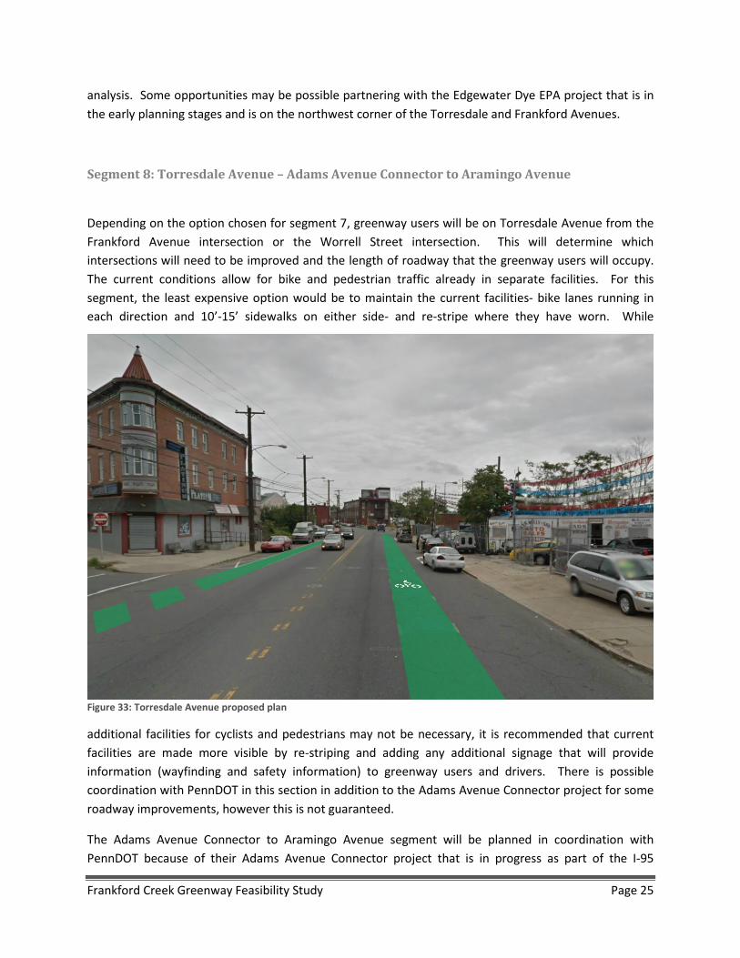
Depending on the option chosen for segment 7, greenway users will be on Torresdale Avenue from the Frankford Avenue intersection or the Worrell Street intersection. This will determine which intersections will need to be improved and the length of roadway that the greenway users will occupy. The current conditions allow for bike and pedestrian traffic already in separate facilities. For this segment, the least expensive option would be to maintain the current facilities- bike lanes running in each direction and 10’-15’ sidewalks on either side- and re-stripe where they have worn. While
additional facilities for cyclists and pedestrians may not be necessary, it is recommended that current facilities are made more visible by re-striping and adding any additional signage that will provide information (wayfinding and safety information) to greenway users and drivers. There is possible coordination with PennDOT in this section in addition to the Adams Avenue Connector project for some roadway improvements, however this is not guaranteed.
The Adams Avenue Connector to Aramingo Avenue segment will be planned in coordination with PennDOT because of their Adams Avenue Connector project that is in progress as part of the I-95
Figure 33: Torresdale Avenue proposed plan
Frankford Creek Greenway Feasibility Study Page 25

reconstruction project. In this section, PennDOT is designing and building a shared-use path along the south side of the roadway that will be 10-12’ wide with a 5’ buffer. Additionally, there are some signal improvements that are planned as part of this project including signal timing changes and potential signal upgrades at key intersections. Coordination with PennDOT on this section is necessary to ensure continuity between greenway segments.
Segment 9: Aramingo Avenue – Adams Avenue Connector to Wheatsheaf Lane
On Segment 9, the greenway will continue from the Adams Avenue Connector on Aramingo Avenue. To improve the safety of the greenway users, a signalized intersection is proposed at the intersection where Aramingo Avenue and Adams Avenue Connector will meet. This signal is going to be constructed by PennDOT as part of the Adams Avenue Connector project. Additional improvements along Aramingo Avenue are also planned as part of the PennDOT project. A side path with buffer will be built from the Adams Avenue Connector to Wheatsheaf Lane. There is an abandoned lot at the intersection of Aramingo Avenue and Wheatsheaf Lane at the southeast corner which will be replaced by a Wawa. Plans for a path through the property, in coordination with Wawa, are currently in design.
One concern with this segment is that the railroad bridge overpass will continue to be a choke point along Aramingo Avenue that will need to be addressed in later stages of this project. The other narrow section, the bridge over Frankford Creek, may be improved as part of the I-95 construction project. Coordination with PennDOT would be necessary for this project.
Segment 10: Wheatsheaf Lane – Aramingo Avenue to Richmond Street
As mentioned in the Existing Conditions Assessment section, there are wide sidewalks along Wheatsheaf Lane in addition to a significant amount of unused right-of-way which could be converted into a shared-use path without changing lane widths. Some improvements may be done along Wheatsheaf Lane as part of the I-95 construction project. Along this section, it is anticipated that the existing sidewalk will be re-paved and turned into a shared-use path with a landscaped buffer along the east side of the road. In some areas, the right-of-way exists, but a wide sidewalk does not. In these areas, the current 4’ sidewalk on the east side of Wheatsheaf Lane will be widened by taking space to the east to create a 10’-12’ shared-use path and to widen the landscaped buffer from 4’ to 5’ to meet AASHTO Guidelines. This allows for space for trees and other plantings (See Appendix C for preliminary plans).
Frankford Creek Greenway Feasibility Study Page 26
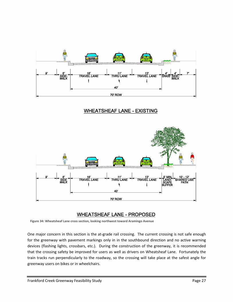
One major concern in this section is the at-grade rail crossing. The current crossing is not safe enough for the greenway with pavement markings only in in the southbound direction and no active warning devices (flashing lights, crossbars, etc.). During the construction of the greenway, it is recommended that the crossing safety be improved for users as well as drivers on Wheatsheaf Lane. Fortunately the train tracks run perpendicularly to the roadway, so the crossing will take place at the safest angle for greenway users on bikes or in wheelchairs.
Figure 34: Wheatsheaf Lane cross section, looking northwest toward Aramingo Avenue
Frankford Creek Greenway Feasibility Study Page 27
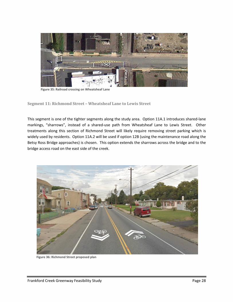
Segment 11: Richmond Street – Wheatsheaf Lane to Lewis Street
This segment is one of the tighter segments along the study area. Option 11A.1 introduces shared-lane markings, “sharrows”, instead of a shared-use path from Wheatsheaf Lane to Lewis Street. Other treatments along this section of Richmond Street will likely require removing street parking which is widely used by residents. Option 11A.2 will be used if option 12B (using the maintenance road along the Betsy Ross Bridge approaches) is chosen. This option extends the sharrows across the bridge and to the bridge access road on the east side of the creek.
Figure 36: Richmond Street proposed plan
Figure 35: Railroad crossing on Wheatsheaf Lane
Frankford Creek Greenway Feasibility Study Page 28

Segment 12: Lewis Street – Richmond Street to North Delaware Avenue
To improve safety for greenway users, intersection improvements are recommended for the “T” intersection between Richmond Street and Lewis Street, and between North Delaware Avenue and Lewis Street. Along this section, roadway changes will include reducing the current 19’ travel lanes to 11’-6” travel lanes, shifting the curb over 15’ on the east side of the street, and introducing a 15’-17’ greenway (10’-12’ shared-use path adjacent to a 5’ tree pit/planting buffer) in this new space. (See Appendix C for preliminary plans of this segment). The primary safety concern that needs to be addressed is the at-grade rail crossing. This may also have design implications and would have to be coordinated with track owners (Conrail).
Figure 37: Lewis Street cross section, looking southeast toward N Delaware Avenue
Frankford Creek Greenway Feasibility Study Page 29
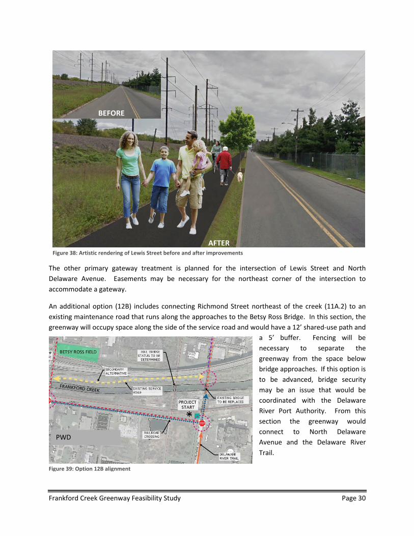
The other primary gateway treatment is planned for the intersection of Lewis Street and North Delaware Avenue. Easements may be necessary for the northeast corner of the intersection to accommodate a gateway.
An additional option (12B) includes connecting Richmond Street northeast of the creek (11A.2) to an existing maintenance road that runs along the approaches to the Betsy Ross Bridge. In this section, the greenway will occupy space along the side of the service road and would have a 12’ shared-use path and
a 5’ buffer. Fencing will be necessary to separate the greenway from the space below bridge approaches. If this option is to be advanced, bridge security may be an issue that would be coordinated with the Delaware River Port Authority. From this section the greenway would connect to North Delaware Avenue and the Delaware River Trail.
BEFORE
AFTER Figure 38: Artistic rendering of Lewis Street before and after improvements
PWD
Figure 39: Option 12B alignment
Frankford Creek Greenway Feasibility Study Page 30
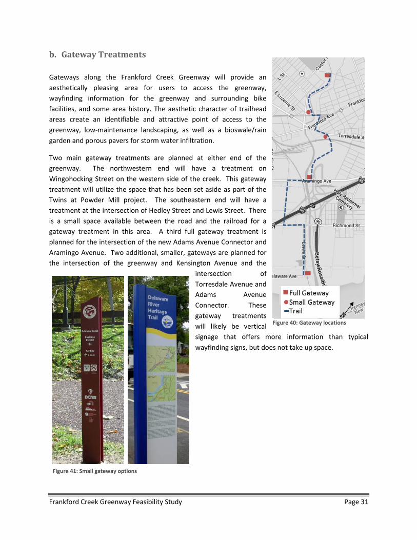
b. Gateway Treatments Gateways along the Frankford Creek Greenway will provide an aesthetically pleasing area for users to access the greenway, wayfinding information for the greenway and surrounding bike facilities, and some area history. The aesthetic character of trailhead areas create an identifiable and attractive point of access to the greenway, low-maintenance landscaping, as well as a bioswale/rain garden and porous pavers for storm water infiltration.
Two main gateway treatments are planned at either end of the greenway. The northwestern end will have a treatment on Wingohocking Street on the western side of the creek. This gateway treatment will utilize the space that has been set aside as part of the Twins at Powder Mill project. The southeastern end will have a treatment at the intersection of Hedley Street and Lewis Street. There is a small space available between the road and the railroad for a gateway treatment in this area. A third full gateway treatment is planned for the intersection of the new Adams Avenue Connector and Aramingo Avenue. Two additional, smaller, gateways are planned for the intersection of the greenway and Kensington Avenue and the
intersection of Torresdale Avenue and Adams Avenue Connector. These gateway treatments will likely be vertical signage that offers more information than typical wayfinding signs, but does not take up space.
Figure 40: Gateway locations
Figure 41: Small gateway options
Frankford Creek Greenway Feasibility Study Page 31
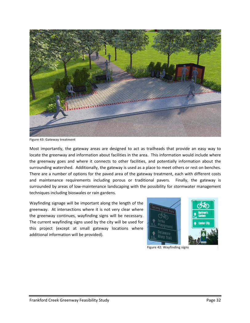
Most importantly, the gateway areas are designed to act as trailheads that provide an easy way to locate the greenway and information about facilities in the area. This information would include where the greenway goes and where it connects to other facilities, and potentially information about the surrounding watershed. Additionally, the gateway is used as a place to meet others or rest on benches. There are a number of options for the paved area of the gateway treatment, each with different costs and maintenance requirements including porous or traditional pavers. Finally, the gateway is surrounded by areas of low-maintenance landscaping with the possibility for stormwater management techniques including bioswales or rain gardens.
Wayfinding signage will be important along the length of the greenway. At intersections where it is not very clear where the greenway continues, wayfinding signs will be necessary. The current wayfinding signs used by the city will be used for this project (except at small gateway locations where additional information will be provided).
Figure 42: Wayfinding signs
Figure 43: Gateway treatment
Frankford Creek Greenway Feasibility Study Page 32
c. Leiper Street Connection Park
The area above the Leiper Street culvert is currently under-utilized vacant land that could provide green space for the community in addition to a formal connection between the neighborhoods on either side of the creek. Providing a connection between these two neighborhoods has the potential to significantly increase usage along the greenway because more homes and businesses will have access. A park could be constructed at the same time as the greenway, or could be a part of a longer-term project. This land is owned by Philadelphia Water Department and coordination between agencies would be necessary for the construction and maintenance of a park.
This land above the culvert consists of a potential area to create an enhanced park area over the Frankford Creek with multiple features and amenities. As a linear area of interest along the greenway, the park area could consist of low-maintenance meadow areas, an overlook of the creek, a small neighborhood playground, and an enhanced gathering space with a gazebo. As an attractive destination along the greenway, the Leiper Street Connection Park could create an amenity for neighborhood events, and enhance the interpretation and history of the greenway. Two concepts are illustrated below with varying landscape and hardscape designs for consideration.
In this area, the 10’-12’ shared-use path will follow the river with a 5’ buffer. Fencing will be used next to steep slopes. Each of the park options include meadows with low-maintenance landscaping that can reduce runoff in addition to some paved areas where there will be heavier pedestrian and bike traffic. These areas could either be a continuation of the paved path or could use the porous pavers that will be used in the gateway treatments. The primary differences between the two options are the additional amenities- the gazebo or the playground.
Frankford Creek Greenway Feasibility Study Page 33
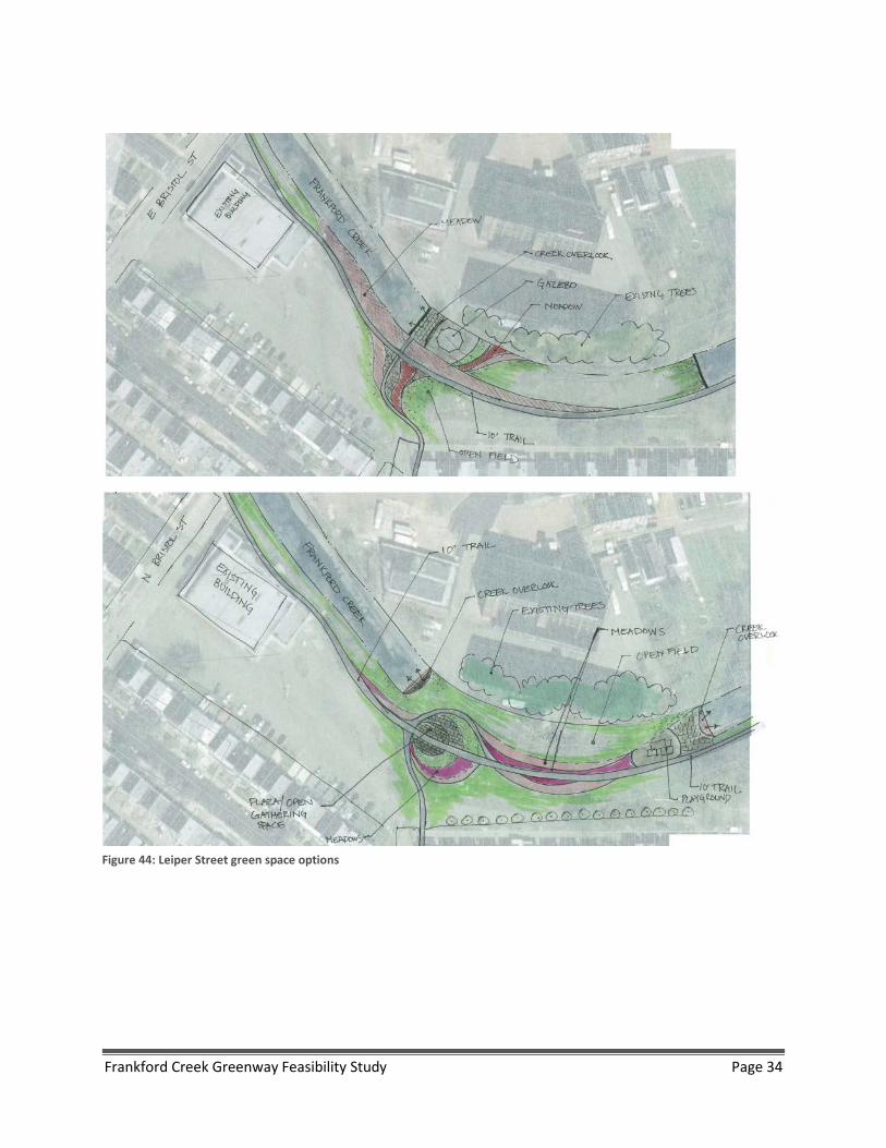
Figure 44: Leiper Street green space options
Frankford Creek Greenway Feasibility Study Page 34
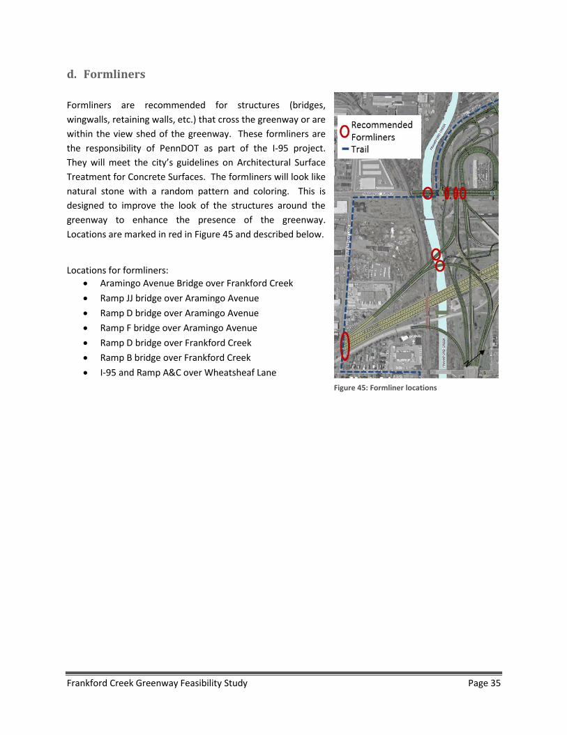
d. Formliners Formliners are recommended for structures (bridges, wingwalls, retaining walls, etc.) that cross the greenway or are within the view shed of the greenway. These formliners are the responsibility of PennDOT as part of the I-95 project. They will meet the city’s guidelines on Architectural Surface Treatment for Concrete Surfaces. The formliners will look like natural stone with a random pattern and coloring. This is designed to improve the look of the structures around the greenway to enhance the presence of the greenway. Locations are marked in red in Figure 45 and described below.
Locations for formliners:
• Aramingo Avenue Bridge over Frankford Creek • Ramp JJ bridge over Aramingo Avenue • Ramp D bridge over Aramingo Avenue • Ramp F bridge over Aramingo Avenue • Ramp D bridge over Frankford Creek • Ramp B bridge over Frankford Creek • I-95 and Ramp A&C over Wheatsheaf Lane
Figure 45: Formliner locations
Frankford Creek Greenway Feasibility Study Page 35
III. Challenges and Partnership Opportunities
For each segment, specific challenges and opportunities are explained in the Existing Conditions and Alignment Options sections of this report. This section of the report focuses on potential challenges and partnerships that may be available to capitalize on concurrent property and roadway development, or to anticipate potential barriers to project completion. Baker has identified key contact people for each partnership opportunity who can help with future development of the greenway.
The following opportunities exist through PennDOT’s I-95 reconstruction project that is ongoing and scheduled to begin in approximately 2018-
• Aramingo Avenue shared-use path and gateway
o SR 95 Section BR0 PM: Paul Shultes, (610)757-1885, [email protected]
o Designer: Robert Kocher from CDM Smith, (717)541-4019, [email protected]
• Adams Avenue Connector shared-use path and lighting
o PM: Paul Shultes, (610)757-1885, [email protected]
o Designer: Antoinette MacIntyre from URS, (215)390-2137, [email protected]
• Formliners on bridges and other structures in view shed
o SR 95 Section BR0 PM: Paul Shultes, (610)757-1885, [email protected]
o SR 95 Section AFC Consultant PM: Pamela Conti from Parsons Brinckerhoff, (215)209-1249, [email protected], [email protected]
There are a number of other potential partnerships that may provide opportunities for this project-
• Shared-use path through Delaware River Port Authority property from Richmond Street to Delaware Avenue along the bridge approaches. Some challenges may arise with this opportunity due to security of bridge approaches
• Shared-use path construction completed by Wawa at the corner of Aramingo and Wheatsheaf Avenues
o Frank Montgomery from Traffic Planning & Design Inc., (856)966-4242, [email protected]
• Potential cost sharing with Philadelphia Water Department for stormwater improvements constructed as part of the greenway project as part of the Green City Clean Waters Program
Frankford Creek Greenway Feasibility Study Page 36

o Jessica Brooks of Philadelphia Water Department, [email protected]
• For Segment 7, if a Frankford-Torresdale connection is chosen instead of using Worrell St for the path, there may be an opportunity to work with the brownfield site- Edgewater Dye- EPA project that is located at the Frankford-Torresdale intersection.
Frankford Creek Greenway Feasibility Study Page 37
IV. Implementation Strategies
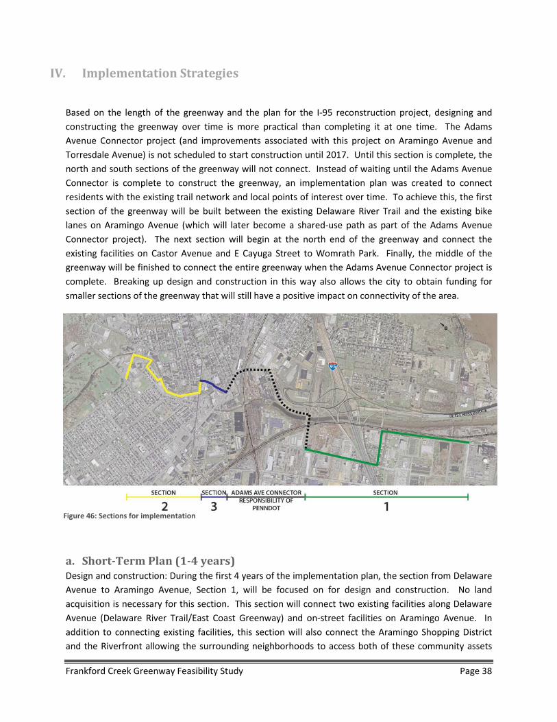
Based on the length of the greenway and the plan for the I-95 reconstruction project, designing and constructing the greenway over time is more practical than completing it at one time. The Adams Avenue Connector project (and improvements associated with this project on Aramingo Avenue and Torresdale Avenue) is not scheduled to start construction until 2017. Until this section is complete, the north and south sections of the greenway will not connect. Instead of waiting until the Adams Avenue Connector is complete to construct the greenway, an implementation plan was created to connect residents with the existing trail network and local points of interest over time. To achieve this, the first section of the greenway will be built between the existing Delaware River Trail and the existing bike lanes on Aramingo Avenue (which will later become a shared-use path as part of the Adams Avenue Connector project). The next section will begin at the north end of the greenway and connect the existing facilities on Castor Avenue and E Cayuga Street to Womrath Park. Finally, the middle of the greenway will be finished to connect the entire greenway when the Adams Avenue Connector project is complete. Breaking up design and construction in this way also allows the city to obtain funding for smaller sections of the greenway that will still have a positive impact on connectivity of the area.
a. Short-Term Plan (1-4 years) Design and construction: During the first 4 years of the implementation plan, the section from Delaware Avenue to Aramingo Avenue, Section 1, will be focused on for design and construction. No land acquisition is necessary for this section. This section will connect two existing facilities along Delaware Avenue (Delaware River Trail/East Coast Greenway) and on-street facilities on Aramingo Avenue. In addition to connecting existing facilities, this section will also connect the Aramingo Shopping District and the Riverfront allowing the surrounding neighborhoods to access both of these community assets
Figure 46: Sections for implementation
Frankford Creek Greenway Feasibility Study Page 38
without driving. For these reasons, it is possible to start design immediately and there will also be an immediate positive impact on the connectivity of the area when the section is finished. The gateway in this section will be completed during the construction of the greenway.
Land Acquisition: In addition to starting design and construction on the first segment, it will be necessary to acquire land for the second section of the project. There are only two properties that will require easements for the second section and none for the third section. In the second section, along the creek from Cayuga Street to Kensington Avenue, easements will be required from two properties. The first is a vacant grocery store (currently for sale) at 1610-32 E. Bristol Street, BRT/OPA #884091050, which is currently owned by Yoon Won Ju. The second property is an auto business at 4066-70 Kensington Avenue, BRT/OPA #884110800, which is owned by Good Friday Investments, LLC.
b. Medium-Term Plan (4-6 years) Design and construction: Once the necessary land is acquired along the creek, it will be possible to start construction on Section 2. Section 2 will connect the Tacony Creek Trail to Womrath Park. Part of this section will include on-road improvements on Wingohocking Street to make the connection to Cayuga Street along Juniata Golf Club which connects to the Tacony Trail. The second gateway will be constructed during at the same time as well. The greenway segments in Section 2 are not all located on city right-of-way, but should not present any problems once the land is acquired along the creek. The bridge improvements on Kensington are part of this section and will likely be the most difficult to schedule and construct.
c. Long-Term Plan (6-10 years) Design and construction: The segments that are PennDOT’s responsibility will not likely be finished until after 2020. Finishing the first two sections of the greenway before that time is reasonable and beneficial to the surrounding areas. However, the north and south sections will not be connected until the Adams Avenue Connector is complete. Design of segments 6 (Adams Avenue) and 7 (Worrell Street) can wait until after the other sections are in construction. Ideally, the third section will be complete around the same time as the Adams Avenue Connector. This would complete the greenway and connect the whole community to the larger trail network.
d. Very long term (10+ years) There are two alignment options that are plausible in the long term if funding and space becomes available. These two include a bike/pedestrian bridge along Ramp JJ that bypasses segments 9-11, and a shared-use path along the Betsy Ross Bridge approach. The first alignment option will require significant coordination with PennDOT. The path along the bridge approach would utilize an existing maintenance road and will require significant coordination with Delaware River Port Authority.
Frankford Creek Greenway Feasibility Study Page 39

e. Maintenance, Operations, Security Plan Similar to any other recreation or transportation facility, periodic and regular maintenance of the greenway corridor will be required. The costs associated with these activities should be incorporated into the long range budget of the city. The following is a list of the key maintenance activities and the anticipated effort involved:
• Shared-use path Surface (Paved) – repaving every 10-12 years • Bridges – inspected every two years by a certified professional • Drainage structures- cleaned annually • Mowing of trailside areas- minimum of 4 times / year • Tree Trimming – annually • Litter Pickup/Trash Collection – biweekly and as needed • Signage/Gates/Bollards – repair/replace as required
Based on our experience and data from other existing trails, annual maintenance costs range from approximately $1000-$5000 per mile. Once the greenway is open, future budgets should be based on actual costs from the first few years of operation.
Research on existing trail facilities has shown that safety, vandalism and liability have not been significant problems. However, certain basic measures should be taken to safeguard against potential issues. The following is a brief list of recommendations for the safe and efficient operation of the greenway:
• Design the greenway according to accepted engineering standards such as AASHTO and PENNDOT
• Provide measures to allow regular patrolling by law enforcement and access by emergency vehicles
• Provide regular safety inspections and maintenance • Provide emergency contact numbers and information at kiosks and on greenway maps • Provide greenway rules at kiosks and on greenway maps • Provide appropriate warning signs along the greenway
It is anticipated that the greenway will be maintained by Philadelphia Parks and Recreation. More formalized “adopt a trail” volunteer groups and events could be organized for future efforts to support the maintenance and operation of the greenway.
f. Operations It is anticipated that Philadelphia Parks and Recreation will take the lead for implementation of the greenway. This department, and the city as a whole, has indicated their long term commitment to trail development and maintenance.
Frankford Creek Greenway Feasibility Study Page 40

g. Public Feedback There were two public meetings during this study, one in fall 2013, and the other in spring 2014. In addition to the public meetings, there was a public information survey for the residents of Potter Street to gather feedback on the alignment options in Segment 2 (either on Potter Street, the alley, or along the creek). Residents of Potter Street were most interested in the alignment option on Potter Street and were least interested in the alignment option along the creek.
Members of the general public have mentioned various maintenance and operations recommendations for the greenway. A preference for low maintenance and more durable surfaces such as asphalt has been recommended by several individuals. They indicated that an asphalt surface serves a majority of users, can be used in almost all weather conditions and minimizes additional on-going repairs and maintenance costs in the future. The surface also allows for better access by emergency services and police patrols as needed. Fencing along private property and along the creek was mentioned for safety reasons.
h. Funding Options Finding the funding for the design and construction of these types of projects can be a challenge, but the following is a list of possible funding sources for this project:
Pennsylvania Transportation Alternatives Program
There will be one solicitation for two years of TAP funding totaling $7.5 million in the DVRPC Pennsylvania counties (Bucks, Chester, Delaware, Montgomery and Philadelphia) for bicycle and pedestrian facilities, conversion of abandoned railway corridors to trails, and stormwater management projects. Concurrently the statewide TAP will have $26 million available for all eligible project types. There will be one application and projects may be selected as either regional or statewide priorities. Local governments, regional transportation authorities, transit agencies, natural resource or public land agencies, school districts, local education agencies, or schools, and tribal governments are eligible to apply for the competitive TAP funds.
http://www.dvrpc.org/TAP/
Robert Wood Johnson Foundation
The mission of the Robert Wood Johnson Foundation is to improve the health and health care of all Americans. Our goal is clear: To help our society transform itself for the better.
http://www.rwjf.org/en/grants.html
Frankford Creek Greenway Feasibility Study Page 41
National Parks Service – Trails Assistance Program
The Rivers, Trails, and Conservation Assistance Program is the community assistance arm of the National Park Service. RTCA supports community-led natural resource conservation and outdoor recreation projects. RTCA staff provides technical assistance to communities so they can conserve rivers, preserve open space, and develop trails and greenways.
http://www.nps.gov/ncrc/programs/rtca/
PA Department of Conservation and Natural Resources – Keystone Grant Program and Recreational Trails Program
Established on July 1, 1995, the Pennsylvania Department of Conservation and Natural Resources is charged with maintaining and preserving the 117 state parks; managing the 2.1 million acres of state forest land; providing information on the state's ecological and geologic resources; and establishing community conservation partnerships with grants and technical assistance to benefit rivers, trails, greenways, local parks and recreation, regional heritage parks, open space and natural areas.
Local governments, county governments and non-profit organizations can apply for Community Conservation Partnerships Program (C2P2) funding to assist them with addressing their recreation and conservation needs as well as supporting economically beneficial recreational tourism initiatives.
http://www.dcnr.state.pa.us/applyforgrants/index.htm
Contact:
Southeast Regional Office: (Region 1)
Jeffrey Knowles.............................................215-560-1182.....jeknowles@pa.gov
Drew Gilchrist................................................215-560-1183.....agilchrist@pa.gov
DCED Act 13 Grants: Greenways, Trails and Recreation Program (GTRP)
Act 13 of 2012 establishes the Marcellus Legacy Fund and allocates funds to the Commonwealth Financing Authority (the “Authority”) for planning, acquisition, development, rehabilitation and repair of greenways, recreational trails, open space, parks and beautification projects using the Greenways, Trails and Recreation Program (GTRP). Application deadline is July 21, 2014.
http://www.newpa.com/find-and-apply-for-funding/funding-and-program-finder/greenways-trails-and-recreation-program-gtrp
Frankford Creek Greenway Feasibility Study Page 42
The following local funding sources may also be available:
• County, City, and Philadelphia Parks and Recreation funds • Private sponsorships, local fund raisers, etc. • William Penn Foundation
Frankford Creek Greenway Feasibility Study Page 43
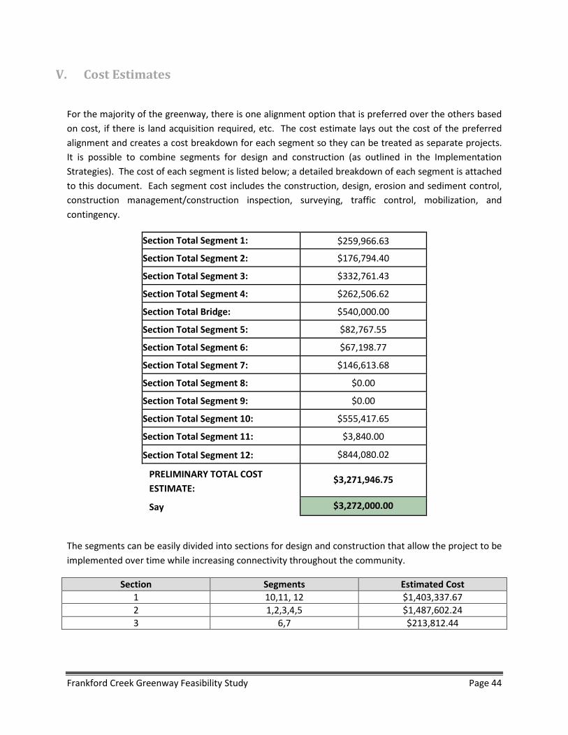
V. Cost Estimates
For the majority of the greenway, there is one alignment option that is preferred over the others based on cost, if there is land acquisition required, etc. The cost estimate lays out the cost of the preferred alignment and creates a cost breakdown for each segment so they can be treated as separate projects. It is possible to combine segments for design and construction (as outlined in the Implementation Strategies). The cost of each segment is listed below; a detailed breakdown of each segment is attached to this document. Each segment cost includes the construction, design, erosion and sediment control, construction management/construction inspection, surveying, traffic control, mobilization, and contingency.
Section Total Segment 1: $259,966.63
Section Total Segment 2: $176,794.40
Section Total Segment 3: $332,761.43
Section Total Segment 4: $262,506.62
Section Total Bridge: $540,000.00
Section Total Segment 5: $82,767.55
Section Total Segment 6: $67,198.77
Section Total Segment 7: $146,613.68
Section Total Segment 8: $0.00
Section Total Segment 9: $0.00
Section Total Segment 10: $555,417.65
Section Total Segment 11: $3,840.00
Section Total Segment 12: $844,080.02
PRELIMINARY TOTAL COST ESTIMATE: $3,271,946.75
Say $3,272,000.00
The segments can be easily divided into sections for design and construction that allow the project to be implemented over time while increasing connectivity throughout the community.
Section Segments Estimated Cost 1 10,11, 12 $1,403,337.67 2 1,2,3,4,5 $1,487,602.24 3 6,7 $213,812.44
Frankford Creek Greenway Feasibility Study Page 44


