Grid plan 1 Grid plan A simple grid plan road map (Windermere, Florida). The grid plan, grid street plan or gridiron plan is a type of city plan in which streets run at right angles to each other, forming a grid. In the context of the culture of Ancient Greece, the grid plan is called Hippodamian plan. [1] Ancient grid plans The grid plan dates from antiquity and originated in multiple cultures; some of the earliest planned cities were built using grid plans. By 2600 BC, Mohenjo-daro and Harappa, major cities of the Indus Valley Civilization, were built with blocks divided by a grid of straight streets, running north-south and east-west. Each block was subdivided by small lanes. A workers' village at Giza, Egypt (2570-2500 BC) housed a rotating labor force and was laid out in blocks of long galleries separated by streets in a formal grid. Many pyramid-cult cities used a common orientation: a north-south axis from the royal palace east-west axis from the temple meeting at a central plaza where King and God merged and crossed. Hammurabi (17th century BC) was a king of the Babylonian Empire who made Babylon one of the greatest metropolises in antiquity. He rebuilt Babylon, building and restoring temples, city walls, public buildings, and building canals for irrigation. The streets of Babylon were wide and straight, intersected approximately at right angles, and were paved with bricks and bitumen. The tradition of grid plans is continuous in China from the 15th century BC onward in the traditional urban planning of various ancient Chinese states. Guidelines put into written form in the Kaogong ji during the Spring and Autumn Period (770-476 BC) stated: "a capital city should be square on plan. Three gates on each side of the perimeter lead into the nine main streets that crisscross the city and define its grid-pattern. And for its layout the city should have the Royal Court situated in the south, the Marketplace in the north, the Imperial Ancestral Temple in the east and the Altar to the Gods of Land and Grain in the west." The first planned Greek city was probably Miletus, which was rebuilt to a grid plan after 479 BC. Its gridded design has been credited to Hippodamus [1] (although this may be apocryphal), a Greek intellectual associated with the Pythagoreans. The pinnacle of Ionian grid planning however was Priene, set on very uneven ground [2] and encompassing an acropolis. The grid plan was a common tool of Roman city planning, based originally on its use in military camps known as castra. One of the most striking extant Roman grid patterns can be found in the ruins of Timgad, in modern-day Algeria. The Roman grid is characterized by a nearly perfectly orthogonal layout of streets, all crossing each other at right angles, and by the presence of two main streets, set at right angles from each other and called the cardo and the decumanus. Teotihuacan, near modern-day Mexico City, is the largest ancient grid-plan site in the Americas. The city's grid covered eight square miles.
Transcript
Grid plan 1
Grid plan
A simple grid plan road map (Windermere, Florida).
The grid plan, grid street plan or gridiron plan is a type of cityplan in which streets run at right angles to each other, forming agrid. In the context of the culture of Ancient Greece, the grid planis called Hippodamian plan.[1]
Ancient grid plans
The grid plan dates from antiquity and originated in multiplecultures; some of the earliest planned cities were built using gridplans.By 2600 BC, Mohenjo-daro and Harappa, major cities of the IndusValley Civilization, were built with blocks divided by a grid ofstraight streets, running north-south and east-west. Each block was subdivided by small lanes.
A workers' village at Giza, Egypt (2570-2500 BC) housed a rotating labor force and was laid out in blocks of longgalleries separated by streets in a formal grid. Many pyramid-cult cities used a common orientation: a north-southaxis from the royal palace east-west axis from the temple meeting at a central plaza where King and God merged andcrossed.Hammurabi (17th century BC) was a king of the Babylonian Empire who made Babylon one of the greatestmetropolises in antiquity. He rebuilt Babylon, building and restoring temples, city walls, public buildings, andbuilding canals for irrigation. The streets of Babylon were wide and straight, intersected approximately at rightangles, and were paved with bricks and bitumen.The tradition of grid plans is continuous in China from the 15th century BC onward in the traditional urban planningof various ancient Chinese states. Guidelines put into written form in the Kaogong ji during the Spring and AutumnPeriod (770-476 BC) stated: "a capital city should be square on plan. Three gates on each side of the perimeter leadinto the nine main streets that crisscross the city and define its grid-pattern. And for its layout the city should havethe Royal Court situated in the south, the Marketplace in the north, the Imperial Ancestral Temple in the east and theAltar to the Gods of Land and Grain in the west."The first planned Greek city was probably Miletus, which was rebuilt to a grid plan after 479 BC. Its gridded designhas been credited to Hippodamus[1] (although this may be apocryphal), a Greek intellectual associated with thePythagoreans. The pinnacle of Ionian grid planning however was Priene, set on very uneven ground [2] andencompassing an acropolis. The grid plan was a common tool of Roman city planning, based originally on its use inmilitary camps known as castra. One of the most striking extant Roman grid patterns can be found in the ruins ofTimgad, in modern-day Algeria. The Roman grid is characterized by a nearly perfectly orthogonal layout of streets,all crossing each other at right angles, and by the presence of two main streets, set at right angles from each otherand called the cardo and the decumanus.Teotihuacan, near modern-day Mexico City, is the largest ancient grid-plan site in the Americas. The city's gridcovered eight square miles.
Asia from the first millennium ADAs Japan and the Korean peninsula became politically centralized in the 7th century AD, those societies adoptedChinese grid-planning principles in numerous locations. In Korea, Gyeongju, the capital of Unified Silla, andSanggyong, the capital of Balhae, adapted the Tang Dynasty Chinese model. The ancient capitals of Japan, such asFujiwara-Kyô (AD 694-710), Nara (Heijô-Kyô, AD 710-784), and Kyoto (Heian-Kyô, AD 794-1868) also adaptedfrom Tang's capital. However, for reasons of defense, the planners of Tokyo eschewed the grid, opting instead for anirregular network of streets surrounding the Edo Castle grounds. In later periods, some parts of Tokyo weregrid-planned.The grid-planning tradition in Asia continued through the beginning of the 20th century.
Europe and its colonies
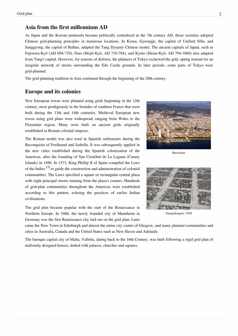
Barcelona
Ouagadougou, 1930
New European towns were planned using grids beginning in the 12thcentury, most prodigiously in the bastides of southern France that werebuilt during the 13th and 14th centuries. Medieval European newtowns using grid plans were widespread, ranging from Wales to theFlorentine region. Many were built on ancient grids originallyestablished as Roman colonial outposts.
The Roman model was also used in Spanish settlements during theReconquista of Ferdinand and Isabella. It was subsequently applied inthe new cities established during the Spanish colonization of theAmericas, after the founding of San Cristóbal de La Laguna (CanaryIslands) in 1496. In 1573, King Phillip II of Spain compiled the Lawsof the Indies [3] to guide the construction and administration of colonialcommunities. The Laws specified a square or rectangular central plazawith eight principal streets running from the plaza's corners. Hundredsof grid-plan communities throughout the Americas were establishedaccording to this pattern, echoing the practices of earlier Indiancivilizations.
The grid plan became popular with the start of the Renaissance inNorthern Europe. In 1606, the newly founded city of Mannheim inGermany was the first Renaissance city laid out on the grid plan. Latercame the New Town in Edinburgh and almost the entire city centre of Glasgow, and many planned communities andcities in Australia, Canada and the United States such as New Haven and Adelaide.
The baroque capital city of Malta, Valletta, dating back to the 16th Century, was built following a rigid grid plan ofuniformly designed houses, dotted with palaces, churches and squares.
Many of the earliest cities in the United States, such as Boston, did not start with a gridsystem.[4] However, even in the pre-revolutionary days some cities saw the benefits ofsuch a layout. New Haven Colony, one of the earliest colonies in America, was designedwith a tiny 9-square grid at its founding in 1638. On a grander scale, Philadelphia wasdesigned on a rectilinear street grid in 1682; one of the first cities in North America touse a grid system.[1] [5] At the urging of city founder William Penn, surveyor ThomasHolme designed a system of wide streets intersecting at right angles between theSchuylkill River to the west and Delaware River to the east, including five squares ofdedicated parkland. Penn advertised this orderly design as a safeguard againstovercrowding, fire, and disease, which plagued European cities. Holme drafted an idealversion of the grid,[6] but alleyways sprouted within and between larger blocks as the citytook shape. Arguably the most famous grid plan in history is the plan for New York Cityformulated in the Commissioners' Plan of 1811, a visionary proposal by the statelegislature of New York for the development of most of Manhattan[7] above HoustonStreet.
A diagram of three city grids at the same scaleshowing the differences in dimensions and
configuration
Washington, D.C., the capital of the United States, was planned underFrench-American architect Pierre Charles L'Enfant. Under the L'enfantplan, the original District of Columbia was developed using a grid planthat is overlapped by diagonal avenues, most famously PennsylvaniaAvenue. These diagonals are often connected by traffic circles, such asDupont Circle and Washington Circle. As the city began to grow insize, the plan was duplicated to cover most of the remainder of thecapital. Meanwhile, the core of the city faced disarray and theMcMillan Plan, led by Senator James McMillan was founded to build aNational Mall and parks system, that is still today a jewel of the city.
Often, some of the streets in a grid are numbered (First, Second, etc.),lettered, or arranged in alphabetical order. (Washington, DC hasexamples of all three).[1]
An exception to the typical, uniform grid is the plan of Savannah, GA(1733). It is a composite, cellular city block consisting of four largecorner blocks, four small blocks in between and a public square in thecentre. Its cellular structure includes all the primary land uses of aneighborhood and has for that reason been called fractal.[8] Its streetconfiguration presages contemporary traffic calming techniquesapplied to uniform grids where certain selected streets becomediscontinuous or narrow thus discouraging through traffic.
In the westward development of the United States, the use of the grid plan was nearly universal in the construction ofnew communities, such as in Salt Lake City (1870), Dodge City (1872) and Oklahoma City (1890). In these westerncities the streets were numbered even more carefully than in the east to suggest future prosperity and metropolitanstatus.[1]
One of the main advantages of the adoption of the grid plan was that it allowed the rapid subdivision and auction of alarge parcel of land. For example, when the legislature of the Republic of Texas decided in 1839 to move the capitalto the new site along the Colorado River, the functioning of the government required the rapid population of thetown, which was named Austin. Charged with the task, Edwin Waller designed a fourteen block grid that fronted theriver on 640 acres (exactly 1 square mile; about 2.6 km²). After surveying the land, Waller organized the sale of 306lots nearly immediately, and by the end of the year the entire Texas government had arrived by oxcart at the newsite. Apart from the speed of surveying advantage, the rationale at the time of the grid's adoption in this and othercities remains obscure.
Late 19th century to the presentIldefons Cerdà defined a concept of urban planning, based on the grid, that he applied to the Barcelona Eixample.The Eixample grid, introduced innovative design elements that made it exceptional at the time and even uniqueamong subsequent grid plans: a) a very large block measuring 113m by 113m (370 x 370 feet) far larger than the oldcity blocks and larger than any Roman, Greek blocks and their mutations (see drawing below); b) a 20 m (66 feet)road width (right of way) compared to mostly 3 m in the old city c) square blocks with truncated corners and d)major roads perpendicular and diagonal measuring 50 m (164 feet) in width. These innovations he based onfunctional grounds: the block size, to enable the creation of a quiet interior open space(60 m by 60 m) and allowample sunlight and ventilation to its perimeter buildings; the rectilinear geometry, the wide streets and boulevards tosustain high mobility and the truncated corners to facilitate turning of carts and coaches and particularly vehicles onfixed rails.[9]
In maps of larger American cities, mostly east of the Mississippi River, it can be noted that the downtown areas arealmost always grids. These areas represent the original land dimensions of the founded city, generally one squaremile. Some cities expanded the grid further out from the centre but maps also show that, in general, as the distancefrom the centre increases a variety of patterns emerge in no particular discernible order . In juxtaposition to the gridthey appear random. These new patterns have been systematically classified and their design characteristicsmeasured[10]
In the United States, the grid system was widely used in most major cities and their suburbs until the 1960s.However, during the 1920s, the rapid adoption of the automobile caused a panic among urban planners, who, basedon observation, claimed that speeding cars would eventually kill tens of thousands of small children per year.Apparently, at this early stage of the car’s entry into the grid, the streets of major cities worldwide were the scene ofvirtual “slaughter” as the fatality rate per 100,000 pop was more than double the current.[11] [12] In 2009, after severaldecades of road safety improvements and a constant decline in fatalities, an estimated 33,963 people died in motorvehicle traffic crashes and, according to the National Highway Traffic Safety Administration, “Motor vehicle crashesare the leading cause of death for children from 3 to 14 years old.”.[13] Planners, therefore, called for an inwardlyfocused "superblock" arrangement that minimized through automobile traffic and discouraged it from traveling onanything but arterial roads; traffic generators, such as apartment complexes and shops, would be restricted to theedges of the superblock, along the arterial. This paradigm prevailed between approximately 1930 and 1960,especially in Los Angeles, where notable examples include Leimert Park (an early example) and Panorama City (alate-period one).A prominent 20th century urbanist, Lewis Mumford, severely criticized some of the grid's characteristics: “With a T-square and a triangle, finally, the municipal engineer could, without the slightest training as either an architect or a sociologist, ‘plan’ a metropolis, with its standard lots, its standard blocks, its standard street widths, in short, with its
standardized comparable, and replaceable parts. The new gridiron plans were spectacular in their inefilciency andwaste. By usually failing to discriminate sufficiently between main arteries and residential streets, the first were notmade wide enough while the second were usually too wide for purely neighborhood functions . . . as for itscontribution to the permanent social functions of the city, the anonymous gridiron plan proved empty.”[14]
In the 1960s, traffic engineers and urban planners abandoned the grid virtually wholesale in favor of a "streethierarchy". This is a thoroughly "asymmetric" street arrangement in which a residential subdivision—oftensurrounded by a noise wall or a security gate—is completely separated from the road network except for one or twoconnections to arterial roads. In a way, this is a return to medieval styles: as noted in Spiro Kostof's seminal historyof urban design, The City Shaped, there is a strong resemblance between the street arrangements of modernAmerican suburbs and those of medieval Arab and Moorish cities. In each case, the community unit at hand—theclan or extended family in the Muslim world, the economically homogeneous subdivision in modernsuburbia—isolates itself from the larger urban scene by using dead ends and culs-de-sac.
A one square km sector in Milton Keynes framedby major roads on a grid configuration. The roadnetwork within the sector uses cul-de-sac streets
complemented by bike and foot paths whichconnect the entire sector and beyond
Milton Keynes
One very famous use of the grid system was in the British new town ofMilton Keynes. In this planned city, which began construction in 1967,a system of ten horizontal and eleven vertical roads at 1 km intervalswas used with roundabouts at each intersection. The horizontal roadswere all given names ending in 'way' and H numbers (for 'horizontal','e.g. H3 Monks Way). The vertical roads were given names ending in'street' and V numbers (for vertical', e.g. V6 Grafton Street). Each gridroad was spaced roughly one kilometre along from the next, formingsquares of approximately one square kilometre. Each square androundabout was given its own name. The system provided very easytransport within the city, although it confused visitors who wereunfamiliar with the system. Note the 'grid squares thus formed are farlarger than the city blocks described earlier, and the road layoutswithin the grid squares are generally 'organic' in form — matching the'street hierarchy model described above
Financial costThe infrastructure cost for regular grid patterns is generally higher than for patterns with discontinuous streets. Costsfor streets depend largely on four variables: street width (or Right of Way (ROW); street length, block width andpavement width.
Block sizes and street length
Street width (ROW) influences the amount of land that is devoted tostreets, which becomes unavailable for development and thereforerepresents an opportunity cost. The wider the street the higher theopportunity cost. Street width is determined by circulation and aestheticconsiderations and is not dependent on the pattern configuration. Anyconfiguration can have wide or narrow streets.
Street length influences proportionately the amount of street componentsthat have to be constructed such as pavement, curbs and sidewalks,storm sewers and drains, light poles, and trees. The street length of agiven area of development depends on the frequency at which streetsoccur which in turn depends on the length and width of a block. Thehigher the frequency of streets the longer is their total length. Thesmaller the block dimensions the higher the frequency of the streets. Asthe frequency of street increases so does the number of intersections.Intersections normally cost more than straight street length because theyare labour intensive and require street and traffic signage.
Pavement width influences the cost by affecting the amount of materialsand labour required to provide a finished road surface. Pavement widthis generally based on traffic engineering considerations and is notdependent on pattern configuration. As with the street width, any patterncan have wide or narrow pavements. Of all three factors that affect cost,street width, street length and pavement width, only street length ispattern dependent. An objective cost comparison would, therefore, relyon this variable with the full understanding that the other variables,though optional, can play a role.
Traditional orthogonal grid patterns generally have greater street frequencies than discontinuous patterns. Forexample, Portland's block is 200 feet X 200 feet while Miletus' is half that size and Timgad's half again (seediagram). Houston, Sacramento and Barcelona are progressively bigger reaching up to four times the area ofPortland's block. New York's 1811 plan (see above) has blocks of 200 ft. in width and variable lengths ranging fromabout 500 to 900 feet. The corresponding frequency of streets for each of these block sizes affects the street length.A simple example of a grid street pattern (see diagram) illustrates the progressive reduction in total street length andthe corresponding increase in block length. For a corresponding reduction of one, two, three and four streets withinthis 40 acre (16 ha) parcel, the street length is reduced from an original total of 12,600 to 7,680 linear feet, a 39%reduction. Simultaneously, block lengths increase from 200 X 200 feet to 1240 X 200 feet. When all five blockshave reached the ultimate size of 1240 feet, four street lengths out of total eight have been eliminated. Block lengthsof 1000 foot or larger rarely appear in grid plans and are not recommended as they hinder pedestrian movement(Pedestrianism, below). From the pedestrian perspective, the smaller the block is, the easier the navigation and themore direct the route. Consequently, the finer grids are preferred.
Patterns that incorporate discontinuous street types such as crescents and cul-de-sacs have not, in general, regardedpedestrian movement as a priority and, consequently, have produced blocks that are usually in the 1000-foot rangeand often exceed it. As a result, street frequency drops and so does the total street length and, therefore, the cost. Ingeneral, it is not the street pattern per se that affects costs but the frequency of streets that it either necessitates orpurposely incorporates.An inherent advantage of the orthogonal geometry of a proper grid is its tendency to yield regular lots in well-packedsequences. This maximizes the use of the land of the block; it does not, however, affect street frequency. Anyfrequency of orthogonal streets produces the same packing effect. Orthogonal geometry also minimizes disputes overlot boundaries and maximized the number of lots that could front a given street. John Randal said Manhattan's gridplan facilitated "buying, selling and improving real estate"/ [1]
Ecological features, rain water absorption and pollutant generationTypical, uniform grids are unresponsive to topography. Priene’s plan, for example, is set on a hill side and most of itsnorth-south streets are stepped, a feature that would have made them inaccessible to carts, chariots and loadedanimals. Other contemporary cities followed Priene’s example e.g. San Francisco, Vancouver, and Saint John, NewBrunswick. In a contemporary context, steep grades limit accessibility by car, and more so by bicycle, on foot, orwheelchair, particularly in cold climates.The same inflexibility of the grid leads to disregarding environmentally sensitive areas such as small streams andcreeks or mature woodlots in preference for the application of the immutable geometry. It is said of the NY grid planthat it flattened all obstacles in its way. By contrast, recent discontinuous street patterns follow the configuration ofnatural features without disrupting them. The grid represents a rationalist, reductionist solution to a multifacetedissue.The grid’s inherent high street and intersection frequency produce large areas of impermeable surfaces comprising ofthe street pavement and the sidewalks. In comparison to recent networks with discontinuous street types, grids can beup to 30% percent higher in impermeable surfaces attributable to roads. The emerging environmental priority ofretaining as much as 90% of rain water on site becomes problematic with high percentages of impermeable surfaces.And since roads constitute the largest share of the total impermeable surfaces of a development, the difficulty iscompounded by the grid type of layout. For these reasons contemporary planners have attempted to modify the rigid,uniform, classic grid.Some cities, notably Seattle, have devised means to improve a street’s retention capacity. However, frequentintersections as they occur in a regular grid would pose an obstacle to their effective application.A street network pattern can affect the production of pollutants by the amount of car travel that it necessitates and thespeed at which cars can travel. The grid plan with its frequent intersections may displace a portion of the local cartrips with walking or biking due to the directness of route that it offers to pedestrians. But it also makes the sameroutes more direct for cars, which could be an enticement for driving. The potential car trip displacement wouldresult in a reduction of pollutant emissions. The advantage of the intersection density for pedestrians, however, canhave a contrary effect for cars due to its potential for reducing speeds. Low speeds below 20 mph have asignificantly higher coefficient of pollutant production than above 30, though the coefficient after levelling off tendsto increase gradually after 50 mph.[15] This effect is accentuated with high traffic density in areas with commercialuses where speeds come to a crawl. Since the grid plan is non-hierarchical and intersections are frequent, all streetscan be subject to this potential reduction of average speeds, leading to a high production of pollutants. Greenhouseand noxious gases can be detrimental to the environment and to resident health.
Social environment and securityIn his seminal study (1982) on livable streets, that was conducted in neighbourhoods with a grid, Donald Appleyardshowed that social networking and street playing degraded as traffic increased on a street. His research provided thegroundwork for traffic calming and for several initiatives such as living streets and Home Zones, all of which areaimed at improving a street’s social milieu.The amount of traffic on a street depends on variables such as the population density of the neighbourhood, carownership and its proximity to commercial, institutional or recreational edifices. Most importantly, however, itdepends on whether a street is or could become a through road to a destination. As a through road, it could sustainunpredictable levels of traffic that may fluctuate during the day and increase over time. A key characteristic of thegrid pattern is that any and all streets are equally accessible to traffic (non-hierarchical) and could be chosen at willas alternative routes to a destination. Cut-through driving, or shortcutting, has been resisted by residents.[16] Citiesresponded by making modifications to prevent it. Current recommended design practice suggests the use of 3-wayintersections to alleviate it.[17] The geometry of the normal, open grid is evidently unsuitable for protecting orenhancing the social environment of a street from the negative influence of traffic.Similarly, a 1972 ground-breaking study by Oscar Newman on a Defensible Space Theory described ways toimprove the social environment and security of neighbourhoods and streets. In a practical application of his theory atFive Oaks, the neighbourhood's grid pattern was modified to prevent through traffic and create identifiable smallerenclaves while maintaining complete pedestrian freedom of movement. The positive outcome of these changesreinforces Appleyard's findings and the need to reduce or prevent through traffic on neighbourhood streets; a needthat cannot be met with a typical, uniform, open grid.The question of neighbourhood security has been a constant focus of research since Oscar Newman's work. Newresearch has expanded the discussion on this disputed issue. A recent study [18] did extensive spatial analysis andcorrelated several building, site plan and social factors with crime frequencies and identified subtle nuances to thecontrasting positions. The study looked at, among others, dwelling types, unit density (site density) movement on thestreet, culs–de-sac or grids and the permeability of a residential area.Among its conclusions are, respectively, that flats are always safer than houses and the wealth of inhabitants matters,density is generally beneficial but more so at ground level, local movement is beneficial, but not larger scalemovement, relative affluence and the number of neighbours have a greater effect than either being on a cul-de-sac orbeing on a through street. It also re-established that simple, linear culs-de-sac with good numbers of dwellings thatare joined to through streets tend to be safe. As for permeability, it suggests that residential areas should bepermeable enough to allow movement in all directions but no more. The overprovision of poorly used permeabilityis a crime hazard. The open, uniform grid could be seen as an example of undifferentiated permeabilty.A recent study in California[19] examined the amount of child play that occurred on the streets of neighbourhoodswith different characteristics; grid pattern and cul-de-sacs. The findings indicate that the open grid streets showedsubstantially lower play activity than the cul-de-sac street type. Cul-de-sacs reduce perceived danger from trafficthereby encouraging more outdoor play. It pointed the way toward the development of hybrid street network patternsthat improve pedestrian movement but restrict cut-through driving.Similar studies in Europe[20] and most recently in Australia[21] found that children's outdoor play is significantlyreduced on through roads where traffic is, or perceived by parents to be, a risk.Traditional street functions such a kids play, strolling and socializing are incompatible with traffic flow, which theopen, uniform grid geometry encourages. For these reasons, cities such as Berkeley, CA and Vancouver, BC, amongmany others, transformed existing residential streets part of a grid plan into permeable, linked culs-de-sac. Thistransformation retains the permeability and connectivity of the grid for the active modes of transport but filters andrestricts car traffic on the cul-de-sac street to residents only.
Pedestrian and bicycle movementTwo inherent characteristics of the grid plan, frequent intersections and orthogonal geometry, assist pedestrianmovement. The geometry helps with orientation and wayfinding and frequent intersections with the choice anddirectness of route to desired destinations. Street networks of old cities that grew organically, though admired forbeing picturesque, can be confusing for visitors but rarely for the original inhabitants (see plan). Similarly confusingto visitors are the plans of contemporary subdivisions with discontinuous and curvilinear streets. Change of streetorientation, particularly when gradual or arbitrary, cannot be “mapped” in the mind. Impasses, crescents orcul-de-sacs frustrate the traveler especially when they are long, forcing an arduous retracing of steps.Frequency of intersections, however, becomes also a disadvantage for pedestrians and bicycles. It disrupts therelaxed canter of walking and forces pedestrians repeatedly onto the road, a hostile, anxiety-generating territory.People with physical limitations or frailties, children and seniors for example, can find such walk challenging. Forbicycles this disadvantage is accentuated as their normal speed is at least double that of pedestrians. Frequent stopsnegate the speed advantage and the physical benefit of bicycling and add to frustration. Intersections are not onlyunpleasant but also dangerous. Most traffic collisions and injuries occur at intersections and the majority of theinjuries to pedestrians crossing with the right of way.A dilemma arises from trying to meet important planning objectives when using the grid: pedestrianism, costefficiency and environmental responsiveness. To serve pedestrians well, a rectangular configuration and highfrequency of streets and intersections is the preferred route, which the orthogonal grid geometry provides. To reducedevelopment costs and environmental impact, lower frequency of streets is the logical path. Since these two designobjectives are contradictory a balance needs to be struck. Such balance has been achieved in leading contemporaryprojects such as Vauban, Freiburg and Village Homes, Davis. Both score high in pedestrian and bike mode shareand, at the same time, in reducing negative development externalities. Their layout configurations represent a fusionof the classic grid plan with recent street network patterns.
SafetyPerceived and actual safety play a role in the use of the street. Perceived safety, though may be an inaccuratereflection of the number injuries or fatalities, influences parents’ decision to allow their children to play, walk or bikeon the street. Actual levels of safety as measured by the total number of collisions and the number and severity ofinjuries are a matter of public concern. Both should inform the layout, if the street network is to achieve its optimumuse.Recent studies have found higher traffic fatality rates in outlying suburban areas than in central cities and innersuburbs with smaller blocks and more-connected street patterns.[22] [23] While some of this disparity is the result ofdistance from emergency medical facilities (hospitals are usually built in a fairly late stage of the development of asuburban area), it is clear that the lower speeds encouraged by the frequency of intersections decrease the severity ofaccidents occurring on streets within a grid plan.An earlier study[24] found significant differences in recorded accidents between residential neighbourhoods that werelaid out on a grid and those that included cul-de-sacs and crescents. The frequency of accidents was significantlyhigher in the grid neighbourhoods.Two newer studies examined the frequency of collisions in two regional districts using the latest analytical tools.They investigated the potential correlation between street network patterns and frequency of collisions. In onestudy,[25] cul-de-sac networks appeared to be much safer than grid networks, by nearly three to one. A secondstudy[26] found the grid plan to be the least safe by a significant margin with respect to all other street patterns.A 2009 study [27] suggests that land use patterns play a significant role in traffic safety and should be considered in conjunction with the network pattern. While all intersection types in general reduce the incidence of fatal crashes, four-way intersections, which occur regularly in a grid, increase total and injurious crashes significantly. The study
recommends hybrid street networks with dense concentrations of T-intersections and concludes that a return to the19th century gridiron is undesirable.Stringent adherence to the grid plan can cause steep inclines since the topology of the land is not taken into account.This may be unsafe for drivers, pedestrians and bicycles since it is more difficult to control speed and braking,particularly in winter conditions.
Reconstruction and developmentOne of the greatest difficulties with grid plans is their lack of specialisation, most of the important amenities beingconcentrated along the city's main arteries. Often grid plans are found in linear settlements, with a main streetconnecting between the perpendicular roads. However, this can be mitigated by allowing mixed use development sothat destinations become closer to home. Many cities, especially in Latin America, still successfully retain their gridplans. Recently, planners in the United States and Canada have revisited the idea of reintroducing grid patterns tomany cities and towns.
AddressingHouse numbering can be tailored to the grid.
See also• City block• United States - Land Ordinance of 1785• Urban planning• Street hierarchy• Permeability (spatial and transport planning)
External links• Historical Society of Pennsylvania [28]
References[1] Jackson, Kenneth (1985). Crabgrass Frontier: The Suburbanization of the United States. Oxford University Press. pp. 73–76.[2] http:/ / www. pbase. com/ dosseman/ image/ 76472497[3] http:/ / www. arc. miami. edu/ Law%20of%20Indies. html[4] Back Bay, Dorchester Heights, and South Boston all have grid layouts.[5] ExplorePaHistory.com (http:/ / www. explorepahistory. com/ story. php?storyId=3& chapter=3& page=2)[6] http:/ / www. swarthmore. edu/ Humanities/ kjohnso1/ pictures/ tholme1683inch9. jpg Swarthmore College[7] Twelve Historical New York City Street and Transit Maps from 1860 to 1967 - John Landers – I SBN 1-882608-16X[8] Batty, M. & Longley, P. (1994) Fractal Cities: A Geometry of Form and Function (San Diego, CA: Academic)[9] http:/ / www. unesco. org/ most/ cerda2. htm#5[10] Southworth, Michael, and Peter Owens. 1993. “The Evolving Metropolis: Studies of Community, Neighbourhood, and Street Form at the
Urban Edge.” JAPA 59, 3: 271-288[11] http:/ / www. factbook. net/ EGRF_Regional_analyses_HMCs. htm[12] http:/ / www. unece. org/ trans/ main/ wp6/ pdfdocs/ RAS_2007. pdf[13] http:/ / www-nrd. nhtsa. dot. gov/ Pubs/ 811291. PDF[14] Mumford Lewis. 1961. The City in History: Its Origins, Its Transformation.r, and Its Prospects. New York, NY:Harcoufi Brace Jovanovich,
p48[15] Final Facility Specific Speed Correction Factors:M6.SPD.002 David Brzezinski, Constance Hart, Phil Enns Assessment and Standards
Division,Office of Transportation and Air Quality, U.S. Environmental Protection Agency[16] Philip Langdon 2006 Seaside Stews Over Street Connections New Urban News, September 2006[17] (http:/ / www. cues. fau. edu/ cnu/ docs/ Traditional_Neighborhood_Development_Street_Design_Guidelines-ITE. pdf) 1999, ITE,
[18] An evidence based approach to crime and urban design Or, can we have vitality, sustainability and security all at once? Bill Hillier,OzlemSahbaz March 2008 Bartlett School of Graduate StudiesUniversity College London
[19] Cul-de-Sacs and Children's Outdoor Play:Quantitative and Qualitative Evidence, 2007. Susan Handy, Samantha Sommer, Julie Ogilvie,Xinyu Cao, and Patricia Mokhtarian University of California Davis, 2007
[20] Huttenmoser, Marco and Marie Meierhofer (1995) “Children and Their Living Surroundings for the Everyday Life and Development ofChildren.” Children’s Environments 12(4): 1-17
[21] Individual, social and physical environmental correlates of children's active free-play: a cross-sectional study, Jenny Veitch, Jo Salmon andKylie Ball Centre for Physical Activity and Nutrition Research, Deakin University, Australia International Journal of Behavioral Nutrition andPhysical Activity 2010, 7:11doi:10.1186/1479-5868-7-11
[22] http:/ / www. minority. unc. edu:9014/ sph/ minconf/ 2004/ materials/ ewing. et al.pdf[23] http:/ / www. virginia. edu/ topnews/ releases2002/ lucy-april-30-2002. html[24] Eran Ben-Joseph, Livability and Safety of Suburban Street Patterns: A Comparative Study (Berkeley, CA: Institute of Urban and Regional
Development, University of California, Working Paper 641, 1995)[25] Using Macrolevel Collision Prediction Models in Road SafetyPlanning Applications Gordon R. Lovegrove and Tarek Sayed Transportation
Research Record: Journal of the Transportation Research Board,No. 1950, Transportation Research Board of the National Academies,Washington,D.C., 2006, pp. 73–82
[26] Sun, J. & Lovegrove, G. (2009). Research Study on Evaluating the Level of Safety of the Fused Grid Road Pattern, External ResearchProject for CMHC, Ottawa, Ontario
[27] Eric Dumbaugh and Robert Rae. Safe Urban Form: Revisiting the Relationship Between CommunityDesign and Traffic Safety. Journal ofthe American Planning Association, Vol. 75, No. 3, Summer 2009