Page 1
Vergo May/June 2008 GPR Report Page 1
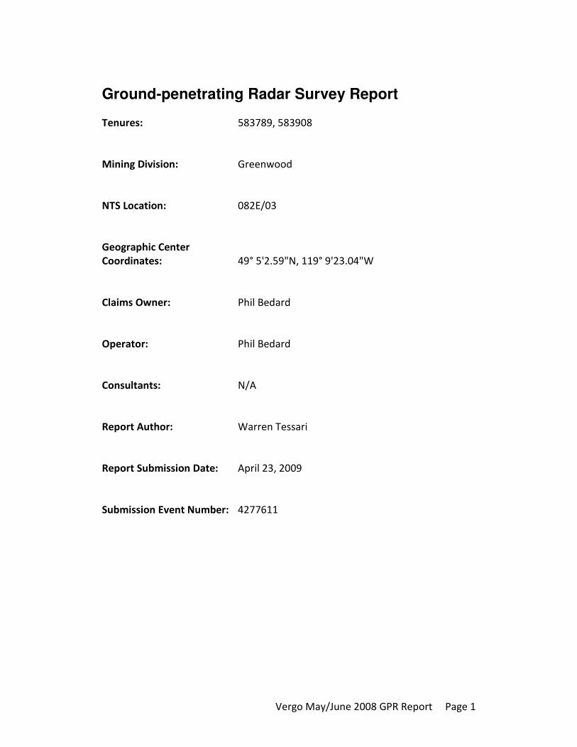
Ground-penetrating Radar Survey Report
Tenures: 583789, 583908
Mining Division: Greenwood
NTS Location: 082E/03
Geographic Center
Coordinates: 49° 5'2.59"N, 119° 9'23.04"W
Claims Owner: Phil Bedard
Operator: Phil Bedard
Consultants: N/A
Report Author: Warren Tessari
Report Submission Date: April 23, 2009
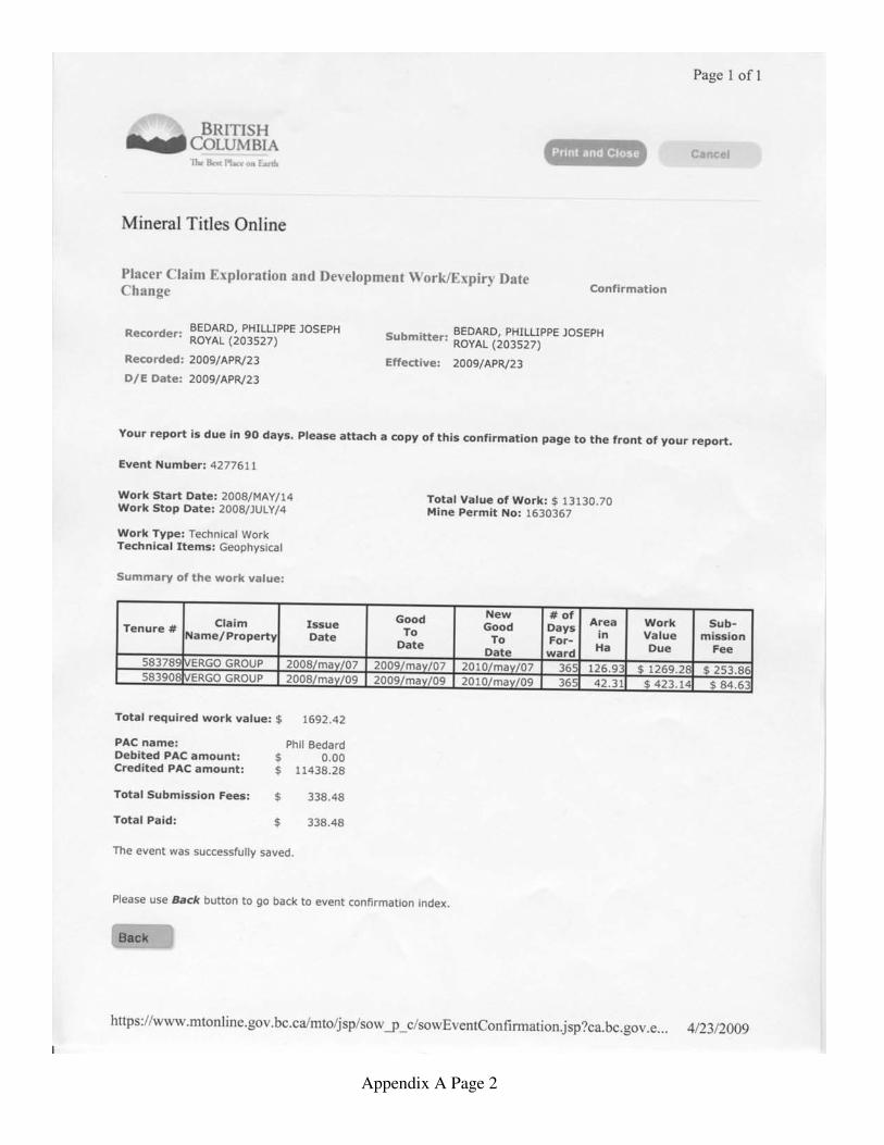
Submission Event Number: 4277611
ldegroot
Text Box
BC Geological Survey Assessment Report 31077
Page 2
Vergo May/June 2008 GPR Report Page 2
Table of Contents
Table of Contents.................................................................................................... 2
Introduction............................................................................................................. 3
Figure 1: Index Map............................................................................................ 3
Property and Survey Overview........................................................................... 4
Technical Data and Interpretation........................................................................... 5
Data and Diagrams.................................................................................................. 7
Figure 2: Sample Radar Data.............................................................................. 7
Figure 3: Plan Map A.......................................................................................... 8
Figure 4: Plan Map B.......................................................................................... 8
Itemized Cost Statements.................................................................................... 9
Statement of Author’s Qualifications ................................................................... 13
References Cited in the Report ............................................................................. 14
List of Software Programs Used in Support of the Exploration and Development
and the Preparation of the Report ......................................................................... 15
Appendix A: Original Report to Vergo Group ..................................................... 16
Table of Contents................................................................................................ 5
Page 3
Vergo May/June 2008 GPR Report Page 3
Introduction
Figure 1: Index Map
LEGEND
Geographic Center Coordinates
(49° 5'2.59"N, 119° 9'23.04"W)
Specific Claims Involved
Roads
Trails
Streams NTS Osoyoos 082E/03
Plan Maps A/B UTM Zone 11
N
1000 meters 500 1:24 317 20m Contour Spacing
INDEX MAP
Page 4
Vergo May/June 2008 GPR Report Page 4
Property and Survey Overview
The Vergo Placer Claims encompass the majority of the surface and suspected
subsurface drainage systems, both current and historical, downstream from the
lode deposits mined around Camp McKinney in the late Nineteenth Century.
In addition to the historically profitable hard-rock mining, Regional GeoChemical
Surveys available online from BCGS Geology also indicated abnormally high gold
values from soil samples south and east of the historical mines.
Other factors that contributed to the selection of this area for exploration and
development included proximity to roads and power and a lack of conflicting
interests. The majority of the claim is not privately owned, although Crown
Grants and other mineral claims abound in original mine and camp area.
The specific claims covered by this scope of work are owned and operated by
Phil Bedard representing the Vergo Group. Their tenure numbers for these
claims are 583789, 583908 and they are outlined in red on the index map in this
report.
Access to the claim is via Mount Baldy Road, and it is located approximately
41.2km east of Oliver. There is a substantial system of trails throughout the
claim.
Approximately 2 kilometers of radar data was collected on the claims listed
above. The purpose of the Ground-penetrating Radar (GPR) survey was to
identify target areas for further testing such as trenching and drilling. Apparent
subsurface channels, both current and historical, were noted in the data and
transferred manually to satellite imagery and quantitatively using non-
differential GPS coordinates attached to the data.
The original report provided to Phil Bedard is attached as an appendix to this
report and contains additional information (see Appendix A.)
Page 5
Vergo May/June 2008 GPR Report Page 5
Technical Data and Interpretation
250 MHz radar data was gathered by towing the radar transducer across
targeted areas by foot. For the first survey, the data was analog and manually
referred back to the specific, straight lines that were flagged and marked in the
field. For the second survey, digital data was gathered and correlated to GPS
coordinates for further analysis.
For this initial study the Noggin 250® made by Sensors & Software Inc. was used.
The transmitter and receiver are both contained in a single unit. The Noggin
250® operates at 250MHz with trace spacing based on elapsed time. This unit
was connected to a laptop and the data was captured in real time.
This radar system was shielded, and therefore out-of-plane objects were not a
significant factor. Although the depth of penetration is relatively shallow for soil
applications with a 250MHz system, this allows for greater resolution of
apparent near-surface object signatures.
All depth measurements were based on an estimated radar velocity for the
expected soil type. For the purposes of this survey, all depths were relative
rather than absolute and intended to be verified and corrected in the future
through other forms of testing such as drilling and/or trenching. Where depths
are given, they are provided in meters below grade.
Specifically, depth was indicated by nanoseconds corresponding to the signal
travel time to and from the radar unit. Based on the estimated soil conditions, a
depth approximation in meters was also provided by the radar unit. The deepest
indications with clear signal returns in this wavelength were approximately 6m.
The soil type appeared to be sand and gravel with localized topsoil and sporadic
clays. There appeared to be an abundance of overlying glacial till. The
topography, as shown on the index map, was variable and sloping overall to the
east and the south. However, in the area of pilot site where the radar data was
gathered, the topography was an elongated bowl shape. The scope of this
evaluation did not extend beyond surficial conditions into the underlying
bedrock.
The apparent relative depths of horizons in the data were indicated by markers
in a blue-shaded spectrum, with the darker markers indicating the deepest
horizons, and the lighter markers indicating shallower horizons. Water saturation
limited the depth of penetration and resulting clarity of the data a depth in some
areas. Any horizons that appeared to be deeper than the signal penetration were
Page 6
Vergo May/June 2008 GPR Report Page 6
indicated by arrows. Apparent features such as gravel, boulders, and side flows
and possible throws were also indicated.
NOTE:
The attached original report contains further details regarding the methods,
procedure, and results of the GPR survey. See Appendix A, which forms part of
this report, for more information.
Page 7
Vergo May/June 2008 GPR Report Page 7
Data and Diagrams
Figure 2: Sample Radar Data
This figure is an example of 250MHz radar data gathered during the survey. The
salient features include subsurface horizons, apparent water saturation, and
hyperbolas indicating features such as boulders or tree roots. The attached
original report comprising Appendix A contains samples from various areas on
the claims as well as further analysis and explanations.
The depth in the data is given in nanoseconds, which is the most accurate
representation of signal return. Any depth estimates are based on an estimated
velocity and are intended to be verified during further testing. Distances along
the ground were not taken from legend across the bottom of the data. Real-time
GPS tags were employed instead and transferred as waypoints to Google Earth
Pro™.
HORIZONS
HORIZONS HYPERBOLAS
APPARENT WATER SATURATION
Page 8
Vergo May/June 2008 GPR Report Page 8
Figure 3: Plan Map A
LEGEND
Specific Claims Involved
Roads
Streams
Data Lines Gathered
1:2 222 10m Contour Spacing
PLAN MAP A: RADAR DATA MAY 2008
N
583789
Page 9
Vergo May/June 2008 GPR Report Page 9
Figure 4: Plan Map B
LEGEND
Specific Claims Involved
Roads
Streams
1:2 353 10m Contour Spacing
N
PLAN MAP B: RADAR DATA JUNE 2008
583789
Page 10
Vergo May/June 2008 GPR Report Page 10
Itemized Cost Statements
The costs associated with this work are itemized on the following invoices
created by Maverick Inspection Ltd. pertaining to this work scope:
Page 11
Vergo May/June 2008 GPR Report Page 11
Page 12
Vergo May/June 2008 GPR Report Page 12
The work, including travel to and from the site, was performed over the course
of 2 trips, each 4 days in length. The bulk of the data formatting, sorting and
analysis was performed during that time, however additional analysis and
reporting was required.
The wages of the technicians were not paid for directly by Vergo Group. The
amounts from the above invoice are hourly and include all food and
accommodation, wages, equipment, transportation, and other costs associated
with this scope of work as billed.
Page 13
Vergo May/June 2008 GPR Report Page 13
Statement of Author’s Qualifications
This report was prepared by Warren Tessari, Operations Manager and Senior
Technician for Maverick Inspection Ltd.
Maverick Inspection has extensive experience in specialized non-destructive data
gathering including infrared thermography, laser imaging, remote video
inspection, and ground-penetrating radar.
Additional analysis was performed by Maverick’s most experienced radar
technician and GPR Department Manager, James Harrison, and by George Mason
M.Sc. As an Earth Scientist, George Mason has worked extensively with GPR
technology for many decades, including mining, archeological, and other
applications. James Harrison and George Mason have worked closely together
for many years and collaborated on the analysis of the radar data.
The analysis and interpretation of the data was based on known signatures of
subsurface features such as water saturation, changes in subsurface horizons,
objects that differentiated from the background, and other known phenomenon.
No attempt was made to positively identify subsurface features. Apparent
signatures were noted for further, targeted investigation, and comments were
made on the data based on previous experience and technical knowledge of
ground-penetrating radar.
Page 14
Vergo May/June 2008 GPR Report Page 14
References Cited in the Report
There are no specific references cited in this report. BCGS Geology Maps were
used as a resource during exploration and correlation of the data.
The report pertains to the specific data and field conditions, and it does not rely
on previous studies or reports apart from basic map data available online from
BCGS.
Page 15
Vergo May/June 2008 GPR Report Page 15
List of Software Programs Used in Support of the Exploration and Development and the Preparation of the Report
BCGS Geology Maps
Google Earth Pro
SPI View (by Sensors & Software)
MICRODEM 12.0
Microsoft Word 2003
Page 16
Vergo May/June 2008 GPR Report Page 16
Appendix A: Original Report to Vergo Group
The following report was submitted to the Vergo Group and to the Ministry of
Mines on April 23, 2009.
Page 17
Appendix A Page 1
Ground Penetrating Radar Report
This document contains the technical reports for two separate Ground-penetrating
Radar (GPR) subsurface surveys for the Vergo Group. The first survey was less
intensive and was performed in May 2008 to verify the existence of suspected
glacial run-off channels.
The second survey was performed in June 2008. This data was gathered with
similar equipment, however much more intensive collection and analysis was
required to map out the located subsurface channels in greater detail. GPS
coordinates were used to overlay the results with satellite imagery for quick
reference.
Both surveys were part of the exploration prior to mechanical test holes,
scheduled for later in 2009.
Additional GPR surveys using longer wavelength, deeper-penetrating (but lower
resolution) systems were also conducted across a greater area, however those are
submitted as a separate technical report.
The BC Mineral Titles Online Event Number for this document is 4277611.
Page 18
Appendix A Page 2
Ground Penetrating Radar Report
Page 19
Appendix A Page 3
Ground Penetrating Radar Report
To: George Mason
Phone : (250) 765-5449
Phil Bedard
Phone : (250) 469-0529
From: Warren Tessari
Phone : (780) 467-1606
Maverick Inspection Ltd.
#22 – 161 Broadway Blvd.
Sherwood Park, Alberta
T8A 2A8
On May 17th
, 2008 Maverick Inspection Ltd. was called upon to perform a series of
Ground-penetrating Radar surveys in the vicinity of the initial test hole (approx. 49°
5'52.24"N, 119° 9'31.89"W.) for the Vergo Project on Mount Baldy. This test hole and
radar data comprised the first steps of field sample collection for further analysis.
The purpose of the surveys was to gather data related to potential glacial channels and
throws with potential for further precious metals exploration.
The data was gathered without the use of an odometer wheel or GPS for this initial study.
Instead, the line starts and stops were manually recorded and marked on site maps and
flagged in the field for later reference.
If you have any questions concerning Ground-penetrating Radar, please contact Maverick
at (780) 467-1606.
Warren Tessari
Operations Manager
Maverick
INSPECTION LTD. Phone: (780) 467-1606
#22 – 161 Broadway Blvd.
Sherwood Park, Alberta
T8H 2A8
Page 20
Appendix A Page 4
Ground Penetrating Radar Report
IMPORTANT INFORMATION REGARDING YOUR MAVERICK INSPECTION
LTD. GROUND PENETRATING RADAR REPORT
These notes have been prepared by Maverick Inspection Ltd. to help you properly
interpret and understand the subsurface conditions of the scanned worksite.
Your Report is Based on Site Specific Criteria
Your report has been developed on the basis of your unique project specific requirements
as understood by Maverick Inspection Ltd. and applies only to the site investigated.
Your Report is Prepared for Specific Purposes and Persons
To avoid misuse of the information contained in your report, it is recommended that you
confer with Maverick Inspection Ltd. before passing your report on to another party who
may not be familiar with the background and purpose of the report. Your report should
not be applied to any project other than that originally specified at the time the report was
issued.
NOTE:
Though GPR is the most accurate subsurface imaging technology available, it is not
100% accurate, as with all forms of remote sensing. Maverick Inspection Ltd. provides
the highest degree of due diligence in acquiring data, and report generation. Although the
chance of missing any subsurface feature is low, clients shall not hold Maverick
Inspection responsible for any non or misidentified subsurface features, objects, or
anomalies. Maverick Inspection will not be held liable for any loss or damages that come
from any non or misidentified subsurface features, objects or anomalies.
There are certain elements that affect GPR. A few of these elements are carbon, chloride,
ironstone, and bentonite. These elements act as conductors that affect depth of
penetration.
Page 21
Appendix A Page 5
Ground Penetrating Radar Report
Table of Contents
1.0 Introduction
2.0 Overview
3.0 Results -interpreted
-datamaps/radargrams
4.0 Conclusion
Page 22
Appendix A Page 6
Ground Penetrating Radar Report
1.0 Introduction
BASIC PRINCIPLES OF GROUND PENETRATING RADAR
Ground-penetrating Radar (GPR) is a non-intrusive method of detecting buried objects or
substances in a non-metallic material through the use of radio waves.
GPR systems work by emitting a short electromagnetic pulse in the ground through a
wide-band antenna. Reflections from the ground are then measured to form a vector. An
image is built by displaying these vectors side by side with the displacement of the
antenna. By moving the antenna along a line and taking regularly spaced acquisitions, it
is possible to construct an image representing a vertical slice of the ground. The GPR
system is connected to a laptop computer that displays these images in real-time. The
data is also recorded on the computer for later interpretation and processing.
BASIC INFORMATION REGARDING THE GPR SYSTEM USED
For this initial study the Noggin 250® made by Sensors & Software Inc. was used. The
transmitter and receiver are both contained in a single unit. The Noggin 250® operates at
250MHz with trace spacing based on elapsed time. This unit was connected to a laptop
and the data was captured in real time.
For more detailed radar studies of this area, additional tools such as an odometer wheel,
GPS locating, and a digital video logger are recommended.
Page 23
Appendix A Page 7
Ground Penetrating Radar Report
2.0 Overview
The area in question was suspected to contain a
main drainage channel with overflow channels
curving to the East.
At the time of the scan and test hole, there was no
standing water in the clearing. No water was
encountered after surface moisture in the hole. The
hole was dug to a depth of approximately 1.3
meters. The satellite image to the right showing the
test holes, therefore, is not current.
Four lines of data were gathered running from west
to east, starting at the south end of the clearing. The
third line crossed over the test hole.
The lines were progressively longer due to the
shape of the clearing, and the start/stop points were
selected to avoid pulling the transducer across
deadfall.
Suspected Main Channel, Additional Channels and Test Hole
Line 1
Line 2 Line 3
Line 4
Page 24
Appendix A Page 8
Ground Penetrating Radar Report
3.0 Results
The main channel and the smaller channels to the east were the primary targets in this
survey.
The data appeared to show a very clear and deep main channel that flattened towards
the south end of the clearing (see Line 1 in the radar data below). It is important to
note that the surface of the radar data is horizontal while the physical surface of the
clearing is bowl-shaped. Due to this, the projected angles of the sides of the main
channel signatures are likely steeper. Therefore, the main channel is also likely deeper
than it appears in the data.
Several, smaller side channels were also apparent in the data. These were located
roughly where expected, and they appeared as a multitude of violent subsurface
horizons.
There was also evidence of possible groundwater saturation in the data below the
level of the test hole.
Multiple horizons throughout suggested an ongoing cycle of significant flooding.
The sand collected from the test hole appeared to be very well washed and cleaned. A
quantity of sand was taken for further separation and testing.
Page 25
9 of 38 #22, 161 Broadway Boulevard Sherwood Park AB T8H 2A8 Ph.: (780) 467-1606 Fax: (780)467-9987 www.maverickinspection.com
THIS REPORT IS CONFIDENTIAL AND SHOULD ONLY BE REPRODUCED IN ITS ENTIRETY
Ground Penetrating Radar Report
3.5 Digital Data/Radargrams
Line 1
Line 2
Line 3
Line 4
Main Channel Profile
Main Channel Profile
Main Channel Profile
Main Channel Profile
Side Channels
Side Channels
Side Channels
Suspected Water Saturation
Test Hole
Field Line Markings
Page 26
10 of 38 #22, 161 Broadway Boulevard Sherwood Park AB T8H 2A8 Ph.: (780) 467-1606 Fax: (780)467-9987 www.maverickinspection.com
THIS REPORT IS CONFIDENTIAL AND SHOULD ONLY BE REPRODUCED IN ITS ENTIRETY
Ground Penetrating Radar Report
Conclusion
Maverick Inspection Ltd. was able to perform Ground-penetrating Radar in the requested
areas. This inspection appears to have yielded useable results, which fulfilled the scope
of work as described.
Overall, the data appeared to confirm suspicions buried drainage channels.
Further data gathering is recommended using a grid pattern, GPS locating and depth
calibration for X, Y, and Z coordinates, and then 3D mapping of subsurface features to
determine more precise size and locations of areas of interest.
The Noggin systems used by Maverick to perform the inspection were designed and
optimized for subsurface inspections, and were chosen for this task because of size,
frequency, reliability, and integrated features/filters, and gain settings.
Each system performs a “Power On Self Test” and will fail if not properly calibrated, or
if some other problem will not allow the system to function adequately.
Thank you for choosing Maverick Inspection Ltd.
Warren Tessari
Operations Manager
Maverick
INSPECTION LTD. Phone: (780) 467-1606
#22 – 161 Broadway Blvd.
Sherwood Park, Alberta
T8H 2A8
Page 27
11 of 38 #22, 161 Broadway Boulevard Sherwood Park AB T8H 2A8 Ph.: (780) 467-1606 Fax: (780)467-9987 www.maverickinspection.com
THIS REPORT IS CONFIDENTIAL AND SHOULD ONLY BE REPRODUCED IN ITS ENTIRETY
Ground Penetrating Radar Report
To: George Mason
Phone : (250) 765-5449
Phil Bedard
Phone : (250) 469-0529
From: Warren Tessari
Phone : (780) 467-1606
Maverick Inspection Ltd.
#22 – 161 Broadway Blvd.
Sherwood Park, Alberta
T8A 2A8
On June 25th
, 2008 Maverick Inspection Ltd. was called upon to perform a series of
Ground-penetrating Radar surveys mapping out the pilot test site for the Vergo Project on
Mount Baldy. This intensive data gathering and analysis was required for more detailed
subsurface mapping prior to selection of mechanical test holes.
The purpose of the surveys was to gather data related to potential glacial channels and
throws with potential for further precious metals exploration.
The radar lines were gathered with GPS coordinates tagged to the data to indicate
position. The analysis was then linked back to Google Earth Pro™ for presentation
If you have any questions concerning Ground-penetrating Radar, please contact Maverick
at (780) 467-1606.
Warren Tessari
Operations Manager
Maverick
INSPECTION LTD. Phone: (780) 467-1606
#22 – 161 Broadway Blvd.
Sherwood Park, Alberta
T8H 2A8
Page 28
12 of 38 #22, 161 Broadway Boulevard Sherwood Park AB T8H 2A8 Ph.: (780) 467-1606 Fax: (780)467-9987 www.maverickinspection.com
THIS REPORT IS CONFIDENTIAL AND SHOULD ONLY BE REPRODUCED IN ITS ENTIRETY
Ground Penetrating Radar Report
IMPORTANT INFORMATION REGARDING YOUR MAVERICK INSPECTION
LTD. GROUND PENETRATING RADAR REPORT
These notes have been prepared by Maverick Inspection Ltd. to help you properly
interpret and understand the subsurface conditions of the scanned worksite.
Your Report is Based on Site Specific Criteria
Your report has been developed on the basis of your unique project specific requirements
as understood by Maverick Inspection Ltd. and applies only to the site investigated.
Your Report is Prepared for Specific Purposes and Persons
To avoid misuse of the information contained in your report, it is recommended that you
confer with Maverick Inspection Ltd. before passing your report on to another party who
may not be familiar with the background and purpose of the report. Your report should
not be applied to any project other than that originally specified at the time the report was
issued.
NOTE:
Though GPR is the most accurate subsurface imaging technology available, it is not
100% accurate, as with all forms of remote sensing. Maverick Inspection Ltd. provides
the highest degree of due diligence in acquiring data, and report generation. Although the
chance of missing any subsurface feature is low, clients shall not hold Maverick
Inspection responsible for any non or misidentified subsurface features, objects, or
anomalies. Maverick Inspection will not be held liable for any loss or damages that come
from any non or misidentified subsurface features, objects or anomalies.
There are certain elements that affect GPR. A few of these elements are carbon, chloride,
ironstone, and bentonite. These elements act as conductors that affect depth of
penetration.
Page 29
13 of 38 #22, 161 Broadway Boulevard Sherwood Park AB T8H 2A8 Ph.: (780) 467-1606 Fax: (780)467-9987 www.maverickinspection.com
THIS REPORT IS CONFIDENTIAL AND SHOULD ONLY BE REPRODUCED IN ITS ENTIRETY
Ground Penetrating Radar Report
Table of Contents
1.0 Introduction
2.0 Overview
3.0 Results -interpreted
-datamaps/radargrams
4.0 Conclusion
Page 30
14 of 38 #22, 161 Broadway Boulevard Sherwood Park AB T8H 2A8 Ph.: (780) 467-1606 Fax: (780)467-9987 www.maverickinspection.com
THIS REPORT IS CONFIDENTIAL AND SHOULD ONLY BE REPRODUCED IN ITS ENTIRETY
Ground Penetrating Radar Report
1.0 Introduction
BASIC PRINCIPLES OF GROUND PENETRATING RADAR
Ground-penetrating Radar (GPR) is a non-intrusive method of detecting buried objects or
substances in a non-metallic material through the use of radio waves.
GPR systems work by emitting a short electromagnetic pulse in the ground through a
wide-band antenna. Reflections from the ground are then measured to form a vector. An
image is built by displaying these vectors side by side with the displacement of the
antenna. By moving the antenna along a line and taking regularly spaced acquisitions, it
is possible to construct an image representing a vertical slice of the ground. The GPR
system is connected to a laptop computer that displays these images in real-time. The
data is also recorded on the computer for later interpretation and processing.
BASIC INFORMATION REGARDING THE GPR SYSTEM USED
For this initial study the Noggin 250® made by Sensors & Software Inc. was used. The
transmitter and receiver are both contained in a single unit. The Noggin 250® operates at
250MHz with trace spacing based on elapsed time. The Digital Video Logger (DVL)
control module was connected to a Garmin GPS Map 76C to provide continual satellite
positioning information for correlation to the radar data.
BENEFITS OF GROUND-PENETRATING RADAR
According to the U.S. Department of the Interior U.S. Geological Survey (Circular 1310,
An Introduction to Using Surface Geophysics to Characterize Sand and Gravel Deposits):
Ground-based geophysical surveys can be conducted prior to intensive drilling to help:
• locate auger or drill holes
• reduce the number of drill holes required
• calculate stripping ratios to help manage mining costs, and
• provide continuity between sampling sites to upgrade the confidence of reserve
calculations from probable reserves to proved reserves
. . . Perhaps the greatest value . . . may be the speed of data acquisition, reduced overall
costs, and improved subsurface characterization.
Page 31
15 of 38 #22, 161 Broadway Boulevard Sherwood Park AB T8H 2A8 Ph.: (780) 467-1606 Fax: (780)467-9987 www.maverickinspection.com
THIS REPORT IS CONFIDENTIAL AND SHOULD ONLY BE REPRODUCED IN ITS ENTIRETY
Ground Penetrating Radar Report
The radar data is intended to be used to reduce the initial costs and overall footprint of the
project. Further test holes, assays, and the eventual mining operation can then be
pinpointed and customized for the subsurface structures.
Page 32
16 of 38 #22, 161 Broadway Boulevard Sherwood Park AB T8H 2A8 Ph.: (780) 467-1606 Fax: (780)467-9987 www.maverickinspection.com
THIS REPORT IS CONFIDENTIAL AND SHOULD ONLY BE REPRODUCED IN ITS ENTIRETY
Ground Penetrating Radar Report
2.0 Overview
This scan was intended to improve the
resolution of subsurface imaging prior to
the selection of mechanical drilling sites.
During the May 15 2008 data gathering,
the main channel was identified as well
as possible side channels and throws.
At the time of the scan there was some
standing water in the clearing. The scan,
therefore, was performed around this
water.
The position of lines of data in this
report are approximated in yellow. The
lines shown in red are not included
because the depth of penetration was
less than the apparent alluvial fill.
Four lines of data were gathered around
the circumference of the sinkhole,
dividing it up into quadrants. Line 2
comprised the NE portion, Line 3 SE,
Line 4 SW, and Line 5 was NW.
Lines 6-34 ran E to West starting across
the mouth of the channel, and then
roughly parallel up the E bank and then
across the S end of the channel.
Line 35 ran the length of the clearing
along the E edge from S to N.
The results were analyzed and manually
translated to symbols referring to the
approximate depth and type of targets
noted.
Page 33
17 of 38 #22, 161 Broadway Boulevard Sherwood Park AB T8H 2A8 Ph.: (780) 467-1606 Fax: (780)467-9987 www.maverickinspection.com
THIS REPORT IS CONFIDENTIAL AND SHOULD ONLY BE REPRODUCED IN ITS ENTIRETY
Ground Penetrating Radar Report
3.0 Results
During the analysis of the data, the signatures noted were divided into the following
categories for quick reference:
• Apparent Channel or Throw Bottoms
• Apparent Gravel Signatures
• Apparent Boulder Signatures
These symbols do not indicate that these exact features necessarily exist in these
locations, however the subsurface data is consistent with these types of indications.
Depth was indicated by nanoseconds corresponding to the signal travel time to and from
the radar unit. Based on the estimated soil conditions, a depth approximation in meters
was also provided.
As a radar unit passes over the surface, the depth measurements and subsurface
signatures are provided relative to the surface angles. This was not corrected for in the
analysis, so all depths and locations provided are perpendicular to the surface at that
point.
The GPS coordinates appear to be quite accurate since no shift compared to the Google
Earth Pro™ imagery was noted.
The following page contains the waypoints overlaid on historical satellite imagery (not
current air photo at the time of the data gathering). A legend of the symbols is included
for reference.
Page 34
18 of 38 #22, 161 Broadway Boulevard Sherwood Park AB T8H 2A8 Ph.: (780) 467-1606 Fax: (780)467-9987 www.maverickinspection.com
THIS REPORT IS CONFIDENTIAL AND SHOULD ONLY BE REPRODUCED IN ITS ENTIRETY
Ground Penetrating Radar Report
GPS Waypoints
Apparent Channel or Throw Bottoms Apparent Gravel Signatures Apparent Boulder Signatures
NOTES:
The estimated depths are measured by radio velocity from the surface topography.
The symbols indicate the type
of features at that location.
With the exceptions of channels and throws, the estimated depth is not the depth of the feature but the depth of horizons visible in reasonable data at that location. Boulder signatures appear to be consistently higher than the lower horizons.
Water saturation is likely
obscuring the bedrock in most areas. There appears to be usable data down to and sometimes into areas of likely water saturation. Useable horizons and signatures appear to diminish gradually into the water saturation.
Some depths are extrapolated
from the angle of horizons entering the area of suspected water saturation.
250 MHz Radar Data Waypoint and Analysis Legend This data was gathered with approximately 6m maximum of signal penetration and return, focusing on the Pilot Plant site area.
Page 35
19 of 38 #22, 161 Broadway Boulevard Sherwood Park AB T8H 2A8 Ph.: (780) 467-1606 Fax: (780)467-9987 www.maverickinspection.com
THIS REPORT IS CONFIDENTIAL AND SHOULD ONLY BE REPRODUCED IN ITS ENTIRETY
Ground Penetrating Radar Report
3.5 Digital Data/Radargrams
CHANNELS IN INLET TO PILOT SITE
CHANNELS AND THROWS IN NE SEGMENT OF PILOT SITE
NOTE: The signatures of all subsurface features are affected by the actual surface topography of the surveyed line.
Page 36
1 of 38 #22, 161 Broadway Boulevard Sherwood Park AB T8H 2A8 Ph.: (780) 467-1606 Fax: (780)467-9987 www.maverickinspection.com
THIS REPORT IS CONFIDENTIAL AND SHOULD ONLY BE REPRODUCED IN ITS ENTIRETY
Ground Penetrating Radar Report
CHANNELS TO OUTLET FROM PILOT SITE
CHANNELS AND THROWS IN SE SEGMENT OF PILOT SITE
NOTE: The signatures of all subsurface features are affected by the actual surface topography of the surveyed line.
Page 37
2 of 38 #22, 161 Broadway Boulevard Sherwood Park AB T8H 2A8 Ph.: (780) 467-1606 Fax: (780)467-9987 www.maverickinspection.com
THIS REPORT IS CONFIDENTIAL AND SHOULD ONLY BE REPRODUCED IN ITS ENTIRETY
Ground Penetrating Radar Report
The above image is color-mapped for clearer definition of the subsurface channels. Although this can
make other features, such as water saturation, more difficult to identify, it does make the size and shape
of horizons more evident.
This line of data shows the S end of the apparent channel. The shape of the channel is clearly defined,
however there are likely multiple layers and horizons. It is quite possible that the bottom of the channel
is deeper than the 250MHz radar system can penetrate, especially in the presence of water saturation.
Page 38
3 of 38 #22, 161 Broadway Boulevard Sherwood Park AB T8H 2A8 Ph.: (780) 467-1606 Fax: (780)467-9987 www.maverickinspection.com
THIS REPORT IS CONFIDENTIAL AND SHOULD ONLY BE REPRODUCED IN ITS ENTIRETY
Ground Penetrating Radar Report
Conclusion
Maverick Inspection Ltd. was able to perform Ground-penetrating Radar in the
requested areas. This inspection appears to have yielded useable results, which
fulfilled the scope of work as described.
Overall, the GPR and GPS data combined to give a clear overview of the location
and types of subsurface features. All of the lines of data have been provided
separately to Vergo Group representatives for reference and further evaluation as
needed.
The next logical step in the data gathering process is to apply a longer wavelength
system such as a 50MHz transducer. This will allow for deeper penetration of the
radar signal. The sacrifice will be in the resolution of the results, however the
250MHz data provides clear imagery of relatively near-surface features. Water
saturation may still be a limitation, however the 50MHz data may be gathered in
winter to minimize that effect..
The Noggin systems used by Maverick to perform the inspection were designed
and optimized for subsurface inspections, and were chosen for this task because
of size, frequency, reliability, and integrated features/filters, and gain settings.
Each system performs a “Power On Self Test” and will fail if not properly
calibrated, or if some other problem will not allow the system to function
adequately.
Thank you for choosing Maverick Inspection Ltd.
Warren Tessari
Operations Manager
Maverick
INSPECTION LTD. Phone: (780) 467-1606
#22 – 161 Broadway Blvd.
Sherwood Park, Alberta
T8H 2A8