Upcoming satellite lidar missions such as the Cloudand Aerosol Lidar and Infrared Pathfinder SatelliteObservations (CALIPSO)1; the Atmospheric Dynam-ics Mission (ADM)2; and the Earth Cloud, Aerosols,and Radiation Explorer (EarthCARE)3 will allow usto monitor the global cloud and aerosol distributionsfor approximately one decade �2006–2014�. Thesemultiyear lidar observations need strong support byground-truth efforts with ground-based lidars aroundthe globe to ensure high-quality spaceborne observa-tions.
Comparison of ground-based and spaceborne aero-sol lidar products is a difficult task for several rea-sons. Direct satellite overflights over a ground-basedstation seldom occur. Horizontally inhomogeneousaerosol conditions may lead to significant differencesin the aerosol profiles obtained from ground andspace in nearby overflight cases.4 The satellite moves7 km�s so that only several tens of shots are availablein the vicinity of a ground-based lidar. As a conse-
quence the signal-to-noise ratio is much lower in thecase of the spaceborne lidar compared with groundlidar measurements. Multiple scattering has a signif-icant effect on any cloud observation with lidar and issignificantly higher for a spaceborne lidar.5,6 The ef-fect is assumed to be negligible in the case of aerosols.The incomplete overlap between the laser transmit-ter and the receiver field of view is another source ofuncertainty in the case of ground-based systems.7Accompanying Sun photometers or satellite radiom-eters provide information about the particle opticaldepths, a valuable constraint in the lidar data anal-ysis. The uncertainty of ground-based Sun photome-ter measurements and of satellite remote sensing ofaerosols over the oceans is of the order of a few per-cent but is comparably large �20%–50%� in the caseof spaceborne passive aerosol remote sensing overland.8 All these difficulties may dominate the qualityassurance and consistency checks when aerosol opti-cal properties retrieved from ground and space lidarare compared.
However, there will also certainly be frequentoverflight situations with sufficiently favorable hor-izontally homogeneous aerosol conditions, withwell-calibrated overlap-corrected ground-based li-dars and highly accurate optical depths obtainedfrom spaceborne and ground-based radiometers.Then the following question becomes important:Does the data analysis procedure (Klett method9–12
in the case of elastic backscatter lidars) itself intro-
The author is with the Leibniz Institute for Tropospheric Re-search, Permoserstrasse 15, 04318 Leipzig, Germany. His e-mailaddress is [email protected].
Received 19 December 2005; accepted 20 December 2005; posted3 January 2006 (Doc. ID 66773).
duce effects that lead to deviations in the retrievedaerosol profiles? The light attenuation process isdifferent for laser pulses that travel from the top ofthe atmosphere down to the ground and then up-ward again and for photons that first travel up-ward. The correction of atmospheric lightattenuation is an important part of the Klett pro-cedure. Possible deviations in the computed prod-ucts (ground versus space) caused by applying theKlett method are investigated here. The study isbased on simulations of a spaceborne and a ground-based elastic backscatter lidar operating both at532 nm (main CALIPSO wavelength) and looking atthe same aerosol column. Realistic aerosol cases ob-served in central Europe,13 in southern China,14 inthe outflow regime of Saharan dust over the subtrop-ical North Atlantic,15 of complex haze layering overthe tropical Indian Ocean (outflow regime of Asianhaze),16 and of an extended Canadian forest fire layerobserved over Europe17 are considered in the simu-lation study.
2. Method
State-of-the-art spaceborne missions such asCALIPSO for global mapping of aerosol distribu-tions combine radiometer-based aerosol column ob-servations with lidar aerosol profiling. For the samereason, modern ground-truth stations are equippedwith Sun photometer and aerosol lidar. Sun pho-tometers and spaceborne multichannel radiometersyield highly accurate particle optical depth spectrain a cloudless column. The optical depth at the laserwavelength (directly measured or obtained from in-terpolation of the spectrally resolved photometerdata) is used as a constraint in the analysis of thelidar data. The height profile of the particle back-scatter coefficient is computed from the elasticbackscatter signals by applying the so-called Klettmethod.9–11 In this paper the formalism as pre-sented by Ref. 11 is used. In the conventionalapproach (one-aerosol-layer approach), a range-independent lidar ratio is assumed as input. Theestimate is varied until the retrieved extinction co-efficient profile (or the backscatter coefficient profilemultiplied with the lidar ratio estimate) matchesthe measured particle optical depth.
Backward as well forward integration can be ap-plied when the optical depth constraint is available.For a ground-based lidar, for example, backward andforward integration means that the retrieval of thebackscatter coefficient profile is started from a refer-ence or calibration height in the upper troposphere orstratosphere, which is the remote end (backward in-tegration) of the measuring range, or from a height inthe boundary layer, which is the near end of themeasuring range (forward integration).
The lidar ratio estimate is the so-called columnlidar ratio defined as the ratio of the particle opticaldepth to the column-integrated backscatter coeffi-cient:
Scol �
�R1
R2
�ep�r�dr
�R1
R2
�p�r�dr
�
�R1
R2
S�r��p�r�dr
�R1
R2
�p�r�dr
(1)
R1 and R2 are the bottom and top heights of theaerosol layer of interest. �ep�r� denotes the volumeextinction coefficient of particles at height r, and �p�r�is the volume backscatter coefficient of particles. Thelidar ratio at height r is given by S�r� � �ep�r���p�r�.The column lidar ratio Scol is the backscatter-weighted mean lidar ratio of the aerosol column.
If the retrieved backscatter coefficient profile indi-cates a pronounced free tropospheric aerosol layer(layer 2) in addition to the planetary boundary layer(PBL), the two-layer approach may be of advantage.Analogously to the one-layer case, now two columnlidar ratios S1 and S2 for the layers 1 (PBL) and 2 arerequired. One of the two lidar ratios S1 and S2 mustbe estimated. Then the remaining Si value is varieduntil the column-integrated backscatter coefficientprofile multiplied by the lidar ratio step profilematches the optical depth measured with the radio-meter.
3. Model
The applied simulation model was developed for sim-ulations of ground-based, airborne, and spacebornestandard backscatter lidar, Raman lidar, and high-spectral-resolution lidar in the framework of a projectof the European Space Agency.18,19 For the purpose ofthis work, particle extinction and backscatter coeffi-cients are calculated from simulated 532 nm elasticbackscatter signals by applying the Klett method asgiven by Ref. 11 and described in Section 2. The re-trieved optical properties are then compared with therespective input data used for the simulations of thesignals.
To clearly show the principle (systematic differ-ences between spaceborne and ground-based remotesensing), uncertainties introduced by signal noise,overlap correction (ground-based system), and lidarsignal calibration are ignored. In addition, uncertain-ties in the radiometer-derived optical depths as wellas possible discrepancies caused by different aerosolvolumes seen by the ground-based and spacebornelidars are not considered in the simulations.
4. Simulations
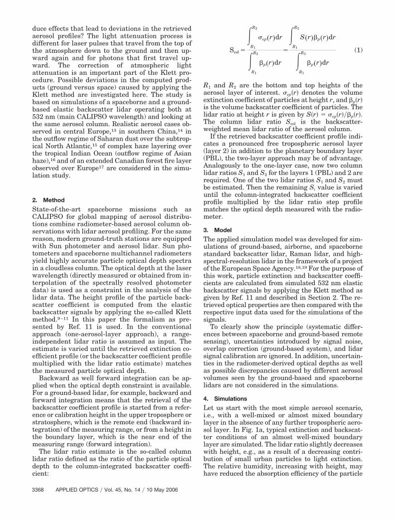
Let us start with the most simple aerosol scenario,i.e., with a well-mixed or almost mixed boundarylayer in the absence of any further tropospheric aero-sol layer. In Fig. 1a, typical extinction and backscat-ter conditions of an almost well-mixed boundarylayer are simulated. The lidar ratio slightly decreaseswith height, e.g., as a result of a decreasing contri-bution of small urban particles to light extinction.The relative humidity, increasing with height, mayhave reduced the absorption efficiency of the particle
because of water uptake by the particles, so that thelidar ratio further decreased. The lidar ratio is a func-tion of particle size, absorption-to-scattering ratio(depending on chemical composition), and particleshape. S decreases with increasing mean particle sizeand decreasing particle absorption. Figure 1b showsa heavily polluted boundary layer over the PearlRiver Delta, China. Here the lidar ratio may increasewith height because of the decreasing influence oflarge dust particles.
As can be seen, the solutions for the backscattercoefficient profile and for the extinction coefficientprofile obtained from space and ground lidar obser-vations almost coincide in the simple case of a bound-ary layer with low particle optical depth and in theabsence of further free tropospheric aerosol layers(Fig. 1a). The deviations are comparably large (of theorder of 10%–20%) in the case of the optically thickChinese pollution layer (Fig. 1b).
The obtained best estimates for the column lidarratio also deviate. Scol is overestimated (ground) andunderestimated (space, the true column lidar ratio is52.9 sr in Fig. 1a) when the true lidar ratio decreaseswith height. The opposite result is obtained when thelidar ratio increases with height. The true column
lidar ratio is 50.6 sr in Fig. 1b. As a direct conse-quence, erroneous column backscatter values are ob-tained from the accurately measured optical depthsand the erroneous column lidar ratios [see Eqs. (1)].
The reason for the different behavior of the solutionprofiles is the correction of atmospheric transmission,as part of the Klett computation. The correction in-troduces uncertainties when a height-constant lidarratio is assumed, but the true lidar ratio increases ordecreases along the line of sight. The effect on theKlett solutions is different for an increasing and de-creasing lidar ratio along the line of sight. Thus thesolutions obtained from space and ground lidar devi-ate because an increasing lidar ratio in the case of aground-based lidar means a decreasing lidar ratiowhen looking from space on the same aerosol scene.The solutions for ground and space lidars coincideonly when the true lidar ratio profile (thin curves inFigs. 1 and 2) is considered in the Klett retrieval afterRef. 11 as input. The same coincidence is given whena well-mixed boundary layer is present with a height-invariant extinction-to-backscatter ratio.
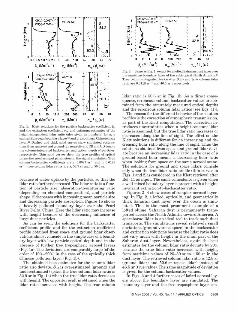
Figures 2–4 show cases of complex aerosol layer-ing. In Fig. 2, a lofted, optically, and geometricallythick Saharan dust layer over the ocean is simu-lated. This is the most prominent example of alofted plume. Saharan dust is permanently trans-ported across the North Atlantic toward America. Aspaceborne lidar is an ideal tool to track such dusttransports. The simulations reveal relatively smalldeviations (ground versus space) in the backscatterand extinction solutions because the lidar ratio doesnot vary much with height in the main part of theSaharan dust layer. Nevertheless, again the bestestimates for the column lidar ratio deviate by 20%because the true lidar ratio increases with height,from maritime values of 25–30 sr to �50 sr in thedust layer. The retrieved column lidar ratio is 42.8 sr(ground lidar) and 50.6 sr (space lidar) instead of46.5 sr (true value). The same magnitude of deviationis given for the column backscatter values.
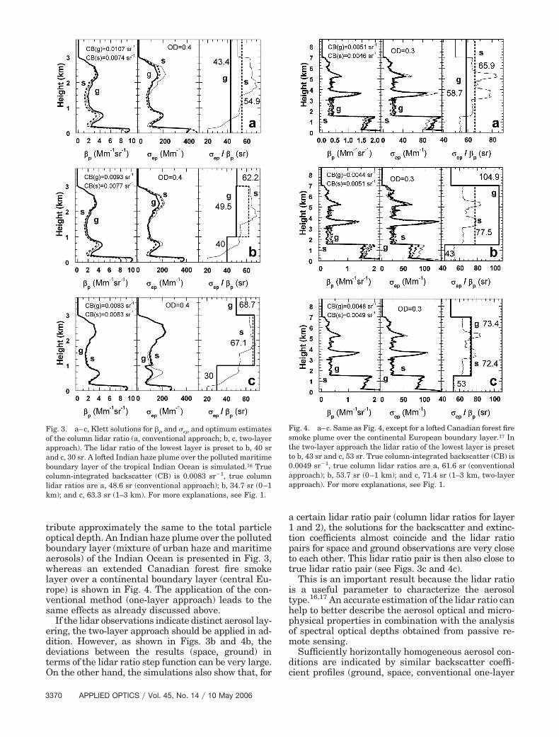
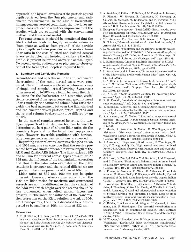
In Figs. 3 and 4 further cases of lofted aerosol lay-ers above the boundary layer are simulated. Theboundary layer and the free-troposphere layer con-
Fig. 1. Klett solutions for the particle backscatter coefficient �p
and the extinction coefficient �ep and optimum estimates of theheight-independent lidar ratio (also given as numbers) for a, acentral European boundary layer13 and b, a southern Chinese hazelayer.14 Dashed and thick solid curves show simulated observa-tions from space (s) and ground (g), respectively. CB and OD denotethe column-integrated backscatter and optical depth of particles,respectively. Thin solid curves show the true profiles of opticalproperties used as input parameters in the signal simulation. Truecolumn backscatter coefficients are a, 0.0027 sr�1 and b, 0.0198sr�1; true column lidar ratios are a, 52.9 sr and b, 50.6 sr.
Fig. 2. Same as Fig. 1, except for a lofted Saharan dust layer overthe maritime boundary layer of the subtropical North Atlantic.15
True column-integrated backscatter (CB) and true column lidarratio are 0.0118 sr�1 and 46.5 sr, respectively.
tribute approximately the same to the total particleoptical depth. An Indian haze plume over the pollutedboundary layer (mixture of urban haze and maritimeaerosols) of the Indian Ocean is presented in Fig. 3,whereas an extended Canadian forest fire smokelayer over a continental boundary layer (central Eu-rope) is shown in Fig. 4. The application of the con-ventional method (one-layer approach) leads to thesame effects as already discussed above.
If the lidar observations indicate distinct aerosol lay-ering, the two-layer approach should be applied in ad-dition. However, as shown in Figs. 3b and 4b, thedeviations between the results (space, ground) interms of the lidar ratio step function can be very large.On the other hand, the simulations also show that, for
a certain lidar ratio pair (column lidar ratios for layer1 and 2), the solutions for the backscatter and extinc-tion coefficients almost coincide and the lidar ratiopairs for space and ground observations are very closeto each other. This lidar ratio pair is then also close totrue lidar ratio pair (see Figs. 3c and 4c).
This is an important result because the lidar ratiois a useful parameter to characterize the aerosoltype.16,17 An accurate estimation of the lidar ratio canhelp to better describe the aerosol optical and micro-physical properties in combination with the analysisof spectral optical depths obtained from passive re-mote sensing.
Sufficiently horizontally homogeneous aerosol con-ditions are indicated by similar backscatter coeffi-cient profiles (ground, space, conventional one-layer
Fig. 3. a–c, Klett solutions for �p and �ep and optimum estimatesof the column lidar ratio (a, conventional approach; b, c, two-layerapproach). The lidar ratio of the lowest layer is preset to b, 40 srand c, 30 sr. A lofted Indian haze plume over the polluted maritimeboundary layer of the tropical Indian Ocean is simulated.16 Truecolumn-integrated backscatter (CB) is 0.0083 sr�1, true columnlidar ratios are a, 48.6 sr (conventional approach); b, 34.7 sr (0–1km); and c, 63.3 sr (1–3 km). For more explanations, see Fig. 1.
Fig. 4. a–c. Same as Fig. 4, except for a lofted Canadian forest firesmoke plume over the continental European boundary layer.17 Inthe two-layer approach the lidar ratio of the lowest layer is presetto b, 43 sr and c, 53 sr. True column-integrated backscatter (CB) is0.0049 sr�1, true column lidar ratios are a, 61.6 sr (conventionalapproach); b, 53.7 sr (0–1 km); and c, 71.4 sr (1–3 km, two-layerapproach). For more explanations, see Fig. 1.
approach) and by similar values of the particle opticaldepth retrieved from the Sun photometer and radi-ometer measurements. In the case of horizontallyinhomogeneous aerosol conditions, the two-layer ap-proach does not lead to a further improvement of theresults, which are obtained with the conventionalmethod, and thus is not useful.
For completeness, it should be mentioned that theKlett solution leads to highly accurate estimates(from space as well as from ground) of the particleoptical depth and also provides an accurate columnlidar ratio in the case of lofted and isolated aerosollayers so that clear air (needed to calibrate the lidarprofile) is present below and above the aerosol layer.No accompanying radiometer or photometer observa-tion of the total optical depth is required here.
5. Summary and Concluding Remarks
Ground-based and spaceborne lidar and radiometerobservations of the same aerosol cases were com-pared. The simulations were based on observed casesof simple and complex aerosol layering. Systematicdifferences of up to 20% were found between the Klettsolutions for the backscatter and extinction coeffi-cients retrieved from spaceborne and ground-basedlidar. Similarly, the estimated column lidar ratio thatyields the best agreement between the lidar-derivedand radiometer-derived particle optical depths andthe related column backscatter value differed by upto 20%.
In the case of complex aerosol layering, the two-layer approach of the Klett method can be used todetermine the best pair of column lidar ratios for theboundary layer and for the lofted free tropopshericlayer. However, favorable conditions with horizon-tally homogeneous aerosol conditions are needed.
Regarding other relevant laser wavelengths at 355and 1064 nm, one can conclude that the results pre-sented here are similar for 355 nm (wavelength of theADM and EarthCARE lidars). The lidar ratios at 355and 532 nm for different aerosol types are similar. At355 nm, the influence of the transmission correctionand thus of the lidar ratio estimates on the Klettsolutions is stronger and the related differences areexpected to be more pronounced than at 532 nm.
Lidar ratios at 532 and 1064 nm can be quitedifferent. However, observations show that the1064 nm lidar ratios for maritime and continentalaerosols are not that different so that the variation ofthe lidar ratio with height over the oceans should beless pronounced when lofted aerosol layers arepresent. Furthermore, the influence of the transmis-sion correction on the Klett solution is weak at 1064nm. Consequently, the effects discussed here are ex-pected to be smaller at 1064 nm than at 532 nm.
References1. D. M. Winker, J. R. Pelon, and M. P. Cormick, “The CALIPSO
mission: spaceborne lidar for observation of aerosols andclouds,” in Lidar Remote Sensing for Industry and Environ-ment Monitoring III, U. N. Singh, T. Itabe, and Z. Liu, eds.,Proc. SPIE 4893, 1–11 (2003).
2. A. Stoffelen, J. Pailleux, E. Källén, J. M. Vaughan, L. Isaksen,P. Flamant, W. Wergen, E. Andersson, H. Schyberg, A.Culoma, R. Meynart, M. Endemann, and P. Ingmann, “TheAtmospheric Dynamics Mission for global wind field measure-ments,” Bull. Am. Meteorol. Soc. 86, 73–87 (2005).
3. European Space Agency, “EarthCARE—Earth clouds, aero-sols, and radiation explorer,” Rep. ESA SP-1257 (1) (EuropeanSpace Research and Technology Centre, 2001).
4. T. L. Anderson, R. J. Charlson, D. M. Winker, J. A. Ogren, andK. Holmen, “Mesoscale variations of tropospheric aerosols,” J.Atmos. Sci. 60, 119–136 (2003).
5. D. M. Winker, “Simulation and modelling of multiple scatter-ing effects observed in LITE data,” in Advances in AtmosphericRemote Sensing with Lidar, A. Ansmann, U. Wandinger, R.Neuber, and P. Rairoux, eds. (Springer, 1997), pp. 185–188.
6. L. R. Bissonnette, “Lidar and multiple scattering,” in LIDAR—Range-Resolved Optical Remote Sensing of the Atmosphere, C.Weitkamp, ed. (Springer, 2005), pp. 43–103.
7. U. Wandinger and A. Ansmann, “Experimental determinationof the lidar overlap profile with Raman lidar,” Appl. Opt. 41,511–514 (2002).
8. D. A. Chu, Y. J. Kaufmann, C. Ichoku, L. A. Remer, D. Tanré,and B. N. Holben, “Validation of MODIS aerosol optical depthretrieval over land,” Geophys. Res. Lett. 29, 10.1029�2001GL013205 (2002).
9. J. D. Klett, “Stable analytical solution for processing lidarreturns,” Appl. Opt. 20, 211–220 (1981).
10. F. G. Fernald, “Analysis of atmospheric lidar observations:some comments,” Appl. Opt. 23, 652–653 (1984).
11. Y. Sasano, E. V. Browell, and S. Ismail, “Error caused by usinga constant extinction�backscattering ratio in the lidar solu-tion,” Appl. Opt. 24, 3929–3932 (1985).
12. A. Ansmann, and D. Müller, “Lidar and atmospheric aerosolparticles,” in LIDAR—Range-Resolved Optical Remote Sens-ing of the Atmosphere, C. Weitkamp, ed. (Springer, 2005), pp.105–141.
13. I. Mattis, A. Ansmann, D. Müller, U. Wandinger, and D.Althausen, “Multiyear aerosol observations with dual-wavelength Raman lidar in the framework of EARLINET,” J.Geophys. Res. 109, 10.1029�2004JD004600 (2004).
14. A. Ansmann, R. Engelmann, D. Althausen, U. Wandinger, M.Hu, Y. Zhang, and Q. He, “High aerosol load over the PearlRiver Delta, China, observed with Raman lidar and Sun pho-tometer,” Geophys. Res. Lett. 32, 10.1029�2005GL023094(2005).
15. J.-F. Leon, D. Tanré, J. Pelon, Y. J. Kaufman, J. M. Haywood,and B. Chatenet, “Profiling of a Saharan dust outbreak basedon a synergy between active and passive remote sensing,” J.Geophys. Res. 108, 10.1029�2002JD002774 (2003).
16. K. Franke, A. Ansmann, D. Müller, D. Althausen, C. Venkat-araman, M. Shekar Reddy, F. Wagner, and R. Scheele, “Opticalproperties of the Indo-Asian haze layer over the tropical IndianOcean,” J. Geophys. Res. 108, 10.1029�2002JD002473 (2003).
17. U. Wandinger, D. Müller, C. Böckmann, D. Althausen, V. Mat-thias, J. Bösenberg, V. Weiß, M. Fiebig, M. Wendisch, A. Stohl,and A. Ansmann, “Optical and microphysical characterizationof biomass-burning and industrial-pollution aerosols frommultiwavelength lidar and aircraft measurements,” J. Geo-phys. Res. 107, 10.1029�2000JD000202 (2002).
18. C. Kähler, J. Ackermann, M. Wiegner, H. Quenzel, A. Ans-mann, and U. Wandinger, “The potential contribution of abackscatter lidar to climatological studies,” ESA contract10722�93�NL�SF (European Space Research and TechnologyCentre, 1995).
19. M. Wiegner, V. Freudenthaler, B. Heese, A. Ansmann, and U.Wandinger, “EarthCARE lidar performance simulations,”ESA contract 15040�01�NL�MM, ES-TEC (European SpaceResearch and Technology Centre, 2003).