25
Ground Water Conditions around the Lathers Property Town of Waukesha Douglas S. Cherkauer PhD, PG, PH November 15, 2007
| Date post: | 29-Dec-2015 |
| Category: |
Documents |
| Upload: | brendan-gardner |
| View: | 216 times |
| Download: | 3 times |
Ground Water Conditions around the Lathers Property
Town of Waukesha
Douglas S. Cherkauer PhD, PG, PH
November 15, 2007

Tonight’s presentation
• Site specific issues at Lathers site– My report and what it means
• Overview of what a ground-water using community needs to do to understand and protect its water supply resource– Status of the Town’s monitoring program
• Discussion

1. Lathers site issues that need addressing
• What extraction rate can the aquifer sustain?
• Where will the water pumped come from?
• What impacts will the removal of water cause?– Drawdowns and effects on local wells– Effects on surface waters– Impacts on ground water quality
• Are these impacts acceptable?
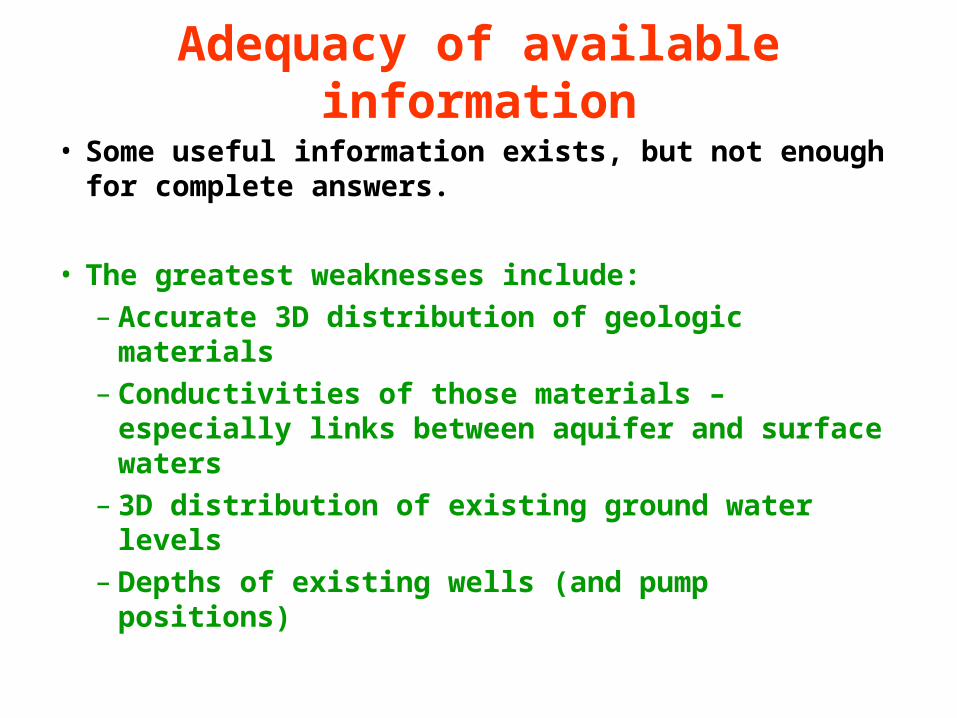
Adequacy of available information
• Some useful information exists, but not enough for complete answers.
• The greatest weaknesses include:– Accurate 3D distribution of geologic materials– Conductivities of those materials – especially
links between aquifer and surface waters– 3D distribution of existing ground water levels– Depths of existing wells (and pump positions)

Role of report done for Town
• Examine existing information to provide an interpretation of geology at and around the site
• Make some preliminary calculations of drawdowns using the existing (but incomplete) data
• Present recommendations as to what needs to be done to allow better answers to the Town’s concerns

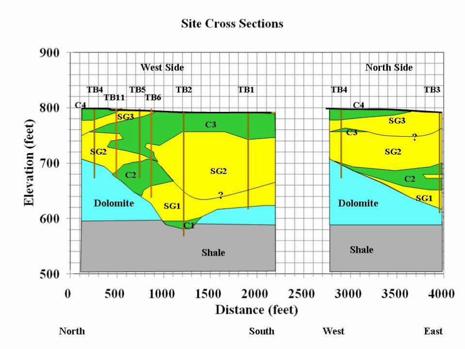


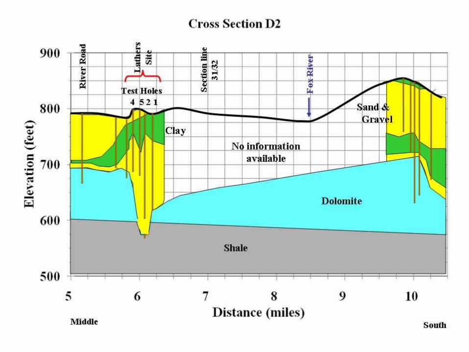
Conclusions about site geology
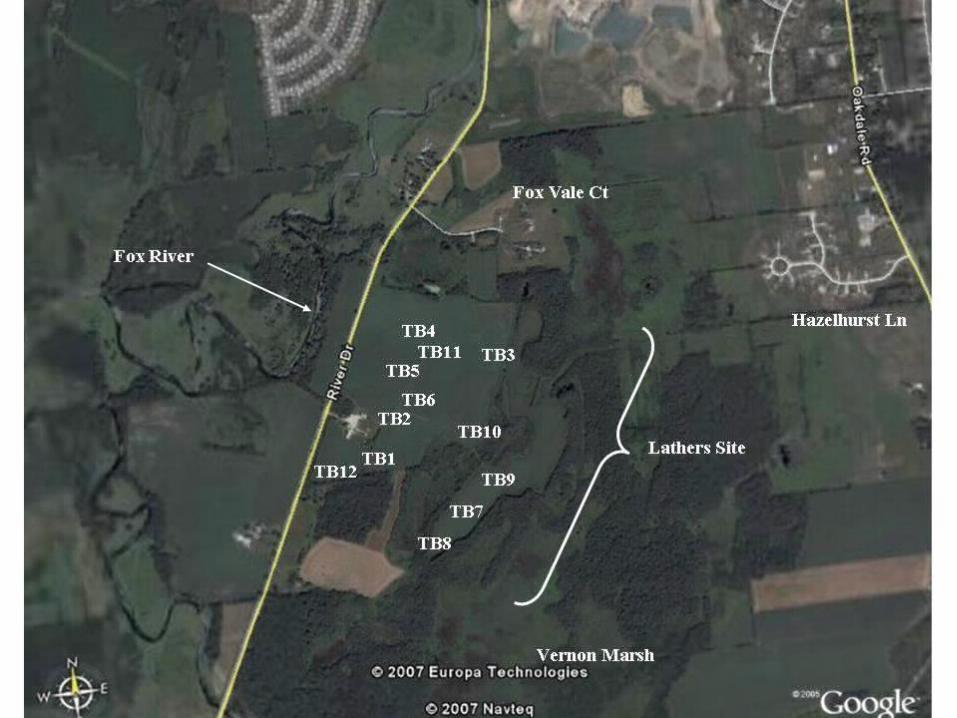
• There is substantial coarse grained (aquifer) material under the Lathers site
• 8 of the 12 test borings on site encountered sand at the surface
• There is a strong likelihood of a hydraulic connection between any well constructed on site and the Fox River (and probably Vernon Marsh)


Assumptions: Aquifer is homogeneous and laterally extensive;Well pumped at 1.5 mgd;
NO interconnection to surface waters (aquifer confined)Cautions: These are likely upper limits & are in the aquifer (not surface waters).

Assumptions: Aquifer is homogeneous and laterally extensive;Well pumped at 1.5 mgd;
NO interconnection to surface waters (aquifer confined)Cautions: These are likely upper limits & are in the aquifer (not surface waters).
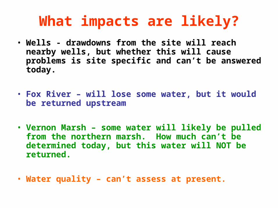
What impacts are likely?
• Wells - drawdowns from the site will reach nearby wells, but whether this will cause problems is site specific and can’t be answered today.
• Fox River – will lose some water, but it would be returned upstream
• Vernon Marsh – some water will likely be pulled from the northern marsh. How much can’t be determined today, but this water will NOT be returned.
• Water quality – can’t assess at present.
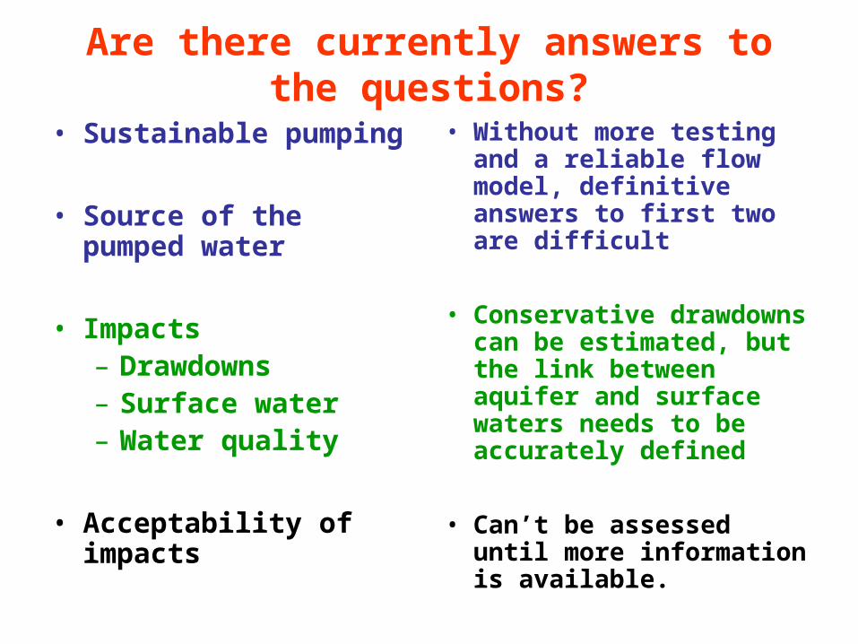
Are there currently answers to the questions?
• Sustainable pumping
• Source of the pumped water
• Impacts– Drawdowns– Surface water– Water quality
• Acceptability of impacts
• Without more testing and a reliable flow model, definitive answers to first two are difficult
• Conservative drawdowns can be estimated, but the link between aquifer and surface waters needs to be accurately defined
• Can’t be assessed until more information is available.

2. Assuring local water supply
• Monitor water levels
• City should assure residents within any well’s impact zone that they will correct water problems they cause
• Town needs to work with City to:– get adequate information– create a good flow model – use that model to test and optimize possible well
scenarios

Additional steps to protect supply
• Land use plan and zoning needs to be consistent with ground water protection– Cluster development with open space for
recharge– Avoid impervious surfaces, curb/gutter, sewers– Minimize road salt, other contaminants
• Require developments to quantify water needs and to show they can live with available supply (Example: Richfield ground water ordinance)

Monitoring Program Status
• Over 50 volunteers– 25 selected as initial set (based on location)– 22 are in backup set– Others too far away for present program
• Initial set– Test for bacteria– If pass, then water level will be measured
bimonthly – during work day when well inactive– Reports and data archiving; future survey– Actual schedule unknown at present (email
helpful)
Monitoring Program Status (2)
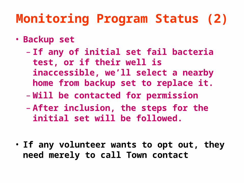
• Backup set– If any of initial set fail bacteria test, or if their
well is inaccessible, we’ll select a nearby home from backup set to replace it.
– Will be contacted for permission– After inclusion, the steps for the initial set will
be followed.
• If any volunteer wants to opt out, they need merely to call Town contact

Additional thoughts
• Other nearby communities dependent on private wells should consider initiating a similar program
• Having long-term, consistent monitoring record is best way to identify areas where problems may be developing
• Examples: Mequon and Richfield
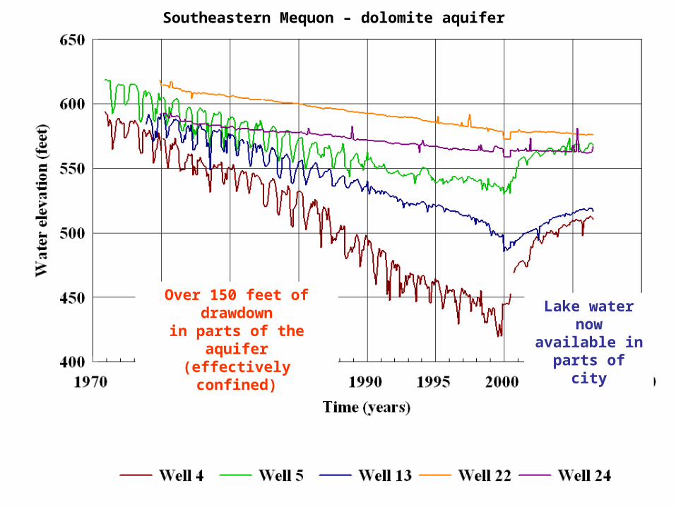
Southeastern Mequon – dolomite aquifer
Over 150 feet of drawdownin parts of the aquifer(effectively confined)
Lake water nowavailable in parts of city

Jun
e, 0
4
Jun
e, 0
5
Jun
e, 0
6
Jun
e, 0
7
Private wells are inboth dolomite and
sand & gravel –unconfined

Questions?


