Ground Water Level Ground Water Level Measurement Measurement Oregon State Water Resources Department in collaboration with Oregon State University Sea Grant Extension Neighborhood Ground Water Network Neighborhood Ground Water Network
Transcript
Ground Water LevelGround Water LevelMeasurementMeasurement
Oregon State Water Resources Departmentin collaboration withOregon State University Sea Grant Extension
Neighborhood Ground Water NetworkNeighborhood Ground Water Network
Presentation OutlinePresentation Outline
What is a ground water level measurement?Why measure the water level in a well?Measurement DocumentationWater Level MetersWater Level Measurement
Gro
und
Wat
er L
evel
Mea
sure
men
tG
roun
d W
ater
Lev
el M
easu
rem
ent
Ground Water Level MeasurementGround Water Level Measurement
A measurement of the water level below land surface in a well.
Static (non-pumping)ground water level measurements represent conditions in the surrounding aquifer.
Measurements over time give a better representation of aquifer conditions.
Source: USGFS Circular 1217
What is a ground water level measurement?What is a ground water level measurement?
Ground Water Storage
100 ft
75 ft
More Water in Storage
Less Water in Storage
Source: Karl Wozniak, Oregon Water Resources Department
Ground Water Level MeasurementGround Water Level Measurement
Some ways include using a graduated steel tape, existing air line, or an electric sounding device.
This program will only include instructions for an electric sounding device (water level meter).
Source: USGFS Water Supply Paper 2220
How do you take a ground How do you take a ground water level measurement?water level measurement?
Electric Sounding Device
Reel and Battery
Water Level MeterWater Level Meter
Coaxial LineProbe
Copper Wire and Tubing
Ground Water Level MeasurementGround Water Level Measurement
To manage and protect the water supply.
To spot problems with your well equipment.
To understand relationships between wells in your community.
To interpret the “health” of the surrounding aquifer.
Why measure the ground water level in a well?Why measure the ground water level in a well?
A A ““GoodGood”” Measuring ProgramMeasuring Program
A wide range of observation wells.
More frequent and longer periods of measurement.
Quality data collection.
Accurate data reporting.
A good monitoring program consists of:A good monitoring program consists of:The United States Geological Survey (USGS) says -
‘How to Measure the Water Level in a Well’ Information Booklet
Don’t forget to fill out your Well Information Sheet
before your measure.
Water Level MetersWater Level MetersFLAT-TAPE WATER LEVEL METER
A coaxial water level meter has a thin line and should be used in a well with a narrow access port or with an installed pump that might restrict the use of a water level meter with a flat tape.
A flat-tape water level meter has a flat tape, usually around 3/4-inch wide, and should onlybe used in well with a dedicated measuring tube.
OR
COAXIAL WATER LEVEL METER
Danger: If you get this type of meter stuck in your well, you might
have to pay to pull the well pump!
Purchase(or rent)
Check-OutParticipants in the Eola Hills may either:Participants in the Eola Hills may either:
OR
Water Level MetersWater Level Meters
Form a neighborhood group to purchase a water level meter together. OWRD will provide you with a water level meter vendor list.
The 4-H Conference and Education Center5390 4-H Rd. NWSalem OR 97304
503-371-7920
StepStep--byby--Step MeasurementStep Measurement
1) Well ID NumberIf there is no well tag on your well, please contact Oregon Water Resources Department to fill out a well tag application.
2) Water Well ReportCheck the well report for important information about the static water level (non-pumping) when your well was drilled, the depth of the well, the depth of the pump, information about the well casing, or the presence of any inner liner.
3) Pump InformationThe amount of water above the depth of the pump can inform you about the reliability of your water supply. Check for pump information on any pump receipts.
Background InformationBackground Information
Well Report or Pump Receipts
OWRD Website
OWRD Website
http://www.wrd.state.or.us
Water Bearing ZonesThe static water level when the well was drilled.
Well LogThe geology of the well borehole and the well depth.
Casing/ LinerIs there an inner liner in your well?
Well YieldThis section shows the estimated well yield at the time of drilling.
StepStep--byby--Step MeasurementStep Measurement
Well and Pump HousesWell and Pump HousesBe aware of animals, snakes, or bees when near to the well or the pump house.
Do not use regular insulation to cover your well casing or water lines.
Keep your well and pump house clean.
Do not store fertilizers, pesticides, or chemicals in or near your pump house.
StepStep--byby--Step MeasurementStep Measurement
StepStep--byby--Step MeasurementStep Measurement
Turn off the pump for at least two hours to ensure that conditions are static (non-pumping) in your well.
Or, take the water level measurement early in the morning before the pump has been used.
Static water level measurements are needed to understand water storage in the surrounding aquifer.
StepStep--byby--Step MeasurementStep Measurement
Turn Off Well Pump and Record TimeTurn Off Well Pump and Record Time
StepStep--byby--Step MeasurementStep Measurement
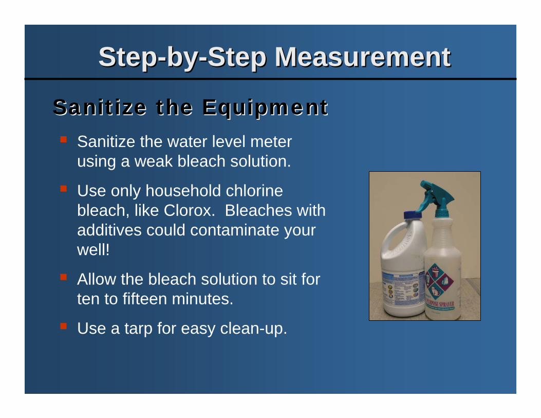
Sanitize the water level meter using a weak bleach solution.
Use only household chlorine bleach, like Clorox. Bleaches with additives could contaminate your well!
Allow the bleach solution to sit for ten to fifteen minutes.
Use a tarp for easy clean-up.
Sanitize the EquipmentSanitize the Equipment
StepStep--byby--Step MeasurementStep Measurement
An example sketch of a
measuring point locati
on.
Well Access Port and Measuring PointWell Access Port and Measuring Point
The measuring point is a reference point on the well casing, cap, or measuring tube from which all measurements are made.
Draw a sketch of the measuring point on your water level data sheet.
Always use the same measuring point.
StepStep--byby--Step MeasurementStep Measurement“Turtle Back" well cap with access plug.
"Turtle Back" well cap without access plug.
Sanitary well cap.
Three common types of well caps.
Always measure from the same access point.
A dedicated measuring tube makes things easier.
You will need to have the right tools (and, do not forget the WD-40).
Well CapsWell Caps
StepStep--byby--Step MeasurementStep Measurement
Measuring TubeMeasuring TubeA ¾-inch measuring tube is now required in the Eola Hills GWLA.
StepStep--byby--Step MeasurementStep Measurement
Handy Tool ListHandy Tool List
Box Wrench
Flashlight
Hammer
Pipe Wrench
Small Mirror
Socket Wrench
WD-40
Don’t forget that you will need to provide your own tools.
StepStep--byby--Step MeasurementStep Measurement
Possible ProblemsPossible Problems
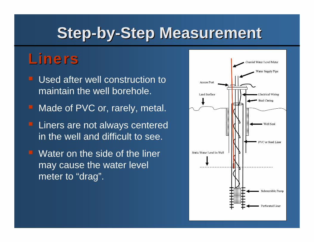
1. Liners
2. Hang-Ups
3. Cascading Water
These problems could lead to an inaccurate water level measurement!
Used after well construction to maintain the well borehole.
Made of PVC or, rarely, metal.
Liners are not always centered in the well and difficult to see.
Water on the side of the liner may cause the water level meter to “drag”.
StepStep--byby--Step MeasurementStep Measurement
Caution: To avoid electrical shock, do not touch any bare wires in the casing.
Where is that inner liner?HangHang--UpsUps
Do not yank the line.
Gently shake the line to free.
If unable to free the line, pull the line slowly to release the probe weights.
Note the “hold-point” if unable to free the line and a strong pull is needed to free the line.
Recalibrate the line after any hang-ups.
StepStep--byby--Step MeasurementStep Measurement
Cascading WaterCascading WaterCascading water may enter the borehole at any point.
Cascading water may cause a false reading.
An unsteady signal (chatter) on the water level meter may indicate cascading water.
If you suspect cascading water, listen down the borehole for flowing water.
Coaxial Water Level Meter
Land Surface
Cascading Water
Static Water Level in Well
Well Borehole
StepStep--byby--Step MeasurementStep Measurement
COAXIAL WATER LEVEL METER
FLAT-TAPE WATER LEVEL METER
Blue500
Green100
Orange5
Pale Green10
Pale Green/Orange/Pale Green5
COLOR-CODES FOR MARKERSDEPTH (Feet)
The coaxial water level meter has a thin line (like a speaker wire) marked in five-foot increments. Determining how much line you have in the well requires counting the color-coded markers using a pattern similar to adding with Roman numerals.
The flat-tape water level meter usually has a 3/4-inch wide tape marked in engineering, standard, or metric scale.Determining how much tape you have in the well requires reading the tape (similar to reading a ruler).
Water Level Meter ScalesWater Level Meter Scales
StepStep--byby--Step MeasurementStep Measurement
1. Test the water level meter.
2. Turn the water level meter to the buzz position.
3. Turn the sensitivity switch all the way to the right.
4. Slowly release some line down the well casing. Do not let the line free fall.
5. Check the "feel" of the line and probe. As the probe goes deeper, the weight should increase.
6. Lower the water level meter until it indicates the probe is in water or if the probe becomes stuck or hung-up. Remember to check the "feel" of the line and probe about every 20 feet.
Measure the Water LevelMeasure the Water Level
StepStep--byby--Step MeasurementStep Measurement7. If you do not feel the weight of the probe,
raise the probe. Gently bounce the probe about two feet.
8. When water level meter indicates water, make sure that it is not cascading water.
9. If you have not already, set down the reel.
10. Raise the line to check for a static (non-pumping) water level. Hold for 3 minutes.
11. Grab the measuring point.
12. Record the water level measurement at the measuring point on your data sheet (Different methods for coaxial and flat-tape water level meters).
13. Repeat the steps to determine a consistent measurement.
StepStep--byby--Step MeasurementStep Measurement14. Slowly rewind the line and probe onto the
reel.
15. Turn off the water level meter, sanitize it, and replace the well cap.
16. Use a pocket tape to measure the height of the measuring point (MP). Record the MP height on your data sheet.
17. Calculate the depth of water below land surface on your data sheet. (Different methods for coaxial and flat-tape water level meters).
Remember to go very slow to avoid getting your water level meter stuck in the well.
StepStep--byby--Step MeasurementStep Measurement
Measuring Point Above Land SurfaceMeasuring Point Above Land Surface
Interpret Your Water Level MeasurementsInterpret Your Water Level Measurements
The easiest way to interpret ground water levels in your well is to plot the data versus time.
This type of figure is known as a hydrograph.
Compare ground water levels to precipitation records.
Normal Seasonal Fluctuations
2001 Drought
Decadal Climatic Cycles
Changes in Long-Term Storage
Submit Your Water Level MeasurementsSubmit Your Water Level Measurements
Entry of your ground water level data on the Neighborhood Ground Water Network webpage will allow you to
retrieve an automatic plot (hydrograph) of your water levels.
If you choose, you may submit your information on the OWRD website at http://www.wrd.state.or.us/.
Look for the Ground Water link on the left-hand side of the page. Navigate to the Neighborhood Ground Water Network webpage at http://www.wrd.state.or.us/OWRD/GW/NGWN_homepage.shtml.
Neighborhood Ground Water NetworkNeighborhood Ground Water Network
Abigail Brown – OSU Sea Grant Fellow Oregon Water Resources Department 725 Summer Street NE, Suite A – Salem, OR 97301 Phone: 503-986-0836 – Fax: 503-986-0902