GROUND-WATER RESOURCE S O F BILLINGS, GOLDEN VALLEY, AN D SLOPE COUNTIES , NORTH DAKOT A b y Lawrence O . Ann a U .S . Geological Surve y COUNTY GROUND-WATER STUDIES 29 — PART II I North Dakota State Water Commissio n Vernon Fahy, State Engineer BULLETIN 76 — PART II I North Dakota Geological Surve y Lee Gerhard, State Geologist Prepared by the U .S. Geological Survey in cooperation with the North Dakota Stat e Water Commission, North Dakota Geological Survey, U.S . Forest Service, U .S. National Park Service, Billings County Wate r Management District, Golden Valle y County Water Management District, an d Slope County Water Management District 1981
Transcript
GROUND-WATER RESOURCE S
O F
BILLINGS, GOLDEN VALLEY, AN DSLOPE COUNTIES,NORTH DAKOT A
by
Lawrence O. Anna
U.S . Geological Survey
COUNTY GROUND-WATER STUDIES 29 — PART II INorth Dakota State Water CommissionVernon Fahy, State Engineer
BULLETIN 76 — PART II INorth Dakota Geological SurveyLee Gerhard, State Geologist
Prepared by the U .S. Geological Surveyin cooperation with the North Dakota State
Water Commission, North Dakota GeologicalSurvey, U.S . Forest Service, U .S. National
Park Service, Billings County Wate r
Management District, Golden Valle yCounty Water Management District, an d
Slope County Water Management District
1981
GROUND-WATER RESOURCE S
OF
BILLINGS, GOLDEN VALLEY, AN DSLOPE COUNTIES ,NORTH DAKOTA
by
Lawrence O. Anna
U .S. Geological Survey
COUNTY GROUND-WATER STUDIES 29 — PART II INorth Dakota State Water Commissio nVernon Fahy, State Enginee r
BULLETIN 76 — PART II INorth Dakota Geological SurveyLee Gerhard, State Geologist
Prepared by the U .S. Geological Surveyin cooperation with the North Dakota State
Water Commission, North Dakota GeologicalSurvey, U.S . Forest Service, U .S. National
Park Service, Billings County Wate rManagement District, Golden Valle y
County Water Management District, an dSlope County Water Management District
198 1
Bismarck, North Dakota
CONTENTS
Page
ABSTRACT 1INTRODUCTION 1
Purpose and objectives of the investigation 2Geography 2Acknowledgements 4Location-numbering system 4Previous investigations : 6
AVAILABILITY AND QUALITY OF kROUND WATER 6General concepts 6Geologic setting 8Aquifers of Paleozoic and Mesozoic age 1 1Aquifers of Late Cretaceous age 1 1
Fox Hills-lower Hell Creek aquifer system 1 1Aquifers of Late Cretaceous and Tertiary age 2 2
Upper Hell Creek-lower Ludlow aquifer system 2 2Aquifers of Tertiary age
2 7Aquifers in the upper part of the Ludlow and Tongue Rive r
Members of the Fort Union Formation 2 7Aquifers in the Sentinel Butte Member of the For t
Union Formation 3 3Aquifers in the Golden Valley and White River
Formations 3 4Aquifers of Quaternary age 3 6
Alluvial aquifers 3 6HYDROGEOLOGY OF STRIPPABLE LIGNITE DEPOSITS 4 0EFFECTS OF FLOWING WELLS 43SURFACE WATER 43WATER UTILIZATION 45
Domestic and livestock use 45Public supplies 46
Beach 46Golva 46Marmarth 47Medora 47
Irrigation 47Industrial 47
SUMMARY 48SELECTED REFERENCES 50DEFINITIONS OF TERMS 54
iii
ILLUSTRATION S
Plate
Page1 . Hydrogeologic sections, Billings, Golden Valley,
and Slope Counties, North Dakota (in pocket)
Figur e1. Map showing physiographic divisions in North
Dakota and location of study area 32. Diagram showing location-numbering system 53. Diagram showing irrigation classifications 1 04. Bedrock geologic map 135. Map showing structure contours of base
of Fox Hills Sandstone 146. Map showing transmissivity and ne t
thickness of sandstone of the Fox Hills -lower Hell Creek aquifer system 1 6
7. Map showing potentiometric contours of th eFox Hills-lower Hell Creek aquifer system ,1976 19
8. Trilinear diagram showing major constituent sin selected water samples from the Fo xHills-lower Hell Creek aquifer system ,the Little Missouri River, and Littl eBeaver Creek 21
10. Trilinear diagram showing major constituent sin selected water samples from the upper Hel lCreek-lower Ludlow aquifer system 26
11. Map showing structure contours of the topof the Harmon lignite bed 28
12. Map showing potentiometric contours ofaquifers in the lower part of the Tongu eRiver Member of the Fort Union Formation ,1977 30
13. Trilinear diagram showing major constituent sin selected water samples from aquifers i nthe lower part of the Tongue River Membe rof the Fort Union Formation 32
14. Trilinear diagram showing major constituent sin selected water samples from aquifers i nthe Sentinel Butte Member of the Fort Unio nFormation and from the Green River 35
iv
Page
15. Generalized geologic section C-C' throug hthe flood plain of the Little MissouriRiver 37
16. Hydrograph showing water-level fluctuation sin the Little Missouri River valley aquifer ,gage height of Little Missouri River a tMarmarth, and precipitation at Medora, 1977 38
17. Graph showing low-flow measurement sAugust 1976, and dissolved-solids concen -trations November 1976, in the Littl eMissouri River 3 9
18. Map showing strippable lignite deposits 4 1
TABLES
Table1. Major chemical constituents in water, thei r
sources, effects upon usability, an drecommended concentration limits 9
2. Billings, Golden Valley, and SlopeCounties stratigraphic column 1 2
3. Summary of aquifer tests, Fox Hills-lowerHell Creek aquifer system 1 8
4. Summary of aquifer tests, upper Hell Creek-lower Ludlow aquifer system 24
5. Flowing-well measurements 446. Generalized geologic section and water -
yielding characteristics of geologic unit sin Billings, Golden Valley, and Slop eCounties, North Dakota 49
v
SELECTED FACTORS FOR CONVERTING INCH-POUND UNITS T OTHE INTERNATIONAL SYSTEM (SI) OF METRIC UNIT S
A dual system of measurements — inch-pound units and the Internationa lSystem (SI) of metric units — is given in this report . SI is an organized system o funits adopted by the 11th General Conference of Weights and Measures in 1960 .Selected factors for converting inch-pound units to SI units are given below .
Multiply inch-pound unit By_Acre 0.4047Acre-foot .001233Cubic foot per second (ft3 /s) .02832
Foot .3048Foot per day (ft/d) .3048Foot per mile (ft/mi) .18943Foot squared per day (ft 2/d) .0929
Gallon 3.785Gallon per day (galld) 3 .785Gallon per minute (gal/min) .06309Gallon per minute per foot .2070
To obtain SI unitshectare (ha)cubic hectometer (hm 3 )cubic meter per second
(m 3/s )meter (m )meter per day (m/d)meter per kilometer (m/km )meter squared per day
(m2/d )liter (L)liter per day (L/d )liter per second (Lis)liter per second pe r
meter [(L/s)/m ]millimeter (mm)kilometer (km )cubic meter (m 3 )cubic hectometer (hm 3 )square kilometer (km 2 )
GROUND-WATER RESOURCES O FBILLINGS, GOLDEN VALLEY, AND SLOPE COUNTIES ,
NORTH DAKOT A
By Lawrence O . Ann a
ABSTRACT
Billings, Golden Valley, and Slope Counties, in west-central North Dakota ,are underlain by at least 15,000 feet (4,570 meters) of sedimentary rocks . Rock swithin the upper 2,200 feet (670 meters) contain act _ifers that bear relativel yfresh water . These upper rocks, which are Late Cretaceous and Tertiary in age ,consist of interbedded sandstone, siltstone, claystone, and lignite .
The major aquifers in the study area are the Fox Hills-lower Hell Cree kaquifer system, the upper Hell Creek-lower Ludlow aquifer system, aquifers i nthe upper Ludlow-Tongue River Members, and aquifers in the Sentinel Butt eMember. The Fox Hills-lower Hell Creek aquifer system has a mean transmis-sivity of313 feet squared per day (29 .1 meters squared per day) from drawdowntests and 80 feet squared per day (7 .4 meters squared per day) from flow andrecovery tests, and may yield as much as 300 gallons per minute (19 liters persecond) of sodium bicarbonate type water to wells at selected locations . Theupper Hell Creek-lower Ludlow aquifer system may yield as much as 150 gallonsper minute (9 .5 liters per second) of sodium bicarbonate type water to wells .Aquifers in the upper part of the Ludlow and Tongue River Members may yieldas much as 250 gallons per minute (16 liters per second) . The quality of the wate rvaries with depth . Aquifers in the Sentinel Butte Member yield as much as 50gallons per minute (3 liters per second) . The quality of the water varies withdepth and aquifer lithology .
Withdrawals of water from flowing wells along the valley of the LittleMissouri River have created a cone of depression and major deflections in th epotentiometric surface of the Fox Hills-lower Hell Creek and upper Hell Creek -lower Ludlow aquifer systems .
Aquifers in alluvial deposits consist of thin beds of sand and gravel an dgenerally yield less than 50 gallons per minute (3 .2 liters per second) .
Water for public, domestic, and livestock use is obtained from ground-wate rsupplies . The most dependable supplies of relatively good quality water ar eobtained from the Fox Hills-lower Hell Creek aquifer system .
INTRODUCTION
This investigation was made cooperatively by the U .S. Geological Survey ,North Dakota State Water Commission, North Dakota Geological Survey, U .S .Forest Service (Surface Environmental and Mining program), U .S . Park Ser-vice, and Billings, Golden Valley, and Slope Counties Water Management
1
Districts . The results of the investigation will be published in three parts . Part Iis an interpretive report describing the surface geology of the study area, part I I(Anna, 1980) is a compilation of the ground-water basic data, and part III, thi sreport, is an interpretation describing the ground-water resources . Part II makesavailable geologic and hydrologic data collected during the investigation an dfunctions as a reference to the other reports . All data referred to in this report arefrom part II (Anna, 1980), unless otherwise referenced .
Purpose and Objectives of the Investigatio n
The purpose of this investigation was to determine the quantity and quality ofground water available in Billings, Golden Valley, and Slope Counties fo rmunicipal, domestic, livestock, industrial, and irrigation uses . The specifi cobjectives were to : (1) determine the location, extent, and nature of the majo raquifers and confining beds ; (2) evaluate the occurrence and movement ofground water, including sources of recharge and discharge ; (3) estimate thequantities of water stored in the alluvial aquifers ; (4) estimate the potential yieldsto wells tapping the major aquifers; and (5) determine the chemical quality of th eground water .
Geography
Billings, Golden Valley, and Slope Counties, which are located in south -western North Dakota (fig . 1), have a combined area of 3,379 mi 2 (8,752 km 2 ) .Billings County has an area of 1,139 mi2 (2,950 km2), Golden Valley County hasan area of 1,014 mi2 (2,626 km 2), and Slope County has an area of 1,226 mi2(3,175 km2) . The counties lie within the unglaciated section of the Great Plain sProvince (fig. 1) .
The three counties are located in the Missouri River drainage basin . TheLittle Missouri River, the main drainage, is north flowing, and most of its majo rtributaries are east-west flowing . A drainage divide trending north-souththrough the eastern part of the study area forms the headwaters of the Heart (vi athe Green River), Knife, and Cannonball Rivers, which flow eastward an ddischarge into the Missouri River .
The topography of the area ranges from rolling uplands in the eastern an dwestern parts of the study area to highly dissected erosional badlands in th ecentral part . The Little Missouri River and its major tributaries carved th ebadlands, a spectacular display of steep-sided buttes and narrow valleys with asmuch as 500 feet (152 m) of relief
Maximum relief in the study area is about 1,430 feet (436 m); the highestpoint being 3,506 feet (1,069 m) above NGVD of 1929 at White Butte (thehighest point in North Dakota) in central Slope County and the lowest poin tbeing approximately 2,080 feet (634 m) above NGVD of 1929 where the Littl eMissouri River leaves northwestern Billings County .
The climate is semiarid and continental, characterized by long cold wintersand short warm summers . According to the U .S . Environmental Data Servic e
2
l.7
48°
COTEAU
H
jWILLI
- -_ — . — . 1
-
UNTRAIL ,
L I
I I
104 - 102 °--_—
102°
100 °DIVIDE,
rBURKE
N, R
Tr- BOTTINEAU~ RO ETTE ITOWNER 1 CAVALIER
OA K
GREAT
MC KENZI E
EkLLt GS ;
ER
I~C/9 DUN N
r1-RK - ~1 4,
{ \MOR70
~~ — 4-
L\
yE4Ar ( 1
iLANT1
L0I
K -CEILOLIVE R
BOWMA N
E
AE ,LHETTINGER
N
C LEAN —~C. \
M
S4K4K,F *
\
LAINS
I
i
II,
LAK E1_
I
PEA"BIN A
REN /ILIAWARDI I
MIROT
-L TPIERCE
IRAMSEY
[WALSH
2L —'VLNSO N
I
CENTRAL 'rN ELSON LAND FORK S
DIF PRAIRIE f
I
Il
~~~
I
I
RKS~ 4R°
S EVENNEMC HENRYL —
\ AGASSI Z
r
y
EO GRIGGS
GGANO F0
A .
STEEL
D )N
E ~RAIL L
1 I(LOW
STERJ,
BARNE S
98°
cnsPLAI N
12(RED RIV E
al
SSOUR
ILSHERIDAN 'WELL SB ~ LEIGHlKIDDER
__r
=9 1 ~\
l i
BISMARCK ~
I
I-v
I
1^ ~` _
y__
STI~TSMA N
ME+IUNS
A --nosSO-
4LOGAN
+A MOIRE_MC IN~TOSH
pICI EYJr
I
RIVER
16
ADAMS i
IOU X104
_ _
102°
0
10
ISb ti "Io
100 °
luo100 MILE S
150 K40MLIERS
RANSOMENT
.",VALLEY )~SARG
RICHLA1i.12 V
0
98° MODIFIED FROM FENNEMAN 11946 1AND CLAYTON 11962 1
FIGURE 1 .-Physiographic divisions in North Dakota and location of study area .
(1973) the mean annual temperature at Marmarth is 42 .7°F (5 .95°C) — rangin gfrom 70 .4°F (21 .3°C) in July to 13 .9°F (-10 .1°C) in January . The mean annualtemperature at Amidon is 42 .3°F (5 .72°C) — ranging from 69 .5°F (20 .8°C) in Julyto 13.8°F (-10 .1°C) in January . Temperatures of90°F (32 .2°C) or above occur onan average of 20 days per year. The long-term average length of the growin gseason (above 32°F or 0 .0°C) is 121 days . Mean annual precipitation varies from14.97 inches (380 mm) at Marmarth to 16 .41 inches (417 mm) at Amidon . Juneusually has the most precipitation and December the least . Seventy-five percentof the precipitation falls in the 6-month period April through September .
In 1970 the population of the three counties was 5,293 (U .S. Bureau of th eCensus, 1971) . Beach (Golden Valley County), the largest community in th ethree-county area, had a population of 1,408 .
Dryland farming, stock raising, and petroleum production are the three mai nindustries . The principal crops are wheat, hay, oats, and rye . Livestock produc-tion is mainly cattle with some sheep and hogs . U .S . National Grasslands, whereonly livestock grazing is permitted, occupy 24 percent of the three-county area .Several oil fields are located in Slope and Billings Counties, and recently (1977 )there has been a sharp increase in oil exploration .
There are no commercial lignite operations at the present time (1978) in thethree counties ; however, there are numerous potential strippable deposits (Pol-lard and others, 1972) . The deposit near Beach (Golden Valley County) probabl ywill be mined in the near future with a gasification or generating plant, or both ,constructed nearby .
Uranium exploration has increased greatly after being dormant since th e1950's . Most of the uranium is concentrated in shallow lignite deposits but i toccasionally is found in shallow sandstones . In situ leaching of the uranium is aproposed method of mining the uranium ore found in sandstone .
Acknowledgement s
The collection of data for this report was made possible by the cooperation o fthose residents and officials of Billings, Golden Valley, and Slope Counties wh ofurnished information on wells and permitted the use of their land for drillin gtest holes, making hydrologic measurements, and sampling of ground water .Particular recognition is due the following personnel of the North Dakota Stat eWater Commission : L. D. Smith and G . L. Sunderland for logging test holes ,providing lithologic descriptions ofcuttings, and contributing to the understand -ing of the local stratigraphy ; and M. O. Lindvig for scheduling of drillingactivities . Recognition also is given to C . G. Carlson of the North DakotaGeological Survey for his contribution of surface geological mapping .
Location-Numbering System
The location-numbering system used in this report is based on the publicland classification system used by the U .S . Bureau of Land Management . Thesystem is illustrated in figure 2 . The first numeral denotes the township north of
4
FIGURE 2.-Location-numbering system .
5
line, the second numeral the range west of the fifth principal meridian, and thethird numeral indicates the section in which the well, test hole, or spring i slocated . The letters A, B, C, and D designate, respectively, the northeast ,northwest, southwest, and southeast quarter section, quarter-quarter section ,and quarter-quarter-quarter section (10-acre or 4-ha tract) . For example, wel l143-102-15ACD is in the SEY4SW'/4N E 1/4 sec. 15, T . 143 N., R. 102 W . Consecu-tive terminal numbers are added if more than one well, test hole, or spring i srecorded within a 10-acre (4-ha) tract . This numbering system also is used for th elocation of stream-gaging stations and other specific locations .
Previous Investigations
The earliest geologic investigations of southwestern North Dakota weremade by Lloyd and Hares (1915), Stanton (1920), and Hares (1928) . Studie sdescribing regional stratigraphy that include the tri-county area were made b yBrown (1952), Denson and Gill (1965), Pipiringos and others (1965), and Gill andCobban (1973) . Frye (1969) and Feldman (1972) described in detail the stratig-raphy of the Hell Creek and Fox Hills Formations, respectively, in wester nNorth Dakota . Short articles or maps on the geology, structure, and stratigraph yfor all or part of the study area were prepared by Fisher (1954), Hanson (1953) ,and Bergstrom (1956) .
Recent geologic studies have been spurred by increasing energy devel-opments in the area . Pollard and others (1972) described the locations, tonnage ,overburdens, and characteristics of lignite deposits . Royce (1967, 1970), Jacob(1975, 1976), Cvancara (1976), and Moore (1976) described in detail the stratig-raphy of Upper Cretaceous and Tertiary sediments in western North Dakota.
The first comprehensive report on ground-water resources that includes th ethree-county area was by Simpson (1929) . Other geohydrologic studies includ ereports by Hamilton (1970), describing ground-water flow in the badlands area ;Croft (1974A), describing the well installation at Painted Canyon Overlook ; M .G. Croft, L. O. Anna, and D . W. Fisher (written commun., 1977) describing theshallow aquifer systems of the Fort Union coal region ; and Don Thorstenson, D .W. Fisher, and M . G. Croft (written commun ., 1977) describing in detail th egeochemistry of the Fox Hills-lower Hell Creek aquifer system of western Nort hDakota .
Tables of well schedules for various counties including the study area werecompiled during the 1930' s as part of a Works Progress Administration project .Also, data from selected shallow observation wells were collected by the U .S .Geological Survey at that time .
AVAILABILITY AND QUALITY OF GROUND WATER
General Concepts
All ground water is derived from precipitation . After precipitation falls on theearth ' s surface, part runs off into streams, part is returned to the atmosphere byevaporation, and the remainder infiltrates the soil . A large quantity of the wate r
6
that enters the soil is held temporarily and then is returned to the atmosphere b yevaporation or by transpiration . After soil and plant requirements have bee nsatisfied, the excess water, if any, percolates downward until it reaches the wate rtable, at which time it becomes available to wells .
Ground water moves by the influence of gravity from areas of recharge t oareas of discharge along paths normal to the hydraulic gradient . Ground-watermovement generally is very slow; it may be only a few feet per year . The rate o fmovement is governed by the hydraulic conductivity of the material throughwhich the water moves and by the hydraulic gradient . Gravel, well-sorted sand ,and fractured rock generally are highly conductive . Poorly sorted sand is les sconductive, and fine-grained materials such as silt, clay, and shale usually havelow conductivities and restrict ground-water movement .
The water level in an aquifer fluctuates in response to recharge to anddischarge from the aquifer, usually indicating a change in the amount of wate rstored in the aquifer . Changes in atmospheric pressure and surface loading ,however, cause small fluctuations in confined aquifers . Aquifers exposed at lan dsurface are usually recharged each spring and early summer by direct infiltratio nof precipiation . Recharge to these aquifers in the study area usually is sufficientto replace losses caused by natural processes and by pumping of wells . Aquifer sthat are confined by deposits of fine-grained materials are recharged by lateralmovement downgradient from a recharge area exposed at the surface and b yleakage through the fine-grained material . Recharge rates in confined aquifersmay increase as water levels in the aquifers are reduced by pumping, but wate rlevels may decline for several years before sufficient recharge is induced t obalance the rate of withdrawal . In some places this balance may never b eachieved without curtailment of withdrawals .
In parts of Billings, Golden Valley, and Slope Counties, surface-watersources, such as the Little Missouri River and its major tributaries, are inhydraulic connection with the aquifers . The aquifers may either receive re -charge from or discharge into them, depending on head relationships, whic hgenerally vary both in time and space .
The ground water in Billings, Golden Valley, and Slope Counties contain svarying degrees of dissolved mineral matter . Rain begins to dissolve mineralmatter in the air as it falls and continues to dissolve minerals as it percolate sthrough the soil . The amount and kind of dissolved mineral matter in waterdepends upon the solubility and types of sediments encountered, temperature ,pressure, length of time the water is in contact with the minerals, and the amountof carbon dioxide and soil acids in the water . Ground water that has been i nstorage a long time, or has traveled a long distance from the recharge area ,generally is more highly mineralized than water that has been in transit for only ashort time.
The suitability of water for various uses is determined largely by the kind an damount of dissolved minerals . The chemical constituents and physical propertie smost likely to be of concern are : iron, sulfate, nitrate, fluoride, percent sodium ,dissolved solids, trace elements, hardness, temperature, odor, specific conduct -ance and sodium-adsorption ratio (SAR) . The sources of the major chemical
7
constituents, their effects on usability, and the limits recommended by th eEnvironmental Protection Agency (National Academy of Sciences-Nationa lAcademy of Engineering, 1972) are given in table 1 .
The concentration of dissolved solids is a measure of the mineralization of th ewater . The dissolved-solids concentration is important because it may limit th euse of water for many purposes . In general, the suitability of water decrease swith an increase in dissolved solids .
Hardness does not seriously affect the use of water for most purposes, but i tdoes decrease the effectiveness of soap . Hardness removal by a softening proces sincreases the wate r ' s suitability for domestic, laundry, and industrial purposes .The classifications of hardness used in this report are listed below :
Calcium and magnesiumhardness, as CaCO 3(milligrams per liter)
Hardness designatio n
0-60
Soft
61-120
Moderately hard
121-180
HardMore than 180
Very hard
Two indices of the suitability of water for irrigation are SAR and specifi cconductance . SAR is related to the sodium hazard, and specific conductance i srelated to the salinity hazard. The hazards increase as the numerical values of theindices increase . Figure 3 shows 16 classifications of water for irrigation . a sdetermined by SAR and specific conductance . For further information th ereader is referred to " Diagnosis and Improvement of Saline and Alkali Soils "(U.S . Salinity Laboratory Staff, 1954) .
In this report references are made to ground-water types, such as sodiu mbicarbonate type and calcium bicarbonate type . These types represent thepredominant cation (sodium, calcium, or magnesium) and anion (bicarbonate ,sulfate, or chloride) expressed in milliequivalents per liter .
Geologic Settin g
Billings, Golden Valley, and Slope Counties lie on the southwest flank of th eWilliston basin, a broad structural depression underlying parts of North Dakota ,South Dakota, Montana, Manitoba, and Saskatchewan . The trace of the basin ' ssynclinal axis trends north-south immediately east of the study area . The regionaldip in the study area is to the northeast toward the center of the basin at about 2 0ft/mi (3 .8 m/km). The Cedar Creek anticline, a major oil producing structure ,trends northwest-southeast in the extreme southwest part of the study area . Thetrace of its axis extends from approximately Glendive, Mont ., to Buffalo, S .Dak . ; through the southwest corner of Bowman County, N. Dak. The northeastflank of the anticline extends into the southwest corner of Slope County .
8
TABLE 1 .—Major chemical constituents in water — their sources, effect supon usability, and recommended concentration limits
(Modified after Durfor and Becker, 1964, table 2 )
Constituents Major source Effects upon usability
National Academyof Sciences —National Academy ofEngineering (1972)recommended limit sfor drinking water Constitues.us Major source Effects upon usability
National Academ yof Sciences —National Academy o fEngineering (1972)recommended limitsfor drinking wate r
Silic a(SiOs)
Feldspars, ferromagne -sian, and clay minerals .
In presence of calcium and magnesium ,silica forms a scale that retards hea ttransfer in boilers and on steam tut -bines .
Fluoride(F)
Amphiboles,
apatite ,fluorite, and mica .
Optimum concentration in drinkin gwater has a beneficial effect on th estructure and resistance to decay o fchildren' s teeth . Concentrations in ex -cess of optimum may cause mottling ofchildren's teeth .
Recommended max -imum limits dependon average of maxi -mum daily tempera-tures . Maximum lim -its
Calcium and magnesium combine withbicarbonate, carbonate, sulfate, andsilica to form scale in heating equip-ment. Calcium and magnesium retardthe suds-forming action of soap . High Nitrate
(NO3)Nitrogenous fertilizers ,animal excrement, leg-umes, and plant debris.
More than 100 mg/L may cause a bittertaste and may cause physiological dis -tress . Concentrations greatly in excessof 45 mg/L have been reported to causemethemoglobinemia in infants.
45 mg/ LMagnesium(Mg)
Amphiboles,
olivine ,pyroxenes,
dolomite ,magnesite, and clay min -erals .
concentrations of magnesium have alaxative effect .
Sodiu m(Na)
Feldspars, clay minerals ,evaporites, and cation ex-change with calcium andmagnesium on clay min-erals .
More than 50 mg/L (milligrams per li -ter) sodium and potassium with sus -pended matter causes foaming, whic haccelerates scale formation and corro-sion in boilers .
Iro n(Fe)
Natural
sources :
Am -phiboles, ferromagnesianminerals, ferrous and fer-ric sulfides, oxides, car-bonates, and clay miner-als . Man-made sources :well casings, pump parts,and storage tanks .
If more than 100 ug/L (micrograms perliter) iron is present, it will precipitat ewhen exposed to air causing turbidity,staining plumbing fixtures, laundry, andcooking utensils, and imparting taste sand colors to food and drinks . Morethan 200 ug/L iron is objectionable formost industrial uses . High concentra -Lions of manganese cause difficulty i nwater-quality control.
300 ug/ L
Potassium(K)
Feldspars, feldspathoids;some micas, and miner-als . 50 ug/ LManganese
(Mn )Bicarbonate(HCOa)
Limestone, dolomite, andanaerobic processes .
Upon heating of water to the boilingpoint, bicarbonate is changed to steam ,carbonate, and carbon dioxide. Carbon -ate combines with alkaline earth s(principally calcium and magnesium) toform scale .
Boron(B)
Tourmaline, biotite, an damphiboles.
Many plants are damaged by concentra -tions of 2,000 ug/L .
Carbonate(COa)
Dissolvedsolids
-
Anything that is soluble . Less than 300 mg/L is desirable fo rsome manufacturing processes . Exces-sive dissolved solids restrict the use o fwater for irrigation.
Because of the widerange of mineraliza-tion, it is not possibleto establish a limitingvalue .
Sulfate(SOa)
Gypsum, anhydrite, andoxidation or weathering o fsulfide minerals in fig -nite .
Combines with calcium to form scale .More than 500 mg/L tastes bitter an dmay be a laxative .
250 mg/ L
Chlorid e(Cl)
Halite and sylvite. In excess of 250 mg/L may impart saltytaste, greatly in excess may causephysiological distress . Food processingindustries usually require less than 25 0mg/L.
250 mg/L
100
2
3
4 5 6 7 8 9 1000
2
4 500 0rx I I
i
I
I
I I
I
I
I Icr 0
a30 - -
28 CI-S 4
x
26 C2-S4 -
x 24 - C3-S4 -
22 -
CI S3
C4-S4
_
20 -
N
o
18 -axz
C2-S 3
16- -qw
Nao
0
14-CI-S2 C3-S3
-
12 -
o C2-S2 C4 S3
10 -
C3-S 2_ -
3oJ - 6 -
CI-SI
•
• C4-S2
-
4- C 2-S I
C3-SI
-
2 - C4-SI
-
0 I I
I
I I100
250
750
2250
CONDUCTIVITY-MICROMHOS/CM (EC X10 6) AT 25° C9y,
2 3 4
LOW MEDIUM HIGH VERY HIGH
SALINITY HAZAR D
EXPLANATIO N
•LITTLE MISSOURI RIVER AQUIFE R
FIGURE 3.-Irrigation classifications .
10
D IAGRAM FROM U .. RA .N)TLABORATORY STAFF nos•)
In the Rocky Mountain region, during Late Cretaceous and early Tertiar ytime, east-west compressional stresses (Stone, 1969) deformed and warped th erocks into northwest and northeast compressional features as shown by drainage ,vegetation, and fracture lineaments .
The study area is underlain by sedimentary rocks that are Cambrian t oQuaternary in age (table 2), and have a combined thickness of at least 15,00 0feet (4,570 m) . The formations of Paleozoic and Mesozoic age below the Pierr eShale are approximately 10,000 feet (3,050 m) thick and consist mainly of lime -stone, dolomite, sandstone, shale, and evaporate deposits . The Pierre Shale i sas much as 2,200 feet (670 m) thick and consists of dark-gray to black shale . Theformations overlying the Pierre (fig . 4) consist mainly of semiconsolidatedsiltstone, claystone, and lignite . These formations range in thickness from 0 t oapproximately 2,200 feet (0 to 670 m) . The following section describes theavailability and quality of ground water in the formations .
Aquifers of Paleozoic and Mesozoic Age
Aquifers of Paleozoic and Mesozoic age in formations below the Pierre Shalelie at depths that presently are uneconomical for drilling of water wells (6,000 to15,000 feet or 1,830 to 4,570 m) ; however, industrial use of the water from theaquifers may occur in the future . Currently, the aquifers (the Madison Group inparticular) are being studied geologically and hydrologically as to their water -yielding and water-quality characteristics in parts of Wyoming, Montana, Nort hDakota, and South Dakota (U.S. Geol . Survey, 1975) . Potential yields fromaquifers in the Madison Group may vary from 20 to 9,000 gal/min (1 .3 to 570 Ls) .Generally, dissolved-solids concentrations in water from the Madison Group inNorth Dakota are high, ranging from 6,000 to 400,000 mg/L .
Aquifers of Late Cretaceous Age
Fox Hills-Lower Hell Creek Aquifer System
The Fox Hills Sandstone, a barrier-bar deltaic deposit (Waage, 1968), an dthe overlying lower part of the Hell Creek Formation, a deltaic sequence o fsubaerial topset beds (Frye, 1969), probably form one of the most extensiv eaquifer systems in the contiguous United States . The Fox Hills Sandstone an dHell Creek Formation underlie all of Billings, Golden Valley, and Slope Coun -ties (fig . 4) .
Structure contours of the base of the Fox Hills Sandstone (fig . 5) indicatethat the formations dip northeastward about 60 ft/mi (12 m/km) in southwes tSlope County . The dip rapidly decreases to about 25 ft/mi (4.7 m/km) near th ecenter of study area and further decreases to approximately 10 ft/mi (1 .9 m/km )in northeast Billings County — this area being near the southwest flank o fa broad structural saddle adjacent to the southern end of the Nesson anticlinein Dunn County (North Dakota Geological Society, 1959) . Minor folding hasoccurred but the folding has had no significant influence on ground-wate rmovement.
11
TABLE 2 .—Billings, Golden Valley, and Slope Countie s
stratigraphic column
Era Period GroupFormationor Member Aquife r
Quaternary Alluvium
o
yTertiary
White River Formatio n
Golden Valley Formation
w
°-
tz
Sentinel Butte Member Sentinel Butte
Tongue RiverMember Tongue Rive r
and upper
Lu g
Lower Ludlow an dupper Hell Cree k
Ludlow Member (upper part)and Lebo Shale Membe requivalent
~nonball Membe r
Ludlow Member (lower part)
UpperCretaceous
Hell Creek FormationFox Hills andlower Hell CreekMontana
Group
Fox Hills Sandston e
Pierre Shale
Colorad oGroup
Niobrara Formation
Carlile ShaleGreenhorn Limeston e
Belle Fourche ShaleMowry Shal eNewcastle Sandston eSkull Creek ShaleLowe r
Charles Formatio nMission Canyon LimestoneLodgepole LimestoneBakken Formation
Devonian
Three Forks Formatio n
Birdbear Formatio n
Duperow FormationSouris River FormationDawson Bay Formatio nPrairie Formatio nWinnipegosis Formatio n
Silurian Interlake Formation
OrdovicianBighorn
Group
Stony Mountain FormationRed River FormationWinnipeg FormationDeadwood Formatio nCambrian
1 2
R105W. A. 99 W .
.
10300,
GeW pqy mW i1~~ lrom C . G . CarlsonS ,,punbsned map, 19191
0
0 III
5
10
F
1
1
1
I
1
f
O
5
10
2 0
EXPLANATIO N
n WHITE RIVER FORMATIO N
GOLDEN VALLEY FORMATIO N
'1 FOiRT UNION FORMATIO N J Sentinel Butte Membe r
Tongue River Member
20 MILE S
30 KILOMETEF S
FOX HILLS SANDSTON E
PIERRE SHAL E
HELL CREEK FORMATIONrnD0w
1 UQIwCCU
Ludlow member (upper part) ,Cannonball member, and Leb oShale member equivalent ,undifferentiatedLudlow member (lower part )
FIGURE 4.-Bedrock geologic map .
1 .3
R . 103 W .
R . 101 W .
R.99 W.
0
5
0
20 MILE SI
I CI
f '
'
I
I
I
0
5
10
20
30 KILOMETER S
EXPLANATIO N
1000 STRUCTURE CONTOUR—Shows altitud eof base of Fox Hills Sandstone. Contou rinterval 100 feet (30.5 meters) . Datum i sNational Geodetic Vertical Datum o f1929
FIGURE 5 .-Structure contours of base of Fox Hills Sandstone .
14
Contours of net sandstone thickness of the Fox Hills-Hell Creek aquife rsystem show northwest-southeast and northeast-southwest lineaments that pos-sibly influenced sedimentation (fig . 6) . The contours also show a trough —termed the Medora trough — of low net sand thickness trending northwest -southeast near the central part of the study area . Because aquifer permeabilityis influenced by sedimentation patterns, the Medora trough may have an effec ton ground-water movement, especially under stressed conditions . Otherstudies show that this area has several geologic and hydrologic anomalies .Rahbein (1977) showed that a channel sand in the Tongue River Member of th eFort Union Formation parallels the trough, and Thorstenson (written corn-mun., 1976) indicated that a geochemical " transition zone " in the Fox Hills-Hell Creek aquifer system parallels the trough .
The Fox Hills and lower part of the Hell Creek consist of interbedded ver yfind to medium sandstone, siltstone, and claystone, and a few thin beds o fcarbonaceous and lignitic shale . The sandstone generally consists of about 28percent silt and clay, the percentage increasing slightly from southwest t onortheast . The Fox Hills can be subdivided into three subsurface units : (1) thelower unit consisting of siltstone and very fine to fine sandstone ; (2) a middle uni tconsisting mostly of silty claystone ; and (3) an upper unit consisting generally o fvery fine to medium-grained sandstone . The lower part of the Hell Creekconsists of very fine to medium sandstone and interbedded claystone . Theclaystone and silty claystone of the upper part of the Hell Creek form a majo rconfining bed throughout most of the study area ; however, some sandstone doe soccur in the upper part of the Hell Creek in western Slope County .
The Fox Hills Sandstone is about 80 feet (24 m) thick in southwest SlopeCounty and increases northeasterly (pl . 1) to an average of about 210 feet (64 m)in northeastern Billings County . The Hell Creek Formation, however, is approx -imately 450 feet (137 m) thick in western Slope County and thins northeasterly(pl . 1) to less than 250 feet (76 m) .
The net sandstone thickness of the Fox Hills-lower Hell Creek aquife rsystem (fig . 6) ranges from approximately 90 feet (27 m) in northwest GoldenValley County and southwest Slope County (due to erosion) to 355 feet (108 m )in south-central Slope County .
Depth to the top of the aquifer system ranges from 0 feet (0 m) at the outcro pto 1,900 feet (580 m) below land surface in northeast Billings County . In thevalley of the Little Missouri River in Billings County the depth is about 1,00 0feet (305 m) below land surface .
Porosity values for the aquifer system were obtained in the laboratory fro msidewall cores that had greater than 70 percent sand-size grains . The value sranged from 31.6 to 40 .2 percent, and had a mean of 35 .3 percent .
Hydraulic conductivity values for the Fox Hills-lower Hell Creek aquife rsystem were determined from drawdown tests and from laboratory analyses ofsidewall cores . Three drawdown tests indicated a mean conductivity of 1 .6 ft/d(0 .49 mid), and 10 sidewall cores indicated that horizontal conductivities range dfrom 0.4 to 7 .1 ft/d (0.1 to 2 .2 m/d) and had a mean of 2 .2 ft/d (0 .7 m/d) .Conductivity values calculated from geophysical logs, using a method describe d
15
0 . 105 W.
R . 103W
R .101 W.
P . 90 W.
0
5
10
20 MILE S
I CI
II I I I
1
0
5
10
20
30 KILOMETEF S
EXPLANATIO N
ESTIMATED TRANSMISSIVITY, IN FEET SQUARE DPER DAY (METERS SQUARED PER DAY )
MORE THAN 500 (46 .4 )
401 to 500 (37 .3 to 46 .4 )
301 to 400 (28 to 37 .3 )
201 to 300 (18 .7 to 28 )
LESS THAN 200 (18 .7 )
200 LINE OF EQUAL NET THICKNESS OF SANDSTON EOF THE FOX HILLS-LOWER HELL CREEK AQUIFE RSYSTEM—Interval feet (15 .2 meters )
FIGURE 6.-Transmissivity and net thickness of sandstone of the Fox Hills-lower Hell Creek aquifer system .
16
by Croft (1971), of two wells that had accurate temperature data were 0 .8 to 6 . 7ft/d (0 .2 to 2 .0 m/d) . Croft's method, however, can produce large variations i nconductivity with only slight variations of temperature and resistivity .
Transmissivity values determined from drawdown tests (table 3) rangedfrom 135 to 600 ft2/d (12 .5 to 55.7 m 2 /d) and had a mean of313 ft 2/d (29.1 m 2/d) ;values determined from flow and recovery tests ranged from 11 to 215 ft2 /d (1 . 0to 20 m2/d) and had a mean of 80 ft 2/d (7 .4 m 2/d) . The lower values for the flowand recovery tests possibly are due to partial penetration of most of the wells .
The transmissivity of the aquifer system ranges from more than 500 ft 2/d (46m2/d) in the western third of Slope County and southwest Golden ValleyCounty to less than 200 ft2/d (19 m 2 /d) in the Medora trough area in west -central Billings County, northwest and east-central Golden Valley County, andeastern Slope County (fig . 6) . The transmissivity pattern not only parallelsregional lineaments but is normal to the direction of the Pierre sea regression .(See Gill and Cobban, 1973 . )
Potential yields from the Fox Hills-lower Hell Creek aquifer system will var ydepending on the thickness of the sandstone penetrated and the hydraulicconductivity . Potential yields in gallons per minute maybe estimated by dividingthe transmissivity at any point by 270, then multiplying by the amount o favailable drawdown in feet (Johnson Division, Universal Oil Products Company ,1966) . Properly completed and developed wells may yield as much as 300 gal/min(19 L/s) . Flowing wells, however, generally will not yield more than 150 gal/min(9 .5 Us) .
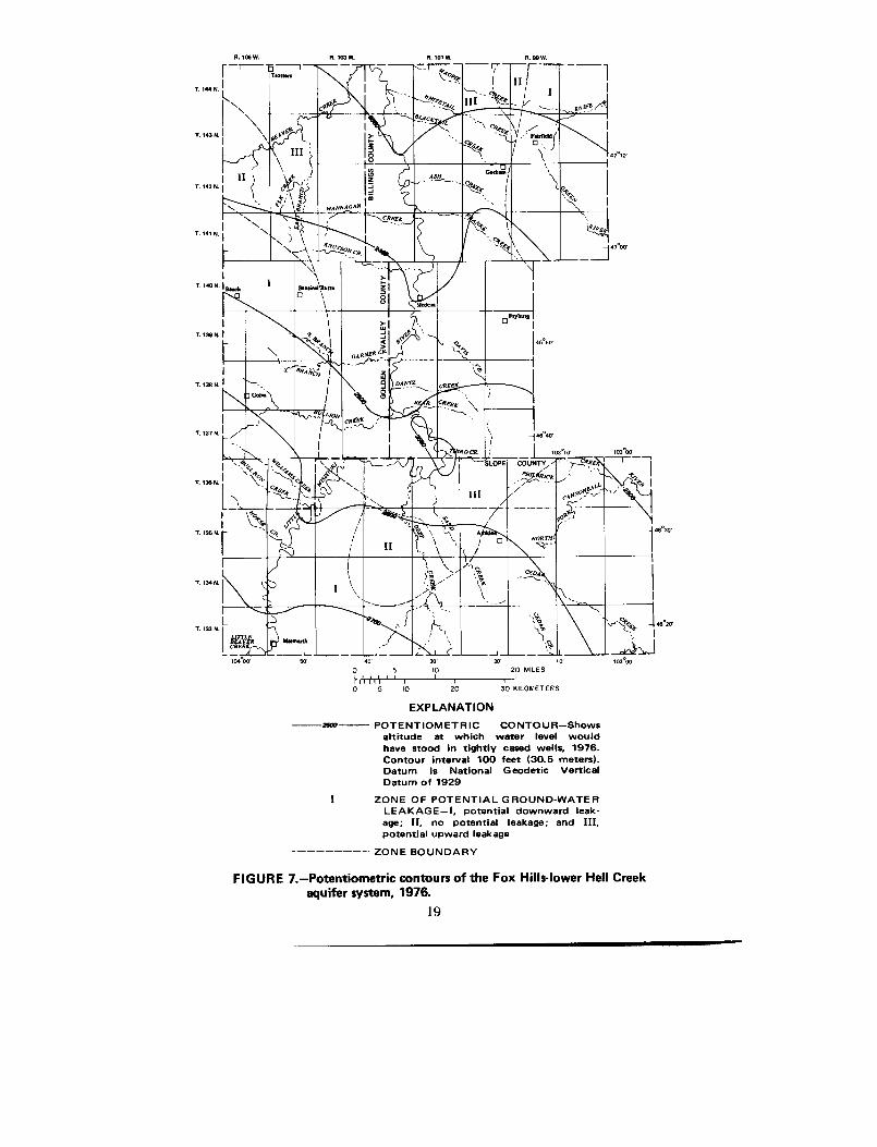
Potentiometric contours indicate that ground-water movement in the stud yarea generally is from southwest to northeast (fig . 7) with a hydraulic gradient ofabout 6 ft/mi (1 m/km) .
In the Fox Hills-lower Hell Creek aquifer system there are three zones o fpotential leakage of ground water . (1) In the southwestern part of Golden Valle yCounty, the eastern part of Billings County, and parts of Slope County (zone I )heads in the overlying aquifer system are higher than those in the Fox Hills -lower Hell Creek aquifer system, creating a potential for water to leak downwardfrom the overlying aquifer system . (2) In two small locations near the peripheryof the study area and one locale in central Slope County (zone II), the head in th eFox Hills-lower Hell Creek aquifer system is at approximately the same altitud eas the head in the overlying aquifer system ; therefore, there is no potential t oleak upward or downward . (3) In the central part of the study area (zone III )heads in the Fox Hills-lower Hell Creek aquifer system are higher than the head sin the overlying aquifer system, creating a potential for water to leak upward .Generally the head differential in zone III is about 100 feet (30 .5 m) near thevalley of the Little Missouri River and 10 to 50 feet (3 to 15 m) east and west of th evalley .
Withdrawals of water from flowing wells have created a cone of depressionalong the Little Missouri River in north-central Slope and southern BillingsCounties (fig . 7) . Withdrawals also have deflected the potentiometric surface al lalong the Little Missouri River (see section on effects of flowing wells) .
17
'—'
TABLE 3 .-Summary of aquifer tests, Fox Hills-lower Hell Creek aquifer syste m
Location
Metho d
ofaquifer test
Transmissivity
(ft2/d)
Discharge(gal/min)
Specificcapacity
[(gal/min)/ft]Storage
coefficien t
133-105-30CCC Drawdown — — 3. 5
134-104-24DDD Drawdown 600 10 2. 2
135-102-03CDB Recovery 33 3 .0 — —
136-100-31DDC Drawdown 205 7.4 .9 3.0x10⁴
136-102-20BBD Recovery 59 3 .6 — —
136-104-12BAA Recovery 54 3. 5
137-101-29CCA Recovery 120 2. 6
138-102-34DDA Recovery 42 4 .8 —
140-101-35DAD Recovery 74 74 .40
140-102-18DCC Flow 204 4 .8 .90
140-102-22DBD Recovery 215 — —
140-106-25CBB1 Recovery — 210 1 . 2
141-101-03AAB Flow 21 2 .0 . 5
141-101-21CAC Recovery 18 4 .6 —
142-101-33DBA Recovery 11 —
144-100-24BBD1 Drawdown 135 7 .70 4,2x10⁻⁴
144-102-24DDD Flow 105 2 .3 1 .8
6.106W . 6.103W. R. 90W.
60'
30'
20'
10
0 II II5
10
20 MILE S
I~ f I1
I
I
I0
5
10
20
30 KILOMETER S
EXPLANATIO N
2600 POTENTIOMETRIC CONTOUR—Show saltitude at which water level wouldhave stood in tightly cased wells, 1976 .Contour interval 100 feet (30.5 meters) .Datum is National Geodetic Vertical
Datum of 1929
ZONE OF POTENTIAL GROUND-WATE RLEAKAGE—I, potential downward leak -
age ; II, no potential leakage; and III,potential upward leakag e
--
ZONE BOUNDAR Y
FIGURE 7 .-Potentiometric contours of the Fox Hills-lower Hell Cree kaquifer system, 1976.
19
Most of the water in the Fox Hills-lower Hell Creek aquifer system is asodium bicarbonate type that generally has less dissolved constituents thanwater in the overlying aquifers . Major chemical constituents in selecte dsurface-water and ground-water samples are plotted on a trilinear diagram infigure 8 . The wells are numbered downgradient from the outcrop . As the wate rmoves downward through overlying beds and downgradient through the aqui-fer, the calcium in solution, picked up in the soil zone, exchanges with sodium .Water from well number 1, which is less than 1 .0 mile (1 .6 km) down dip fro mthe outcrop, had sodium (at 99 percent) as the major cation . An increase o fbicarbonate plus carbonate ions (from 742 to 967 mg/L) and a correspondin greduction in sulfate (from 420 to 29 mg/L) occurs downgradient; chloride alsoincreases downgradient (from 5.5 to 77 mg/L).
D. L . Thorstenson (written commun ., 1976) concluded that sulfate reductionappeared to be the only reasonable reaction to account for the disappearance o fsulfate in the aquifer . He postulated that the removal of sulfate was by bacterialreduction of dissolved sulfate, and oxidation of organic carbon was the energ ysource for the bacteria (Kuznetsov and others, 1963) . Another possibility for th ereduction of sulfate stated by Thorstenson is that water in underlying formation sthat is high in sodium, chloride, and methane may leak into the Fox Hills-lowe rHell Creek aquifer system . The methane reduces the sulfate and the chlorid eand bicarbonate increase accordingly. However, carbon sources other thanmethane, that could reduce the sulfate, may be available from underlyin gand(or) overlying formations .
Locally, water from the Fox Hills-lower Hell Creek aquifer system is dis-charging into streams near the outcrop during low flow . Relatively high calciumand magnesium concentrations in the surface-water samples probably are theresult of ground-water discharge. Higher sulfate/lower bicarbonate is a typica lanion combination for ground water discharging to the streams near the rechargearea.
Dissolved-solids concentrations in 41 samples from the Fox Hills-lower Hel lCreek aquifer system ranged from 887 to 1,720 mg/L and had a mean of 1,160mg/L . The water was soft ; 76 samples contained 0 to 110 mg/L hardness, and hada mean of 11 mg/L . Fluoride concentrations ranged from 0.2 to 7 .4 mg/L andgenerally increased from south to north . Boron concentrations in 36 samplesranged from 0.28 to 1 .8 mg/L and iodine in four samples ranged from 0 .0 to 0 .34mg/L; both increased from southwest to northeast . Sulfur as sulfide was 0 .2 and0.41 mg/L in samples from two wells ; however, all water samples collected fro mthe aquifer system had a rotten egg odor from hydrogen sulfide . Sodium-adsorption ratios ranged from 24 to 200, indicating the sodium hazard generall ywas too high to be classified for irrigation purposes .
For wells more than 800 feet (244 m) deep the water at the well head had amean temperature of 63°F (17°C) ; however, the actual temperature of the wate rin the aquifer determined from temperature logs generally was about 80°F(26 .7°C) or 17°F (9°C) higher.
20
Well
Dissolve dWell
Well
depth
solidsnumber
location
(feet)
(mg/L )
133-106-34BAA
104
1,29 0
• 133-106-13ADB2 229 1,560
• 134-104-24D D D 1 1,300 1,070
• 136-104-12BAA 987 1,020
• 136-100-31 D D C 1 1,725 1,230
• 138-102-34DDA 988 992
140-106-25C B B 1
1,259
1,43 0
140-102-26BCA
1,080
1,06 0
143-105-33BAB
1,177
1,180
144-100-24B B D 1
2,160
1,070
Little Missouri River at Marmarth
DissolvedDischarge
solid s
Date
(ft 3/s)
(mg/L )
10/02/74
4.6
2,060
Little Beaver Creek near Marmarth
9/04/75
2.1
1,20 0
°o
°o
ao
i-10
ti~
~I 00
CATIONS
PERCENTAGE REACTING VALUES
ANION S
FIGURE 8.-Major constituents in selected water samples from the Fox Hills-lower Hel lCreek aquifer system, the Little Missouri River, and Little Beaver Creek .
7
8
9
1 0
VAAYAVAVA
AJ -
AWA/MMAV 40IOWWAVAW AVA
ATAVAVAVAVAVAVA-Y-VAV--AV-AWA
AWAVATAVAVAVAVAVA
2 0
60Numbe r
1 1
12
Aquifers of Late Cretaceous and Tertiary Ag e
Upper Hell Creek-Lower Ludlow Aquifer Syste m
The upper part of the Hell Creek Formation and the lower part of theLudlow Member of the Fort Union Formation form an extensive regionalaquifer system that underlies all of Billings and Golden Valley Counties andmost of Slope County . The units crop out in southwestern Slope County (fig . 4) .Although a structure map was not constructed for the upper Hell Creek an dlower Ludlow aquifer system, the regional dip is thought to approximate that o fthe Fox Hills-lower Hell Creek aquifer system (fig. 5) .
The upper part of the Hell Creek Formation generally consists of a confiningbed composed of claystone and silty claystone, equivalent to the Bacon Cree k
Member of Frye (1969) . In western Slope County, however, very fine tomedium sandstone occurs above the confining bed . This sandstone forms theupper Hell Creek part of the aquifer system. The sandstone either pinches ou t
north of Slope County or has been eroded ; therefore, only sandstone in the lowerpart of the Ludlow Member constitutes the aquifer system over most of the stud y
area.The lower part of the Ludlow Member consists of lignite, brownish-gra y
carbonaceous claystone and siltstone, gray siltstone, and gray very fine to fin esandstone . The sandstone, however, consists of about 30 percent silt and clay .The upper contact of the lower part of the Ludlow Member is arbitrarily placedat the top of the T-cross lignite bed (C . G. Carlson, oral commun ., 1977), whichis the base of the Lebo Shale Member equivalent in the western part of th estudy area and the base of the marine Cannonball Member in the remainder o fthe study area (table 2) . The Lebo Shale Member equivalent and the Cannon-ball Member, which are thought to be time-stratigraphic equivalents, form amajor confining bed throughout the region (pl . 1) .
Where the upper part of the Hell Creek Formation forms part of the aquife rsystem its maximum thickness is about 80 feet (24 m) . The thickness of the lowe rpart of the Ludlow Member ranges from 0 to 500 feet (0 to 152 m) and commonl yis 300 feet (91 m) ; generally, the unit is thinnest near the Cedar Creek anticlineand thickens to the northeast.
The net sandstone thickness in the upper Hell Creek-lower Ludlow aquife rsystem is less than the net sandstone thickness in the Fox Hills-lower Hell Cree kaquifer system due to the increase of siltstone and claystone, especially near theupper part of the aquifer system . Generally the sandstone near the base of thelower part of the Ludlow Member stores most of the water in the aquifer system .
Depth to the top of the aquifer system ranges from 0 feet (0 m) at the outcro pto about 1,400 feet (427 m) below land surface in the upland areas of northeas tBillings County . In the valley of the Little Missouri River the depth ranges fro m0 feet (0 m) north of Marmarth to about 700 feet (210 m) at the north edge o fBillings County .
Porosity values for the aquifer system obtained in the laboratory from twosidewall cores that had greater than 70 percent sand-sized grains were 33 .0 and
22
34.9 percent . Hydraulic conductivity values obtained in the laboratory from tw osidewall cores that had greater than 70 percent sand-sized grains were 0 .6 and 0 . 8ft/d (0.18 and 0 .24 m/d) . The low hydraulic conductivity values for the upper HellCreek-lower Ludlow aquifer system apparently are due to poor sorting and th elarge percent of silt .
Transmissivity values determined from recovery tests on flowing wellsranged from 1 .5 to 160 ft 2/d (0.14 to 15 m 2/d) and had a mean of 77 ft2 /d (7 . 2m2/d; table 4) . The low values are due to partial penetration of the wells, lo wnet sandstone thickness, and the overall low hydraulic conductivity of theaquifer system .
Potential yields from properly completed and developed wells may be a smuch as 150 gal/min (9 .5 Lis) . Flowing wells, however, generally will not yieldmore than 30 gal/min (1 .9 Lis) .
A map of the potentiometric surface (fig . 9) indicates that ground-watermovement generally is from south to north and hydraulic gradients vary fro mabout 17 ft/mi (3 .2•m/km) in central Golden Valley County, to 6 ft/mi (0 .8 m/km )in northern Golden Valley County, and 4 ft/mi (1 .1 m/km) east of the Littl eMissouri River .
Withdrawals of water from flowing wells along the Little Missouri River i nwestern Billings County have created major deflections in the potentiometricsurface . Head declines in the upper Hell Creek-lower Ludlow aquifer syste mare greater than those in the Fox Hills-lower Hell Creek aquifer system due t othe lower hydraulic conductivity .
Most of the water in the upper Hell Creek-lower Ludlow aquifer system i ssoft and is a sodium bicarbonate type . The water generally is more mineralizedthan water in the underlying Fox Hills-lower Hell Creek aquifer system, yet, o nthe average, less mineralized and less variable than water in the overlyin gaquifers .
Major chemical constituents in water samples from selected wells finishedin the upper Hell Creek-lower Ludlow aquifer system are shown in figure 10 .The wells are numbered downgradient from the outcrop . Sodium constitutedmore than 97 percent of the cations, ranging from 400 to 610 mg/L ; bicarbonateplus carbonate constituted more than 60 percent of the anions, ranging fro m666 to 1,524 mg/L . Generally, sulfate constituted less than 30 percent of th eanions, ranging from 0 .8 to 260 mg/L, and generally decreasing downgradient .The sulfate reduction process downgradient is thought to be similar to that i nthe Fox Hills-lower Hell Creek aquifer system — reduction by anaerobic bac-teria or methane entering the aquifer system from underlying formations . Themethod of reduction by bacteria seems more probable than reduction b ymethane because of the abundance of lignite in the Ludlow Member that woul dprovide organic carbon as energy for the bacteria .
Dissolved-solids concentrations in 19 samples ranged from 940 to 2,490mg/L, and had a mean of 1,390 mg/L . Fifty samples contained 2 to 130 mg/ Lhardness; the mean was 15 mg/L. Chloride concentrations in 50 samples range dfrom 1 .5 to 56 mg/L and had a mean of 10 mg/L. Boron concentrations in 19samples ranged from 0 .05 to 1 .6 mg/L and fluoride concentrations in 48 sample s
23
TABLE 4. — Summary of aquifer tests, upper Hell Creek-lower Ludlow aquifer syste m
Methodof Transmissivity Discharge
Specificcapacity
Location aquifer test (ft 2 /d) (gal/min) [(gal/min)/ft ]
135-102-19DAA Recovery 110 1 .9 0 . 3
137-101-19BBD Recovery 1 .5 .5 .0 1
137-103-01ACA Recovery 117 1 .6 . 1
139-102-33AAA Recovery 70 6.7 . 2
139-102-33CBB Recovery 160 6 .0 . 3
144-102-16BBB Recovery 3 .3
R. 106 W.
6.103W.
6.101W .
8.99W.
TrdnnT . 144 N .
S
1 . 143 N . I
j 4,10 ,
T, 14 2
1. 141 N. I
IT. 140 N. I
1. 139 N .
1. 136 N. I
1 . 137 N .
1 . 136 N.
T. 1359
IT. 134 N.
I
i
•k1
. s.mll w 64M~
IU
~Medcn
4y0
,
H
RIJ ,GARNERA ANCf
~
~.
pT
I
SLOP COUNTYJ0
IJ
PH\ IBRIG.a
_
NGRrn
BEAVERCREEK
—_Lto4°oa•
2760 POTENTIOMETRIC CONTOUR—Show saltitude at which water level woul dhave stood in tightly cased wells. 1977 .Contour interval 100 feet (30 .5 meters) .Datum is National Geodetic VerticalDatum of 192 9
FIGURE 9 .-Potentiometric contours of the upper Hell Creek-lower Ludlowaquifer system, 1976-77 .
25
Mrmu1N
40
30
p'
1
0 15
10
20 MILE SIIhillII I I I I0
5
10
20
30 KILOMETER S
EXPLANATIO N
THIRD CR.
Iafi ao'
1031 ioJ0o'rCRffK 1
—T`
NN On~
103°0 0
4f00
46 20
Wellnumber
Wel llocation
Welldepth(feet)
Dissolve dsolids
(mg/L )
1 136-105-26 AC A 570 1,080
2 137-101-32CCB 585 1,020
3 138-100-07 AAA 1 980 1,290
4 142-100-25DDA 1,374 1,330
"W.AIN"
5 144-100-2488D2 1,624 1,47 0
MAn######,nAYA1VATA
MAWAYA 60AVAVAVA nAnAv
A60 WAWA %
MAYAPAVA
AVATAVAVAVA
AVAWAWAA40 TAVAWAVAVA AVAVAVAVAVA WA
AVAVAVAVAVAVAVA AWAVAVAWAVA 20
A20 WAWA/AWAY& AWAVAWAVAVAVA
AVAWAVAVAVAVAWA VAVAVAVAVAVAVAVAVA, Ca °o
0CATIONS
PERCENTAGE REACTING VALUES
ANION S
FIGURE 10 .-Major constituents in selected water samples from the upper Hell Creek -lower Ludlow aquifer system .
ranged from 0 .4 to 10 mg/L, both generally increasing downgradient . Ironconcentrations in 19 samples ranged from 0 .02 to 0 .77 mg/L, and had a mean o f0 .24 mg/L. Sodium-adsorption ratios of 50 samples ranged from 31 to 145, an dhad a mean of 68 .
Aquifers of Tertiary Age
Aquifers in the Upper Part of the Ludlow andTongue River Members of the Fort Union Formation
The upper part of the Ludlow Member is part of a high-constructive delt adeposit consisting of very fine to medium channel fill and sheet sandstone . TheTongue River Member is also part of a high-constructive delta system consistingof very fine to medium channel fill and distributary type sandstone (M . G. Croft ,L . O . Anna, and D . W. Fisher, written commun ., 1977). Other reports (Trappand Croft, 1975 ; Croft, 1978) combine the two formations into one aquife rsystem . The term aquifer system as used in the definitions of terms section of thi sreport, however, does not apply to aquifers in the two members . It is not knownif the upper part of the Ludlow Member is in hydraulic connection with th elower part of the Tongue River Member to form one aquifer system . Most of thedata presented in this report were collected from aquifers in the lower part of th eTongue River Member. The upper part of the Tongue River Member is essen-tially a confining unit consisting mostly of silt, clay, lignite, and thin lenticula rsandstone .
The members crop out as structural and topographic expressions over mos tof the western half of the three counties (fig. 4) . A structure-contour map of thetop of the Harmon lignite bed, which is near the base of the Tongue Rive rMember, indicates an average dip of approximately 23 ft/mi (4.4 m/km) to thenortheast (fig . 11) . The dip decreases slightly near the Medora trough in centra lBillings, northeast Slope, and northwest Golden Valley Counties . The morenorthwesterly strike of the members in northeast Billings County probably i sdue to the influence of the Nesson anticline in Dunn County .
The upper part of the Ludlow Member consists of interbedded moderatel ysorted gray very fine to medium sandstone, gray siltstone, claystone, silt yclaystone, and thick discontinuous lignite . The Tongue River Member consists o finterbedded poor to moderately sorted gray very fine to medium sandstone ,siltstone, silty claystone, thick areally extensive lignite beds near the base tha tthin near the Medora trough and thinner discontinuous lignite beds in themiddle and upper parts .
Geophysical logs show a distinct depositional pattern of the two members .The upper part of the Ludlow Member overlies the Cannonball Member in th eeastern part of the study area and overlies the Lebo Shale Member equivalent i nthe western part (p1 . 1) . Sandstone beds generally are confined to the middlepart. The sandstone beds are overlain by interbedded silt, silty claystone, andclaystone . In most places, the lower part of the Tongue River Member i scharacterized by thick beds of siltstone and sandstone near the base and thic k
27
R . 106 W.
R . 103 W.
R. 101 W.
R. 99 W.
o ` I I5
11
I
I
I
o
5
10
MW — STRUCTURE CONTOUR—Shows altitud eof top of Harmon lignite bed (lowe rTongue River Member) . Contour interva l100 feet (30.5 meters) . Datum is Nationa lGeodetic Vertical Datum of 192 9
FIGURE 11 .-Structure contours of the top of the Harmon lignite bed .
2 8
10
20 MILE S I I
20
30 KILOMETER S
EXPLANATION
lignite beds (Harmon and Hanson beds) about 150 feet (46 m) above the uppe rLudlow-Tongue River contact . In northeast Billings County the lignite beds areonly a few feet above the contact and the sandstone-siltstone beds occur abov ethe lignites .
The thickness of the upper part of the Ludlow Member ranges from 0 feet ( 0m) at the outcrop to about 350 feet (107 m) and has a mean of 200 feet (61 m) . Thethickness of the Tongue River Member ranges from 0 .0 feet (0 .0 m) to about 65 0feet (198 m), increasing from southwest to northeast . Aquifers in the twomembers generally consist of sandstone and, to a lesser degree, of lignite beds .The mean net aquifer thickness in the two members is about 250 feet (76 m) .
Specific-capacity values determined from three drawdown tests on aquifer sin the lower part of the Tongue River Member were 1 .5, 2 .0, and 4 .0 (gal/min)/ft[0 .3, 0 .4, and 0.8 (L/s)/m] . Transmissivity values determined from two of th edrawdown tests were 520 and 530 ft 2/d (48 and 49 m 2/d), and one value deter-mined from a recovery test on a flowing well was 220 ft2/d (20 m2/d) . Generally,thicker more permeable sandstone, and the corresponding higher transmissivityvalues, occur in the southern half of the study area .
Properly completed and developed wells in aquifers in the upper part of theLudlow and Tongue River Members may yield as much as 250 gal/min (16 Lis) ,although yields from flowing wells generally will be less than 10 gal/min (0 .6 L/s) .
A map of the potentiometric surface was constructed for Billings, GoldenValley, and Slope Counties using only wells tapping aquifers in the lower par tof the Tongue River Member (fig . 12) . The map indicates that ground-wate rmovement in the western half of the study area generally is from southwest tonortheast with an average hydraulic gradient of 14 ft/mi (2 .7 m/km) ; and in theeastern half the movement generally is from south to north with an averagehydraulic gradient of 10 ft/mi (1 .9 m/km) .
In aquifers in the lower part of the Tongue River Member there are threezones of potential leakage of ground water (fig . 12) . (1) In southern Slope an dwestern Golden Valley Counties (zone I) heads in aquifers are higher than head sin the underlying aquifer system, creating a potential for water to leak downwar dinto the underlying aquifer system . (2) In a narrow band near the center of thestudy area (zone II) — paralleling the Medora trough — heads in the two aquifer sare at approximately the same altitude . Therefore, the water has no potential toleak upward or downward and the flow is lateral . (3) In the northern one-third o fthe study area (zone III) heads in the underlying aquifer system are higher thanheads in aquifers in the lower part of the Tongue River Member, creating apotential for water to leak upward from the underlying aquifer system .
Heads generally decrease with depth in the Tongue River Member, an dindicate a potential for water to leak downward . Generally recharge to theaquifers in the upper part of the Ludlow and Tongue River Members occurs i nzone I . Modern carbon in the water from well 140-106-25CBB3 at Beach ,determined from Carbon 14 analysis, is relatively high at 17 .2 percent . Thi ssuggests that recharge at the well site is local and relatively rapid (D . W. Fisher ,written commun ., 1977) . Recharge to the ground-water basin (aquifer) may b econtrolled by topography as the potentiometric-surface divide in the aquifers in
29
R. tO5 W. A. 103 W. R . 09 W.
_L -
LAC- --- J
40
30'
20'
1 0
10
20 MILES I
I
1
20
30 KILOMETERS
o 11 115
I I I I I
I
I
I
o
5
1 0
EXPLANATIO N
2 POTENTIOMETRIC CONTOUR—Show saltitude at which water level wouldhave stood in tightly cased wells, 1977 .Contour• interval 100 feet (30.5 meters) .Datum is National Geodetic VerticalDatum of 192 9
ZONE OF POTENTIAL GROUND-WATE RLEAKAGE—L potential downward leak-age ; II, no potential leakage ; and III ,potential upward leakage
ZONE BOUNDAR Y
FIGURE 12.-Potentiometric contours of aquifers in the lower part of the Tongu eRiver Member of the Fort Union Formation, 1977 .
30
eastern Billings and Slope Counties coincides with the surface-drainage divide o fthe Little Missouri River basin and the Knife, Green, and Cannonball Rive rbasins .
Locally water from the aquifers discharges into streams as base flow or fro mflowing wells . Only minor deflections in the potentiometric surface along th eLittle Missouri River have occurred compared to those in underlying aquifer sbecause there are fewer flowing wells, lower pressures, and smaller yields .
Chemical analyses of water samples indicate that the water quality in aquifer sin the lower part of the Tongue River Member is variable and depends mostly o ndepth, to a lesser degree on proximity to lignites, and least on distance fro moutcrop .
A trilinear diagram (fig. 13) shows the major constituents in water from 10wells in the aquifers . The wells are listed according to increased depth . Thediagram indicates that sodium generally is the major cation in the water. In well sgreater than 200 feet (61 m) deep, sodium constituted more than 96 percent ofthe total cations (340 to 580 mg/L and a mean of 440 mg/L) . In wells less than 200feet (61 m) deep, sodium was less than 73 percent of the total cations (40 to 510mg/L and a mean of 250 mg/L) . Generally, the percentage of calcium decrease dwith increasing depth . In wells greater than 200 feet (61 m) deep, calcium range dfrom 2.0 to 6.6 mg/L and had a mean of3.4 mg/L . In wells less than 200 feet (6 1m) deep, calcium ranged from 57 to 100 mg/L and had a mean of 73 mg/L .
In wells greater than 200 feet (61 m) deep, bicarbonate comprised from 50 to86 percent of the total anions (508 to 976 mg/L and a mean of 700 mg/L), andsulfate comprised from 12 to 49 percent of the total anions (120 to 660 mg/L and amean of300 mg/L) . However, in water from wells less than 200 feet (61 m) deep,bicarbonate constituted from 36 to 91 percent of the total anions (351 to 686 mg/Land a mean of 560 mg/L) and sulfate constituted 7.9 to 63 percent of the totalanions (24 to 930 mg/L and a mean of 440) . Dissolved-solids concentrations in th esamples were variable, ranging from 270 to 1,880 mg/L; the mean was 1,100mg/L .
For all wells sampled in aquifers in the lower part of the Tongue Rive rMember, the most consistent values were from wells over 200 feet (61 m) deep .Generally, the water from wells less than 200 feet (61 m) deep was very hard .Hardness ranged from 20 to 760 mg/L and had a mean of280 mg/L . Water fro mwells more than 200 feet deep generally was soft ; hardness ranged from 4 to 42 0
mg/L and had a mean of 38 mg/L. Chloride concentrations generally were les sthan 1 percent of the total anions, ranging from 0.5 to 79 mg/L. There was n oapparent correlation of chloride concentrations with depth or distance from th eoutcrop. Boron and fluoride concentrations ranged from 0 .1 to 2 .2 mg/L and 0 . 1to 6 .5 mg/L, respectively, and fluoride increased slightly downgradient. Dis-solved nitrate concentrations were low, ranging from 0.2 to 26 mg/L, and twosamples had dissolved nitrogen of 36 and 36.3 mg/L. Iron plus manganes econcentrations ranged from 0.009 to 5 .6 mg/L and had no apparent correlationwith depth . Values from seven water samples would plot on the low-sodium-hazard scale for irrigation (fig . 3) ; other values would be in the high-hazard scal eor completely off scale .
31
Wel lnumber
Well
DissolvedWell
depth
solidslocation
(feet)
(mg/L )
1
133-101-09CDD
64
27 0
2
140-106-25C883
110
1,06 0
3
134-103-28BDA
168
1,88 0
4
139-103-32DBB
285
1,59 0
5
138-101-02BAC
343
92 3
6
137-101-34A8A 1
355
98 5
7
140-102-16DAA
364
1,14 0
8
143-103-14DBC
446
1,23 0
9
141-100-34CBC
508
1 .01 0
10
136-099-26 D A D
534
1,15 0
60
M
C3
s
aO
4-10
ryO
1p
CI bO
CATIONS
PERCENTAGE REACTING VALUES
ANION S
FIGURE 13.-Major constituents in selected water samples from aquifers in the lowe rpart of the Tongue River Member of the Fort Union Formation .
Aquifers in the Sentinel Butte Membe rof the Fort Union Formation
The Sentinel Butte Member is thought to be the landward part of a deltaplain overlying the Tongue River Member . The vertical arrangement of th eformations indicates a progradation of a large deltaic complex into the Cannon -ball sea (Jacob, 1976) . The member crops out in the upland areas east of th eLittle Missouri River and as buttes west of the Little Missouri River; some ofthe buttes are capped by the White River Formation (fig . 4). Analyses of pollenin the clays and lignites in the member indicate that it is of late Paleocene ag e(R . H. Tschudy, written commun ., 1976), and is equivalent to the upper part ofthe Tongue River Member in northeast Wyoming and southeast Montana .
The Sentinel Butte Member consists of thin lignite, gray claystone, siltyclaystone, and gray to yellowish-gray fine to medium channel sandstone . Thecontact with the underlying Tongue River Member is generally placed at the to pof the H-T Butte lignite bed . The Sentinel Butte is conformably overlain bythe Golden Valley Formation or unconformably overlain by the White Rive rformation .
On the upland areas in the southeast part of the study area the Sentinel Butt eMember is relatively thin, and has a mean thickness of less than 100 feet (30 .5 m) .However, in the northeastern part the member thickens considerably, rangin gfrom 300 to 450 feet (91 to 137 m).
Aquifers in the Sentinel Butte Member consist of poorly consolidated discon -tinuous channel sandstone and fractured lignite . Most of the wells that tapaquifers in the Sentinel Butte Member are completed in sandstone and ar egenerally less than 100 feet (30.5 m) deep . However, in the Green River drainag ebasin, several miles east of Highway 85, and in extreme northeast Slope Countythick shallow lignites are often tapped as aquifers .
In topographically high areas — paralleling the drainage divide of the Littl eMissouri River basin and the Green and Knife River basins — the member i scharacterized by perched aquifers, especially in northern Billings County .Downward percolating water is perched by lignite and sandstone beds andtravels horizontally until it reaches the surface as springs . Underlying aquifersmay not be recharged from perched aquifers and can be dry . As an example, well144-100-24BAC2 was screened in sandstone from 260 to 270 feet (79 to 82 m )below land surface and was dry, yet overlying sandstone, claystone, and lignitebeds were water saturated . Geophysical logs of this well indicate that theinterstices of the dry aquifer are filled with gas, possibly carbon dioxide and(or )nitrogen .
In topographically low areas few springs exist and water percolates downwar drecharging the underlying aquifers — including the aquifers in the upper part o fthe Ludlow and Tongue River Members .
Since specific hydrologic data were not collected for aquifers in the SentinelButte Member, mean hydraulic conductivities were obtained from the ground -water report for Dunn County (Klausing, 1978), which borders Billings Countyon the east . The mean conductivity value for sandstone aquifers in Dunn Count y
33
was 0 .4 ft/d (0 .1 m/d) and mean values for lignite aquifers, determined from twopump tests, ranged from 94 to 1,200 ft/d (29 to 366 m/d) .
Individual wells in sandstone aquifers will yield 5 to 50 gal/min (0 .3 to 3 Lis) .Individual wells in lignite aquifers may yield 1 to 200 gal/min (0 .06 to 13 Lis) .
Water in aquifers in the Sentinel Butte Member is extremely variable i nconcentration of dissolved solids, cations, and anions . Generally, the wate rquality is dependent on depth (the water generally has a vertical flow path) an daquifer lithology .
Based on few data, a trilinear diagram (fig . 14) shows the major constituent sin water from wells . In wells less than 100 feet (30 .5 m) deep, calcium plu smagnesium constituted more than 74 percent of the cations, ranging from 79 t o940 mg/L and had a mean of 370 mg/L . In wells greater than 100 feet (30 .5 m )deep, sodium constituted more than 58 percent of the total cations, rangin gfrom 100 to 1,100 mg/L and had a mean of 580 mg/L . Therefore, it seem sreasonable to assume that at a depth of about 100 feet (30.5 m) much of thecation exchange of sodium for calcium in the water has taken place .
Sulfate and bicarbonate plus carbonate concentrations apparently are relate dto the proximity of lignite deposits in the area . The iron sulfide in the lignitecombines with bicarbonate and carbon dioxide to form iron oxides and releasesulfate . Sulfate concentrations ranged from 30 to 2,700 mg/L and bicarbonat eplus carbonate concentrations ranged from 318 to 1,248 mg/L .
Dissolved-solids concentrations in nine samples ranged from 367 to 4,21 0mg/L. Generally the water was very hard, ranging from 240 to 3,200 mg/L inwells less than 100 feet (30 .5 m) deep and 12 to 990 mg/L in wells 100 feet (30 . 5m) or deeper . Chloride concentrations were low, ranging from 0 .9 to 18 mg/L .Boron and fluoride concentrations ranged from 0 to 1 .3 mg/L and 0.2 to 1 . 6mg/L, respectively. Dissolved nitrate generally was low and had a mean of 2 . 8mg/L; however, there was one anomaly of 35 mg/L from well 135-098-32DAD1 .Iron plus manganese concentrations ranged from 0 .6 to 7 .35 mg/L. Water fro mwells less than 100 feet (30.5 m) deep had a mean of 0 .09 mg/L iron plu smanganese and water from wells 100 feet (30 .5 m) or deeper had a mean of 2 . 8mg/L. Values from three water samples would plot in the low-sodium medium-salinity zone for irrigation purposes (fig . 3); six values would plot in either th every high-hazard zone or were too high to be classified .
Aquifers in the Golden Valley and White River Formations
The Golden Valley Formation crops out in two small areas in northeas tBillings County (fig . 4) and reaches a maximum known thickness of about 100feet (30 .5 m) . The formation consists of light-purplish-gray claystone, tan sandyclaystone, and a tan micaceous crossbedded sandstone (C . G. Carlson, ora lcommun ., 1977) . There are no major aquifers in the formation .
The White River Formation forms the rimrock of scattered high buttes andunderlies a relatively small area (fig . 4) . The formation consists of conglomerate ,arkose, tuffaceous sandstone, siltstone, and claystone (C . G. Carlson, oralcommun ., 1977) . Its maximum thickness is 250 feet (76 m) . There are no majo raquifers in the formation .
34
Well
DissolvedWell
depth
solidslocation
(feet)
(mg/L )
142-099-10DDD
54
367
• 135-098-32DAD1 62 4,21 0
• 142-099-03DCC 80 444
• 144-099-30AAB 100 2,870
• 144-100-13DBD 105 1,990
• 142-100-01BDC 115 4,11 0
• 136-098-33CCD 120 1,660
• 135-101-16CBA 167 1,380
• 134-101-35BCC 184 413
AVAAIWA
AWAVA-AVAVAVAVA0
AYAWAYAAVAVATAVAWAVA
AA2 0
---MAYA---CATIONS
PERCENTAGE REACTING VALUES
ANION S
FIGURE 14.-Major constituents in selected water samples from aquifers in the Sentine lButte Member of the Fort Union Formation and from the Green River.
Wel lnumber
Green River near New Hradec
80
DissolvedDischarge
solids
Date
(ft3/s)
(mg/L)
10/17/74
0.52
70260
40
Aquifers of Quaternary Age
Alluvial Aquifers
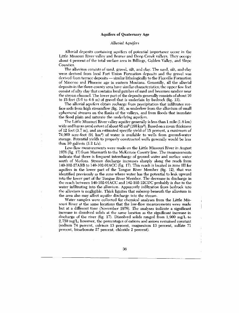
Alluvial deposits containing aquifers of potential importance occur in th eLittle Missouri River valley and Beaver and Deep Creek valleys . They occupyabout 4 percent of the total surface area in Billings, Golden Valley, and SlopeCounties .
The alluvium consists of sand, gravel, silt, and clay . The sand, silt, and claywere derived from local Fort Union Formation deposits and the gravel wa sderived from terrace deposits — similar lithologically to the Flaxville Formatio nof Miocene and Pliocene age in eastern Montana . Generally, all the alluvia ldeposits in the three-county area have similar characteristics ; the upper few feetconsist of silty clay that contains local patches of sand and becomes sandier nearthe stream channel . The lower part of the deposits generally consists of about 1 0to 15 feet (3.0 to 4 .6 m) of gravel that is underlain by bedrock (fig . 15) .
The alluvial aquifers obtain recharge from precipitation that infiltrates sur-face soils from high streamflow (fig . 16), as underlow from the alluvium of smal lephemeral streams on the flanks of the valleys, and from floods that inundat ethe flood plain and saturate the underlying aquifers .
The Little Missouri River valley aquifer generally is less than 1 mile (1 .6 km)wide and has an areal extent of about 65 m il (168 k m2) . Based on a mean thicknessof 12 feet (3 .7 m), and an estimated specific yield of 15 percent, a maximum o f74,000 acre-feet (91 hm 3) of water is available to wells from ground-waterstorage . Potential yields to properly constructed wells generally would be les sthan 50 gal/min (3 .2 Lis) .
Low-flow measurements were made on the Little Missouri River in Augus t1976 (fig. 17) from Marmarth to the McKenzie County line . The measurement sindicate that there is frequent interchange of ground water and surface wate rnorth of Medora . Stream discharge increases sharply along the reach fro m140-102-27ABB to 140-102-01ACC (fig . 17) . This reach is located in zone III fo raquifers in the lower part of the Tongue River Member (fig . 12), that wa sidentified previously as the zone where water has the potential to leak upwardinto the lower part of the Tongue River Member . The decrease in discharge inthe reach between 140-102-01ACC and 142-102-12CDC probably is due to th ewater infiltrating into the alluvium . Apparently infiltration from bedrock int othe alluvium is negligible . Thick lignites that subcrop beneath the alluvium i nthe area also may affect aquifer discharge into the stream .
Water samples were collected for chemical analyses from the Little Mis-souri River at the same locations that the low-flow measurements were mad ebut at a different time (November 1976) . The analyses indicate a significan tincrease in dissolved solids at the same location as the significant increase indischarge of the river (fig . 17) . Dissolved solids ranged from 1,900 mg/L t o2,750 mg/L ; however, the percentages of cations and anions remained constant(sodium 74 percent, calcium 13 percent, magnesium 13 percent, sulfate 7 1percent, bicarbonate 27 percent, chloride 2 percent) .
36
0
0
500
1000
250
2000 FEET
500 METER S
VERTICAL SCALE GREATLY EXAGGERATE DDATUM IS NATIONAL GEODETI C
VERTICAL DATUM OF 1929
EXPLANATION
BEDROC K
Silty cla y
San d
Grave l
ALLUVIU M
Silty sandston e
Silty clayston e
GAMMA RAY
GEOPHYSICAL LO G
C 'TRACE OF SECTION SHOWN O NPLATE 1
FIGURE 15.-Generalized geologic section C-C' through the flood plai nof the Little Missouri River .
FIGURE 16.-Water-level fluctuations in the Little Missouri River valley aquifer ,gage height of Little Missouri River at Marmarth, and precipitatio nat Medora, 1977 .
38
DISTANCE, IN KILOMETER S
018
8 200
210
220
230
240
250
260
270
28 01//II
I 1 I 1
1I 1 I
-0 . 51 7
1 6
Um O 1 5
U OZU14- y
0 W 1 3CC a
=W 1 2U w
0LL
1 1
1 0
9
135
145
155
165
17 5
DISTANCE, IN MILE S
8 i/j0
5
125
FIGURE 17.-Low-flow measurements August 1976, and dissolved-solids concentration sNovember 1976, in the Little Missouri River .
Three water samples collected from the Little Missouri River valley aquiferindicate the water generally is a sodium sulfate-bicarbonate type . Dissolvedconstituents in water from the aquifer at 143-102-09BCC2 were similar to thos ein samples from the underlying aquifers in the Tongue River Member, indicat-ing that ground water from the aquifers in the Tongue River Member may b eleaking into the alluvium at least in that area . The irrigation classifications of th ewater samples were C3-S2 (fig . 3) to off scale .
Beaver Creek valley aquifer generally is less than 0 .5 mile (0 .8 km) wide an dhas an areal extent of about 12 m i 2 (31 km 2 ) . Based on a mean thickness of 12 fee t(3 .7 m), and an estimated specific yield of 15 percent, about 14,000 acre-feet (1 7hm 3 ) of water is available to wells from ground-water storage . Potential yields toproperly constructed wells generally would be less than 50 gal/min (3 .2 L/s) .
Deep Creek valley aquifer generally is less than 0 .5 mile (0 .8 km) wide andhas an areal extent of about 3 .6 mi2 (9 .3 km 2) . Based on a mean thickness of 12feet (3 .7 m), and an estimated specific yield of 15 percent, about 4,000 acre-fee t(5 hm 3) of water is available to wells from ground-water storage . Potential yield sto properly constructed wells generally would be less than 50 gal/min (3 .2 L/s) .
HYDROGEOLOGY OF STRIPPABLE LIGNITE DEPOSIT S
Most of the data presented in this section are from a regional study of th eeffects of strip mining on ground-water resources in western North Dakota (W .F. Horak, written commun ., 1977) . Figure 18 shows the locations of strippabl elignite deposits in Billings, Golden Valley, and Slope Counties (Pollard an dothers, 1972) . The hydrogeology of the Beach, Bowman, and New Englan ddeposits is described below. The Dickinson deposit occurs in Billings, Dunn ,and Stark Counties . The deposit was evaluated hydrogeologically in Dunn andStark Counties (W . F. Horak, written commun ., 1977), but has not been evalu-ated in Billings County. Currently, there are no commercial mining operation sin the three-county area .
The Beach deposit is in west-central Golden Valley County and centralWibaux County, Montana . Most of the strippable deposit lies within the drain -age basin of Beaver Creek and its tributaries . The strippable deposit is theHarmon lignite bed ("C" bed of May, 1954) in the lower part of the Tongue RiverMember. Locally the bed dips 40 to 60 ft/mi (7 .6 to 11 .4 m/km) to the northeast .The bed has a maximum thickness of 40 feet (12 m) and a mean thickness of 1 8feet (5 .5 m).
Where drilled, the lignite was completely saturated . The poteniometricsurface has a gradient of 13 ft/mi (2 .5 m/km) to the north in the southern part o fthe strippable area . The contours of the potentiometric surface gradually shift t othe northeast — paralleling Little Beaver Creek — and the gradient increases toabout 20 ft/mi (3 .8 m/km) in the northern part .
Chemical quality of ground water in the Beach deposit is quite variable .Calcium and magnesium are the dominant cations near the outcrop in Wibau xCounty, Montana, with sodium becoming the dominant cation down dip . Sulfateand bicarbonate are the major anions with higher sulfate concentrations near th e
40
EXPLANATIO N
STRIPPABLE LIGNITE DEPOSIT S
FIGURE 18.--Strippable lignite deposits .
41
470 10
4630 '
~— x +11 I'C' J20
tU'
103 DO'20 MILES Modified from U .S . Geological
Survey Map ME-590 (1974 )30 KILOMETEFS
O
5
10
0
5
10 20
outcrop. Water quality near the outcrop is influenced mainly by oxygenate dwater reacting with the sediments, resulting in an average pH of around 6 .0.
The Bowman deposit occurs in central Slope County and north-centralBowman County . The strippable area is parallel to and west of U .S . Highway 85(fig . 18) . The major strippable deposit is the Harmon lignite bed in the lowe rpart of the Tongue River Member . The local structure shows that the Harmonbed dips to the northeast at about 30 ft/mi (5 .7 m/km). The bed has a meanthickness of 24 feet (7.3 m) and a maximum thickness of 40 feet (12 m) . Otherpotential strippable deposits include the Hansen bed 10 to 60 feet (3 to 18 m)below the Harmon bed ; however, the Hansen bed has not been evaluate dhydrologically .
The Harmon lignite bed is completely saturated in most areas, and has apotentiometric surface 16 to 94 feet (4 .9 to 29 m) above the top of the bed . Dataindicate that the potentiometric surface is greatly influenced by the dissectedtopography and ground-water movement is from topographic highs to topo-graphic lows. Ground water discharges from the lignite bed into local drainages ,which are Sand Creek in the central part of the area and Deep Creek in the west .Also, in higher topographic areas, some of the ground water leaks downwar dthrough the lignite and recharges the sandstone aquifers in the lower part of th eTongue River Member.
Chemical analyses of water from the lignite indicate that sodium constitute s53 to 99 percent of the total cations ; the remainder is calcium and magnesium .Sulfate ranges from 8 to 84 percent of the total anions and bicarbonate plu scarbonate ranges from 15 to 90 percent . Dissolved solids in the samples range dfrom 336 to 3,150 mg/L .
Part of the New England deposit occurs in northeast Slope County, north o fHighway 21 and east of U .S . Highway 85 (fig . 18) . The strippable lignite depos-its are in the upper part of the Tongue River and lower part of the Sentine lButte members . Interbedded siltstone and claystone occur above and betwee nthe lignite beds and discontinuous sandstone lenses underlie the lignite . Thereare at least three lignite beds greater than 4 feet (1 .2 m) thick within 200 feet (6 1m) of the land surface . One of these is the H-T Butte lignite bed, which marksthe top of the Tongue River Member . A structure-contour map on one of thebeds shows a dip of 25 to 120 ft/mi (4 .7 to 23 m/km) to the northwest (W. F.Horak, written commun., 1977) .
Wells penetrating the H-T Butte lignite were used to evaluate the hydrologyof all the lignite aquifers in the New England area, since a number ofwells in theupper lignite beds were dry . In the lowlands of the Cannonball River, the majo rdrainage of the area, ground water locally has an upward flow potential . Neartopographic highs, however, head differentials indicate the water has a down-ward flow potential towards the aquifers in the lower part of the Tongue Rive rMember .
Water quality in the H-T Butte lignite is less variable than that in othe rstrippable lignites in other areas . Less permeable overburdens allow more tim efor ionic exchanges and reactions to take place, allowing more time for chemicalequilibrium of the water to take place . Sodium constitutes 85 to 99 percent of the
42
total cations, and bicarbonate-carbonate and sulfate constitute 31 to 80 percen tand 11 to 68 percent, respectively, of the total anions . Dissolved-solids concen-trations in samples ranged from 948 to 2,600 mg/L, and had a mean of 1,60 0mg/L. The pH of the water averaged more than 8 .0 .
EFFECTS OF FLOWING WELL S
Head declines attributed to flowing wells have occurred in the major bedroc kaquifer systems along the valleys of the Little Missouri River and its tributaries .
In 1967-69 T . M. Hamilton (written commun ., 1969) made head meas-urements on more than 70 flowing wells . In 1975-76 head measurements weremade on 39 flowing wells (table 5), including 17 of those measured by Hamil-ton. The 1975-76 measurements were made using a pressure gage and measur-ing only those wells that had proper completion, documented depths, an dproper plumbing so that a pressure gage could be fitted securely . From 1967 to1976 the mean head decline was 4 .0 percent per year .
Many flowing wells that originally had low heads have ceased to flow becaus eof the lowering of static pressure in each aquifer or aquifer system . Heads willcontinue to decline as long as the amount of water being withdrawn from th eaquifers is greater than the recharge .
Conservation measures should be initiated to reduce the head declines in th eaquifers ; such as restricting the flow rate with either a valve or small diamete rpipe or for properly completed wells with stable casings, a complete shutdown o fthe flow, using measures to prevent freezing, when the water is not being used .
SURFACE WATE R
The Little Missouri River is not only the main drainage in the study area bu tthe river valley itself significantly influences ground-water movement . The U.S .Geological Survey operates two gaging stations on the river ; one at Marmarth insouthwestern Slope County and one at Medora in central Billings Count y(presently in limited operation) . On March 23, 1947, the river had a maximu mdischarge of 45, 000 ft 3/s (1,270 m3/s) at Marmarth and 65,000 ft3/s (1,840 m 3/s) a tMedora (U .S . Geological Survey, 1976). Periods of no flow have been recordedfrequently at both stations during January and February . The mean discharge atMarmarth is 245,600 acre-feet (303 hm3) per year for a 38-year period of record(U.S . Geological Survey, 1976); at Medora the mean discharge is 342,000 acre-feet (422 hm 3) per year for a 42-year period of record (U .S. Geological Survey ,1975) .
Water samples collected at the gaging stations on the Little Missouri River a tMarmarth and Medora showed that during periods of high flow, when the flow i smostly from surface-water runoff (spring snowmelt and heavy thunderstorms) ,dissolved-solids concentrations had a mean of 600 mg/L (U . S . Geological Surve y1973-74 and 1975-76) . Sodium constituted about 80 percent of the total cation s(mean concentration was 190 mg/L), and sulfate constituted about 80 percent o fthe total anions (mean concentration was 500 mg/L) . During periods of low flow ,
43
ovin ryi~
vI~moaam oI~~
m~o
I
, 2 I ; I
I ~~II
N I~~~
ICI
I
-c3 c M'm
c"i chi obi cS i3 4 c3 c M gliq Q;'3
IcM8 ..3 c3 E3 of
N
tO i=N nti
nnn
nn r°n nAA~AA wAA~ti 6~r cA AAm46 o
aci < ..m emoN~ wmw~n<
noo <3 $ate '6 g s , A
^ w g% g,4-r, 2
1111°
1,11
11!15 111 1
'M §k g
I! IPA! 1
I I I~g
c
I IR I ;
I I I I g
°~w<V <o°°° o2<<<< v°mwcc~~ 8 d2
tC~~°pC#
~1
<U <OC1aa0
V'1
4 0 444 1 4 44444 44.444 24444 a4888E,
ii!'r
4
<m p<2-,s m
. g 2 2A g 2t-.'
4 4
FA!''48 8888 .. i
mm°U °
UOUc~ °
4444 4., 845.4 F.
'qt.;Vz
when flow is mostly from ground-water discharge (late summer, fall, and win -ter), dissolved solids increased to a mean of 1,800 mg/L . However, sodium stil lconstituted about 80 percent of the total cations (mean concentration was 44 0mg/L), and sulfate constituted about 70 percent of the total anions (mea nconcentration was 900 mg/L) .
Perennial tributaries to the Little Missouri River include Little Beaver ,Beaver, Deep, Sand, and Bullion Creeks. Little Beaver Creek, at the gagingstation just southwest of Marmarth, has an average discharge of 31,440 acre-fee t(38 .8 hm 3 ) per year for a 38-year period (U .S . Geological Survey, 1976) . Gagingstations recently have been installed on Beaver Creek near Trotters (GoldenValley County) and on Deep Creek near its mouth (Slope County) . These creek sflow from ground-water discharge during late summer, fall, and winter . Water-level recorders were installed in the alluvial aquifers at both new gaging station sto study ground water-surface water relationships .
The Green River, which is perennial, is in the Heart River basin and has anaverage discharge of 13,190 acre-feet (16 .3 hm 3 ) per year for a 12-year period o frecord at a gaging station in eastern Billings County (U .S . Geological Survey ,1976) . Chemical analyses of water samples taken during the low flow (ground -water discharge) indicate that water in the river has about an equal amount o fbicarbonate-carbonate but only about one-quarter as much sulfate as does wate rfrom the Little Missouri River during low flow . The area drained by the GreenRiver includes only the Sentinel Butte Member of the Fort Union Formation ,whereas the area drained by the Little Missouri River includes Upper Creta-ceous shales, the Fox Hills Sandstone, the Hell Creek Formation, and th eLudlow and Tongue River Members of the Fort Union Formation .
WATER UTILIZATIO N
Most of the water used for public, domestic, and livestock purposes inBillings, Golden Valley, and Slope Counties is obtained from drilled well sranging in depth from 10 to 2,200 feet (3 to 670 m). Most of the wellu yield les sthan 10 gallmin (0 .6 Us), although yields vary depending on the transmissivity o fthe aquifer, the type of well construction, and the capacity of the pump installe din the well .
The Fox Hills-lower Hell Creek aquifer system generally is tapped for publicsupplies and for most livestock supplies requiring large yields . The aquifersystem is becoming a popular target for dependable supplies of relatively goo dquality water.
Domestic and Livestock Use
The upper Hell Creek-lower Ludlow aquifer system and aquifers in th eupper part of the Ludlow and Tongue River Members, Sentinel Butte Member ,and alluvial deposits are tapped for domestic and livestock supplies .
Estimates of the quantity of water pumped daily for domestic and livestoc kpurposes in Billings, Golden Valley, and Slope Counties are listed in the follow -ing table .
'Murray, 1968 .2U.S. Bureau of the Census, 1971 .3North Dakota State University, 1974 .
Public Supplie s
Beach
The city of Beach obtains its water supply from several drilled wells . Themost frequently used well is 1,259 feet (384 m) deep and taps the Fox Hills-lowe rHell Creek aquifer system . Presently, the well yields 200 gal/min (13 Us) of soft ,sodium bicarbonate-sulfate type water containing 1,430 mg/L dissolved solids .Total pumpage from this well since installation in 1961 is 650 Mgal (2 .5, hm3) ; themean annual production is 43 Mgal (0 .16 hm3) .
Two wells tapping aquifers in the lower part of the Tongue River Member —above the Harmon lignite bed — are . used as backup wells during the periods o fhigh usage in the summer . These wells are approximately 100 feet (30 .5 m) deepand yield 50 and 200 gal/min (3 .2 and 13 Us) of hard sodium bicarbonate-sulfat etype water .
Golva
The city of Golva obtains its water supply from a 967-foot (295'-m) wel ltapping the Fox Hills-lower Hell Creek aquifer system . The water is soft and is asodium bicarbonate type containing 1,100 mg/L dissolved solids .
46
Marmarth
The city of Marmarth obtains its water supply from two wells, both tappin gthe Fox Hills-lower Hell Creek aquifer system . One well, obtained from theChicago, Milwaukee, St . Paul, and Pacific Railroad, is 215 feet (65 .5m) deep andyields 132 gal/min (8 .3 [is) . The second well is 270 feet (82 m) deep and yields 7 5gal/min (4 .7 Us) . Both wells yield soft, sodium bicarbonate-sulfate type water ,with dissolved solids of 1,720 and 1,680 mg/L, respectively .
Medora
The city of Medora obtains its water supply from one recently drilled well andseveral backup wells . All the wells tap the Fox Hills-lower Hell Creek aquifersystem. The recently drilled well is 1,050 feet (320 m) deep and has a free-flo wpotential of approximately 110 gal/min (6 .9 [is) . The flow, however, is restrictedto a maximum of approximately 100 gal/min (6 .3 Us) . The backup wells free flowat approximately 40 gal/min (2 .5 Us) and can be pumped an additional 40 or 50gal/min (2.5 or 3.2 Us) .
During the months of June, July, and August, tourists place a heavy demandon the city's water supply . During these three months the city uses a mean o f43,520 gal/d (164, 720 Lid) . For the remaining 9 months local residents use only amean of 32,480 gal/d (122,940 L/d), for a mean of 38,000 gal/d (143,800 L/d), or13 .9 Mgal (0 .05 hm 3) per year .
The water from the main well is soft and of a sodium bicarbonate type ;dissolved-solids concentration was 1,080 mg/L.
Irrigatio n
During high flow, water from the Little Missouri River and Beaver Creek isused to irrigate small areas of cropland . During low flows, however, the waterquality is poor ; therefore, the irrigation potential from surface-water sources wil lbe limited. Water from alluvial aquifers has a limited potential even for small -scale irrigation due to the limited extent of .the aquifers and small yield poten-tials . Generally, unsuitable quality restricts the use of water from the bedroc kaquifers for irrigation .
Industrial
At the present time there is no water being used for industrial purposes ;however, energy-resource and associated economic development may entai lsubstantial use of water for industry . Notably, a gasification or power-generationplant is planned near Beach (Golden Valley County) ; and in situ leaching ofuranium may become a reality in Billings and Slope Counties if deposits o feconomic importance are found .
47
SUMMARY
Ground water for public, domestic, livestock, and industrial supplies inBillings, Golden Valley, and Slope Counties is obtained from aquifers consist -ing mostly of semiconsolidated sandstone of Late Cretaceous and Tertiary age .The mean thickness, lithology, and water-yielding characteristics of th egeologic units are summarized in table 6 . Sedimentary rocks below the Pierr eShale extend to at least 15,000 feet (4,570 m) below land surface . They gener-ally contain saline water that is unsuitable for most purposes .
The Fox Hills-lower Hell Creek aquifer system is used as a source for public ,livestock, and domestic supplies . Because water in the aquifer system is the mos tdependable for quality and quantity in the three-county area, the Fox Hills -lower Hell Creek aquifer system supplies most of the municipal water . Trans-missivities range from less than 200 to more than 500 ft2/d (19 to 46 m 2 /d) andwells may yield as much as 300 gal/min (19 Lis) . Water movement in the aquife rsystem generally is from southwest to northeast .
The upper Hell Creek-lower Ludlow aquifer system, aquifers in the uppe rpart of the Ludlow and Tongue River Members, and aquifers in the Sentine lButte Member are tapped for domestic and livestock supplies . They consist o finterbedded very fine to medium sandstone and lignite . Generally the hydraulicconductivities of these aquifers are lower than those of the Fox Hills-lower Hel lCreek aquifer system, and the water quality is more variable than that from th eFox Hills-Hell Creek aquifer system .
Alluvial aquifers also are tapped for domestic and livestock supplies . Theyconsist of approximately 10 to 15 feet (3 .0 to 4 .6 m) of sand and gravel .
Three strippable lignite areas (Beach, Bowman, and New England) occur inthe study area. Where drilled, the lignite deposits were saturated and yielde dwater to most wells . Generally the water quality was variable .
Approximately 2,950 acre-feet (3 .6 hm 3 ) of water is used annually in Billings ,Golden Valley, and Slope Counties, of which almost all is derived from ground -water sources.
Flowing wells along the valley of the Little Missouri River and its tributarie shave caused deflections in the potentiometric surface of the major bedroc kaquifer systems . Water levels in the flowing wells have declined at a rate of 4 . 0percent per year since 1967, and will continue to decline unless conservatio nmeasures are adopted .
48
TABLE 6 .-Generalized geologic section and water-yielding characteristics of geologic unitsin Billings, Golden Valley, and Slope Counties, North Dakota
System Series Formation or MemberThicknes s
(feet) Lithology Water-yielding characteristicsQuaternary 0-15 Alluvium . Maximum yield of less than 50 gal/min t o
individual wells from thicker and mor epermeable sand and gravel deposits. Watergenerally is a sodium bicarbonate-sulfatetype.
Oligocene White River Formation 0-250 Sandstone, siltstone, No major aquifersand claystone.
Eocene Golden Valley Formation 0-100 Sandstone, siltstone, No major aquifers .claystone, and lignite.
Sentinel Butte 0-450 Sandstone, claystone, and Individual wells in sandstone will yiel dMember lignite. 5 to 50 gal/min. Individual wells in
Tertiary Fortlignite may yield 1 to 200 gal/min . Wate rquality is variable .
Union Tongue River 0-1,000 Sandstone, siltstone, Yields to individual wells in sandston ePaleocene Forma- Member and upper silty claystone, clay- are from 1 to 250 gal/min . Water quality
lion part of Ludlow stone, and lignite. is variable .MemberCannonball Member 0-200 Marine claystone, silty Yields little or no water.and Lebo Shale claystone, and siltstone .Member equivalentLower part of 0-500 Sandstone, siltstone, Yields to individual wells generally ar eLudlow Member and silty claystone, clay- less than 150 gal/min . Water generally isupper part of Hell stone, and lignite . a sodium bicarbonate type .Creek Formation
Upper Lower part of Hell Creek 0-420 Sandstone, siltstone, Yields to individual wells generally ar eCretaceous Cretaceous Formation and Fox Hills and claystone. less than 300 gat/min depending on aquife r
Sandstone thickness and hydraulic conductivity .Water generally is a sodium bicarbonatetype .
Pierre Shale 2,200 Shale . Yields little or no water.
SELECTED REFERENCE S
Alger, R. P ., 1966, Interpretation of electric logs in fresh-water wells in uncon-solidated formations : Society of Professional Well Log Analysts, Transac-tions, 7th Annual Logging Symposium, sec . cc, p . 1-25 .
Anna, L . O., 1980, Ground-water data, Billings, Golden Valley, and Slop eCounties, North Dakota : North Dakota State Water Commission Count yGround-Water Studies 29, pt . II, and North Dakota Geological Surve yBulletin 76, pt . II, 241 p .
Benson, W. E ., 1952, , Geology of the Knife River area, North Dakota: U.S .Geological Survey Open-File Report .
Bergstrom, J . R., 1956, The general geology of uranium in southwestern Nort hDakota: North Dakota Geological Survey Report of Investigations no . 23 .
Birch, Francis, ed ., 1942, Handbook of physical constants : Geological Society o fAmerica, Special Paper 36, 325 p .
Bredehoeft, J . D ., Blyth, C . R., White, W . A ., and Maxey, G . B., 1963, Possiblemechanism for concentration of brines in subsurface formations : AmericanAssociation of Petroleum Geologists Bulletin, v . 47, p . 257-269 .
Brown, R . W., 1952, Tertiary strata in eastern Montana and western North an dSouth Dakota, in Billings Geological Society Guidebook, 3d Annual Fiel dConference, Black Hills-Williston Basin, 1952, p . 89-92 .
-1962, Paleocene flora of the Rocky Mountains and Great Plains : U.S .
Geological Survey Professional Paper 375, 119 p .Carlson, C . G ., 1969, Bedrock geologic map of North Dakota : North Dakota
Geological Survey Miscellaneous Map no. 10 .Committee on Water Quality Criteria, 1972, Water quality criteria 1972 : En-
vironmental Protection Agency, Washington, D .C., 594 p .Croft, M. G., 1971, A method of calculating permeability from electric logs : U .S .
Geological Survey Professional Paper 750-B, p . B265-B269 .
-1974A, Water supply at Painted Canyon Overlook, Theodore Roosevel t
National Memorial Park (South Unit), southwestern North Dakota : U .S .Geological Survey Open-File Report 74-136, 33 p .
-1974B, Ground-water basic data, Adams and Bowman Counties, North
Dakota: North Dakota Geological Survey Bulletin 65, pt . II, and Nort hDakota State Water Commission County Ground-Water Studies 22, pt . II ,294 p . 1978, Ground-water resources of Adams and Bowman Counties, Nort h
Dakota: North Dakota Geological Survey Bulletin 65, pt . III, and NorthDakota State Water Commission County Ground-Water Studies 22, pt . III ,54 p .
Cvancara, A . M ., 1976, Geology of the Fox Hills Formation (Late Cretaceous) inthe Williston basin of North Dakota, with reference to uranium potential :North Dakota Geological Survey Report of Investigations no . 55, 16 p .
Denson, N. M., and Gill, J . R., 1965, Uranium-bearing lignite and carbonaceou sshale in the southwestern part of the Williston basin — a regional study : U .S .Geological Survey Professional Paper 463, 75 p .
50
Durfor, C . N ., and Becker, Edith, 1964, Public water supplies of the 100 larges tcities in the United States, 1962 : U.S. Geological Survey Water-SupplyPaper 1812, 364 p .
Feldman, R. M ., 1972, Stratigraphy and paleoecology of the Fox Hills Forma-tion (Upper Cretaceous) of North Dakota: North Dakota Geological Surve yBulletin 61, 65 p .
Fenneman, N . M., 1946, Physiographic divisions of the United States : U .S .Geological Survey map prepared in cooperation with Physiographic Commit -tee, U.S . Geological Survey, Scale 1 :7,000,000 (reprinted 1964) .
Fisher, S . P., 1954, Structural geology of the Skaar-Trotters area, McKenzie an dGolden Valley Counties, North Dakota: North Dakota Geological Surve yReport of Investigations no . 15 .
Frye, C. I., 1969, Stratigraphy of the Hell Creek Formation in North Dakota :North Dakota Geological Survey Bulletin 54, 65 p .
Gill, J . R., and Cobban, W. A., 1973, Stratigraphy and geologic history of th eMontana Group and equivalent rocks, Montana, Wyoming, and North andSouth Dakota : U .S . Geological Survey Professional Paper 776, 37 p .
Ground-Water Subgroup of Water Work Group, Northern Great Plains Re -source Program, 1974, Shallow ground water in selected areas in the For tUnion coal region: U .S . Geological Survey Open-File Report 74-371 .
Hamilton, T . M ., 1970, Groundwater flow in part of the Little Missouri Rive rbasin, North Dakota : Unpublished Ph .D . Dissertation, University of NorthDakota, Grand Forks, N . Dak .
Hanson, B. M ., 1953, Geology of the Elkhorn Ranch area, Billings and Golde nValley Counties, North Dakota: North Dakota Geological Survey Report o fInvestigations no . 18.
Hares, C. J ., 1928, Geology and lignite resources of the Marmarth field, south-western North Dakota : U .S . Geological Survey Bulletin 775, 110 p .
Hem, J . D., 1970, Study and interpretation of the chemical characteristics o fnatural water (2d ed .) : U.S. Geological Survey Water-Supply Paper 1473 ,363 p .
Jacob, A. F., 1975, Criteria for differentiating the Tongue River and Sentine lButte Formation (Paleocene), North Dakota : North Dakota Geological Sur-vey Report of Investigations no . 53, 55 p .
1976, Geology of the upper part of the Fort Union Group (Paleocene) ,Williston basin, with reference to uranium : North Dakota Geological SurveyReport of Investigations no . 58, 49 p .
Johnson, E . E ., Inc., 1966, Ground water and wells : St . Paul, Minn., Edward E .Johnson, Inc ., 440 p .
Klausing, R . L., 1978, Ground-water resources of Dunn County, North Dakota:North Dakota Geological Survey Bulletin 68, pt . III, and North Dakota StateWater Commission County Ground-Water Studies 25, pt . III, 48 p .
Kuznetsov, S . I ., Ivanov, M . V., and Lyalikova, N. N ., 1963, Introduction togeological microbiology : New York, McGraw Hill Book Co ., Inc., 252 p .
Laird W. M ., and Folsom, C . B ., Jr., 1956, North Dakota Nesson Anticline :North Dakota Geological Survey Report of Investigations no . 22, 12 p .
51
Leffingwell, H . A., 1970, Palynology of the Lance (Late Cretaceous) and FortUnion (Paleocene) Formations of the type Lance area, Wyoming, in Sym-posium on Palynology ofthe Late Cretaceous and early Tertiary, Kosanke, R .M ., editor, Geological Society of America Special Paper 127, p . 1-64 .
Lloyd, E . R., and Hares, C . J ., 1915, The Cannonball marine member of theLance Formation of North and South Dakota and its bearing on the Lance -Laramide problem : Journal of Geology, v . 23, p . 523-547 .
Lohman, S . W., 1972, Ground-water hydraulics : U .S . Geological Survey Profes-sional Paper 708, 70 p .
May, P . R., 1954, Strippable lignite deposits, Wibaux area, Montana and Nort hDakota: U .S . Geological Survey Bulletin 995-G, p. 255-292 .
Meyboom, Peter, 1966, Groundwater studies in the Assiniboine River drainagebasin: pt . I : The evaluation of a flow system in south-central Saskatchewan :Geological Survey of Canada Bulletin 139, 65 p .
Meyboom, Peter, van Everdinger, R . O ., and Freeze, R . A., 1966, Patterns ofgroundwater flow in seven discharge areas in Saskatchewan and Manitoba:Geological Survey of Canada Bulletin 147, 57 p .
Moore, W. L., 1976, The stratigraphy and environments of deposition of theCretaceous Hell Creek Formation (Reconnaissance) and the Paleocene Lud-low Formation (Detailed), southwestern North Dakota : North DakotaGeological Survey Report of Investigations no . 56, 40 p .
Murray, C. R., 1968, Estimated use of water in the United States, 1965 : U.S .Geological Survey Circular 556, 53 p .
National Academy of Sciences-National Academy of Engineering, 1972 [1973] ,Water quality criteria 1972: U .S . Environmental Protection Agency, Ecolog-ical Research Series, Report EPA R3-73-033, 594 p .
North Dakota Geological Society, 1954, Stratigraphy ofthe Williston basin : 70 p .North Dakota State Department of Health, 1970, Water quality standards fo r
surface waters of North Dakota: 45 p .North Dakota State University, 1974, North Dakota crop and livestock statistics ,
annual summary for 1973, revisions for 1972 : Agricultural Statistics no . 32, 76P .
Piper, A . M., 1944, A graphical procedure in the geochemical interpretation ofwater analyses : American Geophysical Union Transactions, v. 25, p . 914-923 .
Pipiringos, G . N ., Chisholm, W . A., and Kepferle, R. C ., 1965, Geology anduranium deposits in the Cave Hills area, Harding County, South Dakota :U .S . Geological Survey Professional Paper 476-A, 64 p .
Pollard, B. C., Smith, F . B ., and Knox, C . C., 1972, Strippable lignite reserve sof North Dakota : U .S . Bureau of Mines Circular 8537, 37 p .
Rahbein, E . A ., 1977, Preliminary report on stratigraphy, depositional environ-ments, and lignite resources in the Fort Union Formation, west-centralNorth Dakota : U.S . Geological Survey Open-File Report 77-69, 23 p .
Royce, C . F., 1967, Tongue River-Sentinel Butte contact in western Nort hDakota: North Dakota Geological Survey Report ofInvestigations no . 45, 53P .
52
1970, A sedimentological analysis of the Tongue River-Sentinel Butteinterval (Paleocene) ofthe Williston basin, western North Dakota: Sedimen-tary Geology, v . 4, p . 19-80, and North Dakota Geological Survey Miscel-laneous Series no . 43, 80 p ., 1971 .
Sandoval, F . M ., Bond, J . J ., Power, J . F ., and Willis, W . O., 1973, Lignite minespoils in the Northern Great Plains — Characteristics and potential fo rreclamation, in Wali, M. K . ., editor, Some environmental aspects of stripmining in North Dakota: North Dakota Geological Survey Educational Serie s4, p . 1-24 .
Simpson, H. E ., 1929, Geology and ground-water resources of North Dakota ,with a discussion ofthe chemical character ofthe water by H. B. Riffenburg :U .S. Geological Survey Water-Supply Paper 598, 312 p .
Stanton, T . W., 1920, The fauna ofthe Cannonball marine member ofthe LanceFormation : U.S. Geological Survey Professional Paper 128-A, p . 1-60 .
Stone, D. S ., 1969, Wrench faulting and Rocky Mountain Tectonics : MountainGeologist, v . 6, no . 2, p . 67-69, and Earth Science Bulletin, v . 2, no . 2, p .37-41 .
Taylor, O . J ., 1968, Ground-water resources of the northern Powder Rive rvalley, southeastern Montana : Montana Bureau of Mines and Geology ,Bulletin 66, 34 p .
Trapp, Henry, Jr ., and Croft, M . G., 1975, Geology and ground-water resource sof Hettinger and Stark Counties, North Dakota : North Dakota State Wate rCommission County Ground-Water Studies 16, pt . I, 51 p .
U .S . Bureau of the Census, 1971, United States census of population, 1970 ,Number of inhabitants, North Dakota : U.S . Bureau of the Census FinalReport PC(1)-A36 .
-1972, Census of Agriculture, 1969: Area reports, North Dakota, county
data: v. 1, pt. 18, sec . 2 .U .S . Environmental Data Service, 1973, Monthly normals of temperature ,
precipitation, and heating and cooling degree days 1941-70 : U .S . Depart-ment of Commerce, National Oceanic and Atmospheric Administration ,Climatography of the United States, no . 81 (by state), North Dakota .
- 1977, Hourly precipitation and climatological data, North Dakota : v . 86 .U .S . Federal Water Pollution Control Administration, 1968, Report of the
Committee on water-quality criteria : Washington, U .S . Government Print-ing Office, 234 p .
U .S. Geological Survey, 1973-74, Water resources data for North Dakota; Part 1 ,surface-water records, Part 2, water-quality records .
- 1974, Stripping coal deposits of the northern Great Plains, Montana ,Wyoming, North Dakota, and South Dakota : U .S. Geological Survey Miscel -laneous Field Studies Map M F-590, 1 sheet .
- 1975-76, Water resources data for North Dakota, water years 1975 and1976 : U.S . Geological Survey Data Reports ND75-1, and ND76-1 .
- 1975, Plan of study of the hydrology of the Madison Limestone andassociated rocks in parts of Montana, Nebraska, North Dakota, SouthDakota, and Wyoming : U.S . Geological Survey Open-File Report 75-631 .
53
U.S. Public Health Service, 1962, Drinking water standards : U .S . Public HealthService Publication 956, 61 p .
U .S . Salinity Laboratory Staff, 1954, Diagnosis and improvement of saline andalkali soils : U.S. Department of Agriculture Handbook 60, 160 p .
Waage, K . M ., 1968, The type Fox Hills Formation, Cretaceous (Maestrichtian )South Dakota, Part I, Stratigraphy and paleoenvironments : PeabodyMuseum of Natural History, Yale University, Bulletin 27, 171 p .
DEFINITIONS OF TERM S
Aquifer – a formation, group of formations, or part of formation that contain ssufficient saturated permeable material to yield significant quantities o fwater to wells and springs .
Aquifer system – a heterogeneous body of interconnected permeable and les spermeable material that acts as a water-yielding hydraulic unit of regionalextent .
Area of influence – the area underlain by the cone of depression caused by adischarging well .
Artesian — artesian is synonymous with confined . Artesian water and artesianwater body are equivalent, respectively, to confined ground water andconfined water body . An artesian well obtains its water from a confined waterbody . The water level in an artesian well stands above the top of the aquifer i ttaps .
Bedrock — consolidated or semiconsolidated rock underlying alluvial deposits o fQuanternary age .
Cone of depression — the conical low produced in a water table or potentiometri csurface by a discharging well .
Confined — as used in this report the term confined refers to an aquifer in whic hthe water is under artesian pressure . See artesian .
Drawdown — decline of the water level in a well or aquifer caused by pumping orartesian flow .
Formation — the basic rock-stratigraphic unit in the local classification of rocks ,consisting of a sedimentary stratum generally characterized by lithologi chomogeneity and by mappability at the surface or subsurface .
Ground water — water in the zone of saturation .Hardness — the adjectives "hard" and "soft" as applied to water are inexact, an d
the following classification is used in this report .
Calcium and Magnesiu mhardness as CaCO3 (milligrams per liter)
Hardness description
O to 60
Soft61 to 120
Moderately hard121 to 180
HardMore than 180
Very hard
54
Head – pressure of a fluid upon a unit area due to the height at which the flui dstands above the point where the pressure is determined .
Hydraulic conductivity – the capacity of a rock to transmit water — usuall ydescribed as the rate of flow in cubic feet per day through 1 square foot of th eaquifer under unit hydraulic gradient, at existing kinematic viscosity .
Hydraulic gradient – the change in head per unit of distance in a given direction .Infiltration – the movement of water from the land surface toward the wate r
table .Inflow – movement of ground water into an area in response to the hydrauli c
gradient .National Geodetic Vertical Datum of 1929 (NGVD of 1929) – NGVD is a geodetic
datum derived from a general adjustment of the first order level nets of boththe United States and Canada . It was formerly called "Sea Level Datum o f1929" or "mean sea level" in this series of reports . Although the datum wasderived from the average sea level over a period of many years at 26 tidestations along the Atlantic, Gulf of Mexico, and Pacific Coasts, it does no tnecessarily represent local mean sea level at any particular place .
Perched aquifer – unconfined ground water separated from an underlying mainbody of ground water by an unsaturated zone .
Percolation – movement of water through the saturated interstices of a rock o rsoil .
Permeability, intrinsic – a measure of the relative ease with which a porou smedium can transmit a liquid under a potential gradient . It is a property o fthe medium alone and is independent of the nature of the liquid and of theforce field causing movement .
Porosity – the property of rock containing interstices or voids and may beexpressed quantitatively as the ratio of the volume of its interstices to its tota lvolume .
Potentiometric surface – as related to an aquifers it is defined by the levels towhich water will rise in tightly cased wells . The potentiometric surface i sreported in feet above NGVD of 1929 .
Recharge – the addition of water to the zone of saturation .Sodium-adsorption ratio (SAR) – the sodium-adsorption ratio of water is defined
as
(Na + )SAR =
(Ca+2)+(Mg+2 )2
where ion concentrations are expressed in milliequivalents per liter . Exper-iments cited by the U.S . Department of Agriculture Salinity Laborator y(1954) show that SAR predicts reasonably well the degree to which irrigatio nwater tends to enter into cation-exchange reactions in soil . High values forSAR imply a hazard of a sodium replacing adsorbed calcium and magnesium .This replacement is damaging to soil structure .
55
Specific capacity – the rate of discharge of water from a well divided by thedrawdown of the water level within the well .
Specific conductance – electrical conductance, or conductivity is the ability of asubstance to conduct an electric current . The electrical conductivity of wate ris related to the concentration of ions in the water . Distilled water normall ywill have a conductance of about 1 .0 micromhos per centimeter ; whereas seawater may have a conductance of about 50,000 micromhos per centimeter .Standard laboratory measurements report the conductivity of water in mi-cromhos per centimeter at 25° Celsius .
Specific yield – the ratio of volume of water which a rock or soil, after beingsaturated, will yield by gravity to the volume of the rock or soil . Generallyexpressed as a percentage or decimal fraction .
Storage coefficient – the volume of water an aquifer releases or takes into storageper unit of surface area of the aquifer per unit change in head .
Surface runoff – that part of the runoff which travels over the soil surface to thenearest stream channel .
Transmissivity – the rate at which water of the prevailing kinematic viscosity i stransmitted through a unit width of the aquifer under a unit hydrauli cgradient . It is equal to an integration of the hydraulic conductivities acros sthe saturated part of the aquifer perpendicular to the flow paths .
Unconfined – as used in this report the term unconfined refers to an aquifer i nwhich the water is under atmospheric pressure .
Underf low – the downstream movement of ground water through the permeabl edeposits beneath a stream .
Zone, saturated – that part of the water-bearing material in which all voids ,large and small, are ideally filled with water under pressure greater thanatmospheric .