21
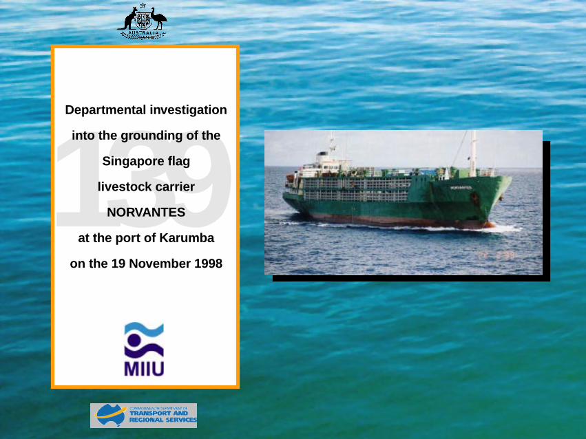
139 Departmental investigation into the grounding of the Singapore flag livestock carrier NORVANTES at the port of Karumba on the 19 November 1998
139 Departmental investigation
into the grounding of the
Singapore flag
livestock carrier
NORVANTES
at the port of Karumba
on the 19 November 1998

Contents
Summary
Narrative
Comment and analysis
Conclusion
Submissions
Details of Norvantes
Navigation Act 1912
Navigation (Marine Casualty) Regulations
into the grounding of the Singapore flag
livestock carrier
NORVANTES
at the port of Karumba on the 19 November 1998
Published: July 1999
ISBN 0 642 20020 X
The Investigation into marine casualties occurring within the Commonwealth's jurisdiction are conducted under the provisions of the Navigation (Marine Casualty) Regulations, made pursuant to sub section 425 (1) (ea) and 425 1 (AAA) of the Navigation Act 1912. The Regulations provide discretionary powers to the Inspector to investigate incidents as defined by the regulations. Where an investigation is undertaken the Inspector must submit a report to the Secretary of the Department. It is Departmental policy to publish such reports in full as an educational tool.
To increase the value of the safety material presented in this report readers are encouraged to copy or reprint the material, in part or in whole, for further distribution, but should acknowledge the source.
For further information please contact:
Inspector of Marine Accidents Marine Incident Investigation Unit P O Box 594 CANBERRA ACT 2601 AUSTRALIA
Phone: +61 2 6274 7324
Fax: +61 2 6274 6699
Email: [email protected]
MIIU on the INTERNET
Information relating to this report and other marine investigation reports can be located from the Marine Incident Investigation Unit's Internet homepage at our
URL: http://www.miiu.gov.au.htm

Summary The Singapore flag livestock carrier Norvantes sailed from the Queensland port of Karumba, in the Gulf of Carpentaria at 2218 on 19 November 1998. Norvantes carried 1509 head of cattle, together with the necessary fodder and water. The navigation of the ship was under the direction of a licensed pilot.
Norvantes cleared the Norman River and entered the approach channel marked by buoys and beacons. At about 2300 the ship turned on to a westerly heading in “Elbow Reach” with about 2700 m (1.458 miles) to run before the final west-north-westerly course to the fairway buoy. Ahead, the Pilot could see No.9 beacon and two red buoy lights. Instead of both buoys being seen to the north of the beacon, one was apparently to the south. The Pilot instructed the pilot launch, which was travelling alongside Norvantes, to go ahead at best speed and investigate. The ship was slowed from half ahead to dead slow ahead and the ship steered for the port (southern side) of the channel to stay clear of the buoy and the pilot boat.
The coxswain of the pilot boat reported that No.8 buoy, which marks the junction of Elbow Reach and the Bar Reach to the fairway buoy, was out of position. The pilot boat crew put a line around the buoy and towed it in a northward direction out of the channel. The buoy was pulled to a position close west of No.10 buoy. Norvantes passed the buoy as the pilot boat crew released the improvised towline.
When the pilot judged that Norvantes was in the wheel over position for the alteration of course to the fairway buoy, course was progressively altered to starboard. As the vessel was brought to a heading of about 285°, the ship stopped turning. Norvantes was aground on the eastern side of the channel.
Attempts to refloat the ship continued until about 0240 but were unsuccessful. The Pilot left the ship at 0250. The following day another pilot boarded the vessel in preparation for the refloating of the ship.
Norvantes was refloated at about 1750 on 20 November using its rudder and engine and with the aid of a local workboat and the pilot boat. The vessel went to anchor close to the fairway buoy. After the ship was found to have sustained no damage and cattle had been examined, it sailed for the Philippines port of General Santos.

Narrative
Norvantes
Norvantes was built in Denmark in 1972 as a cargo ship and launched as m.v. Oceania. The ship had a number of name changes and in 1996 was bought by Norwood Pte Ltd of Singapore and converted to a livestock carrier. The ship can carry in excess of 1500 cattle, depending upon size and weight.
Norvantes is 75.00 m in length, has a beam of 12.5 m, a moulded depth of 5.6 m and a draught of 4.545 m at summer deadweight. All accommodation and the main machinery space are aft. The ship is powered by an MAK diesel engine driving a single shaft and developing a service speed of 11.5 knots.
The ship is manned by a Master, two mates, two engineers and nine ratings – all are Filipino nationals. In addition a stockman travels with the ship when livestock is carried on loaded voyages.
Karumba
Karumba is a small port at the mouth of the Norman River in the south-east of the Gulf of Carpentaria. It is best known as a prawn trawling port, but ships of 90 m or less service the town and surrounding areas. There are a significant number of cattle shipments to SE Asia, particularly the Philippines. A development to export zinc concentrate is in the building stage.
Entry to the port is by a channel of about 6.8 miles marked by buoys and beacons, while the passage in the river to the livestock berth is about 2.0 miles. The width of the turning basin in the Norman River limits the length of ships berthing at Karumba to 90 m. More critical, however, is the depth of water within the channel.
Dredging of the bar and entrance channel was completed in September 1998 with a least depth at the bar of 3.4 m, promulgated by Queensland Notice to Mariners No.339T. The channel at the bar and throughout most of the 6.8 miles is about 60m in width. Before dredging started in 1998, the channel from the bar to
the western end of Elbow Reach had been marked by beacons. The dredging resulted in some of the beacons being replaced by temporary buoys.
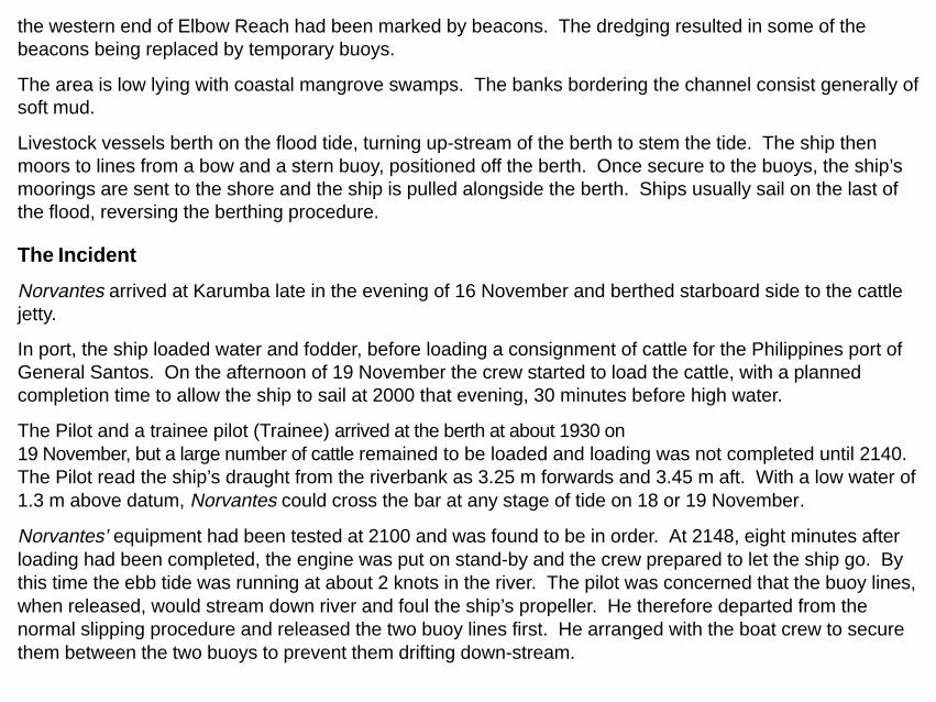
The area is low lying with coastal mangrove swamps. The banks bordering the channel consist generally of soft mud.
Livestock vessels berth on the flood tide, turning up-stream of the berth to stem the tide. The ship then moors to lines from a bow and a stern buoy, positioned off the berth. Once secure to the buoys, the ship’s moorings are sent to the shore and the ship is pulled alongside the berth. Ships usually sail on the last of the flood, reversing the berthing procedure.
The Incident
Norvantes arrived at Karumba late in the evening of 16 November and berthed starboard side to the cattle jetty.
In port, the ship loaded water and fodder, before loading a consignment of cattle for the Philippines port of General Santos. On the afternoon of 19 November the crew started to load the cattle, with a planned completion time to allow the ship to sail at 2000 that evening, 30 minutes before high water.
The Pilot and a trainee pilot (Trainee) arrived at the berth at about 1930 on 19 November, but a large number of cattle remained to be loaded and loading was not completed until 2140. The Pilot read the ship’s draught from the riverbank as 3.25 m forwards and 3.45 m aft. With a low water of 1.3 m above datum, Norvantes could cross the bar at any stage of tide on 18 or 19 November.
Norvantes’ equipment had been tested at 2100 and was found to be in order. At 2148, eight minutes after loading had been completed, the engine was put on stand-by and the crew prepared to let the ship go. By this time the ebb tide was running at about 2 knots in the river. The pilot was concerned that the buoy lines, when released, would stream down river and foul the ship’s propeller. He therefore departed from the normal slipping procedure and released the two buoy lines first. He arranged with the boat crew to secure them between the two buoys to prevent them drifting down-stream.

The ship singled up and sailed at 2218, with 1509 head of cattle, 470 tonnes of fodder and 470 tonnes of fresh water. The cattle pens, which had fodder stowed on top made conning from the enclosed bridge impossible and the view across the bow was restricted. The Pilot conned the ship from the port bridge wing, while the Trainee observed the transit from the starboard bridge wing - also on the bridge were the Master, 2nd Mate and Helmsman. The Mate and one AB remained on the forecastle head, ready to let go the anchor.
The weather was fine, with a cloudy sky and a north-westerly wind. The wind speed was estimated by the Pilot to be 15 knots and the ship estimated the wind to be westerly force 5 (17-21 knots). The fast pilot launch accompanied Norvantes on its outward passage.
As Norvantes passed Karumba Point, the engine was put to half ahead and the ship cleared the Norman River at about 2236 on a course of about 300°.
At about 2250, when approaching the eastern end of Elbow Reach on a course of about 300°, the 2nd Mate plotted a position taken from the ship’s global positioning system. This position placed the ship to the west of the channel in shoal water. This was brought to the Pilot’s attention. The Pilot, however, was sure that the ship was in the channel with buoys 14 and 15 open ahead.
At about 2300 the ship altered course to about 265° and entered “Elbow Reach” between buoys 14 and 15. The Pilot could see No.9 beacon (a north cardinal mark) about 1.5 miles ahead but instead of two red buoy lights to the north of it, one red light was to the north and the other was to the south. The Pilot asked the coxswain of the pilot boat to go ahead and investigate what was apparently a buoy out of position. He asked the Trainee to maintain communications with the pilot boat.
At 2306 the pilot boat coxswain reported that No.8 buoy was out of position and that the boat would tow it clear of the channel. This was confirmed and the Pilot ordered a reduction in speed from half ahead revolutions to dead slow ahead. He adjusted course to steer for the south part of the channel.
The pilot boat had pulled No. 8 buoy clear of the channel and was slipping the improvised towline close to the west of No. 10 buoy as Norvantes passed at about 2318. The Pilot ordered half ahead as the ship

passed the pilot boat. The Pilot could see the channel lights open to the west-north-west and he judged that the ship was in about the normal position to alter course for the fairway buoy. He ordered starboard ten to bring the ship on a heading to navigate the Bar Reach. As the ship started to turn he ordered the rudder be put amidships.
The Pilot then looked to port and astern to try and pick out the quick flash blue and isophase yellow rear leading lights. These were to the south of the ship and are “rear leads” for outward bound ships. The Pilot could not readily make out the lights, the rear leading light being lost in the back-scatter of lights, including shore construction lights. He crossed to the starboard wing where the Trainee Pilot commented that the ship was to the starboard side of the channel. The Pilot acknowledged this and indicated that he was adjusting course to compensate.
The Helmsman recalled that he was given a series of courses in five degree increments and he had brought the ship to a heading of 285° when the starboard turn stopped and the head went a few degrees to port. The Helmsman increased the rudder angle, first to starboard 20° and then starboard 30°, but with no response. He called the Master who immediately ordered full port rudder. This also had no effect and the Master realised the ship was aground. At the same time the Trainee Pilot realised the ship was not making way and reported this to the Pilot. The time observed by the Helmsman was 2320.
Norvantes had grounded to the east of the channel in position 17°26.65’South 140°45.3’ East. The predicted height of tide at that time was 2.9 m and falling.
The Master made immediate attempts to refloat the ship. For 18 minutes the engine was manoeuvred and the rudder was put from side to side in an attempt to free the ship. At one stage the pilot boat took a towline from the stern to attempt to tow the ship off. None of these attempts were successful.
The ship’s Australian agent was informed of the grounding at 2331. The agent and Master made a decision to use the Company’s work-boat Benito to try and tow Norvantes clear of shoal water.
The Master also immediately instructed the Mate to sound all tanks and spaces forward of the engine room. The Chief Engineer sounded the oil fuel tanks. The hull was found to be intact.

With the falling tide and a slight list (about 2°) to port the Master was concerned for the ship’s stability. Fifty three tonnes of water ballast was pumped to the fore peak tank. Twenty six tonnes of fodder was transferred from port to starboard to correct the list and 20 tonnes of fodder was removed from the top deck to decks three and four at and below the waterline.
Benito experienced fuel problems on its way to the ship and the pilot boat was dispatched to assist.
At 0220 on 20 November, Benito and the pilot boat arrived at Norvantes. An immediate attempt was made to tow the ship from the shoal but the attempt was unsuccessful. The attempt was abandoned at 0240, the tide having fallen more than half a metre since the time of grounding.
At 0250 the pilot left the ship. Another pilot boarded Norvantes on 20 November. The ship was successfully refloated at about 1750 on the rising tide of 20 November. After an inspection of the ship, which showed that the hull had not been breached and there was no apparent damage, and a vet’s inspection of the cattle, the ship resumed passage for General Santos in the Philippines.
No person or animal was hurt as a result of the grounding and no pollution occurred.

Copy of inset on chart Aus 303 issued 27 June 1997

Comment and analysis The ship’s equipment was tested before sailing and found to be operating correctly. Tests were also conducted after the ship was refloated and all equipment was working satisfactorily. At no time was it suggested that the ship’s engine or steering malfunctioned and there is no evidence of any such malfunction.
The grounding was not due to any mechanical or equipment failure aboard Norvantes.
Both the Pilot and Master confirmed that the helmsman steered as ordered and that he in no way contributed to the grounding.
The channel
The channel was originally marked by buoys but these were found to be unreliable as they were prone to drag position, particularly in the wet season. As the port has developed, buoys marking the channel have been progressively replaced by pile beacons. By mid 1998 all channel buoys from the bar to Bn.11 at the western end of Elbow Reach had been replaced by pile beacons.
Following the dredging in October some of the pile beacons had become unstable and were replaced by temporary buoys. The temporary buoys had relatively light “dumps” to anchor the buoys in position and, although they marked the channel, neither the port nor the starboard buoys were positioned in a straight line. The intention of the Port Authority was to replace the buoys with pile beacons at the first practicable opportunity in 1999.
The pilot who conducted Norvantes’ inward passage stated that none of the channel buoys were noticeably out of position on the night of 16 November. Between the time of the ship’s inward passage late on 16 November and its outward passage on 19 November, No. 8 buoy had moved. There were no abnormal wind conditions to account for the movement of the buoy. The tidal range was greater than predicted, but no greater than the spring tides of 9 November.

There was no evidence that any other craft hit the buoy or may have moved it in some way.
However it is certain that the buoy was out of position by as much as 60 m.
The Pilot
The Pilot was a senior and very experienced pilot. He had started as a pilot in 1974 and had been piloting in North Queensland ports since 1981.
With the reorganisation of pilotage following the formation of the Queensland Ports Corporation, the pilots based in Cairns cover the ports of Lucinda, Mouriliyan, Cairns, Cape Flattery, Weipa and Karumba. In addition they cover any pilotage requirements for Thursday Island, Cooktown and Port Douglas.
As the ships calling at Karumba are small by the standards of the other ports and there is the inconvenience of a 2 ½ hour plane flight, the more junior, less experienced pilots tend to handle shipping in Karumba. The Pilot tended to handle the larger ships associated with Cape Flattery and the eastern ports of the Cairns pilotage area. However, he had piloted vessels in and out Karumba on two occasions in September 1998.
When he arrived on board, the Pilot’s first priority was to let go the ship safely on a strong ebb tide. This procedure was discussed with the Master. The Pilot also stated that he did not discuss the outward passage with the Master and officers before the ship sailed, rather outlined each leg of the pilotage as they approached the various courses. However, the Master has no such recollection. It does not appear that the Pilot discussed the outward passage with the Master, or others of the bridge team.
Nor did the Pilot have any drawn or written plan. He relied upon his knowledge of the port and general experience as a pilot.
The outward passage
Norvantes did not keep a bridge movement book in which the times of passing buoys or marks were recorded, or when engine movements were ordered. The Chief Engineer kept a record of engine

movements. The times of passing some buoys were noted on the chart and two GPS positions were taken at 2250 and 2314. Based on an analysis of the distance run between the noted positions and the fluctuation in speeds this analysis gives, none of the positions or times are considered sufficiently accurate on which to base an analysis of the ship’s speed at any time.
When it was confirmed that No.8 buoy was out of position the Pilot was forced to improvise in his judgement of when to adjust the course to bring the ship into Bar Reach. He watched the channel markers Nos.1-6 open, marking a clear channel. Based on this he estimated that it was safe to alter course.
The ship grounded about two minutes after passing buoy No.10. The distance between the charted position of buoy No.10 and buoy No.8 is 308 m. Given that Norvantes was increasing speed, having been at dead slow revolutions for some twelve minutes, it would probably have taken at least 2 minutes to cover the distance between the two charted positions.
Given the loss of No.8 buoy as a turning mark, the Pilot crossed from the port to the starboard bridge wing to attempt to align the ship in the channel using the leading lights as “stern” leads. Neither the rear yellow leading light nor the forward blue leading light was immediately obvious. The rear leading light was
Photocopy of inset on chart Aus 303 suppiied by Norvantes

reported to be difficult to see against the similarly coloured shore lights in and around a construction site in Karumba. The Trainee told the Pilot that the ship seemed to be to the east of the channel. The Pilot agreed and was about to adjust course when the ship took the ground.
At about 2306, when it was confirmed that No.8 buoy was out of position, the Pilot ordered dead slow ahead. However, although he had bought time to allow the buoy to be dragged clear of the channel, he did not think about fixing the turning position by some alternate mark. He had about twelve minutes to fix the turning mark using alternative aids, if necessary in conjunction with the radar. Possible marks or radar targets included Bn.9 (about 1.8 cables from the ship’s turning position) or the front leading light beacon, or the rear leading light beacon (about 9 cables from the turning position).
Similarly, the Master and 2nd Mate were aware that the buoy was out of position and neither thought of trying to establish an alternate mark on which to base the alteration of about 30°. The scale of the chart at 1:50,000 would have made this difficult, but it would have been possible to obtain a range and bearing from the rear leading light beacon.
Fatigue and performance
At 1300 on Friday 17 November, the Pilot and the Trainee left Cairns to attend a Queensland Ports Authority Conference. They arrived for the evening session, attended the following day’s sessions and the dinner in the evening. After a drink with colleagues from other ports, the Pilot went to bed at about 2300. The following morning, Sunday 19 November, at about 0600 the two men left Townsville for Cairns. They arrived in Cairns and, after picking up bags from their respective homes, went to the airport for the 1130 flight to Karumba, to conduct Norvantes on its outward pilotage passage.
The plane arrived at Karumba at about 1400. The Pilot made inquiries regarding the expected time of completion and at about 1500 went to bed for one hour. The Pilot and his trainee colleague met for an evening meal, with which the Pilot had one light beer. At about 1930 the Pilot and Trainee Pilot arrived at the ship to find that sailing had been delayed by about two hours.

Over the previous two nights the pilot had not had a full night’s sleep. At 2300 on 19 November the Pilot had been awake, apart from a sleep of not more than one hour in the afternoon, for about eighteen hours. Given the convention that every hour of sleep (up to eight hours) gives a sleep credit of two hours, when the pilot left Townsville at 0600 on 19 November he had a sleep credit of about twelve hours. By the time he took a sleep in Karumba at about 1500, his sleep credit stood at about two hours. This was supplemented by two credits for his one hours sleep and at 1600 he had four hours of sleep credit. By 2000 he had expended his sleep credits and began to accumulate a sleep deficit. By 2300 the pilot was theoretically in sleep deficit by 3 hours. Although this is somewhat theoretical it does indicate that the Pilot was most probably experiencing some level of fatigue.
The ship’s Master and crew had experienced a long day of loading fodder and cattle. Although, given the loading program, there would be no reason for the ship’s staff to have any sleep debt, they would have had little sleep credit in reserve.
Fatigue may manifest itself by a failure to perform to a normal standard, to be less alert and to avoid undertaking unwelcome tasks. Fatigue has an insidious effect in that individuals may not realise that they are not performing at their normal level. It could explain why nobody established an alternative turning mark when No.6 buoy was known to be out of position.
Norvantes’ bridge organisation
When the vessel sailed, the bridge was appropriately manned with the Master, 2nd Mate and a helmsman to assist the Pilot. Although Norvantes visited Karumba on a regular basis and the ship was provided information on the port published by the Queensland Department of Transport, together with information from the shippers, the ship’s staff had no plan indicating turning positions, or other information associated with passage planning.
The chart used by the ship was the inset on chart Aus 303, “Nassau River to Wellsley Islands”, of the Approaches to Karumba on a scale of 1:50,000. It had been supplied to the ship on 15 August 1997. The chart had been corrected to notice 629/98 of Edition 22 (23 October 1998) of Australian Notice to Mariners, showing the 3.4 m minimum depth below datum on the bar. However, it is evident from the information

supplied to the Inspector that the chart was the edition issued on 9 June 1995, rather than the edition issued on 27 June 1997. As a result the Norvantes’ chart showed the channel and its navigation aids as they existed before June 1997. The chart did not show the correct numbering or position of the channel markers, nor did it show the additional markers. The ship’s chart showed twelve channel marks between the fairway buoy and Karumba Point, while the 1997 chart shows eighteen markers.
The issue of the currency of the chart information aside, the scale of the inset of the Karumba Channel and port is not sufficiently large for effective passage
Copy of inset on chart Aus 303 issued 9 June 1995planning under pilotage conditions.
Human interaction
Of the ship’s crew, the Master, 2nd Mate and helmsman made up the bridge team. The 2nd Mate plotted the ship’s position at about 15 minute intervals. He plotted the ship’s position as it passed buoy No. 18 (No.12 on the ship’s chart) at 2236. He then plotted a GPS position at 2250, which put the ship about 100 m off track, to the west of the channel in shoal water. He called the Pilot’s attention to this, who looked and saw the position was inaccurate. Although the Pilot had no intention of being dismissive of the 2nd Mate, it seems that the 2nd Mate took some offence. The 2nd Mate stated that he was “in doubt on his (the Pilot’s) navigation”. The 2nd Mate continued to plot the ship’s position, but was most likely inhibited from making further comment. The next position marked was between buoy 14 and buoy 15 (buoy 8 and buoy 7 on the

ship’s chart) at 2300.
The distance between the 2236 position and the 2250 position plotted on the chart was about 2620 m and between the 2250 position and the 2300 position was about 550 m. The two distances are not consistent with a vessel steadily increasing speed at half ahead and the Inspector is satisfied that the position plotted at 2250 was in error. When navigating in a narrow channel under pilotage there would be no time to fully check the GPS coordinates. In any case, the GPS accuracy would have been within the normal tolerance of a GPS position without a differential correction. Also given that buoys 14 and 15 could be seen open ahead there would seem to be little need to do so. However, the 2nd Mate believed the GPS position to be accurate.
It may well have made some impression on the Master. According to the Master’s statement, when rounding into Elbow Reach, he “ told the Pilot that he should head for the white buoy No.3. But they were convinced that the buoys were out of position, that’s why he put No.3 buoy (north cardinal mark) at about 10 degrees on our port.” The Master felt his advice had been ignored.
The Master was referring to the current Bn.9 (quick flash white). Although referring to the wrong number and to a buoy, there was no confusion in the Pilot’s mind as to the channel marking. However, the situation was somewhat ambiguous for the ship’s staff. They did not use the correct numbering of the channel marks and the episode of 2250 led to some tension in the ship’s bridge team.
The course in Elbow Reach is 265°. The Pilot stated that, to allow the pilot launch maximum room when it went to examine No.3 buoy, he steered for the south side of the channel with Bn.9 one, possibly two, degrees on the starboard bow.
In such a narrow channel to make good a course of more than two or three degrees either side of 265° would be to steer the vessel out of the channel. The Inspector is satisfied that Bn.9 was, at most, one or possibly two degrees on the starboard bow. If Norvantes was in the middle of the channel or even to the starboard side, if the pilot had steered 255° rather than 265° the vessel would have travelled only between 170 m and 250 m before grounding on the south side of Elbow Reach.

Postscript
In April 1999 the Hydrographic office published a new chart, Aus 6 “Australia - North Coast - Queensland Approaches to karumba”. this chart is, on a scale of 1:25,000, is more suitable for pilotage planning than the suspended chart where the plan inset was at a scale of 1:50,000.
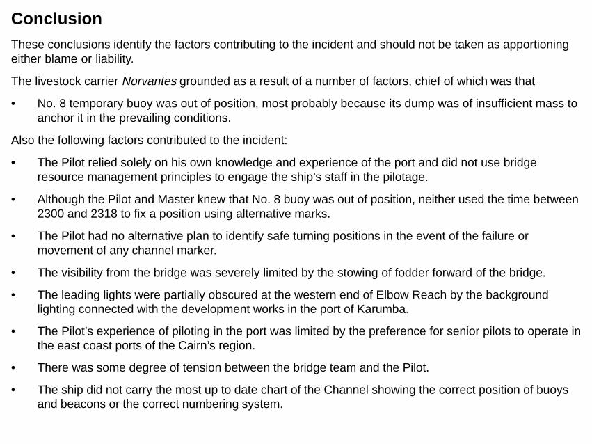
Conclusion These conclusions identify the factors contributing to the incident and should not be taken as apportioning either blame or liability.
The livestock carrier Norvantes grounded as a result of a number of factors, chief of which was that
• No. 8 temporary buoy was out of position, most probably because its dump was of insufficient mass to anchor it in the prevailing conditions.
Also the following factors contributed to the incident:
• The Pilot relied solely on his own knowledge and experience of the port and did not use bridge resource management principles to engage the ship’s staff in the pilotage.
• Although the Pilot and Master knew that No. 8 buoy was out of position, neither used the time between 2300 and 2318 to fix a position using alternative marks.
• The Pilot had no alternative plan to identify safe turning positions in the event of the failure or movement of any channel marker.
• The visibility from the bridge was severely limited by the stowing of fodder forward of the bridge.
• The leading lights were partially obscured at the western end of Elbow Reach by the background lighting connected with the development works in the port of Karumba.
• The Pilot’s experience of piloting in the port was limited by the preference for senior pilots to operate in the east coast ports of the Cairn’s region.
• There was some degree of tension between the bridge team and the Pilot.
• The ship did not carry the most up to date chart of the Channel showing the correct position of buoys and beacons or the correct numbering system.

• The scale of 1:50,000 of the inset chart of the “Approaches to Karumba” on chart Aus 303, “Nassau River to Wellsley Islands”, is insufficient for effective passage planning in pilotage waters.
• The ship, although visiting the Port of Karumba regularly, undertook no proper planning for the pilotage passage.
• There was potential for a degree of ambiguity in the monitoring of the ship’s progress by the ship’s staff in that they and the Pilot were not using the same channel marker numbering system.

Submissions Under sub-regulation 16(3) of the Navigation (Marine Casualty) Regulations, if a report, or part of a report, relates to a person’s affairs to a material extent, the Inspector must, if it is reasonable to do so, give that person a copy of the report or the relevant part of the report. Sub-regulation 16(4) provides that such a person may provide written comments or information relating to the report.
The final draft of the report, or parts of the report, was sent to the following:
The Master,
Pilot,
Karumba Livestock Trading,
Regional Harbour Master, Queensland Transport.

Details of Norvantes IMO No. 7128760
Flag Singapore
Classification Society DNV(BV)
Vessel type Livestock carrier
Owner Norwood Investment
Year of build 1972
Builder A/S Svendborg Skibsvaerft-Svendborg
Gross tonnage 1259
Net tonnage 734
Summer deadweight 1405
Length overall 75 m
Breadth, extreme 12.93 m
Draught (summer) 4.557 m
Engine MaK
Engine power 883 kW
Service speed 11 knots
Crew 14 (Filipino)


