Glenelg Hopkins Catchment Management Authority Groundwater Flow Systems Peter Dahlhaus, Dahlhaus Environmental Geology Pty Ltd David Heislers, Centre for Land Protection Research, NRE Phil Dyson, Phil Dyson and Associates Pty Ltd Report produced by: Dahlhaus Environmental Geology Pty Ltd A.C.N. 085846813 P.O. Box 318 Buninyong Vic 3357 Phone (03) 5341 3994 E-mail [email protected]Report No. GHCMA 02/02 October 2002
Transcript
Glenelg Hopkins Catchment Management Authority
Groundwater Flow Systems
Peter Dahlhaus, Dahlhaus Environmental Geology Pty Ltd David Heislers, Centre for Land Protection Research, NRE Phil Dyson, Phil Dyson and Associates Pty Ltd Report produced by:
Dahlhaus Environmental Geology Pty Ltd A.C.N. 085846813
Groundwater Flow Systems of the Glenelg Hopkins Catchment Management Authority region
Summary Eighteen groundwater flow systems have been delineated in the Glenelg Hopkins
CMA region based on the model put forward by the National Land and Water Resources Audit. Of these, ten are predominately local groundwater flow systems, three are predominately intermediate, and five are predominately regional flow systems. Consensus on the flow systems was an outcome of a three-day workshop held in Hamilton in February 2002, and subsequent discussions with regional experts.
Groundwater flow systems are intended to characterise similar landscapes in which similar groundwater processes contribute to similar salinity issues, and where similar salinity management options apply. They comply with a national salinity evaluation framework being developed under the National Action Plan for salinity and water quality to characterise catchments in terms of their response to salinity management options.
While groundwater flow systems provide a useful tool in the understanding of salinity processes, confidence in management options for the protection of different classes of assets (agricultural land, water quality, biodiversity, infrastructure and cultural heritage) requires confidence in the conceptual model of how the groundwater and salinity processes operate. To date there has been very little scientific validation of the flow systems or salinity process models in the Glenelg Hopkins CMA region. However, the delineation of groundwater flow systems has provided a framework to assess these knowledge gaps in the hydrogeology of the Glenelg Hopkins CMA region.
This document supersedes the first draft report circulated in April 2002 and incorporates the comments and amendments received. The primary purpose of this report is to provide input to the Second Generation GHCMA Salinity Action Plan.
Version 2.01e - October 2002 i
Groundwater Flow Systems of the Glenelg Hopkins Catchment Management Authority region
Table of Contents 1.0 Introduction 1
2.0 Groundwater Flow Systems 2
3.0 GFS descriptions 4
4.0 Discussion 5
Glenelg Hopkins Groundwater Flow Systems 7 Local flow systems in Quaternary alluvium and coastal deposits 9 Local Flow Systems in the Volcanic Plains (later phase volcanics) 13 Local Flow Systems in fractured granitic rocks 17 Local Flow Systems in deeply weathered granitic rocks 21 Local and Intermediate Flow Systems in deeply weathered Palaeozoic rocks 25 Local Flow Systems in Grampians Group colluvial slopes 29 Local and Intermediate Flow Systems in Grampians Group rocks 33 Local and Intermediate Flow Systems in the Woorndoo Complex 36 Local Flow Systems in the West Dundas Tablelands 40 Local and Regional Flow Systems in East Dundas Tablelands 44 Intermediate and Local Flow Systems in the Pliocene sands 48 Intermediate and Local Flow Systems in the Merino Tablelands 52 Intermediate and Regional Flow Systems in fractured Palaeozoic rocks 56 Regional and Intermediate Flow Systems in the Volcanic Plains basalt 60 Regional and Intermediate Flow Systems in the subsurface Deep Leads 64 Regional and Intermediate Flow Systems in the sand plains 68 Regional Flow Systems in the Port Campbell Limestone 70 Regional Flow Systems in the Dilwyn Formation 72
Appendix A Groundwater Flow System workshop participants 74 Appendix B GHCMA Salinity Technical Committee 74
Disclaimer
This document has been written for use by the Glenelg Hopkins Catchment Management Authority by Dahlhaus Environmental Geology Pty Ltd and has been compiled using the consultant’s expert knowledge, due care and professional expertise. Dahlhaus Environmental Geology Pty Ltd does not guarantee that the publication is without flaw of any kind or is wholly appropriate for every purpose for which it may be used and therefore disclaim all liability for any loss, damage or other consequences whatsoever which may arise from the use of or reliance on the information contained in this publication.
Version 2.01e - October 2002 ii
Groundwater Flow Systems of the Glenelg Hopkins Catchment Management Authority region
1.0 Introduction
The National Land and Water Resources Audit (NLWRA, 2001) identified the Glenelg Hopkins Catchment Management Authority (GHCMA) region as a high-risk salinity area. As a result, the GHCMA (along with the neighbouring Corangamite CMA) has been designated one of the priority regions in the National Action Plan for salinity and water quality (NAP). The goal of the NAP is to motivate and enable regional communities to use coordinated and targeted action to: Prevent, stabilise and reverse trends in dryland salinity affecting the sustainability of
production, the conservation of biological diversity and the viability of our infrastructure.
Improve water quality and secure reliable allocations for human uses, industry and the environment.
This report details the initial assessment of the Groundwater Flow Systems (GFS) for the GHCMA. The report was commissioned following a three-day “Salinity Tools” workshop held on 6th to 8th February 2002 at the Pastoral and Veterinary Institute, Hamilton. The purpose of the workshop was to delineate the groundwater flow systems for the GHCMA, according to the methodology outlined by the Bureau of Rural Sciences (BRS) (Coram, et al., 2000; 2001). Approximately 31 invited experts and/or stakeholders in the groundwater and salinity issues in the GHCMA region (Appendix A) attended the workshop, which was facilitated by Ray Evans, Phil Dyson and Darrel Brewin (all consultants).
Purpose The primary purpose of this report is to provide input to the development of
GHCMA Second Generation Salinity Action Plan (a draft of which is currently in circulation). However the GFS information may also provide useful input to other current projects, such as the South West Water and Land-use Change Project.
Scope This report supersedes the GFS draft report issued on the 9th April 2002 (Dahlhaus
Environmental Geology Pty Ltd report no. GHCMA 02/01). The majority of the technical information on the flow systems has been compiled from the data and advice provided by the experts at the workshop, with limited verification. However, the time limitations of the workshop precluded a detailed description of all of the groundwater flow systems and Peter Dahlhaus compiled additional GFS descriptions and attributes, with David Heislers and Phil Dyson contributing the management options. Supplementary modifications and corrections were contributed by the members of the GHCMA Salinity Technical Committee (Appendix B).
Continuous improvement The workshop and report on the GHCMA GFS should be regarded as the initial
process in delineating groundwater flow systems as a tool for salinity management. It is expected that aspects of the GFS models described in this report will be superseded by updated research information within 12 months. As more information and data are provided through on-going research, all aspects of the GFS should be reviewed and the models modified where appropriate. The revised GFS information can be used to further refine the salinity risk priority areas and Salinity Action Plan.
Version 2.01e - October 2002 1
Groundwater Flow Systems of the Glenelg Hopkins Catchment Management Authority region
2.0 Groundwater Flow Systems
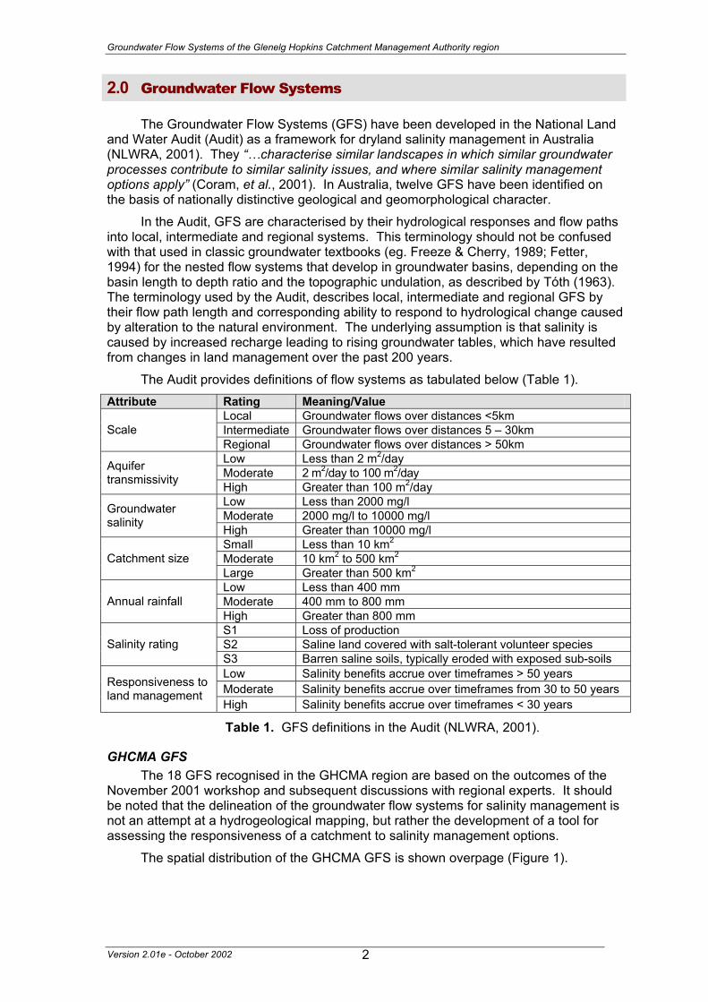
The Groundwater Flow Systems (GFS) have been developed in the National Land and Water Audit (Audit) as a framework for dryland salinity management in Australia (NLWRA, 2001). They “…characterise similar landscapes in which similar groundwater processes contribute to similar salinity issues, and where similar salinity management options apply” (Coram, et al., 2001). In Australia, twelve GFS have been identified on the basis of nationally distinctive geological and geomorphological character.
In the Audit, GFS are characterised by their hydrological responses and flow paths into local, intermediate and regional systems. This terminology should not be confused with that used in classic groundwater textbooks (eg. Freeze & Cherry, 1989; Fetter, 1994) for the nested flow systems that develop in groundwater basins, depending on the basin length to depth ratio and the topographic undulation, as described by Tóth (1963). The terminology used by the Audit, describes local, intermediate and regional GFS by their flow path length and corresponding ability to respond to hydrological change caused by alteration to the natural environment. The underlying assumption is that salinity is caused by increased recharge leading to rising groundwater tables, which have resulted from changes in land management over the past 200 years.
The Audit provides definitions of flow systems as tabulated below (Table 1). Attribute Rating Meaning/Value
Local Groundwater flows over distances <5km Intermediate Groundwater flows over distances 5 – 30km Scale Regional Groundwater flows over distances > 50km Low Less than 2 m2/day Moderate 2 m2/day to 100 m2/day Aquifer
transmissivity High Greater than 100 m2/day Low Less than 2000 mg/l Moderate 2000 mg/l to 10000 mg/l Groundwater
salinity High Greater than 10000 mg/l Small Less than 10 km2 Moderate 10 km2 to 500 km2 Catchment size Large Greater than 500 km2 Low Less than 400 mm Moderate 400 mm to 800 mm Annual rainfall High Greater than 800 mm S1 Loss of production S2 Saline land covered with salt-tolerant volunteer species Salinity rating S3 Barren saline soils, typically eroded with exposed sub-soils Low Salinity benefits accrue over timeframes > 50 years Moderate Salinity benefits accrue over timeframes from 30 to 50 years Responsiveness to
land management High Salinity benefits accrue over timeframes < 30 years
Table 1. GFS definitions in the Audit (NLWRA, 2001).
GHCMA GFS The 18 GFS recognised in the GHCMA region are based on the outcomes of the
November 2001 workshop and subsequent discussions with regional experts. It should be noted that the delineation of the groundwater flow systems for salinity management is not an attempt at a hydrogeological mapping, but rather the development of a tool for assessing the responsiveness of a catchment to salinity management options.
The spatial distribution of the GHCMA GFS is shown overpage (Figure 1).
Version 2.01e - October 2002 2
Groundwater Flow Systems of the Glenelg Hopkins Catchment Management Authority region
Version 2.01e - October 2002 3
Groundwater Flow Systems of the Glenelg Hopkins Catchment Management Authority region
3.0 GFS descriptions
Each GFS has been described according to the attributes listed in the Audit (NLWRA, 2001) and the suggested description in the Evaluation Framework (Coram, Dyson & Evans, 2001). Additional descriptive information has been added in an attempt to add historical and landscape context to each system. Individual GFS Map: An attempt has been made to delineate the spatial influence of each system (presented as a map) represented by the mapped outcrop and estimated sub-crop. The mapped outcrop has been derived from the 1:500,000 scale geological map as provided by the Geological Survey of Victoria (GSV) on their Victoria GIS CD released in November 2000. The estimated sub-crop distribution should be regarded as tentative at this stage and no attempt has been made to estimate sub-crop for some systems as yet. The delineation of sub-crop should improve considerably once the bore database is completed. Region: This is stated in terms of the geographic and major geomorphic divisions. Type areas: Two or three localities in the GHCMA region when the GFS occurs. Description: A brief overview of the geology and groundwater flow for the GFS. Problem statement. The ‘salinity problem statement’ provides context for the GFS’s role in the salinity issue.
Landscape attributes Geology: Geological units derived from the GSV 1:500,000 digital geology map. Topography: Description of the landforms of the GFS area. Land Systems: Hierarchy of Land Systems derived from the 2002 revision by the
Victorian Geomorphology Reference Group. Regolith: General description of regolith materials. Annual rainfall: Range in millimetres derived from rainfall model (CLPR, 2002). Dominant mid-1800s vegetation type: General description of native vegetation cover for
the GFS area, derived from the Land Systems of Victoria (Rees, 2002). Current dominant land uses: General description of land-uses with the GFS area. Mapping method: Method used to delineate the GFS boundaries.
Hydrogeology Aquifer type (porosity): Aquifer materials and porosity (primary or secondary porosity). Aquifer type (conditions): Unconfined or confined. Hydraulic Conductivity (lateral permeability): Range for hydraulic conductivity in m/d. Aquifer Transmissivity: Range for transmissivity in m2/d. Aquifer Storativity: Range for storativity (dimensionless). Hydraulic gradient: Descriptive indicator of hydraulic gradient (Steep, low, etc.). Flow length: Range for flow lengths from recharge to discharge. Catchment size: Estimation of flow systems area. Recharge estimate: Recharge estimate in millimetres. Temporal distribution of recharge: Estimate of when recharge occurs. Spatial distribution of recharge: Estimate of where recharge occurs. Aquifer uses: Description of groundwater use.
Version 2.01e - October 2002 4
Groundwater Flow Systems of the Glenelg Hopkins Catchment Management Authority region
Salinity Groundwater salinity: Salinity range in mg/l. Salt store: Description of salt store in the GFS materials. Salinity occurrence: Description of where salinity occurs. Soil Salinity Rating: S1, S2, or S3, based on CLPR rating (Allen, 1996) Salt export: Description of how the salt is exported (i.e. wash off from surface or
baseflow to streams). Salt impacts: Description of on-site or off-site impacts.
Risk Soil salinity hazard: Estimation of soil salinisation hazard (High / medium / low). Water salinity hazard: Estimation of water salinisation hazard (High / medium / low). Major assets at risk: A general description of the GHCMA region’s assets at risk. Responsiveness to land management: Estimation of hydrologic response (i.e. recharge
response) to changes in land-management.
Management Options Management options are stated in terms of biological management of recharge,
engineering intervention for watertable control and productive uses of saline land and water (i.e. discharge management).
4.0 Discussion
Confidence in the options for salinity management in south west Victoria is constrained by the lack of scientifically validated models relating the assumed cause (land-use change) to the observed effect (salinity). There is growing evidence that land and water salinity was a more prevalent feature (than is assumed) of the landscape before widespread land-use change. In some areas, such as the wetlands of the Volcanic Plains, these primary saline areas are biodiversity assets of regional significance. Confidence in management options for the protection of different classes of assets (agricultural land, water quality, biodiversity, infrastructure and cultural heritage) requires confidence in the conceptual model of how the salinity processes work.
One challenge in adopting the GFS approach to salinity management in the GHCMA region is the emergence of a variety of conceptual models for salinity processes in the different landscapes of south west Victoria. In some areas, it is thought that groundwater tables have risen in response to increased recharge due to land-use change. In such areas where local or intermediate groundwater flow systems are present, recharge control remains a viable option for salinity management. However, in other areas the depth of the groundwater tables below the surface may be relatively unchanged over the past 200 years and other factors - such as changes to soil waterlogging and regolith hydrology - are implicated in the spread of salinity (Dahlhaus & MacEwan, 1997, Dahlhaus et al., 2000). In these areas, the regional systems are regulated by the rate of discharge and recharge control is not considered as relevant to the management of salinity as the control of soil waterlogging and shallow, temporal water flows in the near-surface. In these GFS, the treatment of discharge areas can often result in a more productive outcome for agriculture or biodiversity in a shorter time frame than recharge control.
Peter Dahlhaus
31st October 2002
Version 2.01e - October 2002 5
Groundwater Flow Systems of the Glenelg Hopkins Catchment Management Authority region
References ALLEN, M.J. 1996. Method for assessing dryland salinity in Victoria. Centre for Land
Protection Research Technical Report 34. 19p. CLPR, 2002. GIS data layers: Rainfall, Land Management Units, Salinity and Digital
Elevation. Digital data in MapInfo table format (*.tab). Centre for Land Protection Research, Agriculture Victoria, Department of Natural Resources and Environment, Bendigo.
CORAM, J.E., DYSON, P.R., HOULDER, P.A. & EVANS, W.R. 2000? Australian Groundwater Flow Systems contributing to Dryland Salinity. A report prepared for the National Land and Water Resources Audit Dryland Salinity Project, Bureau of Rural Sciences, Canberra. 74p.
CORAM, J.E., DYSON, P.R. & EVANS, W.R. 2001. An Evaluation Framework for Dryland Salinity. A report prepared for the National Land and Water Resources Audit Dryland Salinity Project, Bureau of Rural Sciences, Canberra. 113p.
DAHLHAUS P.G. & MACEWAN R.J. 1997. Dryland Salinity in South West Victoria - Challenging The Myth. in (G.McNally, ed.) Collected Case Studies in Engineering Geology, Environmental Geology, Hydrogeology, Third Series, Geological Society of Australia Inc. pp. 165-181
DAHLHAUS P.G., MACEWAN R.J., NATHAN E.L. & MORAND V.J. 2000. Salinity on the southeastern Dundas Tableland, Victoria. Australian Journal of Earth Sciences 47/1 pp. 3-11
FETTER, C.W. 1994. Applied Hydrogeology. 3rd edition, Macmillan College Publishing Company Inc., New York. 691p.
FREEZE, R.A. & CHERRY, J.A. 1979. Groundwater. Prentice-Hall inc. New Jersey. 604p. GEOLOGICAL SURVEY OF VICTORIA. 2000. Victoria GIS Data. on 2 Compact Disks (CD),
November 2000. Natural Resources and Environment, Melbourne. NLWRA 2001. Australian Dryland Salinity Assessment 2000. Extent, impacts,
processes, monitoring and management options. National Land & Water Resources Audit. 129p
REES, D. 2002. Land Systems of Victoria. January 2000, Edition 3. Centre for Land Protection Research Technical Report 56. 134p.
TÓTH, J.A. 1963. A theoretical analysis of groundwater flow in small drainage basins. Journal of Geophysical Research 68 (16). pp.4795-4812.
Acknowledgements The participants in the GFS workshop (Appendix A) are thanked for their input. Subsequent discussions with John Leonard, Erica Nathan, Richard MacEwan and Peter Dixon were particularly helpful. Thanks to Mayavan Pillai for additional data.
Version 2.01e - October 2002 6
Groundwater Flow Systems of the Glenelg Hopkins Catchment Management Authority region
Glenelg Hopkins Groundwater Flow Systems
Number Dominant Flow System
Sub-dominant Flow System Description
GFS 1 Local Quaternary alluvium and coastal deposits
GFS 2 Local Volcanic Plains (later phase)
GFS 3 Local Fractured granitic rocks
GFS 4 Local Deeply weathered granitic rocks
GFS 5 Local Intermediate Deeply weathered Palaeozoic rocks
GFS 15 Regional Intermediate Subsurface Deep Leads
GFS 16 Regional Intermediate Sand Plains
GFS 17 Regional Port Campbell Limestone
GFS 18 Regional Dilwyn Formation
Version 2.01e - October 2002 7
Groundwater Flow Systems of the Glenelg Hopkins Catchment Management Authority region
GFS 1
Local flow systems in Quaternary alluvium and coastal deposits
Left: Salinity developed in the alluvium along a drainage line, Malim Road, south of Rossbridge.
(660142E, 5844910N)
Version 2.01e - October 2002 8
Groundwater Flow Systems of the Glenelg Hopkins Catchment Management Authority region
GFS 1
Local flow systems in Quaternary alluvium and coastal deposits
Region: All GHCMA regions (Western Victorian Uplands, Western Victorian Plains) Type areas: Victoria Valley, Warrnambool, Ercildoun, Willaura Description: Quaternary deposits of stream alluvium, hillside colluvium, swamp and lake deposits, lunettes, recent marine sediments and coastal dunes are widespread over the GHCMA region. Although these deposits vary in thickness, formation and materials, they are grouped together by similar hydrological setting. Groundwater moves at varying rates through the deposits in local flow systems that develop at shallow depths below the ground surface. Primary salinity is a feature of some lakes on the plains and the coastal and estuarine environments such as the lower Glenelg River. Problem statement: Changes in water balance resulting from land-use change has increased soil waterlogging, regolith hydrology and groundwater recharge and discharge. In some areas around the lakes (eg. Willaura), the primary salinity is expanded by the hydrological changes (as secondary salinity).
Topography: River flats, swamps, lakes, lunettes, marshes, valley floors, river terraces, colluvial slopes, tidal lagoons, recent marine plains and lowlands, beach dunes
Land Systems: 2.0 Western Uplands:
2.1 Dissected Uplands
2.1.5 Alluvial terraces and floodplains
2.2 Strike ridges and valleys of the Grampians
2.2.2 Valleys, terraces and floodplains
2.3 Tablelands
2.3.5 Alluvial terraces and floodplains
6.0 Western plains
6.1 Volcanic Plains
6.1.5 Lakes, swamps & lunettes 6.1.6 Alluvial terraces and floodplains
6.2 Sedimentary plains
6.2.5 Alluvium, alluvial terraces, floodplains and coastal plains
Regolith: Unconsolidated gravel, sand, silt and clay. Annual rainfall: 500 to 1000 mm Dominant mid-1800s vegetation type: Grassland, Heathland, Shrubland, Scrub,
Woodland and Forest, depending on location. Current dominant land uses: Grazing, dairying, cropping, conservation, urban
development. Mapping method: Outcrop geology.
Version 2.01e - October 2002 9
Groundwater Flow Systems of the Glenelg Hopkins Catchment Management Authority region
GFS 1
Hydrogeology Aquifer type (porosity): Unconsolidated gravel, sand, silt and clay (primary porosity). Aquifer type (conditions): Unconfined. Hydraulic Conductivity (lateral permeability): Extremely variable. Probable range
from 10-6 m/d to 102 m/d. Aquifer Transmissivity: Variable, in the moderate range. Estimated to be generally
less than 20 m2/d. Aquifer Storativity: Extremely variable. Estimated to be from 0.001 to 0.05. Hydraulic gradient: Varies with landscape. Very low to low in river and swamps, and
moderate to locally steep in colluvium or lunettes. Flow length: Generally short, but highly variable depending on local conditions.
Ranges from a few metres up to one or two kilometres. Catchment size: Generally small (<1 Ha to 100 Ha). Recharge estimate: Unknown, but would vary with the rainfall and landscape setting at
any location. Temporal distribution of recharge: Seasonal (winter and spring), with more recharge
in wetter years. Extensive periods of soil waterlogging may add to local recharge. Spatial distribution of recharge: Catchment wide. Aquifer uses: Minor stock and domestic use from shallow bores.
Salinity Groundwater salinity: Variable. Generally in the range of 3000 mg/l to 10000 mg/l. Salt store: Moderate to high. Salinity occurrence: Significant areas of primary salinity. Secondary salinity occurs as
considerable expansion of primary salinity, and along lakeshores, low lying and flat areas, drainage lines, swampy wetlands, base of lunettes and dunes.
Soil Salinity Rating: S2, S3 Salt export: Wash off from surface. Salt impacts: Mostly on-site. Some impacts off-site (eg. Cockajemmy Lakes impacts on
the Hopkins River).
Risk Soil salinity hazard: High. Water salinity hazard: High. Major assets at risk: Wetlands, conservation areas, all major rivers, water quality and
aquatic biodiversity, engineering infrastructure, agricultural land. Responsiveness to land management: Varied, but generally should be very
responsive. In some areas (eg. Willaura) the influence of climate is more significant than land management on a seasonal or annual basis, so the response of the system to land management is low to moderate.
Version 2.01e - October 2002 10
Groundwater Flow Systems of the Glenelg Hopkins Catchment Management Authority region
Management Options Inflows of surface water and the discharge of groundwater originating from
adjoining systems are the likely influence of water levels in the alluvial flats and valley floors (eg. in the Victoria Valley and in the Pyrenees ranges). Recharge control through trees or shrubby vegetation is difficult to apply in these situations where the provenance of the groundwater is uncertain. In other areas (eg. Willaura) the influence of climate is more significant than land management on a seasonal or annual basis, and land management should aim at buffering the system.
As saline areas will always remain a feature of the landscapes of this GFS, saline agronomy may provide the most opportunities for salinity management. Given the 'wet' nature of this landscape, application of salt tolerant grasses is probably more likely to succeed than halophytic types.
Surface and sub-surface drainage of the recharge or discharge areas is generally difficult because of the lack of slope and the difficulties with acceptable disposal options. Local low volume groundwater pumping within this GFS would probably work very well, but is likely to be a costly and excessive treatment.
The presence of relatively saline lake bodies means that saline aquaculture offers additional possibilities.
In many areas of primary salinity, management may be needed to retain the biodiversity values. Indigenous halophytic ecologies generally have a high conservation value, and are especially important in the larger estuarine wetlands of the lower Glenelg River and the wetlands of the Volcanic Plains.
Options for Managing Dryland Salinity within Groundwater Flow Systems in the Glenelg Hopkins CMA Region
Groundwater Flow System Options Treatments Comments
Perennial pastures
Low to moderate – Highly suited below 700mm annual rainfall
Crop management
Low to moderate – Potential for inter-cropping with lucerne
Biological Management of recharge
Trees/woody vegetation
Low – Some potential for water interception through plantations
Surface drainage
Low – Little ability to intercept surface water prior to it becoming recharge Engineering
intervention Groundwater pumping
Low to moderate – Limited opportunities where asset protection makes it warranted
Salt tolerant pastures
Moderate to high – Salt tolerant grasses
Halophytic vegetation Low – Poorly suited to climate
Saline aquaculture
Low to moderate – May be limited opportunities where there is sufficient groundwater and offsite salinity and nutrient issues can be managed
Salt harvesting Low – Groundwater is not sufficiently saline
Local flow systems in Quaternary alluvium and coastal deposits.
Productive uses of saline land and water
Others See OPUS database (NDSP)
GFS 1
Version 2.01e - October 2002 11
Groundwater Flow Systems of the Glenelg Hopkins Catchment Management Authority region
GFS 2
Local Flow Systems in the Volcanic Plains (later phase volcanics)
Left: Salt Lake, north of Pura Pura. These primary saline discharge sites are significant biodiversity assets.
Version 2.01e - October 2002 12
Groundwater Flow Systems of the Glenelg Hopkins Catchment Management Authority region
GFS 2
Local Flow Systems in the Volcanic Plains (later phase volcanics)
Region: Southern and western GHCMA region (Western Victorian Plains) Type areas: Mt Rouse, West of Mt Emu Creek Description: The Newer Volcanic rocks that make up much of the Western Plains were erupted onto the surface during episodes of volcanism spanning from about 4 million years ago to about 7000 years ago. The later phase volcanism resulted in shield and composite volcanoes, scoria cones, maars, tuff deposits and stony rises seen in today’s landscapes. Groundwater moves through the fractured rocks and scoria at rapid rates and is quickly recharged by rainfall. In general, the local flow systems contribute fresh water discharge in lakes, streams, and at the boundaries of the lava flows (‘barriers’), however many primary saline lakes and wetlands are features of the landscape bordering Mount Emu Creek to the west (Streatham – Nerrin Nerrin – Dundonnell).
The scoria cones and stony rises probably have a more important role in water resource management than salinity. Scoria cones are often a local area of high recharge and often contain good quality groundwater that is a local irrigation resource (eg. Tower Hill) or spring water resource. Discharge from stony rises and at the boundaries of the lava flows (‘barriers’) often feeds lakes and wetlands in inter-rise depressions and contributes baseflow into adjacent streams. Their impact on recharging the underlying basalt aquifer (GFS 14) is likely to be limited by their areal extent and any underlying confining beds, such as clayey palaeo-soils. Problem statement: Groundwater discharge around the edges of the stony rises and eruption points may add to the primary salinity of the lakes and wetlands of the inter-rise depressions or the underlying volcanic plains. Increased recharge since land-use change may also leak more water through to the underlying aquifers.
Landscape attributes Geology: Newer Volcanics scoria and stony-rise basalt (Qvs) of Quaternary age. Topography: Stony rises, lava ‘barriers’, scoria cones, tuff mounds, maars. Land Systems:
6.0 Western Plains
6.1 Volcanic plains
6.1.1 Eruption points, including maars, scoria cones and lava shields 6.1.2 Stony rises.
Regolith: Thin stony to weakly gradational soils (skeletal), gravely loams (scoria soils). Annual rainfall: Approximately 600 to 700 mm Dominant mid-1800s vegetation type: Woodland and grassland on stony rises, forests
on some scoria cones. Current dominant land uses: Grazing, conservation, cropping, horticulture, quarrying. Mapping method: Outcrop geology, radiometric ternary ratio, land systems.
Version 2.01e - October 2002 13
Groundwater Flow Systems of the Glenelg Hopkins Catchment Management Authority region
GFS 2
Hydrogeology Aquifer type (porosity): Fractured rock (secondary porosity), scoria (primary porosity) Aquifer type (conditions): Unconfined Hydraulic Conductivity (lateral permeability): Variable. Probably from 10-1 m/d
(tighter pores and fractures) to 102 m/d (open fractures and lava tubes). Aquifer Transmissivity: Variable, but generally in the high range. Estimated to be
generally less than 2000 m2/d. Aquifer Storativity: Variable. Estimated to be up to 0.20. Hydraulic gradient: Estimated to be low (0.001) to moderate (0.01). Hydraulic gradient
is low relative to relief and often changes with temporal conditions. Flow length: Generally <5 km. Catchment size: Generally small (<1000 Ha). Recharge estimate: Unknown, but thought to be up to 100 mm annually. Temporal distribution of recharge: Seasonal (winter and spring), with significantly
more recharge in wetter years. Spatial distribution of recharge: Catchment wide. Aquifer uses: Significant use for stock and domestic purposes, some irrigation.
Salinity Groundwater salinity: Generally in the range of 200 mg/l to 1000 mg/l. Salt store: Low. Salinity occurrence: Lakes and wetlands in inter-rise depressions (primary?) and
around the boundaries of stony rises (‘barriers’). Soil Salinity Rating: Not applicable. Salt export: Possibly some salt wash-off to Mount Emu Creek from saline lakes and
wetlands. Contributes fresh water baseflow to streams in other areas. Salt impacts: Possible off-site impacts from wash-off and some recharge to underlying
aquifers; Potential problem of up-coning intrusions of underlying saline groundwater due to pumping.
Risk Soil salinity hazard: Possible risk to basalt plains salinity, depending on management Water salinity hazard: Risk to stream and lake salinity, depending on management Major assets at risk: Farm and irrigation water supply, stream quality, wetland
biodiversity, conservation areas, engineering infrastructure, agricultural land. Responsiveness to land management: Thought to be high.
Version 2.01e - October 2002 14
Groundwater Flow Systems of the Glenelg Hopkins Catchment Management Authority region
GFS 2
Management Options Both the stony rises (“barriers”) and the scoria cones are areas of high recharge.
Freshwater discharge from this GFS is a significant intrinsic characteristic of these landscapes and recharge control should be a measured response. Evidence has emerged that the treeing of stony barriers may significantly reduce fresh and salt-diluting baseflows into streams (Richard MacEwan, pers. comm.). Similarly, draining inter-rise depressions and wetlands in these systems could result in increased soil salinisation potential, although this outcome is not well researched.
In the area bordering Mount Emu Creek to the west (Streatham – Nerrin Nerrin – Dundonnell) many primary saline lakes and wetlands are features of the landscape and these may require conservation management to maintain their biodiversity value.
Ultimately salinity control strategies in this system are not well researched and may conflict with the need to maintain a commercial fresh groundwater resource and/or local and regional biodiversity. Some sense of how the scoria cone and stony rise country operated in its pristine environment would greatly assist this analysis.
Options for Managing Dryland Salinity within Groundwater Flow Systems in the Glenelg Hopkins CMA Region
Groundwater Flow System Options Treatments Comments
Perennial pastures
Crop management
Biological Management of recharge
Trees/woody vegetation
Recharge management is not appropriate. In most instances the landscape is extremely permeable and contains fresh groundwater resources – groundwater management issues
Surface drainage Not appropriate
Engineering intervention Groundwater
pumping
High – Suitable for groundwater extraction – groundwater management issues
Salt tolerant pastures N/a
Halophytic vegetation N/a
Saline aquaculture N/a
Salt harvesting N/a
Local flow systems in Scoria cones and stony rises
Productive uses of saline land and water
Others N/a
Version 2.01e - October 2002 15
Groundwater Flow Systems of the Glenelg Hopkins Catchment Management Authority region
GFS 3
Local Flow Systems in fractured granitic rocks
Above: Granite tors near Burrumbeep Hill, north of Maroona.
Version 2.01e - October 2002 16
Groundwater Flow Systems of the Glenelg Hopkins Catchment Management Authority region
GFS 3
Local Flow Systems in fractured granitic rocks
Region: North eastern GHCMA region (Western Victorian Uplands) Type areas: Mt Cole, Mt Langi Ghiran Description: The granitic rocks in the north western part of the GHCMA region were formed around 350 million years ago when granitic magma cooled slowly at depths of two to five kilometres within the sedimentary rocks. The resulting crystalline rocks are now exposed by extensive erosion. In the past 15 million years, the granites have been subjected to deep weathering and sporadic erosion controlled by uplift and disrupted drainage. This has resulted in a variable regolith comprising thick kaolin clay in places, and sandy grus or granite tors elsewhere. Groundwater moves slowly through the fractured rocks and the regolith in local flow systems in a variety of pathways and processes. Discharge occurs as springs and in valley floors. Problem statement: Land-use change has altered the water budget of the soil, regolith and fractured rock hydrologic systems.
Landscape attributes Geology: Lower Devonian granite (Dlg), Upper Devonian granite (Dug) Topography: Ridges and plateaus, gently undulating low hills, broad valleys, can be
locally steep.
Land Systems: 2.0 Western Uplands:
2.1 Dissected Uplands. 2.1.2 Ridges and plateaux, hills and valley slopes associated with
granitic rocks and aureoles Regolith: Highly variable weathered profile (soil, grus, saprolite, tors). Annual rainfall: 550 to 750 mm Dominant mid-1800s vegetation type: Woodland and forest. Current dominant land uses: Grazing, conservation, forestry, quarrying. Mapping method: Outcrop geology, land systems.
Version 2.01e - October 2002 17
Groundwater Flow Systems of the Glenelg Hopkins Catchment Management Authority region
GFS 3
Hydrogeology Aquifer type (porosity): Fractured rock and saprolite (secondary porosity), soil and
grus (primary porosity) Aquifer type (conditions): Unconfined and semi confined Hydraulic Conductivity (lateral permeability): Highly variable. The saprolite varies
from approximately 10-6 m/d to 10-1 m/d, grus varies from 10-3 m/d to 10-1 m/d, and the rock varies from 10-10 m/d to 10-2 m/d
Aquifer Transmissivity: Highly variable in the low to moderate range. Estimated to be generally less than 50 m2/d.
Aquifer Storativity: Variable. Estimated to be less than <0.05 for saprolite and grus and <0.01 for the fractured rock.
Hydraulic gradient: Estimated to be moderate to locally steep. Flow length: Generally <5 km. Catchment size: Small (~<500 Ha) to moderate (>1000 Ha). Recharge estimate: Unknown. May be 25 mm to 200 mm annually. Temporal distribution of recharge: Seasonal (winter and spring), with more recharge
in wetter years. Spatial distribution of recharge: Catchment wide but varies with the depth of regolith,
slope and waterlogged areas in the landscape. Aquifer uses: Minor use, mainly for stock and domestic purposes.
Salinity Groundwater salinity: Generally in the range of 3000 mg/l to 10000 mg/l Salt store: High Salinity occurrence: Broad valley floor, drainage lines, small springs. Soil Salinity Rating: S2, some S3. Salt export: Both baseflow to streams and wash-off from surface. Salt impacts: Both on-site and off-site
Risk Soil salinity hazard: High Water salinity hazard: High Major assets at risk: Rivers and streams, engineering infrastructure, conservation
areas, agricultural land. Responsiveness to land management: Largely unknown, but thought to be moderate
to high for these local flow systems.
Version 2.01e - October 2002 18
Groundwater Flow Systems of the Glenelg Hopkins Catchment Management Authority region
GFS 3
Management Options Recharge to the fractured rock aquifer would generally be very slow due to the
sparse and tight fractures in the granite. Vegetation cover is intact on a large proportion of the area held as public land forests. In cleared areas biological control measures such as blocks or belts of trees will potentially reduce recharge to the groundwater system proper, but can be more effective in reducing lateral flow through the upper regolith which will reduce the discharge 'load' accumulating on the flats. By removing this 'fresh' component, the area affected by saline discharge can be reduced in size. However, moderate to high rainfall limits the effectiveness of perennial pasture in recharge control, and soil fertility and acidity issues restrict the use of lucerne. This may leave a role for native grasses, although the recharge benefit has yet to be quantified.
Groundwater pumping is unviable due to the low permeability, deeply weathered landscape. Waterlogging control on the slopes may be assisted by surface and sub-surface drainage, but the economics and the downstream impact are problematic.
Despite the localised nature of many of the flow cells, a significant treatment strategy will revolve around treatment of the broad valley flats using salt tolerant grasses and/or indigenous vegetation to increase productivity and biodiversity.
Options for Managing Dryland Salinity within Groundwater Flow Systems in the Glenelg Hopkins CMA Region
Groundwater Flow System Options Treatments Comments
Perennial pastures
Low to moderate – suitable in local systems below 700mm annual rainfall.
Crop management N/a Biological
Management of recharge
Trees/woody vegetation
Low to moderate – Maintain native vegetation cover and establishment of tree blocks or belts in cleared areas may intercept shallow water flows. Marginal for recharge control.
Surface drainage
Moderate to high – Reduction of surface waterlogging and consequent salinity impacts in local flow systems.
Moderate to high – Salt and water logging tolerant grasses
Halophytic vegetation Low – Poorly suited to climate
Saline aquaculture
Low – Poor aquifer capacity and difficult to extract groundwater
Salt harvesting
Low – Groundwater insufficiently saline
Local flow systems in fractured granitic rocks
Productive uses of saline land and water
Others See OPUS database (NDSP)
Version 2.01e - October 2002 19
GFS 4 Groundwater Flow Systems of the Glenelg Hopkins Catchment Management Authority region
Local Flow Systems in deeply weathered granitic rocks
Left: Digital terrain model of the deeply weathered granite in the Victoria Valley, showing salinity (in black).
Version 2.01e - October 2002 20
GFS 4 Groundwater Flow Systems of the Glenelg Hopkins Catchment Management Authority region
Local Flow Systems in deeply weathered granitic rocks
Region: Central and northern GHCMA uplands (West Victorian Uplands). Type areas: Glenthompson, Victoria Valley Description: The granitic rocks in the Victoria Valley and Glenthompson areas were formed around 400 million years ago when granitic magma cooled slowly at depths of two to five kilometres within the sedimentary rocks. The resulting granite plutons are now exposed by extensive erosion of the overlying rocks. Deep weathering has created a regolith comprising kaolin clay saprolite up to 20 metres thick. Groundwater moves very slowly through the fractured rocks and slowly through the regolith in local flow systems. Initial vertical recharge is partitioned at depth where the lateral flow component becomes dominant as the tightly fractured granite restricts the downward flow. Discharge occurs as springs and in valley floors where the salinity is exacerbated by the lateral flow discharge. Problem statement: Saline discharge occurs in valley floors and is spread by a significant lateral flow component, which also has a dilution effect. Approximately 172 ha are affected, with no significant increase in last 10 years.
regolith (Npl). Topography: Moderately undulating, well defined ridges and valley floors Land Systems:
2.0 Western Uplands:
2.1 Dissected Uplands. 2.1.2 Ridges and plateaux, hills and valley slopes associated with
granitic rocks and aureoles (Victoria Valley)
2.3 Tablelands
2.3.4 Stavely Tableland on Cambrian to Tertiary rocks (Glenthompson) Regolith: Deeply weathered saprolite and saprock up to 20 m thick. Annual rainfall: 700 mm Native landscape: Woodland. Current dominant land uses: Predominantly grazing with some cropping. Mapping method: Outcrop geology and land systems.
Version 2.01e - October 2002 21
GFS 4 Groundwater Flow Systems of the Glenelg Hopkins Catchment Management Authority region
Hydrogeology Aquifer type (porosity): Fractured rock and saprolite (secondary porosity), upper
regolith throughflow (primary porosity) Aquifer type (conditions): Unconfined and semi confined. Hydraulic Conductivity (lateral permeability): Highly variable. The saprolite varies
from approximately 10-6 m/d to 10-1 m/d. Aquifer Transmissivity: Variable in the low range. Estimated to be in the general
range of 1 to 5 m2/d. Aquifer Storativity: Estimated to be less than 0.01 Hydraulic gradient: Generally steep, and locally very steep. Flow length: Generally less than 5 km. Catchment size: Small (~<500 Ha). Recharge estimate: Approximately 50 mm to 100 mm annually. Temporal distribution of recharge: Seasonal with more recharge in wetter years. Spatial distribution of recharge: Catchment wide, and thought to be higher on ridges. Aquifer uses: Minor use, mainly for stock and domestic purposes.
Salinity Groundwater salinity: Generally in the range of 5000 mg/l to 10000 mg/l Salt store: Moderate to high. Salinity occurrence: Valley floors, break-of-slope, hillside seeps. Soil Salinity Rating: S1 to S3. Salt export: Both baseflow to streams and wash-off from surface. Salt impacts: Both on-site and off-site
Risk Soil salinity hazard: Moderate. Water salinity hazard: Moderate to high. Major assets at risk: Rivers and streams (water quality and biodiversity), conservation
areas, agricultural land. Responsiveness to land management: Moderate to high, especially for control of soil-
water throughflow.
Version 2.01e - October 2002 22
Groundwater Flow Systems of the Glenelg Hopkins Catchment Management Authority region
Management Options Biological control measures will potentially reduce recharge to the groundwater
system proper, and can be very effective in reducing lateral flow through the upper regolith which will reduce the discharge 'load' accumulating on the flats. By removing the lateral component, the area affected by saline discharge can be reduced in size. It is estimated that 30% to 40% of the flow system would need to be planted to trees to reduce the recharge. Short rotation woodlots such as timber belts or alleys can be used to mine soil water held at depth and intercept lateral flows. The use of perennial pastures and lucerne are considered recharge neutral in these landscapes. Native grasses may also be useful, although the recharge benefit has yet to be quantified.
Groundwater pumping is unviable due to the low permeability, deeply weathered landscape. Waterlogging control on the slopes may be assisted by surface and sub-surface drainage, but the economics and the downstream impact are problematic.
Treatment of saline areas using salt tolerant species remains an effective strategy to increase productivity and/or biodiversity.
Options for Managing Dryland Salinity within Groundwater Flow Systems in the Glenelg Hopkins CMA Region
Groundwater Flow System Options Treatments Comments
Perennial pastures
Moderate – suitable below 700mm annual rainfall. Considered recharge neutral.
Crop management
Moderate – cropping systems should incorporate lucerne. Biological
Management of recharge
Trees/woody vegetation
Low to moderate – Significant proportion of the flow system needs treatment for recharge control. Short rotation woodlots can be effective in reducing deep soil water.
Surface drainage
Moderate – Reduction of surface waterlogging and consequent salinity impacts in local flow systems. Considered recharge neutral.
Moderate to high – Salt and water logging tolerant grasses
Halophytic vegetation Low – Poorly suited to climate
Saline aquaculture
Low – Poor aquifer capacity and difficult to extract groundwater
Salt harvesting
Low – Groundwater insufficiently saline
Local flow systems in deeply weathered granites
Productive uses of saline land and water
Others See OPUS database (NDSP)
GFS 4
Version 2.01e - October 2002 23
Groundwater Flow Systems of the Glenelg Hopkins Catchment Management Authority region
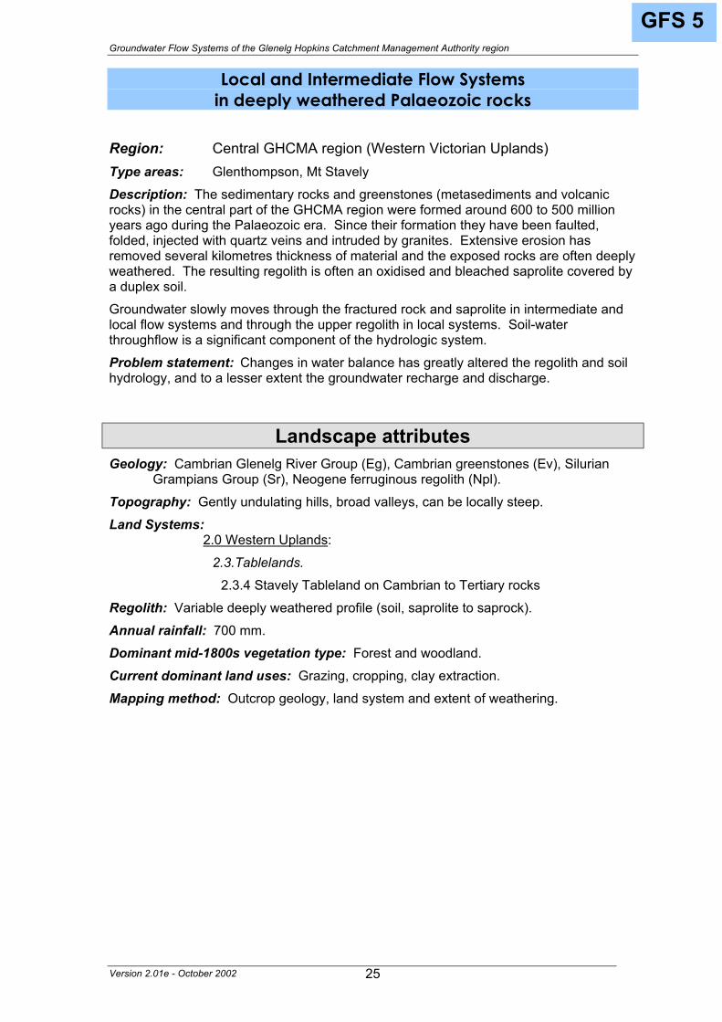
GFS 5
Local and Intermediate Flow Systems in deeply weathered Palaeozoic rocks
Above: Deeply weathered Palaeozoic sediments exposed in the Glenthompson brick pit.
Version 2.01e - October 2002 24
Groundwater Flow Systems of the Glenelg Hopkins Catchment Management Authority region
GFS 5
Local and Intermediate Flow Systems in deeply weathered Palaeozoic rocks
Region: Central GHCMA region (Western Victorian Uplands) Type areas: Glenthompson, Mt Stavely Description: The sedimentary rocks and greenstones (metasediments and volcanic rocks) in the central part of the GHCMA region were formed around 600 to 500 million years ago during the Palaeozoic era. Since their formation they have been faulted, folded, injected with quartz veins and intruded by granites. Extensive erosion has removed several kilometres thickness of material and the exposed rocks are often deeply weathered. The resulting regolith is often an oxidised and bleached saprolite covered by a duplex soil. Groundwater slowly moves through the fractured rock and saprolite in intermediate and local flow systems and through the upper regolith in local systems. Soil-water throughflow is a significant component of the hydrologic system. Problem statement: Changes in water balance has greatly altered the regolith and soil hydrology, and to a lesser extent the groundwater recharge and discharge.
Landscape attributes Geology: Cambrian Glenelg River Group (Eg), Cambrian greenstones (Ev), Silurian
Grampians Group (Sr), Neogene ferruginous regolith (Npl). Topography: Gently undulating hills, broad valleys, can be locally steep. Land Systems:
2.0 Western Uplands:
2.3.Tablelands.
2.3.4 Stavely Tableland on Cambrian to Tertiary rocks Regolith: Variable deeply weathered profile (soil, saprolite to saprock). Annual rainfall: 700 mm. Dominant mid-1800s vegetation type: Forest and woodland. Current dominant land uses: Grazing, cropping, clay extraction. Mapping method: Outcrop geology, land system and extent of weathering.
Version 2.01e - October 2002 25
Groundwater Flow Systems of the Glenelg Hopkins Catchment Management Authority region
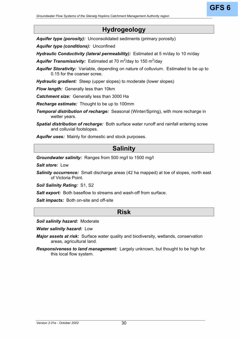
GFS 5
Hydrogeology Aquifer type (porosity): Fractured saprock and saprolite (secondary porosity) Aquifer type (conditions): Unconfined and semi confined Hydraulic Conductivity (lateral permeability): Highly variable. Probably varies from
approximately 10-5 m/d to 10-1 m/d. May be higher in the upper regolith. Aquifer Transmissivity: Highly variable in the low to moderate range. Estimated to be
generally less than 10 m2/d. Aquifer Storativity: Variable. Generally estimated to be less than 0.03. Hydraulic gradient: Estimated to be moderate in intermediate systems and locally
steep in local systems. Flow length: Generally <25 km for intermediate systems and <5 km for local systems. Catchment size: Small (~<500 Ha) for local systems and moderate (>100 km2) for
intermediate systems. Recharge estimate: Annually, approximately 100 mm to 50 mm for the upper regolith
aquifer and 20 mm for the fractured rock system. Temporal distribution of recharge: Seasonal (winter and spring), with more recharge
in wetter years. Spatial distribution of recharge: Catchment wide but varies with the depth of regolith,
slope and wet areas in the landscape. Aquifer uses: Minor use, mainly for stock and domestic purposes.
Salinity Groundwater salinity: Generally in the range of 1000 mg/l to 8000 mg/l Salt store: Moderate to high. Salinity occurrence: Valley floor, break-of-slope, hillside seeps. Soil Salinity Rating: S1 to S3. Salt export: Both baseflow to streams and wash-off from surface. Salt impacts: Mainly on-site. Some off-site impacts (eg. on the north side of the Stavely
Hills, some salt wash-off to the Cockajemmy Lakes).
Risk Soil salinity hazard: Moderate. Water salinity hazard: High. Major assets at risk: Streams, rivers, lakes, conservation areas, agricultural land. Responsiveness to land management: Largely unknown, but thought to be moderate
for intermediate flow systems and high for local flow systems.
Version 2.01e - October 2002 26
Groundwater Flow Systems of the Glenelg Hopkins Catchment Management Authority region
Management Options Recharge control measures would need to be broad-scale to be effective. The
dominant vertical recharge suggests that the control would be proportional to the area under trees or lucerne. However, it is noted from the historical evidence (photographs, sketches) that this landscape was not heavily treed before agricultural settlement. Short rotation woodlots such as timber belts or alleys can be used to mine soil water held at depth and intercept lateral flows. Cropping systems incorporating lucerne should also be effective. Native grasses may also be useful, although the recharge benefit has yet to be quantified.
Groundwater pumping could be used to protect high value assets, although the disposal of the pumped water would need to be carefully considered. The low permeability landscapes make sub-surface drainage unviable for recharge control. Both surface and sub-surface interceptor drains may be used to divert lateral flow in the upper regolith away from discharge areas but the economics and the disposal issues are problematic.
Treatment of saline areas using salt tolerant species remains an effective strategy to increase productivity and/or biodiversity.
Options for Managing Dryland Salinity within Groundwater Flow Systems in the Glenelg Hopkins CMA Region
Groundwater Flow System Options Treatments Comments
Perennial pastures
Low to Moderate – Limited by high rainfall and responsiveness of intermediate flow systems. Can reduce soil moisture excess in areas with less than 700mm annual rainfall.
Crop management
Moderate – Modified cropping systems should incorporate lucerne.
Biological Management of recharge
Trees/woody vegetation
Moderate – The control is directly proportional to the area under trees. Short rotation woodlots can be effective in reducing deep soil water.
Surface drainage
Low – Reduction of recharge is difficult. Interception drains can be used to control lateral flow in the upper regolith.
Engineering intervention
Groundwater pumping
Moderate– could be used to protect high value assets.
Salt tolerant pastures
Moderate to high – Salt and water logging tolerant grasses
Halophytic vegetation Low – Poorly suited to climate
Saline aquaculture
Moderate – Technically feasible and may provide opportunities where salt and nutrients can be managed
Salt harvesting
Low – Groundwater insufficiently saline
Local flow systems in deeply weathered granites
Productive uses of saline land and water
Others See OPUS database (NDSP)
GFS 5
Version 2.01e - October 2002 27
Groundwater Flow Systems of the Glenelg Hopkins Catchment Management Authority region
GFS 6
Local Flow Systems in Grampians Group colluvial slopes
Above: Colluvial slope rising from the foot of Mount Sturgeon, Dunkeld.
Version 2.01e - October 2002 28
Groundwater Flow Systems of the Glenelg Hopkins Catchment Management Authority region
GFS 6
Local Flow Systems in Grampians Group colluvial slopes
Region: Grampians, Dundas and Black Ranges of Western Victorian Uplands.
Type areas: Grampians footslopes, Yarram Park. Description: The ongoing erosion of the Grampians Ranges, Black Range and Dundas Range has produced colluvial slopes that drape the lower slopes of the ranges. The colluvium varies from coarse angular rocks (scree) to sandy soils (sometimes podsolised to form coffee rock). Groundwater is held in the pore spaces of the rock fragments and soil particles. Recharge is from both rainfall and surface runoff from higher upslope. Discharge occurs at the foot of the slopes and as baseflow to lakes and streams. Problem statement: Within this GFS, only small areas of salinity occur north east of Victoria Point (approximately 42 Ha). However, the colluvial slopes provide recharge area to offsite salinity discharge. The groundwater is a valuable resource for domestic and stock supplies.
Landscape attributes Geology: Quaternary (Pleistocene) colluvium and alluvium (Qpa). Topography: Steep scree slopes grading to colluvial fans and footslopes.
Land Systems: 2.0 Western Uplands:
2.2 Strike ridges and valleys (Grampians). 2.2.1 Ridges 2.2.2 Valleys, terraces and floodplains
Regolith: Unconsolidated sediments ranging from boulders to sandy loams. Annual rainfall: Approximately 650mm to 800mm. Dominant mid-1800s vegetation type: Forest, shrubland. Current dominant land uses: National Park and some grazing. Mapping method: Outcrop geology, Land Systems.
Version 2.01e - October 2002 29
Groundwater Flow Systems of the Glenelg Hopkins Catchment Management Authority region
GFS 6
Hydrogeology Aquifer type (porosity): Unconsolidated sediments (primary porosity) Aquifer type (conditions): Unconfined Hydraulic Conductivity (lateral permeability): Estimated at 5 m/day to 10 m/day Aquifer Transmissivity: Estimated at 70 m2/day to 150 m2/day Aquifer Storativity: Variable, depending on nature of colluvium. Estimated to be up to
0.15 for the coarser scree. Hydraulic gradient: Steep (upper slopes) to moderate (lower slopes) Flow length: Generally less than 10km Catchment size: Generally less than 3000 Ha Recharge estimate: Thought to be up to 100mm Temporal distribution of recharge: Seasonal (Winter/Spring), with more recharge in
wetter years. Spatial distribution of recharge: Both surface water runoff and rainfall entering scree
and colluvial footslopes. Aquifer uses: Mainly for domestic and stock purposes.
Salinity Groundwater salinity: Ranges from 500 mg/l to 1500 mg/l Salt store: Low Salinity occurrence: Small discharge areas (42 ha mapped) at toe of slopes, north east
of Victoria Point. Soil Salinity Rating: S1, S2 Salt export: Both baseflow to streams and wash-off from surface. Salt impacts: Both on-site and off-site
Risk Soil salinity hazard: Moderate Water salinity hazard: Low Major assets at risk: Surface water quality and biodiversity, wetlands, conservation
areas, agricultural land. Responsiveness to land management: Largely unknown, but thought to be high for
this local flow system.
Version 2.01e - October 2002 30
Groundwater Flow Systems of the Glenelg Hopkins Catchment Management Authority region
GFS 6
Management Options The area of salinity mapped within this GFS occurs along the drainage lines of
the lower slopes north east of Victoria Point. Since the majority of the GFS is mostly National Park or public land, the majority of the landscape has not been cleared for agricultural settlement. There is very limited scope for changing the status quo.
Within the cleared areas, the value of perennial pastures in reducing recharge for salinity control is marginal given that the rainfall approaches 700 mm, although some areas where there is a significant rain shadow aspect (i.e. eastern slopes), opportunities may be better. Block plantings of trees may provide a management opportunity in the right landscape setting if the economics allow this to be incorporated into a farming system on a sufficiently broad scale. However, this would be very site dependant, since the majority of the GFS is already treed.
Surface drainage may be useful to divert runoff and throughflow away from discharge areas. Groundwater pumping may be considered to protecting a discrete asset, although the management of the groundwater resource needs to be considered.
Options for Managing Dryland Salinity within Groundwater Flow Systems in the Glenelg Hopkins CMA Region
Groundwater Flow System Options Treatments Comments
Perennial pastures
Low – May be an option in cleared areas within a rain shadow zone.
Crop management Not applicable Biological
Management of recharge
Trees/woody vegetation
Low – Most areas remain treed. Limited benefit in some landscape settings within cleared areas.
Surface drainage
Low – Can be used to divert runoff and throughflow away from discharge areas. Engineering
intervention Groundwater pumping
Low – May be an option where high value assets need protection.
Salt tolerant pastures Not applicable.
Halophytic vegetation Not applicable.
Saline aquaculture Not applicable.
Salt harvesting Not applicable.
Local flow systems in Grampians Group colluvial slopes.
Productive uses of saline land and water
Others Not applicable.
Version 2.01e - October 2002 31
Groundwater Flow Systems of the Glenelg Hopkins Catchment Management Authority region
GFS 7
Local and Intermediate Flow Systems in Grampians Group rocks
Left: Sandstone escarpment at The Pinnacle, near Dunkeld.
Version 2.01e - October 2002 32
Groundwater Flow Systems of the Glenelg Hopkins Catchment Management Authority region
GFS 7
Local and Intermediate Flow Systems in Grampians Group rocks
Region: Grampian, Black and Dundas Ranges of Western Victorian Uplands
Type areas: Grampians Ranges, Black Range, Mount Dundas Description: The sandstone of the Grampians Group rocks was deposited around 450 million years ago in terrestrial to marginally marine fluvial environments of large river systems. The deposits were subsequently transported several kilometres by thrust faults, which stacked the strata in repetitive sequence. The rocks were then eroded, intruded by granites and dissected by prolonged erosion to form the present day strike ridges. Groundwater is held in the fractures in the sandstone (the grains of which have been welded by the rock-forming process) and discharges into the streams and lakes around the base of the ranges. Problem statement: The aquifer is a valuable source of fresh water for irrigation and domestic supply. Discharge from the Grampians Flow Systems has a role in the salinity processes at Willaura.
Landscape attributes Geology: Silurian Grampians Group (Sr) Topography: Strike ranges and valleys.
Land Systems: 2.0 Western Uplands:
2.2 Strike ridges and valleys (Grampians). 2.2.1 Ridges
Regolith: Thin stony soils, where present. Annual rainfall: 600 mm (northern slopes) to 1000 mm on ridges Dominant mid-1800s vegetation type: Forest, shrubland, scrub Current dominant land uses: Conservation, water supply, tourism Mapping method: Outcrop geology, Land Systems
Version 2.01e - October 2002 33
GFS 7 Groundwater Flow Systems of the Glenelg Hopkins Catchment Management Authority region
Hydrogeology Aquifer type (porosity): Fractured rock (secondary porosity) Aquifer type (conditions): Unconfined Hydraulic Conductivity (lateral permeability): Largely unknown. May vary from
approximately 10-2 m/d to 1 m/d based on bore yields Aquifer Transmissivity: Variable in the low to moderate range. Estimated to be
generally less than 50 m2/d. Aquifer Storativity: Largely unknown. Estimated to be less than 0.05. Hydraulic gradient: Estimated to be moderate in intermediate systems and locally
steep in local systems. Flow length: Generally <25 km for intermediate systems and <5 km for local systems. Catchment size: Small (~<500 Ha) for local systems and moderate (>100 km2) for
intermediate systems. Recharge estimate: Unknown. May be 50mm to 100mm annually. Temporal distribution of recharge: Seasonal (winter and spring), with more recharge
in wetter years. Spatial distribution of recharge: Catchment wide but varies with the degree of
fracturing and slope. Aquifer uses: Groundwater discharge to streams in the Grampians is a significant
contribution to urban and irrigation water supplies. Bores supply stock and domestic use.
Salinity Groundwater salinity: Generally in the range of 500 mg/l to 1500 mg/l (Black Range) Salt store: Low Salinity occurrence: None known. Soil Salinity Rating: Not Applicable Salt export: Not Applicable Salt impacts: Contributes to salinity processes at Willaura?
Risk Soil salinity hazard: Low Water salinity hazard: Low Major assets at risk: Water quality, urban water supplies, conservation areas. Responsiveness to land management: Largely unknown and not applicable
(conservation area)
Management Options This GFS has no known salinity problems. Groundwater management is required to ensure sustainable water supply and protect water quality.
Version 2.01e - October 2002 34
Groundwater Flow Systems of the Glenelg Hopkins Catchment Management Authority region
GFS 8
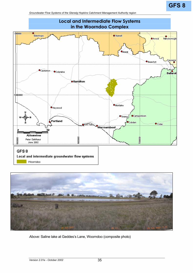
Local and Intermediate Flow Systems in the Woorndoo Complex
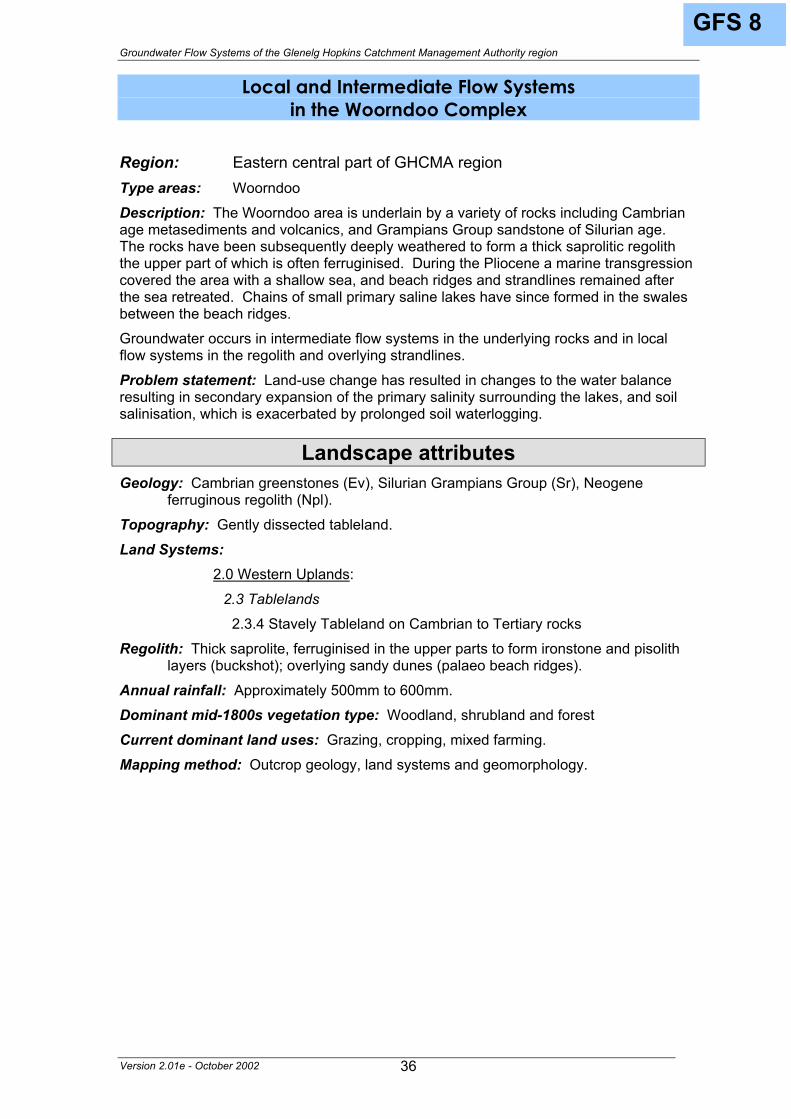
Above: Saline lake at Geddes’s Lane, Woorndoo (composite photo)
Version 2.01e - October 2002 35
Groundwater Flow Systems of the Glenelg Hopkins Catchment Management Authority region
GFS 8
Local and Intermediate Flow Systems in the Woorndoo Complex
Region: Eastern central part of GHCMA region Type areas: Woorndoo Description: The Woorndoo area is underlain by a variety of rocks including Cambrian age metasediments and volcanics, and Grampians Group sandstone of Silurian age. The rocks have been subsequently deeply weathered to form a thick saprolitic regolith the upper part of which is often ferruginised. During the Pliocene a marine transgression covered the area with a shallow sea, and beach ridges and strandlines remained after the sea retreated. Chains of small primary saline lakes have since formed in the swales between the beach ridges. Groundwater occurs in intermediate flow systems in the underlying rocks and in local flow systems in the regolith and overlying strandlines. Problem statement: Land-use change has resulted in changes to the water balance resulting in secondary expansion of the primary salinity surrounding the lakes, and soil salinisation, which is exacerbated by prolonged soil waterlogging.
2.3.4 Stavely Tableland on Cambrian to Tertiary rocks Regolith: Thick saprolite, ferruginised in the upper parts to form ironstone and pisolith
layers (buckshot); overlying sandy dunes (palaeo beach ridges). Annual rainfall: Approximately 500mm to 600mm. Dominant mid-1800s vegetation type: Woodland, shrubland and forest Current dominant land uses: Grazing, cropping, mixed farming. Mapping method: Outcrop geology, land systems and geomorphology.
Version 2.01e - October 2002 36
Groundwater Flow Systems of the Glenelg Hopkins Catchment Management Authority region
GFS 8
Hydrogeology Aquifer type (porosity): Fractured rock and saprolite (secondary porosity), strand-line
dune system (primary porosity) Aquifer type (conditions): Unconfined (local) to semi confined (intermediate) Hydraulic Conductivity (lateral permeability): Less than 1 m/d for the fractured rock,
0.1 - 0.5 m/day for saprolite, possibly higher in the dunes. Aquifer Transmissivity: Generally less than 20 m2/d for the fractured rock, and less
than 2 m2/d for the saprolite. Aquifer Storativity: Variable. Estimated to be less than 0.03 for saprolite, 0.02 to 0.05
for the fractured rock, and 0.05 to 0.10 for the dune systems. Hydraulic gradient: Low Flow length: Can be up to 20 km for the intermediate systems, and up to 2 km for local
systems Catchment size: Up to 1000 ha Recharge estimate: Estimated to be 20mm to 30mm to intermediate flow systems and
up to 50mm to local flow systems in the dunes and saprolite. Temporal distribution of recharge: Seasonal (Winter and Spring) with higher recharge
in wetter years. Spatial distribution of recharge: Catchment wide, but higher on dunes and ridges. Aquifer uses: Minor use, mainly for stock and domestic purposes.
Salinity Groundwater salinity: Varies from 120 mg/l to 15000 mg/l Salt store: High in saprolite and dunes Salinity occurrence: Break of slope, primary salinity in lakes has been exacerbated by
throughflow, and along lower slopes. Soil Salinity Rating: S1, S2, S3. Salt export: Both baseflow to lakes and streams and wash-off from surface. Salt impacts: On site and off-site, major impacts is on the lakes.
Risk Soil salinity hazard: Moderate to high. Water salinity hazard: Moderate to high. Major assets at risk: Wetlands and associated biodiversity, conservation areas,
agricultural land. Responsiveness to land management: Low for intermediate flow systems and
moderate for local flow systems.
Version 2.01e - October 2002 37
Groundwater Flow Systems of the Glenelg Hopkins Catchment Management Authority region
GFS 8
Management Options This area has been well studied and the management options have been clearly
documented1. Much of the salinity problem is associated with the expansion of the primary salinity sites. The regional vegetation plan identifies brackish lakes and permanent saline lakes as high priority ecological vegetation classes. Protection of the sites through application of biodiversity protocols and restoration of indigenous vegetation offers multiple benefits.
Recharge control is most effective where tree belts are planted in strategic locations in the landscape to intercept throughflow and control the recharge to the local flow systems in the upper regolith and dunes. Farm forestry may be viable, provided that it fits with the farming system. Use of lucerne during cropping leys is also considered effective. Perennial pastures can reduce recharge and soil moisture excess in local systems as well as control soil waterlogging.
Surface and sub-surface drains in strategic locations in the landscape can divert surface water runoff and intercept throughflow. However most soils are sodic and may not be suited to drainage. Groundwater pumping using windmills and disposal into the adjoining lakes may be an option provided that the lake ecology is not unduly affected. Where the water is less saline, pumping into dams for aquaculture or stock water may be viable.
The use of salt tolerant species in saline areas can reduce waterlogging and maintain biodiversity or production, depending on the species chosen.
Options for Managing Dryland Salinity within Groundwater Flow Systems in the Glenelg Hopkins CMA Region
Groundwater Flow System Options Treatments Comments
Perennial pastures
Low to moderate – can reduce recharge and soil moisture excess in local systems.
Crop management
Moderate – cropping systems should incorporate lucerne.
Biological Management of recharge
Trees/woody vegetation
Moderate to high– Most effective where tree belts are used in conjunction with other management methods.
Surface drainage
Moderate to high– Interception of surface runoff and throughflow. Most soils are unsuitable. Engineering
intervention Groundwater pumping
Moderate – Disposal of water an issue.
Salt tolerant pastures
Moderate to high – Salt and water logging tolerant grasses
Halophytic vegetation Low – Poorly suited to climate
Saline aquaculture
Low to moderate – can be used with groundwater pumping if salinity is low.
Salt harvesting
Low – Groundwater insufficiently saline
Local and intermediate flow systems in the Woorndoo Complex
Productive uses of saline land and water
Others See OPUS database (NDSP)
Version 2.01e - October 2002 38
1 Fitzpatrick, Cox, Mintern. 1999.
GFS 9 Groundwater Flow Systems of the Glenelg Hopkins Catchment Management Authority region
Local Flow Systems in the West Dundas Tablelands
Below: Extract from an 1843 map of the Koroite Rivulet (Bryan Creek) showing salt pools.
Version 2.01e - October 2002 39
Groundwater Flow Systems of the Glenelg Hopkins Catchment Management Authority region
GFS 9
Local Flow Systems in the West Dundas Tablelands
Region: North western GHCMA region (Western Victorian Uplands) Type areas: Pigeon Ponds, Gringegalgona, Koonongwootong, Wando Vale. Description: The West Dundas Tablelands are underlain by rocks comprising (i) the Glenelg River Complex – granites, pegmatites and mica schists, of Cambrian to Ordovician age (~ 540 to 450 Ma); (ii) Intrusive rocks – granites and granodiorite of Early Devonian age (~ 400 Ma); (iii) sporadic glacial deposits – coarse to fine-grained sediments of Permian age (~ 260 Ma); (iv) sporadic volcanic rocks – trachyte of Jurassic age (~ 170 Ma); and (v) marine sediments – sands of Pliocene age (~3 Ma). The rocks have been very deeply weathered to form a thick saprolitic regolith, the upper part of which has been extensively ferruginised. Since the Pliocene sea retreated, the Tablelands have been uplifted which has renewed the erosion of the creeks and rivers. Very little is known of the region’s deeper groundwater flow systems, but local systems would be present in the regolith. Soil and regolith profiles provide evidence that lengthy seasonal waterlogging has occurred for centuries or millennia, indicating that the watertables were near-surface before widespread land-use change. Problem statement: Primary saline discharge is recorded in the earliest historical records. Land-use change has significantly altered the water balance of the upper regolith local flow systems, resulting in secondary salinity.
Landscape attributes Geology: Cambrian Glenelg River Group – sedimentary (Eg), Cambrian Glenelg River
2.3.1 Western part of Dundas Tablelands Regolith: Deep saprolite, ferruginised in the upper part to form ironstone and pisolitic
horizons (buckshot). Annual rainfall: Approximately 600 mm in valleys to 800 mm on plateaux. Dominant mid-1800s vegetation type: Open woodland, shrubby understorey. Current dominant land uses: Grazing, minor cropping, farm forestry. Mapping method: Outcrop geology, Land Systems, geological structures.
Version 2.01e - October 2002 40
Groundwater Flow Systems of the Glenelg Hopkins Catchment Management Authority region
GFS 9
Hydrogeology Aquifer type (porosity): Fractured saprolite (secondary porosity), buckshot gravels
(primary porosity) Aquifer type (conditions): Unconfined Hydraulic Conductivity (lateral permeability): Probably less than 0.1 - 0.5 m/day. Aquifer Transmissivity: Probably less than 10 m2/d. Aquifer Storativity: Probably variable. Estimated to be less than 0.05. Hydraulic gradient: Probably steep to locally very steep. Flow length: Possibly up to 2 km. Catchment size: Probably less than 1000ha Recharge estimate: Possibly 50mm to 100mm Temporal distribution of recharge: Seasonal (Winter/Spring) with more recharge in
wetter years. Spatial distribution of recharge: Catchment wide Aquifer uses: Mainly for stock and domestic purposes.
Salinity Groundwater salinity: Generally 3000 mg/l to 7000 mg/l Salt store: High Salinity occurrence: Drainage lines, break of slope, hillside seeps. Soil Salinity Rating: S1, S2 Salt export: Both baseflow to streams and wash-off from surface. Salt impacts: Both on-site (agricultural land) and off-site
Risk Soil salinity hazard: Moderate to high Water salinity hazard: High in streams and high offsite (Koonongwootong Reservoir) Major assets at risk: Urban water supply, stream and river water quality and
biodiversity, engineering and agricultural infrastructure, agricultural land. Responsiveness to land management: Possibly moderate to high.
Version 2.01e - October 2002 41
Groundwater Flow Systems of the Glenelg Hopkins Catchment Management Authority region
GFS 9
Management Options Despite the fact that this GFS has one of the highest levels of salinity in the Glenelg
Hopkins region, little is known about the salinity processes. Primary salinity was present in the landscape at the time of the first recorded surveys. It is probable that the local groundwater flow system provides excess lateral flow to the discharge areas, which may spread the primary saline discharge (although this would also imply the presence of a deeper, intermediate or regional system). Recharge control may be best targeted to the establishment of tree belts in strategic positions in the landscape, aimed at intercepting the lateral flow.
Surface and subsurface drainage could also be used to intercept the lateral near-surface flows and divert them to dams or storage areas. However the widespread occurrence of sodic soils renders many areas unsuited to the construction of drains. Groundwater pumping is generally unsuited as a salinity control measure, except for the local protection of a high-value asset.
Treatment of saline discharge areas provides major advantages for the reduction of waterlogging and increasing productivity and biodiversity. The Regional Vegetation Plan identifies brackish drainage lines as high priority ecological vegetation classes, and the protection of sites through the application of biodiversity protocols and reestablishment offers multiple benefits.
Options for Managing Dryland Salinity within Groundwater Flow Systems in the Glenelg Hopkins CMA Region
Groundwater Flow System Options Treatments Comments
Perennial pastures
Low to moderate – can reduce recharge and soil moisture excess in local systems. In areas of less than 700 mm rainfall.
Crop management Low – very little cropping undertaken.
Biological Management of recharge
Trees/woody vegetation
Moderate to high– Most effective where interception tree belts are used in conjunction with other management methods.
Surface drainage
Moderate to high– Interception of surface runoff and throughflow. Most soils are unsuitable. Engineering
intervention Groundwater pumping Low – Disposal of water an issue.
Salt tolerant pastures
Moderate to high – Salt and water logging tolerant grasses. Need to consider biodiversity protection.
Halophytic vegetation Low – Poorly suited to climate
Saline aquaculture
Low – poor aquifer capacity and yields.
Salt harvesting
Low – Groundwater insufficiently saline
Local flow systems in the West Dundas Tablelands
Productive uses of saline land and water
Others See OPUS database (NDSP)
Version 2.01e - October 2002 42
Groundwater Flow Systems of the Glenelg Hopkins Catchment Management Authority region
GFS 10
Local and Regional Flow Systems in East Dundas Tablelands
Left: Break-of-slope saline discharge near Bulart.
Version 2.01e - October 2002 43
Groundwater Flow Systems of the Glenelg Hopkins Catchment Management Authority region
GFS 10
Local and Regional Flow Systems in East Dundas Tablelands
Region: North western GHCMA region (Western Victorian Uplands) Type areas: Bulart, Gatum, Merrifields, Mooralla Description: The East Dundas Tablelands are underlain by the Rocklands Volcanics (ignimbrite), emplaced during violent volcanic eruptions about 400 million years ago. The ignimbrite has been subsequently deeply weathered to form a thick saprolitic regolith, the upper part of which has been extensively ferruginised. A shallow sea covered part of the GFS during the Pliocene (~ 3 Ma), resulting in the deposition of strandlines. Since the sea retreated, the Tableland has been uplifted which has renewed the erosion of the creeks and rivers. A regional groundwater flow system in the fractured rocks and lower regolith is overlain by local flow systems in the upper regolith. Problem statement: Land-use change has significantly altered the water balance of the upper regolith local flow systems. Primary saline discharge from the regional groundwater system is spread by throughflow and waterlogging. The area has 6000 hectares of salinity mapped.
Landscape attributes Geology: Cambrian Glenelg River Group (Eg), Cambrian greenstones (Ev), Devonian
2.3.2 Eastern part of Dundas Tablelands Regolith: Deep saprolite, ferruginised in the upper part to form ironstone and pisolitic
horizons (buckshot). Annual rainfall: Approximately 700mm Dominant mid-1800s vegetation type: Open woodland, shrub understorey. Current dominant land uses: Grazing, minor cropping, farm forestry. Mapping method: Outcrop geology, Land Systems, geological structures. Left: Saline groundwater discharge spring near Bulart.
Version 2.01e - October 2002 44
GFS 10 Groundwater Flow Systems of the Glenelg Hopkins Catchment Management Authority region
Hydrogeology Aquifer type (porosity): Saprolite and fractured rock, well connected (secondary), some
buckshot (primary). Aquifer type (conditions): Unconfined and semi confined Hydraulic Conductivity (lateral permeability): less than 0.2 m/d for the fractured rock,
0.1 - 0.5 m/day for saprolite. Aquifer Transmissivity: Generally less than 20 m2/d for the fractured rock, and less
than 2 m2/d for the saprolite. Aquifer Storativity: Variable. Estimated to be less than 0.01 for fractured rock and
0.04 to 0.05 for the saprolite. Hydraulic gradient: Low for the regional flow system (estimated 0.001) and moderate
for local flow systems (0.01) Flow length: Up to 40 km for regional flow systems and usually less than 1 km for local
flow systems. Catchment size: Up to 100000ha for regional systems, generally less than 50ha for
local flow systems Recharge estimate: Very low for the regional system, possibly 50mm to 100mm for the
local flow systems. Temporal distribution of recharge: Unknown for the regional flow system (possibly
continuous), seasonal (Winter/Spring) for the local system, with more recharge in wetter years.
Spatial distribution of recharge: Unknown for the regional flow system, Catchment wide for the local flow systems
Aquifer uses: Mainly for stock and domestic purposes.
Salinity Groundwater salinity: Varies from 1500 mg/l to 7000 mg/l in regional system and from
5000 mg/l to 15000 mg/l in local flow systems Salt store: Low in the fractured rock, high in the saprolite Salinity occurrence: Drainage lines, break of slope, hillside seeps. Soil Salinity Rating: S1, S2, S3. Soil ECe up to 16 dS/m Salt export: Both baseflow to streams and wash-off from surface. Salt impacts: Both on-site (soil salinity, baseflow) and off-site (baseflow, eg. Rocklands
Reservoir).
Risk Soil salinity hazard: High Water salinity hazard: High Major assets at risk: Water quality and biodiversity (especially Rocklands Reservoir),
agricultural land, engineering and agricultural infrastructure. Responsiveness to land management: Low for regional systems and moderate for
local flow systems.
Version 2.01e - October 2002 45
Groundwater Flow Systems of the Glenelg Hopkins Catchment Management Authority region
Management Options On a per hectare basis, this GFS has the most area affected by salinity in the
Glenelg Hopkins region. Over the past few decades, several research projects and government studies have provided diverse and sometimes controversial theories on the salinity processes. Undoubtedly, primary salinity was present in the landscape at the time of the first recorded surveys. Groundwater discharges from a regional system as baseflow to streams and as springs in the landscape. It is probable that land-use changes have affected the local groundwater flow systems providing increased flow to the discharge areas, which may spread the primary saline discharge. Recharge control may be targeted to the establishment of tree belts in strategic positions in the landscape, to reduce the recharge to local systems and intercept lateral flow in the upper regolith.
Surface and subsurface drainage could also be used to intercept the lateral near-surface flows and divert them to dams or storage areas. However the widespread occurrence of sodic soils renders many areas unsuited to the construction of drains. Constructing dams on the spring discharge areas can control the downslope spread of saline areas. Groundwater pumping is generally unsuited as a salinity control measure, except for the local protection of a high-value asset.
Treatment of saline discharge areas provides major advantages for the reduction of waterlogging and increasing productivity and biodiversity. The Regional Vegetation Plan identifies brackish drainage lines as high priority ecological vegetation classes, and the protection of sites through the application of biodiversity protocols and reestablishment offers multiple benefits.
Options for Managing Dryland Salinity within Groundwater Flow Systems in the Glenelg Hopkins CMA Region
Groundwater Flow System Options Treatments Comments
Perennial pastures
Low to moderate – can reduce recharge and soil moisture excess in local systems. In areas of less than 700 mm rainfall.
Crop management Low – very little cropping undertaken.
Biological Management of recharge
Trees/woody vegetation
Moderate to high– Most effective where interception tree belts are used in conjunction with other management methods.
Surface drainage
Moderate to high– Interception of surface runoff and throughflow. Most soils are unsuitable. Engineering
intervention Groundwater pumping Low – Disposal of water an issue.
Salt tolerant pastures
Moderate to high – Salt and water logging tolerant grasses. Need to consider biodiversity protection.
Halophytic vegetation Low – Poorly suited to climate
Saline aquaculture
Low – poor aquifer capacity and yields.
Salt harvesting
Low – Groundwater insufficiently saline
Local flow systems in the West Dundas Tablelands
Productive uses of saline land and water
Others See OPUS database (NDSP)
GFS 10
Version 2.01e - October 2002 46
Groundwater Flow Systems of the Glenelg Hopkins Catchment Management Authority region
GFS 11
Intermediate and Local Flow Systems in the Pliocene sands
Left: Managed saline discharge area near Hexham
(643895E, 5793592N)
Version 2.01e - October 2002 47
Groundwater Flow Systems of the Glenelg Hopkins Catchment Management Authority region
GFS 11
Intermediate and Local Flow Systems in the Pliocene sands
Region: North western and south eastern areas of the GHCMA region. Type areas: Kanagulk, Cherrypool, Ayrford Description: In the Pliocene, a shallow sea covered most of the GHCMA region, apart from the hills around Beaufort and Ararat, the Grampians and parts of the Dundas Tablelands. As the sea retreated, a thin veneer of gravels, sands, silts and clays were deposited over the landscape. Subsequently, the Pliocene sand sheet was covered in many places by more recent volcanic rocks or aeolian sands, and in other areas it has been eroded away and only remnants remain. In some areas the sands have been ferruginised or silicified. Groundwater generally moves slowly through the Pliocene sands in intermediate flow systems. The local flow systems occur where the sand forms isolated caps and where iron or silica cement has shortened the flow paths. Discharge occurs in streams, wetlands and as springs at the base of the unit. In the local flow systems discharge mostly occurs as elevated springs at the base of the thin remnant sand caps. In the Merino Tablelands, these springs are an integral process of landscape evolution by providing a mechanism for landslides. Problem statement: Primary salinity was probably a feature of these systems. Land-use change has resulted in increased recharge and discharge through the local flow systems, resulting in an increase in salinity.
Annual rainfall: 600 mm to 800 mm Dominant mid-1800s vegetation type: Shrubland, scrub, heathland, forest. Current dominant land uses: Grazing, cropping, dairying, farm forestry and
conservation. Mapping method: Outcrop geology, Land Systems.
Version 2.01e - October 2002 48
Groundwater Flow Systems of the Glenelg Hopkins Catchment Management Authority region
GFS 11
Hydrogeology Aquifer type (porosity): Gravels to fine sands, silts and clays (primary porosity),
fractured ferruginised or silicified rock (secondary porosity). Aquifer type (conditions): Unconfined, semi-confined to confined Hydraulic Conductivity (lateral permeability): Variable and largely unknown.
Probably from 10-2 m/d to 10 m/d Aquifer Transmissivity: Variable, but generally in the moderate range. Estimated to be
generally less than 20 m2/d. Aquifer Storativity: Variable. Estimated to be from 0.05 to 0.10. Hydraulic gradient: Estimated to be very low (0.0001) in intermediate systems on the
plains to moderate (0.01) in local systems. Could be locally steep at the edges of the Pliocene sand caps on dissected ridges.
Flow length: Unknown. Possibly up to 50km in intermediate systems to <0.1 km in local systems.
Catchment size: Estimated to vary from very small (<1 Ha) in local systems to moderate (>1000 Ha) in intermediate systems.
Recharge estimate: Varies with location. Not able to be estimated. Temporal distribution of recharge: Seasonal (Winter and Spring), with significantly
more recharge in wetter years. Spatial distribution of recharge: Catchment wide on outcrops and probably extensive
leakage from overlying basalt (GFS 14), stony rises (GFS 2) and Sand Plains (GFS 15).
Aquifer uses: Minor stock and domestic use.
Salinity Groundwater salinity: Generally in the range of 1000 mg/l to 10000 mg/l Salt store: Moderate to High Salinity occurrence: Drainage depressions (lakes, swamps), some flat areas adjacent
to basalt boundaries, and at the base of the unit (break of slope). Soil Salinity Rating: S2 to S3. Salt export: Wash off from surface and base flow discharge to lakes and rivers. Salt impacts: Both on-site and off-site
Salinity Risk Soil salinity hazard: Moderate to High (scalding). Water salinity hazard: Moderate. Major assets at risk: Water quality and aquatic biodiversity, engineering infrastructure,
conservation areas, agricultural land. Responsiveness to land management: Largely unknown, but thought to be high for
local systems and low for intermediate systems.
Version 2.01e - October 2002 49
Groundwater Flow Systems of the Glenelg Hopkins Catchment Management Authority region
GFS 11
Management Options The intermediate flow systems in the sheet sands would require broadscale
recharge control to generate any significant impacts. A significant proportion of the sand sheet is recharged from leakage of water through the overlying volcanic rock, and any recharge control effort would also be required across the basalt plains. In terms of agriculture, biodiversity and economics, this would be undesirable, impractical and uneconomic. In addition, the system would be slow to respond, especially given the low hydraulic gradients. Massive revegetation of the sand sheet such as the Blue Gum plantations in the north western CMA region should reduce salinity, but may not eliminate the process. Where the local systems occur in isolated sand sheets, biological options for recharge control are more practical, for example around the edge of the Merino Tableland.
Current economics as well as off-site drainage considerations are likely to render engineering solutions as unfeasible.
Where saline discharge occurs on a ‘window’ of Pliocene sands in the Volcanic Plain, such as west of Mortlake, the most feasible salinity management option probably lies with saline agronomy opportunities.
Options for Managing Dryland Salinity within Groundwater Flow Systems in the Glenelg Hopkins CMA Region
Groundwater Flow System Options Treatments Comments
Perennial pastures
Low to moderate – Suitable below 700mm rainfall, but salinity benefits dependant on scale of flow system
Crop management
Low to moderate – Potential for inter-cropping with lucerne
Biological Management of recharge
Trees/woody vegetation
Low to moderate – May be some benefit from broadscale plantations. Local systems should respond.
Surface drainage
Low – little opportunity to intercept recharge and off-site disposal limited for discharge management. Engineering
intervention Groundwater pumping
Moderate – Feasible only where high value assets are to be protected
Salt tolerant pastures
Moderate – Salt tolerant grasses, existing technologies
Halophytic vegetation Low – Poorly suited to climate
Saline aquaculture
Moderate – May be feasible in conjunction with asset protection, but issues of salt and nutrient management need consideration
Salt harvesting
Low – Groundwater not sufficiently saline
Intermediate and local flow systems in Pliocene sands
Productive uses of saline land and water
Others See OPUS database (NDSP)
Version 2.01e - October 2002 50
Groundwater Flow Systems of the Glenelg Hopkins Catchment Management Authority region
GFS 12
Intermediate and Local Flow Systems in the Merino Tablelands
Above: Landslide in the Cretaceous Otway Group Rocks south of Coleraine. This landslide has been caused by lateral water flow in the upper part of the slope.
Version 2.01e - October 2002 51
GFS 12 Groundwater Flow Systems of the Glenelg Hopkins Catchment Management Authority region
Intermediate and Local Flow Systems in the Merino Tablelands
Region: Central western GHCMA region (West Victorian Uplands) Type areas: Casterton, Merino Description: The lithic sandstone and mudstone rocks of the Cretaceous age Otway Group occur in outcrop over the majority of the Merino Tablelands and locally around the western edge Dundas Tablelands. They have been deeply weathered and are covered by residual clay soils. Groundwater flows through the fractured rocks in intermediate flow systems and through the regolith and steeper landscapes in local flow systems. Salinity occurs along drainage lines and at the break of slope. Problem statement: Land-use change has significantly altered the water balance of the upper regolith local flow systems. Primary saline discharge may have been present. There are 239 ha of salinity mapped, mostly along creek lines.
Landscape attributes Geology: Cretaceous Otway Group (Kl) Topography: Moderately to deeply dissected tableland.
Land Systems: 2.0 Western Uplands:
2.3 Tablelands
2.3.3 Merino Tableland on Cretaceous rocks Regolith: Saprolite developed over Cretaceous Otway Group rocks, fine-grained fluvial
sediments, remnant ferruginised regolith, variable depth. Annual rainfall: 700 to 800 mm. Dominant mid-1800s vegetation type: Forest, woodland. Current dominant land uses: Grazing. Mapping method: Outcrop geology, Land Systems
Version 2.01e - October 2002 52
Groundwater Flow Systems of the Glenelg Hopkins Catchment Management Authority region
GFS 12
Hydrogeology Aquifer type (porosity): Fractured rock and saprolite (secondary), sediments (primary) Aquifer type (conditions): Unconfined and semi confined Hydraulic Conductivity (lateral permeability): Unknown, estimated to be less than
one metre per day. Aquifer Transmissivity: Estimated to range from 10 m2/d to 20 m2/day Aquifer Storativity: Unknown. Estimated to be less than 0.03 for saprolite and 0.02 to
0.05 for the fractured rock. Hydraulic gradient: Moderate to steep Flow length: generally less than 5 km for local systems, less than 20 km for
intermediate systems Catchment size: up to 2000 Ha Recharge estimate: Ranges from less than 20 mm to 30 mm Temporal distribution of recharge: Seasonal (Winter/Spring) with more recharge in
wetter years. Spatial distribution of recharge: Catchment wide. Aquifer uses: Minor use, mainly for stock and domestic purposes?
Salinity Groundwater salinity: Ranges from 3000 mg/l to 7000 mg/l Salt store: Moderate Salinity occurrence: Valley floors and seeps. Soil Salinity Rating: S1, S2. Salt export: Both baseflow to streams and wash-off from surface. Salt impacts: Both on-site and off-site
Risk Soil salinity hazard: Moderate Water salinity hazard: Possibly high salt loads Major assets at risk: Stream water quality and aquatic biodiversity, engineering
infrastructure, conservation areas, agricultural land. Responsiveness to land management: Largely unknown, but thought to be moderate
for intermediate flow systems and high for local flow systems.
Version 2.01e - October 2002 53
Groundwater Flow Systems of the Glenelg Hopkins Catchment Management Authority region
GFS 12
Management Options The local groundwater flow systems provide the ability to achieve some level of
salinity control in this landscape, though the response times will likely be tempered by the effect of relatively deep weathered profiles. The value of perennial pastures in reducing recharge for salinity control is generally marginal given the high rainfall. In areas where soil conditions are suitable, lucerne offers considerable promise in its own right, but also as a rotation within a cropping system. Strategic planting of tree belts and blocks offer a management opportunity, particularly for intercepting water above saline seeps, if the economics allow this to be incorporated into a farming system on a sufficiently broad scale.
Surface and subsurface drainage may be useful for intercepting and diverting lateral flow away from saline discharge sites, however the unsuitability of soils for drainage construction will limit adoption at many sites.
Saline agronomy provides a useful management option for the control of saline discharge and soil waterlogging. However, primary discharge was probably a feature of this landscape and the Regional Vegetation Plan identifies brackish drainage lines as a high priority ecological vegetation class. Protection of biodiversity in saline sites can provide multiple benefits.
Options for Managing Dryland Salinity within Groundwater Flow Systems in the Glenelg Hopkins CMA Region
Groundwater Flow System Options Treatments Comments
Perennial pastures
Low – Generally unsuited climatically.
Crop management Uncertain, probably low.
Biological Management of recharge
Trees/woody vegetation
Moderate to high - interception of throughflow and controlling upper regolith hydrology in local flow systems. Most effective where tree belts are planted in strategic locations in the landscape and in when used in conjunction with other management methods
Surface drainage
Moderate – interception and diversion of water away from discharge areas. Engineering
intervention Groundwater pumping
Low – May be useful for high value assets protection
Salt tolerant pastures
Moderate – Salt tolerant grasses with existing technologies
Halophytic vegetation Low- Poorly suited to the climate
Saline aquaculture
Low – Issues of groundwater extraction and salt and nutrient management
Salt harvesting Low – Groundwater salinity too low
Intermediate and local flow systems in the Merino Tablelands.
Productive uses of saline land and water
Others See OPUS database (NDSP)
Version 2.01e - October 2002 54
Groundwater Flow Systems of the Glenelg Hopkins Catchment Management Authority region
GFS 13
Intermediate and Regional Flow Systems in fractured Palaeozoic rocks
Left: Saline discharge along a creek line west of Beaufort.
(707664E, 5855360N)
Version 2.01e - October 2002 55
Groundwater Flow Systems of the Glenelg Hopkins Catchment Management Authority region
GFS 13
Intermediate and Regional Flow Systems in fractured Palaeozoic rocks
Region: North eastern CMA region (Western Victorian Uplands) Type areas: Ballarat, Beaufort, Ararat Description: The sedimentary and metamorphic rocks in the north western part of the GHCMA region were formed around 500 million years ago during the Palaeozoic era. Since their formation they have been folded and faulted, injected with quartz veins and intruded by granites. Extensive erosion has removed several kilometres thickness of material and the exposed rocks are deeply weathered. More recent uplift and erosion has resulted in a dissected landscape covered by an uneven thickness of regolith comprising both saprolite and soil. Groundwater slowly moves through the fractured rocks in intermediate flow systems and through the regolith and steeper landscapes in local systems. Soil-water throughflow and interflow is also a significant component of the hydrologic system. Problem statement: Changes in water balance has altered the hydrology, which is the assumed cause of salinisation. The exact nature of the salinity process is unproven
Landscape attributes Geology: Cambrian greenstones (Ev), Cambrian Glenelg River Group (Eg), Cambrian
St Arnaud Group (Es), Ordovician Castlemaine Supergroup (Oll). Topography: Gently undulating hills, broad valleys, can be locally steep.
Land Systems: 2.0 Western Uplands:
2.1 Dissected Uplands. 2.1.1 Ridges, plateaux, hills and valley slopes underlain by Palaeozoic
sedimentary and metamorphic rock (including greenstone). Regolith: Variable deeply weathered profile (soil, saprolite to weathered rock). Annual rainfall: 600 to 800 mm. Dominant mid-1800s vegetation type: Forest, woodland. Current dominant land uses: Grazing, forestry, urban (Ballarat, Ararat), conservation. Mapping method: Outcrop geology, Land System and extent of weathering. Left: Fractured Palaeozoic rock overlain by a thin stony soil, One Tree Hill Road, Ararat.
Version 2.01e - October 2002 56
Groundwater Flow Systems of the Glenelg Hopkins Catchment Management Authority region
GFS 13
Hydrogeology Aquifer type (porosity): Fractured rock and saprolite (secondary porosity) Aquifer type (conditions): Unconfined and semi confined Hydraulic Conductivity (lateral permeability): Highly variable. The saprolite varies
from approximately 10-5 m/d to 10-1 m/d and the rock varies from 10-5 m/d (measured at Ballarat) to 2 m/d
Aquifer Transmissivity: Highly variable in the low to moderate range. Estimated to be generally less than 50 m2/d.
Aquifer Storativity: Variable. Estimated to be less than 0.03 for saprolite and 0.02 to 0.05 for the fractured rock.
Hydraulic gradient: Estimated to be moderate in intermediate systems and locally steep in local systems.
Flow length: Generally <25 km for intermediate systems and <5 km for local systems. Catchment size: Small (~<500 Ha) for local systems and moderate (>100 km2) for
intermediate systems. Recharge estimate: Approximately 40 mm to 50 mm annually. Temporal distribution of recharge: Seasonal (winter and spring), with more recharge
in wetter years. Spatial distribution of recharge: Catchment wide but varies with the depth of regolith,
slope and wet areas in the landscape. Aquifer uses: Minor use, mainly for stock and domestic purposes.
Salinity Groundwater salinity: Generally in the range of 1000 mg/l to 8000 mg/l Salt store: Moderate to high. Salinity occurrence: Some within this GFS, but mainly contributes to adjacent alluvial
valley floor, deep leads and volcanic plains salinity. Soil Salinity Rating: S1 to S3. Salt export: Both baseflow to streams and wash-off from surface. Salt impacts: Both on-site and off-site.
Risk Soil salinity hazard: Low Water salinity hazard: High Major assets at risk: Streams and rivers, engineering and urban infrastructure,
conservation areas, agricultural land. Responsiveness to land management: Largely unknown, but thought to be moderate
for intermediate flow systems and high for local flow systems.
Version 2.01e - October 2002 57
Groundwater Flow Systems of the Glenelg Hopkins Catchment Management Authority region
GFS 13
Management Options The varied land-use, ranging from grazing, farm forestry, conservation to urban
development (around Ballarat, Beaufort, Ararat) is a significant challenge for salinity management within this GFS. Although some salinity is mapped within this GFS, the major impact is on the salinity occurrences in immediately adjacent flow systems – Quaternary alluvium (GFS 1), Deep Leads (GFS 16) and Volcanic Plains (GFS 14).
Optimal salinity management outcomes can be expected with localised groundwater flow cells in areas where the regolith is thin. Establishment of tree blocks will reduce recharge but a substantial area needs to be planted to gain a benefit. Nevertheless trees are viable if they are able to fit into the farming system; as happens with the farm forestry industry. The establishment of perennial pastures in the areas between rocky outcrops may also provide a benefit, but their effectiveness limited by high rainfall, and access and establishment issues.
Engineering solutions such as groundwater pumping are not suitable for broad-scale application owing to the heterogeneity of fractured rock systems, but may be worth investigating if there is a discrete localised asset at risk.
Options for Managing Dryland Salinity within Groundwater Flow Systems in the Glenelg Hopkins CMA Region
Groundwater Flow System Options Treatments Comments
Perennial pastures
Low to moderate – Limited by high rainfall and responsiveness give n scale of groundwater flow
Crop management N/a
Biological Management of recharge
Trees/woody vegetation
Moderate for local systems – extensive planting over fractured rock outcrops in responsive aquifers, Low for intermediate systems – low response and limited salinity benefit in the longer term.
Surface drainage
Low – Very limited opportunity to intercept surface water to prevent recharge Engineering
intervention Groundwater pumping
Moderate – Useful where high value assets demand protection
Salt tolerant pastures
Moderate to high – Salt tolerant grasses with existing technologies
Halophytic vegetation Low - Unsuitable climate
Saline aquaculture
Moderate – Technically feasible, providing salt and nutrients can be managed.
Salt harvesting
Low – Groundwater not saline enough
Intermediate and local groundwater flow systems in fractured Palaeozoic rocks
Productive uses of saline land and water
Others See OPUS database (NDSP)
Version 2.01e - October 2002 58
Groundwater Flow Systems of the Glenelg Hopkins Catchment Management Authority region
GFS 14
Regional and Intermediate Flow Systems in the Volcanic Plains basalt
Above: Saline area, corner Malim Road and Delacombe Way, Willaura.
Version 2.01e - October 2002 59
Groundwater Flow Systems of the Glenelg Hopkins Catchment Management Authority region
GFS 14
Regional and Intermediate Flow Systems in the Volcanic Plains basalt
Region: Majority of central and eastern GHCMA Type areas: Hamilton South, Mininera, Woolsthorpe Description: The basalt rocks that make up the majority of the volcanic plains were formed by volcanic eruptions between 4 million and 7 thousand years ago. In the earlier phase eruptions, lava flowed over the pre-existing landscape, following drainage lines and spilling out across the coastal plains. The individual lava flows cooled to form lobes or tongues of basalt, generally less than 5 metres thick. Over the lengthy period of volcanic eruptions the overlapping lobes of basalt have built up to form the extensive basalt plains cover. In places, soils that had developed on the basalt were buried by the subsequent lava flows often several hundreds of thousand years later, now forming discontinuous confining layers in the basalt aquifer. The uppermost fractured, fine-grained crystalline rocks have rapidly weathered, forming a blanket of clay soil of variable thickness.
Groundwater moves through the fractured rocks at highly variable rates in both regional and intermediate flow systems. Saline groundwater discharges in lakes, streams, swamps, and over broad depressions in the landscape. Problem statement: Salinity and shallow watertables are features of this landscape. It is unclear how much hydrologic change there has been due to land-use change. It is generally acknowledged that the pre-agricultural basalt plains were inherently 'wet' landscapes given the existence of many shallow lakes and wetlands, the climate and the grasslands (possibly shrubland) and/or open woodland. Primary salinity may have been a widespread feature, as ‘salt’ was a descriptive adjective for many of the lakes and creeks in early historical records. However, given the lack of documented hydrological change and impact across the plains, an understanding of the connection between European settlement and salinisation is yet to be explored.
Landscape attributes Geology: Newer Volcanics basalt (Qvn) of Neogene and Quaternary age. Topography: Volcanic plains and gently undulating plains, dissected plains, low rises.
Land Systems: 6.0 Western Plains
6.1 Volcanic plains
6.1 3 Plains with poorly developed drainage 6.1.4 Plains with well developed drainage
Regolith: Heavy clay soil and weathered rock of variable thickness. Annual rainfall: 600 mm to 700 mm. Dominant mid-1800s vegetation type: Grassland and open woodland (dominant);
shrubby understorey in parts; forest (along the southern fringe). Current dominant land uses: Cropping, grazing, horticulture, farm forestry, urban,
conservation. Mapping method: Outcrop geology and Land Systems
Version 2.01e - October 2002 60
GFS 14 Groundwater Flow Systems of the Glenelg Hopkins Catchment Management Authority region
Hydrogeology Aquifer type (porosity): Fractured rock (secondary porosity), soil (primary porosity). Aquifer type (conditions): Unconfined and semi confined. Hydraulic Conductivity (lateral permeability): Extremely variable. The rock varies
from 10-3 m/d (tight fractures) to 102 m/d (open fracture and lava tubes); soil varies from 10-6 m/d (heavy clay) to 10-2 m/d (clayey loams).
Aquifer Transmissivity: Highly variable in the moderate to high range. Estimated to be generally less 50 m2/d to 200 m2/d.
Aquifer Storativity: Variable. Estimated to be <0.03 to >0.05 for the fractured rock. Hydraulic gradient: Estimated to be very low (0.0001) in regional systems and low
(0.001) in intermediate systems. Flow length: Generally <50 km for regional systems and <10 km for intermediate
systems. Catchment size: Very large (>500000 Ha) for regional systems and large (>50000 Ha)
for intermediate systems. Recharge estimate: Variable with position in landscape and moisture condition of clay
soils. Generally between 10 mm and 40 mm annually. Temporal distribution of recharge: Seasonal (winter and spring), with significantly
more recharge in wetter years, when extensive soil waterlogging can occur. Summer storms can provide rapid recharge where the surface soils are deeply cracked.
Spatial distribution of recharge: Catchment wide but varies with the soil thickness, slope and waterlogged areas in the landscape. More recharge can occur through where overlain by stony rises (GFS 2). Higher recharge can occur under some lakes and wetlands, or seasonally waterlogged low-lying areas.
Aquifer uses: Significant use for stock and domestic purposes, some irrigation.
Salinity Groundwater salinity: ranges from 500 to 10000 (mg/l) Salt store: Moderate to high. Salinity occurrence: Lakes, swamps, drainage lines, broad depressions in the
landscape, boundaries of basalt flows. Soil Salinity Rating: S1 (86%) S2, S3 and waterlogging. Salt export: Commonly baseflow, occasional wash-off from surface. Salt impacts: Both on-site (land salinity) and off-site (stream salinity).
Risk Soil salinity hazard: Intuitively high, based on land area Water salinity hazard: High Major assets at risk: Lake and stream biodiversity, engineering and urban
infrastructure, conservation areas, and agricultural land. Responsiveness to land management: Largely unknown, but thought to be slow.
Version 2.01e - October 2002 61
Groundwater Flow Systems of the Glenelg Hopkins Catchment Management Authority region
GFS 14
Management Options Expert opinion suggests that the plains naturally operated under conditions of
seasonal wetlands and soil waterlogging (and accompanying low grade salinity?), and with brackish to saline baseflow into incised stream systems. An emerging hypothesis is that surface water management may be a key to salinity processes on the basalt plains. Natural seasonal ponding of surface waters in ephemeral depressions and wetlands may aid in 'freshening' the landscape, at the same time limiting the exposure of underlying brackish watertables that would otherwise lead to localised soil salt accumulation.
However, an implication of the assumed intrinsic hydrology of the plains and the slow response times for intermediate to regional groundwater flow systems is that regionally reducing watertables is not a practical or feasible option, be it by biological or engineering means. The realistic question is how to best deal with a naturally saturated landscape underlain by a brackish to saline shallow regional groundwater system.
Perennial pasture and woody vegetation (especially within the bounds of existing agricultural systems) are unlikely to achieve a significant result in terms of salinity benefit. In some situations, surface drainage of low-lying areas may actually increase the salinity hazard. Where there are significant assets at risk it is likely that engineering intervention will be the prime consideration.
The limited ability to control recharge means that treatment of saline areas assumes particular importance, be it through revised surface water management strategies (potentially), sowing productive species that are waterlogging and salt tolerant, or rehabilitating wetlands to restore their indigenous ecologies.
Options for Managing Dryland Salinity within Groundwater Flow Systems in the Glenelg Hopkins CMA Region
Groundwater Flow System Options Treatments Ranking
Perennial pastures
Crop management
Biological Management of recharge
Trees/woody vegetation
Low – Insufficient evidence of salinity driven by changes in the water balance affected by increased recharge post-agricultural development.
Surface drainage
Low – May even exacerbate salinity issues by altering the hydrologic balance of the valley floors Engineering
intervention Groundwater pumping
Moderate – Where high value assets are to be protected
Salt tolerant pastures High – Salt tolerant grasses
Halophytic vegetation Low – Poor suitability to climate
Saline aquaculture
Moderate – Technically feasible, particularly in combination with groundwater extraction for asset protection
Salt harvesting
Low – Groundwater is not saline enough
Regional flow systems in the Volcanic Plains (earlier phase basalt)
Productive uses of saline land and water
Others See OPUS database (NDSP)
Version 2.01e - October 2002 62
Groundwater Flow Systems of the Glenelg Hopkins Catchment Management Authority region
GFS 15
Regional and Intermediate Flow Systems in the subsurface Deep Leads
Version 2.01e - October 2002 63
Groundwater Flow Systems of the Glenelg Hopkins Catchment Management Authority region
GFS 15
Regional and Intermediate Flow Systems in the subsurface Deep Leads
Region: North western GHCMA (Western Uplands) Type areas: Beaufort, Ararat Description: Deep Leads are ancient river valleys buried by volcanic lava flows or the build up of sediments (or both). Three major lead systems are present: The north draining Ascot-Clunes Lead and Madame Hopkins Lead and the south draining Langi Logan or Main Hopkins Lead. They were a valuable source of gold in the early mining history of the region and most have been extensively mined.
High volumes of groundwater flow along the buried river alluvium (gravel, sand, silt and clay). Control of the water flow through the buried river deposits was a considerable problem for the early gold miners. Intermediate flow systems occur in the tributaries of the lead systems around Miners Rest, Beaufort and Ararat, whereas the trunk leads form the regional flow systems. Two of the ancient rivers systems – the Ascot Clunes Lead and the Madame Hopkins Lead flow north into the Murray Basin (to the North Central CMA), even though the surface water flows south into the Hopkins River Basin. Only one of these regional groundwater flow systems is likely to impact on salinity in the GHCMA region – the Langi Logan or Main Hopkins Lead. However, little is understood about the hydraulics of deep lead pressures and how these pressures are dispersed beneath the basalt plains south of Rossbridge and north of Lake Bolac.
As the deep lead systems are high flow regional groundwater systems, groundwater salinity and salt store is generally only expected to be moderate. The key salinity impact is likely to be caused by elevated baseflow occurring in interbasaltic streams. However, the exact impact of these systems on the salinisation of land and water resources is best described as uncertain.
Landscape attributes Geology: Deep Leads (Calivil Formation equivalent). Topography: Subsurface buried river valleys.
Land Systems: Subsurface in 2.0 Western Uplands
2.1 Dissected Uplands
Subsurface in 6.0 Western Plains
6.1 Volcanic plains
Regolith: Not applicable. Annual rainfall: 600 to 750 mm at recharge areas. Dominant mid-1800s vegetation type: Not applicable. Current dominant land uses: Resource used as water supply. Mapping method: Estimated subsurface distribution.
Version 2.01e - October 2002 64
Groundwater Flow Systems of the Glenelg Hopkins Catchment Management Authority region
GFS 15
Hydrogeology Aquifer type (porosity): Gravel, sand, silt and clay (primary porosity) Aquifer type (conditions): Confined, may outcrop at headwaters. Hydraulic Conductivity (lateral permeability): Largely unknown. Estimated range
from 10-2 m/d to 102 m/d. Aquifer Transmissivity: Generally less than 1000 m2/d. Aquifer Storativity: Estimated range from 0.05 to 0.2. Hydraulic gradient: Generally low to very low. Flow length: Estimated up to 30 km. Catchment size: Estimated to be <20000 Ha. Recharge estimate: Unknown. Temporal distribution of recharge: Unknown. Probably marginally seasonal (winter
and spring), with more recharge in wetter years, but may be relatively even leakage through overlying basalt and sediment throughout the year.
Spatial distribution of recharge: General leakage from overlying Quaternary alluvium (GFS 1), Volcanic Plains (GFS 14) and cross-formational flow from Fractured Palaeozoic rocks (GFS 13).
Aquifer uses: Irrigation, stock and domestic use.
Salinity Groundwater salinity: Unknown. Probably in the range of 200 mg/l to 3000 mg/l. Salt store: Low. Salinity occurrence: Unconfirmed contribution to discharge on basalt plains (GFS 14). Soil Salinity Rating: Unknown. Salt export: Unknown. Possible baseflow to streams. Salt impacts: Unknown. Possible off-site (baseflow and surface salinity).
Risk Soil salinity hazard: Unknown. Potentially a risk to Basalt Plains salinity. Water salinity hazard: Unknown. Potentially a risk to Basalt Plains salinity. Major assets at risk: Unknown (if any) Responsiveness to land management: Unknown, probably low
Version 2.01e - October 2002 65
Groundwater Flow Systems of the Glenelg Hopkins Catchment Management Authority region
GFS 15
Management Options As these systems are usually recharged from overlying flow systems the ability to
control recharge is substantially reduced. However, given the system permeability and throughflow, groundwater pumping presents a significant opportunity for both alleviating groundwater pressures and providing supply opportunities. As the link between deep leads and surface salinisation is tenuous there is little reason to comment on saline agronomy opportunities.
Options for Managing Dryland Salinity within Groundwater Flow Systems in the Glenelg Hopkins CMA Region
Groundwater Flow System Options Treatments Comments
Perennial pastures
Crop management
Biological Management of recharge
Trees/woody vegetation
Low – Scale of system is too large to be responsive and the salinity impacts are speculative at present.
Surface drainage As above
Engineering intervention Groundwater
pumping
Moderate to high – If required to protect major assets, or where groundwater can be extracted as a resource
Salt tolerant pastures
Moderate – Salt tolerant grasses (if and when salinity is identified as an issue)
Halophytic vegetation Low – Poorly suited to climate
Saline aquaculture
Moderate to high – Potential for saline & non saline aquaculture providing salinity and nutrients can be managed
Salt harvesting Low – Salinity of groundwater too low
Regional and intermediate flow systems in the subsurface Deep Leads
Productive uses of saline land and water
Others See OPUS database (NDSP)
Version 2.01e - October 2002 66
Groundwater Flow Systems of the Glenelg Hopkins Catchment Management Authority region
GFS 16
Regional and Intermediate Flow Systems in the sand plains
Region: Western GHCMA region (Western Victorian Plains) Type areas: Dorodong, Mumbannar, Strathdownie Description: The Quaternary sediments of the Follet Plain are varied in origin, being mostly aeolian, but also with lagoonal, lacustrine, alluvial and marine components. Little is known of the regional groundwater flow systems. Problem statement: Little known, probably has shallow watertables, but unsure is salinity is a problem.
Topography: Plains with ridges, swamps, closed depressions. Land Systems: 6.0 Western Plains; 6.2 Sedimentary Plains
6.2.1 Plains with ridges.
Version 2.01e - October 2002 67
Groundwater Flow Systems of the Glenelg Hopkins Catchment Management Authority region
GFS 16
Regional and Intermediate Flow Systems in the sand plains
Regolith: Varied unconsolidated sediments and thin sandy soils. Annual rainfall: 600 mm to 800 mm Dominant mid-1800s vegetation type: Shrubland, open woodland, heathland. Current dominant land uses: Grazing, cropping. Mapping method: Outcrop geology, Land Systems.
Hydrogeology Aquifer type (porosity): Fractured limestone and calcareous rocks (secondary) and
unconsolidated sediments (primary porosity) Aquifer type (conditions): Unconfined and locally semi confined Hydraulic Conductivity (lateral permeability): Probable range 10-2 m/d to 10 m/d Aquifer Transmissivity: Unknown, but probably highly variable the low to moderate
range. Estimated to be generally less than 50 m2/d. Aquifer Storativity: Variable. Estimated to be generally less than 0.1. Hydraulic gradient: Estimated to be low. Flow length: Possibly up to 50 km. Catchment size: Probably large (~100,000 ha). Recharge estimate: May be 40 mm to 50 mm annually. Temporal distribution of recharge: Seasonal (winter and spring) Spatial distribution of recharge: Catchment wide. Aquifer uses: Minor use, mainly for stock and domestic purposes.
Salinity Groundwater salinity: Generally in the range of 500 mg/l to 2000 mg/l Salt store: Low. Salinity occurrence: Locally on valley floor. Soil Salinity Rating: S1? Salt export: None known Salt impacts: None known
Risk Soil salinity hazard: Low Water salinity hazard: Low Major assets at risk: Conservation areas, agricultural land. Responsiveness to land management: Largely unknown, but thought to low for
regional systems.
Management Options This GFS has few known salinity problems or groundwater management issues.
Version 2.01e - October 2002 68
Groundwater Flow Systems of the Glenelg Hopkins Catchment Management Authority region
GFS 17
Regional Flow Systems in the Port Campbell Limestone
Region: South GHCMA region (Western Victorian Plains) Type areas: Allansford, Macarthur, Tyrendarra Description: The Port Campbell Limestone was deposited in shallow marine conditions in the Otway Basin during the Neogene (Mid-late Tertiary). The limestone is an important aquifer for water supply and has developed karst features in the south west. Problem statement: Impacts on groundwater management may be an issue.
Landscape attributes Geology: Port Campbell Limestone (Nmg) Topography: Plain with low undulations and minor karst features (sinkholes). Land Systems: 6.0 Western Plains. 6.2 Sedimentary plains. Regolith: Clay soils over moderately weathered limestone. Annual rainfall: 800 to 1000 mm. Dominant mid-1800s vegetation type: Forest, Heathland (coastal). Current dominant land uses: Water supply, dairying, grazing, conservation. Mapping method: Outcrop geology.
Version 2.01e - October 2002 69
Groundwater Flow Systems of the Glenelg Hopkins Catchment Management Authority region
GFS 17
Regional Flow Systems in the Port Campbell Limestone
Hydrogeology Aquifer type (porosity): Fractured and karstic Limestone (secondary porosity) Aquifer type (conditions): Unconfined to confined. Hydraulic Conductivity (lateral permeability): Estimated range from 10-2 m/d to 102
m/d Aquifer Transmissivity: Generally less than 1000 m2/d. Aquifer Storativity: Estimated range from 0.05 to 0.2. Hydraulic gradient: Generally low to very low. Flow length: Estimated up to 30 km. Catchment size: Estimated to be <20000 Ha. Recharge estimate: Unknown. Temporal distribution of recharge: Unknown. Probably marginally seasonal (winter
and spring), with more recharge in wetter years. Spatial distribution of recharge: Where outcrop occurs. Some leakage from overlying
Pliocene sands. Aquifer uses: Urban water supply, irrigation, stock and domestic use.
Salinity Groundwater salinity: Generally < 1500 mg/l. Salt store: Low Salinity occurrence: None known Soil Salinity Rating: None known Salt export: Unknown. Possible baseflow to streams. Salt impacts: Unknown. Possible off-site (baseflow and surface salinity) and pressure
head to overlying systems?
Salinity Risk Soil salinity hazard: Nil. Water salinity hazard: Nil. Major assets at risk: Unknown. Used as water supply for towns. Responsiveness to land management: Unknown, probably slow
Management Options No known salinity problems. Groundwater resource management is an issue.
Version 2.01e - October 2002 70
Groundwater Flow Systems of the Glenelg Hopkins Catchment Management Authority region
GFS 18
Regional Flow Systems in the Dilwyn Formation
Version 2.01e - October 2002 71
GFS 18 Groundwater Flow Systems of the Glenelg Hopkins Catchment Management Authority region
Regional Flow Systems in the Dilwyn Formation
Region: Central west GHCMA region (Western Victorian Plains) Type areas: Dartmoor, Hotspur Description: The Dilwyn Formation comprises sandy sediments (gravel, sand, silt and clay) deposited in the Otway Basin during the Palaeogene (early Tertiary). The Dilwyn Formation generally outcrops in a few localities south of the Merino Tablelands. At depth, it is an important confined aquifer for Portland and other towns. Problem statement: Groundwater resource management may be an issue. In places, the potentiometric surface2 of this GFS is relatively close to the surface, therefore this system influences the overlying flow systems, for example in the Warrnambool – Allansford area (GFS 17, possibly GFS 14).
Landscape attributes Geology: Palaeogene Dilwyn Formation (Pad) Topography: Low sandy hills (Hotspur) and Glenelg River valley (Dartmoor). Land Systems: 6.0 Western Plains, 6.2 Sedimentary Plains Regolith: Sandy soils, gravels, sands, sometimes ferruginised. Annual rainfall: Approximately 700 mm Dominant mid-1800s vegetation type: Forest, woodland, shrubland, scrub, heathland. Current dominant land uses: Water supply recharge, conservation, grazing. Mapping method: Outcrop geology.
20
30
20
Contours in m AHD
60 40
20 WARRNAMBOOL
30
35
20
30 30
50 60
40
Generalised flow line
60
30 Temperature corre ed potentiometric surface ct(After Nahm, 1982)
Water level contour - s(After Blake, 1980)
70 N kilometres
15 0
Peterborough
Camperdown Terang
Port Campbell
Potentiometric surface contours of the Dilwyn Formation near Warrnambool (J. Leonard, 2002)
Version 2.01e - October 2002 72
2 Potentiometric surface is an imaginary surface representing the total head of groundwater and is defined as the level to which water will rise in a tightly cased bore.
Groundwater Flow Systems of the Glenelg Hopkins Catchment Management Authority region
GFS 18
Hydrogeology Aquifer type (porosity): Gravel, sand, silt and clay (primary porosity) Aquifer type (conditions): Confined at depth, unconfined at outcrop. Hydraulic Conductivity (lateral permeability): Estimated range 10-2 m/d to 102 m/d Aquifer Transmissivity: Generally less than 1000 m2/d. Aquifer Storativity: Estimated range from 0.05 to 0.2. Hydraulic gradient: Generally low to very low. Flow length: Estimated up to 100 km. Catchment size: Estimated to be <20000 Ha. Recharge estimate: Unknown. Temporal distribution of recharge: Unknown. Probably marginally seasonal (winter
and spring), with more recharge in wetter years, but may be relatively even throughout the year.
Spatial distribution of recharge: Where outcrop occurs. Some leakage from overlying formations and cross-formational flow.
Aquifer uses: Urban water supply, geothermal energy, irrigation, stock and domestic use.
Salinity Groundwater salinity: Fresh, generally less than 1500 mg/l. Salt store: Low Salinity occurrence: None known Soil Salinity Rating: None known Salt export: Unknown. Possible baseflow to streams. Salt impacts: Unknown. Supplies head to GFS 14, GFS 16 and possibly others.
Salinity Risk Soil salinity hazard: Not Applicable. Water salinity hazard: Not Applicable. Major assets at risk: Unknown. Used as urban water supply and for supply of
geothermal energy. Responsiveness to land management: Unknown, probably slow.
Management Options No known salinity problems. Groundwater resource management is an issue.
Version 2.01e - October 2002 73
Groundwater Flow Systems of the Glenelg Hopkins Catchment Management Authority region
Appendix A Groundwater Flow System workshop participants
Barry Mann Hydrogeologist Consultant Chris Nichols Agricultural scientist NRE Craig Clifton Hydrologist Consultant Darrel Brewin Agricultural scientist Consultant Darren Bennetts Hydrogeologist LaTrobe Uni Dave Stanley Hydrogeologist Consultant David Heislers Hydrogeologist NRE Debbie Shea LABIC representative GHCMA Gillian Holmes Program manager GHCMA Glenn Whipp Soil scientist Consultant Greg Campbell Agricultural scientist NRE Helen Anderson Program manager GHCMA Jim Cox Hydrologist CSIRO John Leonard Hydrogeologist Consultant John Webb Geologist LaTrobe Uni Jon Bartley Hydrogeologist Consultant Jon Fawcett Hydrogeologist Melbourne Uni Jonathan Wearne Program manager GHCMA Keith Davis LABIC representative GHCMA Laurie Norman LABIC Chairman GHCMA Leeanne Fairburn Biological scientist NRE Malcolm McCaskill Soil scientist NRE Mayavan Pillai Hydrogeologist NRE Mike Wagg Agricultural scientist NRE Peter Dahlhaus Geologist Consultant Phil Dyson Hydrogeologist Consultant Ray Evans Hydrogeologist Consultant Richard MacEwan Soils scientist NRE Rick Evans Hydrogeologist Consultant Rob Fitzpatrick Soils scientist CSIRO Rod Bird Biological scientist NRE
Appendix B GHCMA Salinity Technical Committee
Laurie Norman Chairman Peter Dahlhaus Vice-chairman Debbie Shea GHCMA, LABIC representative Glenn Whipp GHCMA, LABIC representative Mike Wagg NRE, Catchment and Agricultural Services Peter Dixon NRE, Catchment and Agricultural Services Malcolm McCaskill NRE, Agriculture Victoria Gillian Holmes GHCMA Helen Anderson Executive Officer
Version 2.01e - October 2002 74
Groundwater Flow Systems of the Glenelg Hopkins Catchment Management Authority region