106 CHAPTER - FIVE GROUNDWATER IRRIGATION AND ITS IMPACT ON HYDROLOGY AND MORPHOLOGY 5.0 INTRODUCTION Murshidabad District is one of the worst affected areas of arsenic contamination in groundwater in the world. The other affected areas are Malda, Nadia, and North and South 24 Parganas districts of West Bengal. According to the water test report of Public Health Engineering Department in Murshidabad District 28,357 water samples have arsenic concentration above 0.05 mg/l in groundwater. 22 out of 26 blocks have arsenic concentration 9 (Samaddar and Subbarao, 2007). This district is also one of the worst affected areas in the world by arsenicosis. 6 Abhijit Mukherjee et. al., 2007 had documented the groundwater flow and a regional- scale hydrostratigraphy for a ~ 21,000 km 2 area of the arsenic affected districts of West Bengal. These districts include Murshidabad District, Nadia, North 24- Parganas and South 24- Parganas (including Kolkata). Eight 22- layer model scenarios of regional groundwater flow were developed based on the observed topography, seasonal conditions and inferred hydrostratigraphy. A comparative picture is drawn between the existence of seasonally variable, regional north- south flow across the basin prior to the onset of extensive pumping and severe pumping, therefore, distorting the flow pattern, inducing high vertical hydraulic gradients across wide cones of depression after 1970’s, a landmark period of Green Revolution. Downward flows of irrigational return flow and inflow from rivers have resulted in arsenic contamination in shallow ground water. Previously safe aquifers appear to have contaminated by a combination of mechanical mixing and chemical equilibrium.
Transcript
106
CHAPTER - FIVE
GROUNDWATER IRRIGATION AND ITS IMPACT ON HYDROLOGY AND MORPHOLOGY
5.0 INTRODUCTION
Murshidabad District is one of the worst affected areas of arsenic contamination
in groundwater in the world. The other affected areas are Malda, Nadia, and North and
South 24 Parganas districts of West Bengal. According to the water test report of Public
Health Engineering Department in Murshidabad District 28,357 water samples have
arsenic concentration above 0.05 mg/l in groundwater. 22 out of 26 blocks have arsenic
concentration 9(Samaddar and Subbarao, 2007). This district is also one of the worst
affected areas in the world by arsenicosis.
6Abhijit Mukherjee et. al., 2007 had documented the groundwater flow and a
regional- scale hydrostratigraphy for a ~ 21,000 km2 area of the arsenic affected
districts of West Bengal. These districts include Murshidabad District, Nadia, North 24-
Parganas and South 24- Parganas (including Kolkata). Eight 22- layer model scenarios
of regional groundwater flow were developed based on the observed topography,
seasonal conditions and inferred hydrostratigraphy. A comparative picture is drawn
between the existence of seasonally variable, regional north- south flow across the basin
prior to the onset of extensive pumping and severe pumping, therefore, distorting the
flow pattern, inducing high vertical hydraulic gradients across wide cones of depression
after 1970’s, a landmark period of Green Revolution. Downward flows of irrigational
return flow and inflow from rivers have resulted in arsenic contamination in shallow
ground water. Previously safe aquifers appear to have contaminated by a combination
of mechanical mixing and chemical equilibrium.
107
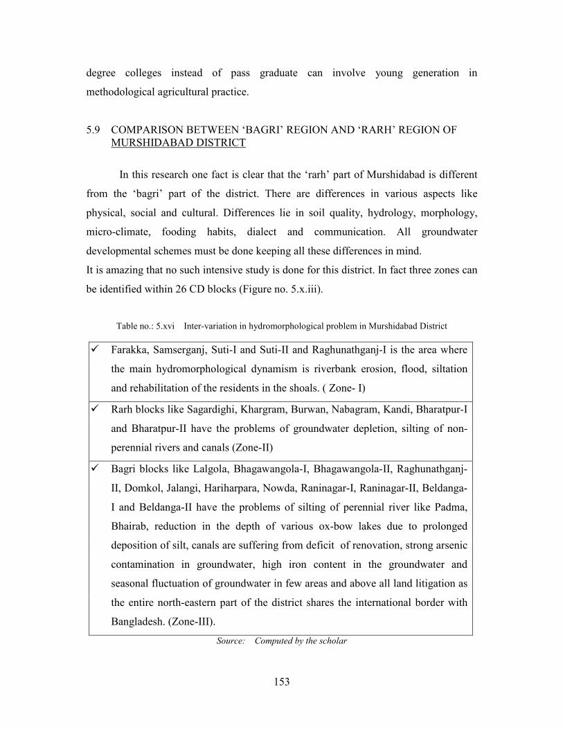
5.1 FACTS AND FINDINGS ABOUT ARSENIC IN GROUNDWATER IN THE DISTRICT
Stuben et.al. 13(2003) had made a study in a small watershed at and around
Berhampore block in ‘bagri’ region of Murshidabad District. Groundwater from wells
and the main rivers crossing the area (Bhagirathi and Gobra) have been sampled in the
north of Murshidabad District covering an area about 200 square kilometers. The
concentration of major cations including Ca, Mg, K, Na and Fe were measured.
Fluoride, Cl-, NO3- and SO4
-2 concentration were also determined. According to the
relative molar portion of the dissolved ionic species, all samples are of Ca – HCO3 type.
River and groundwater samples are similar in their main hydro-geochemical
compositions, but the total amount of dissolved solids in river water is slightly lower in
Bhagirathi about 300 mg/l, Gobra about 500 mg/l and ground water is 700 mg/l
symptomatic of anthropogenic interference into the groundwater through soil due to
infiltrating, surface run-off. In this chapter the geo-chemical mechanism of arsenic
contamination in groundwater has been discussed, and emphasis on the effect of
changing land-use on groundwater since Green Revolution.
Mobilization of As (arsenic) in groundwater is mainly governed by low
temperature geochemical processes that involve leaching of naturally occurring ores.
Accumulation of As (arsenic) in soil and groundwater especially under anoxic
conditions, due to anthropogenic input or human activity (Bowell et. al., 1994; Azcue
Concern has been raised by Bangladeshi and international scientist about
elevated levels of arsenic in Bengali food particularly in rice grain cultivation. The
highest level of As (arsenic) in the southwest of Bangladesh (district -Nawabganj,
109
Faridpur, Rajbari and Gopalganj) share a common international boundary with
Murshidabad District of West Bengal therefore the soil and aquifer are quite similar. In
the rice survey both wet season crop ‘aman’ and dry season crop ‘boro’ were sampled
and observed. 8Roy Chowdhury et.al., 2002, surveyed Domkal blocks in Murshidabad
District where the arsenic level is above 0.05 mg/l in many places. According to the
study many million cubic meter of groundwater is extracted daily by shallow big
diameter tubewells for agricultural irrigation. The mean concentration of As is 10.7
mg/kg, Fe is 7860 mg/kg and Mg is 733 mg/kg in higher side of agricultural land soils
compared to the fallow land soils and lower sides of the agricultural land soils. This
arsenic indirectly gets included in the daily food chain of the common people. Those
consume less protein in their daily food habit are worse affected by intestinal problems.
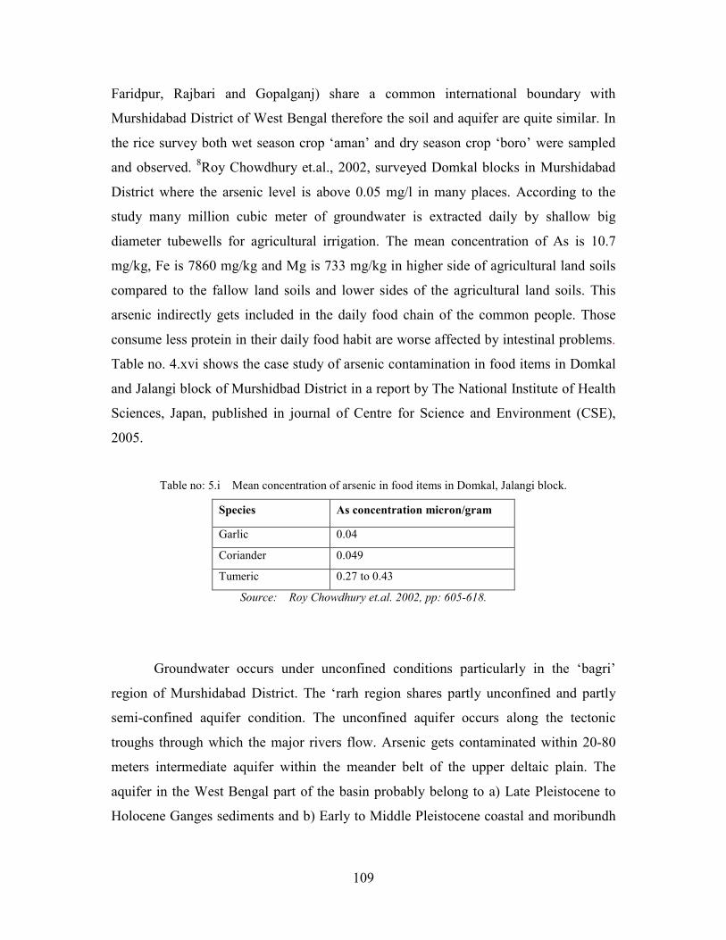
Table no. 4.xvi shows the case study of arsenic contamination in food items in Domkal
and Jalangi block of Murshidbad District in a report by The National Institute of Health
Sciences, Japan, published in journal of Centre for Science and Environment (CSE),
2005.
Table no: 5.i Mean concentration of arsenic in food items in Domkal, Jalangi block.
Species As concentration micron/gram
Garlic 0.04
Coriander 0.049
Tumeric 0.27 to 0.43
Source: Roy Chowdhury et.al. 2002, pp: 605-618.
Groundwater occurs under unconfined conditions particularly in the ‘bagri’
region of Murshidabad District. The ‘rarh region shares partly unconfined and partly
semi-confined aquifer condition. The unconfined aquifer occurs along the tectonic
troughs through which the major rivers flow. Arsenic gets contaminated within 20-80
meters intermediate aquifer within the meander belt of the upper deltaic plain. The
aquifer in the West Bengal part of the basin probably belong to a) Late Pleistocene to
Holocene Ganges sediments and b) Early to Middle Pleistocene coastal and moribundh
110
Ganges delta deep aquifers composed of stacked, main- channel, medium to coarse
sands at depths more than 130 m.
Mukherjee, et. al. (2007), had tried to explain the flow and mechanism of groundwater
due to irrigation since the introduction of green revolution. The extensive exploitation
of groundwater after 1970’s in the up–gradient of mature delta, flushes and dilutes the
arsenic present at very slow rate. The regional flow occurs within the major system
from north to south down- gradient during the dry season probably due to the low
topographic gradient (~0.1 m/km). Very frequent pumping centers in the agricultural
fields and aquifer architectures dictated the hydraulic gradient of the study area. The
absence of continuous confining layers, pumping induces between relatively shallower
and deeper groundwater, which may lead to arsenic enriched water to spread downward.
The arsenic contaminated water when spread over the land surface partially gets
accumulated in crops and partially re-circulate in to the sub surface via enhanced
recharge. This mechanism of repeated extraction and recharging may worsen the
scenario of Murshidabad District in future.
Mukherjee (2006), has opined that the smaller rivers in the study area were
found to be mostly gaining from groundwater discharge. Presumably the groundwater
discharge to rivers has decreased because of pumping by deep tubewells and shallow
tubewells. As a consequence, the outflow from the shallow aquifers may have impacted
the chemistry of smaller rivers. River Bhairab, Dwarka, Pagla, Mayurakhi and many
other rivers may have the same story.
Mineralogical investigations have revealed that arsenic occurs in the silty clay as
well as in the sandy layers as coating on mineral grains. Therefore, it can be said that
more silting of river beds and surface water bodies, more will be the rate of
concentration of arsenic in ground water. Such hydromorphological problem directly
influences the water quality and food chain of the entire population.
Bhattacharya et.al.4 (1997), indicated that the major ions like calcium; magnesium and
bicarbonate with elevated contents of iron, phosphate and arsenic get contaminated with
water during pumping.
The alluvium near the river is sandier and periodic fluviatile action keeps the
alluvium stratified. There is a deposition of coarse sand in river – borne materials along
111
with plant cells and other organic materials cells which may contain considerable
amount of arsenic and other toxic elements. During the course of time arsenic elements
get released in the reducing environment by the process of bio-methylation and get
shelter within silty and clayey sediments. Studies done by Bhattacharya et.al. (1997),
Nickson et.al. (1998) put forward the hypothesis that the burial of sediments rich in
organic matter led to strongly reducing conditions in groundwater aquifer, which is
facilitated by high water table, fine-grained surface layers and widely practiced wetland
paddy cultivation, as well as microbial oxidation of sedimentary organic matter,
depleting thereby the dissolved oxygen in groundwater. Arsenic is released when
external addition of arsenic are reduced in anoxic groundwater and hence driven by
concentrations of sedimentary organic matter. This hypothesis somewhat matches with
A.K. Singh’s organo-arsenic cycles in sediments (2006).
Arsenic pollution is now gradually becoming a disaster for Murshidabad District
and besides other districts of West Bengal like North and South 24- Parganas. This soil-
water and species anomaly has suddenly appeared into the limelight after 1980’s.
Probably it had started from the use of groundwater irrigation since 1970’s otherwise
As (arsenic) in groundwater report was insignificant in literatures.
Proper knowledge of aquifer of the district can help in planning about the use of water
in agricultural and non-agricultural sector.
5.2 AQUIFER OF MURSHIDABAD DISTRICT.
A lithographic model on ‘bagri’ region of West Bengal was developed by A.
Mukherjee, (2007) published in Hydrogeology Journal; describe a detail about the
spatial trends in aquifer thickness and spatial variability. In Murshidabad District a thick
clay deposit covers the area at a depth of ~300 m below mean sea level (MSL). From
west to east the blocks Raghunathganj-II, Lalgola, Bhagawangola –I and II and
Raninagar-II in the ‘bagri’ region of Murshidabad District have sand layers at the top
and extends near the depth of about 65-75 m. Below this unconfined aquifer is a basal
clay aquitard extending from ~80 m to more than 300 m in the west and divide in to
112
multiple layers toward the east. Near Raninagar-II, the upper clay layer is very thin and
mostly replaced by a sandy clay horizon, which lies between thick sand layers. In west
this thick aquitard extends nearly to Beldanga. The noteworthy thing about this area is
the presence of isolated aquifers at depths of ~200 to 230m and ~ 240 to 265m
extending from Bhagawangola to Berhampore through Murshidabad District –Jiaganj
with the possibility of southward extension. These isolated aquifers have water
chemistry distinct from the shallower aquifer (Mukherjee, 2006; Mukherjee and Fryar,
2007 in Mukherjee et.al, 2007).
In the ‘rarh’ region of Murshidabad District the groundwater aquifer
arrangement is somewhat different from the ‘bagri’ region. 14Swadesh Pal and Osondu
C. Akoma in Ethiopian journal of Environmental studies and Management (vol. 2 no. 3,
2009) has discussed in details about the groundwater level and seasonal variation
around Hizal wetland. The groundwater table in the pre-monsoon period ranges from
18.29 m to 21.94 m. Water table depth is quite high in Mahalandi –I GramPanchayet of
Kandi Block and Kandi Municipalty is 18.29 m and 21.68 m respectively. Around Hizal
Wet Land area the ground water table is unexpectedly low about 19.20m – 20.42 m.
The standard deviation value and the co-efficient of variation of ground water table is
0.87 and 4.32% respectively which indicates a fair degree of uniformity of groundwater
table depth. In the monsoon period the spatial groundwater table depth value ranges
from 10.79 m to 13.84 m. Maximum values were recorded near Nabagram is 13.84 m.
Around Hizal area the groundwater table depth is about 10.79 m. Standard Deviation
Value is 0.98 and the co-efficient of variation of ground water table is 8.12%. These
results again reveal the spatial level of consistencies is quite scarce in comparison to the
pre- monsoon season. There is a wide range of water table fluctuation in ‘rarh’ area of
Murshidabad District. The relationship between the recharge and discharge due to
groundwater lifting is a fact of intimate debate. The depth of the water table is usually
deepest during the month of May and thereby a steady decline of ground water table
during summer due to massive drafting of water. The rainfall recharge relationship is
not very strong where r = 0.110 to 0.132. During monsoon again the water level rises up
from June to October.
113
Researchers said that probably Murshidabad District aquitard had formed due to
a major shift in the delta –building process of the Ganges – Brahmaputra. The top
surface of the Murshidabad District aquitard deepens toward east and south, it can be
vertically traced to a depth of at least 300 meters.
Map drawn by Mukherjee et. al. 2007 showed the meteorological stations in and
around the study area whose data were used in contouring the zonal meteoric potential
recharge (PR) used in the model. In Murshidabad District the total number of ground
water pumping tube- well including both deep tube well and shallow tube wells are
63424 (approx) nos. in 2007-08.
If the rate of pumping is 10 m3/h for 12 hours a day then the total water drafting
is 7625880 m3/day (approx) in Murshidabad District. The cones of depression expand
during the pre monsoon with the formation of prominent groundwater lows in Central
Murshidabad District i.e. Murshidabad District- Jiaganj, Berhampore, Hariharpara and
Domkal blocks whereas the ground water mounds in northern Murshidabad District
near Jangipur and Bhagawangola. In Figure no.5.ii, the recharge in the pre- monsoon
season ranges from .15 to 0.25 mm/d in mature part of the Bengal Delta (Murshidabad
District, Nadia and North 24 parganas district) in the pre- monsoon period. In the post
monsoon season the ground water recharge is mainly in the lower part of Bengal Delta.
Therefore, we can presume that rain water harvesting in the mature delta can boost up
the groundwater recharge and also help in post-monsoon season from lowering of water
table. The models proposed by researchers predict that the ground water drafting will
exceed the recharge within 2011 to 2021 barely discernible in Murshidabad District also
(see figure no. 5.iii).
114
Figure no.: 5.ii Modeled map of recharge potential by Mukherjee et. al. 2007
115
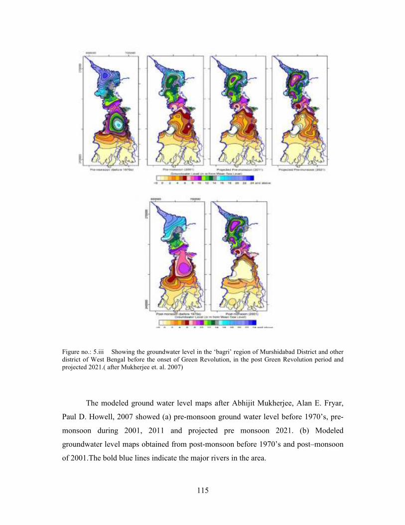
Figure no.: 5.iii Showing the groundwater level in the ‘bagri’ region of Murshidabad District and other district of West Bengal before the onset of Green Revolution, in the post Green Revolution period and projected 2021.( after Mukherjee et. al. 2007)
The modeled ground water level maps after Abhijit Mukherjee, Alan E. Fryar,
Paul D. Howell, 2007 showed (a) pre-monsoon ground water level before 1970’s, pre-
monsoon during 2001, 2011 and projected pre monsoon 2021. (b) Modeled
groundwater level maps obtained from post-monsoon before 1970’s and post–monsoon
of 2001.The bold blue lines indicate the major rivers in the area.
116
Flow in an unconfined aquifer is modeled using the linearized Boussinesq
equation, which is given by:
δh / δt= Kh* /S * δ 2h / δ X2
S is the specific yield, K is the saturated hydraulic conductivity, h is the height
of the water table in the unconfined aquifer, h* is an average height of water table, X is
the distance from the stream in the horizontal plane, and t is time.
Central Groundwater Board had reported the latest state of fresh water that, with
83157 numbers of shallow tube wells and 588 deep tube wells irrigated 1705.56 sq. km.
and 22.11 sq km. respectively in 2007. Surface flow shares only 41.93 sq km area
irrigation with 1808 number of surface flow and 1758 number of river lift irrigated only
144.71 sq km in Murshidabad District. Therefore, actual irrigated area by groundwater
is 1917.67 sq km. and by surface is 186.64 sq km. For last 10 years the ground water
level is declining. The rate decline is 0.01 to 0.4 meters/ year and rising trend is 0.01 to
0.18 m/year. The groundwater resource replenishment is 22.7033 mcm while the gross
annual groundwater draft is 20.0837mcm (CGWB, 2007).
5.3 CHANGING LANDUSE AND ITS IMPACT- A CRITICAL APPRAISAL
To ascertain how with the changing landuse had caused the hydro-
morphological problems water samples from shallow tubewell (field survey) was
undertaken (analysis done in the sixth chapter). Questions were asked to local people
about their perception regarding water underground. Knowledge, availability and
practice of groundwater utilization since the introduction of HYV seed and agricultural
engineering were asked. About 600 peoples were interacted in the ‘bagri’ and ‘rarh’
region of Murshidabad District from 2010 to 2012.
Two phases of land use change was observed in Murshidabad District in the post
Green Revolution period.
117
5.3(a) FIRST PHASE
After land ceiling, in early 1980’s the fallow land, and one cropping lands were
converted into multiple cropping land (almost 3 to 4 time) in a year with the help of
assured groundwater irrigation, HYV seed and chemical fertilizers. Peasants grew
subsistent food and also earned money from agricultural surplus. Orchards,
comparatively high relief cultivated land; road side cultivated land was converted
partially or entirely into settlement with improvement of accessibility. For earning cash
many traditional varieties of paddy cultivation were stopped, vegetable, wheat, mustard
cultivation started instead. ‘Boro’ paddy was becoming popular due to high rate of
production. 10Sen, J. (1988) has discussed that during 1974-75 only three mouzas in the
‘bagri’ region cultivated ‘boro’ paddy. By the middle of 1992-93 almost the entire
district cultivate the ‘boro’ rice which has brought piece meal to some blocks such as
Sagardighi, Burwan. The poor farmers irrigated their land with easy available
groundwater resource with the traditional knowledge and practice of nursing the crops.
Dulal Das, school peon of Jindighi High school of Sagardighi block belong to a
farmer’s family. He cultivate his hierarchical land, said that the ‘aus’ rice was
insufficient to feed the family earlier 1985. But with the introduction of ‘boro’
cultivation, they are now food surplus family more over earns some cash by selling the
high yielding variety of paddy.
Dayarampur mouza of Jalangi Block cultivate the ‘boro’ paddy due to its high
yield which can feed the large family size of this area, explained by Majid Sk, a local
amin. Although the soil quality does not permit such thirsty crop but there is no other
alternative staple food for the Bengali population. ’Boro’ rice had somehow meet the
food crisis of Murshidabad District, hence the entire West Bengal. But the maximum
use of groundwater irrigation during the lean season (February to May) has made this
crop cultivation uneconomical and a question arises about the feasibility of groundwater
irrigation. By 1990 the sugarcane cultivation had reduced, pulses in the riverine tracts
had reduced, instead crops such as ‘dhania’, ‘kalazira’, potato, vegetable, wheat, ‘boro’
rice and jute increased.
118
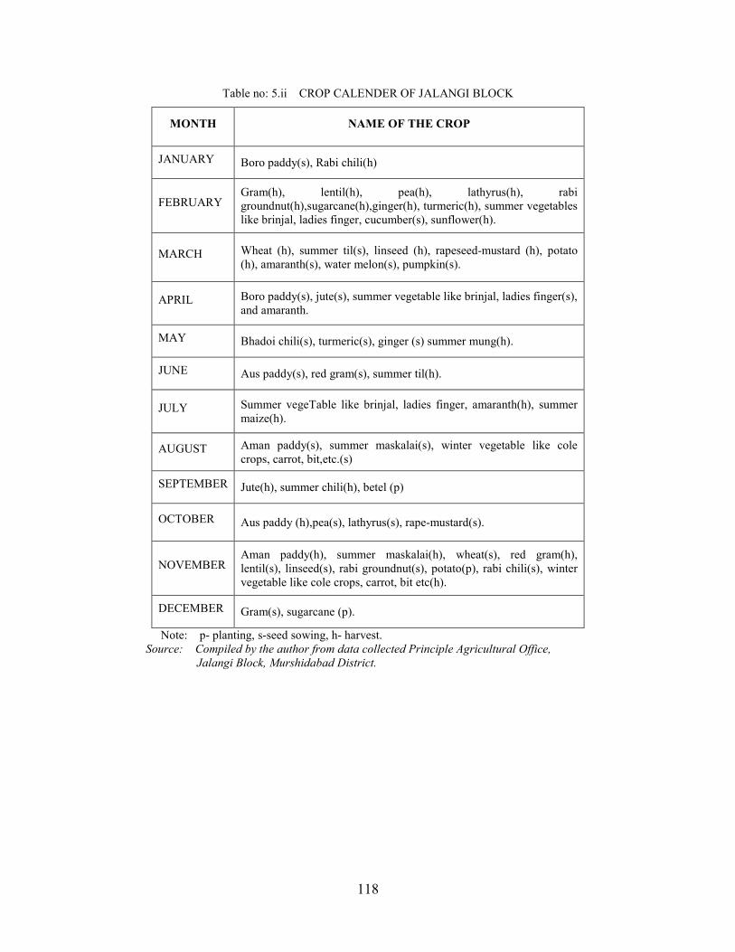
Table no: 5.ii CROP CALENDER OF JALANGI BLOCK
MONTH NAME OF THE CROP
JANUARY Boro paddy(s), Rabi chili(h)
FEBRUARY Gram(h), lentil(h), pea(h), lathyrus(h), rabi groundnut(h),sugarcane(h),ginger(h), turmeric(h), summer vegetables like brinjal, ladies finger, cucumber(s), sunflower(h).
MARCH Wheat (h), summer til(s), linseed (h), rapeseed-mustard (h), potato (h), amaranth(s), water melon(s), pumpkin(s).
APRIL Boro paddy(s), jute(s), summer vegetable like brinjal, ladies finger(s), and amaranth.
MAY Bhadoi chili(s), turmeric(s), ginger (s) summer mung(h).
JUNE Aus paddy(s), red gram(s), summer til(h).
JULY Summer vegeTable like brinjal, ladies finger, amaranth(h), summer maize(h).
AUGUST Aman paddy(s), summer maskalai(s), winter vegetable like cole crops, carrot, bit,etc.(s)
SEPTEMBER Jute(h), summer chili(h), betel (p)
OCTOBER Aus paddy (h),pea(s), lathyrus(s), rape-mustard(s).
NOVEMBER Aman paddy(h), summer maskalai(h), wheat(s), red gram(h), lentil(s), linseed(s), rabi groundnut(s), potato(p), rabi chili(s), winter vegetable like cole crops, carrot, bit etc(h).
DECEMBER Gram(s), sugarcane (p).
Note: p- planting, s-seed sowing, h- harvest. Source: Compiled by the author from data collected Principle Agricultural Office,
Jalangi Block, Murshidabad District.
119
Table no: 5.iii Crop coverage of Jalangi Block (in hectares)
Crop 1998-99 2009-10
Aus Paddy 400 900
Aman Paddy 3500 2800
Boro Paddy 1900 1800
Mustard 1800 4000
Wheat 8000-8500 8500
Sugarcane 270 540
Lentil 820 850
Rabi Vegetable 800 940
Linseed 100 30
Gram 250 190
Lathyrus 180 150
Groundnut 50 250
Sesame 400 945
Jute 10000 9000
Potato 800 450
Summer vegetable 300 800
Turmeric 10 45
Source: Compiled by the author from data collected Principle Agricultural Office,
Jalangi Block, Murshidabad District.
Continuous discourage from block agriculture office has reduced ‘boro’ paddy
cultivation in few areas of Murshidabad District for past three years but more publicity
and alternative crop is necessary.
Table no.5 iv below shows the total requirement of water needed for different crops in
centimeters and table no 5.v shows the amount of water required to cultivate each crop
in acre- inch in Murshidabad District. Here water requirement is shown in two units.
Both are used in agriculture department for calculation of crop-water relationship.
‘Boro’ paddy, ‘aman’ paddy, jute and winter vegetables need larger share of water
which must be irrigated with surface water for sustainability of groundwater.
120
Table no: 5.iv Crop-wise requirement of irrigation water
Crops Total water
requirement
(cm)
Crops Total water
requirement
(cm)
Aus 75-85 Linseed 15-20
Aman 100-125 Kusum 35-40
Boro 150-175 Soybean 20-25
Wheat 30-35 Til 30-35
Maize 50-65 Sunflower 25-30
Gram 25-30 Jute 35-50
Lentil and pea 15-25 Mung,kalai,bean 15-25
Arhar 30-35 Sugarcane 125-175
Mustard 20-30 Winter Vegetables 35-50
Winter
groundnut 35-50 Onion 35-50
Barseem 85-100 tobacco 50-60
Source: Integrated water management by Shyamal Kr. Majumdar,
Dy. Director of Agriculture (Admin.), Murshidabad District, PAO.
Figure no.: 5.iv Pie-Diagram showing the requirement of water for various crops in centimeter.
TOTAL REQUIREMENT OF WATER IN CENTIMETRE FOR
VARIOUS CROPS IN MURSHIDABAD DISTRICT.
Aus
Aman
Boro
Wheat
Maize
Gram
Lentil and pea
121
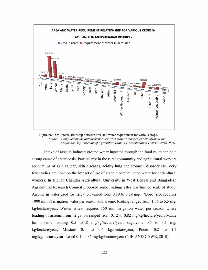
Table no.:5.v Area in acres in different crops and total requirement of water in acre-inch (2009-10)
Crops Area in
acres
Requirement of
water in acre-inch
Aus 70745 2450330
Aman 512642 25632100
Boro 280765 19853550
Wheat 238962 3345468
Maize 3947 102622
Gram 17030 204360
Lentil 41890 418900
Pea 3258 32580
Moong 232 2320
Kalai 14275 142750
Bean 520 5200
Khesari 23685 236850
Arhar 2717 38038
Mustard 220000 2640000
Winter Groundnut 212 4240
Linseed 2625 21000
Til 58020 812280
Jute 263380 5267600
Sugarcane 7725 540750
Winter Vegetable 95702 1914040
onion 9783 159660
Total 1868115 63824638
Source: Principal Agriculture office, Berhampore, Murshidabad District, 2010.
122
Figure no.: 5.v Interrelationship between area and water requirement for various crops. Source: Compiled by the author from Integrated Water Management by Shyamal Kr.
Majumdar, Dy. Director of Agriculture (Admin.), Murshidabad District, 2010, PAO.
Intake of arsenic induced ground water ingested through the food route can be a
strong cause of arsenicosis. Particularly in the rural community and agricultural workers
are victims of skin cancer, skin diseases, acidity lung and stomach disorder etc. Very
few studies are done on the impact of use of arsenic contaminated water for agricultural
workers. In Bidhan Chandra Agricultural University in West Bengal and Bangladesh
Agricultural Research Council proposed some findings after few limited scale of study.
Arsenic in water used for irrigation varied from 0.10 to 0.59 mg/l. ‘Boro’ rice requires
1000 mm of irrigation water per season and arsenic loading ranged from 1.36 to 5.5 mg/
kg/hectare/year. Winter wheat requires 150 mm irrigation water per season where
loading of arsenic from irrigation ranged from 0.12 to 0.82 mg/kg/hectare/year. Maize
has arsenic loading 0.5 to1.8 mg/kg/hectare/year, sugarcane 0.5 to 3.1 mg/
kg/hectare/year, Mustard 0.1 to 0.6 kg/hectare/year, Potato 0.2 to 1.2
mg/kg/hectare/year, Lentil 0.1 to 0.5 mg/kg/hectare/year (NIH AND CGWB, 2010).
AREA AND WATER REQUIREMENT RELATIONSHIP FOR VARIOUS CROPS IN
ACRE-INCH IN MURSHIDABAD DISTRICT.Area in acres requirement of water in acre-inch
123
A report in 2Anandabazar Patrika (a renounced Bengali newspaper) dated 16
May 2012; Wednesday made a broad publication about groundwater irrigation by deep
tubewell and ground water status in West Bengal, India. In 2005, an act was passed by
the state government in order to preserve the groundwater resource. The report
explained that it is becoming costly to irrigate small farming land by shallow pumps by
small diesel pumps. Now, Ministry of Irrigation wanted to do another blunder by
allowing the farmers to extract water from more deep tubewells run by electricity to be
installed shortly. If this happens without prior creating groundwater recharge potency;
then no sooner time will come when ‘ground water piracy’ will be reported in West
Bengal also, especially in agriculture oriented district like Murshidabad.
Geologists fear about many other major calamities in West Bengal if the rate of
groundwater irrigation may not be reduced. If more water will be exploited there will be
disequilibrium in underground geological structure. Besides, arsenic contamination and
ground water fluctuation, scientists fear about the fact of earthquake in near future in
this district. A small shock can bring a major disaster to human resources.
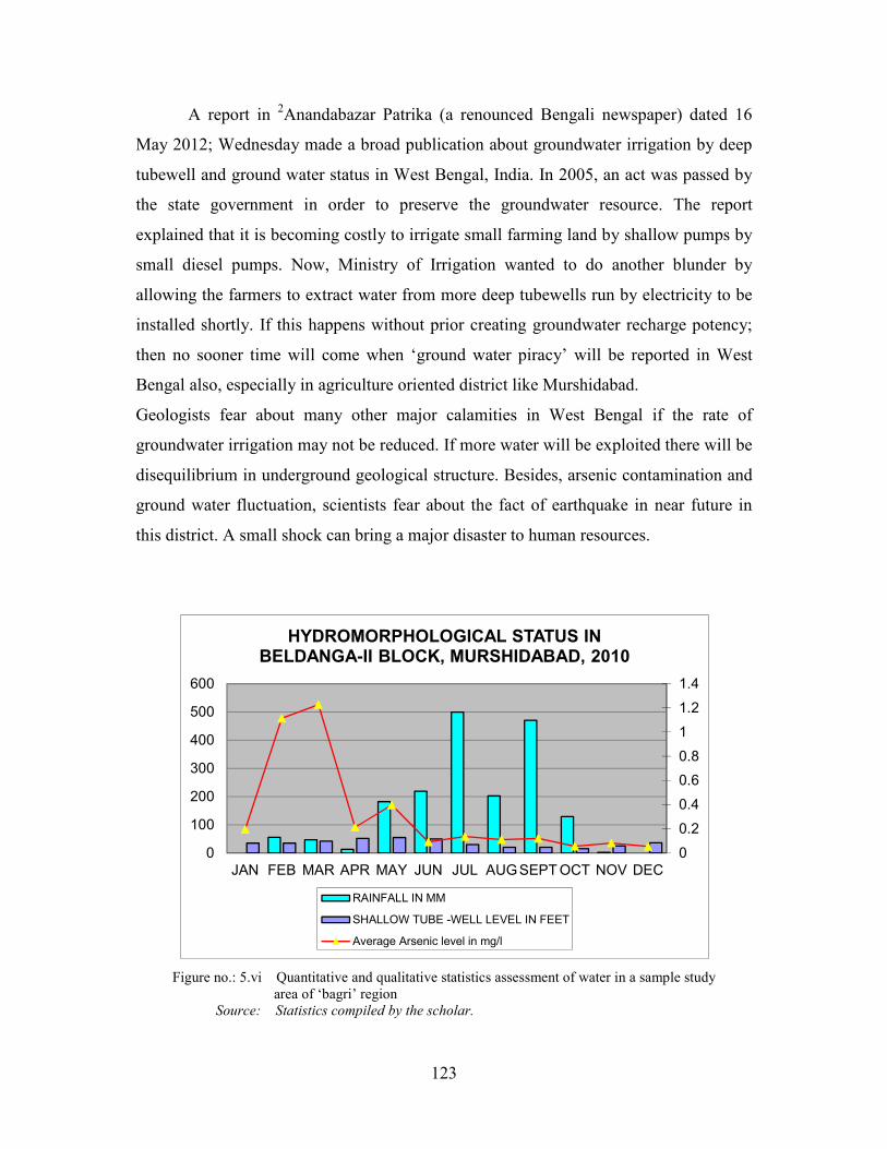
Figure no.: 5.vi Quantitative and qualitative statistics assessment of water in a sample study area of ‘bagri’ region Source: Statistics compiled by the scholar.
0
0.2
0.4
0.6
0.8
1
1.2
1.4
0
100
200
300
400
500
600
JAN FEB MAR APR MAY JUN JUL AUGSEPTOCT NOV DEC
HYDROMORPHOLOGICAL STATUS IN
BELDANGA-II BLOCK, MURSHIDABAD, 2010
RAINFALL IN MM
SHALLOW TUBE -WELL LEVEL IN FEET
Average Arsenic level in mg/l
124
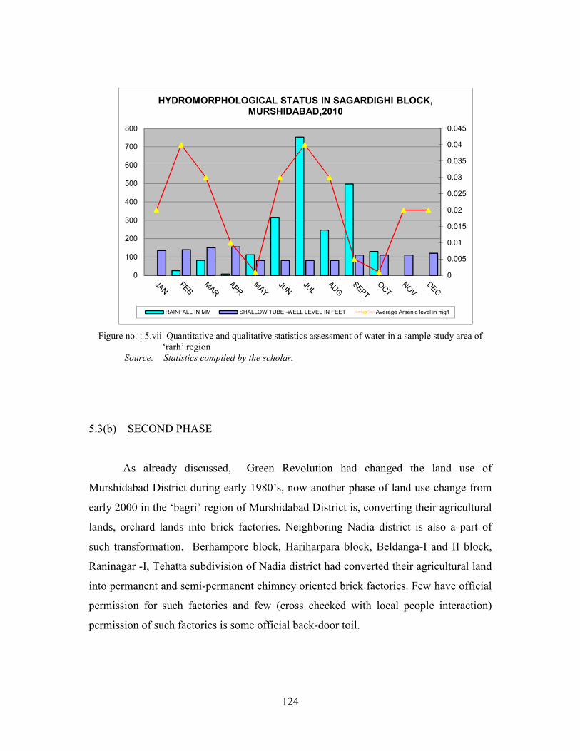
Figure no. : 5.vii Quantitative and qualitative statistics assessment of water in a sample study area of ‘rarh’ region Source: Statistics compiled by the scholar.
5.3(b) SECOND PHASE
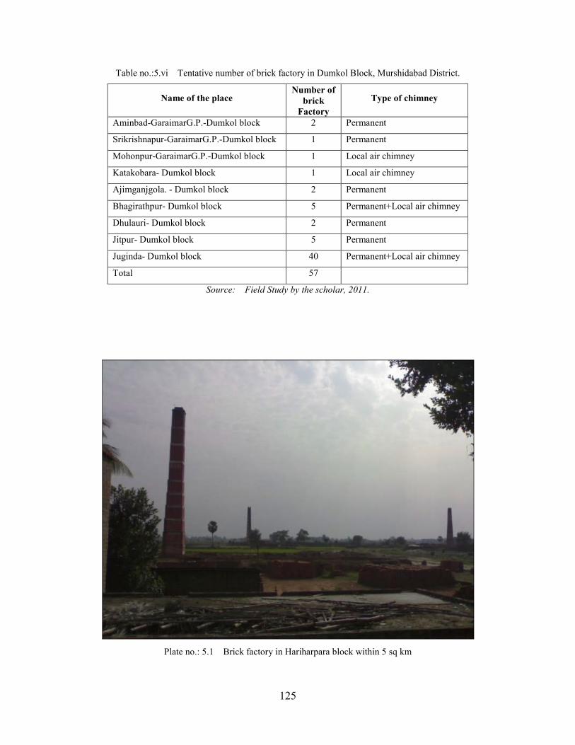
As already discussed, Green Revolution had changed the land use of
Murshidabad District during early 1980’s, now another phase of land use change from
early 2000 in the ‘bagri’ region of Murshidabad District is, converting their agricultural
lands, orchard lands into brick factories. Neighboring Nadia district is also a part of
such transformation. Berhampore block, Hariharpara block, Beldanga-I and II block,
Raninagar -I, Tehatta subdivision of Nadia district had converted their agricultural land
into permanent and semi-permanent chimney oriented brick factories. Few have official
permission for such factories and few (cross checked with local people interaction)
permission of such factories is some official back-door toil.
0
0.005
0.01
0.015
0.02
0.025
0.03
0.035
0.04
0.045
0
100
200
300
400
500
600
700
800
HYDROMORPHOLOGICAL STATUS IN SAGARDIGHI BLOCK,
MURSHIDABAD,2010
RAINFALL IN MM SHALLOW TUBE -WELL LEVEL IN FEET Average Arsenic level in mg/l
125
Table no.:5.vi Tentative number of brick factory in Dumkol Block, Murshidabad District.
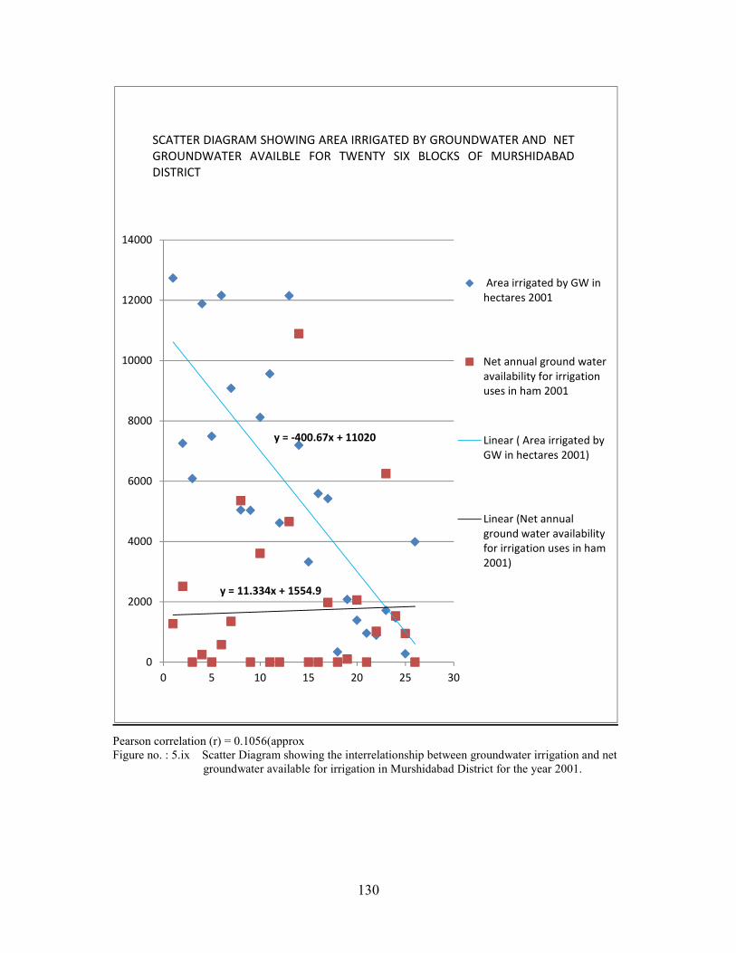
Jiaganj, Nawda, Raninagar –I and Suti –II blocks had negative net annual ground water
available for irrigation in 2004. The important fact to be noted are most of the blocks
are in the ‘Bagri’ region of the district, the ground water status is in semi-critical
position and all of the blocks suffer from arsenic contamination in ground water. With
every year monsoon, the net groundwater available reach at satisfactory level but lack
of proper conservation and management of the easy available water is at jeopardy
situation in Murshidabad. The ‘rarh’ blocks are in worse condition in few areas. The
groundwater is at semi-critical to critical in position. This situation clearly signifies the
immediate need of groundwater recharge with renovation of natural reservoirs so that
rainwater harvesting can be done.
130
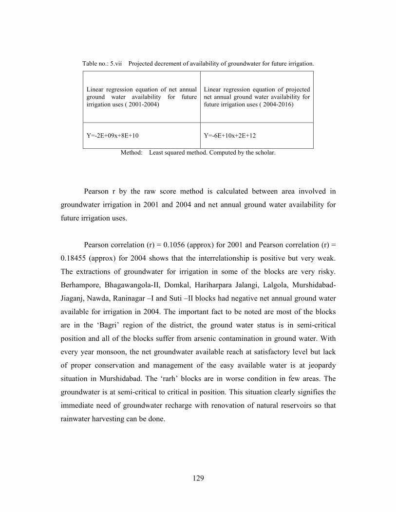
Pearson correlation (r) = 0.1056(approx Figure no. : 5.ix Scatter Diagram showing the interrelationship between groundwater irrigation and net groundwater available for irrigation in Murshidabad District for the year 2001.
y = -400.67x + 11020
y = 11.334x + 1554.9
0
2000
4000
6000
8000
10000
12000
14000
0 5 10 15 20 25 30
Area irrigated by GW in
hectares 2001
Net annual ground water
availability for irrigation
uses in ham 2001
Linear ( Area irrigated by
GW in hectares 2001)
Linear (Net annual
ground water availability
for irrigation uses in ham
2001)
SCATTER DIAGRAM SHOWING AREA IRRIGATED BY GROUNDWATER AND NET
GROUNDWATER AVAILBLE FOR TWENTY SIX BLOCKS OF MURSHIDABAD
DISTRICT
131
Pearson correlation(r) = 0.18455(approx) Figure no.: 5.x Scatter Diagram showing the interrelationship between groundwater irrigation and net groundwater available for irrigation in Murshidabad District for 2004.
y = -389x + 11125
y = 46.049x + 26.092
-10000
-5000
0
5000
10000
15000
20000
0 10 20 30
Area irrigated by GW in
hectares 2004
Net annual ground water
availability for irrigation
uses in ham 2004
Linear ( Area irrigated by
GW in hectares 2004)
Linear (Net annual ground
water availability for
irrigation uses in ham 2004)
SCATTER DIAGRAM SHOWING AREA IRRIGATED BY GROUNDWATER AND NET
GROUNDWATER AVAILBLE FOR TWENTY SIX BLOCKS OF MURSHIDABAD
DISTRICT
132
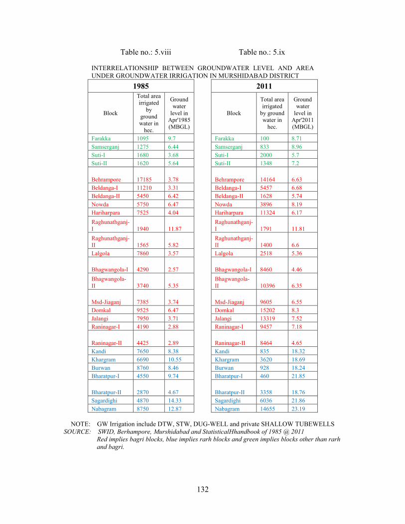
Table no.: 5.viii Table no.: 5.ix
INTERRELATIONSHIP BETWEEN GROUNDWATER LEVEL AND AREA UNDER GROUNDWATER IRRIGATION IN MURSHIDABAD DISTRICT
1985
2011
Block
Total area irrigated
by ground water in
hec.
Ground water
level in Apr'1985 (MBGL)
Block
Total area irrigated
by ground water in
hec.
Ground water
level in Apr'2011 (MBGL)
Farakka 1095 9.7 Farakka 100 8.71
Samserganj 1275 6.44 Samserganj 833 8.96
Suti-I 1680 3.68 Suti-I 2000 5.7
Suti-II 1620 5.64 Suti-II 1348 7.2
Behrampore 17185 3.78 Behrampore 14164 6.63
Beldanga-I 11210 3.31 Beldanga-I 5457 6.68
Beldanga-II 5450 6.42 Beldanga-II 1628 5.74
Nowda 5750 6.47 Nowda 3896 8.19
Hariharpara 7525 4.04 Hariharpara 11324 6.17
Raghunathganj-I 1940 11.87
Raghunathganj-I 1791 11.81
Raghunathganj-II 1565 5.82
Raghunathganj-II 1400 6.6
Lalgola 7860 3.57 Lalgola 2518 5.36
Bhagwangola-I 4290 2.57 Bhagwangola-I 8460 4.46
Bhagwangola-II 3740 5.35
Bhagwangola-II 10396 6.35
Msd-Jiaganj 7385 3.74 Msd-Jiaganj 9605 6.55
Domkal 9525 6.47 Domkal 15202 8.3
Jalangi 7950 3.71 Jalangi 13319 7.52
Raninagar-I 4190 2.88 Raninagar-I 9457 7.18
Raninagar-II 4425 2.89 Raninagar-II 8464 4.65
Kandi 7650 8.38 Kandi 835 18.32
Khargram 6690 10.55 Khargram 3620 18.69
Burwan 8760 8.46 Burwan 928 18.24
Bharatpur-I 4550 9.74 Bharatpur-I 460 21.85
Bharatpur-II 2870 4.67 Bharatpur-II 3358 18.76
Sagardighi 4870 14.33 Sagardighi 6036 21.86
Nabagram 8750 12.87 Nabagram 14655 23.19
NOTE: GW Irrigation include DTW, STW, DUG-WELL and private SHALLOW TUBEWELLS
SOURCE: SWID, Berhampore, Murshidabad and StatisticalHhandbook of 1985 @ 2011
Red implies bagri blocks, blue implies rarh blocks and green implies blocks other than rarh
and bagri.
133
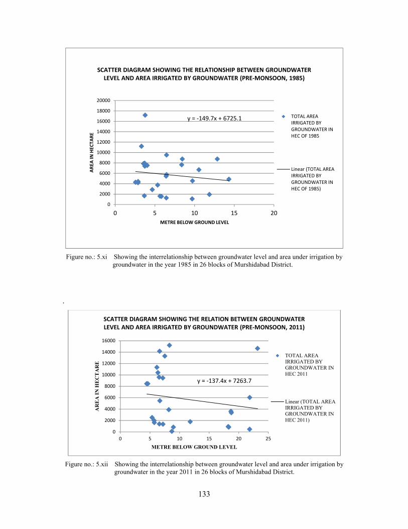
Figure no.: 5.xi Showing the interrelationship between groundwater level and area under irrigation by groundwater in the year 1985 in 26 blocks of Murshidabad District.
.
Figure no.: 5.xii Showing the interrelationship between groundwater level and area under irrigation by groundwater in the year 2011 in 26 blocks of Murshidabad District.
y = -149.7x + 6725.1
0
2000
4000
6000
8000
10000
12000
14000
16000
18000
20000
0 5 10 15 20
AR
EA
IN
HE
CT
AR
E
METRE BELOW GROUND LEVEL
SCATTER DIAGRAM SHOWING THE RELATIONSHIP BETWEEN GROUNDWATER
LEVEL AND AREA IRRIGATED BY GROUNDWATER (PRE-MONSOON, 1985)
TOTAL AREA
IRRIGATED BY
GROUNDWATER IN
HEC OF 1985
Linear (TOTAL AREA
IRRIGATED BY
GROUNDWATER IN
HEC OF 1985)
y = -137.4x + 7263.7
0
2000
4000
6000
8000
10000
12000
14000
16000
0 5 10 15 20 25
AREA IN H
ECTARE
METRE BELOW GROUND LEVEL
SCATTER DIAGRAM SHOWING THE RELATION BETWEEN GROUNDWATER
LEVEL AND AREA IRRIGATED BY GROUNDWATER (PRE-MONSOON, 2011)
TOTAL AREAIRRIGATED BYGROUNDWATER INHEC 2011
Linear (TOTAL AREAIRRIGATED BYGROUNDWATER INHEC 2011)
134
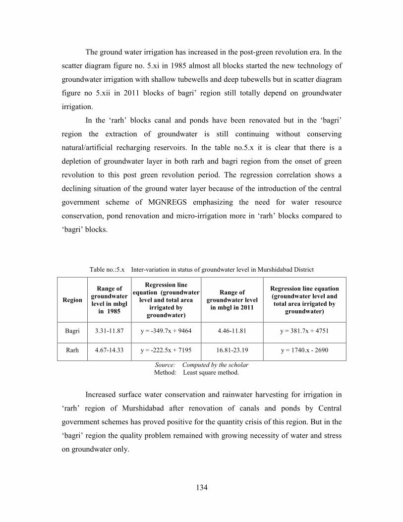
The ground water irrigation has increased in the post-green revolution era. In the
scatter diagram figure no. 5.xi in 1985 almost all blocks started the new technology of
groundwater irrigation with shallow tubewells and deep tubewells but in scatter diagram
figure no 5.xii in 2011 blocks of bagri’ region still totally depend on groundwater
irrigation.
In the ‘rarh’ blocks canal and ponds have been renovated but in the ‘bagri’
region the extraction of groundwater is still continuing without conserving
natural/artificial recharging reservoirs. In the table no.5.x it is clear that there is a
depletion of groundwater layer in both rarh and bagri region from the onset of green
revolution to this post green revolution period. The regression correlation shows a
declining situation of the ground water layer because of the introduction of the central
government scheme of MGNREGS emphasizing the need for water resource
conservation, pond renovation and micro-irrigation more in ‘rarh’ blocks compared to
‘bagri’ blocks.
Table no.:5.x Inter-variation in status of groundwater level in Murshidabad District
Region
Range of
groundwater
level in mbgl
in 1985
Regression line
equation (groundwater
level and total area
irrigated by
groundwater)
Range of
groundwater level
in mbgl in 2011
Regression line equation
(groundwater level and
total area irrigated by
groundwater)
Bagri 3.31-11.87 y = -349.7x + 9464 4.46-11.81 y = 381.7x + 4751
Rarh 4.67-14.33 y = -222.5x + 7195 16.81-23.19 y = 1740.x - 2690
Source: Computed by the scholar
Method: Least square method.
Increased surface water conservation and rainwater harvesting for irrigation in
‘rarh’ region of Murshidabad after renovation of canals and ponds by Central
government schemes has proved positive for the quantity crisis of this region. But in the
‘bagri’ region the quality problem remained with growing necessity of water and stress
on groundwater only.
135
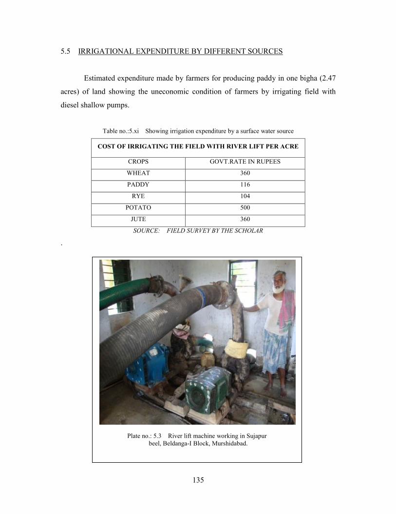
5.5 IRRIGATIONAL EXPENDITURE BY DIFFERENT SOURCES
Estimated expenditure made by farmers for producing paddy in one bigha (2.47
acres) of land showing the uneconomic condition of farmers by irrigating field with
diesel shallow pumps.
Table no.:5.xi Showing irrigation expenditure by a surface water source
COST OF IRRIGATING THE FIELD WITH RIVER LIFT PER ACRE
CROPS GOVT.RATE IN RUPEES
WHEAT 360
PADDY 116
RYE 104
POTATO 500
JUTE 360
SOURCE: FIELD SURVEY BY THE SCHOLAR
.
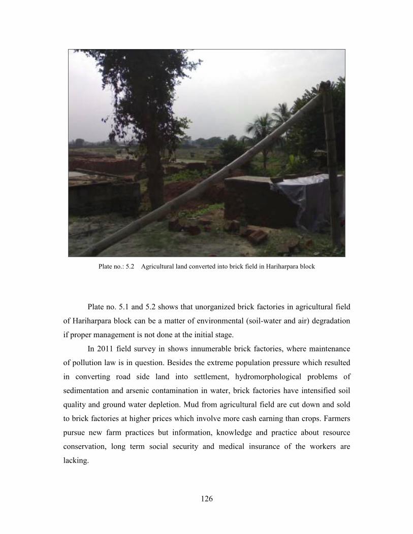
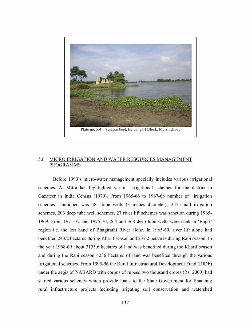
Plate no.: 5.3 River lift machine working in Sujapur beel, Beldanga-I Block, Murshidabad.
136
Table no.: 5.xii Showing irrigation expenditure by a ground water source
TENTATIVE EXPENSES AND INCOME FROM PADDY CULTIVATION BY SHALLOW TUBEWELLS In One Bigha of Land.
ITEM RUPEES(approx)
Ploughing the field once by labour 250
Seeds(10 kg) 75
Fertilizers(5kg) 100
Diesel for irrigating the field ( 5 lit. @ 49) 245
EXPENDITURE FOR IMPLANTING THE PADDY PLANTS
Ploughing the field by labours 1000
Implanting plants with labours 1200
Clearing of weeds by labour 250
Fertilizer at first phase 640
Fertiliser at second phase 690
Insecticides 200
Irrigating the field (25 lit. diesel @49) 1225
Harvesting the paddy 2500
Bringing the paddy home 500
TOTAL EXPENDITURE IN FIELD 8875
Yield of rice is 18 maun (720Kg) from one bigha of land
Price procured for one maun of rice is Rs 300.00
18 maun of rice is Rs.300*18 5400
Price of straw sold is 2000
TOTAL SELLING PRICE 7400
Profit / loss in paddy cultivation in one bigha of rice is Rs.7400-8875 = -Rs 1475.00(approx)
Note: 1 acre=1.60 bigha (approx). The expenditure changes with the change of price of diesel. Source: Primary data compiled by scholars through questionnaire survey of selected villages.
(FIELD SURVEY 10/1/11)
The comparative rates of irrigating the field by two different sources clearly
show that surface water irrigation is much cheaper than groundwater irrigation.
137
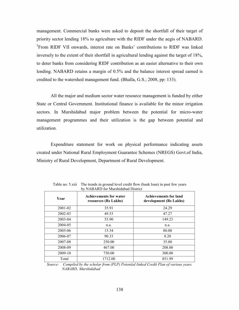
5.6 MICRO IRRIGATION AND WATER RESOURCES MANAGEMENT PROGRAMMS
Before 1990’s micro-water management specially includes various irrigational
schemes. A. Mitra has highlighted various irrigational schemes for the district in
Gazateer in India Census (1979). From 1965-66 to 1967-68 number of irrigation
schemes sanctioned was 58 tube wells (3 inches diameter), 916 small irrigation
schemes, 203 deep tube well schemes. 27 river lift schemes was sanction during 1965-
1969. From 1971-72 and 1975-76, 264 and 368 deep tube wells were sunk in ‘Bagri’
region i.e. the left hand of Bhagirathi River alone. In 1965-69, river lift alone had
benefited 243.2 hectares during Kharif season and 237.2 hectares during Rabi season. In
the year 1968-69 about 3135.6 hectares of land was benefited during the Kharif season
and during the Rabi season 4236 hectares of land was benefited through the various
irrigational schemes. From 1995-96 the Rural Infrastructural Development Fund (RIDF)
under the aegis of NABARD with corpus of rupees two thousand crores (Rs. 2000) had
started various schemes which provide loans to the State Government for financing
rural infrastructure projects including irrigating soil conservation and watershed
Total Expenditure made was Rupees 338415.00 in 2010-2011. Unskilled labour
expenditure was Rupees 318110.00, Semi-skilled labour expenditure was Rupees
18720.00, and work site board expenditure was Rupees 400.00. This expenditure must
be displayed publicly but field’s survey shows that no such board has been installed in
the actual ground of work; it is kept at the corner of Panchayat Office.
This canal will help the people in many ways. The canal will help people to
submerge raw jute plants during rainy seasons. Later on, it will also help to take the
products (pulps) near the main road suspending through the water of the canal.
Sediment accumulation had made the canal shallow, re-excavation will benefit
irrigating field of this region. Again this canal may help in flushing the area from
arsenic (As) contamination and also recharge the ground water. “Flood is a gift” as
144
quoted by Din Mohammad, a farmer in this area of Beldanga-II G.P. as it brings silt
which makes the soil fertile for the next season of cropping. In 2009-2010 due to lack of
rainfall, shallow water tube wells were used to fill up swampy lands (‘dobas’) to
submerge the raw jute plants for fermentation.
Some of other works done during 2011-12 are re-excavation of Dharer Bill from
Shibmandir to Ager Gachhtala at Shibchandrapur. Estimated cost was rupees 3.38 lakhs
and total expenditure made was rupees 3.36315 lakhs. Re-excavation of canal from
Kalachand Sarkar’s house to Surer math. Estimated cost was rupees 3.58 lakhs and
total expenditure made was rupees 3.57495 lakhs. Re excavation of canal from Mohon
Mandal house to Shatberi Gachhtala at Shibchandrapur. The work is going on and the
estimated cost is rupees 7.66 lakhs and expenditure already made is 7.21476 lakhs of
rupees. Re- excavation of canal from Kamal Sk land to Cheleputa pukur tala at Natun
Kashipur. This work is also going on whose estimated cost is 4.86 lakhs. Expenditure
already made is 0.72306 lakhs of rupees. If all these schemes really get finished then
local people and farmers will be benefited in number of ways.
Very little work has been done under water conservation and water harvesting.
Official lacunae and lack of proper utilization of allotted money for work are the main
reason of slow performance in the peoples’ resource creating and conserving work
through MGNREGS.
During field survey many farmers those has medium land size holding are
willing to cut a part of their field as pond both for irrigation and for pisciculture. They
(70.2 % of respondent) also suggested piscicultue as alternate occupation.
145
5.7 (b) CASE STUDY IN ‘RARH’ REGION
Some of the big ponds which can be used for irrigation more areas of land. Few
relevant works in this block to conserve rain water and pond irrigation are discussed
here. Babarpur Faradkhana Pukur is renovated by scheme work of MGNREGS. The
pond is about 1.5 bigha of land and 6 feet deep which is insufficient to hold water in pre
and post monsoon period so that it can help in irrigation. Another pond named Gopal
Nagar Porabali is about 01 bigha of land and 12-13 feet deep. The water of this pond
helps as water reservoir, in irrigation and also as social daily use. Plate 5.9, 5.10 and
Plate no.: 5. 6 A Priory condition of re- excavation of a canal in Kashipur G.P., Beldanga –II block, Murshidabad, West Bengal, India.
Plate no.: 5.7 Re- excavated an irrigation canal from Jikra PWD road to Chelepota Math, Jikra mouza, Kashipur G.P., Beldanga–II block, Murshidabad, West Bengal, India.
Plate no.: 5.8 Re- excavated an irrigation canal from
Sibmandir to Ager gachtala (Dhadhar beel) Kashipur G.P.
Beldanga –II block, Murshidabad, West Bengal, India.
Plate no.: 5.5 Work Expenditure board
146
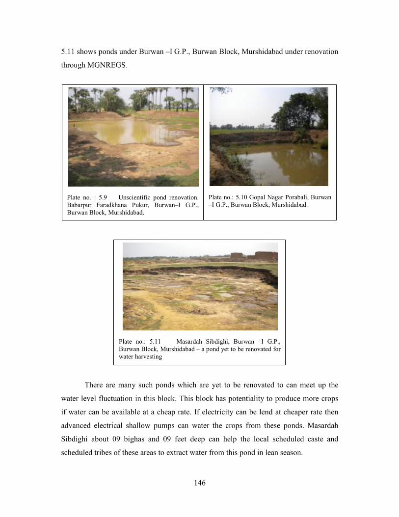
5.11 shows ponds under Burwan –I G.P., Burwan Block, Murshidabad under renovation
through MGNREGS.
There are many such ponds which are yet to be renovated to can meet up the
water level fluctuation in this block. This block has potentiality to produce more crops
if water can be available at a cheap rate. If electricity can be lend at cheaper rate then
advanced electrical shallow pumps can water the crops from these ponds. Masardah
Sibdighi about 09 bighas and 09 feet deep can help the local scheduled caste and
scheduled tribes of these areas to extract water from this pond in lean season.