* Ph.D. Eng. Krzysztof Książyński, Cracow University of Technology, Institute of Water Engineering and Water Management. ** M.Sc. Eng. Iwona Podraza, graduate of the Cracow University of Technology, Faculty of Environmental Engineering, Department of Environmental Engineering. TECHNICAL TRANSACTIONS ENVIRONMENT ENGINEERING 1-Ś/2014 CZASOPISMO TECHNICZNE ŚRODOWISKO KRZYSZTOF KSIĄŻYŃSKI*, IWONA PODRAZA** GROUNDWATER OUTFLOW FROM THE BIAŁUCHA RIVERBED IN THE KRAKÓW VALLEY ODPŁYW PODZIEMNY Z KORYTA BIAŁUCHY W KOTLINIE KRAKOWSKIEJ Abstract A decrease in the flow of the downstream stretch of the Białucha river (also known as Prądnik) has been determined based on the calculations of groundwater inflow to the Białucha riverbed completed for the Ojców‒Giebułtów‒ Olsza stretch using the Wundt and Kille methods. Hydrogeological analysis of this phenomenon revealed that the water is lost at the point where the Prądnik leaves the Proszowice Plateau and enters the Vistula Plain as the Białucha. The reason for the water outflow from the riverbed is the relatively low groundwater level in the alluvia of the Vistula ice-marginal valley. Upstream from this point, groundwater is supplied to the river in a narrow valley eroded in rocky ground, while downstream water flows out into a thick aquifer drained by the Vistula river that is situated much lower in this area. A similar phenomenon is observed at the mouths of most tributaries of the upper Vistula. This problem is discussed in detail in the master’s thesis by Iwona Podraza [6]. Keywords: underground base outflow, hydraulic flownet, riverbed drainage Streszczenie Na podstawie obliczeń dopływu podziemnego do koryta Białuchy (Prądnika) na odcinku Ojców–Giebułtów–Ol- sza, przeprowadzonych metodami Wundta i Kilego, stwierdzono spadek przepływu bazowego w końcowym od- cinku rzeki. Przeprowadzona analiza hydrogeologiczna tego zjawiska wykazała, że straty wody występują w miej- scu, w którym Prądnik opuszcza Płaskowyż Proszowicki i już jako Białucha wkracza na Równinę Nadwiślańską. Przyczyną odpływu wody z koryta jest relatywnie niższy poziom wód gruntowych w aluwiach pradoliny Wisły. Zasilanie podziemne cieku, które dotąd miało miejsce w wąskiej, wyżłobionej w skalistym podłożu dolinie, ustę- puje w tym miejscu odpływowi w głąb warstwy wodonośnej o znacznej miąższości drenowanej przez znacznie niżej położoną Wisłę. Podobne zjawisko zachodzi przy ujściu większości dopływów górnej Wisły. Problem po- wyższy został szczegółowo opisany w pracy dyplomowej autorki [6]. Słowa kluczowe: odpływ bazowy, siatka hydrodynamiczna, drenaż cieku
Transcript
* Ph.D. Eng. Krzysztof Książyński, Cracow University of Technology, Institute of Water Engineering and Water Management.
** M.Sc. Eng. Iwona Podraza, graduate of the Cracow University of Technology, Faculty of Environmental Engineering, Department of Environmental Engineering.
TECHNICAL TRANSACTIONSENVIRONMENT ENGINEERING
1-Ś/2014
CZASOPISMO TECHNICZNEŚRODOWISKO
KRZYSZTOF KSIĄŻYŃSKI*, IWONA PODRAZA**
GROUNDWATER OUTFLOW FROM THE BIAŁUCHA RIVERBED IN THE KRAKÓW VALLEY
ODPŁYW PODZIEMNY Z KORYTA BIAŁUCHY W KOTLINIE KRAKOWSKIEJ
A b s t r a c tA decrease in the flow of the downstream stretch of the Białucha river (also known as Prądnik) has been determined based on the calculations of groundwater inflow to the Białucha riverbed completed for the Ojców‒Giebułtów‒Olsza stretch using the Wundt and Kille methods. Hydrogeological analysis of this phenomenon revealed that the water is lost at the point where the Prądnik leaves the Proszowice Plateau and enters the Vistula Plain as the Białucha. The reason for the water outflow from the riverbed is the relatively low groundwater level in the alluvia of the Vistula ice-marginal valley. Upstream from this point, groundwater is supplied to the river in a narrow valley eroded in rocky ground, while downstream water flows out into a thick aquifer drained by the Vistula river that is situated much lower in this area. A similar phenomenon is observed at the mouths of most tributaries of the upper Vistula. This problem is discussed in detail in the master’s thesis by Iwona Podraza [6].
Keywords: underground base outflow, hydraulic flownet, riverbed drainage
S t r e s z c z e n i eNa podstawie obliczeń dopływu podziemnego do koryta Białuchy (Prądnika) na odcinku Ojców–Giebułtów–Ol-sza, przeprowadzonych metodami Wundta i Kilego, stwierdzono spadek przepływu bazowego w końcowym od-cinku rzeki. Przeprowadzona analiza hydrogeologiczna tego zjawiska wykazała, że straty wody występują w miej-scu, w którym Prądnik opuszcza Płaskowyż Proszowicki i już jako Białucha wkracza na Równinę Nadwiślańską. Przyczyną odpływu wody z koryta jest relatywnie niższy poziom wód gruntowych w aluwiach pradoliny Wisły. Zasilanie podziemne cieku, które dotąd miało miejsce w wąskiej, wyżłobionej w skalistym podłożu dolinie, ustę-puje w tym miejscu odpływowi w głąb warstwy wodonośnej o znacznej miąższości drenowanej przez znacznie niżej położoną Wisłę. Podobne zjawisko zachodzi przy ujściu większości dopływów górnej Wisły. Problem po-wyższy został szczegółowo opisany w pracy dyplomowej autorki [6].
Słowa kluczowe: odpływ bazowy, siatka hydrodynamiczna, drenaż cieku
28
1. The problem
Many rivers near their mouth are characterised by a flow regime which is unusual for a humid climate. As a rule, riverbeds are fed by groundwater, but a natural outflow of water into a water-bearing stratum is observed at such points [8]. This phenomenon plays a significant role during low flows when the groundwater supply is the deciding factor of flow volume. This paper discusses a method used to calculate the value of the described anomaly, based on a case study of the Białucha, a tributary of the Vistula river.
The Wundt method was used to calculate the total underground inflow to the river. The lateral underground inflow used to determine the spatial distribution of inflow was calculated using a hydraulic flownet. The soil parameters were calibrated as required in the latter calculation to ensure consistency of both methods. The rainfall infiltration factor was also calculated using the approach described. This factor enables one to calculate the value of the actual recharge of groundwater without complicated calculations of net precipitation and losses in the runoff process. Despite the relatively general assumptions, the values obtained using this approach are more reliable than those obtained using the reverse seepage model, due to the indeterminacy of the latter approach resulting from the need to simultaneously calibrate the hydraulic conductivity and the water supply volume.
2. A description of the Białucha river drainage area
The Białucha river is a left-bank tributary of the Vistula. It is 33.4 km long and its basin covers an area of 195.8 km2. There are three water-level gauge stations in the riverbed: Ojców (km 21.6, area 75.5 km2); Giebułtów (km 12.8, area 111.1 km2); Olsza (km 2.2, area 178.6 km2). The river valley is eroded in a thick Upper Jurassic limestone complex and has a depth reaching tens meters, and in its middle stretch, even one hundred metres. As the Ojców Valley, it constitutes the major part of the Ojców National Park. The watercourse which is the hydrographical axis of the river basin is known as the Prądnik Brook in the valley, and as the Białucha in its lower course along the 8.7 km stretch flowing through the city of Kraków.
Only shallow alluvia on limestone beds occur in the areas adjacent to the river in the narrow Ojców Valley. The river valley in the city area is filled principally with alluvial soils, and the underlying aquifer is from 5‒10 m thick. The main water-bearing horizon is situated in quaternary formations, present as sand of varying particle sizes, with additions of gravel towards the floor and as limestone pebbles with diameters of up to 10 cm, with additions of clay locally. The impermeable cap rock consists of sandy clays similar to loess (frequently with an addition of sand). The total thickness of quaternary sediments, depending on the ground morphology, reaches 20‒22 m. The impermeable floor of the horizon consists of Miocene clays. The waters of quaternary horizons are fed with water from Jurassic limestone, principally in locations where the quaternary formations remain in direct contact with the limestone. A large alluvial fan, located principally west of the riverbed, formed as a result of the accumulation of brash carried by the river; limestone sands and gravels covered with fine brown sands are the main components of the water-bearing horizon. A system of small valleys, dating back mainly to the Holocene epoch, has also been formed here. The riverbed is characterised by a small slope – from 2 to 4.7‰.
29
3. Separating the underground outflow
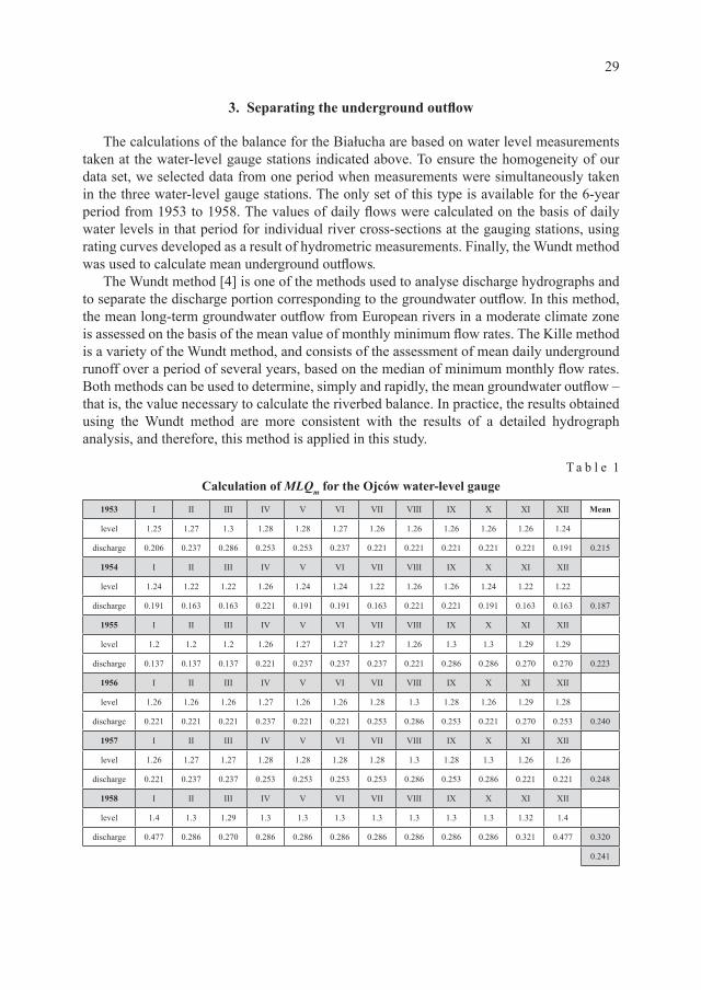
The calculations of the balance for the Białucha are based on water level measurements taken at the water-level gauge stations indicated above. To ensure the homogeneity of our data set, we selected data from one period when measurements were simultaneously taken in the three water-level gauge stations. The only set of this type is available for the 6-year period from 1953 to 1958. The values of daily flows were calculated on the basis of daily water levels in that period for individual river cross-sections at the gauging stations, using rating curves developed as a result of hydrometric measurements. Finally, the Wundt method was used to calculate mean underground outflows.
The Wundt method [4] is one of the methods used to analyse discharge hydrographs and to separate the discharge portion corresponding to the groundwater outflow. In this method, the mean long-term groundwater outflow from European rivers in a moderate climate zone is assessed on the basis of the mean value of monthly minimum flow rates. The Kille method is a variety of the Wundt method, and consists of the assessment of mean daily underground runoff over a period of several years, based on the median of minimum monthly flow rates. Both methods can be used to determine, simply and rapidly, the mean groundwater outflow – that is, the value necessary to calculate the riverbed balance. In practice, the results obtained using the Wundt method are more consistent with the results of a detailed hydrograph analysis, and therefore, this method is applied in this study.
T a b l e 1Calculation of MLQm for the Ojców water-level gauge
The lowest measured monthly levels (LLm) for the years 1953–1958 [7] were set in tables and used to calculate the lowest monthly discharge values (LQm). The mean lowest monthly discharge values (MLQm) were eventually calculated for individual years and for the entire measurement period. Examples of calculations for the Ojców water-level gauge are given above. The mean of the lowest monthly discharge values amounts to 0.241 m3/s in this case. These values for the remaining two water-level gauges amounted to 0.606 m3/s in Giebułtów, and 0.298 m3/s in Olsza.
4. Balance of the watercourse stretch
The mean of the lowest monthly discharge values over a period of several years corresponds to the base discharge value in a gauging cross-section, that is part of the total flow in the riverbed coming from the inflow of groundwater for the entire river basin closed by limiting cross-section. A balance of groundwater inflow can be calculated for a river stretch based on discharge values in a cross-section. The difference between discharge values in subsequent cross-sections (Q2 ‒ Q1) corresponds to the lateral inflow (Qb) along the surveyed river stretch. This value can be used to calculate the mean rate of lateral inflow to the riverbed (the unitary lateral inflow, q) along the river stretch l:
q Q Ql
Qlb=
−=2 1 [ ]m /s2
Fig. 1. Changes in base discharge along the river
31
The value of q = 0.0204 m3/s/km has been thus obtained for the Ojców water-level gauge, q = 0.0415 for the Giebułtów water-level gauge and q = –0.0291 m3/s/km for the Olsza water-level gauge. The distribution of base discharge (MLQm) has been plotted based on mean underground outflows calculated for each water-level gauge along the surveyed watercourse stretch (Fig. 1). Changes in the groundwater inflow value along individual segments of the watercourse are also marked in the graph.
As shown on the graph, the Białucha in its stretch adjacent to the edge of the Proszowice Plateau is characterised by a distinct change in its feeding regime. An expected increase in the flow rate is visible along the Ojców–Giebułtów stretch, but the indications from the Olsza gauging station show a significant reduction in this value. A comparison of unitary lateral inflow values can emphasize the qualitative difference. The mean inflow to the river segment upstream from the Ojców water-level gauge amounts to 0.0204 m3/s/km, then increases to 0.0415 m3/s/km along the Ojców–Giebułtów river stretch, however changes its sign along the Giebułtów–Olsza stretch reaching a value of ‒0.0291 m3/s/km. Hence, despite the river basin area being twice as large as the preceding river stretch, the last segment is characterised by an outflow of water from the riverbed. This reduction takes place even though the nature of land development and the associated coefficient of permeability do not change until the last three-kilometre long stretch of the watercourse. The loss in surface discharge occurs near the edge of the upland; therefore, a change in the geological structure of the base may be considered to be one of the principal reasons. A drop in water supply caused by changes in morphology or land cover could reduce the value of the lateral inflow, but could not change its direction to outflow.
5. Flow field around the watercourse
A hydroisohypse map from 1961 of the area where water outflows could occur was used to determine in detail the variations of riverbed feeding. The map covers the area surrounding the river following its entry in the Vistula ice-marginal valley where the water- -bearing horizon is very thick. The hydroisohypses constituting a basis for the flownet have been plotted using measured data from the piezometers installed near the Białucha riverbed (for the upper terrace of the Vistula valley) [1, 2] and from the piezometers installed in the barrier protecting Kraków against water dammed up at Dąbie (for the area adjacent to the river). The longitudinal profile of the Prądnik along the surveyed stretch [5] and profiles of its tributaries were used to determine relationships with surface water tables. The hydroisohypses were used to plot streamlines, and the obtained flownet has been superimposed on the map (Fig. 2).
The area shown on the map includes, in addition to the Białucha, its tributaries; the right- -bank Sudół and four left-bank streams, one unnamed in the Ojców Valley, the Garliczanka, the Bibiczanka and the Sudół Dominikański. The mouth of the last stream is located several metres upstream from the Olsza water-level gauge.
Using the net, we are able to precisely identify the locations where losses in the groundwater inflow occur whereas the application of the Wundt method could only indicate the river stretch where such losses took place. The map shows two segments
32
of the riverbed where runoffs from the river to groundwater occur. Both are situated between the mouths of the Sudół streams; in addition, water is lost in the lower segment of the (right-bank) Sudół stream bed. The value of water supply is small at the northern banks of both streams, and the segments of the Białucha running perpendicular to the hydroisohypses represent a zero balance.
The flownet was used to calculate values of inflow to the riverbed along its entire length between the Giebułtów and Olsza water-level gauges (Fig. 3). The value of point inflow was calculated based on the infiltration factor determined by the characteristics of the individual areas drained by the river (morphology, cover, soil types). The estimated total
Fig. 2. A map of groundwater hydroisohypses in the area of lower Białucha river’s stretch
33
volume of water that is lost by the river along the described stretch amounts to 0.569 m3/s, of which 0.192 is along the first segment and 0.377 m3/s is along the second segment. The northern banks of both segments are fed with about 0.001 m3/s, and consequently, the balance of bilateral inflow is negative. A detailed curve of changes in base discharge along the described river stretch is shown on Fig. 3.
The graph demonstrates that the Białucha is characterised by a loss in surface discharge along the Giebułtów–Olsza stretch although it is fed from 5 tributaries. The riverbed stretch that is losing water is situated between the mouths of the Sudół and Sudół Dominikański, i.e. at the foot of the Vistula valley slope where the terrain height exceeds 212 m above sea level while the table of the Vistula, the recipient of groundwater, is situated at a height of about 196 m above sea level. This difference determines the significant velocity of outflow of water through the river bottom to the water-bearing horizon.
6. Conclusions
One of the principal reasons for water loss in streams in Polish conditions is the entry of a tributary riverbed in the main river valley (usually, the area of the alluvial fan), where the thickness of the water-bearing horizon dramatically grows while the underground water level (related to the recipient) is relatively low. The method described in this paper is suitable for identifying the volume and location of losses, but cannot be used to identify the root cause of the described feeding regime. This cause must be identified by an appropriate hydrogeological survey.
Fig. 3. A detailed graph of changes in base discharge along the drained river stretch
34
Significant losses in the base discharge of the Białucha river have been demonstrated along the river stretch between Zielonki (located north of Kraków, 6.5 km from its centre) and the city centre. The situation of the groundwater table in the area, as compared to the water table levels in the beds of the river and its tributaries (the Sudół and Sudół Dominikański), indicates that either no exchange of water takes place or that a runoff of water into the ground occurs. This water indirectly feeds the Vistula riverbed. The value of losses reaches 70% of the base discharge. An analysis of hydrogeological conditions indicates the existence of materials characteristic of an alluvial fan under the river bottom, which is a prerequisite of such high water losses. A lower surface infiltration index, resulting from dense land development in a portion of the surveyed area, may also have an effect on the value of losses.
R e f e r e n c e s
[1] Jóźwiak A., Kowalczewska G., Mapa hydrogeologiczna Polski (A hydrogeological map of Poland). Scale 1: 200 000, Instytut Geologii, Kraków 1965.
[2] Jóźwiak A., Kowalczewska G., Objaśnienia do mapy hydrogeologicznej Polski, skala 1:200 000 (Explanations to the hydrogeological map of Poland), pod red. A. Różkowskiego, Wydawnictwo Geologiczne, Warszawa 1986.
[3] Kiciński T., Odpływ gruntowy w rzekach oraz jego określenie (Groundwater runoff in rivers and its assessment), Gospodarka Wodna, Nr 10, 1960, 439-441.
[4] Kiciński T., Udział odpływu gruntowego w całkowitym odpływie rzek na przykładach rzeki górskiej i nizinnej (Proportion of groundwater runoff in the total runoff in a mountain and a lowland river), Prace i studia kom. Inż. i Gosp. Wodn., Nr 6, 1963a, 139-155.
[5] Wodowskazy na rzekach Polski (Water-level gauges in Polish rivers), cz. II: Wodowskazy w dorzeczu Wisły i na rzekach Przymorza na wschód od Wisły (Part 2: Water-level gauges in the Vistula river basin and in the coastal rivers east of the Vistula), Państwowy Instytut Hydro- logiczno-Meteorologiczny, Wydawnictwo Komunikacji i Łączności, Warszawa 1972.
[6] Podraza I., Bilansowanie dopływu podziemnego do rzeki na przykładzie Białuchy (Prądnik) (A balance of groundwater inflow to a river: the Białucha (Prądnik) case study), a master’s thesis, PK (Cracow University of Technology), Kraków 2007.
[7] Rocznik hydrograficzny (Hydrography Annals) (1953–1958): Wisła i rzeki Przymorza na wschód od Wisły (The Vistula and the coastal rivers east of the Vistula), Instytut Meteorologii i Gospodarki Wodnej, Wydawnictwo Komunikacji i Łączności, Warszawa 1959.
[8] Skibiniewski L., Anomalie przepływu Wisły (Anomalies in the Vistula course), Gospodarka Wodna, Nr 4, 1959, 150-152.