Groundwater Resources and Transboundary Aquifers of Southern Africa SLAVEK VASAK & NENO KUKURIC International Groundwater Resources Assessment Centre (IGRAC), P.O. Box 80015, 3508 TA Utrecht, The Netherlands January 2006
Transcript
Groundwater Resources and Transboundary Aquifers of Southern Africa
SLAVEK VASAK & NENO KUKURIC International Groundwater Resources Assessment Centre (IGRAC),
P.O. Box 80015, 3508 TA Utrecht, The Netherlands
January 2006
Groundwater Resources and Transboundary Aquifers of Southern Africa Sustainable development of groundwater resources There is extreme variability in the distribution of water resources in Southern Africa. Spatial and temporal availability of surface water largely depends on precipitation pattern and regional morphology. Due to buffering capacity of soil and underground, the groundwater resources are more reliable with respect to the distribution in time. In this context, groundwater in Southern Africa is likely to be the key resource to improve the water supply coverage in many areas. It is also an important conditioning factor in regional environmental processes. The development of groundwater therefore should be carefully managed to make full benefit of its potential, to protect its quality and to guard against over-exploitation of the aquifers. This brochure provides a brief review of groundwater conditions in Southern Africa and highlights the issues that are important for the management of transboundary aquifers. The brochure is an initiative UNESCO (IHP) and it has been compiled by the International Groundwater Resources Assessment Centre (IGRAC). Financial support has been provided by the United Kingdom. Groundwater occurrence in the SADC region In contradistinction to surface water, it is difficult to detect the presence of the groundwater. Springs and vegetation species can give some clues, but generally, the spatial distribution of groundwater occurrence needs to be assessed through an evaluation of geological, hydrogeological and climatological conditions. It is not an easy task because these conditions may vary over short distances. In relevance to groundwater occurrence, the following groundwater provinces can be distinguished in Southern Africa on basis of the dominant geological setting (Conley, 1996; IGRAC, 2005):
• Basement Provinces. The Precambrian crystalline basement rock forms the continental mass outcrops in a 100 to 300 kilometres wide band inland from the Atlantic coast in Zaire, Angola, Namibia, and South Africa. They cover most of the area of Tanzania, Malawi, and Zimbabwe. In large parts of these regions, groundwater is only present at shallow depths.
• Sedimentary Basin Provinces. Unconsolidated and consolidated sedimentary formations overlie the depressed basement in the axial part of the continent, including the Congo and Kalahari basins. The Karoo basin is a vast raised plateau of coarse sandstone. Basins developed along the coast vary in width. Coastal basins include limestone layers which are often karstified. Thick and extensive sediments sedimentary layers can contain groundwater to considerable depth. Some coastal aquifers are artesian.
• Volcanic Provinces. The vast basalt effusions are especially situated in the Rift Valley zone, Malawi and Tanzania, and in South Africa and Botswana. Relatively recent volcanism affects both the groundwater occurrence and groundwater quality.
• High-Relief Folded Mountain Provinces. Cape Fold Belt in South Africa belongs to this category. Inside the folded rocks arranged in complex structures, the occurrence of groundwater is fragmented.
1
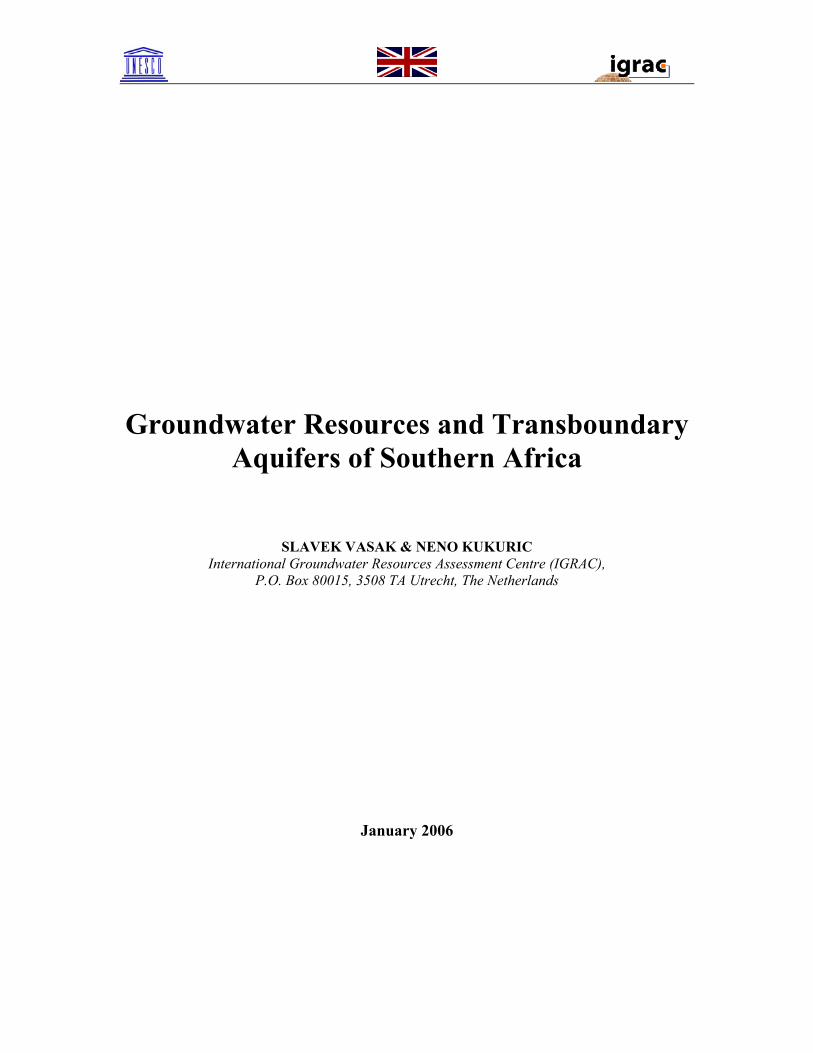
Figure 1 shows the extent of major groundwater provinces in the Southern Africa. Colours in the map reflect the dominant geological setting as described above. This division provides the first insight in the probable pattern of groundwater occurrence.
Sedimentary Basin Provinces:
•Congo Basin
•Kalahari-Ethosha Basin
•Basins of Mozambique
•East African Coastal Basins
Folded Mountain Provinces:
•Cape Fold Belt
Volcanic Provinces:
•Volcanics of East Africa
Basement Provinces:
•West Congo & Damer Percambrian Belt
•West Kalahari Precambrian
•East Congo and Kalahari Precambrian
•East African Basement
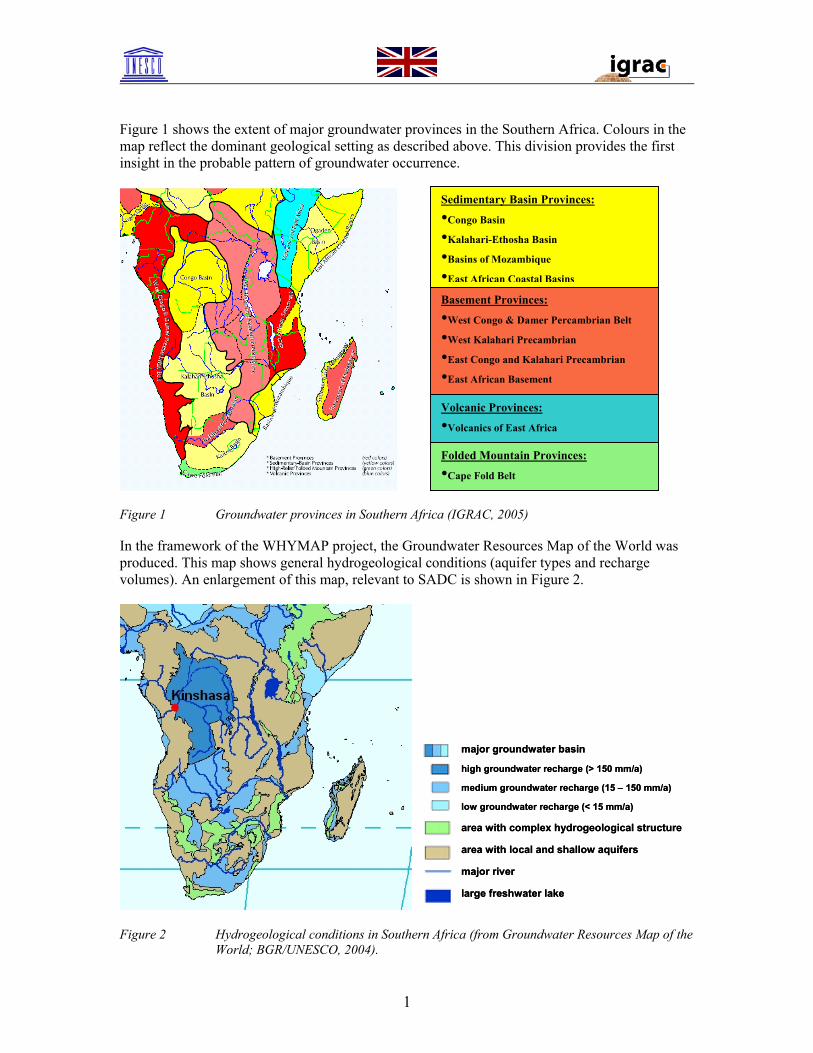
Figure 1 Groundwater provinces in Southern Africa (IGRAC, 2005) In the framework of the WHYMAP project, the Groundwater Resources Map of the World was produced. This map shows general hydrogeological conditions (aquifer types and recharge volumes). An enlargement of this map, relevant to SADC is shown in Figure 2.
major groundwater basin
high groundwater recharge (> 150 mm/a)
medium groundwater recharge (15 – 150 mm/a)
low groundwater recharge (< 15 mm/a)
area with complex hydrogeological structure
area with local and shallow aquifers
major river
large freshwater lake
major groundwater basin
high groundwater recharge (> 150 mm/a)
medium groundwater recharge (15 – 150 mm/a)
low groundwater recharge (< 15 mm/a)
area with complex hydrogeological structure
area with local and shallow aquifers
major river
large freshwater lake
Figure 2 Hydrogeological conditions in Southern Africa (from Groundwater Resources Map of the
World; BGR/UNESCO, 2004).
1
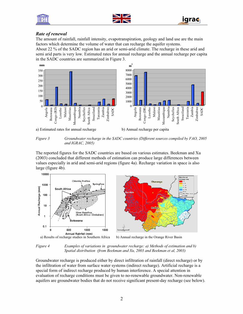
Rate of renewal The amount of rainfall, rainfall intensity, evapotranspiration, geology and land use are the main factors which determine the volume of water that can recharge the aquifer systems. About 22 % of the SADC region has an arid or semi-arid climate. The recharge in these arid and semi arid parts is very low. Estimated rates for annual recharge and the annual recharge per capita in the SADC countries are summarized in Figure 3.
050
100150200250300350
Ang
ola
Bot
swan
aC
ongo
(RD
)Le
soth
oM
alaw
iM
aurit
ius
Moz
ambi
que
Nam
ibia
Seyc
helle
sSo
uth
Afri
caSw
azila
ndTa
nzan
iaZa
mbi
aZi
mba
bwe
SAD
C
mm
010002000300040005000600070008000
Ang
ola
Bot
swan
aC
ongo
(DR
)Le
soth
oM
alaw
iM
aurit
ius
Moz
ambi
que
Nam
ibia
Seyc
helle
sSo
uth
Afri
caSw
azila
ndTa
nzan
iaZa
mbi
aZi
mba
bwe
SAD
C
m3
a) Estimated rates for annual recharge b) Annual recharge per capita Figure 3 Groundwater recharge in the SADC countries (Different sources compiled by FAO, 2005
and IGRAC, 2005) The reported figures for the SADC countries are based on various estimates. Beekman and Xu (2003) concluded that different methods of estimation can produce large differences between values especially in arid and semi-arid regions (figure 4a). Recharge variation in space is also large (figure 4b).
a) Results of recharge studies in Southern Africa b) Annual recharge in the Orange River Basin
Figure 4 Examples of variations in groundwater recharge: a) Methods of estimation and b)
Spatial distribution (from Beekman and Xu, 2003 and Beekman et al, 2003) Groundwater recharge is produced either by direct infiltration of rainfall (direct recharge) or by the infiltration of water from surface water systems (indirect recharge). Artificial recharge is a special form of indirect recharge produced by human interference. A special attention in evaluation of recharge conditions must be given to no-renewable groundwater. Non-renewable aquifers are groundwater bodies that do not receive significant present-day recharge (see below).
2
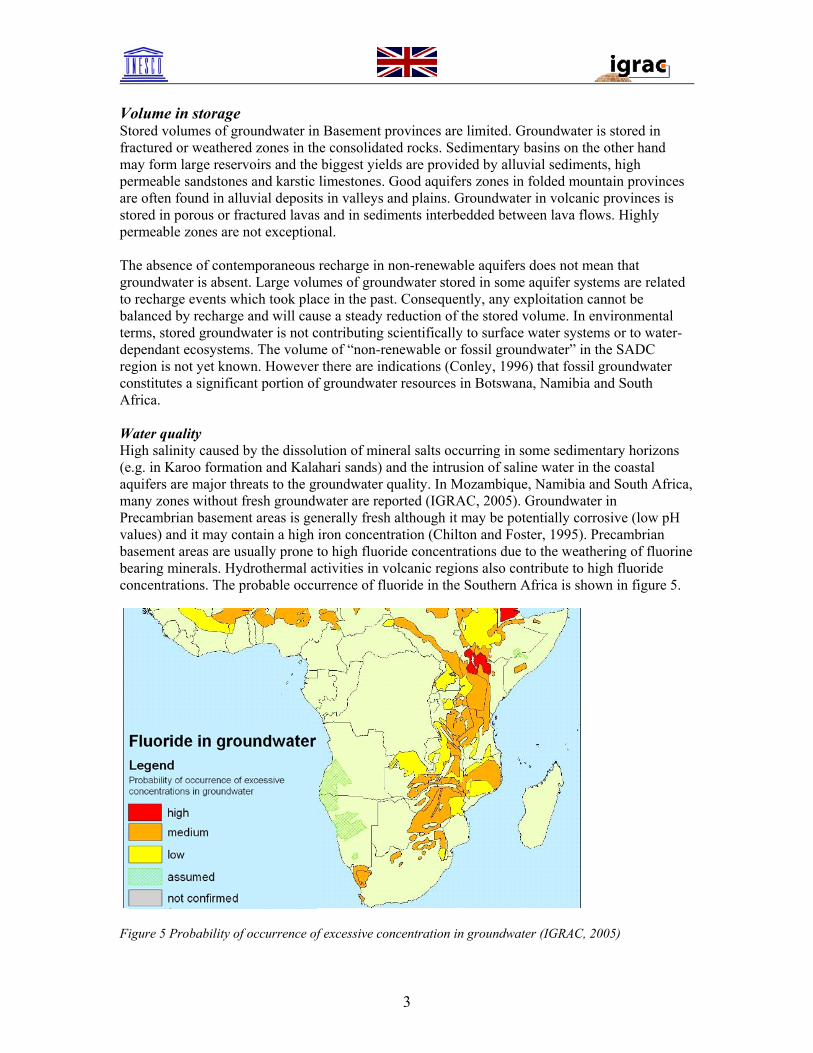
Volume in storage Stored volumes of groundwater in Basement provinces are limited. Groundwater is stored in fractured or weathered zones in the consolidated rocks. Sedimentary basins on the other hand may form large reservoirs and the biggest yields are provided by alluvial sediments, high permeable sandstones and karstic limestones. Good aquifers zones in folded mountain provinces are often found in alluvial deposits in valleys and plains. Groundwater in volcanic provinces is stored in porous or fractured lavas and in sediments interbedded between lava flows. Highly permeable zones are not exceptional. The absence of contemporaneous recharge in non-renewable aquifers does not mean that groundwater is absent. Large volumes of groundwater stored in some aquifer systems are related to recharge events which took place in the past. Consequently, any exploitation cannot be balanced by recharge and will cause a steady reduction of the stored volume. In environmental terms, stored groundwater is not contributing scientifically to surface water systems or to water-dependant ecosystems. The volume of “non-renewable or fossil groundwater” in the SADC region is not yet known. However there are indications (Conley, 1996) that fossil groundwater constitutes a significant portion of groundwater resources in Botswana, Namibia and South Africa. Water quality High salinity caused by the dissolution of mineral salts occurring in some sedimentary horizons (e.g. in Karoo formation and Kalahari sands) and the intrusion of saline water in the coastal aquifers are major threats to the groundwater quality. In Mozambique, Namibia and South Africa, many zones without fresh groundwater are reported (IGRAC, 2005). Groundwater in Precambrian basement areas is generally fresh although it may be potentially corrosive (low pH values) and it may contain a high iron concentration (Chilton and Foster, 1995). Precambrian basement areas are usually prone to high fluoride concentrations due to the weathering of fluorine bearing minerals. Hydrothermal activities in volcanic regions also contribute to high fluoride concentrations. The probable occurrence of fluoride in the Southern Africa is shown in figure 5.
Figure 5 Probability of occurrence of excessive concentration in groundwater (IGRAC, 2005)
3
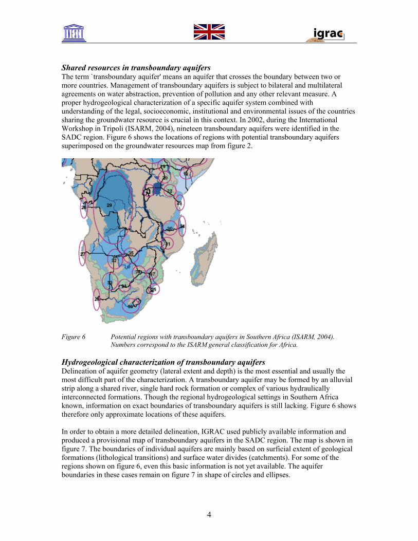
Shared resources in transboundary aquifers The term `transboundary aquifer' means an aquifer that crosses the boundary between two or more countries. Management of transboundary aquifers is subject to bilateral and multilateral agreements on water abstraction, prevention of pollution and any other relevant measure. A proper hydrogeological characterization of a specific aquifer system combined with understanding of the legal, socioeconomic, institutional and environmental issues of the countries sharing the groundwater resource is crucial in this context. In 2002, during the International Workshop in Tripoli (ISARM, 2004), nineteen transboundary aquifers were identified in the SADC region. Figure 6 shows the locations of regions with potential transboundary aquifers superimposed on the groundwater resources map from figure 2.
Figure 6 Potential regions with transboundary aquifers in Southern Africa (ISARM, 2004).
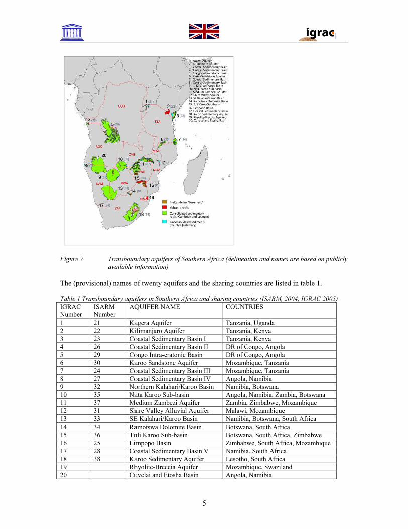
Numbers correspond to the ISARM general classification for Africa. Hydrogeological characterization of transboundary aquifers Delineation of aquifer geometry (lateral extent and depth) is the most essential and usually the most difficult part of the characterization. A transboundary aquifer may be formed by an alluvial strip along a shared river, single hard rock formation or complex of various hydraulically interconnected formations. Though the regional hydrogeological settings in Southern Africa known, information on exact boundaries of transboundary aquifers is still lacking. Figure 6 shows therefore only approximate locations of these aquifers. In order to obtain a more detailed delineation, IGRAC used publicly available information and produced a provisional map of transboundary aquifers in the SADC region. The map is shown in figure 7. The boundaries of individual aquifers are mainly based on surficial extent of geological formations (lithological transitions) and surface water divides (catchments). For some of the regions shown on figure 6, even this basic information is not yet available. The aquifer boundaries in these cases remain on figure 7 in shape of circles and ellipses.
4
Figure 7 Transboundary aquifers of Southern Africa (delineation and names are based on publicly
available information) The (provisional) names of twenty aquifers and the sharing countries are listed in table 1. Table 1 Transboundary aquifers in Southern Africa and sharing countries (ISARM, 2004, IGRAC 2005) IGRAC Number
ISARM Number
AQUIFER NAME COUNTRIES
1 21 Kagera Aquifer Tanzania, Uganda 2 22 Kilimanjaro Aquifer Tanzania, Kenya 3 23 Coastal Sedimentary Basin I Tanzania, Kenya 4 26 Coastal Sedimentary Basin II DR of Congo, Angola 5 29 Congo Intra-cratonic Basin DR of Congo, Angola 6 30 Karoo Sandstone Aquifer Mozambique, Tanzania 7 24 Coastal Sedimentary Basin III Mozambique, Tanzania 8 27 Coastal Sedimentary Basin IV Angola, Namibia 9 32 Northern Kalahari/Karoo Basin Namibia, Botswana 10 35 Nata Karoo Sub-basin Angola, Namibia, Zambia, Botswana 11 37 Medium Zambezi Aquifer Zambia, Zimbabwe, Mozambique 12 31 Shire Valley Alluvial Aquifer Malawi, Mozambique 13 33 SE Kalahari/Karoo Basin Namibia, Botswana, South Africa 14 34 Ramotswa Dolomite Basin Botswana, South Africa 15 36 Tuli Karoo Sub-basin Botswana, South Africa, Zimbabwe 16 25 Limpopo Basin Zimbabwe, South Africa, Mozambique 17 28 Coastal Sedimentary Basin V Namibia, South Africa 18 38 Karoo Sedimentary Aquifer Lesotho, South Africa 19 Rhyolite-Breccia Aquifer Mozambique, Swaziland 20 Cuvelai and Etosha Basin Angola, Namibia
5
Once the geometry of the aquifers is known, variables regarding recharge, discharge and groundwater quality must be specified. Understanding the dynamic of an aquifer system (flow direction, seasonal fluctuations) helps evaluate the impact of abstraction on groundwater levels and vulnerability to pollution in various parts of transboundary aquifer. Managerial issues of transboundary aquifers Management of transboundary aquifers requires willingness to cooperate among the countries concerned. Transboundary aquifers are subject to “conflicts of interest” created by the resource partition with respect to different environmental, economic and social targets of the sharing countries. A SADC Protocol on shared Watercourses (both surface and groundwater systems) was adopted in 1995 and revised in 2000 (Molapo and Puyoo, 2002). The surface water systems can have a large influence on the quantity and quality of groundwater recharge. Integrated water management is therefore needed when addressing current groundwater problems in the region. Crucial in the management of transboundary aquifers is the information on behavior of national (ground)water systems on both sides of the border. This information, based on the evaluation of (ground)water related data should be exchanged and combined in a joint management. Better access to information on transboundary aquifers in SADC To provide, in short time, easily manageable storage facilities for existing and newly to be collected information, UNESCO has initiated development of a web-based database system for transboundary aquifers in Southern Africa. Development of the system is financially supported by the United Kingdom-grant and it is being implemented by the International Groundwater Resources Assessment Centre (IGRAC). The system includes a map of defined and/or inferred transboundary aquifers in the SADC region that serves as a geographical base to enter the system. The system allows managing data which are considered to provide information on aquifer geometry, groundwater characteristics and groundwater management aspects. An interactive meta-information database on organizations, people and documents containing data supplied by individual countries, has also been developed. A digital project workspace set up and faciliated by IGRAC allows for improved communication between all participating SADC members. How to access the web-site on transboundary aquifers in SADC The system can be entered through the ISARM-site http://www.isarm.net/ as follows:
• Click on “Regional Activities” (Circle with Map of Africa on the right side) • Click on “ISARM Africa” • Click on “Transboundary Aquifers in Southern Africa” under Links at the bottom of
the page. • Click on “Global Overview” in the text of this page .The “Global Overview” can
directly be viewed by using the IGRAC web-site http://igrac.nitg.tno.nl/ggis_map/start.html.
• Choose “By Transboundary Aquifer” in the upper dropdown selection button (default appearance is “By Country”).
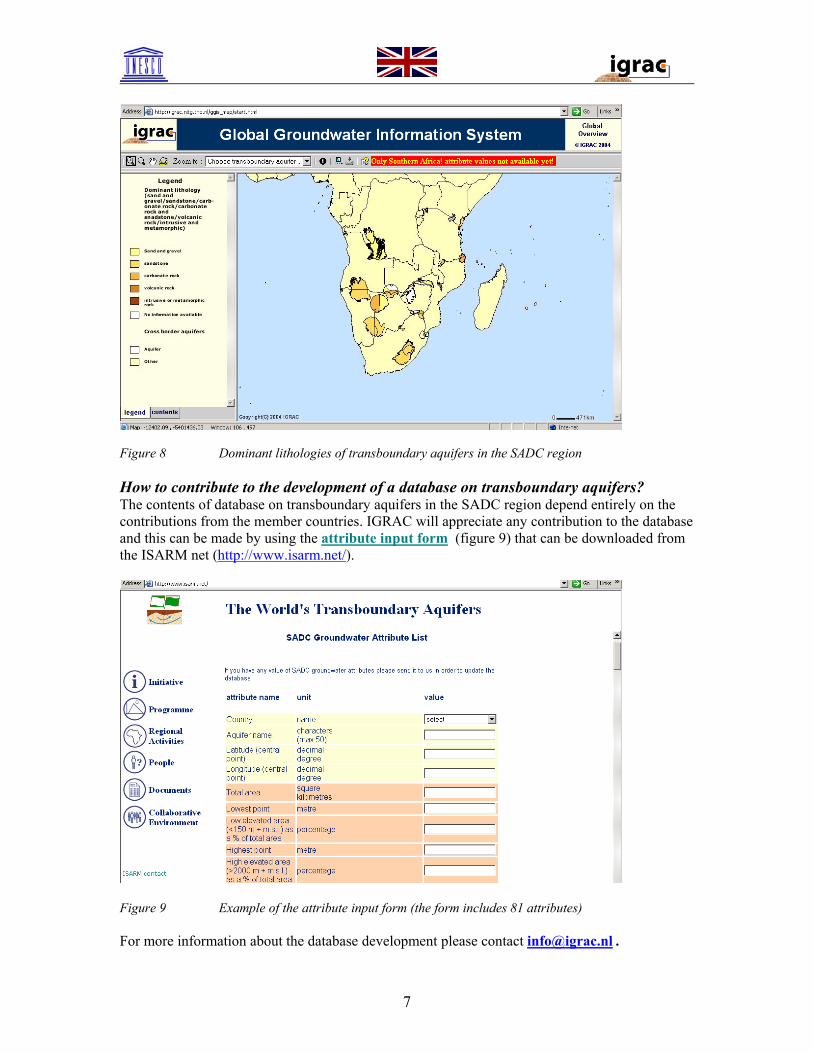
To demonstrate the functionality of the system, (provisional) data on lithologies of aquifers has been inserted. These data can be viewed as follows:
• Choose in the lower dropdown selection button (Select categories) “Aquifer Characteristics”
• Select “dominant lithology” The map with dominant lithologies is shown in figure 8.
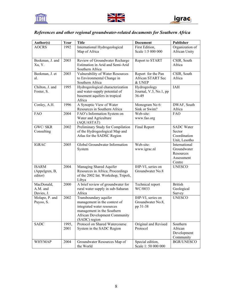
Figure 8 Dominant lithologies of transboundary aquifers in the SADC region How to contribute to the development of a database on transboundary aquifers? The contents of database on transboundary aquifers in the SADC region depend entirely on the contributions from the member countries. IGRAC will appreciate any contribution to the database and this can be made by using the attribute input form (figure 9) that can be downloaded from the ISARM net (http://www.isarm.net/).
Figure 9 Example of the attribute input form (the form includes 81 attributes) For more information about the database development please contact [email protected] .
References and other regional groundwater-related documents for Southern Africa Author(s) Year Title Document Publisher AOCRS 1992 International Hydrogeological
Map of Africa First Edition, Scale 1:5 000 000
Organization of African Unity
Beekman, J. and Xu, Y.
2003 Review of Groundwater Recharge Estimation in Arid and Semi-Arid Southern Africa
Report to START CSIR, South Africa
Beekman, J. et al.
2003 Vulnerability of Water Resources to Environmental Change in Southern Africa
Report for the Pan African START Sec & UNEP
CSIR, South Africa
Chilton, J. and Foster, S.
1995 Hydrogeological characterization and water-supply potential of basement aquifers in tropical Africa
Hydrogeology Journal, V.3, No.1, pp 36-49
IAH
Conley, A.H. 1996 A Synoptic View of Water Resources in Southern Africa
Monogram No 6: Sink or Swim?
DWAF, South Africa
FAO 2004 FAO’s Information System on Water and Agriculture (AQUASTAT)
Web-site: www.fao.org
FAO
GWC/ SKR Consulting
2002 Preliminary Study for Compilation of the Hydrogeological Map and Atlas for the SADSC Region
Final Report SADC Water Sector Coordination Unit, Lesotho
IGRAC 2005 Global Groundwater Information System
Web-site: www.igrac.nl
International Groundwater Resources Assessment Centre
ISARM (Appelgren, B, editor)
2004 Managing Shared Aquifer Resources in Africa; Proceedings of the 2002 Int. Workshop, Tripoli, Libya
IHP-VI, series on Groundwater No.8
UNESCO
MacDonald, A.M. and Davies, J.
2000 A brief review of groundwater for rural water supply in sub-Saharan Africa
Technical report WC/0033
British Geological Survey
Molapo, P. and Puyoo, S.
2002 Transboundary aquifer management in the context of integrated water resources management in the Southern African Development Community (SADC) region
IHP-VI, series on Groundwater No.8, pp 31-38
UNESCO
SADC 1995, 2001
Protocol on Shared Watercourse System in the SADC Region
Original and Revised Protocol
Southern African Development Community
WHYMAP 2004 Groundwater Resources Map of the World
Special edition, Scale 1: 50 000 000
BGR/UNESCO
8
9
Whom to contact on issues regarding groundwater resources and transboundary aquifers in Southern Africa
Country/Institution Contact person Department Phone/e-mail Angola National Department of Water
Supply and Sanitation Ministry of Construction and Housing