University of NSW Planning Law and Practice 2003 1 GROWTH MANAGEMENT AND RURAL LAND Ian Sinclair Principal Consultant EDGE Land Planning www.ruralplanning.com.au University of NSW Faculty of the Built Environment Planning Law and Practice Short Course 2003 1. INTRODUCTION Australia’s agricultural land is a finite resource. Contrary to most beliefs, only 10 % of Australia’s landmass is arable land suitable for soil based agriculture and livestock production. Much of this is marginal with respect to water and nutrient regimes. (Nix, 1988 p.75). Most of this land is located on the coastal fringe of the continent. Australia is a heavily urbanised country. In 1991 82.5% of the population lived in urban centres of 10,000 or more (71.7% lived in urban cities larger than 80,000 people). (State of the Environment Advisory Council, 1996 p3.4) The metropolitan areas of Australia have increased in their share of population from 53.6% in 1954 to 62.7 % in 1996. (Budge and Sinclair, 1998, p3) Most of these centres are located in the coastal or near coastal fringe of the continent between Brisbane and Adelaide. In NSW, 82% of the population lives in the coastal areas, with most of them in the Newcastle - Sydney - Wollongong regions (ABS, 1997). Planning for rural land is an important component of the Planning Profession. Rural land can be many things and many different people have different ideas as to the actual definition of rural land. Rural land can best be described as land that is used for any land use that is not urban. However, the term rural does not define the use of the land, it defines the character - one of rolling hills interspersed with native and exotic vegetation and animals. The main feature of rural land is that it has an unplanned, non-uniform, natural look and can be described as "chaotic". This describes rural land the most accurately – it is a mixture of uses where no one use is the dominant one. The thing to note is that everybody has a different definition of rural land, depending on a range of things such as their background, age, where they live, etc. You could say that the dominant use is rural. Rural land is where the bulk of the nation’s food source is generated. There are three basic components of the use of rural land: agriculture, residential and natural vegetation / ecological issues. There is an increasing trend towards the fragmentation of productive agricultural land, which is affecting its capability to produce agriculture in a sustainable manner. Once viable farming units are now being made into smaller less viable units and the use changed to residential- type uses with no realisation about the impacts of this on such issues as land degradation, rural land use conflict or the cumulative impact of the loss to production of this good agricultural land. This trend is exemplified on the fringe of the Sydney region where the desire for rural living and a productive agricultural hinterland are coming into conflict. Agricultural production in the Sydney region is an important part of the economy as well as providing a rural hinterland. Although this paper focuses on the Sydney region, the issues and problems are evident throughout Rural NSW and Australia. Figure 1 shows the “Cycle of Farmland Conversion “, which is taken from a recently published book on Farmland Preservation in America. It is significant to note that the cycle is as relevant to the Australian situation as it is in America, signifying that it is an international problem. There is a need for Growth Management Strategies that provide a balance between the pressure of urban and rural residential growth and the need protect this high quality agricultural land from further fragmentation and alienation. Sound strategic planning is best placed to provide for the future of agricultural land. However, the first step is for agricultural land to be recognised as a legitimate land use planning constraint when considering growth management strategies for the expansion of Sydney and other rural towns and cities into the rural hinterland.
Transcript
University of NSW Planning Law and Practice 2003 1
GROWTH MANAGEMENT AND RURAL LAND
Ian Sinclair Principal Consultant EDGE Land Planning
www.ruralplanning.com.au
University of NSW Faculty of the Built Environment Planning Law and Practice Short Course 2003 1. INTRODUCTION Australia’s agricultural land is a finite resource. Contrary to most beliefs, only 10 % of Australia’s landmass is arable land suitable for soil based agriculture and livestock production. Much of this is marginal with respect to water and nutrient regimes. (Nix, 1988 p.75). Most of this land is located on the coastal fringe of the continent. Australia is a heavily urbanised country. In 1991 82.5% of the population lived in urban centres of 10,000 or more (71.7% lived in urban cities larger than 80,000 people). (State of the Environment Advisory Council, 1996 p3.4) The metropolitan areas of Australia have increased in their share of population from 53.6% in 1954 to 62.7 % in 1996. (Budge and Sinclair, 1998, p3) Most of these centres are located in the coastal or near coastal fringe of the continent between Brisbane and Adelaide. In NSW, 82% of the population lives in the coastal areas, with most of them in the Newcastle - Sydney - Wollongong regions (ABS, 1997). Planning for rural land is an important component of the Planning Profession. Rural land can be many things and many different people have different ideas as to the actual definition of rural land. Rural land can best be described as land that is used for any land use that is not urban. However, the term rural does not define the use of the land, it defines the character - one of rolling hills interspersed with native and exotic vegetation and animals. The main feature of rural land is that it has an unplanned, non-uniform, natural look and can be described as "chaotic". This describes rural land the most accurately – it is a mixture of uses where no one use is the dominant one. The thing to note is that everybody has a different definition of rural land, depending on a range of things such as their background, age, where they live, etc. You could say that the dominant use is rural. Rural land is where the bulk of the nation’s food source is generated. There are three basic components of the use of rural land: agriculture, residential and natural vegetation / ecological issues.
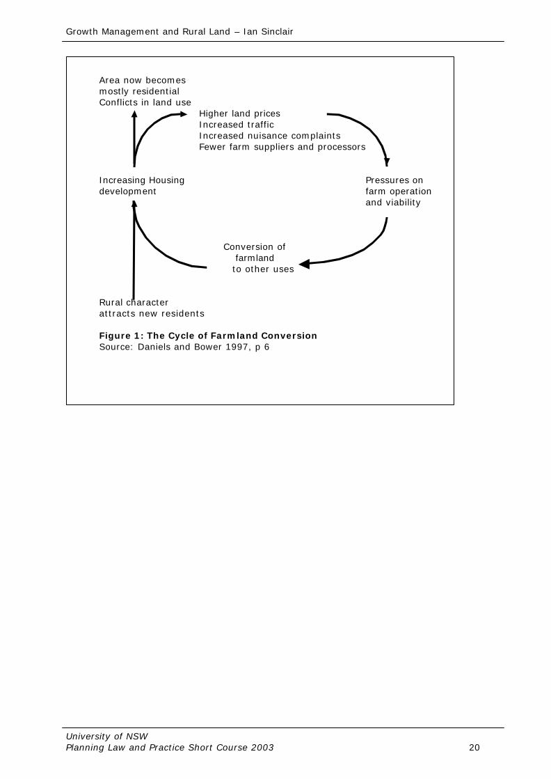
There is an increasing trend towards the fragmentation of productive agricultural land, which is affecting its capability to produce agriculture in a sustainable manner. Once viable farming units are now being made into smaller less viable units and the use changed to residential-type uses with no realisation about the impacts of this on such issues as land degradation, rural land use conflict or the cumulative impact of the loss to production of this good agricultural land. This trend is exemplified on the fringe of the Sydney region where the desire for rural living and a productive agricultural hinterland are coming into conflict. Agricultural production in the Sydney region is an important part of the economy as well as providing a rural hinterland. Although this paper focuses on the Sydney region, the issues and problems are evident throughout Rural NSW and Australia. Figure 1 shows the “Cycle of Farmland Conversion “, which is taken from a recently published book on Farmland Preservation in America. It is significant to note that the cycle is as relevant to the Australian situation as it is in America, signifying that it is an international problem.
There is a need for Growth Management Strategies that provide a balance between the pressure of urban and rural residential growth and the need protect this high quality agricultural land from further fragmentation and alienation. Sound strategic planning is best placed to provide for the future of agricultural land. However, the first step is for agricultural land to be recognised as a legitimate land use planning constraint when considering growth management strategies for the expansion of Sydney and other rural towns and cities into the rural hinterland.
Growth Management and Rural Land – Ian Sinclair
University of NSW Planning Law and Practice Short Course 2003 2
Once recognised, there is a need to develop policy to preserve the agricultural land. This can be by planning policy or through economic incentives or right to farm legislation. The issue of planning policy is being recognised at the Local and the State Government levels to varying degrees. In the Sydney region, Wollondilly Shire has prepared a Local Environmental Plan (LEP) and incorporated the issue in its Corporate Plan, Hornsby Shire has prepared a draft LEP, Hawkesbury Council has prepared a Sustainable Agriculture Development Strategy whilst Camden and Penrith Councils are preparing a Rural Lands Study. Shellharbour, in the Illawarra has prepared a Rural Lands Strategy. Other Councils on the North Coast have also prepared strategies and plans. The North Coast Regional Environmental Plan 1988 (REP) requires that all land identified as prime crop and pastureland is zoned as agricultural protection. The recently released Sustainable Agriculture in the Sydney Region Strategic Plan recognises the issue, as does Sydney REP 20 Hawkesbury - Nepean River (1997 – No.2) and the Hawkesbury Nepean Planning Strategy. The issue is also recognised in Sydney to Canberra Corridor and Metropolitan Strategies. There is a need for it to be recognised by more in the planning profession. Economic incentives and right to farm legislation have not been utilised in NSW. 2. AUSTRALIA’S AGRICULTURAL LAND
Australia’s agricultural land is a finite resource “the physical environment has an underlying influence on Australia’s pattern of agricultural land use. Topography, climate, soils and vegetation are all vital determinates of agricultural land use” (ABS, 1996, p13). The Australian Continent is 7.6 million square kilometres (State of the Environment Advisory Council, 1996 p2-4). Comparatively speaking, Australia is a similar size as the United States without Alaska, about 32 times larger than the United Kingdom and more than 20 times larger than Japan (ibid). Sixty one percent of the Continent is within the temperate zone and 39% within the tropical zone (ABS, 1998). Australia’s climate is such that it is the driest inhabited continent on the earth. More than 1/3 of Australia is classified as arid which means it receives an annual average rainfall of less than 250 mm. Another 1/3 is semi arid with an annual rainfall between 250 mm and 500 mm. A good indicator of the aridity of the country is the amount of rainfall needed to grow crops without irrigation. In the far south of the continent, rain fed crops need about 250 mm of rain per year. In most of NSW it is 375 mm rising to 500 mm in northern NSW and southeast Queensland and 750 mm in the far north of the country. Australian soils are among the most nutrient poor in the world (State of the Environment Advisory Council, 1996, p2-8) and thus providing very few naturally good soils for agriculture. Most of the soils are infertile and shallow which have deficiencies in nitrogen and phosphorous. This adds to the infertility. “Fragile soil structure and a susceptibility to water logging are rather common features of Australian soils while large areas are naturally affected by salt and/or acidity. The soil characteristics may restrict particular agricultural activities or rule out agricultural activity altogether” (ABS, 1996, p19). Australian soils are also very low in organic matter and thus are not highly productive for plants and animals. In total, only a small area of the country has soils with the valuable characteristics of being deep and well drained with high fertility and high water holding capacity. The presence of areas of natural vegetation is an important component of agricultural land and sustainable agriculture. The preservation of native vegetation and biodiversity has a number of benefits for agriculture. Native vegetation, on steep land, can prevent erosion and loss of soil adding to a healthy catchment. Native trees and shrubs also play an important role in lowering the watertable and thus reducing the salinity problems as well as providing shelter for crops and stock. All of this adds to the productivity of agriculture and enables the achievement of a sustainable agricultural environment. The major area of agricultural activity and good soils is on the coastal fringe, to the edge of the inland and are located on the eastern and southern western tip of the continent. When one considers the locations of the major agricultural areas, it is evident that much of the productive land, especially for intensive uses such as fresh vegetables are located along the
Growth Management and Rural Land – Ian Sinclair
University of NSW Planning Law and Practice Short Course 2003 3
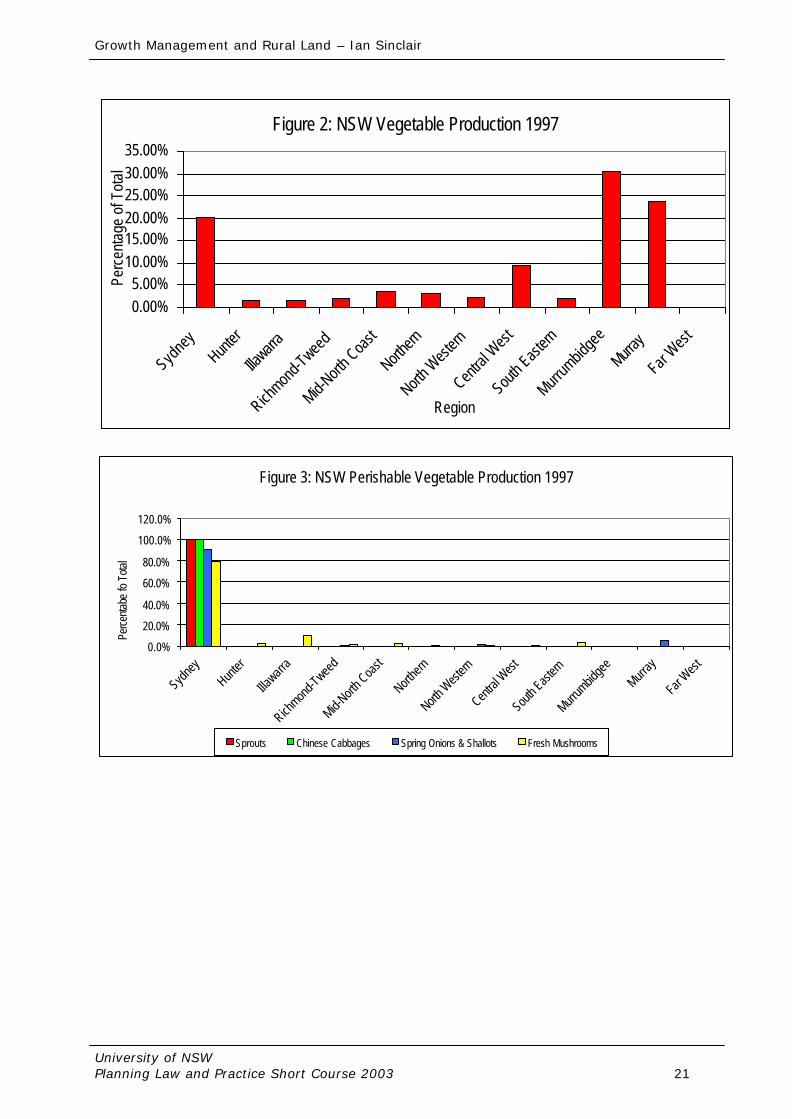
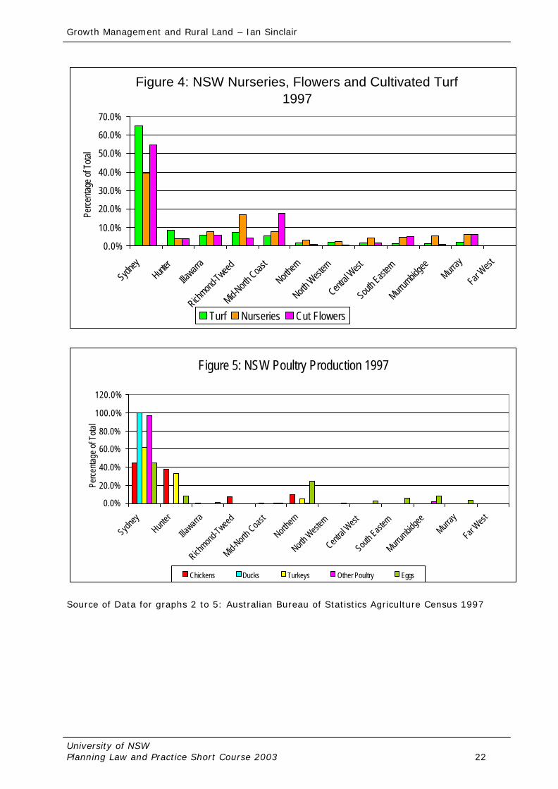
coastal strip of the continent. Paradoxically, this is where the majority of Australia’s population is located, due to historical settlement patterns and a desirable climate, which promotes lifestyle aspiration. 3. AGRICULTURE IN THE SYDNEY REGION The protection of high quality agricultural land within the Sydney region is an important issue for the future planing of the region and its fresh food and produce supply. It is the Shires located on the fringe of Sydney which produce a significant proportion of the fresh produce both consumed and produced in New South Wales (especially perishable commodities). The main agricultural produce grown in Sydney's urban fringe is perishable vegetables, poultry, nurseries, flowers and cultivated turf. There are also considerable dairies, orchards, horse studs and spelling properties as well as goats, deer, alpacas and other traditional forms of agriculture. Australian Bureau of Statistics Data for the 1993-94 Agricultural Census has been analysed to illustrate this point. (Sinclair, 1996b) Vegetable Production occurs in all regions of NSW. The Murray and Murrumbidgee regions produce the highest percentages of total vegetable production (27% and 32%) respectively. The Sydney region contributes 10% of the total vegetable tonnage produced in NSW. (See figure 2) However, when one breaks this vegetable production into perishable commodities, (those commodities that perish quickly when harvested and therefore need to be located close to the market they serve) a different picture arises. It can be seen from figure 3 that the Sydney region produces 52% of the State's lettuce production 84% of fresh mushrooms, 78% of spinach, 90% of spring onions and shallots, 98% of parsley and 100% of the total tonnage of Chinese cabbages. The Sydney region also accounts for 40% of the State's total area devoted to nurseries, 53% of flower production and 56% of the total area under cultivated turf (See Figure 4). Poultry production in the Sydney region accounts for 51% of the State total. Figure 5 illustrates this graphically, it also shows that the Sydney region is where the various types of poultry products originate (these being chickens, ducks and turkeys for meat as well as egg production). NSW Agriculture estimates the value of agriculture in the Sydney region to be $1 billion. (NSW Agriculture, 1997 p12) There is a high proportion of high quality agricultural land in the Sydney region. In fact, approximately 20 % of the land area left are classed as prime agricultural land (Classes 1 - 3). 4. THE BENEFITS OF AGRICULTURE FOR SYDNEY The retention of the broad range of agricultural production in the Sydney region generates a wide range of benefits, the main ones being its economic contribution, its market proximity and ability to provide a land use that is compatible with catchment management for the Nepean Hawkesbury River. In addition to the real dollar value of agriculture mentioned above, it also has economic benefits for the Sydney region. The agricultural industry can generate substantial economic linkages and multiplier effects to other industries such as retailing and other commercial uses (banking, solicitors, accountants etc). The multipliers for agriculture vary significantly but are generally recognised to be in the order of two to three (Young 1993, page 2). That is, every dollar of agricultural output is worth $2 or $3 to the economy in total as a result of flow-on affects. However, this multiplier may not include the subsequent processing of agricultural product. When such value added processes are included the total value can be two to three times the initial multiplier (Young 1993, page 2). In the case of the poultry industry the economic multiplier effects have been identified as being 6.77 for employment, 3.25 for output and 0.58 for household income (Larkin 1991). Employment in the agricultural sector can be broken into two components, full-time and part-time. This is a result of the generally intensive nature of agriculture practiced in the Sydney region. Given this, there is a large part-time seasonal workforce, which can be supplied from
Growth Management and Rural Land – Ian Sinclair
University of NSW Planning Law and Practice Short Course 2003 4
the large adjoining population. This workforce is employed in the picking of fruit, harvesting of vegetables and other produce - all very seasonal activities requiring a pool of flexible part-time workers. Sydney's large population means that it is a large market for fresh produce. The fragility and perishability of much of the fresh produce makes it essential to have quick access to the markets so that it reaches the consumers fresh. This market proximity means that farmers can take their own products to the markets and thus do not need to employ agents or carriers for market delivery. This allows for economies of scale. Market proximity for raw materials is also important for such uses as poultry where feed is produced in the Sydney region as well as for the sale of the birds. It should be noted that most of the poultry processing plants are located in the Sydney region. The consumer’s desire for fresh as opposed to frozen poultry and the number of fresh poultry shops also adds weight to the point. Maintenance of agricultural land use has the potential to promote the long term protection of the water quality of the Nepean Hawkesbury River. Agriculture can be a more sustainable and more easily managed catchment land use than urban development or rural residential development as it does not generally generate the substantial need for effluent disposal as well as run off controls. Both of these are acknowledged as contributing to the water quality problems of the Nepean Hawkesbury River. Agriculture can be used as a buffer between the river and other land uses to act as a filter for protection of the River's water quality. The continuing existence of agricultural development on the fringe of the Sydney region will maintain the rural character of this area. The term rural character is a difficult one to define. It incorporates agricultural production, rolling hills, trees and bushland and built elements scattered over the countryside. It is unplanned and irregular. This has the benefit of providing an area, which is close to the urban area and allows residents to enjoy the rural landscape character. Such an experience is vital for the tourism potential as well as contributing to the quality of life of the residents of urban Sydney. It also provides a buffer between the urban area and the surrounding National Park system. Another feature of regional agriculture is its highly integrated nature. The Poultry Industry and market gardens are good examples of this. The market gardens utilise the poultry manure as fertiliser. Poultry also utilises wood shavings for the floors of the sheds. The Mushroom industry is another good example. Mushrooms are grown in compost that is made from a mixture of straw (from wheat stubble and stable beds sourced from the racing stables in Sydney), cotton husks and poultry manure. Once the mushrooms have been grown the compost is sold as garden compost. Thus there are benefits for the integration of different agricultural practices. The wastes from one practice become the raw materials for another. This linkage is broken when one industry is forced to relocate to another geographic area. The disposal of urban wastes, especially sewage has implications for the continuation of agriculture. The acceptable disposal of sewage is one of the major environmental issues facing the community at this time. Investigations are being carried out into the possibility of land disposal using agriculture and/or agroforestry practices. A Sewerage Treatment Plant using this system is to be constructed in Picton serving the towns of Picton, Tahmoor and Thirlmere. This type of effluent disposal is anticipated to be used elsewhere and thus significant areas of agricultural land will need to be preserved for this purpose. The Sydney region has soil characteristics, a growing season and rainfall patterns which are all suitable for the growing of most temperate crops such as deciduous fruits (citrus and pome fruits), fresh vegetables, cut flowers and nursery stock as well as cultivated turf. The agricultural land uses also have a considerable medium term capital investment associated with them. This includes buildings and structures such as poultry sheds, packing sheds, machinery sheds and hot houses ("Igloos") as well as hail and bird netting. Plant and machinery used on the properties is also included here. An example of the magnitude of this investment can be found in the case of Poultry Sheds in Wollondilly. The cost of building a
Growth Management and Rural Land – Ian Sinclair
University of NSW Planning Law and Practice Short Course 2003 5
new Poultry Shed today is in the order of $150,000 per shed. The Wollondilly Agricultural Lands Study found that there are a total of 277 Poultry sheds in the Local Government Area. This equates to an investment of $41.5 million in today's dollars. The existing investment in agricultural infrastructure, therefore is a reason for the continuation of agricultural production given the high cost of replacement. It stands to reason to use what is there at present than to go through the costly procedure of relocating agriculture to another location. 5 THE SPATIAL DISTRIBUTION OF AUSTRALIA’S POPULATION “The two main distinguishing characteristics of Australia’s settlement pattern are the spread of urbanisation along the coast line and the concentration of Australia’s population in five large cities.” (State of the Environment Advisory Council 1996, p 3-8). Australia’s resident population at 30 December 1998 was 18.87 million (ABS 199, p 1). The population is growing at a rate of 1.3% per annum. The distribution of Australia’s population is such that it is concentrated in two separate coastal regions. These being the south west of Western Australia and the south east and east coast focused on Southern Queensland, NSW and Victoria. In both areas the population is concentrated in urban centres mainly in the capital cities. “Half the area of the continent contains only 0.3% of the population and the most densely populated 1% of the continent contains 84% of the population. (ABS 1998 p135). Australia is widely recognised as one of the world’s most urbanised countries. In 1996, 79.5% of the population lived in towns and cities of 5,000 or more. This is an increasing trend and in the past 75 years, the population living in cities has gone from 49.7% to 79.5%. Similarly, the population growth has been higher in metropolitan areas than other urban areas. (Budge and Sinclair, 1998). “The worlds population is urbanising much faster than it is growing…by the year 2005, half of the worlds people will live in an urban area; by the year 2025 that number will be about 2 out of 3” (World Resources Institute, 1994, p 31). Between 1993 and 1998 the country experienced an average annual population growth of 1.2% per annum (ABS 1999). Much of this population growth was concentrated along the east coast with almost all of the Local Government Areas experiencing growth. In fact, most Local Government areas along the NSW and Southern Queensland coast increased their population density by more than 1 person per square kilometre (ABS 1998, p137). The localities which experienced the greatest amount of population growth were those located on the fringe of the major metropolitan areas being the capital cities of Brisbane, Sydney and Melbourne. 6. RURAL LAND USE CONFLICT The presence of agriculture and non-rural land use in the one location can often generate conflict due to their potential incompatibility. Agriculture can affect adjoining small rural lots, which are used essentially for residential purposes. Similarly, the presence of small rural lots creates an adverse influence on the continued operation of the agricultural enterprise. The issue of rural-urban conflict can arise when there is no separation between incompatible uses, let alone the misunderstanding, which may exist about the purpose and character of a district. Land use conflicts may arise in such situations through noise, odour, farm chemicals, light, visual amenity, dogs, and stock damage and weed infestation, to name just a few. When considering these conflict issues it is important to remember that agriculture is a dynamic activity utilising a range of practices and equipment commonly unfamiliar to non-rural people. The notion of a rural lifestyle is engendered by an association with the pleasant character of the landscape rather than the potentially offensive noises, odours and operations that are the reality in the agricultural areas of a rural Shire. Increasing competition for the available land tends to intensify the agricultural practices at a particular site thereby increasing the potential for conflict with non-rural residents.
Growth Management and Rural Land – Ian Sinclair
University of NSW Planning Law and Practice Short Course 2003 6
It is such a picture, which characterises agriculture on the fringe of the Sydney region. Much of it is intensive by nature given the typically small property size in preferred agricultural areas. Market gardening, turf farming and poultry production are important along with horses, cattle grazing, dairying and orcharding. All of these agricultural enterprises are able to benefit from the market advantage gained by being so close to Sydney. There are a large number of rural smallholdings offering rural residential living or hobby farming scattered throughout the rural areas of fringe shire's and other parts of Rural Australia. Many are Concessional lots which are generally 2 hectare allotments which have been excised from the larger adjacent holding with no thought of the implications of this on the future conflict that will occur. Given their historical connection with the adjacent farm and the commonly polarised nature of their respective use, the potential for conflict is great. There is also a significant proportion of lot sizes up to 10 ha that are used predominantly for Rural Residential use (Wollondilly Shire Council, 1993). The intensive nature of the agricultural enterprise may exacerbate the magnitude of the unfavourable reaction by non-rural residents. Yet the farmer may only be carrying out activities, which for the purposes of making an agricultural living are perfectly reasonable and legitimate. It is therefore important to make allowances when assessing the magnitude and nature of the conflict. The resolution of this conflict in use, attitude and perception of the rural zone is difficult to reach because of its complexity. It will not be easy especially since each "player" (farmer and rural-resident) possesses such contrary expectations about the use of their land. Neither lives in a vacuum, they live within a community which interacts, they have the opportunity to exercise their rights and responsibilities, as well as the ability to influence future decisions about their local area. It must be remembered that people need to eat. The resources to provide this food and fibre are not unlimited and the longevity of the resources depends upon the sustainable use. Similarly, people have a right to live, but in a manner which does not compromise the existing, and possibly necessary, use of the land, whilst remembering that they have certain obligations as responsible community members. Certainly education at all levels is fundamental to the resolution of the conflict over land use. How many residents whether rural or urban know that the Sydney region produces a high percentage of NSW' perishable vegetables, poultry, nurseries, cultivated turf and cut flowers? Do they wish to compromise this essential component of their local economy through unfounded attitudes on the future use of the rural land in their Council area? The dissemination of information on where, why and what is agriculture, combined with growing awareness of the scarcity of sustainable land resources will enable all residents to make more informed decisions about the desirability of one land use compared to another in a particular location. There is a need to separate incompatible land uses whilst recognising the efficiencies which can be achieved through the integration of many of these land uses. This may be achieved, for example, through physical separation or a simple vegetative buffer designed to screen one land use from another. Land use zoning can also be used and this will be discussed in detail later. Such practical strategies require potentially conflicting land uses to acknowledge their impact and then design their operations to account for this impact. A community approach utilising physical solutions, planning strategies and a long term vision for the land use of the shire will enable sustainable coexistence of agriculture and non-rural land use. Local Government can play a further role in the overall education process. Wollondilly Shire for example, places a special notation on all Section 149 Certificates (these are required to be part of a contract to sell land and stipulate the zoning and other planning issues associated with a parcel of land) so as all future purchases of rural land, especially rural residential purchasers, are advised of the surrounding agricultural uses and thereby the potential for conflict. This can be combined with media releases and other methods of disseminating the agricultural message to inform this diverse audience such as articles in Council newsletters and the Annual Report. Other government departments can also assist. NSW Agriculture for example, produces farmer publications (Agfacts, Producer Newsletters)
Growth Management and Rural Land – Ian Sinclair
University of NSW Planning Law and Practice Short Course 2003 7
that can aid in educating the public. Departmental extension staff provide advice on sustainable land management practices. 7. GROWTH MANAGEMENT As Australian towns and cities expand, they are expanding at the expense of the rural hinterland. Sydney is Australia’s largest city with a population of 3.77 million people at 30 June, 1995. This represented 62% of the total population of New South Wales. The population of Sydney increased by 36,000 (0.96%) between 1994 and 1995. (ABS, 1997 pp 4-5) The fringe localities of the Sydney region are growing at a much higher growth rate. As Sydney's population grows there is pressure put on this rural hinterland to be converted from rural to urban use. This has been a common occurrence as once productive agricultural land is converted to residential land (for both urban and rural residential uses). This land use change is occurring at a relatively high rate on the urban fringe of Sydney. The pressure to develop land for urban development and rural residential development is growing as the Sydney region population continually increases. Topographically, Sydney is a basin. Urban expansion and the associated rural residential uses have reached the edge of the basin and are coming into conflict with the agricultural and environmental issues on the fringe. Agriculture cannot move over the lip of the basin into the western areas because, as we saw in the recent drought, there is not sufficient water. Nor is there the workforce and the cost of relocating the infrastructure is very high. The soils, generally, are not as fertile for the intensive nature of agricultural production west of the divide. If this urban expansion is to continue unchecked we will run out of productive, high quality agricultural land in the Sydney region.
Associated with the actual urban growth is a desire for residential living in a rural setting (known generally as rural residential development). This type of living opportunity, if not segregated, invariably creates conflict with the surrounding agricultural land uses, which are being practiced on the high quality agricultural land. This conflict arises when these rural residential lots are generally scattered throughout the countryside and next to productive farms. These incompatible land use patterns result in major conflict as is currently being seen with poultry operations and market gardens to name a few. This conflict, if left unchecked, will only intensify as agricultural production is forced to relocate from other parts of Sydney. Unplanned rural residential uses that are permitted to locate next to productive agricultural land is perhaps the more important issue for other parts of Rural Australia beyond the metropolitan fringe. The NSW Department of Urban Affairs and Planning has developed two strategy documents that aim to provide the framework for the management of Sydney's growth. Cities for the 21st Century provides strategies for the Sydney region, whereas the Sydney to Canberra Corridor Strategy plans for growth in one of the most important inland growth regions in NSW. Both documents were prepared in consultation with the community. 7.1 Sydney Metropolitan Strategy Strategies for the growth of Sydney have been prepared over the past 50 years with a number of documents being developed by the State Government Authorities. The latest of these is titled Cities for the 21 Century. It is the new planning strategy for the greater metropolitan region of Sydney, Newcastle, the Central Coast and Wollongong. It is the result of a process of analysis and consultation to find new solutions to the challenges facing the region. The new strategy provides a framework to manage change in the region including continuing but slower population growth with almost 1 million more people to be housed over the next 30 years. It integrates planning for land use and transport and follows a discussion paper, which was issued in 1993, which sought public comments on the issues for the future of the area. The Strategy and its implementation mechanisms represent a new approach for planning of Sydney in two ways. First, there is greater integration than previously between the areas of land use and transport planning. This has led to the concept of the compact city. Within
Growth Management and Rural Land – Ian Sinclair
University of NSW Planning Law and Practice Short Course 2003 8
the compact city housing, job locations and environmental protection will be planned to improve liveability and to assist in the sustainability of the region. The Strategy envisaged that a compact city will use less resources and will become more efficient than a sprawling city. The second new approach is that the strategy is not a fixed plan for the year 2021. It is a document which comprises directions and processes of urban management which are guides for government to respond to the uncertainties over the next 30 years. The emphasis is on comprehensive whole of government decision making, which considers the requirements, and objectives of the whole region. The implementation of the Strategy, particularly in greater Western Sydney has been slow with the implementation mechanism, Team West, only just completed. This will allow for the development of regional priorities so that the Strategy can be implemented at a sub regional and local level. This is seen as one of the most important components of the Strategy. 7.2 The Sydney to Canberra Corridor Strategy The Sydney to Canberra Corridor is one of the most important inland growth regions in NSW. It is currently home to more than 140,000 people an contains infrastructure and resources of national significance. Growth and change in the corridor presents challenges and opportunities. In addition, issues of common interests are uniting communities towards a common goal. The corridor lies along the Hume and Federal Highways between 2 of Australia's major cities. It crosses 9 individual local government areas. The corridor has several main functions. It is a nationally important channel for the movement of an increasing volume of people, services, goods and information. It is also the home of about 140,000 people living in a number of separate urban, rural residential and rural communities. Further, it supports adjacent metropolitan areas in which the issues of conservation of natural areas, water supply, tourism, outdoor recreation, agricultural produce and extractive industries are prevalent. Within the corridor there have been identified 3 broad communities of interest.
§ The northern sector comprising Wollondilly and Wingecarribee Councils. § The central sector comprising Goulburn, Mulwaree and Tallaganda Councils. § The southern sector comprising Yarralumla, Yass, Queanbeyan and Gunning
Councils. The growth of the corridor and its resulting change in land use are posing challenges and opportunities for the future. Issues of common interest are uniting communities towards a common goal. The Corridor contains a number of nature conservation areas of national significance, important water catchments, mineral and forest resources, agricultural and manufacturing activities, service industries and many items of important cultural heritage. Many of the Corridor's environmental qualities are expected to come under increasing pressure in the face of increased population, tourist visits and development. The special qualities that make the Corridor a desirable place in which to live, work and play need to have protection. The strategy prepared for the Corridor has identified the issues affecting the Corridor highlighting what people, business and governments are concerned with. It has established a preferred future for the corridor, which outlines the living, working, investment and recreation interests of the people living within the corridor. Finally, it outlines how government, business and the community can work together to achieve this shared vision for the future. The strategy was prepared by a Steering Committee made up of government, local government and community representatives. Much of the actual work for the corridor strategy was developed by three technical working parties, which considered settlement and infrastructure, employment and economic development as well as natural and cultural heritage issues. The key elements, which give the Strategy its directions, are as follows: -
Growth Management and Rural Land – Ian Sinclair
University of NSW Planning Law and Practice Short Course 2003 9
§ Primarily restrict future population growth within the Corridor to existing settlements; § Encourage a shift in the focus of population growth from the northern to the central
sector; § Discourage growth in the northern sector from taking the form of large scale
metropolitan urban development; § Establish a hierarchy of urban centres - develop Goulburn as the regional centre with
other centres including Bowral, Yass and Picton/Tahmoor; § Develop the central sector as the major regional centre for the Corridor - the central
sector should provide a wider range of commercial, education, professional and medical services, and improved rail services;
§ Develop the southern sector as a support centre for Canberra/Queanbeyan - to accommodate population growth through a variety of residential opportunities and act as a gateway to the national capital;
§ Provide opportunities for rural residential development in appropriate locations; § Foster local economic development and employment growth throughout the Corridor,
including support for a fast rail links which is environmentally and economically viable; § Complete the Federal Highway upgrade and improved road links from the Corridor to
the coast; § Recognise and enhance the Corridor's natural and cultural resources for their
economic, social and environmental importance; § Upgrade resource management according to principles of ecologically sustainable
development and total catchment management.
The strategy will be implemented through State Government and Local Government agencies developing specific plans and policies under the broad directions outlined within the strategy. Any Local Environmental Plans to be prepared by local government authorities must be in accordance with the strategy. The following points are also fundamental to the implementation of the strategy: - § Involving the community in deciding and carrying out the Strategy; § Using the Strategy as a basis for improved coordination and implementation of
government and private sector policy and activities; § Maintaining the Corridor Steering Committee as a Reference Group in the short to
medium term to assist implementation of the Strategy; § Adopting the ACT and Sub-region Planning Strategy (under preparation) as the basis
for planning and management of the southern sector; § Encouraging local Councils to continue to prepare and carry out strategic plans for
management of key resources (eg rural lands); § Consolidating tourism and economic development organisations within the Corridor to
remove duplication and overlap; § Pursuing opportunities for local economic development and employment growth
involving the community in deciding and carrying out the Strategy.
The agencies and Local Governments within the corridor are currently considering action plans for implementation. Wollondilly and Wingecarribee Shires are both considering collaborating on regional planning issues that affect both councils. 7.3 Growth Management in Wollondilly Shire Wollondilly’s location places it at the junction of both the Metropolitan and Sydney to Canberra Corridor Strategies and both of these documents will have a vital impact on Wollondilly’s future. Wollondilly is located in the southwestern outskirts of the Sydney region. It has a population at 30 June 1996 of 34,300 people. The growth rate from 1995 and 1996 is 2.6% per annum. This equates to approximately three families per month moving into the Shire. Wollondilly is characterised by scattered settlement with sixteen towns and villages ranging in size from Nattai with 75 people to Tahmoor with 3,200. It is an area, which has a high proportion of young people and is also expected to take a proportion of Sydney’s growth
Growth Management and Rural Land – Ian Sinclair
University of NSW Planning Law and Practice Short Course 2003 10
over the next 20 years. Wollondilly has a spectacularly diverse topography with highly productive and fertile river flats as well as steep sandstone gorges. When planning for residential development, one has to consider where the people are going to live and work. In an area such as Wollondilly a large proportion of the population leaves the Shire every day for work - in 1986 52%; 1991 in excess of 60%. (ABS) The environmental issues and topographical constraints mean that major employment generating industries will not move to Wollondilly nor are they desired by the population. Council held a survey of its residents in 1993 at which it was revealed that 53 % of the population relocated in the previous 10 years and 92% of the population wish to maintain the rural atmosphere of Wollondilly and that was the reason they had moved here (Keys Young, 1993). Wollondilly’s Growth Management Strategy focuses on the adage of keeping what you have already got and building on it. Thus, there are four areas of which are being encouraged in addition to those already existing: agricultural maintenance, natural resources (coal), tourism and home based businesses. Wollondilly provides a high percentage of the State’s poultry production as well as significant market gardening, cut flowers, turf and orcharding. There are also large reserves of coal for the steel industry. Tourism is a big feature of an area such as Wollondilly and one in which Council is investing considerable resources. It will add to the Rural Character of the Shire by encouraging people to visit Wollondilly. Research has shown that home based businesses are needed to accommodate today’s and tomorrows employment demographics to provide the permanent home base employment or as a starting point for small businesses which may grow and re-locate. Currently, it is estimated that some where between 10-20% of Australian dwellings contain a home business. It is therefore likely that many houses will at some stage be used for home businesses (Morris & Kaufman 1996). A home based business has been defined as a small workplace usually forming part of a dwelling. With the rise in part time work, as well as reliance on telecommuting and telecommunications it is becoming apparent that an area such as Wollondilly can benefit from home based businesses as an employment generator. Allied to home base businesses are secretarial and professional services such as meeting rooms, photocopying and professional services, which can locate in the nearby commercial centres. Wollondilly’s concept for residential growth therefore is to provide for the expansion of designated towns, which have suitable urban capability, and services (sewerage, water, shopping and community facilities). This will be a mixture of urban and rural urban fringe housing. Lifestyle is the reason for growth, not employment. The traditional model of providing large employment generating industry is not achievable in Wollondilly because of the physical constraints. This is not to say that there will be no employment, just that it will be in the forms outlined above. 8. THE NEED FOR RURAL PLANNING Planning can be defined as the effective and efficient management of the built and natural environment. It can also be described as providing for balanced development - in this case between agricultural and urban development. Strategic Planning entails the formulation of Objectives, Strategies and Policies to guide the future use of land. Without a direction for the future, decisions will be made on an ad hoc basis without thought to the big picture implications. However, to be effective, these strategies must be based on a sound knowledge of the existing pattern of land use. To be accepted by the community, these strategies must also be prepared in consultation with the community. It has been pointed out that the role of agriculture in the Sydney region is an important one. There is a need to recognise agriculture as a constraint to urban development, this has not occurred in the past. Previous planning for rural lands has adopted the principal of urban
Growth Management and Rural Land – Ian Sinclair
University of NSW Planning Law and Practice Short Course 2003 11
planning and applied them to a rural setting. There has not been any actual Rural Planning carried out in the Sydney region. Agricultural land has in the past been looked at as a transitory land use and as being easily developed - flat land in large holdings and already cleared of tree cover. It is my contention that we have never considered that agricultural land is a constraint to urban development. We're coming towards a limit of the expansion of the Sydney region's urbanisation into the rural hinterland. The Blue Mountains are a barrier to the west, there is insufficient land and water in the Hunter region and the climate to the south is not conducive to Intensive agriculture such as market gardens. The recent droughts have belied the previous theory that agriculture can move over the lip of the basin and into the western plains. Planning can achieve a balance between the competing land uses. This will ensure that the future development of the region is sustainable. This planning needs to formulate strategies and policies that can achieve the desired results. Future population growth of the Sydney region is coming into conflict with the role of agriculture as well as the environmental qualities of the region (especially the air and water quality). There is a need to recognise all of the main issues for Planning for the future. These being as follows: 1. Urban growth pressures 2. The role of agriculture 3. The environmental qualities of the Sydney region (especially air and water) In order to plan for balanced urban and rural development it is first necessary to recognise each of the types of development as constraints. In the past, agriculture has not been recognised as a constraint to urban development. This must be done if we are to achieve the balance. The first step is to consider the role of agriculture. As stated above, it is necessary to have a detailed understanding of the pattern and use of agricultural land. Rural planning is a discipline that requires a detailed knowledge of the impact of agriculture as a planning constraint of the area. Detailed study is required to understand this impact. The issue must also be recognised by the State Government so that appropriate strategies and policies can be developed on a regional and statewide basis. Local Government is well placed to carry out detailed studies into the specifics of its area and because the detailed knowledge of local issues can help carry out planning for the future of the Sydney region. There must be a coordinated approach to the planning of the Sydney region and it is recognised that the State Government cannot carry out all of the studies. Therefore, there is a need for co-operation and consultation in the carrying out of detailed studies for the future of the Sydney region. So it can be seen that there is a major problem with the growth of the Sydney region at the present time. If it is not contained and planned for properly, the existing problems will only be exacerbated and we run the risk of losing the environmental and aesthetic qualities of the hinterland of the Sydney region that everyone takes for granted. 9. INITIATIVES TO RECOGNISE AND PRESERVE AGRICULTURAL LAND There are three basic ways to recognise and preserve agricultural land: land use zoning, monetary compensation or right to farm legislation. Land use zoning entails placing restrictions on the use of the land by way of statute. Monetary compensation can take two forms: purchase of development rights or tradeable development rights. Right to Farm legislation, basically, takes away the common law right to sue for nuisance caused by a farmer to a neighbouring rural residential use. Land use zoning is practised in Australia as the principal method for controlling the development of land. It is a system where land is designated for a principal use and uses that are considered not to be suitable or compatible with the principal use are prohibited. There is also the ability to require certain uses to submit an application for use of the land, which is then assessed having regard to a set of published assessment criteria.
Growth Management and Rural Land – Ian Sinclair
University of NSW Planning Law and Practice Short Course 2003 12
The issue of recognising the importance of Agricultural land as a growth management constraint has been done by Wollondilly Shire Council and others to varying degrees of completeness. Wollondilly Shire Council prepared its Agricultural Lands Study in 1993 which recognised the importance of agricultural land in the Shire and the whole Sydney region. This was followed by the Review of Rural Lands LEP and DCP’s for Agricultural Lands and Rural Living zones. The LEP introduced three new zones: an Agriculture Zone, Agricultural Landscape as well as a Rural Living zone. It is important for the zone names to recognise the use and not the character. Rural is a character and agriculture is a use. Similarly Rural Residential uses come in two different forms - Rural Living and Rural Urban Fringe. Rural Urban Fringe development is that style of development, which is within the servicing catchments and in close proximity to an urban centre. It may have reticulated water and in fact may have reticulated sewerage although most effluent disposal will be on site. It will also have a garbage service. The lot size is generally in the range of 4000 square metres to 1 hectare and it is in "estate" style of development. Rural Living development is a residential use of the land within a rural environment. It is not necessarily near an existing urban centre and does not have reticulated water or any other form of service, which would generally be provided in a rural residential zone or urban centre. The density in Wollondilly is one dwelling per 4 hectares with a minimum of 2 hectares and any subdivision must be carried out having due regard to the constraints of the land It is important to separate the uses from conflicting with each other and as such in the rural living zone intensive agriculture is prohibited and rural residential lots can not be established in the agriculture zone.
Monetary compensation takes two forms. Firstly, Purchase of Development Rights involves a farmer selling the development rights to the farm to a government or non-government organisation. In return a covenant is taken ut over the land to ensure that the land is only used for agricultural purposes. The purchase of development rights can also be used to require soil and water management to be undertaken on the property. The property is inspected a regular intervals to ensure that tit is being used properly. Transfer of Development Rights occurs where land is declared to be in a preservation zone and kept of r agriculture. The development rights to this land can be purchased by developers who whish to gain an increase in the development potential of land declared to be in a development zone. Both of these methods exist in the United States. Of the two, \the Purchase of Development Rights is the more successful. Both are applicable to the Australian situation with the issues of Transfer of Development Rights already in existence for heritage sites in the city of Sydney. Its application to agricultural land is problematical under the existing EP&A Act.
Right to farm legislation basically allows farmers to have a right to continue farming as long as they are carrying out “good management practices” even if there is a loss of amenity for surrounding rural residential uses. It precludes surrounding rural residential dwellers from suing in the courts for nuisance caused to them by the farm noises, odours or dust. This is a good concept in theory but in practice is difficult to implement effectively as it does not provide a solution to both sides of the problem. The farmer is able to continue operating but the surrounding rural residential users have not solved their amenity issue. Of these three, only land use zoning is practiced in NSW. Although, Tasmania and Western Australia have Right to Farm legislation, their effectiveness as a tool to preserve agricultural land has been questioned. Purchase of Development Rights and Tradeable Development rights are not used for the recognition and preservation of agricultural land in Australia. However, it is considered that there should be an investigation into their applicability or modification for the Australia political and social environments. It may be that one, two or a combination of them or a modified version is applicable, but without investigation we will not know. 10. PLANNING FOR THE PRESERVATION OF AGRICULTURAL LAND IN WOLLONDILLY SHIRE Wollondilly Shire is located on the south western outskirts of the Sydney region. It has a population at 31 December 1996 of 34,600 people. Wollondilly has experienced an annual
Growth Management and Rural Land – Ian Sinclair
University of NSW Planning Law and Practice Short Course 2003 13
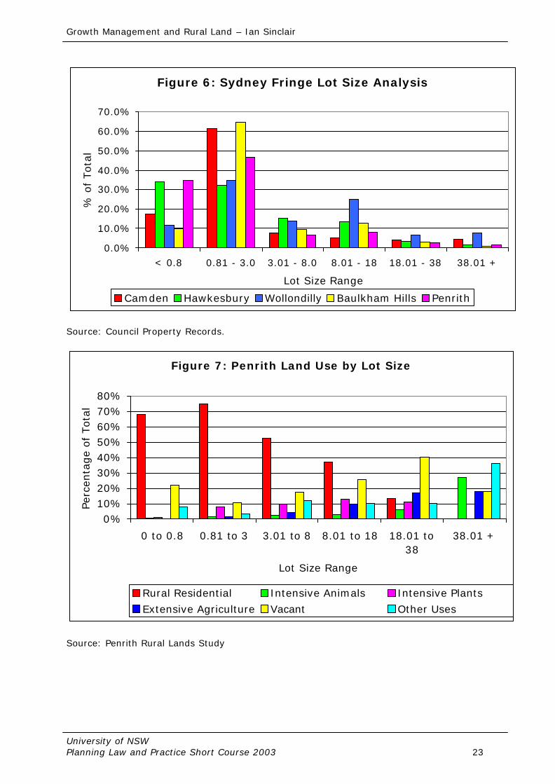
average growth rate between 1986 and 1991 of 4.3% per annum. This was the second highest growth rate in the Sydney region. The current annual growth rate is 2.2 %. Wollondilly is characterised by scattered settlements with 16 towns and villages ranging in size from Nattai with 75 people to Tahmoor with 4000. Wollondilly has a demographic make up which is characterised by a high proportion of the population under 19 years (36.6%) and a high proportion of the population in the 30-49 year age category (32%). There is only 13.4% of the population aged 20-29 and 18% of the population over 50 years. It can be seen therefore that Wollondilly is an area, which has a high proportion of young people. It is also expected to take a large amount of Sydney's growth over the next 20 years. The major issue for the future development of Wollondilly is the pressure for urban growth of the Sydney Region. Associated with these are the role of Agriculture as well as environmental problems with water quality in the Nepean Hawkesbury River and air quality of the Sydney Region. Wollondilly is in the Headwaters of the Nepean River and any development will have to be mindful of the potential for an adverse impact on the Nepean Hawkesbury River downstream of the Shire. Wollondilly is a high producer of fresh vegetables, nurseries, flowers and cultivated turf as well as poultry. A recent study by the University of Western Sydney Hawkesbury has estimated the value of Agriculture at $350 million. Wollondilly also has 54 % of its privately owned land classified as high class agricultural land Analysis of the Australian Bureau of Statistics Agriculture Census for 1993-94 shows that Wollondilly is a particularly high producer for both the Sydney Region and NSW for certain vegetables and poultry. It is the number one poultry producing Shire in the State and is the fourth highest producer of vegetables in Sydney. Wollondilly is obviously an important contributor to agricultural production in the Sydney Region. Its location and large size mean that it will continue to play a role in agricultural production in the future as long as the value of agricultural land use is reflected in strategic planning decisions on the fringe of Sydney. Wollondilly Shire is currently addressing the issue of planning for balanced urban and rural development. Council is currently undertaking Planning Studies to address the issues of Urban Growth, Environmental Impact and the role of Agriculture in the Shire and the Sydney Region. It is felt that Planning is the only way that all of these competing interests can be accommodated to ensure the future development of the Sydney Region. We are currently at a water shed in the Planning for the future of Sydney and if some drastic planning measures are not taken soon the results could be disastrous for the whole Sydney Region. Planning for the preservation of agricultural land is an important issue that has not been adequately addressed by governments at all levels. There are some Councils that have addressed the issue in detail. It is proposed to discuss this issue by using the Wollondilly Shire as a case study. Wollondilly have been developing a detailed land use policy to protect its agricultural land for the past 5 years. It started with the Wollondilly Agricultural Lands Study, published in 1993 and was followed by the Review of Rural Lands LEP and DCP’s. 10.1. Wollondilly Agricultural Lands Study The first stage in the preparation of any planning exercise for rural land is to have a detailed understanding of the existing situation. The Wollondilly Agricultural Lands Study has been prepared by Council to provide that detail. Council published the study in April 1993. The catalyst for the preparation of the Agricultural Lands Study was a concern about the loss of Agricultural Land and the issues of Rural Land Use Conflict. One of the most important components of the study was the advisory group that was set up to help to prepare it. This group had a wide ranging representation. All of the main categories of agriculture in the shire were represented (Extensive and Intensive livestock and horticulture) as well as government departments and Councillors. This group was used as a sounding board and also to check the accuracy of the data presented. The existence of this group was instrumental in the acceptance of the study and its recommendations.
Growth Management and Rural Land – Ian Sinclair
University of NSW Planning Law and Practice Short Course 2003 14
The Study is a detailed analysis of Agriculture in Wollondilly as well as the Sydney Region. It provides an analysis of agricultural production in the Sydney Region as well as NSW. The issues concerning Rural Land Use Conflict and its causes are discussed. A detailed analysis of rural land use was carried out and the results of this are discussed along with the implications of the change in agricultural land use. (This includes the benefits and threats to agriculture in Wollondilly as well as Sydney). The study is based on a detailed land use survey. This Survey has been separately published and identifies all land uses within the rural area of Wollondilly. The survey categorised Agriculture into four broad categories: Intensive Livestock and Horticulture and Extensive Livestock and Horticulture. Rural Residential land uses were identified as were Natural Vegetation and other uses. It was used as the basis for collection purposes the localities within the Shire. In tandem with the land use survey a detailed lot size analysis was carried out. The land use for each parcel was entered into Council's Computer Property System, which allowed for cross referencing of land use and lot size which was useful for analysis purposes. All of this information is presented in tabular form and a summary of each locality is provided in the Agricultural Lands Study. The results of this for 4 Sydney fringe Councils (Wollondilly, Hawkesbury, Penrith and Baulkham Hills) are shown graphically in figure 6 and figure 7 shows the lot size by land use data for Penrith. The Study highlights the need to plan for the retention of land for agricultural production. The issues to be considered for the retention of Agricultural Land are highlighted and a methodology has been developed for the assessment of land for agricultural production. A discussion on the benefits of zoning for agricultural production has been undertaken. The Study concludes that Agriculture is an important land use in the Sydney Region and as such should be recognised as a legitimate land use planning constraint when preparing Strategies for the future. If Agriculture is not recognised as a constraint to further urban development there will be major implications for the availability of fresh food and produce in Sydney. As a result of rural land use conflict, there is a need to identify specific zones for agricultural production and rural living areas (Rural Residential). The cost of not protecting Agriculture for the future will not only be the loss of fresh food production in close proximity to Sydney, but also the loss of the rural hinterland and the benefits of this for recreation, tourism and water quality. The recommendations of the Study are to request the Department of Planning to prepare a Regional Environmental Plan for agriculture in the Sydney Region to recognise it as a legitimate land use planning constraint. Recommendations are also made for a review of Council's rural land to provide for Agricultural production and Rural Living Zones as well as requiring development consent for Intensive Agriculture and the preparation of a Development Control Plan to provide guidelines. An education campaign is to be undertaken to highlight the benefits of Agriculture and the issues concerning Rural Land Use Conflict. Finally, the Study recommends that Council review its farmland rating policy. 10.2 Issues to Consider Planning for the preservation of agricultural land is a complex issue. One cannot consider any of the issues in isolation of each other - they need to be considered together. There is a need to consider the range of lot sizes, land use, land suitability, locational factors, the critical mass of agricultural land and other issues related to Agriculture. All of these must be considered when developing Planning Policies for the retention of agricultural land. Most importantly, there must be a detailed Land Use Survey and lot size analysis so that a clear understanding is gained of the location, holding size and spatial distribution of the rural land uses. 10.3 Methodology for Protecting High Quality Agricultural land The methodology utilised for assessing land for agricultural production was developed by the Wollondilly Agricultural Lands Study and is basically a sieve methodology which takes into
Growth Management and Rural Land – Ian Sinclair
University of NSW Planning Law and Practice Short Course 2003 15
consideration issues such as lot size, land use, physical constraints, Locational factors as well as rural land use conflict. The rationale behind the methodology is to reduce the incidence of rural land use conflict and thereby protecting the sustainability of agricultural development within Wollondilly. It will also provide a balance between the use of the land for agriculture and the desire for rural living. Planning for agriculture is an integrated process - all aspects are linked to one another and one cannot be considered without looking at the impacts on all other aspects. Therefore, when applying the methodology it is necessary to consider all of the steps. There is also a spatial integration of agricultural land use. Planning for one farm cannot be considered in isolation from other land in the locality and other localities in the Shire. Thus, it is important to take a holistic approach when planning for Agricultural Land Use. A methodology such as this is evolutionary because of the dynamic nature of land use planning. It has been developed for use in Wollondilly and has been applied in the Review of Rural Lands recently undertaken. It is expected that it will be subject to scrutiny by Planners and other persons and adapted to other areas. However, it has been developed by council taking into consideration all aspects of land use planning theory and practice. The methodology basically uses a "sieve" process to eliminate land, which is not suitable for agricultural production. It is reliant upon a detailed analysis of the characteristics of Agriculture within the locality such as that provided in the Wollondilly Agricultural Lands Study. The details are placed on a map to allow for ease of identification of all issues. This methodology will lead to the identification of land which is suitable for and which should be retained for agriculture. This land falls into two categories. Firstly, land that is currently used for and has good soil for intensive forms of agriculture such as market gardening, orcharding, grape growing, turf framing or poultry. Secondly, there is land that is not of as high a quality or productive yield and is generally used for extensive forms of agriculture. The former land should be zoned as Agriculture and the latter as a secondary agriculture or Agricultural Landscape zone. It must be recognised that agriculture is the use and rural is the character. This latter land adds to the rural landscape character of an area and should be recognised as such. . It will also identify land that is more suited to rural residential use. It is important to base the zone boundaries on a catchment basis and use physical boundaries for the zones. The assessment should also be undertaken in consultation with NSW Agriculture and other Government Department and organisations, which have an interest in Agriculture. Land which falls outside this classification can be considered for other uses such as continued agricultural use or Rural living. 10.4. Wollondilly Review of Rural Lands Wollondilly Shire has reviewed its rural land with the view to protecting productive agricultural land by providing for a balance between agriculture and the desire for rural living opportunities, as well as reducing land use conflict. The review has culminated in the preparation of a specific Local Environmental Plan and three supporting Development Control Plans – two dealing with the new Agriculture Zones, and the other for the Rural Living zone. The Development Control Plans are objective based documents, which will allow for the maximum flexibility in implementation. They also have a special section, which explains the issues and reasons for implementing the specific controls. The LEP was gazetted on 20 September 1996. The LEP introduced some innovative concepts that needed to be tested by the assessment of development applications. The need to review the provisions was recognised at the time of gazettal and the subsequent LEP was gazetted in June 1998. Three new zones have been developed as follows: - § Agriculture § Agricultural Landscape § Environmental Protection - Rural Living
Growth Management and Rural Land – Ian Sinclair
University of NSW Planning Law and Practice Short Course 2003 16
An important factor in delineating the zone boundaries has been the use of physical boundaries rather than a road or cadastral (lot) boundary as occurs in many urban zones. This is especially so for the Rural Living and Agriculture zones. This has been done to reduce the incidence of rural land use conflict mentioned earlier. In fact, there are rural residential uses in the agriculture zone, however, the philosophy has been taken that it is not desirable to allow further subdivision on the edge of the production areas as this will lead to conflict. It is felt that by providing for agriculture to be located on suitable land that the future development scenario for Wollondilly can be achieved along the lines espoused by Council in its Growth Management Planning which do not encourage the "aesthetic vandalism" of urban sprawl and instead promote planned sustainable communities. Agriculture Zone There are five relatively small parts of the Shire included in this zone. The primary objective of the agriculture zone is as its title suggests to preserve existing agricultural production and to allow for new agricultural production in appropriate locations by recognising the importance of high quality agricultural land. The methodology discussed above has been applied to outline the parameters to be considered and the constraints, which need to be recognised when assessing and identifying land suitable for an agricultural production zone. This land is generally high class agricultural land being that land which is known as prime crop and pastoral land. This includes classes 1-3 of the agricultural land classification technique as used by NSW Agriculture as described in the Rural Land Evaluation Manual. However, some of the production areas have class 4 land in it, which may be needed in a particular agricultural system. A secondary objective of the agriculture zone is to reduce the incidence of rural land use conflict. This is done by ensuring that any new dwelling houses within the zone are permitted only in conjunction with a legitimate and sustainable agricultural enterprise. Likewise, any agricultural enterprise, which is proposed for land adjacent to an existing dwelling house, which is used for residential use, will have to take into consideration the use of the land for residential purposes and provide steps to reduce potential conflict. There is a minimum subdivision size of 20 hectares within the agriculture zone. This minimum is related to the size of existing holdings used for soil-based agriculture and the lack of rural residential uses at this size. The proponent must satisfy Council that the subdivision is required for a sustainable agricultural purpose and as such a Total Farm Management Assessment is required. This includes a Property Plan, an Agricultural Sustainability Assessment and a Farm Management Sustainable Agriculture has been defined as having three components: environmental (it minimises environmental pollution and land degradation problems), social (minimises land use conflict and loss of the amenity of the surrounding area) and economic (it is capable of making a net farm profit). Agricultural Landscape Zone This zone covers most of the Shire. The primary objective of this zone is to preserve the agricultural landscape of Wollondilly whilst also providing for agricultural production. It is this landscape character that gives the Shire its distinct character and attractiveness for rural living opportunities. Existing productive agricultural enterprises will be encouraged to continue within this zone, however, it is not anticipated that a great deal of intensive agriculture will be carried out. The areas set aside for this zone are generally areas which have a fair amount of extensive agriculture practised in the form of grazing for beef cattle and dairying as well as a predominance of deer farming. The minimum subdivision size for this zone is 40 hectares.
Growth Management and Rural Land – Ian Sinclair
University of NSW Planning Law and Practice Short Course 2003 17
This minima is based on the historical minimum as well as an assessment of the existing fragmentation within Wollondilly and the desire not to have any further fragmentation of agricultural holdings. The issue of providing for small scale subdivision in conjunction with agricultural development has been addressed in this zone. The LEP makes provision for this to occur only under a Community Titles subdivision. This community titles subdivision must first of all be based on a Total Farm Management Assessment mentioned above. A detailed landscape assessment must be provided and site constraint plan prepared which will identify those lands which are suitable for dwelling houses. It is only then that the subdivision pattern may be provided. The holding size must be 80 hectares to be able to utilise the provisions and the maximum number of lots to be created is 10. The minimum area for subdivision under the community titles is 1 hectare with a maximum of 2 hectares. However, it must be pointed out that taking into consideration the constraints and specifics of the land this may not be an achievable minimum in all cases. Environmental Protection Rural Living Zone Before describing the zone, it is first necessary to define the two different types of rural residential development within Wollondilly. The definitions of each style of development are as follows: -
Rural Urban Fringe development is that style of development, which is within the servicing catchments and in close proximity to an urban centre. It may have reticulated water and in fact may have reticulated sewerage although most effluent disposal will be on site. It will also have a garbage service. The lot size is generally in the range of 4000 square metres to 1 hectare and it is in "estate" style of development.
Rural Living development is a residential use of the land within a rural environment. It is not necessarily near an existing urban centre and does not have reticulated water or any other form of service, which would generally be provided in a rural residential zone or urban centre. The density in Wollondilly is one dwelling per 4 hectares with a minimum of 2 hectares and any subdivision must be carried out having due regard to the constraints of the land. There are five segments of the Shire that are covered by this proposed zone and they predominantly have a residential use and varying lot size up to 10 hectares and above. As the heading suggests, this zone is to provide rural living opportunities within an environment, which is sensitive. In fact, the whole of Wollondilly can be regarded as sensitive given the issues of land degradation and water quality, which must be considered, especially when subdivision to a smaller minima is being permitted. The primary objective of the rural living zone is to provide for rural living opportunities having due regard to the preservation of the landscape character as well as the constraints of the land. Within this zone the methodology for carrying out subdivision is first of all to identify the constraints of the land and then identify dwelling house sites. The actual subdivision layout is the last thing to be considered and in fact, having regard to the constraints of slope, soil quality and runoff potential as well as effluent disposal areas the minimum of 4 hectares may not be achieved in many cases. Council is currently in the process of reviewing the implementation of this LEP and the DCP’s. This was seen as necessary during the first 6 months of the LEP’s implementation as the submission of Development Applications is the only way to test the innovative components of the document. This has resulted in a draft LEP being prepared and exhibited to institute a minimum of 20 hectares in the Agriculture Zone, an increase in the minimum required and a set density of 10 residential lots for community titles subdivision as the main amendments. Other amendments include altering the objectives of the Agriculture Zone, amending the definitions to the various agricultural land uses to make them easier to understand and some amendments to the DCP for the agriculture and agricultural landscape zones to make one DCP for each zone instead of having one document covering both zones.
Growth Management and Rural Land – Ian Sinclair
University of NSW Planning Law and Practice Short Course 2003 18
Growth Management and Rural Land – Ian Sinclair
University of NSW Planning Law and Practice Short Course 2003 19
11. CONCLUSION The preservation of agricultural land is an important issue facing Australia today. The statistics mentioned about the arable agricultural land and the population density present a dilemma that needs to be addressed when planning for the growth management of the cities and towns. There is a need to provide a balance between the desires of rural residential living opportunities and maintaining long term agricultural production. It requires knowledge of the resource base, limitations on its use, effective recognition of its environmental planning legitimacy and a creative approach to accommodation of the various land use requirements as done in Wollondilly. Above all there must be a commitment to the process along with a clearly anticipated strategic planning vision for each fringe Local Government Area, the region as a whole as well as the State of New South Wales. The provision of a balanced approach to rural land will allow for planned development, which is economically viable, environmentally responsible, aesthetically pleasing and socially acceptable. It will allow for the growing of food as well as the growing of houses. There is a need to investigate other methods for the preservation of agricultural land including purchase of development rights, tradeable development rights and right to farm legislation to ascertain their applicability to the NSW and Australian political and social environments. If agricultural land is not considered as a land use planning constraint and the appropriate balance achieved, we could run the risk of not having a Rural Australia but a Rural Residential Australia. If we can achieve the balance by using some of the methods outlined, we can grow food as well as growing houses.
Growth Management and Rural Land – Ian Sinclair
University of NSW Planning Law and Practice Short Course 2003 20
Area now becomes mostly residential Conflicts in land use Higher land prices Increased traffic Increased nuisance complaints Fewer farm suppliers and processors
Increasing Housing Pressures on development farm operation and viability Conversion of farmland to other uses Rural character attracts new residents Figure 1: The Cycle of Farmland Conversion Source: Daniels and Bower 1997, p 6
Growth Management and Rural Land – Ian Sinclair
University of NSW Planning Law and Practice Short Course 2003 21
Figure 3: NSW Perishable Vegetable Production 1997
0.0%
20.0%
40.0%
60.0%
80.0%
100.0%
120.0%
Sydney
Hunter
Illawarr
a
Richmon
d-Twee
d
Mid-Nort
h Coa
st
Northe
rn
North W
estern
Central
West
South E
astern
Murrum
bidge
eMurr
ay
Far West
Region
Perce
ntabe
fo T
otal
Sprouts Chinese Cabbages Spring Onions & Shallots Fresh Mushrooms
Figure 2: NSW Vegetable Production 1997
0.00%5.00%
10.00%15.00%20.00%25.00%30.00%35.00%
Sydney
Hunter
Illawarr
a
Richmon
d-Twee
d
Mid-Nort
h Coa
st
Northe
rn
North W
estern
Centra
l West
South
Eastern
Murrum
bidge
e
Murray
Far West
Region
Perc
enta
ge o
f Tot
al
Growth Management and Rural Land – Ian Sinclair
University of NSW Planning Law and Practice Short Course 2003 22
Figure 4: NSW Nurseries, Flowers and Cultivated Turf 1997
0.0%
10.0%
20.0%
30.0%
40.0%
50.0%
60.0%
70.0%
Sydney
Hunter
Illawarr
a
Richmond
-Tweed
Mid-Nort
h Coas
t
Norther
n
North W
estern
Central
West
South E
astern
Murrum
bidge
eMurr
ay
Far West
Perc
enta
ge o
f Tot
al
Turf Nurseries Cut Flowers
Figure 5: NSW Poultry Production 1997
0.0%
20.0%
40.0%
60.0%
80.0%
100.0%
120.0%
Sydney
Hunter
Illawarr
a
Richmon
d-Twee
d
Mid-Nort
h Coa
st
Northe
rn
North W
estern
Central
West
South E
astern
Murrum
bidge
eMurr
ay
Far West
Region
Perc
enta
ge o
f Tot
al
Chickens Ducks Turkeys Other Poultry Eggs
Source of Data for graphs 2 to 5: Australian Bureau of Statistics Agriculture Census 1997
Growth Management and Rural Land – Ian Sinclair
University of NSW Planning Law and Practice Short Course 2003 23
0 to 0.8 0.81 to 3 3.01 to 8 8.01 to 18 18.01 to38
38.01 +
Lot Size Range
Perc
enta
ge
of T
otal
Rural Residential Intensive Animals Intensive PlantsExtensive Agriculture Vacant Other Uses
Source: Penrith Rural Lands Study
Growth Management and Rural Land – Ian Sinclair
University of NSW Planning Law and Practice Short Course 2003 24
BIBLIOGRAPHY Australian Bureau of Statistics (1996) Australian Agriculture and the Environment, ABS, Canberra Australian Bureau of Statistics (1996) Australians and the Environment, ABS Canberra Australian Bureau of Statistics (1997) NSW Regional Statistics, ABS, Canberra. Australian Bureau of Statistics (1998) 1998 Year Book Australia, ABS, Canberra Australian Bureau of Statistics (1999) Australian Demographic Statistics, December Quarter, www.abs.gov.au, Cunningham, G.M., Higginson, F.R., Riddler, A.M.H., Emery, K.A. Undated, System Used to Classify Rural Lands in NSW, Soil Conservation Service of NSW and NSW Department of Agriculture, Sydney Budge, T. and Sinclair, I.W., 1998 Rural Australia: Change, Decline and New Directions – How Urbanisation Killed Crocodile Dundee, Paper presented to the American Planners Association Conference, Boston, April, 1998 Daniels, T. and Bower, D, 1997, Holding Our Ground - Protecting America’s Farms and Farmland, Island Press, Washington. EDGE Land Planning, Hassall and Associates, Heather Nesbitt Planning, Jawin Associates and Strategic Business Development, (2001) Penrith Rural Lands Study, Penrith City Council, Penrith. EDGE Land Planning, Andrews Neil, Heather Nesbitt Planning, Jawin Associates, Woods Bagot, (2001) Baulkham Hills Rural Lands Study – Background and Issues Report, Baulkham Hills Shire Council, Castle Hill. George, D. and Brouwer, D. (1996) Nature Conservation on Farms, NSW Agriculture,
Maitland. Keys Young, 1993, Residents Survey Wollondilly Shire, Sydney. Morris, W. and Kaufman, J.A., 1996, Mixed Use Developments - New Designs for New Livelihoods, Queensland Department of Tourism, Small Business and Industry, Brisbane. Larkin, J.T. and Associates, 1991, The Australian Poultry Industry, NSW Chicken Growers Association, Sydney. NSW Agriculture, 1998, Strategic Plan for Sustainable Agriculture - Sydney Region, NSW Agriculture, Orange. Nix, N., 1978, Availability of Land for Energy. Cropping Australia. Alcohol Fuels Conference, Sydney. Nix, N., 1988, Australia's Natural Resources, in How many More Australians, Day, L.H. & Rowland, D.T. Longman, Cheshire. Kennedy, A, 1993, Agriculture in the Sydney Region - A Fringe Activity Critical to the Regional Economy, Paper presented to RAPI (NSW) Conference, Penrith. Sinclair, I and Kennedy A, Planning for a Balance between Urban Growth and Agricultural Production on the Fringe of Sydney, Paper presented to the American Planners Association Conference, San Francisco, April 1994.
Growth Management and Rural Land – Ian Sinclair
University of NSW Planning Law and Practice Short Course 2003 25
Sinclair, I.W., 1995, Planning for Growth Management on the Fringe of Sydney, Paper presented to the American Planners Association / Canadian Institute of Planners Conference, Toronto, April 1995 Sinclair, I.W., 1996b, Planning on the Rural Urban Fringe, Paper presented to UNSW Planning Law and Practice Short Course, Kensington. Sinclair, I. W. , 2000, From Strategy to Plan – Planning for Rural Land in Australia, Paper presented to the American Planners Association Conference, New York City April 2000. Sinclair, I.W. , 2001, Zoning Rural Land to achieve a Balanced Future, Paper presented to the Royal Australian Planning Institute National Congress, Canberra. Wollondilly Shire Council, 1993, Wollondilly Agricultural Lands Study, Wollondilly Council, Picton. Wollondilly Shire Council, 1996, Review of Rural Land Report, Wollondilly Shire Council, Picton. Wollondilly Shire Council, 1996, Draft Residential Development Strategy - A Growth Management Concept, Wollondilly Shire Council, Picton World Resources Institute / United Nations Environment and Development Program (1994) World Resources 1994-95, Oxford University Press, New York Young, R.T., 1993, The Importance of Agriculture and its Relationship to Land Use Planning, Paper presented to RAPI (NSW) Conference, Penrith.