guía metodológica methodological guide for the elaboration of management Plans of the Natura 2000 Sites in Navarra English guide Guía en español para la elaboración de Planes de Gestión de los Lugares Natura 2000 en Navarra
Transcript
guía metodológica
methodological guidefor the elaboration of management Plans
of the Natura 2000 Sites in Navarra
English guide
Guía en español
para la elaboración de Planes de Gestiónde los Lugares Natura 2000 en Navarra
T tPágina Portada
T tPágina Portada
AGRADECIMIENTOSa Marta Múgica, Salvador Grau y PacaBaraza, cuyas sugerencias y opiniones
son siempre bienvenidas
T tPágina Portada
EDITA: GESTIÓN AMBIENTAL, VIVEROS Y REPOBLACIONES DE NAVARRA
PATROCINA: DIRECCIÓN GENERAL DE MEDIO AMBIENTE
Departamento de Medio Ambiente,
Ordenación del Territorio y vivienda
GOBIERNO DE NAVARRA
AUTOR: SANTIAGO GARCÍA FERNÁNDEZ-VELILLA
COLABORADORES: Equipo técnico de conservación
de la Biodiversidad de Gestión Ambiental,
Viveros y Repoblaciones de Navarra
DEPÓSITO LEGAL: 1477/2003IMPRIME: ONA INDUSTRIAL GRÁFICA S.L.
DISEÑO: EGN COMUNICACIÓN
FOTOGRAFÍAS: AZZARI, DAVID CAMPIÓN,
CARLOS ASTRAIN, ARITZ ZALDUA, J.A. MARTÍNEZ
ARCHIVO GOBIERNO DE NAVARRA Y ARCHIVO DIARIO DE NAVARRA
T tPágina Portada
GUÍA METODOLÓGICA
oRed
Natura2000
PARA LA ELABORACIÓN DE PLANES DE GESTIÓN DE LOS LUGARES NATURA 2000 EN NAVARRA
COLABORAN
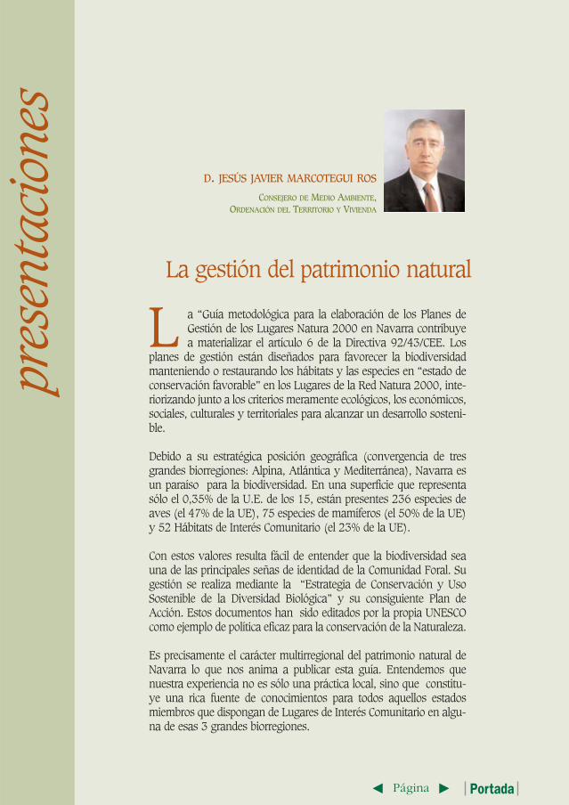
D. JESÚS JAVIER MARCOTEGUI ROS
CONSEJERO DE MEDIO AMBIENTE, ORDENACIÓN DEL TERRITORIO Y VIVIENDA
L a “Guía metodológica para la elaboración de los Planes deGestión de los Lugares Natura 2000 en Navarra contribuyea materializar el artículo 6 de la Directiva 92/43/CEE. Los
planes de gestión están diseñados para favorecer la biodiversidadmanteniendo o restaurando los hábitats y las especies en “estado deconservación favorable” en los Lugares de la Red Natura 2000, inte-riorizando junto a los criterios meramente ecológicos, los económicos,sociales, culturales y territoriales para alcanzar un desarrollo sosteni-ble.
Debido a su estratégica posición geográfica (convergencia de tresgrandes biorregiones: Alpina, Atlántica y Mediterránea), Navarra esun paraíso para la biodiversidad. En una superficie que representasólo el 0,35% de la U.E. de los 15, están presentes 236 especies deaves (el 47% de la UE), 75 especies de mamíferos (el 50% de la UE)y 52 Hábitats de Interés Comunitario (el 23% de la UE).
Con estos valores resulta fácil de entender que la biodiversidad seauna de las principales señas de identidad de la Comunidad Foral. Sugestión se realiza mediante la “Estrategia de Conservación y UsoSostenible de la Diversidad Biológica” y su consiguiente Plan deAcción. Estos documentos han sido editados por la propia UNESCOcomo ejemplo de política eficaz para la conservación de la Naturaleza.
Es precisamente el carácter multirregional del patrimonio natural deNavarra lo que nos anima a publicar esta guía. Entendemos quenuestra experiencia no es sólo una práctica local, sino que constitu-ye una rica fuente de conocimientos para todos aquellos estadosmiembros que dispongan de Lugares de Interés Comunitario en algu-na de esas 3 grandes biorregiones.
pres
enta
cion
es
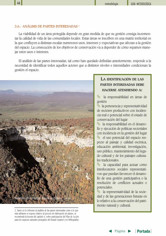
La gestión del patrimonio natural
T tPágina Portada
L a La Red Natura 2000 nace de la creciente conciencia de los ciudadanos que reclaman la con-servación de los sistemas naturales como base para la buena salud de la biosfera. Y es, sin duda,la iniciativa más importante habida en la historia europea para la conservación de hábitats y
especies.
La Directiva de Hábitats establece que la Red Natura 2000 habrá de ser una red de espacios naturaleseuropea para la conservación de los hábitats naturales y de las especies junto con los espacios declara-dos por la Directiva de Aves. En definitiva, con la aplicación de estas dos normas legales se pretende rea-lizar una ordenación del territorio basada en el establecimiento de una red coherente de espacios prote-gidos.
En este modelo de ordenación no se pretende realizar una mera catalogación de espacios consideradosvaliosos desde el punto de vista natural para crear a su alrededor muros y barreras y desarrollar un mode-lo de gestión al margen de las actividades humanas. La conservación de hábitats y especies precisa deuna gestión integral del territorio que contemple a los seres humanos y sus actividades como a un fac-tor más que incide del sistema natural, y siendo conscientes de que estas no tienen por que afectar siem-pre negativamente en su conservación.
La única estrategia posible es contemplar el territorio como un todo y realizar una gestión integral delmismo. Evaluando la adecuación de las actividades en función del nivel de protección que requieran lasáreas localizadas. Y aplicando medidas preventivas, correctoras y compensatorias ante los posiblesimpactos ambientales que habrán de ser previstos para cada uno de los lugares con el objetivo de ase-gurar el mantenimiento de su función para la conservación de esos lugares.
La Declaración del Teide “Natura 2000: Todos Juntos por la Naturaleza” firmada en mayo del 2002,expone las intenciones de la Comisión Europea en el X aniversario de la Directiva y reconoce que el éxitode Natura 2000 requiere del apoyo de los ciudadanos europeos, especialmente de la población y de lospropietarios locales, así como de su participación en las decisiones sobre la puesta en práctica de medi-das de conservación y de gestión de los espacios implicados. Sin embargo, los actores locales, tanto públi-cos como privados hasta la fecha casi no han sido tenidos en cuenta. Y ello a pesar que en ellos recae laúltima palabra en la gestión y en la efectividad de las medidas que se apliquen y ser reconocidos comopieza fundamental en la aplicación de cualquier estrategia de conservación de la biodiversidad.
Para WWF/Adena la correcta aplicación de la Directiva Hábitats y el desarrollo de la Red Natura es unatarea prioritaria a la que hemos dedicado nuestros esfuerzos para el establecimiento de una red coheren-te, recogiendo y difundiendo mucha información científica dispersa y promoviendo la comunicación entrecientíficos y administraciones. Comunicando a los ciudadanos el interés y la necesidad de la Red. Y apli-cando modelos de gestión a pie de terreno en áreas eminentemente agrícolas, ganaderas o costeras, bus-cando el apoyo y la comprensión de los habitantes, de las administraciones y la integración de la con-servación de la biodiversidad en las actividades económicas.
Con el desarrollo de la Red Natura 2000 y la aplicación de documentos de trabajo como el que aquí sepresenta estamos más próximos a hacer realidad un deseable desarrollo sostenible. Y aprovechar estaoportunidad, quizá la última, supondrá promover nuevos modelos de conservación de la naturaleza, inte-grar en la protección del medio natural a otros sectores y políticas económicos y sociales y conservarmuchos espacios de indiscutible valor ambiental que hoy se encuentran seriamente amenazados.
Desde WWF/Adena
T tPágina Portada
L a SEO/BirdLife es una asociación sin ánimo de lucro dedicada a laconservación de las aves silvestres y sus hábitats. Uno de nuestrosobjetivos es la adecuada protección y gestión de las áreas más impor-
tantes para las aves. En este sentido, la creación y adecuada gestión de la RedNatura 2000 (de la que forman parte las Zonas de Especial Protección paralas Aves -ZEPA-) son clave para asegurar la conservación de las aves enEspaña.
SEO/BirdLife se ha dedicado muy intensamente a promover la designacióncomo ZEPA de aquellos lugares que albergan importantes poblaciones deaves. Además, desde 1999 llevamos a cabo una amplia campaña de divul-gación denominada ‘ZEPA: beneficios para las aves y la gente’. Hemos detec-tado que una de las mayores carencias de este proceso es la falta de informa-ción sobre los sitios incluidos en la Red Natura 2000, sus necesidades de ges-tión y sus repercusiones positivas en el desarrollo rural.
En relación a la gestión de la Red Natura 2000, pensamos que no podrálograrse si no se asume como un firme compromiso político. Este reto es abor-dado, de manera innovadora, en la presente ‘Guía Metodológica para la ela-boración de planes de gestión de los lugares Natura 2000 en Navarra’. Estedocumento plantea una aproximación a la conservación de la naturaleza muylógica. Parte de un sistema territorial de áreas protegidas (con un PlanDirector), para luego ir bajando de escala a través de planes de ordenaciónpara comarcas ecológicas y, finalmente, prevé planes de gestión para espaciosconcretos; lo que parece muy coherente. Coincidimos en que la actitud políti-ca de que lo que queda excluido de los espacios protegidos ‘no tiene valor’, esla peor que se puede tomar.
Además, esta guía otorga mucha importancia a la participación de la socie-dad, lo que facilita enormemente el proceso de designación de áreas protegi-das. Por desgracia, es demasiado frecuente que muchas iniciativas de protec-ción del territorio fracasen estrepitosamente precisamente por no incluir atodos los sectores implicados desde los primeros estadios de planificación.
SEO/BirdLife considera importante la publicación de este tipo de documentosde referencia y confiamos en que esta ‘Guía Metodológica para la elaboraciónde planes de gestión de los lugares Natura 2000 en Navarra’ sea asumidacomo un firme compromiso político por el Gobierno de Navarra y se convier-ta en una referencia práctica para otras Comunidades Autónomas.
L a Directiva 92/43/CEE, relativa a la conservación de los hábitats naturales y de la fauna yflora silvestres establece en su artículo 6 la necesidad de fijar medidas reglamentarias, admi-nistrativas o contractuales que respondan a las exigencias ecológicas de los tipos de hábitats
y especies de sus anexos I y II presentes en los Lugares1 Natura 2000.
Asimismo, establece que deberán adoptarse medidas apropiadas para evitar en dichos lugares eldeterioro de los hábitats y especies que han motivado su designación. Si bien la norma no obliga aelaborar planes de gestión para los lugares Natura 2000, se ha considerado que ésta es la mejor mane-ra de vertebrar de manera coherente las medidas activas de conservación que deban acometerse paralos distintos hábitats y especies consideradas objetivo de conservación en un espacio natural. Estosplanes permitirán además, sin menosprecio de los mecanismos específicos de valoración de repercu-siones ambientales que deben habilitarse en cumplimiento de los apartados 3 y 4 del mencionado artí-culo 6, establecer las medidas específicas de prevención necesarias en cada caso.
El Gobierno de Navarra así lo ha entendido y ha promovido la elaboración de planes de gestión de“espacios naturales tipo”, que albergan a los hábitats naturales y especies más representativas deNavarra. La elaboración de estos planes parte de la insatisfacción con los planes que habitualmente sevenían haciendo en los espacios naturales protegidos. A partir de ahí y de un borrador básico de pordónde empezar, se ha ido construyendo por aproximaciones sucesivas la guía que ahora se propone.Esta guía es pues fruto del trabajo colectivo del equipo de técnicos de la Unidad de Conservación de laBiodiversidad de la Sociedad Pública Gestión Ambiental, Viveros y Repoblaciones de Navarra.
Los espacios naturales protegidos no deben ser elementos espaciales aislados sino componentesestructurales de un sistema interconectado de espacios. En este sentido, los planes de gestión de cadaespacio son el tercer nivel de concreción de un sistema de planificación en cascada. Para situar los pla-nes de gestión en el lugar que les corresponde dentro del entramado de la estructura espacial de con-servación, se describe con brevedad en esta guía lo que se entiende por “sistema de espacios natura-les protegidos” y los distintos niveles de planificación que se proponen. Ya en lo que respecta a los pla-
1. INTRODUCCIÓN
1. La Directiva 92/43/CEE, de Hábitats, define un lugar como un área geográfica definida, de superficie claramente delimitada y un lugar de importanciacomunitaria como un lugar que, en la región biogeográfica a la pertenece, contribuye de forma apreciable a mantener o restablecer un tipo de hábitat naturalde los que se citan en el anexo I o una especie de las que se enumeran en el anexo II en un estado favorable de conservación y que pueda de esta forma con-tribuir a la coherencia de Natura 2000, o al mantenimietno de la diversidad biológica en la región biogeográfica de que se trate.
T tPágina Portada
GUÍA METODOLÓGICA características generales 11
nes de gestión, se describen sus características, se establecen sus contenidos, se define la metodolo-gía para su elaboración y se proponen mecanismos para facilitar la participación pública en su elabo-ración.
La metodología propuesta puede parecer excesivamente compleja. En parte esa apariencia respon-de al hecho de haber tratado de dar respuesta a todas las situaciones que se nos pueden presentar alelaborar un plan. Sin embargo, en la mayoría de los casos los planes serán documentos muy senci-llos.
La dificultad no radica tanto en “planificar la ges-tión” sino en “gestionar el plan”. El modelo de planpropuesto requiere indudablemente incrementar lacapacidad de gestión que actualmente tienen lasadministraciones ambientales. En un seminariosobre Natura 2000 organizado recientemente porEUROPARC-España, se suscitó una interesante dis-cusión sobre planificación y capacidad de gestión. Seasume que plantear una metodología de gestión quesupere a la capacidad de gestión sólo puede generarfrustración entre los gestores. Es cierto que los obje-tivos de gestión crecen a un ritmo mayor que la pro-pia capacidad de gestión. Pero esto no debe llevarnosa la conclusión de que los planes propuestos son poco realistas, sino a que resulta poco realista con-seguir frenar la reconocida tendencia al declive y pérdida de la diversidad biológica con los recursosactualmente disponibles.
Por tanto para que la gestión del plan sea posible, la administración ambiental debe dotarse de másrecursos, pero también debe ser capaz de buscar nuevos aliados para la conservación más allá de lossectores conservacionistas, tanto entre los sectores productivos como entre otros departamentos de laadministración. En definitiva, es necesario incrementar la capacidad de gestión diseñando nuevosmecanismos de gestión concertada, entendida como aquella que, sin excluir la aplicación de regíme-nes normativos, coercitivos y sancionadores cuando sea necesario, se basa en la consecución deacuerdos y en la firma de convenios y contratos voluntarios.
Pero eso da para otra guía y para más de un quebradero de cabeza.
LOS ESPACIOS NATURALESPROTEGIDOS NO DEBEN SER
ELEMENTOS ESPACIALESAISLADOS SINO COMPONENTES
ESTRUCTURALES DE UN SISTEMAINTERCONECTADO DE ESPACIOS
Grullas. (ARCHIVO G.N.)
GUÍA METODOLÓGICAcaracterísticas generales12
T tPágina Portada
2. SISTEMAS REGIONALES
2. Se define “área protegida” como una superficie de tierra y/o mar especialmente consagrada a la protección y mantenimiento de la diversidad biológica, así como de losrecursos naturales y los recursos culturales asociados, y manejada a través de medios jurídicos u otros medios eficaces (UICN). En el Estado español es más frecuentehablar de “espacios naturales protegidos”, aunque se suele restringir el uso del término a aquellos espacios declarados en virtud de la ley 4/89 y las normas autonómicasequivalentes. En este sentido cabe decir que en el presente documento se interpreta que los Lugares de Importancia Comunitaria, al estar amparados por el régimen deprotección establecido en la Directiva Hábitats son áreas o espacios naturales protegidos, aunque no hayan sido declarados bajo normativa estatal o autonómica. 3. Adaptada de Bennett, A.F., 1991: What types of organism will use the corridors?. En SAUNDERS & HOBBS Ed. Nature Conservaton 2: the role of corridors, pp. 407-408.4. National System Planning for Protected Areas. Adrian G. et al I.U.C.N., 1998.
REPRESENTATIVIDADQue contenga muestras de todos los hábitats naturales y de todas las especies de flora y fauna sil-vestre presentes en una Región.
EQUILIBRIOQue los hábitats y poblaciones de especies estén contenidos de manera equilibrada, sin que se déredundancia en algunos de ellos e insuficiencia en otros.
COMPLEMENTARIEDADQue cada espacio natural aporte algo significativo y diferente al conjunto.
CONSISTENCIAQue contenga suficiente superficie de hábitats naturales y número de poblaciones de flora y fauna sil-vestre como para que ante una perturbación que provoque la desaparición de un hábitat en una zonao la extinción local de una especie, el sistema pueda responder y sea posible la recuperación naturalde los componentes perdidos.
CONECTIVIDADQue los espacios que componen el sistema estén funcionalmente interconectados de manera que sean
DE ESPACIOS NATURALES PROTEGIDOS
L a Estrategia para la Conservación y el Uso Sostenible de la Diversidad Biológica de Navarrareconoce la importancia de los espacios naturales protegidos2 para la conservación in situ ydefine un Plan de Conservación de Ecosistemas y Hábitats Naturales a desarrollar en tres
Programas de Actuación cuyo objetivo último es establecer un Sistema Regional de Espacios natura-les protegidos, definido como:
Un conjunto interconectado de espacios naturales y seminaturales, que mantienen una trama de rela-ciones ecológicas y se inscriben en una matriz territorial tecnológicamente transformada por activida-des agrarias, forestales, núcleos urbanos, infraestructuras, y otros elementos resultantes de las activi-dades humanas.3
Las características básicas que debe tener un Sistema de Espacios naturales protegidos son4 :
T tPágina Portada
GUÍA METODOLÓGICA características generales 13
SE ENTIENDE POR SISTEMA ECOLÓGICO SALUDABLE Y PERDURABLE AQUEL CON:
� Poblaciones silvestres estructuradas, estables, formadas por individuos sanos y pertene-cientes a todos los niveles de la pirámide trófica.� Alto índice de biodiversidad autóctona.� Niveles de productividad biológica por encima del índice de reposición.� Cargas de contaminantes por debajo del nivel de asimilación.� Capacidad propia de respuesta y recuperación ante una perturbación.� Capacidad de autorregulación o necesidades mínimas de mantenimiento externo.
Foz de Arbayún (AZZARI)
posibles los desplazamientos de individuos, los procesos de recolonización, los flujos genéticos y otrosprocesos ecológicos.
COHERENCIA EXTERNAQue los espacios naturales protegidos no se vean afectadas negativamente por las actividades huma-nas que se realizan en la matriz territorial en la que se inscriben, actuando éstos además como ele-mentos difusores de biodiversidad y como espacios críticos para la salud y perdurabilidad del equili-brio ecológico general del territorio.
EFICIENCIAQue satisfaga los objetivos propios de los sistemas de áreas protegidos con el menor coste de oportu-nidad posible, es decir, comprometiendo la menor superficie posible5.
EQUIDADQue los espacios naturales protegidos se distribuyan de manera equilibrada por todo el territorio, dis-tribuyéndose igualmente de manera equilibrada sus costes y beneficios ambientales, sociales y eco-nómicos.
Sólo un sistema con estas características es capaz de garantizar una estructura natural saludable yperdurable, y por tanto, la integridad de los ecosistemas a escala regional.
GUÍA METODOLÓGICAcaracterísticas generales14
T tPágina Portada
5. Lo que no se contradice con el hecho de que, una vez resueltas otras necesidades básicas y alcanzado los estándares deseables de bienestar social, se pueda aspirar a un sistema deáreas protegidas lo más extenso posible.
SISTEMA REGIONAL DE ÁREASPROTEGIDAS DE NAVARRA
ESTÁ CONSTITUIDO POR:
• áreas prioritarias para laconservación• áreas sensibles para laconservación• corredores biológicos• puntos rojos
La declaración de Espacios protegidos de forma aislada e independiente, tal como se ha venido hacien-do, sin un plan de actuación a escala regional no tiene sentido, ya que no garantiza que las caracte-rísticas señaladas ni la gestión unificada y coordinada del Sistema de Espacios naturales protegidos.
Lamentablemente, los trabajos de constitución de Natura 2000 tampoco están sirviendo para estruc-turar sistemas regionales y transnacionales de espacios naturales protegidos. Si bien se han tenido encuenta algunas características que deben cumplir los sistemas de conservación, como es el caso de larepresentatividad y la consistencia, el artículo 10 de la Directiva de Hábitats, donde se aborda la conec-tividad y coherencia interna de la red, no ha sido desarrollado suficientemente. Además, se observacon preocupación como se extiende la idea de aplicar criterios de sostenibilidad y conservación enNatura 2000 y abandonar a su suerte el resto del territorio. Se olvida así que los espacios naturalesprotegidos dependen de las actividades que se realizan en la matriz que les rodea y que la sostenibi-lidad es un objetivo ineludible en todo el territorio.
La estructura natural de un territorio sólo es sostenible si se le dota de mecanismos eficaces de pro-tección difusa y se seleccionan áreas concretas que se destinen con prioridad a objetivos de conser-vación. Estas áreas deben estar rodeadas por áreas de amortiguamiento que minimicen el impactonegativo de las actividades humanas. Además, las áreas deben estar conectadas por corredores eco-lógicos que permitan los movimientos de fauna, la propagación de la vegetación y la integridad de losprocesos ecológicos.
T tPágina Portada
GUÍA METODOLÓGICA características generales 15
3. INSTRUMENTOSACTUALES DE PLANIFICACIÓN
L os instrumentos específicos establecidos por el estado español para la planificación de lasáreas naturales son los Planes de Ordenación de los Recursos Naturales (PORN) y los PlanesRectores de Uso y Gestión (PRUG). Algunas CCAA han establecido otros tipos de planes.
Los Planes Rectores de Uso y Gestión de espacios naturales fueron incorporados a nuestro orde-namiento jurídico por la Ley sobre Régimen Jurídico del Parque Nacional de Doñana (1978). La Ley4/89 de Conservación de Espacios Naturales y de la Flora y Fauna Silvestres, estableció los Planes deOrdenación de los Recursos Naturales (PORN) como un instrumento innovador de planificación inte-grada, siguiendo un modelo iniciado por las políticas de ordenación del territorio. Sin embargo, unadécada después, hay que afirmar con rotundidad que los PORN no han conseguido los objetivos paralos que fueron definidos.
Ni los PORN ni los PRUG han sido utilizados en todo su potencial. Es más, su indefinición y lamanera en la que se han aplicado ha hecho que sean instrumentos escasamente útiles.
Algunas de las deficiencias que pueden imputársele son:
� La INDEFINICIÓN DE CONTENIDOS para los PORN y los PRUG y la coincidencia de los ámbitos deaplicación de ambos, ha hecho que en muchos casos se solapen ambos, no quedando claro el alcancede cada instrumento. Con frecuencia los PORN se ha utilizado no como instrumento de ordenación, sinocomo instrumento de gestión.
� Incluyen REGÍMENES PREVENTIVOS RÍGIDOS Y POCO DINÁMICOS basados en el esquema de acti-vidades prohibidas, autorizables o permitidas, en lugar de desarrollar mecanismo de análisis “ad hoc”.Pueden ser útiles como modelo de protección pasiva pero resultan manifiestamente insuficientes en unmarco de conservación activa.
� Son documentos tediosos y excesivamente literarios que recopilan información ya conocida enDOCUMENTOS MUY EXTENSOS Y POCO ACCESIBLES A LA CIUDADANÍA sin aportar realmentenueva información relevante, ni interpretar adecuadamente la existente.
� NO IDENTIFICAN CON CLARIDAD LOS VALORES NATURALES objeto de la gestión ni su estadoactual de conservación.
� DESCRIBEN CON AMBIGÜEDAD, cuando lo hacen, los resultados esperados de la gestión.
� NO INCLUYEN INDICADORES DE ÉXITO que permitan evaluar el estado de los elementos a con-servar y la ejecución del plan.
� Con frecuencia SE APLICAN TRASFERENCIAS DE EXPERIENCIAS DE SITUACIONES QUE NO SE
GUÍA METODOLÓGICAcaracterísticas generales16
T tPágina Portada
CORRESPONDEN con situaciones análogas ni responden a las particularidades locales.
� Los PORN se han circunscrito habitualmente al espacio que se piensa declarar. Como consecuencia,SE HA INFRAUTILIZADO COMO INSTRUMENTO PARA LA ORDENACIÓN INTEGRAL DEL TERRI-TORIO, capaz de ordenar actividades situadas en el exterior de las áreas naturales y que sin embargoejercen una clara influencia negativa sobre el mismo, y de dar coherencia interna al sistema de áreasnaturales contemplando la conectividad existente o necesaria entre espacios.
� LA INVERSIÓN EN PLANIFICACIÓN DEDICADA A LOS PORN O PRUG ES CLARAMENTE INSUFI-CIENTE, lo que dificulta alcanzar los niveles deseables de información y de concreción en las propues-tas, así como desarrollar los procesos deseables de participación. Así, Navarra invierte 40 euros/has enlos Proyectos de Ordenación Forestal y sólo 4 euros/has en PORN y PRUG. La diferencia probablementeaumente considerablemente con respecto a planes urbanísticos de Obras Públicas, Regadíos, etc.
� LOS PROGRAMAS DE CONSERVACIÓN ACTIVA SUELEN ESTAR POCO ELABORADOS. De igualmanera, no identifican recursos subexplotados ni prospectan suficientemente las nuevas oportunida-des de desarrollo basadas en la conservación. Por el contrario, el apartado normativo, rígido y poco con-textualizado, está muy desarrollado, por lo que se percibe como un documento restrictivo y coercitivo.Percepción que no se ajusta a la realidad.
�ALGUNOS COMETIDOS ASIGNADOS INICIALMENTE A LOS PORN, como es el caso de la selecciónde las mejores muestras representativas de espacios naturales, ESTÁN SUPERADOS POR el procedi-miento de constitución de LA RED NATURA 2000.
� LA RELACIÓN ENTRE LOS PLANES DE LOS ESPACIOS NATURALES PROTEGIDOS Y OTROS PLA-NES SECTORIALES ES DÉBIL O INEXISTENTE. Los PORN nacieron, entre otras cosas, como instru-mento integrador de todas las políticas de conservación y sectoriales en un territorio concreto. Pero seignoró la realidad administrativa y lo celosos que se muestran los distintos departamentos de la admi-nistración pública respecto a sus competencias y presupuestos.
� En las directrices para el resto de las políticas sectoriales que deben contener los PORN RARA VEZHAN PARTICIPADO LOS RESPONSABLES DE ESTAS POLÍTICAS, lo que ha sido habitualmente inter-pretado como una injerencia de la autoridad ambiental frente a otros colectivos profesionales altamen-te corporativistas y fuertemente asentados en la administración pública.
� Resulta iluso plantear la FALTA DE COORDINACIÓN con otros Departamentos de la Administracióncuando ésta es escasa dentro de los propios Departamentos de Medio Ambiente. Así, por poner sólo unejemplo, las políticas de protección de espacios y de especies suelen discurrir de forma paralela, pero nointegrada, como sería lógico e imprescindible.
� Estos planes NO SE HAN VISTO ACOMPAÑADOS POR UN INSTRUMENTO FINANCIERO NI PORCOMPROMISOS DE INVERSIÓN de todas las entidades y departamentos implicados, por lo que se que-dan en meras directrices y recomendaciones.
� EN LA MAYORÍA DE LAS OCASIONES SON MEROS TRÁMITES ADMINISTRATIVOS obligados porley para los que no existe voluntad de ejecución y que no son asumidos por otros sectores públicos oprivados.
T tPágina Portada
GUÍA METODOLÓGICA características generales 17
L a Red Natura 2000, dada la conveniencia de contar con planes de gestión, es una ocasióninmejorable para analizar las carencias de las actuales redes de espacios naturales protegidosy para definir el tipo de instrumentos de planeamiento que pueden ser necesarios. Permite
revisar y proponer, si es el caso, nuevos contenidos, metodología y proceso de elaboración de estosplanes.
La aplicación de modelos de planificación en cascada, lo suficientemente flexibles para que puedanadecuarse a cada comunidad autónoma (o por extensión, a cualquier estado) se considera como elmás idóneo en el Plan de Acción para los espacios naturales protegidos del Estado español.
4. PLANIFICACIÓNDE UN SISTEMA DE ESPACIOS NATURALES PROTEGIDOS
El instrumento de planificación del Sistema constituye el nivel superior de planificación. El plandel sistema debe establecer los componentes estructurales del sistema de carácter permanente, defi-nir las relaciones entre los diferentes espacios y categorías de protección y regular todos aquellosaspectos que sean comunes a los espacios que lo componen o al conjunto de los mismos como uni-dad funcional.
El establecimiento y las líneas maestras de gestión de un Sistema de Espacios Naturales requie-ren un consenso social y de instrumentos y rutinas técnicas que eviten que los vaivenes adminis-trativos y políticos afecten a la conservación a largo plazo. Un documento estratégico y permanen-te como el plan director puede facilitar la estabilidad de principios programáticos necesaria.
Puede adoptar distintas formas jurídicas. El modelo Asturiano propone la elaboración de un PORNRegional, mientras para los Parques Nacionales se ha optado por un Plan Director. La Estrategia parala Conservación y Uso Sostenible de la Diversidad de Navarra propone igualmente la elaboración deun Plan Director.
4.1.- PLAN DIRECTOR DEL SISTEMA DE ESPACIOS NATURALES
SE PROPONE UN SISTEMA DE PLANIFICACIÓN EN CASCADA CON 3 NIVELES DE CONCRECIÓN:
� Plan Director del Sistema de Regional de Espacios Naturales� Plan de Ordenación de los Recursos Naturales para Comarcas Ecológicas� Plan de Gestión para Espacios Naturales Protegidos
GUÍA METODOLÓGICAcaracterísticas generales18
T tPágina Portada
� Los instrumentos de planificación de los Espacios Naturales Protegidos, sean cuales fuere,deberán contemplar explícitamente su integración con el entorno circundante y alternativas parasu conexión con otros espacios de la red.
� La declaración de un espacio natural debe suponer la inmediata puesta en marcha de planesde usos y gestión realistas para lo que resulta necesario que vaya acompañada de un programade financiación.
� Es imprescindible dotar a todos los espacios de la red de planes de manejo en el que se cla-rifiquen los objetivos de gestión, indique la manera de alcanzarlos, establezca los recursos per-sonales y materiales necesarios, defina un sistema de seguimiento y establezca un calendariode trabajo.
�A la luz de la ya contrastada experiencia que ha supuesto la elaboración y aplicación de ins-trumentos de planificación en Espacios Naturales Protegidos (PORN, PRUG, PUG, etc.), seríaconveniente revisar sus enfoques y contenidos. Así por ejemplo, los PORN deberían incorporardirectrices sobre mejora de calidad de vida de las comunidades locales, conexiones biológicascon otros espacios naturales, carencias de información necesarias para la correcta gestión, nue-vas actividades económicas sostenibles, etc. No es conveniente, por el contrario, que lleguen adefinir normas generales de usos o a cuantificar con precisión niveles de acogida para los dis-tintos usos; competencias éstas más adecuadas a estos niveles de concreción para los PRUG ylos PUG.
� Proponer la redacción de Planes de Ordenación de Recursos Naturales para grandes superfi-cies delimitadas en base a la homogeneidad territorial y de sus recursos naturales. Estos planespermitirían mejorar la capacidad de protección difusa del territorio, la coordinación de las distin-tas políticas sectoriales y la integración de los Espacios Naturales Protegidos, cuando los hubie-ra, en el resto del territorio, posibilitando la regulación de actividades que pudieran afectarles enla matriz donde se insertan y la conexión con otros Espacios Naturales Protegidos próximos dela red.
� La intervención de los futuros gestores de un espacio natural en la redacción de los planesdebe ser mayor y más directa. Con frecuencia, estos planes se encargan a empresas, muchasveces ubicadas fuera de Navarra, cuyo desconocimiento de la situación sobre el terreno esmayúsculo y no son conocidos hasta la fecha de entrega por la administración ambiental yhasta el proceso de información pública por los afectados. En ocasiones se incorporan medidasimportadas de otros planes poco adaptadas a la realidad local.
ESTRATEGIA NAVARRA PARA LA CONSERVACIÓN YEL USO SOSTENIBLE DE LA DIVERSIDAD BIOLÓGICA
La necesidad de dotar a Navarra de una red adecuada de Espacios Naturales Protegidos no debe hacernosolvidar que la conservación de nuestra biodiversidad sólo tendrá éxito si se mejoran los mecanismos de pro-tección difusa que permitan que esa conservación se alcance también fuera del sistema de áreas protegidas.
GUÍA METODOLÓGICA características generales 19
T tPágina Portada
4.1.1.- Objetivos del plan director del sistema:
El plan debería ser el instrumento que:� Creara y definiera al propio Sistema de Espacios Naturales así como sus principios y los criteriosde selección de áreas.� Fijara un marco común y homogéneo para la gestión unificada y coordinada de las áreas natu-rales seleccionadas. �Asignara a cada espacio natural seleccionado un régimen o tipo de protección que correspondancon las necesidades de conservación.� Definiera otros instrumentos de planificación y los mecanismos que garanticen la integraciónambiental en las políticas sectoriales.
4.1.2.- Contenidos sugeridos
� Definición, características y componentes estructurales del Sistema como Sistema Sostenible deEspacios Naturales.� Criterios y principios para la creación de Sistema y para la selección de espacios.� Identificación de vacíos en la cobertura de espacios naturales protegidos y recomendaciones.� Objetivos en materia de conservación, desarrollo socioeconómico sostenible, investigación, usopúblico, formación, sensibilización y participación.� Directrices generales para la gestión coordinada del Sistema en relación con:
• la biodiversidad,• la interconexión entre áreas• la investigación, • aprovechamiento de recursos y políticas sectoriales (definición de tipologías compatibles ocódigos de buenas prácticas)• infraestructuras, instalaciones y servicios• uso público • relación con el entorno• organización, imagen y coordinación administrativa• participación pública y apoyo social
� Delimitación de comarcas ecológicas, entendidas como unidades ambientales homogéneas quealbergan conjuntos de especies y hábitats naturales característicos.� Definición, características y contenidos de los instrumentos de planificación y gestión. � Definición de figuras especiales de conservación (tipología).� Definición de los instrumentos de planificación específicos: contenidos, metodología y procesode elaboración y aprobación.� Programas y Líneas de Actuación comunes y horizontales para todo el Sistema � Criterios de protección de especies de flora y fauna. Registro. Catálogo de Especies Amenazadas.Planes de Gestión de Fauna y su integración en los planes de gestión de los espacios naturales pro-tegidos. � Programa de financiación y criterios de distribución, con inclusión de un compromiso de inver-sión de las partes implicadas� Evaluación y Seguimiento del Plan Director� Programa de Ejecución, vigencia y revisión.
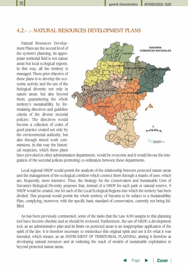
Los Planes de Ordenación deRecursos Naturales son el segundonivel de planificación del sistema. Suámbito territorial adecuado no son losespacios naturales sino las comarcasecológicas. De esta manera todo elterritorio resulta ordenado. Estos pla-nes tienen por objetivo prioritario orde-nar la actividad económica y el uso dela diversidad biológica no sólo en losespacios naturales, sino más allá de losmismos, garantizando la sostenibili-dad de todo el territorio a través de laformulación de directrices y criterios dereferencia orientadores de las diversaspolíticas sectoriales. Estas directricesvendrían a ser un conjunto de códigosde buenas prácticas elaborados no sólopor la autoridad ambiental, sinomediante comisiones mixtas de traba-jo. Se superaría de este modo el recelohistórico que han provocado estos planes en otros departamentos de la administración y se favoreceríala integración de las políticas sectoriales impulsando la coordinación entre dichos departamentos.
Los PORN comarcales permitirían analizar la relación entre espacios naturales protegidos y gestionarlos corredores ecológicos que los conectan a través de la matriz de usos frecuentemente más intensivos.Así se propone en la Estrategia de Conservación y Usos Sostenible de la Diversidad Biológica de Navarra.De esta manera, en el caso de Navarra, en lugar de un PORN para cada parque o reserva natural, se ela-borarían 9 PORN, uno por cada una de la Comarcas Ecológicas en las que se ha dividido su territorio.Este planteamiento permitiría que todo el territorio de Navarra estuviera sujeto a un Plan deSostenibilidad, cumpliendo además la normativa básica específica de conservación, actualmente incum-plida.
Como se ha comentado anteriormente, parte de los cometidos que la Ley 4/89 asigna a este instru-mento de planificación han quedado obsoletos por lo que éstos deberían ser revisados. Además, la uti-lización de los PORN, que es un instrumento de ordenación, como plan de gestión y su circunscripcióna los espacios protegidos es una aplicación inadecuada del espíritu de la ley. Por ello es necesario reto-mar dicho espíritu original y utilizarlo para aquello para lo que fue propuesto, es decir, como INSTRU-MENTO DE PLANIFICACIÓN TERRITORIAL. Y por tanto, encaminarlo más a ordenar los recursos natu-rales y a extender modelos de aprovechamiento sostenible más allá de los espacios naturales protegi-dos.
GUÍA METODOLÓGICAcaracterísticas generales20
T tPágina Portada
4.2.- PLANES DE ORDENACIÓN DE LOS RECURSOS NATURALES
GUÍA METODOLÓGICA características generales 21
T tPágina Portada
Las Directivas de Impacto en vigor y la futura Directiva de Evaluación Estratégica (SEA) a buen segu-ro favorecerá la integración en la conservación del resto de las políticas sectoriales, por cuanto que esta-blece unos procedimientos jurídicamente bien definidos para regular las afecciones sectoriales sobre elmedio ambiente y realizar análisis ad hoc. En el caso español, es no obstante necesario mejorar la actualtransposición de estas normas comunitarias.
La elaboración de los PORN y de los PRUG será siempre que sea posible simultánea y realizado por losmismos equipos multidisciplinares. Esto ayudará a economizar recursos y en ocasiones a derivar actuacio-nes con impacto ambiental de dentro de las áreas con mayores valores naturales a otras áreas alternativassin perjuicio para los promotores ni para los beneficiarios indirectos.
La aprobación del Real Decreto-Ley 4/2000, de medidas urgentes de liberalización en el sector inmo-biliario y Transportes, que modifica algunos aspectos de la Ley Básica 6/98, sobre régimen del suelo yvaloraciones, puede tener efectos indeseados sobre el suelo clasificado genéricamente como no urbaniza-ble. En virtud de este decreto los suelos calificados de no urbanizables sin especial protección son suscep-tibles de ser urbanizados. Por ello es aconsejable que cuanto antes se delimiten los suelos que tengan valornatural. La protección activa de espacios naturales, mediante la propia legislación urbanística o a través dela legislación sectorial de conservación, es imprescindible para la preservación de aquellos espacios consi-derados de especial interés. Los PORN pueden ser un instrumento idóneo para ello.
Se propone para los PORN una vigencia indefinida y revisable cuando proceda.
LAS ACTIVIDADES O ÁMBITOS DE PLANIFICACIÓN QUE PODRÍAN SER CONSIDERADAS ENESTOS PLANES COMARCALES, SIEMPRE DESDE LA PERSPECTIVA DEL USO DE LA DIVERSIDADBIOLÓGICA Y DE LA ALTERACIÓN DE LA ESTRUCTURA NATURAL DEL TERRITORIO SON :
� Las estrategias de conservación y uso sostenible de la diversidad biológica � Las estrategias y planes forestales de ámbito general. Los proyectos de ordenación forestal, ylos planes de prevención y extinción de incendios forestales� Planes hidrológicos: protección de recursos y aprovechamientos hídricos, sistemas generalesde drenaje, etc.� La planificación territorial y el planeamiento urbanístico� Las Agendas 21 locales y regionales (u otros instrumentos de desarrollo sostenible)� Los planes de infraestructuras y de transporte (red viaria y ferroviaria, sistema portuario yaeroportuario, etc.)� La planificación energética y las redes de transporte de energía� Los planes y programas de aplicación de los fondos estructurales de la Unión Europea� Los planes de protección civil� Los planes de ordenación y gestión cinegética y piscícola� Los planes y programas de explotación y restauración del sector minero� Los planes y programas turísticos � Los planes y programas de explotación agraria (planes de regadíos, concentración parcelaria,instalaciones ganaderas intensivas, ...)� Los planes de control de la contaminación (saneamiento, tratamiento y gestión de residuos,...)
GUÍA METODOLÓGICAcaracterísticas generales22
T tPágina Portada
En el contexto de un Sistema de espacios Naturales, los planes de gestión son el tercer nivel de pla-nificación y el más concreto. En ellos debe detallarse qué hacer, qué no hacer, qué favorecer y quéfinanciar en cada lugar. Debería definir los elementos de gestión y manejo de carácter temporal paracada espacio.
Los Planes Gestores empiezan a ser necesarios cuando se han identificado los elementos clavespara la conservación en un lugar, se considera que son relevantes y que necesitan ser gestionadospara mantenerlos, mejorarlos o controlarlos.
La identificación previa de estos elementos clave, que es uno de los objetivos que la actual legisla-ción atribuye a los Planes de Ordenación de los Recursos Naturales, se ha realizado ya durante el pro-ceso de identificación de espacios candidatos a integrarse en la Red Natura 2000. En dicho procesose ha analizado la aportación de cada Lugar a la conservación de taxones y sintaxones en el conjuntodel Sistema Regional de Espacios Naturales. En todo caso, cabe una revisión de elementos clave incor-porando al análisis una perspectiva local.
4.3.- LOS PLANES DE GESTIÓN
DICHO DE UNA MANERA MUY SIMPLE Y CONCISA, UN PLAN DE GESTIÓN DE UNESPACIO NATURAL PROTEGIDO DEBERÍA:
1) Identificar con claridad los elementos clave para la gestión, es decir, aquellos valores por los que se ha seleccionado el lugar.2) Establecer mediante criterios cuantitativos concretos, o estimas cualitativas objetivas si lo primero no es posible, el estado de conservación actual de cada uno de estos elementos clave.3) Establecer metas u objetivos finales mensurables para cada elemento de gestión, entendidoscomo estados favorables y deseables de conservación, o lo que es lo mismo, determinar el estado de conservación que queremos mantener o alcanzar.4) Identificar los factores condicionantes, limitantes o de tensión que dificulten por acción natural o humana la consecución de los objetivos.5) Establecer objetivos operativos para el periodo de vigencia del plan que permitan superar los factores adversos identificados o fomentar otros favorables.6) Definir los indicadores que van a permitir evaluar la eficacia de las actuaciones respecto a los objetivos de gestión.7) Indicar las actuaciones que pueden suprimir los factores adversos y potenciar los favorables.8) Identificar a los responsables de los distintos ámbitos de gestión y a los agentes sociales quese pueden implicar en la gestión9) Establecer los recursos humanos, administrativos y presupuestarios disponibles y necesarios.10) Diseñar un plan de seguimiento para verificar el cumplimiento de los objetivos. 11) Establecer un calendario de trabajo y un periodo de vigencia del plan.12) Diseñar procesos e instrumentos de participación social e inter-administrativa13) Recabar apoyo social y político para el plan14) Establecer compromisos concretos de inversión y ejecución.
Cuadro resumen de los contenidos de un Plan Gestor 1
Identificar con claridad los elementos clavede gestión, es decir, aquellos valores por losque se ha seleccionado el lugar.
Establecer mediante criterios cuantitativosconcretos el estado de conservación actualde cada uno de estos elementos clave.
Definir el estado de conservación favorableo deseable para cada elemento clave, a serposible mediante descriptores mensurables.
Identificar los factores que dificulten o favo-rezcan, por acción natural o humana la con-secución de los objetivos.
Establecer objetivos operativos para superarlos factores adversos identificados o favore-cer otros favorables.
Indicar las actuaciones a proponer parasuprimir los modificadores o limitantes yalcanzar los objetivos propuestos.
Identificar a los responsables de los distintosámbitos de gestión y a los agentes socialesque se pueden implicar en la gestión.
Definir indicadores que me permitan evaluarla eficacia de las actuaciones respecto a losobjetivos de gestión.
Establecer los recursos humanos, adminis-trativos y presupuestarios disponibles ynecesarios
Establecer un calendario de trabajo y unperiodo de vigencia del plan
Diseñar un programa de verificación deresultados.
Diseñar procesos e instrumentos de partici-pación social e inter-administrativa
Recabar apoyo social y político
Establecer compromisos concretos de inver-sión y ejecución.
Elementos clave yvalores de conser-
vación
Diagnóstico e indica-dores de estado
Objetivos finales
Amenazas, riesgos yfactores condicionan-
tes o de tensión
Objetivos operativos
Líneas y programasde actuación
Actores e interesados
Indicadores de gestión.
Recursos materialesy humanos.Presupuesto
Cronograma
Plan de seguimiento
Participación social ycoordinación inter eintra-administrativa.
Programa de ApoyoSocial
Financiación y Cartade Compromiso
¿Qué debemos proteger en ellugar?
¿En que situación se encuen-tran actualmente?
¿Cómo querríamos que seencontraran?
¿Qué impide o favorece que sealcance el estado de conserva-ción deseable?
Dadas la circunstancias y en eltiempo de vigencia del plan ¿aqué situación se puede aspirarpara cada elemento clave?
¿Qué debo y cómo debo hacer-lo?
¿Quién debería de hacerlo,quién podría ayudarle y quienpodría poner trabas?
¿Qué efectos se esperan y cómosabré si lo estoy haciendobien?
¿Qué tenemos, qué necesita-mos y cuánto cuesta lo que sepretende hacer?
¿Cuándo hay que hacerlo?
¿Cómo sabremos si estamoshaciendo lo previsto y alcan-zando los objetivos marcados?
¿Cómo vamos a conseguirimplicar a todo aquel que tengaalgo que decir o qué hacer?
¿Quién nos puede echar unamano?
¿Cómo se puede pagar lo quevamos a hacer y quién lopagará definitivamente?
1. Esquema adoptado como modelo en el Plan de Acción para los espacios naturales protegidos del estado español.
GUÍA METODOLÓGICA características generales 23
T tPágina Portada
GUÍA METODOLÓGICAcaracterísticas generales24
T tPágina Portada
El primer dilema que se plantea al abordar estos planes no es metodológico sino conceptual:¿debemos elaborar planes de conservación o planes de desarrollo sostenible?.
Las Comunidades Locales de las áreas incluidas en las propuestas, que normalmente son áreas enclara regresión económica y demográfica, demandan planes que les permitan mejorar su situaciónsocioeconómica. Por otra parte, la Comisión Europea, a través de la Comunicación (2001) 162, rela-tiva a Planes de Acción sobre biodiversidad, dice que “el desarrollo y la aplicación de la estrategiade la biodiversidad y sus planes de acción han de situarse en el contexto más amplio del compro-miso de la Unión Europea de alcanzar un desarrollo sostenible y de integrar los aspectos ambien-tales en otros sectores y ámbitos políticos. También serán importantes para impulsar el proceso dereforma política iniciada por la Agenda 2000”.
Sin embargo, la Comisión Europea también ha manifestado que “los objetivos del plan de gestiónde las futuras ZEC deben responder a las necesidades ecológicas de los hábitats naturales y especiesque tienen presencia significativa en ese espacio para que su estado de conservación sea favorable”
Parece claro que en el caso de muchos hábitats seminaturales y especies que están ligados a actua-ciones humanas, el mantenimiento o no de estas actividades, deberá ser considerado en el Plan deGestión. Este deberá establecer medidas para abordar cuestiones relativas a la biodiversidad utilizan-do instrumentos que no son específicos de la diversidad biológica y que implican a las diferentes prác-ticas del uso del suelo. Es por ello que la integración de las políticas sectoriales y de sus órganos com-petentes en la elaboración del plan gestor y en su financiación no es una opción sino una necesidadlegalmente prescrita. Por tanto, el plan de gestión establecerá medidas específicas de conservación yevaluará los efectos de otras políticas en la biodiversidad.
La Comisión Europea se ha pronunciado repetidamente respecto a la inconveniencia, en su opi-nión, de crear un fondo específico para la Red Natura 2000, entendiendo que ésta deberá financiarsea través de otros fondos comunitarios existentes y básicamente a través de los fondos regulados porel Reglamento de Desarrollo Rural. Es incuestionable por tanto que, a fecha de hoy y en contra dealgunas expectativas que se vienen generando, la Red Natura 2000 no puede financiar el desarrollorural. Es más, los fondos disponibles para el desarrollo rural no sólo deben ser compatibles con la RedNatura 2000, es decir, deben ser sostenibles, sino que deben servir para financiar la Red Natura 2000.
5. CARACTERÍSTICASDE LOS PLANES DE GESTIÓN Y CRITERIOS PARA SU ELABORACIÓN
5.1.- ¿CUÁL DEBE SER EL ALCANCE DE LOS PLANES DE GESTIÓN?
GUÍA METODOLÓGICA características generales 25
T tPágina Portada
El Desarrollo Rural es un objetivo en el que deben implicarse y comprometerse todos los departa-mentos que gestionan los fondos para el desarrollo. Los Planes de Gestión, salvo que se modifique elactual marco competencial intradministrativo, no son por tanto un plan de desarrollo, si bien puedentener una notable incidencia en el desarrollo rural de áreas desfavorecidas.
Ahora bien, las administraciones ambientales no disponen ni de las competencias ni de los presu-puestos necesarios para abordar planes de desarrollo sostenible. Siendo realistas, ni siquiera disponende lo necesario para financiar un plan de estrictamente circunscrito a la conservación de valores natu-rales. De hecho, el grueso de los fondos europeos que podrían ser utilizados para la conservación songestionados por otros departamentos con otros objetivos propios para los que la conservación medio-ambiental es un asunto secundario cuando no un obstáculo. Un Plan de Desarrollo Sostenible sólopuede ser abordado como acción de Gobierno, en un proceso en el que todos los Departamentos par-ticipen activamente y comprometan sus presupuestos e incorporen acciones decididas para la inte-gración ambiental de sus políticas. Por ello, se propone una metodología en la que a partir de Planesde Conservación, donde se establezcan los objetivos imprescindibles para mantener o alcanzar el esta-do favorable de conservación de taxones y sintaxones, tal como obliga la normativa ambiental comu-nitaria, puedan incorporarse otros objetivos socioeconómicos de manera coordinada entre todos losdepartamentos de una Administración , y concertada con propietarios y entidades locales.
En cualquier caso, conviene resaltar que el plan de gestión debe ser un documento que dote a la ges-tión del espacio de continuidad, evitando que los vaivenes políticos afecten a los valores y funcionesdel espacio natural a largo plazo.
La metodología propuesta para los planes gestores es una adaptación del enfoque de marco lógicopara la mejora del ciclo del proyecto. Esta metodología fue adoptada por la Comisión Europea a prin-cipios de los años 90 para mejorar la calidad en el diseño y gestión de los proyectos de ayuda al desa-rrollo, y para maximizar su eficacia. En la actualidad es la Metodología que exige la Comisión Europeapara la preparación de los Proyectos LIFE-Naturaleza que optan a financiación mediante este instru-mento.
SE PROPONEN COMO FINES DE LOS PLANES DE GESTIÓN LOS SIGUIENTES:
� Proteger y favorecer a los elementos clave; � Desarrollar la potencialidad ecológica del lugar, � Acondicionarlo para un uso aceptable (educación, investigación, formación,interpretación, etc.)
5.2.- ¿CUÁL DEBE SER LA ESTRUCTURA DE UN PLAN DEGESTIÓN?
GUÍA METODOLÓGICAcaracterísticas generales26
T tPágina Portada
5.3.- ¿CÓMO DEBE SER UN PLAN GESTOR?
5.3.1.- Comparable
Es conveniente diseñar métodos estandarizados de ejecución de los planes gestores no sólo paratodos los espacios de la red sino en relación al contexto europeo (Red Natura 2000). Para ello resul-ta de interés tomar como referencia las propuestas del grupo EUROSITE. La asignación de recursos,la comparación de problemáticas, actuaciones y resultados se facilitará si existen documentos estan-darizados.
Es igualmente conveniente que exista un formato estandarizado e informatizado único para todoslos planes de gestión. El formulario estándar EUR 15 empleado para la remisión de la propuesta deLugares de Importancia Comunitaria a la Comisión Europea puede ser, debidamente cumplimentadoun excelente resumen del plan gestor.
5.3.2.- Comprensible
Muchas Comunidades Autónomas definen dos grandes grupos de tipos de planes: de protecciónactiva y de protección pasiva. Ambos tipos pueden integrarse mediante un modelo de plan en el quepara cada objetivo de gestión se establezcan directrices, regulaciones y actuaciones con un indicadorde prioridad. Es también frecuente establecer distintos tipos de planes rectores según la categoría deprotección del lugar. Sin embargo, se propone definir un modelo único y flexible de plan gestor paratodas las áreas protegidas, lo que simplificaría y facilitaría la elaboración, difusión y comprensión delos planes gestores.
Hay que tener en cuenta que un plan de gestión no sólo va dirigido a la Administración como órga-no supervisor y responsable último. Debe ser accesible y entendible por los futuros gestores del espa-cio, los miembros de otros departamentos que estén relacionados con dicho espacio, los propietarios,arrendatarios, vecinos, autoridades locales, y cualquier grupo socioeconómico que muestre interés enel mismo.
ESTA HERRAMIENTA TIENE LAS SIGUIENTES VENTAJAS:
� Facilita la formulación de ideas con mayor claridad.� Asegura una coherencia interna del documento desde las primeras fases de elaboración delmismo hasta sus desarrollos posteriores, poniendo de manifiesto sus contradicciones y errores.� Establece una relación directa entre los problemas detectados y los objetivos a alcanzar endiferentes ámbitos temporales.� Establece una relación directa entre los objetivos establecidos para el espacio y lasactuaciones que van a ayudar a conseguirlos.� Establece unos indicadores objetivamente verificables para el cumplimiento de los objetivos.
GUÍA METODOLÓGICA características generales 27
T tPágina Portada
5.3.3.- Realista y aplicable
El plan debe ser realizable aunque plantee objetivos a largoplazo o difíciles de alcanzar. Es decir, puede entrar en el terre-no de lo utópico, en cuanto a proponer actuaciones deseablesaunque imposibles a corto plazo, pero nunca en lo quimérico.Para los objetivos a largo plazo deben diseñarse otros objetivosque tiendan a conseguir progresivamente situaciones concretas intermedias perfectamente definidas.
Deben incorporar objetivos mensurables y claramente verificables, e indicadores para facilitar elseguimiento y evaluar los resultados. Dichos objetivos deben tener en cuenta la situación inicial, losrecursos y el tiempo disponible.
La unidad básica de gestión en terrenos de propiedad particular deben ser las explotaciones agra-rias o forestales o bien agrupaciones homogéneas de éstas. Proponer una gestión explotación a explo-tación es por el momento un objetivo inalcanzable con la actual capacidad de gestión que en generaltienen las autoridades ambientales.
La regulación de usos debiera describir el régimen preventivo y el tipo de informe ambiental, pro-ceso de elaboración y de autorización, antes que una lista de actividades permitidas, autorizables oprohibidas.
5.3.4.- Concreto
En general, el plan deberá ser lo suficientemente concreto como para poder iniciar la ejecución deactuaciones definidas a nivel de proyecto. Donde no sea posible y se considere importante para la ges-tión, se identificaran los aspectos que dificultan alcanzar una mayor concreción, normalmente relati-vos a la insuficiencia o carencia de información, y se dispondrán acciones que palien dichas caren-cias.
La descripción de cada actuación debe incluir al menos los objetivos con los que se relaciona, ámbi-to de aplicación, condicionantes ambientales a tener en cuenta, periodo sugerido de aplicación y calen-dario, efectos esperados, indicadores para medir los efectos, organismo responsable, agentes socialesafectados o implicados, ejecutores, coste estimado, fuentes de financiación, normativa que pueda afec-tarle significativamente, grado de prioridad y mecanismo de evaluación y seguimiento de resultadoscon respecto a los objetivos con los que se relaciona la medida. En la práctica, las disponibilidadesfinancieras son limitadas, por lo que la asignación de un grado de prioridad a cada actuación es espe-cialmente importante.
5.3.5.- Conciso
Con frecuencia los planes incorporan prolijas descripciones de aspectos irrelevantes o secundariosentre las que quedan diluidos, cuando no directamente excluidos, factores esenciales.
Avefría (ARCHIVO G.N.)
GUÍA METODOLÓGICAcaracterísticas generales28
T tPágina Portada
� Deben evitarse tentaciones literarias y largostextos explicativos.� Debe evitarse la proliferación de datos y deextensos análisis, que por otra parte rara vez seinterpretan o se utilizan en la propuesta de actua-ciones.� Asimismo, las decisiones deben presentarse sinextensas discusiones sobre los pros y los contras en cada caso. En cualquier caso, siempre se puederecurrir a incluir referencias bibliográficas o anexos.� La información se presentará de la forma más sintética posible, preferentemente en tablas, fichasy cartografía de síntesis.
5.3.6.- Específico
Deben ser específicos y adecuados a cada lugar. Es frecuente en los Planes de Ordenación deRecursos Naturales (PORN), aunque ha quedado claro que éstos no pueden considerarse planes degestión, y en los Planes Rectores de Uso y Gestión (PRUG), encontrar fragmentos copiados de otrosplanes con datos o propuestas que se extrapolan de situaciones pretendidamente similares. Tambiénes frecuente encontrar planes genéricos para varios espacios sólo sirven para satisfacer obligacionesnormativas o para establecer regímenes preventivos generales que resultan insuficientes para la ges-tión diaria. La transferencia de datos o medidas rara vez se adapta a las peculiaridades locales. Noobstante, la experiencia en situaciones análogas puede servir para establecer medidas preventivas enaplicación del principio de precaución en tanto en cuanto se estudian medidas adecuadas a cada lugar.
Podrán desarrollarse si es el caso en otros planes más específicos (sectoriales, anuales, plurianua-les, etc.), convirtiéndose el plan de gestión en un plan de planes.
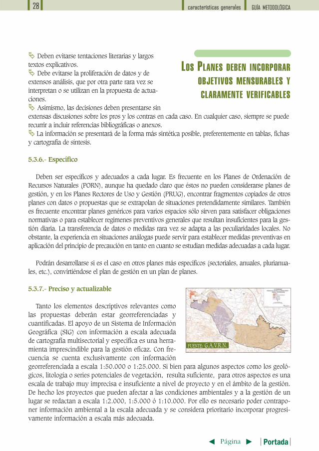
5.3.7.- Preciso y actualizable
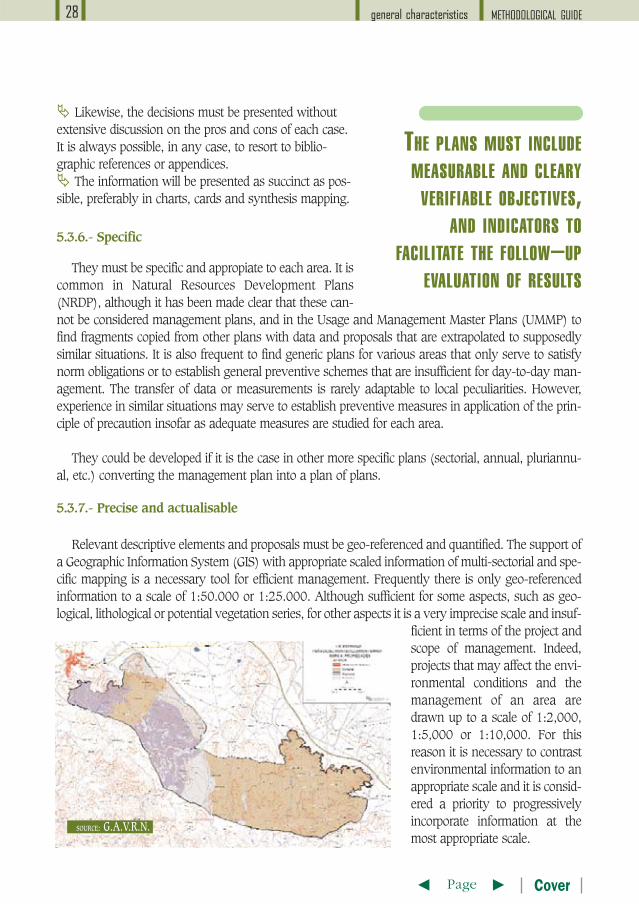
Tanto los elementos descriptivos relevantes comolas propuestas deberán estar georreferenciadas ycuantificadas. El apoyo de un Sistema de InformaciónGeográfica (SIG) con información a escala adecuadade cartografía multisectorial y específica es una herra-mienta imprescindible para la gestión eficaz. Con fre-cuencia se cuenta exclusivamente con informacióngeorreferenciada a escala 1:50.000 o 1:25.000. Si bien para algunos aspectos como los geoló-gicos, litología o series potenciales de vegetación, resulta suficiente, para otros aspectos es unaescala de trabajo muy imprecisa e insuficiente a nivel de proyecto y en el ámbito de la gestión.De hecho los proyectos que pueden afectar a las condiciones ambientales y a la gestión de unlugar se redactan a escala 1:2.000, 1:5.000 ó 1:10.000. Por ello es necesario poder contrapo-ner información ambiental a la escala adecuada y se considera prioritario incorporar progresi-vamente información a escala más adecuada.
LOS PLANES DEBEN INCORPORAROBJETIVOS MENSURABLES YCLARAMENTE VERIFICABLES
FUENTE: G.A.V.R.N.
GUÍA METODOLÓGICA características generales 29
T tPágina Portada
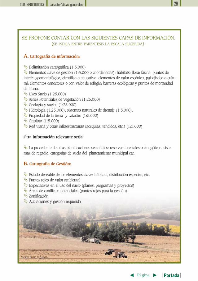
A. Cartografía de información:
� Delimitación cartográfica (1:5.000)� Elementos clave de gestión (1:5.000 o coordenadas): hábitats; flora; fauna; puntos deinterés geomorfológico, científico o educativo; elementos de valor escénico, paisajístico o cultu-ral; elementos conectores o con valor de refugio; barreras ecológicas y puntos de mortandadde fauna.� Usos Suelo (1:25.000)� Series Potenciales de Vegetación (1:25.000)� Geología y suelos (1:25.000)� Hidrología (1:25.000); sistemas naturales de drenaje (1:5.000).� Propiedad de la tierra y catastro (1:5.000)� Ortofoto (1:5.000)� Red viaria y otras infraestructuras (acequias, tendidos, etc.) (1:5.000)
Otra información relevante sería:
� La procedente de otras planificaciones sectoriales: reservas forestales o cinegéticas, siste-mas de regadío, categorías de suelo del planeamiento municipal etc.
B. Cartografía de Gestión:
� Estado deseable de los elementos clave: hábitats, distribución especies, etc.� Puntos rojos de valor ambiental� Expectativas en el uso del suelo (planes, programas y proyectos)� Áreas de conflictos potenciales (puntos rojos para la gestión)� Zonificación� Actuaciones y gestión requerida
SE PROPONE CONTAR CON LAS SIGUIENTES CAPAS DE INFORMACIÓN. (SE INDICA ENTRE PARÉNTESIS LA ESCALA SUGERIDA):
ARCHIVO DIARIO DE NAVARRA
GUÍA METODOLÓGICAcaracterísticas generales30
T tPágina Portada
Aparte del análisis combinado de bases de datos georreferenciadas complejas, estos sistemas infor-máticos permiten desarrollar modelos de simulación. Ahora bien, un SIG que no haya previsto proto-colos permanentes de actualización es con frecuencia un problema antes que una solución. Todos losdatos y coberturas deberán indicar la fecha última de actualización. Y el plan de gestión en su con-junto debe adoptar un formato que permita su actualización permanente e inmediata.
El programa de seguimiento debe establecer rutinas que permitan detectar cambios significativosrápidamente. El plan debe ser suficientemente flexible como para poder adecuarse a nuevas circuns-tancias o a lo que la evaluación de resultados pudiera aconsejar.
El plan debe contemplar en su fase inicial el análisis de las partes interesadas, entendiendo comotales a cualquier individuo, grupo de personas, instituciones o empresas susceptibles de ser afectadaspositiva o negativamente por el plan. Los planificadores deben, no sólo mantenerlos informados, sinodiseñar mecanismos efectivos de participación para las distintas fases de la elaboración del Plan. Laparticipación es especialmente relevante si los planes aspiran a promover el desarrollo sostenible y afavorecer la integración de los aspectos ambientales en otros sectores y ámbitos políticos. Es por ello,que la participación social se ha definido como uno de los tres principios básicos que definen el desa-rrollo sostenible, junto a la conservación del medio ambiente y el desarrollo económico.
Idealmente los autores del plan deben ser los propios gestores del territorio pudiendo incorporar alequipo redactor expertos en planificación territorial, o contar con la colaboración de especialistas para
5.4.- ¿QUIÉN DEBE ELABORAR UN PLAN?
EN LA MEDIDA ENQUE SE IMPLIQUEN TODOSLOS AGENTES SOCIALES Y
ADMINISTRATIVOS DEINCIDENCIA TERRITORIAL,
SERÁ MÁS FÁCIL CONSEGUIRUN ALTO GRADO DE
COMPROMISO EN SUDESARROLLO
Sierra de Beriáin (AZZARI)
GUÍA METODOLÓGICA características generales 31
T tPágina Portada
5.6.- ¿CUÁNDO HAY QUE REVISAR EL PLAN?
Cualquier actuación o situación que pueda plantearse y que tenga incidencia en la conservacióndebería tener su referencia en el Plan Gestor. Si no es así, el plan deberá modificarse.
Se propone para los planes de gestión un periodo de vigencia de 6 años. Es aconsejable definir sen-cillos protocolos de elaboración de memorias breves que permitan revisiones anuales. En este caso esnecesario que sean informes muy sencillos para evitar que el papel acabe abrumando al gestor. Suobjetivo no es incorporar un nuevo trámite administrativo sino ayudar al gestor a identificar desvia-ciones del plan con respecto a sus objetivos finales y adecuarlo con rapidez.
En Navarra la vigencia es indefinida, aunque se prevé la revisión cuando las condiciones lo acon-sejen. Esta opción es más cómoda y flexible, evita los compromisos normativos que rara vez se cum-plen, pero se puede caer fácilmente en la desidia y no revisarlos.
Las evaluaciones sobre el grado de cumplimiento y la eficacia del plan gestor es aconsejable quelas realice por una parte el propio órgano gestor y por otra un evaluador externo.
Un plan que incorpore la participación de agentes sociales y otros departamentos implicados de laAdministración puede requerir al menos un año para su elaboración. Este tiempo puede resultar dila-tado pero es notoriamente menor al que viene siendo habitual.
El procedimiento de elaboración del plan suele ser independiente y consecutivo al de informacióndel mismo. Esta última fase, en la que es frecuente que aparezcan conflictos con los implicados, alar-ga extraordinariamente el proceso. Las experiencias en las que elaboración y participación han sidosimultáneas demuestran que es más fácil alcanzar un consenso en torno al documento final y enmenor tiempo.
5.5.- ¿CUÁNTO TIEMPO SE NECESITA PARA REDACTAR UN PLAN?
aspectos concretos. Sin los puntos de vista de las distintas partes interesadas sobre un problema y sunaturaleza, y sobre sus necesidades, no pueden emerger soluciones alternativas.
En la medida que en la elaboración del Plan se impliquen todos los agentes sociales y administra-tivos de incidencia territorial, será más fácil conseguir un alto grado de compromiso en su desarrollo.Este compromiso debe llevar a considerar el plan como de obligado cumplimiento con respecto a lasprescipciones técnicas, los recursos financieros y humanos. La inmensa mayoría de los planes ejecu-tados, tanto a nivel regional como estatal, no se han ejecutado por falta de una distribución clara deresponsabilidades y de la asunción de compromisos.
metodologíacapítulo 2
GUÍA METODOLÓGICAmetodología32
Paisaje de la Zona Media (AZZARI)T tPágina Portada
GUÍA METODOLÓGICA metodología 33
T tPágina Portada
Se describirán con brevedad los motivos que llevaron a la designación del Lugar. No es convenienteque exceda una página. Mencionará los principales valores del lugar por sí mismo y en relación alconjunto del Sistema de Áreas Naturales; las relaciones entre las personas y el medio ambiente (pro-pietarios, usuarios y otros), los problemas ambientales más relevantes y las directrices de gestión prio-ritarias. Se recomienda redactarlo al concluir la elaboración del plan.
El Plan de gestión se estructura en los siguientes documentos:
Se describen a continuación los contenidos y orientacionespara la redacción de cada uno de estos documentos
1. ANÁLISIS ECOLÓGICO Y SOCIOECONÓMICO
2. DOCUMENTO DE OBJETIVOS
3. DOCUMENTO DE MEDIDAS
4. ANÁLISIS DE COSTES Y BENEFICIOS
5. PROGRAMA DE SEGUIMIENTO
EL PLAN DE GESTIÓNNOTAS EXPLICATIVAS PARA LA ELABORACIÓN PASO A PASO DE UN PLAN DE GESTIÓN
� TÍTULO DEL PLAN
� ÍNDICE
� RESUMEN
DOCUMENTO 1 ANÁLISIS ECOLÓGICO Y SOCIOECONÓMICO��En esta parte deberá analizarse la situación existente e identificar los problemas que deberán ser
resueltos para proyectar en la segunda parte del plan la situación deseable y las actuaciones que pue-den hacerla posible. Por tanto, lo relevante de esta parte del plan es seleccionar los elementos clave,describir su situación actual e identificar sus problemas.
La descripción abordará ÚNICAMENTE aquellos aspectos físicos, biológicos, legales, sociales, eco-nómicos o culturales que sean relevantes de cara a la gestión por identificar un elemento clave, unproblema o un factor condicionante o de tensión. Si en fases posteriores se identifican nuevos aspec-
GUÍA METODOLÓGICAmetodología34
T tPágina Portada
tos relevantes que no se hayan tenido en cuenta en la descripción, siempre podrán incorporarse alplan. Es por tanto IMPRESCINDIBLE evitar tediosas descripciones literarias de aspectos irrelevantesque no vuelven a ser utilizados en todo el plan y que normalmente se copian de documentos pree-xistentes. Incluso cuando los aspectos descritos sean relevantes deben reseñarse con la mayor bre-vedad y concreción posible incluyendo la referencia bibliográfica donde puede ampliarse la informa-ción.
Se describen a continuación los aspectos que podrían ser abordados en la parte descriptiva tenien-do en cuenta que NO ES NECESARIO CONSIDERAR TODOS ELLOS EN CADA PLAN, sino sólo aque-llos que tengan relevancia y puedan condicionar el tipo de gestión del Lugar al que hace referencia.
1.1.- LOCALIZACIÓN Y DELIMITACIÓN
Debe ser suficiente para que cualquier persona sea capaz de ubicar el espacio. Se sugiere incluirplano anejo, lista de términos municipales y porcentaje del espacio que está en cada uno de ellos, cri-terios utilizado y descripción razonada de los límites.
1.2.- DISTRIBUCIÓN DE LA PROPIEDAD DE LA TIERRA
Se indicará el porcentaje de suelo público y privado con indicaciones, siempre que sea posible, delgrado de fragmentación de la propiedad, tamaño de las parcelas y régimen de tenencia.
1.3.- ESTATUS LEGAL
Figuras de protección, designaciones legales e instrumentos normativos o de planificación vigen-tes y relativos a la conservación.
1.4.- ESTRUCTURA Y ADMINISTRACIÓN ORGANIZATIVA
Listado de todas las instituciones e individuos relacionados con la gestión del espacio, así comorecursos disponibles: � Personal relacionado con la gestión y sus responsabilidades.� Equipamientos y recursos consolidados (incluyendo presupuestos).� Infraestructuras de gestión relativas a la conservación.
1.5.- OTROS PLANES SECTORIALES QUE AFECTEN A LA GESTIÓN
En este apartado debe recopilarse con brevedad la información existente sobre todos los aspectos rele-vantes relativa a componentes biológicos (flora, fauna y hábitats naturales) y procesos ecológicos que
GUÍA METODOLÓGICA metodología 35
T tPágina Portada
den valor al espacio natural. Su objetivo es facilitar la posterior selección de elementos significativoso claves. Deberán incluirse también, cuando se disponga de datos o estimaciones, referencias al por-centaje de superficie o de poblaciones de flora y fauna que aporta cada espacio al conjunto de la RedRegional de Espacios Naturales y al conjunto de Natura 2000.
2.2.- CARACTERÍSTICAS FÍSICAS O ABIÓTICAS
SÓLO se considerarán aquellos aspectos que tengan una repercusión manifiesta y relevante en losvalores por los que se declara el lugar, o pueda llegar a condicionar la gestión del mismo. En ningúncaso se trata de caracterizar o describir un aspecto concreto, sino de analizar la manera en que reper-cute sobre los valores naturales.
Puede darse el caso de que un elemento abiótico sea en sí mismo un valor de conservación, porejemplo un karst yesífero u otras formaciones geomorfológicas singulares.
Por tanto, se enumeran a modo de guía los aspectos que podrían ser abordados, sin que ellosuponga que hay que abarcar en todos los planes todos ellos:
� clima: cualquier aspecto que pueda determinar microclimas o climas locales y sea origen sesingularidades biogeográficas o afectar a futuras actuaciones.� geología y geomorfología; suelos y sus procesos (formación, erosión, contaminación, salini-zación, compactación, inundación, ...)� hidrología, sistemas de drenaje, calidad del agua o de otros recursos naturales,� elementos de valor cultural, científico o educativo, etc.
2.3.- PROCESOS ECOLÓGICOS
Además del análisis específico de taxones y sintaxones, deberá realizarse un enfoque ecosistémi-co del Lugar en el que se pongan de relieve posibles interacciones de interés o procesos ecológicos.Este análisis abarcará en la medida de lo posible las relaciones del Lugar con su entorno inmediato ycon otros Lugares de Natura 2000. De este modo se valorará la aportación del Lugar a la coherenciainterna de la red, su grado de conectividad actual y potencial con otros espacios naturales, etc.
Lamentablemente nuestros conocimientos en la mayoría de los casos no permiten este análisis eco-sistémico y la identificación de procesos ecológicos clave. No obstante, la constatación de estas caren-cias es el primer paso necesario para subsanarlas y el plan es un documento abierto que podrá ir incor-porando nuevas informaciones y conocimientos en el futuro.
2.4.- PAISAJE
El paisaje debe entenderse como una manifestación perceptible de los procesos ecológicos subya-centes y la interacción de usos históricos y actuales del territorio. Los usos del suelo están condiciona-dos por las condiciones del medio físico y a la vez condicionan y modelan el medio natural y la pre-
GUÍA METODOLÓGICAmetodología36
T tPágina Portada
sencia de flora, fauna y hábitats naturales característicos. El resultado es la conformación de unidadespaisajísticas diferentes donde la gestión debe ser necesariamente diferente. En este apartado deberándescribirse dichas unidades paisajísticas.
La definición de estas unidades de cierta homogeneidad facilita la localización de problemas, obje-tivos y actuaciones cuando el Lugar resulta muy extenso o complejo.
La zonificación es una herramienta optativa aplicable únicamente si reduce la complejidad de lagestión. Debe ser tan simple como sea posible.
Además, es conveniente identificar aquellos paisajes representativos, singulares y con valor cultural.
Por tanto, para cada uno de estos elementos deberá formularse al menos un objetivo y las actua-ciones necesarias para conseguirlo. Serán de carácter preferentemente bióticos (componentes del eco-sistema o procesos ecológicos), aunque excepcionalmente se podrán considerar elementos abióticos,culturales, científicos o sociales.
Los elementos clave podrán ser componentes de los ecosistemas, tales como especies de flora yfauna o hábitats naturales, bien considerados individualmente o bien por comunidades faunísticas ogrupos de hábitats. Pero pueden ser también procesos ecológicos, tales como la dinámica fluvial, eincluso el propio ecosistema. Así por ejemplo, en un agrosistema estepario o en la campiña atlántica,más allá de la presencia de ciertas comunidades vegetales (hábitats naturales) que interesa conservarpor su valor intrínseco, nos interesa también su patrón de distribución, es decir, el número y posiciónrelativa de estas comunidades entre sí y con otros usos del suelo y componentes del paisaje.Elementos banales desde el punto de vista de la presencia de especies o de hábitats naturales ame-nazados pueden tener importancia en lo referente a la funcionalidad e integridad del agrosistema y ala superviviencia de especies multihábitats. En ese caso, el paisaje estepario o la campiña atlánticapueden ser seleccionados como elementos claves, si bien será necesario caracterizarlos con atributosmedibles.
Es conveniente presentar los elementos seleccionados en una tabla en la que se indique si se valo-ra su interés en el ámbito europeo, estatal o regional. Se entenderá de ámbito europeo si está inclui-do en los algún anexo de la directiva hábitats o Aves; estatal si está incluido en el Catálogo Nacionalde especies Amenazadas; y regional si está incluido en el Catálogo de Especies Amenazadas deNavarra.
Además de la tabla, se justificará brevemente y caso por caso su elección como elemento clave.
2.5.- ELEMENTOS CLAVE PARA LA GESTIÓN DEL ESPACIO
SE SELECCIONAN Y DESCRIBEN LOS ELEMENTOS CLAVE, ES DECIR, AQUELLOS POR LOS QUEHA SIDO DESIGNADO UN LUGAR. UN ELEMENTO DEBE SER SELECCIONADO COMO CLAVE SI:
� Es relevante para la conservación a escala comunitaria, estatal o regional� Tiene presencia significativa en el Lugar� Necesita ser gestionados para mantenerlo, mejorarlo o controlarlo
Proceso de selección de elementos claveListar todos los hábitats y especies de flora y fauna presentes en el lugar y que estén incluidos en los ane-
xos I de la Dir. Aves, II y IV de la Dir. Hábitats, Catálogo Nacional o Foral de especies amenazadas.
Incorporar a la lista anterior aquellos que aún no estando presentes actualmente lo estuvieron y o tienepotencialidad e interés para su introducción.
Incorporar a la lista anterior aquellos procesos ecológicos u otros elementos y aspectos que puedan consi-derarse elemento clave en el Lugar
Eliminar de la lista los elementos que no sean significativos en el Lugar y para los que por tanto, no seanecesario establecer objetivos de gestión en ese Lugar, aunque sin duda sean merecedores de atención en
otros espacios de la red.
Eliminar aquellos elementos que no necesiten ser gestionados para mantenerlos, mejorarlos o controlarlos.Los elementos que tengan un alto valor natural deberán seleccionarse con independencia de su estado de
conservación. Si este es óptimo, deberá formularse como objetivo al menos su monitorización.
Asegurarse de que no hay solapamientos o incompatibilidades entre elementos distintos. Por ejemplo, siexisten especies que están presentes en hábitats seleccionados, se incluirá sólo el hábitat como elemento
clave, salvo que la especie tenga especial relevancia o tenga unos requerimientos muy específicos. O si enel lugar se tratará de favorecer especies forestales, no es conveniente seleccionar especies características deespacios abiertos salvo que una adecuada zonificación del Lugar permita compatibilizar ambos objetivos.
Listar los elementos resultantes: son los elementos clave considerados focales para la gestión
En este apartado se debe describir atributos mensurables de los elementos clave, es decir, caracte-rísticas esenciales e inherentes al mismo, que permitan caracterizarlos y valorar su estado actual deconservación.
2.6.- ESTADO DE CONSERVACIÓN DE LOS ELEMENTOS CLAVE
tt
tt
tt
Por ejemplo: una comunidad vegetal se caracteriza por contener al menos unas determina-das especies y con frecuencia otras; su estado de conservación será malo, regular o bueno sicumple unas condiciones que se deberán especificar.
GUÍA METODOLÓGICA metodología 37
T tPágina Portada
GUÍA METODOLÓGICAmetodología38
T tPágina Portada
A su vez, para cada atributo es conveniente establecer un valor óptimo y otros valores máximo ymínimo por encima o por debajo de los cuales se entenderá que el estado de conservación deja de serfavorable. Para cada elemento es conveniente seleccionar el menor número de atributos posible siem-pre que definan con precisión las condiciones favorables y que sean fácilmente monitorizables. Parasu selección puede ser de utilidad pensar en qué sentido pueden aparecer cambios adversos e identi-ficar indicadores que permitan reconocer con premura esos cambios. Por ejemplo, la frecuencia de ene-bros puede indicar el avance de la sucesión en brezales.
La identificación de estos atributos y sus valores mensurables facilitarán posteriormente el estable-cimiento del Plan de Seguimiento al poder ser utilizados como indicadores de estado. Es cierto queseleccionar atributos significativos y establecer sus valores óptimo, máximo y mínimo requiere cono-cimientos considerables y exhaustivos de los elementos clave, que rara vez tenemos. Sin embargo,debemos incrementar los esfuerzos en esta línea de trabajo pues si no se es capaz de evaluar con pre-cisión la situación inicial difícilmente se podrá valorar la repercusión de la gestión y conocer si se estánalcanzando los objetivos marcados.
En el caso de las especies, es conveniente incluir datos sobreel área de distribución cuando sea un dato relevante. Por ejem-plo, cuando la población del lugar se trate de una población ais-lada, sea fuente de irradiación o sumidero, este muy reducida,etc. Deben consignarse datos concretos sobre su presencia en elLugar cuando se haya constatado, sea probable o tenga condi-ciones potenciales para ello. Son igualmente útiles, si se cono-cen, los datos sobre mortalidad, tamaño de la población, evolu-ción de poblaciones y tendencia. Deberán evitarse las estima-ciones cualitativas e incorporar indicadores cuantitativos.
En el caso de hábitats se indicará la superficie actual y a falta de criterios más precisos, el estadode conservación estimado en el actual Inventario de Hábitats. Igualmente será conveniente incluirdatos, cuando estén disponibles, de las especies características, estructura vertical, estado sanitario,clases de edad, fragmentación, cobertura y tendencia.
Una vez proporcionada esta información, es preciso analizarla para determinar los mayores pro-blemas de conservación: pérdida, simplificación o degradación del hábitat, disminución de efectivos,falta de regeneración, fragmentación de poblaciones, carencia de información, extinción local, pobla-ción muy reducida, etc.
La búsqueda de las causas de los problemas detectados, y el establecimiento de relaciones causa-efecto se realizará más adelante, en el apartado de “Condicionantes”, una vez establecida la “situa-ción deseada”. Se identificarán entonces todos los factores de tensión que impiden actualmente alcan-zar dicha situación ideal.
No obstante, dado que el análisis debe estar orientado a identificar los problemas para la conser-
LA IDENTIFICACIÓN DELOS INDICADORES
MENSURABLES FACILITARÁEL ESTABLECIMIENTO DEL
PLAN DE SEGUIMIENTO
GUÍA METODOLÓGICA metodología 39
T tPágina Portada
3. ANÁLISIS SOCIOECONÓMICO
3.2.- CARACTERIZACIÓN Y DIMENSIÓN DE LOS SECTORES PRODUCTIVOS
El objetivo de este apartado es describir brevemente el carácter dominante de la actividad económi-ca y los aspectos más relevantes que puedan condicionar la actitud de la población ante el espacio ya las propuestas de gestión.
3.1.- CARACTERIZACIÓN SOCIOECONÓMICA
En este apartado se trata de poner de relieve los aspectos más significativos que caracterizan la acti-vidad económica y social de las comunidades locales. Debe evitarse la proliferación de datos socioe-conómicos y presentar con brevedad conclusiones que permitan componer una foto de las caracterís-ticas socioeconómicas del espacio y su entorno.
Se analizarán aspectos como la estructura y tendencia de la población, dinamismo y asociacionis-mo, bienestar y calidad de vida, servicios, equipamientos y dotaciones, parque de viviendas, etc.
Es conveniente utilizar indicadores que permitan establecer comparaciones claras y fiables conotras zonas de Navarra. Así por ejemplo: el déficit local de infraestructuras generales (DIG), tasa dehombres y mujeres, índice de desigualdad de género en órganos locales de representatividad, índicesde juventud, variación poblacional, calidad del parque de viviendas, consumo eléctrico medio porhabitante, distancia a servicios básicos, renta familiar, tasa de actividad minorista comercial (excluidala alimentación), etc.
La selección de un conjunto de indicadores socioeconómicos facilitará la formalización de un“observatorio socioeconómico” para el seguimiento y la evaluación antes y después de la aplicaciónde los planes, tal como se propone en el artículo 34 del Plan de Acción sobre la biodiversidad en losámbitos de la conservación de los recursos naturales, la agricultura, la pesca y la cooperación al desa-rrollo y cooperación económica (COM (2001)162)
� Dimensión social: análisis general de la ocupación de la población por sectores y género.� Lugar de trabajo y movilidad: porcentaje de población que trabaja en el espacio o su entorno.� Dimensión económica: análisis general de la actividad productiva por sectores, número ydimensión financiera de las explotaciones, renta agraria/explotación en la zona y comparado conNavarra y con la renta media, etc.
Otros aspectos generales que pueden ser de interés son:
vación de los elementos clave, es conveniente concluir este apartado indicando las amenazas o pro-blemática de la especie en el Lugar, o aquellas que se ha constatado que le afectan en áreas análogasy que pudieran estar afectándole en el Lugar.
GUÍA METODOLÓGICAmetodología40
T tPágina Portada
La descripción de algún sector productivo concreto sólo se abordará en el caso de que su actividadafecte al estado de conservación del lugar.
3.3.- RELACIÓN DE DEPENDENCIA ENTRE LA ACTIVIDAD ECONÓMICA Y LOS RECURSOSNATURALES
En definitiva, en previsión de que la gestión del Lugar pueda afectar a la actividad económica, ypara poder valorar el impacto económico de la conservación, nos interesa cualquier información quenos permita valorar el tipo de impacto ambiental, si lo hubiera, de una actividad, su impacto social(medido en empleos generados) y su impacto económico (medido en generación directa e indirectade riqueza).
Tal como reconoce la Estrategia de la Comunidad Europea en materia de biodiversidad, “los incen-tivos económicos y sociales pueden tener considerables efectos, positivos o negativos, sobre la biodi-versidad. Junto a la determinación e introducción de incentivos a la conservación y el uso sosteniblees necesario considerar la supresión de subsidios que tienen incidencia negativa”. Por otra parte, elPlan de Acción de la U.E. sobre biodiversidad para la conservación de los recursos naturales establececomo acción “la evaluación del impacto sobre la biodiversidad de los instrumentos financieros comu-nitarios”. Esta necesidad se propone igualmente
� Identificación de los recursos naturales actualmente explotados en la zona.� Identificación de actividades consumidoras de recursos y análisis de dependencia, valora-da como una estima de la proporción de renta empresarial dependiente del consumo o dete-rioro de componentes o procesos ecológicos.� Identificación de impactos ambientales de la actividad: por consumo o deterioro de compo-nentes o procesos ecológicos. O de otra manera, análisis del grado de integración ambientaly sostenibilidad de la actividad productiva, valorando la tendencia y dirección con respecto ala sostenibilidad.� Análisis social de las unidades productivas impactantes o dependientes de los recursosnaturales: dimensión, orientación productiva, renta empresarial, capacidad de renovación,importancia relativa sobre el empleo local o la renta familiar, etc.� Identificación y caracterización de recursos actualmente subexplotados con potencialidadde usos sostenible.� Expectativas de nuevas actividades económicas y análisis de sostenibilidad de dichasexpectativas.� Ingresos municipales o beneficios directos e indirectos sobre las sociedades locales proce-dentes de actividades dependientes.
SE ENUMERAN ALGUNOS ASPECTOS QUE PUEDEN SER RELEVANTES PARA LAGESTIÓN DEL LUGAR:
3.4.- IDENTIFICACIÓN DE SUBSIDIOS PÚBLICOS CON IMPACTOS EN EL MEDIO AMBIENTAL
T tPágina Portada
en la Estrategia para la Conservación y el Uso Sostenible de ladiversidad biológica de Navarra.
Gran parte de las afecciones sobre el medio natural se pro-ducen con fondos públicos. El análisis de impactos en el ámbi-to local deberá abordarse en los planes.
Estos planes aspiran a establecer mecanismos contractua-les de gestión concertada y revisar los derechos de propiedady uso, así como evaluar el impacto en la conservación de laspolíticas comerciales y económicas nacionales y comunitariasa escala local y regional. Todo ello con el objetivo de modifi-car o mantener modelos de producción, consumo y compor-tamiento con efectos positivos sobre el estado de conservaciónde la diversidad biológica. Para ello debe proponer medidasque permitan a consumidores y usuarios del territorio bieninformados tomar el mayor número de decisiones individua-les beneficiosas para el medio ambiente, y a las administra-ciones regionales a adecuar sus políticas sectoriales.
En todo proceso concertado, es necesario que cada una delas partes sea consciente de lo que cada una aporta y recibe.Así, en estos momentos, los presupuestos de 2003 destinaránen Navarra 108,79 € (18.101 ptas.) por habitante paravivienda, siendo ésta la que los navarros consideran susegundo problema; mientras que dedicará 183,39 € (23.026ptas.) por habitante, sin incluir las ayudas directas europeas(48% del presupuesto comunitario) a los sectores agrarios yforestales, que son los mismos con los que habrá que alcan-zar acuerdos contractuales para la conservación de bienes yservicios ambientales. En el año 2000, el 22 % de la rentaagraria navarra correspondió a subvenciones. Las comunida-des locales deben ser conscientes de las fuentes de financia-ción externa, en especial de la que pueda provenir de la inclu-sión en Natura 2000 o en la accesibilidad que esta red puedafavorecer hacia nuevos fondos y oportunidades. A pesar deque la incidencia de las ayudas ambientales sobre el porcen-taje de subsidios es cada vez mayor, y con una tendencia claraal incremento, la sociedad rural percibe a la administraciónambiental, como un freno a sus expectativas de desarrolloeconómicas. Resulta evidente la necesidad de elaborar estra-tegias de comunicación para la red Natura 2000 y para lasáreas protegidas en general.
� Análisis del impactofinanciero de los subsidiospúblicos más habituales, sig-nificativos y relevantes en lazona, de los que se hayanaplicado hasta la fecha, yque hayan tenido una reper-cusión directa sobre el medionatural: ingresos totales aentidades locales y particula-res y porcentaje sobre losrecursos movilizados.
� Incidencia en la rentade los particulares y en losingresos de las entidadeslocales de los subsidios públi-cos y de las actividades eco-nómicas relacionadas con elmedio natural y sus compo-nentes.
� Cálculo del precio demercado imputable a losrecursos naturales emplea-dos en la actividad económi-ca y diferencial con el precioactual.
� Análisis del impactosocial: número de empleos alos que afecta, número deperceptores, valor medio delas ayudas por perceptor.
� Análisis de su impactoambiental.
POR TODO ELLO, ENESTE APARTADODEBERÁN ABORDARSELOS SIGUIENTES PASOS:
GUÍA METODOLÓGICA metodología 41
GUÍA METODOLÓGICAmetodología42
T tPágina Portada
3.5.- ANÁLISIS DE ACTIVIDADES E IMPACTOS
En este apartado no se trata de analizar en detalle las actividades que tiene lugar dentro del espa-cio, o en su entorno si afectan a la conservación del mismo, ni de los impactos que generan. Sino dechequearlas sistemáticamente y de inducir una primera reflexión sobre cual de ellas es relevante desdeel punto de vista de la conservación.
La Decisión 97/266/CE de la Comisión, en su apéndice E, aporta una relación detallada de las acti-vidades e impactos susceptibles de afectar al estatus de conservación de los sitios a las que por tantohabrán de hacer frente los gestores. Tal relación constituye una guía exhaustiva a la que puede recu-rrirse para la identificación de factores de coste o tensión (BARBERÁ et al., 2001)1.
El análisis puede presentarse en una tabla similar a la correspondiente del formulario EUR 15 (tabla... ). La valoración de la gravedad del impacto, si existe, o la concreción de los elementos clave afec-tados queda para el apartado “Condicionantes y factores limitantes”.
Uso de fertilizan-tes químicos
Uso de fertilizan-tes orgánicos
- D 2 L
- D 2 P
–Pastizales ymatorrales
–Zonas húmedas–Fauna ligada acursos de agua
Puede implicar la modificación del pH delsuelo con repercusión en la comunidadflorística. Parece ser una práctica habitual en lazona de Sorogain. Se desconoce en elresto
Dependiendo de la cantidad y forma de usopuede provocar la contaminación del agua
TIPO LOCALIZACIÓN INTENSIDAD EXTENSIÓN- Negativo D Dentro 0 Inocuo P Puntual+ Positivo F Fuera 1 Baja L Localizada0 Sin impacto 2 Media E Extendido
3 Alta
Tabla de análisis de actividades e impactos del LIC de Alduide (extracto)
1. BARBERAN et al., 2001: Criterios metodológicos para la valoración económica de los costes de conservación de espacios naturales. Universidad de Zaragoza.
ACTIVIDAD IMPACTO ELEMENTO CLAVE OBSERVACIONES
Actividades agropecuarias
Pastoreo (Ver:Fotos 25 y 26)
Abandono de lossistemas pastorales
Sobrepastoreo
Fosas de trata-mientos sanitariosdel ganado
Uso del fuego enmejora de pastos
Desbroces en mejo-ra de pastizal
Roturación enmejora de pastos
Uso de cebos enve-nenados
Trasmochado parael ganado
Recolección dehelecho para elganado
+ D 3 E
- D 3 L
- D 3 P
- D 3 P
- D 2 E
+ D 3 L
- D 3 L
- 3
+ D 2 L
+ D 1 L
–Pastizales y mato-rrales–Fauna ligada aganadería extensiva
–Pastizales y mato-rrales
–Pastizales y matorrales
–Zonas húmedas–Fauna ligada a cur-sos de agua
–Pastizales y matorrales–Bosques caducifolios
–Pastizales y matorrales
–Pastizales y matorrales
–Fauna ligada aganadería extensiva–Bosque caducifolio
–Invertebradosforestales–Quirópteros
–Pastizales y matorrales
Necesario para el mantenimiento de los hábi-tats. Necesario para mantener la carga ganadera ypor lo tanto la oferta trófica.
Riesgo de pérdida de superficie de pastizalinventariado. Visible en algunas zonas de lavertiente meridional.
Riesgo de pérdida de superficie computada.Visible en puntos localizados de la vertienteseptentrional
Se desconoce si existe un método de recogidade residuos. Es organizado y se realiza enSorogain
Práctica habitual muy arraigada sobre todoen la vertiente septentrional. Favorece elempobrecimiento del pasto y la erosión, sien-do muy llamativo su efecto en los barrancos. Se realiza generalmente sin control, llegandoa calcinar alambradas y extendiéndose inclu-so por zonas arboladas.
Necesario para el mantenimiento y mejoradel pastizal. Se ha llevado a cabo en la zonade Sorogain y también en Enekorri.
Afecta a la composición florística de los pas-tos. Hace algunos años se realizó enSorogain.
Se desconoce su uso en el Lugar.
Su práctica favorece la diversidad del hayedoy ofrece refugio y alimento ala fauna. Localizado en la zona septentrional.
Práctica que favorece el mantenimiento delpastizal. Localizado en la zona septentrional
ACTIVIDAD IMPACTO ELEM. CLAVE OBSERVACIONES
Actividades agropecuarias
GUÍA METODOLÓGICA metodología 43
T tPágina Portada
GUÍA METODOLÓGICAmetodología44
T tPágina Portada
3.6.- ANÁLISIS DE PARTES INTERESADAS 2
La viabilidad de un área protegida depende en gran medida de que su gestión consiga incremen-tar la calidad de vida de las comunidades locales. Estas áreas se inscriben en una matriz territorial enla que confluyen a distintas escalas numerosos usos, intereses y expectativas que afectan a la gestióndel espacio. La consecución de los objetivos de conservación va a depender de cómo sepamos mane-jar estos usos e intereses.
El análisis de las partes interesadas, tal como han quedado definidas anteriormente, responde a lanecesidad de identificar todos aquellos actores que a distintos niveles e intensidades condicionan lagestión el espacio.
� la responsabilidad en áreas degestión � la pertenencia y representatividadde sectores productivos con inciden-cia real o potencial sobre el estado deconservación del lugar� la responsabilidad en el desarro-llo y ejecución de políticas sectorialescon incidencia en la gestión del lugar� el uso potencial del espacio res-pecto al paisaje y calidad escénica,educación ambiental, investigación,uso público, mantenimiento del lega-do cultural y de los paisajes cultura-les tradicionales.� la capacidad para actuar comointerlocutores sociales representati-vos que puedan favorecer el desarro-llo de una gestión participativa o laresolución de conflictos actuales opotenciales.� la representatividad de la socie-dad y de las generaciones futuras enlo relativo a la conservación del patri-monio natural y cultural.
LA IDENTIFICACIÓN DE LAS
PARTES INTERESADAS DEBE
HACERSE ATENDIENDO A:
Nacedero del Urederra. Balcón de Pilatos. (AZZARI)
2. Tanto en lo referente al análisis de las partes interesadas como a lo quemás adelante se expone relativo al proceso de elaboración de planes, serecomienda la lectura del capítulo 6, sobre participación del Plan de Acciónpara los espacios naturales protegidos del Estado español (ver bibliografía).
GUÍA METODOLÓGICA metodología 45
T tPágina Portada
A partir de esta tabla debe ser posible obtener una imagen de la situación socioeconómica del Lugaren la que se recogan comentarios sobre la dependencia de la actividad económica de los recursos nat-urales, incidencia de los subsidios públicos en la actividades relacionadas con los recursos naturales,capacidad de los propietarios o de colectivos locales para intervenir en la gestión, fragmentación dela propiedad, estructura de la pirámide de población, presencia de asociaciones de voluntarios o ami-gos del lugar, valoración del espacio por parte de la comunidad local y de la sociedad en general, exis-tencia de programas de educación ambiental para la población local o los visitantes, empleos ligadosa la conservación, etc.
Este análisis debe facilitar igualmente el diseño de herramientas de participación efectiva de laspartes interesadas y medidas de apoyo a la gestión.
Probablemente no todas las partes identificadas tengan la misma implicación ni se vean afectadasde igual manera por la gestión del lugar, por lo que el detalle de análisis y el grado de participación enla planificación será distinto en cada caso.
� Características que puedan ser relevantes de cara a la planificación o a la implicación de laparte interesada en la gestión y en las medidas que el plan pueda proponer. Representatividade influencia social, así como la relación con otras partes.� Intereses y expectativas que puedan afectar al estado de conservación del lugar.� Información sobre los valores ambientales del espacio y conocimiento sobre las interac-ciones de su actividad con el estado de conservación; sensibilidad ambiental, percepción yvaloración del espacio; y capacitación para intervenir en las medidas del plan.�Conflictos potenciales: surgen del análisis cruzado entre los objetivos de conservación, usos
actuales del suelo, intereses y expectativas.� Implicaciones y conclusiones para el proyecto: posibles
aportaciones al proyecto de cada parte y recomendaciones decara a la participación de dicha parte en el propio proce-so planificador y en la gestión delespacio.
EL RESULTADO DE ESTE ANÁLISIS PUEDE PRESENTARSE BIEN EN UNA FICHAPOR CADA PARTE, BIEN EN UNA TABLA EN LA QUE CADA FILA REPRESENTEUNA PARTE INTERESADA Y EN CADA COLUMNA TRATE DE RESPONDERSE ALOS SIGUIENTES ASPECTOS:
Golondrina. (DAVID CAMPION)
Entidad pública de carácter asociativo, formada por 11 entidades locales y otras organiza-ciones entre las que se encuentra el Ayuntamiento de Pitillas, destinada a impulsar el desar-rollo integrado de la Zona Media y servir de foro de convergencia y representación a los agenteseconómicos y sociales de la comarca, tanto públicos como privados.
� Incentiva alternativas económicas sostenibles. Así, por ejem-plo, han apoyado la constitución de la primera empresa ecoturís-tica en Pitillas.� Están dedicando un importante esfuerzo en la promoción deun turismo basado en los recursos culturales y naturales. En estesentido, se considera a la Laguna de Pitillas como un comple-mento necesario a esta oferta turística y reconocen su potencial.�Han suscrito un proyecto de cooperación transnacional con suequivalente en la zona del Lago Trasimeno, Umbria (Italia), deValorización de Humedales.� Es el órgano de coordinación y coherencia en la gestión turís-tica supramunicipal. Gestionan asimismo, desde 1998, elPrograma de Innovación Rural de la Zona Media, entre cuyasprioridades se encuentra la valorización del entorno.� Existe interés de cara a promocionar productos “de la tierra”de calidad, que puede favorecer una mayor adopción de prácti-cas agrarias respetuosas con el medio por parte de los agriculto-res de la zona.� Consideran la variable ambiental en la ejecución de sus pro-yectos.� Dispone de información, capacitación técnica y experienciapara el manejo de fondos estructurales con aplicación directa enel área y que tengan a la Reserva Natural como referencia bási-ca.
� Los recursos natura-les se consideran comosecundarios frente a laoferta cultural en la pla-nificación turística parala Zona Media y en laelaboración de unaimagen turística con-junta de cara al exterior.
�No conocen los obje-tivos de gestión dellugar.
� No se conocen losvalores que han moti-vado su inclusión en lapropuesta de Lugaresde Interés Comunitariode Navarra.
FAVORECE PUEDE LIMITAR
PARTE INTERESADA: CONSORCIO DEL DESARROLLO DE LA ZONA MEDIA
EJEMPLO DE ANÁLISIS DE LAS PARTES INTERESADAS(LAGUNA DE PITILLAS-NAVARRA)
• CARACTERÍSTICAS DE CARA A LA PLANIFICACIÓN
GUÍA METODOLÓGICAmetodología46
T tPágina Portada
• INTERESES Y EXPECTATIVASImpulsar el desarrollo integral de la Zona Media. En el ámbito turístico, mejorar la rentabilidad
social, económica y patrimonial del sector turístico en esta zona.
• CONFLICTOS POTENCIALES
Incremento de la presión turística y recreativa sobre componentes biológicos muy sensibles alas perturbaciones humanas.
• POSIBLES APORTACIONES AL PROYECTO
� Buen conocimiento de la realidad socioeconómica del área y del potencial que puede tener laLaguna de Pitillas como promotor de un mayor desarrollo turístico en la zona.� Conocimiento y apoyo técnico para actuaciones de capacitación de la población local o la cre-ación de canales de comercialización para productos de calidad con alto valor.� Puede colaborar en la definición de objetivos y planes de acción concretos relativos al incre-mento del bienestar de la población local.
GUÍA METODOLÓGICA metodología 47
T tPágina Portada
Laguna de Pitillas. (AZZARI)
GUÍA METODOLÓGICAmetodología48
Capacidad de decisión y financiera(líneas de subvenciones forestales).Apoyo al desarrollo del ecoturismoen la zona.
Elevado presupuesto.Personal numeroso.Estructura sólida y asentada.Capacidad de decisión y financiera.Goza de la confianza de Entidadeslocales y titulares de explotaciones.Responsable de PAC y PDR.Aprobación del Código de BuenasPrácticas Agrarias.Extensa información sobre activida-des agropecuarias.
Disponen de un gran acercamiento ala población y un gran conocimientodel terreno y de las necesidades de lazona.Buena capacidad de análisis de laproblemática que les afecta.Dinámicos en la búsqueda de alter-nativas.Relaciones fluidas con el Dpto. deMedio Ambiente.
Mantenimiento del paisaje en mosai-co gracias a su actividad.Esencial para el mantenimiento delárea de campeo de las rapaces.
Con su actividad han mantenido elpaisaje en mosaico.El pastoreo extensivo contribuye a laconservación de hábitats de interés yel mantenimiento del área de campeode las rapaces.
Centran su labor en un turismo yusos (agricultura) compatibles conlos valores naturales del Lugar.Agrupa la totalidad de entidadeslocales incluidas en el ámbito delPlan.
Escaso personal.Presupuesto exiguo.Mala imagen, provoca recelo.Participa en el PDR con el Dpto de Agricultura.Falta de coordinación entre las diferentes secciones.
Escaso desarrollo de actividades relacionadas con laconservación, en el PDR.
Diferente sensibilidad ambiental de los grupos polí-ticos locales.
Interés por la concentración parcelaría, aumentandoel tamaño de las parcelas, con la pérdida de ele-mentos ecológicamente importantes, así como delpaisaje en mosaico.
Distribución irregular de la carga ganadera, con laconsecuente pérdida de diversidad en el Lugar.Tendencia a estabular el ganado.Concentración de corrales en los cascos urbanos ypastoreo sólo de sus alrededores.Abandono de infraestructuras ganaderas (corrales ybalsas) no inmediatos a los cascos urbanos.Escasa diversificación del ganado (sólo existe unaexplotación de ganado vacuno).Desconocimiento de la potencialidad pascícola y dela carga pastante.
CARACTERÍSTICAS ASPECTOS POSITIVOS DEBILIDADES
Gob
iern
o N
avar
ra D
pto.
Agr
icul
tura
e IT
Gs
Ent
idad
es lo
cale
s:A
yunt
amie
ntos
de
Leoz
y P
ueyo
Agr
icul
tore
sA
soci
ació
n pa
rael
Des
arro
llo d
ela
Val
dorb
a
Impulsor del proyecto.Responsable de la Red Natura2000.Responsable de la gestión delLugar.
Responsable de la gestión ganade-ra en el Lugar.
Gestores de terrenos comunales.Son sólo dos ayuntamientos impli-cados en el LIC.Las subvenciones en materia fores-tal complementan el presupuesto.Su principal fuente de ingresos pro-viene de los aerogeneradores.Poseen capacidad económica parala contratación de asesores especia-lizados en temas diversos (concen-tración parcelaría).
Escaso número (en Leoz, 27 ATP).Sector envejecido.Tamaño medio de parcela muypequeño (83% < 1 Ha).Dependencia económica de lasayudas de la PAC.Escaso aprovechamiento de lasmedidas agroambientales.
Escaso número: (9 de ovino ycaprino y 2 de vacuno).Sector envejecido.Dependientes económicamente dela PAC y el PDR.
Asociación para el Desarrollo de laValdorbaAsociación sin ánimo de lucro,con intereses en un desarrollosostenible para el Lugar.
Tabla: extracto del ANÁLISIS DE LAS PARTESdel plan de gestión de montes de ValdorbaPARTES
Gobi
erno
Nav
arra
, Dpt
o.M
edio
Am
bien
teG
anad
eros
T tPágina Portada
GUÍA METODOLÓGICA metodología 49
Con otros departamentos del Gobierno deNavarra por sus objetivos, inter e intradepar-tamentalmente.Con agricultores por condicionantes ambien-tales de la concentración parcelaria.
Prioridad de objetivos productivos frente amedioambientales.Desarrollo de la concentración parcelaria.Potenciación y financiación de proyectos dealto coste ambiental (concentración parcela-ria y plan pascícola).
Falta de consenso claro en cuanto a lasmedidas ambientales de la concentraciónparcelaria.
Debe ser el motor, coordinador y dina-mizador de la aplicación del Plan.
Colaboración, implicación y financia-ción en el Plan de Gestión, tanto enaspectos técnicos (plan pascícola yconcentración parcelaria), como en laadecuación y creación de medidas delPDR a los objetivos del Plan.
Necesidad de su implicación activapara conseguir un documento de obje-tivos consensuado.
Necesidad prioritaria de ser informadosdetalladamente sobre la aplicación delPlan de Gestión.Necesidad de que se impliquen en lapuesta en marcha del PlanLa aplicación del Plan de Gestión nodebe suponer la pérdida de renta alsector.
Su actividad resulta imprescindiblepara la conservación de pastizales(hábitat de interés).Necesidad prioritaria de ser informadosdetalladamente sobre la aplicación delPlan de Gestión.Necesidad de que se impliquen en lapuesta en marcha del PlanLa aplicación del Plan de Gestión nodebe suponer la pérdida de renta alsector.
Apoyo a la consecución de los objeti-vos de conservación del LIC.
Aplicación del Plan de Gestión.Implantación de la Red Natura 2000 enNavarra.
Mantener y mejorar el rendimiento delos aprovechamientos actuales: foresta-les, cinegéticos, pascícolas y fúngicos(LIFE Mycovaldorba).Proyectos y alternativas de desarrollopara mantener poblaciones activas.Medidas de apoyo y fomento al ecotu-rismoPoder de decisión sobre el Lugar y en laelaboración del Plan de Gestión.
Interés por modelos alternativos de agri-cultura (alta participación en lasJornadas sobre Agricultura Ecológica).Mejora en sus condiciones de vida,así como en las ayudas para lamejora de sus explotaciones y susrentas.
Mejora en sus condiciones de vida,así como en las ayudas para lamejora de sus explotaciones y susrentas.
Mantenimiento de la población ymejora de la renta, acordes con la con-servación de los valores naturales delLugar.
CONFLICTOS POTENCIALES IMPLICACIÓN EN EL PROYECTOINTERESES Y/O EXPECTATIVAS
T tPágina Portada
GUÍA METODOLÓGICAmetodología50
Probablemente muchos usuarios (o simplemente lectores de esta guía) opinen que el área de influen-cia socioeconómica del espacio planificado debe definirse antes de comenzar el análisis socioeconómico,estableciendo así el ámbito territorial de análisis. En la planificación tradicional suele considerarse comoárea de influencia socioeconómica de un espacio al conjunto de los términos municipales entre los quese distribuye el área protegida.
Sin embargo, y admitiendo que es necesario un ámbito territorial que se defina como referencia inicialpara el análisis socioeconómico, y que este puede coincidir con los términos municipales que aportan unasuperficie significativa al espacio natural, la delimitación de dicho área debiera abordarse con mayor fle-xibilidad. Existen espacios naturales cuyo estado de conservación, siendo básicamente pastizales medi-terráneos, dependen de la actividad trashumante y por tanto del mantenimiento de una actividad eco-nómica cuyos actores viven a gran distancia del área. En otros los pastos son utilizados por ganaderosde algunos de los términos municipales del entorno mientras que otros no aportan carga pastante. Lalocalización del agente que explota un recurso dentro de un espacio natural y los efectos socioeconómi-cos de su actividad pueden distar mucho de dicho espacio. Como en el caso de la actividad ganadera,podemos encontrarnos muchas variables que aconsejen establecer un área de influencia que resulte delsumatorio de las áreas de influencia de las distintas actividades económicas que inciden en el estado deconservación. Es por eso que aunque pueda parecer heterodoxo, se proponga delimitar el área de influen-cia al finalizar el análisis socioeconómico tomando en consideración los datos y conclusiones del mismo.
3.7.- DELIMITACIÓN DEL ÁREA DE INFLUENCIA SOCIOECONÓMICA
Una vez descrito el espacio natural será conveniente realizar una primera evaluación desde unpunto de vista ecológico. Esta evaluación preliminar supone una primera reflexión y síntesis sobre lascaracterísticas más relevantes del lugar cuya sistematización puede verse facilitada si se describen unaserie de criterios que permitan estimar el valor de un espacio.
La valoración puede presentarse en forma de matriz o tabla. No es necesario incluir un comen-tario de cada criterio; sólo de aquellos en los que quepa hacer alguna observación.
Se incluirá cualquier otra información relevante que no se haya considerado en los aparta-dos anteriores:
� Referencias bibliográficas que aparecen en el texto
� Bibliografía útil para conocer mejor el lugar
� Bases de datos
� Cartografía
� Imágenes y fotografías
� Etc.
4. INFORMACIÓN ADICIONAL
5. VALORACIÓN PREVIA DEL LUGAR
T tPágina Portada
GUÍA METODOLÓGICA metodología 51
5.1.- CRITERIOS DE VALORACIÓN
Resulta difícil encontrar definiciones consensuadas para algunos términos científicos. No es objetode este documento debatir o discutir las diferentes acepciones o matices que reconocidos autores dana cada término. Dejando para otros foros estas necesarias discusiones que nos permitan alcanzar unlenguaje común, y a los efectos de este documento, se describe a continuación lo que se entiende porcada uno de los criterios de valoración seleccionados.
5.1.1.- Fragilidad y vulnerabilidad
Entiende en este documento como la susceptibilidad de un lugar o de sus componentes biológicosy procesos ecológicos a la pérdida de sus características intrínsecas o de su estado favorable de con-servación. Se debe tener en consideración también la capacidad de respuesta y recuperación frente aperturbaciones naturales o antrópicas, lo que algunos autores definen como elasticidad o resiliencia.
5.1.2.- Rareza y singularidad
La rareza expresa la abundancia de un hábitat o taxón en términos reales. La rareza de los princi-pales hábitats y especies debe ser evaluada con indicación del ámbito internacional, nacional o region-al al que haga referencia. Cuanto mayor sea el número de hábitats o taxones raros de un lugar, mayorserá su valoración en este apartado. Se tendrán también en cuenta otros aspectos singulares, como porejemplo el relictismo, endemicidad, el hecho de ser límite de distribución, el estar localizado en áreasmuy degradadas o humanizadas, etc.
5.1.3.- Naturalidad
Algunos de los hábitats objeto de protección son la última etapa de la serie de vegetación, lo quecorrespondería con la situación potencial o climácica. En estos casos, la naturalidad sería un indicadordel grado de alteración de sus características primigéneas debida a la acción del ser humano. Este aspec-to no es valorable en hábitats originados por la intervención humana.
5.1.4.- Estado de conservación
El estado de conservación será tanto mejor cuanto más se aproxime a lo que consideremos una rep-resentación ideal del estado de conservación favorable de ese hábitat. En el caso de las especies se val-orará el estado de conservación de su hábitat y el tamaño de la población. En cualquier caso, se enten-derá por estado de conservación y estado favorable para hábitats y especies lo descrito en el artículo 1de la Directiva Hábitats.
5.1.5.- Representatividad o tipicalidad
Algunas comunidades vegetales o faunísticas muestran una respuesta típica a determinadas prácti-cas humanas durante un largo periodo de tiempo; en otros casos la composición o característicasresponde a factores geológicos, edáficos, climáticos, etc. En este sentido cabe valorar igualmente hasta
T tPágina Portada
GUÍA METODOLÓGICAmetodología52
que punto las características de un hábitat en un lugar responden a lo que es típico o representativo deese hábitat, de manera que un hábitat tendrá un mejor estado de conservación cuanto mejor representea la imagen ideal de ese hábitat.
5.1.6.- Interés especial
Se tendrán en cuenta algunas especies o hábitats que sin encontrarse entre los más amenazadostendrán especial relevancia por su valor como constructores del ecosistema, elementos paraguas, porsu valor económico, cultural o estético, etc.
5.1.7.- Tamaño y forma
A menudo los espacios naturales de grandes dimensiones son más valiosos para la conservaciónque los pequeños. Este factor, medido en términos de superficie absoluta y de relación área/perímetrose ha tenido en cuenta en la valoración de recintos.
5.1.8.- Presencia de Especies o Habitats Amenazadas
La presencia de especies o hábitats amenazados incrementa el valor de conservación de un lugar.Se debe analizar este aspecto en el ámbito regional, estatal e internacional. Se debe tener en cuenta siel lugar aporta un porcentaje significativo de algún hábitat o especie en el contexto global de la prop-uesta de lugares en Navarra, y si están presentes hábitats o especies de interés prioritario.
5.1.9.- Diversidad biológica
La diversidad debe ser considerada en los siguientes términos 1) diversidad de hábitats y estructuradel hábitat 2) diversidad de grupos biológicos 3) diversidad de especies. Si bien en general la diversi-dad es un valor en sí misma, hay que tener en cuenta el interés de las especies presentes, pues con fre-cuencia la presencia de unos pocos especialistas muy amenazados en un lugar es más importante quela de un número mayor de especies generalistas más abundantes y no amenazadas. Por tanto el cri-terio de “diversidad” debe circunscribirse a las especies de interés para la conservación o a concentra-ciones de comunidades faunísticas bien estructuradas que resulten características del ecosistema a con-servar.
5.1.10.- Unicidad
Se refiere a los casos en los que un Lugar determinado albergue la única representación de un hábi-tat o taxón. El análisis debe hacerse para todo el sistema regional de espacios naturales, en el ámbitode cada región biogeográfica.
5.1.11.- Estabilidad
Tendrá en cuenta si los hábitats presentes son estables o están en transición, así como la incidencia
T tPágina Portada
GUÍA METODOLÓGICA metodología 53
de factores naturales o actuaciones humanas concretas en la dinámica natural, la importancia de estoscambios en el mantenimiento de las características ambientales del área y la viabilidad de su controlmediante la gestión. En el caso de las especies, se debe valorar si su presencia es regular o se trata deindividuos flotantes o de territorios no consolidados.
5.1.12.- Coherencia interna
¿El lugar es importante para las especies migratorias? ¿Está en las rutas de desplazamientos habit-uales de alguna especie o es la vía para la recolonización de nuevos territorios? ¿Puede tener inciden-cia en la conservación de procesos ecológicos o tener un valor relevante en la protección de la inter-relación de otros lugares de la red sus ecosistemas y hábitats?. En definitiva ¿qué lugar ocupa el lugaren la estructura ecológica del sistema regional de espacios naturales? ¿y con respecto a la red estatal oeuropea?
5.1.13.- Potencialidad y capacidad de recuperación
En el caso de algunos hábitats y taxones la situación actual es subóptima por lo que la gestión nopuede ir encaminada a mantener el estado actual de conservación sino a mejorarlo. Se debe valorar lapotencialidad de un lugar para albergar especies de interés para la gestión que no estén presentes o loestén de manera irregular o inestable.
Igualmente en el caso de hábitats naturales sevalorará la presencia de etapas de la misma serieque dichos hábitats y que puedan evolucionarhacia los mismos mediante un manejo adecuado.Todo ello con especial atención a lugares identifi-cados como indispensables para alcanzar un esta-do de conservación favorable para alguna especieo hábitat prioritaria.
5.1.14.- Aislamiento y fragmentación
La fragmentación y aislamiento provoca unadisminución de efectivos que en último casopuede llegar a la extinción de poblaciones. En tér-minos ecológicos la fragmentación se definemediante el proceso por el cual un determinadohábitat va quedando reducido a islas de menortamaño, más o menos conectadas entre sí en unamatriz de hábitats diferentes al original. Se debevalorar a escala local el grado de fragmentación yde pérdida de elementos conectores del lugar quehayan podido influir en disminución de efectivoso en extinciones locales.
Río Olazar (Quinto Real).(ARITZ ZALDUA)
T tPágina Portada
EJEMPLO DE MATRIZ DE VALORACIÓN
Regional
Europeo
Estatal
Europea yRegional
Europea yestatal
Regional
Estatal yregional
Europea yestatal
Debido a la permeabilidad del suelo, los acuíferos presentanuna gran vulnerabilidad a los agentes contaminantes.Algunos hábitats dependen del mantenimiento de niveles deexplotación extensivos poco rentables (ganaderíatrasterminante o trashumante)Las balsas son susceptibles de sufrir procesos de desecación,eutrofización y contaminación convirtiéndo a lascomunidades de anfibios y plantas acuáticas enelementos muy frágiles.En caso de alteración, el proceso de recuperación de hábitats,como los pastizales de repisas innivadas, y de losbiotopos donde se encuentran instalados, como losroquedos, es muy lento pudiéndo resultar irreversible.
Límite de distribución del Tritón alpino, Sapillo moteado,Lagartija de turbera, Víbora de seoane, y Quebrantahuesos.La distribución de la tarabilla norteña en Navarra se limitasólo a las sierras de Urbasa-Andía, Aralar, Loquiz y Codés.Cuatro especies de flora son endemismos ibéricos, pirenaicoso locales. Además, en el Lugar hay otras cuatro especies osubespecies de anfibios y reptiles de ambito exclusivopeninsular.
Confluyen hasta siete hábitats de interés distintos con unexcelente estado de conservación.
Pastos: los del Lugar son muy representativos de sus tipos ysubtipos respectivos. Son un referente para la ganaderíaextensiva Navarra. Las formaciones de boj estables en pendientes rocosasson muy representaivas de este tipo de hábitat.Bosques: presencia de manchas de hayedos trasmochos, enmonte bajo y adehesadas típicas de diferentes modos deexplotación del bosque. Medio kárstico: las sierras son una clara representación deun particular paisaje kárstico, que se manifiesta tanto en sucaracterístico modelado superficial como subterráneo.
Fragilidad yvulnerabilidad
Rareza ysingularidad
Estado deconservación
Representatividado tipicalidad
CRITERIO COMENTARIOS IMPORTANCIA
Criterios ecológicos
(Plan de Gestión del LIC de las Sierras de Urbasa y Andía)
GUÍA METODOLÓGICAmetodología54
T tPágina Portada
Europea
Regional
Estatal yregional
Europea,estatal yregional
Europeo,estatal yregionalRegional
Europea,estatal yregional
Regional
Europea yregional
Existen hayedos en zonas poco accesibles con una bajao nula intensidad de explotación que muestran nivelesaltos de naturalidad.
Extensas manchas continuas y compactas de pastizalesy hayedos.
Anfibios: Urbasa y Andía están consideradas comoárea importante para los anfibios y reptiles de España.Se encuentran representados el 80% de las especiescitadas en Navarra. Quebrantahuesos: Lugar estratégico para la expansiónde la especie hacia la cordillera cantábrica. Además esespecie paraguas para el resto de aves rupícolasnecrófagas.Hayedos y pastizales: de gran valor ecológico,paisajístico, recreativo, económico y de tradición cultural.Acuíferos: abastecen de agua de boca a gran parte dela población navarra.
12 hábitats del Anexo I de la Directiva Hábitats.47 especies animales incluidas en los CatálogosRegional y Estatal de especies amenazadas y/o Anexos Ide la Directiva Aves y II y IV de la Directiva Hábitats.5 especies de flora del Catálogo Regional deespecies Amenazadas.
Cochlearia aragonensis subsp navarrana es unendemismo botánico de Andía.La única población conocida de la planta Hydrocotylevulgaris en Navarra se encuentra en el Lugar.
La diversidad del Lugar es alta como corresponde a unazona en la que confluyen dos regiones biogeográficas.Se han identificado al menos 18 hábitats diferentes, delos que un 67% son de interés europeo. En cuanto a lafauna, hay una alta representación de la mayor parte degrupos faunísticos estando al menos el 43% de losvertebrados de Navarra (excepto peces), de los cuales47 especies se encuentran en libros rojos.
Naturalidad
Tamaño yforma
Interés especial
Presencia deespecies ohábitatsamenazados
Unicidad
Diversidadselectiva
CRITERIO COMENTARIOS IMPORTANCIA
GUÍA METODOLÓGICA metodología 55
T tPágina Portada
Regional
La persistencia de algunos ecosistemas del Lugar pasaineludiblemente por el mantenimiento de los tradicionalesusos ganaderos.
Los matorrales sobre suelos podsólicos pueden evolucionara hayedos si no se mantiene un pastoreo adecuado.
El espacio presenta poblaciones de cangrejo autóctono,quebrantahuesos y liebre europea cuya situación essubóptima y podría mejorarse.
Además presenta potencialidad para albergar otras especiescomo el Pico mediano, y varias especies de murciélagos einvertebrados, de los cuales no se ha constatado supresencia en el Lugar.
Podría mejorarse el manejo de determinados rodalesforestales con el fin de lograr estados de conservaciónfavorables para especies de fauna catalogadas y ligadas abosques diversos y maduros.
Existe un problema de barrera ecológica (vial decomunicaciones de la Sakana) y de fragmentación dehábitats (banda potencila de robledal) entre las sierras deUrbasa-Andía y la de Aralar, que puede estar afectando ala expansión de especies como el corzo o el Pico mediano.
Estabilidad
Potencialidad ycapacidad derecuperación
Aislamiento yfragmentación
CRITERIO COMENTARIOS IMPORTANCIA
GUÍA METODOLÓGICAmetodología56
Bosque mixto. (AZZARI)
T tPágina Portada
GUÍA METODOLÓGICA metodología 57
Habiendo descrito en el apartado anterior la situación en la que se encuentran los elementos clavepara la gestión, se establecerá cuál es su situación deseable en el Lugar, o lo que es lo mismo sedefinirá lo que se entiende por estado de conservación favorable en el ámbito del Lugar para cada ele-mento clave, concretando en lo posible los requerimientos de cada uno. Esta situación se plantearáen un escenario utópico en el que se tuviera control absoluto sobre el uso del suelo y sobre las activi-dades del lugar y de su entorno. No se tendrán en cuenta limitaciones, por lo que no tienen que serposibles en la práctica o económicamente viables en la coyuntura actual.
No obstante, como ya se ha comentado, para establecer el estado de conservación favorable demuchas especies y hábitats se necesitan unos conocimientos de los que en muchas veces carecemos.En estos casos, tras constatar esta carencia, es conveniente establecer objetivos alternativos en dosdirecciones:
� Establecer proyectos que permitan obtener la información necesaria para definir las condicionesfavorables, atributos y valores de referencia
� Formular objetivos que aseguren que las condiciones actuales no se deterioren antes de que lainformación anterior se haya obtenido.
En este documento se analizan pormenorizadamente los problemas que afectan a los elementosclave y el estado final que deseamos alcanzar respecto al estado de conservación y la integridadecológica del lugar.
PARA ELLO DEBERÁ DEFINIRSE:
� La situación deseada para cada elemento clave.� Los condicionantes que impiden o favorecen alcanzar esa situación. � Los resultados u objetivos operativos que puedan esperarse en el ámbito temporal y compe-tencial del plan� Las medidas activas, normas o directrices que se porponen para conseguir los resultados espe-rados del plan
1. METAS U OBJETIVOS FINALES
DOCUMENTO 2 DOCUMENTOS OBJETIVOS��
T tPágina Portada
GUÍA METODOLÓGICAmetodología58
T tPágina Portada
En algún momento pueden establecerse objetivos principalesy secundarios, lo que ayudará a establecer prioridades y orientarel esfuerzo de la gestión.
Los objetivos no tiene que ser exclusivamente ecológicos.Cabe proponer también otros de índole socioeconómica, cultural,educativa, científica, etc., siempre que se entienda que puedentener un efecto positivo sobre la conservación. En cualquiercaso, como se ha discutido anteriormente, la inclusión de otrosobjetivos que incidan sobre el bienestar de la población y sobresu desarrollo socieconómico dependerá de la implicación y com-promiso de las administraciones competentes.
Para algunos hábitats y taxones la situación actual no alcanza un estado de conservación favor-able, por lo que en ocasiones los objetivos de gestión no deben proponerse mantener la situación actu-al sino mejorar la situación. A la hora de formular estos objetivos deberá por tanto tenerse en cuentala potencialidad del lugar para albergar poblaciones mayores de especies significativas o para reintro-ducir otras. Análogamente para incrementar la superficie de hábitats de interés.
Teniendo en cuenta que al favorecer a unas especies o hábitats puede perjudicar a otras, deberealizarse un análisis cruzado de objetivos.
Se entiende por factores condicionantes aquellos que interactuando con los elementos clave tien-den a alejarlos o acercarlos a las condiciones establecidas como deseables. Pueden ser factores natu-rales (ej: evolución natural) o artificiales (ej: intensificación agrícola o descenso de pastoreo) y situ-arse dentro del espacio o en el entorno. Con frecuencia se habla de “factores de tensión” o “limitantes”,lo que induce a no prestar suficiente atención a aquellos factores que pueden incidir positivamente enla conservación y que la gestión debe mimar y estimular.
En esta fase de análisis deberá compararse la situación definida establecida como favorable paracada elemento con la descrita en el apartado “Estado de conservación de los elementos clave”. Siambas situaciones no coinciden, se tratará de desmenuzar los problemas detectados hasta llegar aestablecer de la forma más concreta posible las relaciones causa-efecto. Para ello puede ser útil la real-ización de un árbol de problemas, que es un esquema de la realidad negativa actual que se quierecambiar. Con independencia del método de análisis elegido, hay que tener en cuenta lo siguiente:
� Con frecuencia se confunde lo que es un problema con lo que es la ausencia de una solución.
LAS METAS U OBJETOSFINALES DEFINEN CUÁL
ES LA SITUACIÓN DECADA ELEMENTO CLAVE
EN CADA LUGAR
2. FACTORES CONDICIONANTES
GUÍA METODOLÓGICA metodología 59
T tPágina Portada
� Muchos problemas identifica-dos son a la vez causa o efecto deotros, por lo que establecer correc-tamente correlaciones entre ellospermite identificar los problemasfocales o principales.
� Al identificar un problema,siempre es necesario preguntarsela causa del mismo hasta alcanzarla raíz del mismo.
� Existen problemas o factores externos que no son abordables en el ámbito competencial o tempo-ral del plan, o que simplemente exceden la capacidad de actuación, por el ejemplo el cambio climáti-co, los cambios en la Política Agraria Comunitaria o el deslinde del Dominio Público Hidráulico.Conviene analizar cómo estos problemas globales o extraterritoriales afectan al lugar y aportar a ladiscusión general informaciones locales que den luz al debate, pero no tiene sentido plantear objeti-vos o acciones que están fuera del alcance de los gestores del plan. Esto no quiere decir que a esca-la local no tengan que asumir el reto de modificar los comportamientos de todas las partes interesa-das, para conseguir la consecución de los objetivos.
Así por ejemplo, cuando se analiza la pérdida de pastizales, se suele mencionar como proble-ma “la falta de ayudas a la extensificación”, cuando el problema es “la falta de rentabilidadeconómica de las explotaciones extensivas”. Puede resultar una cuestión exclusivamentesemántica, pero no es así. Si se enuncia así el problema, se evita restringir la solución única-mente a “la creación de ayudas a la extensificación”, olvidando otras alternativas o medidascomplementarias como “las mejoras de los canales de comercialización de productos de cali-dad”, “la mejora de cierres, abrevaderos u otras infraestructuras ganaderas para la extensifi-cación”, “la internalización de costes ambientales de las producciones intensivas”, etc.
Así, y simplificando mucho el ejemplo, en el caso anteriormente citado “ la pérdida de hábitatspascícolas” se produce por “el descenso de la carga ganadera extensiva”, que a su vez se pro-duce “por la falta de rentabilidad de las explotaciones extensivas, que a su vez se produce “porla mayor rentabilidad de explotaciones intensivas”, que a su vez se produce por “la no inter-nalización de los costes ambientales en este tipo de producciones y por las ayudas directas a laproducción”, etc. Naturalmente la realidad es más compleja y existen otros factores como la “novalorización de los beneficios ambientales de la ganadería extensiva”, la ausencia de canales decomercialicazión de productos de calidad”, o “la falta de atractivo del pastoreo como actividadprofesional” que influyen en el problema y que hay que relacionar entre sí.
Ovejas pastando. (DAVID CAMPION)
GUÍA METODOLÓGICAmetodología60
T tPágina Portada
Con frecuencia el nivel actual de conocimientos científico-técnicos no permite conocer con precisiónla situación actual ni lo que podría considerarse “estado de conservación es favorable”. Si éste es elcaso, tiene que indicarse con claridad ya que los objetivos específicos y las medidas que los persigandeberán tratar de subsanar estas carencias. Mientras eso ocurre, en aplicación del principio de pre-vención, habrá que proponerse que la situación al menos no empeore, y si es posible se tratará dehacer una estimación subjetiva de dicho estado.
Cuando se identifiquen impactos de la actividad económica sobre la conservación, se intentará enlo posible definir modelos de explotación sostenible para al menos los usos más significativos, enten-diendo por tales aquellos que permitan obtener rendimientos económicos alcanzando o manteniendoel estado favorable de conservación para los elementos clave. El grado actual de nuestros conocimien-tos dista mucho de ser suficiente para poder proponer modelos contrastados de sostenibilidad. Por ellouna parte significativa de los esfuerzos y recursos disponibles en los primeros años de vigencia delplan, e incluso en los primeros planes, ha de estar dirigida a investigar sobre estos modelos. La posi-bilidad de transferir experiencias contrastadas de aprovechamientos sostenibles o la existencia decondiciones favorables para su aplicación debe consignarse como un condicionante positivo.
Por otra parte, hay que decir que el análisis de condicionantes resulta más valioso cuando se efec-túa en forma de taller en el que participan las partes interesadas y es animado por una persona quedomina la dinámica de grupos. El análisis conjunto entre todas las partes implicadas y la utilizaciónde metodologías de diagnóstico participativo permite que afloren de forma directa distintas perspecti-vas de un mismo problema, así como expectativas e intereses. De esta manera pueden ser con-frontados con los objetivos de conservación y definir los factores de tensión y nuevas oportunidades.Un hecho frecuente es que los problemas identificados como tales por los técnicos así como la valo-ración de su gravedad, rara vez coincide con los problemas percibidos o sentidos por las comunidadeslocales. Esto sin duda requerirá una campaña de información y sensibilización. Sólo mediante unaplanificación participada en la que las partes interesadas comprendan los problemas ambientales yasuman los objetivos propuestos, puede alcanzarse un compromiso social sobre la estrategia de inter-vención a seguir para alcanzar dichos objetivos.
PARA IDENTIFICAR ESTOS CONDICIONANTES O FACTORES DE TENSIÓN PUEDE SER DE
UTILIDAD HACERSE LAS SIGUIENTES PREGUNTAS CON RESPECTO A LOS OBJETIVOS
FINALES:
� ¿Es posible alcanzar el objetivo con los recursos, conocimientos y tecnología disponibles?� ¿Cuál es el coste económico y social de alcanzar el objetivo?� ¿Cuánto tiempo tardará en alcanzarse?� ¿Qué efecto tendrá una vez alcanzado sobre otros objetivos propuestos?� ¿Qué factores pueden impedir que se consiga el objetivo?� ¿Pueden eliminarse total o parcialmente?
GUÍA METODOLÓGICA metodología 61
T tPágina Portada
Este análisis debe incluir, si es posible, una previsión de evolución futura de los elementos clave sise mantuvieran las inercias y limitaciones actuales (prognósis)
Es necesario realizar un análisis cruzado de compatibilidades de cada factor de tensión con todoslos elementos clave pues puede darse el caso de que una actividad beneficie a unos y perjudique aotros. Por ejemplo, el pastoreo beneficia unos tipos de hábitats y especies determinadas asociadas aespacios abiertos y perjudica la instalación de matorrales o espacios arbolados. En este caso habrá quedecantarse por uno u otro objetivo de gestión, por zonificar el espacio con objetivos de gestión distin-tos en cada caso o por establecer una gestión dinámica con rotaciones.
Los objetivos operativos del plan son el reverso “en estado positivo”, es decir, las soluciones, a losproblemas o “estados negativos” detectados en la fase anterior. Por ejemplo: “La fragmentación yreducción de los robledales”, como problema para el pico mediano; se convierte en objetivo siplanteamos “la extensión y conexión de robledales”. Así pues, el análisis adecuado de condicionanteses clave para el desarrollo posterior del plan.
Paisaje de campiña en Ituren (ARITZ ZALDUA)
GUÍA METODOLÓGICAmetodología62
T tPágina Portada
SE ENUMERAN A CONTINUACIÓN ALGUNOS ASPECTOS QUE PUEDEN CONSTITUIR
FACTORES DE TENSIÓN O CONDICIONANTES PARA LA CONSERVACIÓN Y QUE DEBEN
SER OBJETO DE ANÁLISIS:
� Además del efecto intrínseco de actividades humanas, deben valorarse aquellas circunstan-cias que determinan el modelo de explotación o la gestión: tradiciones, derechos históricos,inercias administrativas, tendencias económicas y/o tecnológicas, estructura de la población,carencias de formación profesional en alternativas de explotación sostenible, expectativas delos propietarios, edad media de dichos propietarios y posibilidades de continuidad de la activi-dad, política de subsidios públicos.�Muchas actuaciones sectoriales perjudiciales están ya reguladas por normativa específicaque se incumple con frecuencia. En estos casos hay que revisar la legislación aplicable a cadaactuación e identificar posibles incumplimientos legales.� Debe valorarse igualmente limitaciones de gestión como es la ausencia de recursos huma-nos y materiales suficientes; carencias de información, conocimientos o experiencia. � En ocasiones puede ser útil analizar los usos pasados que han modelado el paisaje o lascondiciones ambientales del Lugar, siempre desde la perspectiva del estado de conservación delos elementos clave. Cuando éstas sean las que hay que mantener, será necesario interpretarla manera en la que se ha producido dicho modelado y la tendencia de sustitución por dinámi-ca natural, para poder sugerir modelos de gestión adecuados.� Con respecto a los usos actuales, deberá profundizarse en el análisis realizado anteriormen-te de actividades e impactos y valorar aquellos aspectos que pueden dificultar, en el caso deconflictos, la adopción de medidas de conservación, como puede ser la importancia económicadel uso indeseado, lo que sin duda complicará la búsqueda de alternativas y encarecerá posi-bles compensaciones del lucro cesante.� El régimen de tenencia de la tierra y fragmentación de la propiedad.� Aspectos legales y sociales que condicionen a la gestión: planificación existente, derechos yservidumbres (pasos, aprovechamientos –caza, minas, agua, pastos, etc.–, convenios, com-promisos previos, etc. Debe registrarse y cartografiarse cualquier condicionante que sea poten-cialmente conflictivo citándose cualquier tipo de escritura o documento relevante.
3. OBJETIVOS OPERATIVOS O RESULTADOS DEL PLAN
EN ESTA PARTE DEL PLAN DEBERÁ DEFINIRSE: � los objetivos operativos o productos finales que esperan conseguirse, � los criterios de éxito o indicadores objetivamente verificables y� las actuaciones que se proponen para alcanzar los resultados esperados.
GUÍA METODOLÓGICA metodología 63
T tPágina Portada
Una vez identificadas las causas que impiden alcanzar los objetivos finales o ideales será muchomás fácil establecer qué se debe hacer para neutralizarlas. Para ello, deben formularse objetivos alcan-zables en la práctica y en el periodo de vigencia del plan, considerando los recursos existentes, losconocimientos y la tecnología disponible, así como la situación local a nivel social, económico y polí-tico. Deben por tanto incidir directamente sobre los factores limitantes o condicionantes para suprimiro reducir sus efectos sobre los elementos clave de gestión o para favorecer aquellos cuyas repercu-siones sean positivas. Todo ello con el fin de alcanzar en algún momento los objetivos finales.
Los objetivos operativos deben entenderse como los resultados previstos que deberán alcanzarseen el tiempo de vigencia del plan, o de otro modo, sus productos finales. A su vez, cada resultadopodrá ser alcanzado mediante medidas activas de conservación, mediante normas o mediante la apli-cación de directrices. Las directrices, y sobre todo las normas configurarán los mecanismos preventi-vos del plan para garantizar la conservación.
En ocasiones resulta muy difícil discernir entre el estado positivo o resultado que esperamos alcan-zar (fin) y las acciones necesarias para alcanzarlas (medio).
Cuando lo deseable diste mucho de la realidad, los objetivos operativos servirán para definir dis-tintos horizontes temporales que podrían llevarnos hasta la situación óptima (meta u objetivo final).Cuando alcanzar el estado de conservación deseable exceda en ámbito temporal del Plan, la evalua-ción puede ser difícil si no se establecen objetivos a corto plazo que definan gradientes mensurablesde progreso hacia esa situación favorable.
Los recursos disponibles son limitados, y muchas veces no están todavía definidos en la fase deplanificación, por lo que debe asignarse un orden de prioridad a los distintos objetivos (1: alto; 2:medio; 3: bajo).
En el enunciado de los resultados no debe haber ninguna ambigüedad. Por ese motivo deben serdescritos con brevedad, ser mensurables e incluir criterios de éxito, indicando si es posible, y no se hahecho al determinar los objetivos finales, los valores mínimos, óptimos y máximos aceptables. Estoscriterios funcionarán como indicadores de seguimiento o indicadores objetivamente verificables (IOV).
3.1.- OBJETIVOS OPERATIVOS
Un indicador es un dato medible de manera fiable y a un coste aceptable de un aspecto concreto,que permite comparar el estado de conservación a lo largo de un período de tiempo y valorar la reper-cusión de las actuaciones que se hayan realizado. Normalmente serán indicadores de cantidad, cali-dad, grupo diana, producto, tiempo o localización. Éstos podrán ser a su vez indicadores de presión,estado y respuesta. En cualquier caso, se valorará el uso de indicadores incluidos en programas demonitorización internacional, con el
3.2.- INDICADORES DE SEGUIMIENTO OBJETIVAMENTE VERIFICABLES (IOV)
GUÍA METODOLÓGICAmetodología64
T tPágina Portada
objeto de poder comparar resultados de gestión en áreas análogas (NATURNET/EIONET3). Se puedenutilizar varios indicadores para un mismo objetivo, pero tendiendo siempre a que sean el menor núme-ro posible.
Además del indicador elegido, el objetivos operativo, como resultado esperado que es, deberá indi-car el valor que esperamos alcanzar para dicho indicador, o lo que es lo mismo, el criterio de éxito.
Para cada indicador de seguimiento debe señalarse la manera en la que se va a medir, es decir, lafuente de verificación. Si un indicador no puede ser verificado, debe ser rechazado.
3.3.- FUENTES DE VERIFICACIÓN
Los indicadores de seguimiento se pueden formular dentro del objetivo operativo o consignarlosindependientemente.
En cualquier caso, deben hacer referencia al objetivo, no a la actuación propuesta para conseguirlo.
EJEMPLOS DE INDICADORES:
� Cantidad: aumentar la superficie de robledales higromórficos de Quercus robur en 100has.; o la población de quebrantahuesos hasta 2 parejas reproductoras.� Localización: detectar la presencia regular de pico mediano en determinados cantones� Calidad: aumentar la diversidad de un hayedo mediante la presencia de una serie concretade especies.� Producto: elaborar un manual de directrices de gestión de los pastizales de interés� Grupo diana: hacer un curso de formación para todos los agricultores del Lugar� Tiempo: conseguir la incorporación del 80% de los productores a la agricultura ecológicaen los tres primeros años del plan
Supongamos que un objetivo es “el mantenimiento de la renta agraria y el aumento de super-ficie de bosques autóctonos mediante la subvención de actuaciones de restauración forestal”.En ese caso, el número de hectáreas repobladas sería un indicador relativo a la actuación (almedio) mediante la cual tratamos de alcanzar el objetivo (el fin). Pero no nos da informacióndirecta sobre el objetivo y por tanto no sirve para detectar posibles desviaciones sobre elmismo. Otros indicadores de seguimiento que nos permitirían no sólo valorar el objetivo sinola pertinencia del camino elegido serían “incremento de renta por reforestación en agriculto-res a título principal”, “incremento de superficie de bosque autóctono” e “incremento de rentapor hectarea/inversión pública por hectárea”. Al elegir como indicador el número de hectáre-as repobladas corremos el riesgo de asumir como objetivo la repoblación del mayor númeroposible de tierras agrarias y no la repercusión socioeconómica y ambiental de la actuación.
3. Red Europea de Información y Observación sobre el Medio Ambiente, dependiente de la Agencia Europea de Medio Ambiente.
GUÍA METODOLÓGICA metodología 65
T tPágina Portada
Un problema puede tener distintas soluciones. Entendemos por estrategias los diferentes enfoqueso alternativas para lograr un objetivo. Los objetivos operativos han dejado claro qué hacer; las estra-tegias identificaran distintas formas de hacerlo.
� El formato en el que se presentará la información (por ejemplo: resultados de censo,manual, informe, contratos, digitalización y planimetria de superficies, etc.� Quién debería proporcionar la información� Cómo debe ser recolectada� Cuándo y con qué periodicidad debería ser obtenida
ALGUNOS CRITERIOS PARA SELECCIONAR LA ESTRATEGIA MÁS PERTINENTE SON:� la probabilidad de éxito respecto al objetivo principal y el grado en el que conseguirá losresultados esperados� la probabilidad de que colabore a la obtención de otros objetivos secundarios� las prioridades de las partes afectadas� la complejidad y aplicabilidad� el presupuesto disponible� la sostenibilidad de la estrategia, entendida como aquella que es capaz de continuar unavez que cesa la actuación sin ser necesaria una acción continuada.
No siempre será posible identificar diferentes estrategias para cada objetivo y para cada problemadetectado, si bien es conveniente proponer distintas opciones y alternativas.
Así por ejemplo, un pastizal de interés puede mantenerse mediante pastoreo ordenado, median-te roturaciones periódicas o mediante quemas controladas; incentivando la ganadería local o sub-sidiando la trashumancia. Unas opciones pueden ser más viables que otras, atendiendo a las con-diciones locales. Y cada alternativa tiene distintos costes y beneficios económicos, ambientales ysociales que hay que valorar.
El trabajo, los costes y los medios empleados para la obtención de los indicadores deben ser teni-dos en cuenta a la hora de seleccionarlos. Siempre que sea posible se recurrirá a rutinas de obtenciónde información ya establecidas, sondeando también la existencia de fuentes de verificación exterioresfiables, accesibles y pertinentes. Las fuentes de verificación serán la base para la redacción del pro-grama de seguimiento, que incluirá los protocolos establecidos para la verificación de todos los indi-cadores de seguimiento.
LA FUENTE DE VERIFICACIÓN DEBE PRECISARSE EN PARALELO A LA FORMULA-CIÓN DE INDICADORES Y ESPECIFICAR LOS SIGUIENTES ASPECTOS:
3.4.- ESTRATEGIAS DE GESTIÓN
GUÍA METODOLÓGICAmetodología66
T tPágina Portada
Las medidas se describen con detalle en el documento de medidas. No obstante, para facilitar lacomprensión de la lógica de la intervención, en este documento se enumerarán, junto a los objetivosa cuya consecución ayudarán, las medidas, normas y directrices correspondientes en cada caso.
4. AVANCE DE MEDIDAS, DIRECTRICES Y NORMAS
5. MATRIZ DE PLANIFICACIÓN
4. Análisis de debilidades, amenazas, fortalezas y debilidades.
� El análisis del contexto del plan� El ordenamiento y la estructuración de las ideas relacionando la causa, los efectos, losobjetivos, las medidas, los medios y los resultados� La presentación del proyecto de forma clara, comprensible y estandarizada.
COMO YA SE HA COMENTADO, SE PROPONE SEGUIR LA METODOLOGÍA DE LAGESTIÓN DEL CICLO DEL PROYECTO. EL USO DE ESTE MÉTODO FACILITA:
COMO SE HA COMENTADO ANTERIORMENTE, PARA ALCANZAR UN OBJETIVOPUEDE PROPONERSE:
La matriz de planificación constituye el núcleo central del documento y refleja la estructura del plan.
� Una actuación: entendida como una medida activa de conservación�Una norma: entendida como una medida preventiva de conservación. Deberá ser espe-cífica para el Lugar, pues de otra manera deberá estar contemplada en otros documentos demayor ámbito territorial o en otras normas generales.� Una directriz: entendida como recomendación que, siendo deseable, va más allá de loque puede obligarse mediante una norma.
Para facilitar una discusión sistemática de las alternativas puede usarse el método de análisis FODA(o DAFO4), o el método de pesos ponderados.
GUÍA METODOLÓGICA metodología 67
El marco lógico no es una forma de presentación de un proyecto, sino una herramienta de análi-sis y estructuración de ideas.
La complejidad de los planes, con numerosos elementos de gestión y varios objetivos finales encada caso, se podría atenuar mediante la aplicación del “marco lógico en cascada”. Sin embargo, seha optado por simplificar la estructura de la matriz de planificación procurando que esto no reste cohe-rencia al plan. De esta forma, se propone una adecuación de dicha metodología a la elaboración dePlanes de Gestión, que puede resumirse en la siguiente tabla:
Meta uobjetivo final
Resultado uobjetivooperativo
Medidas Medios Costes
ELEMENTOCLAVE
LÓGICA DE LAINVERTENCIÓN
CONDICIONANTES INDICADORES DESEGUIMIENTO
FUENTES DEVERIFICACIÓN
Bardenas Reales (AZZARI)
T tPágina Portada
2 de 4: Mantener la integridad estructural y el patrón de distribución en mosaico de los hábitats típicos del paisaje monta-no mediterráneo.
1.4: Clasificación y zonificación de los hábitats de matorral
1.5: Establecimiento de modelo de explotación pastos y matorrales
1.6: Desarrollo de medidas de fomento de la actividad ganadera
1.7: Definición del patrón de distribución paisaje en mosaico
1.8: Mantenimiento del IDP en Area Sensible e incremento en los sectores del Lugar
1.4.1: Identificar y valorar las distintas masas de matorral presentes en el Lugar.1.4.2: Realizar una zonificación de los matorrales del Lugar. 1.5.1: Elaborar un Plan de Ordenación Pascícola. 1.5.2: Desarrollar el Plan de Mejoras derivado del POP en materia de pastizales e infraestructuras.1.6.1: Promover, acuerdos entre entidades locales y ganaderos que contemplen los compromisos de las explotaciones y lasposibles ayudas financieras. 1.6.2: Establecer ayudas financieras al sector ganadero.1.7.1: Desarrollar un índice de diversidad paisajística y establecer el rango que mejor contribuya a los objetivos de conser-vación.1.8.1: Identificar y digitalizar todos los elementos diversificadores del paisaje.1.8.2: Caracterizar y valorar todos los elementos diversificadores identificados.1.8.3: Incorporar y adaptar la matriz resultante de elementos identificados, al diseño de las nuevas parcelas y obras deinfraestructura.1.8.4: Desarrollar un protocolo de restauración ambiental.1.8.5: Desarrollar un protocolo de instalación de setos.
ELEMENTO CLAVE: HABITATS NATURALESEJEMPLO DE MATRIZ DE PLANIFICACIÓN
LÓGICA DE LA INTERVENCIÓN
MET
AU
OBJE
TIVO
FINA
LRE
SULT
ADO
UOB
JETI
VOOP
ERAT
IVO
MED
IDA
S
GUÍA METODOLÓGICAmetodología68
T tPágina Portada
INDICADOR DESEGUIMIENTO
FUENTE DEVERIFICACIÓNCONDICIONANTES
- Falta de presión ganadera que provoca elevadoaumento de masa arbustiva y desaparición del pastizal- Zonas degradadas sin evolución sucesional- Ausencia de ordenación pascícola- Fuerte disminución de la actividad ganadera- Escasez y mal estado de infraestructuras ganaderas- Inexistencia de un indicador de paisaje diversificado- La concentración parcelaria puede afectar a la diversi-dad del paisaje.
- Personal de campo especializado- Ortoimágenes 1.5.000 recientes
- Falta de atractivo de la actividad ganadera- Ausencia de pastores- Envejecimiento de ganaderos y falta de renovación- Falta de ganado equino en la zona
- Insuficiencia de apoyos a la extensificación en PDR
- Desconocimiento científico sobre índices mensurablesde caracterización del mosaico mediterráneo- Falta de cartografía digital adecuada
- Concentración parcelaria- Desconocimiento del índice actual e ideal de diversidad.
(Ver base de datos)
- % Superficie de matorrales y pastiza-les caracterizadas- % Superficie zonificada
Plan de Ordenación Pascícola (POP)
- Nº de actuaciones de mejoras- Nº de explotaciones beneficiarias quehan introducido medidas de fomento dela actividad ganadera- % superficie pastable acogida/superfi-cie total- UGM
Indice de diversidad paisajística (IDP)
Indice de diversidad paisajística (IDP)
(Ver base de datos)
- Base datos caracterización
- Mapa zonificación
- POP
- Informe según PDR - Informe según PAC
- Informe según PAC
- Informe
IDP
Informes
(Ver base de datos)
GUÍA METODOLÓGICA metodología 69
T tPágina Portada
GUÍA METODOLÓGICAmetodología70
El documento de medidas se presentará preferentemente en formato de base de datos digital, lo quefacilitará su explotación estadística posterior y el seguimiento del plan.
Un programa es un grupo de proyectos o actuaciones ligados a conveniencia. Durante la elabora-ción del plan y en aplicación de la metodología del marco lógico se habrán ido proponiendo actuacio-nes para cada objetivo, y objetivos para cada elemento clave. Sin embargo, a la hora de elaborar eldocumento de actuaciones puede resultar más práctico agruparlas según otra lógica. Así por ejemplo,puede ser interesante agrupar todas aquellas actuaciones de formación o de restauración de hábitatsnaturales en programas específicos, aún cuando afecten a elementos distintos.
DOCUMENTO 3 DOCUMENTO DE MEDIDAS��
AUNQUE CADA PLAN PROPONDRÁ SUS PROPIOS PROGRAMAS DE ACTUACIÓNADECUADOS A LA GESTIÓN QUE PROPONEN, EXISTEN ALGUNOS PROGRAMAS QUESON HABITUALES EN ESTE TIPO DE PLANES:�Mejora de los conocimientos sobre procesos ecológicos, hábitats naturales y las especies deflora y fauna de interés para la conservación.�Mantenimiento y restauración de los hábitats naturales y hábitats de flora y fauna de interéspara la conservación. � Supresión de las causas de mortandad y bajo éxito reproductor � Inversión de las tendencias actuales de pérdida de biodiversidad en relación con el aprove-chamiento de recursos naturales (integración)� Desarrollo de la potencialidad ecológica � Acceso a la información y divulgación del estado de conservación de la biodiversidad y suproblemática �Acondicionamiento para un uso compatible con la conservación (uso público, investigación,formación, interpretación ambiental etc.)� Desarrollo de la potencialidad socioeconómica fomentando actividades sostenibles alternati-vas y activando recursos ociosos� Organización, estructura de gestión, señalización, imagen corporativa y coordinación admi-nistrativa� Participación pública, sensibilización y apoyo social� Formación de capacidades profesionales para la gestión y el uso sostenible�Adecuación del marco normativo� Financiación
1. PROGRAMAS DE ACTUACIÓN
T tPágina Portada
GUÍA METODOLÓGICA metodología 71
2. PROYECTOS O ACTUACIONES
La estructura de programas debe ser lo más sencilla posible. Así por ejemplo, si su envergadura delos ocho últimos citados no es excesiva, se pueden agrupar como subprogramas de un único progra-ma: “Instrumentos de Apoyo a la Gestión Ambiental”.
Las actuaciones constituyen las piezas básicas de un plan. Son los medios para alcanzar resulta-dos y cumplir los objetivos. Es imprescindible que sean realizables; deberán detallarse con precisióny, siempre que sea posible, localizarlas cartográficamente y cuantificarlas (adquisición de 350 Has,restauración de 50 has, remodelación de 3 balsas, etc.).De esta manera, deberán estar listas para comenzar inme-diatamente su ejecución.
Las acciones deben dar una respuesta directa a los obje-tivos y por lo tanto estarán basadas en el análisis realiza-do, por lo que debe de existir una clara continuidad en eldocumento. Si llegado a este punto se considera necesarioincluir otras actividades que no responden a los objetivosprevistos, puede haberse producido la omisión de un pro-blema en una fase anterior, por lo que es necesario volvera la misma y modificar el plan. La detección de esta con-tradicción es posible gracias a la utilización del marco lógico. Así pues, no debe haber ningún elementoclave para la gestión para el que no se haya formulado un objetivo y no debe haber ningún objetivopara el que no se proponga una actuación. Con frecuencia se describen situaciones indeseables o pro-blemáticas en la fase de diagnóstico que se ignoran en la fase propositiva de los planes o viceversa.Por tanto, cada actuación debe ligarse al menos a un objetivo.
Las actuaciones deben quedar enmarcadas en el ámbito de alcance del plan, por lo que no cabeconsiderar aquellas de alcance superior al mismo.
Es conveniente diseñar un programa con un modelo estandarizado de proyectos o actuaciones quepermita que se registrarla en soporte informático y verificar en cualquier momento el progreso o lasdesviaciones respecto a lo previsto. Para cada actuación deben indicarse al menos:
1. Programa2. Medida (enunciado)3. Justificación4. Objetivos con los que se relaciona5. Índice de prioridad 5
6. Descripción
LAS ACTUACIONES SON LASPIEZAS BÁSICAS DE UN PLAN.
DEBEN DETALLARSE CONPRECISIÓN Y LOCALIZARLAS
CARTOGRÁFICAMENTE
5. A cada actuación deberá asignársele un índice de prioridad con respecto a las otras actuaciones establecidas para unmismo objetivo (1: alto; 2: medio; 3: bajo).
T tPágina Portada
metodología72
7. Ámbito de aplicación (localización)8. Efectos esperados9. Beneficiarios directos10. Agente/s ejecutor11. Partes interesadas12. Periodo sugerido de ejecución y calendario13. Condicionantes ambientales a tener en cuenta14. Otras recomendaciones para la ejecución15. Indicadores para medir los efectos16. Recursos necesarios y disponibles17. Coste estimado 18. Coste final19. Posibles fuentes o líneas de financiación20. Financiación elegida y compromiso de inversión21. Normativa que pueda afectarle22. Referencia de contacto con responsables deexperiencias análogas23. Seguimiento del grado de ejecución delcumplimiento de compromisos y de efectos esperados.
Asimismo, puede ser conveniente clasificarse las actuaciones en:
�A: Acciones que repercutan o estén relacionadas con otros planes sectoriales establecidos parael territorio en cuestión.�B: Acciones que surjan directamente del Plan de gestión y que no tengan relación con otros pla-nes.
Si una actividad o aspecto del plan es especialmente relevante y complejo podrá proponerse la ela-boración de un Plan Sectorial o Parcial. Ejemplo: Plan de Ordenación Forestal, Pascícola, de UsoPúblico, Agroambiental, etc. En cualquier caso, los Planes Sectoriales o Parciales se desprenden y vin-culan al Plan de Gestión.
En el caso de que dichos planes sectoriales o parciales ya existan en un Lugar, deberá realizarse ala conclusión del plan de gestión un análisis cruzado entre ambos documentos para detectar contra-dicciones, incoherencias o incompatibilidades. Si las medidas contempladas en los planes sectorialesson compatibles con las establecidas en el Plan de gestión se hará referencia a ello y si los planesdeben incluir nuevas cuestiones o ser modificados de acuerdo con lo establecido por el Plan deGestión, deberá hacerse referencia a esta situación.
3. PLANES PARCIALES O SECTORIALES
Digital (Digitalis purpurea)Carlos Astráin
GUÍA METODOLÓGICA
T tPágina Portada
metodología 73
Las acciones tenderán a ser compatibles con los planes sectoriales. Las acciones que impliquencambios en los planes sectoriales deberán estar muy justificadas y en todo caso se evitará la genera-lización para el conjunto del Lugar ya que en general las condiciones estacionales, socio culturales yeconómicas dentro del mismo son muy cambiantes.
Este análisis cruzado deberá ser extensivo a cualquier programa, proyecto o actuación sectorial,iniciando, si procede, el procedimiento establecido por el artículo 6 de la Directiva 43/92/CEE deHábitats.
Los planes o proyectos sectoriales previamente elaborados que afecten a un Lugar, se podrán incor-porar al Plan de Gestión como Planes Sectoriales del mismo. Para ello será necesario revisar la com-patibilidad de ambos, no siendo necesario que el plan de gestión desarrolle aspectos ya contempladosen el plan sectorial. Bastará con hacer referencia al mismo. Este puede ser el caso de muchosProyectos de Ordenación Forestal o de Planes de Ordenación Cinegética. El ámbito territorial de losplanes sectoriales realizados antes de la delimitación de los Lugares de Importancia Comunitaria (LIC)no coincide con éstos; es conveniente incorporar la delimitación del LIC al plan sectorial o especificarcuales de las acciones del mismo son imputables al ámbito del LIC.
Los Planes Anuales suponen un coste en tiempo de elaboración que debe estar muy bien justifi-cado. Pueden evitarse si el calendario de trabajos esta bien elaborado y contempla cronograma deactuaciones con desglose financiero y objetivos parciales.
Los Planes Anuales en todo caso, pueden tener sentido para adecuar las actuaciones a las dispo-nibilidades presupuestarias de líneas consolidadas en los presupuestos del Departamento. Serán extra-ordinariamente breves. Antes de comenzar cada año presupuestario y tras acometer la fase corres-pondiente del programa de seguimiento se deberá preparar un programa detallado de costes ajustadoa los recursos disponibles e indicando posibles carencias. Deberá incluir también un cronograma deactuaciones anual.
4. PLAN ANUAL
LOS PLANES SECTORIALESO PARCIALES SE
DESPRENDEN Y VINCULANAL PLAN DE GESTIÓNGarza imperial (Archivo G.N.)
GUÍA METODOLÓGICA
T tPágina Portada
GUÍA METODOLÓGICAmetodología74
Para cada actuación se debe indicar el calendario de ejecución de la misma. Pero resulta conve-niente visualizar un calendario global del proyecto en el que aparezcan todas las actuaciones pro-puestas e identifique la secuencia temporal e interdependencia entre las mismas.
Se pueden presentar en una tabla:
5. CALENDARIO DE ACTUACIONES
ACTUACIÓN 1
1 2 3 4
2 3 4 5 6 Año delproyecto
1 2 3 4 1 2 3 4 1 2 3 4 1 2 3 4 1 2 3 4 trimestre
Hayedo–abetal en Irati(Azzari)
T tPágina Portada
GUÍA METODOLÓGICA metodología 75
La valoración de los costes y beneficios mide en términos monetarios todas las consecuenciascuantificables de los planes de gestión de un espacio, evaluando los proyectos recogidos en dicho planen función del valor neto presente de sus costes y beneficios. Para que puedan valorarse los costes dela conservación es preciso por tanto conocer de antemano con la mayor precisión posible las caracte-rísticas de las medidas que se proponen y sus repercu-siones económicas teniendo en cuenta condicioneslocales que pueden ser muy variables de un lugar aotro. Esto nos lleva a la conclusión de que el estableci-miento de costes de Natura 2000 sólo es posiblemediante el análisis caso por caso, y que éste sólo esposible si se planifica la gestión. Se desestima por tantouna aproximación basada en el establecimiento de cos-tes medios de conservación para cada tipo o grupo detipos de hábitats naturales y especies, y la posteriortrasferencia a situaciones supuestamente similares.
No obstante, y aún mediando un plan ejemplar,todos los costes y beneficios tienen un componente deincertidumbre asociado a su estimación. El “factor incertidumbre” es debido al propio sistema de cál-culo, al ámbito territorial y al horizonte temporal considerados, y a la imprevisibilidad del comporta-miento de los agentes económicos que intervendrán en su ejecución.
DOCUMENTO 4 �� DOCUMENTO DE ANÁLISISDE COSTES Y BENEFICIOS
EN CUALQUIER CASO LA METODOLOGÍA DE ANÁLISIS APLICADA DEBE PERMITIR:
� Establecer en cada caso el sujeto, entidad o administración que soporta el coste� Establecer en cada caso el sujeto o entidad que obtiene el beneficio�Alcanzar conclusiones sobre si costes y beneficios recaen equilibradamente sobre los mismosagentes sociales o entidades.� Calcular los costes y beneficios de carácter monetario según el ámbito local o supralocal.� Identificar y estimar si es posible los costes en términos de pérdida de bienestar, y los benefi-cios, en términos de bienes y servicios ambientales sin valor financiero que genera el plan
EL ESTABLECIMIENTO DECOSTES DE NATURA 2000
SÓLO ES POSIBLE MEDIANTE ELANÁLISIS CASO POR CASO, YÉSTE SÓLO ES POSIBLE SI SE
PLANIFICA LA GESTIÓN
T tPágina Portada
GUÍA METODOLÓGICAmetodología76
Identificación y designación: investigaciones científicas e inventarios, elaboración de lapropuesta técnica, delimitación, información pública, etc.
Gestión: estructura de gestión y equipos técnicos, redacción de planes, manejo de hábitatso especies, seguimiento, investigación, compensación de derechos preexistentes, compra deterrenos, subsidios e incentivos, inversiones, información, participación, formación, etc.
Oportunidad: pérdida de recaudación e ingresos
Lucro cesanteDiferencial de costes: sobrecostes por adopción de métodos beneficiosos de producción opor inclusión de condicionantes ambientales en obras Coste de oportunidad
Disminución del valor recreativoIncrementos impositivosIncremento de precios por intervención pública, mejora de calidad o internalización decostes ambientales.Asignación de precios a valores naturales
Aumento valor de existenciaProvisión de servicios ambientalesReducción costes para evitar contaminaciónAhorro en pago de indemnizaciones por daños Incremento del valor de uso recreativo
Reducción costes de producción o descontaminación
Diferencial de precios para producciones de calidad o con denominación específica
Puesta en valor de nuevas producciones
Acceso a nuevos subsidios ambientales
Costes
Beneficios
COSTE/BENEFICIO
AGENTEAFECTADO
ACTIVIDADES POTENCIALES QUE PUEDEN TENERCOSTE DE CONSERVACIÓN
Los estudios de costes deben distinguir entre el coste que para la sociedad tiene en su conjuntocada medida y el pago compensatorio mínimo que debería hacer la Administración para compensarlo que en cada caso deja de percibir el agente social a quien afecta directamente una medida.
Administración
Agenteseconómicos:productores
Agenteseconómicos:consumidores
Sociedad
Agenteseconómicos
Es el valor financiero o monetario derivado del cese o modificación de una actividad económicamotivada por la necesidad o conveniencia de conservar valores ambientales. Para calcularlo debencomputarse los costes directos e indirectos, es decir los costes sobre la propia actividad y las repercu-siones sobre otras actividades económicas dependientes. Ante la imposibilidad de elaborar tablas deinputs-outputs para cada medida del plan, se propone calcular el valor total de la producción.
1. COSTE DE CONSERVACIÓN
La siguiente tabla resume los distintos costes y beneficios que deben tenerse en cuenta, señalan-do igualmente quien es el agente afectado.
T tPágina Portada
GUÍA METODOLÓGICA metodología 77
Así, por ejemplo, en el caso de que se proponga la sustitución de una superficie cultivada de maízpor un soto natural sin explotación. El coste que la sociedad debe asumir por dejar de realizar esaactividad se calculará mediante el valor de la producción tomando como referencia los preciosinternacionales (sin intervenir) o si no existe ese valor de referencia, el precio actual de mercadodescontando los subsidios recibidos por dicho cultivo. De esta manera se incluye tanto el benefi-cio del agricultor como la actividad económica derivada del aprovechamiento de los terrenos agrí-colas (compras de insumos, mano de obra contratada, maquinaria arrendada, pagos por intere-ses, etc.)
Si se propone la sustitución del maíz por otro cultivo, el coste será el diferencial del valor de laproducción entre ambos cultivos.
El coste de conservación no es por tanto un valor compensable a un agente económico concretopuesto que lo soporta el conjunto de la sociedad. Es una información que cabe facilitar a la adminis-tración pública para facilitar la toma de decisiones.
Cuando los costes de una acción son a su vez beneficios para otros individuos de la misma comu-nidad no deberían computarse como tales ya que no suponen una pérdida neta de bienestar para elconjunto de la sociedad (Barberá et al, 2001)6. Sin embargo, esta traslación de costes de unos indivi-duos a otros motivada por el plan debe ser analizada para establecer los mecanismos redistributivospertinentes. Para eso es imprescindible identificar a los distintos agentes afectados por cada mediday el sentido de la afección, ya que esta puede ser positiva o negativa.
Una vez realizada esta identificación, la administración puede valorar la necesidad y grado de lacompensación social en función de los costes de conservación soportados por cada grupo o agentesocial por una parte, y de la accesibilidad de dicho grupo a otro tipo de inversiones, subvenciones oservicios públicos, por la otra. Para ello, es de interés la información previamente obtenida en la fasede análisis socioeconómica relativa a:
� Definición del área de influencia socioeconómica de cada Lugar� Caracterización y dimensión de los distintos sectores de la actividad económica� Establecimiento de la relación y dependencia de los distintos sectores de la actividad económi-ca con el medio natural y sus componentes� Análisis del impacto social, financiero y ambiental de los subsidios públicos que hayan tenidouna repercusión directa sobre el medio natural.
6. BARBERAN et al., 2001: Criterios metodológicos para la valoración económica de los costes de conservación de espacios naturales.Universidad de Zaragoza.
El cálculo no debe contabilizar los subsidios públicos ya que si la actividad cesa, los subsidios públi-cos que recibe podrían emplearse en las nuevas actividades que se propongan como alternativa. O encualquier caso, debería consignarse explícitamente el coste en ambos supuestos, con y sin subsidios.
T tPágina Portada
GUÍA METODOLÓGICAmetodología78
� Incidencia en la renta de los particulares y en los ingresos de las entidades locales de lo subsi-dios públicos y de las actividades económicas relacionadas con el medio natural y sus componen-tes biológicos.� Cálculo del precio de mercado imputable a los recursos naturales empleados en la actividad eco-nómica y diferencial con el precio actual, si existiera.
Es el valor que la sociedad debe pagar a un particular para que éste cese o modifique una activi-dad económica a la que tiene derecho, con el objeto de generar bienes y servicios ambientales, y portanto colectivos. Se entiende que la sociedad no debe pagar a un particular por no producir deterioroambiental, pues la afección a un bien común debe considerarse susceptible de sanción (“quien con-tamina paga”) y por tanto evitarlo no es susceptible de compensación alguna. El pago mínimo com-pensatorio debe por tanto compensar exclusivamente el sobrecoste de producción, el lucro cesante oel coste de oportunidad que se genere con la regulación ambiental con el objeto de producir valoresambientales.
Se entiende “pago mínimo” ya que calcula exclusivamente la repercusión de costes sobre un pro-ductor en comparación con otro que no aplique medidas ambientales. A partir de ese cálculo mínimo,la sociedad puede poner el precio que considere justo a los bienes ambientales producidos por el cam-bio de usos o modelo de explotación, y que depende no tanto de factores de mercado como cultura-les y de sensibilidad ambiental. El problema es que el precio de mercado no refleja con frecuencia elvalor del recurso y que para muchos recursos no existe mercado. Así, en el caso de la actividadagraria, por poner un ejemplo, sería deseable que, ante la dificultad de determinar el precio justo delos valores ambientales, y en tanto se disponen de más estudios de valoración de bienes ambientalesintangibles no regulados por el mercado, se adoptara comovalor de referencia para el establecimiento de pagos com-pensatorios mínimos la renta media regional. El objetivo esclaro: si para el mantenimiento de ciertos valores ambien-tales que la sociedad quiere conservar, y para lo que haaprobado una normativa ambiental, es necesario el man-tenimiento de ciertas actividades económicas, la “remune-ración” de estas actividades debe permitir a quienes lasejercen alcanzar al menos la renta media regional de mane-ra que se frene el abandono de la actividad o la tentaciónde intensificar los modelos de aprovechamiento (salvo quetengan acceso a una renta complementaria y la actividadconservadora no se realice a tiempo completo).
Sin embargo, y al contrario de lo que ocurre al fijar losprecios de intervención y las ayudas directas, que tratan de
2. PAGO MÍNIMO COMPENSATORIO
ES EL VALOR QUE LASOCIEDAD DEBE PAGAR A UNPARTICULAR PARA QUE ESTE
CESE O MODIFIQUE UNAACTIVIDAD ECONÓMICA A LAQUE TIENE DERECHO CON ELOBJETO DE GENERAR BIENES
Y SERVICIOS AMBIENTALES
T tPágina Portada
GUÍA METODOLÓGICA metodología 79
mantener la renta agraria del productor, para el cálculo de las ayudas agroambientales se establece ellucro cesante y un valor de incentivo máximo del 20% del pago. Lo que en agrosistemas marginalesextensivos queda muy lejos de la renta regional media y no es suficiente para frenar el abandono dela actividad.
Otro aspecto polémico de los análisis de costes y beneficios es dilucidar que actividades suponenun coste de oportunidad7.
En cualquier caso, y más allá de estas discusiones, para establecer el pago mínimo compensatoriose debe calcular el margen neto de la producción. Incluye el valor de la producción menos los cos-tes de la misma. En el caso agrario,se mantienen algunos conceptos decoste que el agricultor deja de utilizarsi se limita la producción (renta de latierra, intereses de capitales propiosy mano de obra familiar). Es decir, seutiliza el concepto margen neto y noel de beneficio empresarial8. Se inclu-ye además un porcentaje adicional alpago mínimo en concepto de incen-tivo para la adopción de la medidapor parte de los agentes afectados.Este porcentaje varía entre el 0% y el20% en función de la dificultad esti-mada para que los agentes afectadoslleven a cabo el cambio de usosimplícito en la medida.
A diferencia del coste de conser-vación, calculado sin incluir los sub-sidios, el pago mínimo compensato-rio debe incorporar la pérdida depagos de otros subsidios ya que eneste caso el análisis no se hace anivel del conjunto de la sociedadsino al nivel de un agente en parti-cular, donde la pérdida de este ingre-so si tiene un efecto neto sobre sunivel de ingresos.
7. GARCÍA FDEZ. VELILLAS, S., 2002: Nuevos mecanismos de financiación de la conservación de la diversidad biológica. Segunda revisión. Informe inéditopara la Dirección General de Medio Ambiente del Gobierno de Navarra.8. Esto se hace ya que se supone que los costes variables externos pueden ser usados por el agricultor para otras actividades (o simplemente dejar de usarlo)mientras que su tiempo (mano de obra familiar), su tierra y su capital (intereses de capitales propios) no tendrían usos alternativos.
Serbal de cazadores (Sorbus aucuparia). (ARITZ ZALDUA)
T tPágina Portada
CASO ESTUDIADO: CÁLCULO DEL COSTE DE CONSERVACIÓN Y DEL PAGO MÍNIMOPARA UNA MEDIDA AGRÍCOLA PROPUESTA EN EL PLAN DE GESTIÓN DE ABLITAS
�MEDIDA:Dejar sin cosechar una banda periférica de tres
metros en el 50% de la superficie sembrada con cere-al del 80% de las explotaciones.
� CÁLCULO DEL COSTE DE CONSERVACIÓN: Esta medida supone una pérdida de renta para los
agricultores al exigir que una banda de sus fincas nosea destinada a producción. Dado que el criterio deéxito establecido por el plan es afectar al 50% de lasuperficie sembrada con cereal en el 80% de las explo-taciones, se dejarían de cosechar 238 has., que supo-nen un 11,64% de la superficie actual de cereal. Lamedia ponderada de pérdida de producción para lostipos de cultivo que se dan en la zona (trigo blando,trigo duro y cebada), una vez descontados los subsi-dios que reciben vía PAC, es de 17,84 euros/ha.. Enel caso de la superficie con producción ecológica, asu-miendo una reducción de la producción del 10% y unaumento del precio del 25%, asciende a 20,07euros/ha.
� CÁLCULO DEL PAGO COMPENSATORIO MÍNIMO:
En este caso el agricultor no perderá el derecho apercibir el pago directo por PAC ya que llevará a cabola siembra, que es la condición para el cobro de dichosubsidio, aunque no coseche. La pérdida media pon-derada de margen neto por la banda sin cosechar sintener en cuenta la PAC para los tres cultivos citados esde 3,21 euros/ha. Esta medida contempla un incenti-vo del 10%, por lo que el pago mínimo se calcula de3,53 euros/ha. Esta cifra incluye el valor real de laproducción a precios internacionales (1,94 _/ha), el
valor de incentivo (0,32 _/ha.), y el valor adicionalque tiene que pagar directamente el consumidor euro-peo por apoyo a la agricultura vía precios interveni-dos. En este caso el valor que el ciudadano europeapaga en apoyo a la agricultura vía PAC es cero.
Si la medida hubiera supuesto la pérdida de la PAChabría que haber sumado este ingreso al pago míni-mo (16,51 euros/ha). Esto tiene un curioso efectosobre el coste público de la medida. En principio cabríasuponer que no supone un coste adicional para laadministración pues lo que dejaría de pagar por PAClo pagaría dentro de la ayuda por medida agroam-biental. Sin embargo, las ayudas directas se pagandirectamente desde Bruselas al 100 % siendo la admi-nistración Comunitaria quien se ahorraría el pago.Pero las ayudas agroambientales las tiene que cofi-nanciar el Estado o la Región. En este caso, Navarradebería de pagar el 50% de la compensación del sub-sidio PAC no cobrado por el agricultor. Por contra laU.E se ahorraría el 50% del pago de correspondientea la PAC, ya que sólo pagaría el 50% de la medidaagroambiental. Este es un efecto perverso que haceque la conversión de una medida que cobra ayudadirecta en otra agroambiental suponga un ahorro paralos fondos europeos y un sobrecoste a la región queaplica la medida. Por lo que, mientras se mantenga lacofinanciación nacional en medidas de conservación,cuanto más conserve un territorio con este tipo demedidas más ahorrará la U.E. y más tendrá que pagarla administración nacional o regional. Esto dificultaque los Estados apuesten decididamente por reforzarel segundo pilar de la PAC mediante el trasvase defondos desde el primer pilar.
GUÍA METODOLÓGICAmetodología80
Paisaje estepario en Ablitas (AZZARI)
T tPágina Portada
GUÍA METODOLÓGICA metodología 81
3. COSTE DE OPORTUNIDAD
9. BARBERAN et al., 2001: Criterios metodológicos para la valoración económica de los costes de conservación de espacios naturales. Universidad deZaragoza. 10. Es absolutamente imprescindible que para aplicar con equidad el artículo 8 de la Directiva Hábitats, la Comisión Europea elabore unas directrices clarassobre los costes de oportunidad que pueden ser susceptibles de compensación. En los pocos estudios que se han realizado hasta la fecha, se han utilizado cri-terios muy dispares, lo que da como resultado unos cálculos de costes muy variables para las mismas medidas, pudiendo generar agravios graves si estos cál-culos tan dispares se utilizan como base para establecer los programas de cofinanciación. Es igualmente imprescindible que se establezcan criterios homogé-neos de cálculo en cuestiones tan elementales como establecer una tasa común de rentabilidad o descuento social según el caso. Si no se elaboran estas direc-trices, los servicios jurídicos de la U. E. pueden verse pronto desbordados por la avalancha de quejas.
En un entorno de recursos económicos escasos y susceptibles de usos alternativos, cualquieracción que implique el empleo de un recurso supone incurrir en un coste. Así el concepto de costelleva implícita la noción de coste de oportunidad entendido como el coste de utilizar los recursospara una determinada finalidad medido por el beneficio a que se renuncia al no utilizarlos en un mejoruso alternativo (Barberán et al.)9
Una de las cuestiones más polémicas a la hora de establecer los costes de conservación es diluci-dar qué costes de oportunidad son susceptibles de pago compensatorio. Para poder responder hay quetener en cuenta la perspectiva o escala de análisis. Así, analizados los costes de conservación a niveldel conjunto de la sociedad, cada vez parece más evidente que los beneficios generados por la sumade los beneficios de las nuevas actividades económicas y por la generación de bienes y serviciosambientales son mayores que los costes de conservación, por lo que en sentido estricto no existe costede oportunidad. Pero a otra escala de análisis, puede ocurrir que los costes de oportunidad con con-secuencias monetarias derivadas de la limitación de determinadas actividades recaigan sobre un agen-te económico concreto y los beneficios (monetarios o no), aún siendo mayores, recaigan bien en elconjunto de la sociedad, en forma de bienes y servicios ambientales intangibles, o bien en otros sec-tores económicos distintos que pueden aprovecharse de las nuevas oportunidades económicas sinverse afectados por los costes. En este sentido, si bien es cierto que la adopción de medidas de con-servación en muchos lugares ha dado como resultado elincremento de la actividad económica en su conjunto por eldesarrollo de actividades de turismo y naturaleza o por lacomercialización de productos artesanales, no es menoscierto que con frecuencia no coinciden los sectores econó-micos que pueden acceder a los beneficios monetarios yaquellos sobre los que recaen los costes de igual índole. Enocasiones, pero sólo en ocasiones, ésto puede resolversecon programas de capacitación.
Un segundo problema es determinar cuál es el alcancedel término “coste de oportunidad compensable”10. Dehecho no existe una idea consensuada sobre si son com-pensables aquellas actividades que no se estén realizandoya en el momento de aplicar el plan y generen por tanto unlucro cesante o pérdida de renta.
EN UN ENTORNO DERECURSOS ECONÓMICOS
ESCASOS Y SUSCEPTIBLES DEUSOS ALTERNATIVOS,
CUALQUIER ACCIÓN QUEIMPLIQUE EL EMPLEO DE UNRECURSO SUPONE INCURRIR
EN UN COSTE
T tPágina Portada
GUÍA METODOLÓGICAmetodología82
T tPágina Portada
En este apartado deben analizarse, y siempre que sea posible cuantificar, los beneficios ambienta-les, sociales y económicos de la aplicación de un plan de gestión. En cuanto a los beneficios ambien-tales, cabe el incremento del valor de no uso del paisaje y de la diversidad biológica. Respecto a losbeneficios sociales, incluyen la fijación y rejuvenecimiento de la población, diversificación del empleo,reestructuración del tejido social, nuevas capacidades de las comunidades locales, valorización de suterritorio y aumento de la identidad cultural y autoestima colectiva. En lo relativo a beneficios eco-nómicos habrá que considerar ingresos por actividades alternativas, captación de nuevas inversionesy ayudas públicas y costes evitados gracias a la provisión de servicios ambientales
Inversiones en aprovechamientos de recursos económicosMejora de infraestructuras ganaderasValor productivo de los recursos naturales11
• Madera de haya• Madera de calidad• Pastos• Energía• Caza
Valor recreativo 12
Valor de los servicios ambientales• Purificación de agua de boca13
Caso estudiado: beneficios económicos anuales de la aplicación del Plan de Gestión de Alduide
11. No se ha valorado el valor productivo de los hongos, que se está calculando actualmente.12. Calculado mediante valoración contingente y coste de viaje.13. Calculado mediante método de costes evitados.14. Calculado mediante valoración contingente. No se ha valorado el aumento del valor de existencia que provocará la aplicación del plan.
Entre quienes admiten la posibilidad de que se admita un “coste de oportunidad” que pueda serobjeto de compensación a un particular, la idea más extendida es limitarlo a aquellas actividades quese esté realizando en el entorno de un lugar y que sea restringida por el plan. Surgen entonces dudassobre el alcance término “entorno”: ¿cuál es la distancia que debemos considerar? Otras interpreta-ciones consideran que serían objeto de compensación aquellas actividades restringidas que se reali-zan en el entorno o en situaciones análogas. El problema planteado en estos términos tenga proba-blemente difícil solución, por lo que cabe plantear por una parte, que no se piense en el concepto de“compensación” sólo en términos monetarios sino también en términos de provisión de serviciospúblicos a comunidades locales, o de inversiones que permitan el aprovechamiento de nuevas opor-tunidades; y por otra parte, que tomando como referencia la renta media regional, se arbitren meca-nismos redistributivos entre las zonas que se benefician de subsidios públicos que apoyan la produc-ción de bienes de consumo (parques eólicos, transformaciones de regadío, etc.) y las que generan bie-nes ambientales o sociales sin valor de mercado.
4. BENEFICIOS
GUÍA METODOLÓGICA metodología 83
La monitorización o seguimiento es un aspecto clave para asegurar datos a largo plazo, fiables ycomparables. Es un proceso que discurre paralelamente a la ejecución del plan, pero que debe ser pre-viamente planificado. Por ello, al final del plan debe incluirse un programa de seguimiento cuyosresultados permitirán posteriormente evaluar la ejecución del plan, o lo que es lo mismo, analizar yvalorar el grado de cumplimiento de los objetivos. En definitiva el programa de seguimiento y eva-luación debe comparar el trabajo planificado con el realizado e identificar otros factores no previstosque puedan haber influido positiva o negativamente.
DOCUMENTO 5 �� PROGRAMA DE SEGUIMIENTOY EVALUACIÓN DE RESULTADOS
Salamandra. (DAVID CAMPIÓN)
T tPágina Portada
GUÍA METODOLÓGICAmetodología84
Un programa de seguimiento es el conjunto de procedimientos, mecanismos e instrumentos quese utilizan para obtener la información adecuada sobre la situación del plan. Debe incluir todos losaspectos recogidos en el fase anterior del plan, tales como los resultados esperados, los indicadores, elcriterio de éxito y la fuente de verificación para dichosindicadores, especificando además, si no se ha hechoanteriormente, el agente verificador, el cronograma, elproducto o formato en el que se recogerán los resultados,y cualquier otro dato necesario para garantizar su correc-ta ejecución. Debe indicarse igualmente los protocolos deverificación y los momentos en los que se realizaráninformes de resultados.
La gran cantidad de objetivos y fuentes de verificaciónque se proponen precisan la colaboración de una grancantidad de agentes sociales, entidades e instituciones,por lo que se requiere una adecuada coordinación. Esta coordinación permitirá optimizar los esfuer-zos de verificación, evitará solapamientos y facilitará la comunicación entre todos los participantes delplan.
1. PROGRAMA DE SEGUIMIENTO
DEBE INDICARSE LOSPROTOCOLOS DE VERIFICACIÓN
Y LOS MOMENTOS EN LOS QUESE REALIZARÁN INFORMES DE
RESULTADOS
Se ha de prever la elaboración de un formulario estandarizado e informatizado donde seregistren los resultados. Estos pueden presentarse en una tabla:
OBJETIVO INDICADOR DESEGUIMIENTO
VALORINICIAL
CRITERIODE ÉXITO
FUENTE DEVERIFICACIÓN
VALOR VERIFICADO (1)
ELEMENTO CLAVE
1 2 3 4 5 6
(1): Se indicará la información en la casilla correspondiente al año de vigencia del plan en el que se obtenga el dato.
LOS OBJETIVOS DE UN PROGRAMA DE SEGUIMIENTO SON:
� Obtener información temprana sobre la consecución o no de los resultados esperados.� Evaluar la implicación de las partes y el cumplimiento de compromisos� Adoptar con inmediatez las medidas correctoras oportunas� Fortalecer los resultados positivos y tenerlos en cuenta en nuevos planes
T tPágina Portada
GUÍA METODOLÓGICA metodología 85
2. ANÁLISIS DE RESULTADOS
Una vez obtenidos los resultados, se procederá a realizar una valoración e interpretación de los mis-mos que incluya:
� análisis de la pertinencia de los objetivos� análisis de la incidencia de la gestión en los objetivos,� estimación del grado de cumplimiento de los mismos� análisis de eficiencia y eficacia de las medidas � identificación de factores no previstos que puedan haber influido positiva o negativamente enlos resultados� valoración de la rentabilidad de los costes por objetivo en función de los resultados obtenidos.
Si los cambios propuestos son significativos puede ser necesario que sean aprobados de la mismamanera en la que se aprobó el plan.
Si bien el seguimiento es un proceso continuo, periódicamente es conveniente elaborar informesescritos. Se propone una periodicidad anual. Esta memoria tiene un doble objetivo:
�Asegurar la evaluación: quienes tengan experiencia en la gestión sabrán que, con frecuencia, enel trabajo diario, lo urgente no te deja hacer lo importante. La actividad frenética se transforma enactivismo y cuando te quieres dar cuenta han desaparecido los momentos para la reflexión indivi-dual y colectiva. Perder de vista la finalidad del plan, es entonces ya sólo una cuestión de tiempo.La elaboración de un informe anual nos obliga a hacer una valoración global del plan.� Favorecer la difusión de resultados: a la sociedad en general y a las partes interesadas.
La memoria anual debe incluir una descripción general de la marcha del plan en relación con losresultados previstos hasta la fecha, las medidas realizadas, el presupuesto ejecutado, una valoracióndel impacto y efecto producido por la gestión, recomendaciones y, consecuentemente, las modifica-ciones propuestas con el correspondiente ajuste de calendario y del presupuesto.
3. MEMORIA DE RESULTADOS
� proponerse cambios en la gestión de manera que se alcancen los objetivos propuestos demanera más eficaz y eficiente� reformular, suprimir o incorporar nuevos objetivos.
EL PROGRAMA DE SEGUIMIENTO Y EVALUACIÓN TIENE COMO OBJETOIDENTIFICAR LO ANTES POSIBLE CUALQUIER DESVIACIÓN SOBRE LOS OBJETIVOSDEL PLAN DE MANERA QUE PUEDA:
T tPágina Portada
GUÍA METODOLÓGICAmetodología86
ANÁLISIS ECOLÓGICO
VALORES AMBIENTALES
ELEMENTOS CLAVE ANÁLISIS DEACTIVIDADES E
IMPACTOS
ANÁLISIS DEPARTES
INTERESADAS
AN
ÁLISIS
PRO
BLEMÁ
TICAFA
SE OPER
ATIVAF. VER
IFICACIÓ
N
ANÁLISIS SOCIOECONÓMICO
ESTADO CONSERVACIÓN
DE ELEM. CLAVE
ESTADO DE CONSERVACIÓNDESEABLE
CONDICIONANTES YPROBLEMAS
OBJETIVOS OPERATIVOS INDICADORES DESEGUIMIENTO
FUENTES DEVERIFICACIÓN
MEDIDAS
ACTUACIONES
MEDIOS COSTESCONDICIONES DE
EJECUCIÓN YFINANCIACIÓN
DIRECTRICES
NORMAS
PROGRAMAS DE ACTUACIÓN CALENDARIO
PROGRAMA DE SEGUIMIENTO
SECUENCIA LÓGICA DE ELABORACIÓN DE UN PLAN DE GESTIÓN
T tPágina Portada
GUÍA METODOLÓGICA metodología 87
Seleccionar los elementos clave
Hay suficiente informaciónpara establecer el estado
favorable de conservaciónde cada elemento clave
PROYECTO:Obtener información para
definir el estado favorable deconservación
Formular objetivosideales a largo plazo
Sí
Sí... Sí...
No
Formular objetivosalternativos
Estimar subjetivamente las condiciones actuales
No hay evidencia decondiciones desfavorables
Identificar cambios necesariosen los modelos de explotación
o en el uso del suelo
Identificar áreas dondesea necesaria su
restauración
Estudio de conservaciónfavorable
Condiciones desfavorablessubóptimas
Definir los condicionantes ofactores limitantes
Proponer estrategias concretas
Son abordables dentro del periodode vigencia del plan
Seleccionar medidas concretascon indicadores de gestión
Monitorización y seguimiento
Evaluación del plan
Definir objetivos operativos a cortoplazo usando atributos
PROCESO PARA LA ELABORACIÓN DE UN PLAN DE GESTIÓN
Sí...
NoSí
Valorar la situación actual decada elemento clave usando
atributos mensurablesSí...
T tPágina Portada
LÓGICA VERTICAL DE INTERVENCIÓN (EJEMPLO 1)
Objetivo final:
Mantener un mosaico de pastizales y manchas arboladas aumentando la superficie de cer-vunales, mejorando su calidad y su valor forrajero.
Estrategia:
Realizar un plan de mejora de pastizales e instaurar un régimen de pastoreo extensivo conun régimen de rotaciones, un calendario y el apoyo a la trashumancia hasta alcanzar la cargaganadera necesaria en cada caso. Este régimen debe considerar también la presencia de herbí-voros silvestres.
Objetivo operativo:
1. Aumentar en 250 has. la superficie actual de cervunales de manera que al menos el 60%sea del tipo dulce (sin Nardus stricta), y con presencia al menos de Danthonia decumbens,Potentilla erecta, Galium saxitile y Jasione laevis.
Actuaciones: (índice de prioridad)
1.1 Hacer un desbroce e instalar un cercado en las parcelas 124, 136 y 148 (1)1.2 Planificar un plan de rotación de pastoreo subvencionando trashumancia y trastermitancias(1)1.3 Aumentar la cabaña ganadera caballar (3)1.4 Hacer una mejora de pastos con desbroce y resiembra en las parcelas 45, 67, 92, 98. (2)1.5 Instalar abrevadero en parcela 124 y mejorar la pista de acceso al área B.11.6 Firmar convenio con ganaderos y con el concejo para aplicación del plan de rotaciones (1)1.7 Coordinar a las Secciones de Montes y de Pastos para rechazar proyectos de mejora de pas-tizales que afecten a hábitats de interés y dar preferencia en otras actuaciones de mejora a ayun-tamientos que tienen comunales dentro del ámbito del plan. (2)
GUÍA METODOLÓGICAmetodología88
Carrizal. (ARCHIVO G.N.)
T tPágina Portada
LÓGICA VERTICAL DE INTERVENCIÓN (EJEMPLO 2)
Objetivo final:
Aumentar la población de pico mediano hasta un mínimo de 10 parejas y garantizar la cone-xión de esta población con el núcleo de la comunidad de Alava.
Estrategia:
Recoger en el Proyecto de Ordenación Forestal las recomendaciones necesarias para unagestión forestal favorable a la especie y conseguir ampliar la superficie de robledal de Quercuspyrenaica.
Objetivo operativo:
1. Garantizar un mínimo de 5 pies secos o enfermos por hectárea (2)2. Conseguir una superficie continua de 300 hectáreas de robledal (1)3. Disminuir hasta 3 kilómetros la distancia entre la masa 2a, 3c y la masa de robledal situa-da en Alava. (2)
Actuaciones: (índice de prioridad)
1.1. Anillado de 4 robles en cada uno de los cantones 1, 3 y 5 (2).2.1. Eliminar el aprovechamiento de leñas en los cantones 1 y 2, desviando la presión haciala masa de hayedo joven del cantón 7. (3)2.2. Reforestar con Quercus pyrenaica 30 hectáreas de pastizal degradado situadas en el can-tón 2. (1)2.3. Efectuar desbroce y mejora de pastizal en cantón 9 para eliminar la presión ganadera delcantón 2. (1)3.1. Reforestación lineal del barranco de Mugazuri con fresno y álamo blanco hasta la mugacon Alava. (2)
GUÍA METODOLÓGICA metodología 89
Valle de Ata (ARITZ ZALDUA)
T tPágina Portada
evaluación del plancapítulo 3
Río Ebro (AZZARI)
GUÍA METODOLÓGICAevaluación del plan90
T tPágina Portada
GUÍA METODOLÓGICA evaluación del plan 91
Una vez concluido el plan es necesario hacer una revisión final para verificar que se han tenido enconsideración todos los aspectos considerados factores clave para el éxito del plan. No se trata portanto de evaluar la ejecución del plan, que como se ha expuesto se hace dentro del Programa deSeguimiento, sino al propio plan.
Para realizar esta evaluación final del plan se ha preparado un listado de criterios de evaluación.La evaluación por criterios puede considerarse un método útil para tratar de sistematizar el análisis detodos los aspectos implicados en la gestión y favorecer la reflexión colectiva de los implicados en lamisma.
Se recomienda que además de por el propio equipo redactor, la evaluación sea también efectuadaindependientemente por evaluadores externos que no hayan participado en la elaboración del plan.
En el capítulo siguiente se explica el proceso mediante el cual la administración pública y el con-junto de la sociedad evalúa, asume y aprueba el plan.
1. ESTRUCTURA DEL PLAN
CRITERIOS PARA LA EVALUACIÓN DEL PLAN
� ¿La delimitación del lugar es la adecuada según sus valores naturales y las necesidades degestión?� ¿Tenemos los conocimientos necesarios para realizar una gestión adecuada?� ¿Es completa y correcta la lógica vertical del plan?� ¿Se ha formulado al menos un objetivo para cada elemento clave y al menos una actua-ción para cada objetivo?� ¿Se han identificado todos los factores de tensión que inciden en el estado de conservaciónde los elementos clave?� ¿Son realistas los objetivos operativos o resultados?� ¿Están redactados sin ambigüedad?� ¿Son los indicadores y fuentes de verificación accesibles y fiables?� ¿Los indicadores de seguimiento aportan información fiable sobre el grado de consecuciónde los objetivos?� ¿El programa de seguimiento permite conocer a cada momento la situación de los elemen-tos clave para la gestión y la incidencia de la gestión sobre los mismos?� Si se mantiene la tendencia actual ¿es previsible que se consigan los objetivos previstos?
�
T tPágina Portada
2. EQUIPO DE GESTIÓN
� ¿Hay recursos humanos y materiales suficientes para la gestión?
� ¿Forma el equipo gestor un equipo competente y motivado?
� ¿La estructura administrativa de la gestión es clara y eficiente?
� ¿Existe capacidad de ejecución para las inversiones previstas?
� ¿Conoce el equipo gestor las condiciones ecológicas del Lugar?
� ¿Conoce el equipo gestor la dinámica social del Lugar?
� ¿Tiene el equipo gestor capacidad de liderazgo y genera confianza entre las partes interesadas?
� ¿Se han implicado los técnicos del Departamento de Medio Ambiente en la redacción del plan?
� ¿Han asumido los técnicos del Departamento de Medio Ambiente el plan y lo han incorpora-
do a su gestión?
3. COORDINACIÓN INSTITUCIONAL
� ¿Están involucradas en la gestión todas las políticas sectoriales que afectan a la conserva-ción del lugar?� ¿Se han implicado las administraciones locales en el plan?� ¿Se han creado, de ser necesarias, estructuras de coordinación entre instituciones?� ¿Contribuirá el plan a mejorar las relaciones y la coordinación entre instituciones?� ¿Se corresponden los objetivos del plan con los objetivos de las políticas regionales, estatalesy comunitaria? � ¿Son coherentes los subsidios públicos con los objetivos del plan?
Sierra de Beriàin (ARITZ ZALDUA)
GUÍA METODOLÓGICAevaluación del plan92
T tPágina Portada
GUÍA METODOLÓGICA evaluación del plan 93
4. ASPECTOS SOCIOCULTURALES, PARTICIPACIÓN Y GESTIÓN CONCERTADA
� ¿Las actuaciones que se proponen ¿respetan y/o aprovechan los valores socioculturales de laspersonas y poblaciones afectadas?� ¿Los actores sociales están capacitados para participar en la ejecución del plan en la medida delo previsto?� ¿El proceso de participación ha garantizado la representación equitativa de los distintos intere-ses?� ¿El proceso participativo ha permitido incorporar al plan puntos de vista de las partes interesa-das?� ¿Se ha identificado con precisión los grupos beneficiados y perjudicados por el plan? � ¿Se ha conseguido un amplio consenso sobre los objetivos?� ¿Aumenta el plan el bienestar de las partes interesadas?� ¿Las decisiones se basan en la concertación o han sido impuestas? � ¿Se han firmado acuerdos contractuales?� ¿Están previstos mecanismos para mantener informadas a las partes de los resultados del plan?� ¿Están previstos mecanismos para incorporar aportaciones de las partes en el desarrollo del plan?
5. APOYO SOCIAL
� ¿El Gobierno Foral apoya incondicionalmente el plan?� ¿Han firmado la mayoría de las partes implicadas la Carta deCompromiso y Apoyo al plan?� ¿Hasta qué punto las partes interesadas están de acuerdo con los obje-tivos del plan y se comprometen a alcanzarlos haciéndolo propio?� ¿Cuenta el plan con apoyos sociales relevantes fuera del área?
6. FINANCIACIÓN
� ¿Los beneficios del plan justifican los costes?� ¿Existe compromiso de financiación firme de las partes involucradas enel plan?� ¿Existen fondos suficientes para cubrir los costes estimados?� Si no es así, ¿se ha previsto la obtención de fondos complementarios? � ¿Podrían alcanzarse los objetivos con un coste menor?� ¿Se crean o mantienen puestos de trabajo con el plan?� ¿Se prevé recuperación de costes?
Y POR FIN, COMO
CONCLUSIÓNDEL ANÁLISIS
QUE SE ACABADE REALIZAR
¿ES PRECISOMODIFICAR
PARCIALMENTEEL PLAN?
Ç
T tPágina Portada
proceso de elaboraciónde los planes de gestión
capítulo 4
GUÍA METODOLÓGICAproceso de elaboración94
Río Aragón (AZZARI)T tPágina Portada
GUÍA METODOLÓGICA proceso de elaboración 95
Siguiendo el espíritu de la Convención de Aarhus1 y la Comunicación 2001/162 de la Comisión alConsejo y al Parlamento Europeo2, en el proceso de elaboración de los Planes de Gestión deben impli-carse administraciones, entidades y agentes sociales y económicos, lo que supone habilitar no sóloinstrumentos de información y consulta, sino de comunicación y participación en la toma de decisio-nes.
En general, los problemas ambientales son multifactoriales y en ellos intervienen una gran canti-dad y variedad de factores y agentes sociales. Por ello, es difícil adoptar soluciones eficaces si no secuenta con el interés y el apoyo de todas las personas u organizaciones implicadas.
Un aspecto importante en los procesos de participación, es el momento en que ésta se hace efecti-va. Lo habitual es que se proponga la difusión de documentos que, aunque sometidos a discusión,presentan ya un análisis de problemas y proponen soluciones concretas, condicionando, cuando nocircunscribiendo la discusión a las propuestas planteadas. La apertura a la participación en fases pre-vias del proceso, permite a las comunidades locales y a otraspartes interesadas de la administración y de la sociedad inter-venir en la definición del problema. Se incrementa de estemodo la posibilidad de que aparezcan soluciones novedosas.Sea como fuere, sin la implicación efectiva de la comunidadlocal en la gestión ambiental, el plan está abocado al fracaso.
Otro principio de los planes de gestión es la subsidiaridad,lo que implica responsabilidad compartida en la búsqueda desoluciones a los problemas ambientales, pero también que ladecisión debe tomarse lo más cerca posible del lugar dondedebe aplicarse. Los protagonistas de los problemas han deserlo también de sus soluciones. Todos los afectados por laplanificación ambiental deben estar implicados en la elabora-ción de los planes.
La posibilidad de discusión en un foro adecuado, que garantice las mismas oportunidades de infor-mación, asesoramiento y opinión a todos los integrantes de la comunidad, puede facilitar a los res-ponsables políticos la toma de decisiones. La cooperación en el momento adecuado de todos los inte-resados en la planificación y aplicación de acciones ambientales puede suavizar mucho los obstácu-los del camino.
1. DIAGNÓSTICO PARTICIPADO
PARA ELABORAR LOSPLANES DE GESTIÓN SE
DEBEN HABILITAR NO SÓLOINSTRUMENTOS DE
INFORMACIÓN Y CONSULTA,SINO TAMBIÉN DE
PARTICIPACIÓN EN LATOMA DE DECISIONES
1. Convención de la ONU/CEPE sobre el acceso a la información, la participación del público en la toma de decisiones y el acceso a la justicia en materia demedio ambiente.2. COM (2001) 162 sobre Planes de acción sobre biodiversidad en los ámbitos de la conservación de los recursos naturales, la agricultura, la pesca y la coop-eración al desarrollo y cooperación económica.
T tPágina Portada
GUÍA METODOLÓGICAproceso de elaboración96
La participación de los integrantes de una comunidad en el análisis de la situación ambiental de suterritorio y en la elaboración de propuestas es uno de los mejores apoyos con los que pueden contarlos responsables de la administración para defender decisiones difíciles que tengan que tomar.
Como se ha comentado anteriormente, existen metodologías de diagnóstico participado que per-miten incorporar a las partes interesadas en el análisis de los problemas y en la planificación de lassoluciones.
No obstante, la metodología para la discusión y participación pública en la elaboración de los pla-nes de gestión no puede ser única dada la enorme variedad, características y problemática de los luga-res para los que se ha de redactar planes gestores. Existen lugares de reducido tamaño en los que laspartes interesadas son dos particulares, un ayuntamiento y la administración regional, y otros muyextensos, con gran complejidad de las tramas sociales, diferencias culturales y diversidad de activi-dades económicas.
Para que las partes interesadas puedan expresar sus opiniones pueden participar directamente enun único taller de análisis, a través de representantes o en mesas sectoriales o por grupos de afinidad.Todo ello dependerá de la complejidad del lugar, del número de implicados y de la relación entre losmismos.
A continuación se describe un proceso tipo de participación, con definición de actores y funcionesde los mismos, que deberá adecuarse a las condiciones del Lugar.
En cualquier caso recuerden: Si algo puede hacerse sencillo no hay porqué complicarlo; en oca-siones el taller de participación pude consistir en varias reuniones informales celebradas en unahabitación de 6x6 metros.
1.1.- ACTORES DEL PROCESO Y FUNCIONES
1.1.1.- Departamento de Medio Ambiente
Como Autoridad Ambiental es el organismo competente y responsable de la planificación y gestiónde la Red Natura 2000, y por tanto, el impulsor del proyecto. Es depositario de la voluntad delGobierno de dar cumplimiento a la Directiva Hábitats y a la propia normativa medioambiental estataly regional, y garante por tanto de la conservación del patrimonio natural.
COMO TAL :� Inicia oficialmente el proceso de elaboración del plan convocando a los actores.� Revisa los documentos elaborados por el equipo conductor antes de pasarlos a la Comisiónde Integración�Aprueba el documento de objetivos finales al amparo de las obligaciones de conservaciónde la normativa foral y comunitaria.� Preside coordina y convoca a la Comisión de Integración
T tPágina Portada
GUÍA METODOLÓGICA proceso de elaboración 97
1.1.2.- Equipo conductor
En el caso de Navarra, la Dirección General de Medio Ambiente ha encomendado la elaboraciónde estos planes a la Sociedad Pública Gestión Ambiental, Viveros y Repoblaciones de Navarra. Paraello, esta empresa pública cuenta con sus propios medios y personal técnico, pudiendo contratar elpersonal científico y técnico, o aquellos trabajos que sean necesarios.
Como primera actuación, el equipo técnico de Gestión Ambiental, ha redactado la presente GuíaMetodológica para la elaboración de Planes de Gestión de Natura 2000.
1.1.3.- Comisión de Integración
Estará formada por representantes de todos los Departamentos de la Administración con compe-tencias sectoriales en el territorio objeto de planificación.
La composición de la Comisión podrá ser diferente para cada plan gestor, en función de sus carac-terísticas. En cualquier caso, en el mismo momento en que el Departamento de Medio Ambiente déinicio a la elaboración de un Plan, el resto de los Departamentos implicados, nombrará a los técnicosque le representarán en el proceso. De esta manera se favorecerá la aportación de información rele-vante de cada Departamento, que se canalizará a través de los técnicos designados, desde el inicio deldocumento de análisis.
En la medida de lo posible deberá aprovecharse la existencia de órganos consolidados de coordi-nación entre departamentos del Gobierno Regional. En el caso de Navarra existe ya una ComisiónTécnica Interdepartamental para el desarrollo de la educación y comunicación ambiental (DecretoForal 138/2001) que podría ampliar sus competencias y asumir las tareas de la Comisión deIntegración.
SU COMETIDO EN CADA UNO DE LOS PLANES ES:
�Asumir la Dirección Técnica del plan� Encargarse de todos los aspectos financieros, administrativos, técnicos y de comunicaciónentorno al proyecto.� Seleccionar y coordinar al personal científico y técnico que va a participar en el plan.� Establecer contacto directo con todos los actores.� Solicitar, sintetizar y facilitar datos al equipo redactor o a los participantes en el proceso.� Preparar los documentos técnicos para las distintas partes participantes y fases� Preparar, convocar y moderar las reuniones de la Comisión Técnica de Integración, las delConsejo Local, así como otras reuniones técnicas sectoriales.� Debe hacer propuestas a la Comisión y al Consejo.
T tPágina Portada
GUÍA METODOLÓGICAproceso de elaboración98
ESTAS FUNCIONES SE CONCRETAN EN LOS SIGUIENTES COMETIDOS:
�Análisis participativo del documento de descripción y análisis, los objetivos y las medidasplanteadas.� Valoración del grado de adecuación a las necesidades y aspiraciones de la comunidad, pro-poniendo, si procede, modificaciones o nuevos objetivos.� Valoración de la eficacia y viabilidad de las actuaciones propuestas y propuesta, si procede,de nuevas actuaciones u objetivos.
1.1.4.- Consejo Local
En muchos lugares, la participación de las partes interesadas puede quedar garantizada mediantereuniones multilaterales, talleres de participación o mediante los propios Contratos de ExplotacionesSostenibles (CES) que se piensa poner en funcionamiento como instrumento de gestión concertada.Sólo cuando la complejidad o extensión de los Lugares haga imposible estas fórmulas sencillas de par-ticipación, puede ser necesaria la creación de un órgano local de discusión.
Debe tenerse en cuenta que la fórmula más sencilla es siempre la más eficaz. Dicho esto, y se optepor el instrumento que se opte, debe ser un organismo donde los diferentes sectores de la comunidadpuedan expresar sus opiniones, debatir principios, razonar visiones enfrentadas, intercambiar y difun-dir información, etc.
SE PROPONEN DOS NIVELES DE DISCUSIÓN:
A) COMISIÓN TÉCNICA DE INTEGRACIÓN�Aporta toda la información sectorial de que disponen que sea necesaria en la elaboración delplan.�Analiza y controla la coherencia y compatibilidad del avance del plan con las normativas, pla-nes, programas y proyectos sectoriales existentes.�Analiza las implicaciones presupuestarias de las acciones propuestas para cada departamento.� Valora la idoneidad de las propuestas del Consejo Local.
B) COMISIÓN POLÍTICA DE INTEGRACIÓN�Aprueba los documentos presentados por la Comisión Técnica�Aprueba el programa de financiación pública.
LAS FUNCIONES DEL CONSEJO DEBEN CONSISTIR POR TANTO EN:
� Facilitar la participación social en las discusiones y decisiones ambientales;� Facilitar la cooperación entre las distintas partes interesadas;� Recomendar actuaciones a las autoridades ambientales.
T tPágina Portada
La coincidencia de funciones y de temas deambos foros y la necesidad de no duplicaresfuerzos, aconseja que el Foro de MedioAmbiente asuma la función de Consejo Localdel Plan de Gestión.
Para la composición del Consejo Local debetenerse en cuenta el análisis de las partes inte-resadas elaborado en el documento de análisisdel propio plan. Como criterio general, hay queintentar que cualquier persona interesada de la comarca pueda participar. El equipo conductor debefomentar la representación del mayor número posible de grupos de interés. Cada plan debe identificarlas partes interesadas en el mismo. No obstante, una relación orientativa de los sectores que podríanestar interesados en el proceso sería la siguiente:
GUÍA METODOLÓGICA proceso de elaboración 99
En los lugares donde se esté en proceso de elaboración o se vaya a iniciar la Agenda Local 21, hayque tener en cuenta que el Consejo Internacional de Iniciativas Locales por el Medio Ambiente pro-pone la creación de un Foro de Medio Ambiente (ICLEI).
“La función principal de este organismo es representar los intereses del conjunto de lacomunidad en diversos puntos del proceso de elaboración y aplicación de una políticadeterminada. Otras funciones consistirán en promover debates generales y la participa-ción de los ciudadanos en todas las fases del proceso y no únicamente en la aplicación.El foro ambiental asesorará al consistorio, pero no lo puede sustituir como ente de tomade decisiones porque no cuenta con la legitimidad política de haber sido elegido por sufra-gio. Por ello, solo puede hacer recomendaciones al ayuntamiento. Sin embargo, la impli-cación de concejales y de representantes de diferentes formaciones políticas, contribuiráa asegurar que estas recomendaciones sean aceptables.” (ICLEI)”.
PARA LA COMPOSICIÓN DEL CONSEJOLOCAL DEBE TENERSE EN CUENTA EL
ANÁLISIS DE LAS PARTES INTERESADASELABORADO EN EL DOCUMENTO DE
ANÁLISIS DEL PROPIO PLAN
�GOBIERNO LOCAL: Representantes de Mancomunidades, Alcaldes, Concejales,Funcionarios y Técnicos municipales� CIUDADANÍA: Asociaciones cívicas (amas de casa, vecinos, jóvenes, deportivas,culturales, etc.), formaciones políticas y sindicatos�GRUPOS DE INTERÉS: asociaciones ecologistas y naturalistas, cazadores y pescadores.� SECTOR EMPRESARIAL: comerciantes, hosteleros, servicios turísticos, asociacionesempresariales, cooperativas, agricultores, ganaderos y comunidades de regantes,�ORGANISMOS AUTONÓMICOS Y ESTATALES: representantes de los departamentosde la administración foral implicados, Confederación Hidrográfica, etc.
T tPágina Portada
Las Malloak (CARLOS ASTRÁIN)
GUÍA METODOLÓGICAproceso de elaboración100
La autoridad ambiental informa a otros departamentos de la administración y a las entidades loca-les afectadas del inicio de la redacción del plan y presenta al equipo conductor encargado del mismo.Esto permitirá:
� Comunicar los fines y principios del plan, así como su enmarque en la política regional� Facilitar la transmisión de información relevante al equipo conductor para la elaboración delprimer documento de avance� Recoger las primeras sugerencias y propuestas generales
2. FASES PARA LA
ELABORACIÓN DE PLANES
2.1.- INICIO DEL PLAN
2.2.- REDACCIÓN DEL AVANCE DEL PLAN DE GESTIÓN
Este documento es responsabilidad del equipo técnico de Gestión Ambiental (equipo conduc-tor), quien para su elaboración podrá contar con el asesoramiento de especialistas o contratar laasistencia técnica de equipos externos.
Los contenidos de los dos primeros documentos se han descrito anteriormente. De manera muyresumida, el primero de ellos debe permitir identificar los valores naturales del Lugar, seleccionar aque-llos que van a ser objetivo de gestión y establecer cual es su estado actual de conservación. El docu-mento de objetivos debe establecer cual es el estado de conservación satisfactorio o favorable paracada elemento de los anteriormente seleccionados e identificar los problemas que impiden alcanzar lasituación deseada.
ES IMPORTANTE tener en cuenta que estos objetivos son listados de fines, no demedios y que no avanzan soluciones, sino que describen la situación ideal o deseable.
EL AVANCE CONTENDRÁ:
�Análisis ecológico y socioeconómico� Documento de objetivos: objetivos finales, condicionantes y problemas
T tPágina Portada
GUÍA METODOLÓGICA proceso de elaboración 101
Igualmente, el análisis socioeconómico identificará todas las entidades y personas interesadas enel proceso. Incluirá, al menos, a los departamentos de la administración implicados, entidades y repre-sentantes de sectores sociales y económicos (asociaciones de agricultores, cazadores, institucionescientíficas, organizaciones no gubernamentales, propietarios, empresas, etc.) y personas cuya opi-nión sea interesante conocer por su profesión, juicio o influencia social. Podrá incorporarse también apersonas que expresen interés aún no perteneciendo a los grupos anteriores.
2.3.- DISCUSIÓN DEL AVANCE DEL PLAN
TAL COMO SE HA COMENTADO ANTERIORMENTE, LA METODOLOGÍA DEL TALLERDE PARTICIPACIÓN VARIARÁ SEGÚN EL PLAN. EL OBJETIVO DE ESTE TALLER ES:� Exponer la información recopilada en el documente de avance� Informar sobre los objetivos de conservación que derivan de la normativa ambiental y quepor tanto, son presciptivos para el plan�Analizar los condicionantes positivos y los factores de tensión desde ópticas diversas contodas las partes involucradas� Debatir distintas estrategias de conservación� Proponer líneas de actuación posibles
Podrán hacerse propuestas de modificación, supresión o inclusión de nuevos objetivos. Se debetener en cuenta no obstante que la incorporación de las aspiraciones de la comunidad de cara al futu-ro en relación con la salud, calidad y estilo de vida, la calidad del medio ambiente de la comarca, aldesarrollo socioeconómico, etc., si no tienen que ver directamente con la conservación, estarán con-dicionados a la aceptación y compromiso financiero del Departamento competente.
Se tendrá igualmente en cuenta que los objetivos finales pueden responder a la aplicación de lanormativa ambiental existente y que deben estar supeditados a criterios técnicos y científicos, siendoesta aplicación responsabilidad de la Autoridad Ambiental. Siendo conveniente que estos objetivostengan un amplio consenso entre las partes interesadas, hay que tener en cuenta que dichos objeti-vos son irrenunciables y responden a la normativa vigente. Por tanto, el límite de lo que puede serpropuesto será siempre el marco normativo vigente, en especial en lo relativo a conservación de hábi-tats, flora y fauna silvestre.
2.3.1.- Primer taller de participación
El equipo conductor, en representación del Departamento de Medio Ambiente, convocará a laspartes interesadas, según el modelo de participación decidido en cada caso, para explicar el propó-sito del foro de discusión y facilitar su organización y funcionamiento.
T tPágina Portada
GUÍA METODOLÓGICAproceso de elaboración102
Los procesos participados con complicados pero muy productivos. Como ya se ha comentado eshabitual que problemas ambientales objetivamente relevantes no sean percibidos como tales por laspartes interesadas y lo contrario. Resulta igualmente habitual que se planteen problemas que no tienerelación con la situación ambiental del Lugar ni con los elementos clave. Esto podría llevarnos a con-cluir que es mejor proponer una discusión sobre un documento elaborado que presente ya un análi-sis de problemas y una propuesta de soluciones.
Para el análisis de soluciones y el tratamiento de conflictos puede ser conveniente un segundo tallerparticipativo o reuniones por grupos más reducidos. En todo caso, en el momento de proponer solu-ciones ha de prestarse especial atención a que las soluciones sean realistas y con una razonable rela-ción coste-beneficio. En algunos casos puede ser necesario elaborar un cuadro de alternativas tal comose ha expuesto anteriormente
Es imprescindible no despertar expectativas equivocadas sobre el proceso de participación quepudieran derivar en un rechazo posterior del plan y dejar claro desde el principio a quién correspondela toma de decisiones. En materia ambiental, LA DECISIÓN ÚLTIMA ES DE LA AUTORIDADAMBIENTAL QUE ES LA GARANTE DEL MANTENIMIENTO DE LOS BIENES AMBIENTALES PRO-PIEDAD DEL CONJUNTO DE LA SOCIEDAD. Sin embargo, el cumplimiento de esta responsabilidad,y sin prejuicio de la sopesada aplicación
Durante la identificación de problemas NO SE PROPONEN DECISIONES NI SE RECOMIENDAN SOLUCIONES.
�Aflora algunas de las razones aparentemente ilógicas que sustentan comportamientossociales con incidencia negativa en el medio natural� Permite aportar información relevante y favorece la sensibilización ambiental de las par-tes interesadas� Facilita la desagregación de los problemas y el análisis causa-efecto es más rico con laintervención de las partes involucradas.� La intervención en la definición del problema de partes con distintos intereses y puntosde vista facilita la aparición de estrategias o soluciones alternativas.� Favorece la identificación de conflictos potenciales entre la conservación y las expectati-vas e intereses de las partes� La discusión desligada de problemas y soluciones impide que algunas partes puedaninfravalorar interesadamente los primeros para evitar la adopción de medidas no deseadas
PERO A PESAR DE LOS APARENTES INCONVENIENTES ESTOS PROCESOS TIENENALGUNAS VENTAJAS NADA DESDEÑABLES QUE CONVIENE REPASAR:
T tPágina Portada
GUÍA METODOLÓGICA proceso de elaboración 103
del principio de autoridad, debe basarse en con-venios y consensos (gestión concertada), frentea las prohibiciones y conductas coercitivas.
En este sentido, no debe considerarse ningu-na actuación que afecte negativamente al esta-do de conservación de los elementos clave ni ala integridad ecológica del Lugar. No obstante, sise fijaron previamente los objetivos de gestión yse identificaron los problemas con precisión, espoco frecuente que se de esta situación.
En esta fase pueden emplearse otros mediosque faciliten la participación no presencial y la comunicación de opiniones de aquellos que tengan difi-cultades para su expresión en público: fichas, cuestionarios, entrevistas, foros virtuales, etc.
A partir de este diagnóstico participado el equipo conductor modificará los dos documentos ante-riores y redactará el documento de “Avance de Medidas”, integrando en la medida de lo posible laspropuestas de las partes interesadas. Este avance incluirá la primera propuesta de objetivos operati-vos, medidas, normas y directrices.
2.3.2.- Dirección General de Medio Ambiente
Una vez concluida la redacción del Avance de Medidas, los tres documentos generados hasta lafecha serán revisados por los técnicos del Departamento de Medio Ambiente, que en cada caso desig-ne la Autoridad Ambiental responsable del proceso (Dirección General de Medio Ambiente).
EN MATERIA AMBIENTAL, LADECISIÓN ÚLTIMA ES DE LA
AUTORIDAD AMBIENTAL, QUE ES LAGARANTE DEL MANTENIMIENTO DE
LOS BIENES AMBIENTALES PROPIEDADDEL CONJUNTO DE LA SOCIEDAD
2.3.3.- Comisión de Integración Ambiental
Una vez aprobados los documentos previos por el Departamento de Medio Ambiente, este distri-buirá copias a todos Departamentos del Gobierno de Navarra que tengan incidencia en el territorio delplan. Las tareas de esta comisión interdepartamental han quedado expuestas anteriormente.
� Verificar la información contenida y la idoneidad de las propuestas� Incorporar al plan, si procede, actuaciones previstas o en ejecución de las distintasSecciones de la Dirección General.� Incorporar a todas las actuaciones que se vengan ejecutando desde la Dirección General laperspectiva ambiental que el plan define para cada Lugar.
LOS OBJETIVOS DE ESTA REVISIÓN SERÁN:
T tPágina Portada
GUÍA METODOLÓGICAproceso de elaboración104
2.3.4.- Segundo Taller de Participación
Una vez aprobado el documento de avance de medidas por la Comisión de Integración se presen-tará a discusión en un segundo taller de participación. En muchos casos, el tratamiento de conflictos,exposición y discusión de alternativas será posible abordarlo mediante reuniones sectoriales o traba-jos en grupos pequeños
En virtud de las conclusiones de este segundo taller de participación se realizarán cuantas modifi-caciones se considere oportuno.
Una vez discutido el documento de avance de medidas se completarán la base de datos de medi-das y se elaborará el análisis de costes y beneficios, el programa de seguimiento y el informe de eva-luación del plan.
2.4.- REDACCIÓN DEL PLAN
2.5.- TRAMITACIÓN Y APROBACIÓN DEL PLAN
La redacción provisional del plan se someterá a un período de exposición pública de al menos dosmeses. Durante el mismo se desarrollará un esfuerzo informativo y divulgador de su contenido.
Como resultado de las consultas realizadas y de las alegaciones presentadas el Departamento deMedio Ambiente introducirá las modificaciones oportunas y se remitirá al Consejo de Gobierno parasu aprobación definitiva por Decreto Foral.
Se propone la promulgación de una “Carta de Apoyo y Compromiso” con el plan de gestión. Dichadeclaración deberá ser consensuada y aprobada por el mayor numero posible de sectores sociales,incluidas las autoridades locales y forales, para mostrar su compromiso político y financiero al proce-so de implantación del Plan de Gestión.
El equipo técnico gestor informará periódicamente a la Comisión Interdepartamental de Integracióny al Consejo Local (o en su defecto a las partes interesadas) del seguimiento y evaluación de los dis-tintos programas y le presentará, si es el caso, nuevas propuestas de actuación.
El documento aprobado en esta Comisión, aparte de garantizar la integración de las políticas sec-toriales que tengan lugar en el espacio planificado debe tener la virtud de proponer a las comunida-des locales y afectados una línea única y coherente de acción por parte de la administración. El docu-mento al salir de esta comisión debe perder el carácter de política sectorial de conservación para pasara ser un documento único de acción de gobierno. Esto es imprescindible si se quiere evitar la percep-ción de incoherencia y la distribución de roles enfrentados que el ciudadano atribuye a los distintosdepartamentos de la administración.
T tPágina Portada
GUÍA METODOLÓGICA proceso de elaboración 105
Como se ha expuesto en la introducción de esta guía, el objeto de la misma es la planificación dela gestión. No obstante y dado su interés, se ha considerado conveniente aprovechar la edición deesta guía para exponer brevemente lo que se espera sea uno de los principales instrumentos para lagestión del plan: los Contratos Ambientales para la Sostenibilidad de las Explotaciones Agrarias yForestales.
Existen algunos principios básicos en la gestión de áreas protegidas y de la biodiversidad en suconjunto. Uno ellos es el principio de gestión concertada, en base al cual debe incentivarse la par-ticipación de las comunidades locales y de la sociedad en su conjunto no sólo en la fase de planifica-ción sino en la toma de decisiones y en la aplicación del plan. Para ello deben fomentarse acuerdosvoluntarios con los actores territoriales que concreten sus compromisos en la gestión y las contra-partidas, si proceden, que tendrán por dichos compromisos.
3. DESARROLLO DEL PLAN: CONTRATOS
AMBIENTALES PARA LA SOSTENIBILIDAD DE LAS
EXPLOTACIONES AGRARIAS Y FORESTALES (CASE)
Para que esto sea posible, es preciso en marcha un novedoso instrumento que permitía no sólomejorar los mecanismos de gestión concertada, sino la rentabilidad ambiental y social de los subsidiospúblicos: los Contratos Territoriales de Explotaciones.
Se ha analizado la posible implantación de este tipo de contratos como instrumento de gestión con-certada de los planes para áreas protegidas donde la actividad humana sea consustancial al manteni-miento de valores naturales y esta es la propuesta:
CUANDO ESTAS CONTRAPARTIDAS SUPONGAN COMPENSACIONES ECONÓMICAS, LAACCIÓN PÚBLICA EN MATERIA DE SUBSIDIOS DEBERÍA GARANTIZAR QUE:
� Cualquier subsidio público genere bienes públicos, bien sean de carácter social o ambiental.� Ningún subsidio público afecte a bienes públicos, como es el caso de los ambientales.� Los subsidios públicos no generen desigualdades sociales.
T tPágina Portada
GUÍA METODOLÓGICAproceso de elaboración106
Los contratos se basan en la aceptación de la multifuncionalidad de la agricultura y de la silvicul-tura, tanto en lo referido a la producción de alimentos, de madera y de otros productos secundarios,como a la protección y gestión de los bienes sociales y ambientales (equilibrio territorial, empleo,diversidad biológica, paisaje, etc.).
Se plantean como un instrumento para poner en marcha los Planes de Desarrollo Rural de mane-ra que se garantice el pago a los productores por sus servicios ambientales a la sociedad. Son por tantoun contrato entre los productores y la sociedad, y un instrumento para la ordenación de la actuaciónsobre el territorio derivada de las políticas sectoriales.
Los contratos precisan de la movilización de un grannúmero de actores, del desarrollo de dispositivos deconcertación, del compromiso entre intereses colectivose individuales, y de la coordinación de todos los orga-nismos competentes de la Administración Pública.
Son voluntarios e individuales. E incluyen medidaspara mejorar la productividad, aumentar el empleo yapoyar la producción de bienes ambientales no remu-nerados por el mercado. Sin embargo, en el caso deexplotaciones que soliciten y reciban algún subsidio público, se propone que el contrato sea obligato-rio y se incluya en la solicitud de la ayuda pública. Se convertiría así en un mecanismo para el esta-blecimiento de contraprestaciones de carácter ambiental por la percepción de ayudas públicas.
El sistema de contratos permite igualmente aplicar factores de ponderación o bonificaciones com-plementarias a las ayudas por hectárea de manera que se favorezca a las pequeñas y medianas explo-taciones, a aquellas con mayor desviación negativa respecto a la renta media agraria, a las que gene-ran más empleos o a las que mayor compromiso adquieran con medidas beneficiosas para el medioambiente.
Desde el punto de vista ambiental, las medidas subvencionables tienen que ir más allá de los códi-gos de buenas prácticas, que habrá que definir en el caso de la actividad forestal y mejorar sensible-
LOS CONTRATOS PRECISAN DELA MOVILIZACIÓN DE UN GRAN
NÚMERO DE ACTORES Y DELCOMPROMISO ENTRE INTERESES
COLECTIVOS E INDIVIDUALES
�Mejorar la rentabilidad de las explotaciones� Atender a la demanda de mayor calidad en los productos primarios� Disminuir los impactos de la agricultura y silvicultura en el medio ambiente y apoyar a lossistemas extensivos de explotación, reduciendo los subsidios públicos a actividades agrarias conimpacto negativo en el medio ambiente e implantando la eco–condicionalidad en la percepciónde subsidios públicos� Favorecer un reparto más equilibrado de los subsidios públicos en los sectores agrario y forestal.
LOS OBJETIVOS DE DICHOS CONTRATOS SON:
T tPágina Portada
GUÍA METODOLÓGICA proceso de elaboración 107
T tPágina Portada
mente en el caso de la agraria.
Los contratos buscan la sostenibilidad y coherencia global de la explotación por lo que se formali-zarán en toda su superficie y no en una parte marginal de la misma. Esto viene al caso porquemuchas explotaciones agrarias tienen parte de su terreno en regadío y parte en secano. No tiene sen-tido y resulta ecómicamente inviable mantener generosas subvenciones a la intensificación en unaparte de la explotación, sin contraprestación alguna y establecer en la superficie de secano de las mis-mas explotaciones nuevas ayudas a la extensificación. Para ello sería necesario incrementar l las ayu-das a los productores marginales cuya actividad tiene una incidencia positiva en el medio natural yredistribuir los actuales recursos agrarios entre el conjunto de los productores de manera equilibrada.
Si bien los contratos tienen carácter individual, en los Planes de Gestión facilitará su aplicación,sobre todo en las primeras fases, la agrupación de las explotaciones en unidades homogéneas de ges-tión. Pueden plantearse ayudas financieras o fiscales para la formación de cooperativas, ventas oarrendamientos de modo análogo a como se plantea en la ley de mejora de infraestructuras agrariascuando se persigue la consecución de unidades básicas de explotación con fines productivos. El tra-bajo en agrupaciones permite optimizar recursos de la administración, favorece una percepción globalde los problemas territoriales y la implantación, mediante concertación, de sistemas de explotacióncoherentes en áreas homogéneas al facilitar el trabajo con mediadores, agentes económicos y socia-les.
El contrato debe partir de un diagnóstico de las potencialidades de la explotación respecto a objeti-vos relativos a beneficios financieros y creación de empleo por un lado, y objetivos de conservaciónpor otro. Por ello el contrato incluirá obligatoriamente un inventario de los valores naturales de laexplotación, donde se establezcan los mínimos ambientales que deben conservarse en cada explota-ción a lo largo del tiempo. Este diagnóstico debe realizarse con apoyo técnico por parte de la admi-nistración de manera que los tres componentes, económico, social y ambiental, se formulen simultá-neamente.
Pastizales de montaña en Ibañeta–Ortzanzurieta. (AZZARI)
GUÍA METODOLÓGICAproceso de elaboración108
Desde el punto de vista administrativo permitirán almacenar en una única base de datos toda lainformación referente a las características técnicas, orientaciones y ayudas recibidas por cada explo-tación, siendo incluso posible unificar todas las solicitudes de ayudas en una única convocatoria.Resulta especialmente interesante poder conocer de forma rápida el total de los subsidios públicos reci-bidos por cada explotación y los compromisos ambientales y sociales adquiridos por el productor.Además se facilita la asistencia técnica al productor.
En definitiva, el contrato, a partir del análisis de potencialidades de la explotación debe “sugerir” alpropietario las posibilidades de mejora de rentabilidad de la explotación e indicar a la administraciónlas subvenciones públicas que serían justas y coherentes con los servicios sociales y ambientales quesuministra la actividad agraria concreta. Así por ejemplo, seindicarían los subsidios públicos para la mejora de la produc-tividad o de las infraestructuras productoras a los que hatenido acceso una explotación y la cuantía de los mismos, asícomo las contrapartidas que le serían exigibles por esa inver-sión pública, en forma de porcentaje de la ayuda solicitadaque debe ser invertido en medidas ambientales. Para ello,cada plan ofrece el “menú” de actuaciones agroambientaleso forestales que pueden ser de aplicación en cada parcela enfunción de los objetivos de conservación del área donde seinscribe cada explotación. De esta manera, sería posible aco-gerse al programa de “Reforestación de Tierras Agrarias” enuna explotación de una comarca agraria donde el objetivoambiental fuera la recuperación de masas arboladas autócto-nas, y no ser de aplicación en otra explotación de la misma comarca agraria donde el objetivo fuerala conservación de avifauna esteparia. En consecuencia, a través de los contratos se mejora la ade-cuación de los modelos de aprovechamiento de cada explotación a la diversidad de situaciones y pro-blemática ambiental del territorio atendiendo a la variabilidad local.
En resumen, los contratos permiten establecer un equilibrio entre los subsidios públicos a los queuna explotación agraria puede acceder sobre la base de objetivos de productividad (por ejemplo ayu-das a la superficie o primas por UGM) y aquellos que percibe sobre la base de objetivos de conserva-ción (ayudas a áreas desfavorecidas, agroambientales, etc.). Así podrá hacerse efectivo el trasvase defondos públicos de la PAC al Desarrollo Rural, que en estos momentos mantiene un inquietante dese-quilibrio.
Los contratos, que en definitiva no son sino una forma más justa y sostenible de aplicar y distri-buir las ayudas agrarias y forestales comunitarias, incluyendo factores ambientales y sociales en lasmismas, tendrán una vigencia de cinco años, como viene ocurriendo actualmente, existiendo contro-les que comprueben la aplicación de los compromisos. La vulneración de estos compromisos o la afec-ción a un elemento de valor ambiental podría llegar a suponer la retirada de todo el paquete de sub-venciones públicas, no sólo de la correspondiente a la actuación no respetada, aplicando no obstanteel principio de proporcionalidad que rige la acción de la U.E.
LOS CONTRATOS SON UNAFORMA MÁS JUSTA Y
SOSTENIBLE DE DISTRIBUIRLAS AYUDAS PÚBLICAS,INCLUYENDO FACTORES
AMBIENTALES Y SOCIALES
T tPágina Portada
APLICACIÓN DE CONTRATOS AGRARIOS Y FORESTALES EN NAVARRAEl Departamento de Medio Ambiente del Gobierno de Navarra ha apostado por los Contratos
Ambientales para la Sostenibilidad de las Explotaciones (CASE) como uno de los instrumentosbásicos de gestión concertada en los espacios pertenecientes a su sistema regional de áreas protegidas.
La eficacia de los contratos depende de que se tengan en consideración todas las medidas subvencio-nables y que puedan aplicarse en todo el territorio y en toda la superficie de una explotación. Ademásrequieren del desarrollo de códigos de buenas prácticas para los sectores subvencionados y de medidascomplementarias de carácter ambiental definidas de manera horizontal para todo el territorio y de mane-ra específica para cada una de las áreas protegidas. En este último caso, éstas vendrán definidas por losplanes de gestión que se han comenzado a elaborar. Todo ello supone la participación en el modelo detodos los departamentos competentes de la administración regional.
Estas condiciones no se dan en este momento. Sin embargo el Departamento de Medio Ambiente,ante la urgencia de comenzar la aplicación de planes de gestión, ha iniciado la implantación progresivade los contratos, comenzando por unas áreas piloto y aplicándolos a las medidas y subvenciones que eneste momento son de su competencia. Se espera así que los beneficios obtenidos por el sistema animena otros departamentos y a los actores sociales a incorporarse progresivamente al modelo.
GUÍA METODOLÓGICA proceso de elaboración 109
Paisaje de campiña. (AZZARI)
T tPágina Portada
GUÍA METODOLÓGICAproceso de elaboración110
LAS DECISIONES ADOPTADAS PARA ESTA PRIMERA FASE SON:
�Dar prioridad en las subvenciones dependientes del Departamento de Medio Ambiente a las áreasincluidas en la Red de Espacios Naturales en el caso de que las solicitudes superen los límites presupues-tarios .� Establecer diferenciales positivos en la cuantía de las ayudas para estas áreas en cuantas medidas seaposible.� Condicionar la percepción de ayudas a la aplicación de medidas activas de conservación. �Modular las contraprestaciones ambientales de los particulares por las ayudas públicas que reciben enfunción de su aportación a la Red de Espacios Naturales.�Adecuar progresivamente los procedimientos administrativos establecidos por las ordenes forales desubvenciones al modelo propuesto.
Modelo de aplicación de Contratos en Áreas Esteparias
La medida 6 del Plan de Desarrollo Rural de Navarra, relativa a los métodos de producción agraria com-patibles con la conservación del medio natural en explotaciones extensivas de secano depende delDepartamento de Medio Ambiente. En la revisión intermedia se ha propuesto a la Comisión una modifica-ción que establece tres contratos tipo para estas áreas. Estos contratos establecen desde el primero hasta eltercero un gradiente cada vez mayor de compromiso ambiental del agricultor. Son aplicables al conjunto dela explotación incluida en el ámbito de aplicación de la ayuda y permiten regular el porcentaje de la explo-tación que se acoge a cada medida atendiendo a criterios ambientales y tratando de preservar el patrón dedistribución en mosaico típico de estos sistemas extensivos.
El régimen de ayudas se aplica a las explotaciones incluidas en la Red de Espacios Naturales u otrasáreas de interés medioambiental.
Ayudas a la silvicultura
Las nuevas Ordenes Forales de ayuda a particulares y entidades locales no establecen con-tratos según lo expuesto, pero incorporan en una primera fase algunas de las características delos mismos. Definen tres categorías para los solicitantes:� Explotaciones que aportan al menos 10 hectáreas a la Red de Espacios Naturales�Montes de Utilidad Pública� Resto de solicitantes
La cuantía del paquete de ayudas que se destina a cada una de estas categorías es variable, siendomucho mayor el primero de ellos. Por tanto, las explotaciones que están en la red de espacios tienen másoportunidades de acceder a las ayudas.
El solicitante debe incluir en su solicitud de ayuda las medidas ambientales que se compromete a reali-zar por un valor que puede alcanzar el 20 % de la ayuda solicitada. Estas medidas se seleccionan de entrelas propuestas en los planes de gestión.
Por último, mientras que en el caso de las explotaciones que están dentro de la red, las medidas ambien-tales son financiadas totalmente por la Administración, el resto de los productores debe cofinanciar aque-llas que se ha comprometido a ejecutar. Se establece así la contraprestación por las ayudas percibidas.
T tPágina Portada
GUÍA METODOLÓGICA bibliografía 111
� Cómo elaborar un proyecto LIFE- Guía explicativa. Comisión Europea,1998
� Estrategia Navarra para la Conservación y el Uso Sostenible de laDiversidad Biológica. Consejería de Medio Ambiente, Ordenación delTerritorio y Vivienda. Gobierno de Navarra. 1999
� “Grazing Management Planning for Upland Natura 2000 Sites. A prac-tical Manual”. The National Trust for Scotland, 1998.
� “Guía Europea para la planificación de las Agendas Locales 21”. ICLEI.Editorial Bakeaz.
� “Guía Europea para la preparación de Planes de Gestión de EspaciosNaturales”. Grupo de trabajo EUROSITE, 1998
� “Guide méthodologique des documents d’objectifs Natura 2000”.Ministère de L’aménagement du Territoire et de L’environnement. 1998
� “Guide pratique du contrat territorial d’exploitation”. Ministère deL’Agriculture et de la Pèche, 2000.
� “Manual “Gestión del Ciclo del Proyecto”. Comisión Europea. Unidad deEvaluación. Marzo, 2001
� “Plan de Acción para los espacios naturales protegidos del Estado espa-ñol”. EUROPARC-España. Fundación Fernando González Bernáldez, 2002
BIBL
IOGR
AFÍA
T tPágina Portada
guía
met
odol
ógica
•
cast
ellan
o
lugaresNatura 2000en Navarra
1. LARRA–AZTAPARRETA2. RONCESVALLES–SELVA DE IRATI3. LARRONDO–LAKARTXELA4. RÍOS ESKA Y BINÉS5. RÍO SALAZAR6. SISTEMA FLUVIAL DE LOS RÍIOSIRATI, URROBI Y ERRO7. MONTE ALDUIDE8. RÍO BIDASOA9. REGATA DE ORABIDEA10. ARITZAKUN-URRITZATE11. SEÑORÍO DE BÉRTIZ12. DESEMBOCADURA DEL ARROYODE ARTESIAGA13. BELATE14. SIERRA DE ARALAR15. ROBLEDALES DE ULTZAMA
16. SIERRA DE URBASA-ANDÍA17. SIERRA DE LÓQUIZ18. SIERRA DE ARRIGORRIETA YPEÑA EZKAURRE19. SIERRA DE SAN MIGUEL20. SIERRA DE ARTXUGA,ZARIKIETA Y MONTES DE ARETA21. ARABARKO22. RÍO ARETA23. SIERRA DE UGARRA24. SIERRA DE ILLÓN Y FOZ DEBURGUI25. SIERRA DE LEIRE-FOZ DEARBAYÚN26. PEÑA IZAGA27. RÍOS EGA–UREDERRA28. SIERRA DE CODÉS
29. MONTES DE LA VALDORBA30. LAGUNA DEL JUNCAL31. TRAMO MEDIO DEL RÍOARAGÓN32. EMBALSE DE LAS CAÑAS33. YESOS DE LA RIBERA ESTELLESA34. LAGUNA DE PITILLAS35. TRAMOS BAJOS DEL ARAGÓN YDEL ARGA36. ESTANCA DE LOS DOS REINOS37. BADINA ESCUDERA38. BARDENAS REALES39. RÍO EBRO40. BALSA DEL PULGUER41. PEÑADIL, MONTECILLO YMONTERREY42. ARIKUTZA
T tPágina Portada
T tPage Cover
THANKS TOMarga Múgica, Salvador Grau and
Paca Baraza, whose suggestions andopinions are always highly welcome
T tPage Cover
EDITED BY: GESTIÓN AMBIENTAL, VIVEROS Y REPOBLACIONES DE NAVARRA
WITH THE SUPPORT: DEPARTMENT OF
ENVIRONMENT, TERRITORY DEVELOPMENT AND
HOUSING GOVERNMENT OF NAVARRA
AUTHOR: SANTIAGO GARCÍA
FERNÁNDEZ-VELILLA
COLABORATORS: Biodiversity Conservation
Technical Team, Gestión Ambiental Viveros y
Repoblaciones de Navarra
LEGAL DEPOSIT: 1477/2003PRINTED BY: ONA INDUSTRIAL GRÁFICA S.L.
DESING: EGN COMUNICACIÓN
PHOTOGRAPHS: AZZARI, DAVID CAMPIÓN,
CARLOS ASTRÁIN, ARITZ ZALDUA, J.A. MARTÍNEZ
ARCHIVES OF GOVERMENT OF NAVARRA AND ARCHIVES
OF DIARIO DE NAVARRA
T tPage Cover
METHODOLOGICAL GUIDE
oRed
Natura2000
FOR THE ELABORATION OF MANAGEMENT PLANS OF THE NATURA 2000 SITES IN NAVARRA
COLLABORATORS
T tPage Cover
D. JESÚS JAVIER MARCOTEGUI ROS
COUNCILLOR FOR THE ENVIRONMENT, TERRITORIAL MANAGEMENT
AND HOUSING DEPARTMENT OF THE GOVERNMENT OF NAVARRA
T he “Methodological guide to preparing Plans ofManagement for Natura 2000 natural spaces in Navarracontributes to the materialisation of article 6 of the EEC
Directive 92/43. The plans of management are designed toencourage biodiversity, maintaining or restoring the habitats andspecies in a “favourable state of conservation” in the NaturalAreas in the Natura 2000 Network, and together with merely eco-logical criteria, internalising the economic, social, cultural and ter-ritorial criteria in order to obtain sustainable development.
Due to the strategic geographical position (convergence of threelarge bioregions: Alpine, Atlantic and Mediterranean), Navarra isa paradise for biodiversity. On a surface that represents only0.35% of the 15 states of the EU, there are 236 species of birds(47% of the EU), 75 species of mammals (50% of the EU) and 52Habitats of Interest for the Community (23% of the EU).
With these percentages it is easy to understand that biodiversity isone of the main distinguishing characteristics of the AutonomousRegion. Their management is undertaken through the « Strategyof Conservation and Sustainable Use of Biological Diversity » andits consequent Plan of Action. These documents have been pub-lished by UNESCO as an example of efficient policy for the con-servation of Nature.
It is precisely the multi-regional character of the natural heritageof Navarra which has encouraged us to publish this guide. Webelieve that our experience in not only a local practise but consti-tutes a rich source of knowledge for all those member states thathave Places of Interest for the Community in any of these threelarge bioregions.
pres
enta
tions
Managing the natural heritage
T tPage Cover
T he Natura 2000 Network emerges from the growing awareness of citizens who demand theconservation of natural systems as the basis for the good health of the biosphere. It is, with-out doubt, the most important initiative in European history for the conservation of habitats
and species.
The Habitats Directive establishes that the Natura 2000 Network must be a network of naturalEuropean spaces for the conservation of natural habitats and species together with the areas declaredin the Directive on Birdlife. In short, with the application of these two legal standards it is hoped toundertake territorial management based on establishing a coherent network of protected nature areas.
The intention, with this model of management, is not to undertake a mere cataloguing of areas con-sidered valuable from the point of view of nature in order to build up walls and barriers around themand develop a model of management separate from human activities. The conservation of habitatsand species calls for an integral management of the territory which contemplates human beings andtheir activities as another factor that has a bearing on the natural system, and being aware that thesedo not always affect conservation negatively.
The only strategy possible is to contemplate the territory as a whole and carry out an integral man-agement of this whole; assess the suitability of activities in terms of the level of protection the locat-ed areas require; and apply preventive, corrective and compensatory measures in view of the possi-ble environmental impacts which need to be foreseen for each of the spaces with the aim of ensuringthe maintenance of its function for the conservation of these spaces.
The Declaration of Teide « Natura 2000: All together for Nature » signed in May 2002, states the inten-tions of the European Commission on the 10th anniversary of the Directive and acknowledges thatthe success of Natura 2000 requires the support of European citizens, especially the local populationand landowners, as well as their participation in decisions on setting up conservation measures andthe management of the spaces involved. However, local agents, both public and private, to date havepractically not been taken into consideration in spite of the fact that the last word on management andthe effectiveness of the measures applied falls on them, in spite of being acknowledged as the key ele-ment in the application of any conservation strategy of biodiversity.
For WWF/Adena the correct application of the Habitats Directive and the development of the NaturaNetwork is a priority task to which we have concentrated our efforts for the establishment of a coher-ent network, gathering and spreading a lot of diverse scientific information and promoting communi-cation between scientists and administrations; communicating to citizens the interest and need for theNetwork; and applying management models on the spot in eminently agricultural, livestock andcoastal areas, seeking the support and comprehension of inhabitants, administrations and the inte-gration of the conservation of biodiversity on economic activities.
With the development of Natura 2000 Network and the application of working documents such asthe one herein presented, we are closer to making desirable sustainable development a reality. Takingadvantage of this opportunity, perhaps the last, involves new models of conservation of nature, inte-grating other economic and social sectors and policies in the protection of the natural environment andconserving many nature areas of indubitable environmental value which are at the present time underserious threat.
WWF/Adena
T tPage Cover
SEO/BirdLife
S EO/BirdLife is a non-profit making association dedicated to the con-servation of wild birdlife and their habitats. One of our objectives isthe appropriate protection and management of the most important
nature areas for birds. In this sense, the creation and appropriate manage-ment of Natura 2000 Network (of which the Special Protection Zones forBirdlife -ZEPA- form a part) are fundamental in ensuring the conservation ofbirdlife in Spain.
SEO/BirdLife has concentrated intensely on encouraging the designation,such as ZEPA, of those areas that house important populations of birds.Furthermore, since 1999 we have been carrying out an expansive campaignof disseminating information denominated “ZEPA: benefits for birds and peo-ple”. We have detected that one of the greatest weaknesses in this processis the lack of information on the places included in the Natura 2000 Network,their management needs and their positive repercussions on rural develop-ment.
In relation to the management of the Natura 2000 Network, we believe itcannot be achieved unless it is taken on as a firm policy commitment. Thischallenge is tackled, innovatively, in the present “Methodological guide forthe preparation of plans of management of Natura 2000 nature areas inNavarra”. This document presents a very logical rapprochement to the con-servation of nature. It stems from a territorial system of protected areas (witha Master Plan), and then goes down in scale through development plans forecological regions and, finally, foresees management plans for specificspecies; which seems very coherent. We agree that the political attitude thatconsiders that whatever is excluded from the protected spaces “is of novalue” is the worst attitude that could be adopted.
In addition, this guide gives much importance to the participation of the soci-ety, greatly facilitating the process of designating protected areas.Unfortunately, many initiatives of territorial protection all too often fail dras-tically precisely because they do not involve all the sectors from the initialstages of planning.
SEO/BirdLife views the publication of this type of reference document asimportant and we trust that this “Methodological Guide for the preparation ofplans of management of Natura 2000 nature areas in Navarra” is adopted asa firm policy commitment by the Government of Navarra and becomes apractical reference for other Autonomous Communities.
T he 92/43/CEE Directive, relating to conservation of natural habitats and wild flora and fauna,establishes, in article 6, the need to establish measures regarding regulations, administrationand contracts which respond to the ecological requirements of the habitat and species types
in its annexes I and II present in the Natura 2000 Locations1.
In this way, it establishes that appropriate measures should be adopted in order to avoid the dete-rioration of the habitats and species, which have brought about a location’s designation. Although thenorm does not oblige the production of management plans for the Natura 2000 locations, they arewidely regarded as the best way to coherently give structure to the active conservation measureswhich must be taken on for the different habitats and species, which are considered conservationobjectives in a natural space. These plans will, furthermore, permit specific prevention measures to beestablished which are necessary in each case, without undervaluing the specific environmental reper-cussion valuation mechanisms which must be observed according to sections 3 and 4 of the afore-mentioned article 6.
The Government of Navarra has taken this on board and has promoted the production of man-agement plans for “typical nature areas”, which house the most representative natural habitats andspecies in Navarra. The production of these plans springs from dissatisfaction with plans which wereusually produced for protected nature areas. From this starting point and using a basic rough outline,the guide which is being proposed now has been put together by means of successive approximations.This guide is therefore fruit of collective work from the team of technicians working for the Bio-diver-sity Conservation Unit of the Public Environmental, Aqua-cultural and Re-population AdministrationSociety of Navarra.
Worth particular mention is the importance which the LIFE projects, developed in Navarra since1993, have had in defining this proposal. The experience accumulated, the analysis of successes andfailures in the management of these projects are in the basis of many of the ideas contained in theproposal herein presented.
Protected nature areas must not be isolated spatial elements but structural components of a systemof interconnected spaces. In this sense, the management plans of each space are the third level of real-isation of an unfolding planning system. In order to situate management plans in their corresponding
1. INTRODUCTION
1. The 92/43/CEE Habitats Directive defines a “location” as a geographically defined area with a clearly marked out surface area. It defines a “location ofcommunity importance” as a location which, within the bio-geographic area to which it belongs, contributes notably to the maintenance or re-establishmentof a type of natural habitat cited in annexe I or a species of those listed in annexe II in a good state of conservation and which can, in this way, contribute tothe coherence of Natura 2000, or to the maintenance of the biological diversity in the bio-geographical region with which it deals.
T tPage Cover
METHODOLOGICAL GUIDE general characteristics 11
T tPage Cover
position within the fabric of the conservation spatial structure, this guide briefly describes what ismeant by a “protected nature areas system” and the different levels of planning proposed. With regardto the management plans, the guide describes their characteristics, establishes their contents, definestheir production methodology and proposes mechanisms to make public participation in their produc-tion easier.
The proposed methodology may seem to be excessively complex. In some ways, this appearanceis a result of having endeavoured to respond to all the situations, which can appear when producinga plan. However, in most cases, the plans will bevery simple documents.
The difficulty does not lie so much in “planningthe management” as in “managing the plan”. Theproposed plan model undoubtedly requires anincrease in management capacity, which the envi-ronmental administrations currently have at theirdisposition. In a seminar on Natura 2000 organisedrecently by EUROPARC-Spain, an interesting discus-sion arose concerning planning and managementcapacity. It is assumed that proposing a manage-ment methodology, which goes beyond the man-agement capacity, can only generate frustration among the administrators. It is true that managementobjectives grow faster than the capacity to manage them. But this should not lead us to the conclu-sion that the proposed plans are not realistic but that it is not particularly realistic to manage to slowdown the recognised tendency of decline and loss of biological diversity with the resources which arecurrently available
Therefore in order to make the administration of the plan possible, the environmental administra-tion must not only equip itself with more resources, but also be capable of looking for new allies forconservation beyond the conservationist sectors, such as between other administration departments.In short, it is necessary to increase the management capacity by designing new mechanisms of offi-cially approved management, understood to be based on the attainment of agreements and the sign-ing of voluntary agreements and contracts.
But this calls for another guide and more than a few more problems.
PROTECTED NATURE AREASMUST NOT BE ISOLATED SPATIAL
ELEMENTS BUT STRUCTURALCOMPONENTS OF A SYSTEM OF
INTERCONNECTED SPACES
Cranes (ARCHIVE OF G.N.)
METHODOLOGICAL GUIDEgeneral characteristics12
T tPage Cover
2. REGIONAL SYSTEMS
2. “Protected area” is defined as an area of land and/or sea especially devoted to protection and maintenance of biological diversity and the related cultural resources, andmanaged by legal or other efficient means (UICN). In Spain it is more frequent to speak of “protected nature areas”, although the use of the term is usually restricted tothose areas declared by virtue of law 4/89 and equivalent norms in Autonomous Communities. In this way, it must be noted that this present document interprets thatthose Areas of Autonomous Community Importance, being included in the protection scheme established in the Habitats Directive, to be protected nature areas eventhough they have not been declared as such under National or Autonomous norms. 3. Adapted from Bennett, A.F., 1991: What types of organism will use the corridors?. In SAUNDERS & HOBBS Ed. Nature Conservation 2: the role of corridors, pp. 407-408.4. National System Planning for Protected Areas. Adrian G. et al I.U.C.N., 1998.
REPRESENTATIONThat it contains samples of all the natural habitats and all the species of wild flora and fauna presentin a Region.
EQUILIBRIUMThat the habitats and species populations are kept in check in a balanced way, without overpopulat-ing some and under-populating others.
COMPLEMENTARY ASPECTSThat each nature area contributes something significant and different to the group
CONSISTENCYThat it contains sufficient surface area of natural habitats and populations of wild flora and fauna sothat in the face of a disturbance causing the disappearance of a habitat in an area or the local extinc-tion of a species, the system can respond and natural recuperation of lost components is possible.
CONNECTIVITYThat the spaces which make up the system are functionally interconnected in such a way that the
OF PROTECTED NATURE AREAS
T he Strategy for Conservation and Sustainable Use of Navarra’s Biological Diversity recognis-es the importance of protected nature areas2 for in situ conservation and defines aConservation Plan for Ecosystems and Natural Habitats. This strategy is to be developed in
three Action Programmes whose ultimate objective is to establish a Regional System of protectednature areas defined as:
An interconnected collection of nature and semi-nature areas, which maintain interwoven ecologicalrelationships and are registered in a territorial matrix technologically transformed by agricultural andforestry activities, urban centres, infrastructures, and other elements resulting from human activities.3
The basic characteristics which a System of Protected Nature Areas should have are4:
T tPage Cover
METHODOLOGICAL GUIDE general characteristics 13
movement of individuals, re-colonisation processes, gene flow and other ecological processes wouldbe possible.
EXTERNAL COHERENCE That the protected nature areas are not detrimentally affected by human activities which are carriedout in the territorial matrix to which they belong, acting moreover as disseminating elements of bio-diversity and as spaces which are critical for the health and longevity of the general ecological equi-librium of the territory.
EFFICIENCYThat it satisfies the objectives relevant to systems of protected areas with the least opportunity costpossible, which means, committing the least surface area possible5.
EQUALITYThat the protected nature areas are distributed in a balanced manner throughout the territory, distrib-uting their environmental, social and economic costs and benefits in an equally balanced way. Onlya system with these characteristics is capable of guaranteeing a healthy and lasting natural structure,and likewise, the integrity of ecosystems on a regional scale.
A HEALTHY AND LASTING ECOLOGICAL SYSTEM IS DEFINED AS:
� Stable, structured wild populations, formed by healthy individuals belonging to all lev-els of the trophic pyramid.� High index of indigenous bio-diversity.� Levels of biological productivity above the replacement index.� Pollutant loads below the assimilation level.� Having its own capacity to respond and recuperate in the face of a disturbance.� Capacity of auto-regulation or minimum necessities of external maintenance.
Arbayún canyon (AZZARI)
METHODOLOGICAL GUIDEgeneral characteristics14
5. Which does not contradict the fact that, once other basic necessities have been resolved and desired standards of social well-being achieved, the widest system of protected areaspossible can be aspired to.
REGIONAL SYSTEM OF PROTECTEDNATURE AREAS OF NAVARRA
THIS IS MADE UP OF:
• Prioritary areas forconservation• Conservation–sensitive areas• Biological corridors• Red points
The declaration of isolated and independent Protected Areas, as has been the custom, without aregional plan of action does not make sense, as they do not guarantee the aforementioned charac-teristics nor the unified and co-ordinated management of the System of Protected Nature Areas.
Lamentably, the work of setting up Natura 2000 is not helping to structure regional and transnationalsystems of protected nature areas. Even though some characteristics which conservation systemsmust comply with, have been taken into account, such as representation and consistency, article 10of the Habitats Directive, which tackles internal connectivity and network coherence, has not beensufficiently developed. Furthermore, it is worrying to see how the idea of applying criteria of sustain-ability and conservation in Natura 2000 spreads while leaving the rest of the territory to its own fate.Thus it is forgotten that protected nature areas depend on the activities carried out in the matrix sur-rounding them and that sustainability is an unavoidable objective in the whole territory.
The natural structure of a territory is only sustainable if it is equipped with efficient mechanisms ofdiffuse protection and specific areas are selected which are prioritised as conservation objectives. Theseareas must be surrounded by cushion zones which minimise the negative impact of human activity.Furthermore, the areas must be connected by ecological corridors, which allow the movement offauna, the propagation of vegetation and the integrity of the ecological processes.
T tPage Cover
METHODOLOGICAL GUIDE general characteristics 15
3. CURRENTPLANNING TOOLS
T he specific tools established by the Spanish State for planning nature areas are the NaturalResources Development Plans (NRDP) and the Use and Management Master Plans(UMMP). Some autonomous communities have established other types of plans.
The Use and Management Master Plans for nature areas were incorporated into our legal systemby the Law on the Legal Regime of Doñana National Park (1978). The Law 4/89 of Conservation ofNature areas and Wild Flora and Fauna, established Natural Resources Development Plans (NRDP) asan integrated innovating planning tool, following a model initiated by territorial development policies.However, a decade later, it must be soundly affirmed that the NRDP have not achieved the objectivesfor which they were created.
Neither the NRDP nor the UMMP have been used to their full potential. Even more, their lack ofdefinition and the way in which they have been applied have made them barely useful tools at all.
Some of the deficiencies, which can be attributed to them, are:
� The LACK OF CONTENT DEFINITION for NRDP and UMMP and duplication in their fields of appli-cation, have created cases where they both overlap, with the scope of each tool not being clear.Frequently the NRDP have been used not as an organisational tool, but as a management tool.
� They INCLUDE PREVENTATIVE REGIMES, WHICH ARE RIGID AND NOT VERY DYNAMIC, basedon the perception of prohibited, permissible or permitted activities, instead of developing an “ad hoc”mechanism of analysis. They can be useful as a passive protection model but they turn out to bedemonstrably insufficient in an active conservation framework.
� They are tedious and excessively literary documents which compile previously known informa-tion in EXTENSIVE DOCUMENTS WHICH ARE NOT PARTICULARLY ACCESSIBLE TO THE PUBLIC,do not really contribute any new relevant information and offer inappropriate interpretations of exist-ing information.
� THEY DO NOT CLEARLY IDENTIFY THE NATURAL VALUES which are being managed or theircurrent state of conservation.
� They describe the expected management results AMBIGUOUSLY, if at all.
� THEY DO NOT INCLUDE SUCCESS INDICATORS that permit an evaluation of the state of the ele-ments to be conserved and the execution of the plan.
T tPage Cover
METHODOLOGICAL GUIDEgeneral characteristics16
� Frequently, TRANSFER EXPERIENCES OF SITUATIONS WHICH DO NOT CORRESPOND to similarsituations or to local peculiarities are applied.
�NRDP have habitually limited themselves to the area which they plan to designate. Consequently,THEY HAVE BEEN UNDERUSED AS A TOOL FOR INTEGRAL DEVELOPMENT OF TERRITORY, capa-ble of managing activities situated outside nature areas which exert a clearly detrimental effect with-in them, and of giving internal coherence to the system of nature areas taking into account the exist-ing or necessary connectivity between spaces.
� PLANNING INVESTMENT AIMED AT NRDP OR UMMP IS CLEARLY INSUFFICIENT, which makesit difficult to reach desired levels of information and precision in proposals, as well as the problemat-ics in developing desired participation processes. Thus, Navarra invests 40 Euro/ha. in ForestryDevelopment Projects and only 4 Euro/ha. in NRDP and UMMP. The difference probably increasesconsiderably when regarding urban plans of Public Works, Irrigation Schemes, etc.
�ACTIVE CONSERVATION PLANS TEND TO BE POORLY PRODUCED. In the same way, they neitheridentify under-exploited resources nor sufficiently survey new development opportunities based onconservation. On the contrary, the rigid, poorly contextualised paragraph related to standards is verywell developed, which makes it restrictive and coercive. This perception is not based on reality.
� SOME TASKS INITIALLY ASSIGNED TO NRDP, such as selection of the best representative sam-ples of nature areas, ARE SURPASSED BY the constitutional procedure of THE NATURA 2000NETWORK.
� THE RELATIONSHIP BETWEEN PROTECTED NATURE AREA PLANS AND OTHER SECTORIALPLANS IS WEAK OR NON-EXISTENT. NRDP were created, amongst other things, as an integratingtool for all the conservation and sectorial policies in a specific territory. However, due considerationwas not given to the situation in the administration and the jealousy between the different depart-ments of public administration regarding their powers and budgets.
� Those in charge of sectorial policies which must be included in the NRDP RARELY PARTICIPATEIN DIRECTIVES. This has often been interpreted as interference on the part of the environmentalauthority as opposed to other highly corporativist professional groups who are strongly established inthe public administration.
� It is not beneficial to complain about the LACK OF CO-ORDINATION with other AdministrationDepartments when co-ordination itself is scarce within the Departments of the Environment them-selves. Thus, to give only one example, the policies for the protection of nature areas and species usu-ally operate in parallel, but are not integrated as would be logical and essential.
� These plans HAVE NOT BEEN ACCOMPANIED BY EITHER FINANCIAL INSTRUMENTS ORINVESTMENT COMMITMENTS from all the entities and departments involved, which means that theyremain merely directives and recommendations.
� IN MOST CASES THEY ARE MERE ADMINISTRATIVE PROCEDURES, obliged by the law, for peo-ple who do not have any desire to carry them out and they are not taken on by other public or pri-vate sectors.
T tPage Cover
METHODOLOGICAL GUIDE general characteristics 17
T he Natura 2000 Network, given the convenience of relying on management plans, is theperfect occasion to analyse the shortfalls of current networks of protected nature areas andto define the type of planning tools, which could be necessary. It allows us to go over and
propose, if necessary, new contents, methodology and elaboration processes of these plans.
A SEQUENTIAL PLANNING SYSTEM IS PROPOSED WITH THREE LEVELS OF PRECISION:
�Master Plan for the Regional System of Nature areas � Natural Resources Development Plan for Ecological Regions�Management Plan for Protected Nature Areas
The Action Plan for Protected Nature Areas of the Spanish State considers the application of sequen-tial planning models which are sufficiently flexible to be adapted to every autonomous community (orby extension, to any state), to be ideal.
4. PLANNINGA SYSTEM OF PROTECTED NATURE AREAS
The System’s planning tool represents the top planning level. The system’s plan must establish itspermanent structural components, define the relationships between the different spaces and categoriesof protection and regulate all common aspects of its component spaces or their collective grouping asa functional unit.
The establishment and the master lines of management of a System of Nature areas require a socialconsensus as well as a consensus of tools and technical routines which prevent the changing ideas ofadministrators and politicians from affecting conservation in the long term. A strategic and permanentdocument like the master plan can facilitate the stability of necessary programmatic principles.
It can adopt different legal forms. The Asturian model proposes drawing up a Regional NRDP, whilsta Master Plan has been chosen for National Parks. The Strategy for the Conservation and SustainableUse of Diversity for Navarra also proposes drawing up a Master Plan.
4.1.- MASTER PLAN FOR THE SYSTEM OF NATURE AREAS
T tPage Cover
METHODOLOGICAL GUIDEgeneral characteristics18
� The planning tools of the Protected nature areas, be them what they may, should explic-itly envisage its integration with the surrounding area and alternatives for its connection toother spaces in the network.
� The declaration of a nature area must suppose realistic use and management plans beingput to use, immediately imposing the need for it to be accompanied by a financing pro-gramme.
� It is essential to equip all the spaces in the network with handling plans which clarify man-agement objectives, indicate how to achieve them, establish personnel resources and neces-sary materials, define a follow-up system and establish a work calendar.
� In the light of the already contrasted experience gained from the production and applica-tion of planning tools in Protected nature areas (NRDP, UMMP, PUG, etc.), it would be con-venient to review their approaches and contents. Thus, for example, NRDP should incorpo-rate directives on improving the quality of life of the local communities, biological connec-tions with other nature areas, lack of necessary information for correct management, new,sustainable economic activities, etc. It is not convenient, on the other hand, that they definegeneral rules of use or quantify exactly coverage levels for the different uses; these being morewithin the competence of the UMMP and PUG at these levels of precision.
� Propose drawing up the Natural Resources Development Plan for large surface areasdemarcated by the territorial homogeneity and for its natural resources. These plans will makeit possible to improve the capacity of comprehensive protection of the territory, coordinationof different sectorial policies and the integration of the Protected nature areas, where theyexist, into the rest of the territory, enabling the regulation of activities which could affect themin the matrix in which they are inserted and the connection with other Protected nature areasnearby in the network.
� The intervention of future administrators of a nature area in writing up the plans must begreater and more direct. Frequently, these plans, taken on by companies based outsideNavarra who show great ignorance of the on-the-spot situation, are not known until the dateof submittal by the environmental authority and until the process of public informationbrought by those affected. On occasions, measures are incorporated from other plans, whichare barely suitable to the local reality.
STRATEGY FOR CONSERVATION AND SUSTAINABLEUSE OF NAVARRA’S BIOLOGICAL DIVERSITY:
The necessity to provide Navarra with a suitable network of Protected Nature Areas must not allow usto forget that the conservation of our bio-diversity will only be successful if diffuse protection mecha-
nisms are improved enabling this conservation to go beyond the system of protected nature areas.
T tPage Cover
METHODOLOGICAL GUIDE general characteristics 19
4.1.1.- Objectives of the master plan of the system:
The plan should be the tool that will:� Create and define the very System of Nature areas as well as its principles and area selectioncriteria.� Fix a common and homogenous framework for unified and co-ordinated management of theselected nature areas. �Assign a regime or type of protection to each selected nature area, which corresponds to theconservation needs.� Define other planning tools and mechanisms, which guarantee environmental integration insectorial policies.
4.1.2.- Suggested contents
� Definition, characteristics and structural components of the System as a Sustainable System ofNature areas.� Criteria and principles for the creation of System and in order to select spaces.� Identification of gaps in the coverage of protected nature areas and recommendations.� Objectives in conservation material, sustainable socio-economic development, research, publicuse, training, raising awareness and participation.� General directives for co-ordinated management of the System related to:
• bio-diversity,• interconnection between areas • research, • exploitation of resources and sectorial policies (definition of compatible typologies or goodpractice codes),• infrastructures, installations and services,• public use • relationship with surroundings• organisation, image and administrative co-ordination • public participation and social support
� Demarcation of ecological regions, understood to be homogeneous environmental units whichhouse collections of species and characteristic natural habitats� Definition, characteristics and contents of planning and management tools. � Definition of special conservation figures (typology).� Definition of specific planning tools: contents, methodology and process of elaboration andapproval.� Common and horizontal Programmes and Lines of Action concerning the whole System� Criteria for protection of flora and fauna species. Registry. Catalogue of Endangered Species.Fauna Management Plans and their integration in the management plans of protected natureareas. � Financing programme and distribution criteria, with inclusion of investment commitment ofthe parties involved � Evaluation and Follow up of Master Plan� Implementation Programme, validity and review.
T tPage Cover
Natural Resources Develop-ment Plans are the second level ofthe system’s planning. Its appro-priate territorial field is not natureareas but local ecological regions.In this way, all the territory ismanaged. These prior objective ofthese plans is to develop the eco-nomic activity and the use of thebiological diversity not only innature areas, but also beyondthem, guaranteeing the wholeterritory’s sustainability by for-mulating directives and guidelinecriteria of the diverse sectorialpolicies. The directives wouldbecome a collection of codes ofgood practice created not only bythe environmental authority, butalso through mixed work com-missions. In this way the histori-cal suspicion, which these planshave provoked in other administration departments, would be overcome and it would favour the inte-gration of the sectorial policies promoting co-ordination between these departments.
Local regional NRDP would permit the analysis of the relationship between protected nature areasand the management of the ecological corridors which connect them through a matrix of uses, whichare, frequently, more intensive. Thus, the Strategy for the Conservation and Sustainable Uses ofNavarra’s Biological Diversity proposes that, instead of a NRDP for each park or natural reserve, 9NRDP would be created, one for each of the Local Ecological Regions into which the territory has beendivided. This proposal would permit the whole territory of Navarra to be subject to a SustainabilityPlan, complying, moreover, with the specific basic standard of conservation, currently not being ful-filled
As has been previously commented, some of the tasks that the Law 4/89 assigns to this planningtool have become obsolete and so should be reviewed. Furthermore, the use of NRDP, a developmenttool, as an administrative plan and its limits on protected areas is an inappropriate application of thespirit of the law. It is therefore necessary to reintroduce this original spirit and use it for what it wasintended, which means, as an INSTRUMENT OF TERRITORIAL PLANNING, aiming it therefore atdeveloping natural resources and at widening the reach of models of sustainable exploitation tobeyond protected nature areas.
METHODOLOGICAL GUIDEgeneral characteristics20
4.2.- .- NATURAL RESOURCES DEVELOPMENT PLANS
T tPage Cover
NAVARRACOMARCAS NATURALES
METHODOLOGICAL GUIDE general characteristics 21
Current Impact Directives and the future Strategic Evaluation Directive (SED) will certainly favourthe integration of the remaining sectorial policies on conservation, in as much that they establish somewell-defined legal proceedings in order to regulate sectorial complaints about the environment andcarry out ad hoc analysis. In the case of Spain, it is however necessary to improve the current trans-positions of these community norms.
The drawing up of NRDP and UMMP will also be, where possible, simultaneous and carried out bythe same multidisciplinary teams. This will help to economise resources and, on occasions, to divertactions with environmental impact from inside the areas with greatest natural values to other alterna-tive areas without prejudice to the promoters or to indirect beneficiaries.
The approval of the Royal Decree-Law 4/2000, on urgent liberalisation measures in the real estateand Transport sectors, which modifies some aspects of the Basic Law 6/98, on the land valuationscheme, can have undesirable effects on land classified generically as greenbelt. By virtue of thisdecree, land classified as greenbelt without special protection, is susceptible to urban development.Therefore it is advisable that grounds with natural value be demarcated as soon as possible. Activeprotection of nature areas, by means of the urban legislation itself or sectorial conservation legislation,is essential in order to preserve spaces considered of special interest. NRDP can be an ideal tool for this.
It is proposed that NRDPs be for an indefinite period and reviewable as appropriate.
THE ACTIVITIES OR FIELDS OF PLANNING, WHICH COULD BE CONSIDERED IN THESELOCAL REGIONAL PLANS, ALWAYS FROM THE PERSPECTIVE OF THE USE OFBIOLOGICAL DIVERSITY AND THE ALTERATION OF THE NATURAL STRUCTURE OF THETERRITORY, ARE:
� Strategies of conservation and sustainable use of biological diversity � Forestry strategies and general plans. Forestry development projects and forest fireprevention and extinction plans � Hydrological plans: resource protection and hydro exploitation, general drainage systems,etc.� Territorial planning and urban proposals � Local and regional Agenda 21 (or other sustainable development tools)� Infrastructure and transport plans (road and rail networks, harbour and airport system,etc.)� Energy planning and energy transportation networks� Plans and programmes for the application of structural funds from the European Union � Civil protection plans � Plans for development and management of hunting and fishing� Plans and programmes for exploitation and restoration of the mining sector � Tourism-related plans and programmes � Plans and programmes for agricultural exploitation (irrigation plans, land parcelconcentration, intensive cattle-breeding installations, ...)� Contamination control plans (sanitation, waste treatment and management,...)
T tPage Cover
METHODOLOGICAL GUIDEgeneral characteristics22
In the context of a System of Nature Areas, management plans are the third and most specific levelof planning. They must outline in detail what to do, what not to do, what to promote and what tofinance in each area. The elements of management and planning of a temporary character must bedefined for each area.
Management Plans begin to be necessary when the key elements for conservation in an area havebeen identified, when it is considered that they are relevant and need to be managed in order to bemaintained, improved or controlled.
The preliminary identification of these key elements, one of the objectives which current legislationattributes to the Plans of Management of Natural Resources, has already been carried out during theprocess of identification of areas possibly to be incorporated into the Natura 2000 Network. In thisprocess the contribution of each Area to the conservation of taxonomic and non-taxonomic groups inthe whole Regional System of Unspoiled Nature Areas has been analysed. In any case, a review ofkey elements incorporating a local perspective to the analysis is possible.
4.3.- MANAGEMENT PLANS
IN OTHER WORDS, PERHAPS MORE CLEARLY AND CONCISELY, A PLAN OFMANAGEMENT OF A PROTECTED NATURE AREA SHOULD:
1) Clearly identify the key elements for management, that is, those values for which the areahas been selected.2) Using specific quantitative criteria or, in its absence, objective qualitative estimates, establishthe state of current conservation of each of these key elements. 3) Establish measurable final objectives or goals for each element of management, understoodas favourable and desirable states of conservation, or what is basically the same, determine thestate of conservation that we wish to maintain or reach. 4) Identify conditioning, limiting or tension-creating factors which for reasons of human or nat-ural action make it difficult to achieve these objectives.5) Establish operating objectives, for the period when the plan is in force, that make it possibleto overcome the identified adverse factors or encourage other favourable factors. 6) Define the indicators which make it possible to evaluate the efficiency of the actions withregard to the management objectives.7) Indicate actions which might eradicate adverse factors and strengthen favourable ones.8) Identify the persons responsible for the various scopes of management and the social agentsthat might be involved in management. 9) Establish the human, administrative and budgetary resources available and necessary. 10) Design a follow-up plan to check the fulfilment of objectives. 11) Establish a working calendar and period when the plan is to be in force. 12) Design social and inter-administrative participation processes and instruments.13) Obtain social and political support for the plan.14) Establish specific commitments of investment and execution.
T tPage Cover
Summary chart of contents of Management Plan1
Identify clearly the key elements of man-agement, that is, those values for whichthe place has been chosen in the firstplace.
Using specific quantitative criteriaestablish the state of current conserva-tion of each of these key elements.
Define the state of favourable or desir-able conservation for each key element,if possible using measurable descriptors.
Identify the factors that, throughhuman or natural actions, hamper orfavour obtaining the objectives.
Establish operating objectives so as toovercome adverse factors identified orencourage other favourable factors.
Indicate the actions to be proposed toeliminate modifiers or limiting condi-tions and attain the proposed objectives.
Identify the persons responsible in differ-ent scopes of management and socialagents that may be involved in themanagement.
Define indicators that enable me toevaluate the efficiency of actions interms of the management objectives.
Establish the human, administrativeand budgetary resources available andnecessary.
Establish a working calendar and aperiod when the plan is in force.
Design a programme of results verifica-tion.
Design social and inter-administrativeparticipation processes and instru-ments.
Obtain social and political support.
Establish specific investment and exe-cution commitments.
Key elements and con-servation values
Diagnosis and indicatorsof condition
End objectives
Threats, risks and condi-tioning or tension-creat-ing factors.
Operating objectives
Action lines and pro-grammes.
Agents and interestedparties
Management indicators.
Material and humanresources. Budget
Chronogram
Follow-up plan
Social participation andinter- and intra- adminis-trative coordination.
Social Help Programme
Financing and Letter ofcommitment
What should be protected in thearea?
What is its current state?
How would we prefer it to be?
What restricts or encourages theachievement of the desired stateof conservation?
Given the circumstances and theperiod when the plan is in force,what situation can be aspired tofor each key element?
What must I and how must I doit?
Who should do it, who couldhelp and who could hinder?
What effects can be expected andhow will I know if I am actingcorrectly?
What do we have, what do weneed and how much does whatwe want to do cost?
When should it be done?
How will we know if we are pro-ceeding according to plan andobtaining the defined objectives?
How are we going to involve allthose who have something tosay or do?
Who can lend us a hand?
How can we pay for what we aregoing to do and who definitivelydoes payment correspond to?
1. Scheme adopted as model in the Action Plan of protected areas of unspoiled nature in Spain.
METHODOLOGICAL GUIDE general characteristics 23
T tPage Cover
METHODOLOGICAL GUIDEgeneral characteristics24
The first dilemma which poses itself on tackling these plans is not methodological but conceptual:should we draw up plans of conservation or plans of sustainable development?
Local Communities of the areas included in the proposals, which are normally areas in clear eco-nomic and demographic regression, require plans that enable them to improve their socio-economicsituation. On the other hand, the European Commission, through the Communication (2001) 162,related to Action Plans on biodiversity, states that “the development and application of biodiversitystrategy and its action plans must be set in the broadest context of commitment of the EuropeanUnion to reach sustainable development and to integrate environmental aspects in other sectorsand political scopes. They will also be important for promoting the process of political reform initi-ated by the Agenda 2000”.
However, the European Commission has also declared that “the objectives of the plan of manage-ment of future ZECs must respond to the ecological needs of the natural habitats and species existingon a significant scale in this space so that its state of conservation is favourable.”
It seems clear that in the case of many semi-natural habitats and species that are linked to humanactions, the maintenance or not of these activities should be contemplated in the Management Plan.The Plan must establish measures to tackle questions related to biodiversity using non-specific toolsof biological diversity and that involve different practices of land use. It is for this reason that the inte-gration of sectorial policies and their relevant entities in the preparation of the management plan andin its financing is not an option but a legally prescribed need. Therefore, the management plan shallestablish specific measures of conservation and evaluate the effects of other policies on the biodiver-sity.
The European Commission has repeatedly stated the inconvenience, in their opinion, of creating aspecific fund for the Natura 2000 Network, understanding that this should be financed through exist-ing Community funds and basically through funds governed by the Rural Development Regulation. Itis unquestionable therefore that, to date and contrary to some expectations that have been generat-ed, the Natura 2000 Network cannot finance rural development. What is more, the funds availablefor rural development should not only be compatible with the Natura 2000 Network, that is, they mustbe sustainable, but must serve to finance the Natura 2000 Network.
5. CHARACTERISTICSOF MANAGEMENT PLANS AND CRITERA FOR THEIR ELABORATION
5.1.- WHAT SHOULD THE SCOPE OF MANAGEMENT PLANS BE?
T tPage Cover
METHODOLOGICAL GUIDE general characteristics 25
Rural Development is an objective in which all the departments that mange funds for developmentmust be involved and committed to. The Management Plans, unless the present intra-administrativecompetence framework is modified, are not therefore a development plan, although they have a sig-nificant effect on the rural development of disadvantaged areas.
Environmental administration entities have neither the authority nor the budget necessary toundertake sustainable development plans. To be realistic, they do not even have what is necessary tofinance a plan strictly limited to the conservation of ecological value. In fact, the weight of Europeanfunds that could be used for conservation is managed by other departments with other particularobjectives for which environmental conservation is a secondary matter, if not an obstacle. A Plan ofSustainable Development can only be tackled as an action of Government, in a process in which allDepartments actively participate, dedicate their budgets and incorporate decisive actions for the envi-ronmental integration of their policies. For this purpose, a methodology is proposed in which, com-mencing with Conservation Plans that establish the objectives necessary to maintain or reach thefavourable state of conservation of taxonomic and non-taxonomic groups, as required by Communityenvironmental norms, other socio-economic objectives can be incorporated in a coordinated mannerbetween all departments of an Administration, and formally agreed with owners and local entities.
In any case, it is worth underlining that the management plan must be a document that gives con-tinuity to management, so that the comings and goings of politicians do not affect the values and func-tions of the natural area in the long term.
The methodology proposed for management plans is an adaptation of the logical frameworkapproach for the improvement in the project cycle. The European Commission adopted this method-ology at the beginning of the 1990s to improve the quality in the design and management of devel-opment aid projects, and to optimise their efficiency. At the present time it is the Methodology whichthe European Commission requires for the preparation of LIFE-Nature Projects that seek this type offinancing.
AS POSSIBLE AIMS OF MANAGEMENT PLANS THE FOLLOWING ARE PROPOSED:
� protect and encourage key elements;
� develop the ecological potential of the area,
� adapt for acceptable use (education, research, training, interpretation, etc.)
� develop the social potential encouraging alternative sustainable activities.
5.2.- WHAT SHOULD THE STRUCTURE OF A MANAGEMENT PLAN BE?
T tPage Cover
METHODOLOGICAL GUIDEgeneral characteristics26
5.3.- WHAT SHOULD A MANAGEMENT PLAN BE?
5.3.1.- ComparableIdeally it is good to design standardised methods of execution of management plans not only for
all the areas in the network but in relation to the European context (Natura 2000 Network). For thisit is interesting to take as a reference the proposals of the EUROSITE group. The assignation ofresources, the comparison of the problematics, actions and results will facilitate the existence of stan-dardised documents.
Likewise it is convenient to have a single standardised and computerised format for all manage-ment plans. The standard EUR 15 form used for sending the proposal of Places of CommunityImportance to the European Commission, duly filled, could be an excellent summary of the manage-ment plan
5.3.2.- ComprehensibleMany Autonomous Communities define two large groups of plan types: active protection and pas-
sive protection. Both types can be integrated using a model of plan in which guidelines, regulationsand actions are established for each management objective with an indicator of priority. It is also fre-quent to establish different types of master plans depending on the class of protection of the area.However, the definition of a single flexible model is proposed for all protected areas, which would sim-plify and facilitate the preparation, dissemination and comprehension of management plans.
It is necessary to bear in mind that a management plan is not only aimed at the Administration asthe supervisory and ultimately responsible organ. It must be accessible and understandable to futureplanners of the area, members of other departments that are related to this area, owners, tenants,neighbours, local authorities and any socio-economic group showing interest in it.
5.3.3.- Realistic and applicableThe plan should be realizable even though is presents long term objectives or objectives that are
difficult to attain. In other words, it could come to be considered utopian, in terms of proposing desir-
THIS TOOL HAS THE FOLLOWING ADVANTAGES:
� It facilitates the formulation of ideas with greater clarity� It ensures internal coherence of the document from the first phases of its preparation to itslater development, revealing its contradictions and errors. � It establishes a direct relation between the problems detected and the objectives to bereached in different temporal scopes. � It establishes a direct relation between the objectives established for the area and theactions that will assist in attaining them. � It establishes objectively verifiable indicators for the fulfilment of the aims.
T tPage Cover
METHODOLOGICAL GUIDE general characteristics 27
able actions although impossible in theshort term, but never chimeric. For thelong-term objectives other goals must bedesigned that tend to obtain perfectlydefined specific intermediate situations moreprogressively.
They must include measurable and clear-ly verifiable objectives, and indicators tofacilitate the follow-up and evaluation ofresults. These objectives must take into con-sideration the initial situation, resources andthe time available.
The basic unit of management in lands under private ownership must be agricultural or forestryexploitation or else homogeneous groupings of these. Proposing exploitation-to-exploitation manage-ment for the moment is an unattainable objective given the current capacity of management of envi-ronmental authorities in general.
Regulation of usages should describe the preventive scheme and the type of environmental report,elaboration and authorisation process prior to a list of allowed, authorisable or prohibited activities.
5.3.4.- ConcreteIn general, the plan should be sufficiently specific as to be able to initiate the execution of actions
defined at project level. Where it is not possible and it is considered important for management, thoseaspects which hamper achieving greater concretion will be identified, normally related to the insuffi-ciency or lack of information, and actions to alleviate such shortages will be offered.
The description of each action must include at least the objectives with which it is related, scope ofapplication, environmental constraints to be taken into consideration, recommended period of appli-cation and schedule, expected effects, indicators to measure effects, organism responsible, socialagents affected or involved, executors, estimated cost, sources of finance, norms that may affect it sig-nificantly, degree of priority and mechanism of evaluation and follow-up of results with regard to theobjectives with which the measurement is related. In practice, the funds available are limited, so theassignation of a degree of priority to each action is especially important.
5.3.5.- ConciseFrequently the plans incorporate long-winded descriptions of irrelevant or secondary aspects
among which essential factors, if not directly excluded, are diluted.
� Avoid literary tendencies or long explanatory texts. � Avoid the proliferation of data and extensive analysis which are rarely interpreted or used in theproposal of actions.
Lapwing (ARCHIVES OF G.N.)
T tPage Cover
METHODOLOGICAL GUIDEgeneral characteristics28
� Likewise, the decisions must be presented withoutextensive discussion on the pros and cons of each case.It is always possible, in any case, to resort to biblio-graphic references or appendices. � The information will be presented as succinct as pos-sible, preferably in charts, cards and synthesis mapping.
5.3.6.- Specific
They must be specific and appropiate to each area. It iscommon in Natural Resources Development Plans(NRDP), although it has been made clear that these can-not be considered management plans, and in the Usage and Management Master Plans (UMMP) tofind fragments copied from other plans with data and proposals that are extrapolated to supposedlysimilar situations. It is also frequent to find generic plans for various areas that only serve to satisfynorm obligations or to establish general preventive schemes that are insufficient for day-to-day man-agement. The transfer of data or measurements is rarely adaptable to local peculiarities. However,experience in similar situations may serve to establish preventive measures in application of the prin-ciple of precaution insofar as adequate measures are studied for each area.
They could be developed if it is the case in other more specific plans (sectorial, annual, pluriannu-al, etc.) converting the management plan into a plan of plans.
5.3.7.- Precise and actualisable
Relevant descriptive elements and proposals must be geo-referenced and quantified. The support ofa Geographic Information System (GIS) with appropriate scaled information of multi-sectorial and spe-cific mapping is a necessary tool for efficient management. Frequently there is only geo-referencedinformation to a scale of 1:50.000 or 1:25.000. Although sufficient for some aspects, such as geo-logical, lithological or potential vegetation series, for other aspects it is a very imprecise scale and insuf-
ficient in terms of the project andscope of management. Indeed,projects that may affect the envi-ronmental conditions and themanagement of an area aredrawn up to a scale of 1:2,000,1:5,000 or 1:10,000. For thisreason it is necessary to contrastenvironmental information to anappropriate scale and it is consid-ered a priority to progressivelyincorporate information at themost appropriate scale.
THE PLANS MUST INCLUDEMEASURABLE AND CLEARY
VERIFIABLE OBJECTIVES,AND INDICATORS TO
FACILITATE THE FOLLOW–UPEVALUATION OF RESULTS
SOURCE: G.A.V.R.N.
T tPage Cover
METHODOLOGICAL GUIDE general characteristics 29
A.- Information mapping:
� Mapping limitation (1:5.000)� Key elements of management (1:5.000 or coordinates): habitats; flora; fauna; points ofgeomorphologic, scientific or educational interest; elements of scenic or cultural value; con-nector elements or having safety value; ecological barriers and points of fauna mortality.� Soil uses (1:25.000)� Potential Vegetation Series (1:25.000)� Geology and soil (1:25.000)� Hydrology (1:25.000); natural draining systems (1:5.000).� Land ownership and land register (1:5.000)� Orthophoto (1:5.000)� Road network and other infrastructure (irrigation ditches, overhead cables, etc.) (1:5.000)
Other relevant information would be:
� Information from other sectorial planning: forestry or hunting, irrigation systems, munici-pal planning soil categories etc.
B.- Management Mapping:
� Desirable state of key elements: habitats, distribution of species, etc.� Red points of environmental value � Expectations on use of soil (plans, programmes and projects)� Areas of potential conflict (red points for management)� Coverage of areas� Required actions and arrangements
ARCHIVES OF DIARIO DE NAVARRA
IT IS PROPOSED THAT THE FOLLOWING LEVELS OF INFORMATION AREAVALAIBLE. (THE RECOMMENDED SCALE IS GIVEN IN BRACKETS):
T tPage Cover
METHODOLOGICAL GUIDEgeneral characteristics30
Apart from the combined analysis of complex geo-referenced databases, these computer systemsmake it possible to develop simulation models. However, a GIS that does not account for permanentupdating protocols is more often a problem than a solution. All the data and coverage must indicatethe latest date of updating. And the management plan as a whole must adopt a format that enablesit to be updated permanently and immediately.
The follow-up programme must establish routines that make it possible to detect significantchanges quickly. The plan must be sufficiently flexible so as to be able to adapt to new circumstancesor to what the results evaluation might advise.
The plan must contemplate, in its initial phase, an analysis of the interested parties, understandingthese to be any individual, group or persons, institutions or companies likely to be affected positivelyor negatively by the plan. The planners must not only keep them informed but design effective mech-anisms or participation for the different phases of the Plan elaboration. Participation is especially rele-vant if the plans aspire to encouraging sustainable development and favouring the integration of envi-ronmental aspects in other sectors and political spheres. For this reason, social participation has beendefined as one of the three basic principles that define sustainable development, together with the con-servation of the environment and economic development.
Ideally the authors of the plan must be the planners of the territory, being able to incorporate terri-torial planning experts into the editing team or obtain the cooperation of specialists for specific aspects.Alternative solutions will not emerge without the points of view of the various interested parties onthe problem and its character, and on its needs.
5.4.- WHO SHOULD DRAW UP A PLAN?
INSOFAR ALL THE SOCIALAND ADMINISTRATIVE AGENTS
INVOLVED IN THE TERRITORYARE IMPLIED, IT WILL BEEASIER TO OBTAIN A HIGHDEGREE OF COMMITMENT
IN ITS DEVELOPMENT
Beriain mountain (AZZARI)
T tPage Cover
METHODOLOGICAL GUIDE general characteristics 31
Insofar as the preparation of the Plan involves all the social and administrative agents involved inthe territory, it will be easier to obtain a high degree of commitment in its development. This commit-ment implies considering the plan as obligatory with regard to technical prescriptions, financial andhuman resources. The immense majority of plans executed, both at regional and national level, havenot been executed because of a lack of a clear distribution of responsibilities and the assimilation ofcommitment.
5.5.- HOW MUCH TIME IS NECESSARY TO DRAW UP A PLAN?
A plan that includes the participation of social agents and other relevant departments in theAdministration may require at least one year to be prepared. This time may seem long but it is con-siderably less than the usual.
The procedure for writing up the plan is often independent and consecutive to the procedure for theinformation. This last phase, when conflicts between those affected frequently arise, greatly lengthensthe process. Experiences in which the preparation and participation have been simultaneous show thatit is easier to reach a consensus on the final document and in less time.
5.6.- WHEN SHOULD THE PLAN BE REVIEWED?
Any action or situation that might arise and that has a bearing on conservation must be referencedin the Management Plan. If not, the plan should be modified.
A period of 6 years validity of the management plan is proposed. It is advisable to define simpleprotocols for the preparation of brief summaries that make yearly reviews possible. In this case theymust be very simple reports so that the planner is not overwhelmed with paperwork. The purpose isnot to incorporate a new administrative procedure but to help the planner identify deviations from theplan in terms of its end objectives and make quick adjustments.
In Navarra, the validity period is indefinite, although a review is foreseen when conditions sorequire. This option is more comfortable and flexible, it avoids norm commitments that are rarely ful-filled, but it is also easy to become slovenly and not review them.
It is advisable that evaluations on the degree of fulfilment and the efficiency of the managementplan are made by the managing organ itself and by an external evaluator.
T tPage Cover
methodologychapter 2
METHODOLOGICAL GUIDEmethodology32
Landscape in the central area. (AZZARI) T tPage Cover
METHODOLOGICAL GUIDE methodology 33
T tPage Cover
A brief description will be given of the reasons for designating the Area. No more than one pageshould be used on this. Mention the main values of the area in itself and in relation to the overallSystem of Unspoiled Nature Areas; the relations between the people and the environment (owners,users and others), the most relevant environmental problems and the priority guidelines of manage-ment. It is advisable to write this up once the plan has been elaborated.
The management plan is structured in the following documents:
The contents and guidelines on writing up each of thesedocuments are described below:
1. ECOLOGICAL AND SOCIO-ECONOMICS ANALYSIS
2. OBJECTIVES DOCUMENT
3. MEASUREMENTS DOCUMENT
4. ANALYSIS OF COST AND BENEFITS
5. FOLLOW-UP PROGRAMME
THE MANAGEMENT PLANEXPLANATORY NOTES FOR THE STEP-BY-STEP PREPARATION OF A MANAGEMENT PLAN
� TITLE OF THE PLAN
� INDEX
� SUMMARY
DOCUMENT 1 ECOLOGICAL AND SOCIO-ECONOMIC ANALYSIS��This part should analyse the existing situation and identify the problems that should be resolved
so as to draw up, in the second part of the plan, the desirable situation and actions that might makethis possible. Therefore, what is relevant in this part of the plan is to choose the key elements, describetheir current situation and identify their problems.
The description will ONLY cover those physical, biological, legal, social, economic or cultural aspectsthat are relevant with a view to management in identifying a key element, a problem, a constrainingfactor or tension potential. If, in later phases, new relevant aspects are identified that have not been
METHODOLOGICAL GUIDEmethodology34
taken into consideration in the description, these can always be incorporated into the plan. It is there-fore NECESSARY to avoid tedious literary descriptions of irrelevant aspects that are not used again inthe whole plan and that are usually copied from pre-existing documents. Even when the aspectsdescribed are relevant, these must be highlighted as briefly and succinctly as possible including bibli-ographic reference where further information can be consulted.
Described below are the aspects that might be tackled in the descriptive part bearing in mind thatIT IS NOT NECESSARY FOR ALL TO BE CONTEMPLATED IN EACH PLAN, but only those that arerelevant and can affect the type of management of the Area being referred to.
1.1. LOCATION AND DEMARCATION
This must be sufficient so that any person is able to locate the area. You are recommended to attacha plan, list of municipal boundaries and percentage space in each, criterion used and a well-reasoneddescription of the borders.
1.2. DISTRIBUTION OF LAND OWNERSHIP
Mention will be made of the percentage public and private land indicating, where possible, thedegree of ownership fragmentation, size of plots and system of tenancy.
1.3. LEGAL STATUS
Protection figures, legal designations and normative or planning instruments that are current andrelated to conservation.
1.4. STRUCTURE AND ORGANISATIONAL ADMINISTRATION:
List of all the institutions and individuals related to the management of the area as well as avail-able resources: � Personnel related to the management and their responsibilities� Consolidated equipment and resources (including budgets)�Management infrastructures related to conservation
1.5. OTHER SECTORIAL PLANS THAT AFFECT MANAGEMENT
1. GENERAL INFORMATION
2. ECOLOGICAL ANALYSIS
2.1.- BIOLOGICAL CHARACTERISTICS:
In this section it is necessary to bring together briefly the existing information on all the relevantaspects related to biological components (flora, fauna and natural habitats) and ecological processeswhich give value to the unspoiled nature area. The aim is to facilitate the later selection of significant
T tPage Cover
METHODOLOGICAL GUIDE methodology 35
or key elements.
You must also include, where data or estimations are available, references to the percentage surfaceor populations of flora and fauna corresponding to each area in the whole of the Regional Networkof Nature Areas and to the whole of Natura 2000.
2.2.- PHYSICAL OR ABIOTIC CHARACTERISTICS:
ONLY those aspects that have a clear and relevant repercussion on the values for which the areais selected or that might influence its management will be considered. Under no circumstance does itinvolve characterising or describing a specific aspect, but rather analysing the way in which itrebounds on the natural values.
The case may arise that an abiotic element is in itself a conservation value, for example a gypsif-erous karst or other particular geo-morphological formations.
Therefore, the aspects that could be tackled are listed for reference without the implication that allof them are to be covered in the plans:
� Climate: any aspect that could bring about microclimate or local climate and be the cause ofbio-geographical peculiarities or affect future actions. � Geology and geomorphology: soils and its processes (formation, erosion, contamination,salinization, compaction, flooding, etc.)�Hydrology, draining system, quality of water or other natural resources� Elements of cultural, scientific or educational value, etc.
2.3.- ECOLOGICAL PROCESSES
In addition to the specific analysis of taxonomic and non-taxonomic groups, an eco-systemicapproach of the Area should be made in which possible interactions of ecological interests and process-es are outlined. This analysis will tackle, insofar as possible, the relations between the Area and itsimmediate environment and with other Natura 2000 Areas. In this way, the contribution of the Areato the internal coherence of the network will be evaluated, its degree of actual and potential connec-tivity to other natural areas, etc.
Unfortunately our knowledge in the majority of cases does not allow us to make this ecosystemicanalysis and identification of key ecological processes. However, the confirmation of these failings isthe first step towards solving them and the plan is an open document that can incorporate new infor-mation and knowledge in the future.
2.4.- LANDSCAPE
The landscape must be understood as a perceptible demonstration of underlying ecological process-es and the interaction of historic and current uses of the territory. Land uses are conditioned by the
T tPage Cover
METHODOLOGICAL GUIDEmethodology36
T tPage Cover
status of the physical environment yet at the same time condition and model the natural environmentand the presence of characteristic flora, fauna and natural habitats. The result is the conformation ofdifferent landscape units where the management intervention must necessarily be different. Theselandscape units must be described in this section.
The identification of these more or less homogeneous units facilitates the location of problems,objectives and actions when the Area is very extensive and complex. Zonification is an optional toolapplicable only if it reduces the complexity of management. It should be as simple as possible.
Furthermore, it is convenient to identify representative, singular landscapes with cultural value.
Therefore, for each of these elements at least one objective must be formulated and the necessaryactions to attain it. These will preferably be of a biotic nature (components of the ecosystem or eco-logical processes), although in exceptional circumstances abiotic, cultural, scientific or social elementsmay be considered.
Key elements may be components of the ecosystems, such as species of flora and fauna or natu-ral habitats, whether considered individually or by faunal communities or habitat groups. They mayalso be ecological processes, such as fluvial dynamics and even the ecosystem itself. So, for example,in a steppe agrosystem or in the Atlantic stretch, more than the presence of certain vegetation com-munities (natural habitats) worth preserving for their intrinsic value, we are interested in their patternof distribution, that is, the number and relative position of these communities among themselves andwith other soil uses and landscape components. Banal elements from the point of view of the pres-ence of endangered species or natural habitats may acquire importance in terms of the functionalityand integrity of the agrosystem and of the survival of multihabitat species. In this case, the steppelandscape or the Atlantic stretch may be chosen as key elements, even though it will be necessary tocharacterise them with measurable attributes.
It is convenient to present the elements chosen in a table which indicates whether their interest isvalued in terms of Europe, the nation or the region. It will be understood to be of a European scope ifit is included in some appendix in the directive on habitats or Birds; National if it is included in theNational Catalogue of Endangered Species and Regional if it is included in the Catalogue of EndangeredSpecies of Navarra.
In addition to the table, a brief case-by-case justification must be given of its choice as a key ele-ment.
2.5.- KEY ELEMENTS FOR THE MANAGEMENT OF THE AREA
THE KEY ELEMENTS ARE SELECTED AND DESCRIBED, THAT IS, THOSE FOR WHICH ANAREA HAS BEEN DESIGNATED. AN ELEMENT SHOULD BE CHOSEN AS A KEY ELEMENT IF:
� It is relevant for the conservation at a community, state or regional level� It is significantly present in the Area� It needs to be managed in order to maintain, improve and control it
Process of selection of key elements
In this section you must describe the measurable attributes of the key elements, that is, essentialand inherent characteristics which make it possible to characterise them and value their current stateof conservation.
2.6.- STATE OF CONSERVATION OF THE KEY ELEMENTS
tt
tt
tt
For example: one vegetation community is characterised as containing at least some deter-mined species and frequently others; its state of conservation will be bad, regular or good if it ful-fils certain conditions that need to be specified.
METHODOLOGICAL GUIDE methodology 37
T tPage Cover
List all the habitats and, flora and fauna species in the area and that are included in the Appendices Iof the Directive on Birds, II and IV of the Habitats Directive, National or Regional Catalogue of threat-
ened species.
Include in the previous list any that, although not currently existing, used to exist and/or their intro-duction is possible and interesting.
Add to the previous list those ecological processes or other elements and aspects that may be consid-ered a key element in the Area.
Eliminate from the list elements that are not significant in the Area and for which it is therefore notnecessary to establish management objectives in this Area, although undoubtedly are worth atten-
tion in other spaces in the network.
Eliminate those elements that do not need to be managed in order to maintain, improve or controlthem. Elements that contain high natural value should be selected whatever the state of conserva-
tion. If the latter is optimum then monitoring should at least be formulated as an objective.
Make sure there is no overlap or incompatibility between different elements. For example, if thereare species in the selected habitats, only the habitat will be included as the key element, unless thespecies is especially relevant or has some specific requirements. Or if what is being sought in thearea is to encourage forest species, it is not convenient to choose species that are characteristic of
open spaces unless appropriate zonification of the Area facilitates the compatibility of both objectives.
List of resulting elements: these are the key elements considered as focal for management
METHODOLOGICAL GUIDEmethodology38
At the same time, for each attribute it is convenient to establish one optimum value and other max-imum and minimum values, above or below which it will be understood that the state of conserva-tion is no longer favourable. For each element it is convenient to choose the smallest number of attrib-utes possible as long as the favourable conditions are precisely defined and can be easily monitored.It might be useful in the selection to think in what direction adverse changes might appear and iden-tify indicators that make it possible to recognise the changes in time. For example, the frequency ofjunipers could indicate progress in the succession of moorland.
The identification of these attributes and their measurable values will facilitate later the establish-ment of the Follow-up Plan as they can be used as indicators of condition. It is true that choosing sig-nificant attributes and establishing their optimum, maximum and minimum values requires consider-able knowledge and exhaustive efforts in this line of work because if one is unable to evaluate pre-cisely the initial situation it will be difficult to evaluate the repercussion of management and to find outwhether the objectives set are being reached.
In the case of species, it is convenient to include data on the area of distribution when it is a rele-vant data. For example, when the population of the area is an isolated population, whether it is asource of irradiation or draining, is very reduced, etc. specific data must be allocated for its presence inthe Area when noted, whether it is probable or where potential conditions exist for this. Equally use-ful, if known, are data on mortality, size of population, evolution of population and tendencies.Qualitative estimations must be avoided and quantitative indicators included.
In the case of habitats, the actual surface should be indicated and, lacking more specific criteria, theestimated state of conservation in the current Inventory of Habitats. It is also convenient to includedata, when available, on characteristic species, vertical structure, sanitary condition, age groups, frag-mentation, coverage and tendency.
Once this information have been gathered, it is necessary todetermine the major conservation problems: loss, simplification ordegradation of the habitat, decrease in means, lack of regenera-tion, fragmentation of population, lack of information, localextinction, reduced population, etc.
The search for the causes of the problems detected and theestablishment of cause-effect relations will be carried out later inthe section on “Constraints”, once the “desired situation” hasbeen established. By that time, all the stress factors that current-ly hinder reaching the ideal situation will have been identified.
However, given that the analysis must be aimed at identifying problems for the conservation of keyelements, it is convenient to conclude this section indicating the threats and problems of the speciesin the Area, or those that it has been verified, affect it in similar areas and that could be affecting it inthe Area.
THE IDENTIFICATIONOF THE MEASURABLES
INDICATORS WILLFACILITATE LATER THE
ESTABLISHMENT OF THEFOLLOW-UP PLAN
T tPage Cover
METHODOLOGICAL GUIDE methodology 39
3. SOCIO-ECONOMIC ANALYSIS
3.2.- CHARACTERISATION AND DIMENSION OF PRODUCTIVE SECTORS
The objective in this section is to describe briefly the dominant character of the economic activityand the most relevant aspects that may affect the attitude of the population towards the area and tothe management proposals.
3.1.- SOCIO-ECONOMIC CHARACTERISATION
This section is aimed at underlining the most significant aspects that characterise the economic andsocial activity of the local communities. It is necessary to avoid the proliferation of socio-economic dataand present conclusions briefly that build up a picture of the socio-economic characteristics of the areaand its environment.
An analysis will be made of aspects such as the structure and tendency of the population,dynamism and associationism, well-being and quality of life, services, amenities and installations,housing provision, etc.
It is convenient to use indicators that make it possible to establish clear reliable comparisons withother zones in Navarra. So, for example: the local deficit of general infrastructures (DGI), index of menand women, index of inequality of sexes in local representative organs, youth rates, population vari-ation, quality of housing provision, average electric consumption per person, distance to basic servic-es, family income, rate of small business activity (excluding food), etc.
The selection of a group of socio-economic indicators will facilitate the formalisation of a “socio-eco-nomic platform” for the follow-up and evaluation before and after the application of plans, as proposedin article 34 of the Plan of Action on the biodiversity in the scopes of conservation of natural resources,agriculture, fishing, development cooperation and economic cooperation (COM (2001) 162)
� Social dimension: general analysis of the occupation of the population by sector and gender.� Place of work and mobility: percentage of population that works in the area or its surroundingareas.� Economic dimension: general analysis of the productive activity per sector, number andfinancial dimension of exploitations, agricultural/exploitation income in the zone and comparedwith Navarra and with average income, etc.
Other general aspects that could be of interest are:
T tPage Cover
METHODOLOGICAL GUIDEmethodology40
The description of any specific productive sector will only be tackled in the case that its activityaffects the state of conservation of the area.
3.3.- RELATION OF DEPENDENCY BETWEEN THE ECONOMIC ACTIVITY AND THE NATURALRESOURCES
In conclusion, anticipating that the management of the Area could affect the economic activity, andin order to be able to evaluate the economic impact of conservation, we are interested in any infor-mation that allows us to evaluate the type of environmental impact, where applicable, of an activity,its social impact (measured in employment generated) and its economic impact (measured in directand indirect generation of wealth).
As acknowledged in the European Community Strategy on matters of biodiversity “economic andsocial incentives could have considerable effects, positive or negative, on biodiversity. Together withthe determination and introduction of incentives for conservation and sustainable use it is necessaryto consider the elimination of subsidies that have a negative influence”. On the other hand, the Planof Action of the E.U. on biodiversity for the conservation of natural resources establishes as action“the evaluation of the impact on the biodiversity of the community financial tools”. This need is alsoproposed in the Strategy for Conservation and the Sustainable Use of biological diversity in Navarra.
� Identification of natural resources currently exploited in the zone. � Identification of consumer activities of resources and analysis of dependence, valued as anestimate of the proportion of business income dependent on the consumption or deterioration ofecological components or processes. � Identification of environmental impacts of the activity: due to consumption or deteriorationof ecological components or processes. Or, analysis of the degree of environmental integrationand sustainability of the productive activity, evaluating the tendency and direction with regardto sustainability. � Social analysis of productive units impacting or dependent on the natural resources: dimen-sion, productive orientation, business income, capacity of renovation, relative importance onlocal employment or family income, etc. � Identification and characterisation of resources currently under-exploited with possibility forsustainable uses. � Expectations of new economic activities and analysis of sustainability of these expectations. �Municipal income or profits, direct or indirect, on local companies emerging from dependentactivities.
SOME ASPECTS THAT COULD BE RELEVANT FOR THE MANAGEMENT OF THE AREAARE LISTED BELOW:
3.4.- IDENTIFICATION OF PUBLIC SUBSIDIES WITH AN IMPACT ON THE NATURALENVIRONMENT
T tPage Cover
A large number of the complaints on the natural environmentarise from public funds. The analysis of impacts on the localenvironment should be dealt with in the plans.
These plans aspire to establishing contractual mechanisms offormalised management and revising ownership rights and use,as well as evaluating the impact on the conservation of nation-al and community economic and commercial policies at a localand regional level. All of this is aimed at modifying and main-taining models of production, consumption and behaviour withpositive effects on the state of conservation of the biologicaldiversity. For this purpose, measures must be proposed thatallow well-informed consumers and users of the territory to takethe greatest number of beneficial individual decisions for theenvironment, and that allow regional administrations to adapttheir sectorial policies.
In all formalised processes it is necessary for each of the par-ties to be aware of what each one contributes and receives. So,at the present time, the 2003 budgets will designate for Navarra108.79 € (18,101 pesetas) per inhabitant for housing, thisbeing what the Navarrese consider a second problem; while183.39 € (23,026 pesetas) will be designated per inhabitant,without including direct European aid (48% of the Communitybudget) to agricultural and forestry sectors, the same as those forwhich contractual agreements will have to be reached for theconservation of environmental assets and services. In 2000,22% of the agricultural income in Navarra corresponded togrants. Local communities must be aware of the sources ofexternal finance, especially that coming from the incorporationof Natura 2000 or from the access which this network could cre-ate for new funds and opportunities. In spite of the fact that theincidence of environmental aid on the percentage subsidies isincreasingly greater, and clearly tending to increase, the ruralcommunity perceives environmental administration as hinder-ing their expectations of economic development. There is a clearneed to draw up communication strategies for Natura 2000 andfor protected areas in general.
�Analysis of the finan-cial impact of the mostusual, significant and rele-vant public subsidies in thezone, of those applied todate, and which have haddirect repercussions on thenatural environment: totalincome to local and privateentities and percentage ofresources raised.
� Incidence which pub-lic subsidies and econom-ic activities related to thenatural environment andits components have on theincome of private individu-als and on the income oflocal entities.
� Calculation of themarket price chargeableto natural resources used ineconomic activity and thedifferential with the currentprice.
� Analysis of socialimpact: number of jobsaffected, number of percipi-ents, average value of aidper percipient.
� Analysis of its envi-ronmental impact.
FOR THIS PURPOSE THEFOLLOWING ASPECTSSHOULD BE TACKLED INTHIS SECTION:
METHODOLOGICAL GUIDE methodology 41
T tPage Cover
METHODOLOGICAL GUIDEmethodology42
3.5 - ANALYSIS OF ACTIVITIES AND IMPACTS
The aim here is not to analyse in detail the activities taking place within the area, or in its envi-ronment, if they affect the conservation of the environment, nor of the impacts generated. The aimrather is to systematically check these activities and to come to an initial reflection on which of themare relevant from the point of view of conservation.
Decision 97/266/CE of the Commission, in appendix E, offers a detailed list of the activities andimpacts likely to affect the status of conservation of the areas which the organisers would thereforeneed to tackle. This list is an exhaustive guide to which one could resort in order to identify factors ofcost or tension (BARBERÁ et al., 2001)1.
The analysis may be presented in a table similar to the one in the form EUR 15 (table....). An eval-uation of the gravity of the impact, where applicable, or the specification of key elements affected isleft for the section “Constraints and limiting factors”.
Use of chemi-nal fertilisers
Use of organicfertilisers
- D 2 L
- D 2 P
–Grazing land and brushwood
–Damp areas–Fauna linked to watercourses
May affect the modification of soil pHwith repercussions on the floral commu-nity. Seems to be common practice inthe area of Sorogain. Rest is unknown.
Depending on the quantity and how it isused could contaminate the water.
TYPE LOCATION INTENSITY EXTENSION- Negative D Inside 0 Harmless P Precise+ Positive F Outside 1 Low L Localised0 Without impact 2 Medium E Extended
3 High
TABLE OF ANALYSIS OF ACTIVITIES AND IMPACTS OF ACI2 OF ALDUIDE (extract)
2. Areas of Community Importance
ACTIVITY IMPACT KEY ELEMENT OBSERVATIONS
Agricultural activities
T tPage Cover
S h e p h e r d i n g(See: Photos 25and 26)
Abandoning pastoral systems
Over-grazing
Pits for sanitarytreatment of cat-tle
Use of fire toimprove pas-tures
Clearing of weedsto improve graz-ing land.
Ploughing to im-prove grazing land
Use of poisonedbait
Tree topping forlivestock
Gathering fernsfor livestock
+ D 3 E
- D 3 L
- D 3 P
- D 3 P
- D 2 E
+ D 3 L
- D 3 L
- 3
+ D 2 L
+ D 1 L
–Grazing land andbrushwood–Fauna linked toextensive livestock
Necessary for the maintenance of the habi-tats. Necessary to maintain livestock and thereforetrophic supply.
Risk of loss of inventoried grazing land.Visible in some areas of the southern slopes.
Risk of loss of measured surface area. Visiblein specific points of the northern slopes.
Unknown whether waste collection systemexists. In Sorogain it is organised and carriedout.
Deeply rooted practice especially in thenorthern slopes. Encourages impoverish-ment of pasture and erosion, particularlynoticeable in the gullies. Generally carried out without control, evenburning wiring and extending to forestedareas.
Necessary to maintain and improve the graz-ing land. Has been carried out in the area ofSorogain and also in Enekorri.
Affects the floristic composition of the grazingland. Carried out some years ago in Sorogain.
Its use in the Area is unknown.
This practice encourages the diversity ofbeech grove and offers refuge and alimenta-tion to the fauna. Localised in the northern zone.
Practice that encourages the maintenance ofpastureland. Located in the northern zone.
ACTIVITY IMPACT KEY ELEMENT OBSERVATIONS
Agricultural activities
METHODOLOGICAL GUIDE methodology 43
T tPage Cover
METHODOLOGICAL GUIDEmethodology44
3.6.- ANALYSIS OF INTERESTED PARTIES 3
The feasibility of the protected area depends largely on being able to increase the quality of life ofthe local communities. These areas are registered in a territorial matrix in which numerous uses, inter-ests and expectations converge on different scales that affect the management of the area. The attain-ment of conservation objectives will depend on knowing how to manage these uses and interests.
The analysis of the interested parties, as previously defined, responds to the need to identify all theagents which at different levels and intensities condition the management of the area.
� Responsibility in areas of manage-ment � Ownership and representative-ness of productive sectors with real orpotential incidence on the state ofconservation of the area.� Responsibility in the developmentand execution of sectorial policiesaffecting the management of thearea. � The potential use of the area withregard to the landscape and scenicquality, environmental education,research, public use, maintenance ofthe cultural heritage and of the tradi-tional cultural settings. � The capacity to act as representa-tive social interlocutors who are ableto promote the development of partic-ipative management or resolve cur-rent or potential conflicts. � The representativeness of societyand of future generations in terms ofthe conservation of the natural andcultural heritage.
THE IDENTIFICATION OF THE
INTERESTED PARTIES MUST
TAKE INTO ACCOUNT:
Urederra river source. Pilatos balcony. (AZZARI)
3. Both in terms of analysis of interested parties and what is presented later related to the process of drawing up plans, you are recommended to read Chapter6 on participation in the Plan of Action for protected nature areas within Spain (see bibliography).
T tPage Cover
METHODOLOGICAL GUIDE methodology 45
From this table it should be possible to obtain a picture of the socio-economic situation of the Area,bringing together commentaries on the dependence of the economic activity of the natural resources,incidence of public subsidies on activities related to the natural resources, capacity of owners or localgroups to intervene in management, fragmentation of ownership, structure of the population pyramid,presence of voluntary associations or friends in the area, evaluation of the space on the part of thelocal community and of society in general, existence of environmental education programmes for thelocal population or visitors, employment linked to conservation, etc.
This analysis should also facilitate the design of effective tools of participation of interested partiesand support measures for management.
Probably not all the parties identified have the same implication nor consider themselves affectedin the same way by the management of the area, so the detail of analysis and degree of participationin planning will be different in each case.
� Characteristics that might be relevant in view of planning or getting the involvement of theinterested party in management and in the measures which the plan might propose. Social rep-resentativeness and influence as well as the relation with other parties. � Interests and expectations that might affect the state of conservation of the area. � Information on environmental values in the space and knowledge on interactions of its activ-ity with the state of conservation; environmental awareness, perception and evaluation of thespace; capability to intervene in the plan’s measures. � Potential conflicts: emerge from the cross analysis between conservation objectives, current
land uses, interests and expectations. � Implications and conclusions for the project: possible contri-butions to the project of each party and recommendations with
a view to the participation of each party in the planning processitself and in the management of the area.
THE RESULT OF THIS ANALYSIS CAN BE PRESENTED IN A FILE-CARD FOR EACHPARTY, IN A TABLE IN WHICH ONE ROW REPRESENTS ONE INTERESTED PARTYAND EACH COLUMN RESPONDS TO THE FOLLOWING ASPECTS:
T tPage Cover
Swallow. (DAVID CAMPION)
Public entity of an associative character, made up of 11 local entities and other organisationsamong them the Town Council of Pitillas, aimed at promoting the integral development of theMiddle Zone and serve as a convergence and representation forum to economic and socialagents, both public and private, in the area.
� Promoting sustainable economic alternatives. In this direc-tion, for example, support has been given to setting up thefirst eco-tourist business in Pitillas. � Considerable efforts are being made in promoting tourismbased on cultural and natural resources. In this direction,Pitillas Lake is considered a necessary complement to thistourist offer and its potential is being acknowledged. � A transnational cooperation project on MarshlandEvaluation has been signed with its counterpart in the zone ofTrasimeno Lake, Umbria (Italy). � It is a body of coordination and coherence in supra-munic-ipal tourist management. They have, since 1998, been man-aging the Programme of Rural Innovation in the Middle Zone,whose priorities include the recovery of the environment. � There is an interest in promoting quality “local produce”,which could encourage greater use of environmentally friend-ly farming practices on the part of farmers in the zone. � They consider the environment variable in the executionof their projects. � Information, technical capability and experience availablefor the handling of structural funds with direct application inthe area and that have the Nature Reserve as a basic refer-ence.
� Natural resources areconsidered secondary asopposed to the culturaloffer in the tourist plan-ning for the Middle Zoneand in drawing up a jointtourist image to the out-side.
� They do not know theaims of management ofthe area.
� The values leading toit being included in theproposal of Places ofCommunity Interest inNavarra are unknown.
ENCOURAGES COULD HINDER
INTERESTED PARTY: ASSOCIATION FOR THE DEVELOPMENT OF THE MIDDLEZONE
EXAMPLE OF ANALYSIS OF INTERESTED PARTIES(LAGUNA DE PITILLAS-NAVARRA)
• CHARACTERISTICS WITH A VIEW TO PLANNING
METHODOLOGICAL GUIDEmethodology46
T tPage Cover
• INTERESTS AND EXPECTATIONS
Promote the integral development of the Middle Zone. Within the scope of tourism, improvesocial, economic and patrimonial profitability of the tourist sector in this zone.
• POTENCIAL CONFLICTS
Increase in the touristic and recreational pressure on biological components sensitive to humandisturbances.
• POSSIBLE CONTRIBUTIONS TO THE PROJECT
�Useful knowledge of the socio-economic reality of the area and the potential of Pitillas Lake inpromoting greater touristic development in the zone. � Technical knowledge and support for training local population and creating marketing chan-nels for high value quality products. � Can contribute in defining objectives and specific action plans related to increasing the well-being of the local population.
METHODOLOGICAL GUIDE methodology 47
Pitillas lagoon. (AZZARI)
T tPage Cover
METHODOLOGICAL GUIDEmethodology48
Decision-making and financialcapacity (lines of forest grants).Support to development of eco-tourism in the zone.
High budget.Numerous personnel.Solid and settled structure.Decision-making and financial capacity.Boasts confidence of local entities andowners of exploitations.Responsible for PAC and PDR.Approval of Code of Good AgriculturalPractices.Extensive information on agriculturalactivities.
Very close to the population andgreat knowledge of the terrain andthe needs of the zone.Good capacity of analysis of theproblems that affect them.Dynamic in searching for alterna-tives.Fluid relations with the Dept. ofEnvironment.
Keep the mosaic landscape thanksto its activity. Essential for maintaining the area inwhich birds of prey abound.
With their activity have maintainedthe mosaic landscape. The extensive pasture contributes tothe conservation of habitats of inter-est and the maintenance of the areain which birds of prey abound.
Concentrate their labour on tourismand uses (agriculture) compatiblewith the natural values of the Area. Groups together the totality of localentities included in the scope of thePlan.
Limited personnel.Meagre budget.Bad image causes mistrust.Participates in PDR with Dept. of Agriculture.Lack of coordination between different sections.
Scant development of activities related with con-servation, in the PDR.
Different environmental awareness of local polit-ical groups.
Interest in land consolidation, increasing the sizeof the plots, with the loss of ecologically impor-tant elements, as well as the mosaic landscape.
Irregular distribution of the livestock load, withconsequent loss in the diversity of the Area. Tendency to stable livestock.Concentration of corrals in urban centres andgraze only in surrounding areas.Abandonment of livestock infrastructures (cor-rals and drinking troughs) not within immediatereach of urban centres. Scant diversification oflivestock (only one bovine exploitation.)Lack of knowledge on the potential of pastureand the weight of grazing.
Project promoter.Responsible for Natura 2000Network.Responsible for the management ofthe Area.
Responsible for livestock manage-ment in the Area.
Administrators of communal lands.Only two town councils involved inthe ACI.Subsidies to forestry matters comple-ment the budget.Its main source of income is fromaero generators.They have the economic capacity tocontract consultants specialised invarious subjects (land consolidation).
Scarce in number (in Leoz, 27 ATP).Aged sector.Average size of plot is very small(83% < 1 Ha).Economic dependence on the aid ofPAC.Scant exploitation of agro-environ-mental measures.
Scare in number: (9 ovine and goatsand 2 bovine).Aged sector.Economically dependent on PAC andPDR.
Non-profit making association, withinterest in sustainable developmentfor the Area.
Table: extract of the ANALYSIS OF PARTIESin the management plan of Valdorba Mountains
Stoc
kbre
eder
s
T tPage Cover
METHODOLOGICAL GUIDE methodology 49
With other departments in Government ofNavarra, due to their objectives, inter-departmentally and intra-departmentally.With farmers because of environmental con-ditions of land consolidation.
Priority of productive objectives in contrastwith environmental.Development of land consolidation.Strengthening and financing of high envi-ronmental cost projects (land consolidationand grazing plan).
Lack of clear consensus with regard to envi-ronmental measures of the land consolida-tion.
Must be the driving-force, coordinatorand the dynamo in the application of thePlan.
Cooperation, involvement in and financ-ing of the Plan of Management, both intechnical aspects (grazing plan and landconsolidation), and in the adaptationand creation of PDR measures to theobjectives of the Plan.
Need for its active involvement to obtaina document of consensual objectives.
Priority necessity to be informed in detailon the application of the ManagementPlan. Need to be involved in setting up thePlan. The application of the Management Planmust not represent a loss in income tothe sector.
Their activity is vital for the conserva-tion of pastureland. (habitat of interest).Priority need to be informed in detail onthe application of the Management Plan.Need to be involved in setting up thePlan. The application of the Management Planmust not represent a loss in income tothe sector.
Support to attaining the conservationobjectives of the ACI.
Application of Management Plan.Introduction of Natura 2000 Network inNavarra.
Maintain and improve the performanceof current exploitations: forest, cyneget-ics, pastures and fungicolous (LIFEMycovaldorba).Alternative projects and alternatives tomaintain active populations. Measures of support and encouragementof eco-tourism. Power of decisions on the Area and onthe preparation of the Master Plan.
Interest in alternative modes of agricul-ture (high participation in Conferences onEcological Agriculture).Improvement in their conditions ofliving, as well as in aid to improvetheir exploitations and their income.
Improvement in their living condi-tions, as well as aid to improve theirexploitations and their income.
Maintain the population and improveincome in accordance with the conserva-tion of natural values in the Area.
POTENCIAL CONFLICTS INVOLVEMENT IN THE PROJECTINTEREST AND/OR EXPECTATIONS
T tPage Cover
METHODOLOGICAL GUIDEmethodology50
Probably many users (or simply readers of this guide) are of the opinion that the area of socio-eco-nomic influence of the planned space should be defined prior to commencing the socio-economicanalysis, hence establishing the territorial scope of analysis. In traditional planning the area of socio-economic influence is often considered to be the conjunction of municipal boundaries covered by theprotected area.
However, accepting that a defined territorial scope as the initial reference for a socio-economicanalysis is necessary, and that this could coincide with the municipal boundaries that contribute a sig-nificant surface area of unspoiled natural space, the demarcation of this area should be tackled withgreater flexibility. There are nature areas whose state of conservation, being basically Mediterraneangrazing land, depends on transhumant activity and therefore on the maintenance of an economicactivity whose agents live a considerable distance from the area. In others, the pasture is used by stockfarmers of some of the municipal boundaries in the environment while others do not contribute graz-ing function. The location of the agent who exploits a resource within an unspoiled nature area andthe socio-economic effects of his/her activity could be a long way from the space in question. As inthe case of cattle farming, we may find many variables that suggest establishing an area of influencethat turns out to be the total of the areas of influence of the different economic activities that have abearing on the state of conservation. It is for this reason that, although it may seem unorthodox, thedemarcation of the area of influence is proposed at the end of the socio-economic analysis taking intoconsideration the data and conclusions of the analysis.
3.7.- DEMARCATION OF THE AREA OF SOCIO-ECONOMIC INFLUENCE
Once the unspoiled nature area has been described it would be convenient to carry out an initialevaluation from the ecologic point of view. This preliminary evaluation involves an initial reflectionand synthesis on the most relevant characteristics of the place, the systematisation of which could befacilitated if a series of criteria were described that make it possible to estimate the value of a space.
The assessment could be presented in the form of a matrix or table. It is not necessary to include acommentary on each criterion: only on those which deserve observation.
Any other relevant information will be included that may not have been considered inthe previous sections: � Bibliographic references that appear in the text � Bibliography used to get to know the area better� Databases � Cartography� Pictures and photographs� Etc.
4. ADDITIONAL INFORMATION
5. PRELIMINARY ASSESSMENT OF THE AREA
T tPage Cover
METHODOLOGICAL GUIDE methodology 51
5.1.- ASSESSMENT CRITERIA
It is difficult to find consensual definitions for some scientific terms. It is not the aim of this docu-ment to debate or discuss the different acceptation or subtleties that renowned authors give to eachterm. Leaving aside these necessary discussions that allow us to use a common language for anoth-er occasion, and returning to the purposes of this document, below is a description of what is under-stood by each of the chosen assessment criteria.
5.1.1.- Fragility and vulnerability
Understood in this document as the susceptibility of an area or of its biological components andecological processes to the loss of its intrinsic characteristics or of its favourable state of conservation.Consideration must also be given to the capacity of response and recovery in the face of natural oranthropic disturbances, what some authors define as elasticity or resilience.
5.1.2.- Rarity and singularity
Rarity expresses the abundance of a habitat or taxonomic group in real terms. The rarity of themain habitats and species must be evaluated indicating the international, national or regional scopeto which reference is being made. The greater the number of unusual habitats or taxonomic groups inan area, the greater its evaluation in this section. Consideration will also be given to other uniqueaspects, such as relictism, endemism, distribution limit, being located in very degraded or humanisedareas, etc.
5.1.3.- Naturalness
Some of the habitats aimed for protection are the last stage in a vegetation series, what would cor-respond to the potential or climatic situation. In these cases, the naturalness would be an indicator ofthe degree of alteration of its original characteristics due to the action of the human being. This aspectis not assessable in habitats brought about by human intervention.
5.1.4.- State of conservation
The state of conservation will be better the more it approaches what we consider an ideal repre-sentation of the favourable state of conservation in this habitat. In the case of species, what will bevalued will be the state of conservation of their habitat and the size of the population. In any case,what is described in article 1 of the Directive on Habitats will be understood to be state of conserva-tion and favourable state for habitats and species.
5.1.5.- Representativeness or typicalness
Some vegetation or fauna communities show a typical response to determined human practicesover a long period of time; in other cases the composition or characteristics respond to geological,edaphic, climatic, etc. factors. In this sense it is also worth assessing up to what point the character-istics of a habitat in one area respond to what is typical or representative in that habitat, so that a habi-tat will have a better state of conservation the more it represents the ideal picture of this habitat.
T tPage Cover
METHODOLOGICAL GUIDEmethodology52
5.1.6.- Special interest
Some species or habitats will be taken into consideration which, without being found among themost endangered, will have special relevance for their value as constructors in the ecosystem, umbrel-la elements, for their economic, cultural or aesthetic etc. value.
5.1.7.- Size and form
Quite often unspoiled nature areas of considerable dimensions are more valuable for conservationthan small areas. This factor, measured in terms of absolute surface and in area-perimeter terms hasbeen taken into consideration in the evaluation of the enclosures.
5.1.8.- Presence of Endangered Species or Habitats
The presence of endangered species or habitats increases the conservation value of an area. Thisaspect must be analysed at the regional, national and international level. Consideration must be givento whether the area offers significant percentage of any habitat or species in the global context of theproposal of areas in Navarra, and whether priority interest habitats or species are present.
5.1.9.- Biological diversity
Diversity must be considered in the following terms: 1) diversity of habitats and structure of thehabitat 2) diversity of biological groups 3) diversity of species. Although in general diversity is a valuein itself, the interest of the species present must be taken into consideration as frequently the pres-ence of a few very endangered species in the area is more important than that of a great number ofmore abundant non endangered species. Therefore, the criteria of “diversity” must be confined to thespecies of interest for conservation or to concentrations of well-structured fauna communities that arecharacteristic of the ecosystem to be preserved.
5.1.11.- Uniqueness
This refers to cases in which a determined Area houses the unique representation of a habitat ortaxonomic group. The analysis must be made for the whole regional system of Nature Areas, in thescope of each bio-geographic region.
5.1.12.- Stability
Consideration will be given to whether the habitats existing are stable or in transition, as well asthe incidence of natural factors or specific human actions on the natural dynamics, the importance ofthese changes in maintaining the environmental characteristics of the area and the feasibility of theircontrol via management. In the case of species, it is necessary to evaluate if their presence is regularor whether they are buoyant individuals or from non-consolidated territories.
5.1.13.- Internal coherence
Is the area important for migratory species? Is it along the usual travel routes of some species or is
T tPage Cover
METHODOLOGICAL GUIDE methodology 53
it the course for re-colonising new territories? Could its ecosystems or habitats have a bearing on theconservation of ecological processes or have a relevant value in protecting the interrelation of otherareas in the network? In conclusion, what place does this area occupy in the ecological structure ofthe regional system of unspoiled nature areas, and with regard to the national or European network?
5.1.14.- Potential and capacity of recovery
In the case of some habitats and taxonomic groups the present situation is below optimum so man-agement intervention cannot be directed at maintaining the present state of conservation but atenhancing it. Consideration must be given to the potential of an area to house species of interest forthe management intervention that do not presently exist or are present in an irregular or unstableway. Likewise, in the case of natural habitats valuation will be given to the presence of stages in thesame series as these habitats and that, by means of appropriate handling, can evolve towards natu-ral habitats. All of this will bedone while paying specialattention to areas identified asindispensable to attain afavourable state of conserva-tion for some priority speciesor habitat.
5.1.15.- Isolation and fragmentation
Fragmentation and isola-tion causes a decrease in theelements, which ultimatelymight result in the extinctionof populations. In ecologicalterms fragmentation isdefined as the process bywhich a determined habitatbecomes reduced to smallersized islands, more or lessconnected between them in amatrix of habitats differentfrom the original. It is neces-sary to evaluate at a localscale the degree of fragmenta-tion and loss of connector ele-ments of the area that havehad an influence on thedecrease in the elements or inlocal extinctions.
Olazar river. Quinto Real.(ARITZ ZALDUAI)
T tPage Cover
EXAMPLE OF EVALUATION MATRIX
Regional
European
National
European andRegional
European andnational
Regional
National andregional
European and national
Due to the permeability of the ground, the aquiferous showhigh vulnerability to polluting agents.
Some habitats depend on the maintenance of non-profitableextensive exploitation levels (seasonal migration or transhu-mant livestock).
Ponds are susceptible to drying, eutrophication and contami-nation processes converting the communities of amphibiansand aquatic plants in very fragile elements.
In the case of alteration, the process of recovery of habitats,such as grazing lands in areas once covered for long peri-ods in snow, and biotopes where they are to be found, such ascrags, is very slow perhaps even irreversible.
Distribution limit of the Alpine triton, Parsley Frog, Viviparouslizard, Iberian viper, and Bearded vultures.
The distribution of the whinchat in Navarra is only limited to themountain ranges of Urbasa-Andía, Aralar, Loquiz and Codés.
Four flora species are Endemic, Iberian, Pyrenean and Local.Furthermore, in the Area there are four other species or sub-species of amphibians or reptiles belonging exclusively to thepeninsula.
Up to seven habitats converge of varying interest in an excel-lent state of conservation.
Pastures: those in the Area are very representative of theirrespective types and subtypes. These are a reference for theextensive livestock farming in Navarra.
The formations of stable boxwood on rocky slopes are veryrepresentative of this type of habitat.
Forests: patches of tree-topped beech forests exist on lowmountains and wood pastures typical in different modes of for-est exploitation.
Karstic environment: the mountain ranges are a clear repre-sentation of a particular karstic landscape, which reveals itself inits characteristic superficial and subterranean model.
Fragility and vulnerability
Uniquenessand singularity
State of conservation
Representativeness or typi-calness
CRITERION COMMENTS IMPORTANCE
Ecological criteria
(LIC Management Plan of the Mountain Ranges of Urbasa and Andía
METHODOLOGICAL GUIDEmethodology54
T tPage Cover
T tPage Cover
European
Regional
National and regional
European,national andregional
European,natinal andregional
Regional
European,nationaland regional
Regional
European and regional
There are beech forests in not very accessible areas with low ornon-existent intensity of exploitation which indicate high levelsof naturalness.
Extensive continuous and compact patches of pastures andbeech forests.
Amphibians: Urbasa and Andía are considered an importantarea for amphibians and reptiles in Spain. 80% of the mentionedspecies can be found in Navarra.
Bearded vultures: Strategic place for the expansion of thespecies towards the Cantabrian mountain. Furthermore it is anumbrella species for the rest of the rock nesting necrophagousbirds.
Beech forests and pastures: of great ecological, scenic, recre-ational and culturally traditional value.
Aquiferous: supply large part of the population of Navarrawith drinking water.
12 habitats in Appendix I of the Habitats Directive.
47 animal species included in the Regional and StateCatalogues of endangered species and/or Appendix I of theDirective on Birds and II and IV of the Habitats Directive.
5 floral species in the Regional Catalogue of endangeredspecies
Cochlearia aragonensis subsp navarrana is a botanicalendemism of Andia.
The only known population of the plant Hydrocotyle vulgarisin Navarra can be found in the Area.
The diversity of the Area is high as corresponds to the zone inwhich two bio-geographical regions converge.
At least 18 different habitats have been identified, of which 67%are of European interest. With regard to fauna, there is a highrepresentation of the greater part of faunal groups with at least43% of the vertebrates in Navarra (except fish), of which 47species can be found in red books.
Naturalness
Size and form
Special interest
Presence of endangered species or habitats
Uniqueness
Selective diversity
CRITERION COMMENTS IMPORTANCE
METHODOLOGICAL GUIDE methodology 55
Regional
The persistence of some ecosystems in the Area which passinevitably through the maintenance of traditional livestockuses.
The brushwood on podsol may evolve into beech forest if thereis not sufficient grazing.
The area has populations of autochthonous crab, bearded vul-tures and European hare whose situation is below optimum andcould be improved.
Also existing is the potential to house other species such as theMiddle-spotted woodpecker, and various species of bats andinvertebrates, no record of which exists in the Area.
The manipulation of certain forest stands could be improvedwith the aim of obtaining favourable states of conservation forcatalogued species of fauna and linked to various matureforests.
There is a problem of ecological barrier (Sakana communicationinfrastructure) and fragmentation of habitats (potential band ofoak wood) between the ranges of Urbasa-Andía and Aralar,which could be affecting the expansion of species such as theroe deer or the middle-spotted woodpecker.
Stability
Potential and capacity of recovery
Isolation and fragmenta-tion
CRITERION COMMENTS IMPORTANCE
METHODOLOGICAL GUIDEmethodology56
Mixed wood. (AZZARI)
T tPage Cover
METHODOLOGICAL GUIDE methodology 57
Having described in the previous section the situation in which the key elements for managementfind themselves, it will be established what their desirable situation is in the Area, or what is really thesame, what is understood as favourable state of conservation in the scope of the Area for each keyelement will be defined, specifying as far as possible the requirements of each one. This situation willbe approached in a utopian setting in which there would be absolute control over land use and overthe area and its surroundings. No limitations will be taken into consideration so they do not have tobe possible in practice or economically viable in the present circumstance.
However, as already commented, to establish the favourable state of conservation of many speciesand habitats some knowledge is needed which in many cases in lacking. In these cases, having stat-ed this lack, it is convenient to establish alternative objectives in two directions:
�Establish projects that make it possible to obtain the necessary information to define the favourableconditions, attributes and reference values.
� Formulate objectives that ensure that the present conditions to not deteriorate prior to havingobtained the previous information.
At some time primary and secondary objectives may be established which will help to set prioritiesand direct the efforts of the management.
In this document a detailed analysis is made of the problems affecting the state of conservation andthe ecological integrity of the area.
FOR THIS IT WILL BE NECESARY TO DEFINE:
� The desired situation for each key element.� The constraints that hinder or favour obtaining such a situation.� The results or operative objectives which might be expected on a temporary level and withinthe competence of the plan. � The active measures, norms or directives proposed to obtain the desired results of the plan.
1. CHALLENGES AND FINAL AIMS
DOCUMENT 2 DOCUMENTS OF OBJETIVES��
T tPage Cover
METHODOLOGICAL GUIDEmethodology58
The objectives do not have to be exclusively ecological. It is alsopossible to propose others of a socio-economic, cultural, educational,scientific, etc. character, only when it is understood that they canhave a positive effect on conservation. In any case, as already men-tioned, the inclusion of other objectives that have a bearing on thewell-being of the population and on the socio-economic developmentwill depend on the implication and commitment of the relevantadministrations.
For some habitats and taxonomic groups the actual situation doesnot constitute a favourable state of conservation, so on occasions theaims of management should not be to maintain the present situationbut to improve it. When it comes to formulating these objectives, thepotential of the area to house greater populations of significant species or to reintroduce others mustbe borne in mind: analogically to increase the surface of habitats of interest.
Bearing in mind that favouring some species or habitats could prejudice others, a cross analysis ofobjectives must be carried out.
Constraining factors are understood to be those that, inter-acting with key elements, tend to dis-tance them or bring them closer to the conditions established as desirable. They may be natural fac-tors (e.g. natural evolution) or artificial (e.g. agricultural intensification or decrease in grazing).“Tension factors” or “limitations” are often spoken about which do not pay sufficient attention to thosefactors that may have a positive bearing on conservation and which management must foster andstimulate.
In this phase of analysis the defined situation established as favourable for each key element mustbe compared with the description in the section “State of conservation of key elements”. If both situ-ations do not coincide, then what is involved is a break down of the problems detected until it is pos-sible to establish as specifically as possible the cause-effect relations. For this a problem chart mightbe useful. This is a sketch of the current negative reality which it is being sought to change.Independently from the method of analysis chosen, the following must be taken into consideration:
� All too frequently what is a problem is confused with what is really the absence of a solution.
THE CHALLENGESOF FINAL AIMS
DEFINE THESITUATION OF
EACH KEY ELEMENTIN EACH AREA
2. CONSTRAINING FACTORS
T tPage Cover
METHODOLOGICAL GUIDE methodology 59
�Many problems identified are atthe same time the cause or effect ofothers, so correctly establishingcorrelations between them enablesidentification of focal or main prob-lems.
� Having identified a problem, itis always necessary to question thecause of it until coming to the sameroot.
� There are external problems or factors that cannot be tackled in terms of the temporary nature orcompetence of the plan, or that simply exceed the capacity of action, because of climatic change forexample, changes in the Community Agricultural Policy or the demarcation of the Public HydrologicalResources. It is convenient to analyse how these global or extra-territorial problems affect the area andadd local information to the general discussion that shed light on the debate, but it makes no sense topose objectives or actions that are beyond the scope of the planners. This does not mean that, at alocal level, the challenge of all interested parties modifying their behaviour in order to achieve theobjectives should not be tackled.
So, for example, when the loss of grazing land is analysed mention is often made of theproblem “lack of aid to extensification”, when the problem is “the lack of economic profitabili-ty of extended exploitations”. It may seem a purely semantic question, but this is not so. If theproblem is expressed like this, you avoid restricting the solution to only “creating aid to exten-sification”, forgetting other alternatives or complementary measures such as “improvements inchannels of commercialisation of quality products”, “improving open furrows, watering pointsand other cattle-raising infrastructure for extensification”, “the internalisation of environmen-tal costs of intensive productions”, etc.
So, using a very simple example, in the previously mentioned case, “the loss of pasture habi-tats” occurs due to “a decrease in extensive cattle-raising function”, which in turn occurs “dueto lack of profitability of extensive exploitations”, which in turn occurs “because of greater prof-itability of intensive exploitations”, which in turn occurs because of “the non-internalisation ofenvironmental costs of these types of productions and because of direct aid to production”, etc.Naturally the reality is more complex and there are other factors such as “non evaluation ofenvironmental benefits of extensive cattle-raising”, “the absence of channels of commercialisa-tion of quality products” or “the lack of attractiveness of grazing as a professional activity”which influence the problem and must be related to one another.
Grazing sheep. (DAVID CAMPION)
T tPage Cover
METHODOLOGICAL GUIDEmethodology60
Frequently the actual level of scientific-technical knowledge makes it impossible to know exact-ly the present situation or what could be considered “favourable state of conservation”. If this is thecase, it must be clearly indicated, as the specific objectives and the measures to obtain them needto rectify these failings. Until this is done, applying the principle of prevention, everything must bedone to ensure that the situation gets no worse and, if possible, carry out a subjective estimate ofthe state.
When the impact of economic activity on conservation has been identified, efforts must be madeas far as possible to define sustainable models of exploitation for at least the most significant uses,understanding these to be those that facilitate the attainment of economic profitability in order toobtain or maintain the favourable state of conservation for key elements. The actual extent of ourknowledge is far from being sufficient to be able to propose contrasted models of sustainability. Forthis, a significant part of the efforts and available resources in the early years when the plan is inforce, and even the early plans, must be aimed at investigating these models. The possibility oftransferring different experiences of sustainable recovery or the existence of favourable conditionsfor its application must be earmarked as a positive constraint.
On the other hand, it must be said that the analysis of constraints is more valuable when car-ried out as a workshop in which the interested parties participate led by a person competent atgroup dynamics. The joint analysis of all the parties involved and the use of participative diagnos-tic methodologies directly encourage different perspectives of the same problem, as well as expec-tations and interests. In this way, they can be confronted using conservation objectives, and stressfactors and new opportunities defined. A frequent fact is that the problems identified as such by thespecialists as well as the evaluation of their seriousness, rarely coincide with the problems perceivedor felt by the local communities. This will, without doubt, call for an information and awareness-raising campaign. A social commitment on the strategy of intervention to be followed to obtain theproposed objectives can only be reached by means of participative planning in which the interest-ed parties understand the environmental problems and adopt these objectives.
TO IDENTIFY THESE CONSTRAINTS OR TENSION FACTORS IT MIGHT BE USEFUL TOASK THE FOLLOWING QUESTIONS WITH REGARD TO THE FINAL OBJETIVES:
� Is it possible to attain the objective with the available resources, knowledge and technolo-gy?�What is the economic and social cost of attaining the objective?� How long will it take to attain?�What effect will it have on other proposed objectives once reached?�What factors could hinder obtaining the objective?� Can they be eliminated totally or partially?
T tPage Cover
METHODOLOGICAL GUIDE methodology 61
T tPage Cover
This analysis should include, if possible, a forecast of the future evolution of key elements giventhat the actual inertia and limitations (prognosis) continue the same.
A cross analysis of the compatibility of each stress factor with all key elements must be carried outas it could happen that an activity benefits some and prejudices others. For example, grazing benefitscertain types of habitats and species related to open spaces and prejudices the installation of brush-wood or wooded areas. In this case it will be necessary to adopt one or other objective of manage-ment, to zonify the space with different management objectives in each case or to establish a dynam-ic management with rotations.
The operative objectives of the plan are the opposite “in a positive condition”, that is, the solutionsto the problems or “negative conditions” detected in the previous phase. For example: “the fragmen-tation and reduction of oak woods” as a problem for the middle-spotted woodpecker; it becomes anobjective if we pose “the extension and connection of oak woods”. So, the appropriate analysis of con-straints is essential for the later development of the plan.
Atlantic countryside landscape in Ituren. (ARITZ ZALDUA)
METHODOLOGICAL GUIDEmethodology62
LISTED BELOW ARE SOME ASPECTS THAT COULD BE STRESS FACTORS ORCONSTRAINTS FOR CONSERVATION AND WHICH MUST BE THE OBJECT OFANALYSIS:
� In addition to the intrinsic effect of human activities, those circumstances that determinethe model of exploitation or management must be evaluated: traditions, historic rights,administrative inertia, economic tendencies and/or technologies, population structure, pro-fessional training shortages in sustainable exploitation alternatives, expectations of owners,average age of owners and possibilities of continuity of the activity, public grants policy. �Many prejudicial sectorial actions are already regulated by specific norms that are fre-quently not complied with. In these circumstances, the legislation applicable to each actionmust be reviewed and possible legal non-fulfilment identified. � Likewise limitations of management such as the absence of sufficient human and mate-rial resources, lack of information, knowledge or experience must be evaluated. � On occasions it could be useful to analyse the past uses that have modelled the land-scape or the environmental conditions of the Area, always from the point of view of thestate of conservation of the key elements. When these are the elements that have to bemaintained, it will be necessary to interpret how this modelling came about and the tenden-cy of replacement by natural dynamics, to be able to suggest suitable models of manage-ment. �With regard to actual uses, the preliminary analysis of activities and impacts needs to bedone in more detail evaluating those aspects that may complicate, in the case of conflicts,the adoption of conservation measures, such as the economic importance of the undesireduse, which would undoubtedly complicate the search for alternatives and raise the possiblecompensation for the loss of revenue. � Tenancy regime of the land and fragmentation of ownership.� Legal and social aspects that affect management: existing planning, rights and easement(right of way, recovery (hunting, mines, water, pasture, etc.) agreements, previous commit-ments, etc.) Any constraint that is potentially conflictive must be registered and mappedmentioning any type of relevant deed or document.
3. OPERATIVE OBJETIVES OR RESULTS OF THE PLAN
IN THIS PART OF THE PLAN THE FOLLOWING MUST BE DEFINED:
� the operative objectives or final products that one hopes to obtain� success criteria or objectively verifiable indicators and � actions proposed to obtain the expected results
T tPage Cover
METHODOLOGICAL GUIDE methodology 63
Once the causes that hinder obtaining the final or ideal objectives have been identified it will bemuch easier to establish what must be done to neutralise these. For this, objectives that are attainablein practice and within the period in which the plan is in force must be formulated taking into consid-eration existing resources, available knowledge and technology as well as the local social, economicand political situation. They must therefore have a bearing on the limiting factors or constraints toeliminate or reduce their effects on the key elements of management or to encourage those whoserepercussions are positive. The aim of the aforementioned being to reach, at some point, the finalobjectives.
The operative objectives must be understood as anticipated results that should be reached withinthe time the plan is in force, or in another way, its final products. At the same time, each result couldbe obtained by active measures of conservation, through norms or through the application of direc-tives. The directives, and above all the norms, will shape the preventive mechanisms of the plan toguarantee conservation.
On occasions it is very difficult to discern between the positive state or result we hope to reach (aim)and the actions necessary to reach them (means).
When what is desired is far removed from the reality, the operative objectives will serve to define dif-ferent temporary horizons that might lead to the optimum situation (goal or final objective). When reach-ing the desirable state of conservation exceeds the temporary scope of the Plan, the evaluation could bedifficult if short-term objectives are not established that define measurable gradients of progress towardsthis favourable situation.
The resources available are limited, and many times are not even defined in the planning phase, asituation which calls for an order of priority of the different objectives (1: high, 2: medium, 3: low).
There must be absolutely no ambiguity in stating the results. For this reason they should bedescribed briefly, be measureable and include success criteria, indicating whether this is possible, andthat this has not been done in determining the final objectives, minimum, optimum and maximumvalues acceptable. These criteria will work as follow-up indicators or objectively verifiable indicators(OVI).
3.1.- OPERATIVE OBJECTIVES
An indicator is a piece of data that can be reliably measured and at an acceptable cost of a specif-ic aspect, which makes it possible to compare the state of conservation throughout a period of timeand evaluate the repercussion of the actions that have been carried out. These will normally be indi-cators of quantity, quality, target group, product, time or location. These might also in turn be indica-
4. European Network of Information and Observation on the Environment, responsible to the European Agency for the Environment.
tors of pressure, state and response. In any case, value will be given to indicators included in inter-national monitoring programmes, whit the aim of being able to compare management results in anal-ogous areas (NATURNET/EIONET4), will be appreciated. Various indicators may be used for one sin-gle objective, but always the smallest possible number.
In addition to the indicator chosen, the operative objective, being an expected result, should indi-cate the value we hope to reach for this indicator, or what is basically the same, the success criteria.
For each follow-up indicator it is necessary to point out how it is to be measured, that is, the sourceof verification. If an indicator cannot be verified, it should be rejected.
3. 3.- SOURCES OF VERIFICATION
The follow-up indicators could be formulated within the operative objective or allocated independ-ently.
In any case, they must refer to the objective not to the action proposed to attain it.
EXAMPLES OF INDICATORS
� Quantity: increase the surface of hydromorphous oak woods of Quercus robur by 100
hectares; or the population of bearded vultures by 2 reproductive pairs
� Location: detect the regular presence of the middle-spotted woodpecker in specific places
� Quality: increase the diversity of a beech wood by the presence of a specific series of species.
� Product: draw up a manual of management guidelines of pasturelands of interest.
� Target group: prepare a training course for all farmers in the Area.
� Time: incorporate 80% of the producers to ecological agriculture in the first 3 years of the plan.
Suppose that an objective is “the maintenance of agricultural income and an increase in thesurface of autochthonous forests by subsidising forest restoration actions”. In this case, thenumber of hectares reforested would be a relative indicator of the action (on the environment)through which we try to reach the objective (aim). But this gives us no direct information onthe objective and therefore is no use in detecting possible deviations. Other follow-up indica-tors that would allow us to evaluate the objective and also the relevance of the route chosenwould be “to increase income through reforestation in full ownership farmers”, “an increase insurface of autochthonous forests” and increase in income per hectare/public investment perhectare”. On choosing the number of reforested hectares as an indicator, we run the risk ofaccepting as an objective the reforestation of the greatest possible number of agricultural landsand not the socio-economic and environmental repercussions of the action.
T tPage Cover
METHODOLOGICAL GUIDE methodology 65
One problem may have different solutions. By strategies we understand the different approachesor alternatives to attaining an objective. The operative objectives have made it clear what needs to bedone: strategies will identify the different ways to do it.
� The format in which information will be presented (for example: results of census, manu-al, report, contracts, digitalisation and planimetry of surfaces, etc. �Who should provide the information� How it should be gathered �When and how frequently it should be obtained
SOME CRITERIA FOR CHOOSING THE MOST RELEVANT STRATEGY ARE:� The possibility of success with regard to the main objective and the extent to which expect-ed results will be attained. � The possibility of cooperating in obtaining other secondary objectives� The priorities of the affected parties� Complexity and applicability� Budget available� Sustainability of the strategy, understanding as such the capacity to continue once theactivity has ceased without the need for continued action.
It will not always be possible to identify different strategies for each objective and for each problemdetected, although it is convenient to propose different options and alternatives.
So, for example, interesting pasture land could be maintained by orderly grazing, via peri-odic rotations or controlled burning; giving incentives to local cattle-raising or subsidising tran-shumance. Some options may be more feasible than others, depending on local conditions. Andeach alternative has different costs and economic, environmental and social benefits that needto be evaluated.
The work, costs and means used to obtain the indicators should be taken into consideration whenthey are chosen. Where possible, already established routines of information gathering should be used,investigating also the existence of reliable, accessible and relevant exterior sources of verification.
The verification sources will be the basis for drawing up the follow-up programme which willinclude established protocols for verifying all follow-up indicators:
THE SOURCE OF VERIFICATION MUST BE SPECIFIED AT THE SAME TIME AS INDI-CATORS ARE FORMULATED, OUTLINING THE FOLLOWING ASPECTS
3.4.- MANAGEMENT STRATEGIES
T tPage Cover
METHODOLOGICAL GUIDEmethodology66
Measures are described in detail in the document of measures. However, to facilitate understand-ing the logic of intervention, this document will contain the corresponding measures, norms andguidelines in each case together with the objectives they are aimed at attaining.
4. ADVANCE ON MEASURES, GUIDELINES AND NORMS
5. PLANNING MATRIX
5. Analysis of Strengths, Weaknesses, Opportunities and Threats.
� Analysis of the context of the plan� Ordering and structuring ideas relating cause, effects, objectives, measures, means andresults. � Presenting the project in a clear, comprehensible and standardised form.
AS ALREADY COMMENTED, THE PROPOSAL IS TO CONTINUE THE METHODOLOGYOF MANAGEMENT OF THE PROJECT CYCLE. THE USE OF THIS METHODFACILITATES:
AS PREVIOUSLY COMMENTED ON, TO ATTAIN AN OBJECTIVE IT IS POSSIBLE TOPROPOSE:
The planning matrix constitutes the central nucleus of the document and reflects the structure ofthe plan.
� An action: understood as an active measurement of conservation� A norm: understood as a preventive measure of conservation. It should be specific to theArea, otherwise it should be contemplated in other documents of greater territorial scope or inother general norms. � A guideline: understood as a recommendation which, being desirable, goes beyond whatcan be obliging by means of a norm.
To facilitate a systematic discussion it is possible to use the SWOT5 method of analysis, or themethod of weighted averages.
T tPage Cover
METHODOLOGICAL GUIDE methodology 67
T tPage Cover
The logical framework is not a form of presentation of a project, but rather a tool of analysis andstructuring of ideas.
Applying the “cascade logic framework” could attenuate the complexity of the plans, with numer-ous elements of management and various final objectives in each case. However, the option chosenis to simplify the structure of the planning matrix ensuring that it does not detract from the coherenceof the plan. In this way, it is proposed to adapt this methodology to drawing up Plans of Management,as summarised in the following table:
Final objectiveor goal
Result oroperativeobjective
MeasuresMeans Cost
KEYELEMENT
INTERVENTIONLOGIC
CONSTRAINTS FOLLOW-UPINDICATORS
VERIFICATION SOURCES
Steppe landscape in Bardenas. (AZZARI)
2 de 4: Maintain the structural integrity and the mosaic pattern of distribution of the habitats typical of the mountainousMediterranean landscape.
1.4: Classification of brushwood habitats.
1.5: Establishing a model of pastureland and brushwood exploitation.
1.6: Development of measures to encourage cattle raising activity.
1.7: Definition of mosaic pattern of landscape distribution.
1.8: Maintenance of IDP in Sensitive Areas and increase in the sectors of the Area.
1.4.1: Identify and evaluate the different brushwood masses existing in the Area.1.4.2: Carry out zonification of brushwood in the Area.1.5.1: Draw up Pasture Management Plan.. 1.5.2: Develop Improvement Plan derived from POP on matters of pasture and infrastructures.1.6.1: Promote agreements between local entities and stock farmers that contemplate commitment to exploitations and possiblefinancial help. 1.6.2: Establish financial help to the livestock sector.1.7.1: Develop an index of landscape diversity and establish the range that best contributes to the conservation objectives.1.8.1: Identify and digitalise all the diversifying elements in the landscape.1.8.2: Characterise and evaluate all the diversifying elements identified.1.8.3: Incorporate and adapt the matrix emerging from the elements identified, to the design of new plots and infrastructurework.1.8.4: Develop a protocol of environmental restoration.1.8.5: Develop protocol for installation of hedges.
KEY ELEMENT: NATURAL HABITATSEXAMPLE OF PLANNING MATRIX
INTERVENTION LOGIC
FINA
LOB
JECT
IVE
OPER
ATIV
EOB
JECT
IVE
MEA
NS
METHODOLOGICAL GUIDEmethodology68
T tPage Cover
FOLLOW-UPINDICATORS
VERIFICATIONSOURCESCONSTRAINTS
- Lack of cattle-raising pressure which causes notable increasein shrublike mass and disappearance of grazing land. - Degraded zones without sequential evolution. - Absence of pasture planning- Marked decrease in cattle-raising activity- Scarcity and bad condition of livestock infrastructures. - Inexistence of a diversified landscape indicator. - Land consolidation may affect the diversity of the land-scape.
- Lack of attractiveness of cattle-raising activity- Absence of grazing land- Ageing of stock farmers and lack of replacements. - Lack of horses in the zone
- Insufficiency of support to extensification in PDR
- Scientific ignorance on measureable rates of characteri-sation of the Mediterranean mosaic map. - Lack of adequate digital cartography.
- Land consolidation- Ignorance of actual and ideal rate of diversity.
(See database)
- % surface of characterised brush-wood and pasture- % zonified surface
Plan of Pasture Planning (POP)
- No. of improvement actions- No. of beneficiary exploitationsthat have introduced measures ofdevelopment of livestock farming. - % pasture surface included/totalsurface- UGM
Index of landscape diversity (IDP)
Index of landscape diversity (IDP)
(See database)
- Database characterisation
- Zonification map
- POP
- Report according to PDR
- Report according to PAC
- Report according to PAC - Report
IDP
Reports
(See database)
METHODOLOGICAL GUIDE methodology 69
T tPage Cover
METHODOLOGICAL GUIDEmethodology70
The document of measures will preferably be presented in digital database format which will facil-itate its later statistical exploitation and follow-up of the plan.
A programme is a group of projects or actions linked at convenience. While the plan is being drawnup and on applying the methodology of logic framework, actions will have been proposed for eachobjective, and objectives for each key element. However, when it comes to preparing the document ofactions it may be more practical to group them according to another logic. So, for example, it could beinteresting to group all those training actions or actions for restructuring natural habitats into specificprogrammes, especially when they affect different elements.
DOCUMENT 3 DOCUMENT OF MEASURES��
ALTHOUGH EACH PLAN WILL PUT FORWARD ITS OWN PROGRAMMES OF ACTIONADAPTED TO THE MANAGEMENT THEY PROPOSE, THERE ARE SOMEPROGRAMMES THAT ARE USUAL IN THIS TYPE OF PLAN:
� Improvement in knowledge on ecological processes, natural habitats and flora and faunaspecies of interest for conservation. �Maintenance and restoration of natural habitats and flora and fauna habitats of interest forconservation. � Elimination of causes of mortality and low success rate of reproduction. � Investment in current tendencies of biodiversity loss in relation to the recovery of naturalresources (integration). � Development of ecological potential. �Access to information and dissemination of the state of conservation of biodiversity and itsproblematics. � Conditioning for use that is compatible with conservation (public use, research, training,environmental interpretation etc.)�Development of socio-economic potential encouraging alternative sustainable activities andactivating leisure resources. � Organisation, management structure, signposting, corporate image and administrativecoordination. � Public participation, awareness and social support. � Training in professional skills for management and sustainable use.�Adaptation of norm framework� Funding
1. PROGRAMMES OF ACTION
T tPage Cover
METHODOLOGICAL GUIDE methodology 71
2. PROJECTS AND ACTIONS
The programme structure should be as simple as possible. So, for example, if the span of the lasteight items mentioned is not excessive, they can be grouped as sub programmes in one single pro-gramme: “Tools of Support to Environmental Management”.
The actions constitute basic pieces in a plan. They are the means to attain results and fulfil objec-tives. It is essential that they are attainable; they should be outlined in detail and, where possible, car-tographically situated and quantified (acquisition of 350 Ha., restoration of 50 Ha., remodelling of 3ponds, etc.). In this way it should be possible to commence work immediately.
The actions must give a direct response to the objec-tives and will therefore be based on the analysis carriedout, so there should be clear continuity in the document.If at this point it is considered necessary to include otheractivities that do not respond to the anticipated objec-tives, a problem in a previous phase may have beenomitted. So it will be necessary to go back and modifythe plan. The detection of this contradiction is possiblethanks to the use of the logic framework. So, thereshould be no key element for management for which anobjective has not been formulated and there should beno objective for which an action has not been proposed. Undesirable or problematic situations oftendescribed in the diagnostic phase are ignored in the prepositional phase of the plans or vice versa.Therefore, each action must be linked to at least one objective.
The actions must be framed in terms of the scope of the plan, so no consideration is given to thosethat go beyond the scope of the plan.
It is convenient to design a programme with a standardised model of projects or actions that enableit to be recorded in computerised format and the progress or deviations verified at any time with whatwas forecast. For each action it is necessary to indicate at least:
1. Programme2. Measure (expressed)3. Justification4. Objectives with which it is related5. Index of priority6
6. Description
THE ACTIONS ARE THEBASIC PIECES IN A PLAN.
THEY HAVE TO BEOUTLINED IN DETAIL AND
CARTOGRAPHICALLY SITUATED
6. A priority index must be designated to each action with regard to the other actions established for the same objective. (1: high; 2: medium; 3. low).
T tPage Cover
METHODOLOGICAL GUIDE72
7. Scope of application (location)8. Expected effects9. Direct beneficiaries10. Executing Agent/s 11. Interested parties12. Suggested period of execution and calendar13. Environmental constraints to be taken into consid-eration14. Other recommendations for execution15. Indicators for measuring effects16. Necessary and available resources17. Estimated cost 18. Final cost19. Possible sources or lines of finance20. Finance chosen and investment commitment21. Norms that could affect it22. Contact reference with those responsible for analo-gous experiences23. Follow-up of the extent to which execution hascomplied with commitment and expected effects.
It might also be convenient to classify actions into: �A: Actions that have repercussions or are related to other sectorial plans established for the ter-ritory in question. �B: Actions that emerge directly from the Plan of management and that have no relation to otherplans.
If one activity or aspect of the plan is especially relevant and complex the preparation of a Sectorialor Partial Plan could be proposed: Forestry Management, Pasture, Public Use, Environmental, etc.. Inany case, the Sectorial or Partial Plans follow on from and are linked to the Management Plan.
Should these sectorial or partial plans already exist in an Area, a cross analysis between both doc-uments should be carried out in the conclusion of the management plan in order to detect contradic-tions, incoherence or incompatibility. If the measures contemplated in the sectorial plans are compat-ible with those established in the management Plan reference must be made to this. If the plans shouldinclude new questions or be modified in accordance with what is established by the Management Plan,reference must be made to this situation.
3. PARTIAL OR SECTORIAL PLANS
Foxglove (Digitalis purpurea). (CARLOS ASTRAIN)
methodology
T tPage Cover
METHODOLOGICAL GUIDE methodology 73
Actions will tend to be compatible with sectorial plans. The actions which involve changes to thesectorial plans must be justified and in any case avoid generalisation to the whole Area because ingeneral the seasonal, socio-cultural and economic conditions are very changeable.
This cross analysis should be extendible to any programme, project or sectorial action, initiating, ifnecessary, the procedure established by article 6 of the Directive 43/92/EEC on Habitats.
The sectorial plans or projects, previously drawn up that affect an Area, can be incorporated intothe Management Plan as Sectorial Plans. For this it is simply necessary to check the compatibility ofboth, as it is not necessary for the management plan to develop aspects already contemplated in thesectorial plan. It is sufficient to make reference to this. This could be the case for many Forest WorkingProjects or Cynegetic Working Plans. The territorial scope of sectorial plans carried out prior to demar-cating the Areas of Community Importance (ACI7) does not coincide with these: it is convenient toincorporate the demarcation of the ACI in the sectorial plan or specify which actions are imputable tothe scope of the ACI.
Annual Plans are time consuming and must be well justified. They could be avoided if the workcalendar is well prepared and contemplates an action chronogram specifying partial objectives andfinancial details.
Annual Plans however, could make sense for adjusting actions to the budgetary availability on con-solidated lines in budgets of the Department. They would be extremely brief. Prior to commencingeach budgetary year and having covered the corresponding phase of the follow-up programme, adetailed programme of costs must be prepared adapted to the resources available and indicating pos-sible failings. A chronogram of annual actions must also be included.
4. ANNUAL PLAN
THE SECTORIAL ORPARTIAL PLANS
FOLLOW ON FROM ANDARE LINKED TO THE
MANAGEMENT PLANPurple heron. (ARCHIVE OF G.N.)
7. Areas of Community Importance.
T tPage Cover
METHODOLOGICAL GUIDEmethodology74
A working calendar must be indicated for each action. It is however convenient to draw up a glob-al calendar of the project in which all the proposed actions appear and any temporal sequence andinterdependence between them identified.
This could be presented in a chart:
5. CALENDAR OF ACTIONS
ACTION 1
1 2 3 4
2 3 4 5 6 Year ofproject
1 2 3 4 1 2 3 4 1 2 3 4 1 2 3 4 1 2 3 4 quarter
Irati forest. (ARCHIVE OF G.N.)
T tPage Cover
METHODOLOGICAL GUIDE methodology 75
The evaluation of costs and benefits measures, in monetary terms, all the quantifiable conse-quences of the management plans of an area, evaluating the projects brought together in this plan interms of the existing net value of their costs and bene-fits. In order to evaluate the costs of conservation it isnecessary therefore to know beforehand, as precisely aspossible, the characteristics of the measurements thatare proposed and their economic repercussions bearingin mind local conditions that may vary from one placeto another. This leads us to the conclusion that theestablishment of costs of Natura 2000 is only possiblein a case-by-case analysis and this is only possible ifthe management is planned. An approximation basedon establishing the average costs of conservation foreach type or group of types of natural habitats andspecies, and the later transfer to supposedly similar sit-uations is therefore ruled out.
However, even with an exemplary plan, all costs and benefits have an element of uncertainty relat-ed to their calculation. The “uncertainty factor” is due to the system of calculation itself, to the territo-rial environment and the temporal horizon considered, and to the unpredictableness of the behaviourof the economic agents that intervene in its execution.
DOCUMENT 4 �� DOCUMENT OF COSTAND BENEFIT ANALYSIS
IN ANY CASE, THE METHODOLOGY OF ANALYSIS APPLIED SHOULD MAKE ITPOSSIBLE:
� To establish in each case the subject, entity or administration that bears the cost� To Establish in each case the subject or entity that obtains the benefit� To come to conclusions on whether costs and benefits fall equally on the same social agentsor entities� To calculate the costs and benefits of a monetary character in accordance with the local andsupra-local environment� To identify and estimate, if possible, costs in terms of loss of well-being, and the benefits,in terms of environmental goods and services without financial value which the plan gener-ates.
THE ESTABLISHMENT OFCOSTS OF NATURA 2000 IS
ONLY POSSIBLE IN ACASE-BY-CASE ANALYSIS AND
THIS IS ONLY POSSIBLE IF THEMANAGEMENT IS PLANNED
T tPage Cover
METHODOLOGICAL GUIDEmethodology76
Identification and designation: scientific research and inventories, drawing up technicalproposal, demarcation, public information, etc. .
Management: structure of management and technical teams, drawing up plans, manag-ing habitats or species, follow-up, research, compensation of pre-existing rights, purchaseof land, subsidies and incentives, investments, information, participation, training, etc.
Opportunity: loss of returns and income
Loss of revenue Cost differential: cost overrun from adopting beneficial methods of production or fromincluding environmental constraints in works Opportunity cost
Decrease in recreational valueTaxable incrementsPrice increase from public intervention, quality improvement or internalisation of envi-ronmental costs.Designation of prices at natural values
Increase inventory valueProvision of environmental servicesCost reduction to avoid pollutionSavings in payment of compensation for damages Increase in value of recreational use
Reduction in costs of production or decontamination
Price differential for quality productions or with specific denomination
Utilisation of new production
Access to new environmental subsidies
Costs
Benefits
COST/BENEFIT
AGENTAFFECIED
POTENTIAL ACTIVITIES THAT COULD HAVE CONSERVATION COST
Studies of costs must distinguish between the cost which each measure overall has for society andthe minimum compensatory payment which Administration should make to compensate for what, ineach case, the social agent directly affected by a measure no longer receives.
Administration
Economicagents: produc-ers
Economicagents: con-sumers
Society
Economicagents
This is the financial or monetary value derived from the suspension or modification of an economicactivity caused by the need or convenience of preserving environmental values. Its calculation mustinclude direct and indirect costs, that is the costs of the activity itself and the repercussions on other
1. COST OF CONSERVATION
The following table summarises the different costs and benefits that must be taken into considera-tion, indicating also the agent affected.
T tPage Cover
METHODOLOGICAL GUIDE methodology 77
So, for example, should the case arise that a corn growing area be replaced by a naturaluncultivated grove. The cost which society must assume for not carrying out this activity willbe calculated by the value of the production taking international prices as a reference (withoutintervention) or, should this reference value not exist, the actual market price discounting thesubsidies received for this crop. In this way both the benefit of the farmer and the economicactivity derived from exploiting the agricultural territory (purchase of inputs, labour contracted,machinery rented, payment of interest, etc.) are included.
If it is proposed to replace corn for another crop, the cost will be the differential in the valueof production between both crops.
The cost of conservation, therefore, is not a value compensatory to a specific economic agent as itis borne by the whole society. This information is worth providing to the public administration to facil-itate decision taking.
When the costs of an action are at the same time benefits for other individuals in the same com-munity they should not be computed as such as they do not represent a new loss of well-being forthe society as a whole (Barberá et al, 2001)8. However, this transfer of costs from some individualsto others caused by the plan must be analysed to establish relevant redistribution mechanisms. It isessential, for this reason, to identify the different agents affected by each measure and the direction ofthe affection, as it may be positive or negative.
Once this identification has been carried out, the administration can evaluate the need and degreeof social compensation in terms of the costs of conservation supported by each group or social agenton the one hand, and of the accessibility of this group to another type of investment, subsidy or pub-lic service, on the other hand. For this reason, the information previously obtained in the socio-eco-nomic analysis phase related to the following is interesting:
� Definition of the area of socio-economic influence of each Area. � Characterisation and dimension of the different sectors of the economic activity� Establishment of the relation and dependence of different sectors in the economic activity with
8. BARBERÁN et al., 2001: Criterios metodológicos para la valoración económica de los costes de conservación de espacios naturales. Universidad de Zaragoza.
dependent economic activities. In view of the impossibility of drawing up input-output tables for eachmeasure in the plan, it is proposed to calculate the total value of production.
The calculation must not include public subsidies because if the activity is suspended, the publicsubsidies received could be used in the new activities that are proposed as an alternative. The cost inboth circumstances, with and without subsidies, should be explicitly written in.
T tPage Cover
METHODOLOGICAL GUIDEmethodology78
the natural environment and its components� Analysis of the social, financial and environmental impact of public subsidies that have haddirect repercussions on the natural environment.� Incidence on the income of private individuals and on the income of local entities of public sub-sidies and the economic activities related to the natural environment and its biological components� Calculation of the market price chargeable to the natural resources used in the economic activ-ity and the differential with the actual price, where applicable.
Is the value which society must pay to a private individual for him/her to cease or modify an eco-nomic activity to which he/she has a right, with the aim of generating environmental, and thereforecollective goods or services. It is understood that society does not need to pay a private individual fornot producing environmental deterioration, as the affect to a common good must be considered sus-ceptible to sanction (“he who contaminates pays”) and so avoiding it is not susceptible to any com-pensation. The minimum compensation payment should therefore compensate exclusively the extracost of production, the loss of revenue or the opportunity cost that is generated with the environmentalregulation with the aim of producing environmental values.
“Minimum payment” calculates exclusively the repercussion of costs on a producer in comparisonwith another who does not apply environmental measures. Starting from this minimum calculation, thesociety can put the price it considers fair on environmental goods produced by the change in uses ormodel of exploitation, and that depends not so much on market factors but on cultural and environ-mental awareness factors. The problem is that the market price does not frequently reflect the value ofthe resource and for many resources there is no market.So, in the case of agricultural activity, to give an exam-ple, it would be desirable that, in view of the difficulty indetermining the fair price of environmental values, anduntil such time as more studies on the evaluation ofintangible environmental goods not regulated by themarket are available, the average regional income will beadopted as the reference value for establishing minimumcompensatory payments. The aim is clear: if in order tomaintain certain environmental values which societywishes to preserve, and for which environmental normshave been approved, it is necessary to maintain certaineconomic activities. The “remuneration” of these activi-ties should allow those exercising them to attain at leastthe average regional income so as to put a halt to aban-doning the activity or the temptation to intensify modelsof exploitation (unless they have access to complemen-
2. MINIMUN COMPENSATION PAYMENT
IS THE VALUE WHICH THESOCIETY MUST PAY TO A PRIVATE
INDIVIDUAL FOR HIM/HER TOCEASE OR MODIFY AN ECONOMICACTIVITY TO WHICH HE/SHE HAS
A RIGHT, WITH THE AIM OFGENERATING ENVIRONMENTAL,
AND THEREFORE COLLECTIVEGOODS OR SERVICES
T tPage Cover
METHODOLOGICAL GUIDE methodology 79
tary income and the conservation activity is not carried out full time).
However, and contrary to what occurs when intervention prices and direct aid are fixed in anattempt to maintain the agricultural income of the producer, to calculate the environmental aid the lossof revenue and a maximum incentive value of 20% of the payment is set. In extensive marginal agro-systems the average regional income is quite different and it is not enough to halt abandoning theactivity.
Another polemic aspect in analysing costs and benefits is to clarify what activities represent oppor-tunity cost9.
In any case, and beyond these discussions, to establish minimum compensatory payment it isnecessary to calculate the net margin ofproduction. This includes the value ofproduction minus the costs of the same.In the case of agriculture, some conceptsof cost are maintained which the farmerstops using if he limits production (landincome, interest on own capital and fam-ily labour). In other words, the concept ofnet margin is used and not that of busi-ness profit10. Also included is an addition-al percentage to the minimum paymentby way of an incentive to adopting themeasure on the part of agents affected.This percentage varies between 0% and20% depending on the difficulty estimat-ed for the affected agents to carry out thechange in use implied in the measure.
Unlike conservation cost, calculatedwithout including subsidies, the mini-mum compensation payment mustinclude the loss of payment of other sub-sidies as in this case the analysis is notdone in terms of the whole society but interms of a particular agent, where the lossof this income does have a net effect onthe level of income.
9. GARCIA FDEZ.-VELILLA, S., 2002: “New mechanisms of financing the conservation of biological diversity. Second edition”. Unpublished report for theEnvironmental Directorate-General of the Government of Navarra.10. This is done as it is understood that external variable costs could be used by the farmer for other activities (or simply stop using them) while his time(family labour) his land and his capital (interests on own capital) would have no alternative uses.
Rowan. (Sorbus aucuparia). (ARITZ ZALDUA)
T tPage Cover
CASE STUDIED: CALCULATION OF CONSERVATION COST AND THE MINIMUN PAYMENTFOR AN AGRICULTURAL MEASURE PROPOSED IN THE MANAGEMENT PLAN OF ABLITAS
�MEASURE: Stop cultivating a peripheral strip of three
metres on 50% of the surface sown with cerealon 80% of the exploitations.
� CALCULATION OF COST OF CONSERVA-
TION: This measure means a loss in income for
farmers by demanding that a strip of their fieldsis not dedicated to production. Given that thesuccess criteria established by the plan is toaffect 50% of the surface given over to cereal in80% of the exploitations, a total of 238 Ha.would be left uncultivated, representing 0.64%of the present surface of cereal. The weightedaverage loss in production for the types of cropgrown in the zone (soft wheat, durum wheatand barley), once the subsidies received via PAChave been discounted, is 17.84 euros/ha. In thecase of surface with ecological production.Assuming a reduction in production of 10% andan increase in the price of 25%, this would be20.07 euros/ha.
� CALCULATION OF MINIMUM
COMPENSATORY PAYMENT:In this case the farmer will not lose the right
to receive the direct payment from PAC as thesowing will be carried out, given that it is thecondition for receiving the subsidy, even thoughthere is no harvest. The weighted average lossof net margin per strip not cultivated withouttaking into consideration the PAC for the threecrops mentioned, is 3.21 euros/ha. This meas-ure contemplates an incentive of 10%, so theminimum payment is calculated at 3.53euros/ha. This figure includes the real value ofproduction at international prices (1.94 €/ha),the incentive value (0.32 €/ha.) and the addi-
tional value which the European consumer hasto pay directly as support to the farmer via con-trolled prices. In this case the value which theEuropean citizen pays in support of agriculturevia PAC is zero.
If the measure meant the loss of the PAC itwould have been necessary to add this incometo the minimum payment (16.51 euros/ha).This has a curious effect on the public cost of themeasure. Basically it would be possible to sup-pose that it does not represent an additional costfor the administration because what it wouldstop paying through PAC it would pay as part ofthe aid as agro-environmental measure.However, direct aid is paid directly from Brusselsat 100% as the Community administrationwould save paying. But agro-environmentalhelp must be co-financed by the State or theRegion. In this case, Navarra would have to pay50% of the compensation of the PAC subsidynot received by the farmer. On the contrary, theEU would save 50% of the payment correspon-ding to the PAC, as it would only pay 50% of theagro-environmental measure. This is a perverseeffect which means that the conversion of ameasure that receives direct aid into anotheragro-environmental measure represents a sav-ing for the European funds and a cost overrunto the region that applies the measure. So, whilenational co-financing is maintained on conser-vation measures, the more a territory with thistype of measure is preserved the more the EUwould save and the more the national orregional administration would have to pay. Thismakes it difficult for member States to opt decid-edly for reinforcing the second pillar of PAC bytransferring funds from the first pillar.
METHODOLOGICAL GUIDEmethodology80
Steppe landscape in Ablitas. (AZZARI)
T tPage Cover
METHODOLOGICAL GUIDE methodology 81
In an ambient of economic resources that are scarce and susceptible to alternative uses, any actionthat involves using a resource means getting involved in costs. So the concept of cost implicitly bringsthe notion of opportunity cost understood as the cost of using the resource for a determined pur-pose measured by the benefit which is renounced as a result of not using it for a better alternative use(Barberán et al.)11
One of the most polemic questions when it comes to establishing conservation costs is to elucidatewhich opportunity costs are susceptible to compensatory payment. To be able to respond it is neces-sary to take into consideration the perspective or scale of analysis. So, having analysed the costs ofconservation in terms of society as a whole, it seems increasingly more evident that the benefits gen-erated by the total of benefits of the new economic activities and by the generation of environmentalgoods and services are greater than the costs of conservation, so in the strict sense of the term thereis no opportunity cost. But, on a different scale of analysis, it could happen that opportunity costs withmonetary consequences derived from the limitation of determined activities fall on a specific econom-ic agent and the benefits (monetary or otherwise), although being greater, fall either on the society asa whole, in the form of intangible environmental goods and services, or on other different economicsectors that could take advantage of the new economic opportunities without being affected by thecosts. In this sense, even though it is true that the adoption of conservation measures in many placeshas resulted in an increase in the economic activity overall given the development of tourist or natureactivities or from the commercialisation of handicraft prod-ucts, it is no less true that frequently the economic sectorsthat could accede to monetary benefits and those affected bythe costs do not coincide in the same way. On occasions, butonly on occasions, this could be resolved with training pro-grammes.
A second problem is to determine the scope of the term“compensatable opportunity cost”12. Indeed, there is nogeneral consensus on whether those activities that are notcarried out at the time of application of the plan and gener-ate therefore a loss of revenue or income are compensatable.
Among those who accept the possibility of having an“opportunity cost” that might be the object of compensation
3. OPPORTUNITY COST
11. BARBERAN et al., 2001: Criterios metodológicos para la valoración económica de los costes de conservación de espacios naturales. Universidad deZaragoza. 12. It is absolutely imperative that in order to apply fairly article 8 of the Habitats Directive, the European Community prepare clear guidelines on the opportu-nity costs that could be susceptible to compensation. In the few studies that have been carried out to date, very disperse criterion have been used, whichresults in variable cost calculations for the same measures, possibly leading to serious harm if these very diverse calculations are used as a basis for establish-ing co-finance programmes. It is equally imperative that homogeneous criterion of calculation is established in such elemental questions as establishing acommon rate of profitability or social discount depending on the case. If these guidelines are not prepared, the judicial services of the E.U. could soon be over-whelmed with an avalanche of complaints.
IN AN AMBIENT OFECONOMIC RESOURCES THAT
ARE SCARCE ANDSUSCEPTIBLE TO
ALTERNATIVE USES, ANYACTION THAT INVOLVES
USING A RESOURCE MEANSGETTING INVOLVED IN COSTS
T tPage Cover
METHODOLOGICAL GUIDEmethodology82
T tPage Cover
This section should analyse, and were possible quantify, the environmental, social and economicbenefits of the application of a management plan. As regards environmental benefits, it is worth men-tioning the increase in the value of non use of countryside and of biological diversity. With regard tosocial benefits, they include the establishment and rejuvenating of the population, diversification ofemployment, restructuring the social fabric, new capacities of local communities, valuation of their ter-ritory and increase in the cultural identity and collective self-esteem. Referring to economic benefits,consideration must be given to income from alternative activities, harnessing new investments andpublic aid, and avoiding costs thanks to the provision of environmental services.
Investments in recovery of economic resourcesImprovement in cattle raising infrastructuresProductive value of natural resources13
Case studied: annual economic benefits of the application of the Management Plan of Alduide
13. The productive value of mushrooms has not been valued and is currently being calculated. 14. Calculated by contingent appraisal and travel expenses15. Calculated by means of costs avoided16. Calculated by contingent appraisal. The increase in value of stock which the application of the plan would create has not been evaluated.
for a private individual, the most widespread idea is to limit it to those activities that are being carriedout in the surrounds of an area and that are restricted by the plan. There emerge, therefore, doubts onthe scope of the term “surroundings”: what is the distance we should consider? Other interpretationsconsider that those restricted activities that are carried out in the surroundings or in analogous situa-tions would be object of compensation. The problem, presented in these terms, is probably difficult tosolve, so it is sufficient to propose, on the one hand, not to think of “compensation” in purely mone-tary terms but also in terms of provision of public services to local communities, or of investmentswhich make it possible to make full use of new opportunities; and on the other hand, taking the aver-age regional income as reference, work out redistributive mechanisms between zones benefiting frompublic subsidies that support the production of consumer goods (wind farms, irrigation transforma-tions, etc) and those that generate environmental or social goods without market value.
4. BENEFITS
METHODOLOGICAL GUIDE methodology 83
T tPage Cover
The supervision and follow-up is a key aspect to ensure long-term, reliable and comparable data.It is a process that runs at the same time as the execution of the plan, but needs to have been plannedpreviously. For this reason, at the end of the plan a follow-up programme must be included whoseresults make possible a later evaluation of the execution of the plan, in other words, analysis and eval-uation of the degree of completion of the objectives. In summary, the follow-up and evaluation pro-gramme must compare the work planned with the work undertaken and identify other factors notforeseen which might have had a positive or negative influence.
DOCUMENT 5 �� PROGRAMME OF FOLLOWUPAND EVALUATION OF RESULTS
Salamander. (DAVID CAMPIÓN)
METHODOLOGICAL GUIDEmethodology84
A follow-up programme is the whole group of procedures, mechanisms and instruments used toobtain adequate information on the status of the plan. It must include all the aspects gathered in theanterior phase of the plan, such as expected results, indicators, success criteria and verification sourcefor said indicators, specifying in addition, whether this has been done previously, the verifying agent,the chronogram, the product or format in which theresults are collected, and any other necessary data toguarantee its correct execution. Verification protocols andthe moments when result reports will be undertaken mustalso be indicated.
The great number of objectives and verificationsources proposed require the cooperation of a great num-ber of social agents, entities and institutions which callsfor adequate coordination. This coordination will make itpossible to optimise the verification efforts, avoid overlaps and facilitate communication between allthe participants in the plan.
1. FOLLOW-UP PROGRAMME
VERIFICATION PROTOCOLS ANDTHE MOMENTS WHEN RESULT
REPORTS WILL BE UNDERTAKENMUST BE INDICATED
Provision must be made for preparing a standardised and computerised form where theresults are registered. These could be presented in a table:
OBJEcTIVE FOLLOW-UP INDICATOR
INITIALVALUE
SUCCESS CRITERIA
SOURCE OFVERIFICATION
VERIFIED VALUE (1)
KEY ELEMENT
1 2 3 4 5 6
(1): Se indicará la información en la casilla correspondiente al año de vigencia del plan en el que se obtenga el dato.
THE OBJETS OF A FOLLOW-UP PROGRAMME ARE:
� To obtain information at an early stage on the attainment or not of the expected results� To evaluate the implication of the parties and the fulfilment of commitments� To adopt immediately the opportune corrective measures� To strengthen the positive results and take them into consideration in new plans
T tPage Cover
METHODOLOGICAL GUIDE methodology 85
2. ANALYSIS OF RESULTS
Once obtained, the results will be evaluated and interpreted and will include:
� analysis of the relevance of objectives� analysis of incidence of management on objectives � estimate of degree of compliance of these � analysis of efficiency and effectiveness of measures� identification of unforeseen factors that could have had positive or negative influence on theresults� evaluation of profitability of costs by objectives in terms of results obtained
� changes can be proposed in the management in order to attain the proposed objectives effi-ciently and effectively � reformulate, eliminate or incorporate new objectives
THE FOLLOW-UP AND EVALUATION PROGRAMME IS AIMED AT IDENTIFYING ASSOON AS POSSIBLE ANY DEVIATION FROM THE OBJETIVES IN THE PLAN SO THAT:
If the changes proposed are significant it may be necessary to have them approved in the sameway as was done for the plan.
Even though the follow-up is a continuous process, it is convenient periodically to prepare writtenreports. An annual schedule is proposed. The report would have a two-fold objective:
� Ensure the evaluation: those with experience in management will know that frequently, in thedaily routine, what is urgent inhibits you from doing what is important. Frenetic activity transformsinto activism and when you realise it, the time for individual and collective reflection has disap-peared. It is then only a question of time before you lose sight of the aim of the plan. The prepara-tion of an annual report forces us to make a global evaluation of the plan. � Encourage dissemination of results: to society in general and to interested parties.
The annual report must include a general description of the plan in relation to the expected resultsto date, the measures undertaken, the budget used, an evaluation of the impact and effect producedby the management, recommendations and, consequently, the modification proposed with the corre-sponding adjustment in the calendar and in the budget.
3. REPORT OF RESULTS
T tPage Cover
METHODOLOGICAL GUIDEmethodology86
ECOLOGICAL ANALYSIS
ENVIRONMENTAL VALUES
KEY ELEMENTS ANALYSIS OFACTIVITIES AND
IMPACTS
ANALYSIS OFINTERESTED
PARTIES
AN
ALYSIS
PRO
BLEMATICS
OPER
ATIVE PHA
SEVER
IFICATION
PH.
SOCIO–ECONOMIC ANALYSIS
STATE OF PRESERVATION
OF KEY ELEMENTS
STATE OF DESIRABLEPRESERVATION
CONSTRAINTS AND
PROBLEMS
OPERATIVE OBJECTIVES FOLLOW–UP
INDICATORS
SOURCES OFVERIFICATION
MEASURES
ACTIONS
MEANS COSTSCONDITIONS OF
EXECUTION
AND FINANCE
GUIDELINES
NORMS
PROGRAMMES OF ACTION CALENDAR
FOLLOW–UP PROGRAMME
LOGICAL SEQUENCE OF DRAWING UP MANAGEMENT PLAN
T tPage Cover
METHODOLOGICAL GUIDE methodology 87
Choose key elements
Is there enoughinformation toestablish the
favourable state ofpreservation of
each key element
PROJECT:
Obtain information to define thefavourable state of preservation
Draw up ideal long–termobjectives
Yes
Yes...Yes... Yes...
No
Draw up alternativeobjetives
Subjectively estimate actual conditions
No evidence ofunfavourable conditions
Identify necessary changesin the models of exploitation
or in soil use
Identify areas whererestoration is necessary
Study of favourablepreservation
Unfavourable conditions below optimum
Define constraints or limiting factors
Propose specific strategies
Can be tackled in the period of the Plan
To select concrete measures withmanagement indicators
Monitoring and follow–up
Evaluation of the Plan
To define short term operativeobjectives using attributes
Evaluate the actual situationof each key element using
measureable attributes
PROCESS FOR DRAWING UP A MANAGEMENT PLAN
Yes...
NoYes
T tPage Cover
VERTICAL LOGIC OF INTERVENTION (EXAMPLE 1)
Final objective:
Maintain a mosaic of grazing land and wooded areas increasing the surface of cervines,improving their quality and fodder value.
Strategy:
Undertake a plan of improvement in grazing land and introduce a system of extensive graz-ing with a rotation scheme, a calendar and support to seasonal migration until reaching the nec-essary livestock load in each case. This system should also take into consideration the presenceof wild herbivores.
Operative objective:
Increase by 250 ha. the present surface of cervines so that at least 60% are of the sweet type(without Nardus stricta), and at least with Danthonia decumbens, Potentilla erecta, Galium sax-itile and Jasione laevis.
Actions: (index of priority)
1.1 Carry out a clearing of undergrowth and install an enclosure in plots 124, 136 and 148 (1)1.2 Organise a rotation plan of grazing, subsidising transhumance and seasonal migration (1)1.3 Increase the equine stockbreeding livestock (3)1.4 Improve grassland with clearing of undergrowth and replanting plots 45, 67, 92, and 98. (2)1.5 Install watering points in plot 124 and improve the access route to area B.11.6 Sign agreement with farmers and with the council on the application of rotation plan. (1)1.7 Coordinate the Divisions on Mountains and Grasslands to reject projects for improving pas-tures that affect habitats of interest and to give preference to other improvement actions to towncouncils that have communities within the scope of the plan. (2)
METHODOLOGICAL GUIDEmethodology88
Reed. (ARCHIVES OF G.N.)
T tPage Cover
VERTICAL LOGIC OF INTERVENTION (EXAMPLE 2)
METHODOLOGICAL GUIDE methodology 89
Final objective:
Increase the population of middle-spotted woodpecker to a minimum of 10 couples andguarantee the connection of this population with the nucleus of the community in Alava.
Strategy:
Gather together in the Project on Forestry Planning the necessary recommendations forfavourable forestry management for the species and attempt to extend the surface of oak woodQuercus pyrenaica.
Operative objective:
1. Guarantee a minimum of 5 black-tops per hectare (2)2. Obtain a continuous surface of 300 hectares of oak wood (1)3. Decrease to 3 kilometres the distance between the patches 2a, 3c and the mass of oak woodsituated in Alava.. (2)
Actions: (index of priority)
1.1. Annular of 4 oaks in each of the sections 1, 3 and 5 (2).2.1. Eliminate the recovery of firewood in the sections 1 and 2, rerouting pressure to thespread of young beech wood in section 7. (3)2.2. Reforest with Pyrenean Quercus 30 hectares of degraded grassland situated in section 2.(1)2.3. Clear undergrowth and improve pasture in section 9 to eliminate stockbreeding pressurein section 2. (1)3.1. Lineal reforestation in Mugazuri ravine with ash tree and white poplar until the frontierwith Alava. (2)
Ata valley. (ARITZ ZALDUA)
T tPage Cover
evaluation of the planchapter 3
Ebro river. (AZZARI)
METHODOLOGICAL GUIDEmethodology90
T tPage Cover
METHODOLOGICAL GUIDE methodology 91
Once the plan is concluded it is necessary to make a final revision to check that all the aspects con-sidered as key factors for the success of the plan have been taken into consideration. It is not so mucha question of evaluating the execution of the plan which, as explained, is done as part of the Follow-up Programme, but the plan itself.
To carry out this final evaluation of the plan a list of evaluation criteria has been prepared.Evaluation by criteria could be considered as a useful method for systematising the analysis of allaspects involved in the management and encouraging collective reflection of those involved in it.
It is advisable that, in addition to the drafting team itself, the evaluation also be carried out inde-pendently by external assessors who have not participated in drawing up the plan.
In the following chapter the process by which the public administration and the society as a wholeadopt and approve the plan is explained.
1. STRUCTURE OF THE PLAN
CRITERIA FOR EVALUATING THE PLAN
� Is the demarcation of the area adequate according to its natural values and managementneeds? � Do we have the necessary knowledge to undertake adequate management?� Is the vertical logic of the plan complete and correct?� Has at least one objective been formulated for each key element and at least one action foreach objective?�Have all the stress factors been identified that have a bearing on the state of conservation ofthe key elements?�Are the operative objectives or results realistic?�Have they been drawn up without ambiguity?�Are the indicators and sources of verification accessible and reliable?� Do the follow-up indicators provide reliable information on the extent of attainment of theobjectives?� Does the follow-up programme allow you to know at all times the situation of the key ele-ments for management and the extent to which management is having an influence on them?� If the present trend continues, is it foreseeable that the anticipated objectives be reached?
�
T tPage Cover
2. MANAGEMENT TEAM�Are there sufficient human and material resources for management?� Is the managing team a competent and motivated team?� Is the administrative structure of management clear and efficient?� Is there capacity of execution for the anticipated investments?� Does the managing team know the ecological conditions of the Area?� Does the managing team know the social dynamics of the Area?� Does the managing team have leadership capacity and does it generate confidence amongthe interested parties?� Have the technicians in the Department of the Environment been involved in drawing upthe plan?�Have the technicians of the Department of the Environment adopted the plan and have theyincorporated it into their management?
3. INSTITUTIONAL COORDINATION
� Are all the sectorial policies that affect the conservation of the area included in the manage-ment?�Has local administration been involved in the plan?�Have coordination structures between institutions been created, where necessary?�Will the plan contribute towards improving relations and coordination between institutions?� Do the objectives of the plan correspond to the objectives of regional, national or communitypolicies?�Are public subsidies coherent with the objectives of the plan?
�Do the actions that are proposed respect and/or take advantage of the socio-cultural values ofthe persons and populations affected?� Are the social agents qualified to participate in the execution of the plan to the extent antici-pated?�Has the participatory process guaranteed the fair representation of the different interests? � Has the participatory process made it possible to incorporate the points of view of interestedparties into the plan. �Have the groups benefiting and suffering from the plan been identified with precision? �Has wide consent been obtained on the objectives?� Does the plan increase the well-being of the interested parties?�Have decisions been based on agreement or have they been imposed?�Have contractual agreements been signed?�Have mechanisms been provided for, to keep the parties informed on the results of the plan?� Have mechanisms been provided for, to include contributions of the parties in the develop-ment of the plan?
5. SOCIAL SUPPORT
� Is the Regional Government unconditionally supporting the plan?� Have the majority of the parties involved signed the Letter ofCommitment and Support of the plan?�To what extent do the interested parties agree with the objectives of theplan and are they committed to achieving them?� Does the plan have relevant social support beyond the area?
6. FINANCE
� Do the benefits of the plan justify the cost?� Is there a firm financial commitment of the parties involved in theplan?�Are there sufficient funds to cover the estimated costs?� If not, has provision been made to obtain complementary funds?� Could the objectives have been attained with a reduced cost?�Have work posts been created or maintained with the plan?�Are there any expectations to recover costs?
AND FINALLY,TO CONCLUDETHE ANALYSISCARRIED OUT
IS ITNECCESARY TO
MODIFY THEPLAN
PARTIALLY?
Ç
T tPage Cover
process of drawing upmanagement plans
chapter 4
METHODOLOGICAL GUIDEprocess of drawing up94
Aragón river. (AZZARI)
T tPage Cover
METHODOLOGICAL GUIDE process of drawing up 95
Following the spirit of the Aarhus1 Convention and the Communication 2001/162 from theCommission to the European Council and Parliament2, administrations, entities and social and eco-nomic partners should be involved in the process of drawing up Management Plans. This will thenprovide not only information and consultancy tools, but also communication and participation in deci-sion taking.
In general, environmental problems are multi-factorial and involve a great quantity and variety offactors and social partners. It is, therefore, difficult to adopt efficient solutions without the interest andsupport of all the people and organizations involved.
One important aspect in the participation processes is the moment in which it is put into practice.Normally, a proposal is made to distribute documents which, although submitted to discussion, putforward problem analysis and propose specific solutions, conditioning, (if not limiting), the discussionof the proposals which have been made. The liberalisation of participation in the early stages of theprocess allows local communities and other interested parties from administration and society to takepart in defining the problem. This method increases the pos-sibility of coming up with new solutions. Be that as it may,without the effective involvement of the local community inenvironmental management, the plan is destined to fail.
Another principle of management plans is the subsidiarityprinciple, which implies shared responsibility when searchingfor solutions to environmental problems, but also that deci-sions should be taken as close as possible to where they areto be applied. The protagonists of the problems should also bethe protagonists of the solutions. All those affected by envi-ronmental planning should be involved in the preparation ofthe plans.
The possibility for discussion in a suitable forum, whichguarantees the same opportunities for information, consulta-tion and opinion to all members of the community, can make decision making easier for the politiciansin charge. Co-operation between all those interested in planning and applying environmental actionsapplied at the right moment can iron out a lot of the obstacles along the way.
1. PARTICIPATORY DIAGNOSIS
TO DRAW UPMANAGEMENT PLANS
THERE SHOULD BE PROVIDEDNOT ONLY INFORMATION
AND CONSULTANCY TOOLS,BUT ALSO COMMUNICATION
AND PARTICIPATION INDECISION TAKING
1, UN/CEPE convention on access to information, public participation in decision making and judicial access to environmental material.2, COM (2001) 162 on Action Plans on bio-diversity in fields of conservation of natural resources, agriculture, fishing and co-operation in development andeconomic co-operation.
T tPage Cover
METHODOLOGICAL GUIDEprocess of drawing up96
The participation of community members in analysing the environmental status of their territoryand in drawing up proposals is one of the best means of support for those in charge of administrationin order to defend difficult decisions which they have to make.
As already mentioned, participatory diagnosis methodologies exist which allow interested partiesto become involved in analysing problems and planning solutions.
However, the methodology for public discussion and participation in drawing up managementplans cannot be the only methodology given the enormous variety, characteristics and problems ofthe areas for which management plans must be drawn up. In small nature areas the interested par-ties can be two individual entities, a town council and a county council, whilst other much larger areasdeal with great complexities of social connections, cultural differences and diversity of economic activ-ity.
In order to be able to express their opinions, interested parties can participate directly in a one-offanalysis workshop, through representatives or in sectorial round-tables or in collectives. All of thisdepends on the complexity of the area, the number of people involved and the relationship betweenthem.
Below a typical participation process is described, defining the protagonists and their functions,which must adapt to the conditions of the Area.
In any case remember: If something can be simple, don’t complicate it; occasionally the participation workshop couldconsist of various informal meetings celebrated in a room measuring 6 x 6 metres.
1.1.- PROTAGONISTS IN THE PROCESS AND FUNCTIONS
1.1.1.- Department of the Environment
As the Environmental Authority it is the appropriate organism in charge of planning and adminis-tering Natura 2000 Network, and therefore, the instigator of the project. It represents the wishes ofthe Government in carrying out the Directive on Habitats and the regional and national environmen-tal norms in trust, and therefore guarantees the conservation of the natural resources.
AS SUCH :� It initiates officially the process of drawing up the plan by bringing the protagonists together.� It checks the documents produced by the guiding team before passing them on to theIntegration Commission. � It approves the document on final objectives under the protection of the conservationobligations of autonomous community and European community standards.� It presides, co-ordinates and convenes the Integration Commission
T tPage Cover
METHODOLOGICAL GUIDE process of drawing up 97
1.1.2.- Guiding team
In the case of Navarra, the Directorate General on Environment has entrusted the drawing up ofthese plans to the Public Environmental, Nursery and Reforestation Management Company ofNavarra. In order to do this, this public company has at its disposal its own means and technical per-sonnel, is able to contract other scientific and technical personnel, or whatever works may be neces-sary.
As its first action, the technical Environmental Management team has produced the MethodologicalGuide given here for the preparation of Natura 2000 Management Plans.
1.1.3.- Integration Commission
It will be made up of representatives of all the Administration Departments with sectorial responsi-bilities in the subject matter of the territory to be planned.
The composition of the Commission can be different for each management plan, in accordance withits characteristics. In any case, at the same time as the Department of the Environment calls for a Planto be drawn up, the rest of the Departments involved will name the technicians who will representthem in the process. In this way, from the beginning of the analysis document, relevant informationcan be contributed easily by each Department, channelling it through the designated technicians.
As far as possible, good use should be made of existing consolidated co-ordination means betweenregional Government departments. In the case of Navarra, an Interdepartmental Technical Commissionalready exists for the development of environmental education and communication (Autonomouscommunity Decree 138/2001) which could increase its powers and take on the tasks of theIntegration Commission.
ITS TASK IN EACH OF THE PLANS IS:
�Assume the Technical Management of the plan.� Take on all the financial, administrative, technical and communication aspects surroundingthe project.� Select and co-ordinate the scientific and technical personnel who will participate in theplan.� Establish direct contact with all the protagonists.� Seek, summarise and supply data to the writing team or to the participants in the process.� Prepare technical documents for the different participating parties and phases. � Prepare, convene and moderate meetings of the Technical Integration Commission, theLocal Council, as well as other sectorial technical meetings.� The obligation to make proposals to the Commission and the Council.
T tPage Cover
METHODOLOGICAL GUIDEprocess of drawing up98
THESE FUNCTIONS ARE SPECIFIED IN THE FOLLOWING TASKS:� Participatory analysis of description and analysis documents, objectives and proposedmeasures.�Assessment of how far the needs and aspirations of the community are being met, propos-ing, if necessary, modifications and new objectives. �Assessment of the proposed actions’ efficiency and viability and proposal, if necessary, ofnew actions and objectives.
1.1.4.- Local Council
In many locations, participation of interested parties can be guaranteed through multi-lateral meet-ings, participation workshops or through the self-same Contracts of Sustainable Development (CSD)which are designed to be put to use as an instrument of officially approved management. Only whenthe complexity or the great size of the Locations make these simple participation formula impossible,a medium of local discussion may need to be created.
It must be taken into account that the simplest formula is always the most efficient. Having saidthat, whichever instrument is chosen, it must be an organism where the different sectors of the com-munity can express their opinions, debate principles, exchange opposing views, exchange and trans-mit information, etc.
TWO LEVELS OF DISCUSION ARE PROPOSED:
A) TECHNICAL INTEGRATION COMMISSION� Contributes all available sectorial information, which would be useful for drawing up thePlan.�Analyses and controls the coherence and compatibility of the plan advance with the existingsectorial standards, plans, programmes and projects.�Analyses the budgetary implications of each department’s proposed actions.� Values the suitability of the Local Council proposals.
B) POLITICAL INTEGRATION COMMISSION �Approves documents presented by the Technical Commission�Approves the public financing programme
THEREFORE, THE COUNCIL’S FUNCTIONS SHOULD CONSIST OF THE FOLLOWING: � Facilitate social participation in environmental discussions and decisions;� Facilitate co-operation between different interested parties;� Recommend actions to environmental authorities.
T tPage Cover
METHODOLOGICAL GUIDE process of drawing up 99
T tPage Cover
In locations where they are in the process of drawing up a plan or where they are going to start upLocal Agenda 21, it must be taken into account that the International Council of Local Initiatives forthe Environment proposes the creation of an Environmental Forum (ICLEI).
It is advisable that the EnvironmentalForum takes on the function of theManagement Plan´s Local Council as thefunctions and topics of both forums coincideand work duplication is thus avoided.
For the composition of the Local Council,the analysis of the interested parties drawnup in the analysis document of the self-same plan must be taken into account. Asgeneral criteria, any interested person fromthe local region should be encouraged to participate. The guiding team must encourage the represen-tation of the greatest number of interest groups possible. Each plan must identify its own interestedparties. However, a guide to sectors which might be interested in the process would be the following:
“The main function of this organism is to represent the joint interests of the community atvarious points of the elaboration and application process of a determined policy. Other func-tions will consist of encouraging general debate and citizen participation at all stages of theprocess and not only in its application. The environmental forum will assess the town coun-cil, but it cannot substitute it as a decision making body because it is not politically legiti-mate not having been elected by vote. So, it can only make recommendations to the townhall. However, the implication of councillors and representatives of different political group-ings, will contribute to ensuring that these recommendations are acceptable.” (ICLEI)”.
FOR THE COMPOSITION OF THE LOCALCOUNCIL, THE ANALYSIS OF THE
INTERESTED PARTIES DRAWN UP IN THEANALYSIS DOCUMENT OF THE SELF–SAME
PLAN MUST BE TAKEN INTO ACCOUNT
� LOCAL GOVERNMENT: Representatives of Communities, Mayors, Councillors, CivilServants and municipal technicians� CITIZENSHIP: Civic associations (of housewives, neighbourhoods, youth, sports-people,cultural, etc.), political groupings and trade unions� INTEREST GROUPS: Ecology and naturalist associations, hunters and fishermen.� BUSINESS SECTOR: shopkeepers, landlords, tourist services, business associations, co-operatives, farmers, cattle breeders and irrigation communities,�AUTONOMOUS AND STATE ORGANISMS: representatives from the autonomouscommunity administration departments involved, Hydro-graphic Confederation, etc.
The Malloak. (CARLOS ASTRAIN)
METHODOLOGICAL GUIDEprocess of drawing up100
The environmental authority informs other administration departments and affected local entitiesabout the start of the plan write-up and presents the guiding team responsible for doing this job. Thiswill facilitate:
� Communication of the aims and principles of the plan, as well as its place in regional politics � Ttransmission of relevant information to the guiding team in order to draw up the first progressdocument. � Collection of first general suggestions and proposals
2. STAGES IN
DRAWING UP PLANS
2.1.- START OF THE PLAN
2.2.- WRITING UP THE PROGRESS ON THE MANAGEMENT PLANThis document is the responsibility of the Environmental Management technical team (guiding
team), who can call on specialist consultancy or contract technical assistance from external teams inorder to produce it.
The contents of the two documents have been described previously. As a brief summary, the firstmust identify the Location’s nature values, select those which are to be the object of management andestablish its current state of conservation. The objectives document must establish the satisfactory orfavourable state of conservation for each of the previously selected elements and identify problemswhich hinder attaining this optimum situation.
IT IS IMPORTANT to take into account that these objectives are lists of aims, notmeans and they do not provide solutions but describe the ideal or desired situation.
THE PROGRESS REPORT WILL CONTAIN:� Ecological and socio-economic analysis � Objectives document: final objectives, determining factors and problems
T tPage Cover
METHODOLOGICAL GUIDE process of drawing up 101
Equally, the socio-economic analysis will identify all the entities and people interested in theprocess. It will, at least, include the administration departments involved, entities and representativesof social and economic sectors (associations of farmers, hunters, scientific institutes, non-governmen-tal organisations, land owners, companies, etc.) and people whose opinions could be interestingbecause of their profession, wisdom or social influence. People who express an interest but do notbelong to the groups mentioned above will also be able to be involved.
2.3.- DISCUSSION OF PLAN PROGRESS
AS HAS BEEN COMMENTED PREVIOUSLY, THE METHODOLOGY OF THE PARTIPA-TION WORKSHOP WILL VARY ACCORDING TO THE PLAN. THE WORKSHOP’S OBJE-TIVE IS:� To present the information compiled in the progress document� To report on the conservation objectives which are derived from the environmental stan-dards and therefore, are prescriptive for the plan. � To analyse the positive determining factors and the pressure factors from various points ofview with all the parties involved � To debate different conservation strategies � To propose possible lines of action
Proposals for modification, suppression and the inclusion of new objectives can be made. It mustbe taken into account, however, that the incorporation of community aspirations for the future relat-ing to health, quality and style of life, environmental quality of the surrounding area, socio-econom-ic development, etc, will be conditioned by the acceptance and financial commitment of the appropri-ate Department, if they are not directly connected to conservation.
Equally, it is also taken into account that the final objectives can respond to the application of theexisting environmental standard and that they must be conditioned by technical and scientific crite-ria, this application being the responsibility of the Environmental Authority. As it is convenient thatthe interested parties reach a wide consensus on the objectives, it must be taken into account thatthese objectives respond to the current standard and cannot be renounced. Therefore, the limit of whatcan be proposed will always be limited to the current standard, especially referring to conservation ofhabitats, wild flora and fauna.
2.3.1.- First participation workshop
The guiding team, representing the Department of the Environment, will, according to the modelof participation which has been decided in each case, convene the interested parties in order to explainthe proposition of the discussion forum and facilitate its organisation and function.
T tPage Cover
METHODOLOGICAL GUIDEprocess of drawing up102
Participatory processes are complicated but very productive. As has been previously commented, itis usual that objectively relevant environmental problems are not perceived to be so by the interestedparties and vice versa. It is equally usual that problems are brought up which have no relation to thekey elements or to the environmental situation in the Location. This could lead us to conclude that itis better to propose a discussion about a written document, which already presents problem analysisand proposed solutions.
For solution analysis and treatment of conflicts, a second participatory workshop or get-togethersof small groups could be convenient. In all cases, at the moment of proposing solutions, special atten-tion must be paid to ensure that the solutions are realistic and with a reasonable cost-benefit ratio. Insome cases it may be necessary to produce a book of alternatives as has been shown previously.
It is essential not to raise false hopes about the participation process, which could later cause rejec-tion of the plan, and to be clear from the beginning who will be making the decisions. On environ-mental matters, THE FINAL DECISION BELONGS TO THE ENVIRONMENTAL AUTHORITY, WHICHGUARANTEES THE MAINTENANCE OF ENVIRONMENTAL PROPERTY JOINT OWNED BY THESOCIETY. However, fulfilment of this responsibility, and without the prejudice of the studied applica-tion of the authority principle, must be based on agreements and consensus (officially approved man-agement), and not on prohibitions and coercive behaviour.
During the problem identification phase, DECISIONS ARE NOT PROPOSED AND SOLUTIONS ARE NOT
RECOMMENDED.
� They bring to the surface some of the apparently illogical reasons which social behavioursustains with a detrimental effect on the natural medium� They permit the contribution of relevant information and encourage environmental sensi-tivity amongst the interested parties � They facilitate disintegration of problems and improve quality of a cause and effect analy-sis, when all the parties involved can participate.� The intervention of parties, with different interests and viewpoints, in problem definitionhelps to produce alternative strategies or solutions.� They favour the identification of potential conflict between conservation and the expecta-tions and interests of the parties � Discussion, which strays from problems and solutions, prevents some parties from beingable to underestimate the former in order to avoid adopting non-desirable measures
IN SPITE OF THE APPARENT INCONVENIENCES, THESE PROCESSES HAVE SEVERALSIGNIFICANT ADVANTAGES WHICH IT WOULD BE USEFUL TO REVIEW:
T tPage Cover
METHODOLOGICAL GUIDE process of drawing up 103
In this way, no action should be consideredwhich negatively affects the state of conserva-tion of the key elements or the ecological integri-ty of the Area. However, this situation does notoften occur if management objectives are fixedpreviously and the problems are identified pre-cisely.
At this stage other media can be employedwhich facilitate participation in absentia and thecommunication of opinions of those who havedifficulties in expressing them, in public records,questionnaires, interviews, virtual forums, etc.
From this participatory diagnosis the guiding team will modify the previous documents and willwrite the “Advance on Measures” document, integrating the interested parties’ proposals in every pos-sible measure. This advance will include the first proposal of operative objectives, measures, standardsand directives.
2.3.2.- Directorate General of Environment
Once the Advance on Measures has been written, the three documents generated to date will bechecked by the Department of the Environment technicians, who in each case designate theEnvironmental Authority in charge of the process (Directorate General of Environment).
ON ENVIRONMENTAL MATTERS, THEFINAL DECISION BELONGS TO THE
ENVIRONMENTAL AUTHORITY, WHICHGUARANTEES THE MAINTENANCE OF
ENVIRONMENTAL PROPERTY JOINTOWNED BY THE SOCIETY
2.3.3.- Environmental Integration Commission
Once the previous documents have been approved by the Department of the Environment, it willdistribute copies to all Departments of the Government of Navarra which have an impact on the plan’sterritory. The tasks of this interdepartmental commission have been presented previously.
� To verify the information given and the suitability of the proposals� To incorporate planned actions into the plan, if it proceeds, or those in compliance with thedifferent Sections of the Directorate General.� To incorporate in all the actions which are carried out by the Directorate General, the envi-ronmental perspective which the plan defines for each Area.
THE OBJETIVES OF THIS CHECK WILL BE:
T tPage Cover
METHODOLOGICAL GUIDEprocess of drawing up104
2.3.4.- Second Participation Workshop
Once the advance on measures document has been approved by the Integration Commission it willbe presented for discussion in a second participation workshop. In many cases, it will be possible totackle the treatment of conflicts, presentation and discussion of alternatives through sectorial meetingsor work in small groups.
In virtue of the conclusions of this second participation workshop, as many modifications as aredeemed necessary will be made.
Once the document of advance on measures has been discussed, the database of measures will becompleted and the cost and benefit analysis, the follow up programme and the plan’s evaluation reportwill be produced.
2.4.- WRITING UP THE PLAN
2.5.- PROCEDURE AND APPROVAL OF THE PLANThe provisional write-up of the plan will be submitted to a period of public exhibition of at least two
months. During this time, an informative and in-depth communication of its content will be devel-oped.
As a result of the consultations carried out and the allegations presented, the Department of theEnvironment will introduce the opportune modifications and will refer to the Government Council forits definitive approval by Autonomous community Decree.
The promulgation of a “Letter of Support and Commitment” is proposed with the management plan.This declaration must be agreed by consensus and approved by the greatest possible number of socialsectors including local and autonomous community authorities, to show their political and financialcommitment to the implantation process of the Management Plan.
The technical management team will periodically inform the Interdepartmental IntegrationCommission and the Local Council (or failing that the interested parties) about the follow-up and eval-uation of the different programmes and, if appropriate, it will present new action proposals.
The document, approved by this Commission, apart from guaranteeing the integration of the sec-torial policies which will take place in the planned space, must have the virtue of proposing a singleand coherent line of action to the local and affected communities on behalf of the administration. Afterbeing released by this commission, the document must lose its nature of sectorial policy of conserva-tion and become a single document of government action. This is essential in order to avoid the per-ception of incoherence and the distribution of conflicting roles that citizens attribute to the differentadministration departments.
T tPage Cover
METHODOLOGICAL GUIDE process of drawing up 105
As stated in the introduction, the object of this guide is to plan management. However, given itsinterest, it has been considered convenient to take advantage of the publication of this guide to set outbriefly what is hoped to be one of the principal tools for the management of the plan: EnvironmentalContracts for the Sustainability of Agricultural and Forestry Exploitations.
There are some basic principles in the management of protected nature areas and in the biodiver-sity of the whole. One of them is the principle of formally agreed management, based on encour-aging the participation of local communities and the society in general, not only in the planning phasebut also in taking decisions and in the application of the plan. For this purpose, voluntary agree-ments must be formed with territorial agents which specify their commitment to management andthe compensations, if these should arise, from such commitment.
3. PLAN DEVELOPMENT: ENVIRONMENTAL
CONTRACTS FOR THE SUSTAINABILITY OF
AGRICULTURAL AND FORESTRY EXPLOITATIONS (ECSE)
In order for this to be possible, it is necessary to set in operation a new instrument that allows younot only to improve mechanisms of agreed management, but the environmental and social profitabil-ity of the public subsidies: the Territorial Contracts of Exploitations.
The possible introduction of this type of contract has been analysed as an instrument of agreedmanagement in plans for protected nature areas where human activity is consubstantial to the main-tenance of natural values and this is the proposal:
WHEN THESE COMPENSATIONS REPRESENT ECONOMIC COMPENSATION, THE PUBLICACTION IN MATTERS OF SUBSIDIES SHOULD GUARANTEE THAT:
�Any public subsidy should generate public assets, whether of a social or environmentalnature.� No public subsidy should affect public assets, as is the case of environmental goods.� Public subsidies should not generate social inequality.
T tPage Cover
METHODOLOGICAL GUIDEprocess of drawing up106
The contracts are based on the acceptance of the multi-functionality of agriculture and forestry, bothin terms of the production of food, wood and other secondary products and in terms of the protectionand management of social and environmental assets (territorial balance, employment, biological diver-sity, countryside, etc.).
They have been designed as an instrument for setting up Rural Development Plans so as to guar-antee payment to producers for their environmental services to society. They are, therefore, a contractbetween the producers and the society, and a tool for planning actions on the territory derived fromsectorial policies.
The contracts call for the mobilisation of a great number of agents, of developing agreementdevices, of the commitment between collective and individual interests, and of the coordination of allthe competent organisms in the Public Administration.
They are voluntary and individual. They include measures for improving productivity, increasingemployment and supporting the production of environmental assets not remunerated by the market.However, in the case of exploitations that apply for and receive public subsidy, it is proposed that thecontract be obligatory and included in the application for public aid. This way it will become a mech-anism for establishing considerations of an environmental nature for receiving public help.
The system of contracts also makes it possible to apply weighting or bonus factors complementa-ry to the help per hectare in such a way that it favours small and medium sized exploitations, thosewith greater negative deviation with respect tothe average agricultural income, those that gen-erate more employment or those that take ongreater commitment with beneficial measures forthe environment.
From the environmental point of view, thesubsidisable measures have to go beyond thecodes of good practices, which would have to bedefined in the case of forestry activity and slight-
THE CONTRACTS CALL FOR THEMOBILISATION OF A GREAT
NUMBER OF AGENTS AND THECOMMITMENT BETWEEN COLLECTIVE
AND INDIVIDUAL INTERESTS
� Improve the profitability of exploitations� Respond to the demand for greater quality of primary products.� Decrease the impact of agriculture and forestry on the environment and support extensivesystems of exploitation, reducing public subsidies to agricultural activities that have a negativeimpact on the environment and introducing the eco-conditionality into the perception of publicsubsidies.� Encourage a more balanced sharing of public subsidies in agricultural and forestry sectors.
THE OBJECTIVES OF THESE CONTRACTS ARE:
T tPage Cover
METHODOLOGICAL GUIDE process of drawing up 107
T tPage Cover
ly improved in the case of agriculture.
The contracts seek global sustainability and coherence of the exploitation so will be formalisedthroughout the surface area and not in a marginal part. This is so because in many agriculturalexploitations part of their terrain is irrigated land and part is dry. It makes no sense and is economi-cally non-viable to maintain generous grants to intensification in one part of the exploitation, withoutany consideration; and establish on the unirrigated land in the same exploitations, new aid to exten-sification. For this it would be necessary to increase aid to marginal producers whose activity has apositive affect on the environment and redistribute the current agricultural resources among all theproducers equally.
Even though the contracts have an individual character, the grouping of exploitations into homo-geneous units of management will facilitate their application to the Management Plans, especially inthe initial phases. Financial or fiscal aid may be proposed for the formation of cooperatives, sales orleasing similar to how it is proposed in the law on improvement of agricultural infrastructures whenthe aim is to obtain basic units of exploitation with productive ends. The work in groupings makes itpossible to optimise administration resources, encourages a global perception of territorial problemsand the introduction, by agreement, of coherent systems of exploitation in homogeneous areas tofacilitate the work with mediators, economic and social agents.
The contract must start with a diagnosis of the potentials of the exploitation with regard to theobjects related to financial benefits and the creation of employment on one hand, and conservationobjectives on the other. For this reason the contract will necessarily include an inventory of all the nat-ural value in the exploitation, establishing environmental minimums that must be preserved in eachexploitation throughout. This diagnosis must be carried out with technical support by the administra-tion so that the three components: economic, social and environmental, are formulated at the sametime.
Mountain grassland in Ibañeta–Ortzanzurieta. (AZZARI)
METHODOLOGICAL GUIDEprocess of drawing up108
From the administrative point of view this will facilitate storage in a single database of all the infor-mation related to the technical characteristics, orientations and help received by each exploitation,while also making it possible to unify all the applications for aid in one single notification. It is espe-cially interesting to be able to know quickly the total public subsidy received by each exploitation andthe environmental and social commitments acquired by the producer. In addition, the provision oftechnical assistance to the producer will be made easier.
In short, the contract, starting with an analysis of theexploitation potentials, should “suggest” to the owner thepossibilities of profitable improvement in the exploitation andindicate to the administration the public grants that would befair and coherent with the social and environmental serviceswhich the specific agricultural activity provides. So, for exam-ple, public grants would be indicated for the improvement inproductivity or in the productive infrastructures to which anexploitation has had access and the quantity of these, as wellas the compensations that might be required by such publicinvestment, in the form of a percentage of the aid requestedthat must be invested in environmental measures. For this,each plan offers a “menu” of agro-environmental or forestryactions that might be applied in each plot depending on thepreservation objectives of the area to which each exploitation belongs. In this way, it would be possi-ble to take advantage of the programme for the “Reforestation of Agricultural Lands” in an exploita-tion of an agricultural region where the environmental objective was the recovery of autochthonousforested areas, and should not be applicable to another exploitation in the same agricultural regionwhere the objective was the preservation of steppe birds and fauna. Consequently, the contractsimprove the adaptation of models of exploitation of each farm to the diversity of situations and envi-ronmental problematics of the territory while dealing with the local variability.
In short, the contracts allow you to establish a balance between public subsidies to which an agri-cultural farm may accede on the basis of productivity objectives (for example, aid to the surface orbonuses for UGM) and those who receive on the basis of preservation objectives (help to underprivi-leged areas, agro-environmental areas, etc). So, the transfer of public funds in the PAC to RuralDevelopment, at present worryingly imbalanced, could be made effective.
The contracts, which are in short no other than a fairer and more sustainable way of applying anddistributing community agricultural and forestry aid, incorporating environmental and social factors,will be valid for five years, as is the case at the present time, there being controls that check the appli-cation of the commitment. The violation of these commitments or the affection of an element of envi-ronmental value could mean the withdrawal of the whole package of public grants, not only the grantcorresponding to the action not respected, while applying however the principle of proportionalitywhich governs actions of the EU.
THE CONTRACTS ARE AFAIRER AND MORE
SUSTAINABLE WAY OFDISTRIBUTING PUBLIC AID,
INCORPORATINGENVIRONMENTAL AND
SOCIAL FACTORS
T tPage Cover
APPLICATION OF AGRICULTURAL AND FORESTRY CONTRACTS IN NAVARRAThe Department of the Environment of the
Government of Navarra has committed itself to theEnvironmental Contracts for theSustainability of Exploitations (ECSE) as oneof the basic tools of agreed management in thespaces belonging to its regional system of protect-ed nature areas.
The efficiency of the contracts depends onwhether consideration is given to all the subsidis-able measures and that can be applied throughoutthe territory and in the whole surface area of anexploitation. Furthermore, they require the devel-opment of codes of good practices for the subsi-dized areas and of complementary measures of ahorizontally defined environmental character forthe whole territory and specifically for each of the
protected nature areas. In the latter case, thesewill be defined by the management plans, theelaboration of which has begun. All this involvesparticipation in the model of all the competentdepartments of the regional administration.
These conditions are not given at this moment.However, given the urgency of commencing theapplication of management plans, the Departmentof the Environment has initiated the progressiveintroduction of the contracts, beginning with pilotareas and applying them to the measures andgrants which at this moment are within its compe-tence. It is hoped in this way that the benefitsobtained by the system encourage other depart-ments and social agents to join gradually themodel.
METHODOLOGICAL GUIDE process of drawing up 109
Atlantic countryside landscape.(AZZARI)
T tPage Cover
METHODOLOGICAL GUIDEprocess of drawing up110
THE DECISIONS ADOPTED FOR THIS FIRST PHASE ARE:
� To give priority, in grants dependent on the Department of the Environment, to the areasincluded in the Network of Nature Areas in the case that applications exceed the budgetary limits. � To establish positive differentials in the amount of aid for these areas in whatever measuresare possible. � To condition the perception of aid to the application of active measures of preservation. �Modulate environmental considerations of private individuals by the public aid they receivedepending on their contribution to the Network of Nature Areas. � Progressively adapt administrative procedures established by regional government directiveson grants to the model proposed.
Model of application of Contracts in Steppe Areas
Measure 6 of the Plan of Rural Development of Navarra, related to methods of agricultural production com-patible with preservation of the natural environment in extensive exploitations of unirrigated land comesunder the Department of the Environment. In the intermediary review a modification was proposed to theCommission which establishes three contract types for these areas. These contracts set out, from one to three,an increasing gradient of environmental commitment of the farmer. They are applicable to the overall exploita-tion even in the scope of application of aid and make it possible to regulate the percentage of the exploitationcovered by each measure, bearing in mind environmental criteria and trying to preserve the mosaic distribu-tion patterns typical of these extensive systems.
The aid regime is applied to exploitations included in the Network of Nature Areas or other areas of envi-ronmental interest.
Aid to Forestry
New Regional Orders on aid to private individuals and local entities do not establish contractsas they are set out but incorporate in the first phase some of the characteristics of the contracts.They define three categories for applicants:
� Exploitations that contribute at least 10 hectares to the Network of Nature Areas. �Mountains of Public Use.� Remaining applicants
The amount of the aid packet directed to each of these categories is variable, the first being the greater.Therefore, the exploitations that are within the network of areas have more opportunities of acceding to thisaid.
The applicant must include in his/her application for aid the environmental measures they promise tocarry out for a value that may reach up to 20% of the aid requested. These measures are selected from amongthose proposed in the management plans.
Finally, while in the case of exploitations that are within the network, the environmental measures arefinanced wholly by the Administration, the remaining producers must co-finance those that were promisedto be undertaken. In this way, consideration for the aid received is established.
T tPage Cover
METHODOLOGICAL GUIDE bibliography 111
�How to produce a LIFE project - Explicative guide. EuropeanCommission, 1998
�Navarrese Strategy for the Conservation and Sustainable Use ofBiological Diversity. Ministry of the Environment, Territorial Managementand Housing. Government of Navarra. 1999
� “Grazing Management Planning for Upland Natura 2000 Sites. A practi-cal Manual”. The National Trust for Scotland, 1998.
� “Guía Europea para la planificación de las Agendas Locales 21”. ICLEI.Bakeaz publishers.
� “Guía Europea para la preparación de Planes de Gestión de EspaciosNaturales”. EUROSITE workgroup, 1998
� “Guide méthodologique des documents d’objectifs Natura 2000”.Ministere de L’aménagement du Territoire et de L’environnement. 1998
� “Guide pratique du contrat territorial d’exploitation”. Ministère deL’Agriculture et de la Pèche, 2000.
� “Manual “Gestión del Ciclo del Proyecto”. European Commission.Evaluation Unit. March, 2001
� “Plan de Acción para los espacios naturales protegidos del Estadoespañol”. EUROPARC-España. Fundación Fernando González Bernáldez,2002
BIBL
IOGR
APHY
T tPage Cover
T Page Cover
met
hodo
logi
cal g
uide
•
engl
ish
Natura 2000sites in Navarra
1. LARRA–AZTAPARRETA2. RONCESVALLES–SELVA DE IRATI3. LARRONDO–LAKARTXELA4. RÍOS ESKA Y BINÉS5. RÍO SALAZAR6. SISTEMA FLUVIAL DE LOS RÍIOSIRATI, URROBI Y ERRO7. MONTE ALDUIDE8. RÍO BIDASOA9. REGATA DE ORABIDEA10. ARITZAKUN-URRITZATE11. SEÑORÍO DE BÉRTIZ12. DESEMBOCADURA DEL ARROYODE ARTESIAGA13. BELATE14. SIERRA DE ARALAR15. ROBLEDALES DE ULTZAMA
16. SIERRA DE URBASA-ANDÍA17. SIERRA DE LÓQUIZ18. SIERRA DE ARRIGORRIETA YPEÑA EZKAURRE19. SIERRA DE SAN MIGUEL20. SIERRA DE ARTXUGA, ZARIKIETAY MONTES DE ARETA21. ARABARKO22. RÍO ARETA23. SIERRA DE UGARRA24. SIERRA DE ILLÓN Y FOZ DEBURGUI25. SIERRA DE LEIRE-FOZ DEARBAYÚN26. PEÑA IZAGA27. RÍOS EGA–UREDERRA28. SIERRA DE CODÉS
29. MONTES DE LA VALDORBA30. LAGUNA DEL JUNCAL31. TRAMO MEDIO DEL RÍOARAGÓN32. EMBALSE DE LAS CAÑAS33. YESOS DE LA RIBERA ESTELLESA34. LAGUNA DE PITILLAS35. TRAMOS BAJOS DEL ARAGÓN YDEL ARGA36. ESTANCA DE LOS DOS REINOS37. BADINA ESCUDERA38. BARDENAS REALES39. RÍO EBRO40. BALSA DEL PULGUER41. PEÑADIL, MONTECILLO Y MON-TERREY42. ARIKUTZA