ΕΚΠΑΤΜΗΜΑΓΕΩΛΟΓΙΑΣ &ΓΕΩΠΕΡΙΒΑΛΛΟΝΤΟΣΤΟΜΕΑΣ ΔΥΝΑΜΙΚΗΣ- &ΕΦΑΡΜ. ΓΕΩΛΟΓΙΑΣΚΕΝΤΡΟΠΕΡΙΒΑΛΛΟΝΤΙΚΗΣΕΚΠΑΙΔΕΥΣΗΣΣΤΥΛΙΔΑΣECOGNOSIA CENTER OF ENVIRONMENTAL RESEARCH &INFORMATIONΓεω-ΜυθολογικήΕκδρομή Geo-Mythological Field Trip“ΣταβήματατουΠοσειδώνακαιτουΗρακλή , στοδρόμογιατηνΟλυμπία”“Following the steps ofPoseidon and Hercules towards Olympia”ΟΔΗΓΟΣΕΚΔΡΟΜΗΣ 13/14-06-2009 FIELD - TRIP GUIDE 13/14-06-2009 Από: By:Ομ. Καθηγητής Η. Μαριολάκος Επίκ . Καθηγητής Ι. Φουντούλης Drs ∆. Θεοχάρης Drs Ι. Μπαντέκας Drs ∆. Μαριολάκος MSc Ε. Καπουράνη MSc ∆. Μίνου – Μινοπούλου Ε. Ανδρεαδάκης , Γεωλόγος Em. Professor I. Mariolakos Ass. Professor I. Fountoulis Drs D. Theocharis Drs Ι. Bantekas Drs D. Mariolakos MSc E. Kapourani MSc D. Minou – Minopoulou E. Andreadakis, Geologist ΔΙΟΡΓΑΝΩΣΗ: ΠΑΝΕΠΙΣΤΗΜΙΟΑΘΗΝΩΝΤΜΗΜΑΓΕΩΛΟΓΙΑΣ &ΓΕΩΠΕΡΙΒΑΛΛΟΝΤΟΣΤΟΜΕΑΣΔΥΝΑΜΙΚΗΣ, ΤΕΚΤΟΝΙΚΗΣ &ΕΦΑΡΜΟΣΜΕΝΗΣΓΕΩΛΟΓΙΑΣΚΕΝΤΡΟΠΕΡΙΒΑΛΛΟΝΤΙΚΗΣΕΚΠΑΙΔΕΥΣΗΣΣΤΥΛΙΔΑΣORGANIZATION: UNIVERSITY OF ATHENS FACULTY OF GEOLOGY &GEOENVIRONMENT DIVISION OF DYNAMIC, TECTONIC &APPLIED GEOLOGY ENVIRONMENTAL EDUCATION CENTRE OF STYLIDA 1
Transcript
8/14/2019 Guide Layout
http://slidepdf.com/reader/full/guide-layout 1/53
ΕΚΠΑ
ΤΜΗΜΑ ΓΕΩΛΟΓΙΑΣ & ΓΕΩΠΕΡΙΒΑΛΛΟΝΤΟΣ
ΤΟΜΕΑΣ ΔΥΝΑΜΙΚΗΣ-
& ΕΦΑΡΜ. ΓΕΩΛΟΓΙΑΣ
ΚΕΝΤΡΟ
ΠΕΡΙΒΑΛΛΟΝΤΙΚΗΣ
ΕΚΠΑΙΔΕΥΣΗΣ
ΣΤΥΛΙΔΑΣ
ECOGNOSIA
CENTER OFENVIRONMENTAL
RESEARCH &
INFORMATION
Γεω-Μυθολογική Εκδρομή Geo-Mythological Field Trip
“Στα βήματα του Ποσειδώνα και του Ηρακλή , στο δρόμο για την
Ολυμπία”
“Following the steps of Poseidon and Hercules towardsOlympia”
ΟΔΗΓΟΣ ΕΚΔΡΟΜΗΣ
13/14-06-2009
FIELD - TRIP GUIDE
13/14-06-2009
Από: By:
Ομ. Καθηγητής Η. Μαριολάκος
Επίκ . Καθηγητής Ι. Φουντούλης
Drs ∆. Θεοχάρης
Drs Ι. Μπαντέκας
Drs ∆. Μαριολάκος
MSc Ε. Καπουράνη
MSc ∆. Μίνου – Μινοπούλου
Ε. Ανδρεαδάκης , Γεωλόγος
Em. Professor I. Mariolakos
Ass. Professor I. Fountoulis
Drs D. Theocharis
Drs Ι. Bantekas
Drs D. Mariolakos
MSc E. Kapourani
MSc D. Minou – Minopoulou
E. Andreadakis, Geologist
ΔΙΟΡΓΑΝΩΣΗ:
ΠΑΝΕΠΙΣΤΗΜΙΟ ΑΘΗΝΩΝ
ΤΜΗΜΑ ΓΕΩΛΟΓΙΑΣ & ΓΕΩΠΕΡΙΒΑΛΛΟΝΤΟΣ
ΤΟΜΕΑΣ ΔΥΝΑΜΙΚΗΣ, ΤΕΚΤΟΝΙΚΗΣ &
ΕΦΑΡΜΟΣΜΕΝΗΣ ΓΕΩΛΟΓΙΑΣ
ΚΕΝΤΡΟ ΠΕΡΙΒΑΛΛΟΝΤΙΚΗΣ
ΕΚΠΑΙΔΕΥΣΗΣ ΣΤΥΛΙΔΑΣ
ORGANIZATION:
UNIVERSITY OF ATHENS
FACULTY OF GEOLOGY &
GEOENVIRONMENT
DIVISION OF DYNAMIC, TECTONIC &
APPLIED GEOLOGY
ENVIRONMENTAL EDUCATION
CENTRE OF STYLIDA
1
8/14/2019 Guide Layout
http://slidepdf.com/reader/full/guide-layout 2/53
Η. ΜΑΡΙΟΛΑΚΟΣ et al. 2009 ΣΩΚΡΑΤΗΣ / GRUNDVIG 2
Following the steps of Poseidon and Hercules towards Olympia
Geo-Mythological Field Trip
2
ΠΕΡΙΕΧΟΜΕΝΑ / CONTENTS
1. Ο ΔΡΟΜΟΣ ΤΟΥ ΗΡΑΚΛΗ - HERCULES’ ROUTE ................................ 3 11.. ΟΟ Δ ΔΡΡΟΟΜΜΟΟΣΣ ΤΤΟΟ Υ Υ ΗΗΡΡ Α ΑΚ Κ Λ Λ ΗΗ -- HHEER R CCUULLEESS’ ’ R R OOUUTTEE ................................................................33
1.1. Η γέννηση και τα παιδικά χρόνια του ήρωα – The birth and childhood of the
hero ...........................................................................................................................3 1.2. Τα πρώτα κατορθώματα - The first feats ...................................................................3 1.3. Οι δώδεκα άθλοι – The twelve labors ........................................................................5
2. ΑΚΟΛΟΥΘΩΝΤΑΣ ΤΑ ΑΡΧΑΙΑ ΧΝΑΡΙΑ – FOLLOWING THE ANCIENT TRACES ................................. ................................. ...................... 7 22.. Α ΑΚ Κ ΟΟ Λ Λ ΟΟ Υ Υ ΘΘΩΩΝΝΤΤ Α ΑΣΣ ΤΤ Α Α Α ΑΡΡ Χ Χ Α ΑΙΙ Α Α Χ Χ ΝΝ Α ΑΡΡΙΙ Α Α – – FFOOLLLLOOWWIINNGG TTHHEE A ANNCCIIEENNTT TTR R A ACCEESS.................................................................. ....................................................................................................................77
Stadium .....................................................................................................................7 2.2. Στάση 2η – Ποταμός Ιλισός και Πηγή Καλλιρρόης / Stop 2 – Ilissos River and
Kalliroi Spring ............................................................................................................9 2.3. Στάση 3η – Ποταμός Ηριδανός και Κεραμικός / Stop 3 – Eridanus River and
Plain, Rarion Plain and Elefsis .................................................................................26
2.6. Στάση 6η – Ισθμός Κορίνθου και Ποσειδωνία / Stop 6 – Isthmus of Corinth
and Posidonia ..........................................................................................................31 2.7. Στάση 7η – Μυκήνες / Stop 7 – Mycenae ................................................................34 2.8. Στάση 8η – Αρχαία Τίρυνθα / Stop 8 – Ancient Tiryns .............................................40 2.9. Στάση 9η – Πηγές Λέρνης , ο Ηρακλής και η Λερναία Ύδρα / Stop 9 – Lerni
Springs, Hercules and the Lernaean Hydra .............................................................41 3. Ο ΔΡΟΜΟΣ ΤΟΥ ΠΟΣΕΙΔΩΝΑ – POSEIDON’S ROUTE ...................... 46 33.. ΟΟ Δ ΔΡΡΟΟΜΜΟΟΣΣ ΤΤΟΟ Υ Υ ΠΠΟΟΣΣΕΕΙΙ Δ ΔΩΩΝΝ Α Α – – PPOOSSEEIIDDOONN’ ’ SS R R OOUUTTEE............................................4466
3.1. Στάση 10η – Υποθαλάσσιες πηγές Κιβερίου , Σημείο άφιξης του θεού Ποσειδώνα στον Αργολικό κόλπο / Stop 10 – Kiveri submarine Springs,
Arrival point of Poseidon in the Argolic Gulf ...........................................................46 3.2. Στάση 11η – Αρκαδία , ο τόπος γέννησης του Ποσειδώνα και το Αργόν πεδίον
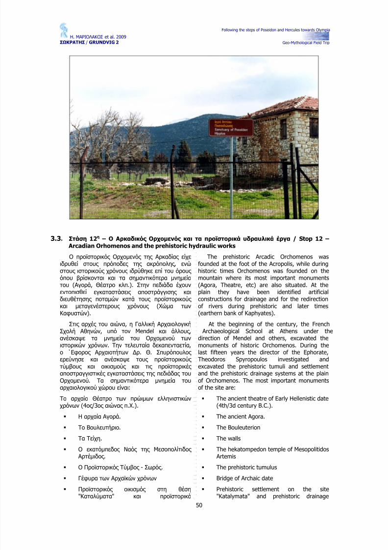
/ Stop 11 – Arcadia, the Birthplace of Poseidon and the Argon Field .....................47 3.3. Στάση 12η – Ο Αρκαδικός Ορχομενός και τα προϊστορικά υδραυλικά έργα /
Stop 12 – Arcadian Orhomenos and the prehistoric hydraulic works .....................50 3.4. Στάση 13η - Λίμνη Στυμφαλία (Ηρακλής ) / Stop 13 – Stymfalia Lake
(Hercules)................................................................................................................51 444... ΤΤΤ Α Α Α Υ Υ Υ Δ Δ ΔΡΡΡ Α Α Α Υ Υ Υ Λ Λ Λ ΙΙΙΚ Κ Κ Α Α Α ΕΕΕΡΡΡΓΓΓ Α Α Α ΤΤΤΩΩΩ ΝΝΝ ΜΜΜΙΙΙΝΝΝ Υ Υ Υ ΩΩΩΝΝΝ --- MMMIIINNN Y Y Y A A ANNN HHH Y Y Y DDDR R R A A AUUULLLIIICCC WWWOOOR R R K K K SSS 555222
8/14/2019 Guide Layout
http://slidepdf.com/reader/full/guide-layout 3/53
Η. ΜΑΡΙΟΛΑΚΟΣ et al. 2009 ΣΩΚΡΑΤΗΣ / GRUNDVIG 2
Following the steps of Poseidon and Hercules towards Olympia
Geo-Mythological Field Trip
3
1.11.. Ο ΔΡΟΜΟΣ ΤΟΥ ΗΡΑΚΛΗ - HERCULES’ ROUTEΟ ΔΟ ΔΡΡΟΟΜΜΟΟΣ ΤΣ ΤΟΟ Υ Η Υ ΗΡΡ Α ΑΚ Κ Λ Λ Η - HΗ - HEER R CCUULLEESS’ R ’ R OOUUTTEE
1.1.
Η γέννηση και τα παιδικά χρόνια του ήρωα – The birth and childhood of the hero Υπάρχουν τόσες διαφορετικές εκδοχές για τη
ζωή του Ηρακλή, όσοι ακριβώς και αυτοί που την εξιστορούν. Ο ∆ίας , ο πατέρας του Ηρακλή, ήταν ο ισχυρότερος Θεός .
Ο ∆ίας ερωτεύτηκε μία όμορφη γυναίκα, την Αλκμήνη και, με δόλο, όταν ο άνδρας της Αλκμήνης , ο Αμφιτρύων έλειπε, ο ∆ίας άφησε έγκυο την Αλκμήνη. Αυτό εξαγρίωσε τόσο την Ήρα που προσπάθησε να εμποδίσει τη γέννηση του παιδιού. Όταν, παρόλα αυτά, η Αλκμήνη γέννησε το παιδί, το ονόμασε Ηρακλή. Το όνομα «Ηρακλής » σημαίνει «το δοξασμένο δώρο της
Ήρας », και αυτό εξαγρίωσε την Ήρα ακόμη περισσότερο. Τότε προσπάθησε να σκοτώσει το μωρό, στέλνοντας φίδια στην κούνια του. Αλλά ο μικρός Ηρακλής ήταν πολύ δυνατός και έπνιξε τα φίδια, ένα με κάθε χέρι, πριν προλάβουν να τον τσιμπήσουν.
Η Ήρα παρέμεινε θυμωμένη. Πώς θα μπορούσε να εκδικηθεί; Η Ήρα ήξερε ότι θα έχανε σε μία μάχη και ότι δεν ήταν αρκετά ισχυρή, ώστε να εμποδίσει το ∆ία να κάνει αυτό που επιθυμεί.Έτσι, αποφάσισε να εκδικηθεί την απιστία του ∆ία κάνοντας την υπόλοιπη ζωή του Ηρακλή όσο δύσκολη μπορούσε.
There are as many different versions of Hercules' life story as there are storytellers. Zeus,Hercules' father, was the most powerful of thegods.
Zeus fell in love with a beautiful Greek womannamed Alcmene [Alk-ME-ne]. When Alcmene'shusband, Amphitryon, was away, Zeus made herpregnant. This made Hera (Zeus’ wife) so angrythat she tried to prevent the baby from being born.When Alcmene gave birth to the baby anyway, shenamed him Herakles. (The Romans pronouncedthe name "Hercules," and so do we today.) The
name Herakles means "glorious gift of Hera" inGreek, and that got Hera angrier still. Then shetried to kill the baby by sending snakes into hiscrib. But little Hercules was so strong, that hestrangled the snakes, one in each hand before theycould bite him.
Hera remained angry. How could she get even?Hera knew that she would lose in a fight, and thatshe wasn't powerful enough to prevent Zeus fromhaving his way. So Hera decided to pay Zeus back for his infidelity by making the rest of Hercules' lifeas miserable as she could.
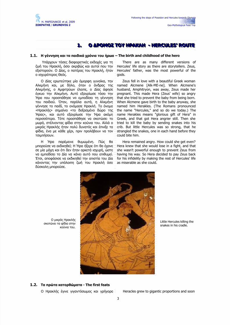
Ο μικρός Ηρακλής σκοτώνει τα φίδια στην
κούνια του.
Little Hercules killing thesnakes in his cradle.
1.2. Τα πρώτα κατορθώματα - The first feats
Ο Ηρακλής έγινε γιγαντόσωμος και γρήγορα Heracles grew to gigantic proportions and soon
8/14/2019 Guide Layout
http://slidepdf.com/reader/full/guide-layout 4/53
Η. ΜΑΡΙΟΛΑΚΟΣ et al. 2009 ΣΩΚΡΑΤΗΣ / GRUNDVIG 2
Following the steps of Poseidon and Hercules towards Olympia
Geo-Mythological Field Trip
4
άρχισα να κάνει θαυμαστές πράξεις . Η πρώτη από όλες , που ήταν να σκοτώσει το λιοντάρι του Κιθαιρώνα, έγινε όταν ήταν 18 χρονών. Ο Ηρακλής ανέλαβε το κυνήγι αυτό για χάρη του Θεσπιέα, το γιο του Ερεχθέα, βασιλιά της Αθήνας , ο οποίος
βασίλευε στις Θεσπιές .Κατά τη διάρκεια ενός πολέμου τον οποίο
κέρδισε εναντίον του βασιλιά του Ορχομενού,απελευθέρωσε τη Θήβα από τους φόρους που είχε ο τελευταίος επιβάλει, αλλά σκοτώθηκε ο θετός πατέρας του, Αμφιτρύων. Σαν ανταμοιβή για την απελευθέρωση των Θηβών, ο Κρέων έδωσε την κόρη του Μεγάρα και τη νεότερη αδερφή της ως συζύγους στον Ηρακλή και τον Ιφικλή. Από τη Μεγάρα ο Ηρακλής απέκτησε πολλά παιδιά, αλλά μετά σε μια κρίση παράνοιας που του προκάλεσε η Ήρα, τα σκότωσε. Όταν συνήλθε, δεν μπόρεσε πια να ζήσει με τη Μεγάρα, και την έδωσε για σύζυγο
στον ανιψιό του Ιόλαο, πιστό του σύντροφο και σύμμαχο στους άθλους . Μια εξήγηση των άθλων είναι ότι μετά από το συμβάν αυτό, ο Ηρακλής συμβουλεύτηκε το μαντείο των ∆ελφών, όπου ο χρησμός του Απόλλωνα τον οδήγησε κάτω από τις διαταγές του εξάδελφού του, Ευρυσθέα, για 12 χρόνια, με αντάλλαγμα την αθανασία. Άλλοι υποστηρίζουν ότι ο Ηρακλής απλά ήθελε να επιστρέψει στο Άργος , και οι άθλοι ήταν οι όροι που του έθεσε ο Ευρυσθέας .
Από τους 12 άθλους , οι έξι πρώτοι έλαβαν χώρα στην Πελοπόννησο, και οι υπόλοιποι έξι σε όλο τον τότε γνωστό κόσμο.
started to undertake wondrous deeds. The first of them, the killing of the lion of Cithæron (amountain in Boeotia), took place when he was 18.Heracles underook the hunt at the request of Thespius, (a son of Erechtheus, the king of
Athens), himself who was king of the nearby cityof Thespiæ.
During a war which he had waged, and wonagainst the king of Orchomenus (a city in northernBoeotia) to free Thebes from having to paytribute, his father Amphitryon was killed whilefighting on his side. As a reward for freeingThebes, Creon gave his daughter Megara and heryounger sister as wives to Heracles and Iphicles.Hercules had several children by Megara, but, oneday, having been rendered temporarily insane byHera, he killed them all. After that, he could nolonger live with Megara and gave her as wife to
his nephew Iolaus. One explanation of his labors isthat, following this crime, he went to consult theoracle of Apollo at Delphi and was ordered tosubject himself to his cousin Eurystheus for 12years and that he would win immortality as aresult. Other simply say that he wanted to returnto Argos and the labors were the condition set byEurystheus for his return. Either way, Hera was inthe background.
Of his twelve labors, the first six took place inPeloponnese, and the last six in all parts of theworld.
Μερικές από τις τοποθεσίες ανά την
Ελλάδα, όπου ο Ηρακλής έκανε
σπουδαία κατορθώματα.
Some of the areas of Greece where Herculesachieved wondrous hisdeeds.
Ο Ηρακλής γύρισε όλο τον γνωστό στους
αρχαίους Έλληνες κόσμο.
Hercules went to almostevery part of the worldknown to the ancientGreeks.
8/14/2019 Guide Layout
http://slidepdf.com/reader/full/guide-layout 5/53
Η. ΜΑΡΙΟΛΑΚΟΣ et al. 2009 ΣΩΚΡΑΤΗΣ / GRUNDVIG 2
Following the steps of Poseidon and Hercules towards Olympia
Geo-Mythological Field Trip
5
1.3. Οι δώδεκα άθλοι – The twelve labors
1ος Άθλος : Το λιοντάρι της Νεμέας
2ος Άθλος : Η Λερναία Ύδρα
3ος Άθλος : Το ελάφι της Κυρήνειας
4ος Άθλος : Ο Ερυμάνθιος κάπρος
5ος Άθλος : Η κόπρος του Αυγεία
6
ος
Άθλος : Οι Στυμφαλίδες όρνιθες
7ος Άθλος : Ο ταύρος της Κρήτης
8ος Άθλος : Τα άλογα του ∆ιομήδη
9ος Άθλος : Η ζώνη της Ιππολύτης
10ος Άθλος : Τα βόδια του Γηρυόνη. Ο Γηρυόνης , ένα τέρας με τρία κεφάλια ήταν γιος του Χρυσάονα (γιου του Ποσειδώνα που γεννήθηκε από τη γοργόνα Μέδουσα, όταν ο
Περσέας της έκοψε το κεφάλι), που είχε τεράστια κοπάδια με βόδια στο νησί της Ερυθίας όπου ζούσε στη μακρινή ∆ύση (κατά την επιστροφή του από αυτό τον άθλο, συνέβησαν οι περισσότερες από τις περιπέτειες του Ηρακλή στη δυτική Μεσόγειο).
Labor 1: The killing of the lion of Nemea,whose hide Hercules thereafter used as a coat
Labor 2: The slaying of the Hydra of Lerna(a marsh in Argolis), whose heads grew anew assoon as they were cut off.
Labor 3: The capture of the doe of Cerynia (a mountain in Achaia) that belonged to Artemisand could rum very fast for a long time withoutgetting tired
Labor 4: The capture of the boar of Erymanthus (a mountain on the border of Arcadia, Achaia and Elis) alive.
Labor 5: The cleaning of the stables of Augeas, the king of Elis.
Labor 6: The eradication of the birds of Lake Stymphalus, in Arcadia.
Labor 7: The capture of the bull of Crete alive.
8/14/2019 Guide Layout
http://slidepdf.com/reader/full/guide-layout 6/53
Η. ΜΑΡΙΟΛΑΚΟΣ et al. 2009 ΣΩΚΡΑΤΗΣ / GRUNDVIG 2
Following the steps of Poseidon and Hercules towards Olympia
Geo-Mythological Field Trip
6
11ος Άθλος : Τα μήλα των Εσπερίδων
12ος Άθλος : Ο Κέρβερος
Η επιστροφή του Ηρακλή από την Ερυθία, όπου έκλεψε τα βόδια του Γηρυόνη.
Hercules’ route back from Erythia, were he stole thecattle of Geryon.
Labor 8: The capture of the mares of Diomedes, (a king of Thracia), which fed onhuman flesh.
Labor 9: The quest for the belt of Hippolite,Queen of the Amazons.
Labor 10: The stealing of the cattle of Geryon, a three-headed monster, son of Chrysaor(the son of Poseidon born from the GorgonMedusa when Perseus cut off her head), who kepthuge herds of oxen in the island of Erythia wherehe lived, in the far Occident, across the Ocean (itis on the way back from this labor that most of the
extra adventures ascribed to Heracles in thewestern Mediterranean area took place).
Labor 11: The picking of the golden apples grown by Hera in a garden near Mount Atlas keptby the Hesperides, Nereids of the evening, alongwith an immortal dragon (on his way, Heraclesfreed Prometheus, and eventually, he asked Atlasto go pick the apples while he would support theworld in his place).
Labor 12: The bringing back from Hades of Cerberus, the monstrous dog that prevented thedead from coming back to Earth.
8/14/2019 Guide Layout
http://slidepdf.com/reader/full/guide-layout 7/53
Η. ΜΑΡΙΟΛΑΚΟΣ et al. 2009 ΣΩΚΡΑΤΗΣ / GRUNDVIG 2
Following the steps of Poseidon and Hercules towards Olympia
Αρχικά ήταν μία φυσική κοιλότητα του εδάφους ανάμεσα σε δύο παραϊλίσια υψώματα,τους λόφους ΄Αγρα και Αρδηττό. ∆ιευθετήθηκε ως Στάδιο από τον Λυκούργο το 330-329 π.Χ. για τους αθλητικούς αγώνες στις εορτές των Μεγάλων Παναθηναίων. Στην τετραετία 140-144 μ.Χ. ο Ηρώδης Αττικός ανακαίνισε το Στάδιο, στη μορφή που η ανασκαφή του 1870 απεκάλυψε. Ήταν πεταλόσχημο, συνολικού μήκους στίβου 204,07μ.και πλάτους 33,35μ. Υπολογίζεται ότι χωρούσε 50.000 θεατές . Είχε κτιστές κλίμακες ανάμεσα στις
κερκίδες . Στη σφενδόνη υπήρχε στοά με δωρικούς κίονες , όπως επίσης στοά υπήρχε και στην πρόσοψη. Ο Ηρώδης ανακαίνισε πιθανόν και την γέφυρα του Ιλισού στην είσοδο του Σταδίου. Την έκανε μεγαλύτερη, με τρία τόξα. Ήταν ορατή έως το 1778, τμήμα της δε αποκαλύφθηκε σε ανασκαφή του 1958. Στα Ρωμαϊκά χρόνια μπορούσε να χρησιμοποιηθεί ως αρένα, με προσθήκη ενός ημικυκλικού τοίχου προς Β που αντιστοιχούσε στην σφενδόνη της νότιας πλευράς .
Η νεώτερη αναμόρφωση του Σταδίου έγινε από τον Γ. Αβέρωφ στα τέλη του 19ου αιώνα για τους αγώνες της πρώτης Ολυμπιάδας , μετά την
αναβίωση των Ολυμπιακών Αγώνων το 1896.
It was originally a natural hollow part of theground between the two hills of Agra and Ardettos, over Ilissos river. It was transformedinto a stadium by Lykourgos in 330-329 BC for theathletic competitions of the Great PanathinaeaFestivities. Between 140 and 144 AD, Herodes Atticus restored the Stadium, giving it the formthat was found at the 1870 excavation: thehorseshoe construction with a track 204,07 meterslong and 33,35 meters wide. It is believed that theStadium had a seating capacity of 50.000 people.
Separating scales were built between the tiers andon the base of the sphendone there was a porticowith Doric-style columns; another portico wasplaced in the stadium's facade. Herodes possiblyrestored also the Ilissos river bridge on theStadium's entrance, making it larger and addingthree archways on its base. The bridge wasstanding there up to 1778 and a part of it wasexcavated in 1958. At the Roman times, theStadium was used as an arena, with the additionof a semi-circular wall on the north that wascorresponding to the sphendone of the southernside.
The modern times restoration of the Stadiumwas conducted by G. Averof by the end of the19th century for the first Olympic Games thatwere reborn again in 1896.
2.1.1. Αναβίωση των Ολυμπιακών Αγώνων - Revival Of The Olympic Games
Οι προσπάθειες για την αναβίωση των Ολυμπιακών Αγώνων στη σύγχρονη εποχή κορυφώθηκαν στα τέλη του 19ου αιώνα με την
Efforts for the revival of the Olympic Games inmodern times reached a peak at the end of the19th century with the instrumental contribution of
8/14/2019 Guide Layout
http://slidepdf.com/reader/full/guide-layout 8/53
Η. ΜΑΡΙΟΛΑΚΟΣ et al. 2009 ΣΩΚΡΑΤΗΣ / GRUNDVIG 2
Following the steps of Poseidon and Hercules towards Olympia
Geo-Mythological Field Trip
8
αποφασιστική συμβολή του Γάλλου βαρώνου Πιέρ ντε Κουμπερντέν και του Έλληνα ∆ημητρίου Βικέλα. Οι πρώτοι σύγχρονοι Ολυμπιακοί Αγώνες τελέσθηκαν με μεγάλη λαμπρότητα το 1896 στην Αθήνα, στο Παναθηναϊκό Στάδιο.
Στην Ολυμπία έχει σήμερα την έδρα της η ∆ιεθνής Ολυμπιακή Ακαδημία.
Η αφή της φλόγας γίνεται στον βωμό του ναού της Ήρας στην Ολυμπία. Η φλόγα ανάβει με την συγκέντρωση των ηλιακών ακτίνων σε μεταλλικό κάτοπτρο. Η διαδικασία αυτή αποτελεί μέρος ενός σύνθετου τελετουργικού, το οποίο περιλαμβάνει την επίκληση και τον ύμνο στον Απόλλωνα.
Η πρωθιέρεια κρατώντας την αναμμένη δάδα εισέρχεται στο στάδιο και στη συνέχεια την παραδίδει στον πρώτο δρομέα, για να ξεκινήσει το μακρύ ταξίδι της έως τα πέρατα της γης .
the French Baron Pierre De Coubertin and theGreek Dimitrios Vikelas. The first contemporaryOlympic Games took place with great glamour in1896 in Athens, in the Panathenaic Stadium. Thehead quarters of the International Olympic
Academy are in Olympia now. Also in Olympia is the altar of the Olympic
flame, which is transferred every four years to thecity that hosts the Olympic Games. The lighting of the flame takes place at the altar of the Temple of Hera and it is done with the convergence of sunlight onto a metal reflector. This process is partof a ritual combination that includes the prayerand the hymn to Apollo. The high priestess entersthe stadium holding the lit torch, which she thenhands over to the first runner in order for it tostart its long journey to the ends of the earth.
8/14/2019 Guide Layout
http://slidepdf.com/reader/full/guide-layout 9/53
Η. ΜΑΡΙΟΛΑΚΟΣ et al. 2009 ΣΩΚΡΑΤΗΣ / GRUNDVIG 2
Following the steps of Poseidon and Hercules towards Olympia
Geo-Mythological Field Trip
9
2.2. Στάση 2η – Ποταμός Ιλισός και Πηγή Καλλιρρόης / Stop 2 – Ilissos River and KalliroiSpring
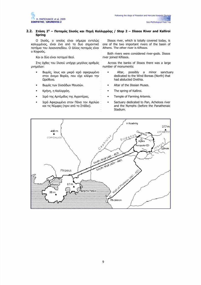
Ο Ιλισός , ο οποίος είναι σήμερα εντελώς καλυμμένος , είναι ένα από τα δυο σημαντικά ποτάμια του λεκανοπεδίου. Ο άλλος ποταμός είναι ο Κηφισός .
Και οι δύο είναι ποταμοί θεοί.
Στις όχθες του Ιλισού υπήρχε μεγάλος αριθμός μνημείων:
Βωμός , ίσως και μικρό ιερό αφιερωμένο στον άνεμο Βορέα, που είχε κλέψει την Ωρείθυια.
Βωμός των Ιλισιάδων Μουσών.
Κρήνη, η Καλλιρρόη.
Ιερό της Αρτέμιδος της Αγροτέρας .
Ιερό Αφιερωμένο στον Πάνα τον Αχελώο και τις Νύμφες (πριν από το Στάδιο).
Ilissos river, which is totally covered today, isone of the two important rivers of the basin of Athens. The other river is Kifissos.
Both rivers were considered river-gods. Ilissosriver joined Kifissos.
Across the banks of Ilissos there was a largenumber of monuments:
Altar, possibly a minor sanctuarydedicated to the Wind Boreas (North) thathad abducted Orethia.
Altar of the Ilissian Muses.
The spring of Kalliroi.
Temple of Farming Artemis.
Sactuary dedicated to Pan, Acheloos riverand the Nymphs (before the PanathenaicStadium.
Following the steps of Poseidon and Hercules towards Olympia
Geo-Mythological Field Trip
10
2.3. Στάση 3η – Ποταμός Ηριδανός και Κεραμικός / Stop 3 – Eridanus River and Kerameikos
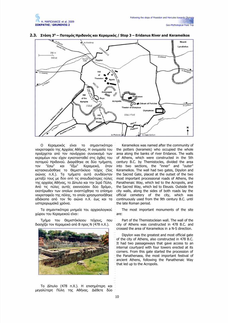
Ο Κεραμεικός είναι το σημαντικότερο νεκροταφείο της Αρχαίας Αθήνας . Η ονομασία του προέρχεται από τον πανάρχαιο συνοικισμό των κεραμέων που είχαν εγκατασταθεί στις όχθες του ποταμού Ηριδανού. ∆ιαιρέθηκε σε δύο τμήματα,τον "έσω" και "έξω" Κεραμεικό, όταν
κατασκευάσθηκε το Θεμιστόκλειο τείχος (5ος αιώνας π.Χ.). Τα τμήματα αυτά συνδέονταν μεταξύ τους με δύο από τις σπουδαιότερες πύλες της αρχαίας Αθήνας , το ∆ίπυλο και την Ιερά Πύλη. Από τις πύλες αυτές εκκινούσαν δύο δρόμοι,εκατέρωθεν των οποίων αναπτύχθηκε το επίσημο νεκροταφείο της πόλης , το οποίο χρησιμοποιήθηκε αδιάκοπα από τον 9ο αιώνα π.Χ. έως και τα υστερορωμαϊκά χρόνια.
Τα σημαντικότερα μνημεία του αρχαιολογικού χώρου του Κεραμεικού είναι:
Tμήμα του Θεμιστόκλειου τείχους , που διασχίζει τον Κεραμεικό από Β προς Ν (478 π.Χ.).
Το ∆ίπυλο (478 π.Χ.). Η επισημότερη και μεγαλύτερη Πύλη της Αθήνας . ∆ιέθετε δύο
Kerameikos was named after the community of the potters (kerameis) who occupied the wholearea along the banks of river Eridanos. The wallsof Athens, which were constructed in the 5thcentury B.C. by Themistocles, divided the areainto two sections, the "inner" and "outer"
Kerameikos. The wall had two gates, Dipylon andthe Sacred Gate, placed at the outset of the twomost important processional roads of Athens, thePanathenaic Way, which led to the Acropolis, andthe Sacred Way, which led to Eleusis. Outside thecity walls, along the sides of both roads lay theofficial cemetery of the city, which wascontinuously used from the 9th century B.C. untilthe late Roman period.
The most important monuments of the siteare:
Part of the Themistocleian wall. The wall of thecity of Athens was constructed in 478 B.C. andcrossed the area of Kerameikos in a N-S direction.
Dipylon was the greatest and most official gateof the city of Athens, also constructed in 478 B.C.It had two passageways that gave access to aninternal courtyard with four towers erected at itscorners. From this gate started the procession of the Panathenaea, the most important festival of ancient Athens, following the Panathenaic Waythat led up to the Acropolis.
Following the steps of Poseidon and Hercules towards Olympia
Geo-Mythological Field Trip
11
ανοίγματα που οδηγούσαν σε εσωτερική αυλή με τέσσερις πύργους στις γωνίες .
Το Πομπείο (τέλη 5ου αι. π.Χ.). Αρχαίο οικοδόμημα που χρησίμευε για τη φύλαξη των αντικειμένων της πομπής των Παναθηναίων.Πρόκειται για ένα ευρύχωρο οικοδόμημα με περίστυλη αυλή.
Η Ιερά Πύλη (478 π.Χ.). Είναι η Πύλη του τείχους από την οποία εκκινούσε η Ιερά Οδός , η οποία κατέληγε στην Ελευσίνα. Είχε δύο τετράγωνους πύργους και αυλή χωρισμένη σε δύο τμήματα. Το ένα καταλαμβανόταν από την κοίτη του ποταμού Ηριδανού.
Ο Ταφικός περίβολος με τη στήλη της Ηγησούς (410 π.Χ.).
Μαρμάρινος Ταύρος στον ταφικό περίβολο του ∆ιονυσίου από τον Κολλυτό. (345 - 338 π. χ)
Το ∆ημόσιο Σήμα. Έξω από το ∆ίπυλο ξεκινούσε το ∆ημόσιο Σήμα, δηλαδή το ∆ημόσιο Νεκροταφείο της πόλης . Οι τάφοι βρίσκονταν στις παρυφές μιας οδού που έξω από τα τείχη είχε πλάτος 40 μ. Μέρος του αποκαλύφθηκε το 1997σε ανασκαφή σωστικού χαρακτήρα.
The Pompeion. Spacious building with aperistyle courtyard, used for the preparation of festival processions. In the Pompieion were keptthe sacral items used at the Panathenaicprocession. Dated to the end of the 5th centuryB.C.
The Sacred Gate was one of the gates of the
city wall built by Themistocles in 478 B.C. Itallowed the passage of river Eridanos and of theSacred Way, the processional way that led toEleusis. Two square towers protected it and it hada courtyard divided into two parts, one of whichwas occupied by the bank of the river. Dated to478 B.C.
Grave circle. In this precinct was found thefamous stele of Hegeso, dated to 410 B.C.
Marble bull in the plot of Dionysios of Kollytos(345 - 338 B.C.).
Following the steps of Poseidon and Hercules towards Olympia
Geo-Mythological Field Trip
12
Η Κρήνη (307 - 304 π.Χ.). Αριστερά της εισόδου του ∆ιπύλου βρισκόταν υπόστυλη κρήνη,ένα οικοδόμημα που τροφοδοτούσε με νερό τους κατοίκους της πόλης και τους ταξιδιώτες .
The "Demosion Sema", the public cemetery of the city, extended just outside the Dipylon gate.The graves were constructed along the sides of the road, which became very wide (up to 40 m.)outside the walls. A part of the "Demosion Sema"
cemetery has been brought to light in 1997,during a rescue excavation.
The Fountain House. The hypostyle fountainwas located on the left side of the entrance of theDipylon gate and provided a continuous supply of water to the inhabitants of the city and thetravellers. It was built in 307-304 B.C.
The finds from the excavations of Kerameikosare exhibited in the Museum of Kerameikos andthe National Archaeological Museum.
Following the steps of Poseidon and Hercules towards Olympia
Geo-Mythological Field Trip
13
2.4. Στάση 4η – Ιερά Οδός , Λίμνη Ρειτών , Παλαιολίμνη Κυχρεία και Σαρωνικός κόλπος / Stop 4 – Sacred Way, Reitoi Lake, Kychreia Paleo-lake and Saronic Gulf
2.4.1. Ιερά Οδός – Ποταμός Ελευσίνιος Κηφισός / Iera Odos (Sacred Way) – ElefsinianKifissos River
Η Ιερά Οδός συναντάει την κοίτη του Ελευσινιακού Κηφισού (σημερινού Σαρανταπόταμου), στα ανατολικά κράσπεδα της σημερινής Ελευσίνας . Εδώ ο αυτοκράτορας Αδριανός , κατασκεύασε τη μεγάλη λίθινη γέφυρα με διαστάσεις 50 μέτρα μήκος και 5,30 μέτρα πλάτος . Το πλάτος του ποταμού είναι 30 μέτρα περίπου και γεφυρώνεται από τέσσερα τόξα με διάμετρο των μεσαίων 6,90 μέτρα και των ακραίων 4,30 μέτρα. Το τμήμα της κοίτης κάτω απ' την γέφυρα, είναι στρωμένο με μεγάλους ορθογώνιους πωρόλιθους , πάνω στους οποίους εδράζονται τα βάθρα των τόξων της γέφυρας . Οι τοίχοι της , τα βάθρα και τα τόξα της , είναι κατασκευασμένα με σκληρούς πωρόλιθους του Πειραιά, που η επεξεργασία τους είναι τόσο επιμελημένη, ώστε νομίσθηκε κατ' αρχήν ότι ήταν έργο ελληνιστικών χρόνων. Η χρησιμοποίηση όμως ασβέστη, το σχήμα των συνδέσμων και οι λατινικοί αριθμοί, χρονολογούν τη γέφυρα στους ρωμαϊκούς χρόνους και μάλιστα στους χρόνους του Αδριανού. Προς τις ενδείξεις αυτές συμφωνούν και οι μαρτυρίες των αρχαίων συγγραφέων, που μας πληροφορούν, ότι ο Αδριανός όταν ήλθε στην Αθήνα και μυήθηκε στα Ελευσίνια Μυστήρια, κατασκεύασε και γέφυρα στον Ελευσινιακό Κηφισό. Επειδή είναι γνωστό, ότι
ο Αδριανός μυήθηκε στα Μυστήρια μεταξύ των ετών 124-125 μ.Χ., τότε πρέπει να τοποθετηθεί και η κατασκευή της γέφυρας . Ο Παυσανίας επισκέφθηκε την Ελευσίνα 25 χρόνια μετά την πολύμηνη παραμονή του Αδριανού στην Αθηνά και ίσως έμαθε, πως αφορμή στην κατασκευή της γέφυρας , έδωσε μια πλημμύρα του Κηφισού το φθινόπωρο του 125 μ.Χ. Η πληροφορία αυτή,έκανε τον Παυσανία να χαρακτηρίσει το Ελευσινιακό ποτάμι, ως "βιαιότερον" του ομώνυμου αθηναϊκού.
Οι Ελευσίνιοι φαίνεται, πως συχνά υπέφεραν απ' τα νερά του ποταμού, αν κρίνουμε από ένα
χωρίο, του Προς Καλλικλέα λόγου του ∆ημοσθένη:"σκ oπίτ' , ω άνδρες δικασταί, πόσους υπό των υδάτων εν τοις αγροίς βεβλάφθαι συμβέβηκεν, τα μέν Ελευσίνι τα δ' εν τοις άλλοις τόποις ". Αλλά και σήμερα, εξακολουθεί να βασανίζει την γύρω περιοχή, με πρόσφατη τη θεομηνία της 27ης Ιανουαρίου 1996, με ολοκληρωτικές καταστροφές σε βιομηχανίες , κτηνοτροφικές μονάδες ,καλλιέργειες , κατοικίες αλλά και ανθρώπινα θύματα (ένα ανδρόγυνο, εγκλωβίστηκε απ' τα πλημμυρικά νερά στα ανάντη του ποταμού).Σημειωτέον, ότι η υδρολογική λεκάνη του σημερινού Σαρανταπόταμου, εκτείνεται απ' τις ανατολικές έως νοτιοανατολικές παρυφές του
όρους Πατέρα, τις νότιες του Κιθαιρώνα και της Πάστρας , έως τις δυτικές του όρους Πάρνηθα,
The Iera Odos (the Sacred Way) meets thebank of the Elefsinian Kifissos River (modernname: Sarantapotamos) in eastern Elefsina. It washere that the Emperor Adrianos (Hadrian)constructed a great stone bridge 50m long and5.30m wide supported by four arches (The widthof the river is approximately 30m). The two middlearches are 6.90m in diameter and the two sidearches are 4.30m in diameter. The support sectionbelow the bridge is built of large, rectangular, highporosity rock blocks on which the arches arebased. The bridge’s walls, the arches and theirbase were all constructed with hard porous stonesfrom Piraeus which were so carefully shaped andset that initially it was thought that the work belonged to the Hellenistic period. However, theuse of lime, the shape of the joints and seams aswell as numbers carved in Latin, date this bridgeas being of Roman times, specifically during Andrianos’ ruling. Documentary evidencesupporting this estimation comes from the worksof ancient writers who record Adrianos arrival in Athens and his introduction to the ElefsinianMysteries. It was then that he constructed thebridge over the Elefsinian Kifissos River.Pausanias, who visited Elefsina 25 years after Adrianos’ long stay in Athens, he possibly found
out that it was a flood of the river during the fallof 125 AD that initiated the building of the bridge.This information led Pausanias to characterize theElefsinian Kisiddos River as being more violentthan its Athenian counterpart.
It seems that the Elefsinians often sufferedfrom the flooding of the river if we are to judgefrom a section of Demosthenis speech towardsKallikleas in which he describes extensivedamages caused by floods in Elefsis and thesurrounding area.
Even today, floods plague the surroundingarea: the most recent inundation took place on
the 27th of January 1996 and resulted in totaldestruction of small industries, stock-farms andfields as well as the loss of homes and humanlives (a couple was trapped by the flood water). Itshould be mentioned here that the hydrologicalbasin of the present-day Sarantapotamos, riverextends from the eastern to the southern foot of Mt. Pateras, and expands from the south of Kitheronas and Pastra mountains to the westernfoot of Mt. Parnitha, a total area of 253 km2.
Following the steps of Poseidon and Hercules towards Olympia
Geo-Mythological Field Trip
14
οριοθετώντας μια έκταση της τάξης των 253 km².
2.4.2. Λίμνη Ρειτών – Reitoi lake
Πρόκειται για δύο λιμνοθάλασσες , οι οποίες ήταν
αφιερωμένες
στις
θεές
της
Ελευσίνας
,η "προς το άστυ" στην Κόρη και η βορειότερη στη
∆ήμητρα (κατά τον Ησύχιο). Σήμερα διατηρείται η "προς το άστυ" (η σημερινή λίμνη Κουμουνδούρου), ενώ τα νερά της δεύτερης λίμνης διοχετεύονταν στη θάλασσα με όρυγμα.Παρά ταύτα, ένα μέρος των νερών σχηματίζει και σήμερα βάλτο μεταξύ των εγκαταστάσεων του διυλιστηρίου και του μικρού υψώματος που χωρίζει τις δύο λίμνες . Στις λίμνες είχαν δικαίωμα να ψαρεύουν μόνο οι ιερείς της θεάς . Ο Παυσανίας χαρακτηρίζει το νερό που πηγάζει θαλασσινό και αναφέρει ότι "θα μπορούσε κανείς να πιστέψει,πως από τον Εύριπο της Χαλκίδας ρέουν κάτω απ'
το έδαφος και χύνονται σε μια θάλασσα χαμηλότερη" (αυτή της Ελευσίνας μέσω των Ρειτών). Στην πραγματικότητα ήταν ρέματα που σχηματίζονταν από πολλές πήγες σε δύο γειτονικές θέσεις των δυτικών υπωρειών του Αιγάλεω και χύνονταν στον κόλπο της Ελευσίνας . Το αλμυρό νερό οφείλεται στη γειτνίαση με τη θάλασσα.Επειδή οι πήγες και στις δύο θέσεις βρίσκονται σε ταπεινώσεις του εδάφους (ενώ χωρίζονται μεταξύ τους από πετρώδες λοφίσκο), ήδη στην αρχαιότητα φαίνεται πως σχηματίστηκαν σ' αυτά λίμνες με φράγματα τεχνητά προς τη μεριά της θάλασσας , οι οποίες εκροές απ' τα φράγματα σχημάτιζαν "τα ρεύματα ποταμών", που είδε ο
Παυσανίας .
Στις ΙΕ του μηνός Βοηδρομιώνος (25 Αυγούστου), οι παλαιοί μύστες έμεναν στην Αθήνα, ενώ εκείνοι που έπρεπε να μυηθούν πήγαιναν στην Ελευσίνα, θυσίαζαν, έπιναν τον κυκεώνα (κατά μίμηση της ∆ήμητρας ) και προϋπαντούσαν μαζί με τους Ελευσίνιους στην περιοχή των Ρειτών τους παλαιούς μύστες και προσκυνητές . Μετά από σύντομη διαδρομή (με κατεύθυνση προς Αθήνα), την 19η του μηνός επέστρεφαν όλοι μαζί πλέον, ακολουθώντας την Ιερά Οδό με κατεύθυνση προς Ελευσίνα, αυτή τη φορά, για να αναπέμψουν ύμνους σ' όλα τα ιερά
που βρίσκονταν κατά μήκος της Ιεράς Οδού.Πρώτη στάση γινόταν στο ∆αφνί , στο ιερό του ∆αφνείου Απόλλωνα, έπειτα στο ιερό της Αφροδίτης και τέλος στους Ρειτούς , τις λίμνες που ήταν αφιερωμένες στις θεές . Όταν έφθαναν στους Ρειτούς , τα μέλη του γένους των Κροκωνιδών έδεναν με μάλλινη κίτρινη κλωστή το αριστερό πόδι και το δεξί χέρι του κάθε μύστη, γιατί πίστευαν ότι μ' αυτόν τον τρόπο εξαφανίζεται κάθε μίασμα.
Two lagoons were dedicated to the goddesses
of Elefsina, that towards the town to Kori and thenorthern one to Demetra (according to Isyhios).Today the only lagoon that is preserved is the onetowards the town (Lake Koumoundourou), whilethe water of the second lagoon were directed tothe sea by an artificial trench. However, part of the lagoon’s water forms a small swamp amongthe oil refinery plant and the high ground thatseparates the two lagoons. In these lagoons, onlythe priests that served the goddess had a right forfishing. Pausanias also characterises the water assalty and he mentions that “one could believe thatthe water flow through the Evripos of Chalkidaand end into a sea that is much lower”. In reality
they were streams that were formed by manysprings in two neighbouring locations of thewestern foot of Aegaleo, and discharged at thebay of Elefsina. The salty water was due to themixing with seawater. Since the springs in bothlocations were located in topographic depressionsof the ground (while separated by a rocky highground), during the ancient times, they formedsmall lakes with artificial dams towards theseaside, and their discharge from these damsformed the streams that Pausanias recorded.
At the IE of the Voidromion month (25th of August), the older initiates remained in Athens,
while those who had to be initiated headed toElefsina. There they made sacrifice, drank kykeona(in honour of Demetra) and went forwards alongwith the Elefsinians in the area of Reitoi to meetthe old initiates and pilgrims. After following ashort route (towards Athens), on the 19th of themonth they returned altogether following the IeraOdos (sacred way) towards Elefsina, this time toattribute hymns to all the sanctuaries that werelocated along Iera Odos. The first stop was atDafni at the sanctuary of the Dafnios Apollo, thesecond stop was at the sanctuary of Aphrodite andfinally at the Reitoi, the lagoons that werededicated to the goddesses. When they where
arriving at the Reitoi, the members of the genderof Croconides were tying a yellow woollen threadto the right hand and left leg of each initiate topurify them.
2.4.3. Παλαιολίμνη Κυχρεία και Σαρωνικός κόλπος - Kychreia Paleo-lake and Saronic Gulf
Όπως είναι γνωστό, ολόκληρος ο Ελλαδικός
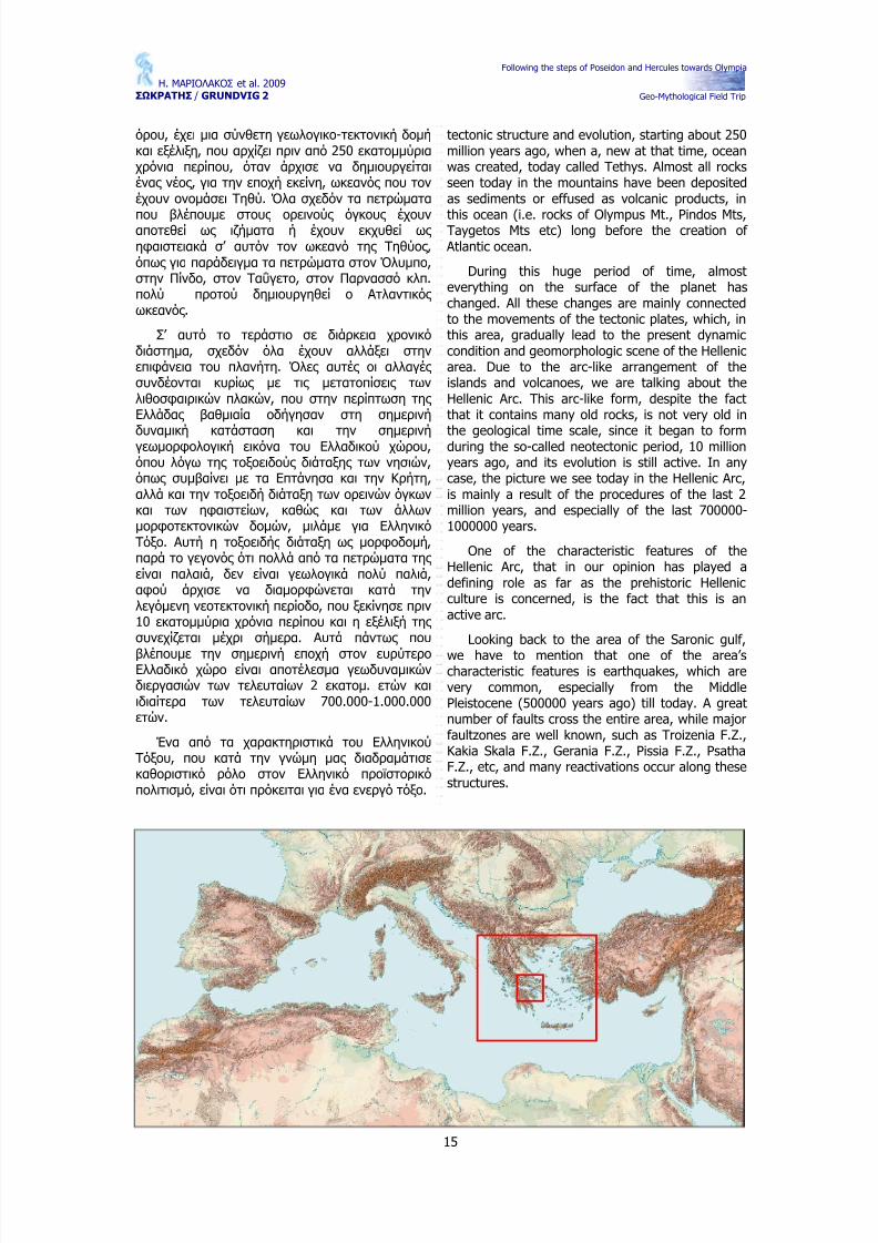
χώρος υπάγεται σ΄ αυτό που, από γεωτεκτονική άποψη, αποκαλείται Ελληνικό τόξο. Ο Ελλαδικός χώρος , με την ευρεία γεωγραφική έννοια του
As it is well known, the whole Hellenic area
belongs to what from a geotectonic point of view,is called Hellenic arc. The geographically broaderHellenic area shows a composite geological and
Following the steps of Poseidon and Hercules towards Olympia
Geo-Mythological Field Trip
όρου, έχει μια σύνθετη γεωλογικο-τεκτονική δομή και εξέλιξη, που αρχίζει πριν από 250 εκατομμύρια χρόνια περίπου, όταν άρχισε να δημιουργείται ένας νέος , για την εποχή εκείνη, ωκεανός που τον έχουν ονομάσει Τηθύ. Όλα σχεδόν τα πετρώματα
που βλέπουμε στους ορεινούς όγκους έχουν αποτεθεί ως ιζήματα ή έχουν εκχυθεί ως ηφαιστειακά σ’ αυτόν τον ωκεανό της Τηθύος ,όπως για παράδειγμα τα πετρώματα στον Όλυμπο,στην Πίνδο, στον Ταΰγετο, στον Παρνασσό κλπ.πολύ προτού δημιουργηθεί ο Ατλαντικός ωκεανός .
Σ’ αυτό το τεράστιο σε διάρκεια χρονικό διάστημα, σχεδόν όλα έχουν αλλάξει στην επιφάνεια του πλανήτη. Όλες αυτές οι αλλαγές συνδέονται κυρίως με τις μετατοπίσεις των λιθοσφαιρικών πλακών, που στην περίπτωση της Ελλάδας βαθμιαία οδήγησαν στη σημερινή
δυναμική κατάσταση και την σημερινή γεωμορφολογική εικόνα του Ελλαδικού χώρου,όπου λόγω της τοξοειδούς διάταξης των νησιών,όπως συμβαίνει με τα Επτάνησα και την Κρήτη,αλλά και την τοξοειδή διάταξη των ορεινών όγκων και των ηφαιστείων, καθώς και των άλλων μορφοτεκτονικών δομών, μιλάμε για Ελληνικό Τόξο. Αυτή η τοξοειδής διάταξη ως μορφοδομή,παρά το γεγονός ότι πολλά από τα πετρώματα της είναι παλαιά, δεν είναι γεωλογικά πολύ παλιά,αφού άρχισε να διαμορφώνεται κατά την λεγόμενη νεοτεκτονική περίοδο, που ξεκίνησε πριν 10 εκατομμύρια χρόνια περίπου και η εξέλιξή της συνεχίζεται μέχρι σήμερα. Αυτά πάντως που
βλέπουμε την σημερινή εποχή στον ευρύτερο Ελλαδικό χώρο είναι αποτέλεσμα γεωδυναμικών διεργασιών των τελευταίων 2 εκατομ. ετών και ιδιαίτερα των τελευταίων 700.000-1.000.000ετών.
Ένα από τα χαρακτηριστικά του Ελληνικού Τόξου, που κατά την γνώμη μας διαδραμάτισε καθοριστικό ρόλο στον Ελληνικό προϊστορικό πολιτισμό, είναι ότι πρόκειται για ένα ενεργό τόξο.
tectonic structure and evolution, starting about 250million years ago, when a, new at that time, oceanwas created, today called Tethys. Almost all rocksseen today in the mountains have been depositedas sediments or effused as volcanic products, in
this ocean (i.e. rocks of Olympus Mt., Pindos Mts,Taygetos Mts etc) long before the creation of Atlantic ocean.
During this huge period of time, almosteverything on the surface of the planet haschanged. All these changes are mainly connectedto the movements of the tectonic plates, which, inthis area, gradually lead to the present dynamiccondition and geomorphologic scene of the Hellenicarea. Due to the arc-like arrangement of theislands and volcanoes, we are talking about theHellenic Arc. This arc-like form, despite the factthat it contains many old rocks, is not very old in
the geological time scale, since it began to formduring the so-called neotectonic period, 10 millionyears ago, and its evolution is still active. In anycase, the picture we see today in the Hellenic Arc,is mainly a result of the procedures of the last 2million years, and especially of the last 700000-1000000 years.
One of the characteristic features of theHellenic Arc, that in our opinion has played adefining role as far as the prehistoric Hellenicculture is concerned, is the fact that this is anactive arc.
Looking back to the area of the Saronic gulf,
we have to mention that one of the area’scharacteristic features is earthquakes, which arevery common, especially from the MiddlePleistocene (500000 years ago) till today. A greatnumber of faults cross the entire area, while majorfaultzones are well known, such as Troizenia F.Z.,Kakia Skala F.Z., Gerania F.Z., Pissia F.Z., PsathaF.Z., etc, and many reactivations occur along thesestructures.
Following the steps of Poseidon and Hercules towards Olympia
Geo-Mythological Field Trip
16
Επανερχόμενοι στην περιοχή του Αργοσαρωνικού, πρέπει να αναφέρουμε ότι από τα χαρακτηριστικότερα γνωρίσματα της ευρύτερης περιοχής του είναι οι σεισμοί, που είναι πολύ συχνοί, ιδιαίτερα από το Μ. Πλειστόκαινο (500.000) μέχρι σήμερα. Εξάλλου, πάρα πολλά ρήγματα διασχίζουν την ευρύτερη περιοχή, ενώ μεγάλες ρηξιγενείς ζώνες είναι γνωστές , όπως οι ρηξιγενείς ζώνες της Τροιζηνίας , της Κακιάς Σκάλας , τα πάμπολλα ρήγματα του Ισθμού της Κορίνθου, οι ρηξιγενείς ζώνες των Γερανείων, των Πισσίων, της Ψάθας , κλπ. Επειδή ο ρηγματικός τεκτονισμός είναι ενεργός παρατηρούνται συχνές επαναδραστηριοποιήσεις των ενεργών ρηγμάτων.
Πέραν όμως της επαναδραστηριοποίησης των ρηγμάτων, στον ευρύτερο χώρο των παράκτιων περιοχών του Σαρωνικού, παρατηρούνται πολύ
συχνά και κατακόρυφες κινήσεις φλοιού, όπως για παράδειγμα καθοδικές στις Κεγχρεές και ανοδικές στην Ποσειδωνία. Πιο συγκεκριμένα, στις Κεγχρεές , κτίσματα από την αρχαιότητα, αλλά και τους πρώτους χριστιανικούς χρόνους , βρίσκονται σήμερα κάτω από τη στάθμη της θάλασσας .
Στην Ποσειδωνία, που βρίσκεται στην είσοδο της διώρυγας της Κορίνθου προς την πλευρά του Κορινθιακού, παρατηρείται τμήμα της ∆ίολκου,δομικοί λίθοι της οποίας καλύπτονται από μεταγενέστερα beach rocks, να βρίσκονται σήμερα πάνω από την στάθμη της θάλασσας .
Το 18.000 π.α.σ. οι τότε ακτογραμμές δεν έχουν καμιά σχέση με τις σημερινές , ούτε από άποψη μορφής ούτε από γεωγραφική θέση. Ο γνωστός μας Σαρωνικός Κόλπος την εποχή αυτή απλούστατα δεν υπήρχε.
Αρχαία κτίσματα στις Κεγχρεές , τα οποία σήμερα βρίσκονται κάτω από τη στάθμη της θάλασσας .
Τμήμα της ρηξιγενούς ζώνης της Κακιάς Σκάλας ( Αττικής ).
Part of the Kakia Skala (Attica) fault zone.
Beyond the reactivations of the faults, in thegreater area of the Saronic gulf shorelines, veryoften vertical movements of the crust areobserved, for example in Kechrees (downwards)
and in Posidonia (upwards. More Specifically, inKechrees, ancient and protochristianic ruins, todaylay below the sea level.
In Posidonia, at the entrance of the Corinthcanal, a part of Diolkos is observed to be partlycovered by beach rocks, above the sea level.
18000 years BP, shorelines had no similaritywith what we see today. Saronic Gulf simply didnot exist.
Sea level was at the time 125 metres lowerthan today.
At that time Attica and Peloponnesus wereunited, since all the islands of the Saronic areaformed a “bridge” of land connecting Attica andPeloponnesus, between lakes, such as the one of Troizenia, and a smaller one, Kichrea.
The gulf of Corinth was also a lake at the time,while the southern Evoic Gulf was a valleybetween Attica and Evoia.
All the islands of the Saronic gulf appearedafter 18000BP, gradually.
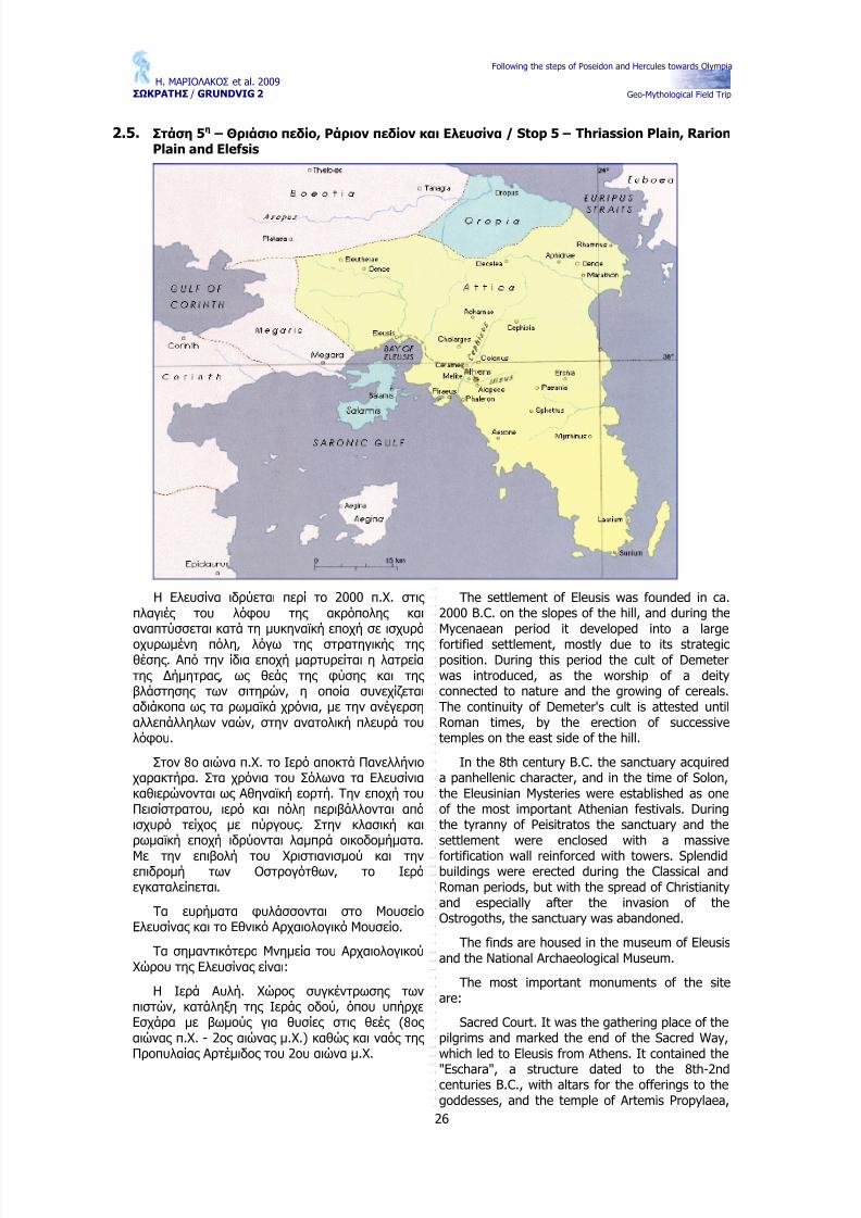
The formation of the Saronic gulf as we knowit today, nust have happened around 6000BP, and
until 4000BP, when Salamis island was separatedfrom the land of Attica. This period corresponds tothe climatic optimum of the Holocene, when
Following the steps of Poseidon and Hercules towards Olympia
Geo-Mythological Field Trip
17
Ancient buildings at Kehrees that are actually belowsea-level.
Το 18.000 π.α.σ. η στάθμη της θάλασσας βρισκόταν 125 μ. περίπου χαμηλότερα σε σχέση με την σημερινή στάθμη.
Την εποχή αυτή λοιπόν η Πελοπόννησος ήταν ενωμένη με τη Αττική, αφού τα νησιά Αγκίστρι, Αίγινα, Κυρά, ∆ιάποροι, Λαγούσες , Σαλαμίνα,Φλέβες , το νησί του Πατρόκλου, αλλά και η Μακρόνησος αποτελούσαν μια ενιαία ξηρά που ήταν ενωμένα με την Αττική. Τα νησιά του Σαρωνικού αποτελούσαν μια γέφυρα ξηράς , τον Παλαιοϊσθμό της Αίγινας , αφού ανατολικά αυτής της γέφυρας και της Πελοποννήσου, εκεί που σήμερα εκτείνεται ο Κόλπος των Κεγχρεών και ο Κόλπος της Επιδαύρου, υπήρχε μια λίμνη, η Παλαιολίμνη της Τροιζηνίας .
Σημειωτέον ότι την εποχή αυτή, ο Κορινθιακός Κόλπος ήταν κι αυτός λίμνη, ενώ ο Νότιος Ευβοϊκός ήταν μια μεγάλη πεδιάδα που ένωνε την Ανατολική Αττική με την Νότιο Εύβοια.
Αφού δεν υπήρχε ο Σαρωνικός , άρα δεν υπήρχαν ούτε η Αίγινα, ούτε η Σαλαμίνα, ούτε οι ∆ιάποροι κ .λ.π. Όλα τα σημερινά νησιά του Σαρωνικού συνεπώς δημιουργήθηκαν μετά το 18.000 πριν από σήμερα και φυσικά όχι όλα μαζί.
Η διαμόρφωση της σημερινής μορφής ακτών Σαρωνικού οπότε και αποσπάστηκε η Σαλαμίνα από την Αττική, πρέπει να έγινε γύρω στο 6.000π.α.σ., τότε δηλ. που αρχίζει και το κλιματικό
optimum του Ολοκαίνου, που διήρκεσε, σύμφωνα με τις απόψεις των περισσότερων ερευνητών,μέχρι το 4.000 π.α.σ. περίπου, δηλ. μέχρι το 2.000π.Χ. Την περίοδο αυτή, τόσο η μέση θερμοκρασία όσο και οι βροχοπτώσεις πρέπει να ήσαν υψηλότερες από τις σημερινές .
temperature rose, along with precipitation,melting of ice caps, and sea level.
In fact, a large part of Attica, along with partsof the greater area, has a long history as a greatlake or partly lake, going back to the Mio-Pliocene(2-5 million years ago). From that time, lacustrineareas were gradually restricted and isolated, oropened to the sea, leaving only traces of theirexistence, such as lacustrine deposits in Athensbasin and the greater area, or lagoon-likeenvironments, such as Reitoi lake.
Following the steps of Poseidon and Hercules towards Olympia
Geo-Mythological Field Trip
19
∆ορυφορική φωτογραφία της Αθήνας και του Αργοσαρωνικού, με τη Σαλαμίνα και την Αίγινα. Πάνω στο κέντρο (βόρεια) ο ορεινός όγκος της Πάρνηθας , ανατολικά η Πεντέλη, στο κέντρο το λεκανοπέδιο με τον Υμηττό ανατολικά και το Αιγάλεω στα δυτικά του, δυτικά του Αιγάλεω το Θριάσιο πεδίο. Το πλαίσιο δείχνει την θέση του επόμενου χάρτη.
Satellite image of Athens and part of the Saronic Gulf. North (at the top): Mt Parnitha., northeast: Mt. Penteli andthe Bay of Marathonas, center: basin of Athens bordered by Mt. Imittos on the east and Mt. Egaleo on the west.West of Mt.Egaleo: Thriasio Plain and the island of Salamis (south of the Thriasio Plain), with the island of Egina at
the southern most section of the picture. The frame indicates the area detailed in the map pf the following page.
Ο χάρτης που ακολουθεί απεικονίζει τις εμφανίσεις αλπικών και μεταλπικών πετρωμάτων και σχηματισμών σε μια περιοχή των Αθηνών, μαζί αρκετά ενεργά ρήγματα, που διασχίζουν την περιοχή και μετατοπίζουν το υπόβαθρο, κατά αρκετές εκατοντάδες μέτρα. Οι μειο-Πλειοκαινικοί σχηματισμοί είναι κυρίως λιμναίες αποθέσεις ,
λιγνιτοφόρες στην συγκεκριμένη περιοχή.
The following map shows the outcrops of alpine and post alpine rocks and formations in apart of Athens, along with several active faults,crossing the whole area, and displacing thebasement by several hundreds of meters. TheMio-Pliocene formations are lacustrine deposits,bearing lignite in this area.
Following the steps of Poseidon and Hercules towards Olympia
21
Geo-Mythological Field Trip
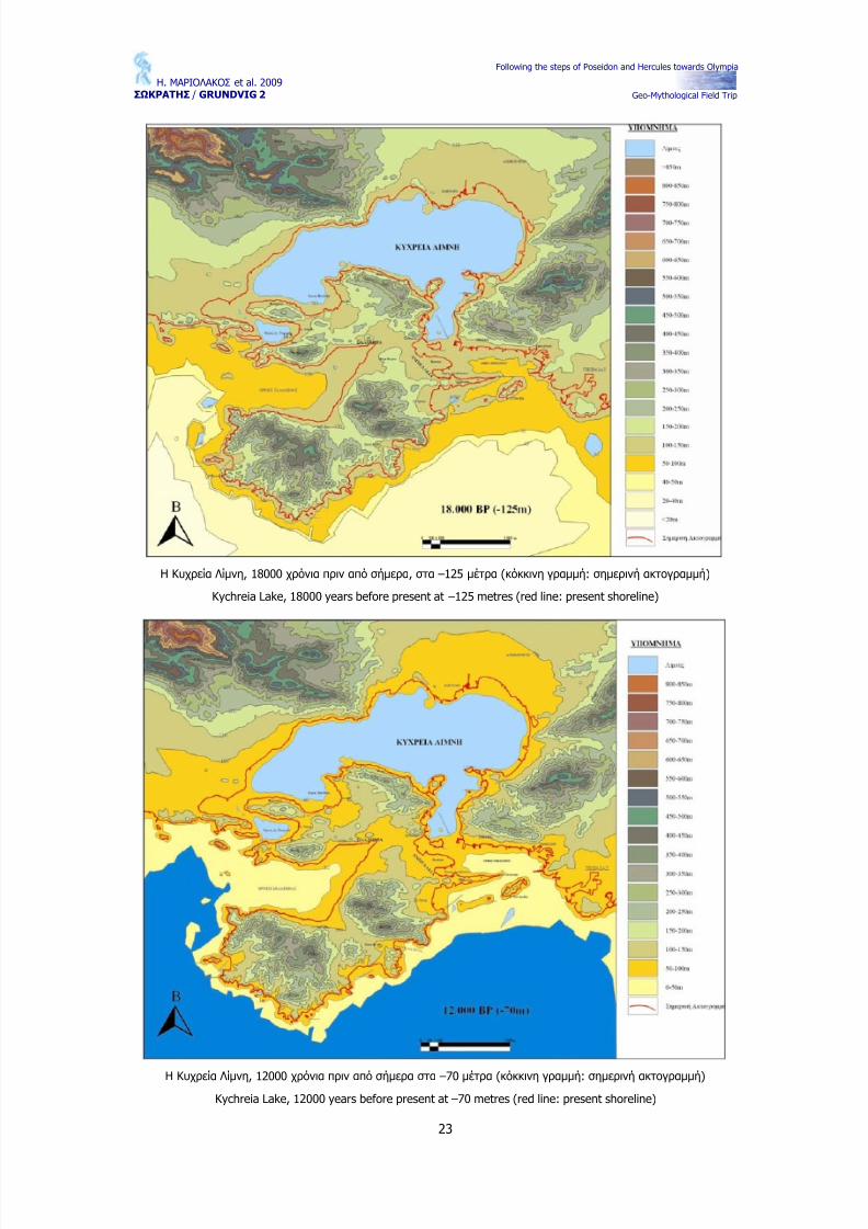
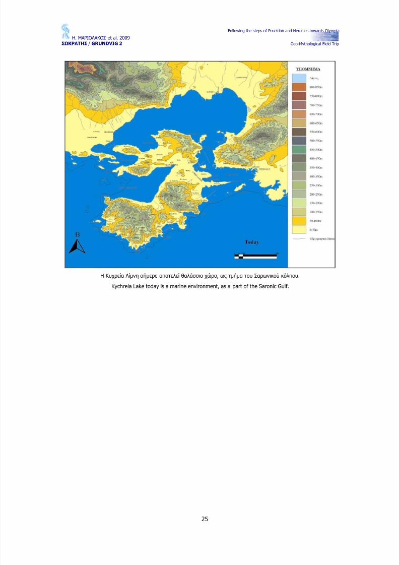
Οι ακτογραμμές στον ευρύτερο χώρο του σημερινού Σαρωνικού κατά την περίοδο 18.000 B.P. (-125m.) και
12.000 B.P. (-70m.) (B.P. = Before Present = πριν από σήμερα = π.α.σ.).
The actual shorelines of the broader area of Saronikos Gulf and those of 18.000 B.P. (-125m.) of 12.000 (-70m.)B.P. (B.P. = Before Present).
Ο ευρύτερος χώρος της Αττικής και του Σαρωνικού Κόλπου συγκεντρώνει ένα μεγάλο τμήμα της ιστορίας και της μυθολογίας του αρχαίου ελληνικού κόσμου. ∆εν θα ήταν υπερβολή να λεχθεί ότι είναι μια από τις ιερότερες περιοχές του αρχαιοελληνικού χώρου και ίσως να μην υπάρχει άλλη περιοχή σ’ ολόκληρο τον πλανήτη όπου να έχουν δραστηριοποιηθεί τόσοι πολλοί Θεοί και Θεές , τόσοι πολλοί ήρωες .
Το γεγονός αυτό συνδέεται με παλαιοκλιματικές και γεωπεριβαλλοντικές μεταβολές σ’ ολόκληρο τον Αιγαιακό και Περιαιγαιακό χώρο και στον Σαρωνικό.
Κατά τα τελευταία 18.000 χρόνια, ήτοι μετά το τέλος της τελευταίας παγετώδους περιόδου, οι κλιματικές αλλαγές που σημειώθηκαν και που συνδέονται με αύξηση της θερμοκρασίας και επακόλουθο την τήξη των παγετώνων είχαν σαν αποτέλεσμα την άνοδο της στάθμης της θάλασσας της τάξης των 125 μέτρων τουλάχιστον. Η άνοδος της στάθμης της θάλασσας είχε σαν αποτέλεσμα σημαντικές αλλαγές στο φυσικό περιβάλλον και στη διαμόρφωση των ακτογραμμών και των παράκτιων περιοχών. Η άνοδος της στάθμης είχε επίσης σαν αποτέλεσμα την κατάκλυση κλειστών υδρολογικών λεκανών με αλλαγή της
φυσικογεωγραφικής τους λειτουργίας με την μετατροπή τους αρχικά σε λίμνες και στη συνέχεια
The wider area of Attica region and generallythe Saronic Gulf contains a significant part of thehistory and mythology of the ancient Hellenicworld. Without exaggeration, we could say that itis one of the most sacred regions of AncientGreece and perhaps the only region in the wholeworld that is related to the births of so many gods,goddesses and heroes.
This fact is linked to the paleo-climatic andgeo-environmental changes, which took place inthe Aegean and Peri-Aegean areas and especiallyin the Saronic Gulf.
As it is known, during the last 18000 years,which is after the end of the last glacial period,the climatic changes related to temperature risehad as a consequence the rise of the sea level by125 m at least.
The sea level rise had as a result significantchanges in the natural environment and mainly tothe distribution of coastlines and coastal areas.The rise of the sea level had also as a result theflooding of closed hydrological basins withchanges in their physico-geographical function bychanging them initially to lakes and in time tobasins.
Prehistoric man witnessed these changes in hisenvironment and he attributed them to various
Following the steps of Poseidon and Hercules towards Olympia
Geo-Mythological Field Trip
22
σε πυθμένα όρμων ή κόλπων.
Ο προϊστορικός άνθρωπος έγινε μάρτυρας των συγκλονιστικών αυτών αλλαγών στο περιβάλλον του, και τις απόδωσε σε διάφορους Θεούς , άλλοτε καταστρεπτικούς και άλλοτε προστάτες . Όλα αυτά παρακολουθούνται σε διάφορους αρχαίους μύθους . Σκοπός λοιπόν εδώ είναι ο συσχετισμός ορισμένων μύθων με φυσικογεωγραφικές και γεωλογικές μεταβολές που συνέβησαν κατά την προϊστορία και η την απόπειρα ερμηνείας τους .Προσπαθούμε να προσεγγίσουμε τη μυθολογική σχέση της Νύμφης Σαλαμίνας , κόρης του Ασωπού και της Μετώπης , με τον Θεό Ποσειδώνα σε συσχετισμό με τις φυσικο-γεωγραφικές αλλαγές του χώρου μεταξύ της νήσου Σαλαμίνας και της Ελευσίνας κατά τα τελευταία 18.000 χρόνια. Του χώρου δηλαδή που καταλαμβάνεται σήμερα από τον κόλπο της Ελευσίνας . Εκεί, το 18.000 BP
υπήρχε μια κλειστή υδρολογικά λεκάνη, που δεν είχε επιφανειακή απορροή και που δεν επικοινωνούσε με την τότε θάλασσα που βρισκόταν περί τα 30 Km μακριά. Τα στοιχεία που έχουμε συγκεντρώσει μέχρι σήμερα δεν μας επιτρέπουν να πούμε ότι ήταν λίμνη την εποχή αυτή, κάτι που είναι το πιθανότερο, οπωσδήποτε όμως πρέπει να είχε μετατραπεί σε λίμνη μεταξύ του 10.000 BP και του 5.000 BP. Την παλαιολίμνη αυτή την ονομάσαμε «Κυχρεία Λίμνη» προς τιμήν του Κυχρέα γιου του Ποσειδώνα και της Νύμφης Σαλαμίνας .
Η Σαλαμίς και η αδερφή της Αίγινα ήσαν δύο
από τις κόρες του Ασωπού ποταμού, ενός ποταμού που βρίσκεται στην Αίγινα.
gods, sometimes to destructive gods andsometimes to protective ones. All these arementioned in several myths of Greek mythology.Therefore, the aim of this paper is the correlationof several of those myths with the
physicogeographical and geological changes thattook place mainly during prehistoric times in orderto attempt their interpretation.
We try to approach the mythologicalrelationship of Salamis nymph, the daughter of Asopos river and Metopi, with god Poseidon, inrelation to the physicogeographical changes in thegreater area between the island of Salamis andElefsis area during the last 18000 years. The areawhich, nowadays, is being occupying by the bay of Elefsis.
In this area 18.000 years BP there was aclosed hydrological basin, which is a morphological
depression that did not communicate with the sea,during that time the Saronic Gulf shoreline waslocated about 30 km away. The data collected upto today do not allow us to say that it was a lakeduring that period, however, something verypossible especially during 10000 BP and 5000 BP.We named this paleo-lake “Kichrea Lake” as atribute towards Kihreas, the son of Poseidon andSalamis nymph.
At this point it is worth mentioning thatSalamina and her sister Aegina were bothdaughters of Asopos river, a river that is located in Aegina Island.
Following the steps of Poseidon and Hercules towards Olympia
Geo-Mythological Field Trip
26
2.5. Στάση 5η – Θριάσιο πεδίο , Ράριον πεδίον και Ελευσίνα / Stop 5 – Thriassion Plain, RarionPlain and Elefsis
Η Ελευσίνα ιδρύεται περί το 2000 π.Χ. στις πλαγιές του λόφου της ακρόπολης και αναπτύσσεται κατά τη μυκηναϊκή εποχή σε ισχυρά
οχυρωμένη πόλη, λόγω της στρατηγικής της θέσης . Από την ίδια εποχή μαρτυρείται η λατρεία της ∆ήμητρας , ως θεάς της φύσης και της βλάστησης των σιτηρών, η οποία συνεχίζεται αδιάκοπα ως τα ρωμαϊκά χρόνια, με την ανέγερση αλλεπάλληλων ναών, στην ανατολική πλευρά του λόφου.
Στον 8ο αιώνα π.Χ. το Ιερό αποκτά Πανελλήνιο χαρακτήρα. Στα χρόνια του Σόλωνα τα Ελευσίνια καθιερώνονται ως Αθηναϊκή εορτή. Την εποχή του Πεισίστρατου, ιερό και πόλη περιβάλλονται από ισχυρό τείχος με πύργους . Στην κλασική και ρωμαϊκή εποχή ιδρύονται λαμπρά οικοδομήματα.
Με την επιβολή του Χριστιανισμού και την επιδρομή των Οστρογότθων, το Ιερό εγκαταλείπεται.
Τα ευρήματα φυλάσσονται στο Μουσείο Ελευσίνας και το Εθνικό Αρχαιολογικό Μουσείο.
Τα σημαντικότερα Μνημεία του Αρχαιολογικού Χώρου της Ελευσίνας είναι:
Η Ιερά Αυλή. Χώρος συγκέντρωσης των πιστών, κατάληξη της Ιεράς οδού, όπου υπήρχε Εσχάρα με βωμούς για θυσίες στις θεές (8ος αιώνας π.Χ. - 2ος αιώνας μ.Χ.) καθώς και ναός της Προπυλαίας Αρτέμιδος του 2ου αιώνα μ.Χ.
The settlement of Eleusis was founded in ca.2000 B.C. on the slopes of the hill, and during theMycenaean period it developed into a large
fortified settlement, mostly due to its strategicposition. During this period the cult of Demeterwas introduced, as the worship of a deityconnected to nature and the growing of cereals.The continuity of Demeter's cult is attested untilRoman times, by the erection of successivetemples on the east side of the hill.
In the 8th century B.C. the sanctuary acquireda panhellenic character, and in the time of Solon,the Eleusinian Mysteries were established as oneof the most important Athenian festivals. Duringthe tyranny of Peisitratos the sanctuary and thesettlement were enclosed with a massive
fortification wall reinforced with towers. Splendidbuildings were erected during the Classical andRoman periods, but with the spread of Christianityand especially after the invasion of theOstrogoths, the sanctuary was abandoned.
The finds are housed in the museum of Eleusisand the National Archaeological Museum.
The most important monuments of the siteare:
Sacred Court. It was the gathering place of thepilgrims and marked the end of the Sacred Way,which led to Eleusis from Athens. It contained the
"Eschara", a structure dated to the 8th-2ndcenturies B.C., with altars for the offerings to thegoddesses, and the temple of Artemis Propylaea,
Following the steps of Poseidon and Hercules towards Olympia
Geo-Mythological Field Trip
27
Τα Μεγάλα Προπύλαια.
Τα Μικρά Προπύλαια.
Το Τελεστήριο. Μεγάλη τετράγωνη αίθουσα με
έξι εισόδους . Στο κέντρο υπήρχε το ανάκτορο, το άδυτο της Ελευσινιακής λατρείας , όπου έμπαινε μόνο ο Ιεροφάντης για την τέλεση των μυστικών ιερουργιών (5ος αιώνα π.Χ. - 2ος αιώνα μ.Χ.).
Οι Θριαμβικές Αψίδες .
Το Καλλίχορον Φρέαρ. Σύμφωνα με τον Ομηρικό Ύμνο, εδώ κάθισε η ∆ήμητρα, όταν ήρθε στην Ελευσίνα. Εδώ τελούνταν και οι χοροί των γυναικών της Ελευσίνας , που αποτελούσαν μέρος των ιεροτελεστιών προς τιμή της θεάς ∆ήμητρας (α' μισό 5ου αιώνα π.Χ.).
Το Πλουτώνειο. Ιερός Περίβολος με σπηλιά απ'
όπου, σύμφωνα με την παράδοση, είχε φανεί ο Πλούτων, θεός του Άδη. Εδώ γινόταν αναπαράσταση της ετήσιας επιστροφής της Περσεφόνης στη γη (β' μισό 6ου αιώνα π.Χ. - 4ος αιώνας π.Χ.).
Το Μυκηναϊκό Μέγαρο. Ναός σε σχήμα ορθογωνίου παραλληλογράμμου, με δύο κίονες κατά μήκος του κύριου άξονα.
dated to the 2nd century A.D.
Greater Propylaea.
Lesser Propylaea.
The Telesterion. Large square hall with sixentrances. The centre of the hall was occupied by
the "megaron", the adyton of the Eleusenian cult,where only the hierophantes (the high priest) wasallowed to enter in order to perform the mystericrites. Several architectural phases aredistinguished in the building, dated from the 5thcentury B.C. until the 2nd century A.D.
Triumphal Arches.
Callichoron Well. According to the HomericHymn, here rested Demeter, when she first cameto Eleusis. Around this well the Eleusinian womenperformed dances during the ceremony in honorof the goddess. Dated to the first half of the 5thcentury B.C.
Ploutoneion. Sacred retaining wall around acave where, according to tradition, Plouto, the godof the Underwolrd, appeared. A representation of the annual return of Persephone on earth took place here. Dated between the second half of the6th and the 4th century B.C.
The Mycenaean Megaron. Part of foundationsbelonging to a rectangural temple with twocolumns on the longitudinal axis.
2.5.1. Καλίχορον φρέαρ – Kalihoron frear (well)
Έτσι ονομάζει ο Παυσανίας το πηγάδι, που το στόμιο του διατηρείται σε καλή κατάσταση, κοντά
στη βορειοανατολική γωνιά των Μεγάλων Προπυλαίων. Ανακαλύφθηκε το 1892 από το Φίλιο και είναι κτισμένο με το πολυγωνικό σύστημα. Το
Pausanias names the well, whose opening iswell preserved, near the northeastern corner of
the Great Propylaia. It was discovered in 1892 byFilios and is constructed with the polygonalsystem. The opening that is preserved till today is
Following the steps of Poseidon and Hercules towards Olympia
Geo-Mythological Field Trip
28
άνοιγμα που σώζεται σήμερα είναι 0,88 μέτρα, ενώ η διάμετρος του δακτυλίου στη βάση του, που σχηματίζεται από οκτώ λίθους , είναι περίπου 2,85μέτρα. Το βάθος του φθάνει τα 6 μέτρα. Τρεις θύρες επέτρεπαν την είσοδο στο φρέαρ, όπου για
πρώτη φορά χόρεψαν οι γυναίκες των Ελευσινίων και έψαλαν προς τιμή της ∆ήμητρας . Το φρέαρ χρονολογείται, στο πρώτο μισό του 5ου π. χ. αιώνα και θεωρείται σύγχρονο των K ιμώνειων κατασκευών. Βρισκόταν (πριν χτιστούν τα Μεγάλα Προπύλαια), στο τέρμα του δρόμου, που ακολουθούσαν απ' την Αθήνα οι προσκυνητές .
0.88m, while the diameter at its base, that iscomprised of 8 stones is approximately 2.85m. Itsdepth reaches 6m. Three doors allowed entranceto the well where for the first time the woman of Elefsinian Mysteries danced and sang to honour
Demetra. The well is dated at the first half of the5th century and is regarded a modern of Kimonianconstructions. It was located (before the GreatPropylaia were constructed) at the end of the roadthat the pilgrims where following from Athens.
Το Καλλίχορον Φρέαρ. Σύμφωνα με τον Ομηρικό Υμνο,εδώ κάθησε η ∆ήμητρα, όταν ήρθε στην Ελευσίνα. Εδώ
τελούνταν και οι χοροί των γυναικών της Ελευσίνας , που αποτελούσαν μέρος των ιεροτελεστιών προς τιμή της θεάς ∆ήμητρας (α' μισό 5ου αιώνα π.Χ.).
Kalihoron Frear(Well). According tothe Homeric Hymn,Demetra sat on thewell when she visitedElefsina. It was herethat the dances of the women of Elefsina were takingplace as part of theritual to honorDemetra (1rst half of the 5th century BC).
2.5.2. Το Καλλίχορον φρέαρ στα Ελευσίνια μυστήρια – The Kalihoron Frear (well) in theElefsinian Mysteries
Εδώ στο Καλλίχορον φρέαρ, κατέληγε η πομπή την 19η του μηνός Βοηδρομιώνος , που είχε ξεκινήσει απ' το ∆αφνί, με πρώτη στάση στο ιερό
του ∆αφνείου Απόλλωνα, δεύτερη στο ιερό της Αφροδίτης , τρίτη στους Ρειτούς . Στη συνέχεια,στη γέφυρα του Ελευσίνιου Κηφισού οι Ελευσίνιοι υποδέχονταν τα ιερά και τους μύστες και τέλος αργά τη νύχτα στο φρέαρ της θεάς . Αναπαριστώντας τον πρώτο χορό των παρθένων, χόρευαν προς τιμή της θεάς , ψάλλοντας τον ομηρικό και τον ορφικό (κυρίως ) ύμνο, υπό τις ευωδιές των θυμιαμάτων με στύρακα.
Έτσι λοιπόν, περνούσαν την υπόλοιπη νύχτα με ύμνους και χορούς , νοσταλγώντας την επόμενη μέρα για τον εξαγνισμό τους , με αυστηρή νηστεία που έληγε με τον "κυκεώνα" (μείγμα κριθάλευρου
και νερού ανακατεμένο με καλοτριμμένο δυόσμο),το ειδικό ποτό των Ελευσίνιων Μυστηρίων.
Here, at the Kalihoron Frear ended theprocession that had started at Dafni on the 19th of Voidromionos month. Τhe first stop was at the
temple of Dafneios Apollo, the second at thetemple of Aphrodite and the third at Reitoi. Afterthe stops the Elefsinians were gathering at thebridge of Elefsinios Kifissos and went forwards tomeet the initiates at finally late at night at thefrear (well) of the goddess. By representing thefirst dance of the virgins, they were dancing tohonour the goddess, singing the Homeric andOrphean (mainly) hymns under the scent of stiraka.
That is how they spent the rest of the eveningand night with hymns and dances waiting for theirpurification with strict feasting that was completed
with the consumption of kikeona (mixture of barley-flour, mint and water), the special drink of the Elefsinian Mysteries.
2.5.3. Ράριον Πεδίον - Rarion Field
Το Ράριον πεδίο, αναφέρεται για πρώτη φορά στον Ομηρικό ύμνο και μάλιστα, ως μαστός της γης ζωοδότης . Γεωγραφικώς το Ράριον πεδίο,περικλείει την παρά την Ελευσίνα πεδιάδα και κυρίως το δυτικό τμήμα προς τη Μεγαρίδα.Νεότερες αδημοσίευτες έρευνες , το τοποθετούν σε βορειοδυτική διεύθυνση του σημερινού αρχαιολογικού χώρου, προς τη σημερινή πόλη της
Μάνδρας , και νοτιοανατολικά του όρους Τρικέρατο (Κέρατα κατά τον Παυσανία).Σύμφωνα με την παράδοση, ήταν ο αγρός στον οποίον ο
The Rarion Field is first mentioned in theHomeric Hymn and actually as the breast of thelife-giving earth. Geographically, the Rarion Fieldincludes the valley next to Elefsina and mainly thewestern section towards Megarida. Recentunpublished research locate Rarion Field in anorthwestern direction of the presentarchaeological site, towards the present town of
Mandra, and southeastern of Trikerato Mt. (Kerataaccording to Pausanias). According to tradition, itwas the field in which Triptolemos, following the
Following the steps of Poseidon and Hercules towards Olympia
Geo-Mythological Field Trip
29
Τριπτόλεμος έσπειρε πρώτος , σύμφωνα με την υπόδειξη της θεάς ∆ήμητρας , τον κόκκο του ιερού σίτου που έδωσε τους πρώτους καρπούς . Το Ράριον πεδίο εθεωρείτο ως "Γη ιερά", ονομαζόμενη και "οργάς " δηλαδή έκταση γης πολύ καλά
αρδευόμενη και εύφορη, η οποία ήταν αφιερωμένη στη θεά ∆ήμητρα και περιελάμβανε αγρούς και δάση.Το ρήμα οργάω σημαίνει είμαι πλήρης υγρών ( χυμών), από την υγρασία επί εδάφους , στην προκειμένη περίπτωση, αρδεύομαι, αφθονώ (είμαι πλήρης ) από καρπούς . Το όνομα έλαβε απ' τον μυθολογικό Ελευσίνιο ήρωα Ραρ, παππού του Τριπτόλεμου (ή πατέρα σύμφωνα με τον Παυσανία), ο οποίος παρέλαβε και περιποιήθηκε τη θεά ∆ήμητρα που έφθασε στην Ελευσίνα, προς αναζήτηση της κόρης της Περσεφόνης . Η θεά προς εκδήλωση της ευγνωμοσύνης της για τη φιλοξενία,δίδαξε τον γιο ή εγγονό του Ραρός Τριπτόλεμο τη γεωργία και κυρίως την καλλιέργεια του σίτου
στον αγρό του, που λόγω του επώνυμου ήρωα έλαβε το όνομα του. Εκεί όπου είχε αλωνιστεί ο πρώτος παραχθείς απ' τη σπορά σίτος , είχε εγκατασταθεί βωμός , όπου προσέφεραν θυσίες με χονδροαλεσμένους δημητριακούς καρπούς , οι πανηγυρίζοντες . Στο συγκεκριμένο πεδίο επίσης γινόταν και η τελετή της "Ιεράς Αρόσεως ", που δεν πρόκειται για πραγματική άροση ολόκληρου του πεδίου, αλλά περί συμβολισμού. Κατά την τελετή αυτή επαναλάμβαναν την εργασία που είχε κάνει για πρώτη φορά ο Τριπτόλεμος , σύμφωνα με τις οδηγίες της θεάς και περιελάμβανε τρεις συμβολικούς αρότρους . Οι τρεις αυτοί ιεροί άροτροι, ήταν οι τρεις γεωργικές εορτές της Αττικής , τελούμενοι σε τρεις διαφορετικές εποχές (τα τρία αλέτρια), την άνοιξη, το καλοκαίρι και το φθινόπωρο, ο δεύτερος εκ ' των οποίων γινόταν στο Ράριον πεδίο.
instructions of goddess Demetra, first sowed theseed of the holy barley and reaped its firstharvest. The Rarion Field was regarded as “sacredland”. It was also called “orgas” which means aland that is well irrigated and fertile. It was
dedicated to goddess Demetra and included fieldsand forests. The verb “orgao” means I am full of juices from the moisture in the ground (in thiscase irrigation) plentiful of crops. The name wastaken by the mythological Elefsinian hero Rar, thegrandfather of Triptolemos (or his father accordingto Pausanias). He is said to have looked aftergoddess Demetra when she arrived in Elefsinalooking for her daughter Persephone. The goddessexpressed her gratitude for the hospitality byteaching Triptolemos the cultivation of barley inhis fields. And the fields where named after hisfather’s or grandfather’s name. Where the firstcrops where harvested an altar was constructed
where offerings of seeds and crops where made. At this field the symbolic ceremony of the “Iera Aroseos” was taking place (ploughing). During thisceremony all the participants where repeating allthe work that Triptolemos had done for the firsttime following the instructions of the goddess andincluded three symbolic ploughs. Those ploughswhere representing the three farming celebrationsof Attica, that took place in three differentseasons, in spring, summer and fall. The secondone (the summer celebration) was taking place inRarion Field.
Following the steps of Poseidon and Hercules towards Olympia
Geo-Mythological Field Trip
30
∆ήμητρα, Περσεφόνη και Τριπτόλεμος . Η
∆ήμητρα παραδίδει το στάχυ στον Τριπτόλεμο για να το καλλιεργήσει.
(Εθνικό Αρχαιολογικό Μουσείο, Αθήνα).
Demetra, Persephoneand Triptolemos.Demetra hands the earto Triptolemos tocultivate it. (National ArchaeologicalMuseum).
2.5.4. Το Ράριον πεδίον και τα Ελευσίνια μυστήρια – The Rarion Field and the ElefsinianMysteries
Την 20η του μηνός Βοηδρομιώνος (η σημαντικότερη ημέρα των Ελευσίνιων Μυστηρίων), οι μυσταγωγοί επέβλεπαν για την
τήρηση της νηστείας , που έληγε με τον κυκεώνα (το ειδικό ποτό των Μυστηρίων) στην αρχή της τελετής , όπως άλλωστε και η θεά ήπιε τον "κυκεώνα" στην αρχή της διαμονής της στην Ελευσίνα. Επίσης πρόσφεραν ψωμί, τον "πέλανο"δώρο των Ευμολπιδών, από σιτάρι και κριθάρι που καλλιεργούσαν στο Ράριον πεδίο. Την νύχτα της ίδιας ημέρας , ακολουθούσε η "τελετή" στο Τελεστήριο. Εξάλλου κατά τη διάρκεια των εορτών αυτών, διεξάγονταν και αγώνες , γυμναστικοί,ιππικοί και μουσικοί, που οι αρχαίοι θεωρούσαν αρχαιότερους των Ολυμπιακών. Οι αγώνες μαρτυρούνται με την προσωνυμία "πάτριος αγών"και οι νικητές είχαν σαν έπαθλο, ένα ορισμένο
αριθμό μερίδων κριθαριού, που προερχόταν απ' το Ράριον πεδίο, όπου καλλιεργήθηκαν για πρώτη φορά τα δώρα της θεάς απ' τους ανθρώπους .
On the 20th day of the Voidromionos month(the most important day of the ElefsinianMysteries), the initiates were supervising the
feasting that ended with kikeonas (the specialdrink of the Mysteries). The drink was consumedat the start of the ceremony, as the goddess haddrank kikeonas during the first days of her visit inElefsina. They also offered bread, “pelanos” gift of Eumolpides, made of barley and wheat that wascultivated in the Rarion Field. During thesecelebrations gymnastic, horseriding and musicalgames were also taking place and wereconsidered older than the Olympic games. Thegames are recorded with the title “patrios agon” and the winners had as a trophy a certain numberof barley portions from the Rarion Field where thegifts of Demetra where first cultivated by humans.
Following the steps of Poseidon and Hercules towards Olympia
Geo-Mythological Field Trip
31
2.6. Στάση 6η – Ισθμός Κορίνθου και Ποσειδωνία / Stop 6 – Isthmus of Corinth and Posidonia
2.6.1. Αρχαία Κόρινθος – Ancient Corinth
Η σημαντική θέση της αρχαίας Κορίνθου κατοικήθηκε από τα νεολιθικά χρόνια (5000-3000π.Χ.). Η μεγάλη όμως ακμή της αρχίζει από τον 8ο π.Χ. αιώνα και συνεχίζεται μέχρι την καταστροφή της από τον Ρωμαίο στρατηγό Μόμμιο το 146 π.Χ. ∆είγμα της αποτελεί ο δωρικός ναός του Απόλλωνα που κατασκευάσθηκε το 550 π.Χ. Η πόλη επανοικίζεται το 44 π.Χ., αναπτύσσεται και πάλι και το 51-52 μ.Χ. δέχεται την επίσκεψη του Απόστολου Παύλου. Το κέντρο της οργανώνεται νότια του ναού του Απόλλωνα και περιλαμβάνει
καταστήματα, μικρούς ναούς , κρήνες , λουτρό και άλλα δημόσια κτήρια. Το 267 μ.Χ., με την εισβολή των Ερούλων, αρχίζει η παρακμή της πόλης , η οποία ωστόσο επιζεί, παρά τις επανειλημμένες καταστροφές και εισβολές , μέχρι την απελευθέρωσή της από τους Τούρκους το 1822.
Περιορισμένη σε έκταση και αποτελέσματα έρευνα έγινε κατά τα έτη 1892 και 1906 από τον Α. Σκιά με δαπάνες της Αρχαιολογικής Εταιρείας .Συστηματικές ανασκαφές στην περιοχή που συνεχίζονται έως σήμερα, άρχισαν το 1896 από την Αμερικανική Σχολή Κλασικών Σπουδών, που έφεραν στο φως την αγορά, ναούς , κρήνες ,
καταστήματα, στοές , λουτρά. Επίσης ,ερευνήθηκαν ο Ακροκόρινθος , προϊστορικοί οικισμοί, το Θέατρο, το Ωδείο, το Ασκληπιείο,νεκροταφεία, η συνοικία των κεραμέων και άλλα κτήρια.
The site of Ancient Corinth was first inhabitedin the Neolithic period (5000-3000 B.C.). The peak period of the town, though, started in the 8thcentury B.C. and lasted until its destruction by theRoman general Mummius in 146 B.C.Representative of its wealth is the Doric temple of Apollo, which was built in 550 B.C. The city wasreinhabited in 44 B.C. and gradually developedagain. In 51/52 A.D., Apostle Paul visited Corinth.The centre of the Roman city was organized to thesouth of the temple of Apollo and included shops,
small shrines, fountains, baths and other publicbuildings. The invasion of the Herulians in A.D.267 , initiated the decline of the city though itremained inhabited for many centuries throughsuccessive invasions and destructions, until it wasliberated from the Turks in 1822.
The Archaeological Society of Athens under thedirection of A. Skias conducted limited excavationsin 1892 and 1906. The systematic excavations of the area, initiated by the American School of Classical Studies in 1896, are still continuing todayand have brought to light the agora, temples,fountains, shops, porticoes, baths and various
other monuments. The investigations extendedalso to the fortress on Acrocorinthos, theprehistoric settlements, the Theatre, the Odeion,the Asklepeion, the cemeteries, the Quarter of thePotters, and other buildings outside the mainarchaeological site.
Following the steps of Poseidon and Hercules towards Olympia
Geo-Mythological Field Trip
32
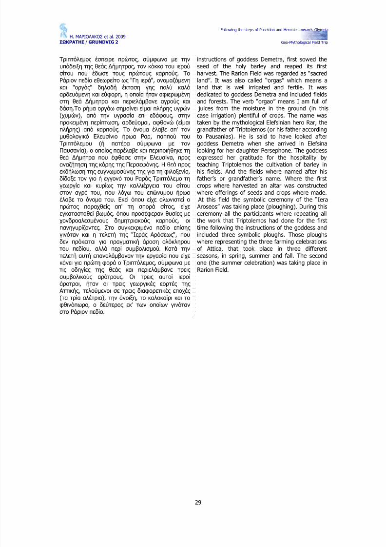
2.6.2. Αρχαία Δίολκος – Ancient Diolkos
Λιθόστρωτος δρόμος που χρησιμοποιείτο για την από ξηράς μεταφορά πλοίων, πάνω σε τροχοφόρο όχημα ("Ολκός νεών") από τον Σαρωνικό στον Κορινθιακό κόλπο και αντιστρόφως . Αποκαλύφθηκε το δυτικό του τμήμα σε μήκος 255 μ. στην πλευρά της Πελοποννήσου και σε μήκος 204 μ. στην Στερεά Ελλάδα μέσα στις εγκαταστάσεις της Σχολής Μηχανικού.Το πλάτος του είναι 3,40 - 6,00 μ. Είναι στρωμένος με κανονικούς πώρινους κυβόλιθους και στο μέσον του φέρει δύο αυλακώσεις σε απόσταση 1,50 μ.Στο δυτικό άκρο του κατέληγε σε λιθόστρωτη αποβάθρα.
Η κατασκευή της ∆ιόλκου προέκυψε από την ανάγκη για γρήγορο πέρασμα των πλοίων από τον
Σαρωνικό στον Κορινθιακό κόλπο και αντίστροφα,έγινε στις αρχές του 6ου π.Χ. αιώνα και συνδέεται με την τυραννίδα του Περίανδρου στην Κόρινθο.Το δυτικό άκρο του ανακατασκευάσθηκε στις αρχές του 4ου π.Χ. αιώνα. Χρησιμοποιείτο για τη μεταφορά μικρών, κυρίως πολεμικών σκαφών.Τέτοια χρήση βεβαιώνεται από τις πηγές ως τον 9ο μ.Χ. αιώνα.
Η ανασκαφή του μνημείου έγινε κατά τα έτη 1956-1959 από την Αρχαιολογική Υπηρεσία (ανασκαφέας Ν. Βερδελής ). Συνεχίστηκε κατά τα έτη 1960 και 1969 από τον ίδιο ανασκαφέα με δαπάνη της Αρχαιολογικής Εταιρείας .
The Diolkos is a paved road, which was usedfor the transport of boats by land on a platform("puller of boats").
Its western section was excavated to a lengthof 255m. on the Peloponnesos side of the Isthmusand of 204 m. on the Sterea Hellas side, in theprecinct of the School of Engineering.
Its width is 3,40 - 6,00m. It is paved withsquare blocks of poros and carried two grooves inthe middle, at a distance of 1,50 m. from eachother. On its western side it ended on a pavedquay.
It became necessary to built the "diolkos" inorder to provide a quick passage for the boatsbetween the Saronic Gulf and the Corinthian Bay.It was constructed during the 6th century B.C.,probably during the tyranny of Periandros inCorinth. Its westren end was reconstructed at thebeginning of the 4th century B.C. It was used forthe transport of small boats, mostly warships, upto the 9th century A.D. as is confirmed by varioussources.
The monument was excavated during theyears 1956-1959 by the Greek ArchaeologicalService (under the direction of N.Verdelis).Supplementary investigations were undertaken in1960 and 1963 by the archaeologist with funds
Following the steps of Poseidon and Hercules towards Olympia
Geo-Mythological Field Trip
33
2.6.3. Ισθμία – Isthmia
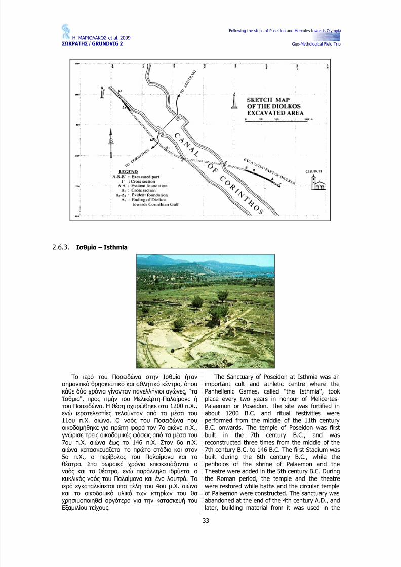
Το ιερό του Ποσειδώνα στην Ισθμία ήταν σημαντικό θρησκευτικό και αθλητικό κέντρο, όπου κάθε δύο χρόνια γίνονταν πανελλήνιοι αγώνες , "τα
Ίσθμια", προς τιμήν του Μελικέρτη-Παλαίμονα ή του Ποσειδώνα. Η θέση οχυρώθηκε στα 1200 π.Χ.,ενώ ιεροτελεστίες τελούνταν από τα μέσα του 11ου π.Χ. αιώνα. Ο ναός του Ποσειδώνα που οικοδομήθηκε για πρώτη φορά τον 7ο αιώνα π.Χ.,γνώρισε τρεις οικοδομικές φάσεις από τα μέσα του 7ου π.Χ. αιώνα έως το 146 π.Χ. Στον 6ο π.Χ.αιώνα κατασκευάζεται το πρώτο στάδιο και στον 5ο π.Χ., ο περίβολος του Παλαίμονα και το θέατρο. Στα ρωμαϊκά χρόνια επισκευάζονται ο ναός και το θέατρο, ενώ παράλληλα ιδρύεται ο κυκλικός ναός του Παλαίμονα και ένα λουτρό. Το ιερό εγκαταλείπεται στα τέλη του 4ου μ.Χ. αιώνα και το οικοδομικό υλικό των κτηρίων του θα χρησιμοποιηθεί αργότερα για την κατασκευή του Εξαμιλίου τείχους .
The Sanctuary of Poseidon at Isthmia was animportant cult and athletic centre where thePanhellenic Games, called "the Isthmia", took
place every two years in honour of Melicertes-Palaemon or Poseidon. The site was fortified inabout 1200 B.C. and ritual festivities wereperformed from the middle of the 11th centuryB.C. onwards. The temple of Poseidon was firstbuilt in the 7th century B.C., and wasreconstructed three times from the middle of the7th century B.C. to 146 B.C. The first Stadium wasbuilt during the 6th century B.C., while theperibolos of the shrine of Palaemon and theTheatre were added in the 5th century B.C. Duringthe Roman period, the temple and the theatrewere restored while baths and the circular templeof Palaemon were constructed. The sanctuary wasabandoned at the end of the 4th century A.D., andlater, building material from it was used in the
Following the steps of Poseidon and Hercules towards Olympia
Geo-Mythological Field Trip
34
Οι πρώτες ανασκαφές , περιορισμένες σε έκταση και αποτελέσματα, έγιναν το 1883 από τον Paul Monceaux και το 1930 από τους Β. S. Jenkinsκαι H. Megaw. Συστηματικές ανασκαφές στο χώρο διεξήγαγε η Αμερικανική Σχολή Κλασικών
Σπουδών. Κατά τα έτη 1959-1967 ο Oscar Broneerανέσκαψε το ναό του Ποσειδώνα, στοές , το ιερό του Παλαίμονα, τα δύο στάδια και ένα ελληνιστικό οικισμό στη θέση "Ράχη", ενώ αργότερα η Ε.Gebhard αποκάλυψε το θέατρο. Κατά τα έτη 1967-1976, ο P. Clement έσκαψε το ρωμαϊκό λουτρό και άλλα κτήρια. Τέλος , το 1980 και 1989,η Ε. Gebhard ερεύνησε το κεντρικό ιερό και τον οικισμό της Ράχης .
construction of the Hexamilion wall.
B.S. Jenkins and H. Megaw carried out thefirst, restricted excavations, poor in results, in1883 by Paul Monceaux and in 1930. The American School of Classical Studies undertook extensive excavations on the site. During theyears 1959-1967, Oscar Brooner excavated thetemple of Poseidon, porticoes, the sanctuary of Palaemon, the two Stadiums and a Hellenisticsettlement at "Rachi", while later, E. Gebhardbrought to light the theatre. During 1967-1976 , P.Clement excavated the Roman baths and otherbuildings. Finally, in 1980 and 1989, E. Gebhardinvestigated the central shrine and the prehistoricsettlement at "Rachi".
2.7. Στάση 7η – Μυκήνες / Stop 7 – Mycenae
2.7.1. Μυκήνες , Θρύλος και Ιστορία / Mycenae, Legend and History
Οι Μυκήνες ήταν ένα από τα πιο σημαντικά πολιτιστικά και πολιτικά κέντρα της Ελλάδας από το 2.500 π.Χ. και μετά.
Κυριαρχούσαν στην πεδιάδα και είχαν τον έλεγχο όλων των διαδρομών προς βορρά,ανατολή και δύση ακόμα και της θαλάσσιας διαδρομής από τον κόλπο του Ναυπλίου μέσω της επίβλεψης από το φρούριο της Τύρινθας .
Η πιο λαμπρή περίοδος των Μυκηνών άρχισε το 1.600 π.Χ. και εξελίχθηκε μέχρι το 1200 π.Χ.
Ο λόφος (280 μέτρα υψόμετρο)πρωτοκατοικήθηκε το 2.500 π.Χ. (Πρώιμη Εποχή Χαλκού) και πιθανόν την εποχή του Λίθου.
Γενικότερα θεωρείται ότι:
Ο ιδρυτής και πρώτος βασιλιάς των Μυκηνών ήταν ο Περσέας , ο γιος του ∆ία
και της ∆ανάης . Ο Περσέας έχτησε τα τείχη των Μυκηνών κατά το πρώτο μισό του 14ου αιώνα, (περίπου το 1340 π.Χ.)
Mycenae was one of the most importantcultural and political centres of Greece,from 2,500 B.C. on.
Mycenae dominated the plain andcontrolled the overland routes to thenorth, west and east and even the sea-lane of the Gulf of Nafplion through itsdependency, the citadel of Tyrins.
The most brilliant and prosperous periodof Mycenae was from ca. 1,600 to 1,200B.C.
The hill (rd. 280 m. high) was inhabited
from 2,500 B.C. (Early Bronze Age) andperhaps even in the Stone Age.
It is believed that the
Founder and first King of Mycenae wasPerseus, son of Zeus and Danae. Perseusbuilt the fortification walls the first half of the 14th century (about 1,340 B.C.) usingthe legendary Cyclops.
The fortification walls are not of oneperiod as the area surrounded wasgradually increased in well-establishedstages. Around 1,250 B.C. the
Mycenaeans enlarged the area of thecitadel towards west and south.
Following the steps of Poseidon and Hercules towards Olympia
Geo-Mythological Field Trip
35
χρησιμοποιώντας τους θρυλικούς Κύκλωπες .
Τα οχυρωτικά τείχη δεν ανήκουν αποκλειστικά σε μία περίοδο καθώς η τριγύρω περιοχή αυξανόταν σταδιακά.Γύρω στο 1250 π.Χ. οι Μυκηναίοι αύξησαν την έκταση του φρουρίου προς δύση και νότο.
Ο Αγαμέμνων, ο απόγονος του Περσέα ήταν ο αρχηγός των Αχαιών εναντίων της Τροίας .
Οι ∆ωριείς κατέστρεψαν τις Μυκήνες προς το τέλος του 12ου αιώνα π.Χ.
Agamemnon, the descendant of Perseuswas the leader of Achaeans against Troy.
The Dorian destroyed Mycenae towardsthe end of the 12th century B.C.
Η πύλη των Λεόντων (κατασκευάστηκε το 1250π.Χ.) με την εντυπωσιακή
κλίση των κεκλιμένων τριγώνων: 450 x 1.98 x0.80 = 7.18 x 2.5 = 1.799
≈ 1.800 τόνοι
Το πέτρωμα στα αριστερά είναι ασβεστόλιθος , ενώ η κεκλιμένη επιφάνεια είναι μία ρηξιγενής επιφάνεια ενός ενεργού κανονικού
ρήγματος
The Lion Gate (built in ca.1,250 B.C.) with the
impressive relief on therelieving triangle: 450 x1.98 x 0.80 = 7.18 x 2.5 =1,799 ≈ 1,800 tons
The rock on the left islimestone, whereas therelief surface is a faultsurface of an active normalfault.
Σύμφωνα με την Ελληνική Μυθολογία:
Ο Περσέας (1400 – 1350 π.Χ.) ήταν ο ιδρυτής των Μυκηνών
Ο Περσέας ήταν ο γιος του ∆ια και της ∆ανάης και αυτός που σκότωσε τηε γοργόνα Μέδουσα.
Ο Ευρισθέας – ένας από τους απόγονους του Περσέα – ήταν ο βασιλιάς για τον οποίο ο Ηρακλής πραγματοποίησε τους 12άθλους . (1250 π.Χ.).
Ατρέας : Οι Μυκηναίοι επέλεξαν τον Ατρέα ως διάδοχο της βασιλίας του Ευρυσθέα ο οποίος σκοτώθηκε στη μάχη εναντίων των παιδιών του Ηρακλή. Ο Ατρέας ήταν ο γιος του Πέλοπα.
Αγαμέμνονας (1220 π.Χ.): Ο γιος του Ατρέα εκλέχθηκε να οδηγήσει τους Αχαιούς εναντίων της Τροίας (1200 –1190 π.Χ.).
Η αρχαιολογική έρευνα δείχνει ότι:
Γύρω στο 1475 π.Χ. οι Μυκηναίοι κατέκτησαν την Κνωσσό,εκμεταλλευόμενοι την καταστροφική ηφαιστειακή έκρηξη του ηφαιστείου της Θήρας και ενός ισχυρού σεισμού ο οποίος κατέστρεψε τα Κρητικά παλάτια.
Το πολιτικό σύστημα της πόλης κράτους καταργήθηκέ από τον βασιλιά Αναξ .
Χρησιμοποιούσαν την Γραμμική Β η οποία
According to the Greek Mythology
Perseus, who lived between 1,400 and1,350 was the founder of Mycenae.
Perseus was son of Zeus and Danae anddestroyer of the Gorgon Medusa.
Eurystheus –one of Perseus descendants-was the King for whom Herculesperformed the 12 labours (ca. 1,250).
Atreus: The Mycenaeans chose Atreus torule Mycenae after Eurystheus was killedin a war against the children of Hercules. Atreus was son of Pelops.
Agamemnon (ca. 1,220 B.C.): The son of Atreus was chosen to lead the AchaeanGreeks against Troy (Troyan war ca.1,200 – 1,190 B.C.).
Archaeological research shows that:
Around 1,475 B.C. the Mycenaeansconquered Knossos, taking advantage of the devastating volcanic eruption of Theraand a violent earthquake that destroyedthe Cretan palaces.
The political system of the city-state ruledover by a King known as a wanax (=theHomeric anax).
They used the Linear B script, which was
developed from the earlier Minoan Linear A script, when the Mycenaeans occupied
Following the steps of Poseidon and Hercules towards Olympia
Geo-Mythological Field Trip
36
εξελίχθηκε από την πρώιμη Μινωική Γραμμική Α, όταν οι Μυκηναίοι επικρατούσαν στη Κνωσσό.
Ο Μιχάλης Βεντρής κατάφερε να αποκωδικοποιήσει και να ερμηνεύσει ένα αριθμό επιγραφών. Το επίτευγμα του έργου του Βεντρή είναι η απόδειξη ότι η Γραμμική Β είναι Ελληνική και ότι οι Μυκηναίοι μιλούσαν Ελληνικά.
Μυκηναϊκός Πολιτισμός : όχι μόνο εξελίχθηκε στις Μυκήνες αλλά και στην υπόλοιπη Ελλάδα από το 1620 μέχρι το 1120 π.Χ.
“Μυκηναίοι” δεν θεωρούνταν μόνο οι κάτοικοι των Μυκηνών αλλά και όλος ο πληθυσμός της κεντρικής Ελλάδας
Γύρω στο 1450 π.Χ., ήταν η περίοδος την μεγαλύτερης κυριαρχίας και επιρροής των Μυκηναίων σε Ανατολική και ∆υτική Μεσόγειο. Οι έμποροι μετέφεραν προϊόντα από την πατρίδα τους – ελαιόλαδο, αρωματικά έλαια, κρασί, έργα τέχνης και κεραμικά – στην Αίγυπτο, Παλαιστίνη και Συρία, στις δυτικές ακτές της Μικράς Ασίας , της Νότιας Ιταλίας , Σικελίας και πιθανότατα δυτικότερα μέχρι τις ακτές της Νότιας Αγγλίας . Σε αντάλλαγμα έπαιρναν χαλκό, χρυσό, κασσίτερο,ελεφαντόδοντο, αρωματικά βότανα και φυσικά πολιτιστικές και καλλιτεχνικές ιδέες .
Knossos.
Michael Ventris was able to read andinterpret a number of inscriptions ortablets. The chief result of Ventris work isthe proof that the language of Linear Bscript is Greek and the Mycenaeans wereGreek-speaking people.
Mycenaean civilization: not only that developedat Mycenae, but also in the rest of Greece betweenca. 1,620 to 1,120 B.C.
“Mycenaeans” are not only the people of Mycenae but all the population of the mainlandGreece.
Around 1,450 B.C. was the period of greatestexpansion and influence of the Mycenaeans in boththe Eastern and the Western Mediterranean area.The merchants carried products of the homeland –olive oil, perfumed oil, wine, works of art andpottery- to Egypt, Palestine and Syria to the westcoast of Asia Minor also to Southern Italy, Sicilyand perhaps as far west as Southern England. Inexchange, they brought home copper, gold, tin,ivory, aromatic herbs and cultural and artisticideas.
2.7.2. Η υπόγεια δεξαμενή / The underground cistern
Η είσοδος της δεξαμενής είναι στη βορειοανατολική γωνία της προέκτασης του βορείου Κυκλώπειου τείχους .
Περίπου 54 σκαλοπάτια πιο κάτω (12 μέτρα βάθος ) ο διάδρομος καταλήγει σε μια δεξαμενή με διαστάσεις 1.60 μ .Χ 0.70 μ. Χ 5 μ βάθος .
Ακριβώς πάνω από την δεξαμενή στην οροφή του διαδρόμου υπάρχει ένα μεγάλο άνοιγμα, το κανάλι μεταφοράς του νερού από κεραμικούς σωλήνες και
το υδραγωγείο.
The opening to the cistern is at the northeastcorner of the extension and in the north Cyclopeanwall.
Some 54 steps below that is about 12 m. deep,the passage terminates at a well-like cistern about1.60 m. by 0.70 m. and 5 m. deep.
Immediately above the cistern in the roof of the passage there is a large opening, thetermination of the water conduit of terracottapipes, the aqueduct.
Πιθανή χρήση του νερού της τεχνητής λίμνης ως
νεροτριβείο.Possible use of the water from the artificial llake, as a
Κατασκευαστικές λεπτομέρειες στο διατηρημένο τμήμα του φράγματος .
Construction details of the preserved part of the dam.
Following the steps of Poseidon and Hercules towards Olympia
Geo-Mythological Field Trip
37
wash – basin.
Υπολείμματα της «γέφυρας » πάνω από το ρεύμα του Χάβου ( ∆ιαστάσεις 20 m. μήκος , 5 m. πλάτος και 4,5 m.ύψος ). Πρόκειται για ένα Κυκλώπειο τείχος της ανώτερης Ελλαδικής Εποχής (1400 – 1200 π.Χ.). Σύμφωνα με τον J. Knauss (1966) δεν πρόκειται για γέφυρα αλλά για ένα
φράγμα.
Ruins of the “bridge” over the havos stream (Dim. 20mlength, 5m width, 4.5m height). It is one of the so-called
“CyclopianWalls” of the Y. Helladic Period (1400-1200B.C.). According to J.Knauss (1966) this is not a
bridge, but a dam.
Κατασκευαστική λεπτομέρεια και διαστάσεις του μετώπου του φράγματος (1400 – 1200 π.Χ.) (κατά J.
Knauss, 1966).
Construction detail and dimensions of the forehead of the dam (1400 – 1200 B.C.) (after J. Knauss, 1966)
Τομή στο μέτωπο του τείχους με το υλικό πλήρωσης (κατά J. Knauss, 1966)
Section of the forehead of the bridge (or dam) (after J.Knauss, 1966).
Σύγχρονο νεροτριβείο από το Κεφαλάρι (κατά J. Knauss,1966).
Reconstruction of the wash-basin (=Nerotrivio) (after J.Knauss, 1966).
Following the steps of Poseidon and Hercules towards Olympia
Geo-Mythological Field Trip
40
2.8. Στάση 8η – Αρχαία Τίρυνθα / Stop 8 – Ancient Tiryns
Στο μυχό του αργολικού κόλπου, σε μικρή απόσταση από το Ναύπλιο, η ακρόπολη της Τίρυνθος προβάλλει επιβλητικά πάνω σ' ένα βραχώδη λόφο ύψους 16 μ.
Η αρχαιότερη εγκατάσταση πάνω στον λόφο χρονολογείται στη νεολιθική εποχή (περίπου 5.000π.Χ.). Ακολούθησαν αλλεπάλληλοι οικισμοί, των οποίων όμως τα κατάλοιπα καταστράφηκαν σχεδόν ολότελα κατά τις μεγάλης τάξεως διαμορφώσεις της Μυκηναϊκής εποχής . Από τον οικισμό της Πρώιμης Εποχής του Χαλκού (2500-2000 π.Χ.) διασώζονται αρκετές ενδείξεις για την ύπαρξη μίας σειράς αψιδωτών κτιρίων και ένας τεραστίων διαστάσεων κυκλικού κτιρίου (διαμέτρου 28 μ.) στο ψηλότερο σημείο του λόφου.
Τον 14ο αιώνα π.Χ. αρχίζει η κατασκευή της οχύρωσης του λόφου που ολοκληρώνεται στα τέλη του 13ου αιώνα π.Χ. ( Υστεροελλαδική ΙΙΙΒ περίοδος ). Τα κυκλώπεια τείχη που περιλαμβάνουν την άνω, μέση και κάτω Ακρόπολη, έχουν συνολική περίμετρο 750 μ περίπου και πλάτος από 4,50 ως 7 μ. Εντός αυτών οργανώνεται το τοιχογραφημένο ανάκτορο, οι λοιποί δημόσιοι χώροι, οι αποθήκες και οι κυκλώπειες σήραγγες , τα εργαστήρια καθώς και συγκροτήματα οικιών. Έξω
On the edge of the Argolic gulf, at a shortdistance from Nauplion, the Acropolis of Tirynsrises impressively on a rocky hill (16 m).
The earliest human occupation on the hill goesback to the Neolithic period (about 5000 B.C.). Itwas followed by successive settlements but theirremains have been destroyed almost completelyby the extensive construction arrangement of theMycenaean age. Enough evidence survived fromthe settlement of the Early Bronze Age (2500-2000B.C.) to prove the existence then of a series of apsidal houses arranged around a very hugecircular building (diam. 28 m) on the summit of thehill.
The building of the fortification of the hill beganduring the 14th century B.C. and was completed atthe end of the 13th century (Late Helladic IIIBperiod). The Cyclopaean walls which surround theUpper, Middle and Lower Citadel, have a totalperimeter of approximately 750 m and a widthbetween 4,50 and 7 m. Within the walls wereplanned the wall-painted palace, the remainingpublic spaces, the cyclopaean tunnels leading to
the storehouses and the workshops. The towndivided into blockhouses extended outside thewalls and around the Acropolis (about 750 acres).
Following the steps of Poseidon and Hercules towards Olympia
Geo-Mythological Field Trip
41
και γύρω από την ακρόπολη, εκτείνεται η οργανωμένη σε οικοδομικά τετράγωνα πόλη (περίπου 250 στρέμματα).
Μετά την κατάρρευση του ανακτορικού συστήματος (γύρω στο 1200 π.Χ.), η ακρόπολη εξακολουθεί να χρησιμοποιείται κυρίως ως χώρος λατρείας . Ο χώρος είχε ερημωθεί όταν τον επισκέφτηκε ο Παυσανίας , τον 2ο μ.Χ. αιώνα.
After the disintegration of the palatial system(about 1200 B.C.), the Acropolis continued to beused mostly as a cult place. The site had becomedeserted when Pausanias visited it during the 2dcentury A.D.
2.9. Στάση 9η – Πηγές Λέρνης , ο Ηρακλής και η Λερναία Ύδρα / Stop 9 – Lerni Springs,Hercules and the Lernaean Hydra
Κατά τα πρώτα στάδια της ανθρώπινης κοινωνίας , η εξάρτηση του ανθρώπου από την φύση ήταν πιο άμεση, και έντονα φυσικά φαινόμενα όπως πλημμύρες , σεισμοί, καταιγίδες ,ηφαιστειακές εκρήξεις κτλ, που έπαιξαν ένα πιο σημαντικό ρόλο στη ζωή του ανθρώπου ερμηνεύτηκαν ως θεϊκές και συνδέθηκαν με τους θεούς , ημίθεους η με ανθρώπους που είχαν
υπερφυσικές δυνάμεις . Αυτά τα γεωλογικά φαινόμενα, που αναγνωρίζονται σήμερα σε αρχαίους μύθους και συνδέονται κυρίως με τη
During the early stages of human society,man’s dependence on nature was more direct,whereas natural phenomena of extreme intensity,such as floods, earthquakes, thunderstorms,volcanic eruptions, etc., playing a most crucialpart in human’s survival, were interpreted asdivine actions and were connected with gods,semi gods or as actions of men having
supernatural powers. Such geologicalphenomena, known today under the sense of amyth and connected in time with the period of
Following the steps of Poseidon and Hercules towards Olympia
Geo-Mythological Field Trip
42
χρονική περίοδο του Ολοκαίνου (10000 χρόνια πριν από σήμερα), μπορούν και πρέπει να αναδειχθούν σε μια ειδική κατηγορία γεωτόπων, τους γεωμυθολογικούς .
Στην Ελλάδα, υπάρχει ένας μεγάλος αριθμός γεωμυθολογικών γεωτόπων, οι οποίοι, μετά τον εντοπισμό τους , θα πρέπει να διατηρηθούν και να αναδειχθούν. Κάποιοι από αυτούς , είναι μοναδικοί και προκαλούν το διεθνές ενδιαφέρον, σχετικά με το κλίμα και τις παλαιογεωγραφικές αλλαγές του Ολοκαίνου. Οι γεωμυθολογικοί και οι γεωαρχαιολογικοί γεώτοποι, εκτός από το γεωλογικό ενδιαφέρον, επιπλέον παρουσιάζουν ιστορικό, παλαιο-κλιματολογικό και επιμορφωτικό-εκπαιδευτικό ενδιαφέρον.
Ο γεωμυθολογικός γεώτοπος , των Πηγών της Λέρνης συνδέεται με τον 2ο άθλο του Ηρακλή, του ήρωα που δεσπόζει στην Ελληνική Μυθολογία και
εξολόθρευσε το οφιόμορφο τέρας Λερναία Ύδρα. Η Ύδρα ζούσε στην περιοχή του Άργους , κοντά στην Λίμνη της Λέρνης . Το σώμα της ήταν τεράστιο και κατέληγε σε πολλαπλά πλοκάμια και κάθε πλοκάμι είχε στην κορυφή του ένα κεφάλι.
Η ανάσα του τέρατος ήταν δηλητηριώδης και ακόμα και όταν κοιμόταν συνήθιζε να καταστρέφει τα πάντα γύρω της : καλλιέργειες , δένδρα, ζώα και ανθρώπους .
Υπάρχουν πολλές απόψεις σχετικά με τον αριθμό των κεφαλιών της Ύδρας οι οποίες αναφέρονται παρακάτω:
Πάνω σε ένα ερυθρόμορφο αγγείο του 480-470 π.Χ. και σε άλλες παραστάσεις , η Ύδρα παρουσιάζεται με 12 κεφάλια.
Κατά τον Αλκαίο και τον Απολλόδωρο η Ύδρα είχε 9 κεφάλια.
Σε πόρπες της γεωμετρικής περιόδου η Ύδρα παρουσιάζεται με 5 ή 6 κεφάλια.
Κατά τον Σιμωνίδη, η Ύδρα είχε 50 κεφάλια.
Κατά τον Ευριπίδη και τον ∆ιόδωρο, η Ύδρα είχε 100 κεφάλια.
Η Ύδρα έχει χαρακτηρισθεί ως «μυριόκρανος »
και «πολυαύχενος », επίθετα που υποδηλώνουν την ποικιλία των θρύλων σχετικά με τον αριθμό των κεφαλιών και οπωσδήποτε τον τρομακτικό χαρακτήρα του τέρατος .
Ο μύθος της Λερναίας Ύδρας μπορεί να εξηγηθεί μέσα από την υδρογεωλογική συμπεριφορά των πηγών της Λέρνης , αν λάβουμε υπόψη τα παρακάτω:
Το υψόμετρο των πηγών της Λέρνης είναι 0.5-1m πάνω από την σημερινή στάθμη της θάλασσας .
Το 1965 η παροχή των πηγών ήταν 60
εκατομμύρια m3 το χρόνο.
Οι πηγές παρόλο που έχουν μέση ετήσια
the uppermost Pleistocene and/or that of Holocene, may and should be included in aspecific category of geotopes, thegeomythological geotopes or geomythotopes.
In the Hellenic territory a great number of geomythological geotopes exists which, followingtheir localisation, should be preserved, renderedand propounded. Some of them even are uniqueand feature a specific, international interest,pertaining to the climatic and thepaleogeographic changes of the Holocene. Thegeomythological as well as the geoarcheologicalgeotopes, except their strictly geological interest,are of general scientific and educational interesttoo.
As it is known, the myth of the extinguishingof Lernaia Hydra, which is the 2nd labour of Hercules, has as follows:
A repulsive snake-formed beast namedLernaia Hydra used to live in the region of Argos,near the Lake Lerna. It had an enormousserpentine body (Fig. 1), which was ending atseveral snaky tresses, with a head at each edge.
The beast’s breath was poisonous and oftenLernaia Hydra would spit out fire while, evenasleep, it used to destroy everything in the valley,including crops, trees, animals and even people.
Concerning the number of Hydra’s heads,there are several views, such as the following:
On a reddish jug of 480-470 BC and onother representations too, Hydra ispresented with 12 heads.
According to Alkaios and Apollodoros,Hydra had 9 heads.
On clasps of the geometric period, Hydrais depicted with 5 or 6 heads.
According to Symonides, Hydra had 50heads.
According to Euripides and Deodorus,Hydra had 100 heads.
Hydra is also reported as “myriokranos”, “amphikranos” and “polyaphchenos”, adjectivesshowing the variety of legends on the number of heads (“myriokranos” means with 1000 heads)and definitely the frightful character of the beast.
Τhe myth of Hercules and Lernaia Hydra maybe interpreted through the hydrogeologicalconditions of the karstic springs of Lerni, aretaken into account:
Spring Altitude: The present altitude isvarying. Specifically, Kefalari springs are at24 m above the present sea level, Lernisprings are at 0,50-1m, while the group of
Anavalos springs discharge under thepresent sea level, in a depth of -5m
Following the steps of Poseidon and Hercules towards Olympia
Geo-Mythological Field Trip
43
ποσότητα εκφόρτισης χαμηλότερη από άλλες καρστικές πηγές , η κεντρική πηγή δεν έχει διακόψει ποτέ τη λειτουργία της .
Ένας αριθμός μικρότερων πηγών εμφανίζονται εκατέρωθεν της κεντρικής .
Επίσης , τα σημεία όπου ο καρστικός υδροφόρος ορίζοντας των πηγών εκφορτίζεται διαφέρουν και εξαρτώνται από την εποχή του χρόνου, το μέσο ετήσιο ύψος των ατμοσφαιρικών κατακρημνισμάτων κυρίως στις ορεινές περιοχές της Αρκαδίας και Κορινθίας , και το χρονικό διάστημα,δηλ. αν η «υγρή» κλιματική περίοδος είναι 100, 500ή ακόμα και 2.000 χρόνια. Έτσι, μπορούν να ερμηνευθούν οι διαφορές στον αριθμό των κεφαλών της Λερναίας Ύδρας , αφού γίνεται αποδεκτό ότι κάθε κεφάλι αντιπροσωπεύει ένα σημείο εκφόρτισης του καρστικού υδροφορέα και,όπως αναφέρθηκε και παραπάνω, αυτός ο αριθμός
διαφέρει ανάλογα με τις κλιματικές συνθήκες που επικρατούν για ένα μικρό ή μεγαλύτερο χρονικό διάστημα. Σε ότι αφορά την αναγέννηση των κεφαλών της Λερναίας Ύδρας , είναι δυνατόν να ερμηνευτεί από το γεγονός ότι αν φραχθεί το σημείο εξόδου μιας καρστικής πηγής , το νερό θα εκφορτιστεί από δύο ή περισσότερα διαφορετικά σημεία.
Σύμφωνα με όσα παρουσιάστηκαν παραπάνω,είναι προφανές ότι ο μύθος της Λερναίας Ύδρας και του Ηρακλή είναι άμεσα συνδεδεμένος με τις υδρογεωλογικές συνθήκες της πηγής της Λέρνης . Αυτός είναι ένας από τους λόγους που η πηγή της
Λέρνης θα πρέπει να συμπεριληφθεί στον ∆ιεθνή Κατάλογο των Γεωμυθολογικών Γεωτόπων. Ένας άλλος λόγος είναι ότι, εξαιτίας της υπεράντλησης ,δεν αργεί η στιγμή που η πηγή θα στερέψει και συνεπώς , η αθάνατη κεντρική κεφαλή της Ύδρας θα «πεθάνει», κάτι που δεν είχε επιτύχει ούτε ο Ηρακλής .
Spring Yield. The spring yield is differentand varies during the year, as naturallyexpected. So, in 1965, the mean annualyield of Kefalari springs was ≅ 80X106m3 /year, that of the main Lerni spring was
≅ 60X106
m3
/year whereas that of Anavalos springs the discharge was≅100X106 m3 /year.
At Lerni springs, despite the fact that themean annual discharge is relatively lowerthan the Kefalari one, dry up of the centralspring has never been observed.
At Lerni, the discharge occurred at severalpoints.
The number of the points, from where thekarstic aquifer is being discharged, as it isexpected, differs and it depends on the season of
the year, the mean annual height of theatmospheric precipitation at the regional area andin this case at the mountainous areas of Arkadiaand Korinthia provinces, and the length of theclimatic period, that is if the wet period is of 100,500 or even 2.000 years. In this way, one mayinterpret the existing differences in the numbersof the heads of Hydra, since it may be acceptedthat each head represents a point of discharge of the karstic aquifer and, as it is mentioned before,this number differs according to the climaticconditions existing during a longer or a shorterperiod.
According to what has been described, it isobvious that the myth of Lernaia Hydra andHercules is directly connected with the prehistoricand the present day hydrogeological conditions of Lerni springs.
The inclusion of Lerni spring in theinternational catalogue of geomythologicalgeotopes is, in our opinion, absolutely necessaryand of crucial importance. The intensive increaseof cultivation in this fertile land of our planet,without applying in parallel certain strategies andmeasures for water use and exploitation, forcesus to accept that, it is not far the time when the
spring will dry up and the immortal central headof Hydra will die.
Following the steps of Poseidon and Hercules towards Olympia
Geo-Mythological Field Trip
46
3.33.. Ο ΔΡΟΜΟΣ ΤΟΥ ΠΟΣΕΙΔΩΝΑ – POSEIDON’S ROUTEΟ ΔΟ ΔΡΡΟΟΜΜΟΟΣ ΤΣ ΤΟΟ Υ Π Υ ΠΟΟΣΣΕΕΙΙ Δ ΔΩΩΝΝ Α – P Α – POOSSEEIIDDOONN’ ’ S R S R OOUUTTEE
3.1. Στάση 10η – Υποθαλάσσιες πηγές Κιβερίου , Σημείο άφιξης του θεού Ποσειδώνα στον Αργολικό κόλπο / Stop 10 – Kiveri submarine Springs, Arrival point of Poseidon in the
Argolic Gulf
Οι υποθαλάσσιες πηγές του Ανάβαλου στο Κιβέρι.
The Anavalos submarine The area of Lerni and Kiveri in the Argolic Gulf.
Υδραυλική επικοινωνία μεταξύ των καρστικών πηγών στο Κιβέρι, το Κεφαλάρι και τη Λέρνη
Hydraulic connection between Kiveri, Kefalari and Lerni springs
Following the steps of Poseidon and Hercules towards Olympia
Geo-Mythological Field Trip
47
3.2. Στάση 11η – Αρκαδία , ο τόπος γέννησης του Ποσειδώνα και το Αργόν πεδίον / Stop 11 – Arcadia, the Birthplace of Poseidon and the Argon Field
3.2.1. Αργό Πεδίο / Argon Field
Είναι γνωστά ότι ο πολιτισμός ενός λαού, ήτοι το πολίτευμα, η θρησκεία, οι τέχνες , οι επιστήμες ,
οι οικονομικές δραστηριότητες κλπ, συνδέεται άμεσα με τα φυσικογεωλογικά χαρακτηριστικά και,κυρίως , με το γεωπεριβάλλον της περιοχής που αναπτύσσεται. Ο μεγάλος Ελληνικός Πολιτισμός δεν θα μπορούσε να αποτελέσει εξαίρεση.Χαρακτηριστικό παράδειγμα μιας τέτοιας σύνδεσης ενός από τους σημαντικότερους θεούς της αρχαιοελληνικής θρησκείας με το γεωπεριβάλλον αποτελεί ο μύθος της γέννησης του Ποσειδώνα στο οροπέδιο της Τρίπολης , και ειδικότερα οι γεωλογικές και υδρογεωλογικές συνθήκες της Αρκαδίας .
Πιο συγκεκριμένα, στο βορειοανατολικό τμήμα
του οροπεδίου της Τρίπολης αναπτύσσεται μια υπολεκάνη, το Αργό Πεδίον, που ονομάζεται έτσι επειδή για μεγάλο χρονικό διάστημα πλημμυρίζει και δεν καλλιεργείται.
Σύμφωνα λοιπόν με την Ελληνική Μυθολογία,σε μικρή απόσταση από το Αργό Πεδίο στην περιοχή της σημερινής Μηλιάς , η Ρέα γέννησε τον Ποσειδώνα και τον άφησε δίπλα σε μία στάνη σε μια πηγή, την Άρνα, λέγοντας ψέμματα στον πατέρα του Ποσειδώνα τον Κρόνο, ότι δεν γέννησε παιδί αλλά ένα πουλαράκι, κι αυτό για να προστατέψει το νεογέννητο.
Τα νερά του Αργού Πεδίου απομακρύνονται
από την καταβόθρα –σπήλαιο της Νεστάνης . Το νερό φθάνει στην καταβόθρα με μια μικρή αποχετευτική αύλακα που έχει οφειοειδές
It is known that the civilization of a nation,that is its constitution, religion, art, science,
economical activities etc., is directly related to thephysicogeological characteristics and mainly to thegeoenvironment of the area that is underdevelopment. The great Hellenic Civilization couldnot be an exception. A characteristic example of such a connection of one of the most importantgods of the ancient Hellenic religion to theenvironment is the myth of Poseidon at the Tripoliplateau, and more specifically the geological andhydrogeological conditions of Arcadia.
More specifically, at the north-eastern sectionof the Tripoli plateau, a sub-basin develops knownas the Argon Field because long term flooding was
taking place and therefore was not cultivated. According to the Greek Mythology, in a short
distance from the Argon Field, in the area of present Milia village, Rea gave birth to Poseidonand left him next to a sheep-fold near Arna spring,and, in order to protect the newborn she lied toPoseidon’s father Cronus, claiming that she did notgave birth to a child but to a colt.
The Argon field water is drained through thecave-sinkhole of Nestani. The water reaches thesinkhole through a draining canal that is has anundulating “snake-like” shape.
Since the ancient times, it was known that ahydraulic communication between the Nestanisinkhole and the submarine spring at the
Following the steps of Poseidon and Hercules towards Olympia
Geo-Mythological Field Trip
48
σχήμα.Κατά την αρχαία εποχή ήταν γνωστό ότι υπήρχε υδραυλική επικοινωνία μεταξύ της καταβόθρας της Νεστάνης και της πηγής που αναβλύζει από τον πυθμένα του Αργολικού κοντά στο Κιβέρι, που σήμερα είναι γνωστή και ως
Μικρός Ανάβαλος , ενώ κατά την αρχαιότητα ονομαζόταν ∆ίνη, που βρίσκεται στην περιοχή Γενέθλιο ή Γενέσιον, όπου οι αρχαίοι Αργίτες θυσίαζαν άλογα στον Ποσειδώνα, επειδή μάλλον πίστευαν ότι εκεί εμφανίστηκε ο Ποσειδών.Σημειωτέον ότι σε μωσαϊκό ρωμαϊκής εποχής εμφανίζεται ο Ποσειδών σε τέθριππο να αναδύεται μέσα από την θάλασσα.
Μήπως για να φτάσει στο Γενέσιο χρησιμοποίησε την καταβόθρα-σπήλαιο της Νεστάνης και την υπόγεια οδό που ακολουθούν τα νερά του Αργού Πεδίου, μέχρι να φτάσουν στη ∆ίνη;
basement of Argolic gulf near Kiveri existed, thatis presently known as Small Anavalos. During theantiquity it was known as Dini, located in the areaof Genethlio or Genesio where the ancient Argiteswhere sacrificing horses to Poseidon because they
believed that the great god made his firstappearance in this location.
Is it possible that Poseidon in order to get toGenesion used the Nestani sinkhole and theunderground watercourse from Argon Field to theDini?
Following the steps of Poseidon and Hercules towards Olympia
Geo-Mythological Field Trip
49
3.2.2. Ιερό Ιππίου Ποσειδώνος ( Αρχαία Μαντίνεια) / Temple of Ippios Poseidon (AncientMantineia)
Το Ιερό βρίσκεται νοτιοανατολικά της αρχαίας Μαντινείας , στα όρια του συνοικισμού Μηλιά της κοινότητας Νεστάνης . Είχε εντοπισθεί από τη Γαλλική Αρχαιολογική Σχολή που ανέσκαψε την αρχαία Μαντινεία. Επανεντοπίσθηκε και ανασκάφηκε από τον Έφορο Αρχαιοτήτων ∆ρα Θ.Σπυρόπουλο, την τελευταία δεκαετία.
Οι ανασκαφές (1985-1995) αποκάλυψαν λείψανα του αρχαϊκού ναού και σημαντικά κινητά ευρήματα των ίδιων χρόνων (πήλινο ακρωτήριο λακωνικού τύπου με γοργόνειο, κεραμεική των αρχαϊκών και κλασικών χρόνων, ειδώλια κλπ.). Αποκαλύφθηκαν, επίσης , νεώτερα κτίσματα και
τάφοι με αρχαίες απελευθερωτικές επιγραφές στον ΄Ιππιο Ποσειδώνα.
The temple is located southeast of ancientMantinia, at the outer limits of the Milia settlementof the Nestani community. The French Archaeological School that also excavated theancient Mantinia initially discovered it. It was re-located and excavated by the Curator of Antiquities,Dr. Th. Spyropoulos in the last decade.
The excavations (1985-1995) revealed ruins of the archaic temple and important findings of thesame period (potter ornaments of laconic typewith “gorgonion”, ceramics of archaic and classicaltimes, statuettes etc). Also, later constructions andtombs with ancient liberating inscriptions to the
Following the steps of Poseidon and Hercules towards Olympia
Geo-Mythological Field Trip
50
3.3. Στάση 12η – Ο Αρκαδικός Ορχομενός και τα προϊστορικά υδραυλικά έργα / Stop 12 – Arcadian Orhomenos and the prehistoric hydraulic works
Ο προϊστορικός Ορχομενός της Αρκαδίας είχε ιδρυθεί στους πρόποδες της ακρόπολης , ενώ στους ιστορικούς χρόνους ιδρύθηκε επί του όρους όπου βρίσκονται και τα σημαντικότερα μνημεία του ( Αγορά, Θέατρο κλπ.). Στην πεδιάδα έχουν εντοπισθεί εγκαταστάσεις αποστράγγισης και διευθέτησης ποταμών κατά τους προϊστορικούς και μεταγενέστερους χρόνους (Χώμα των Καφυατών).
Στις αρχές του αιώνα, η Γαλλική Αρχαιολογική Σχολή Αθηνών, υπό τον Mendel και άλλους ,ανέσκαψε τα μνημεία του Ορχομενού των ιστορικών χρόνων. Την τελευταία δεκαπενταετία,ο ΄Εφορος Αρχαιοτήτων ∆ρ. Θ. Σπυρόπουλος ερεύνησε και ανέσκαψε τους προϊστορικούς τύμβους και οικισμούς και τις προϊστορικές αποστραγγιστικές εγκαταστάσεις της πεδιάδας του Ορχομενού. Τα σημαντικότερα μνημεία του
αρχαιολογικού χώρου είναι:
Το αρχαίο Θέατρο των πρώιμων ελληνιστικών χρόνων (4ος /3ος αιώνας π.Χ.).
Η αρχαία Αγορά.
Το Βουλευτήριο.
Τα Τείχη.
Ο εκατόμπεδος Ναός της Μεσοπολίτιδος Αρτέμιδος .
Ο Προϊστορικός Τύμβος - Σωρός .
Γέφυρα των Αρχαϊκών χρόνων
Προϊστορικός οικισμός στη θέση "Καταλύματα" και προϊστορικά
The prehistoric Arcadic Orchomenos wasfounded at the foot of the Acropolis, while duringhistoric times Orchomenos was founded on themountain where its most important monuments(Agora, Theatre, etc) are also situated. At theplain they have been identified artificialconstructions for drainage and for the redirectionof rivers during prehistoric and later times(earthern bank of Kaphyates).
At the beginning of the century, the French Archaeological School at Athens under thedirection of Mendel and others, excavated themonuments of historic Orchomenos. During thelast fifteen years the director of the Ephorate,Theodoros Spyropoulos investigated andexcavated the prehistoric tumuli and settlementand the prehistoric drainage systems at the plainof Orchomenos. The most important monuments
of the site are:
The ancient theatre of Early Hellenistic date(4th/3d century B.C.).
The ancient Agora.
The Bouleuterion
The walls
The hekatompedon temple of Mesopolitidos Artemis
The prehistoric tumulus
Bridge of Archaic date
Prehistoric settlement on the site"Katalymata" and prehistoric drainage
Η περιοχή είναι γνωστή από τη μυθολογία γιατί στις όχθες της λίμνης ο Ηρακλής σκότωσε τις μυθικές καταστρεπτικές όρνιθες . Γνωστή η λίμνη της Στυμφαλίας που την ονομασία της την οφείλει στην πόλη Στύμφαλο που ήταν χτισμένη στις όχθες της και όπου ο Ρωμαίος αυτοκράτορας Αδριανός μετέφερε τα νερά της με υδραγωγείο
στην Κόρινθο. Ο άθλος αυτός του Ηρακλή εξηγείται ίσως από τις αναθυμιάσεις της ελώδους περιοχής , προτού αποξηρανθεί. Η πόλη ήταν χτισμένη στη βόρεια πλευρά της λίμνης και περιβαλλόταν με τείχος , λείψανα του οποίου διακρίνονται.
Οι ανασκαφές έφεραν στο φως οικοδομήματα της αγοράς και θεμέλια παλαίστρας , στοάς και ναού. Βρέθηκαν ακόμη εξέδρες που χρησίμευαν σαν βάθρα αγαλμάτων, μια κρήνη και πάνω στο ύψωμα που χρησίμευε σαν ακρόπολη, τμήματα του οχυρωματικού περιβόλου και ίχνη ναού της Αθηνάς . ∆ιακρίνονται ακόμη ίχνη υδραγωγείου,
του οποίου το νερό έφτανε μέχρι την Κόρινθο σε μήκος 100 χλμ περίπου.
According to the mythology, Heracules killedthe legentary destructive fowls, at the banks of Stymfalia lake. Well-known is this lake, which took the name of the city Stymfalo that was built on itsbanks. The Roman emperor Andrian transferedthe lake`s waters to Corinth, through anaqueduct. The legent of the dreadful fowls was
probably inspired by the exhalations of the marshyarea when it wasn`t yet dried. The city was builtnorth of the lake and fortification walls, remains of which are still there, surrounded it.
The excavations brought to light buildings of the market, foundations of wrestling ring, arcadeand temple, platforms used as statues` bases, abublic tap on acropolis`s hill, remains of thefortification walls and traces of Minerva`s templeand traces of aqueduct of which the watersreached till Corinth, in a length of approximately100km.
Following the steps of Poseidon and Hercules towards Olympia
Geo-Mythological Field Trip
52
4.44.. ΤΑ ΥΔΡΑΥΛΙΚΑ ΕΡΓΑ ΤΩΝ ΜΙΝΥΩΝ – MINYAN HYDRAULIC WORKS ΤΤ Α Α Υ Υ Δ ΔΡΡ Α Α Υ Υ Λ Λ ΙΙΚ Κ Α Α ΕΕΡΡΓΓ Α Α ΤΤΩΩΝΝ ΜΜΙΙΝΝ Υ Υ ΩΩΝΝ – – MMIINN Y Y A ANN HH Y Y DDR R A AUULLIICC WWOOR R K K SS
Στην περιοχή από το Κάστρο (αρχαίες Κώπες )μέχρι το Στροβίκι στην Κωπαΐδα, και στη συνέχεια μέχρι τις Πηγές των Χαρίτων στον Ορχομενό,εντοπίζεται ένας σημαντικότατος γεωμυθολογικός - γεωαρχαιολογικός γεώτοπος , ο γεώτοπος της Κωπαΐδας και του καρστικού σπηλαίου στο Νέο Κόκκινο . Εκεί βρίσκονται τα αντιπλημμυρικά –αποστραγγιστικά έργα των Μινύων, τα αρχαιότερα στην Ευρώπη αφού άρχισαν να κατασκευάζονται τουλάχιστον κατά τον 16 ο
προχριστιανικό αιώνα .
Ο γεώτοπος της Κωπαΐδας χαρακτηρίζεται ως γεωμυθολογικός -γεωαρχαιολογικός γεώτοπος και όχι απλώς γεώτοπος , γιατί συνδέει το
φυσικογεωγραφικό σύστημα της λεκάνης της Κωπαΐδας με τους Μινύες , με τα αντιπλημμυρικά και αποστραγγιστικά έργα τους , με τη δράση του Ηρακλή και με γεωλογικά φαινόμενα.
Πιο συγκεκριμένα, το φυσικογεωγραφικό σύστημα της λεκάνης της Κωπαϊδας αποτελεί ένα νεοτεκτονικό βύθισμα σεισμικά ενεργό.Πρόκειται για ένα κλειστό γεωμορφολογικά και υδρολογικά σύστημα και μερικώς ανοικτό υδρογεωλογικό σύστημα, που αποτελείται από καρστικοποιημένα ανθρακικά πετρώματα που εμφανίζονται στα περιθώρια και που οπωσδήποτε υπάρχουν και κάτω από τις νεώτερες αποθέσεις
στον πυθμένα της λεκάνης .
Ο πολιτισμός των Μινύων αναπτύχθηκε κατά την προϊστορική εποχή , και κυρίως κατά την Μυκηναϊκή, ενώ σύμφωνα με ορισμένους τα έργα είναι ακόμη παλαιότερα. Τα αντιπλημμυρικά – αποστραγγιστικά έργα πάντως που βλέπουμε, έχουν κατασκευαστεί,σύμφωνα με τον Knauss, αλλά και με άλλους ,κατά τον 16ο –13ο π.Χ. αιώνα.
Η εξαφάνιση των Μινύων και του πολιτισμού τους συνδέεται με την καταστροφή των έργων τους από τον Θηβαίο Ηρακλή , ο
οποίος σφράγισε
την
είσοδο
της
καταβόθρας
κοντά στο Νέο Κόκκινο με έναν ογκόλιθο και εμπόδισε την απομάκρυνση του νερού με αποτέλεσμα να γίνει υπερχείλιση, να καταστραφούν οι αντιπλημμυρικές κατασκευές , να κατακλυστεί η λεκάνη και να καταστραφούν όχι μόνο οι καλλιέργειες αλλά και οι πόλεις που είχαν εν τω μεταξύ ιδρυθεί στις περιοχές της πεδιάδας .
Ο ογκόλιθος αυτός βρίσκεται ακόμα στη θέση του, μπορεί να τον δει ο σύγχρονος επισκέπτης και πρέπει να προταθεί για να συμπεριληφθεί στον διεθνή κατάλογο γεωτόπων της UNESCO .