67
STEP-BY-STEP GUIDE FOR DEVELOPING A LOCAL SOURCE WATER ASSESSMENT AND PROTECTION PROGRAM DRAFT JUNE 2007
STEP-BY-STEP
GUIDE FOR
DEVELOPING A
LOCAL SOURCE WATER ASSESSMENT AND PROTECTION PROGRAM
DRAFT JUNE 2007

JUNE 2007 ii
Acknowledgements
This document was prepared by:
West Virginia Bureau for Public Health, Office of Environmental Health Services Source Water Assessment and Protection Program Capitol and Washington Streets 1 Davis Square, Suite 200 Charleston, West Virginia 25301 The material contained in this document were modified from: http://www.wvdhhr.org/oehs/eed/swap/swap_ed/index.htm
This website was developed as a cooperative effort between the West Virginia Bureau of Public Health and the National Drinking Water Clearinghouse.
It is modeled after the "Montana Source Water Protection Technical Guidance" Manual & CD-ROM, developed by:
• Montana Water Center (one of eight EPA Small Systems Technical Assistance Centers), • Montana Department of Environmental Quality • Montana Bureau of Mines and Geology.
For more information, please visit:
http://water.montana.edu/training

JUNE 2007 iii
TABLE OF CONTENTS List of Appendices .................................................................................................................iv
Acronyms...............................................................................................................................iv
Summary ............................................................................................................................... v
Step 1: Organize a SWAP Program Planning Team ............................................................. 1
Getting Started................................................................................................................... 1
Recruiting a team............................................................................................................... 1
Team Responsibilities ........................................................................................................ 3
Timeframe.......................................................................................................................... 3
Communicate with the Public............................................................................................. 3
What do I need to complete Step 1?.................................................................................. 4
Step 2: Source WAter Protection Area Delineation ............................................................... 4
What do I need to complete Step 2?.................................................................................. 5
Step 3: Potential Contaminant Source Inventory ................................................................... 5
Data Management ............................................................................................................. 5
Susceptibility Determination............................................................................................... 6
What do I need to complete Step 3?.................................................................................. 6
Step 4: SOURCE WATER Management Planning ................................................................ 7
Management Tecnhiques................................................................................................... 7
Management Approaches .................................................................................................. 7
What do I need to do to complete Step 4? ......................................................................... 8
Step 5: Emergency Planning ................................................................................................. 8
What do I need to do to complete Step 5? ......................................................................... 9
Step 6: Plan Approval .......................................................................................................... 10
How Are Plans Approved? ............................................................................................... 10
What do I need to do to complete Step 6? ....................................................................... 10
JUNE 2007 iv
LIST OF APPENDICES
Appendix A
A-1 : Sample Public Service Announcement A-2 : SWAP Fact Sheet A-3 : Sample Volunteer Questionnaire A-4 : Suggested Public Education Topics
Appendix B : Enhanced Delineation Information
Appendix C: Potential Contaminant Source Category and Threat Levels
Appendix D: Agency Regulations, Programs, and Contact Information
Appendix E: Elements of an Emergency Plan Emergency/Contingency and Land Management Plan—Short Form Surface Systems-Emergency/Contingency and Land Management Plan
Appendix F: Template for Preparing a Source Water Assessment and Protection Plan
ACRONYMS BMP Best Management Practices
PCS Potential Contamination Source
PWS Public Water System
SWAP Source Water Assessment and Protection
SWP Source Water Protection

JUNE 2007 v
SUMMARY
The West Virginia Bureau for Public Health, Office of Environmental Health Services, Environmental Engineering Division is tasked with developing the state Source Water Assessment and Protection (SWAP) Program. The goal of the SWAP Program is to prevent degradation of source waters which may preclude present and future uses of drinking water supplies to provide safe water in sufficient quantity to users. The most efficient way to accomplish this goal is to encourage and oversee source water protection on a local level. Every aspect of SWAP can be enhanced by focusing efforts at the public water system’s perspective. The WV SWAP Program has developed this guide with local perspective in mind.
Ultimately, your local SWAP Program will answer these questions: 1) Where does our water come from? 2) What are potential threats to our water supply? 3) How do we manage existing threats and protect against future threats? 4) What if our water supply becomes compromised through contamination or depletion?
This guide is organized into six (6) steps. You may find that you can skip a step and move on to the next depending upon previous SWAP activities specific to your system.
Step 1: Organize a SWAP Program Planning Team, describes in detail the measures to involve the community and increase the success of the local SWAP Program. If you have such a team, you can move on to the next step.
Step 2: Source Water Protection Area Delineation. The WV SWAP Program has delineated a source water protection (SWP) area for most public water systems. In most cases these delineations are generalized and conservative. Your community may determine that an enhanced delineation is needed; or your community may have new sources not assessed in the original delineation. In either case, refer to Step 2 and Appendix B for guidance on preparing an updated SWP area delineation. However, if the existing delineation is sufficient, move on to Step 3.
Step 3: Potential Contaminant Source Inventory: This step should be completed in most systems. While SWP area delineations for a particular source does not need updated often, Potential Contaminant Source (PCS) inventories do. Efforts should be made to assess current PCSs in your systems SWP area.
Step 4: Source Water Management Planning and Step 5: Emergency Planning are closely related. After gathering data in Steps 2-3 from the WV SWAP Program and local investigations, you will be ready to develop and write your local plans for protecting your water supply.
Step 6: Plan Approval. Lastly, your system Source Water Management Plan, including the Emergency/ Contingency Plans should be reviewed and approved by the state SWAP Program.

JUNE 2007 1
STEP 1: ORGANIZE A SWAP PROGRAM PLANNING TEAMA water system or operator contemplating the development of a source water assessment and protection (SWAP) program should make every effort to involve the water system users, area landowners, and the community in order to generate support. A SWAP program development without input from people possibly affected can divide a community and lead to failure of the effort. One way to make sure interested persons are included is to form a SWAP Program Planning Team (team) to assist in the development of the program and invite volunteers to help.
If you are concerned because the concept of a "planning team" does not really seem to fit your situation remember that source water protection for very small systems may simply involve the system owner / operator and those from whom the operator might seek technical advice or assistance.
The team coordinates the program projects, sets meeting times and places, advises local officials, and coordinates with state and local agencies. Team size will depend on the availability of volunteers, but 5-7 seems to be ideal. More can be cumbersome due to scheduling difficulties and fewer can result in non-productive meetings if absenteeism occurs.
The team will need to be somewhat structured by defining member roles and responsibilities. Structure will help a diverse group successfully function in a manner that accomplishes the goals within the time frames set by the group. Possible team members are county sanitarians, water and wastewater operators, elected officials, city/county health officials, fire marshals, county extension agents, city/county planners, and resource conservation and development officials.
Valuable team members may also include local citizens, who are members of groups such as West Virginia Rural Water Systems, West Virginia Water Resources Organization,
League of Women Voters, Alternative Energy Resource Organization, West Virginia Water Well Drillers Association, West Virginia Environmental Health Association, West Virginia Chapter of the American Water Resources Association, and the American Water Works Association, service organizations, senior citizen groups, youth groups, and school personnel.
GETTING STARTED
Make sure you have the approval of the public water system (PWS) or governing body in your community before you begin to organize. While costs are expected to be minimal, you may need some support for postage or copying costs. You may also find that the PWS can assist with administrative support such as addressing envelopes, customizing mailings, arranging meeting rooms, etc. You should ask that the governing body, homeowners association, or water users association pass a “Resolution of Intent to Develop a Source Water Protection Plan” to document their support and lend added authority to your efforts.
RECRUITING A TEAM
1. Schedule a SWAP volunteer solicitation meeting.
Contact the public library, school, fire hall, county extension, Natural Resource Conservation Service, US Forest Service, or other government agencies for possible use of a meeting place. Your meeting date may be dictated by the availability of an adequate meeting place. You should allow yourself about 6 weeks to plan and publicize the meeting. Best meeting time is usually around 7 PM in the middle of the week.
Be sure to consider other happenings, such as haying season, calving season, grain harvest, and school sporting events in the community

JUNE 2007 2
so that you can schedule a meeting date/time that doesn't conflict.
2. Publicize the initial meeting.
• Mail a meeting notice to any citizens who have expressed interest or have qualifications with water supply issues. If you're not part of the PWS or local governing body (city or county), go to those folks and ask for recommendations. You may be able to use an existing citizen group that will greatly simplify the process.
• Mail a meeting notice to any water resource agencies in your area. Look in the blue pages under government headings. Possible federal agencies include: Dept of Agriculture Stabilization & Conservation, Conservation Service, US Forest Service; US Geological Survey. See also Appendix D for specific state agency programs and contact information.
• Mail a meeting notice to the county health department, disaster and emergency services coordinator, and local planning office.
• Mail a meeting notice to local offices of environmental consulting firms.
• Mail a meeting notice to local water well drillers (yellow pages under Well Drillers).
• Mail a notice to any local community or business organizations such as the Chamber of Commerce or service groups such as Kiwanis, Lions, or Rotary clubs.
• Follow up each mailing with a phone call to confirm receipt and encourage participation. Recruiting solely by letter is not productive.
• Post a meeting notice at the post office, city hall, courthouse, public library, senior center, state/federal agency buildings, and any other public bulletin boards.
• Place public notice in the local daily or weekly newspaper. The local print media may write a brief article based on the Public Service Announcement or actually place a public notice in the classified section.
• Issue a public service announcement to the local radio and TV stations (see Appendix A-1).
3. Hold the volunteer solicitation meeting as scheduled.
Be well prepared. A poorly organized and executed meeting may dissuade potential volunteers from wanting to participate. Be sure to have handouts available so potential volunteers can learn more about SWAP at their own pace. A “Source Water Assessment and Protection Fact Sheet” is included in Appendix A-2 for your use and may be reproduced and distributed.
It will also be helpful to display general information about wells, maps, and a sample source water protection time line planner so potential volunteers can ascertain just what might be expected of them. You can contact the WV Bureau for Public Health, Office of Environmental Health Services, Source Water Assessment and Protection (WV SWAP) Program personnel at (304)558-2981 to participate in the meeting or provide display materials.
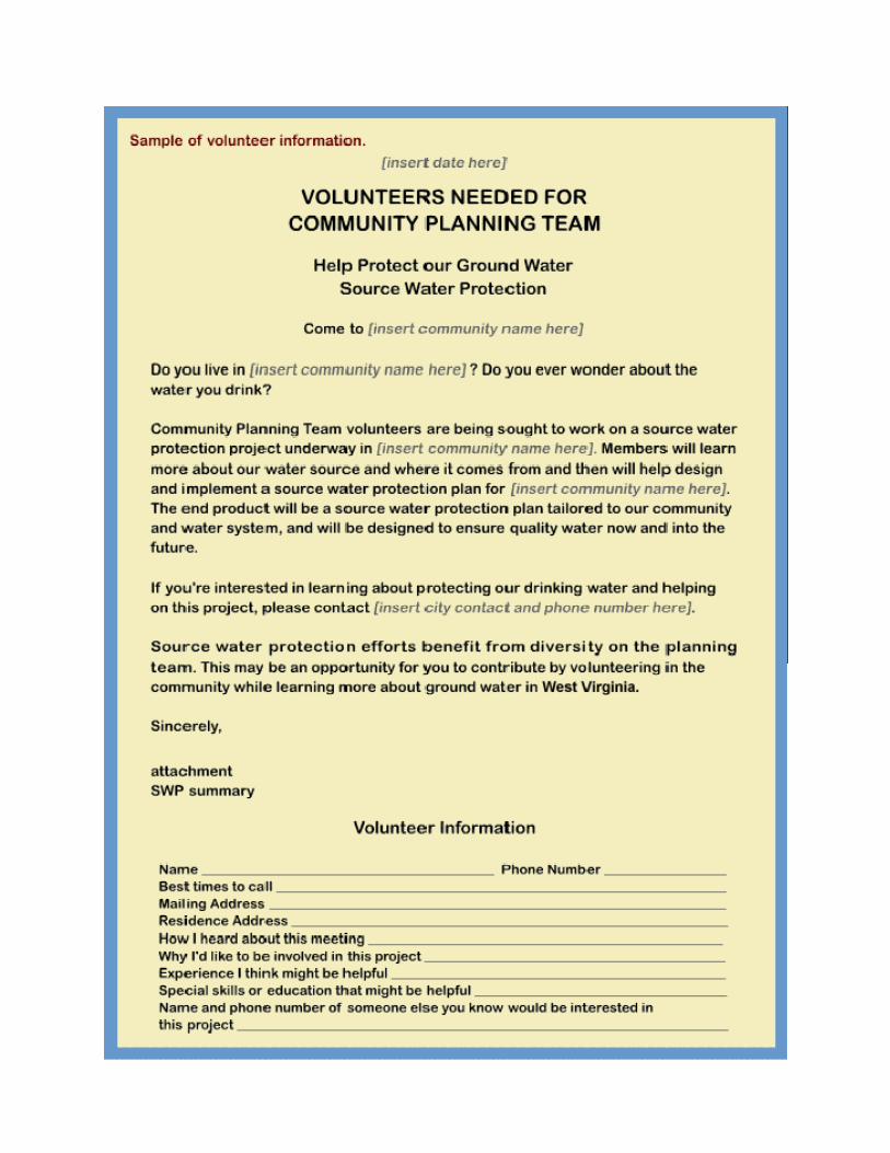
Toward the end of the meeting you will want potential volunteers to identify potential strengths they may contribute to the effort. Do this by passing out a questionnaire (see examples in Appendix A-3) to each person and ask them to write out their name, address, phone number, and a brief description of their knowledge, experience or skills they may possess that might be useful to the group. Give examples such as good writing skills; good people skills; sales ability; or technical training in geology, engineering, planning, or geography; leadership skills; or personnel management skills. Allow 5-10 minutes before collecting the information sheets.
You should pass a sign up sheet around before closing the meeting. This will allow potential volunteers to make a positive decision and will identify those persons most committed to the process. Let the others know that you will be doing follow-up calls over the next couple of
JUNE 2007 3
days because you'd like a wide variety of experience from which to choose.
4. Make follow-up calls to potential volunteers within a few days of the meeting.
Allowing more time to pass causes enthusiasm to diminish resulting in a lower recruitment rate. Many communities will need all who volunteer so you don't want to lose them through inaction or delay.
If more citizens volunteer than you have room for, you may want to increase the team size somewhat or select those that best represent the diversity of experience and skills needed for SWAP planning. Be sure to call all who wished to be considered to thank them for their interest. Remember, you may need replacements later in the process and these folks have already expressed an interest in SWAP.
If you don't attract potential volunteers to the first meeting, you will need to try to find out why and either address the problem or form a team in some other way. You may find that, despite your efforts, you can't seem to attract volunteers, in which case you will probably need to proceed without them.
TEAM RESPONSIBILITIES
The team should select a leader and secretary, set goals and timetables, assemble all pertinent documents and serve as advisors to the local entity that will eventually manage the source water protection area. The team should review the delineation of a source water protection area, the complete an inventory of potential contaminant sources, make management recommendations, and evaluate contingency plans to take care of emergencies, including plans for replacement wells or alternative sources of water. These responsibilities are further described in Steps 2-5 of this guide.
TIMEFRAME
A reasonable timeframe is about two years. The team would probably meet once a month
during the first year and perhaps every other month during the second. A project that relies on volunteers will take longer than one completed by consultants.
The team will actually set the schedule for the effort by completing a time line in the first meeting or two, so the length of time it takes to complete the project will be locally driven. While setting and achieving goals is important to keep the project on track, some flexibility is needed to account for unforeseen circumstances.
COMMUNICATE WITH THE PUBLIC
Part of the team's responsibilities will include communicating with the public. In fact, without the support of the community, you will probably fail.
Let the community know what the team is doing and learning. Involve the local newspaper and radio station. Consider writing letters to the editor. Post minutes of your meetings in a prominent place. Invite interested members of the community to attend your meetings and other planned activities.
A series of newspaper articles or an educational newspaper column is one way to raise awareness of water issues and expose the community to the efforts of the team.
To arrange this, a team member may need to meet with the newspaper editor and discuss a column of approximately 500 words every 2-4 weeks (when meeting with a editor you should be prepared to submit a couple of examples of your articles). If a regular column cannot be arranged, you might want to try for a reporter-written article based on suggested topics or your regular committee meetings.
The articles should begin very early in your SWAP process. The articles should be designed to be educational with regard to managing the local water resource and the team's activities. The articles should be relatively short and hit a few main points. Column or article topics should be timely and presented in a logical fashion. Some of the

JUNE 2007 4
topics may be sensitive to some people. While you want to present all the issues important to SWAP and ground water education, please note that each topic ends with a positive thought or idea. Refer to Appendix A-1 for suggested topics.
The SWP information you present should educate and inform a large portion of the community or newspaper readership, both within the city limits and in the adjacent area. In fact, most rural residents will enjoy learning
more about water and wells because the vast majority use wells for their domestic water supply.
When writing your articles, it is also suggested you contact the resources listed in Appendix D to better provide a local perspective on the topics. While various state officials can be contacted and even quoted, the readership is probably more interested in what's happening in your immediate area.
WHAT DO I NEED TO COMPLETE STEP 1? T Obtain “Resolution of Intent to Develop a Source Water Protection Plan”. T Schedule and publicize volunteer solicitation meeting. T Hold volunteer solicitation meeting. T Name SWAP Program Planning Team members. T Schedule first organizational meeting. T Contact WV SWAP Program personnel to arrange presentation at meeting. T Hold first SWAP Program Planning Team organizational meeting. T Designate SWAP Program Planning Team chairman and secretary. T Set goals and objectives. T Complete time-line planning calendar. T Make sub-committee assignments.
STEP 2: SOURCE WATER PROTECTION AREA DELINEATIONDelineation is the process used to identify and map the recharge area that supplies water to the well or spring, or the drainage basin that supplies water to a surface water intake. This area is referred to as the Source Water Protection (SWP) area. The size and shape of the SWP area depends on the characteristics of the aquifer, the well, and/or the watershed. It is within the SWP area that potential releases of contaminant could end up in the community's water supply. (Step 3 provides guidance for preparing a potential contamination source inventory.)
Several methodologies exist for delineating a SWP area. The appropriate methodology for any system depends on the area geology,
water source, water demand, and available resources, such as data or funding.
The WV SWAP Program, has prepared SWP area delineations for most community water systems in the state. In general these delineations can be used in a system’s source water protection planning.
However, a planning team may decide that an enhanced delineation is needed. If this is the case, refer to Appendix B for details on SWP area delineation.
To receive copies of you system’s SWP area delineation, contact the SWAP Program at (304)558-2981.

JUNE 2007 5
WHAT DO I NEED TO COMPLETE STEP 2? T Contact WV SWAP for delineation information. If the team determines that this delineation is
adequate, move on to Step 3. T If an enhanced delineation is needed, refer to Appendix B. T May need to contact PWS operator for source and pumping information to provide WV SWAP. T May need to contact WV SWAP for geologic and hydrogeologic information.
STEP 3: POTENTIAL CONTAMINANT SOURCE INVENTORYA potential contaminant source (PCS) inventory should identify all contaminant sources and land uses in the delineated SWP area and show their locations in relation to the well or intake as an overlay on the base map. Some sources may be obvious like above ground storage tanks, landfills, livestock confinement areas, highway or railroad right of ways, and sewage treatment facilities. Others are harder to locate like abandoned cesspools, underground tanks, French drains, dry wells, and wells or old dumps and mines.
Figure 1 provides general list of PCSs that may occur in any SWP area. For specific information to include in your system PCS inventory, refer to your system Source Water Assessment Report prepared by the WV SWAP Program. To obtain a copy of your system’s report, contact the SWAP Program at (304)558-2981. In addition, the SWAP Program can provide locational data for regulated PCSs.
While the inventory information obtained from the WV SWAP Program and report are useful, an effort should be made to conduct a local inventory. This will allow you to field verify the information provided and to gather new data.
Many communities have found existing citizen groups to be the best volunteers to conduct a local PCS inventory. For example, members of a senior citizen group may know the history of the community, are known and trusted by the community, and may have the time to do the necessary property inspections and interviews.
You may also interest a local high school science class in assisting with the inventory effort. Inventory data may be gathered by conducting visual or mail surveys.
DATA MANAGEMENT
PCSs and/or land uses should be identified on a base map, usually a 7.5-minute topographic map. Placing the compiled inventory information on the base map allows the team to see the number, location, and type of PCSs that exist in the SWP area, including land uses that may result in non-point source contamination.
While it is important to identify general land uses within the boundary of the SWP area; certain specific activities or sites of concern should have an inventory sheet completed due to high risk factors. Risk is elevated by proximity to the well, shallow ground water, or the nature of a land-use activity. Understanding the relationship of inventoried sources to the well or intake is important in deciding on the best management options.
When complete, you will have a base map showing general land uses in your SWP area and specific sites noted by a map locator number that corresponds to the inventory sheet upon which specific site information is maintained.
Information on the completed PCS inventory sheet should include:
JUNE 2007 6
• A unique site identification number. • Address of the site or latitude/ longitude or
township/range/section. • Name, address and phone number of
landowners. • Name, address and phone number of any
renters or lease holders. • Nature of property and type of land use
activity. • Chemicals used or stored. • Description and possible sketch of site.
Refer to Appendix C-1 for categories to aid in the inventory. PCS inventories of each local SWP area should be regularly updated and submitted to the SWAP Program as often as needed. This is important in identifying the PWS susceptibility.
SUSCEPTIBILITY DETERMINATION
Susceptibility has been defined as the potential for a PWS source to become contaminated at concentrations that would pose a drinking water concern. In most cases a susceptibility determination has been made for community water systems by the WV SWAP Program.
A system’s susceptibility is determined by considering four factors: (1) assessing the integrity of the raw water intake; including the transmission to the treatment plant; (2) assessing the sensitivity [1] of the hydrologic settings between the intake and the boundary of the delineated area; (3) inventorying and identifying the threat level of the potential contamination located within the SWP area and (4) considering the interplay among the factors.
The susceptibility analysis should provide an indication to actions that a public water system should take to protect the system’s source(s).
The Source Water Assessment Report prepared for your system provides the susceptibility determination. Updated PCS inventory information may result in a different susceptibility determination. [1] Sensitivity refers to the potential for contaminants transport, whether due to natural or human factors. More sensitive settings have a higher potential for contaminant transport and less sensitive setting have a lower potential for contaminant transport.
WHAT DO I NEED TO COMPLETE STEP 3?
T Decide on type of inventory. T Identify inventory participants. T Make inventory assignments. T Provide training. T Contact agencies for existing information. T Distribute inventory forms. T Conduct field inventory. T Prioritize sites, reduce field data. T Transfer field data to base map overlay. T Contact WV SWAP for determination of susceptibility.

JUNE 2007 7
STEP 4: SOURCE WATER MANAGEMENT PLANNINGThe goal of source water management is to protect public water systems by reducing the likelihood of contamination. Source water management plans should be written in order to be effective for the long-term protection of the system’s water source. Arrangements between adjacent jurisdictions may be necessary to implement a protection strategy that takes into account property and development rights.
MANAGEMENT TECNHIQUES
Local entities may choose to manage their SWP areas in various ways. The choice of management techniques is determined by the size and nature of the SWP area, the type of local entity, the operation of the potential source of contamination, the characteristics of the contaminant, and the source management already in place. Management techniques may include:
• PCS prohibitions and permits. • Municipal ordinances. • Design and operating standards. • Public education. • Inspectors at construction/drilling site. • Best management practices (BMPs). • Local water quality district. • Ground water monitoring. • Subdivision regulation. • Site plan review. • Sole source aquifer designation. • Purchase of property and development
rights.
It is important to prioritize the potential sources of contamination for management by determining which sources are managed adequately by existing federal or state laws or local ordinances, and which sources need additional management. Potential sources of contamination within SWP area and those that use, generate, or store chemicals that are regulated by a drinking water standard should be prioritized for management.
Trained personnel from a number of state agencies are available to provide technical assistance, including information on regulations and regional programs regarding PCSs and land use. Appendix D provides a description of these agency programs, including possible funding opportunities.
MANAGEMENT APPROACHES
When writing a source water management plan, you may consider using one or all of the following management approaches:
Control Management
Control management is applied to the SWP area immediately surrounding the well. The goal of control management in ground water systems is to protect against damage to the well and prevent the introduction of contaminants into the well or ground water in the immediate area. At surface water systems control management should be used to prevent the discharge of contaminants in the area immediately upstream from the intake.
Ownership, easement, or lease of the land may be necessary to control certain activities around or entry to the well site or intake area. Control methods include fencing the property, prohibiting improper chemical storage or use, sloping the land away from the well, building a secure well house, or installing positive controls on the intake.
Intensive Management
Intensive management is used in special protection regions where water can migrate to the well or move downstream to an intake within a short period of time. The goal of intensive management is to focus pollution prevention activities where water is expected to be captured by a pumping well or surface water intake. Intensive management may address specific contaminants such as microbes, nitrates, solvents, and herbicides.

JUNE 2007 8
Certain PWSs will also want to consider intensive management for sediment, TOC, metals, and possibly sulfates.
Intensive management includes: prohibitions against specific sources of pollution, leak detection monitoring, requirements for existing septic systems to connect to a public sewage treatment system, secondary containment for storing specific chemicals, or use of agricultural BMPs.
Protective Management
Protective management is applied to a larger portion of the aquifer supplying the well or the upper watershed area.
This approach may be most useful in areas with unconfined, fractured bedrock aquifer(s). Even though portions of the aquifer may be many miles away, fractures and solution cavities in the formation can facilitate the movement of pollutants to the well or spring.
WHAT DO I NEED TO DO TO COMPLETE STEP 4? T Prioritize potential contaminant threats within each delineated region. T Discuss possible management options. T Meet with local governing body to discuss regulatory options. T Develop or identify BMPs. T Develop education plan T Request adoption of local ordinance. T Write source water management plan.
STEP 5: EMERGENCY PLANNING
Emergency planning is one of the most valuable parts of the SWP Planning process. It puts answers to many of the "what if" type questions and can enable your system to react thoughtfully to a problem instead of reacting to a crisis. For example,
"What if a tanker spill or tank leak occurred today that caused a large pool of fuel within 300 feet of one of your wells or within a mile upstream from your intake?."
• Is the well or intake threatened? • Is there an emergency response
mechanism in place sufficient to contain the spill?
• Should you shut down the well or intake? • Can you provide an alternate and safe
supply of water for a short period of time until the threat has past?
• Do you have the funding to pay for water via a tank truck for a short period of time?
• Is providing an alternative source of water an option?
These are the types of questions to which you should have answers before you actually need them. It is a form of short- term planning.
In addition to the short-term response described above, groundwater based systems should also consider the type of response if a well is permanently contaminated. Do you have a back-up source or at least an idea of where to locate a back-up well? For example, the delineation effort will have provided useful information concerning the source of water. Use that information to complete a SWP area delineation for a new well location.
The West Virginia Bureau for Public Health highly recommends that a plan include the

JUNE 2007 9
delineation of a SWP area for a replacement well. The SWP area delineation for a future well can be a 2000-ft. radius around the well, or a more rigorous method (Appendix B) may be used to increase delineation accuracy. A PCS inventory should be completed for the replacement well SWP area, as described in Step 3.
Long term planning needs for a surface water based system vary considerably between PWSs. Surface water systems may be able to allow serious contamination threats to pass by closing intake valves and then reopening after the threat has passed. Surface water based systems on small streams should consider their response to a total loss of their current supply through contamination or drought as a response planning exercise.
To begin the Emergency Planning step, the team or operator should review the PWS emergency plan (if one exists) and make any needed modification to update the plan or, if no emergency plan currently exists, should put one together. This would also be a good time for the county Emergency Coordinator to meet with the operator or team to discuss how you will interact in the event a disaster threatens the water supply. It is important that the local emergency officials know about the SWP area to ensure priority response should a spill or disaster occur.
Disruptions to the PWS may occur due to natural disasters, accidents, or even vandalism. The local governing entity and public water supply should plan for these emergencies and should be prepared to provide an alternative drinking water supply.
Emergency or contingency plans are designated to provide public water supplies with a plan of action in the event that a drinking water source becomes contaminated, or is threatened by contamination. The plans address locating alternate, approved supplies and delivering those supplies to the users. Enhanced treatment of existing water supplies is also considered a viable option.
Each public water supply is responsible for submitting its own contingency plans to the WV SWAP for evaluation as part of the local program. Each supply will have specific needs, which is addressed in their contingency plan; however, certain general information should be included in the contingency plans. They are as follows:
• Water supply characteristics, such as source name/identification number, water demands, water source capacity or yield, distribution system layout, storage capacity, etc.
• Alternate water supply or source(s) in case of shortage, contamination, etc.
• Contact names and phone numbers in case of emergency for public water supply operator and state and local contacts.
• Financial considerations in case of contamination/ emergency.
• Provide opportunity for public participation in the development of contingency plans.
Refer to Appendix E for specific guidance and Emergency/Contingency and Land Management Short Forms. These short forms are most appropriate for smaller community systems.
WHAT DO I NEED TO DO TO COMPLETE STEP 5? T Identify principal risks to ground water in your SWAP area. T Meet with local emergency coordinator or officials. T Write detailed contingency plan. Or for smaller systems, complete the short form. T Include contingency plan in the over-all SWAP plan.

JUNE 2007 10
STEP 6: PLAN APPROVAL
A SWP plan template or fill in the blank form is included as Appendix F to aid in the development of your system’s SWP Plan. Contact WV SWAP Program personnel at (304)558-2981 for an electronic version of the template or visit:
http://www.wvdhhr.org/oehs/eed/swap/swap_ed/templates/temp.htm
Because certified operators change, as do city councils and water user association board members, the plan will be used by others who were not involved with its creation. Thus, your SWP plan should be of sufficient detail to allow an unfamiliar reader to fully understand how your water system works, what steps you have taken to identify and manage potential contaminants, and your planned response to an emergency. In other words, your source
water plan should be a document that fully describes your PWS including distribution system and water source(s). Some of the description will be written and some will be graphic (maps, diagrams, etc.) attached as appendices. The complete plan will include a title page, six chapters, a reference page, and appendices.
HOW ARE PLANS APPROVED?
To gain plan approval, a PWS submits their plan to the WV SWAP for review. The purpose of the review and certification is to verify that your plan meets the requirements of the Safe Drinking Water Act and the WV SWAP Program.
If there are sections for which you do not have complete information you will need to add it before certification.
WHAT DO I NEED TO DO TO COMPLETE STEP 6? T Publicize the status of your SWAP effort. T Compile all your SWAP information, including:
o SWP area delineation. o PCS inventory. o Source Water Management Plan. o Emergency/Contingency Plan (narrative or short form).
T Fill in any necessary missing data. T Submit plan to WV SWAP for review. T If plan review indicates data missing, adjust plan and re-submit to WV SWAP.
Appendix A
A-1 : Sample Public Service Announcement A-2 : SWAP Fact Sheet A-3 : Sample Volunteer Questionnaire A-4 : Suggested Public Education Topics


Fact Sheet Source Water Assessment and Protection (SWAP) Program
West Virginia Department of Health and Human Resources Bureau for Public Health
In 1996, Congress required all states to develop and implement program elements to protect the sources for all public water supplies by adopting Amendments to the Safe Drinking Water Act. In West Virginia, the Department of Health and Human Resources (DHHR) is developing the Source Water Assessment and Protection (SWAP) program. It was developed with input from other government agencies, private agencies, and public interests. The DHHR, Bureau for Public Health (BPH) is responsible for ensuring that source water assessments are completed for all of West Virginia’s public water systems. West Virginia’s goal is to assess all sources serving public water supply systems in the next several years. How are sources being assessed? A source water assessment provides information about the potential contaminant threats to public drinking water sources. Each source water assessment will: ►Determine where water used for public drinking
water supplies comes from (delineate the source areas);
►Inventory potential sources of contamination that may impact public drinking water sources (contaminant source inventory); and
►Assess the likelihood of a source water area becoming contaminated (susceptibility analysis).
This information will be used as a building block in developing and implementing a voluntary community source water protection management plan as a barrier to drinking water contamination. The SWAP program will provide information to direct local and state efforts to protect public drinking water sources. This information will help the State to provide more effective public water systems oversight. The SWAP Program will seek to: ►Maximize the use of existing information;
►Emphasize the use of a statewide geographic information system (GIS);
►Emphasize state and local partnerships; and ►Provide recommendations for future improvements
and protection efforts. How will the SWAP Program help the public? A vulnerable or contaminated drinking water source puts a community at a disadvantage in planning and building future capacity for economic growth. SWAP assessments will help to continue or to enhance the following: ►Development of a source water management
protection plan; ►Identification or knowledge of water quality issues
that help maintain clean, safe drinking water and increase community awareness and participation;
►Allow preventive actions to be designed and implemented before the water system becomes contaminated by identifying contamination threats to water supplies and enhance emergency response;
►Provide information that may lead to improvements in raw water quality and reduced treatment costs; and
►Prioritization and coordination of actions by federal and state agencies to better protect public health and safety.
How will the SWAP Program apply to Wellhead Protection (WHP) Program? Wellhead protection, required under Section 1428 of the federal Safe Drinking Water Act, was established to protect public ground water sources from contamination, and forms the cornerstone of the SWAP program. Wellhead protection involves many aspects of the SWAP program, including the delineation of the recharge area contributing water and the development of potential source water contaminant inventory. The ultimate goal is the development of a community-based drinking water source protection program. Elements of a comprehensive WHP program include the following:
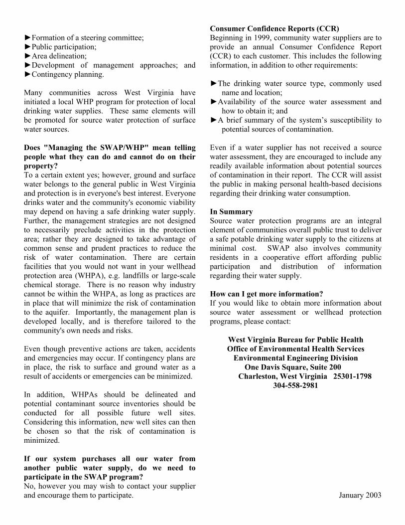
►Formation of a steering committee; ►Public participation; ►Area delineation; ►Development of management approaches; and ►Contingency planning. Many communities across West Virginia have initiated a local WHP program for protection of local drinking water supplies. These same elements will be promoted for source water protection of surface water sources. Does "Managing the SWAP/WHP" mean telling people what they can do and cannot do on their property? To a certain extent yes; however, ground and surface water belongs to the general public in West Virginia and protection is in everyone's best interest. Everyone drinks water and the community's economic viability may depend on having a safe drinking water supply. Further, the management strategies are not designed to necessarily preclude activities in the protection area; rather they are designed to take advantage of common sense and prudent practices to reduce the risk of water contamination. There are certain facilities that you would not want in your wellhead protection area (WHPA), e.g. landfills or large-scale chemical storage. There is no reason why industry cannot be within the WHPA, as long as practices are in place that will minimize the risk of contamination to the aquifer. Importantly, the management plan is developed locally, and is therefore tailored to the community's own needs and risks. Even though preventive actions are taken, accidents and emergencies may occur. If contingency plans are in place, the risk to surface and ground water as a result of accidents or emergencies can be minimized. In addition, WHPAs should be delineated and potential contaminant source inventories should be conducted for all possible future well sites. Considering this information, new well sites can then be chosen so that the risk of contamination is minimized. If our system purchases all our water from another public water supply, do we need to participate in the SWAP program? No, however you may wish to contact your supplier and encourage them to participate.
Consumer Confidence Reports (CCR) Beginning in 1999, community water suppliers are to provide an annual Consumer Confidence Report (CCR) to each customer. This includes the following information, in addition to other requirements: ►The drinking water source type, commonly used
name and location; ►Availability of the source water assessment and
how to obtain it; and ►A brief summary of the system’s susceptibility to
potential sources of contamination. Even if a water supplier has not received a source water assessment, they are encouraged to include any readily available information about potential sources of contamination in their report. The CCR will assist the public in making personal health-based decisions regarding their drinking water consumption. In Summary Source water protection programs are an integral element of communities overall public trust to deliver a safe potable drinking water supply to the citizens at minimal cost. SWAP also involves community residents in a cooperative effort affording public participation and distribution of information regarding their water supply. How can I get more information? If you would like to obtain more information about source water assessment or wellhead protection programs, please contact:
West Virginia Bureau for Public Health Office of Environmental Health Services
Environmental Engineering Division One Davis Square, Suite 200
Charleston, West Virginia 25301-1798 304-558-2981
January 2003

APPENDIX A: SUGGESTED TOPICS FOR PUBLIC EDUCATION
The Community Water System
• What is a public water system in West Virginia? • Who operates the local PWS? • What is the water source? • Provide general information about sampling requirements. • Describe physical extent of distribution system / number of users. • Describe summer vs. winter water use. • Describe per capita consumption. • Describe the cost of developing a PWS well. • Describe possible homeowner water conservation methods.
What is ground water?
• Definition and example, define aquifer. • Describe confined vs. unconfined. • Describe GW vs. SW, what is base flow? • Provide example of aquifers in the local area and their uses. • Describe benefits / risks of using shallow vs. deep aquifers. • Describe the local PWS water source.
General Concerns about Ground Water
• Describe local ground water use and quality. • Describe how GW can become unusable for these purposes. • Spills • LUST leaks • Septic tanks / lagoons • Injection wells • Storm-water infiltration • Fertilizers • Sumps / french drains / dry sumps / infiltration gallery • Storage areas • Describe general management practices that minimize risk of GW contamination. • Describe local recycling opportunities.
The Improper Handling of Solvents and Other Hazardous Material
• What are solvents? • Who uses them? • Historic methods of waste solvent disposal • Current VOC contamination in GW concerns • VOC monitoring, detects, and the local PWS • What regulations apply? • Modern methods of solvent handling

Maintenance of Underground Storage Tank
• Historic tank installation methods • The fire code • LUSTs • Gasoline / diesel and ground water • What regulations apply? • Modern methods of tank installation • Describe tank operation and maintenance procedures.
Spills in the Community; Cars, Trucks, and Trains
• Why do we care about spills? • What's a reportable spill and who gets the report? • Describe historic spills and GW in the local area. • Describe the main transport route in town and materials transported. • Describe the local DES response and PWS preparedness.
Community Sewage Treatment; the Lagoon
• What is the local public sewage treatment system? • Who operates the local system? • Describe physical extent of collection system / flow rate / number of users. • Describe sewer line infiltration and impact on local system. • Describe industrial type users and any pre-treatment requirements. • Describe substances than should not enter the treatment system. • Describe the difference between storm sewers and sanitary sewers. • Provide general information about sampling requirements. • Describe possible homeowner water conservation methods.
The Local Landfill
• Who operates the local collection / disposal system? • Landfill vs. dump, what's the difference? • Historical practices of waste disposal • Describe the connection between dumps and GW. • What regulations apply to landfills now? • How's a modern landfill constructed? • What about waste disposal on my own property? • Describe local recycling opportunities.
Septic System Installation and Maintenance
• What is a septic system? • How do they work? • Who regulates septic tanks? • What site conditions are limiting and why? • What is septic system maintenance?
• Septic system failure, what is it? • Septic system effluent as GW recharge • The do and don't list for septic systems
Agriculture and Ground Water
• Describe the primary local agricultural activities. • Describe local ground water use by agriculture. • Describe potential pollution from various agricultural activities. • Describe surface water / ground water interaction potential. • Describe general agricultural Best Management Practices (BMPs) to prevent pollution. • Describe locally used BMPs to prevent pollution, give examples.
Pesticides and Water Quality
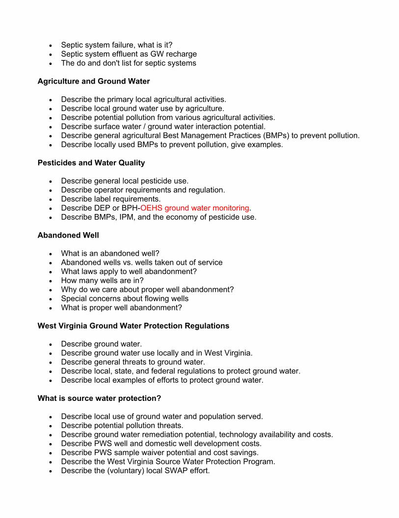
• Describe general local pesticide use. • Describe operator requirements and regulation. • Describe label requirements. • Describe DEP or BPH-OEHS ground water monitoring. • Describe BMPs, IPM, and the economy of pesticide use.
Abandoned Well
• What is an abandoned well? • Abandoned wells vs. wells taken out of service • What laws apply to well abandonment? • How many wells are in? • Why do we care about proper well abandonment? • Special concerns about flowing wells • What is proper well abandonment?
West Virginia Ground Water Protection Regulations
• Describe ground water. • Describe ground water use locally and in West Virginia. • Describe general threats to ground water. • Describe local, state, and federal regulations to protect ground water. • Describe local examples of efforts to protect ground water.
What is source water protection?
• Describe local use of ground water and population served. • Describe potential pollution threats. • Describe ground water remediation potential, technology availability and costs. • Describe PWS well and domestic well development costs. • Describe PWS sample waiver potential and cost savings. • Describe the West Virginia Source Water Protection Program. • Describe the (voluntary) local SWAP effort.

• Describe the involvement of local citizens. • Describe efforts that can be taken by a domestic well owner.
What is the community planning team?
• Describe how members were solicited and appointed. • Describe the organization of the team. • Describe the duties / function of the team. • Describe potential for citizen input.
What is Source Water Protection Area (SWPA) delineation?
• What is a SWPA? • Describe various methods of SWPA delineation. • Describe the local aquifer(s). • Describe the local method of SWPA delineation. • Describe the regions of a SWPA and how they differ. • Describe impacts to local property owners within the SWPA.
What is a potential contaminant inventory?
• Describe PWS well development costs. • Describe the local SWPA delineation and ground water flow. • Describe general potential threats to ground water. • Describe the importance of identifying threats before they are problems. • Discuss remediation vs. prevention, available technology and costs. • Describe possible inventory methods by regions. • Discuss the use of inventory information.
Management of the SWAP
• Describe the delineated SWPA. • Describe how the contaminant inventory was completed. • Outline the inventory findings. • Describe identified contaminant priorities. • Outline management options available to local government. • Describe options recommended by community planning team. • Describe benefits to community of contaminant. • Inventory and management before actual contamination occurs
What is emergency planning of the Public Water Supply?
• Describe why emergency planning is important. • Outline probable emergency responders. • Include what-if scenario. • Describe short-term emergency plan. • Describe long-term emergency plan. • Outline the cost benefits of designating a replacement well.
PWS production well development
• What is a PWS? • Who operates the local PWS? • Describe local PWS water use. • Who regulates a PWS and why? • Describe emergency plan and designated replacement well area. • Describe PWS well plan review requirements. • Describe water rights requirements. • Outline PWS well development and costs. • Compare domestic well development verses public well development.
What is Source Water Protection Program (SWPP) certification?
• Describe the 6 steps of SWAP. • Outline the local SWAP plan development. • Describe community involvement in the process. • Describe certification criteria of the West Virginia SWPP. • Describe the benefits of certification. • Describe the local SWAP plan. • Describe inventory update requirements. • Describe any long term educational or public awareness type activities required by the
local plan.

Appendix B : Enhanced Delineation Information
Appendix B : Ground Water Source for Community and Non-Community Systems
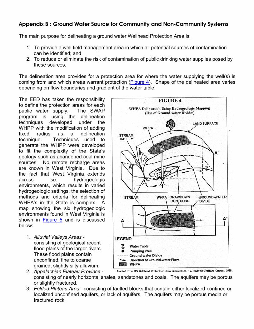
The main purpose for delineating a ground water Wellhead Protection Area is:
1. To provide a well field management area in which all potential sources of contamination can be identified; and
2. To reduce or eliminate the risk of contamination of public drinking water supplies posed by these sources.
The delineation area provides for a protection area for where the water supplying the well(s) is coming from and which areas warrant protection (Figure 4). Shape of the delineated area varies depending on flow boundaries and gradient of the water table.
The EED has taken the responsibility to define the protection areas for each public water supply. The SWAP program is using the delineation techniques developed under the WHPP with the modification of adding fixed radius as a delineation technique. Techniques used to generate the WHPP were developed to fit the complexity of the State’s geology such as abandoned coal mine sources. No remote recharge areas are known in West Virginia. Due to the fact that West Virginia extends across six hydrogeologic environments, which results in varied hydrogeologic settings, the selection of methods and criteria for delineating WHPA’s in the State is complex. A map showing the six hydrogeologic environments found in West Virginia is shown in Figure 5 and is discussed below:
1. Alluvial Valleys Areas - consisting of geological recent flood plains of the larger rivers. These flood plains contain unconfined, fine to coarse grained, slightly silty alluvium.
2. Appalachian Plateau Province - consisting of nearly horizontal shales, sandstones and coals. The aquifers may be porous or slightly fractured.
3. Folded Plateau Area - consisting of faulted blocks that contain either localized-confined or localized unconfined aquifers, or lack of aquifers. The aquifers may be porous media or fractured rock.
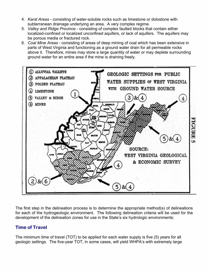
4. Karst Areas - consisting of water-soluble rocks such as limestone or dolostone with subterranean drainage underlying an area. A very complex regime.
5. Valley and Ridge Province - consisting of complex faulted blocks that contain either localized-confined or localized unconfined aquifers, or lack of aquifers. The aquifers may be porous media or fractured rock.
6. Coal Mine Areas - consisting of areas of deep mining of coal which has been extensive in parts of West Virginia and functioning as a ground water drain for all permeable rocks above it. Therefore, mines may store a large quantity of water or may deplete surrounding ground water for an entire area if the mine is draining freely.
The first step in the delineation process is to determine the appropriate method(s) of delineations for each of the hydrogeologic environment. The following delineation criteria will be used for the development of the delineation zones for use in the State’s six hydrologic environments:
Time of Travel
The minimum time of travel (TOT) to be applied for each water supply is five (5) years for all geologic settings. The five-year TOT, in some cases, will yield WHPA’s with extremely large

areas due to geologic anomalies, for example, karst areas involving major faults. In such cases, flow boundaries will be employed as the alternate criterion to delineate the WHPA.
Flow Boundaries
Flow boundaries are based on determining the locations of ground water divides and/or other physical/hydrologic features that control ground water flow. Flow boundaries are used to delineate the maximum potential zone of contribution to a well. The flow boundaries that will be used are topographic and local ground water divides for smaller aquifers, and regional ground water divides for large aquifers.
The following EPA recommended delineation methods were selected to be used in the SWAP process. Types of delineation methods to be used in the SWAP fall into three main types, computer models, hydrogeologic mapping and volumetric methods and will be discussed below:
• Computer Models - There are many types of computer generated flow models for delineating SWAP areas. These models are based on mathematical assumption that an aquifer is a granular, porous material, like sand and gravel. Figure 6 is an example of a computer model for a delineated WHPA/SWAP area.
• Analytical Modeling - This modeling technique solves ground water flow equations through simple, calculus-based mathematics, generating an exact mathematical solution for the unknown variable. Hydraulic head is usually the unknown at a given location. Analytical modeling simplifies the equation by assuming the aquifer is homogeneous and isotropic, and that flow is one or two dimensions. Results may be questionable when applied to a heterogeneous aquifer.
• Numerical Modeling -This technique can be used for modeling layered aquifers, partial penetrating wells and boundaries, variations of transmissivity and recharge, and a number of other scenarios that cannot be addressed by the analytical models. Numerical modeling capabilities are only relevant if the data is available.
• Hydrogeologic Mapping -This delineation method involves determining the flow boundaries for the area of interest and designating those boundaries as the SWAP area. An example would be the karst areas within Jefferson and Berkeley Counties, West Virginia. The karst areas are very vulnerable to contamination, because surface water enters the aquifer directly through numerous sinkholes. Since ground water travel times in area are fast, the flow direction is difficult to predict, and the aquifer is vulnerable, a regional delineation approach that encompasses the entire surficial and near surface karst is the most conservative and cost effective method. Figure 7 and Figure 8 are examples of using hydrogeologic mapping using flow boundaries to determine WHP/SWAP areas for karst and fractured zones.
Fixed Radius Method - This delineation method involves a circle of a specified radius drawn around a well or well field (Figure 6). This is an easy, fast and inexpensive way to determine the distance boundary. This type of delineation will only be used on the smaller systems consisting of the non-community non-transient and non-community transient systems in West Virginia on an interim basis.
The following guidelines will be followed to delineate a ground water source area:


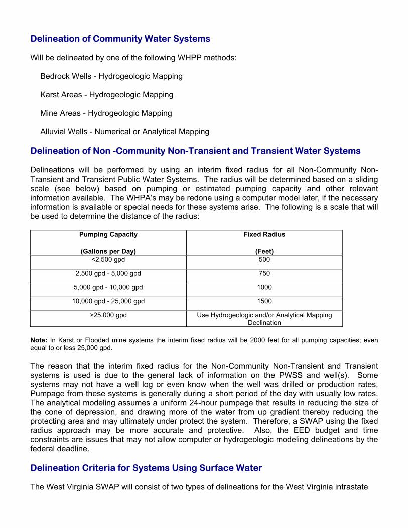
Delineation of Community Water Systems
Will be delineated by one of the following WHPP methods:
Bedrock Wells - Hydrogeologic Mapping
Karst Areas - Hydrogeologic Mapping
Mine Areas - Hydrogeologic Mapping
Alluvial Wells - Numerical or Analytical Mapping
Delineation of Non -Community Non-Transient and Transient Water Systems
Delineations will be performed by using an interim fixed radius for all Non-Community Non-Transient and Transient Public Water Systems. The radius will be determined based on a sliding scale (see below) based on pumping or estimated pumping capacity and other relevant information available. The WHPA’s may be redone using a computer model later, if the necessary information is available or special needs for these systems arise. The following is a scale that will be used to determine the distance of the radius:
Pumping Capacity
(Gallons per Day)
Fixed Radius
(Feet) <2,500 gpd 500
2,500 gpd - 5,000 gpd 750
5,000 gpd - 10,000 gpd 1000
10,000 gpd - 25,000 gpd 1500
>25,000 gpd Use Hydrogeologic and/or Analytical Mapping Declination
Note: In Karst or Flooded mine systems the interim fixed radius will be 2000 feet for all pumping capacities; even equal to or less 25,000 gpd.
The reason that the interim fixed radius for the Non-Community Non-Transient and Transient systems is used is due to the general lack of information on the PWSS and well(s). Some systems may not have a well log or even know when the well was drilled or production rates. Pumpage from these systems is generally during a short period of the day with usually low rates. The analytical modeling assumes a uniform 24-hour pumpage that results in reducing the size of the cone of depression, and drawing more of the water from up gradient thereby reducing the protecting area and may ultimately under protect the system. Therefore, a SWAP using the fixed radius approach may be more accurate and protective. Also, the EED budget and time constraints are issues that may not allow computer or hydrogeologic modeling delineations by the federal deadline.
Delineation Criteria for Systems Using Surface Water
The West Virginia SWAP will consist of two types of delineations for the West Virginia intrastate

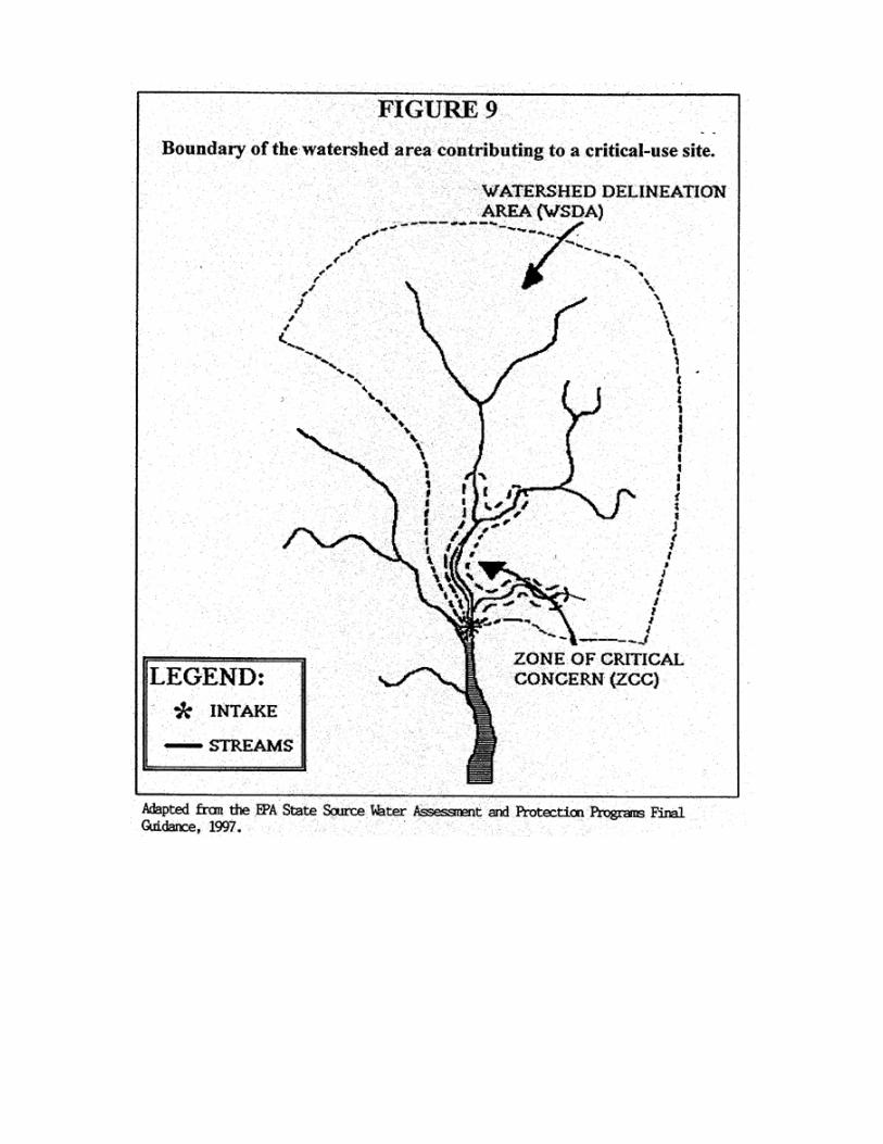
waterways. These will consist of a broad Watershed Delineation Area (WSDA) and the detailed Zone of Critical Concern (ZCC) delineation. For the PWSS along the Ohio River ORSANCO will conduct the delineations.
The WSDA includes the entire watershed area upstream of the PWSS intake structure, up to the boundary of the state borders, or a topographic boundary and is the perimeter of the catchment that provides water to the water supply intake (Figure 9). This delineation will use the eight digit and/or eleven hydrologic cataloging units (HUC) based on the watershed network established by the United States Geological Survey (USGS). An eight-digit HUC number is assigned to each of approximately 32 hydrologic units, known as watersheds that make up West Virginia (Figure 10). A smaller network within the eight digit HUCs are the 11 digit HUCs is shown on Figure 11. A total of 344 hydrologic units make up the 11 digit HUCs in West Virginia. Some modification of the HUCs may be required due to fact that the HUCs were not developed for SWAP and extend well downstream of the supply intake.
The ZCC will be a corridor along the streams, lakes, and reservoirs within the WSDA that warrants a more detailed inventory and management due to its proximity to the source water and to the susceptibility to potential contaminants.
ZCC delineations will consist of the following:
1. Free flowing streams within the WSDA will use the following configuration (Figure 9): Width 1000 feet on each bank of the principal stream and 500 feet on each bank of the tributaries draining into the principal stream. Length along Source Stream Determined on a 5-hour time of travel and using an estimated 90 percent high flow rate or up to the next upstream intake where it is available. If high flow rate data is not available to calculate flow time then a 5-MPH flow rate will be used. The stream-flow time-of-travel (TOT) approach facilitates heightened management of those stream reaches most critical to protecting drinking water intakes from potential sources of contamination. This method also enhances delineations of surface water SWP areas by facilitating spill and other emergency-response activities. This method calculates the TOT of flow in a stream between a drinking water intake and a point(s) upstream. It is the stream-flow TOT between the intake and the upstream point of interest that provides the opportunity for managers to enhance protection from long-term potential contaminant sources and to respond to a contamination event.
2. Reservoirs or lakes within the WSDA will use the following standards: Width 1000 feet on each bank of the reservoir and 500 feet on each bank of the tributaries draining into the reservoir or lake. Length along Source Stream - The free flow stream segment will be delineated following the free flow stream procedure. If a lake or reservoir is encountered within the five-hour time of travel, the following delineation will take place. If the length of the lake/reservoir is less or equal to the five hour calculated time of travel distance from the intake then the entire water body will be included. If the length of the lake/reservoir is greater than the calculated five-hour time of travel distance from the intake then the section of water body within the five-hour time of travel distance will be used to establish the ZCC Zone.


3. Ohio River Delineation - ORSANCO will delineate the Ohio River and will use a tiered -delineation system consisting of three protection zones for each Ohio River surface intake consisting of the following:
Zone 1 - Zone of Critical Concern - The area adjacent to the Ohio River from 1/4 mile downstream of the intake to a distance of 25 miles (equivalent to a 5-hour time of travel) upstream or the next upstream intake. The lateral extent of this zone extends 1/4 mile on both sides of the river and major tributaries.
Zone 2 - Zone of High Concern - All 14 digit hydrologic units adjacent to the Ohio River from a distance of 1/4 mile down stream of the intake up to a distance of 1/4 mile below the next upstream intake and all 14 digit hydrologic units adjacent to the major Ohio River tributaries a distance of 25 miles up stream or to the next upstream intake. At this time West Virginia does not have the 14 digit hydrologic units completed, therefore this zone will not be completed within West Virginia.
Zone 3 - Source Water - The entire portion of the Ohio River Basin upstream of the surface intake. This is equivalent to the West Virginia WSDA for the intrastate waterways.
The use of this method would be of greatest importance for drinking water utilities tapping rivers that receive municipal and industrial wastewater discharges. Water-quality flow models provide a means through which specific hydrologic, geographic, and water quality parameters can be used to estimate the travel time for a contaminant introduced into a river to reach a drinking-water intake and to estimate the level of contamination at that intake.
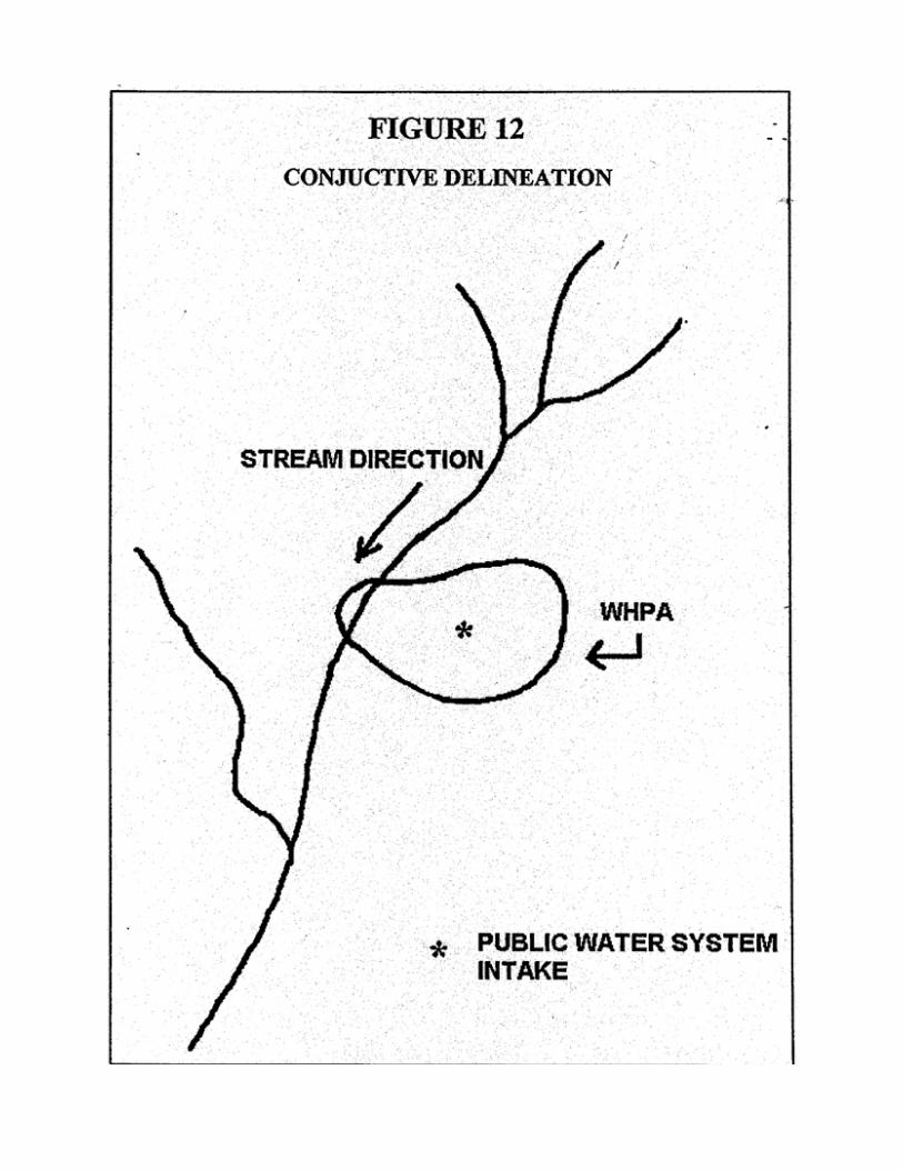
Conjunctive Delineations (Ground Water Under the Influence of Surface Water)
This is an event where a hydraulic connection of surface water to a well pumping ground water has been determined. The SWAP guidance requires the watershed for that surface water that is impacting the well(s) should have a surface water delineation performed. In West Virginia, the State is in the process of determining PWSS wells that are under the direct influence of surface water, under the Surface Water Treatment Rule. The criteria that the state uses for this determination are the identification between selected physical parameters in the wells and in surface water in the nearby streams. Using this information, West Virginia has developed a statewide standard for the GWUDI designation. Therefore, if a PWSS has been determined to be under the influence of surface water and its WHPA intersects the surface water body, than this system will be required to do a surface delineation in addition to the ground water delineation (Figure 12).

Appendix C: Potential Contaminant Source Category and Threat Levels

APPENDIX C: POTENTIAL CONTAMINANT SOURCES
The West Virginia BPH has developed Appendix E that commonly identifies sources of contamination (e.g. dry cleaners, animal feedlots) and the possible contaminants commonly associated with those sources and are based on U.S. EPA documents for conducting inventories. It is important to note that the links between the potential significant contaminant sources and the primary contaminant types are not intended to be comprehensive, but only those most commonly associated with the potential contaminant source. Any potential source may have none, some, or more types of contaminants associated with the chemicals indicated. This list will be used in the inventory efforts and presents land uses and activities considered being significant potential sources of contamination to drinking water. Each land use has been ranked relative to its threat to water quality (high, medium, low), considering the type of drinking water source, be it ground water or surface water. The risk rankings were chosen as a collective decision by the SWAP team, TAC, and CAC committees using best professional judgment. The risk rankings are a combination of the perceived risk of release of a contaminant form a land use area, chance of transport of the contaminant from the land use to the source water and the relative public health risk of the contaminant itself.
SOURCE CATEGORY SOURCE NAME
POSSIBLE ASSOCIATED CHEMICALS
THREAT TO
GROUND WATER
THREAT TO
SURFACE WATER
Agriculture Animal Burial Grounds MP L L Agriculture Animal Feedlots NN, MP, TO H H Agriculture Confined Animal Feeding
Operations NN, MP, TO H H
Agriculture Crop Irrigation NN, MP, T L L Agriculture Crops, corn, soybean, wheat NN, SOC, MP L L Agriculture Crops: orchards NN, SOC L L Agriculture Crops: other NN, MP, SOC L M Agriculture Drainage canals (agricultural) T L L Agriculture Drainage tile (agricultural) NN L L Agriculture Drainage wells (agricultural) NN L L Agriculture Farm chemical distributor NN, VOC, SOC,
PH L L
Agriculture Farm machinery areas PH, VOC L L Agriculture Fertilizer Application NN M M Agriculture Fertilizer Storage NN L L Agriculture Greenhouses/Nurseries MP, NN L L Agriculture Manure spreading or Storage* NN, MP, T, TO M H Agriculture Other animal facilities MP L L Agriculture Pasture* MP, SOC L L Agriculture Pesticide/fertilizer/petroleum
storage and transfer PH, NN, SOC, VOC
L L
Agriculture Silviculture (logging) T, PH, VOC L H Agriculture Slaughterhouses MP, TO, T, SOC,
D H M
Residential Fuel Oil Storage PH, VOC L L

SOURCE CATEGORY SOURCE NAME
POSSIBLE ASSOCIATED CHEMICALS
THREAT TO
GROUND WATER
THREAT TO
SURFACE WATER
Residential Pesticide Application VOC, SOC L L Residential Residential (multi-units) VOC, NN, TO, MP L L Residential Residential (single family homes) VOC, SOC, NN H H Residential Septic Systems (discharging to
stream or surface) MP, TO, NN H H
Residential Septic Systems (leach field)* MP, VOC, SOC, TO, NN
M M
Municipal Artificial ground water recharge areas
MP L L
Municipal Combined Sewer Overflows MP, TO, VOC, PH L H Municipal Composting facility/yard wastes MP, TO, SOC L L Municipal Demolition Debris Landfills M, HM L L Municipal Drinking Water Treatment Plants D L L Municipal Fire Stations PH, VOC L L Municipal Highway PH, VOC, M M H Municipal Historic railroad right-of-ways M, PH M L Municipal Historic waste dumps/landfills M, VOC, SOC, NN H L Municipal Illegal Dump PH, M, VOC, SOC H H Municipal Incinerators (municipal) M, HM L L Municipal Landfills/municipal M, VOC, HM,
SOC, NN L L
Municipal Managed forest SOC L L Municipal Military Base (past and present) PH, R, M, VOC,
SOC H M
Municipal Park lands NN, SOC L L Municipal Radioactive waste disposal sites R, M, HM, VOC,
SOC H H
Municipal Railroad Tracks (right of way) M, VOC, SOC, PH H M Municipal Railroad
yards/maintenance/fueling areas PH, VOC, SOC, HM, M
H H
Municipal Recycling/reduction facilities M, VOC, HM, SOC L L Municipal Road maintenance depots/deicing
operations PH, VOC, M H M
Municipal Schools SOC, D, VOC, PH L L Municipal Sewage sludge/biosolid
application M, VOC, MP, TO L L
Municipal Sewer Lines * M, VOC, MP, TO H L Municipal Storm Drains M, VOC, MP, PH L M Municipal Storm water basins/drains M, VOC, MP M M Municipal Waste transfer/recycling stations PH, M M M Municipal Wastewater Treatment Plant MP, D L M Municipal Wastewater application MP, D L L Municipal Wells: abandoned VOC, SOC, MP,
PH, NN H L
SOURCE CATEGORY SOURCE NAME
POSSIBLE ASSOCIATED CHEMICALS
THREAT TO
GROUND WATER
THREAT TO
SURFACE WATER
Municipal Wells: water supply VOC, SOC L L Municipal Swimming Pools Chlorine Commercial Airports/Abandoned airfields PH, VOC H H Commercial Above Ground Storage Tanks PH, VOC L L Commercial Auto repair shops PH, M, VOC, HM,
SOC H M
Commercial Boat services/repair refinishing PH, VOC, NN, M HM
M H
Commercial Body shops VOC, PH H M Commercial Camp grounds MP, SOC, VOC,
PH L L
Commercial Car dealerships PH, VOC H L Commercial Car washes PH, VOC L M Commercial Cemeteries M, SOC, PH L L Commercial Construction areas M, T, PH, VOC,
SOC, HM M H
Commercial Demolition areas M, T, PH, VOC M M Commercial Dry cleaners VOC, SOC H M Commercial Equipment rental/repair shop PH, M, VOC H L Commercial Fleet/truck/bus terminals M, VOC, HM,
SOC, PH H H
Commercial Funeral services and crematories M, MP, SOC, HM, VOC
M L
Commercial Furniture and fixtures manufacturers
VOC, SOC H M
Commercial Furniture repair and finishing shops
VOC, SOC H M
Commercial Gas Stations PH, M, VOC, SOC H M Commercial Gas Stations PH, M, VOC, SOC H M Commercial Golf courses VOC, SOC, PH M M Commercial Hardware/lumber/parts stores VOC, SOC, HM, M L L Commercial Heating oil companies PH, VOC H M Commercial Historic gas stations PH, M, VOC H L Commercial Hospitals R, VOC, MP, D M L Commercial Junk yards, scrap and auto PH, VOC, M, HM H H Commercial Landscaping firms VOC, PH, SOC,
NN L L
Commercial Laundromats VOC, SOC L M Commercial Lawn/farms stores VOC, SOC, NN L L Commercial Marina/boat docks PH L H Commercial Medical/dental offices/clinics MP, D, R M L Commercial Nursing Homes MP, D M L Commercial Office building/complexes PH, VOC, SOC L L Commercial Paint stores M, VOC, SOC L L
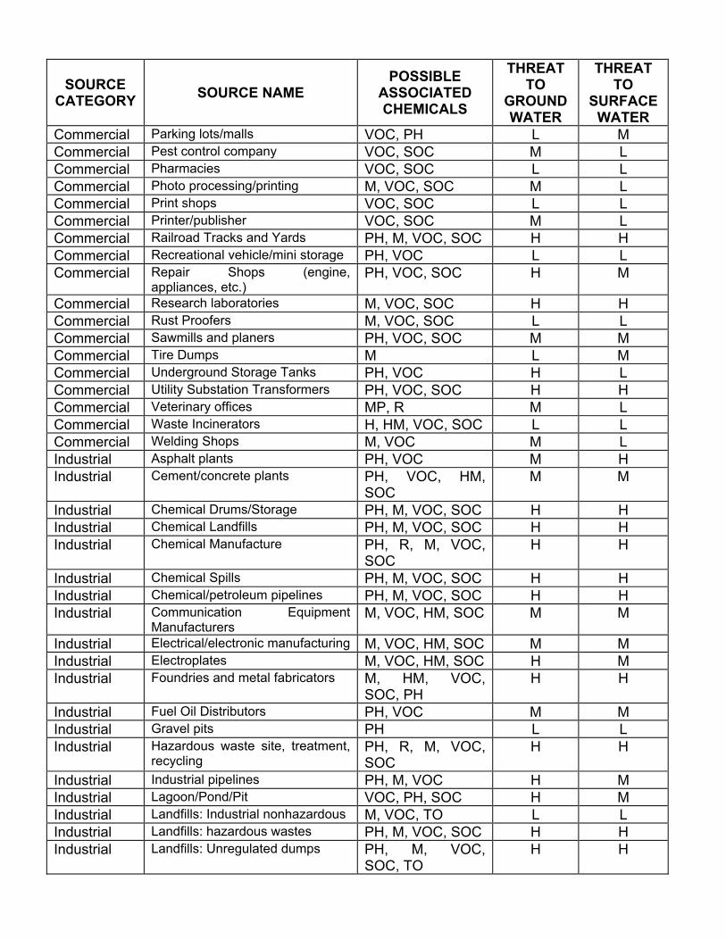
SOURCE CATEGORY SOURCE NAME
POSSIBLE ASSOCIATED CHEMICALS
THREAT TO
GROUND WATER
THREAT TO
SURFACE WATER
Commercial Parking lots/malls VOC, PH L M Commercial Pest control company VOC, SOC M L Commercial Pharmacies VOC, SOC L L Commercial Photo processing/printing M, VOC, SOC M L Commercial Print shops VOC, SOC L L Commercial Printer/publisher VOC, SOC M L Commercial Railroad Tracks and Yards PH, M, VOC, SOC H H Commercial Recreational vehicle/mini storage PH, VOC L L Commercial Repair Shops (engine,
appliances, etc.) PH, VOC, SOC H M
Commercial Research laboratories M, VOC, SOC H H Commercial Rust Proofers M, VOC, SOC L L Commercial Sawmills and planers PH, VOC, SOC M M Commercial Tire Dumps M L M Commercial Underground Storage Tanks PH, VOC H L Commercial Utility Substation Transformers PH, VOC, SOC H H Commercial Veterinary offices MP, R M L Commercial Waste Incinerators H, HM, VOC, SOC L L Commercial Welding Shops M, VOC M L Industrial Asphalt plants PH, VOC M H Industrial Cement/concrete plants PH, VOC, HM,
SOC M M
Industrial Chemical Drums/Storage PH, M, VOC, SOC H H Industrial Chemical Landfills PH, M, VOC, SOC H H Industrial Chemical Manufacture PH, R, M, VOC,
SOC H H
Industrial Chemical Spills PH, M, VOC, SOC H H Industrial Chemical/petroleum pipelines PH, M, VOC, SOC H H Industrial Communication Equipment
Manufacturers M, VOC, HM, SOC M M
Industrial Electrical/electronic manufacturing M, VOC, HM, SOC M M Industrial Electroplates M, VOC, HM, SOC H M Industrial Foundries and metal fabricators M, HM, VOC,
SOC, PH H H
Industrial Fuel Oil Distributors PH, VOC M M Industrial Gravel pits PH L L Industrial Hazardous waste site, treatment,
recycling PH, R, M, VOC, SOC
H H
Industrial Industrial pipelines PH, M, VOC H M Industrial Lagoon/Pond/Pit VOC, PH, SOC H M Industrial Landfills: Industrial nonhazardous M, VOC, TO L L Industrial Landfills: hazardous wastes PH, M, VOC, SOC H H Industrial Landfills: Unregulated dumps PH, M, VOC,
SOC, TO H H

SOURCE CATEGORY SOURCE NAME
POSSIBLE ASSOCIATED CHEMICALS
THREAT TO
GROUND WATER
THREAT TO
SURFACE WATER
Industrial Machine and metalworking shops M, VOC, HM, PH, SOC
H M
Industrial Material stockpiles (coal, metallic ores, phosphate
M, HM, T H H
Industrial Metal and Drum cleaning/reconditioning
M, VOC, SOC H H
Industrial Waste Tailings ponds (common for mining waste)
M, HM, T M M
Industrial Mines: abandoned M, T H H Industrial Mining: Surface M, T M M Industrial Mining: underground M, T H H Industrial Paper Mills M, VOC, HM,
SOC, TO M H
Industrial Permitted Discharge Pipe (outfall) ALL L M Industrial Petroleum production and storage
facilities PH, M, VOC H M
Industrial Plastics/synthetics producers VOC, SOC, M H H Industrial Public Utilities (phone, gas,
electric power) M, VOC, SOC M M
Industrial Quarry M, T, PH, VOC M L Industrial Radioactive Waste Disposal Site R, M, HM, SOC H H Industrial Sawmills PH, VOC M M Industrial Stone, clay and glass
manufacturers M M L
Industrial Surface Impoundments VOC, TO, M H H Industrial Tanneries VOC, TO, M H H Industrial Unsealed Abandoned Mines used
as Waste Pits M H H
Industrial Wells: Injection M, VOC, PH, SOC H M Industrial Wells: brine injection M, VOC, PH H H Industrial Wells: oil and gas PH, M, VOC H M Industrial Wood preserving/treatment
facilities M, VOC, SOC H H
Industrial Wood/pulp/paper mills M, VOC, TO H H Industrial Clandestine Dumping M, VOC, SOC,
TO, HM H H
* Possible Pathogen Sources
* * The potential significant contamination sources land use have been ranked according to its threat to water quality (high, medium, low). The risk ranking provides a simple approach to comparing the relative risk of the potential contaminant sources land uses. The risk rankings are based on the general nature of their activities and the contaminants associated with them, not on facility-specific information, such as management practices. However, this ranking does not take into consideration any unforeseen releases or the dynamics of new potential sources within the delineated SWAP area. Based on case specific information, BPH may also reduce

the threat ranking for an activity which is generally considered high to moderate or moderate to a low ranking based on a finding that none of the contaminants of concern are associated with that activity or may increase the ranking based on data obtained for a specific source.
Index to Associated Chemicals
MP Microbiological Pathogens: Total/Fecal Coliform, Viruses, Protozoa
NN Nitrate/Nitrite
VOC Volatile Organic Compounds
HM Heavy Metals
M Metals
SOC Synthetic Organic Compounds
T Turbidity
D Disinfection byproducts
TO Taste & Odor precursors
R Radio nuclides
PH Petroleum Hydrocarbons
DRAFT
Appendix D: Agency Regulations, Programs, and Contact Information

DRAFT
STATE AGENCY PROGRAM AND CONTACT INFORMATION A number of state agencies have interest in water resources and may be available to provide assistance to you as you develop your local SWAP program. See Table 1 for contact information.
These state agencies are responsible for enforcing a number of regulations. Knowledge of these existing regulations will aid in resource management and enable local efforts to focus on those areas not already regulated.
This document describes each state agency, including information on their regulatory duties, involvement in watershed management, and financial assistance programs.
POLLUTION SOURCES REGULATIONS
This section details state agencies which regulate potential pollution sources and may be of assistance in tailoring and enforcing local regulations and policies for water supply watersheds:
BUREAU FOR PUBLIC HEALTH (BPH) OFFICE OF ENVIRONMENTAL HEALTH SERVICES
Environmental Engineering Division
Responsibilities include the development of regulations to implement and enforce legislation, design standards and policies relating to the siting, design, construction, operation and management of public water systems. The State of West Virginia has primary enforcement responsibility for public water systems under the federal Safe Drinking Water Act. The Environmental Engineering Division carries the duties inherent in this responsibility.
Emergency Planning and Preparedness
This program provides technical professional engineering expertise in helping water and wastewater utilities and emergency service officials in preparing for emergencies of various types. Also responds to emergencies to provide on site emergency assistance to help utilities restore service while protecting public health. This program is coordinated with the state, federal, and county emergency services offices.
Public Sewage System:
Responsibilities include the development of regulations to implement and enforce legislation, design standards and policies relating to the siting, design, construction, operation and management of public sewage systems. The program is responsible for training and certification of wastewater treatment plant operators.
Source Water Assessment and Protection (SWAP) and Wellhead Protection Programs (WHPP):
The WHPP was approved by the U.S. Environmental Protection Agency in 1992 and the SWAP was approved in 1999 and has been active since then. The primary components of WHPP and the SWAP programs are public participation, wellhead protection area delineation, inventory of potential contamination sources, wellhead protection area management and contingency planning.
The WHPP mission is to establish a zone of protection around each ground water supply well to prevent unwanted contaminants and pollutants from entry. The zones, or wellhead protection areas, are established using complex technical procedures. Once delineated, the areas are used

DRAFT
by local authorities and governments to establish wellhead protection programs for their water systems. Contingency and management plans are developed for each delineated source.
The Source Water Protection Program was set up to be pro active toward the prevention of polluted drinking water and was approved by the federal EPA in 1999. Program provides technical assistance to local water utilities that develop a source water protection assessment plan within their watershed. An area around a drinking water source is delineated and designated as the zone of protection for the ground water systems and the entire watershed area for surface water systems. Within this area all possible pollution sources are identified and assessed. Contingency and management plans are developed for each delineated source.
Infrastructure Capacity and Development
This program provides detailed, on-site assessments of large, public water and wastewater systems and other environmental facilities to evaluate compliance with regulatory requirements. Detailed reports are developed to assist utilities in the development of capital improvement, operation and maintenance programs to correct deficiencies. Technical services also include health risk assessments, regulatory guidance, and evaluations to determine the most feasible alternatives for utilities to provide maximum public health protection.
Public Health Sanitation (PHS):
Responsibilities include the development of regulations to implement and enforce legislation, design standards and policies relating to the siting, design, construction, operation and management of individual homeowner’s water systems (wells, springs, cisterns, etc.) and on-site, homeowner sewage disposal systems (septic tanks and home aeration units). The local or county Health Department generally carries out specific activities involving investigation, permitting, inspections and enforcement. Public Health Sanitation is responsible for the regulation of the transport, storage and disposal of infectious waste.
DEPARTMENT OF ENVIRONMENTAL PROTECTION (DEP) Office of Environmental Remediation (OER):
This office was formed in 1997 to bring together several remediation programs. The office includes the programs for the cleanup of hazardous waste management sites, leaking underground storage tanks, and Superfund sites. OER also has established rules and regulations for a voluntary remediation program and for the establishment of brownfield sites (sites used for industrial or commercial activities that are inactive or abandoned and use public monies for cleanup of contamination that is onsite) (West Virginia Voluntary Remediation and Redevelopment Act Guidance Manual). OER administers the Voluntary Remediation and Redevelopment Act, which promotes the cleanup of contaminated sites so they can be reused. The Act encourages remediation of these sites by providing financial incentives and limiting liability. OER is the state designated agency to work with the U.S. Environmental Protection Agency (EPA) at Superfund sites. OER helps provide reviews and technical assistance for remediation designs and acts as the liaison to the public concerning these sites. OER also inputs pertinent information into the EPA database for the hazardous ranking score, which determines eligibility for sites to be put onto the National Priority List to receive funding and remediation under the Superfund program.

DRAFT
Division of Water and Waste Management:
This office is responsible for ensuring that industrial manufacturers and municipalities comply with the water pollution control act through the permitting of their effluent discharges. OWR, along with the West Virginia Water Development Authority, manages the Clean Water State Revolving Fund, which is used to provide low-interest loans to municipalities and public service districts to construct or modify wastewater treatment facilities. Low-interest loan programs have also been developed to assist farmers in implementing practices to prevent water pollution. An on-site system loan program has also been created and a pilot project (1999) is being implemented to address pollution from failing septic systems and direct discharge systems.
OWR coordinates many water-related activities for non-point source pollution, groundwater, and water monitoring. The Groundwater Program works with the various permitting staffs to ensure that groundwater protection plans are adequate; manages the monitoring well driller certification program (Bureau for Public Health performs the testing); and manages the underground injection control (UIC) program for shallow injection wells by performing the tracking, inspection, and permitting activities (Groundwater Program).
Permits Branch:
Responsible for the issuance of National Pollutant Discharge Elimination System (NPDES) permits for industrial facilities and municipal sewage treatment facilities, land application of sewage sludge, and the inspection of these sewage treatment facilities.
Non-Point Source Discharge Program:
Non-Point Source pollution is caused by diffuse sources that are not regulated as point sources and normally are associated with agricultural, silvicultural activities, urban runoff, and runoff from construction sites. Responsibilities include education, technical assistance, demonstration projects, and enforcement. Memoranda of Agreement are in force for several state agencies to manage activities and provide a mechanism for showing Best Management Practices (BMPs). Demonstration projects are conducted to provide for innovative technique development. Applicable regulations will be developed to implement the State Groundwater Protection Act and to enforce the State Groundwater Quality Standards. Enforcement of regulations is accomplished through application of the State groundwater quality standards.
Underground Injection Control Program (UIC):
The UIC program is responsible for designing, monitoring, permitting, sampling, and site investigation of underground injection wells. Responsibilities include Class I, IV, and V wells. Also, included are the development, implementation and enforcement of regulations and policies relating to the maintenance and protection of the State’s ground water for its present and future beneficial uses.
Total Maximum Daily Load (TMDL) Program:
Streams that do not meet water quality standards are put on the 303(d) list of impaired streams. This list is updated every two years based upon new information that surfaced or was generated during this time period. Listed streams are polluted based on specific parameters for which water quality standards are not being met. To bring these streams back into compliance, data is gathered and models developed to determine the amounts and locations where these loadings occur in a stream. A total maximum daily load (TMDL) is calculated for each loading source and a

DRAFT
management strategy identifying these loadings is reported. A total maximum daily load is the greatest amount of a pollutant that a stream can bear without exceeding water quality standards.
The overall process of creating a TMDL is to acquire sufficient data, either through existing or additional sampling, to determine the sources and amounts of pollutant loadings; to analyze the data and develop a strategy to bring the impaired stream into compliance; and strategy implementation. Throughout this process, all stakeholders, citizens, local, state, and federal governments, and private sectors are to be informed and involved in the process.
Hazardous Waste Management Program:
The responsibilities include: Issuance of RCRA (Resource Conservation and Recovery Act) permits, groundwater monitoring, design, site investigation, monitoring and sampling in the vadose zone, and soil sampling. In regard to monitoring after construction, the Hazardous Waste Management Office is responsible for development, surveying, and well identification.
Solid Waste Management Program:
Responsibilities include issuance of permits for municipal landfills. Ground water monitoring is required at all landfill sites with a minimum of one monitoring well above gradient and three monitoring wells below gradient.
Underground Storage Tank Program:
The Underground Storage Tank program is responsible for regulating, investigating, and monitoring underground storage tanks.
Environmental Enforcement Program:
Environmental Enforcement’s mission promotes compliance with the solid Waste Management Act, the Water Pollution Control Act, and the Ground Water Protection Act by providing assistance and enforcing conditions required of municipalities, solid waste facilities, manufacturing industry and the general public to advance the lawful management of solid waste and wastewater. As a part of this, Environmental Enforcement conducts groundwater sampling inspections (GSI) at solid waste fills, industrial and facilities around West Virginia. These GSI’s are conducted to ensure proper sampling techniques by permittees, collect samples to decide of the ground water has been influenced by activities at the site, and evaluate the permittee’s self-monitoring program according to the permit. Narrative reports from GSI’s self-monitoring program according to the permit. Narrative reports from GSI’s are drafted and provided to the permittee for their records.
Other Responsibilities:
Ground Water Regulations through the use of Ground Water Protection Plans, Monitoring Well Driller Certification and Design Standards and Ground Water Remediation for sites that do not fit under the jurisdiction of other state agency programs, such as RCRA, CERCLA, etc. OWR’s Quality Assurance Program ensures that all state environmental laboratories are certified under the Environmental Laboratory Certification Program. All data received by the DEP must come from a certified laboratory.

DRAFT
Office of Oil & Gas
Underground Injection Control (UIC) Program (Class II & III wells):
Responsible for issuance of permits and inspection of Class II & III under injection control wells. Class II wells are those used for reinjection of produced fluid from oil and gas well drilling, or for injection of freshwater for enhanced recovery of oil and natural gas. Class II wells can also be used for storage of liquefied hydrocarbons. Class III wells are used for injecting water or other suitable solvents into the ground for purposes of mineral extraction. Program responsibilities also include permitting for construction, plugging and abandonment of oil and gas wells.
Division of Mining and Reclamation
This office is responsible for regulating the coal and mineral extraction (ex. quarries) industries to ensure the protection of human health and the environment. This is accomplished through permitting, inspection, and enforcement. MR is also responsible for ensuring that surface mine sites are reclaimed. Discharge monitoring is performed by the inspection staff to ensure compliance with water quality standards.
Office of Abandoned Mine Lands and Reclamation (AML):
This office is responsible for inventorying abandoned mine sites from pre-1977 mining operations. Often these sites were abandoned with continuing damage occurring to the lands, waters, and public health and safety. This program is federally funded through a tax on coal (AML&R Abandoned Mine Lands and Reclamation). The program prioritizes mine sites based primarily on the danger to public health, safety and general welfare. Some monies can be used for the purpose of protecting, improving, enhancing or developing water supply and water treatment systems that have been adversely affected by coal mining activities (Abandoned Mine Lands & Reclamation: Intranet). Water quality monitoring occurs to aid in designing acid mine drainage treatment systems. Post water quality monitoring also occurs to determine the effectiveness of the implemented treatment system.
The WEST VIRGINIA DEP also has copies of the SARA Title III database for West Virginia.
DEPARTMENT OF AGRICULTURE (DOA) Pesticide Control Division:
The Pesticide Control Division operates under the authority of the West Virginia Pesticide Control Act of 1990 and provision of the Ground Water Protection Act of 1991. The Pesticide Control Division also carries out responsibilities of the Federal Insecticide, Fungicide and Rodenticide act (FIFRA) through cooperative agreements with the United State Environmental Protection Agency. The Pesticide Control Division has primacy for pesticide enforcement under FIFRA and has been designated as the State lead agency for pesticide applicator certification and training. The legislation mandate of the Pesticide Control Division is to regulate and control pesticides in the public interest by their registration, use and application. Activities or programs to that end include: product registration, certification and training, licensing, enforcement and laboratory analysis.

DRAFT
DIVISION OF HIGHWAYS (DOH) & CONSTRUCTION MATERIALS
The Division of Highways is responsible for assessing risks of de-icing agents and highway construction materials within established delineating zones and conduction quality assurance programs.
DIVISION OF FORESTRY (DOF) The Division of Forestry is responsible for managing the state’s forestland resources. There are three major programs within DOF; Land Owner Assistance Program, Logging and Sediment Control Program, and the Fire Program. DOF regulates the logging industry through the Logging and Sediment Control Program. Logging operators are required to be licensed and are required to submit a notification form to DOF concerning harvesting operations. Field Inspectors perform site visits to ensure compliance with all logging requirements. Through this program DOF also holds workshops and trainings to educate logging operators on best management practices and their importance. The Fire Program is responsible for the prevention and suppression of forest fires. Prevention is encouraged through educational activities and public outreach. The Land Owner Assistance Program provides technical and sometimes financial resources to assist landowners in managing their forestlands. Woodland management planning, timber sales assistance, and tree planting assistance is provided to landowners. Proper management planning aids in protecting and improving soils and water, enhance wildlife habitat, protect endangered species, and can improve timber and wood product potential while maintaining the forest’s ability for future health and productivity.
WATER ENVIRONMENTAL QUALITY BOARD (EQB)
The West Virginia Environmental Quality Board (EQB) serves two functions. First, the Board issues rules that set the water quality standards for West Virginia's surface and ground waters. The Board also has the authority to grant a variance from these water quality standards for remaining activities. The second function of the EQB is to hear appeals of orders, environmental enforcement actions and permit actions made by the Secretary of the Department of Environmental Protection or the Director of the Division of Water Resources or the Division of Waste Management.
CONSERVATION AGENCY
The State Conservation Agency works through a Conservation Partnership with the Soil Conservation Districts and the federal Natural Resources Conservation Services to provide technical, educational, and sometimes financial assistance towards the conservation of our state’s natural resources. The many programs within the agency undertake efforts towards flood control, wildlife conservation, water protection, public land protection, and the overall promotion of activities to protect the health, safety and general welfare of the public (WV Soil Conservation Agency).
Two programs under the Natural Resource Management and Development Section are the Stream Access Permitting Program for Landowners and the Emergency Watershed Assistance Program. The Stream Access Permitting Program was developed to simplify the permitting process for landowners who wanted to perform activities in and around streams such as debris removal, streambank stabilization, channel restoration, or silt, sand or gravel bar reduction (WV
DRAFT
Stream Access). This program allows the landowner to contact the Soil Conservation Districts for help in determining permit requirements and management plan design and eliminates the need for the landowner to contact and work through all the necessary government agencies.
The Emergency Watershed Assistance Program sends a review team out to assess damages after a major storm/flooding event to determine where conservation programs might be needed.
The Conservation Planning and Water Quality Section includes programs that assess activities that can impact the water quality, determines statewide flood damages, and helps in determining management strategies and planning activities needed to protect, enhance, and restore stream water quality (WV Conservation Agency).
The West Virginia Agriculture Water Quality Loan Program provides low interest loans to farmers who want to apply best management practices to reduce non-point source impacts to water quality. DEP Office of Water Resources handles the financial aspect of this program, while the Soil Conservation Agency works with the farmers and assists in the management planning and implementation. The Water Resource Assessments and Plans Program provides research, analysis, action plan and documentation on water resource needs for drinking, recreational, or flood prevention of a community.
The SCA oversees the Resource Management Training Center which is a component of the state non-point source program. This center provides training and information on water quality issues and mechanisms to prevent or reduce water quality impacts from non-point source pollution caused by agriculture, forestry, resource extraction, urban runoff, and construction (West Virginia Non-point Source Resource Management Training Center).
Soil Conservation Districts work with SCA and perform much of the hands-on field work required, such as working and providing technical assistance directly to the landowner, assisting in developing various management plans, and educating the public on conservation activities.
The Envirothon is organized by the Soil Conservation District with help from other agencies, educators, and organizations. This event tests high school students through written and hands on activities that deal with knowledge of the state’s natural resources (water, wildlife, forestry, soils, etc), problem-solving abilities, and public outreach strategies.
OTHER REGULATORY RESOURCES
In addition to state agencies, you may find additional information from the following:
• Local fire chiefs inspect work places and may have information on the hazardous chemicals used and stored.
• Federal land management agencies have inventoried hazards and prepared management plans that outline the activities occurring on the public lands. When public lands are contained within the SWP area, site-specific information is available from the land management agency. Information may be in GIS.
DRAFT
EXISTING WATERSHED MANAGEMENT PROGRAMS
A number of watershed programs are available in West Virginia that can be implemented and supported at the water supply level. The following is a brief review of the West Virginia state-sponsored watershed management programs:
DEPARTMENT OF ENVIRONMENTAL PROTECTION – Division of Water and Waste Management
Watershed Framework Program (WFP)
This program was established to process and to coordinate existing programs and activities that address water and land resource issues. The Watershed Management Framework establishes a process that outlines an overall way for government agencies to work together better. The Framework does not specify any particular programs or activities that could merge well into the process. An important note to make concerning the Watershed Management Framework, is that there is no specific additional funding toward this program. The Framework relies on existing programs and their funding sources. Assessments, management strategy developments, and project implementation are all parts of existing programs or activities of the various partner agencies. To help achieve the Framework activities, integration of existing programs is essential.
Clean Water Action Plan (CWAP)
The Clean Water Action Plan is a federal watershed approach initiative. This plan requires an assessment of the state’s watersheds, evaluation and determination of the priority watersheds, and the development of watershed restoration action’s strategies for these priority watersheds. Additional money was to be allocated for the implementation of activities within the Clean Water Action Plan. Once Congress established the federal budget, only a small amount of additional monies was created for this plan. These additional monies could only be used for non point source implementation projects. These projects were to be based upon the watershed restoration action strategies and were to be used for implementation. To become eligible to receive any additional monies, the state had to put together a Unified Watershed Assessment and determine the priority watersheds. This was to be accomplished through a committee that included state and federal government agencies and with public participation.
Watershed Assessment Program (WAP)
The program was set up to measure the quality of the state’s rivers and streams in a systematic manner so the whole state would be assessed over a period of time. Often, in the past, monitoring occurred in selected areas for specific reasons. The new WAP program deviated from this method by establishing a five-year repeating cycle that would be conducted statewide. There are basic parameters monitored at all sites, no matter where the location. Physical, chemical, and biological sampling is performed and analyzed during the fall and winter months. The results are stored in a database for easy access and reporting. This information is used to aid in identifying the existing water quality of specific streams and watersheds and helps in establishing areas where streams are polluted and restoration strategies may be warranted. However, the information does not always identify the source or cause of the pollution.
Stream Restoration Group
The purpose of the Stream Restoration Group is to perform pre- and post- implementation water quality monitoring for abandoned mine land projects. The pre-design sampling identifies where the acid mine drainage pollution problems are and the extent. Post-construction monitoring

DRAFT
measures the successes or failures of the implemented water treatment mechanisms. This group has also worked with watershed associations that are trying to restore streams that have been adversely affected by acid mine drainage. This group does specific monitoring for identifying the sources of the pollution and the extent to which these sources are causing pollution.
Appalachian Clean Streams Initiative:
The Appalachian Clean Streams Initiative was created after Environmental Protection Agency announced that acid drainage from abandoned coalmines had been identified as the number one water quality problem in Appalachia. This program focuses on the cleaning up of acid drainage problems using both private and governmental resources. This program helps to facilitate and coordinate citizen groups, university researchers, the coal industry, corporations, the environmental community, and local, state, and federal government agencies involved in cleaning up streams polluted by acid drainage. Because of the high costs to solve this form of pollution, it can only be eliminated through combined public and private efforts and resources.
One of the major goals is to better communicate to eliminate duplicative efforts among local, state, and federal government agencies working on acid drainage projects. Grassroots efforts to address acid drainage problems have been building throughout the state through watershed associations, community groups, and recreation associations, which have partnered with government and private entities.
Three grant-type programs have been developed through the Clean Streams Initiative to aid these not-for-profit organizations in their endeavor to take on the acid mine drainage issues in their watershed. These programs are the Cooperative Agreement Program, the OSM Internship Program, and the Arts and Appalachian Clean Streams Program.
DIVISION OF NATURAL RESOURCES (DNR)
The Division of Natural Resources is mainly broken up in to three sections; State Parks and Recreation, Wildlife Resources, and Environmental Resources. The State Parks and Resources Section manages the state forests and the recreational activities that occur. They also work with the U.S. Forest Service to manage the national forests.
The Wildlife Resources Section is responsible for the programs that address the management of the state’s wildlife resources and their habitats through conservation, education, and enhancement activities. This section also manages recreational activities that occur from the state’s wildlife resources (Today’s Plan for Tomorrow’s Wildlife).
Programs such as The Outdoor Wildlife Learning Sites, Cooperative Projects, Research Projects, Bird and Bat Education Trunks, and West Virginia Wild Yard Programs are designed to provide technical, educational, and sometimes monetary assistance to youths and adults to help promote the understanding and appreciation of wildlife in the environment. Some programs offer monetary grants for projects that will benefit non-game wildlife or botanical resources through education, conservation, research, species protection/identification, and habitat management. Other programs provide educational material to help learn more about wildlife and the environment, bird biology and migration, and backyard wildlife landscaping.
DRAFT
Environmental reviews for projects occurring on the state’s lands or waters are conducted to identify potential impacts on wildlife and fish and if any endangered plants or animals will be threatened or harmed.
The Wildlife Resources Section manages recreational activities such as recreational access for physically challenged, wildlife management areas, public shooting ranges, trout stocking and hatchery management.
The Environmental Resource Section works with students and other citizens to promote environmental awareness and conservation. The West Virginia Youth Conservation Program, made up of the Junior Conservation Camp and the Youth Environmental Conference, is designed to bring together youth groups and provide conservation education which includes opportunities to participate in community service conservation projects. The program also offers educational workshops concerning conservation practices, recycling, clean water, etc.
The Environmental Resource Section also coordinates the Adopt-A-Highway, and the West Virginia Make it Shine programs. These programs recruit volunteers to help in cleaning up litter along the state’s highways, parks, communities, and streams.
The West Virginia DNR Litter Control Grant Program offers financial assistance to counties, municipalities, and others planning and implementing recycling and public education programs which promote recycling and recycling markets.
POSSIBLE FUNDING SOURCES FOR SOURCE WATER ASSESSMENT AND PROTECTION
BUREAU FOR PUBLIC HEALTH (BPH) Drinking Water Treatment Revolving Fund:
This fund capitalized by the United States Environmental Protection Agency provides loans for the funding of drinking water infrastructure projects needed to achieve and maintain compliance with the federal Safe Drinking Water Act and the states Public Water Systems Regulations. The Intended Use Plan prepared each year details the intended use of funding available. The program is coordinated with other funding under the auspices of the West Virginia Infrastructure and Jobs Development Council.
DEPARTMENT OF ENVIRONMENTAL PROTECTION (DEP) The Stream Partners’ Program:
A four agency grant program that helps communities form a watershed group that works to improve their watershed through activities such as stream cleanups, public education and outreach, water quality monitoring, fish and wildlife habitat creation, stream bank stabilization, etc. (West Virginia Stream Partners). There is $100,000 in grant money available, and groups can apply for up to $5,000. This program is supported by the West Virginia Division of Environmental Protection, West Virginia Division of Natural Resources, West Virginia Division of Forestry, and the state Soil Conservation Agency.
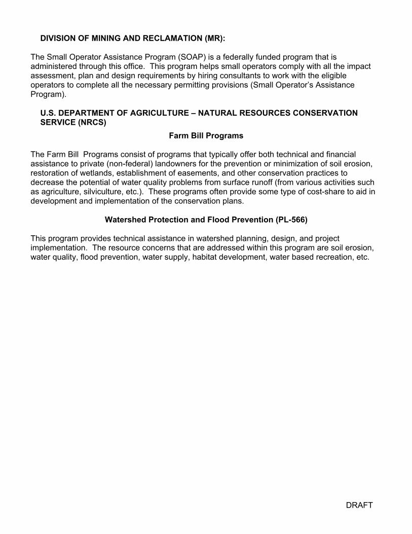
DRAFT
DIVISION OF MINING AND RECLAMATION (MR):
The Small Operator Assistance Program (SOAP) is a federally funded program that is administered through this office. This program helps small operators comply with all the impact assessment, plan and design requirements by hiring consultants to work with the eligible operators to complete all the necessary permitting provisions (Small Operator’s Assistance Program).
U.S. DEPARTMENT OF AGRICULTURE – NATURAL RESOURCES CONSERVATION SERVICE (NRCS)
Farm Bill Programs
The Farm Bill Programs consist of programs that typically offer both technical and financial assistance to private (non-federal) landowners for the prevention or minimization of soil erosion, restoration of wetlands, establishment of easements, and other conservation practices to decrease the potential of water quality problems from surface runoff (from various activities such as agriculture, silviculture, etc.). These programs often provide some type of cost-share to aid in development and implementation of the conservation plans.
Watershed Protection and Flood Prevention (PL-566)
This program provides technical assistance in watershed planning, design, and project implementation. The resource concerns that are addressed within this program are soil erosion, water quality, flood prevention, water supply, habitat development, water based recreation, etc.
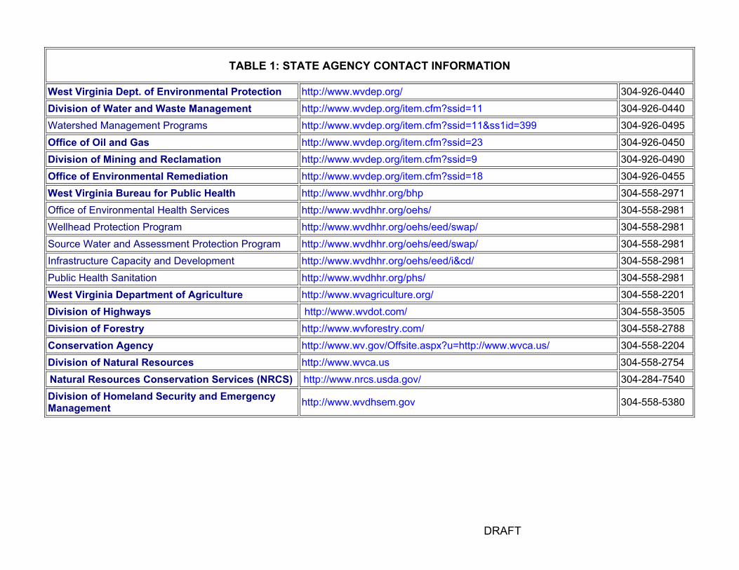
DRAFT
TABLE 1: STATE AGENCY CONTACT INFORMATION
West Virginia Dept. of Environmental Protection http://www.wvdep.org/ 304-926-0440 Division of Water and Waste Management http://www.wvdep.org/item.cfm?ssid=11 304-926-0440 Watershed Management Programs http://www.wvdep.org/item.cfm?ssid=11&ss1id=399 304-926-0495 Office of Oil and Gas http://www.wvdep.org/item.cfm?ssid=23 304-926-0450 Division of Mining and Reclamation http://www.wvdep.org/item.cfm?ssid=9 304-926-0490 Office of Environmental Remediation http://www.wvdep.org/item.cfm?ssid=18 304-926-0455 West Virginia Bureau for Public Health http://www.wvdhhr.org/bhp 304-558-2971 Office of Environmental Health Services http://www.wvdhhr.org/oehs/ 304-558-2981 Wellhead Protection Program http://www.wvdhhr.org/oehs/eed/swap/ 304-558-2981 Source Water and Assessment Protection Program http://www.wvdhhr.org/oehs/eed/swap/ 304-558-2981 Infrastructure Capacity and Development http://www.wvdhhr.org/oehs/eed/i&cd/ 304-558-2981 Public Health Sanitation http://www.wvdhhr.org/phs/ 304-558-2981 West Virginia Department of Agriculture http://www.wvagriculture.org/ 304-558-2201 Division of Highways http://www.wvdot.com/ 304-558-3505 Division of Forestry http://www.wvforestry.com/ 304-558-2788 Conservation Agency http://www.wv.gov/Offsite.aspx?u=http://www.wvca.us/ 304-558-2204 Division of Natural Resources http://www.wvca.us 304-558-2754 Natural Resources Conservation Services (NRCS) http://www.nrcs.usda.gov/ 304-284-7540Division of Homeland Security and Emergency Management http://www.wvdhsem.gov 304-558-5380
Appendix E:
Elements of an Emergency Plan Emergency/Contingency and Land Management Plan—Short Form Surface Systems-Emergency/Contingency and Land Management Plan

ELEMENTS OF AN EMERGENCY PLAN
The public water supply must have an emergency plan describing procedures to be followed to correct problems with the distribution system, wells, and source water. The plan should describe the following:
I. Identification of possible disruption threats.
A. Have you identified the principal threats to your PWS? B. Have you educated water system users in recognition of principal threats and recommended
response?
II. Designation of an emergency coordinator for the public water supply.
A. Have you designated an emergency coordinator for the PWS? B. Has this person been trained in emergency procedures? C. Do other PWS personnel and local/state OES coordinators know to contact the designated
emergency coordinator when an emergency arises? D. Have you described the chain of command at the local level and within the OES system. E. Have you identified the legal authority that authorizes an emergency response.
III. Equipment and material resources.
A. Have you identified equipment and material resource needs for principal threats to your PWS?
B. Have you identified which items need to be on hand and which need to be available? C. Have you described how you will access equipment and materials in an emergency?
IV. Procedures to shut down and isolate the threatened or contaminated well from the distribution system.
A. Can you isolate various parts of your distribution system? B. Can you monitor selected parts of your system if contaminants have gained entry? C. Are important shut off valves mapped, marked, and maintained?
V. Procedures to coordinate with county and state emergency response agencies.
A. Have you added your contingency plan to the county's Comprehensive Disaster and Emergency Plan?
B. Have you included a list of local and state DEP personnel names and phone numbers?
VI. Procedures to effectively communicate with the water users.
A. Have you established a policy concerning how and when you will alert the media such as radio, newspaper, and TV?
B. Have you described how to directly alert water users if an emergency warrants such action?
VII. Sources of emergency water for drinking and other household uses as well as sources of equipment to transport, disinfect, and distribute the water.
A. Do you have a list of possible alternative sources of BPH approved potable water and supply plan?
B. Do you have a plan for water rationing? C. If your normal water system is disrupted, do you have a mechanism for emergency water
disinfection?
VIII. Procedures to decontaminate the distribution system and the well.
A. Have you described how you might disinfect or decontaminate the entire water system? B. Have you described a policy for resumption of water service following disruption?
IX. Sources of emergency funds and procedures for requesting and dispersing such funds.
A. Have you budgeted emergency funds? B. Do you know how to request emergency funds from the state? C. Have you planned long term well replacement, have you identified funding mechanisms?
X. Replacement well or wellfield.
A. Have you identified the replacement well location on your base map? B. Have you shown a 2000' radius as the delineated SWPA on your base map? C. Have you included the contaminant source inventory for the replacement well SWPA?
An emergency plan can be developed by completing the following example emergency plan or by addressing each of the indexed items listed above as a section heading and then providing a descriptive answer, name and phone number list, or map to the bulleted questions. The following information may help you complete your contingency plan development. Possible disruption threats include chemical or fuel spills, leaking above or underground storage tanks, pipeline leaks, flooding, pump failure, main breaks, power outages, and vandalism. A major highway, rail line or industrial area near your well or intake may increase the chances of an emergency. The inventory step should have identified many of these potential threats already. Water-system users can also assist in the recognition of emergency situations by educating them through an annual water bill insert. Once a problem is identified and reported, response personnel need to be notified. A roster with names, telephone numbers, responsibilities, and back-up personnel should be created. A chain of command should describe each individuals responsibility and one person should be designated as the emergency coordinator. The legal authority under which you act can be identified through discussions with the local OES coordinator or the local governing body. It is especially important for non-municipal PWSs to know what authority they can use to protect their water supply in the event a crisis occurs. A list of existing and needed equipment and materials (spare parts, disinfection chemicals, spill containment supplies, personnel protective equipment) should be compiled. Sources for outside assistance and equipment that may be needed in a emergency such as well drillers, excavators, portable pumps, generators, emergency disinfection equipment and technical consultants should be identified. A contact sheet listing the need and probable source should be generated. A map of your distribution system with important valve locations should be included in the contingency plan. It may be possible to color code various sections of your system on the map to clearly identify sections that you can isolate and where the valves are located. Include a

description of your maintenance schedule for important valves. The map should also show possible sample points to be used in the event a contaminant is isolated in certain parts of the system. Contact the local OES coordinator (usually at the courthouse or through the sheriffs office) to be sure they are aware of your SWAP area delineation and contingency plan. Many OES coordinators aren't specifically aware of PWS emergency planning and this is an opportunity to coordinate but not duplicate efforts. A listing of locally available media contacts should be generated. You should also develop a policy regarding media contact and designate a specific media contact person to ensure correct information is disseminated when deemed necessary. Regulations concerning many potential contaminants dictate how and when you must notify your water system users of a Maximum Contaminant Level (MCL) exceedance. Some situations require an immediate alert mechanism so you need to identify ways in which you can reach your users such as a phone network. For example, a water system operated by an water user's association may state that the operator will contact each board member who in turn will contact a specified portion of the water users. There are several ways to replace a contaminated water supply. Some systems may have access to a back-up well that could be physically connected to the distribution system should the need arise. It is wise to ensure that the back-up is maintained in a potable condition. Other systems may use bottled water or a water hauler may provide an emergency supply. Identify these possible sources and make sure they are an approved source. You should also include a written procedure describing routine tank truck disinfection because this is often the weak link in a short-term water supply plan. Resumption of water service following an emergency is usually based on one or more "clean" samples and may be dictated by regulation. Your local health department may be willing to assist with sample collection that should be verified now and included in your emergency plan. You should be aware of emergency funding sources that may exist at both the local and state levels. Contact the local OES coordinator and the PWS program for assistance. A list of possible funding sources and contacts should be maintained so valuable time is not lost dealing with this issue during an emergency. For new public water supply wells, construction standards for large public water systems are contained in OEHS-EED circulars. The standards require submission of plans and specifications to OEHS-EED prior to construction. The design engineer must ensure that the proposed well site is not threatened by known contamination events. Before anyone can drill a new well that serves more than 25 people per day, the owner must obtain a permit from the OEHS-EED. A good technique to use after you have developed an emergency plan is to run through a couple of mock emergencies. You cannot anticipate everything, but pre-planning can save many headaches when something really does happen. Emergency plans should be dynamic and should include a built-in mechanism for annual review and updates. You might try to tie your emergency plan review and update to some other regularly scheduled event or put it on the time line planning calendar you use for sample planning.

EMERGENCY/CONTINGENCY AND LAND MANAGEMENT PLAN–SHORT FORM
PLEASE CHECK APPROPRIATE ITEM(S). PRINT OR TYPE AND ATTACH ADDITIONAL SHEETS IF NEEDED.
System Name: ________________________________________________County:___________________ Address: _________________________________________________ PWSID#: _________________ _________________________________________________ Date:_____________________ Telephone:_______________________Fax:___________________Email:___________________________ 1. The water users will be notified of a water emergency by:
Word-of-mouth ___ Posted notices ___ Door-to-door canvas ___ Radio ___ Newspaper ___ Other _______________________________________________________________________________
2. Phone numbers for emergency services: Police: __________________________ Fire: _____________________ Ambulance: _________________ County Director of Emergency Services (Name and number) _____________________________________ _______________________________________________________________________________________
3. Name, location, and phone number of person(s) that the consumer should notify regarding a potential problem so that the operator can assess the potential problem and notify the appropriate parties: _______________________________________________________________________________________
4. This plan will be reviewed every five (5) years. The revised plan will be dated and distributed to the following: ______________________________________________________________________________
5. The most likely causes of a water disruption are: Drought ___ Contaminant spill ___ Other _________________________________________________________________________________
6. Short-term alternative sources of water are: ____ Locally purchased bottled water ____ Transported by (name and phone) ______________________________________________________ ____ Backup well (Is this well located in a wellhead protection area? Yes___ No___ If not, when will one
be submitted _______________________________________________________________________ ____ Other _____________________________________________________________________________
7. Long-term alternative sources of water are: ____ Another well (Is this well located in a wellhead protection area? Yes___ No___ Have necessary
rights been obtained? Yes___ No___) ____ Connection to another system (name)____________________________________________________ ____ Other _____________________________________________________________________________
8. The following land management method(s) apply: ___ Site review (The frequency that the wellhead protection area will be inspected for new potentially
contaminating sources is __________________________________, e.g. quarterly). ___ Purchase of property or development rights (include a general description and state if a revised
wellhead protection area is needed). ___ Introduction of best management practices (BMPs), e.g. storm water runoff, agricultural practices, salt
storage, etc. (include a description) ___ Site specific design or operating standards (include a description) ___ Source prohibitions (include a description) ___ Zoning Ordinances / Subdivision Ordinances (include a description) ___ Other _____________________________________________________________________________

9. Public participation and education will be accomplished by: Word-of-mouth ___ ___ Posted notices ___ Public meetings ___ Pamphlets ___ Lectures ___ Other _____________________________________________________________________________ 10. List any additional ideas or explanations of possible source water activities for your area in the space
provided below. __________________________________________________________________________________________________________________________________________________________________________________________________________________________________________________________________________________________________________________________________________________________________________________________________________________________________________________________________________________________________________________________________________________________________________________________________________________________________________________________________________________________________________________________________________________________________________________________________________________________________________ This survey was completed on ______________ by ____________________________________
Date Signature
____________________________________ Printed Name ____________________________________ Position Title ____________________________________ Operator Certification Number
THANK YOU!!! The Source Water Assessment and Wellhead Protection Program is administered by the WV Department of Health and Human Resources, Bureau for Public Health. The EMERGENCY/CONTINGENCY AND LAND MANAGEMENT PLAN information provided will be used to update and maintain the currently approved wellhead/source water protection plans and related projects. If you have any questions or comments regarding this survey, please contact Scott Rodeheaver at: Office of Environmental Health Services Capitol and Washington Streets 1 Davis Square, Suite 200 Charleston, WV 25301-1798 Phone: 304.558.6713 Fax: 304.558.0324 Email: [email protected] Website at http://www.wvdhhr.org/oehs/eed/swap/

SURFACE SYSTEMS - EMERGENCY/CONTINGENCY AND LAND MANAGEMENT PLAN (Please Keep a Copy for Your Files)
PLEASE CHECK APPROPRIATE ITEM(S). PRINT OR TYPE AND ATTACH ADDITIONAL SHEETS IF NEEDED. System Name: ___________________________________________________ County:___________________ Address: ____________________________________________________ PWSID#: _________________ ____________________________________________________ Date:_____________________ Telephone: ________________________Fax:___________________Email:__________________________ 2. The water users will be notified of a water emergency by:
Word-of-mouth ___ Posted notices ___ Door-to-door canvas ___ Radio ___ Newspaper ___ Other _________________________________________________________________________________
2. Phone numbers for emergency services:
Police: __________________________ Fire: _____________________ Ambulance: _________________ County Director of Emergency Services (Name and number) _____________________________________ _______________________________________________________________________________________
3. Name, location, and phone number of person(s) that the consumer should notify regarding a potential problem
so that the operator can assess the potential problem and notify the appropriate parties: _______________________________________________________________________________________
4. This plan will be reviewed every five (5) years. The revised plan will be dated and distributed to the following:
______________________________________________________________________________ 5. The most likely causes of a water disruption are: Drought ___ Contaminant spill ___ Flooding ________
Other _________________________________________________________________________________ 6. Short-term alternative sources of water are:
____ Locally purchased bottled water ____ Backup well ____ Transported by (name and phone) ______________________________________________________ ____ Other _____________________________________________________________________________
7. Long-term alternative sources of water are:
____ Another intake or well (Is this intake or well available for use?) Yes___ No___ ____ Connection to another system (name)____________________________________________________ ____ Other _____________________________________________________________________________
8. Intake shut down is the responsibility of ______________________________________________________ 9. A list of possible contractors needed during an emergency is maintained? Yes___ No___ This list is
maintained and updated by ________________________________________________________________ 10. Please identify any local source water protection management activities on the list below that you are Planning
to do with a (P), Currently doing with a (C), or have Interest in doing with an (I) in your area. _____ Risk Management Plans _____ Emergency Response Plans _____ Contingency Plans _____ Participate in an early warning communication network _____ Stream monitoring beyond the normal regulatory requirements
1
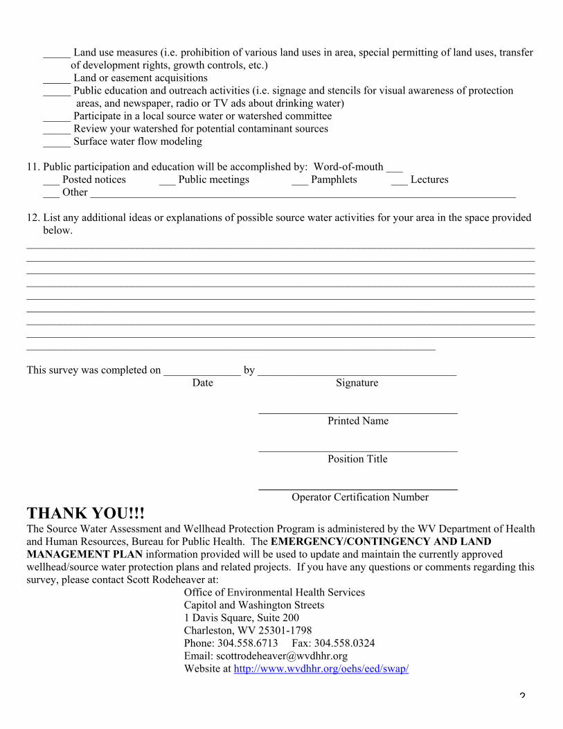
_____ Land use measures (i.e. prohibition of various land uses in area, special permitting of land uses, transfer of development rights, growth controls, etc.)
_____ Land or easement acquisitions _____ Public education and outreach activities (i.e. signage and stencils for visual awareness of protection
areas, and newspaper, radio or TV ads about drinking water) _____ Participate in a local source water or watershed committee _____ Review your watershed for potential contaminant sources _____ Surface water flow modeling
11. Public participation and education will be accomplished by: Word-of-mouth ___ ___ Posted notices ___ Public meetings ___ Pamphlets ___ Lectures ___ Other _____________________________________________________________________________ 12. List any additional ideas or explanations of possible source water activities for your area in the space provided
below. __________________________________________________________________________________________________________________________________________________________________________________________________________________________________________________________________________________________________________________________________________________________________________________________________________________________________________________________________________________________________________________________________________________________________________________________________________________________________________________________________________________________________________________________________________________________________________________________________________________________________________ This survey was completed on ______________ by ____________________________________
Date Signature
____________________________________ Printed Name ____________________________________ Position Title ____________________________________ Operator Certification Number
THANK YOU!!! The Source Water Assessment and Wellhead Protection Program is administered by the WV Department of Health and Human Resources, Bureau for Public Health. The EMERGENCY/CONTINGENCY AND LAND MANAGEMENT PLAN information provided will be used to update and maintain the currently approved wellhead/source water protection plans and related projects. If you have any questions or comments regarding this survey, please contact Scott Rodeheaver at:
Office of Environmental Health Services Capitol and Washington Streets 1 Davis Square, Suite 200 Charleston, WV 25301-1798 Phone: 304.558.6713 Fax: 304.558.0324 Email: [email protected] Website at http://www.wvdhhr.org/oehs/eed/swap/
2

Appendix F: Template for Preparing a Source Water Assessment and Protection Plan


