78
GUIDELINE MINE REHABILITATION PORTAL
GUIDELINE
MINE REHABILITATION PORTAL
1
GUIDELINE: MINE REHABILITATION PORTAL
Document control
Published by NSW Resources Regulator
Title: Guideline: Mine Rehabilitation Portal
First published: 02 July 2021
Authorised by: Director Compliance, NSW Resources Regulator
CM9 reference: DOC21/464516
AMENDMENT SCHEDULE
Date Version Amendment
02 July 2021 1 First published
© State of New South Wales through Regional NSW 2021. You may copy, distribute, display, download and otherwise freely deal with this publication for any purpose, provided that you attribute Regional NSW as the owner. However, you must obtain permission if you wish to charge others for access to the publication (other than at cost); include the publication in advertising or a product for sale; modify the publication; or republish the publication on a website. You may freely link to the publication on a departmental website.
Disclaimer: The information contained in this publication is based on knowledge and understanding at the time of writing (July 2021) and may not be accurate, current or complete. The State of New South Wales (including Regional NSW), the author and the publisher take no responsibility, and will accept no liability, for the accuracy, currency, reliability or correctness of any information included in the document (including material provided by third parties). Readers should make their own inquiries and rely on their own advice when making decisions related to material contained in this publication.

2
GUIDELINE: MINE REHABILITATION PORTAL
Contents Purpose of this guideline ............................................................................................................................... 3
Mine rehabilitation portal ............................................................................................................................. 3
Portal functions.............................................................................................................................................. 3
Computer environment information ............................................................................................................. 4
Portal access and account registration .......................................................................................................... 4
Spatial data format requirements ................................................................................................................. 6
Theme details and submission requirements ............................................................................................ 6
Schema requirements ................................................................................................................................ 7
Accuracy ..................................................................................................................................................... 9
Submission procedure ................................................................................................................................. 10
File upload ................................................................................................................................................ 10
Online tracing ........................................................................................................................................... 12
Aerial imagery upload .............................................................................................................................. 13
Data review .............................................................................................................................................. 13
Access to supplied data ............................................................................................................................... 13
Attached – List of themes: Tables 1-10 ....................................................................................................... 21

3
GUIDELINE: MINE REHABILITATION PORTAL
Purpose of this guideline Conditions of a mining lease granted under the Mining Act 1992 require the lease holder to:
prepare a rehabilitation management plan (large mines only) in the form and way approved by the Secretary. This includes the submission of a final landform and rehabilitation plan via the mine rehabilitation portal.
prepare an annual rehabilitation report (small and large mines) in the form and way approved by the Secretary. This includes (for large mines) the submission of spatial data relating to disturbance areas, rehabilitation status and achievement of established rehabilitation during the reporting period in accordance with Plan 1 – Status of mining and rehabilitation at completion of annual reporting period.
prepare a forward program (small and large mines) in the form and way approved by the Secretary. This includes (for large mines) the submission of spatial data relating to a three-yearly forecast of cumulative disturbance and rehabilitation progression that is planned over this three-year period in accordance with the submission of Plan 2 – Mining and rehabilitation three-year forecast.
The purpose of this guideline is to assist lease holders with the submission of the above spatial data (as detailed in Table 1) via the mine rehabilitation portal.
Mine rehabilitation portal The mine rehabilitation portal has been developed to streamline the collection of rehabilitation geographical information system (GIS) spatial data from lease holders. The mine rehabilitation portal is an online portal that can be accessed via the internet after account registration and approval. This will allow for collection of the spatial data into a centralised geodatabase, which will be used by us to monitor and regulate the rehabilitation of mining activities.
Portal functions The mine rehabilitation portal provides a secure portal (or web application) to allow lease holders to submit, and the Department to review, spatial information within the web application’s map viewer. Spatial data provided in a GIS format facilitates a range of functions that are not readily achieved by reviewing data in hard copy or PDF format. These functions include:

4
GUIDELINE: MINE REHABILITATION PORTAL
providing two options for the submission of spatial data:
uploading completed shapefiles/file geodatabases through the portal or
via the online tracing workflow within the map viewer.
online validation of data to facilitate submissions
calculating rehabilitation key performance indicators (KPIs) using the KPI Report workflow
recording and maintaining all submissions logged within the portal that can then be subsequently downloaded
reviewing current and previous data submissions within the map viewer.
Our website provides a range of guidance material, including how-to videos, covering the functions outlined above. This includes guidance regarding how to submit files, using tracing features, uploading imagery and viewing maps.
Computer environment information The mine rehabilitation portal is designed to World Wide Web Consortium (W3C) compliant browsers that are compatible with HTML5 developed sites. The recommended environment is a Microsoft-based computer, with a modern, and up-to-date operating system (at least Windows 7) with the following browsers:
Google Chrome: version 56 or greater (preferred)
Internet Explorer: version 11 or greater
Edge: version 39 or greater (Windows 10 or higher)
Firefox: version 55 or greater.
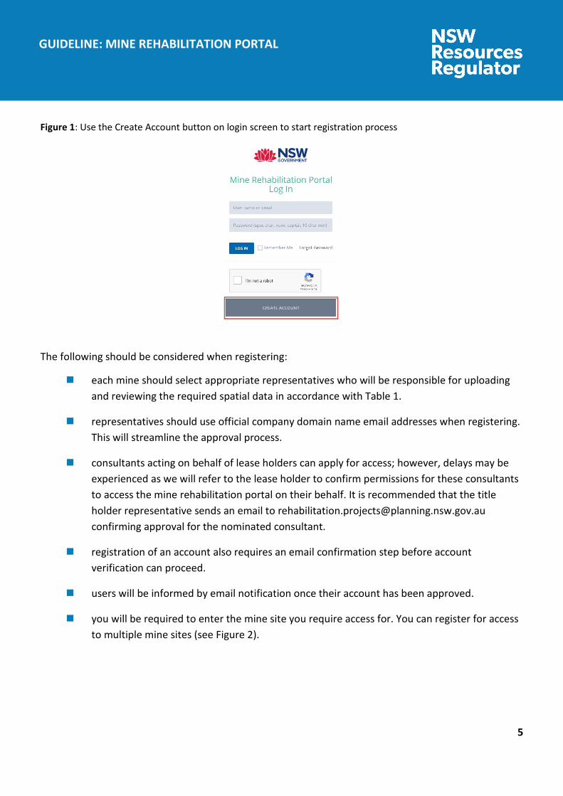
Portal access and account registration The mine rehabilitation portal can be accessed at the following web address: minerehabilitationportal.nsw.gov.au
Representatives from each mine are required to register their details via the ‘Create Account’ section link at the bottom of the initial login page (see Figure 1).
5
GUIDELINE: MINE REHABILITATION PORTAL
Figure 1: Use the Create Account button on login screen to start registration process
The following should be considered when registering:
each mine should select appropriate representatives who will be responsible for uploading and reviewing the required spatial data in accordance with Table 1.
representatives should use official company domain name email addresses when registering. This will streamline the approval process.
consultants acting on behalf of lease holders can apply for access; however, delays may be experienced as we will refer to the lease holder to confirm permissions for these consultants to access the mine rehabilitation portal on their behalf. It is recommended that the title holder representative sends an email to [email protected] confirming approval for the nominated consultant.
registration of an account also requires an email confirmation step before account verification can proceed.
users will be informed by email notification once their account has been approved.
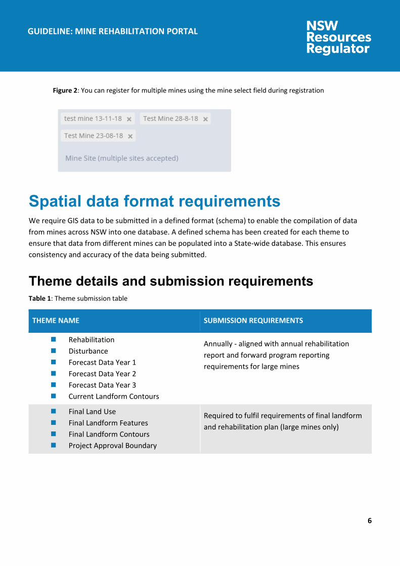
you will be required to enter the mine site you require access for. You can register for access to multiple mine sites (see Figure 2).
6
GUIDELINE: MINE REHABILITATION PORTAL
Figure 2: You can register for multiple mines using the mine select field during registration
Spatial data format requirements We require GIS data to be submitted in a defined format (schema) to enable the compilation of data from mines across NSW into one database. A defined schema has been created for each theme to ensure that data from different mines can be populated into a State-wide database. This ensures consistency and accuracy of the data being submitted.
Theme details and submission requirements Table 1: Theme submission table
THEME NAME SUBMISSION REQUIREMENTS
Rehabilitation Disturbance Forecast Data Year 1 Forecast Data Year 2 Forecast Data Year 3 Current Landform Contours
Annually - aligned with annual rehabilitation report and forward program reporting requirements for large mines
Final Land Use Final Landform Features Final Landform Contours Project Approval Boundary
Required to fulfil requirements of final landform and rehabilitation plan (large mines only)

7
GUIDELINE: MINE REHABILITATION PORTAL
Schema requirements The tables attached at the end of this guideline (Tables 1-10) describe the schema requirements for the themes listed above. Data submitted must follow the schema format to ensure successful validation and submission into our database. The mine rehabilitation portal ensures that data is compliant with the schema through an automated validation process before it can be submitted.
Lease holders should refer to the guidance notes provided for each attribute in the ‘description’ column in Tables 1-10.
The information below provides important points to note for the data submission.
All Themes
Domain lists – some of the fields require specific values populated only (domain lists) as defined in Tables 1-10. Information provided in these fields must exactly match the list provided, otherwise the mine rehabilitation portal will reject the data set (e.g. spelling and spaces must be identical). The template File Geodatabase provided on the mine rehabilitation portal link has these domain lists prepopulated.
Mandatory fields – themes include both mandatory and non-mandatory attributes. Mandatory attributes must be included for the data to pass validation. Non-mandatory attributes are considered by us as useful but not compulsory. We therefore recommend providing this data, if available.
Reporting year selection (during upload) - The reporting year selected in the upload page must correlate to the year in which the reporting period ends (e.g. if the reporting year ends in March 2019, the reporting year is 2019). The mine rehabilitation portal provides an option to select the previous year as the reporting year, in instances when reporting period and submission date are in separate years (e.g. if the reporting period ends 31 December 2020, the submission will occur in early 2021. The reporting year would be 2020).
KPI calculations – The KPI data calculated by the mine rehabilitation portal (KPI report functionality) use the reporting year selected during upload to calculate areas of active rehabilitation and disturbance. Therefore, it is important that attribute information of ‘year landform established’, ‘year vegetation established’ (rehabilitation theme) and ‘disturbance year’ (disturbance theme) correlate with this reporting year value where active rehabilitation/disturbance has occurred.
Rehabilitation theme
Polygons should represent annual rehabilitation progress, where rehabilitation methods/attributes are similar. Polygons should further be created where there are differences in attribute information (e.g. if different soil treatment was used or if areas are at different phases of rehabilitation or targeting different vegetation communities (e.g. plant community types)).

8
GUIDELINE: MINE REHABILITATION PORTAL
Year vegetation established - Include details in endorsement field for any uncertainties or for data over multiple years. In the event of multiple years, only enter the most recent year of activities and include details of previous activities (e.g. staged establishment of multi-storey communities) in the ‘Additional Information’ field. If vegetation is not yet established, use date of year landform established until vegetation is established and then update.
Disturbance theme
Polygon areas should be created based on the different mining domain types. Polygons should be further refined where differences in attribute information exists (e.g. if different disturbance year). The disturbance theme must show total mine disturbance footprint up until this reporting year (includes rehabilitated areas). This is important for the calculation of KPI data.
Final land use theme
Spatial reference field - The spatial reference is an alphanumeric code used for linking rehabilitation objectives/rehabilitation completion criteria with the spatial data for final land use and mining domains. The spatial reference is created by combining the code of the final land use domain and mining domains for each polygon as set out in the table below (for example A2 would be the spatial reference for a final land use of native ecosystem that has a mining domain of tailings storage facility). Every final land use polygon must have a spatial reference code.
Table 2: Codes for spatial reference field
FINAL LAND USE DOMAIN CODE MINING DOMAIN CODE
Native Ecosystem A Infrastructure Area 1
Agricultural – Grazing B Tailings Storage Facility 2
Agricultural – Cropping C Water Management Area 3
Rehabilitation Biodiversity Offset Area
D Overburden Emplacement Area 4
Industrial E Active Mining Area (Open cut void) 5
Water Management Areas F Underground Mining Area (SMP) 6

9
GUIDELINE: MINE REHABILITATION PORTAL
FINAL LAND USE DOMAIN CODE MINING DOMAIN CODE
Water Storage (Excluding Final Void)
G Beneficiation Facility 7
Heritage Area H Other 8
Infrastructure I
Final Void J
Other K
Accuracy Data should be compiled using the best possible means available at the mine site. Mine sites with surveying capabilities are expected to use these services in preparing the data.
When data is provided, data accuracy is required to be nominated. Two categories of accuracy are provided:
0-5 metre accuracy
5-20 metre accuracy
It is expected that an accuracy of 0 - 5 metres will apply to all data. Accuracy outside of this range will need to be justified in the ‘additional info’ field for each theme.
The current and final landform contours are required in 1 metre intervals (elevation AHD).
Lease holders should contact us if they have difficulty meeting these requirements.

10
GUIDELINE: MINE REHABILITATION PORTAL
Submission procedure Mine rehabilitation theme data will need to be submitted via the mine rehabilitation portal, which will be available on the portal - minerehabilitationportal.nsw.gov.au.
There are two methods for submission of data:
file upload
online tracing.
File upload The file upload method is the main way title holders will provide spatial data to us via the mine rehabilitation portal. The prepared shapefile or file geodatabase is uploaded, validated and submitted via the upload portal workflow.
File geodatabase and shapefile templates
A file geodatabase template and a shapefile template that is aligned with the required schema and attribute fields has been created to help title holders meet the data submission requirements. Using the file geodatabase or shapefile template, as a template, will ensure the validation and submission process is streamlined.
The file geodatabase and shapefile template can be downloaded in the upload templates tab within the upload portal minerehabilitationportal.nsw.gov.au (Figure 3).
Figure 3: Templates can be found in the upload templates tab located in the upload portal
It is important to note that some attribute fields have specific domain list requirements and the data provided by lease holders must match what is provided in the domain list.
These lists have already been populated into the file geodatabase template (drop-down lists). By using the file geodatabase template, and picking from the populated drop-down lists, the chance of validated errors will be significantly reduced.

11
GUIDELINE: MINE REHABILITATION PORTAL
File format
All populated datasets must be submitted as Shapefiles or File Geodatabase. The Shapefile format consists of three or more files with the following file extensions:
.shp – The main file that stores the feature geometry (required)
.dbf – The dBASE table that stores the attribute information of features (required)
.prj – The file that stores the coordinate system information (required)
.shx – The index file that stores the index of the feature geometry (optional)
.sbn and .sbx – The files that store the spatial index of the features (optional).
Projection
Data provided should be in a major and well-defined projection (e.g. Map Grid of Australia 1994 (MGA1994)). The mine rehabilitation portal map viewer will reproject the data in Web Mercator based on the supplied projection file.
Upload procedure
Data in Shapefile or File Geodatabase format that matches the schema requirements for each theme can be uploaded to the Upload Portal. There are three steps in uploading data via this method:
1. Upload: Each theme must be uploaded separately in either Zip, 7z or rar formats (shapefile or file geodatabase) in the File Upload tab.
2. Validate: Once uploaded, each theme must be validated in the Pending Submission tab by clicking on the Validate button for each data set. If validation fails, the validation report will provide details of where the data does not meet the specific schema requirements. Please refer to schema requirements in Table 1-10 attached.
The mine rehabilitation portal validates the submitted data for the following requirements
Section 1 validates your data against the nomenclature of the theme, spatial location and reference, checks for the valid data/files.
Section 2 validates your data for the defined schema which is defined in the list of themes attachment to this document. This includes field name, length and type.
Section 3 validates your data attributes (e.g. mandatory fields, domain lists).
3. Submit: Only data sets that are successfully validated in the three sections above will be able to be submitted to the mine rehabilitation portal. If validation is successful, the data must then be
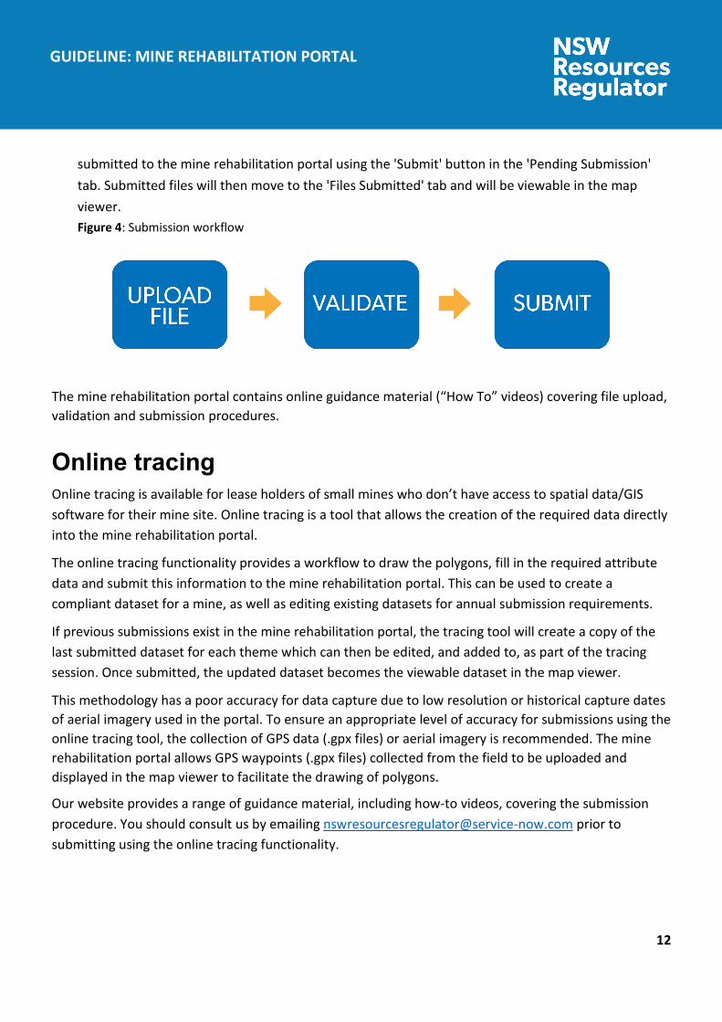
12
GUIDELINE: MINE REHABILITATION PORTAL
submitted to the mine rehabilitation portal using the 'Submit' button in the 'Pending Submission' tab. Submitted files will then move to the 'Files Submitted' tab and will be viewable in the map viewer. Figure 4: Submission workflow
The mine rehabilitation portal contains online guidance material (“How To” videos) covering file upload, validation and submission procedures.
Online tracing Online tracing is available for lease holders of small mines who don’t have access to spatial data/GIS software for their mine site. Online tracing is a tool that allows the creation of the required data directly into the mine rehabilitation portal.
The online tracing functionality provides a workflow to draw the polygons, fill in the required attribute data and submit this information to the mine rehabilitation portal. This can be used to create a compliant dataset for a mine, as well as editing existing datasets for annual submission requirements.
If previous submissions exist in the mine rehabilitation portal, the tracing tool will create a copy of the last submitted dataset for each theme which can then be edited, and added to, as part of the tracing session. Once submitted, the updated dataset becomes the viewable dataset in the map viewer.
This methodology has a poor accuracy for data capture due to low resolution or historical capture dates of aerial imagery used in the portal. To ensure an appropriate level of accuracy for submissions using the online tracing tool, the collection of GPS data (.gpx files) or aerial imagery is recommended. The mine rehabilitation portal allows GPS waypoints (.gpx files) collected from the field to be uploaded and displayed in the map viewer to facilitate the drawing of polygons.
Our website provides a range of guidance material, including how-to videos, covering the submission procedure. You should consult us by emailing [email protected] prior to submitting using the online tracing functionality.
13
GUIDELINE: MINE REHABILITATION PORTAL
Aerial imagery upload The mine rehabilitation portal provides functionality for uploading aerial imagery (orthomosaics) to help improve the accuracy of data submitted using the tracing tool. It is recommended that online tracing submissions are digitised with an up-to-date aerial image as the basemap. This can be achieved using drone technology and appropriate software.
Aerial imagery must be in .Jpeg2 or .ecw formats and uploaded in a zipped folder. Our website provides a range of guidance material, including how-to videos, covering the uploading of aerial imagery.
Data review A review of the submitted data will be undertaken by us as part of the assessment process for the annual rehabilitation report and forward program, the rehabilitation management plan and the rehabilitation cost estimate. We may request a resubmission of data if the accuracy, completeness or any other issues are deemed unsatisfactory.
Access to supplied data The mine rehabilitation portal’s purpose is to collect spatial data relevant to mine rehabilitation and closure from lease holders or their authorised representatives. The data submitted to the portal will be available for viewing within the map viewer by registered users of that mine.
The map viewer has reporting tools to help with the reporting requirements of the mining lease. These tools include the KPI Report and Print Plan functions.
We will make the submitted data (see Table 1) available on the NSW Government’s Sharing and Enabling Environmental Data (SEED) portal for viewing purposes by the community. The sharing of these spatial themes is considered important in ensuring the transparency of the regulation of progressive mine rehabilitation in NSW.
Users are required to check any licensing information and copyright for each piece of material submitted to ensure the permission extends to our use and potential distribution to third parties described above.

14
GUIDELINE: MINE REHABILITATION PORTAL
Glossary TERM DEFINITION
Active mining phase of rehabilitation
In the context of rehabilitation, the active mining phase of rehabilitation constitutes the rehabilitation activities undertaken during mining operations such as land clearing, salvaging and managing soil resources, salvaging habitat resources, and native seed collection. This phase also includes management actions taken during operations to manage risks to rehabilitation and enhance rehabilitation outcomes such as selective handling of waste rock and management of tailings emplacements.
Annual rehabilitation report
As outlined in the Mining Regulation 2016.
Attribute Means a database field attached to a feature object in a theme used to describe spatial data (also known as ‘object data’). Examples include ‘MineN’ (Mine Name) or ‘RehabPha’ (Rehabilitation phase).
Decommissioning The process of removing mining infrastructure and removing contaminants and hazardous materials.
Decommissioning phase of rehabilitation
Activities associated with the removal of mining infrastructure and removal and/or remediation of contaminants and hazardous materials. In the context of the rehabilitation management plan (for large mines only) this phase of rehabilitation may also include studies and assessments associated with decommissioning and demolition of infrastructure or works carried out to make safe or ‘fit for purpose’ built infrastructure to be retained for future use(s) following lease relinquishment.
Department Department of Regional NSW.
Disturbance See Surface Disturbance.
Disturbance area An area that has been disturbed and that requires rehabilitation. This may include areas such as exploration areas, stripped areas ahead of mining, infrastructure areas, water management infrastructure, sewage treatment facilities, topsoil stockpile areas, access tracks and haul roads, active mining areas, waste emplacements (active/unshaped/in or out-of-pit), tailings dams (active/unshaped/uncapped), and areas requiring
15
GUIDELINE: MINE REHABILITATION PORTAL
TERM DEFINITION
rehabilitation that are temporarily stabilised (e.g. managed to minimise dust generation and/or erosion).
Domain An area (or areas) of the land that has been disturbed by mining and has a specific operational use (mining domain) or specific final land use (final land use domain). Land within a domain typically has similar geochemical and/or geophysical characteristics and therefore requires specific rehabilitation activities to achieve the associated final land use.
Domain list A predefined list of attributes. Values in a field with a domain list must match the list records exactly to ensure successful validation of data (e.g. spelling, caps).
Ecosystem and land use development
This phase of rehabilitation consists of the activities to manage maturing rehabilitation areas on a trajectory to achieving the approved or, if not yet approved, the proposed:
rehabilitation objectives, and rehabilitation completion criteria, and for large mines – final landform and rehabilitation plan.
For vegetated land uses this phase may include processes to develop characteristics of functional self-sustaining ecosystems, such as nutrient recycling, vegetation flowering and reproduction, and increasing habitat complexity, and development of a productive, self-sustaining soil profile.
This phase of rehabilitation may include specific vegetation management strategies and maintenance such as tree thinning, supplementary plantings and weed management.
Ecosystem and land use establishment
This phase of rehabilitation consists of the processes to establish the approved final land use following construction of the final landform (as per the approved final landform and rehabilitation plan for large mines).
For vegetated land uses this rehabilitation phase includes establishing the desired vegetation community and implementing land management activities such as weed control. This phase of rehabilitation may also include habitat augmentation such as installation of nest boxes.
Exploration Has the same meaning as that term under the State Environmental Planning Policy (Mining, Petroleum Production and Extractive Industries) 2007.

16
GUIDELINE: MINE REHABILITATION PORTAL
TERM DEFINITION
Final landform and rehabilitation plan
As defined in the Mining Regulation 2016.
Final land use As defined in the Mining Regulation 2016.
Final land use domain A land management unit with a final land use. A mining lease may have one final land use (e.g. returning the entire mining lease to native vegetation) or several final land use units (e.g. a mix of pasture areas and native ecosystems). Each final land use unit represents a separate final land use domain.
Form and way Means the form and way approved by the Secretary. Approved form and way documents are available on the Department’s website.
Forward program As defined in the Mining Regulation 2016.
Growth medium development
This phase of rehabilitation consists of activities required to establish the physical, chemical and biological components of the substrate required to establish the desired vegetation community (including short lived pioneer species) to ensure achievement of the approved or, if not yet approved, the proposed:
rehabilitation objectives, and rehabilitation completion criteria, and for large mines – final landform and rehabilitation plan.
This phase may include spreading the prepared landform with topsoil and/or subsoil and/or soil substitutes, applying soil ameliorants to enhance the physical, chemical and biological characteristics of the growth media, and actions to minimise loss of growth media due to erosion.
Land As defined in the Mining Act 1992.
Landform establishment
This phase of rehabilitation consists of the processes and activities required to construct the approved final landform (as per the development consent and, for large mines, the approved final landform and rehabilitation plan).
In addition to profiling the surface of rehabilitation areas to the approved final landform profile this phase may include works to construct surface water drainage features, encapsulate problematic materials such as tailings,

17
GUIDELINE: MINE REHABILITATION PORTAL
TERM DEFINITION
and prepare a substrate with the desired physical and chemical characteristics (that is, rock raking or ameliorating sodic materials).
Large mine As defined in the Mining Regulation 2016.
Lease holder The holder of a mining lease.
Life of mine The timeframe of how long a mine is approved to mine, from commencement to closure.
Mine rehabilitation portal
Means the NSW Resources Regulator’s online portal that leaseholders must use (via a registered account) to:
upload rehabilitation geographical information system (GIS) spatial data
develop rehabilitation GIS spatial data (using online tracing functions)
generate rehabilitation plans and rehabilitation statistics using the map viewer and Rehabilitation Key Performance Indicator functionalities.
Data submitted to the mine rehabilitation portal is collated in a centralised geodatabase for use by the NSW Resources Regulator to regulate rehabilitation performance of leaseholders.
Mining area As defined in the Mining Act 1992.
Mining domain A land management unit with a discrete operational function (for example, overburden emplacement), and therefore similar geophysical characteristics, that will require specific rehabilitation treatments to achieve the final land use(s).
Mining lease As defined in the Mining Act 1992.
Overburden Material overlying coal or a mineral deposit.
Phases of rehabilitation
The stages and sequences of actions required to rehabilitate disturbed land to achieve the final land use. The phases of rehabilitation are:
active mining decommissioning
18
GUIDELINE: MINE REHABILITATION PORTAL
TERM DEFINITION
landform establishment growth medium development ecosystem and land use establishment ecosystem and land use development rehabilitation completion (sign-off).
Polygon An area defined on a map by a closed shape.
Progressive rehabilitation
The progress of rehabilitation towards achieving the approved or, if not yet approved, the proposed:
rehabilitation objectives, and rehabilitation completion criteria, and for large mines – final landform and rehabilitation plan.
This may be described in terms of domains, phases, performance indicators and rehabilitation completion criteria.
Rehabilitation As defined in the Mining Act 1992.
Rehabilitation completion
The final phase of rehabilitation when a rehabilitation area has achieved the final land use for the mining area:
as stated in the approved rehabilitation objectives and the approved rehabilitation completion criteria, and
for large mines – as spatially depicted in the approved final landform and rehabilitation plan.
Rehabilitation areas may be classified as complete when the NSW Resources Regulator has determined in writing that rehabilitation has achieved the final land use following submission of the relevant application by the lease holder.
Rehabilitation completion criteria
Rehabilitation completion criteria set out the criteria the achievement of which will demonstrate the achievement of the rehabilitation objectives.
Rehabilitation cost estimate
As defined in the Mining Regulation 2016.

19
GUIDELINE: MINE REHABILITATION PORTAL
TERM DEFINITION
Rehabilitation management plan
As defined in the Mining Regulation 2016.
Rehabilitation objectives
Means the rehabilitation objectives required to achieve the final land use for the mining area.
Rehabilitation outcomes
Means the final land use for the mining area as stated in the approved rehabilitation objectives, the approved rehabilitation completion criteria and the approved final landform and rehabilitation plan.
Risk The effect of uncertainty on objectives. It is measured in terms of consequences and likelihood (AS/NZS ISO 31000:2018).
Schema Defines the data structure, field names and data formats required for a particular theme (e.g. text or short integer).
Secretary The Secretary of the Department.
Small mine As defined in the Mining Regulation 2016.
Spatial reference The spatial reference is an alphanumeric code used for linking objectives/completion criteria with the final land use polygons. See explanatory note under the schema requirements heading for more details.
Surface disturbance Includes activities that disturb the surface of the mining area, including mining operations, ancillary mining activities and exploration.
Tailings A combination of the fine-grained (typically silt-sized, in the range from 0.001 to 0.6 mm) solid materials remaining after the recoverable metals and minerals have been extracted from mined ore, together with the water used in the recovery process1.
Themes Refers to a type of information/data stored on a GIS single layer (e.g. rehabilitation). Each theme has a specific set of required attribute fields.
1 Tailings Management: Leading Practice Sustainable Development Program for the Mining Industry, Commonwealth of Australia (2016).
20
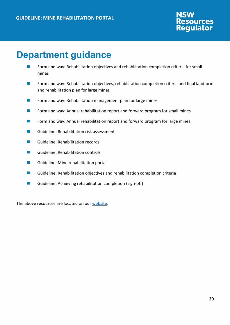
GUIDELINE: MINE REHABILITATION PORTAL
Department guidance Form and way: Rehabilitation objectives and rehabilitation completion criteria for small
mines
Form and way: Rehabilitation objectives, rehabilitation completion criteria and final landform and rehabilitation plan for large mines
Form and way: Rehabilitation management plan for large mines
Form and way: Annual rehabilitation report and forward program for small mines
Form and way: Annual rehabilitation report and forward program for large mines
Guideline: Rehabilitation risk assessment
Guideline: Rehabilitation records
Guideline: Rehabilitation controls
Guideline: Mine rehabilitation portal
Guideline: Rehabilitation objectives and rehabilitation completion criteria
Guideline: Achieving rehabilitation completion (sign-off)
The above resources are located on our website.
21
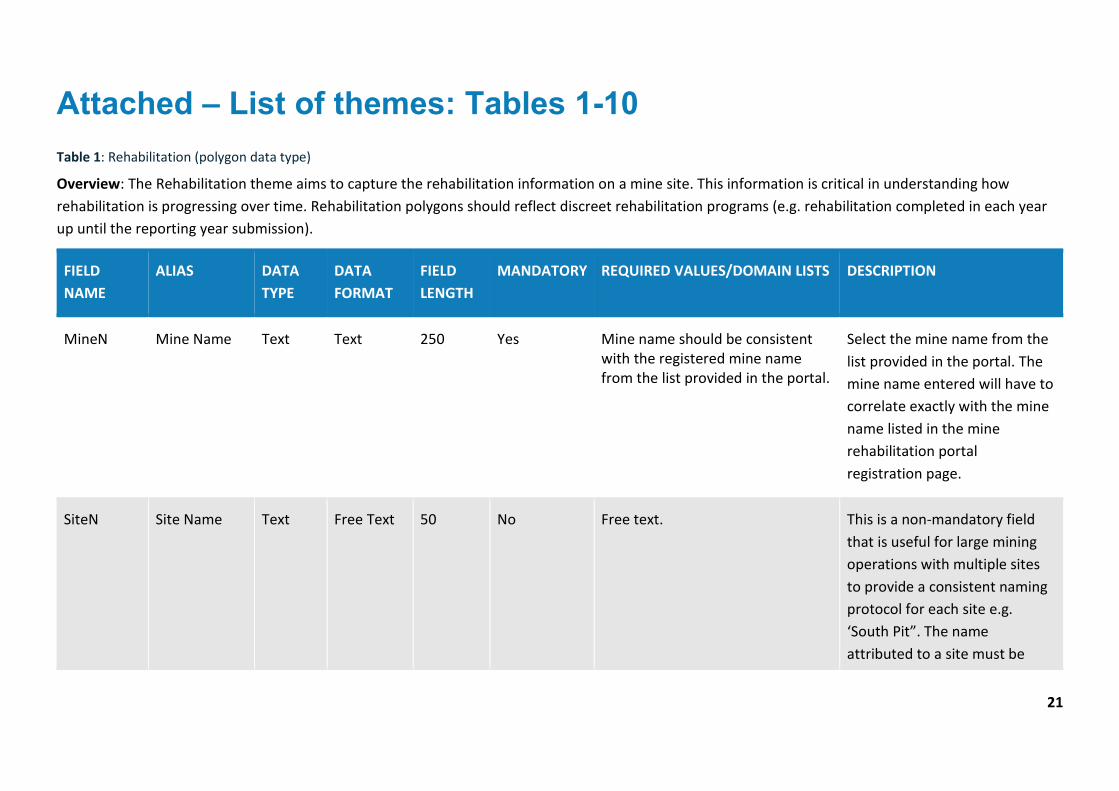
Attached – List of themes: Tables 1-10 Table 1: Rehabilitation (polygon data type)
Overview: The Rehabilitation theme aims to capture the rehabilitation information on a mine site. This information is critical in understanding how rehabilitation is progressing over time. Rehabilitation polygons should reflect discreet rehabilitation programs (e.g. rehabilitation completed in each year up until the reporting year submission).
FIELD NAME
ALIAS DATA TYPE
DATA FORMAT
FIELD LENGTH
MANDATORY REQUIRED VALUES/DOMAIN LISTS DESCRIPTION
MineN Mine Name Text Text 250 Yes Mine name should be consistent with the registered mine name from the list provided in the portal.
Select the mine name from the list provided in the portal. The mine name entered will have to correlate exactly with the mine name listed in the mine rehabilitation portal registration page.
SiteN Site Name Text Free Text 50 No Free text. This is a non-mandatory field that is useful for large mining operations with multiple sites to provide a consistent naming protocol for each site e.g. ‘South Pit”. The name attributed to a site must be
22
FIELD NAME
ALIAS DATA TYPE
DATA FORMAT
FIELD LENGTH
MANDATORY REQUIRED VALUES/DOMAIN LISTS DESCRIPTION
identical for future reporting and comparison purposes.
MineDomN Mining Domain Name
Text Free Text 50 Yes Free text. Provide a name for the mining domain. For larger operations, selected name should contain reference site name (if used) and local name given to the area e.g. “South Pit Chitter Dump” or “REA Stage 3”.
RehabPha Rehabilitation Phase
Text Text 55 Yes Must be one of the following:
Decommissioning
Landform Establishment
Growth Media Development
Ecosystem and Land Use Establishment
Ecosystem and Land Use Development
Rehabilitation Completion
Select the phase from the domain list that the rehabilitation is in at the time of data submission/last survey.
You will not enter any other value apart from the mentioned values under the “Required Values” (domain list) as the application will discard any record not having any one of the mentioned values.
23
FIELD NAME
ALIAS DATA TYPE
DATA FORMAT
FIELD LENGTH
MANDATORY REQUIRED VALUES/DOMAIN LISTS DESCRIPTION
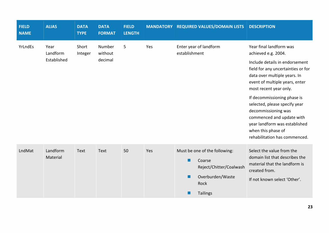
YrLndEs Year Landform Established
Short Integer
Number without decimal
5 Yes Enter year of landform establishment
Year final landform was achieved e.g. 2004.
Include details in endorsement field for any uncertainties or for data over multiple years. In event of multiple years, enter most recent year only.
If decommissioning phase is selected, please specify year decommissioning was commenced and update with year landform was established when this phase of rehabilitation has commenced.
LndMat Landform Material
Text Text 50 Yes Must be one of the following:
Coarse Reject/Chitter/Coalwash
Overburden/Waste Rock
Tailings
Select the value from the domain list that describes the material that the landform is created from.
If not known select ‘Other’.

24
FIELD NAME
ALIAS DATA TYPE
DATA FORMAT
FIELD LENGTH
MANDATORY REQUIRED VALUES/DOMAIN LISTS DESCRIPTION
Natural ground
Other
If ‘Other’ further details can be provided in the “Additional Info” field.
You will not enter any other value apart from the mentioned values under the ‘Required Values’ (domain list) as the application will discard any record not having any one of the mentioned values.
SbSoilD Subsoil Depth (m)
Double Numbers with decimals
38 No Enter the depth in metres This is a non-mandatory field useful for recording subsoil placement depth.
Enter the depth of the sub soil in metres (e.g. 1.2).
TpSoilD Topsoil Depth (m)
Double Numbers with decimals
38 No Enter the depth in metres This is a non-mandatory field useful for recording topsoil placement depth.
Enter the depth of the topsoil in metres (e.g. 0.5).
25
FIELD NAME
ALIAS DATA TYPE
DATA FORMAT
FIELD LENGTH
MANDATORY REQUIRED VALUES/DOMAIN LISTS DESCRIPTION
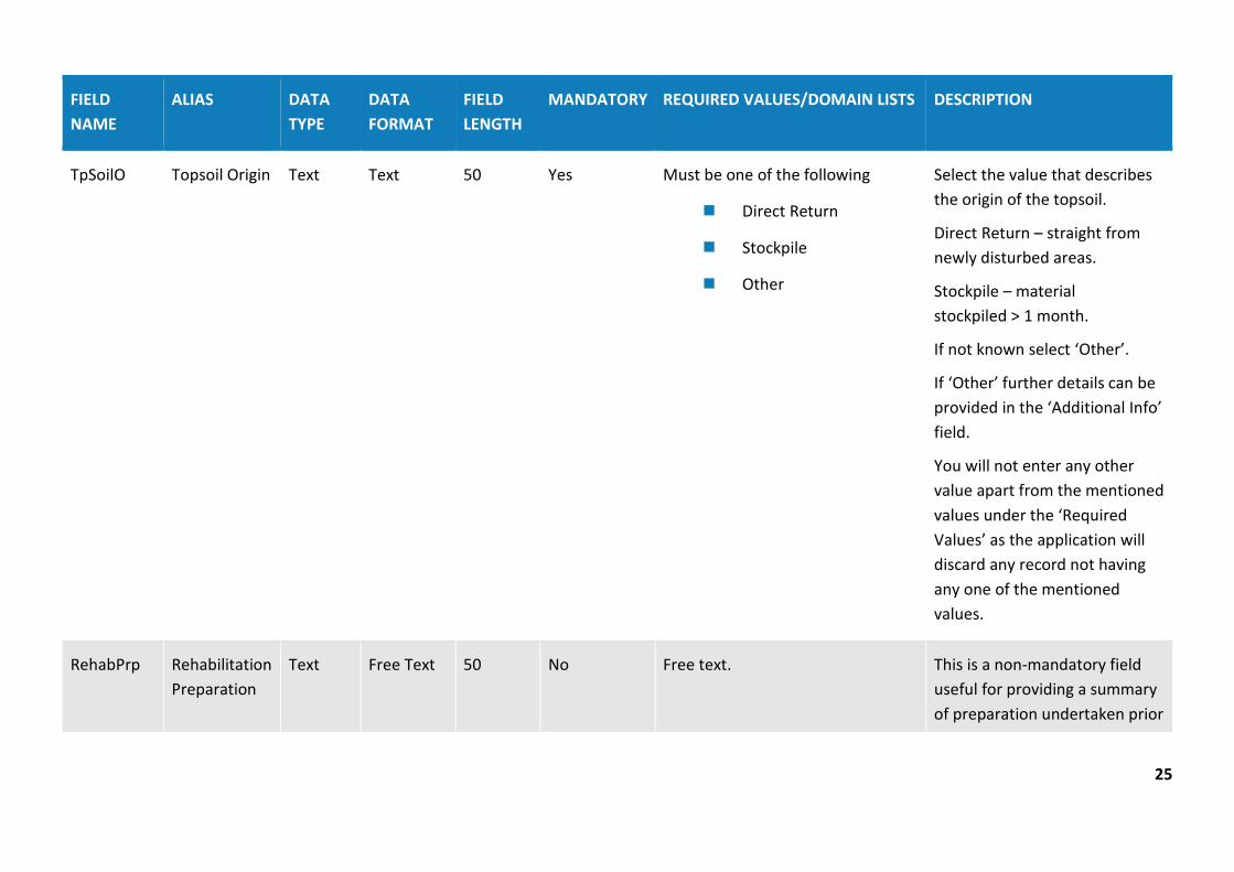
TpSoilO Topsoil Origin Text Text 50 Yes Must be one of the following
Direct Return
Stockpile
Other
Select the value that describes the origin of the topsoil.
Direct Return – straight from newly disturbed areas.
Stockpile – material stockpiled > 1 month.
If not known select ‘Other’.
If ‘Other’ further details can be provided in the ‘Additional Info’ field.
You will not enter any other value apart from the mentioned values under the ‘Required Values’ as the application will discard any record not having any one of the mentioned values.
RehabPrp Rehabilitation Preparation
Text Free Text 50 No Free text. This is a non-mandatory field useful for providing a summary of preparation undertaken prior
26
FIELD NAME
ALIAS DATA TYPE
DATA FORMAT
FIELD LENGTH
MANDATORY REQUIRED VALUES/DOMAIN LISTS DESCRIPTION
to seeding. For example, ‘Deep Ripped to 1m’.
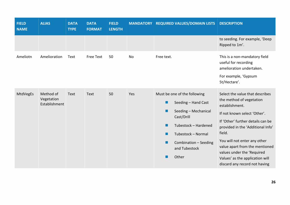
Ameliotn Amelioration Text Free Text 50 No Free text. This is a non-mandatory field useful for recording amelioration undertaken.
For example, ‘Gypsum 5t/Hectare’.
MtdVegEs Method of Vegetation Establishment
Text Text 50 Yes Must be one of the following
Seeding – Hand Cast
Seeding – Mechanical Cast/Drill
Tubestock – Hardened
Tubestock – Normal
Combination – Seeding and Tubestock
Other
Select the value that describes the method of vegetation establishment.
If not known select ‘Other’.
If ‘Other’ further details can be provided in the ‘Additional Info’ field.
You will not enter any other value apart from the mentioned values under the ‘Required Values’ as the application will discard any record not having

27
FIELD NAME
ALIAS DATA TYPE
DATA FORMAT
FIELD LENGTH
MANDATORY REQUIRED VALUES/DOMAIN LISTS DESCRIPTION
any one of the mentioned values.
YrVegEs Year Vegetation Established
Short Integer
Number without decimal
5 Yes Enter the year value e.g. 2004. Enter year when Vegetation was established e.g. seeding, planting of tubestock.
Signstat Sign-off Status
Text Text 50 Yes Not applicable
Signoff requested
Signoff complete
This field is used to track rehabilitation areas undergoing or completed rehabilitation sign-off. You must enter ‘Not applicable’ if no sign-off has been requested.
You must not enter any other value apart from the mentioned values under the ‘Required Values’ as the application will discard any record not having any one of the mentioned values.
Signref Sign-off Reference
Text Text 50 No Free text.

28
FIELD NAME
ALIAS DATA TYPE
DATA FORMAT
FIELD LENGTH
MANDATORY REQUIRED VALUES/DOMAIN LISTS DESCRIPTION
AddInfo Additional Info
Text Free Text 250 No Free text. This is a non-mandatory field which allows for any additional information to be provided related to the feature.
Source Source Text Text 50 Yes Must be one of the following
Mine survey
Other survey
Digitised
Coordinate entry
Department records
Planning Approval
Other
This field is for entering the source of this data.
Data recorded using online tracing is to be labelled ‘Digitised’.
You will not enter any other value apart from the mentioned values under the ‘Required Values’ as the application will discard any record not having any one of the mentioned values.
ChartDt Chart Date Date Date NA Yes Date format should be as follows DD/MM/YYYY
Enter the date value when this data was charted/created.
29
FIELD NAME
ALIAS DATA TYPE
DATA FORMAT
FIELD LENGTH
MANDATORY REQUIRED VALUES/DOMAIN LISTS DESCRIPTION
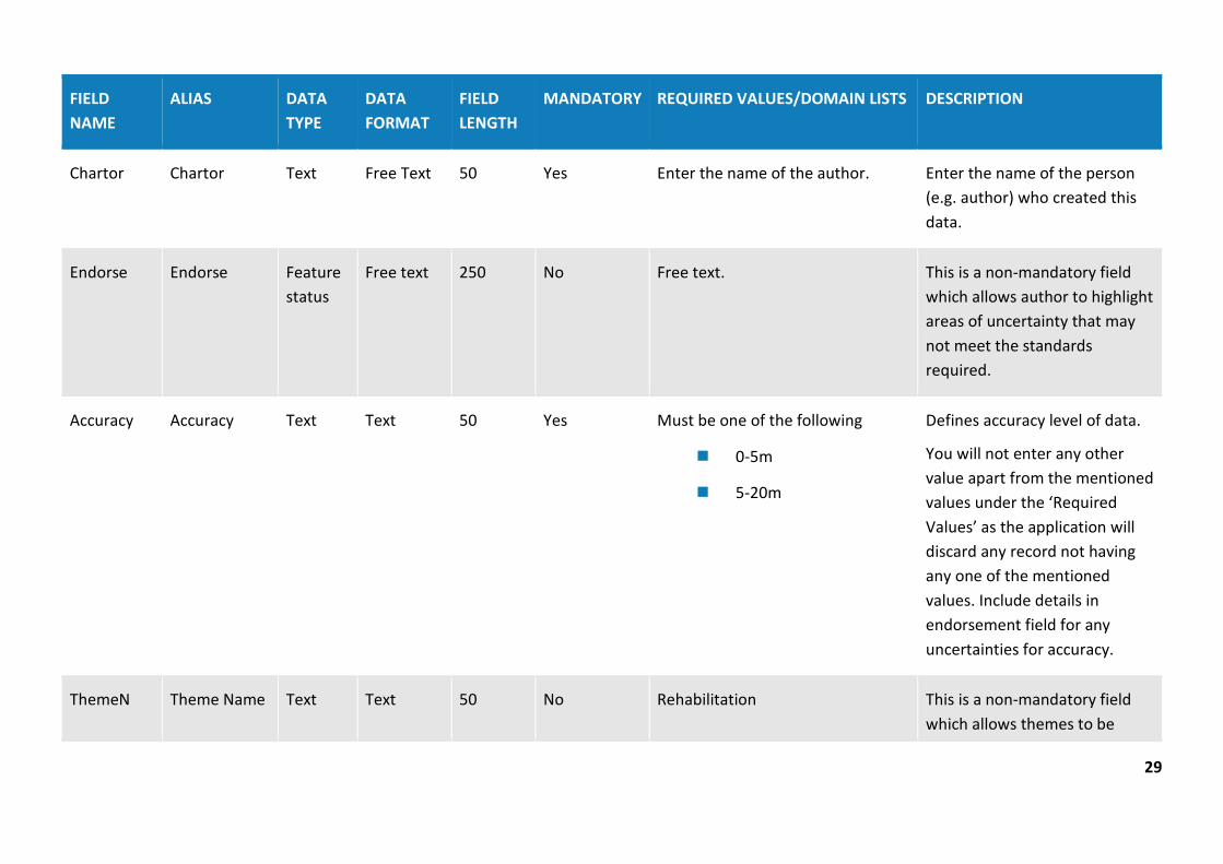
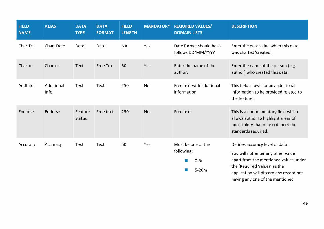
Chartor Chartor Text Free Text 50 Yes Enter the name of the author. Enter the name of the person (e.g. author) who created this data.
Endorse Endorse Feature status
Free text 250 No Free text. This is a non-mandatory field which allows author to highlight areas of uncertainty that may not meet the standards required.
Accuracy Accuracy Text Text 50 Yes Must be one of the following
0-5m
5-20m
Defines accuracy level of data.
You will not enter any other value apart from the mentioned values under the ‘Required Values’ as the application will discard any record not having any one of the mentioned values. Include details in endorsement field for any uncertainties for accuracy.
ThemeN Theme Name Text Text 50 No Rehabilitation This is a non-mandatory field which allows themes to be
30
FIELD NAME
ALIAS DATA TYPE
DATA FORMAT
FIELD LENGTH
MANDATORY REQUIRED VALUES/DOMAIN LISTS DESCRIPTION
categorised for user cataloging purposes. Must match standard theme names.
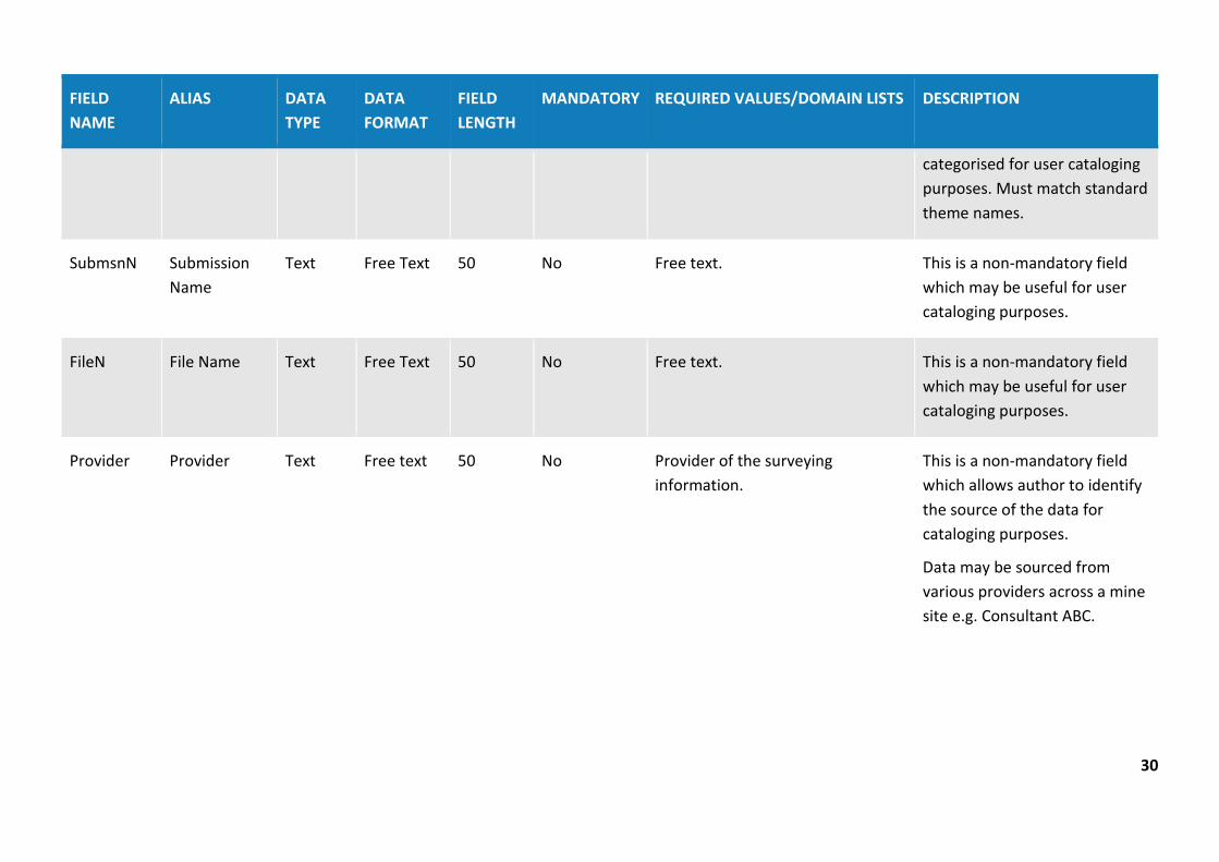
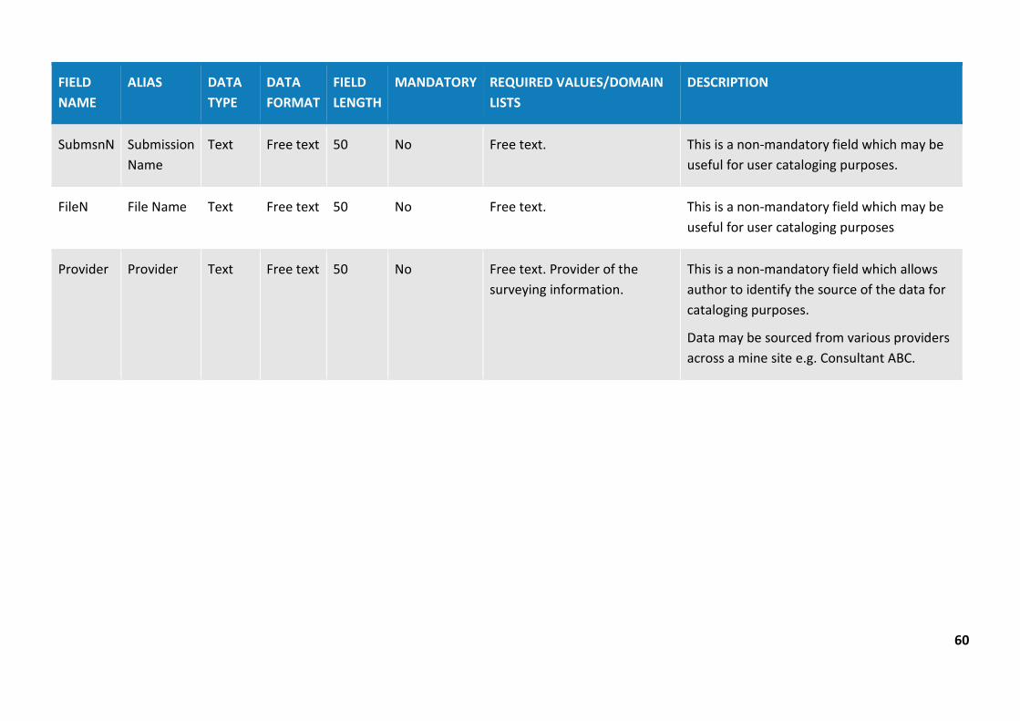
SubmsnN Submission Name
Text Free Text 50 No Free text. This is a non-mandatory field which may be useful for user cataloging purposes.
FileN File Name Text Free Text 50 No Free text. This is a non-mandatory field which may be useful for user cataloging purposes.
Provider Provider Text Free text 50 No Provider of the surveying information.
This is a non-mandatory field which allows author to identify the source of the data for cataloging purposes.
Data may be sourced from various providers across a mine site e.g. Consultant ABC.

31
Table 2: Disturbance (polygon data type)
Overview: The Disturbance theme captures spatial and temporal information about disturbance across the mine site. The Disturbance theme should reflect the life of mine to date e.g. all disturbance areas including areas that have been rehabilitated. Do not remove disturbance polygons if rehabilitation has occurred in that area.
FIELD NAME
ALIAS DATA TYPE
DATA FORMAT
FIELD LENGTH
MANDATORY REQUIRED VALUES/DOMAIN LISTS
DESCRIPTION
MineN Mine Name Text Text 250 Yes Mine name should be consistent with the registered mine name from the list provided in the portal.
Select the mine name from the list provided in the portal. The mine name entered will have to correlate exactly with the mine name listed in the mine rehabilitation portal registration page.
SiteN Site Name Text Text 50 No Free text. This is a non-mandatory field that is useful for large mining operations with multiple sites to provide a consistent naming protocol for each site (e.g. ‘South Pit’). The name attributed to a site must be identical for future reporting and comparison purposes.

32
FIELD NAME
ALIAS DATA TYPE
DATA FORMAT
FIELD LENGTH
MANDATORY REQUIRED VALUES/DOMAIN LISTS
DESCRIPTION
MineDomN Mining Domain Name
Text Free Text 50 Yes Free text. Select a name for the mining domain. For larger operations, selected name should contain reference site name (if used) and local name given to the area (e.g. ‘South Pit Chitter Dump’ or ‘REA Stage 3’).
MineDomT Mining Domain Type
Text Text 50 Yes Must be one of the following:
Infrastructure Area
Tailings Storage Facility
Water Management Area
Overburden Emplacement Area
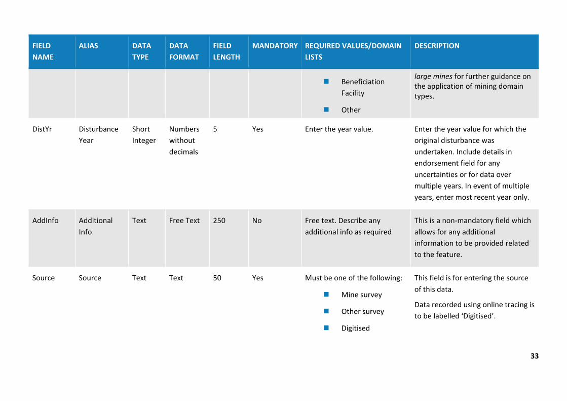
Active Mining Area (Open cut void)
Underground Mining Area (SMP)
Enter the domain type from the list provided.
Disturbance polygons must show cumulative mine disturbance (e.g. areas that have been disturbed and subsequently rehabilitated are to remain included in the disturbance theme layer).
You will not enter any other value apart from the mentioned values under the ‘Required Values’ as the application will discard any record not having any one of the mentioned values.
Please refer to Form and way: Rehabilitation management plan for
33
FIELD NAME
ALIAS DATA TYPE
DATA FORMAT
FIELD LENGTH
MANDATORY REQUIRED VALUES/DOMAIN LISTS
DESCRIPTION
Beneficiation Facility
Other
large mines for further guidance on the application of mining domain types.
DistYr Disturbance Year
Short Integer
Numbers without decimals
5 Yes Enter the year value. Enter the year value for which the original disturbance was undertaken. Include details in endorsement field for any uncertainties or for data over multiple years. In event of multiple years, enter most recent year only.
AddInfo Additional Info
Text Free Text 250 No Free text. Describe any additional info as required
This is a non-mandatory field which allows for any additional information to be provided related to the feature.
Source Source Text Text 50 Yes Must be one of the following:
Mine survey
Other survey
Digitised
This field is for entering the source of this data.
Data recorded using online tracing is to be labelled ‘Digitised’.

34
FIELD NAME
ALIAS DATA TYPE
DATA FORMAT
FIELD LENGTH
MANDATORY REQUIRED VALUES/DOMAIN LISTS
DESCRIPTION
Coordinate entry
Department records
Planning Approval
Other
You will not enter any other value apart from the mentioned values under the ‘Required Values’ as the application will discard any record not having any one of the mentioned values.
ChartDt Chart Date Date Date NA Yes Date format should be as follows DD/MM/YYYY
Enter the date value when this data was charted/created.
Chartor Chartor Text Free Text 50 Yes Enter the name of the author. Enter the name of the person (e.g. author) who created this data.
Endorse Endorse Feature status
Free text 250 No Free text. This is a non-mandatory field which allows author to highlight areas of uncertainty that may not meet the standards required.
Accuracy Accuracy Text Text 50 Yes Must be one of the following
0-5m
5-20m
Defines accuracy level of data.
You will not enter any other value apart from the mentioned values under the ‘Required Values’ as the

35
FIELD NAME
ALIAS DATA TYPE
DATA FORMAT
FIELD LENGTH
MANDATORY REQUIRED VALUES/DOMAIN LISTS
DESCRIPTION
application will discard any record not having any one of the mentioned values. Include details in endorsement field for any uncertainties for accuracy.
ThemeN Theme Name Text Text 50 No Disturbance This is a non-mandatory field which allows themes to be categorised for user cataloging purposes. Must match standard theme names.
SubmsnN Submission Name
Text Free text 50 No Free text. This is a non-mandatory field which may be useful for user cataloging purposes.
FileN File Name Text Free text 50 No Free text. This is a non-mandatory field which may be useful for user cataloging purposes.
Provider Provider Text Free text 50 No Provider of the surveying information.
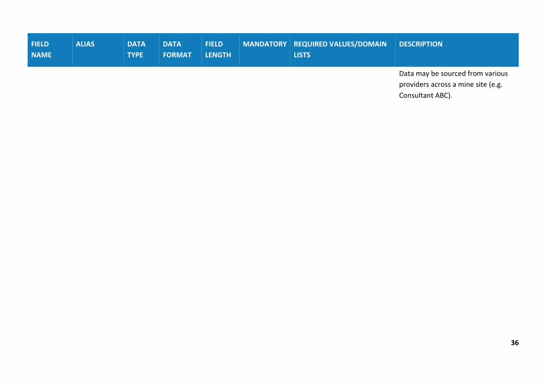
This is a non-mandatory field which allows author to identify the source of the data for cataloging purposes.
36
FIELD NAME
ALIAS DATA TYPE
DATA FORMAT
FIELD LENGTH
MANDATORY REQUIRED VALUES/DOMAIN LISTS
DESCRIPTION
Data may be sourced from various providers across a mine site (e.g. Consultant ABC).
37
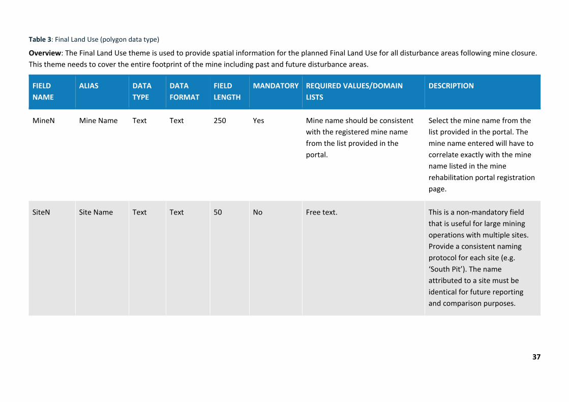
Table 3: Final Land Use (polygon data type)
Overview: The Final Land Use theme is used to provide spatial information for the planned Final Land Use for all disturbance areas following mine closure. This theme needs to cover the entire footprint of the mine including past and future disturbance areas.
FIELD NAME
ALIAS DATA TYPE
DATA FORMAT
FIELD LENGTH
MANDATORY REQUIRED VALUES/DOMAIN LISTS
DESCRIPTION
MineN Mine Name Text Text 250 Yes Mine name should be consistent with the registered mine name from the list provided in the portal.
Select the mine name from the list provided in the portal. The mine name entered will have to correlate exactly with the mine name listed in the mine rehabilitation portal registration page.
SiteN Site Name Text Text 50 No Free text. This is a non-mandatory field that is useful for large mining operations with multiple sites. Provide a consistent naming protocol for each site (e.g. ‘South Pit’). The name attributed to a site must be identical for future reporting and comparison purposes.

38
FIELD NAME
ALIAS DATA TYPE
DATA FORMAT
FIELD LENGTH
MANDATORY REQUIRED VALUES/DOMAIN LISTS
DESCRIPTION
FnlndDom Final Landuse Domain
Text Text 50 Yes Must be one of the following:
Native Ecosystem
Agricultural – Grazing
Agricultural – Cropping
Rehabilitation Biodiversity Offset Area
Industrial
Water Management Areas
Water Storage (Excluding Final Void)
Heritage Area
Infrastructure
Final Void
Other
Enter the Final Land Use domain of your mine.
You will not enter any other value apart from the mentioned values under the ‘Required Values’ as the application will discard any record not having any one of the mentioned values.
Please refer to Form and way: Rehabilitation management plan for large mines for further guidance on the application of Final Land Use domain types.
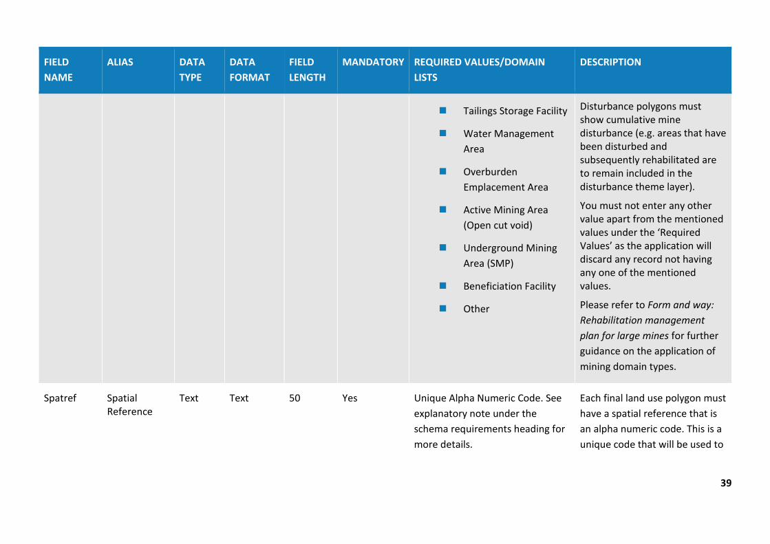
MineDomT Mining Domain Type
Text Text 50 Yes Must be one of the following:
Infrastructure Area
Enter the domain type from the list provided.
39
FIELD NAME
ALIAS DATA TYPE
DATA FORMAT
FIELD LENGTH
MANDATORY REQUIRED VALUES/DOMAIN LISTS
DESCRIPTION
Tailings Storage Facility
Water Management Area
Overburden Emplacement Area
Active Mining Area (Open cut void)
Underground Mining Area (SMP)
Beneficiation Facility
Other
Disturbance polygons must show cumulative mine disturbance (e.g. areas that have been disturbed and subsequently rehabilitated are to remain included in the disturbance theme layer).
You must not enter any other value apart from the mentioned values under the ‘Required Values’ as the application will discard any record not having any one of the mentioned values.
Please refer to Form and way: Rehabilitation management plan for large mines for further guidance on the application of mining domain types.
Spatref Spatial Reference
Text Text 50 Yes Unique Alpha Numeric Code. See explanatory note under the schema requirements heading for more details.
Each final land use polygon must have a spatial reference that is an alpha numeric code. This is a unique code that will be used to

40
FIELD NAME
ALIAS DATA TYPE
DATA FORMAT
FIELD LENGTH
MANDATORY REQUIRED VALUES/DOMAIN LISTS
DESCRIPTION
link the rehabilitation objectives and rehabilitation completion criteria to the spatial data being submitted via the portal.
VegCom Vegetation Community
Text Free Text 50 No Free text. Enter Vegetation Community Name
This is a non-mandatory field that is useful to describe the Vegetation Community that is trying to be achieved. This is most relevant to the ‘Native Ecosystem’ and ‘Rehabilitation Biodiversity Offset Area’ Final Land use Domains.
Source Source Text Text 50 Yes Must be one of the following:
Mine survey
Other survey
Digitised
Coordinate entry
Department records
Planning Approval
This field is for entering the source of this data.
Data recorded using online tracing is to be labels ‘Digitised’.
You will not enter any other value apart from the mentioned values under the ‘Required Values’ as the application will discard any record not having

41
FIELD NAME
ALIAS DATA TYPE
DATA FORMAT
FIELD LENGTH
MANDATORY REQUIRED VALUES/DOMAIN LISTS
DESCRIPTION
Other any one of the mentioned values.
ChartDt Chart Date Date Date NA Yes Date format should be as follows DD/MM/YYYY
Enter the date value when this data was charted/created.
Chartor Chartor Text Free Text 50 Yes Free text. Enter the name of the author.
Enter the name of the person (e.g. author) who created this data.
AddInfo Additional Info
Text Text 250 No Free text. Describe any additional info as required
This field allows for any additional information to be provided related to the feature.
Endorse Endorse Feature status
Free text 250 No Free text. This is a non-mandatory field which allows author to highlight areas of uncertainty that may not meet the standards required.
Accuracy Accuracy Text Text 50 Yes Must be one of the following:
0-5m
Defines accuracy level of data.
You will not enter any other value apart from the mentioned

42
FIELD NAME
ALIAS DATA TYPE
DATA FORMAT
FIELD LENGTH
MANDATORY REQUIRED VALUES/DOMAIN LISTS
DESCRIPTION
5-20m values under the ‘Required Values’ as the application will discard any record not having any one of the mentioned values. Include details in endorsement field for any uncertainties for accuracy.
ThemeN Theme Name Text Text 50 No Final land use This is a non-mandatory field which allows themes to be categorised for user cataloging purposes. Must match standard theme names.
SubmsnN Submission Name
Text Free text 50 No Free text. This is a non-mandatory field which may be useful for user cataloging purposes.
FileN File Name Text Free text 50 No Free text. This is a non-mandatory field which may be useful for user cataloging purposes.

43
FIELD NAME
ALIAS DATA TYPE
DATA FORMAT
FIELD LENGTH
MANDATORY REQUIRED VALUES/DOMAIN LISTS
DESCRIPTION
Provider Provider Text Free text 50 No Free text. Provider of the surveying information.
This is a non-mandatory field which allows author to identify the source of the data for cataloging purposes.
Data may be sourced from various providers across a mine site e.g. Consultant ABC.

44
Table 4: Final landform features (polygon data type) – non-mandatory
Overview: The Final Landform Features theme is used to provide spatial information on specific features to be designed, installed or maintained as part of the final landform. For instance: safety bunds, drainage networks, final voids etc.
FIELD NAME
ALIAS DATA TYPE
DATA FORMAT
FIELD LENGTH
MANDATORY REQUIRED VALUES/ DOMAIN LISTS
DESCRIPTION
MineN Mine Name Text Text 250 Yes Mine name should be consistent with the registered mine name from the list provided in the portal.
Select the mine name from the list provided in the portal. The mine name entered will have to correlate exactly with the mine name listed in the mine rehabilitation portal registration page.
SiteN Site Name Text Text 50 No Free text. This is a non-mandatory field that is useful for large mining operations with multiple sites to provide a consistent naming protocol for each site (e.g. ‘South Pit’). The name attributed to the site must be identical for future reporting and comparison purposes.
FnLfFeat Final Landform Feature
Text Text 50 Yes Free text. Enter description of Final landform Feature. Free text. e.g. safety bund
A short description of the final landform feature is required.
This field is useful for providing the location of final landform features that are not located in the Final Land Use

45
FIELD NAME
ALIAS DATA TYPE
DATA FORMAT
FIELD LENGTH
MANDATORY REQUIRED VALUES/ DOMAIN LISTS
DESCRIPTION
Theme. For example, ‘safety bund’ or ‘permanent water body within final void’.
Please refer to Form and way: Rehabilitation management plan for large mines for further guidance on where this information should be provided.
Source Source Text Text 50 Yes Must be one of the following:
Mine survey
Other survey
Digitised
Coordinate entry
Department records
Planning Approval
Other
This field is for entering the source of this data.
Data recorded using online tracing is to be labelled ‘Digitised’.
You will not enter any other value apart from the mentioned values under the ‘Required Values’ as the application will discard any record not having any one of the mentioned values.
46
FIELD NAME
ALIAS DATA TYPE
DATA FORMAT
FIELD LENGTH
MANDATORY REQUIRED VALUES/ DOMAIN LISTS
DESCRIPTION
ChartDt Chart Date Date Date NA Yes Date format should be as follows DD/MM/YYYY
Enter the date value when this data was charted/created.
Chartor Chartor Text Free Text 50 Yes Enter the name of the author.
Enter the name of the person (e.g. author) who created this data.
AddInfo Additional Info
Text Text 250 No Free text with additional information
This field allows for any additional information to be provided related to the feature.
Endorse Endorse Feature status
Free text 250 No Free text. This is a non-mandatory field which allows author to highlight areas of uncertainty that may not meet the standards required.
Accuracy Accuracy Text Text 50 Yes Must be one of the following:
0-5m
5-20m
Defines accuracy level of data.
You will not enter any other value apart from the mentioned values under the ‘Required Values’ as the application will discard any record not having any one of the mentioned

47
FIELD NAME
ALIAS DATA TYPE
DATA FORMAT
FIELD LENGTH
MANDATORY REQUIRED VALUES/ DOMAIN LISTS
DESCRIPTION
values. Include details in endorsement field for any uncertainties for accuracy.
ThemeN Theme Name Text Text 50 No Final (Post Mining) Landuse This is a non-mandatory field which allows themes to be categorised for user cataloging purposes. Must match standard theme names.
SubmsnN Submission Name
Text Free text 50 No Free text. This is a non-mandatory field which may be useful for user cataloging purposes.
FileN File Name Text Free text 50 No Free text. This is a non-mandatory field which may be useful for user cataloging purposes.
Provider Provider Text Free text 50 No Free text. Provider of the surveying information.
This is a non-mandatory field which allows author to identify the source of the data for cataloging purposes.
Data may be sourced from various providers across a mine site (e.g. Consultant ABC).
48
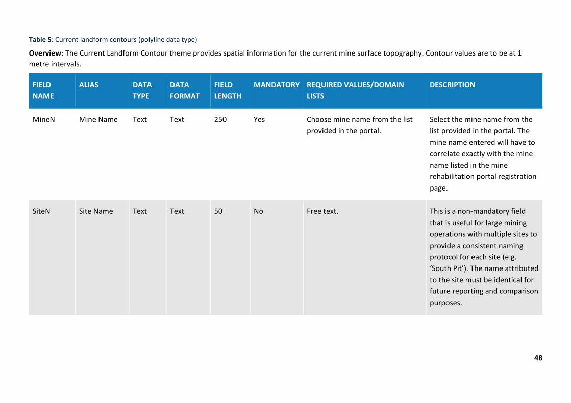
Table 5: Current landform contours (polyline data type)
Overview: The Current Landform Contour theme provides spatial information for the current mine surface topography. Contour values are to be at 1 metre intervals.
FIELD NAME
ALIAS DATA TYPE
DATA FORMAT
FIELD LENGTH
MANDATORY REQUIRED VALUES/DOMAIN LISTS
DESCRIPTION
MineN Mine Name Text Text 250 Yes Choose mine name from the list provided in the portal.
Select the mine name from the list provided in the portal. The mine name entered will have to correlate exactly with the mine name listed in the mine rehabilitation portal registration page.
SiteN Site Name Text Text 50 No Free text. This is a non-mandatory field that is useful for large mining operations with multiple sites to provide a consistent naming protocol for each site (e.g. ‘South Pit’). The name attributed to the site must be identical for future reporting and comparison purposes.
49
FIELD NAME
ALIAS DATA TYPE
DATA FORMAT
FIELD LENGTH
MANDATORY REQUIRED VALUES/DOMAIN LISTS
DESCRIPTION
CntrHt Contour Height (m AHD)
Double Double 10 Yes Australian Height Datum, AHD in metre with one decimal.
Height in metres above/below mean sea level. Contour values should be at 1 metre intervals. May include negative values.
Source Source Text Text 50 Yes Must be one of the following:
Mine survey
Other survey
Digitised
Coordinate entry
Department records
Planning Approval
Other
This field is for entering the source of this data.
Data recorded using online tracing is to be labelled ‘Digitised’.
You will not enter any other value apart from the mentioned values under the ‘Required Values’ as the application will discard any record not having any one of the mentioned values.
ChartDt Chart Date Date Date NA Yes Date format should be as follows DD/MM/YYYY
Enter the date value when this data was charted/created.
50
FIELD NAME
ALIAS DATA TYPE
DATA FORMAT
FIELD LENGTH
MANDATORY REQUIRED VALUES/DOMAIN LISTS
DESCRIPTION
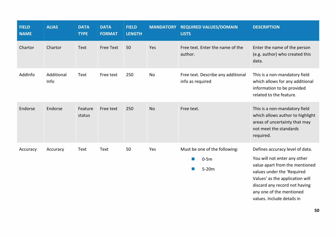
Chartor Chartor Text Free Text 50 Yes Free text. Enter the name of the author.
Enter the name of the person (e.g. author) who created this data.
AddInfo Additional Info
Text Free text 250 No Free text. Describe any additional info as required
This is a non-mandatory field which allows for any additional information to be provided related to the feature.
Endorse Endorse Feature status
Free text 250 No Free text. This is a non-mandatory field which allows author to highlight areas of uncertainty that may not meet the standards required.
Accuracy Accuracy Text Text 50 Yes Must be one of the following:
0-5m
5-20m
Defines accuracy level of data.
You will not enter any other value apart from the mentioned values under the ‘Required Values’ as the application will discard any record not having any one of the mentioned values. Include details in

51
FIELD NAME
ALIAS DATA TYPE
DATA FORMAT
FIELD LENGTH
MANDATORY REQUIRED VALUES/DOMAIN LISTS
DESCRIPTION
endorsement field for any uncertainties for accuracy.
ThemeN Theme Name Text Text 50 No Current Landform Contours This is a non-mandatory field which allows themes to be categorised for user cataloging purposes. Must match standard theme names.
SubmsnN Submission Name
Text Free text 50 No Free text. This is a non-mandatory field which may be useful for user cataloging purposes.
FileN File Name Text Free text 50 No Free text. This is a non-mandatory field which may be useful for user cataloging purposes
Provider Provider Text Free text 50 No Free text. Provider of the surveying information.
This is a non-mandatory field which allows author to identify the source of the data for cataloging purposes.
52
FIELD NAME
ALIAS DATA TYPE
DATA FORMAT
FIELD LENGTH
MANDATORY REQUIRED VALUES/DOMAIN LISTS
DESCRIPTION
Data may be sourced from various providers across a mine site (e.g. Consultant ABC).
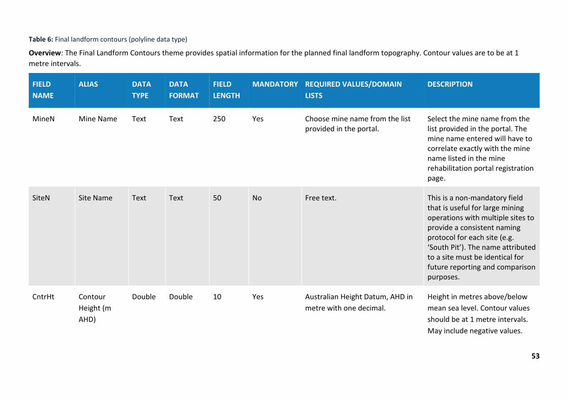
Table 6: Final landform contours (polyline data type)
53
Overview: The Final Landform Contours theme provides spatial information for the planned final landform topography. Contour values are to be at 1 metre intervals.
FIELD NAME
ALIAS DATA TYPE
DATA FORMAT
FIELD LENGTH
MANDATORY REQUIRED VALUES/DOMAIN LISTS
DESCRIPTION
MineN Mine Name Text Text 250 Yes Choose mine name from the list provided in the portal.
Select the mine name from the list provided in the portal. The mine name entered will have to correlate exactly with the mine name listed in the mine rehabilitation portal registration page.
SiteN Site Name Text Text 50 No Free text. This is a non-mandatory field that is useful for large mining operations with multiple sites to provide a consistent naming protocol for each site (e.g. ‘South Pit’). The name attributed to a site must be identical for future reporting and comparison purposes.
CntrHt Contour Height (m AHD)
Double Double 10 Yes Australian Height Datum, AHD in metre with one decimal.
Height in metres above/below mean sea level. Contour values should be at 1 metre intervals. May include negative values.
54
FIELD NAME
ALIAS DATA TYPE
DATA FORMAT
FIELD LENGTH
MANDATORY REQUIRED VALUES/DOMAIN LISTS
DESCRIPTION
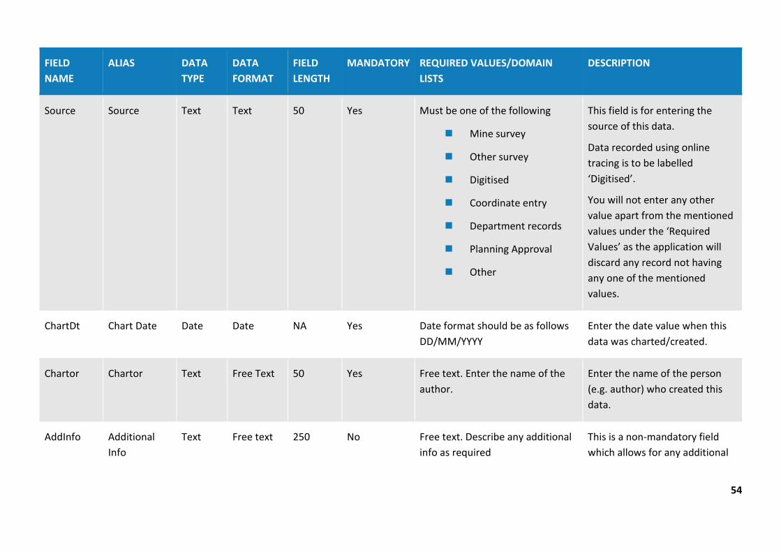
Source Source Text Text 50 Yes Must be one of the following
Mine survey
Other survey
Digitised
Coordinate entry
Department records
Planning Approval
Other
This field is for entering the source of this data.
Data recorded using online tracing is to be labelled ‘Digitised’.
You will not enter any other value apart from the mentioned values under the ‘Required Values’ as the application will discard any record not having any one of the mentioned values.
ChartDt Chart Date Date Date NA Yes Date format should be as follows DD/MM/YYYY
Enter the date value when this data was charted/created.
Chartor Chartor Text Free Text 50 Yes Free text. Enter the name of the author.
Enter the name of the person (e.g. author) who created this data.
AddInfo Additional Info
Text Free text 250 No Free text. Describe any additional info as required
This is a non-mandatory field which allows for any additional
55
FIELD NAME
ALIAS DATA TYPE
DATA FORMAT
FIELD LENGTH
MANDATORY REQUIRED VALUES/DOMAIN LISTS
DESCRIPTION
information to be provided related to the feature.
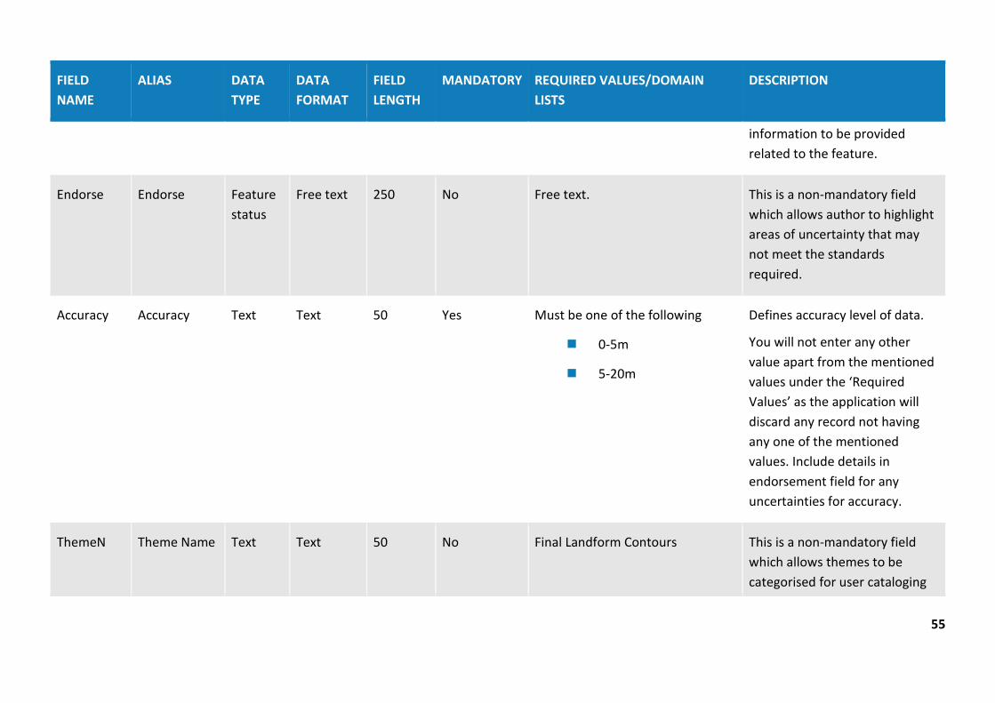
Endorse Endorse Feature status
Free text 250 No Free text. This is a non-mandatory field which allows author to highlight areas of uncertainty that may not meet the standards required.
Accuracy Accuracy Text Text 50 Yes Must be one of the following
0-5m
5-20m
Defines accuracy level of data.
You will not enter any other value apart from the mentioned values under the ‘Required Values’ as the application will discard any record not having any one of the mentioned values. Include details in endorsement field for any uncertainties for accuracy.
ThemeN Theme Name Text Text 50 No Final Landform Contours This is a non-mandatory field which allows themes to be categorised for user cataloging

56
FIELD NAME
ALIAS DATA TYPE
DATA FORMAT
FIELD LENGTH
MANDATORY REQUIRED VALUES/DOMAIN LISTS
DESCRIPTION
purposes. Must match standard theme names.
SubmsnN Submission Name
Text Free text 50 No Free text. This is a non-mandatory field which may be useful for user cataloging purposes.
FileN File Name Text Free text 50 No Free text. This is a non-mandatory field which may be useful for user cataloging purposes
Provider Provider Text Free text 50 No Free text. Provider of the surveying information.
This is a non-mandatory field which allows author to identify the source of the data for cataloging purposes.
Data may be sourced from various providers across a mine site (e.g. Consultant ABC).
57
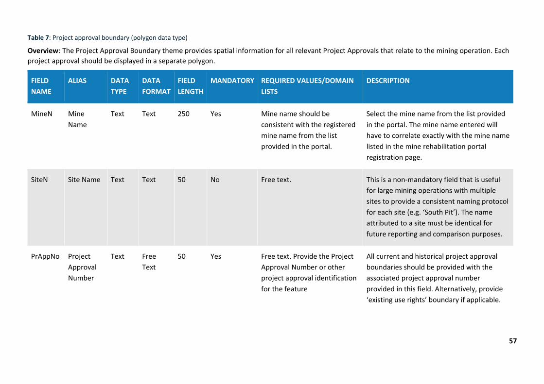
Table 7: Project approval boundary (polygon data type)
Overview: The Project Approval Boundary theme provides spatial information for all relevant Project Approvals that relate to the mining operation. Each project approval should be displayed in a separate polygon.
FIELD NAME
ALIAS DATA TYPE
DATA FORMAT
FIELD LENGTH
MANDATORY REQUIRED VALUES/DOMAIN LISTS
DESCRIPTION
MineN Mine Name
Text Text 250 Yes Mine name should be consistent with the registered mine name from the list provided in the portal.
Select the mine name from the list provided in the portal. The mine name entered will have to correlate exactly with the mine name listed in the mine rehabilitation portal registration page.
SiteN Site Name Text Text 50 No Free text. This is a non-mandatory field that is useful for large mining operations with multiple sites to provide a consistent naming protocol for each site (e.g. ‘South Pit’). The name attributed to a site must be identical for future reporting and comparison purposes.
PrAppNo Project Approval Number
Text Free Text
50 Yes Free text. Provide the Project Approval Number or other project approval identification for the feature
All current and historical project approval boundaries should be provided with the associated project approval number provided in this field. Alternatively, provide ‘existing use rights’ boundary if applicable.

58
FIELD NAME
ALIAS DATA TYPE
DATA FORMAT
FIELD LENGTH
MANDATORY REQUIRED VALUES/DOMAIN LISTS
DESCRIPTION
PrAppDt Project Approval Date
Date Date NA No Date format should be as follows DD/MM/YYYY
This is a non-mandatory field that should be used when the date of the project approval is known.
Source Source Text Text 50 Yes Must be one of the following:
Mine survey
Other survey
Digitised
Coordinate entry
Department records
Planning Approval
Other
This field is for entering the source of this data.
Data recorded using online tracing is to be labelled ‘Digitised’.
You will not enter any other value apart from the mentioned values under the ‘Required Values’ as the application will discard any record not having any one of the mentioned values.
ChartDt Chart Date Date Date NA Yes Date format should be as follows DD/MM/YYYY
Enter the date value when this data was charted/created.
Chartor Chartor Text Free text 50 Yes Free text. Enter the name of the author.
Enter the name of the person (e.g. author) who created this data.

59
FIELD NAME
ALIAS DATA TYPE
DATA FORMAT
FIELD LENGTH
MANDATORY REQUIRED VALUES/DOMAIN LISTS
DESCRIPTION
AddInfo Additional Info
Text Free text 250 No Free text. Describe any additional info as required
This is a non-mandatory field which allows for any additional information to be provided related to the feature.
Endorse Endorse Feature status
Free text 250 No Free text. This is a non-mandatory field which allows the author to highlight areas of uncertainty that may not meet the standards required.
Accuracy Accuracy Text Text 50 Yes Must be one of the following
0-5m
5-20m
Defines accuracy level of data.
You will not enter any other value apart from the mentioned values under the ‘Required Values’ as the application will discard any record not having any one of the mentioned values. Include details in endorsement field for any uncertainties for accuracy.
ThemeN Theme Name
Text Text 50 No Project Approval Boundary This is a non-mandatory field which allows themes to be categorised for user cataloging purposes. Must match standard theme names.
60
FIELD NAME
ALIAS DATA TYPE
DATA FORMAT
FIELD LENGTH
MANDATORY REQUIRED VALUES/DOMAIN LISTS
DESCRIPTION
SubmsnN Submission Name
Text Free text 50 No Free text. This is a non-mandatory field which may be useful for user cataloging purposes.
FileN File Name Text Free text 50 No Free text. This is a non-mandatory field which may be useful for user cataloging purposes
Provider Provider Text Free text 50 No Free text. Provider of the surveying information.
This is a non-mandatory field which allows author to identify the source of the data for cataloging purposes.
Data may be sourced from various providers across a mine site e.g. Consultant ABC.
61
Table 8: Forecast data – Year 1 (polygon data type)
Overview: The Forecast Data – Year 1 theme provides spatial information for the forecast disturbance and rehabilitation areas over the next 12-month period as documented in the forward program.
FIELD NAME
ALIAS DATA TYPE
DATA FORMAT
FIELD LENGTH
MANDATORY REQUIRED VALUES/DOMAIN LISTS
DESCRIPTION
MineN Mine Name Text Text 250 Yes Mine name should be consistent with the registered mine name from the list provided in the portal.
Select the mine name from the list provided in the portal. The mine name entered will have to correlate exactly with the mine name listed in the mine rehabilitation portal registration page.
SiteN Site Name Text Text 50 No Free text. This is a non-mandatory field that is useful for large mining operations with multiple sites provide a consistent naming protocol for each site (e.g. ‘South Pit’). The name attributed to a site must be identical for future reporting and comparison purposes.
ForcstA Forecast Area Text Text 50 Yes Must be one of the following: You will not enter any other value apart from the mentioned

62
FIELD NAME
ALIAS DATA TYPE
DATA FORMAT
FIELD LENGTH
MANDATORY REQUIRED VALUES/DOMAIN LISTS
DESCRIPTION
Forecast Disturbance (total)
Forecast Land Prepared for Rehabilitation
Ecosystem and Land Use Establishment
values under the ‘Required Values’ as the application will discard any record not having any one of the mentioned values.
Forecast Disturbance (total)
This is the new disturbance areas for the forecast year e.g. areas of land/vegetation clearing.
Forecast Land Prepared for Rehabilitation
Areas where works are planned to be undertaken in the following rehabilitation phases: Decommissioning, Landform Establishment, and Growth Media Development.
Ecosystem and Land Use Establishment
Areas where works are planned to be undertaken in the

63
FIELD NAME
ALIAS DATA TYPE
DATA FORMAT
FIELD LENGTH
MANDATORY REQUIRED VALUES/DOMAIN LISTS
DESCRIPTION
following rehabilitation phases: Ecosystem and Land Use Establishment e.g. vegetation establishment (seedling/planting) initiated.
Please refer to Form and way: Annual rehabilitation report and forward program for large mines for further guidance on application of rehabilitation phases.
Source Source Text Text 50 Yes Must be one of the following:
Mine survey
Other survey
Digitised
Coordinate entry
Department records
Planning Approval
Other
This field is for entering the source of this data.
Data recorded using online tracing is to be labelled ‘Digitised’.
You will not enter any other value apart from the mentioned values under the ‘Required Values’ as the application will discard any record not having

64
FIELD NAME
ALIAS DATA TYPE
DATA FORMAT
FIELD LENGTH
MANDATORY REQUIRED VALUES/DOMAIN LISTS
DESCRIPTION
any one of the mentioned values.
ChartDt Chart Date Date Date NA Yes Date format should be as follows DD/MM/YYYY
Enter the date value when this data was charted/created.
Chartor Chartor Text Free Text 50 Yes Free text. Enter the name of the author.
Enter the name of the person (e.g. author) who created this data.
AddInfo Additional Info
Text Text 250 No Free text. Describe any additional info as required
This is a non-mandatory field which allows for any additional information to be provided related to the feature.
Endorse Endorse Feature status
Free text 250 No Free text. This is a non-mandatory field which allows author to highlight areas of uncertainty that may not meet the standards required.
Accuracy Accuracy Text Text 50 Yes Must be one of the following
0-5m
Defines accuracy level of data. You will not enter any other value apart from the mentioned

65
FIELD NAME
ALIAS DATA TYPE
DATA FORMAT
FIELD LENGTH
MANDATORY REQUIRED VALUES/DOMAIN LISTS
DESCRIPTION
5-20m values under the ‘Required Values’ as the application will discard any record not having any one of the mentioned values. Include details in endorsement field for any uncertainties for accuracy.
ThemeN Theme Name Text Text 50 No Forecast Data This is a non-mandatory field which allows themes to be categorised for user cataloging purposes. Must match standard theme names.
SubmsnN Submission Name
Text Text 50 No Free text. This is a non-mandatory field which may be useful for user cataloging purposes.
FileN File Name Text Text 50 No Free text. This is a non-mandatory field which may be useful for user cataloging purposes.
Provider Provider Text Free text 50 No Free text. Provider of the surveying information.
This is a non-mandatory field which allows author to identify

66
FIELD NAME
ALIAS DATA TYPE
DATA FORMAT
FIELD LENGTH
MANDATORY REQUIRED VALUES/DOMAIN LISTS
DESCRIPTION
the source of the data for cataloging purposes.
Data may be sourced from various providers across a mine site e.g. Consultant ABC.

67
Table 9: Forecast data – Year 2 (polygon data type)
Overview: The Forecast Data – Year 2 theme provides spatial information for the forecast disturbance and rehabilitation areas in the period 12 - 24 months from the annual reporting date. This is indicative data only.
FIELD NAME
ALIAS DATA TYPE
DATA FORMAT
FIELD LENGTH
MANDATORY REQUIRED VALUES/DOMAIN LISTS
DESCRIPTION
MineN Mine Name Text Text 250 Yes Mine name should be consistent with the registered mine name from the list provided in the portal.
Select the mine name from the list provided in the portal. The mine name entered will have to correlate exactly with the mine name listed in the mine rehabilitation portal registration page.
SiteN Site Name Text Text 50 No Free text. This is a non-mandatory field that is useful for large mining operations with multiple sites to provide a consistent naming protocol for each site (e.g. ‘South Pit’). The name attributed to a site must be identical for future reporting and comparison purposes.
ForcstA Forecast Area Text Text 50 Yes Must be one of the following: You will not enter any other value apart from the mentioned

68
FIELD NAME
ALIAS DATA TYPE
DATA FORMAT
FIELD LENGTH
MANDATORY REQUIRED VALUES/DOMAIN LISTS
DESCRIPTION
Forecast Disturbance (total)
Forecast Land Prepared for Rehabilitation
Ecosystem and Land Use Establishment
values under the ‘Required Values’ as the application will discard any record not having any one of the mentioned values.
Forecast Disturbance (total)
This is the new disturbance areas for the forecast year e.g. land/vegetation clearing
Forecast Land Prepared for Rehabilitation
Areas where works are planned to be undertaken in the following rehabilitation phases: Decommissioning, Landform Establishment, and Growth Media Development.
Ecosystem and Land Use Establishment
Areas where works are planned to be undertaken in the
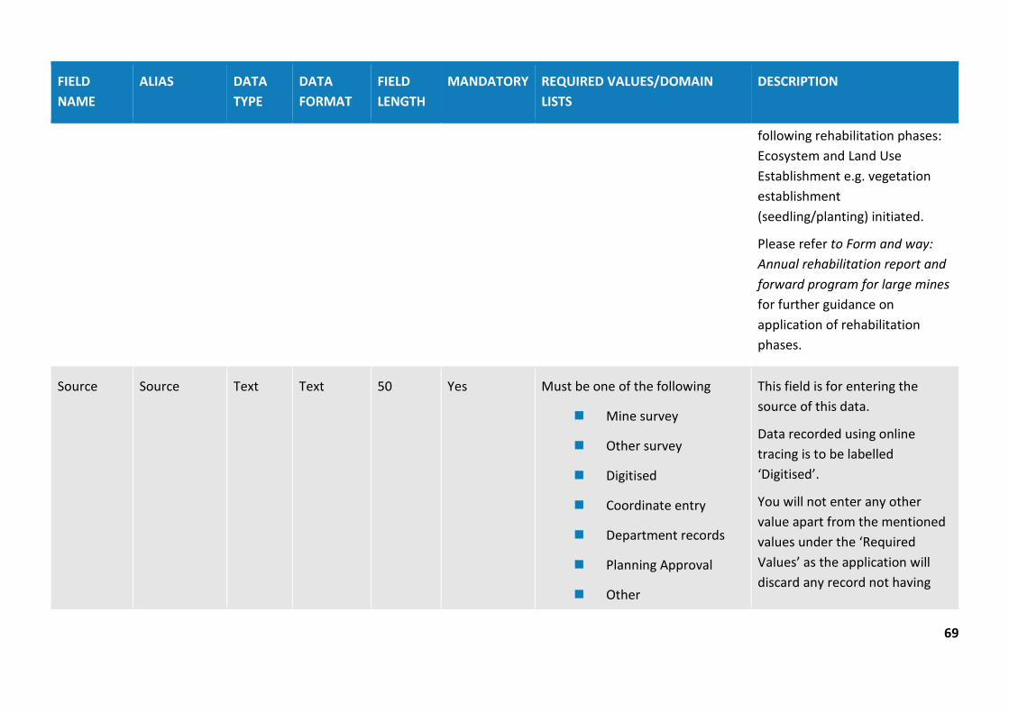
69
FIELD NAME
ALIAS DATA TYPE
DATA FORMAT
FIELD LENGTH
MANDATORY REQUIRED VALUES/DOMAIN LISTS
DESCRIPTION
following rehabilitation phases: Ecosystem and Land Use Establishment e.g. vegetation establishment (seedling/planting) initiated.
Please refer to Form and way: Annual rehabilitation report and forward program for large mines for further guidance on application of rehabilitation phases.
Source Source Text Text 50 Yes Must be one of the following
Mine survey
Other survey
Digitised
Coordinate entry
Department records
Planning Approval
Other
This field is for entering the source of this data.
Data recorded using online tracing is to be labelled ‘Digitised’.
You will not enter any other value apart from the mentioned values under the ‘Required Values’ as the application will discard any record not having

70
FIELD NAME
ALIAS DATA TYPE
DATA FORMAT
FIELD LENGTH
MANDATORY REQUIRED VALUES/DOMAIN LISTS
DESCRIPTION
any one of the mentioned values.
ChartDt Chart Date Date Date NA Yes Date format should be as follows DD/MM/YYYY
Enter the date value when this data was charted/created.
Chartor Chartor Text Free Text 50 Yes Free text. Enter the name of the author.
Enter the name of the person (e.g. author) who created this data.
AddInfo Additional Info
Text Text 250 No Free text. Describe any additional info as required
This is a non-mandatory field which allows for any additional information to be provided related to the feature.
Endorse Endorse Feature status
Free text 250 No Free text. This is a non-mandatory field which allows the author to highlight areas of uncertainty that may not meet the standards required.
Accuracy Accuracy Text Text 50 Yes Must be one of the following
0-5m
Defines accuracy level of data.
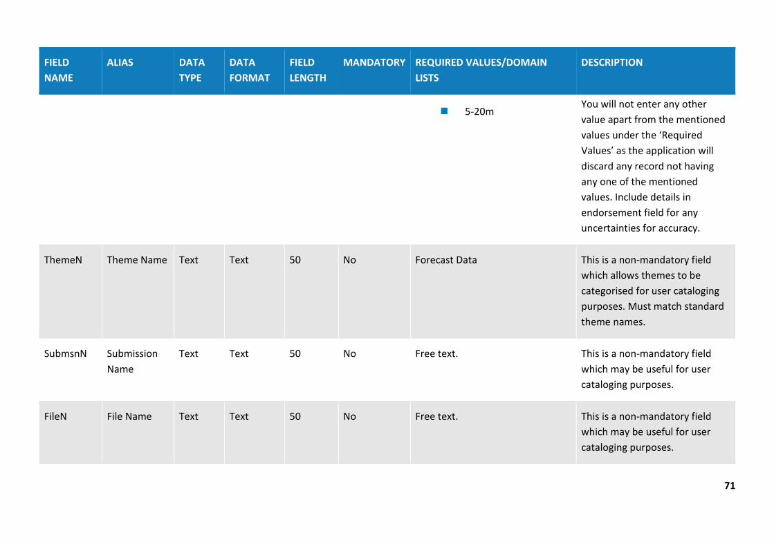
71
FIELD NAME
ALIAS DATA TYPE
DATA FORMAT
FIELD LENGTH
MANDATORY REQUIRED VALUES/DOMAIN LISTS
DESCRIPTION
5-20m You will not enter any other value apart from the mentioned values under the ‘Required Values’ as the application will discard any record not having any one of the mentioned values. Include details in endorsement field for any uncertainties for accuracy.
ThemeN Theme Name Text Text 50 No Forecast Data This is a non-mandatory field which allows themes to be categorised for user cataloging purposes. Must match standard theme names.
SubmsnN Submission Name
Text Text 50 No Free text. This is a non-mandatory field which may be useful for user cataloging purposes.
FileN File Name Text Text 50 No Free text. This is a non-mandatory field which may be useful for user cataloging purposes.

72
FIELD NAME
ALIAS DATA TYPE
DATA FORMAT
FIELD LENGTH
MANDATORY REQUIRED VALUES/DOMAIN LISTS
DESCRIPTION
Provider Provider Text Free text 50 No Free text. Provider of the surveying information.
This is a non-mandatory field which allows the author to identify the source of the data for cataloging purposes.
Data may be sourced from various providers across a mine site (e.g. Consultant ABC).
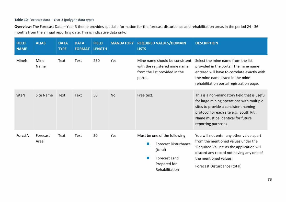
73
Table 10: Forecast data – Year 3 (polygon data type)
Overview: The Forecast Data – Year 3 theme provides spatial information for the forecast disturbance and rehabilitation areas in the period 24 - 36 months from the annual reporting date. This is indicative data only.
FIELD NAME
ALIAS DATA TYPE
DATA FORMAT
FIELD LENGTH
MANDATORY REQUIRED VALUES/DOMAIN LISTS
DESCRIPTION
MineN Mine Name
Text Text 250 Yes Mine name should be consistent with the registered mine name from the list provided in the portal.
Select the mine name from the list provided in the portal. The mine name entered will have to correlate exactly with the mine name listed in the mine rehabilitation portal registration page.
SiteN Site Name Text Text 50 No Free text. This is a non-mandatory field that is useful for large mining operations with multiple sites to provide a consistent naming protocol for each site e.g. ‘South Pit’. Name must be identical for future reporting purposes.
ForcstA Forecast Area
Text Text 50 Yes Must be one of the following
Forecast Disturbance (total)
Forecast Land Prepared for Rehabilitation
You will not enter any other value apart from the mentioned values under the ‘Required Values’ as the application will discard any record not having any one of the mentioned values.
Forecast Disturbance (total)
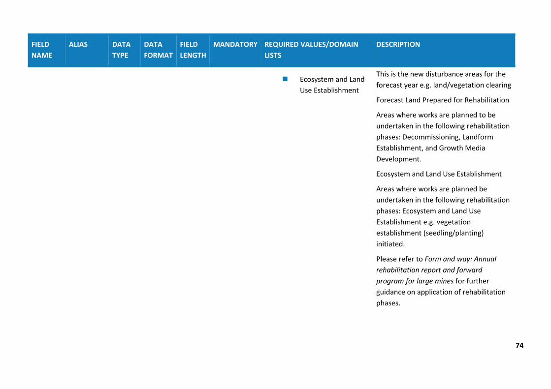
74
FIELD NAME
ALIAS DATA TYPE
DATA FORMAT
FIELD LENGTH
MANDATORY REQUIRED VALUES/DOMAIN LISTS
DESCRIPTION
Ecosystem and Land Use Establishment
This is the new disturbance areas for the forecast year e.g. land/vegetation clearing
Forecast Land Prepared for Rehabilitation
Areas where works are planned to be undertaken in the following rehabilitation phases: Decommissioning, Landform Establishment, and Growth Media Development.
Ecosystem and Land Use Establishment
Areas where works are planned be undertaken in the following rehabilitation phases: Ecosystem and Land Use Establishment e.g. vegetation establishment (seedling/planting) initiated.
Please refer to Form and way: Annual rehabilitation report and forward program for large mines for further guidance on application of rehabilitation phases.

75
FIELD NAME
ALIAS DATA TYPE
DATA FORMAT
FIELD LENGTH
MANDATORY REQUIRED VALUES/DOMAIN LISTS
DESCRIPTION
Source Source Text Text 50 Yes Must be one of the following:
Mine survey
Other survey
Digitised
Coordinate entry
Department records
Planning Approval
Other
This field is for entering the source of this data.
Data recorded using online tracing is to be labels ‘Digitised’.
You will not enter any other value apart from the mentioned values under the ‘Required Values’ as the application will discard any record not having any one of the mentioned values.
ChartDt Chart Date Date Date NA Yes Date format should be as follows DD/MM/YYYY
Enter the date value when this data was charted/created.
Chartor Chartor Text Free Text
50 Yes Free text. Enter the name of the author.
Enter the name of the person (e.g. author) who created this data.
AddInfo Additional Info
Text Text 250 No Free text with additional information
This is a non-mandatory field which allows for any additional information to be provided related to the feature.

76
FIELD NAME
ALIAS DATA TYPE
DATA FORMAT
FIELD LENGTH
MANDATORY REQUIRED VALUES/DOMAIN LISTS
DESCRIPTION
Endorse Endorse Feature status
Free text 250 No Free text. This is a non-mandatory field which allows author to highlight areas of uncertainty that may not meet the standards required.
Accuracy Accuracy Text Text 50 Yes Must be one of the following:
0-5m
5-20m
Defines accuracy level of data.
You will not enter any other value apart from the mentioned values under the ‘Required Values’ as the application will discard any record not having any one of the mentioned values. Include details in endorsement field for any uncertainties for accuracy.
ThemeN Theme Name
Text Text 50 No Forecast Data This is a non-mandatory field which allows themes to be categorised for user cataloging purposes. Must match standard theme names.
SubmsnN Submission Name
Text Text 50 No Free text. This is a non-mandatory field which may be useful for user cataloging purposes.
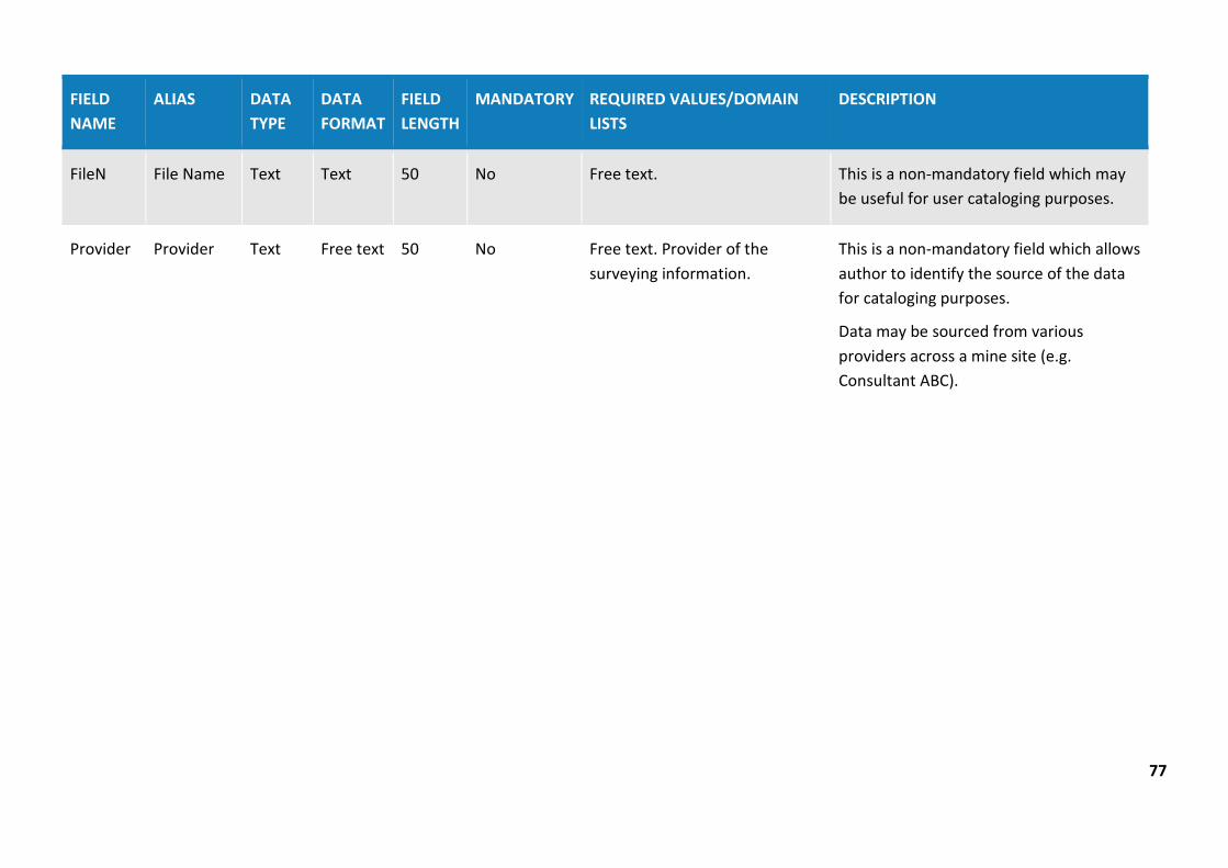
77
FIELD NAME
ALIAS DATA TYPE
DATA FORMAT
FIELD LENGTH
MANDATORY REQUIRED VALUES/DOMAIN LISTS
DESCRIPTION
FileN File Name Text Text 50 No Free text. This is a non-mandatory field which may be useful for user cataloging purposes.
Provider Provider Text Free text 50 No Free text. Provider of the surveying information.
This is a non-mandatory field which allows author to identify the source of the data for cataloging purposes.
Data may be sourced from various providers across a mine site (e.g. Consultant ABC).


