134 Gypsum and Carbonate Karst Along the I-90 Development Corridor, Black Hills, South Dakota By Larry D. Stetler and Arden D. Davis Department of Geology and Geological Engineering, South Dakota School of Mines and Technology, Rapid City, South Dakota 57701 ABSTRACT The Interstate 90 development corridor extends from Rapid City to Spearfish, South Dakota, and over- lies several formations that exhibit gypsum and carbonate karst features. Karst development commonly occurs within sections of three formations in the Black Hills region. The oldest karst features occur in the Mississippian Madison Limestone, a limestone-dolomite system that exhibits a karsted surface as well as extensive cave formation. The Pennsylvanian-Permian Minnelusa Formation contains anhydrite and thin limestone beds that have undergone localized and varied karstification. Hydration and swelling of primary anhydrite has resulted in multiple collapse structures within the formation. The Triassic Spearfish Forma- tion contains gypsum deposits throughout; however, massively bedded gypsum up to 10 m thick is con- tained at the top in the Gypsum Spring Member. All of these formations can exhibit karst topography and features where exposed, but their properties also influence ground-water flow in the subsurface. Dye tracer tests and geochemical analyses have pro- vided evidence that flow paths through these formations are controlled largely by karst features and associ- ated fracture systems. Ground water in the Madison aquifer in the Rapid City area converges from flows through karst from different surface watersheds to the south and the north. Springs at or near the contact of the Permian Minnekahta Limestone and the overlying Spearfish Formation have been chemically tied to Madison water, indicating upward flow through collapse breccia in both the Minnelusa and Spearfish for- mations. In addition, sinkholes are common occurrences in the Spearfish Formation throughout the Inter- state 90 development corridor in the Black Hills. Ground water supplies much of the municipal and private water needs in the Black Hills. As develop- ment continues throughout the region, ground-water protection should receive focused attention, particu- larly along the I-90 development corridor. Current research is aimed toward geologic mapping, hazard identification, and assessment as tools to inform the general public and as planning guides for local govern- ments.
Transcript
134
Gypsum and Carbonate Karst Along the I-90 Development Corridor, Black Hills, South Dakota
By Larry D. Stetler and Arden D. DavisDepartment of Geology and Geological Engineering, South Dakota School of Mines and Technology, Rapid City, South Dakota 57701
ABSTRACT
The Interstate 90 development corridor extends from Rapid City to Spearfish, South Dakota, and over-lies several formations that exhibit gypsum and carbonate karst features. Karst development commonly occurs within sections of three formations in the Black Hills region. The oldest karst features occur in the Mississippian Madison Limestone, a limestone-dolomite system that exhibits a karsted surface as well as extensive cave formation. The Pennsylvanian-Permian Minnelusa Formation contains anhydrite and thin limestone beds that have undergone localized and varied karstification. Hydration and swelling of primary anhydrite has resulted in multiple collapse structures within the formation. The Triassic Spearfish Forma-tion contains gypsum deposits throughout; however, massively bedded gypsum up to 10 m thick is con-tained at the top in the Gypsum Spring Member.
All of these formations can exhibit karst topography and features where exposed, but their properties also influence ground-water flow in the subsurface. Dye tracer tests and geochemical analyses have pro-vided evidence that flow paths through these formations are controlled largely by karst features and associ-ated fracture systems. Ground water in the Madison aquifer in the Rapid City area converges from flows through karst from different surface watersheds to the south and the north. Springs at or near the contact of the Permian Minnekahta Limestone and the overlying Spearfish Formation have been chemically tied to Madison water, indicating upward flow through collapse breccia in both the Minnelusa and Spearfish for-mations. In addition, sinkholes are common occurrences in the Spearfish Formation throughout the Inter-state 90 development corridor in the Black Hills.
Ground water supplies much of the municipal and private water needs in the Black Hills. As develop-ment continues throughout the region, ground-water protection should receive focused attention, particu-larly along the I-90 development corridor. Current research is aimed toward geologic mapping, hazard identification, and assessment as tools to inform the general public and as planning guides for local govern-ments.
135
Karst Features as Animal Traps: Approximately 500,000 Years of Pleistocene and Holocene Fauna and Paleoenvironmental Data from the Northern High Plains
By Larry D. Agenbroad and Kristine M. ThompsonMammoth Site of Hot Springs, South Dakota, Inc., P. O. Box 692, Hot Springs, SD 57747
ABSTRACT
Karst sinkhole features have served as natural animal traps for at least 500,000 years in the uplifted regions of the northern High Plains. We examine reported karst traps that have faunas ranging from greater than 451,000 years ago, upward through Holocene time. Chronologies are based on tephra, biostratigraphy, and absolute dating. Full glacial and interglacial faunas from the late Irvingtonian Land Mammal Age through the Rancholabrean Land Mammal Age into the Holocene, are represented. As such, sinkhole traps serve as time capsules preserving extinct fauna and clues to past environments.
INTRODUCTION
Fossil vertebrates dating to the mid-Pleistocene (Irvingtonian Land Mammal Age) to Holocene are known from filled and partially filled karst features. Located in the uplifted areas of the northern High Plains (Figure 1), at least seven of these features have served as natural traps yielding faunal and paleoenvironmental data covering the last 500,000 years. These repositories are often bell shaped solu-tion caverns with narrow openings, allowing ingress, but preventing egress for trapped fauna. Some of the features have filled with talus, roof col-lapse and both eolian and alluvial sediments. Others have been sealed off naturally and have only recently been reopened. One natural trap (the Mam-moth Site of Hot Springs, South Dakota) is a former karst feature preserved by differential erosion, creat-ing a topographic high from a former topographic low (sink).
All these karst traps have one thing in common-they are the result of dissolution of limestone or dolomite, and possibly even gypsum. Often the opening to the cave is very small, sometimes only a slot due to dissolution along fractures in the crystal-line rocks. Others are the result of roof collapse cre-ating small, somewhat circular openings. Still others represent massive cavern roof collapse creating breccia pipes extending to the surface. At least one karst trap (the Vore Buffalo Jump) is postulated to be the result of solution of gypsum beds within the Spearfish Formation (Epstein 2005).
Figure 1. Locality of karst and natural animal traps.
Many of these traps are located on, or near, the tops of ridges (Natural Trap, Salamander Cave, Graveyard Cave, Shield Cave) which were animal trails, especially during periods of heavy snow accu-mulation. As such, with small entrance openings, they may have been masked by drifting snow, con-cealing the entrance to the trap. Some features, such as Natural Trap, Wyoming, maintained a snow cone on top of the talus and debris, allowing for lateral dispersal of large, heavy bodied fauna.
136
DESCRIPTIONS
Middle to late Pleistocene
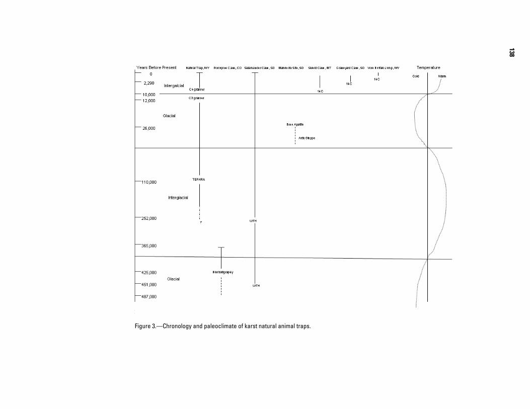
Natural Trap, Wyoming
This trap is a large, somewhat bell-shaped cav-ern formed in the Madison Formation of Mississip-pian age (Figures 1, 2a, and 3; Table 1). The entrance is small with a free fall of up to 85 ft (27 m) as illustrated in Fig. 2. The entrance is located on a ridge which serves as a major animal trail from the summit of the Bighorn Mountains to the valley floor of the Bighorn River. The entrance is small enough to be hidden almost until at the edge, and it served as a trap for pursued herbivores and their pursuing car-nivores.
Excavation has only proceeded to a depth of about 25 ft (8 m), ceasing at a volcanic ash dating to 110,000 years ago. There are still bones beneath this marker horizon, but they have yet to be investigated. Several extinct, late Pleistocene megafauna (animals over 100 pounds live weight) are represented, including mammoth, horses, musk oxen, American lions, short-faced bears, and other mammals. The first record of the cheetah in North America comes from this cave. Most of the studied fauna occur in the 12,000 to 20,000 year old horizons (Martin and Gilbert, 1978; Gilbert and Martin, 1984).
Botanical information records a C-3 grassland being replaced by a C-4 grassland at around 12,000 years ago. A paleoenvironmental interpretation is that of an arctic steppe in a cooler, wetter environ-ment, becoming warmer and drier as it approached the modern conditions. As such, the deposits reflect the last interglacial (Sangomon), the last glacial (Wisconsinan) and Holocene interglacial.
Porcupine Cave, Colorado
Originally formed in an Ordovician age Mani-tou Dolomite, Porcupine Cave was sealed naturally, in the middle Pleistocene and reopened by miners (Figures 1, 2b, and 3; Table 1). Based on biostratig-raphy, (Table 1) the deposits range from approxi-mately 487,000 to 365,000 years ago (Anderson 1996; Barnowski et aI., 1996). The fauna represents a glacial (Illinoian) to interglacial (Sangamonian)
environmental change. Significant information on the paleoenviroment of this period had been deter-mined by the rich floral and faunal record.
Salamander Cave, South Dakota
A solution cavern in the Mississippian age Madison Limestone, Salamander Cave has a narrow, slot opening from dissolution along a fracture zone (Figures 1, 2c, and 3; Table 1). The cave has two major chambers and the horse room is a naturally sealed cave with a narrow connection to the modern entrance room. A flowstone seals the bone bearing stratum revealed in a crystal hunters prospect pit. Uranium-Thorium (U/Th) dates on the flowstone are 252,000 years ago (Mead et al. 1996). It is estimated that initial bone deposition could have been as early as 451,000 years ago, based on biostratigraphy and a statistical estimate based on the U/Th dating (Mead et al. 1996). These data suggest a glacial (Illi-noian) followed by an interglacial, (Sangamonian) followed by the Wisconsinan glacial, and the Holocene interglacial.
Late Pleistocene to Holocene
Mammoth Site, South Dakota
The Mammoth site is a filled karst feature which served as a conduit for thermal artesian springs, creating a pond within the sinkhole confines (Figures 1, 2d, and 3; Table 1). It became a natural trap, selective for young, male mammoths and their behavior patterns. In addition, 47 species of other fauna were also preserved in this deposit. An aver-age radiocarbon age from one stratigraphic horizon provides a date of 26,000 years ago (Agenbroad 1994). It may have been an active trap for 300 to 750 years, ceasing to trap animals after the downcutting Fall River caused lateral migration of the artesian springs. The deposit is elliptical in form, roughly 150 ft (46 m) by 125 ft (38 m). Drill cores by the South Dakota Geological Survey indicate a depth of greater than 65 ft (22m). Animals attracted to vege-tation along the rim of a warm water pond were attracted into the sink, to find they could not climb out due to the wet, slippery, Spearfish Shale, and died of starvation or fatigue. Carnivores were attracted to the deposit by the smell of decaying ani-mals. Some smaller fauna may have been
137
Figure 2.—Plan and profile of karst animal traps in High Plains
Table 1. Generalized faunal assemblages from High Plains Karst traps
Non-mammals V G Sa M NT Sh PMollusca X X XPisces X XAmphibia X X X XReptilia X XAves X X X X
MammalsInsectivora X XChiroptera X X XXenarthra XLagomorpha X X X X X XRodentia Sciuridae X X X X X X Geomyidae X X X Heteromyidae X X X Cricetidae X X X X X Eretezontidae X X X XCarnivora Mustelidae X X X X X X Canidae X X X X X X Felidae X(?) X X Ursidae X X X XPerissodactyla Equidae X X X XArtiodactyla Tayassuidae X Camelidae X X X X Cervidae X X Antilocapridae X X X X Bovidae X X X X XProboscidea Elephantidae X X
138
Figure 3.—Chronology and paleoclimate of karst natural animal traps.
139
incorporated by being washed into the sinkhole from surrounding uplands. The reworked, cemented sedi-ment filling the sinkhole were more resistant to dif-ferential erosion, and the former low topographic expression became a modem topographic high.
Shield Cave, Montana
Shield Cave is a 46 ft (14 m) deep bell-shaped cave in the Mississippian age Madison Limestone (Figures 1, 2e, and 3; Table 1). The trap is located near the top of a southwest ridge at an altitude of 6549 ft (2606 m), in the Pryor Mountains in Carbon County, Montana. The floor of the chamber is about 15 ft (5m) wide in an elliptical configuration. The trap collected animals from 9,230 years ago to 1,250 years ago. At least 13 species of fauna have been identified from the site. The prominent fauna repre-sented is bison. Other fauna from the deposits include prairie dogs and grizzly bears (Oliver, 1989).
Graveyard Cave, South Dakota
Graveyard Cave is located in Wind Cave National Park and is a small, bell-shaped pit. There is a small, circular opening along the north wall which allowed entrance for Holocene animals (Fig-ures 1, 2f, and 3; Table 1). The floor of the cave is literally carpeted with bones. Manganaro (1994) investigated a 3 ft by 3 ft square test pit in the south-east floor of the cave. A radiocarbon date of 2290 BP indicates a late Holocene accumulation. Thousands of bones were sorted from the fill and one bone awl was identified. The site was described as an archae-ological site on the basis of this one anomalous arti-fact. We suggest it is a paleontological site with one probable artifact.
Vore Buffalo Jump, Wyoming
The Vore Buffalo Jump is an open sinkhole located between the westbound and eastbound lanes of the interstate (1-90), just west of the South Dakota state line near Beulah, Wyoming (Figures 1, 2g, and 3; Table 1). Testing by the University of Wyoming, prior to highway construction, indicates the sinkhole was used, repeatedly, as a buffalo jump for at least 300 years. Plains Indians trapped and slaughtered thousands of bison by stampeding the animals over
the steep rim. At least 22 stratified layers of bison bone beds have been recorded in the sinkhole fill. Radiocarbon dates and artifact typology place the period of use for this trap at the middle to late pre-historic interval, about 450 years ago (Frison 1991). Epstein (2001) suggests the sinkhole may have formed by solution of gypsum beds in the lower Spearfish Formation.
CONCLUSIONS
The information provided by the seven karst animal traps in the northern High Plains is presented here. Nearly 500,000 years of faunal and environ-mental data are represented in the interval repre-sented in these deposits. At least the last two glacial and interglacial intervals are represented by both faunal and more limited botanical interpretations. The presence of highly fractured and tilted carbon-ates in the uplifted areas of this physiographic region provide the possibility of many more solution fea-tures than have currently been investigated, or reported. This information indicates the high poten-tial of additional time capsules recording both extinct and extra local faunal assemblages, and the prospect of additional paleoenvironmental data.
REFERENCES CITED
Anderson, E. 1996, A preliminary report on the Carnivora of Porcupine Cave, Park County, Colorado in K. M. Stewart and K. L. Seymour, eds., Palaeoecology and Palaeoenvironment of late Cenozoic mammals, Uni-versity of Toronto Press, Toronto. p. 259-282.
Barnowsky, A. D., Rouse, T.I., Hadly, E.A., Wood, D.L., Keesing, F.L., and Schmidt, V.A., 1996, Comparison of mammalian response to glacial-interglacial transi-tions in the middle and late Pleistocene, in K. M. Stew-art and K. L.Seymour, eds., Palaeoecology and palaeo-evnironment of late Cenozoic mammals. University of Toronto Press, Toronto. p. 16-33.
Epstein, J. B. 2001. Hydrology, hazards and geomorphic development of gypsum karst in the northern Black Hills, South Dakota and Wyoming, in Kuniansky, E.L., ed.,U.S. Geological Survey Karst Interest Group Pro-ceedings, St. Petersburg, Florida February 13-16, 2001, Water-Resources Investigations Report 01-4011, p. 30.37.
140
Frison, G. C. , 1991, Prehistoric hunters of the High Plains: San Diego, CA, Academic Press, p. 226-229.
Gilbert, B. M. and Martin, L.D.,1984, Late Pleistocene fossils of Natural Trap Cave, Wyoming, and the cli-matic model of extinction, in P. S. Martin and R. G. Klein eds. Quaternary Extinctions: the search for a cause. University of Arizona Press, Tucson. p. 138-147.
Manganaro, C. A., 1994, Graveyard Cave: a Holocene faunal record from the Black Hillsof South Dakota. Unpublished Master of Science thesis. Northern Ari-zona University. 119p.
Martin. L. D. and Gilbert, B.M, 1978, Excavations at Nat-ural Trap Cave. Transactions of the Nebraska Acad-emy of Sciences 6:107-116.
Mead, J. 1., Manganaro, C.A., Reppening, C.A. and Agenbroad, L.D., 1996, Early Rancholabrean mam-mals fromSalamander Cave, Black Hills, South Dakota. in K. M. Stewart and K. L. Seymour eds. Palaeoecology and palaeoenviroment of late Cenozoic mammals. University of Toronto Press, Toronto. p. 458-482.
Oliver, J. S., 1989, Analogues and site context: bone dam-ages from Shield trap Cave (24CB91),Carbon County, Montana, USA. in R. Bonnichsen and M. H. Sorg eds. Bone Modification: Dexter, MT. Thompson-Shore, Inc. p. 73-98.
141
Developing a Cave Potential Map of Wind Cave to Guide Exploration Efforts
By Rodney D. HorrocksWind Cave National Park, RR 1 Box 190, Hot Springs, SD, 57747
ABSTRACT
Although the known boundaries of Wind Cave are expanding only gradually, the length of the overall survey is increasing at a rate of about four miles per year. This expansion reflects the on-going exploration and survey work by cavers. As an aide to these exploration efforts, a cave potential concept was developed. However, the cave potential map actually serves many purposes, including, determining the likely maxi-mum likely potential of the cave, calculating the potential length of the cave survey, identifying likely areas where significant cave may be discovered, determining the relationship, if any, with nearby Jewel Cave, determining the cave watershed boundaries, identifying potential land management partners, and guiding future land management decisions. This paper will focus on the first four purposes related to cave explora-tion. To develop the cave potential map, several data sets were gathered, including: structural geological factors, a contour map, plan and profile views of the cave survey, radio location data, geology map, blow-hole location map, water table contour map, geographic information system (GIS) generated triangular irregular networks (TIN), orthophotoquads, and a park boundary map. By combining these data sets, this exercise demonstrated that is it unlikely that Wind and Jewel Caves are connected, while at the same time it identified the maximum likely potential of Wind Cave. By calculating passage density within the current boundaries of Wind Cave and then for the maximum likely boundaries, a minimum and maximum potential length of the cave was calculated. It was determined that the current cave boundaries cover 1/8 of the total maximum likely potential of the cave. Interestingly, the maximum potential boundaries are roughly 97 per-cent inside of the current boundaries of Wind Cave National Park. Based on passage density, the length of the Wind Cave survey could range from 400 kilometers (250 miles) to 1,760 kilometers (1,100 miles). The final length depends on whether the boundaries remain as they currently are or if they were expanded to their maximum likely potential. Since the current 185.6 kilometers (116 miles) of survey represents no more than 46 percent of the minimum predicted length of the cave or as little as 10 percent of the maximum predicted length of the cave, it is obvious that a tremendous amount of surveyable passage remains in the system.
142
The Potential Extent of the Jewel Cave System
By Michael E. Wiles Jewel Cave National Monument, 11149 US Highway 16, Bldg.12, Custer, SD 57730
ABSTRACT
Currently, over 50 miles (40 percent) of the known cave system is outside park boundaries, and baro-metric airflow studies indicate that as much as 95 percent remains to be discovered. A first approximation of the maximum extent of humanly passable cave passages based on volume estimates from barometric air flow, constraints presented by geologic contacts, the water table, and known structural features have been modeled. These relationships were quantified and analyzed using structural and potentiometric contours from the U.S. Geological Survey Black Hills Hydrologic Study, surface and subsurface mapping by the National Park Service, and other sources. The model serves as an important management tool for an enor-mous resource requiring proactive measures to ensure its continued protection.
143
Geologic Controls on a Transition Between Karst Aquifers at Buffalo National River, Northern Arkansas
By Mark R. Hudson1, David N. Mott2, Kenzie J. Turner1, and Kyle E. Murray31 U.S. Geological Survey, Box 25046, MS 980, Denver, CO 802252 National Park Service, Buffalo National River, Harrison, AR 726013 University of Texas at San Antonio, San Antonio, TX 78249
ABSTRACT
Most major springs, in the central part of the 190-km-long Buffalo River watershed of northern Arkan-sas, discharge from limestone of the Mississippian Boone Formation (the Springfield Plateau aquifer). However, the largest spring, Mitch Hill Spring, discharges from dolostone of the lower part of the underly-ing Ordovician Everton Formation (part of the Ozark Plateau aquifer). New dye tracer studies and geologic mapping in and adjacent to the Davis Creek subbasin of the Buffalo River watershed have revealed the geo-logic framework of this transition between the upper and lower karst aquifers.
Seventeen new dye injection traces conducted by National Park Service in 2001-2003 indicate that the recharge area for Mitch Hill Spring is twice that previously known. Springs in the upper part of the Davis Creek subbasin locally draw interbasin recharge from the adjacent Crooked Creek watershed to the north. Importantly, a losing section in the middle reach of Davis Creek has been documented by a dye trace to con-tribute to Mitch Hill Spring, connecting it to stream flow from the upper part of the Davis Creek subbasin.
Integration of geologic mapping with the dye tracer results highlights the stratigraphic and structural features that influence ground-water flow. In general, within the erosional relief of the Buffalo River water-shed, structural lows localize the largest springs in the perched upper limestone aquifer of the Mississippian Boone Formation whereas structural highs allow recharge and discharge of the lower karst aquifer repre-sented by the lower part of the Ordovician Everton Formation.
Most springs in the upper aquifer discharge near the base of the Mississippian Boone Formation, par-ticularly its basal St. Joe Limestone Member. Local shaley facies in the St. Joe Limestone Member in this area help concentrate the springs at this stratigraphic horizon. As found in a previous study farther west, structural lows formed by faults and folds in the Boone Formation localize the largest springs, including the discharge with known interbasin recharge.
Development of the karst aquifer in the lower part of the Ordovician Everton Formation was facilitated by a change to carbonate-rich facies from sand-rich facies of the formation farther west. The losing reach of Davis Creek coincides with outcrop of lower Everton Formation brought to the surface by uplift along an anticline and monocline. Likewise, Mitch Hill Spring is localized in a dolostone interval near the base of the Everton Formation just above its contact with argillaceous dolostone of the Ordovician Powell Dolo-mite, a unit of lower karstic permeability. Both formations are exposed where the Buffalo River has eroded into the uplifted side of the northwest-trending Cane Branch monocline. Collapse breccia is widely pre-served in sandstone layers just above the dolostone horizon of Mitch Hill Spring, providing further evidence of a major karst network. The west-trending Mill Creek graben intervenes between outcrops of lower Ever-ton Formation at the losing reach of Davis Creek and at Mitch Hill Spring. A ground-water path across this graben probably utilizes down-dropped limestone of the Boone Formation to link flanking zones of lower Everton Formation.
144
Quantification of Hydrologic Budget Parameters for the Vadose Zone and Epikarst in Mantled Karst J. V. Brahana1, Tiong Ee Ting2, Mohammed Al-Qinna3, John F. Murdoch4, Ralph K.
Davis1, Jozef Laincz1, Jonathan J. Killingbeck5, Eva Szilvagyi6, Margaret Doheny-
Skubic7, Indrajeet Chaubey4, P.D. Hays1,8, and Greg Thoma21Department of Geosciences, 113 Ozark, University of Arkansas, Fayetteville, AR 727012Department of Chemical Engineering, 3202 Bell, University of Arkansas, Fayetteville, AR 727013Faculty of Natural Resources and Environment, The Hashemite University, Zarqa 13115, Jordan4Department of Biological and Agricultural Engineering, University of Arkansas, Fayetteville, AR 727015Department of Geology, Central Washington University, Ellensburg, Washington6Department of Geology, Beloit College, 700 College St., Beloit, WI 535117Department of Geology, Carleton College, 300 N. College St., Northfield, MN 550578US Department of Agriculture, National Water Management Center, 44 Ozark, Fayetteville, AR 72701
ABSTRACT
Hydrologic studies at the Savoy Experimental Watershed initially focused on conduit-flow and trans-port in the karst aquifers that underlie the site. Recently, in the last two years, a new research focus has shifted to the shallower, more diffuse-flow pathways that contribute water to the fast-flow conduits. The extended residence time and exponentially-increased particle surface areas in the soil, regolith, and epikarst have been suspected to be active geochemical sites for microbe-soil-water-rock interaction. Preliminary chemical analyses indicate that the interface and interflow zones are indeed optimum locations for bio-geochemical processing. To more fully document and provide needed data on fluxes, hydraulic parameters, and calibration quantities for numerical testing of hypotheses, an accurate characterization of hydrologic budget components within all aspects of the flow system was undertaken. This study briefly summarizes new infrastructure and presents preliminary results that have helped refine a coherent, integrated conceptual model.
INTRODUCTION
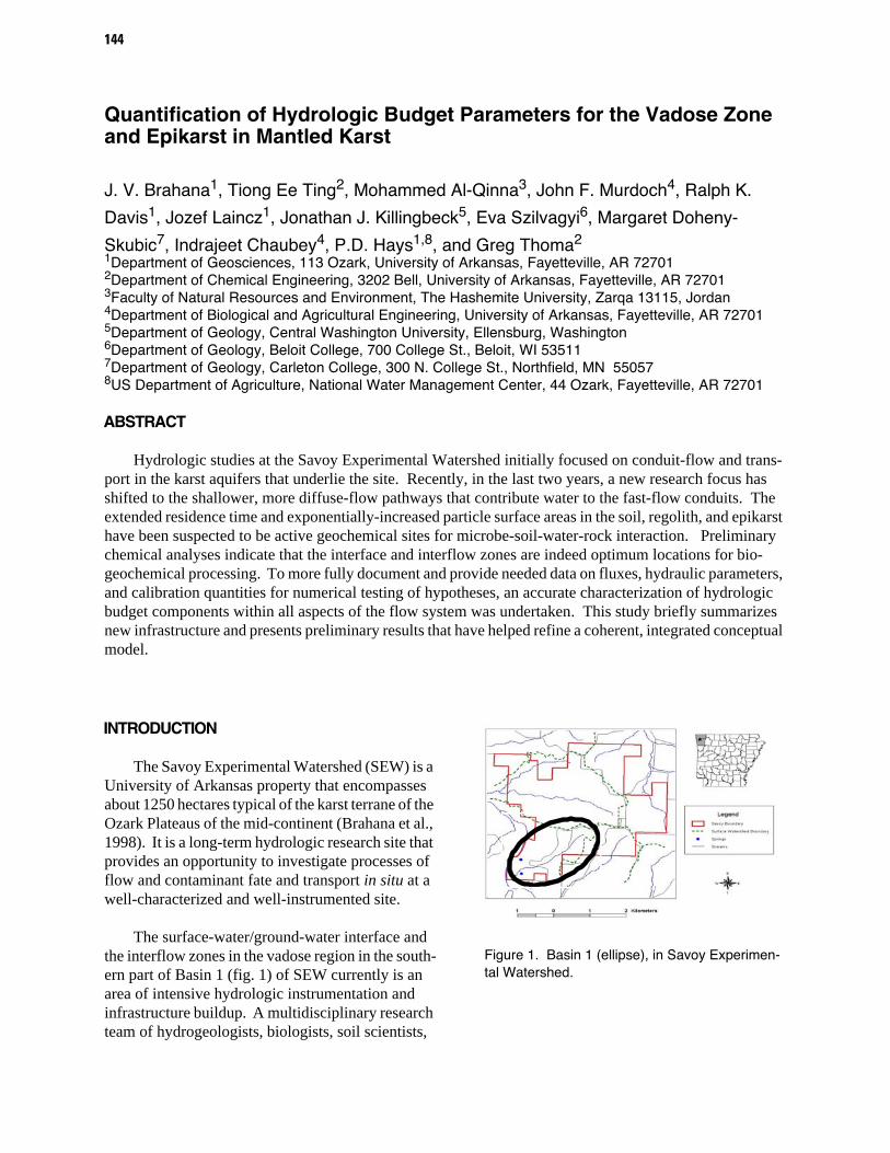
The Savoy Experimental Watershed (SEW) is a University of Arkansas property that encompasses about 1250 hectares typical of the karst terrane of the Ozark Plateaus of the mid-continent (Brahana et al., 1998). It is a long-term hydrologic research site that provides an opportunity to investigate processes of flow and contaminant fate and transport in situ at a well-characterized and well-instrumented site.
The surface-water/ground-water interface and the interflow zones in the vadose region in the south-ern part of Basin 1 (fig. 1) of SEW currently is an area of intensive hydrologic instrumentation and infrastructure buildup. A multidisciplinary research team of hydrogeologists, biologists, soil scientists,
Figure 1. Basin 1 (ellipse), in Savoy Experimen-tal Watershed.
Figure 2. Vadose zone and epikarst research area showing geometry of infrastructure in Basin 1. Circles are weirs at springs, parallel lines identify the trench, and rectangles represent field plots. Details of the infrastructure are shown in figure 3.
chemical engineers, biological and agricultural engi-neers, stable-isotope geochemists, ecologists, hydrologists, animal scientists, karst tracers, and crop scientists have installed a suite of instrumenta-tion that includes: 4 tipping-bucket rain gages; a full weather station; 6 suction lysimeters in the soil zone (fig. 2); 5 epikarst wells; one deep well; one 2-meter deep sampling trench (figs. 2, 3, and 4); 36 v-notch weirs measuring surface runoff and sheet flow from test plots (figs. 3 and 5); 3 H-flumes which capture and collect surface runoff from storms; 5 v-notch weirs and 1 H-flume on perched springs which drain the study site, 3 of which that are monitored contin-uously for discharge and temperature (fig. 2); 2 v-notch weirs on an overflow/underflow spring system that underdrains the shallow flow system through conduits in the shallowest phreatic carbonate aqui-fer; and periodic continuous autosamplers at selected sites during selected transient flow condi-tions.
H-Flume TB - Rain Gauge Surface/SubsurfaceSensors
Legend
L
L
L
L
Ground-Water Sampling Trench
Weir
1 2 3
T
W
M D
R
Springs/Seep Designations R-Red Dog D-Dribblin M-Memory W-Woodpecker T-Tree Suction Lysemeter
Figure 3. Numbered field plots of the vadose and epikarst research site. Note that the orientation of this figure has been rotated 120o clockwise from figure 2.
Springs/Seeps
146
OBJECTIVES, METHODOLOGY, AND BACKGROUND
This report has two main objectives: 1) to pro-vide a brief description of the type of infrastructure currently in place, including methodology, rationale, and expected accuracy; and 2) to synthesize data and make hydrologic interpretations based on those data. Inasmuch as space limitations preclude a detailed summary of results, information provided is not complete; the interested reader is directed to http://www.uark.edu/depts/savoyres/index.html.
Discharge at springs is determined by measur-ing the head in the pool behind 22.5o v-notch weirs. The stage-discharge data are represented theoreti-cally by the equation:
Q = 274.4 H2.5 (1)
where Q is discharge in liters per second, and H is head in meters above the bottom of the v-notch (Grant and Dawson, 1997). Below 0.06 meters, the stage discharge relation was determined empirically. Spring stage is monitored by transducers on a 5-minute interval, with an accuracy of 0.001 meter.
Precipitation is monitored by tipping-bucket rain gages, which are set to record increments (0.01 feet) of rainfall instantaneously. These are recorded with a time stamp, totalized every 5 minutes by the weather station, and recorded on digital data loggers powered by solar cells. Loggers also record other relevant digital data, and are periodically down-loaded on approximately bi-weekly intervals.
Sensors attached to weirs measure the presence or absence of surface runoff during specific storms, and subsurface saturation sensors measure depth to soil saturation. There are 36 of each of these sen-sors; accuracy is 0.002 meters (m) for the surface runoff sensors, and about 0.050 m for the subsurface saturation sensors. Water level in wells is measured with pressure transducers, which have an accuracy of 0.001 meters. Total flow from each of the plots is measured by pressure transducers attached to still-ing wells on H-flumes.
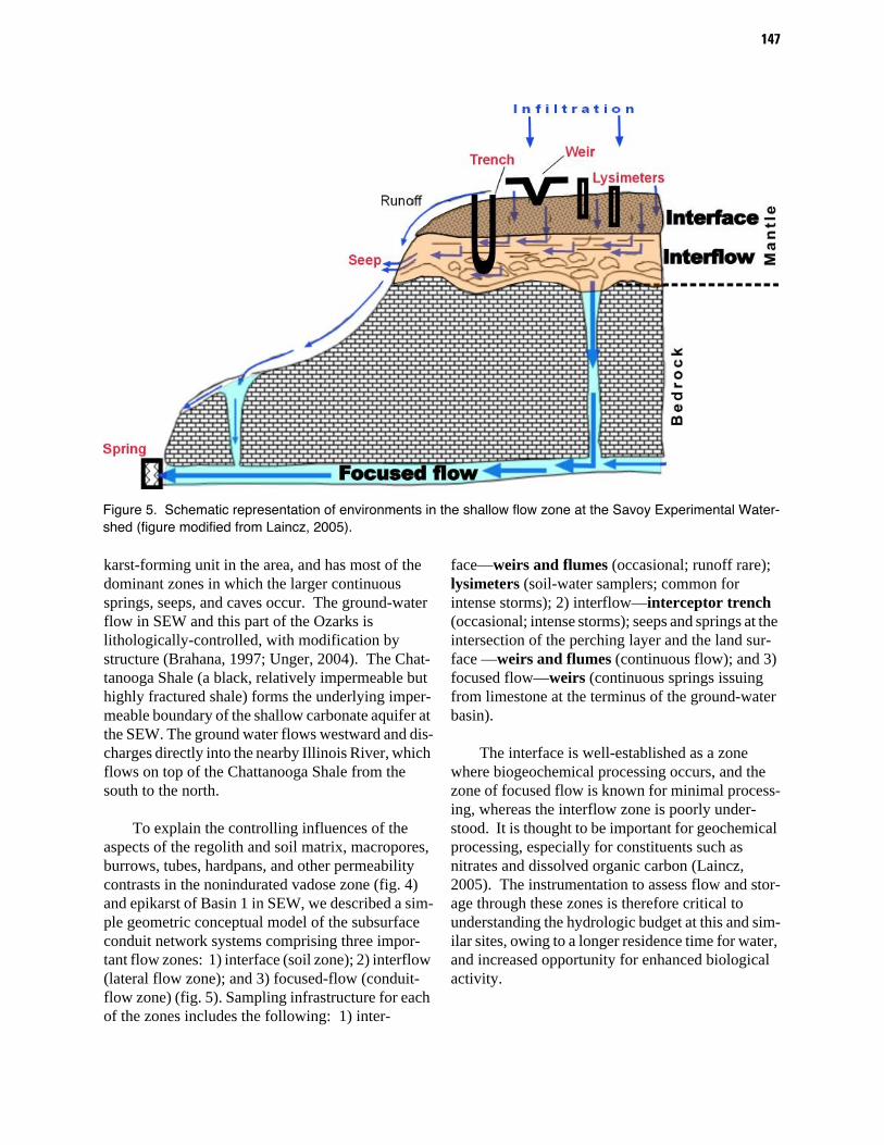
The karst hydrogeology in SEW includes aqui-fers covered by a thin, rocky soil, and a variable thickness of regolith which mantles the bedrock (figs. 4 and 5). Below the regolith lies the Boone Formation, a layer of impure, cherty limestone of approximately 55 m thickness (Al-Rashidy, 1999). The Boone is widespread and is considered to be a karst-forming formation, but owing to its high con-centration of insoluble chert and clay (as much as 70%) insoluble debris remaining from weathering mantles the surface of the carbonate rock and plugs voids in the developing conduits and bedding planes. The resulting overall karst nature of this for-mation typically is masked. Underneath the Boone Limestone is a relatively- pure, crystalline, chert-free St. Joe Limestone, about 6 m thick (Al-Rashidy, 1999). The St. Joe Formation is the predominant
Figure 4. Redoximorphic and macropore features in the trench identify and provide access to preferred flow zones in the vadose zone above the epikarst.
karst-forming unit in the area, and has most of the dominant zones in which the larger continuous springs, seeps, and caves occur. The ground-water flow in SEW and this part of the Ozarks is lithologically-controlled, with modification by structure (Brahana, 1997; Unger, 2004). The Chat-tanooga Shale (a black, relatively impermeable but highly fractured shale) forms the underlying imper-meable boundary of the shallow carbonate aquifer at the SEW. The ground water flows westward and dis-charges directly into the nearby Illinois River, which flows on top of the Chattanooga Shale from the south to the north.
To explain the controlling influences of the aspects of the regolith and soil matrix, macropores, burrows, tubes, hardpans, and other permeability contrasts in the nonindurated vadose zone (fig. 4) and epikarst of Basin 1 in SEW, we described a sim-ple geometric conceptual model of the subsurface conduit network systems comprising three impor-tant flow zones: 1) interface (soil zone); 2) interflow (lateral flow zone); and 3) focused-flow (conduit-flow zone) (fig. 5). Sampling infrastructure for each of the zones includes the following: 1) inter-
face—weirs and flumes (occasional; runoff rare); lysimeters (soil-water samplers; common for intense storms); 2) interflow—interceptor trench (occasional; intense storms); seeps and springs at the intersection of the perching layer and the land sur-face —weirs and flumes (continuous flow); and 3) focused flow—weirs (continuous springs issuing from limestone at the terminus of the ground-water basin).
The interface is well-established as a zone where biogeochemical processing occurs, and the zone of focused flow is known for minimal process-ing, whereas the interflow zone is poorly under-stood. It is thought to be important for geochemical processing, especially for constituents such as nitrates and dissolved organic carbon (Laincz, 2005). The instrumentation to assess flow and stor-age through these zones is therefore critical to understanding the hydrologic budget at this and sim-ilar sites, owing to a longer residence time for water, and increased opportunity for enhanced biological activity.
Figure 5. Schematic representation of environments in the shallow flow zone at the Savoy Experimental Water-shed (figure modified from Laincz, 2005).
148
DISCUSSION
The measurement of interflow through the weirs at the seeps and springs (Tree, Woodpecker, and Red Dog) provides insight into a component of the hydrologic budget that is seldom quantified. For the period 15 July through 20 July 2005, measure-ments of discharge were made in early morning and mid- afternoon using a graduated cylinder and a stopwatch. Ten measurements were averaged for each data point shown on the graphs (fig. 6). All plots show a diurnal reduction in flow during the period of maximum solar radiation, reflected also in the transducer measurements at each weir. This loss of water from the shallow ground-water system is interpreted to be to evapotranspiration, and is on the order of 5 to 25 milliliters per second over the course of a diurnal cycle for each spring. The period of record is not long, owing to the recent installation of the weirs this past spring, but preliminary results reflect consistent and reproducible records using multiple tools, and provide confidence that the quan-tities are accurate and reflect actual conditions in the subsurface.
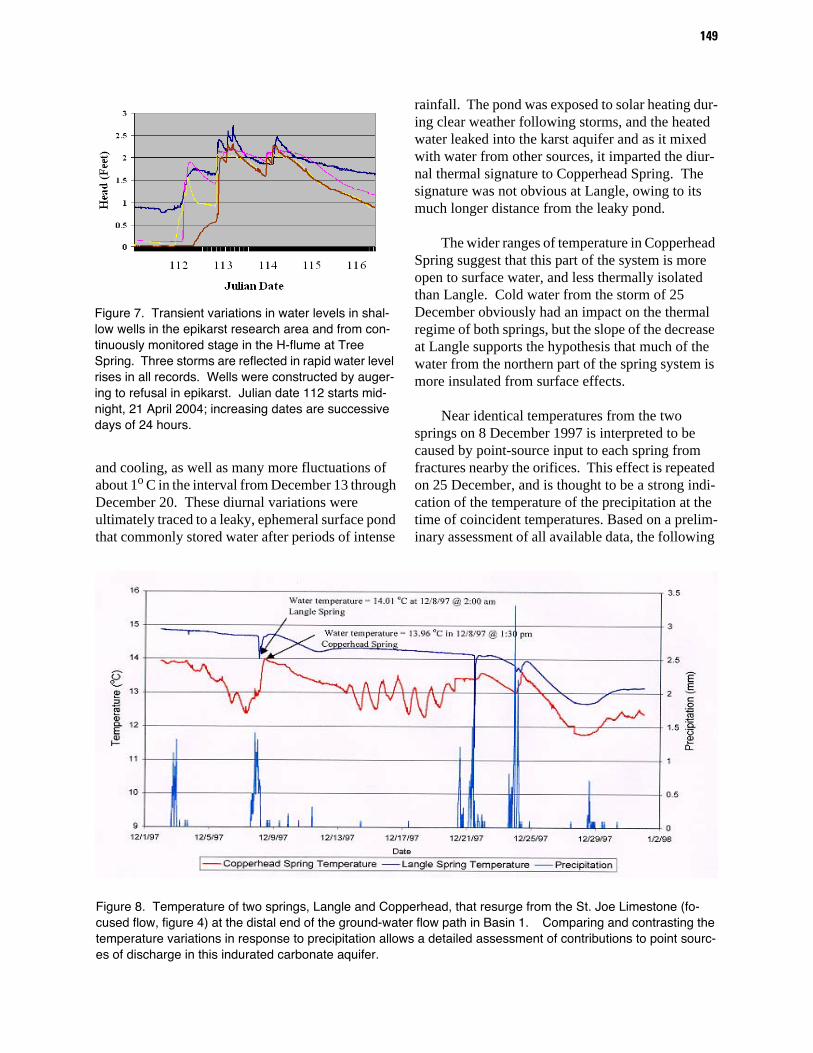
Another suite of data from the epikarst site shows transient variations in stage of the H-flume at Tree Spring, and water levels in 3 epikarst wells (fig. 7) within the field plots. Three transient storm pulses are reflected in the water-level records start-ing on Julian date 112 (21 April 2004), with an obvi-ous lag in the first record from plot 3 (fig. 3), reflecting the furthest downgradient well. This lag in water-level increase is interpreted to be caused by dryer conditions in a downgradient direction. Water level in the downgradient well does not rise until deficient soil moisture in the plot has been accom-modated, after which time the water-level responses are rapid and coincident with the wells in plots 1 and 2. The delayed response of the H-flume at Tree Spring is explained by unsaturated conditions along the flow path initially requiring saturation. Once achieved, subsequent spring stage rises are almost instantaneous with precipitation occurrence and with ground water increases in wells (fig. 7).
Physical and chemical water-quality parameters are valuable tools that also hold clues for under-standing the complexities of flow in karst terranes
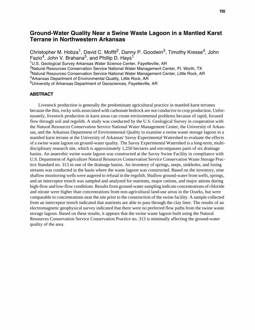
(fig. 8). Continuous monitoring of two springs at the distal end of the ground- water flow path in Basin 1 provides an illustrative example. Langle Spring, the underflow part of the focused flow sys-tem, is about 3 centimeters lower than Copperhead, the overflow spring. During a 33-day period starting in December 1997, five major storms perturbed the stability of the temperature of these springs (fig. 8). These produced a general overall cooling in the dis-charge waters of Langle, although the trend was by no means linear or gradual. Water from Copper-head, on the other hand, showed both warming and cooling trends, numerous abrupt reversals in heating
Figure 6. Diurnal variations in discharge (Q) in Tree, Woodpecker, and Red Dog Springs, interpreted to re-flect increased transpiration during periods of maxi-mum solar radiation. All springs are shallow and perched on chert in epikarst of lower 5 meters of the Boone Formation. 0 time is midnight, 15 July 2005.
149
and cooling, as well as many more fluctuations of about 1o C in the interval from December 13 through December 20. These diurnal variations were ultimately traced to a leaky, ephemeral surface pond that commonly stored water after periods of intense
rainfall. The pond was exposed to solar heating dur-ing clear weather following storms, and the heated water leaked into the karst aquifer and as it mixed with water from other sources, it imparted the diur-nal thermal signature to Copperhead Spring. The signature was not obvious at Langle, owing to its much longer distance from the leaky pond.
The wider ranges of temperature in Copperhead Spring suggest that this part of the system is more open to surface water, and less thermally isolated than Langle. Cold water from the storm of 25 December obviously had an impact on the thermal regime of both springs, but the slope of the decrease at Langle supports the hypothesis that much of the water from the northern part of the spring system is more insulated from surface effects.
Near identical temperatures from the two springs on 8 December 1997 is interpreted to be caused by point-source input to each spring from fractures nearby the orifices. This effect is repeated on 25 December, and is thought to be a strong indi-cation of the temperature of the precipitation at the time of coincident temperatures. Based on a prelim-inary assessment of all available data, the following
Figure 7. Transient variations in water levels in shal-low wells in the epikarst research area and from con-tinuously monitored stage in the H-flume at Tree Spring. Three storms are reflected in rapid water level rises in all records. Wells were constructed by auger-ing to refusal in epikarst. Julian date 112 starts mid-night, 21 April 2004; increasing dates are successive days of 24 hours.
Figure 8. Temperature of two springs, Langle and Copperhead, that resurge from the St. Joe Limestone (fo-cused flow, figure 4) at the distal end of the ground-water flow path in Basin 1. Comparing and contrasting the temperature variations in response to precipitation allows a detailed assessment of contributions to point sourc-es of discharge in this indurated carbonate aquifer.
150
conceptual model is thought to describe the control-ling influences of surface- and ground-water interaction within the SEW (fig. 9). Ground-water recharge (from precipitation) within SEW is distrib-uted areally across the mantled aquifer, yet prelimi-nary data suggest that runoff and recharge occur at discrete points. Lateral flow in the vadose zone, and temporal changes in directions of flow are a function of many factors which are highly variable, and can only be observed over long periods of observation that reflect the full range of hydrologic variability experienced at the site. Surface-water basins and ground-water basin boundaries do not coincide at SEW. This means that if a contaminant were spilled on the ground in one watershed, it may not necessar-ily show up in wells or springs in the same water-shed; it may be “pirated” along unseen underground flow routes to discharge at another resurgence point. Permeability contrasts within the soil, at the soil-rock interface, and within the solid-rock aquifer con-centrate flow and distribute it down gradient along the flow paths of least resistance. These preferred pathways are a reflection of many factors, and are a dominant control on the hydrology. Springs in Basin 1 represent the interception of flowpaths with
the land surface, and these range across a continuum of intermittent, infrequent flowing seeps that barely trickle to continuous springs that flow year-round. The epikarst developed on the Boone Formation, and the relatively-pure limestone of the St. Joe For-mation represent the two most common zones in which continuous springs and seeps occur. Hydrau-lic gradients of the ground-water, which generally appear to follow the tilt (structural dip) of the rock formations, act independently (are decoupled) from surface-water bodies where confinement by chert layers in the Boone Formation is effective. This decoupling is also lithologically controlled, but in areas of faults and major joints, exhibits strong structural control. Stream piracy is one manifesta-tion of combined lithologic and structural control that is obvious in Basin 1.
CONCLUSIONS
The wealth of karst understanding at SEW has benefited from long-term integrated research of a truly multidisciplinary flavor. Research projects have grown from basic descriptive studies of resource assessments to sophisticated
Figure 9. Conceptual model showing the relation between the karst flow components of Basin 1 in SEW (Ting, 2005).
151
process-oriented studies that cut across the bound-aries of disciplines and draw from the community of many sciences. The conceptual models of flow have evolved from simple two-component mixing models to sophisticated three-dimensional models (fig. 10) that consider conservative and non-conservative constituents (Ting, 2005; Laincz, 2005; Al-Qinna, 2004). Numerical models of the site have been applied, and though not yet perfected, they provide insight and improving tools with which to test our hypotheses (Unger, 2004).
Hydrologic budget parameters are but one com-ponent of our recent emphasis, but such studies rep-resent an essential part in gaining a thorough understanding of such complex systems. With our expanding infrastructure, burgeoning data bases, and our lengthening period of study, we feel that we are following the right path to finally get to solutions
that will allow us to provide meaningful answers to pressing land-use questions.
REFERENCES
Al-Qinna, Mohammed, Measuring and modeling soil water and solute transport with emphasis on physical mechanisms in karst topography: unpublished Ph.D. dissertation, University of Arkansas, Fayetteville, 279 p.
Al-Rashidy, S.M., 1999, Hydrogeologic Controls of Groundwater in the Shallow Mantled Karst Aquifer, Copperhead Spring, Savoy Experimental Watershed, Northwest Arkansas: unpublished M.S. thesis, Univer-sity of Arkansas, Fayetteville, 124 p.
Brahana, J.V., 1997, Rationale and methodology for approximating spring-basin boundaries in the mantled karst terrane of the Springfield Plateau, northwestern Arkansas: in Beck, B.F. and Stephenson, J. Brad, eds.,
Figure 10. Proportional geometric model of the subsurface conduit network systems of Basin 1 in SEW. The storage unit is represented with a larger pipe in the conceptual conduit model, and is based on contin-uous flow data, tracing data, and long-term chemographs. (Ting, 2005)
152
Sixth Multidisciplinary Conference on Engineering Geology and Hydrogeology of Karst Terranes, A.A. Balkema, Rotterdam, p. 77-82.
Brahana, J.V., Sauer, T.J., Kresse, Tim, Al-Rashidy, Said, Shirley, Tracy, and McKee, Paul, 1998, Tipping the scale in long-term karst research—Hydrogeologic characterization of the Savoy Experimental Water-shed: Proceedings Volume, Water Quality of Surface and Ground Water and Best Management Practice, Arkansas Water Resources Center, p. 9-17.
Fanning, B.J., 1994, Geospeleologic analysis of cave and karst development within the Boone and St. Joe Forma-tions of Benton and Madison counties, Northwest Arkansas: unpublished M.S. thesis, University of Arkansas, Fayetteville, 144 p.
Grant, D.M and Dawson, B.D., 1997, Isco Open channel flow measurement handbook: Isco, Inc., Lincoln, Nebraska, 5th ed.
Laincz, Jozef, 2005, A biogeochemical /hydrological approach to characterize transport and cycling of nitro-gen in mantled karst watershed: Arkansas Water Research Conference, Fayetteville, Conference Pro-ceedings [compact disk].
National Research Council, 2001, Conceptual models of flow and transport in the fractured vadose zone: National Academy Press, Washington, 374 p.
Palmer, A.N., 1990, Groundwater processes in karst ter-ranes, in Higgins, C.G., and Coates, D.R. (eds.), Groundwater geomorphology: The role of subsurface water in Earth-surface processes and landforms, Boul-der, Colorado: Geological Society of America Special Paper 252.
Ting, Tiong Ee, 2005, Assessing bacterial transport, stor-age and viability in mantled karst of Northwest Arkan-sas using clay and Escheria coli labeled with lan-thanide-series metals: unpublished Ph.D. dissertation, University of Arkansas, Fayetteville.
Unger, Tim, 2004, Structural controls influencing groundwater flow within the mantled karst of the Savoy Experimental Watershed, Northwest Arkansas: unpublished M.S. thesis, University of Arkansas, Fayetteville, 124 p.
153
Characterization of Nutrient Processing at the Field and Basin Scale in the Mantled Karst of the Savoy Experimental Watershed, Arkansas
By Jozef Laincz1, P.D. Hays2,3, Sue Ziegler4, Byron Winston4, J.F. Murdoch5, J.V. Brahana2, K.F. Steele2, Indrajeet Chaubey5, and Ralph K. Davis2 1Program of Environmental Dynamics, 113 Ozark, University of Arkansas, Fayetteville, AR 727012Department of Geosciences, 113 Ozark, University of Arkansas, Fayetteville, AR 727013US Department of Agriculture, National Water Management Center, 44 Ozark, Fayetteville, AR 727014Department of Biological Sciences, 528 Science and Engineering, University of Arkansas, Fayetteville, AR 727015Department of Biological and Agricultural Engineering, 203 Engineering, University of Arkansas, Fay-etteville, AR 72701
ABSTRACT
Animal production and associated pasture application of animal manures in vulnerable karst regions poses a significant threat to water quality. Balanced nutrient application presupposes an understanding of biogeochemical processes and controls on nitrogen transport, transformation, and sequestration—an under-standing that is not well evolved for karst.
Concentration and bioavailability of dissolved organic carbon, and karst hydrogeological compart-ments were investigated as important factors controlling nutrient cycling and transport. Additionally, con-centration and isotopic composition of NO3
- was used to determine the extent of denitrification and immobilization of nitrate.
The study incorporated sampling events during two hydrologic regimes, storm and base flow, to char-acterize three components of a shallow system of a karst watershed: (1) surface-water/ground-water inter-face (soil/regolith) zone, (2) interflow over permeability contrasts zone, and (3) focused flow zone. The first two are presumably the zones with increased biogeochemical processing of nutrients due to longer retention time and greater matrix/water ratios. The importance of the soil zone in nutrient utilization and immobili-zation is well established. Conversely, the minimal degree of nutrient processing that occurs in the focused flow zone in karst is also well documented; however, the amount of nutrient processing that may occur in the interflow zone in karst setting has not been studied. The potential for nutrient processing that may occur in the interflow zone is important because of the lack of processing in thin soils and the focused flow zones that typify karst.
Study results indicate that dilution of dissolved nutrient species and flow bypassing the soil zone through macropores are two important controls on nitrogen behavior. A key finding of the study is that the decrease of nitrate concentrations observed within the interflow zone is greater than can be ascribed to dilu-tion, indicating that microbial processing of nitrate is an important occurrence. Hydrologic conditions dic-tate flow-paths and affect biogeochemical processing of nitrate.
Once the biogeochemical mechanisms proposed are completely elucidated, the impact of agricultural practices on the integrity of these zones, and the way the processes occurring within these zones can be cap-italized upon for nutrient management can be tested.
154
Transport Potential of Cryptosporidium parvum Oocysts in a Drinking-Water, Karstic-Limestone Aquifer: What We Have Learned Using Oocyst-Sized Microspheres in a 100-m Convergent Tracer Test at Miami's Northwest Well Field
Ronald W. Harvey1, Allen M. Shapiro2, Robert A. Renken3, David W. Metge1, Joseph N. Ryan4, Christina L. Osborn4, and Kevin J. Cunningham31U.S. Geological Survey, 3215 Marine Street, Boulder, Colorado 803032U.S. Geological Survey, 12201 Sunrise Valley Drive, Reston, Virginia 201923U.S. Geological Survey, 9100 NW 36th St., Miami, FL 331784Dept. Civil, Environ., and Arch. Eng., University of Colorado, Boulder, Colorado 80309
ABSTRACT
Aquifers characterized by karstic limestone are highly vulnerable to contamination by pathogens, in part because their solution-enlarged conduits and fracture systems can result in rapid and significant pref-erential flow. Contamination by Cryptosporidium parvum, a waterborne pathogenic protist, is of particular concern in areas where shallow karstic systems also serve as the drinking water supply. The vulnerability of Miami’s Northwest Well Field (NWWF) to contamination by C. parvum oocysts was assessed in a large-scale, forced-gradient (convergent) injection and recovery test. The field study involved simultaneous pulse introduction to the Biscayne Aquifer of a conservative tracer (SF6, an inert gas) and a polydispersed suspen-sion of oocyst-sized (2-5 µm, diameter) carboxylated polystyrene microspheres. Estimated fractional recoveries for the microspheres at a municipal supply well 100-m downgradient from the injection borehole were inversely related to microsphere diameter and ranged from 2.8% for the largest to 5.6% for the smallest size classes or from 4.7% - 9.3%, respectively, if corrected for the incomplete (~60%) cumulative recovery observed for SF6 in the same field test. Results from flow-through column studies with NWWF limestone cores housed in a modified triaxial cell indicated that microsphere surrogates may underestimate the trans-port potential of oocysts in Biscayne Aquifer by 4-6 fold, in part because of the microspheres’ more-reactive surface (more negative zeta potential) under the calcium, ionic strength, and very slightly alkaline condi-tions of the Biscayne Aquifer. Our study suggests that, although the karstic limestone within the Biscayne Aquifer appears to have a substantive sorptive capacity for oocysts, it may take more than two hundred meters of transport to ensure even a 1-log unit removal of oocysts in the vicinity of the NWWF, depending upon the local-scale heterogeneity and factoring in a reasonable margin of safety. Flow-through column studies involving intact limestone cores housed within a modified triaxial cell suggest that considerable spa-tial variation in the transport behavior of microspheres relative to a conservative tracer may be expected because of the spatial variations in limestone structure beneath the NWWF.
155
Ground-Water Quality Near a Swine Waste Lagoon in a Mantled Karst Terrane in Northwestern Arkansas
Christopher M. Hobza1, David C. Moffit2, Danny P. Goodwin3, Timothy Kresse4, John Fazio4, John V. Brahana5, and Phillip D. Hays11U.S. Geological Survey Arkansas Water Science Center, Fayetteville, AR2Natural Resources Conservation Service National Water Management Center, Ft. Worth, TX3Natural Resources Conservation Service National Water Management Center, Little Rock, AR 4Arkansas Department of Environmental Quality, Little Rock, AR5University of Arkansas Department of Geosciences, Fayetteville, AR
ABSTRACT
Livestock production is generally the predominant agricultural practice in mantled karst terranes because the thin, rocky soils associated with carbonate bedrock are not conducive to crop production. Unfor-tunately, livestock production in karst areas can create environmental problems because of rapid, focused flow through soil and regolith. A study was conducted by the U.S. Geological Survey in cooperation with the Natural Resources Conservation Service National Water Management Center, the University of Arkan-sas, and the Arkansas Department of Environmental Quality to examine a swine waste storage lagoon in a mantled karst terrane at the University of Arkansas' Savoy Experimental Watershed to evaluate the effects of a swine waste lagoon on ground-water quality. The Savoy Experimental Watershed is a long-term, multi-disciplinary research site, which is approximately 1,250 hectares and encompasses parts of six drainage basins. An anaerobic swine waste lagoon was constructed at the Savoy Swine Facility in compliance with U.S. Department of Agriculture Natural Resources Conservation Service Conservation Waste Storage Prac-tice Standard no. 313 in one of the drainage basins. An inventory of springs, seeps, sinkholes, and losing streams was conducted in the basin where the waste lagoon was constructed. Based on the inventory, nine shallow monitoring wells were augered to refusal in the regolith. Shallow ground-water from wells, springs, and an interceptor trench was sampled and analyzed for nutrients, major cations, and major anions during high-flow and low-flow conditions. Results from ground-water sampling indicate concentrations of chloride and nitrate were higher than concentrations from non-agricultural land-use areas in the Ozarks, but were comparable to concentrations near the site prior to the construction of the swine facility. A sample collected from an interceptor trench indicated that nutrients are able to pass through the clay liner. The results of an electromagnetic geophysical survey indicated that there were no preferred flow paths from the swine waste storage lagoon. Based on these results, it appears that the swine waste lagoon built using the Natural Resources Conservation Service Conservation Practice no. 313 is minimally affecting the ground-water quality of the area.
156
INTRODUCTION
Animal production in northwestern Arkansas is the predominant agricultural practice because the thin, rocky soils are unsuitable for sustainable crop production. Nationally, Arkansas ranks 2nd in broiler production, 16th in cattle, and 17th in swine production (U.S. Department of Agriculture, 2003). Animal waste generated from these agricultural operations typically is applied to local pastures, often in excess of nutrient requirements. These excess nutrients have little opportunity for natural attenuation in a mantled karst setting because of thin soils and underlying karst geology that allow rapid, focused flow resulting in contaminated ground and surface waters. Adamski (1987) compared nutrient concentrations in springs in an intensely farmed area with a minimally affected forested area and reported that the areas of intense livestock production had elevated concentrations of nitrate and chloride.
One potential source of ground-water contami-nation is from animal waste stored in anaerobic lagoons generated from confined animal feeding operations. These lagoon structures are designed to store animal waste for a specified time period until the waste is ready to be applied as liquid fertilizer to adjacent pastures or cropland. If not properly located, designed, constructed, and maintained, ani-mal waste lagoons can adversely affect water quality through the introduction of excess nutrients and bac-teria (Ham and DeSutter, 2000).
The Natural Resources Conservation Service (NRCS) has developed several Best Management Practices (BMPs) to reduce this risk of ground-water contamination. Waste Storage Practice no. 313 was created to allow producers to safely and effectively store animal waste while protecting ground-water resources in environmentally sensitive areas across a variety of hydrogeological environments (Natural Resources Conservation Service, 2003). Ideally, these structures are located in areas with thick soils, over deep or confined aquifers, and away from domestic water supplies. When this is not possible, the NRCS provides options that allow an additional measure of safety such as an impermeable geosyn-thetic membrane liner or a compacted liner con-
structed from native soil with a specific permeability.
This BMP has been successful in protecting ground-water resources in other hydrogeologic set-tings, (David Moffit, Natural Resources Conserva-tion Service, oral commun., 2004) but its effectiveness has not been evaluated in areas with thin soils such as a mantled karst setting. To address this need, the U.S. Geological Survey in cooperation with the Natural Resources Conservation Service National Water Management Center, the University of Arkansas, and the Arkansas Department of Envi-ronmental Quality designed a study to determine the effectiveness of Waste Storage Practice no. 313 for storing swine waste in a mantled karst setting. The purpose of this report is to describe ground-water quality near the swine waste lagoon.
STUDY AREA
The Savoy Swine Facility is located within the Savoy Experimental Watershed (SEW) in northern Washington County in northwestern Arkansas (fig. 1). The SEW serves as a long-term, multi-disci-plinary research site to examine water-quality prob-lems associated with livestock production in a mantled karst setting. The SEW offers a unique opportunity to test and evaluate the environmental effects of different animal agricultural practices. In 2002 the University of Arkansas constructed the Savoy Swine Facility to improve planned large-scale swine production. The Savoy Swine Facility is managed as a demonstration farm to provide a long-term model for environmentally friendly manage-ment of animal nutrition, animal waste and odors (Maxwell and others, 2003).
The Savoy Swine Facility is located within the Springfield Plateau (Fenneman, 1938), which is underlain by nearly flat lying Mississippian-age cherty limestones and limestones. These sedimentary sequences have been incised by streams to form dendritic drainages and rolling hills. Karst features such as springs, sinkholes, losing streams, caves, and conduits are present in the study area (Little, 1999).
157
0
0
1
1
2 Miles
2 Kilometers
Base map modified fromU.S. Geolog ical Survey digital data, 1996
36 07’30”o
36 10’o
94 22’30”o 94 20’o 94 17’30”o
Figure 1. Location of the Savoy Swine Farm and diagram of waste storage infrastructure within the Savoy Experimental Watershed.
The major geologic units present in the study area are the Chattanooga Shale, the St. Joe Lime-stone Member of the Boone Formation, and the Boone Formation. The Chattanooga Shale is a black, Devonian-age shale that is approximately 45 feet thick within the SEW (Little, 1999) that unconform-ably underlies the St. Joe Limestone Member. The Chattanooga Shale acts as a regional confining unit where it is present in the Ozarks separating ground-water flow between the Mississippian-age lime-stones which compose the Springfield Plateau aqui-fer and the underlying Ordovician-age dolomites and sandstones which compose the Ozark aquifer (Imes and Emmett, 1994). The St. Joe Limestone Member, which is part of the Boone Formation is a relatively pure limestone, is conformably overlain by cherty limestone. The Boone Formation consists of Mississippian-age cherty limestones and is thick-est beneath the uplands throughout the study area. The bedrock in the study area is overlain by regolith that is the weathering product of the cherty lime-
stone of the Boone Formation that creates the man-tled karst topography. The soils formed from the regolith are composed of silt loams and the associ-ated subsoils are silty clay loam or cherty silt loam (Harper and others, 1969).
The waste storage infrastructure at the Savoy Swine Facility was constructed in compliance with Waste Storage Practice no. 313 (Natural Resources Conservation Service, 2003). Because the swine facility was constructed over an unconfined lime-stone aquifer, more stringent design options were considered for the waste lagoon. The most econom-ical solution was to construct a compacted clay liner from sieved native soil with a target coefficient of permeability of 1.0 x 10⁻⁷ centimeters per second (Stan Rose, Natural Resources Conservation Ser-vice, oral commun., 2004). Because of budget con-straints during the construction, the Savoy Swine Facility is only able to house half the animals it was initially designed for. As a result the waste storage
158
36 07’30”o
36 08o
36 08’30”o
94 20’30”o 94 20’o 94 19’30”o 94 19’o
Base map modified fromU.S. Geological Survey digital data, 1996
0
0
0.25
0.25 0.5 Kilometer
0.5 Mile
ANAEROBICLAGOON
INTERCEPTORTRENCH
Figure 2. Location of water-quality sampling points within study area.
infrastructure is substantially oversized with respect to the number of animals served (Karl VanDev-ender, University of Arkansas, oral commun., 2004). The Savoy Swine Farm has a unique project-specific design constructed with four holding ponds each designed to store animal waste for a set of ani-mals with a specific diet (fig. 1).
METHODS
A karst inventory was conducted in the area of the swine farm to gain a better understanding of the ground-water system prior to sampling point selec-tion and well drilling. An inventory of springs, seeps, sinkholes, and losing and gaining reaches of streams was compiled. Nine shallow monitoring wells were augered to the depth of drilling refusal in the regolith. All wells were constructed with 2-inch polyvinyl chloride (PVC) casing and slotted PVC screen sections. A sand filter pack was installed sur-rounding the screened section with 2 feet of bento-nite overlying the filter pack to prevent surface
contamination. An interceptor trench was installed west of the anaerobic lagoon on the swine farm and was excavated with a backhoe to the bedrock surface to allow collection of lagoon leachate moving down-gradient from the anaerobic lagoon after a storm event (fig. 1).
Sampling points consisted of monitoring wells, springs, seeps, and the interceptor trench. Water-quality samples were collected (fig. 2) during high-flow conditions in April 2004 and low-flow condi-tions in October 2004. The interceptor trench was sampled after one storm event on July 27, 2004. All samples were analyzed for nutrients including nitrate plus nitrite, ammonium, total Kjeldahl nitro-gen, total phosphorus, and orthophosphate, major cations and major anions by the Arkansas Depart-ment of Environmental Quality (ADEQ) Water Quality Laboratory in Little Rock, Arkansas. Nitrate plus nitrite concentrations are reported as nitrate for this report because nitrate is the dominant form of nitrogen for this analyte. Fewer monitoring wells
159
were sampled during low-flow conditions because some of the wells were dry or did not yield water for sampling.
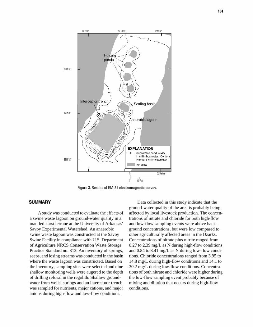
An electromagnetic geophysical survey was conducted near the waste storage infrastructure to determine any areas of preferential seepage from the lagoon and to assess the selection and placement of the sampling points. An EM-31 is a frequency domain electromagnetic instrument that is capable of determining subsurface conductivity (Geonics, 1984). Electromagnetic surveys have been success-ful in the past locating areas of preferred seepage from animal waste lagoons. Areas of lagoon seepage result in anomalously high subsurface conductivities compared to unaffected areas (Brune and Doolittle, 1990). Conductivity data were collected with a hor-izontal dipole instrument orientation providing an average depth of investigation of 6 meters. Global Positioning System (GPS) data and subsurface con-ductivity data were collected simultaneously. These data were plotted and contoured using the computer program Surfer (2002) for visual interpretation of results.
GROUND-WATER QUALITY
Concentrations of nitrate and chloride for both high-flow and low-flow sampling events were above background concentrations, but were low compared to other areas in the Ozarks affected by livestock production (table 1). Background concentrations for nitrate plus nitrite in forested, relatively pristine areas of the Ozarks are typically less than 0.5 milli-grams per liter (mg/L) as nitrogen (N) and 5.0 mg/L for chloride (Steele, 1983). Data collected in this study indicate that local livestock production proba-bly is affecting the ground-water quality of the area. Concentrations of nitrate ranged from 0.27 to 2.39 mg/L as N during high-flow conditions and 0.84 to 3.41 mg/L as N during low-flow conditions. Chlo-ride concentrations ranged from 3.95 to 14.8 mg/L during high-flow conditions and 14.1 to 30.2 mg/L during low-flow conditions. Concentrations of both nitrate and chloride were higher during the low-flow sampling event probably because of mixing and dilution that occurs during high-flow conditions.
Table 1. Concentrations of nitrate and chloride for low-flow and high-flow sampling events
[Background concentrations of nitrate and chloride are from relatively pristine, forested areas of the Ozarks. Source sample collected from anaero-bic lagoon]
Sampling point
High-flow sampling(concentrations in mg/L)
Low-flow sampling (concentrations in mg/L)
DateNitrate as N
Chloride DateNitrateas N
ChlorideAmmonium
as NWell 1 4-12-04 1.08 14.8 - - - -
Well 2 4-12-04 2.10 6.96 10-5-04 1.37 18.4 -
Well 3 4-12-04 1.23 9.97 10-5-04 1.07 18.9 -
Well 4 4-12-04 0.32 5.87 10-5-04 0.98 14.4 -
Well 5 4-12-04 0.46 3.95 - - - -
Well 6 4-12-04 0.75 5.87 10-6-04 0.84 15.2 -
Well 7 4-12-04 0.27 3.95 10-6-04 0.99 14.1 -
Well 8 4-12-04 0.62 14.3 10-5-04 2.22 29.1 -
Well 9 4-12-04 1.99 12.9 - - - -
Hidden Spring 4-12-04 2.39 11.5 10-5-04 3.41 30.2 -
These results were comparable to a previous study conducted prior to the construction of the Savoy Swine Facility. Little (1999) collected water-quality samples from springs, seeps, and wells prox-imal to the study area under high-flow and low-flow sampling conditions. Nitrate concentrations ranged from 0.06 to 4.64 mg/L as N and chloride concentra-tions ranged from 2.89 to 27.0 mg/L as N. The ele-vated concentrations suggest that the basin probably was affected by local livestock production prior to the construction of the Savoy Swine Facility. The highest concentrations of nitrate and chloride were detected near the University of Arkansas Beef Head-quarters towards the eastern portion of the study area (fig. 2).
The results from the interceptor trench sample indicate that nitrogen is seeping through the anaero-bic lagoon liner as ammonium with nitrification converting the ammonium into nitrate. The intercep-tor trench sample had concentrations of nitrate at 23.5 mg/L as N and ammonium concentrations at 1.19 mg/L as N. A water-quality sample was col-lected from the anaerobic lagoon on June 13, 2005. The form of nitrogen within the anaerobic lagoon is predominantly ammonium, with concentrations at 40.0 mg/L as N. Nitrate concentrations were 0.44 mg/L as N and chloride concentrations were 462 mg/L in the lagoon sample (table 1). The lagoon
leachate is probably mixing with other waters result-ing in lower concentrations of nitrate and chloride in downgradient sampled wells and springs. Based on these ground-water quality data, the swine waste lagoon built using the Natural Resources Conserva-tion Practice no. 313 is minimally affecting the ground-water quality of the area.
ELECTROMAGNETIC GEOPHYSICAL SURVEY
The results of the EM-31 survey did not identify any areas of preferential seepage from the holding ponds, settling basin, or anaerobic lagoon. Subsur-face conductivities ranged from 0.6 to 21.0 millim-hos per meter. It appears that most of the leakage is from the anaerobic lagoon and the leachate is migrating from the source in a fairly uniform pattern (fig. 3). There is very little leakage from the waste holding ponds and settling basin. This is probably because the animal waste stored in both the holding ponds and settling basin contains a much higher pro-portion of solid animal waste compared to the anaer-obic lagoon. The solid waste is able to create a seal that decreases liner permeability (Natural Resources Conservation Service, 2003). Based on the results of the EM-31 survey it appears that the oversizing of the waste storage infrastructure is having a negative impact on the effectiveness of the anaerobic lagoon.
161
3
12
126
18126 6
96
3
0
0
50 Meters
50 Feet
36 08’32”o
36 08’35”o
36 08’37”o
97 19’37”o 97 19’35”o 97 19’32”o
Figure 3. Results of EM-31 electromagnetic survey.
SUMMARY
A study was conducted to evaluate the effects of a swine waste lagoon on ground-water quality in a mantled karst terrane at the University of Arkansas' Savoy Experimental Watershed. An anaerobic swine waste lagoon was constructed at the Savoy Swine Facility in compliance with U.S. Department of Agriculture NRCS Conservation Waste Storage Practice Standard no. 313. An inventory of springs, seeps, and losing streams was conducted in the basin where the waste lagoon was constructed. Based on the inventory, sampling sites were selected and nine shallow monitoring wells were augered to the depth of drilling refusal in the regolith. Shallow ground-water from wells, springs and an interceptor trench was sampled for nutrients, major cations, and major anions during high-flow and low-flow conditions.
Data collected in this study indicate that the ground-water quality of the area is probably being affected by local livestock production. The concen-trations of nitrate and chloride for both high-flow and low-flow sampling events were above back-ground concentrations, but were low compared to other agriculturally affected areas in the Ozarks. Concentrations of nitrate plus nitrite ranged from 0.27 to 2.39 mg/L as N during high-flow conditions and 0.84 to 3.41 mg/L as N during low-flow condi-tions. Chloride concentrations ranged from 3.95 to 14.8 mg/L during high-flow conditions and 14.1 to 30.2 mg/L during low-flow conditions. Concentra-tions of both nitrate and chloride were higher during the low-flow sampling event probably because of mixing and dilution that occurs during high-flow conditions.
162
These results were comparable to a previous study conducted prior to the construction of the Savoy Swine Facility. Water-quality samples were collected from springs, seeps, and wells within near the study area under high-flow and low-flow sam-pling conditions. Nitrate concentrations ranged from 0.06 to 4.64 mg/L as N and chloride concentrations ranged from 2.89 to 27.0 mg/L. The elevated con-centrations suggest that ground water in the basin has been affected by local livestock production prior to the construction of the Savoy Swine Facility.
A water-quality sample collected from an inter-ceptor trench after a storm event on July 27, 2004 had concentrations of nitrate at 23.5 mg/L as N and dissolved ammonium concentrations at 1.19 mg/L as N. The results from the interceptor trench sample indicate that nitrogen is seeping through the anaero-bic lagoon liner as ammonium with nitrification converting the ammonium into nitrate. The lagoon leachate probably is mixing with other waters result-ing in lower concentrations of nitrate and chloride in downgradient sampled wells and springs.
The results of an electromagnetic geophysical survey identified no areas of preferred seepage from the holding ponds, settling basin, and anaerobic lagoon. Most of the leakage appears to be from the anaerobic lagoon and the leachate is migrating from the source in a fairly uniform pattern. Very little leakage from the waste holding ponds and settling basin occurs. This is probably because the animal waste stored in both the holding ponds and settling basin contains a much higher proportion of solid ani-mal waste compared to the anaerobic lagoon. Based on these results, the swine waste lagoon built using the Natural Resources Conservation Service Con-servation Practice no. 313 is minimally affecting the ground-water quality of the area.
SELECTED REFERENCES
Adamski, J.C., 1987, The effect of agriculture on the quality of ground water in a karstified carbonate ter-rain, northwest Arkansas: Unpublished M.S. Thesis, 124 p.
Brune, D.E., and Doolittle, J., 1990, Locating lagoon seepage with radar and electromagnetic survey: Envi-ronmental Geology Water Science, v. 16, no. 3, p. 195-207.
Fenneman, N.M., 1938. Physiography of eastern United States: New York, McGraw-Hill Book Co. Inc., 714 p.
Geonics Limited, 1984, Operating manual for EM-31D non-contacting terrain conductivity meter: 60 p.
Ham, J.M., and DeSutter T.M., 2000, Toward site-spe-cific design standards for animal-waste lagoons: Pro-tecting ground water quality: Journal of Environmental Quality, v. 29, p.1721-1732.
Harper, M.D., Phillips, W.W., and Haley, G.J., 1969, Soil survey of Washington County, Arkansas: U.S. Depart-ment of Agriculture, 94 p.
Imes, J.L., and Emmett, L.F., 1994, Geohydrology of the Ozark Plateau aquifer system in parts of Missouri, Arkansas, Oklahoma, and Kansas: U.S. Geological Survey Professional Paper 1414-D, 127 p.
Little, P.R., 1999, Dominant processes affecting ground-water quality and flow in Basin 2, Savoy Experimental Watershed (SEW): Unpublished M. S. Thesis, 93 p.
Maxwell, C.V., Van Devender, K., Coffey, K.P., Moore, P.A., Chaubey, I., and Smith, D.R., 2003, Swine waste demonstration and training project: University of Arkansas, Division of Agriculture, Final Project Report, 6 p.
Natural Resources Conservation Service, 2003, Agricul-tural waste management field handbook, Appendix 10D: 31 p.
Steele, K. F., 1983, Chemistry of the springs of the Ozark Mountains, northwest Arkansas: Water Resources Completion Report A-055-Ark. 47 p.
Surfer version 8.02, 2002, Surface mapping system: Golden Software.
United States Department of Agriculture, 2003, United States Department of Agriculture National Agricul-tural Statistics Service, accessed June 10, 2005 at http://www.usda.gov/nass/pubs/estindx.htm.