HA-1617 Havre de Grace Historic District Architectural Survey File This is the architectural survey file for this MIHP record. The survey file is organized reverse- chronological (that is, with the latest material on top). It contains all MIHP inventory forms, National Register nomination forms, determinations of eligibility (DOE) forms, and accompanying documentation such as photographs and maps. Users should be aware that additional undigitized material about this property may be found in on-site architectural reports, copies of HABS/HAER or other documentation, drawings, and the “vertical files” at the MHT Library in Crownsville. The vertical files may include newspaper clippings, field notes, draft versions of forms and architectural reports, photographs, maps, and drawings. Researchers who need a thorough understanding of this property should plan to visit the MHT Library as part of their research project; look at the MHT web site (mht.maryland.gov) for details about how to make an appointment. All material is property of the Maryland Historical Trust. Last Updated: 05-15-2018
Transcript
HA-1617
Havre de Grace Historic District
Architectural Survey File
This is the architectural survey file for this MIHP record. The survey file is organized reverse-
chronological (that is, with the latest material on top). It contains all MIHP inventory forms, National
Register nomination forms, determinations of eligibility (DOE) forms, and accompanying documentation
such as photographs and maps.
Users should be aware that additional undigitized material about this property may be found in on-site
architectural reports, copies of HABS/HAER or other documentation, drawings, and the “vertical files” at
the MHT Library in Crownsville. The vertical files may include newspaper clippings, field notes, draft
versions of forms and architectural reports, photographs, maps, and drawings. Researchers who need a
thorough understanding of this property should plan to visit the MHT Library as part of their research
project; look at the MHT web site (mht.maryland.gov) for details about how to make an appointment.
All material is property of the Maryland Historical Trust.
Last Updated: 05-15-2018
F v * * 300 (11-78} HA-1617
United ^ ta tes Department of t h^ Interior Heritage Conservation a.id Recreation Service
Nat iona l Register of H is to r i c Places Inventory—Nominat ion Form
See instructions in How to Complete National Register Forms Type all entries—complete applicable sections
1 . Name
historic
and/or common Havre de Grace H i s t o r i c D i s t r i c t
2. Location
street & number
city, town Havre de b r a c e vicinity of congressional district
state M a r y l a n d c o d e 24 c o u n t y Harford
3. Classification
not for publication
Second
code 0-5
Category X district
building(s) „ structure
. site .._ object
Ownership public private
X_both Public Acquisiti
in process on
being considered
Status X occupied
i innnnipieri
work in progress Accessible
yes: restricted X yes: unrestricted
no
Present Use agriculture
X commercial educational entertainment
& government
industrial military
museum park
X private residence X religious
scientific transportation other:
4. Owner of Property
name M u l t i p l e P u b l i c a n d P r i v a t e O w n e r s
street & number
city, town . vicinity of state
5. Location of Legal Description courthouse, registry of deeds, etc. H a r f o r d C o u n t y C o u r t h o u s e
street & number M a i n S t r e e t
city, town B e l A i r state M a r y l a n d
6. Representation in Existing Surveys . M a r y l a n d H i s t o r i c a l T r u s t H i s t o r i c S i t e s I n v e n t o r y
title H a v r e dp Crxcp has this property been determined elegible? yes no
federal X state county local
deposi tory for survey records Maryland Historical Trust
city, town A n n a p o l i s state Maryland 21401
7. Description HA-1617
Condition Check one Check one excellent deteriorated unaltered original site good ruins altered moved date fair unexposed
\ K ', Describe the present and original (if known) physical appearance
The district herein described lies within the borders of the City of Havre de Grace. The City is composed of a tract of 1,661 acres situated on the west bank at the mouth of the Susquehanna, at the head of the
.' Chesapeake Bay. The district takes up approximately 344 acres of this tract. The River and Bay form the eastern and southern boundaries of Havre de Grace, giving it approximately three miles of Coastal Plain Province waterfront; the proposed historic area includes this waterfront and extends inland for a distance of about five city blocks parallel to it. This inland or Western border is not exact because of modern intrusion but generally goes no further west than the major artery of Juniata Street. The exceptions are Erie, Ontario and Otsego Streets which include significant 19th century dwellings. The northern boundary of the district is the Lock House and Holding Pond which are National Register properties. This is the most densely populated section of the City, sheltering approximately 4,000 of the City's 9,000 inhabitants. (1978).
Havre de Grace, Maryland is basically a 19th century town in appearance having much in common historically and physically with such other Bay area towns as Chestertown, Oxford and St. Michaels. Havre de Grace began as a river settlement in the 17th century and was known as Susquehanna Lower Ferry. This settlement grew until there were 200 residents when he county was formed in 1773-74. The land was divided into lots before ^785, but laid out again on a grander scale in the 1790s. The earlier plan was done by Robert Young Stokes, and the later by C.P. Harducoeur. (See enclosed map).
A pamphlet of 1795 described Harducoeur's work:
eight hundred and fifty acres...laid out in squares in imitation of Philadelphia. These squares are now divided into lots, amounting in the whole to forty-five hundred. The principal street one hundred and thirty-two feet .wide, and the other seventy.
The same pamphlet stated that the town at that time had fifty "good dwelling-houses." John W. Reps, in his work Tidewater Towns, further details Harducoeur's plan:
Harducoeur provided many for public buildings and open spaces... no fewer than ten locations for churches, two of them fronting on a "public walk and Garden called Washington Square."...sites were reserved for a college, a "Bettering House", a hospital, an almshouse, "Columbia Square and Theatre", a public market, a cemetery, and a Courthouse and jail.
Havre de Grace never developed to the grand proportions laid out for her. Bel Air won the election for county seat and the Susquehanna as rarely navigable. Few structures from the 18th century have survived
out there are a significant number of houses and commercial buildings from the early and mid-19th century. Havre de Grace experienced a building boom in the late 19th century, with many Victorian structures remaining to prove it. (See architectural description).
FHP H--00 (11 /8)
For HCRS u;2 only United States Department of the Interior Heritage Conservation and Recreation Service
Mational Register of Historic Places received inventory-—domination Form rdats^ntered
Havre de Grace H i s t o r i c D i s t r i c t , H a r f o r d Coun ty Continuation sheet Mary l and Item number 7 Page
c
(DESCRIPTION, continued)
Because the town was laid out with such large lots, many houses of 19th century were built with plenty of ground around them. In the 20th century many of these lots have been divided and new structures built between the older ones. The commercial area alon gthe waterfront has experienced several fires, leaving some early buildings divided by both newer ones and empty lots. These facts have caused the historic area of Havre de Grace to have in places a disjointed appearance with older properties systematically appearing up and down the streets, in some places literally alternating with new buildings. There are quite a few streetscapes, however, that remain basically 19th century in character.
Many of the buildings in Havre de Grace are of historic and architectural importance individually. Many other older structures contribute as a group to the surviving fabric of the 19th century Tidewater town.
In general, the older structures, circa 1800 and 1825 and circa 1825 o 1850, are found in the north, east, and central sections of the historic
district, reflecting the town's growth pattern. The earliest settlement logically rose around the biggest industry, initially the Post Road crossing at the ferry. Officially licensed in 1695, the ferry was served by inns built as ferry stations on either side of the river. Rogers Tavern on the Perryville side and Lafayette Hotel on the Havre de Grace side occupy the locations of these original inns. In Havre de Grace, the Lafayette Hotel marks a point of origin for the rest of the town.
Fire ravaged the town twice, once circa 1775 and again in 1813. Most of the original structures were said to be of frame construction, and therefore easily in 1813. Streets are unified by uniform porch setbacks, and mid-to-late 19th century architecture predominates. Small-scale, two to 2% story frame dwellings form the bulk of the architecture. These are complimented by larger Queen Anne and late Federal and Greek Revival architecture as well as a significant number of commercial structures.
Within the historic area, approximately 607o of the space falls into residential use, 357o in commercial, commercial-residential, and mixed use, 470 in parks and public open space, and 1% in use by heavy industry. At present there is no zoning in Havre de Grace although a Comprehensive Plan is under consideration which recommends historic district zoning.
That Havre de Grace has a diverse collection of 19th century and early 20th century architectural types as suggested by the recent survey work conducted jointly by the Harford County Office of Planning and Zoning, the Maryland Historical Trust and the City of Havre de Grace. The survey has identified structures which pre-date the 1930s and which run a full gamut of styles and construction types. They stand together as a designed
SEE CONTINUATION SHEET #2.
FHR-4-300 (11-78)
HA-1617 Uni ted S ta tes Depar tment of t he In ter ior "heritage Conservat ion and Recrea t ion Serv ice ForHCRS e niy
. i&tlonal Register of H is to r ic P laces [received Inventory—Mominat ion Form r^!f-:f"
ter8d
Havre de Grace Historic District, Harford County Continuation sheet Mary l and Item number 7 Page 2
(DESCRIPTION, continued)
community in an easily recognizable district that corresponds with the depictions of Havre de Grace on maps dating from 1799, 1858, 1878, and 1899. (See Bibliography)
The highest proportion of the buildings are of frame construction, brick and stone construction found primarily in the earliest buildings, public structures such as churches and government buildings, and the buildings in the dominately commercial area, many of which were originally residential and later converted for commercial use or multi-purpose.
While the 17th century and 18th century history of this site is documented, virtually no pre-revolutionary fabric remains. In fact the only 18th century building at all may be the Elizabeth Rogers House, 226 N. Washington Street although the configuration of the streets can be traced to the 1780s and 90s. From the turn of the century on, however, particularly following the British attack of 1813, Havre de Grace acquired xamples of nearly all of the major styles on both an architectonic and vernacular level. These would include the Federal Period, Greek Revival, Gothic Revival, Italianate, Mansard, Queen Anne, Classical Revival, Stick Style, Shingle Style and Bungalow Style. The Federal Period (c. 1790-1820s) witnessed a type of house that one finds in the cities of Philadelphi Baltimore and Washington as well as in the rural areas of the Chesapeake region. It is constructed of wood or brick or stone,is usually two, but can be three, stories in height and is further typified by its side hall and parlor plan. A pair of end chimnies on the parlor side is most common and in the brick dwellings these are often parapeted chimnies. Decorative motifs are classical and are expressed through pedimented dormers, keyed arches and moldings and chimney-piece featuring reeding, dentils, fretting swags and garlands. Both high style and vernacular examples of this house type exist in Havre de Grace with the Elizabeth Rogers House, 226 N. Washington Street, the Parker Mitchell House, 518 Franklin Street, and the Nicholas and Gabriel Sutor House, 121 S. Washington Street, being examples.
A building which further documents this period but in a manner more specifically atuned to a maritime community is the Concord Point Lighthouse. This National Register property has been standing since c. 1829.
French influence cannot be denied in this City which tradition holds to have named for the French port by the great Lafayette. The expanded plan for the 1790s was the work of the French engineer C.P. Haudercoeur and there are such street names as Bourbon, Lafayette and Girard. At least two buildings date from this early era that are French in character. The Old Ordinary, 100 St. John Street, c. 1798-1813 with its wrap around galleries and hipped roof would be at home in New Orleans and the Averilhe-Goldsborough House, 300 N. Union Street, with its concave hipped roof appears to have been built by John Baptiste Averilhe c.1801.
FHP 5-300 (11-78)
received '-.: •-;
dale entered
HA-tin "Tiled Sta tes Department of the Interior , r ~ r""ritage Conservation and Recreation Service ' For HCRS use only iMational Register of Historic Places inventory—domination Form
Havre de Grace.Historic District, Harford County *a Continuation sheet Maryland Item number 7 Page 3
(DESCRIPTION, continued)
Just on the other side of Union Avenue from Averilhe House is the Thomas Hopkins House, 229 N. Union Street, which along with three other Union Avenue dwellings documents the Greek Revival in Havre de Grace.
While classical architecture vocabulary has never been dead in the United States it was challenged for three quarters of a century or more by the various styles of the Victorian era. In such styles as the Gothic Revival, Italianate, Mansard, Queen Anne and so called "Eclectic Style" hard edges are softened with organic scrollwork, the severe geometry of classisism replaced by asymetrical plans and massing and the severity of white surface treatments is replaced by a host of colors. These colors are seen not only in paint but in stained glass and such natural materials as stone, wood and slate. These are in general the characteristics of the Picturesque attitude towards the built environment, one which expresses a concern for the natural environment in which the building stands.
Havre de Grace is full of textbook examples of such styles and it is important to realize that not only is this period documented by individual structures, but by blocks and blocks of complete streetscapes. The Gothic Revival for instance is expressed as one level in the McCombs House, 120 S. Union Street, or the Carver House, 115 S. Union Street, but on a vernacular level in the duplex at 612-614 S. Washington Street and the Klair House, 611 Franklin Street
The Italianate manifests itself in more than one way. For instance one can see the characteristic bracketed cornice, vertical massing and low profile roof in 414 Congress Avenue, 453 Congress Avenue, or in 324 N. Union Avenue. It exists at a lower level in such houses as the James Hopper House 605 Ontario Street, or 726-728 Fountain Street or in the commercial area on buildings like 131 N. Washington Street. The same comparison can be made for the popular Mansard by looking at 450-452 Congress Avenue and 552 Franklin Street.
A late Victorian style was the Queen Anne. Characterized by both juxtaposition of shapes and textures it is well represented by such Union Avenue mansions as the Seneca Mansion, 200 N. Union Avenue, the Vosbury House, 123 S. Union Avenue, and the Vandiver, 301 S. Union Avenue. Less grandoise buildings throughout town carry the same expressions by combining cranbury brick, wood and stone by featuring turrets and towers by using heavily mullioned windows and fishscale shingles. See 126 N. Union Avenue and 209 N. Union Avenue.
In explaining the variations and philosophical attitudes of the Victorian period a single property in town comes to mind. The Van Diver Mansion, 301 S . Union Avenue, is a huge Queen Anne residenceof 1886 with richly adorned gables and a large wrap around porch. Porches on well-shaded streets that are still much used are a characteristic of Havre de
a
FHR-6-3O0 (11-7B)
United States Department of the interior heritage Conservation and Recreation Service For HCRC use oniv a
^ v
.*a2ional Reg is ter of H is to r i c P laces 'received Inven to ry—domina t i on Form [ d a t e e n t e r e * •
Havre de Grace Historic District, Harford County Continuation sheet M a r y l a n d Item number 7 Page ^
(DESCRIPTION, continued)
Grace and the Van Diver porch is one of the most impressive. The site is most valuable, however, for its collection of well preserved dependencies. There is a board and batten stable, a privy with bargeboards and a perfect example of rusticated gazebo.
One will find eclectic buildings in Havre de Grace which will show a combination of these above mentioned styles, 701-703 Ontario Street, and one will also see good examples of those buildings which played a role in the transition out of the Victorian era into modern times. The important Bungalow for example is well represented in Havre de Grace.
An important aspect of this town's housing types has not so much to do with fashion as social make-up. Alleys are an important part of the townscape having a nearly equal role with major streets insofar as they contain residences with a system of street numbers. Marion Morton in the 1976 survey realized alley residences as a type of building and in describ-ng the Lauretta Harris House for example says, "Alley houses and those uuilt on the corner of alleys have many characteristics in common. Besides their location, their size and scale are usually the same: no more than one-and-a-half stories high, two or three bays wide and two rooms deep. Another characteristic they should is their plain and simple details of fenestration, entrances, roof treatment and so forth. Many of this simple type of dwelling was used for tenament houseing and may be connected with the Black History of the community."
People use their yards in Havre de Grace and during the growing season fine flower and vegetable gardens.can be seen. These yards, the outbuildings and the alley houses make-up very interesting sub-streetscapes.
As indicated on the attached map there are intrusions into the district. The bulk of these are mid-20th century residential structures along with some commercial;.buildings particularly along Union Avenue. The major intrusions include the hospital, the nursing home and two senior citizen housing projects. While most of the open space is either historic or simply unimproved land the public and private parking lots (particularly those near the hospital and the A & P) are intrusions.
In addition to describing the buildings of Havre de Grace, one must recognize, too, a special feeling that the town has one which can only be attributed to its being a tidewater town.
The streetscapes of Havre de Grace are defined by a grid pattern that is sensitive to the fact that the town is situated in the unique setting where a major river meets the Chesapeake Bay. With at least two wide boulevards that end with waterfront vistas and a system of alternating streets and alleys, most of which do the same, there is little doubt that Havre de Grace is a "planned" waterfront community.
FHB-»-300 (11 78)
roceived
dats entered
United S ta te s Department of the Interior Heri tage Conservation and Recreation Se rv ice ' For HCRS use only Natiional Register of Historic Places inventory—Nomination Form
Havre de Grace H i s t o r i c D i s t r i c t , Harford County Continuation sheet Maryland Item number Page * (DESCRIPTION, continued)
As John Reps points out in Tidewater Towns Havre de Grace did not "just happen". The present townscape represents an early attitude towards this special maritime site and as well as the recognition of the 19th century American fashion and building technique.
Another aspect of Havre de Grace's vistas that should not be forgotten relates not only to how the water is seen from in town but to the image which the town projects to the river and Bay. Considering that it has a history of three centuries as a river settlement, it is only in very recent times that the waterway has ceased to be the principal transportation route to Havre de Grace.
There is still quite a bit of commercial traffic which passes Havre de Grace and an even greater volume of pleasure boats. The latter traffic is expected to increase with the proposed planned revitalization.
Havre de Grace entered via water is quite different than Havre de "race and an even greater volume of pleasure boats. The latter traffic , expected to increase with the proposed planned revitalization.
Havre de Grace entered via water is quite different than Havre de Grace entered by the Old Post Road or Route 40. When entering the Susquehanna from the Bay one sees a town facing the water. Her bulkheads meet the water and her piers extend out into it. Her streets, more than twenty of them, come down to the water and allow the boat traveler to look into the town. The facades of so many buildings, not only along the waterfront but along such higher streets as Market Street, make visual contact with river traffic. In fact, on approaching Havre de Grace fromthe south, one is first greeted by the facades of such landmarks as the Bayou Hotel and the Concord Point Lighthouse which because of the open space around them can both announce the presence of a town and allow one to see into it.
These aforementioned residences exhibit naturally significant styles should not obscure the fact that Havre de Grace is composed of many othe types of historic constructions as well. These certainly include the buildings of the commercial sector of Washington Street with their range of shopfront. There is the Seneca Warehouse, St. John Street and Pennington Avenue, which is visual document of the fact that this waterfront community has a thriving past of industrial activity whichincluded shipping,canning gathering and selling ice, the shipping of coal and fishing. It is this activity and such related construction as bulkheads, piers, wharfs and 'he related sheds and outbuildings which document human activities at .at special place where the land meets the water.
More than one era of commercial transportation is indicated by the alignment of the Old Post Road, the canal and lockhouse and the tressels and bridges of the Pennsylvania railroad.
FHH-J-iOO (11-78)
United States Department of the Interior Heritage Conservation and Recreation Service
National Register of Historic Places Invenitory—Nomination Form Havre de Grace Historic District, Harford County
Continuation sheet Maryland Item number
(DESCRIPTION, continued)
BOUNDARY JUSTIFICATION
The boundaries of the Havre de Grace Historic District, as being nominated to the National Register, are drawn to include the highest concentration of buildings and structures that meet the criteria for listing on the Register and contribute to the ambience of the urban district; to exclude those areas and where possible buildings and structures which do not meet the criteria or contribute to the feeling of the district such as the primarily mid-twentieth century houses and industrial site along the western border; and to utilize lines of convenience such as curb and property lines and strong visual and physical barriers.such as the Susquehanna River and the Chesapeake Bay to the east and south.
Major intrusions and incompatible structures were excluded in such areas as between Commerce and Otsego Streets where there are mid-20th century residential_developments, the 600 Block Fountain Street where
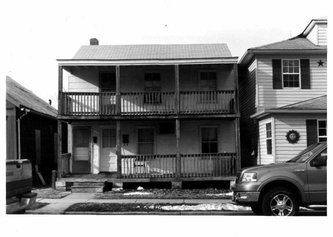
C \ mid-20th century utility building stands and north of Otsego Street .̂ here there is major 20th century commercial activity. The block between Fountain an dBourbon Streets west of Adams Street has been included where a late 19th century factory has grown functional. The boundary lines follow property lines in order to include contributing structures such as 552 South Stokes Street and 400 South Stokes Street which are important structures and contribute to the district.
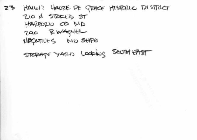
The Susquehanna River and the Chesapeake Bay were selected as the eastern and southern borders of the district.because historically these natural features have been a significant factor in the growth and development of this river city. Although many non-contributing buildings stand along the shore line, historical records indicate, as noted on the attached sketch map delineating the boundaries, the strong and logical possibility of the existence of archaeological sites that would yield information on 19th and early 20th century commercial activity of the town The terrain of Havre de Grace rises gently from the shoreline with the river and the bay providing strong visual boundaries. The town also is visually opened into the river by several streets running to the river (see photographs numbers 26, 27, 29, 30 and 32).
HA-1617
8. Signif icance
Period _ prehistoric .1400-1499 1500-1599 1600-1699
_X_ 1700-1799 X 1800-1899
_ K - 1 9 0 0 -
Areas of Signif icance—Chert* and Justi fy beSow archeology-prehistoric . 1 community planning archeology-historic agriculture
J i_ architecture art
X commerce communications
conservation economics education engineering exploration/settlement industry invention
landscape architecture law literature
. military music philosophy politics/government
religion science sculpture social/ humanitarian
. theater transportation other (specify)
Specific dates B snider Architect
Statement of Significance (in one paragraph)
SIGNIFICANCE
Havre de Grace is a small town located in northeastern Maryland where the Susquehanna River flows into the Chesapeake Bay. Historically, this town, which was founded in the 18th century has been a major commercial and transportation service center in this section of the state. An early 19th century Post Road to Philadelphia from Baltimore crossed the Susquehanna at this point; the Susquehanna and Tidewater Canal, constructed in the late 1830s, which was part of the canal system serving New York, Pennsylvania, New Jersey, Delaware, and Maryland terminated at Havre de Grace; and the town was serviced by both the Baltimore and Ohio and the Philadelphia, Wilmington, and Baltimore Railroads. The Havre de Grace Historic District consists of most of the town and is significant for the collection of 18th, 19th, and early 20th century buildings which 1) record the development and status of Havre de Grace as an important commercial and transportation center in northeastern Maryland; 2) include several excellent and well-preserved examples of the major stylistic influences that characterize American architecture up to the early 20th century; and, 3) contribute through their juxtaposition and variety of design and materials to several streetscapes that retain the basic environmental qualities associated with life in small urban centers at the turn of the 20th century.
HISTORY AND SUPPORT
When considering style, construction methods and socio-economic roles, the buildings of Havre de Grace are extremely informative. One finds relatively unaltered examples of the Federal Era, Greek Revival, Gothic Revival, Italianate, Queen Anne and others grouped in a single section of the City. These buildings utilize stone, brick and frame in their construction with various combinations of the three. One finds the mansion house and the commercial structures which facilitated the wealth to build it as well as the buildings of the average people who have contributed to the developnent of this area. In all, there are more than 800 buildings that do, or could, contribute to the district.
That these buildings are components of streetscapes that define blocks and neighborhoods in a townscape produces an area which has natural borders on two sides and a clear separation of date, style and material from modern developments 'or. the North and West. These historical resources are important in light of the recent formation of an Historic Preservation Committee in Havre de Grace as well as an organized attempt at commercial revitalization in the old business district.
SEE CONTINUATION SHEET #7.
>"HR »-300 (11-781
Uni ted 'S ta tes Depar tment of the In te r io r Her i tage Conservat ion and Rec rea t i on Serv ice
National Register of Histor ic Places Invsntory—-Mornaraatiori Form Havre de Grace H i s t o r i c D i s t r i c t , H a r f o r d C o u n t y ,
Continuation sheet M a r y l a n d Item number 8
(SIGNIFICANCE, continued)
Like Chestertown, Oxford, St. Michaels and others, Havre de Grace survives from both a distant and recent time when Chesapeake Bay and its tributaries were a primary transportation system. Havre de Grace has been a commercial service center at the crossing of a major transportation since the 17th century when it was known as Susquehanna Lower Ferry. The Old Post Road leading to Philadelphia crossed the Susquehanna at this point, the Susquehanna and Tidewater Canal terminated at Havre de Grace and it was served by both the B & 0 and P.W. & B. railroads. In modern times U.S. Route 40 and the AmTrack system loom above the town and river on their respective bridges. There is still quite a bit of commercial water traffic which passes Havre de Grace and even greater volume of pleasure boats. The latter traffic is expected to increase with the proposed planned revitaliza-tion. The town is a landmark in navigating the length of the Chesapeake Bay marking its uppermost shores.
There is in Tidewater Maryland a special physical relationship where the land meets the water and these natural elements experience built environment. Havre de Grace was planned perhaps as early as 1785 but certainly by 1795, to provide for a series of orderly two-way vistas. More than twenty streets in Havre de Grace not only allow those in town to look out onto the water, but in turn allow those on the water to look into the town.
With its docks, bulkheads and piers the town literally reaches out into the water creating a very special relationship between the natural and built environment. These extensions can be seen on the Atlasses of 1857 and 1878 and most clearly on the Hopper Map of 1889. While such constructions as the coal and ice wharves are no longer extant one does still find a "town wharf", "ship yard" and the Seneca Warehouse as well as the shoreline configuration scene on the 19th century atlases.
The combination of these historic buildings and the design of their setting is a tout ensemble that allow one the unique experience of seeing and feeling perhaps as much as possible pre-modern life in Tidewater Maryland.
HA-1617
For HC.1S i:~c on ly
' r ece i ved
date entered
Page
FHR-C-OOO ( ' 1 78)
United States Department of Ihe Interior HA-1617 Heritage Conservation and Recreation Service For HC?S use only!
National Register of Historic Places received inventory—Mcrtuiraatiori Form entered
Havre de Grace Historic District, Harford County Continuation sheet M a r y l a n d Item number 9 Page 8
MAJOR BIBLIOGRAPHICAL REFERENCES
Hauducoeur, C.P., Engineer. Plan of town of Havre de Grace with the additions surveyed and laid out by the author; 1799.
Havre de Grace Planning Commission, assisted by James C. Bosworth, Jr.
Comprehensive Development Plan--City of Havre de Grace, May, 1977
Morton, Marion, Historic Sites Surveyor. Historical Report on the Southern Terminal of the Susquehanna and Tidewater Canal at Havre de Grace. 123 South Union Avenue, Havre de Grace, Maryland. February 14, 1978.
Morton, Marion, Historic Sites Surveyor. Maryland Historic Sites Inventory of Havre de Grace, Maryland. Maryland Historical Trust, 21 State Circle Annapolis, Maryland, 21401, June 12, 1977.
Norris, Septimus, Engineer. Map of Havre de Grace, 1838. Copied by Henry C. Fulan Wider, 1883.
lep, John S. Tidewater Towns. Williamsburg, Va.: The Colonial Williamsburg Foundation, 1972.
Preston, S.W. History of Harford County, Maryland. Baltimore: Regional Publishing Co. (Reprint of 1910 ed.), 1972.
Sanborn Map, 1899. Sanborn-Perris Map Co., Ltd. New York, 1899.
HA-1617 United Sta tes Depar tment of the Inter ior Her i tage Conservat ion and Recrea t ion Serv ice
< cr HCRS use only
National Register of Historic P!a C 8 S '"received
inventory—No minsation Form date en te red
Havre de Grace Historic District, Harford County Continuation sheet Maryland Item number 10 Page 9 VERBAL BOUNDARY DESCRIPTION
The boundaries of the Havre de Grace Historic District as being nominated to the National Register are delineated by a broken line on the attached map labeled "Havre de Grace National Register Historic District which was prepared in December 1980 and drawn to a scale of 1-200'. The boundaries consist of the existing inner curblines and property lines of the indicated streets and properties and the shoreline on the east and south sides.
SEE CONTINUATION SHEET #8
10. Geographical Data Acreage of nominated property 3 3 4 a c r e s a p p r o x i m a t e l y
Quadrangle name H a v r e d e G r a c e Q u a d r a n g l e Quadrangle scale 1 : 2 4 0 0 0
UMT References
A | l | 8 | [410,611,2,01 14,317,819,0,01 B |1,8 | |4 JO ,6 |9 ,2 ,0 | |4 ,3 |7 ,7 |7 ,0 ,0 | Zone Easting Northing Zone Easting Northing
c j l , 8 | 1410,617,8,01 14,317,710^,01 D |1 ,8 | fr [0 £ [4 |2 ,0 1 [4,317,617,8^1
E l L U l^|0.6|0,9,0| [4 ,3 [7 ,6 |7 ,9 fl | F |1J8J |4 |0 g (5 ,6 fl 1 [4 3 |7 g [5 ,1 0
G | l , 8 | 1410,5|6,6,0| 14,3|7,818 gjDJ H | , | 1 I • I , , 1 1 , I , I , i I
Verba l boundary desc r ip t i on and j u s t i f i c a t i o n
SEE CONTINUATION SHEET #9.
Lis t al l s t a t e s and count ies for p rope r t i es over lapp ing s t a t e or coun ty boundar ies
state code county code
state code county code
11 • Form Prepared By P a u l a Low, P l a n n i n g A s s i s t a n t , Wayne L . N i e l d I I , H i s t o r i c
name/title S i t e S u r v e y o r , D a r l e n e S h u l t z , A s s i s t a n t
organization H a r f o r d County D e p t . o f P l a n n i n g date November . 1980
street & number 4 5 S o u t h M a i n S t r e e t telephone ( 3 0 1 ) 8 3 8 - 6 0 0 0
city or town Bel A i r state M a r y l a n d 21014
12. State Historic Preservation Officer Certif ication The evaluated significance of this property within the state is:
national state local
As the designated State Historic Preservation Officer for the National Historic Preservation Act of 1966 (Public Law 89-665), I hereby nominate this property for inclusion in the National Register and certify that it has been evaluated according to the criteria and procedures set forth by the Heritage Conservation and Recreation Service.
State Historic Preservation Officer signature
'STATE HISTORIC PRESERVATION OFFICER date
: For HCRS use only - ; - - ~-I hereby certify that this property is included in the National Register
date
Keeper of the National Register
Attest: date
Chief of Registration
rap of the NortJiern Portion of Chesapeake Bay with a Plan of Havre de Grace, Maryland: 1799
HA-1617
M A R Y L A N D H I S T O R I C A L
T R U S T National Register Nominations;
Resource Sketch Map Codes
William Donald Schaefer Governor
Jacqueline H. Rogers Secretary, DHCD
In Maryland, for nomination of properties which have a large number of resources, the individual resources are noted on a resource sketch map as to the contributive value of each resource to the significance of the property. Decisions concerning the contributive value are based upon various factors including historical and architectural character and the integrity of historic design and decorative features such as the fenestration and trim. All major resources, both contributing and non-contributing, are to be delineated on the map. Listed below are the codes utilized by the Trust.
A. A contributing resource with an exceptionally high level of integrity and historic and/or architectural significance to the nomination.
B. A contributing resource with a high level of integrity and historic and/or architectural significance to the nomination.
C. A contributing resource with a low level of integrity whose contribution could be enhanced by sympathetic rehabilitation or restoration or by research documenting historic significance unknown at the time of nomination.
D. A resource that does not contribute to the significance of the nomination but may be eligible for listing in the National Register within another historical and/or cultural context.
E. A resource that does not contribute to the significance of the nomination and is not eligible for listing in the National Register, due to recent construction or irretrievable loss of integrity.
F. A contributing open-space of historic or scenic significance to the nomination such as a park, town square, agricultural fields, meadows, pastures, etc.
G. A non-contributing open-space which is of no significance to the nomination and is not eligible for listing in the National Register, such as a parking lot, etc.
t of Housing /and Community De Department of Housing /and Community Development Shaw House, 21 State Circle, Annapolis, Maryland 21401 (301) 974-5000