Page 1
ASSESSMENT OF HYBRID MODEL FOR SUSTAINABLE SANITARY
LANDFILL SITING USING GEOSPATIAL AND GEOTECHNICAL
TECHNIQUES
HABIBA IBRAHIM MOHAMMED
A thesis submitted in fulfilment of the
requirements for the award of the degree of
Doctor of Philosophy
Faculty of Built Environment and Surveying
Universiti Teknologi Malaysia
MARCH 2019
Page 2
iii
DEDICATION
This thesis is dedicated to my late father Alhaji Ibrahim Mohammed who
taught me how to strive for success, self-sufficient and never give up. Also, to my
late step mother Hajia Amina Yerima and my late darling sister Safiya Makarfi. May
Allah (Azza Wa Jaal) grant them the highest place in Aljannah Firdaus. Amin!!!
Page 3
iv
ACKNOWLEDGEMENT
First and foremost, I would like to express my profound gratitude to Allah
(Subhanahu Wa Taala) who has helped and guided me in all aspect of my life
especially to accomplish this work successfully and made me overcome all
circumstances, Alhamdulillah!
Special thanks and appreciation to my able supervisor Assoc. Prof. Dr Zulkepli
Majid for his guidance, valuable advices, encouragement and continuous guidance
throughout the stages of this research. I would like to also thank you for allowing me
to grow as a research scientist. I beseech Allah to reward you with highest rank of
Aljannah Firdaus. My thanks to all the members of staff of the Department of
Geoinformatic, FABU, notably Assoc. Prof Mohamad Nor Said, Dr Mohd Farid, Dr
Khairul Idris, Kak Ella, Madam Dewi, and Aini. I also appreciate the technical staff of
Geotechnical Engineering laboratory, School of Civil Engineering UTM for their
assistance during the research.
I extend my thanks and gratitude to Universiti Teknologi Malaysia for
providing me with the International Doctorate Fellowship (IDF) and an enabling
environment and facilities for the success of this thesis.
My sincere appreciation to my beloved mother Hajia Bilkisu Bature for her
endless support and encouragement throughout the period of my study. Also, to my
wonderful husband Engr. Dr. Yamusa Bello Yamusa for his motivation, valuable
advice, corrections and commitment to ensure that this thesis was completed. I am also
highly obliged to my kids Aliyu, Nur Bilkis and, Suwaibah having you has always
been a source of inspiration and encouragement to me. Mummy loves you so much. I
would like to use this opportunity to extend my gratitude to my beloved family
members especially Aunty Ummi, Yaya Umar and the entire family of Alh. Ibrahim
Makarfi (One love). I sincerely appreciate the endless effort of my mother in-law Hajia
Suwaiba Bello Yamusa who also contributed to the success of my study.
Finally, my sincere acknowledgement to my research group members and
colleagues who sailed through the rough waters with me, worthy of mention are Ngozi
Linda Izah, NurSyahirah Binti Ahmad Fuad and Mohd Radhie Bin Mohd Saleh.
Page 4
v
ABSTRACT
One of the major challenges in waste management is the issue of selecting an
appropriate site for sustainable sanitary landfilling for the disposal of municipal solid
waste (MSW) due to the complexity of various factors that must be considered such
as environmental, economic, and social. Therefore, this research developed an
innovative hybrid model based on the integration of geographic information systems
(GIS), multi-criteria decision analysis (MCDA) and geotechnical technique following
landfill siting guidelines and regulations. Therefore, in order to have a sustainable
sanitary landfill site selection model, there is a need to evaluate geospatial and
geotechnical properties of the area where the potential landfill is to be constructed. The
research included identification criteria of siting sanitary landfill such as water bodies,
geology, soils, elevation, slope, residential areas, archeological sites, airports,
population, roads, railways, infrastructures, and land use. Due to the large volume of
spatial data, GIS was used to manage, evaluate, and process these data. In addition,
analytical hierarchy process (AHP) was applied to solve decision making problems
where multiple alternatives and competing objectives are involved. Criteria maps
obtained for this research were prepared in the GIS environment followed by the
criteria weights obtained from AHP pairwise comparison matrix and normalization.
Next, the weighted criteria were evaluated and overlaid through GIS software ArcGIS
10.3. Then, map production of the most suitable sites for sanitary landfill was carried
out using QGIS. Finally, a hybrid model was developed by integrating geospatial and
geotechnical techniques. The results from the GIS and AHP revealed the three most
suitable sites for sustainable sanitary landfill site selection. This was further examined
using geotechnical criteria, namely permeability, volumetric shrinkage and shear
strength to obtain the best site. Additionally, computer modeling through digital image
technique (using Surfer and Matlab software) was used to validate the model. The
model developed from the results of this research can be used as a guide for sustainable
sanitary landfilling in developed and developing countries.
Page 5
vi
ABSTRAK
Salah satu cabaran utama dalam pengurusan sisa adalah isu pemilihan tapak
yang sesuai untuk pembuangan sampah sanitari yang mampan bagi pelupusan sisa
pepejal perbandaran (MSW) kerana kerumitan pelbagai faktor yang perlu
dipertimbangkan seperti alam sekitar, ekonomi dan sosial. Oleh itu, kajian ini
membangunkan model hibrid inovatif berasaskan penyepaduan sistem maklumat
geografi (GIS), analisis keputusan pelbagai kriteria (MCDA) dan teknik geoteknik
mengikut garis panduan dan peraturan tapak pelupusan sampah. Oleh itu, untuk
mempunyai model pemilihan tapak tambah sanitari sampah yang mampan, terdapat
keperluan untuk menilai sifat-sifat geospatial dan geoteknik kawasan di mana potensi
tambak pelupusan akan dibina. Kajian ini termasuk kriteria pengenalan tapak
pelupusan sanitari seperti badan air, geologi, tanah, ketinggian, cerun, kawasan
perumahan, tapak arkeologi, lapangan terbang, penduduk, jalan raya, kereta api,
infrastruktur, dan penggunaan tanah. Oleh kerana jumlah besar data spatial, GIS
digunakan untuk mengurus, menilai, dan memproses data ini. Di samping itu, proses
hierarki analitik (AHP) telah digunakan untuk menyelesaikan masalah membuat
keputusan di mana pelbagai pilihan dan objektif bersaing terlibat. Peta kriteria yang
diperoleh untuk kajian ini disediakan dalam persekitaran GIS diikuti dengan kriteria
berat yang diperoleh dari matriks perbandingan pasangan yang sepadan dengan AHP
dan penormalan. Seterusnya, kriteria pemberat telah dinilai dan ditindih melalui
perisian GIS ArcGIS 10.3. Kemudian, pengeluaran peta yang paling sesuai untuk tapak
pelupusan sanitari telah dilakukan menggunakan QGIS. Akhirnya, model hibrid telah
dibangunkan dengan mengintegrasikan teknik geospatial dan geoteknik. Hasil
daripada GIS dan AHP menunjukkan tiga tapak paling sesuai untuk pemilihan tapak
pelupusan sampah sanitari yang mampan. Kajian ini diperluaskan lagi dengan
menggunakan kriteria geoteknik, iaitu kebolehtelapan, pengecutan isipadu dan
kekuatan ricih untuk mendapatkan tapak terbaik. Di samping itu, pemodelan komputer
melalui teknik imej berdigit (menggunakan perisian Surfer dan Matlab) digunakan
untuk mengesahkan model. Model yang dibangunkan dari hasil kajian ini dapat
digunakan sebagai panduan untuk pembuangan sampah sanitari yang mampan di
negara maju dan berkembang.
Page 6
vii
TABLE OF CONTENTS
TITLE PAGE
DECLARATION ii
DEDICATION iii
ACKNOWLEDGEMENT iv
ABSTRACT v
ABSTRAK vi
TABLE OF CONTENTS vii
LIST OF TABLES xiii
LIST OF FIGURES xiv
LIST OF ABBREVIATIONS xviii
LIST OF SYMBOLS xx
LIST OF APPENDICES xxi
INTRODUCTION 1
1.1 Introduction 1
1.2 Problem Statement 4
1.3 Aim and Objectives 6
1.4 Research Questions 7
1.5 Scope of the Study 7
1.6 Significance of the Study 9
1.7 Contribution of the Study 10
1.8 Thesis Outlines 11
LITERATURE REVIEW 13
2.1 Introduction 13
2.2 Solid Waste Management (SWM) 13
2.2.1 Incineration 14
2.2.2 Composting 14
2.2.3 Pyrolysis 15
Page 7
viii
2.2.4 Source Reduction 15
2.2.5 Sanitary Landfill 15
2.3 Landfills Facility 17
2.3.1 Cells 17
2.3.2 Lift 18
2.3.3 Leachate 18
2.3.4 Landfill Liners 18
2.3.5 Landfill Gas 19
2.4 Methods of Landfilling 19
2.4.1 Excavated Cell or Trench 19
2.4.2 Area Method 20
2.4.3 Canyon 20
2.5 Landfill Design 21
2.5.1 Sanitary Landfills 21
2.5.2 Natural Attenuation Landfills 22
2.6 Landfill Site Selection 23
2.6.1 GIS and Site Selection 34
2.6.2 GIS and MCDA in Solving Spatial Problems 35
2.7 Framework for Spatial Multi Criteria Decision
Analysis 43
2.7.1.1 Fuzzy Logic 44
2.7.1.2 Weighted Linear Combination 45
2.7.1.3 Ordered Weighted Averaging 45
2.7.1.4 Analytic Hierarchy Process 46
2.8 Criteria for Landfill Siting 47
2.8.1 Environmental Criteria 48
2.8.1.1 Surface Water 48
2.8.1.2 Groundwater Resources 48
2.8.1.3 Soil 49
2.8.1.4 Slope 50
2.8.1.5 Geology 50
2.8.2 Social Criteria 51
Page 8
ix
2.8.2.1 Distance from Residential Areas 51
2.8.2.2 Proximity to Waste Production
Centers 52
2.8.2.3 Airports 52
2.8.2.4 Population Density 52
2.8.3 Economic Criteria 52
2.8.3.1 Site Capacity 53
2.8.3.2 Proximity to Roads 53
2.8.3.3 Land Uses/Land Cover 54
2.8.3.4 Infrastructural Utilities 54
2.8.4 Geotechnical Criteria 54
2.8.4.1 Compaction 55
2.8.4.2 Hydraulic Conductivity 55
2.8.4.3 Volumetric Shrinkage 56
2.8.4.4 Shear Strength 56
2.8.5 Guidelines for Landfill Siting (Local and
International) 57
2.9 Digital Image Technique (DIT) 60
2.10 Summary 61
RESEARCH METHODOLOGY 63
3.1 Introduction 63
3.2 Flow Chart 63
3.3 Selection of Important Criteria for Sustainable Sanitary
Landfill Siting 65
3.3.1 Required Data and their Sources 67
3.3.2 Data Acquisition and Preparation 68
3.4 GIS Data Analysis 69
3.4.1 Preparation of Thematic Maps 71
3.4.2 Creation of Digital Elevation Model (DEM) 71
3.4.3 Digitizing 73
3.4.4 Specifying Environment 78
3.4.5 Clip 78
Page 9
x
3.4.6 Distancing 79
3.4.7 Conversion 80
3.4.8 Reclassify 81
3.5 MCDA Method using AHP 84
3.5.1 Decision-Making Tree 84
3.5.2 Questionnaire 86
3.5.3 Deriving Priorities (Weights) for the Criteria 86
3.5.4 Consistency 89
3.6 Sanitary Landfill Suitability Evaluation 91
3.7 Validation of Potential Candidate Sites 92
3.8 Model Development 92
3.9 Geotechnical Method 94
3.9.1 Physical Properties 94
3.9.1.1 Specific Gravity 95
3.9.1.2 Atterberg Limits 96
3.9.1.3 Plastic Limit 98
3.9.1.4 Plasticity Index 99
3.9.1.5 Particle Size Distribution 99
3.9.2 Engineering Properties 100
3.9.2.1 Compaction 101
3.9.2.2 Permeability 102
3.9.2.3 Shear Strength 104
3.9.2.4 Volumetric Shrinkage 105
3.10 Model Validation using Digital Image Technique
(DIT) 106
3.10.1 Sample Preparation 107
3.10.2 Laboratory Experimental Procedures 108
3.10.3 Digital Image Processing 109
3.11 Summary 111
RESULTS AND DISCUSSION 113
4.1 Introduction 113
Page 10
xi
4.2 GIS Analysis 113
4.3 Identification of Criteria 114
4.3.1 Water bodies 114
4.3.2 Geology 115
4.3.3 Soil 117
4.3.4 Digital Elevation Model (DEM) 118
4.3.5 Slope 119
4.3.6 Residential Areas 121
4.3.7 Archeological sites 122
4.3.8 Airport 123
4.3.9 Population 124
4.3.10 Distance to Road 125
4.3.11 Railways 126
4.3.12 Infrastructure 127
4.3.13 Land Use/Land Cover (LU/LC) 128
4.4 AHP Implementation 129
4.4.1 Consistency Check 132
4.5 Final Potential Sites Map for Sanitary Landfill 132
4.5.1 Best Potential Sites Map 134
4.6 Validation of Potential Sites for Sustainable Sanitary
Landfill 135
4.7 Geotechnical Properties of the Best Landfill Sites 141
4.7.1 Physical Properties 141
4.7.2 Engineering Properties 143
4.7.2.1 Soil Compaction 143
4.7.2.2 Soil Permeability 144
4.7.2.3 Shear Strength 146
4.7.2.4 Volumetric Shrinkage 148
4.7.2.5 Overall Acceptable Zone 150
4.8 Model Validation using Digital Image Technique
(DIT) 152
4.9 General Discussion 154
Page 11
xii
4.10 Summary 156
CONCLUSION AND RECOMMENDATIONS 157
5.1 Introduction 157
5.2 Achievement of Objectives 157
5.3 Conclusion 159
5.4 Recommendations 160
REFERENCES 163
LIST OF PUBLICATIONS 208
Page 12
xiii
LIST OF TABLES
TABLE NO. TITLE PAGE
Table 2. 1 Summary of recent literature related to landfill site selection
models 26
Table 2. 2 Landfill site selection criteria from different researchers 34
Table 2. 3 Landfill site selection using GIS-MCDA methods 41
Table 2. 4 Summary of rock types and their suitability to landfill siting
(Şener, 2006) 51
Table 2. 5 Landfill siting rules and regulations of different parts of the
world and the World Bank (Ahmad et al., 2014a) 58
Table 2. 6 Landfill siting criteria ranking of different parts of the
world and World Bank (Ahmad et al., 2014a) 59
Table 3. 1 Selected criteria for sanitary landfill siting. 65
Table 3. 2 Required data 67
Table 3. 3 Data types and their sources 67
Table 3. 4 Sub-criteria ranking used in this study 82
Table 3. 5 Pair wise comparison scale 86
Table 3. 6 Pairwise comparison matrix 88
Table 3. 7 Random Consistency Index (RI) for different values of n
(Saaty, 1994) 90
Table 4. 1 Pair wise comparison matrix 130
Table 4. 2 Normalization matrix 131
Table 4. 3 Criteria weight and percentage 131
Table 4. 4 Location of best potential sites 136
Table 4. 5 Physical properties of the soils used in this study 142
Table 4. 6 Acceptable ranges of moulding water contents 151
Page 13
xiv
LIST OF FIGURES
FIGURES NO. TITLE PAGE
Figure 1.1 Map of the study area 9
Figure 2.1 Open dump landfill (www.good360.org, 2018) 16
Figure 2.2 Sanitary landfill (www.good360.org, 2018) 17
Figure 2.3 Schematic representation of a sanitary landfill with design
components (Şener et al., 2005). 22
Figure 2.4 Schematic representation of a natural attenuation landfill
(Şener et al., 2005). 23
Figure 2.5 Tree Diagram for selection of suitable landfill site (Chabuk
et al., 2016). 25
Figure 2.6 Landfill suitability map (Chabuk et al., 2016). 25
Figure 2.7 Criteria weights (Mornya et al., 2010). 36
Figure 2.8 Conceptual model for landfill site selection (Bahrani et al.,
2016). 37
Figure 2.9 Raster calculator embedded in ArcGIS 9.3 (Lawal et al.,
2011) 39
Figure 2.10 GIS and AHP Integration method adopted for regional
landfill site selection (Vasiljević et al., 2012) 40
Figure 2.11 Structure of spatial multi-criteria decision analysis. Source:
(Khan and Samadder, 2014a) 43
Figure 2.12 Fuzzy membership function 45
Figure 3.1 Overall flow chart of the methodology 64
Figure 3.2 Data acquisition and preparation 69
Figure 3.3 ArcGIS template 70
Figure 3.4 QGIS template 70
Figure 3.5 Elevation map 72
Figure 3.6 Slope tool 73
Figure 3.7 Soil map of the Peninsular Malaysia 74
Figure 3.8 Geological map of the Peninsular Malaysia 75
Page 14
xv
Figure 3.9 Topographical map of Johor Bahru 77
Figure 3.10 Environment settings 78
Figure 3.11 Clip tool 79
Figure 3.12 Euclidean distance tool 80
Figure 3.13 Conversion tool 81
Figure 3.14 Reclassify tool 82
Figure 3.15 Hierarchical diagram of decision-making tree 85
Figure 3.16 Raster calculator 91
Figure 3.17 Developed hybrid model for sanitary landfill siting 93
Figure 3.18 Flow chart showing the Geotechnical tests 94
Figure 3.19 Vacuum pyknometer apparatus 96
Figure 3.20 Cone penetrometer 98
Figure 3.21 Mechanical shaker and test sieves 100
Figure 3.22 Compaction apparatus 102
Figure 3.23 Falling head permeameter 103
Figure 3.24 Unconfined compression test machine 105
Figure 3.25 Volumetric shrinkage test 106
Figure 3.26 Flow chart of model validation process 107
Figure 3.27 Digital image laboratory setup 109
Figure 3.28 Digitizing grids and image conversion into HSI value in
surfer 110
Figure 3.29 Image transformation in Matlab 111
Figure 4.1 Reclassified map of water body 115
Figure 4.2 Reclassified map of geology 117
Figure 4.3 Reclassified map of soil 118
Figure 4.4 Reclassified map of elevation 119
Figure 4.5 Reclassified map of slope 120
Figure 4.6 Reclassified map of residential 121
Figure 4.7 Reclassified map of archeological sites 122
Figure 4.8 Reclassified map of airport 123
Page 15
xvi
Figure 4.9 Reclassified map of population 124
Figure 4.10 Reclassified map of road 126
Figure 4.11 Reclassified map of railway 127
Figure 4.12 Reclassified map of infrastructures 128
Figure 4.13 Reclassified map of land use/land cover 129
Figure 4.14 Potential sanitary landfill sites map 133
Figure 4.15 Most suitable sites map after filtering 134
Figure 4.16 Best potential sanitary landfill sites map 135
Figure 4.17 Best potential sanitary landfill sites map using Google Earth
137
Figure 4.18 Best potential sanitary landfill site map A 137
Figure 4.19 Best potential sanitary landfill sites map B 138
Figure 4.20 Best potential sanitary landfill sites map C 138
Figure 4.21 Reality view of best potential site A 139
Figure 4.22 Reality view of best potential site B 140
Figure 4.23 Reality view of best potential site C 140
Figure 4.24 Particle size distribution curves for best sites soils 142
Figure 4.25 Compaction curves for best sites soils 144
Figure 4.26 Variation of hydraulic conductivity with moulding water
content for best sites soils 145
Figure 4.27 Variation of hydraulic conductivity with dry density for
best sites soils 146
Figure 4.28 Variation of unconfined compressive strength with
moulding water content for best sites soils 147
Figure 4.29 Variation of unconfined compressive strength with dry
density for best sites soils 148
Figure 4.30 Variation of volumetric shrinkage with moulding water
content for best sites soils 149
Figure 4.31 Variation of volumetric shrinkage with dry density for best
sites soils 150
Figure 4.32 Overall acceptable zone for best site A soil 151
Figure 4.33 Leachate migration in soil column 152
Page 16
xvii
Figure 4.34 Leachate migration in soil column 154
Page 17
xviii
LIST OF ABBREVIATIONS
AHP
ANP
-
-
Analytical Hierarchy Process
Analytical Network Process
ASTER - Advanced Spaceborne Thermal Emission and Reflection
Radiometer
BSCS - British Standard Classification System
BSL - British Standard Light
DEM
DIT
-
-
Digital Elevation Model
Digital Image Technique
FL - Fuzzy Logic
GDEM - Global Digital Elevation Map
GIS - Geographic Information Systems
GLOVIS - Global Visualization Viewer
KML - Keyhole Mark-up Language
MCDA - Multi-Criteria Decision Analysis
MDD - Maximum Dry Density
MSWDS - Municipal Solid Waste Disposal Sites
NA
OMC
OWA
PI
PL
QGIS
RSO
SAW
SWM
TOPSIS
UCS
UKEA
-
-
-
-
-
-
-
-
-
-
-
-
Natural Attenuation
Optimum Moisture Content
Ordered Weighted Averaging
Plasticity Index
Plastic Limit
Quantum Geographic Information Systems
Rectified Skewed Orthomorphic
Simple Additive Weighting
Solid Waste Management
Technique for Order of Preference by Similarity to Ideal
Solution
Unconfined Compressive Strength
United Kingdom Environment Agency
Page 18
xix
USEPA - United States Environmental Protection Agency
USGS - United States Geological Survey
VSS - Volumetric Shrinkage Strain
Page 19
xx
LIST OF SYMBOLS
- Maximum Eigen Value
a - Area of the standpipe
Gs - Specific gravity
k - Hydraulic conductivity
kr - Relative hydraulic conductivity
ks - Saturated hydraulic conductivity
L - Length of sample
Si - Free swell index
t - Time
𝜓 - Suction
𝑣 - Velocity
𝑣𝑠 - Volume of soil
𝑣𝑤 - Volume of water
Page 20
xxi
LIST OF APPENDICES
APPENDIX TITLE PAGE
Appendix A Digitized and Derived Maps 186
Appendix B Distance and Rasterized Maps 192
Appendix C Questionnaire 197
Page 22
1
INTRODUCTION
1.1 Introduction
The most significant part of urban planning is identifying a desirable location
for municipal solid waste disposal landfill (Bahrani et al., 2016). However, serious
environmental problems or hazards to inhabitants can arise from landfill locations as
well as the methods with which the solid waste at a site is disposed (Sharholy et al.,
2008). The greatest concerns associated with landfill environmental impacts are linked
to its effects on ground water, surface water, air, soil, odor emission, and issues
occurring as a result of solid waste transportation (Chabuk et al., 2017a). The most
common approach used in municipal solid waste management techniques is a landfill
(Jeswani and Azapagic, 2016). Other methods are composting and incineration, but
the landfill has become the oldest and most common technique as a result of its
convenience and affordability. Due to landfills, there are lots of problem that have
risen in the waste management sector (Nas et al., 2010). There is a need for effective
and efficient solid waste management to prevent public health hazards, which will
have a negative environmental impact.
Increase in the world population and the industrialization of more cities means
an increase in the volume of waste, and managing the waste produced by cities have
become more complex (Tahir et al., 2011). Getting rid of waste using landfills has
become an unavoidable component of the entire solid waste management framework.
Regardless of reduction, reuse, and recycling activities and practices, there will always
be a need for the transfer of the remaining generated waste into the landfill. In majority
of developed and some developing countries, the most common techniques adopted
for the disposal of solid waste are the sanitary landfills (Alavi et al., 2013).
Page 23
2
Presently, solid waste disposal sites are not properly monitored in many regions
of the world, especially those that do not adhere strict terms for solid waste
management. This has given rise to a combination of commercial, industrial,
household waste as well as construction and hazardous waste into the same landfill
(Chabuk et al., 2017a; Scott et al., 2005; Stanton and Schrader, 2001). As generally
considered, open dumps or unsanitary solid waste landfill sites are the most disposal
problem because of their irregularity and threat to the environment. Also, they are
often used without sufficient hydrogeological, geological, and environmental
assessments (Önal et al., 2013). This threatens the environment due to bad odor, air
pollution, the risk of fire, surface water pollution, as well as groundwater pollution.
Therefore, undesired visual pollution can easily be traced in these categories of sites.
Planned sites for sanitary landfills must be first evaluated and measured in
detail to determine its social, environmental, economic, and geotechnical attributes in
term of subsoil and geological formations, which consist of rock types, tectonic
properties, groundwater level depth, etc. (Önal et al., 2013). The most problematic
aspects of the disposal process of municipal solid waste is the site selection issue
(Kemal Korucu and Erdagi, 2012). Due to the many factors required when identifying
landfills, this makes it become a very complex process (Önüt and Soner, 2008). These
factors can be referred to as social, environmental, geomorphological, economic,
geological, hydrological, and geotechnical. In many developing countries, the required
data is collected via traditional methods, which are tedious and time consuming, or old
existing data is used (Mohamed and Plante, 2002). According to Chabuk et al. (2016),
there is a need for waste disposal sites in the surrounding area to preserve the
biophysical environment and ecology. Similarly, other factors that must also be
considered are the factors associated with the economy, which comprise the cost of
acquiring the land together with both developmental and operational costs (Yesilnacar
and Cetin, 2008). Likewise, when protecting the environment as well as public health
while making sure the need for better sustainability features in term of quality of life,
the selection of landfill sites is seen as a fundamental step when it comes to ultimate
waste disposal practices. In terms of the preliminary landfill process, the required
successive steps are determined by proper landfill site selection. To ensure undesirable
long-term effects are avoided, it is necessary to implement landfill siting. Therefore,
Page 24
3
landfill sites should be carefully selected through the recommendations provided by
environmental agencies (Ahmad et al., 2011).
The United State is one of the countries that saw the earliest changes in the
development of sanitary landfills in the 20th century through the process of depositing
solid waste in layers, compacting, as well as making sure it is often covered with soil.
Several countries (e.g. Canada, United States, United Kingdom, Sweden, Australia,
and Malaysia) have adopted governmental regulations involving the selection, design,
and monitoring of modern landfills to avoid negative social and environmental impacts
(Scott et al., 2005). Landfill site selection operation can involve the advantages of
geospatial technology, namely remote sensing, Geographical Information Systems
(GIS), and Multi-Criteria Decision-Making Methods (MCDM). Hence, they serve as
powerful tools for addressing problems arising from landfill site selection. Remote
sensing has a great potential to extract earth surface features such as roads, rivers, and
vegetation, as well as providing a detailed land cover and land use map from satellite
images (Wasige et al., 2013). GIS allows the analyst to efficiently utilize data from
various sources to produce detailed models to identify potential places. Multi-Criteria
Decision-Making Analysis (MCDA) is often used to handle complex information in
very large quantities, especially in this area of research where criteria maps weightings
are used together with GIS to recognize the most suitable landfill site.
In order to select a sanitary landfill site, it is significant to conduct geotechnical
analysis, which is referred to as soil investigation for the purpose of acquiring the
necessary data to study a variety of layers of soil at selected sites as well as to unveil
the groundwater depth at these sites (Bagchi, 2004). The investigation of soil at each
site is usually based on knowing the properties associated with the subsoil. Similarly,
other features of the soil such as the Atterberg limits of fine grained soils or thickness
of each stratum are required to estimate both the quantities of solid waste that can be
put at each site, and the groundwater depth for each site (Chabuk et al., 2017a).
Many researchers have assessed potential landfill sites using GIS and MCDA
methods. This research presents an up-to-date overview on improvements made to
landfill site selection evaluation criteria and the methodology used for locating
Page 25
4
landfills that combines GIS and MCDA. A hybrid model was developed for the
selection of sustainable sanitary landfill sites that consider geotechnical criteria as a
basic requirement of the landfill sites selection process to ensure the best sites are
underlain by an impermeable layer possessing desirable geotechnical characteristics
that is also environmentally friendly, economically affordable, and socially acceptable.
Geotechnical properties comprise hydraulic conductivity or permeability, shear
strength, and volumetric shrinkage. No research is currently available to fill in the
missing research gap regarding geotechnical criteria as an important criterion in
landfill site selection. As leachate is the main groundwater contaminant, landfill sites
must have soil with excellent geotechnical properties capable of retaining these
leachates. Therefore, the soil must have a good retention capacity for leachate in terms
of permeability and an adequate shear strength to carry the load of waste and
trafficability of vehicles that disposes the waste. Equally, minimal volumetric
shrinkage is required to negate seasonal variations due to wetting and drying seasonal
variation. This study will help decision-makers, stakeholders, and solid waste
management agencies to identify the most optimal and sustainable locations for
municipal solid waste disposal.
1.2 Problem Statement
To curtail environmental and health hazard, assessments of major factors such
as geotechnical, hydrogeological, seismicity, geological and environmental are
required for sanitary solid waste disposal sites to be sustainably constructed (Şener et
al., 2011; Önal et al., 2013). Thus, to plan and construct suitable municipal solid waste
landfills that have attributes in relation to environmental, social, and economic factors
in today’s society, the problem of site selection and location is inevitable (Eskandari
et al., 2012a). This required the application of integrated specialty that involves
professionalism from geospatial and geotechnical which was judiciously deploy in this
research.
Malaysia daily disposes up to 28,500 tons of municipal solid waste into
landfills (Agamuthu and Fauziah, 2011). Considering this fact enforces sustainable
landfilling to curtail danger to the people and the environment. Furthermore, the main
Page 26
5
waste disposal technique in Malaysia up-to-date is landfilling, which accounts for
more than 80% of the collected MSW (Manaf et al., 2009). Though, the present landfill
sites are attaining their maximum limits of containment which means that new sites
need to be constructed (Manaf et al., 2009).
Johor is among the states in Malaysia developing at a speedy pace. This means
that an increase in the solid waste generation is expected. Unfortunately, record shows
that by 2010, Johor had terminated 21 landfills, and 15 are still operating with only 1
among them being sanitary landfill, and the rest are either open or controlled landfills
(Samsudina and Dona, 2013). This is causing great concerns as one sanitary landfill
cannot accommodate the waste generation for long, except with an alternative for
expansion. These uncontrolled landfills have repercussion leading to unpleasant views,
leachate generation, water contamination and costlier waste management. These
challenges could be overcome by creating new sanitary landfill sites.
Existing methods for landfill site selection regards many objectives and
criteria, however, an integrated method that inculcates all policies for optimum landfill
site is lacking. Regarding this, a hybrid model is required which simultaneously
considers important criteria as environmental, economic, social, and geotechnical. The
use of geospatial technology such as remote sensing with GIS to prepare the required
input data in GIS-based site selection for improved decision-making was used in this
study. Indeed, researchers constantly attempt to improve the techniques to mapping
the best sites for waste disposal and resolve the problems associated with the current
mapping techniques. In this respect, an innovative approach based on Geotechnical
criteria was developed in this study to improve the accuracy of the landfill sites
selection process. This is because when environmental measures were not put in place
with respect to the construction, problems are expected to occur (Önal et al., 2013;
Depountis et al., 2009; Bruno, 2007). Therefore, for a sustainable sanitary landfill site
selection model, the geotechnical, environmental, economic, and social factors need
to be evaluated and assessed in detail.
Furthermore, it can be observed that landfill siting analysis typically requires
evaluating various rules, factors, constraints, and numerous spatial data which modern
Page 27
6
GIS, although capable of rapidly processing a massive amount of spatial data, lacks
the ability to locate an optimal site when compactness and other factors are
simultaneously evaluated. Previously developed GIS-based model could not be
applied to resolve this inability for irregularly shaped spatial data. Therefore, an
enhanced spatial siting model is developed herein for general spatial data with the
integration of both GIS, remote sensing, and multi-criteria evaluation methods.
Thereafter, the geotechnical criteria are applied to ensure the integrity of selected sites.
The study area (Johor Bahru) was used to demonstrate the applicability of the
developed model.
1.3 Aim and Objectives
The aim of this study is to develop a hybrid model for siting a sustainable
sanitary landfill site using geospatial and geotechnical techniques. To achieve the aim,
the following objectives had been formulated:
1. To identify the most important criteria that conform with sanitary landfill
siting guidelines, rules, and regulations.
2. To produce and validate map of potential sites for sanitary landfills according
to the identified criteria.
3. To develop a hybrid model for siting suitable and sustainable sanitary landfill
sites using an integration of geospatial and geotechnical techniques.
4. To evaluate and validate the developed hybrid model using digital image
technique (DIT).
Page 28
7
1.4 Research Questions
S/No Objectives Research Questions
1 Objective 1 1. What are the important criteria
used in sanitary landfill siting?
2. What are the rules and
regulations governing these
criteria?
2 Objective 2 1. What are the methods used in
producing the potential map sites
for sanitary landfill based on the
identified criteria?
2. How do you validate the
potential map sites produced?
3 Objective 3 1. How can the model be
developed?
2. What is the impact of the
geotechnical criteria in sanitary
landfill siting model?
4 Objective 4 1. Which method is used to
validate the developed model?
2. Where are the most suitable sites
based on the integration of
geotechnical suitability criteria?
1.5 Scope of the Study
The efficiency of solid waste disposal depends upon selection of proper site
and there are several issues that have impacts for site selection. One of the reasons for
undertaking the present study is the rapid growth in population which is leading to an
increase in the amount of waste generated in the study area.
The applications of GIS and MCDA are numerous in different fields of
Sciences and Engineering. In this research, GIS and MCDA were integrated with
geotechnics to develop a hybrid model for identifying the most suitable site for
sustainable sanitary landfill to meet the future waste disposal site demand.
Additionally, the Analytical Hierarchy Process (AHP) was adopted as a prevalent
Page 29
8
MCDA method for deriving the importance of one criterion over the other. Equally,
its flexibility, efficiency, and accuracy when it comes to solving issues related to
conflicting objectives. AHP gives range of location from least suitable to most suitable
location according to criteria ranking and expert judgement. Therefore, this is
important to users especially for the decision makers to decide the most suitable areas
to be considered for landfilling.
The various criterion considered for this research are water bodies, geology,
soils, elevation, slope, residential area, archeological sites, airport, population, roads,
railways, infrastructures, land use, soil permeability, soil volumetric shrinkage, and
soil shear strength.
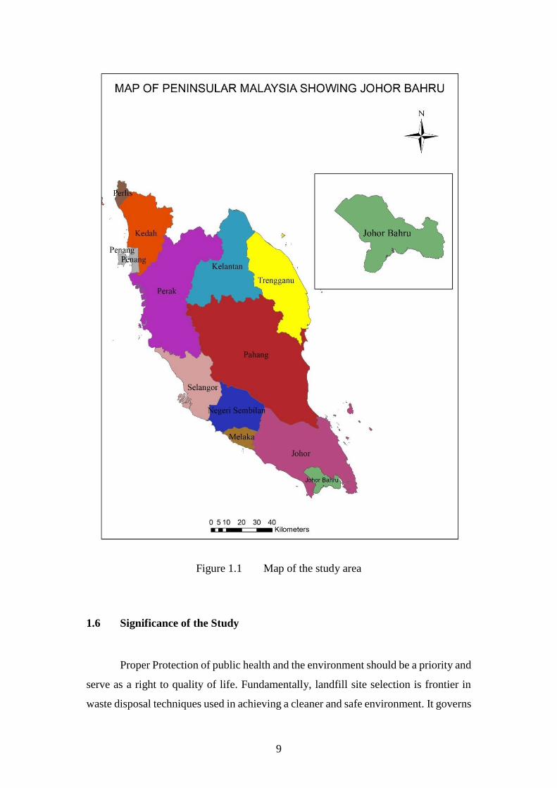
This research work has implemented the use of latest geospatial techniques to
select a sustainable sanitary landfill site in the study area focusing on geotechnical
criteria as a key factor in siting sanitary landfill. This is to ensure that the soil beneath
the ground surface can support the threats of varying climatic conditions of wet and
dry season, loads bearing capacities, and conditions posed on it by transportation
facilities before any further construction process begins. Also, the goal of the
geotechnical investigation was to preserve the safety of the public and the facility
constructed, as well as to preserve the economic investment by the government or
stakeholders. Figure 1 shows the map of the study area. This study covers Johor Bahru
(JB). JB was chosen in this study as it is one of the rapid developing area in Johor state,
this has contributed to the increasing amount of solid waste generated. Therefore,
selecting sustainable sanitary landfill site in this area is needed because the existing
sanitary landfill cannot accommodate the waste produced.
Page 30
9
Figure 1.1 Map of the study area
1.6 Significance of the Study
Proper Protection of public health and the environment should be a priority and
serve as a right to quality of life. Fundamentally, landfill site selection is frontier in
waste disposal techniques used in achieving a cleaner and safe environment. It governs
Page 31
10
various of the successive stages in the landfill process, and when appropriately
employed, would safeguard against nuisances and negative long-term effects. A well-
selected sanitary landfill site will generally facilitate an uncomplicated design and
provide ample cover material, which would facilitate an environmentally and publicly
acceptable operation at a reasonable cost.
By applying this developed hybrid model, the landfill siting process can be
done comprehensively knowing that the safety measure for construction of quality
criteria is adopted through geotechnics. All the different organizations involved i.e.
solid waste management authorities, policy and decision makers, stakeholders from
various fields can implement the use of the latest up to date model for the construction
of a well and sustainable sanitary landfill site for the disposal of municipal solid waste.
Similarly, this will reduce the cost of construction as it impedes the money paid for
site investigation. In addition, it will also help the project managers to cut down the
time spent debating location-based problems as well as reduce costs.
Most importantly, the results of the best potential sites obtained in this study
will be useful especially to the Johor Bahru solid waste management authority. They
can directly use these areas to construct a new sanitary landfill site. This is because the
sites have met all the necessary requirements related to landfill siting standards, rules
and regulations. Moreover, this newly selected sites, if constructed can serve as a way
of reducing illegal waste dumping sites because the waste generated can be transported
easily within the municipality.
1.7 Contribution of the Study
In terms of contributions to the frontier of knowledge, this research stretches
over the following fields: GIS, MCDA, and Geotechnics. This study contributes to the
frontier of knowledge by developing a hybrid model linking Geospatial and
Geotechnical techniques for sustainable sanitary landfill siting. Although GIS and
MCDA has been widely used for landfill site selection models (Santhosh and Babu,
2018; Khodaparast et al., 2018; Eskandari et al., 2013; Şener et al., 2005;), yet no
models have considered geotechnical criteria as a basic requirement analysis. Only
Page 32
11
few studies (Mornya et al., 2010; Babalola and Busu, 2011) have linked their site
selection model with soil permeability as a criterion for landfill site selection.
However, they have failed to employ other engineering and physical properties
examination of the soil in their models for landfill site selection. To the author’s
knowledge, this is the first study that integrates Geospatial and Geotechnical approach
to select not just a landfill but a sustainable sanitary landfill site.
Furthermore, all the different organizations involved i.e. solid waste
management authorities, policy and decision makers, stakeholders from various fields
can implement the use of the latest up to date model for the construction of a well and
sustainable sanitary landfill site for the disposal of municipal solid waste.
This research is also the first formal study on sanitary landfill site selection to
the Johor Bahru municipality of Johor, Malaysia which rigorously evaluated the
process of landfill siting in terms of selection criteria and methodology used in the past
and present researches. This developed hybrid model helps to evaluate and illustrate
the process of sustainable sanitary landfill siting.
1.8 Thesis Outlines
This thesis is organized in five chapters; introduction, literature review,
methodology, results and discussion, and conclusion.
Chapter 1 (Introduction): This chapter covers the introduction which briefly
explained an overview of the whole research, which includes background of the study,
problem statement, aim and objectives, scope of study, the significance and
contributions of the study.
Chapter 2 (Literature Review): This chapter is based on literature review of
previous studies and describes the fundamental part of the research which provides
appropriate knowledge including the theories and applications employed in this study.
Page 33
12
Chapter 3 (Methodology): In this chapter, the whole work flow is explained
and addresses each of the objectives outlined in Chapter 1 by adopting the appropriate
research methods. In this chapter, the research methodology discusses from the initial
study until the model development as well as the model validation technique.
Chapter 4 (Results, Analysis and Discussion): This chapter presents the
results, analysis and discussion achieved according to the implementation of the
methods adopted in the research. The results and relevant analysis were illustrated and
elaborated in various forms such as tables, graphs and figures in this chapter.
Chapter 5 (Conclusions and Recommendations): Finally, this chapter
delivers the conclusions drawn from this research and recommendations for future
researches related to this study.
Page 34
163
REFERENCES
Abd-El Monsef, Hesham. 2015. Optimization of municipal landfill siting in the Red
Sea coastal desert using geographic information system, remote sensing and an
analytical hierarchy process. Environmental Earth Sciences. 74(3), 2283-2296.
Abdalqader, Ahmed Fahmi. 2011. Landfills needs assessment in Gaza strip and sites
selection using GIS. Unpublished Master Thesis). The Islamic University of
Gaza, Gaza, Palestine.
Abdullah, Lazim, Naim, N and Wahab, Af. 2011. Determination of weight for landfill-
siting criteria under conflicting bifuzzy preference relation. J Sustain Sci
Manag. 6, 139-147.
Abujayyab, Sohaib Km, Ahamad, Mas, Yahya, Ahmad Shukri and Saad, Am Hy.
2015. A New Framework for Geospatial Site Selection Using Artificial Neural
Networks as Decision Rules: a Case Study on Landfill Sites. ISPRS Annals of
the Photogrammetry, Remote Sensing and Spatial Information Sciences. 2(2),
131.
Abujayyab, S. K. M., Ahamad, M. S. S., Yahya, A. S. and Aziz, H. A., 2016a. Spatial
Data Mining Toolbox for Mapping Suitability of Landfill Sites Using Neural
Networks. ISPRS - International Archives of the Photogrammetry, Remote
Sensing and Spatial Information Sciences. XLII-4/W1, 199-208.
Abujayyab, Sohaib Km, Ahamad, Mohd Sanusi S, Yahya, Ahmad Shukri, Bashir,
Mohammed Jk and Aziz, Hamidi Abdul 2016b. GIS modelling for new landfill
sites: critical review of employed criteria and methods of selection criteria. IOP
Conference Series: Earth and Environmental Science. 012053.
Adams, Barry J, Karney, Bryan W, Cormier, Charles J and Lai, Anita. 1998. Artesian
landfill liner system: Optimization and numerical analysis. Journal of water
resources planning and management. 124(6), 345-356.
Adeyemi, Gabriel Oladapo, Afolagboye, Lekan Olatayo and Chinwenwa
Chukwuemeka, Alexandra. 2015. Geotechnical properties of non-crystalline
coastal plain sand derived lateritic soils from Ogua, Niger Delta, Nigeria.
African Journal of Science, Technology, Innovation and Development. 7(4),
230-235.
Page 35
164
Aerts, Jeroen, Van Herwijnen, Marjan, Janssen, Ron and Stewart, Theodor. 2005.
Evaluating spatial design techniques for solving land-use allocation problems.
Journal of Environmental Planning and Management. 48(1), 121-142.
Agamuthu, P. and Fauziah, S. H., 2011. Challenges and issues in moving towards
sustainable landfilling in a transitory country - Malaysia. Waste Manag Res.
29(1), 13-19.
Ahmad, Adeel, Javaid, Umar, Javed, Muhammad Asif, Ahmad, Sajid Rashid, Jaffri,
Muhammad Abbas and Ashfaq, Mudassar. 2016. Landfill Sites Identification
Using GIS and Multi-Criteria Method: A Case Study of Intermediate City of
Punjab, Pakistan. Journal of Geographic Information System. 08(01), 40-49.
Ahmad, K, Yamusa, Yb and Rosly, Mh Bin. 2018a. Laterite Soil Shear Strength
Characteristics from the Use of the Standard Proctor and Compression
Machine. Arid Zone Journal of Engineering, Technology and Environment.
14(2), 304-316.
Ahmad, K., Yamusa, Y. B. and Kamisan, M. A. Bin. 2018b. Effects of Soil
Recompaction on Permeability. Science World Journal Vol 13(No 3), 6-9.
Ahmad, S. Z., Ahamad, M. S. and Yusoff, M. S., 2014a. Spatial effect of new
municipal solid waste landfill siting using different guidelines. Waste
management & research. 32(1), 24-33.
Ahmad, Siti Zubaidah, Ahmad, S Mohd Sanusi and Wan, Hussein. 2011. Comparative
site selection process based on different policies and guidelines for municipal
solid waste landfill site. 10th International symposium & exhibition on
geoinformation 2011 (ISG 2011), Selangor, Malaysia.
Ahmad, S. Z., Ahamad, M. S. and Yusoff, M. S., 2014b. Spatial effect of new
municipal solid waste landfill siting using different guidelines. Waste Manag
Res. 32(1), 24-33.
Ahmad, Siti Zubaidah, Ahamad, Mohd Sanusi S. and Yusoff, Mohd Suffian. 2015. A
Comprehensive Review of Environmental, Physical and Socio-Economic
(EPSE) Criteria for Spatial Site Selection of Landfills in Malaysia. Applied
Mechanics and Materials. 802, 412-418.
Akbari, V, Rajabi, Ma, Chavoshi, Sh and Shams, R. 2008. Landfill site selection by
combining GIS and fuzzy multi criteria decision analysis, case study: Bandar
Abbas, Iran. World Applied Sciences Journal. 3(1), 39-47.
Page 36
165
Aksoy, E. and San, B. T., 2016. Using Mcda and Gis for Landfill Site Selection:
Central Districts of Antalya Province. ISPRS - International Archives of the
Photogrammetry, Remote Sensing and Spatial Information Sciences. XLI-B2,
151-157.
Aksoy, Ercument and San, Bekir Taner. 2017. Geographical information systems
(GIS) and Multi-Criteria Decision Analysis (MCDA) integration for
sustainable landfill site selection considering dynamic data source. Bulletin of
Engineering Geology and the Environment.
Al-Adamat, Rida, Diabat, Abdullah and Shatnawi, Ghada. 2010. Combining GIS with
multicriteria decision making for siting water harvesting ponds in Northern
Jordan. Journal of Arid Environments. 74(11), 1471-1477.
Al-Jarrah, Omar and Abu-Qdais, Hani. 2006. Municipal solid waste landfill siting
using intelligent system. Waste management. 26(3), 299-306.
Alanbari, Mohammad, Al-Ansari, Nadhir, Jasim, Hadeel and Knutsson, Sven. 2014a.
Modeling landfill suitability based on GIS and multicriteria decision analysis:
case study in Al-Mahaweel Qadaa. Natural Science. 6(11), 828-851.
Alanbari, Mohammad Ali, Al-Ansari, Nadhir and Jasim, Hadeel Kareem. 2014b. GIS
and Multicriteria Decision Analysis for Landfill Site Selection in Al-
Hashimyah Qadaa. Natural Science. 06(05), 282-304.
Alanbari, Mohammad Ali, Al-Ansari, Nadhir, Jasim, Hadeel Kareem and Knutsson,
Sven. 2014c. Al-Mseiab Qadaa Landfill Site Selection Using GIS and
Multicriteria Decision Analysis. Engineering. 06(09), 526-549.
Alavi, N., Goudarzi, G., Babaei, A. A., Jaafarzadeh, N. and Hosseinzadeh, M., 2013.
Municipal solid waste landfill site selection with geographic information
systems and analytical hierarchy process: a case study in Mahshahr County,
Iran. Waste management & research. 31(1), 98-105.
Alazaiza, Motasem Yd, Ngien, Su Kong, Bob, Mustafa M, Kamaruddin, Samira A and
Faizal Ishak, Wan Mohd. 2016a. Assessment of the behaviour of soil structure
in double-porosity kaolin media using light transmission visualization (LTV)
method. International Journal of Geotechnical Engineering. 1-5.
Alazaiza, Motasem Yd, Ngien, Su Kong, Bob, Mustafa M, Kamaruddin, Samira A and
Ishak, Wan Mohd Faizal. 2017. Influence of Macro-pores on DNAPL
Migration in Double-Porosity Soil Using Light Transmission Visualization
Method. Transport in Porous Media. 1-21.
Page 37
166
Alazaiza, Motasem Yd, Ngien, Su Kong, Mustafa, M Bob, Samira, A Kamaruddin and
Wmf, Wan Ishak. 2016b. Application of Light Reflection Method to Observe
DNAPL Movement in Different Soil Media. The National Conference for
Postgraduate Research, Universiti Malaysia Pahang.
Alaziaza, Motasem Yd, Ngien, Su Kong, Bob, Mustafa M, Kamaruddin, Samira A and
Ishak, Wan Mohd Faizal. 2016. Investigation of Light Non-Aqueous Phase
Liquid Migration Single and Double-Porosity Soil Using Light Transmission
Visualization Method (LTV). MATEC Web of Conferences. 47.
Alkhuzaie, Marwah M and Janna, Hussein. 2018. Optimum Location for Landfills
Sites Based on GIS Modeling for Al-Diwaniyah City, Iraq. International
Journal of Civil Engineering and Technology Volume 9(8), pp. 941-951.
Allen, A, Brito, G, Caetano, P, Costa, C, Cummins, V, Donelly, J, Fernades, C,
Koukoulas, S, O’donell, V and Robalo, C 2002. Procedure for the location of
landfill sites using a GIS model. 9th Congress of the International Association
of Engineering Geology and the Environment, Durban. 16-20.
Allesch, Astrid and Brunner, Paul H. 2014. Assessment methods for solid waste
management: A literature review. Waste Management & Research. 32(6), 461-
473.
Amadi, Aa and Eberemu, Ao. 2013. Characterization of geotechnical properties of
lateritic soil-bentonite mixtures relevant to their use as barrier in engineered
waste landfills. Nigerian J Technol. 32(1), 93-100.
Amadi, Aa, Eberemu, Ao and Osinubi, Kj. 2012. Strength consideration in the use of
lateritic soil stabilized with fly ash as liners and covers in waste landfills. State-
of-the-art and practice in geotechnical engineering. American Society of Civil
Engineers (ASCE) geotechnical special publication (GSP). 225, 3835-3844.
Amadi, Agapitus A., 2012. Improvement of Barrier Soil Properties with Fly Ash to
Minimize Desiccation Shrinkage. International Journal of Engineering
Research in Africa. 7, 1-11.
Amadi, Agapitus Ahamefule and Eberemu, Adrian Oshioname. 2012. Delineation of
compaction criteria for acceptable hydraulic conductivity of lateritic soil-
bentonite mixtures designed as landfill liners. Environmental Earth Sciences.
67(4), 999-1006.
Page 38
167
Arıkan, Emre, Şimşit-Kalender, Zeynep Tuğçe and Vayvay, Özalp. 2017. Solid waste
disposal methodology selection using multi-criteria decision making methods
and an application in Turkey. Journal of Cleaner Production. 142, 403-412.
Asha, Poorna C and Vinod, P. G. 2016. Solid waste disposal site selection by data
analysis using GIS and Remote sensing tools A case study in
Thiruvananthapuram corporation area. International Journal of Geomatics and
Geosciences. Volume 6.
Aydi, Abdelwaheb, Zairi, Moncef and Dhia, Hamed Ben. 2012. Minimization of
environmental risk of landfill site using fuzzy logic, analytical hierarchy
process, and weighted linear combination methodology in a geographic
information system environment. Environmental Earth Sciences. 68(5), 1375-
1389.
Babalola, Ayo and Busu, Ibrahim. 2011. Selection of Landfill Sites for Solid Waste
Treatment in Damaturu Town-Using GIS Techniques. Journal of
Environmental Protection. 02(01), 1-10.
Baban, Serwan Mj and Flannagan, Joseph. 1998. Developing and implementing GIS-
assisted constraints criteria for planning landfill sites in the UK. Planning
Practice & Research. 13(2), 139-151.
Bagchi, Amalendu (2004). Design of landfills and integrated solid waste management.
John Wiley & Sons.
Bahrani, Sara, Ebadi, Taghi, Ehsani, Hadi, Yousefi, Hossein and Maknoon, Reza.
2016. Modeling landfill site selection by multi-criteria decision making and
fuzzy functions in GIS, case study: Shabestar, Iran. Environmental Earth
Sciences. 75(4).
Baiocchi, V., Lelo, K., Polettini, A. and Pomi, R., 2014. Land suitability for waste
disposal in metropolitan areas. Waste management & research. 32(8), 707-716.
Barakat, Ahmed, Hilali, Abdessamad, El Baghdadi, Mohamed and Touhami, Fatima.
2017. Landfill site selection with GIS-based multi-criteria evaluation
technique. A case study in Béni Mellal-Khouribga Region, Morocco.
Environmental Earth Sciences. 76(12), 413.
Bello, Aa. 2011a. Analysis of shear strength of compacted lateritic soils. The Pacific
Journal of Science and Technology. 12(1), 425-434.
Page 39
168
Bello, Adefemi Afeez. 2011b. The use of Standard Proctor for the determination of
Shrinkage Properties of Reddish Brown Tropical soil. Leonardo Journal of
Sciences. (19), 57-68.
Bello, Adefemi Afeez. 2013a. Design Parameters for Abandoned Dumpsite Soil as
Liner Material. Leonardo Journal of Sciences. (23), 29-40.
Bello, Afeez Adefemi. 2013b. Hydraulic conductivity of three compacted reddish
brown tropical soils. KSCE Journal of Civil Engineering. 17(5), 939-948.
Bello, Afeez Adefemi and Osinubi, Kolawole Juwonlo. 2011. Attenuative capacity of
compacted abandoned dumpsite soils. Electronic Journal of Geotech.
Engineering.(EJGE). 16, 71-91.
Benson, Craig H, Zhai, Huaming and Wang, Xiaodong. 1994. Estimating hydraulic
conductivity of compacted clay liners. Journal of Geotechnical Engineering.
120(2), 366-387.
Beskese, Ahmet, Demir, H. Handan, Ozcan, H. Kurtulus and Okten, H. Eser. 2014.
Landfill site selection using fuzzy AHP and fuzzy TOPSIS: a case study for
Istanbul. Environmental Earth Sciences. 73(7), 3513-3521.
Blueprint for Iskandar Malaysia. 2010. Integrated Solid Waste Management Blueprint
of Iskandar Malaysia. Johor Bahru, Malaysia. .
Bruno, B. 2007. Hydro-geotechnical properties of hard rock tailings from metal mines
and Subsoil Characteristics and Hydrogeology…… emerging geo-
environmental disposal approaches. Canadian Geotechnical Journal. 44(9),
1019-1052.
BSI 1990. Methods of Testing Soil for Civil Engineering Purposes (BS 1377:Part 1-
9). British Standards Institute, London.
BSI 1999. Code of practice for site investigations (BS 5930). British Standards
Institute, London.
Cabała, Paweł. 2010. Using the analytic hierarchy process in evaluating decision
alternatives. Operations research and decisions. 20(1), 5-23.
Chabuk, A., Al-Ansari, N., Hussain, H. M., Knutsson, S. and Pusch, R., 2016. Landfill
site selection using geographic information system and analytical hierarchy
process: A case study Al-Hillah Qadhaa, Babylon, Iraq. Waste management &
research. 34(5), 427-437.
Page 40
169
Chabuk, Ali, Al-Ansari, Nadhir, Hussain, Hussain M, Kamaleddin, Suhair, Knutsson,
Sven, Pusch, Roland and Laue, Jan. 2017a. Soil Characteristics in Selected
Landfill Sites in theBabylon Governorate, Iraq: Soil Characteristics in Selected
Landfill Sites in theBabylon Governorate, Iraq. Journal of Civil Engineering
and Architecture. 11(4), 348-363.
Chabuk, Ali Jalil, Al-Ansari, Nadhir, Hussain, Hussain Musa, Knutsson, Sven and
Pusch, Roland. 2017b. GIS-based assessment of combined AHP and SAW
methods for selecting suitable sites for landfill in Al-Musayiab Qadhaa,
Babylon, Iraq. Environmental Earth Sciences. 76(5).
Chandio, Imtiaz Ahmed, Matori, Abd Nasir B, Wanyusof, Khamaruzaman B, Talpur,
Mir Aftab Hussain, Balogun, Abdul-Lateef and Lawal, Dano Umar. 2013. GIS-
based analytic hierarchy process as a multicriteria decision analysis instrument:
a review. Arabian Journal of Geosciences. 6(8), 3059-3066.
Chandio, Imtiaz Ahmed, Matori, Abdul-Nasir, Lawal, Dano Umar and Sabri, Soheil.
2011. GIS-based land suitability analysis using AHP for public parks planning
in Larkana City. Modern applied science. 5(4), 177.
Chang, N. B., Parvathinathan, G. and Breeden, J. B., 2008. Combining GIS with fuzzy
multicriteria decision-making for landfill siting in a fast-growing urban region.
J Environ Manage. 87(1), 139-153.
Chen, Yun, Yu, Jia and Khan, Shahbaz. 2013. The spatial framework for weight
sensitivity analysis in AHP-based multi-criteria decision making.
Environmental Modelling & Software. 48, 129-140.
Cointreau, Sandra. 2004. Sanitary landfill design and siting criteria. World Bank
guidance as an urban infrastructure sanitary landfill sitting and design
guidance note. World Bank, Washington, DC.
Cowen, David J. 1988. GIS versus CAD versus DBMS: What are the differences?
Photogramm. Eng. Remote Sens. 54(11), 1551-1555.
Daniel, David E and Wu, Yung-Kwang. 1993. Compacted clay liners and covers for
arid sites. Journal of Geotechnical Engineering. 119(2), 223-237.
Daniel, David Edwin (2012). Geotechnical practice for waste disposal. Springer
Science & Business Media, DOI:10.1007/978-1-4615-3070-1.
Day, Robert W. 1997. Discussion of “Hydraulic Conductivity of Desiccated
Geosynthetic Clay Liners” by Tom Boardman and David E. Daniel. Journal of
Geotechnical and Geoenvironmental Engineering. 123(5), 484-486.
Page 41
170
Delgado, Otoniel Buenrostro, Mendoza, Manuel, Granados, Erna López and Geneletti,
Davide. 2008. Analysis of land suitability for the siting of inter-municipal
landfills in the Cuitzeo Lake Basin, Mexico. Waste management. 28(7), 1137-
1146.
Demesouka, Oe, Vavatsikos, Ap and Anagnostopoulos, Kp. 2013. Suitability analysis
for siting MSW landfills and its multicriteria spatial decision support system:
method, implementation and case study. Waste management. 33(5), 1190-
1206.
Demesouka, Oe, Vavatsikos, Ap and Anagnostopoulos, Kp. 2014. GIS-based
multicriteria municipal solid waste landfill suitability analysis: A review of the
methodologies performed and criteria implemented. Waste Management &
Research. 32(4), 270-296.
Demesouka, Oe, Vavatsikos, Ap and Anagnostopoulos, Kp. 2016. Using Macbeth
multicriteria technique for GIS-based landfill suitability analysis. Journal of
Environmental Engineering. 142(10), 04016042.
Depountis, Nikos, Koukis, George and Sabatakakis, Nikos. 2009. Environmental
problems associated with the development and operation of a lined and unlined
landfill site: a case study demonstrating two landfill sites in Patra, Greece.
Environmental geology. 56(7), 1251-1258.
Djokanović, S., Abolmasov, B. and Jevremović, D., 2016. GIS application for landfill
site selection: a case study in Pančevo, Serbia. Bulletin of Engineering Geology
and the Environment. 75(3), 1273-1299.
Doumpos, Michael and Zopounidis, Constantin (2014). An overview of multiple
criteria decision aid. Multicriteria Analysis in Finance. (pp. 11-21). Springer.
Eberemu, Adrian O., 2011. Desiccation Induced Shrinkage of Compacted Tropical
Clay Treated with Rice Husk Ash. International Journal of Engineering
Research in Africa. 6, 45-64.
Ebistu, Tirusew Ayisheshim and Minale, Amare Sewnet. 2013. Solid waste dumping
site suitability analysis using geographic information system (GIS) and remote
sensing for Bahir Dar Town, North Western Ethiopia. African Journal of
Environmental Science and Technology. 7(11), 976-989.
Effat, Hala A and Hegazy, Mohamed N. 2012. Mapping potential landfill sites for
North Sinai cities using spatial multicriteria evaluation. The Egyptian Journal
of Remote Sensing and Space Science. 15(2), 125-133.
Page 42
171
El Baba, Moustafa, Kayastha, Prabin and De Smedt, Florimond. 2014. Landfill site
selection using multi-criteria evaluation in the GIS interface: a case study from
the Gaza Strip, Palestine. Arabian Journal of Geosciences. 8(9), 7499-7513.
Elahi, Athena and Samadyar, Hassan. 2014. Municipal solid waste landfill site
selection using analytic hierarchy process method for Tafresh Town. Middle-
East Journal of Scientific Research. 22(9), 1294-1307.
Epa, Nsw. 1996. Environmental guidelines: solid waste landfills. NSW Environment
Protection Authority, Sydney.
Eskandari, M, Homaee, M, Mahmoodi, S and Pazira, E. 2013. Integrating GIS and
AHP for municipal solid waste landfill site selection. Journal of Basic and
Applied Scientific Research. 3(4), 588-595.
Eskandari, M., Homaee, M. and Mahmodi, S., 2012a. An integrated multi criteria
approach for landfill siting in a conflicting environmental, economical and
socio-cultural area. Waste Management. 32(8), 1528-1538.
Eskandari, M., Homaee, M., Mahmoodi, S., Pazira, E. and Van Genuchten, M. T.,
2015. Optimizing landfill site selection by using land classification maps.
Environ Sci Pollut Res Int. 22(10), 7754-7765.
Eskandari, Mahnaz, Homaee, Mehdi and Mahmodi, Shahla. 2012b. An integrated
multi criteria approach for landfill siting in a conflicting environmental,
economical and socio-cultural area. Waste Management. 32(8), 1528-1538.
Fetter, Charles Willard, Boving, Thomas and Kreamer, David (2017). Contaminant
hydrogeology. Waveland Press.
Foomani, Mahdieh Saadat, Karimi, Saeed, Jafari, Hamidreza and Ghorbaninia, Zahra.
2017. Using boolean and fuzzy logic combined with analytic hierarchy process
for hazardous waste landfill site selection: A case study from Hormozgan
province, Iran.
Foong, Loke Kok, Rahman, Norhan Abd and Ramli, Mohd Zamri. 2016. A Laboratory
study of vibration effect for deformable double-porosity soil with different
moisture content. Malaysian Journal of Civil Engineering. 28 (3), 207-222.
Gbanie, Solomon Peter, Tengbe, Paul Bobby, Momoh, Jinnah Samuel, Medo, James
and Kabba, Victor Tamba Simbay. 2013. Modelling landfill location using
Geographic Information Systems (GIS) and Multi-Criteria Decision Analysis
(MCDA): Case study Bo, Southern Sierra Leone. Applied Geography. 36, 3-
12.
Page 43
172
Ghobadi, Mohammad Hosein, Taheri, Milad and Taheri, Kamal. 2017. Municipal
solid waste landfill siting by using analytical hierarchy process (AHP) and a
proposed karst vulnerability index in Ravansar County, west of Iran.
Environmental Earth Sciences. 76(2).
Gorsevski, P. V., Donevska, K. R., Mitrovski, C. D. and Frizado, J. P., 2012.
Integrating multi-criteria evaluation techniques with geographic information
systems for landfill site selection: a case study using ordered weighted average.
Waste Management. 32(2), 287-296.
Güler, Doğuş and Yomralıoğlu, Tahsin. 2017. Alternative suitable landfill site
selection using analytic hierarchy process and geographic information systems:
a case study in Istanbul. Environmental Earth Sciences. 76(20), 678.
Head, K H (2006). Manual of soil laboratory testing, third edition. Whittles publishing,
Dunbeath, Caithness KW6 6EY, Scotland, UK.
Head, K. H. and Epps, R. J. (2011). Manual of soil laboratory testing, volume 2.
Whittles publishing, Dunbeath, Caithness KW6 6EY, Scotland, UK.
Hengl, T, Gruber, S and Shrestha, Dp. 2003. Digital terrain analysis in ILWIS.
International Institute for Geo-Information Science and Earth Observation
Enschede, The Netherlands. 62.
Henry, R. K., Yongsheng, Z. and Jun, D., 2006. Municipal solid waste management
challenges in developing countries--Kenyan case study. Waste Management.
26(1), 92-100.
Https://Glovis.Usgs.Gov. 2018. United States Geological Survey Global Visualization
Viewer (USGS GloVis) [Online]. [Accessed 13/01/2018].
Hussain, Mh. 2004. Assessment of groundwater vulnerability in an alluvial interfluve
using GIS. Unpublished Ph. D Thesis, Department of Hydrology, Indian
Institute of Technology Roorkee, Roorkee-247. 667, 2224.
Isa, Muhammad Zumo and Saidu, Ahmad Vokna. 2014. Identification of Suitable Site
for Solid Waste Disposal in Yola, Nigeria Using GIS Method.
Issa, Sm and Shehhi, Bal. 2012. A gis-based multi-criteria evaluation system for
selection of landfill sites: a case study from Abu Dhabi, United Arab Emirates.
International Archives of the Photogrammetry, Remote Sensing and Spatial
Information Sciences. 39, b2.
Jamshidi, Azadeh, Kazemijahandizi, Elmira, Allahgholi, Leili, Monavari, Seyed
Masoud, Tajziehchi, Sanaz, Hashemi, Alireza, Moshtaghie, Minoo and
Page 44
173
Jamshidi, Mojgan. 2015. Landfill Site Selection: a Basis Toward Achieving
Sustainable Waste Management. Polish Journal of Environmental Studies. 24,
1021-1029.
Javaheri, H, Nasrabadi, T, Jafarian, Mh, Rowshan, Gr and Khoshnam, H. 2006. Site
selection of municipal solid waste landfills using analytical hierarchy process
method in a geographical information technology environment in Giroft.
Journal of Environmental Health Science & Engineering. 3(3), 177-184.
Jeswani, H. K. and Azapagic, A., 2016. Assessing the environmental sustainability of
energy recovery from municipal solid waste in the UK. Waste management.
50, 346-363.
Jones, Rm, Murray, Ej, Rix, Dw and Humphrey, Rd. 1995. Selection of clays for use
as landfill liners. Waste disposal by landfill-GREEN. 93, 433-438.
Kara, C. and Doratli, N., 2012. Application of GIS/AHP in siting sanitary landfill: a
case study in Northern Cyprus. Waste management & research. 30(9), 966-
980.
Keelson, Kodwo Beedu. 2015. Evaluation of Landfill Cover Design Options for Waste
Disposal Sites in the Coastal Regions of Ghana. International Journal of
Engineering and Technology. 5(1), 45-55.
Kemal Korucu, M. and Erdagi, B., 2012. A criticism of applications with multi-criteria
decision analysis that are used for the site selection for the disposal of
municipal solid wastes. Waste Management. 32(12), 2315-2323.
Khademalhoseiny, M. S., Nadoushan, M. A. and Radnezhad, H., 2017. Site selection
for landfill gas extraction plant by fuzzy analytic hierarchy process and fuzzy
analytic network process in the city of Najafabad, Iran. Energy & Environment.
28(7), 763-774.
Khamehchiyan, Mashalah, Nikoudel, Mohammad Reza and Boroumandi, Mehdi.
2011. Identification of hazardous waste landfill site: a case study from Zanjan
province, Iran. Environmental Earth Sciences. 64(7), 1763-1776.
Khan, D. and Samadder, S. R., 2014a. Municipal Solid Waste Management using
Geographical Information System aided methods: a mini review. Waste
Management & Research. 32(11), 1049-1062.
Khan, Debishree and Samadder, Sr. 2014b. Application of GIS in Landfill Siting for
Municipal Solid Waste. International Journal of Environmental Research and
Development. 4(1), 37-40.
Page 45
174
Kharat, Manoj Govind, Kamble, Sheetal Jaisingh, Raut, Rakesh D., Kamble, Sachin
S. and Dhume, Sudheer M., 2016. Modeling landfill site selection using an
integrated fuzzy MCDM approach. Modeling Earth Systems and Environment.
2(2).
Khodaparast, M., Rajabi, A. M. and Edalat, A., 2018. Municipal solid waste landfill
siting by using GIS and analytical hierarchy process (AHP): a case study in
Qom city, Iran. Environmental Earth Sciences. 77(2), 12.
Khorram, Alireza, Yousefi, Maryam, Alavi, Seyed Ali and Farsi, Javad. 2015.
Convenient Landfill Site Selection by Using Fuzzy Logic and Geographic
Information Systems: A Case Study in Bardaskan, East of Iran. Health Scope.
4(1).
Kontos, Themistoklis D, Komilis, Dimitrios P and Halvadakis, Constantinos P. 2005.
Siting MSW landfills with a spatial multiple criteria analysis methodology.
Waste management. 25(8), 818-832.
Kreith, Frank. 1999. Handbook of solid waste management.
Kumar, Manish and Biswas, Vivekananda. 2013. Identification of Potential Sites for
Urban Development Using GIS Based Multi Criteria Evaluation Technique. A
Case Study of Shimla Municipal Area, Shimla District, Himachal Pradesh,
India. Journal of Settlements and Spatial Planning. 4(1), 45.
Kurttila, Mikko, Pesonen, Mauno, Kangas, Jyrki and Kajanus, Miika. 2000. Utilizing
the analytic hierarchy process (AHP) in SWOT analysis—a hybrid method and
its application to a forest-certification case. Forest policy and economics. 1(1),
41-52.
Latinopoulos, D and Kechagia, K. 2015. A GIS-based multi-criteria evaluation for
wind farm site selection. A regional scale application in Greece. Renewable
Energy. 78, 550-560.
Lawal, Dano Umar, Matori, Abdul-Nasir and Balogun, Abdul-Lateef. 2011. A
Geographic Information System and Multi-Criteria Decision Analysis in
Proposing New Recreational Park Sites in Universiti Teknologi Malaysia.
Modern Applied Science. 5(3), 39.
Lin, Hung-Yueh and Kao, Jehng-Jung. 1999. Enhanced spatial model for landfill siting
analysis. Journal of environmental engineering. 125(9), 845-851.
Page 46
175
Liu, Hu-Chen, You, Jian-Xin, Fan, Xiao-Jun and Chen, Yi-Zeng. 2014. Site selection
in waste management by the VIKOR method using linguistic assessment.
Applied Soft Computing. 21, 453-461.
Madurika, Hkgm and Hemakumara, Gpts. 2015. GIS based analysis for suitability
location finding in the residential development areas of greater Matara region.
Int. J. Sci. Technol. Res. 4, 96-105.
Makropoulos, Ck and Butler, D. 2006. Spatial ordered weighted averaging:
incorporating spatially variable attitude towards risk in spatial multi-criteria
decision-making. Environmental Modelling & Software. 21(1), 69-84.
Malczewski, Jacek (1999). GIS and multicriteria decision analysis. John Wiley &
Sons.
Malczewski, Jacek. 2006. GIS‐based multicriteria decision analysis: a survey of the
literature. International Journal of Geographical Information Science. 20(7),
703-726.
Manaf, L. A., Samah, M. A. and Zukki, N. I., 2009. Municipal solid waste management
in Malaysia: practices and challenges. Waste Management. 29(11), 2902-2906.
Marshall, Rachael E and Farahbakhsh, Khosrow. 2013. Systems approaches to
integrated solid waste management in developing countries. Waste
Management. 33(4), 988-1003.
Mef. 2000. The Municipal Solid Wastes Management & Handling Rules. Part II,
Section 3, Sub-section (ii). Ministry of Environment and Forests, India.
Mejía, Zafra, Alfonso, Carlos, Mendoza Castañeda, Franklin Andrés and Montoya
Varela, Paula Alejandra. 2012. A methodology for landfill location using
geographic information systems: a Colombian regional case. Ingeniería e
Investigación. 32(1), 64-70.
Mhlg (2005a). Ministry of Housing and Local Government, Criteria for Siting Sanitary
Landfills: National Strategic Plan for Solid Waste Management, Vol. 3,
Appendix 6B, Kuala Lumpur, Malaysia.
Mhlg, Ministry of Housing and Local Government. 2005b. National Strategic Plan for
Solid Waste Management, Putrajaya, Malaysia.
www.kpkt.gov.my/kpkt/fileupload/ hebahan/lab_sisa_pepejal.pdf.
Moeinaddini, M., Khorasani, N., Danehkar, A., Darvishsefat, A. A. and Zienalyan, M.,
2010. Siting MSW landfill using weighted linear combination and analytical
Page 47
176
hierarchy process (AHP) methodology in GIS environment (case study: Karaj).
Waste management. 30(5), 912-920.
Mohamed, Hanine, Omar, Boutkhoum, Abdessadek, Tikniouine and Tarik, Agouti.
2016. An application of OLAP/GIS-Fuzzy AHP-TOPSIS methodology for
decision making: Location selection for landfill of industrial wastes as a case
study. KSCE Journal of Civil Engineering.
Mohamed, M and Plante, R 2002. Remote sensing and geographic information
systems (GIS) for developing countries. Geoscience and Remote Sensing
Symposium, 2002. IGARSS'02. 2002 IEEE International. 2285-2287.
Mohammed, Habiba Ibrahim, Majid, Zulkepli, Yusof, Norhakim Bin and Yamusa,
Yamusa Bello 2018. Analysis of Multi-Criteria Evaluation Method of Landfill
Site Selection for Municipal Solid Waste Management. E3S Web of
Conferences.
Mornya, A, Majid, Rafee and Yola, L 2010. Identification of Landfill Sites by Using
GIS and Multi-Criteria Method in Batam, Indonesia. 3rd International
Graduate Conference on Engineering, Science and Humanities, University
Tekologi Malaysia. http://s3. amazonaws. com/academia. edu.
Motlagh, Z. K. and Sayadi, M. H., 2015. Siting MSW landfills using MCE
methodology in GIS environment (Case study: Birjand plain, Iran). Waste
management. 46, 322-337.
Naphade, Kshitija S. 1999. Soil characterization using digital image processing.
Nas, B., Cay, T., Iscan, F. and Berktay, A., 2010. Selection of MSW landfill site for
Konya, Turkey using GIS and multi-criteria evaluation. Environ Monit Assess.
160(1-4), 491-500.
Ngien, Su Kong, Rahman, Norhan Abd, Bob, Mustafa M, Ahmad, Kamarudin, Sa’ari,
Radzuan and Lewis, Roland W. 2012. Observation of light non-aqueous phase
liquid migration in aggregated soil using image analysis. Transport in porous
media. 92(1), 83-100.
Nwambuonwo, Okeibunor Jude and Mughele, Es. 2012. Using geographic information
system to select suitable landfill sites for megacities (case study of Lagos,
Nigeria). Comput, Inform Syst Dev Inform J (CISDI). 3(4), 48-57.
O’leary, Pr, Tchobanoglous, G and Kreith, F. 2002. Handbook of solid waste
management. Landfilling. New York: McGraw-Hill.
Page 48
177
Oeltzschner, Hansjorg and Mutz, Dieter (1994). Guidelines for an appropriate
management of domestic sanitary landfill sites. GTZ.
Ogunmola, Olaitan Pius. 2016. Selection of Landfill Site for Waste Disposal
Management in Ile Ife, Southwest Nigeria Using Geo- Spatial Technique (Case
Study of Ile-Ife and its Environs, South-West Nigeria). Greener Journal of
Environmental Management and Public Safety. 5(2), 041-050.
Ohri, Anurag, Maurya, Satya Prakash and Mishra, Sachin. 2015. Sanitary Landfill Site
Selection by Using Geographic Information System.
Önal, Ayten Öztüfekçi, Demirbilek, Deniz and Demir, Veysel. 2013. Geo-
environmental site investigation for Tunceli, Turkey municipal solid waste
disposal site. Engineering Geology. 159, 76-82.
Önüt, Semih and Soner, Selin. 2008. Transshipment site selection using the AHP and
TOPSIS approaches under fuzzy environment. Waste Management. 28(9),
1552-1559.
Osinubi, K. J. and Bello, A. A. (2009). Desiccation-induced shrinkage in compacted
abandoned dumpsite soil. researchgate.net/publication/282325487:
researchgate publication.
Osinubi, K. J., Moses, G., Oriola, F. O. P. and Liman, A. S., 2015a. Influence of
Molding Water Content on Shear Strength Characteristic of Compacted
Cement Kiln Dust Treated Lateritic Soils for Liners and Covers. . Nigerian
Journal of Technology. 34(2), 266.
Osinubi, K. J., Moses, G., Oriola, F. O. P. and Liman, A. S., 2015b. Influence of
Molding Water Content on Shear Strength Characteristic of Compacted
Cement Kiln Dust Treated Lateritic Soils for Liners and Covers. . Nigerian
Journal of Technology. 34 (2), pp. 266 – 271.
Osinubi, Kj, Bello, Aa, Quadros, C and Jacobsz, Sw 2011. Characterization of shear
strength of abandoned dumpsite soils, Orita-Aperin, Nigeria. Proceedings of
the 15th African Regional Conference on Soil Mechanics and Geotechnical
Engineering. Resource and infrastructure geotechnics in Africa: putting the
theory into practice, Maputo, Mozambique, 18-21 July 2011., 293-298.
Osinubi, Kj and Eberemu, Ao 2008. Effect of desiccation on compacted lateritic soil
treated with bagasse ash. Proceedings of Bi-Monthly Meetings/Workshops,
Materials Society of Nigeria (MSN) Zaria Chapter, January-December. 1-9.
Page 49
178
Osinubi, Kj, Eberemu, Ao, Bello, Ao and Adzegah, A. 2012. Effect of fines content
on the engineering properties of reconstituted lateritic soils in waste
containment application. Nigerian Journal of Technology. 31(3), 277-287.
Osinubi, Kj and Moses, G 2011a. Compacted Foundry Sand Treated with Bagasse
Ash As Hydraulic Barrier Material. Geo-Frontiers 2011@ sAdvances in
Geotechnical Engineering. 915-925.
Osinubi, Kj and Moses, G (2011b). Compacted foundry sand treated with bagasse ash
as hydraulic barrier material. Geo-Frontiers 2011: Advances in Geotechnical
Engineering. (pp. 915-925).
Osinubi, Kj, Moses, G and Liman, As. 2015c. The Influence of Compactive Effort on
Compacted Lateritic Soil Treated with Cement Kiln Dust as Hydraulic Barrier
Material. Geotechnical and Geological Engineering. 33(3), 523-535.
Osinubi, Kj and Nwaiwu, Cmo 2006a. Compatibility of compacted lateritic soils with
municipal solid waste leachate. 5th ICEG Environmental Geotechnics:
Opportunities, Challenges and Responsibilities for Environmental
Geotechnics: Proceedings of the ISSMGE's fifth international congress
organized by the Geoenvironmental Research Centre, Cardiff University and
held at Cardiff City Hall on 26–30th June 2006. 608-615.
Osinubi, Kolawole J and Nwaiwu, Charles M. 2006b. Design of compacted lateritic
soil liners and covers. Journal of geotechnical and geoenvironmental
engineering
132(2), 203-213.
Osinubi, Kolawole J. and Eberemu, Adrian O., 2010. Desiccation Induced Shrinkage
of Compacted Lateritic Soil Treated with Blast Furnace Slag. Geotechnical and
Geological Engineering. 28(5), 537-547.
Osinubi, Kolawole J. and Nwaiwu, Charles M. O., 2008. Desiccation-induced
Shrinkage in Compacted Lateritic Soils. Geotechnical and Geological
Engineering. 26(5), 603-611.
Ouma, Yashon O., Kipkorir, Emmanuel C. and Tateishi, Ryutaro. 2011. MCDA-GIS
integrated approach for optimized landfill site selection for growing urban
regions: an application of neighborhood-proximity analysis. Annals of GIS.
17(1), 43-62.
Oweis, Issa S and Khera, Raj P. 1990. Geotechnology of waste management.
Page 50
179
Peavy, Howard S Rowe and Tchobanoglous, Donald R (1985). Environmental
engineering.
Prakash, Anjali and Poulose, Emy. 2016. Kuttanad Clay Amended Laterite as a
Landfill Liner for Waste Disposal Facilities. International Journal of Scientific
Engineering and Research (IJSER). 4 (3), 75-78.
Punmia, Bc and Jain, Ashok Kumar (2005). Soil mechanics and foundations. Firewall
Media.
Rahmat, Zeinab Ghaed, Niri, Mehdi Vosoughi, Alavi, Nadali, Goudarzi, Gholamreza,
Babaei, Ali Akbar, Baboli, Zeinab and Hosseinzadeh, Mohsen. 2016. Landfill
site selection using GIS and AHP: a case study: Behbahan, Iran. KSCE Journal
of Civil Engineering. 21(1), 111-118.
Rathore, S, Ahmad, Sr and Shirazi, Sa. 2016. Use of the suitability model to identify
landfill sites in Lahore-Pakistan. Journal of Basic and Applied Sciences. 12,
103-108.
Rikalovic, Aleksandar, Cosic, Ilija and Lazarevic, Djordje. 2014. GIS based multi-
criteria analysis for industrial site selection. Procedia Engineering. 69, 1054-
1063.
Rowe, Kerry R (1995). Clayey barrier systems for waste disposal facilities. E & FN
Spon Lond.
Sa’ari, R, Rahman, N, Yusof, Z, Ngien, S, Kamaruddin, S, Mustaffar, M and Hezmi,
M. 2015. Application of digital image processing technique in monitoring
LNAPL migration in double porosity soil column. Jurnal Teknologi. 72(3), 23-
29.
Saatsaz, M., Monsef, I., Rahmani, M. and Ghods, A., 2018. Site suitability evaluation
of an old operating landfill using AHP and GIS techniques and integrated
hydrogeological and geophysical surveys. Environmental Monitoring and
Assessment. 190(3), 31.
Saaty, Thomas. 2005. The analytic hierarchy and analytic network processes for the
measurement of intangible criteria and for decision-making. Multiple criteria
decision analysis: state of the art surveys. 345-405.
Saaty, Thomas L. 1977. A scaling method for priorities in hierarchical structures.
Journal of mathematical psychology. 15(3), 234-281.
Saaty, Thomas L (1988a). What is the analytic hierarchy process? Mathematical
models for decision support. (pp. 109-121). Springer.
Page 51
180
Saaty, Thomas L (1988b). What is the analytic hierarchy process? , Springer.
Saaty, Thomas L. 1994. Highlights and critical points in the theory and application of
the analytic hierarchy process. European Journal of operational research.
74(3), 426-447.
Saaty, Thomas L. 2008. Relative measurement and its generalization in decision
making why pairwise comparisons are central in mathematics for the
measurement of intangible factors the analytic hierarchy/network process.
RACSAM-Revista de la Real Academia de Ciencias Exactas, Fisicas y
Naturales. Serie A. Matematicas. 102(2), 251-318.
Saaty, Thomas L and Vargas, Luis G (2012). Models, methods, concepts &
applications of the analytic hierarchy process. Springer Science & Business
Media.
Samsudina, Mohd Dinie Muhaimin and Dona, Mashitah Mat. 2013. Municipal solid
waste management in Malaysia: Current practices, challenges and prospect.
Jurnal Teknologi. 62(1), 95–101.
Santhosh, L. G. and Babu, G. L. S., 2018. Landfill site selection based on reliability
concepts using the DRASTIC method and AHP integrated with GIS - a case
study of Bengaluru city, India. Georisk-Assessment and Management of Risk
for Engineered Systems and Geohazards. 12(3), 234-252.
Santok Singh, D. 1985. Director General geological survey Malaysia 1985. Geological
map of peninsular Malaysia.
Schwartz, 2001. A simple approach to solid waste planning for urbanizing counties.
Department of Geosciences. University of Missouri--Kansas City.
Scott, Jason, Beydoun, Donia, Amal, Rose, Low, Gary and Cattle, Julie. 2005. Landfill
management, leachate generation, and leach testing of solid wastes in Australia
and overseas. Critical Reviews in Environmental Science and Technology.
35(3), 239-332.
Şener, Başak, Süzen, M. Lütfi and Doyuran, Vedat. 2005. Landfill site selection by
using geographic information systems. Environmental Geology. 49(3), 376-
388.
Şener, Başak, Süzen, M Lütfi and Doyuran, Vedat. 2006. Landfill site selection by
using geographic information systems. Environmental geology. 49(3), 376-
388.
Page 52
181
Şener, Şehnaz, Sener, Erhan and Karagüzel, Remzi. 2011. Solid waste disposal site
selection with GIS and AHP methodology: a case study in Senirkent–Uluborlu
(Isparta) Basin, Turkey. Environmental monitoring and assessment. 173(1),
533-554.
Shahabi, Himan, Keihanfard, Soroush, Ahmad, Baharin Bin and Amiri, Mohammad
Javad Taheri. 2014. Evaluating Boolean, AHP and WLC methods for the
selection of waste landfill sites using GIS and satellite images. Environmental
Earth Sciences. 71(9), 4221-4233.
Sharholy, M., Ahmad, K., Mahmood, G. and Trivedi, R. C., 2008. Municipal solid
waste management in Indian cities - A review. Waste management. 28(2), 459-
467.
Sharifi, M., Hadidi, M., Vessali, E., Mosstafakhani, P., Taheri, K., Shahoie, S. and
Khodamoradpour, M., 2009. Integrating multi-criteria decision analysis for a
GIS-based hazardous waste landfill sitting in Kurdistan Province, western Iran.
Waste management. 29(10), 2740-2758.
Shekdar, Ashok V. 2009. Sustainable solid waste management: an integrated approach
for Asian countries. Waste management. 29(4), 1438-1448.
Sims, John E, Elsworth, Derek and Cherry, John A. 1996. Stress-dependent flow
through fractured clay till: A laboratory study. Canadian geotechnical journal.
33(3), 449-457.
Stanton, P and Schrader, Tony P. 2001. Surface geophysical investigation of a
chemical waste landfill in northwestern Arkansas.
Stark, Timothy D, Huvaj-Sarihan, Nejan and Li, Guocheng. 2009. Shear strength of
municipal solid waste for stability analyses. Environmental geology. 57(8),
1911-1923.
Stewart, Di, Cousens, Tw, Studds, Pg and Tay, Yy. 1999. Design parameters for
bentonite-enhanced sand as a landfill liner. Proceedings of the Institution of
Civil Engineers-Geotechnical Engineering. 137(4), 189-195.
Sumathi, V. R., Natesan, U. and Sarkar, C., 2008. GIS-based approach for optimized
siting of municipal solid waste landfill. Waste Manag. 28(11), 2146-2160.
Sureshkumar, M., 2017. Selection of Alternative Landfill Site in Kanchipuram, India
by Using Gis and Multicriteria Decision Analysis. Applied Ecology and
Environmental Research. 15(1), 627-636.
Page 53
182
Taha, Omer Muhie Eldeen and Taha, Mohd Raihan. 2015. Volume change and
hydraulic conductivity of soil-bentonite mixture. Jordan Journal of Civil
Engineering. 9(1), 43-58.
Tahir, Adnan Ahmad, Chevallier, Pierre, Arnaud, Yves, Neppel, Luc and Ahmad,
Bashir. 2011. Modeling snowmelt-runoff under climate scenarios in the Hunza
River basin, Karakoram Range, Northern Pakistan. Journal of Hydrology.
409(1), 104-117.
Tchobanoglous, George (1993). Integrated solid waste managementengineering
principles and management issues.
Torabi-Kaveh, M., Babazadeh, R., Mohammadi, S. D. and Zaresefat, M., 2016.
Landfill site selection using combination of GIS and fuzzy AHP, a case study:
Iranshahr, Iran. Waste Manag Res.
Trupti, I. Lokhande, Sachin, J. Mane and Sandip, T. Mali. 2017. Landfill Site Selection
using GIS and MCDA Methods : A Review. International Journal of Research
in Engineering, Science and Technology.
Ukea. 2014. Earthworks in landfill engineering: LFE4. Design, construction and
quality assurance of earthworks in landfill engineering. UK Environment
Agency.
Usepa. 1989. Requirements for hazardous waste landfill design, construction, and
closure. EPA/625/4-89/022. United States Environmental Protection Agency.
53-74.
Usepa. 1991. Design and construction of RCRA/CERCLA final covers. Soils Used in
Cover Systems, EPA/625/4-91/025. United States Environmental Protection
Agency, 1-25.
Usepa. 1993a. Solid Waste Disposal Facility Criteria: Technical Manual. EPA 530-R-
93-017. United States Environmental Protection Agency, 1-84
Usepa. 1993b. Technical Guidance Document: Quality Assurance And Quality
Control For Waste Containment Facilities. Epa/600/R-93/182. United States
Environmental Protection Agency.
Uyan, Mevlut. 2013. MSW landfill site selection by combining AHP with GIS for
Konya, Turkey. Environmental Earth Sciences. 71(4), 1629-1639.
Vasiljević, Tamara Zelenović, Srdjević, Zorica, Bajčetić, Ratko and Miloradov,
Mirjana Vojinović. 2012. GIS and the analytic hierarchy process for regional
Page 54
183
landfill site selection in transitional countries: a case study from Serbia.
Environmental management. 49(2), 445-458.
Viswanadham, B.V.S. (2018). Advanced Geotechnical Engineering.
nptel.ac.in/courses/105101001/downloads/L12. Department of Civil
Engineering, IIT Bombay.
Voogd, Henk (1983). Multicriteria evaluation for urban and regional planning. Pion
London.
Wang, G., Qin, L., Li, G. and Chen, L., 2009. Landfill site selection using spatial
information technologies and AHP: a case study in Beijing, China. J Environ
Manage. 90(8), 2414-2421.
Wasige, John E, Groen, Thomas A, Smaling, Eric and Jetten, Victor. 2013. Monitoring
basin-scale land cover changes in Kagera Basin of Lake Victoria using
ancillary data and remote sensing. International Journal of Applied Earth
Observation and Geoinformation. 21, 32-42.
Widomski, Marcin K., Stępniewski, Witold, Horn, Rainer, Bieganowski, Andrzej,
Gazda, Lucjan, Franus, Małgorzata and Pawłowska, Małgorzata. 2015. Shrink-
swell potential, hydraulic conductivity and geotechnical properties of clay
materials for landfill liner construction. International Agrophysics. 29(3).
Www.Good360.Org. 2018. The social benefits of zero waste to landfill. Access on
13/03/2018 [Online]. [Accessed 13/03/2018].
Www.Ritdye.Com. 2017. Rit dye powder. Access on 10/04/2017 [Online]. [Accessed
2017-04-10].
Www.Westerncostumes.Com. 2017.
Westerncostume.com/sites/default/files/sds/rit%20powdered%20dyes. Access
on 10/04/2017 [Online]. [Accessed 2017-04-10].
Www.Yourarticlelibrary.Com. 2017. Yourarticlelibrary.com. Access on 05/01/2018
[Online]. [Accessed 05/01/2018].
Yamusa, Yamusa Bello. 2018. Effects of Gradation on Engineering Properties of
Compacted Laterite Soil Liner. Unpublished PhD Thesis, Universiti Teknologi
Malaysia.
Yamusa, Bello Yamusa, Kamarudin, Ahmad, Norhan, Abd Rahman, Radzuan, Sa’ari,
Nor Zurairahetty, Yunus and Ahmad, Rashid. 2018a. Volumetric Shrinkage of
Compacted Soil Liner for Sustainable Waste Landfill. CHEMICAL
ENGINEERING TRANSACTIONS. 63, 613-618.
Page 55
184
Yamusa, Yamusa Bello, Ahmad, Kamarudin and Rahman, Norhan Abd. 2016.
Gradation Effect Review on Hydraulic Conductivity and Shear Strength
Properties of Compacted Laterite Soil Liner. Proceedings of The
11thInternational Civil Engineering Postgraduate Conference - The 1st
International Symposium on Expertise of Engineering Design (SEPKA-
ISEED’16). 26-27th September, 2016. Faculty of Civil Engineering, Universiti
Teknologi Malaysia, 81310 Johor Bahru, Johor, Malaysia.
Yamusa, Yamusa Bello, Ahmad, Kamarudin and Rahman, Norhan Abd. 2017.
Hydraulic Conductivity and Volumetric Shrinkage Properties Review on
Gradation Effect of Compacted Laterite Soil Liner. Malaysian Journal of Civil
Engineering 29(1), 153-164.
Yamusa, Yamusa Bello, Yunus, Nor Zurairahetty Mohd, Ahmad, Kamarudin,
Rahman, Norhan Abd and Sa’ari, Radzuan. 2018b. Effects of fines content on
hydraulic conductivity and morphology of laterite soil as hydraulic barrier. E3S
Web of Conferences, International Conference on Civil & Environmental
Engineering (CENVIRON 2017). 34.
Yesilnacar, M Irfan and Cetin, Hasan. 2008. An environmental geomorphologic
approach to site selection for hazardous wastes. Environmental Geology. 55(8),
1659-1671.
Yıldırım, Ümit and Güler, Cüneyt. 2016. Identification of suitable future municipal
solid waste disposal sites for the Metropolitan Mersin (SE Turkey) using AHP
and GIS techniques. Environmental Earth Sciences. 75(2).
Yildirim, V., 2012. Application of raster-based GIS techniques in the siting of landfills
in Trabzon Province, Turkey: a case study. Waste management & research.
30(9), 949-960.
Younes, M. K., Nopiah, Z. M., Basri, N. E., Basri, H., Abushammala, M. F. and
Younes, M. Y., 2016. Landfill area estimation based on integrated waste
disposal options and solid waste forecasting using modified ANFIS model.
Waste management. 55, 3-11.
Youssef, Ahmed M, Pradhan, Biswajeet and Tarabees, Elhami. 2011. Integrated
evaluation of urban development suitability based on remote sensing and GIS
techniques: contribution from the analytic hierarchy process. Arabian Journal
of Geosciences. 4(3-4), 463-473.
Page 56
185
Zadeh, Lotfi A. 2008. Is there a need for fuzzy logic? Information sciences. 178(13),
2751-2779.
Zamorano, M., Molero, E., Hurtado, A., Grindlay, A. and Ramos, A., 2008. Evaluation
of a municipal landfill site in Southern Spain with GIS-aided methodology. J
Hazard Mater. 160(2-3), 473-481.
Zopounidis, Constantin and Doumpos, Michael. 2002. Multicriteria classification and
sorting methods: A literature review. European Journal of Operational
Research. 138(2), 229-246.