Submitted to Guildford Borough Council Submitted by AECOM Scott House Alençon Link Basingstoke Hampshire RG21 7PP United Kingdom Habitats Regulations Assessment for Guildford Borough Proposed Submission Local Plan: Strategy and Sites 2017 Update April 2017
Transcript
Submitted to Guildford Borough Council
Submitted by AECOM Scott House Alençon Link Basingstoke Hampshire RG21 7PP United Kingdom
Habitats Regulations Assessment for Guildford Borough Proposed Submission Local Plan: Strategy and Sites
2017 Update
April 2017
AECOM Habitats Regulations Assessment for the Guildford Borough Proposed Submission Local Plan: strategy and
sites. 2017 update
Page i
Guildford Borough Council April 2017
Prepared by: Isla Hoffmann Heap Checked by: Dr James Riley
Consultant Ecologist Associate Director
Approved by: Max Wade
Technical Director
Rev No Comments Checked
by
Approved
by
Date
0 First issue, without air quality analysis JR MW 27/04/16
1 Amendments following client feedback and inclusion of air quality
analysis
JR JR 06/06/16
2 Update: Changes to development locations and quanta JR JR 20/04/17
3 Update: Further changes and addressing client comments JR JR 25/04/17
Scott House, Alençon Link, Basingstoke, Hampshire, RG21 7PP, United Kingdom
4 HRA Screening of Policies within the Guildford Local Plan Strategy and Sites Submission Version 2016 ...... 21 5 HRA Screening of Site Allocations within the Guildford Local Plan Strategy and Sites Submission Version
6.1 Introduction .......................................................................................................................................................... 44 6.2 Features of European interest ............................................................................................................................. 44 6.3 Conservation objectives ...................................................................................................................................... 45 6.4 Key environmental conditions .............................................................................................................................. 45 6.5 Potential effects of the plan ................................................................................................................................. 45
11.2 Recommendations to ensure no likely significant effects occur as a result of urbanisation impacts resulting from the Plan. .............................................................................................................................................................. 60
AECOM Habitats Regulations Assessment for the Guildford Borough Proposed Submission Local Plan: strategy and
sites. 2017 update
Page iv
Guildford Borough Council April 2017
11.3 Recommendations to ensure no likely significant effects occur as a result of recreational pressure impacts resulting from the Plan......................................................................................................................................... 60
11.4 Recommendations relating to SANG provision ................................................................................................... 61
12 April 2017 Update for Regulation 19 Local Plan ..................................................................................................... 62
12.1 Screening of April 2017 Modifications ................................................................................................................. 62 12.2 Update April 2017 Modifications: SANG Assessment ......................................................................................... 69 12.3 Recommendations from the 2016 HRA ............................................................................................................... 70 12.4 Implications of the Ashdown Forest SPA Judicial Review ................................................................................... 70
Appendix A. Figures .......................................................................................................................................... A-1 Appendix B. Figure B1: Locations and Catchment of SANG Sites .................................................................... B-1 Appendix C. SANG Assessment ....................................................................................................................... C-2 Appendix D. Air Quality Analysis Data ............................................................................................................... D-5
List of Tables Table 1: Key principles underpinning the methodology ......................................................................................................... 8 Table 2: Housing levels that were to be delivered in authorities surrounding the Thames Basin Heaths SPA under Local
Plans and Core Strategies .................................................................................................................................................. 10 Table 3: Documents reviewed in order to inform this assessment ...................................................................................... 10 Table 4: Location of Link Roads analysed within 200m of the Thames Basin Heaths SPA ................................................ 12 Table 5: The Critical Load for the Target Habitats of the Thames Basin Heaths SPA. ....................................................... 13 Table 6: Main sources and effects of air pollutants on habitats and species ....................................................................... 17 Table 7: HRA Screening of the Policies within Guildford Local Plan Strategy and Sites Submission Version for Effects on
Thames Basin Heaths SPA. ................................................................................................................................................ 21 Table 8: HRA Screening for Effects on Thames Basin Heaths SPA of Locations Identified in the Above Policies but not
Identified as Individual Site Allocations. .............................................................................................................................. 27 Table 9: HRA Screening of the Site Allocations within Guildford Local Plan Strategy and Sites Submission Version for
Effects on Thames Basin Heaths SPA. ............................................................................................................................... 33 Table 10: Table identifying recommendations to ensure no likely significant effects occur as a result of urbanisation
impacts resulting from the Plan. .......................................................................................................................................... 48 Table 11: Table identifying recommendations to ensure no likely significant effects occur as a result of recreational
pressure impacts resulting from the Plan. ........................................................................................................................... 52 Table 12: Expected Capacity of SANG ............................................................................................................................... 54 Table 13: Table identifying recommendations relating to SANG provision .......................................................................... 55 Table 14: Summary of recommendations to ensure no likely significant effects occur as a result of urbanisation impacts
resulting from the Plan. ....................................................................................................................................................... 60 Table 15: Summary of recommendations to ensure no likely significant effects occur as a result of recreational pressure
impacts resulting from the Plan. .......................................................................................................................................... 60 Table 16Summary of recommendations relating to SANG provision................................................................................... 61 Table 17: HRA Screening of Modifications (April 2017) to the Guildford Borough Proposed Submission Local Plan Strategy
and Sites for Effects on Thames Basin Heaths SPA. .......................................................................................................... 62 Table 18: Updated (April 2017 modifications): Expected Capacity of SANG ....................................................................... 69 Table 19: Local Plan sites allocated to Chantry Wood SANG and Tyting Farm SANG. .................................................... C-2 Table 20: Local Plan sites allocated to Riverside SANG. .................................................................................................. C-3 Table 21: Local Plan sites allocated to Burpham Court Farm SANG. ............................................................................... C-3 Table 22: Local Plan sites allocated to Ash Lodge Drive SANG. ...................................................................................... C-3 Table 23: Local Plan sites allocated to Russel Place Farm SANG. ................................................................................... C-3 Table 24: Local Plan sites allocated to Long Reach (Horsley) SANG. .............................................................................. C-4 Table 25: Local Plan sites providing/ allocated to bespoke SANG. ................................................................................... C-4
List of Figures Figure 1: Four-Stage Approach to Habitats Regulations Assessment (Source: CLG, 2006) ................................................. 9 Figure 2: Traffic contribution to concentrations of pollutants at different distances from a road (Source: DfT) .................... 18 Figure 3: Areas of water stress within England. It can be seen from this map that Surrey is classified as being an area of
serious water stress (coded red). ........................................................................................................................................ 19
AECOM Habitats Regulations Assessment for the Guildford Borough Proposed Submission Local Plan: Strategy and
Sites: 2017 update
Page 5
Guildford Borough Council April 2017
1 Introduction
1.1 Scope of the project
1.1.1 AECOM was appointed in 2012 by Guildford Borough Council to assist the Council in undertaking a Habitats Regulations Assessment (HRA) of the Guildford Borough Local Plan. The Issues and Options were subject to HRA during 2013, followed by HRA of the Draft Local Plan: Strategy and Sites in 2014. The objective of these assessments was to identify any aspects of the emerging Local Plan documents that would have the potential to cause a likely significant effect on Natura 2000 or European sites (Special Areas of Conservation (SACs), Special Protection Areas (SPAs) and Ramsar sites), either in isolation or in combination with other plans and projects, and to begin to identify appropriate mitigation strategies where such effects were identified. Such strategies would be firmed up and become more defined as the Local Plan itself became more fixed at later stages.
1.1.2 Prior to submission, further amendments have been made to the Plan. The purpose of this current update document is to assess those changes to the Plan and potential linking impact pathways on European designated sites. The bulk of the document is a repeat of that which was consulted upon in 2016. The final chapter updates the analysis to discuss the implications of the 2017 changes. That Chapter also takes the opportunity to consider the implications of a recent Judicial Review, regarding the use of transport flow thresholds in Local Plan HRAs.
1.2 Legislation
1.2.1 The need for Appropriate Assessment (AA) is set out within Article 6 of the EC Habitats Directive 1992, and interpreted into British law by the Conservation of Habitats & Species Regulations 2010. The ultimate aim of the Habitats Directive is to “maintain or restore, at favourable conservation status, natural habitats and species of wild fauna and flora of Community interest” (Habitats Directive, Article 2(2)). This aim relates to habitats and species, not the European sites themselves, although the sites have a significant role in delivering favourable conservation status. European sites (also called Natura 2000 sites) can be defined as actual or proposed/candidate Special Areas of Conservation (SAC) or Special Protection Areas (SPA). It is also Government policy for sites designated under the Convention on Wetlands of International Importance (Ramsar sites) to be treated as having equivalent status to Natura 2000 sites.
1.2.2 The Habitats Directive applies the precautionary principle to protected areas. Plans and projects can only be permitted having ascertained that there will be no adverse effect on the integrity of the site(s) in question. This is in contrast to the SEA Directive which does not prescribe how plan or programme proponents should respond to the findings of an environmental assessment; merely that the assessment findings (as documented in the ‘environmental report’) should be ‘taken into account’ during preparation of the plan or programme. In the case of the Habitats Directive, plans and projects may still be permitted if there are no alternatives to them and there are Imperative Reasons of Overriding Public Interest (IROPI) as to why they should go ahead. In such cases, compensation would be necessary to ensure the overall integrity of the site network.
1.2.3 All the European sites mentioned in this document are illustrated in Appendix A Figure A1. In order to ascertain whether or not site integrity will be affected, an Appropriate Assessment should be undertaken of the plan or project in question:
AECOM Habitats Regulations Assessment for the Guildford Borough Proposed Submission Local Plan: Strategy and
Sites: 2017 update
Page 6
Guildford Borough Council April 2017
Box 1: The legislative basis for Appropriate Assessment
1.3 Guildford Borough
1.3.1 There is no pre-defined guidance that dictates the physical scope of a HRA of a Local Plan. Therefore, in considering the physical scope of the assessment we were guided primarily by the identified impact pathways rather than by arbitrary ‘zones’. Current guidance suggests that the following European sites be included in the scope of assessment:
• All sites within the Guildford Borough boundary; and
• Other sites shown to be linked to development within the Borough boundary through a known ‘pathway’ (discussed below).
1.3.2 Briefly defined, pathways are routes by which a change in activity within the Local Plan area can lead to an effect upon a European site. In terms of the second category of European site listed above, DCLG guidance states that the AA should be ‘proportionate to the geographical scope of the [plan policy]’ and that ‘an AA need not be done in any more detail, or using more resources, than is useful for its purpose’ (CLG, 2006, p.6).
1.3.3 There are two European sites which fall partially within Guildford Borough - the Thames Basin Heaths (TBH) Special Protected Area (SPA) and Thursley, Ash, Pirbright and Chobham Special Area of Conservation (SAC) (which overlaps with the SPA).
1.3.4 During HRA of previous stages of the new Local Plan, (detailed in separate reports) it was possible to conclude, in consultation with Natural England, that only the Thames Basin Heaths SPA required further consideration as the Guildford Local Plan and associated DPDs and SPDs are developed, primarily due to possible likely significant effects through recreational pressure, urbanisation and reduced air quality. This HRA report therefore focuses on that SPA and impacts such as recreational pressure, urbanisation and impacts from air quality.
1.4 This Report
1.4.1 Chapter 2 of this report explains the process by which the HRA has been carried out. Chapter 3 explores the relevant pathways of impact. Chapter 4 undertakes screening of the policies of the Local Plan and their potential to lead to adverse effects on the Thames Basin Heaths SPA. Chapter 5 performs this exercise for strategic Site Allocations. Chapter 6 considers the TBH in more detail – its designation features and, condition and potential effects of the Plan policies or Site Allocations screened in for further consideration from Chapters 4 and 5. Chapter 7 undertakes Appropriate Assessment of impacts from the Plan of urbanisation, Chapter 8 is the Appropriate Assessment of the impacts from the Plan of recreational pressure, and Chapter 9 is an assessment of the proposed provision of SANG to enable the accommodation of residential development outlined within the Plan. Chapter 10 will be the Appropriate Assessment of the impacts of the Plan from changes in air quality.
Habitats Directive 1992
Article 6 (3) states that:
“Any plan or project not directly connected with or necessary to the management of
the site but likely to have a significant effect thereon, either individually or in
combination with other plans or projects, shall be subject to appropriate assessment
of its implications for the site in view of the site's conservation objectives.”
Conservation of Habitats & Species Regulations 2010 (as amended)
The Regulations state that:
“A competent authority, before deciding to … give any consent for a plan or project
which is likely to have a significant effect on a European site … shall make an
appropriate assessment of the implications for the site in view of that sites
conservation objectives… The authority shall agree to the plan or project only after
having ascertained that it will not adversely affect the integrity of the European site”.
AECOM Habitats Regulations Assessment for the Guildford Borough Proposed Submission Local Plan: Strategy and
Sites: 2017 update
Page 7
Guildford Borough Council April 2017
The key findings are summarised in Chapter 11: Conclusions. Chapter 12 then presents the updated analysis of changes made in 2017.
AECOM Habitats Regulations Assessment for the Guildford Borough Proposed Submission Local Plan: Strategy and
Sites: 2017 update
Page 8
Guildford Borough Council April 2017
2 Methodology
2.1 Key Principles
2.1.1 This section sets out the basis of the methodology for the HRA. AECOM has adhered to several key principles in developing the methodology. See Table 1.
Table 1: Key principles underpinning the methodology
Principle Rationale
Use existing information Make the best use of existing information to inform the assessment. This will include information gathered as part of the SA of the emerging Plan and information held by Natural England, the Environment Agency and others.
Consult with Natural England, the Environment Agency and other stakeholders
Ensure consultation with Natural England for the duration of the assessment. We will ensure that we utilise information held by them and others and take on board their comments on the assessment process and findings.
Ensure a proportionate assessment Ensure that the level of detail addressed in the assessment reflects the level of detail in the Plan (i.e. that the assessment is proportionate). With this in mind, the assessment will focus on information and impacts considered appropriate to the local level.
Keep the process as simple as possible Endeavour to keep the process as simple as possible while ensuring an objective and rigorous assessment in compliance with the Habitats Directive and emerging best practice.
Ensure a clear audit trail Ensure that the HRA process and findings are clearly documented in order to ensure a clearly discernible audit trail.
2.2 Process
2.2.1 The HRA is being carried out in the absence of formal Government guidance. Department for Communities and Local Government (DCLG, was CLG) released a consultation paper on Appropriate Assessment of Plans in 2006
1. As yet, no further formal guidance has emerged.
2.2.2 Figure 1 below outlines the stages of HRA according to current draft DCLG guidance. The stages are essentially iterative, being revisited as necessary in response to more detailed information, recommendations and any relevant changes to the plan until no significant adverse effects remain.
1 CLG (2006) Planning for the Protection of European Sites, Consultation Paper
AECOM Habitats Regulations Assessment for the Guildford Borough Proposed Submission Local Plan: Strategy and
2.3.1 The first stage of any Habitat Regulations Assessment (AA Task 1) is a Likely Significant Effect (LSE) test - essentially a risk assessment to decide whether the full subsequent stage known as Appropriate Assessment is required. The essential question is:
”Is the Plan, either alone or in combination with other relevant projects and plans, likely to result in a significant effect upon European sites?”
2.3.2 The objective is to ‘screen out’ those plans and projects that can, without any detailed appraisal, be said to be unlikely to result in significant adverse effects upon European sites, usually because there is no mechanism for an adverse interaction with European sites.
2.3.3 The purpose of the current report is to undertake this exercise with regard to the Guildford Borough Proposed Submission Local Plan: Strategy and Sites.
2.4 Confirming other plans and projects that may act ‘in combination’
2.4.1 It is clearly neither practical nor necessary to assess the ‘in combination’ effects of the Local Plan within the context of all other plans and projects within the South East. In practice therefore, in combination assessment is of greatest relevance when the plan would otherwise be screened out because its individual contribution is inconsequential. For the purposes of this assessment, we have determined that, due to the nature of the identified impacts, the key other plans and projects relate to the additional housing, transportation and commercial/industrial allocations proposed for other neighbouring authorities over the lifetime of the Local Plan. Spatial planning policies for Local Authorities surrounding Guildford borough are at various stages of production, and Table 2 below indicates the most up to date information on quantum of delivery to be expected during the lifetime of the Guildford Local Plan.
AA Task 1: Likely significant effects (‘screening’) –identifying
whether a plan is ‘likely to have a significant effect’ on a European
site
AA Task 2: Ascertaining the effect on site integrity – assessing
the effects of the plan on the conservation objectives of any
European sites ‘screened in’ during AA Task 1
AA Task 3: Mitigation measures and alternative solutions –
where adverse effects are identified at AA Task 2, the plan should
be altered until adverse effects are cancelled out fully
Evidence Gathering – collecting information on relevant
European sites, their conservation objectives and characteristics
and other plans or projects.
AECOM Habitats Regulations Assessment for the Guildford Borough Proposed Submission Local Plan: Strategy and
Sites: 2017 update
Page 10
Guildford Borough Council April 2017
Table 2: Housing levels that were to be delivered in authorities surrounding the Thames Basin Heaths SPA under Local Plans
and Core Strategies
Local Authority Total housing to 2029 unless stated
Source of data
Basingstoke & Deane
15,300 Basingstoke and Deane (Adopted May 2016) Local Plan 2011 - 2029
Bracknell Forest 11,139 (to 2026) Core Strategy Development Plan (adopted Feb 2008)
Hart 4,253 Hart Local Plan Core Strategy (2013) – Withdrawn September 2013
Mole Valley 3,760 (to 2026) Core Strategy (adopted 2009)
Runnymede 3,300 (to 2028) Local Plan Core Strategy (Submitted 2014; currently being revised)
Rushmoor 6,350 Core Strategy (adopted Oct 2011)
Surrey Heath 3,240 (to 2028) Core Strategy & Development Management Policies 2011- 2028 (adopted Feb 2012
Windsor & Maidenhead
14,298 Draft Borough Local Plan Consultation Version (December 2016)
Woking 4,964 (to 2027) Core Strategy (adopted Oct 2012)
Wokingham 13,230 Adopted Core Strategy Development Plan Document (adopted Jan 2010)
2.4.2 There are other plans and projects that are often relevant to the ‘in combination’ assessment, most notably Water Resource Management Plans and the Environment Agency’s River Wey Catchment Abstraction Management Strategy (2012). These have all been taken into account in this assessment.
2.4.3 Table 3 summarises documents that we have reviewed to inform our assessment:
Table 3: Documents reviewed in order to inform this assessment
Document Relevant contents
Environment Agency (2012)
The Wey Catchment Abstraction Licencing Strategy
• Sets out the Environment Agency’s position regarding future abstraction within the Wey Catchment
Guildford Borough Council (2010)
Thames Basin Heaths Avoidance Strategy • Guildford’s approach to development in consideration of the Thames Basin Heaths area.
Thames Basin Heaths SPA Delivery Framework • Sets out the agreed Framework regarding the Thames Basin Heaths SPA
Natural England (2006) Thames Basin Heaths Special Protection Area: Mitigation Standards for Residential Development. 26 May 2006.
• Avoidance and mitigation for recreational impacts on heathland SPA.
Environment Agency (various)
Stage 3 and 4 Appropriate Assessments: Review of Consents
• Understanding of existing conditions at European sites
Environment Agency (2006a)
Water Resources in the South East report to latest South East Plan housing provision and distribution received from SEERA. May 2006, for commentary to SEERA
• Water resources.
South East Water (June 2014)
Water Resources Management Plan • Sets out the proposed approach to providing water resources in the future
Affinity Water (June 2014)
Water Resources Management Plan • Sets out the proposed approach to providing water resources in the future
Thames Water (December 2013)
Revised Draft Water Resource Management Plan 2015-2040
• Sets out the proposed approach to providing water resources in the future
Environment Agency (2006b)
Creating a Better Place: Planning for Water Quality and Growth in the South East. Version 10.4
• Sewage treatment capacity.
AECOM Habitats Regulations Assessment for the Guildford Borough Proposed Submission Local Plan: Strategy and
Sites: 2017 update
Page 11
Guildford Borough Council April 2017
Surrey County Council (2011)
The Surrey Local Transport Plan, 2011 – 2026. • Transport schemes.
Core Strategies and Local Plans for neighbouring local authorities
Spatial development policies for Woking, Elmbridge, Waverley, Mole Valley, Rushmoor, and Surrey Heath
• Provides projected levels of housing for authorities surrounding Guildford Borough
Liley, D, Jackson, D. & Underhill-Day, J. (2005).
Visitor Access Patterns On The Thames Basin Heaths
• Provides detail of the catchment of recreational activities to the SPA
2.4.4 In preparing this HRA we have utilised data held on the following sources in order to inform on the current ecological status of relevant European sites:
• The UK Air Pollution Information System (www.apis.ac.uk); and
• Multi Agency Geographic Information for the Countryside and its links to SSSI citations and the JNCC website (www.MAGIC.gov.uk)
2.5 Air Quality Impact Assessment
2.5.1 To support this document an Air Quality Impact Assessment was undertaken comparing the predicted change in vehicle flows on roads within 200m of Thames Basin Heaths SPA due to the Local Plan, with that which would be expected to occur over time due to background population growth and delivery of consented permissions.
2.5.2 Since vehicle exhausts are situated very close to the ground the emissions only have a local effect within a narrow band along the roadside, well within 200m of the centreline of the road. Beyond 200m emissions will have dispersed sufficiently that atmospheric concentrations are essentially background levels. The rate of decline is steeply curved rather than linear. In other words concentrations will decline rapidly as one begins to move away from the roadside, slackening to a more gradual decline over the rest of the distance up to 200m.
2.5.3 Even 200m may be an overestimate of the dispersal distance depending on the topography of the area. For example, if the road is at the base of a steep slope, the local dispersal of exhaust emissions will be physically much more constrained than if the road is on the same level as the adjacent habitat. In addition, intervening objects such as buildings and thick tree belts will also intercept a large proportion of the emitted pollutants (trees intercept a lot of pollutants compared to other types of vegetation due to the large leaf area)
2.
2.5.4 There are two measures of relevance regarding air quality impacts from vehicle exhausts. The first is the concentration of oxides of nitrogen (known as NOx) in the atmosphere. In extreme cases NOx can be directly toxic to vegetation but its main importance is as a source of nitrogen, which is then deposited on adjacent habitats either directly (known as dry deposition) or washed out in rainfall (known as wet deposition). The guideline atmospheric concentration advocated by Government for the protection of vegetation is 30 micrograms per cubic metre (µgm
-3), known as the Critical Level.
This is driven primarily by the role of NOx in nitrogen deposition. If the total NOx concentration in a given area is below the critical level, it is very unlikely that nitrogen deposition will be an issue. If it is above the critical level then nitrogen deposition could be an issue and should be investigated.
2.5.5 The second important metric is a measure of the rate of the resulting nitrogen deposition. The addition of nitrogen is a form of fertilization, which can have a negative effect on heathland and other habitats over time by encouraging more competitive plant species that can force out the less competitive species that are more characteristic of such grassland. Unlike NOx in atmosphere, the nitrogen deposition rate below which we are confident effects would not arise is different for each habitat. The rate (known as the Critical Load) is provided on the UK Air Pollution Information System website (www.apis.ac.uk) and is expressed as a quantity (kilograms) of nitrogen over a given area (hectare) per year (kgNha
-1yr
-1).
2 Xu, Y. (2008) Modelling the effects of roadside trees, results and conclusions. Report for the London Borough of Harrow.
AEA, Harwell, Oxon. Air pollution removal by urban trees and shrubs in the United States (2006). David J. Nowak , Daniel E. Crane, Jack C. Stevens. Urban Forestry & Urban Greening 4 115–123 Freer-Smith, P.H., Beckett, K.P. and Taylor, G. (2005). Deposition velocities to Sorbus aria, Acer campestre, Populus deltoides x trichocarpa ‘Beaupre’, Pinus nigra and x Cupressocyparis leylandii for coarse, fine and ultra-fine particles in the urban environment. Environmental Pollution 133, 157–167.
AECOM Habitats Regulations Assessment for the Guildford Borough Proposed Submission Local Plan: Strategy and
Sites: 2017 update
Page 12
Guildford Borough Council April 2017
2.5.6 For completeness, rates of acid deposition have also been calculated. Acid deposition derives from both sulphur and nitrogen. It is expressed in terms of kiloequivalents (keq) per hectare per year. The thresholds against which acid deposition is assessed are referred to as the Critical Load Function. The principle is similar to that for a nitrogen deposition Critical Load but it is calculated very differently.
2.5.7 Environment Agency guidance3, to which Natural England also subscribe, advises that where the
concentration within the emission footprint [i.e. the Process Contribution (PC), the contribution of the scheme in question] in any part of the European site(s) is less than 1% of the relevant long-term benchmark (Critical Level or Critical Load), the emission is not likely to have a significant effect alone or in combination irrespective of the background levels. When the PC does exceed 1% of the Critical Level/Load but the Predicted Environmental Concentration (PEC) (the sum of the PC and the background concentrations) falls at or below 70% of the Critical Level/Load then it is still possible to conclude without further analysis that no likely significant effect will result. Where the PC exceeds 1% of the Critical Level/Load and the PEC exceeds 70% of the Critical Level/Load this does not necessarily mean that an adverse effect will occur, but does mean further consideration of any potential effect is required.
2.5.8 A series of seven road links within 200m of the Thames Basin Heaths SPA were identified by for investigation. These are identified in Table 4 below.
Table 4: Location of Link Roads analysed within 200m of the Thames Basin Heaths SPA
Link Ecological Site Grid reference
x y
M25 Thames Basin Heaths 507500 159500
A3 Thames Basin Heaths 507500 158500
A320 Thames Basin Heaths 499500 153500
A322 Thames Basin Heaths 497500 153500
B3032 Thames Basin Heaths 495500 154500
B380 Thames Basin Heaths 495500 154500
A324 Thames Basin Heaths 492500 152500
2.5.9 For each of these roads, Surrey County Council transport modellers calculated the following scenarios:
• Do Minimum (i.e. traffic flows expected by 2033, without development identified within the Local Plan)
• Do Something (i.e. traffic flows expected by 2033 with the level of development identified within the Local Plan).
2.5.10 Annual Average Daily Traffic (AADT) for each of these link locations was modelled based on Peak Flow data gathered in 2009. This is referred to as the Base Case.
2.5.11 Using these Scenarios, and information on average vehicle speeds and percentage heavy duty vehicles (both of which influence the emissions profile), AECOM air quality specialists calculated expected NOx concentrations, nitrogen deposition rates and acid deposition rates for all seven road links. The difference between the Do Minimum and Do Something scenarios is essentially the Process Contribution (PC).
2.5.12 The predictions of nitrogen deposition and annual mean NOX concentrations for the PC are based on the assessment methodology presented in Annex F of the Design Manual for Roads and Bridges (DMRB), Volume 11, Section 3, Part 1 (HA207/07)
4 for the assessment of impacts on sensitive
designated ecosystems due to highways works. Background data for the predictions for 2033 were sourced from the Department of Environment, Food and Rural Affairs (Defra) background maps for 2011 projected forward to 2033
5. Data for 2009 were also sourced from 2009 base maps. Background
data for 2033 were used for the future assessment, with contributions from A-roads within the grid square removed from the background as this contribution was calculated using ADMS-Roads software. Background nitrogen deposition rates were sourced from the Air Pollution Information System (APIS) website
6. These rates were reduced by 2% per year, as set out in HA207/07, to allow
3 Environment Agency. 2007. Appendix ASC 1 Environment Agency Stage 1 and 2 Assessment of New PIR Permissions
under the Habitats Regulations
AECOM Habitats Regulations Assessment for the Guildford Borough Proposed Submission Local Plan: Strategy and
Sites: 2017 update
Page 13
Guildford Borough Council April 2017
for an improvement in background air quality over the Local Plan period as a result of ongoing national initiatives to improve emissions and the expected improvement in vehicle emissions over that period.
2.5.13 Annual mean concentrations of NOx were calculated at 50m intervals back from each Road Link location, with the closest distance being the closest point of the designated site to the road. Predictions were made using the latest version of ADMS-Roads using emission rates derived from the Defra Emission Factor Toolkit (version 6.0.2) which utilises traffic data in the form of 24-hour Annual Average Daily Traffic (AADT)
7, detailed vehicle fleet composition and average speed. The end of the
Local Plan period has been selected for the future scenario as this is the point at which the total emissions due to Local Plan traffic will be at their greatest.
2.5.14 The tables in Appendix D present the calculated changes in NOx concentration, nitrogen deposition and acid deposition due to Local Plan development compared to that which would occur in any case over the plan period. In these tables ‘Base’ refers to the current (2009) baseline flows. The key column/row is that which shows:
• The difference between the DM and DS Scenarios (Change) – this identifies the contribution of development provided in the Local Plan, i.e. the Process Contribution
2.5.15 Target habitats identified within 200m of the seven modelled Road Links and there Critical Loads are illustrated in Table 5.
Table 5: The Critical Load for the Target Habitats of the Thames Basin Heaths SPA.
2.5.16 For NOx, if the numbers in the Change column fall on or below 0.3 µgm-3
(i.e. 1% of the generic Critical Level for vegetation of 30 µgm
-3) then impacts can be screened out without further discussion.
For Nitrogen deposition and Acid deposition, if the numbers in this column fall on or below 0.1 kgNha-
1yr
-1 or keq/ha/yr (1% of the lowest point in the Critical Load range) then it can also be screened out.
4 Design Manual for Roads and Bridges, HA207/07, Highways Agency
5 Air Quality Archive Background Maps. Defra, 2013. Available from: http://laqm.defra.gov.uk/review-and-
assessment/tools/background-maps.html 6 Air Pollution Information System (APIS) www.apis.ac.uk
7 Derived from Peak Flow data
8 For the purpose of this assessment the minimum Critical Load for coniferous woodland has been taken as 10 kg/N/ha/yr.
Whilst APIS provides a minimum figure of 5 kg/N/ha/yr, this figure is based on botanical quality. For the purpose of this study it is not the botanical quality that is under consideration but the structure that supports the designated features. Further to this, within the Thames Basin Heaths SPA the amount of coniferous plantation is being reduced to encourage heathland habitat to re-establish.
AECOM Habitats Regulations Assessment for the Guildford Borough Proposed Submission Local Plan: Strategy and
Sites: 2017 update
Page 14
Guildford Borough Council April 2017
3 Pathways of Impact
3.1 Introduction
3.1.1 In carrying out an HRA it is important to determine the various ways in which land use plans can impact on European sites by following the pathways along which development can be connected with European sites, in some cases many kilometres distant. Briefly defined, pathways are routes by which a change in activity associated with a development can lead to an effect upon a European site.
3.2 Urbanisation
3.2.1 This impact is closely related to recreational pressure, in that they both result from increased populations within close proximity to sensitive sites. Urbanisation is considered separately as the detail of the impacts is distinct from the trampling, disturbance and dog-fouling that results specifically from recreational activity. The list of urbanisation impacts can be extensive, but core impacts can be singled out:
• Increased fly-tipping - Rubbish tipping is unsightly but the principle adverse ecological effect of tipping is the introduction of invasive alien species with garden waste. Garden waste results in the introduction of invasive aliens precisely because it is the ‘troublesome and over-exuberant’ garden plants that are typically thrown out9. Alien species may also be introduced deliberately or may be bird-sown from local gardens.
• Cat predation - A survey performed in 1997 indicated that nine million British cats brought home 92 million prey items over a five-month period10. A large proportion of domestic cats are found in urban situations, and increasing urbanisation is likely to lead to increased cat predation.
3.2.2 The most detailed consideration of the link between relative proximity of development to European sites and damage to interest features has been carried out with regard to the Thames Basin Heaths SPA.
3.2.3 After extensive research, Natural England and its partners produced a ‘Delivery Plan’ which made recommendations for accommodating development while also protecting the interest features of the European site. This included the recommendation of implementing a series of zones within which varying constraints would be placed upon development. While the zones relating to recreational pressure expanded to 5km (as this was determined from visitor surveys to be the principal recreational catchment for this European site), that concerning other aspects of urbanisation (particularly predation of the chicks of ground-nesting birds by domestic cats, but also including recreational pressure, fly tipping, increased incidence of fires and general urbanisation) was determined at 400m from the SPA boundary. The delivery plan concluded that the adverse effects of any development located within 400m of the SPA boundary could not be mitigated, in part because this was the range within cats could be expected to roam as a matter of routine and there was no realistic way of restricting their movements, and as such, no new housing should be located within this zone.
3.2.4 Guildford Council is a participatory organisation within the Thames Basin Heaths SPA Delivery Plan, including the prohibition on net new housing within 400m of the SPA.
3.3 Recreational pressure
3.3.1 Consultation for the HRA of the South East Plan (now revoked, but with the exception of Policy NRM6 that seeks to protect the Thames Basin Heaths SPA) revealed that potentially damaging levels of
9 Gilbert, O. & Bevan, D. 1997. The effect of urbanisation on ancient woodlands. British Wildlife 8: 213-218. 10
Woods, M. et al. 2003. Predation of wildlife by domestic cats Felis catus in Great Britain. Mammal Review 33, 2 174-188
AECOM Habitats Regulations Assessment for the Guildford Borough Proposed Submission Local Plan: Strategy and
Sites: 2017 update
Page 15
Guildford Borough Council April 2017
recreational pressure are already faced by many European sites. Recreational use of a site has the potential to:
• Cause disturbance to sensitive species, particularly ground-nesting birds such as woodlark and nightjar, and wintering wildfowl;
• Prevent appropriate management or exacerbate existing management difficulties;
• Cause damage through erosion; and
• Cause eutrophication as a result of dog fouling.
3.3.2 Different types of European sites (e.g. heathland, chalk grassland) are subject to different types of recreational pressures and have different vulnerabilities. Studies across a range of species have shown that the effects from recreation can be complex.
3.3.3 The effects of recreation on heathland sites have been described in a series of English Nature Research Reports
11 It would appear that recreational pressure can have a significant adverse effect
on the Annex 1 bird species for which the SPAs in this area are designated. Disturbance can have an adverse effect in various ways, with increased nest predation by natural predators as a result of adults being flushed from the nest and deterred from returning to it by the presence of people and dogs likely to be a particular problem. A literature review on the effects of human disturbance on bird breeding found that 36 out of 40 studies reported reduced breeding success as a consequence of disturbance
12. The main reasons given for the reduction in breeding success were nest abandonment
and increased predation of eggs or young. Over years, studies of other species have shown that birds nest at lower densities in disturbed areas, particularly when there is weekday as well as weekend pressure
13.
3.3.4 A number of studies have shown that birds are affected more by dogs and people with dogs than by people alone, with birds flushing more readily, more frequently, at greater distances and for longer (Underhill-Day, 2005). In addition, dogs, rather than people, tend to be the cause of many management difficulties, notably by worrying grazing animals, and can cause eutrophication near paths. Nutrient-poor habitats such as heathland are particularly sensitive to the fertilising effect of inputs of phosphates, nitrogen and potassium from dog faeces
14.
3.3.5 Underhill-Day (2005) summarises the results of visitor studies that have collected data on the use of semi-natural habitat by dogs. In surveys where 100 observations or more were reported, the mean percentage of visitors who were accompanied by dogs was 54.0%.
3.3.6 However these studies need to be treated with care. For instance, the effect of disturbance is not necessarily correlated with the impact of disturbance, i.e. the most easily disturbed species are not necessarily those that will suffer the greatest impacts. It has been shown that, in some cases, the most easily disturbed birds simply move to other feeding sites, whilst others may remain (possibly due
11
Liley, D. and R.T. Clarke (2002) – Urban development adjacent to heathland sites in Dorset: the effect on the density and settlement patterns of Annex 1 bird species. English Nature Research Reports, No. 463. Murison, G. (2002) – The impact of human disturbance on the breeding success of nightjar Caprimulgus europaeus on heathlands in south Dorset, England. English Nature Research Reports, No. 483. Land Use Consultants (2005) – Going, going, gone? The cumulative impact of land development on biodiversity in England. English Nature Research Reports, No. 626. Rose, R.J. and R.T. Clarke (2005) – Urban impacts on Dorset Heathlands: Analysis of the heathland visitor questionnaire survey and heathland fires incidence data sets. English Nature Research Reports, No. 624. Tyldesley, D. and associates (2005) – Urban impacts on Dorset heaths: A review of authoritative planning and related decisions. English Nature Research Reports, No. 622. Underhill-Day, J.C. (2005) – A literature review of urban effects on lowland heaths and their wildlife. English Nature Research Reports, No. 623. 12
Hockin, D., M. Oundsted, M. Gorman, D. Hill, V. Keller and M.A. Barker (1992) – Examination of the effects of disturbance on birds with reference to its importance in ecological assessments. Journal of Environmental Management, 36, 253-286. 13
Van der Zande, A.N., J.C. Berkhuizen, H.C. van Letesteijn, W.J. ter Keurs and A.J. Poppelaars (1984) – Impact of outdoor recreation on the density of a number of breeding bird species in woods adjacent to urban residential areas. Biological Conservation, 30, 1-39. 14
Shaw, P.J.A., K. Lankey and S.A. Hollingham (1995) – Impacts of trampling and dog fouling on vegetation and soil conditions on Headley Heath. The London Naturalist, 74, 77-82.
AECOM Habitats Regulations Assessment for the Guildford Borough Proposed Submission Local Plan: Strategy and
Sites: 2017 update
Page 16
Guildford Borough Council April 2017
to an absence of alternative sites) and thus suffer greater impacts on their population15
. A recent literature review undertaken for the RSPB
16 also urges caution when extrapolating the results of one
disturbance study because responses differ between species and the response of one species may differ according to local environmental conditions. These facts have to be taken into account when attempting to predict the impacts of future recreational pressure on European sites.
3.3.7 It should be emphasised that recreational use is not inevitably a problem. Many European sites are also National Nature Reserves (e.g. Thursley Common) or nature reserves managed by wildlife trusts and the RSPB. At these sites, access is encouraged and resources are available to ensure that recreational use is managed appropriately.
3.3.8 Where increased recreational use is predicted to cause adverse impacts on a site, avoidance and mitigation should be considered. Avoidance of recreational impacts at European sites involves location of new development away from such sites; Local Plans (and other strategic plans) provide the mechanism for this. Where avoidance is not possible, mitigation will usually involve a mix of access management, habitat management and provision of alternative recreational space:
• Access management – restricting access to some or all of a European site - is not usually within the remit of the Council and restriction of access may contravene a range of Government policies on access to open space, and Government objectives for increasing exercise, improving health etc. However, active management of access is possible, for example as practised on nature reserves.
• Habitat management is not within the direct remit of the Council. However the Council can help to set a framework for improved habitat management by promoting cross-authority collaboration and S106 funding of habitat management. In the case of Guildford, opportunities for this are limited since, according to Natural England, the majority of Thames Basin Heath component SSSI units are in favourable or favourable recovering conditions.
• Provision of alternative recreational space can help to attract recreational users away from sensitive European sites, and reduce additional pressure on them. Some species for which European sites have been designated are particularly sensitive to dogs, and many dog walkers may be happy to be diverted to other, less sensitive, sites. However the location and type of alternative space must be attractive for users to be effective.
Thames Basin Heaths SPA
3.3.9 In 2005, a visitor assessment of the Thames Basin Heaths SPA17
determined that the majority of visitors travel by car and drive relatively short distances (less than 5km). This helped determine that any new residential development within 5km of the SPA could result in likely significant effects upon the SPA. To ensure development within Guildford did not result in likely significant effects upon the Thames Basin Heaths SPA, the Council produced the Thames Basin Heaths Special Protected Area Avoidance Strategy (2009-2016) which forms the basis of planning guidance in relation to new residential development and its impact upon the SPA.
3.4 Atmospheric pollution
3.4.1 The main pollutants of concern for European sites are oxides of nitrogen (NOx), ammonia (NH3) and sulphur dioxide (SO2). NOx can have a directly toxic effect upon vegetation. In addition, greater NOx or ammonia concentrations within the atmosphere will lead to greater rates of nitrogen deposition to soils. An increase in the deposition of nitrogen from the atmosphere to soils is generally regarded to lead to an increase in soil fertility, which can have a serious deleterious effect on the quality of semi-natural, nitrogen-limited terrestrial habitats.
15
Gill et al. (2001) - Why behavioural responses may not reflect the population consequences of human disturbance. Biological Conservation, 97, 265-268 16
Woodfield & Langston (2004) - Literature review on the impact on bird population of disturbance due to human access on foot. RSPB research report No. 9. 17
Liley, D, Jackson, D. & Underhill-Day, J. (2005). Visitor Access Patterns on the Thames Basin Heaths. English Nature Research Report 682. English Nature, Peterborough
AECOM Habitats Regulations Assessment for the Guildford Borough Proposed Submission Local Plan: Strategy and
Sites: 2017 update
Page 17
Guildford Borough Council April 2017
Table 6: Main sources and effects of air pollutants on habitats and species
Pollutant Source Effects on habitats and species
Acid deposition SO2, NOx and ammonia all contribute to acid deposition. Although future trends in S emissions and subsequent deposition to terrestrial and aquatic ecosystems will continue to decline, it is likely that increased nitrogen emissions may cancel out any gains produced by reduced suplhur levels.
Can affect habitats and species through both wet (acid rain) and dry deposition. Some sites will be more at risk than others depending on soil type, bed rock geology, weathering rate and buffering capacity.
Ammonia (NH3)
Ammonia is released following decomposition and volatilisation of animal wastes. It is a naturally occurring trace gas, but levels have increased considerably with expansion in numbers of agricultural livestock. Ammonia reacts with acid pollutants such as the products of SO2 and NOX emissions to produce fine ammonium (NH4
+) containing aerosol which may be
transferred much longer distances (can therefore be a significant trans-boundary issue.)
Adverse effects are as a result of nitrogen deposition leading to eutrophication. As emissions mostly occur at ground level in the rural environment and NH3 is rapidly deposited, some of the most acute problems of NH3 deposition are for small relict nature reserves located in intensive agricultural landscapes.
Nitrogen oxides NOx
Nitrogen oxides are mostly produced in combustion processes. About one quarter of the UK’s emissions are from power stations.
Deposition of nitrogen compounds (nitrates (NO3), nitrogen dioxide (NO2) and nitric acid (HNO3)) can lead to both soil and freshwater acidification. In addition, NOx can cause eutrophication of soils and water. This alters the species composition of plant communities and can eliminate sensitive species.
Nitrogen (N) deposition
The pollutants that contribute to nitrogen deposition derive mainly from NOX and NH3 emissions. These pollutants cause acidification (see also acid deposition) as well as eutrophication.
Species-rich plant communities with relatively high proportions of slow-growing perennial species and bryophytes are most at risk from N eutrophication, due to its promotion of competitive and invasive species which can respond readily to elevated levels of N. N deposition can also increase the risk of damage from abiotic factors, e.g. drought and frost.
Ozone (O3) A secondary pollutant generated by photochemical reactions from NOx and volatile organic compounds (VOCs). These are mainly released by the combustion of fossil fuels. The increase in combustion of fossil fuels in the UK has led to a large increase in background ozone concentration, leading to an increased number of days when levels across the region are above 40ppb. Reducing ozone pollution is believed to require action at international level to reduce levels of the precursors that form ozone.
Concentrations of O3 above 40 ppb can be toxic to humans and wildlife, and can affect buildings. Increased ozone concentrations may lead to a reduction in growth of agricultural crops, decreased forest production and altered species composition in semi-natural plant communities.
Sulphur Dioxide SO2
Main sources of SO2 emissions are electricity generation, industry and domestic fuel combustion. May also arise from shipping and increased atmospheric concentrations in busy ports. Total SO2 emissions have decreased substantially in the UK since the 1980s.
Wet and dry deposition of SO2 acidifies soils and freshwater, and alters the species composition of plant and associated animal communities. The significance of impacts depends on levels of deposition and the buffering capacity of soils.
3.4.2 Sulphur dioxide emissions are overwhelmingly influenced by the output of power stations and industrial processes that require the combustion of coal and oil. Ammonia emissions are dominated by agriculture, with some chemical processes also making notable contributions. As such, it is unlikely that material increases in SO2 or NH3 emissions will be associated with Local Plans. NOx emissions, however, are dominated by the output of vehicle exhausts. Within a ‘typical’ housing development, by
AECOM Habitats Regulations Assessment for the Guildford Borough Proposed Submission Local Plan: Strategy and
Sites: 2017 update
Page 18
Guildford Borough Council April 2017
far the largest contribution to NOx (92%) will be made by the associated road traffic. Other sources, although relevant, are of minor importance (8%) in comparison
18. Emissions of NOx could therefore be
reasonably expected to increase as a result of greater vehicle use as an indirect effect of the LDF.
3.4.3 According to the World Health Organisation, the critical NOx concentration (critical threshold) for the protection of vegetation is 30 µgm
-3; the threshold for sulphur dioxide is 20 µgm
-3. In addition,
ecological studies have determined ‘Critical Loads’19
of atmospheric nitrogen deposition (that is, NOx combined with ammonia NH3) for key habitats within European sites.
Local Air Pollution
3.4.4 According to the Department of Transport’s Transport Analysis Guidance, “Beyond 200m, the contribution of vehicle emissions from the roadside to local pollution levels is not significant”
20.
Figure 2: Traffic contribution to concentrations of pollutants at different distances from a road (Source: DfT)
3.4.5 This is therefore the distance that has been used throughout this HRA in order to determine whether European sites are likely to be significantly affected by development under the draft Local Plan. Given that the Thames Basin Heaths SPA lies within 200m of numerous roads that may be regularly used by vehicle journeys arising from within Guildford borough as a result of the increased population, it was concluded that air quality should be included within the scope of this assessment. The location of roads in relation to the SPA is shown in Appendix A, Figure A1.
Diffuse air pollution
3.4.6 In addition to the contribution to local air quality issues, development can also contribute cumulatively to an overall deterioration in background air quality across an entire region. In July 2006, when this issue was raised by Runnymede Borough Council in the South East, Natural England advised that their Local Development Framework ‘can only be concerned with locally emitted and short range locally acting pollutants’ as this is the only scale which falls within a local authority remit. It is understood that this guidance was not intended to set a precedent, but it inevitably does so since (as far as we are aware) it is the only formal guidance that has been issued to a Local Authority from any Natural England office on this issue.
3.4.7 In the light of this and our own knowledge and experience, it is considered reasonable to conclude that diffuse pan-authority air quality impacts are the responsibility of higher tier strategies or national government, both since they relate to the overall quantum of development within a region (over which individual districts have little control), and since this issue is best addressed at the highest pan-authority level. Diffuse air quality issues will not therefore be considered further within this HRA.
18
Proportions calculated based upon data presented in Dore CJ et al. 2005. UK Emissions of Air Pollutants 1970 – 2003. UK National Atmospheric Emissions Inventory. http://www.airquality.co.uk/archive/index.php 19
The Critical Load is the rate of deposition beyond which research indicates that adverse effects can reasonably be expected to occur 20
www.webtag.org.uk/archive/feb04/pdf/feb04-333.pdf
AECOM Habitats Regulations Assessment for the Guildford Borough Proposed Submission Local Plan: Strategy and
Sites: 2017 update
Page 19
Guildford Borough Council April 2017
3.5 Water abstraction
3.5.1 The South East is generally an area of high water stress (see Figure 3).
Figure 3: Areas of water stress within England. It can be seen from this map that Surrey is classified as being an area of serious
water stress (coded red).
3.5.2 Development within Guildford Borough over the plan period will increase water demand.
3.5.3 According to the Wey Catchment Abstraction Management Strategy Guildford Borough lies within several Water Resource Management Units:
• Cranleigh Waters;
• Tillingbourne;
• Guildford
• Hoe Stream; and
• Weybridge
3.5.4 The surface water and groundwater within these Wey catchment units is that there is no water available for licensing.
3.5.5 Guildford borough lies within Thames Water’s Guildford Water Resource Zone. According to the draft Water Resource Management Plan (2013) this water resource zone is calculated to be in surplus over the entire plan period under normal conditions, but may have deficits under peak demand. Thames Water intends to extend their water efficiency, leakage reduction and metering programmes into the zone in order to conserve resources. Affinity Water have also identified the need to employ measures to ensure sustainable supply in their ‘Wey’ Water Resource Zone, as have South East Water in their WRZ4 and WRZ5, which extend east of Aldershot. The determination of surplus or deficit does take account of environmental limits and the implication is that there should be no requirement for damaging levels of abstraction from any of the aquifers connected to these European sites.
AECOM Habitats Regulations Assessment for the Guildford Borough Proposed Submission Local Plan: Strategy and
Sites: 2017 update
Page 20
Guildford Borough Council April 2017
3.6 Water quality
3.6.1 Development within Guildford Borough over the plan period will increase wastewater production. Wastewater from the District is treated by Thames Water and discharges to the River Wey or River Blackwater, which ultimately drains to the River Thames. Neither of these rivers are European sites.
3.6.2 Moreover, research carried out by the Environment Agency has indicated that future sewage treatment capacity at Guildford sewage treatment works can be rendered adequate to deal with projected growth, at least to 2026 given relatively small capital cost
21 and will therefore not have an
adverse effect upon receiving waters.
21
Environment Agency. May 2006. Creating a Better Place: Planning for Water Quality and Growth in the South East.
AECOM Habitats Regulations Assessment for the Guildford Borough Proposed Submission Local Plan: Strategy and
Sites: 2017 update
Page 21
Guildford Borough Council April 2017
4 HRA Screening of Policies within the Guildford Local Plan Strategy and Sites Submission Version from 2016
4.1.1 The following table presents the screening assessments for each strategic policy that has been put forward for consideration. Green shading in the final column indicates a policy that has been screened out of further consideration in the table due to the absence of any mechanism for an adverse effect on European sites. Orange shading indicates that further discussion later in the document is required since a pathway of impact exists that cannot be immediately screened out at this stage. Table 7 is the screening of locations identified within the Plan Policies that are not identified as specific Site Allocations.
Table 7: HRA Screening of the Policies within Guildford Local Plan Strategy and Sites Submission Version for Effects on Thames Basin Heaths SPA.
Policy number HRA screening (green = screened out, amber = screened in for Appropriate Assessment)
Policy S1: Presumption in favour of sustainable development
No HRA implications
This policy reflects the position of the NPPF in the presumption in favour of sustainable development. However, there is a caveat with respect to ‘material considerations’, which in the context of the NPPF will explicitly include protection of European sites. Accordingly this policy does not create any likely significant adverse effects.
Policy S2: Borough Wide Strategy Potential HRA implications
This Policy provides for the delivery of 13,860 new dwellings. It also provides for 81 permanent plots for Gypsies and Travellers, and Travelling Show people. Unmitigated, this could lead to effects from urbanisation, excessive recreational pressure and disturbance on the Thames Basin Heaths SPA, since much of this development will lie within 5km of the SPA, a zone in which the Thames Basin Heaths Avoidance Strategy requires mitigation to be applied to avoid such effects.
This policy also outlines an annual housing target. It is noted that these targets are not a ceiling and earlier delivery of site allocations is supported ‘where appropriate’
In addition the policy provides for 37,200 – 47,200 sqm of employment land to supply 3,200 new B class jobs. The development of new housing and employment opportunities has the potential to lead to increased road journeys within the Borough, and therefore potentially reduced air quality on the SPA where it lies within 200m of major roads. The above effects also apply to the SPA outside of Guildford, where leisure or business journey could affect the SPA beyond the Borough boundaries.
Similarly, development in Guildford must be considered in the context of development in surrounding local authorities, where developmental pressure may also apply to the SPA. The implications of this policy are therefore discussed later in the document.
Policy H1: Homes for all No HRA implications.
This is a development management policy that outlines the requirement for a mix of house types, the density of housing provision; the provision of specialist housing, housing for students, dwellings for Travellers and HMOs. It is noted that an increases in residential development could result in likely significant effects upon the TBH SPA; however, this policy does not identify any location or quantum of housing. With regards to Travellers, this policy does not stipulate a quantum of development but rather sets out the provision standards required for developments of particular sizes. Moreover, this policy states ‘Sites should not significantly
AECOM Habitats Regulations Assessment for the Guildford Borough Proposed Submission Local Plan: Strategy and
Sites: 2017 update
Page 22
Guildford Borough Council April 2017
impact on the visual amenity and local character of the area or adversely affect an environmentally sensitive location’. There are no impact pathways present.
Policy H2: Affordable Homes
No HRA implications.
This is a development management policy relating to the provision of affordable homes. There are no impact pathways present.
Policy H3: Rural Exception Homes Potential HRA implications.
This policy provides for small quantities of development to be located in rural locations. It does not identify a quantum or location of development. Whilst it is noted that this policy is likely to lead to only a small amount of residential development, it does not identify that it will not be located within proximity to the TBH SPA. At present this policy could provide for the following impact pathways linking to the TBH SPA:
• ‘In combination’ recreational pressure from a single dwelling brought forward between 400m to 5km from the TBH SPA • Urbanisation from any development brought forward within 400m of the TBH SPA • Air quality from an increase in traffic on roads within 200m of the TBH SPA The implications of this policy are therefore discussed later in the document.
Policy P1: Surrey Hills Area of Outstanding Natural Beauty (AONB)
No HRA implications.
This policy provides protection for the Surrey Hill AONB. There are no impact pathways resulting from this policy that could link to a likely significant effect upon the TBH SPA.
Policy P2: Green Belt Potential HRA implications.
This is a development management policy relating to the protection of the green belt. However, this policy has potential to allow for small quantities of new residential development. It does not identify a quantum or location of development. Whilst it is noted that this policy is likely to lead to only a small amount of residential development, it does not identify that it will not be located within proximity to the TBH SPA. At present this policy could provide for the following impact pathways linking to the TBH SPA:
• Recreational pressure from a single dwelling brought forward between 400m to 5km from the TBH SPA • Urbanisation from any development brought forward within 400m of the TBH SPA • Air quality from an increase in traffic on roads within 200m of the TBH SPA The implications of this policy are therefore discussed later in the document.
Policy P3: Countryside Potential HRA implications.
This is a development management policy relating to the countryside. However, this policy has potential to allow for small quantities of new residential development. It does not identify a quantum or location of development. Whilst it is noted that this policy is likely to lead to only a small amount of residential development, it does not identify that it will not be located within proximity to the TBH SPA. At present this policy could provide for the following impact pathways linking to the TBH SPA:
• Recreational pressure from a single dwelling brought forward between 400m to 5km from the TBH SPA • Urbanisation from any development brought forward within 400m of the TBH SPA • Air quality from an increase in traffic on roads within 200m of the TBH SPA
AECOM Habitats Regulations Assessment for the Guildford Borough Proposed Submission Local Plan: Strategy and
Sites: 2017 update
Page 23
Guildford Borough Council April 2017
The implications of this policy are therefore discussed later in the document. Policy P4: Flood risk and water source protection zones
No HRA implications
This is a development management policy relating to flooding, flood risk and groundwater source production. There are no impact pathways linking to the TBH SPA.
Policy P5: Thames Basin Heaths Special Protection Areas
No HRA implications.
This is a positive hook policy as it provides for explicit protection of the Thames Basin Heaths SPA stating that ‘Permission will not be granted for development proposals unless it can be demonstrated that doing so would not give rise to adverse effects on the ecological integrity of the Thames Basin Heaths Special Protection Area (SPA), whether alone or in combination with other development’. Where adverse likely significant effects could arise, this policy provides detail of measures to avoid and mitigate these effects that need to be delivered and secured in perpetuity and the principles under which these will be required.
This policy also identifies the requirements for SANG provision and SAMMs contributions. It also details the need for consultation with Natural England for the provision of new SANG sites (both bespoke and strategic).
It is assumed that all policies and site allocations provided within the Plan will be in accordance with other policies, such as this, thus ensuring no likely significant effects result. There are no impact pathways present.
This policy also provides the ultimate protection for other policies in the plan that will be delivering development in the vicinity of the Thames Basin Heaths SPA, even if (as with policies P2, P3 and E2) no specific quantum of development or development sites are identified in the policy.
Policy E1: Sustainable employment Potential HRA implications
This policy provides for a quantum of new office and research and development floorspace (3,200 jobs and between 37,000 and 47,000 sq m) and new industrial land (between 4.7 and 5.3ha). This policy has the potential to link to the TBH SPA via the following impact pathways:
• Air quality from an increase in traffic on roads within 200m of the TBH SPA (in-combination and alone) • Potential for urbanisation from any development brought forward within 400m of the TBH SPA. The following Site Allocations
are located within 400m of the SPA: o Pirbright Institute o Lysons Avenue, Ash Vale o Henley Business Park, Normandy o 1. Wharf Road, Ash o Ash Vale Parade, Ash
Due to their close proximity, these sites have potential to result in the following impact pathways:
• Disturbance relating to construction activities and operational activities (noise and vibration, visual disturbances including lighting, and dust deposition) depending on the nature of the employment development; and
• Surface water runoff o Pirbright Institute.
AECOM Habitats Regulations Assessment for the Guildford Borough Proposed Submission Local Plan: Strategy and
Sites: 2017 update
Page 24
Guildford Borough Council April 2017
See Table 8 for more detail on the screening of locations identified in this policy.
Policy E2: Location for new employment floorspace
Potential HRA implications
This policy identifies a hierarchy for the location of office, research and development. Whilst no specific location of development is identified, it does not identify that it will not be located within proximity to the TBH SPA. At present this policy could provide for the following impact pathways linking to the TBH SPA:
• Urbanisation from any development brought forward within 400m of the TBH SPA (noise and vibration, visual disturbances including lighting, and dust deposition) depending on the nature of the employment development)
• Air quality from an increase in traffic on roads within 200m of the TBH SPA The implications of this policy are therefore discussed later in the document.
Policy E3: Maintaining employment capacity and improving employment floorspace
No HRA implications
This is a development management policy providing protection of employment floorspace. It does not provide for any new employment space, location, or type. There are no impact pathways present that link to the TBH SPA.
Policy E4: Surrey Research Park Potential HRA implications
This policy provides for an increase in business use comprising offices, research, development and design facilities, and light industry. Potential impact pathways present linking to the TBH SPA are:
• Air quality from an increase in traffic on roads within 200m of the TBH SPA The implications of this policy are therefore discussed later in the document.
Policy E5: Rural economy Potential HRA implications
This policy supports economic growth in the rural economy, including the growth and expansion of all types of business, and diversification. Whilst it is noted that this policy does not identify any type or location of development, this policy does not prevent development within proximity to the TBH SPA. Potential impact pathways linking to the TBH SPA are:
• Urbanisation from any development brought forward within 400m of the TBH SPA
• Air quality from an increase in traffic on roads within 200m of the TBH SPA The implications of this policy are therefore discussed later in the document.
Policy E6: The leisure and visitor experience
Potential HRA implications
This policy provides for tourism and enhanced leisure and visitor attractions, and new accommodation, and conference facilities for tourist and business visitors. These provisions have potential to result in impact pathways that link to the TBH SPA. It is noted that this policy provides for ‘sustainable rural tourism’ which by definition would not include tourism that would lead to an adverse effect upon the TBH SPA. In addition, this policy encourages the retention of existing leisure facilities, which could potentially act as deterrent from using the TBH SPA for recreation. Whilst it is noted that this policy does provide a level of protection for the TBH SPA, in balance it is our opinion that this policy still has potential to have impact pathways linking to the TBH SPA. Potential impact pathways present include:
• Recreational pressure from a single dwelling brought forward between 400m to 5km from the TBH SPA • Urbanisation from any development brought forward within 400m of the TBH SPA • Air quality from an increase in traffic on roads within 200m of the TBH SPA
AECOM Habitats Regulations Assessment for the Guildford Borough Proposed Submission Local Plan: Strategy and
Sites: 2017 update
Page 25
Guildford Borough Council April 2017
The implications of this policy are therefore discussed later in the document. Policy E7: Guildford Town Centre Potential HRA implications
This policy provides for 45,000sqm of retail-led mixed-use development including 1,172 new dwellings within the lifetime of the Plan within the town centre. This policy also provides for larger retail and leisure proposals located outside of the town centre, local or district centres. This has potential to result in impact pathways that link to the SPA as follows:
• Recreational pressure from any dwelling brought forward between 400m to 5km from the TBH SPA • Air quality from an increase in traffic on roads within 200m of the TBH SPA
The implications of this policy are therefore discussed later in the document. It is noted that this policy provides provision for more effective pedestrian and cycle routes within the town centre, thus providing for an increase in air quality.
Policy E8: District Centres Potential HRA implications.
This policy supports District Centres as a focus for everyday shopping and service needs. This also provides for new residential development, retail development, and new food takeaways although the quantity and exact location is not identified.
This has potential to result in impact pathways that link to the SPA as follows:
• Recreational pressure from a single dwelling brought forward between 400m to 5km from the TBH SPA • Urbanisation from any development brought forward within 400m of the TBH SPA • Air quality from an increase in traffic on roads within 200m of the TBH SPA The implications of this policy are therefore discussed later in the document. See Table 8 for screening of locations identified in this policy.
Policy E9: Local Centres Potential HRA implications.
This policy supports District Centres as a focus for everyday shopping and service needs. This also provides for new residential development, retail development, and new food takeaways although the quantity and exact location is not identified.
This has potential to result in impact pathways that link to the SPA as follows:
• Recreational pressure from a single dwelling brought forward between 400m to 5km from the TBH SPA • Urbanisation from any development brought forward within 400m of the TBH SPA • Air quality from an increase in traffic on roads within 200m of the TBH SPA The implications of this policy are therefore discussed later in the document. See Table 8 for screening of locations identified in this policy.
Policy D1: Making better places No HRA implications
This is a development management policy. It provides for high-quality design and to enhance the environment in which the development is set. This is a positive policy in that it promotes walking and cycling. It does not identify any type or location of development. There are no impact pathways linking to the TBH SPA present.
Policy D2: Sustainable design, construction and energy
No HRA implications.
AECOM Habitats Regulations Assessment for the Guildford Borough Proposed Submission Local Plan: Strategy and
Sites: 2017 update
Page 26
Guildford Borough Council April 2017
This is a development management policy providing for sustainable development, which by definition would not result in a likely significant effect upon the TBH SPA. Measures within this policy have potential to result in improvements in air quality. There are no impact pathways present that could result in likely significant effects upon the TBH SPA.
Policy D3: Historic environment No HRA implication
This is a development management policy relating to the historic environment. There are no impact pathways linking to the TBH SPA present.
Policy D4: Development in urban areas and inset villages
No HRA implications.
This is a development management policy relating to urban areas and inset villages. Whilst it does identify broad locations for development, it does not provide for any type or quantum of development. There are no impact pathways provided linking to the TBH SPA present.
Policy I1: Infrastructure and delivery
No HRA implications.
This is a development management policy identifying requirements for the delivery of infrastructure, including the prioritisation of CIL for TBH SPA mitigation and avoidance. There are no impact pathways present.
Policy I2: Supporting the Department for Transport’s “Road Investment Strategy”
No HRA implications.
This policy is in support of the Department for Transport’s existing ‘Road Investment Strategy’. Whilst road schemes have the potential to result in changes in traffic flow on roads within 200m of the TBH SPA resulting in changes to air quality, and potential likely significant effects, this policy does not contain any detail of the specific projects identified on the A3 and M25. As part of the planning process these projects, if required will be subject to a project specific HRA.
Policy I3: Sustainable transport for new developments
Potential HRA implications.
This policy provides for sustainable transport, which by definition would not result in a likely significant effect upon any internationally designated site. It must be noted that the provision of transport infrastructure has potential to alter traffic flows (and thus air quality) along roads within 200m of the TBH SPA, thus potentially resulting in a likely significant effect upon the SPA. This policy provides for ‘mitigation of environmental impacts’.
The implications of this policy are therefore discussed later in the document. However, for robustness it is recommended that this policy also provides for avoidance mechanisms (not just mitigation), and provides specific protection to the TBH SPA from any transport schemes.
Policy I4: Green and blue infrastructure
No HRA implications.
This is a positive hook policy as it provides for explicit protection of European designated sites, stating that ‘Permission will not be granted for development proposals unless it can be demonstrated that doing so would not give rise to adverse effects on the integrity of European sites, whether alone or in combination with other development. Any development with a potential impact on SPA or SAC sites will be subject to a Habitats Regulations Assessment’. There are no impact pathways present.
AECOM Habitats Regulations Assessment for the Guildford Borough Proposed Submission Local Plan: Strategy and
Sites: 2017 update
Page 27
Guildford Borough Council April 2017
Table 8: HRA Screening for Effects on Thames Basin Heaths SPA of Locations Identified in the Above Policies but not Identified as Individual Site Allocations.
4.1.2 All employment sites, and Local and District Centres listed within the following policy have potential to result in an in-combination impact upon the TBH SPA as they have to the potential to lead to a decrease in air quality from an increase in traffic on roads within 200m of the TBH SPA. The issue of air quality impacts of the Local Plan is considered later in this report.
Policy and site name not identified as an individual site Allocations
Screening discussion of location and type of site provided.
Policy E1: Sustainable employment
Office (B1a) and Research & Development (B1b) Strategic Employment Sites Guildford Town Centre employment core Located between 400m and 5km from the Thames Basin Heaths SPA.
No impact pathways present beyond in-combination air quality impact pathway.
Surrey Research Park (extended) Located between 400m and 5km from the Thames Basin Heaths SPA.
No impact pathways present beyond in-combination air quality impact pathway.
Guildford Business Park Located between 400m and 5km from the Thames Basin Heaths SPA.
No impact pathways present beyond in-combination air quality impact pathway.
London Square, Cross Lane Located between 400m and 5km from the Thames Basin Heaths SPA.
No impact pathways present beyond in-combination air quality impact pathway.
57 and Liongate Ladymead Located between 400m and 5km from the Thames Basin Heaths SPA.
No impact pathways present beyond in-combination air quality impact pathway.
The Pirbright Institute This site is located immediately adjacent to the Thames Basin Heaths SPA.
Potential impact pathway:
• Air quality (alone and in – combination) • Disturbance relating to construction activities and operational activities (noise and vibration, visual disturbances
including lighting, and dust deposition). • Surface water runoff
Due to the close proximity of this site to the SPA, development at this location will, in accordance with Policy P5: Thames Basin Heaths Special Protected Area, need to undertake a bespoke HRA to ensure these above impact pathways can be avoided or suitably mitigated. With appropriate design and timing of works it is considered probable that this site can be delivered for its intended purpose.
Industrial (B1c, B2 and B8) Strategic Employment Sites Slyfield Industrial Estate Located between 400m and 5km from the Thames Basin Heaths SPA.
No impact pathways present beyond in-combination air quality impact pathway.
AECOM Habitats Regulations Assessment for the Guildford Borough Proposed Submission Local Plan: Strategy and
Sites: 2017 update
Page 28
Guildford Borough Council April 2017
Lysons Avenue, Ash Vale This site is located within 400m of the Thames Basin Heaths SPA.
Potential impact pathway:
• Air quality (alone and in – combination) • Urbanisation
Due to the close proximity of this site to the SPA, development at this location will, in accordance with Policy P5: Thames Basin Heaths Special Protected Area, need to undertake a bespoke HRA to ensure these above impact pathways can be avoided or suitably mitigated. With appropriate design and timing of works it is considered probable that this site can be delivered for its intended purpose.
Riverway, Astolat, Weyvern at Peasmarsh Located more than 5km from the Thames Basin Heaths SPA
No impact pathways present beyond in-combination air quality impact pathway.
Cathedral Hill Industrial Estate/Guildford Industrial Estate
Located between 400m and 5km from the Thames Basin Heaths SPA.
No impact pathways present beyond in-combination air quality impact pathway.
Guildford Industrial Estate, Deacon Field Located between 400m and 5km from the Thames Basin Heaths SPA.
No impact pathways present beyond in-combination air quality impact pathway.
Woodbridge Meadows Located between 400m and 5km from the Thames Basin Heaths SPA.
No impact pathways present beyond in-combination air quality impact pathway.
Midleton Road Industrial Estate Located between 400m and 5km from the Thames Basin Heaths SPA.
No impact pathways present beyond in-combination air quality impact pathway.)
Merrow Lane (incl Perram Works, Bridge Park, Merrow Business Centre, SCC depot)
Located between 400m and 5km from the Thames Basin Heaths SPA.
No impact pathways present beyond in-combination air quality impact pathway.
The Guildway, Portsmouth Road Located between 400m and 5km from the Thames Basin Heaths SPA.
No impact pathways present beyond in-combination air quality impact pathway.
Quadrum Park, Peasmarsh Located more than 5km from the Thames Basin Heaths SPA
No impact pathways present beyond in-combination air quality impact pathway.
Woodbridge Park, Woodbridge Road Located between 400m and 5km from the Thames Basin Heaths SPA.
No impact pathways present beyond in-combination air quality impact pathway.
Henley Business Park, Normandy This site is located within 400m of the Thames Basin Heaths SPA.
Potential impact pathway:
• Air quality (alone and in – combination)
AECOM Habitats Regulations Assessment for the Guildford Borough Proposed Submission Local Plan: Strategy and
Sites: 2017 update
Page 29
Guildford Borough Council April 2017
• Urbanisation Due to the close proximity of this site to the SPA, development at this location will, in accordance with Policy P5: Thames Basin Heaths Special Protected Area, need to undertake a bespoke HRA to ensure these above impact pathways can be avoided or suitably mitigated. With appropriate design and timing of works it is considered probable that this site can be delivered for its intended purpose.
Locally Significant Employment Sites 31 Chertsey Street and 1-7 Stoke Road, Guildford
Located between 400m and 5km from the Thames Basin Heaths SPA.
No impact pathways present beyond in-combination air quality impact pathway.
Andrew House, College Road, College House (89 and 91), Stoke House, Leapale House and Bell Court, Guildford
Located between 400m and 5km from the Thames Basin Heaths SPA.
No impact pathways present beyond in-combination air quality impact pathway.
65 Woodbridge Road, Guildford Located between 400m and 5km from the Thames Basin Heaths SPA.
No impact pathways present beyond in-combination air quality impact pathway.
The Pines Trading Estate, Broad Street Located between 400m and 5km from the Thames Basin Heaths SPA.
No impact pathways present beyond in-combination air quality impact pathway.
Send Business Centre, Tannery House, Tannery Lane, Send
Located between 400m and 5km from the Thames Basin Heaths SPA.
No impact pathways present beyond in-combination air quality impact pathway.
Grange Court, Tongham Located between 400m and 5km from the Thames Basin Heaths SPA.
No impact pathways present beyond in-combination air quality impact pathway.
The Courtyard, Wisley Located between 400m and 5km from the Thames Basin Heaths SPA.
No impact pathways present beyond in-combination air quality impact pathway.
Policy E8: District Centres
1. Wharf Road, Ash Located approximately 160m from the Thames Basin Heaths SPA.
Potential impact pathway:
• Recreational pressure
• Air quality (alone and in – combination) • Urbanisation
Due to the close proximity of this site to the SPA, development at this location will, in accordance with Policy P5: Thames Basin Heaths Special Protected Area, need to undertake a bespoke HRA to ensure these above impact pathways can be avoided or suitably mitigated. Since Policy P5 already prohibits a net increase in residential dwellings within 400m of the SPA it can be concluded that any net new residential dwellings would be more than 400m from the SPA.
AECOM Habitats Regulations Assessment for the Guildford Borough Proposed Submission Local Plan: Strategy and
Sites: 2017 update
Page 30
Guildford Borough Council April 2017
2. Station Parade, East Horsley Located between 400m and 5km from the Thames Basin Heaths SPA.
Potential impact pathway:
• Recreational pressure ‘in combination’ 3. Ripley Located between 400m and 5km from the Thames Basin Heaths SPA.
Potential impact pathway:
• Recreational pressure ‘in combination’ Policy E9: Local Centres
The 14 urban Local Centres are: Aldershot Road, Westborough Located between 400m and 5km from the Thames Basin Heaths SPA.
Potential impact pathway:
Recreational pressure ‘in combination’
Collingwood Crescent, Boxgrove Located between 400m and 5km from the Thames Basin Heaths SPA.
Potential impact pathway:
Recreational pressure ‘in combination’
Kingpost Parade, London Road, Burpham Located between 400m and 5km from the Thames Basin Heaths SPA.
Potential impact pathway:
Recreational pressure ‘in combination’
Epsom Road, Merrow Located between 400m and 5km from the Thames Basin Heaths SPA.
Potential impact pathway:
Recreational pressure ‘in combination’
Kingfisher Drive, Merrow Located between 400m and 5km from the Thames Basin Heaths SPA.
Potential impact pathway:
Recreational pressure ‘in combination’
Madrid Road, Guildford Park Located between 400m and 5km from the Thames Basin Heaths SPA.
Potential impact pathway:
Recreational pressure ‘in combination’
Southway, Park Barn Located between 400m and 5km from the Thames Basin Heaths SPA.
Potential impact pathway:
Recreational pressure ‘in combination’
AECOM Habitats Regulations Assessment for the Guildford Borough Proposed Submission Local Plan: Strategy and
Sites: 2017 update
Page 31
Guildford Borough Council April 2017
Stoughton Road, Bellfields Located between 400m and 5km from the Thames Basin Heaths SPA.
Potential impact pathway:
Recreational pressure ‘in combination’
The Square, Onslow Village Located between 400m and 5km from the Thames Basin Heaths SPA.
Potential impact pathway:
Recreational pressure ‘in combination’
Woodbridge Hill, Guildford Located between 400m and 5km from the Thames Basin Heaths SPA.
Potential impact pathway:
Recreational pressure ‘in combination’
Woodbridge Road, Guildford Located between 400m and 5km from the Thames Basin Heaths SPA.
Potential impact pathway:
Recreational pressure ‘in combination’
Worplesdon Road, Stoughton Located between 400m and 5km from the Thames Basin Heaths SPA.
Potential impact pathway:
Recreational pressure ‘in combination’
Ash Vale Parade, Ash Located approximately 160m from the Thames Basin Heaths SPA.
Potential impact pathway:
• Recreational pressure • Air quality (alone and in – combination) • Urbanisation
Due to the close proximity of this site to the SPA, development at this location will, in accordance with Policy P5: Thames Basin Heaths Special Protected Area, need to undertake a bespoke HRA to ensure these above impact pathways can be avoided or suitably mitigated. Since Policy P5 already prohibits a net increase in residential dwellings within 400m of the SPA it can be concluded that any net new residential dwellings would be more than 400m from the SPA.
The Street, Tongham Located between 400m and 5km from the Thames Basin Heaths SPA.
Potential impact pathway:
Recreational pressure ‘in combination’
The six rural Local Centres: Bishopsmead Parade, East Horsley Located between 400m and 5km from the Thames Basin Heaths SPA.
AECOM Habitats Regulations Assessment for the Guildford Borough Proposed Submission Local Plan: Strategy and
Sites: 2017 update
Page 32
Guildford Borough Council April 2017
Potential impact pathway:
Recreational pressure ‘in combination’
Effingham Located between 400m and 5km from the Thames Basin Heaths SPA.
Potential impact pathway:
Recreational pressure ‘in combination’
Fairlands Located between 400m and 5km from the Thames Basin Heaths SPA.
Potential impact pathway:
Recreational pressure ‘in combination’
Send Located more than 5km from the Thames Basin Heaths SPA.
No impact pathways present beyond in-combination air quality impact pathway.
Shalford Located more than 5km from the Thames Basin Heaths SPA.
No impact pathways present beyond in-combination air quality impact pathway.
Shere Located more than 5km from the Thames Basin Heaths SPA.
No impact pathways present beyond in-combination air quality impact pathway.
AECOM Habitats Regulations Assessment for the Guildford Borough Proposed Submission Local Plan: Strategy and
Sites: 2017 update
Page 33
Guildford Borough Council April 2017
5 HRA Screening of Site Allocations within the Guildford Local Plan Strategy and Sites Submission Version from 2016
5.1.1 The following table presents the screening assessments for each strategic Site Allocation that has been put forward for consideration. Green shading in the final column indicates a policy that has been screened out of further consideration in the table due to the absence of any mechanism for an adverse effect on European sites. Orange shading indicates that further discussion is required later in the document since a pathway of impact exists that cannot be immediately screened out at this stage. Locations of Site Allocations are illustrated in Appendix A, Figure A2.
Table 9: HRA Screening of the Site Allocations within Guildford Local Plan Strategy and Sites Submission Version for Effects on Thames Basin Heaths SPA.
LAA Site Site Allocation
Site Detail Screening Outcome
Guildford Town Centre A1 The Plaza, Portsmouth
Road, Guildford 70 dwellings • Located between 400m and 5km from the Thames Basin Heaths
SPA. Potential for increased disturbance from recreational activities on Thames Basin Heaths SPA, in combination.
• Could contribute to reduced air quality through traffic movements past Thames Basin Heaths SPA in combination.
A2 Cinema Guildford Cinema (D3), and food and drinks (A3-A5)
• Located between 400m and 5km from the SPA. • Could contribute to reduced air quality through traffic movements
past Thames Basin Heaths SPA in combination. A3 Land between
Farnham Road and the Mount, alongside the multi storey car park
70 dwellings • Located between 400m and 5km from the Thames Basin Heaths SPA. This development has been identified as a car free development with a legal agreement preventing residents from applying for a resident’s parking permit; however, there is no formal mechanism in place to prevent residents from parking vehicles in public car parks in proximity to the allocation, as such potential for increased disturbance from recreational activities on Thames Basin Heaths SPA ‘in combination’.
A4 Telephone Exchange, Leapale Lane, Guildford
100 dwellings • Located between 400m and 5km from the Thames Basin Heaths SPA. Potential for increased disturbance from recreational activities on Thames Basin Heaths SPA ‘in combination’. The provision of ‘green infrastructure’ within the site is positive, in that it could help to divert people away from the SPA. However, that is not enough by itself to enable the site to be screened out.
• Could contribute to reduced air quality through traffic movements
AECOM Habitats Regulations Assessment for the Guildford Borough Proposed Submission Local Plan: Strategy and
Sites: 2017 update
Page 34
Guildford Borough Council April 2017
past Thames Basin Heaths SPA in combination. A5 Jewsons, Walnut Tree
Close 125 dwellings • Located between 400m and 5km from the Thames Basin Heaths
SPA. Potential for increased disturbance from recreational activities on Thames Basin Heaths SPA ‘in combination’. The provision of ‘integrated green infrastructure’ is positive, in that it could help divert people away from the SPA. However, that is not enough by itself to enable the site to be screened out.
• Could contribute to reduced air quality through traffic movements past Thames Basin Heaths SPA in combination.
A6 North Street redevelopment, Guildford
200 dwellings, retail floorspace, food and drink and drinking establishments and gym.
• Located between 400m and 5km from the Thames Basin Heaths SPA. Potential for increased disturbance from recreational activities on Thames Basin Heaths SPA ‘in combination’.
• Could contribute to reduced air quality through traffic movements past Thames Basin Heaths SPA in combination.
A7 Land and buildings at Guildford Railway Station, Guildford
350 dwellings, improved transport and interchange facilities, retail, food and drink establishments, gym
• Located between 400m and 5km from the Thames Basin Heaths SPA. Potential for increased disturbance from recreational activities on Thames Basin Heaths SPA ‘in combination’. The opportunity to ‘improve green infrastructure’ is positive in that it has potential to divert people away from the SPA. However, that is not enough by itself to enable the site to be screened out.
• Could contribute to reduced air quality through traffic movements past Thames Basin Heaths SPA in combination.
A8 Land west of Guildford railway station, Guildford Park Road, Guildford
Guildford platform capacity scheme • This provides for a ‘Guildford platform capacity’ scheme to increase the capacity of Guildford station platform to accommodate future growth in train movements and passenger movements. This aspect of the policy does not provide any impact pathways.
• This policy also provides for opportunities for residential development. It is noted that no quantum is identified. The site is located between 400m and 5km from the Thames Basin Heaths SPA. The residential provision has potential for increased disturbance from recreational activities on Thames Basin Heaths ‘in combination’
A9 77 to 83 Walnut Tree Close, Guildford
Offices (B1a) • Could contribute to reduced air quality through traffic movements past Thames Basin Heaths SPA in combination.
A10 Land for sustainable Movement Corridor Town Centre Phase 2, off Walnut Tree Close, Guildford
Sustainable Movement Corridor • There are no impact pathways present. This site can be screened out.
A11 Guildford Park Car Park, Guildford Park
160 dwellings and Multi-story car park
• Located between 400m and 5km from the Thames Basin Heaths SPA. Potential for increased disturbance from recreational activities
AECOM Habitats Regulations Assessment for the Guildford Borough Proposed Submission Local Plan: Strategy and
Sites: 2017 update
Page 35
Guildford Borough Council April 2017
Road, Guildford on Thames Basin Heaths SPA ‘in combination’. • Could contribute to reduced air quality through traffic movements
past Thames Basin Heaths SPA in combination. A12 Bright Hill Car Park,
Sydenham Road, Guildford
60 dwellings • Located between 400m and 5km from the Thames Basin Heaths SPA. Potential for increased disturbance from recreational activities on Thames Basin Heaths SPA ‘in combination’.
• Could contribute to reduced air quality through traffic movements past Thames Basin Heaths SPA in combination.
Guildford Urban Area A13 Kernal Court, Walnut
Tree Close, Guildford 100 dwellings • Located between 400m and 5km from the Thames Basin Heaths
SPA. Potential for increased disturbance from recreational activities on Thames Basin Heaths SPA ‘in combination’. The opportunity to ‘improve green infrastructure’ is positive in that it could act to divert people from using the SPA. However, that is not enough by itself to enable the site to be screened out.
• Could contribute to reduced air quality through traffic movements past Thames Basin Heaths SPA in combination.
A14 Wey Corner, Walnut Tree Close, Guildford
35 dwellings • Located between 400m and 5km from the Thames Basin Heaths SPA. Potential for increased disturbance from recreational activities on Thames Basin Heaths SPA ‘in combination’. The opportunity to ‘improve green infrastructure’ is positive in that it could act to divert people from using the SPA. However, that is not enough by itself to enable the site to be screened out.
• Could contribute to reduced air quality through traffic movements past Thames Basin Heaths SPA in combination.
A15 Land at Guildford Cathedral, Alresford Road, Guildford
100 dwellings • Located between 400m and 5km from the Thames Basin Heaths SPA. Potential for increased disturbance from recreational activities on Thames Basin Heaths SPA ‘in combination’. The incorporation of pockets of open space and green infrastructure is positive in that it may contribute to diverting people away from the SPA. However, that is not enough by itself to enable the site to be screened out.
• Could contribute to reduced air quality through traffic movements past Thames Basin Heaths SPA in combination.
A16 Land between Gill Avenue and Rosalind Frankin Close, Guildford
450 dwellings to potentially include some student accommodation
• Located between 400m and 5km from the Thames Basin Heaths SPA. Potential for increased disturbance from recreational activities on Thames Basin Heaths SPA ‘in combination’..
• Could contribute to reduced air quality through traffic movements past Thames Basin Heaths SPA in combination.
A17 Land south of Royal Surrey County Hospital, Rosalind
Hospital relevant development including medical facilities and accommodation for staff
• Located between 400m and 5km from the Thames Basin Heaths SPA. It is assumed that the staff accommodation will be permanent and as such has potential to result in increased recreational
AECOM Habitats Regulations Assessment for the Guildford Borough Proposed Submission Local Plan: Strategy and
Sites: 2017 update
Page 36
Guildford Borough Council April 2017
Franklin Close, Guildford
pressure upon the SPA in combination. Potential for increased disturbance from recreational activities on Thames Basin Heaths SPA ‘in combination’.
• Could contribute to reduced air quality through traffic movements past Thames Basin Heaths SPA in combination.
• Located between 400m and 5km from the Thames Basin Heaths SPA. Potential for increased disturbance from recreational activities on Thames Basin Heaths SPA ‘in combination’.
• Could contribute to reduced air quality through traffic movements past Thames Basin Heaths SPA in combination.
A19 Land at Westway, off Aldershot Road, Guildford
38 dwellings • Located between 400m and 5km from the Thames Basin Heaths SPA. Potential for increased disturbance from recreational activities on Thames Basin Heaths SPA ‘in combination’.
• Could contribute to reduced air quality through traffic movements past Thames Basin Heaths SPA in combination.
A20 Former Pond Meadow School, Pond Meadow, Guildford
Community hub providing a medical centre, youth centre and 10 dwellings
• Located between 400m and 5km from the Thames Basin Heaths SPA. Potential for increased disturbance from recreational activities on Thames Basin Heaths SPA ‘in combination’.
• Could contribute to reduced air quality through traffic movements past Thames Basin Heaths SPA in combination.
A21 Land at Westborough allotments, Guildford
Allotments • There are no impact pathways present. This site can be screened out.
A22 Land north of Keens Lane, Guildford
140 dwellings and care home with approximately 60 beds for people with limited mobility such that they are unlikely to access the TBH SPA.
• Partially located (approximately 0.5ha of the site) within 400m of the Thames Basin Heaths SPA. Potential for impacts from urbanisation affecting the Thames Basin Heaths SPA. This is recognised within the policy. However the policy does not detail requirements to ensure no likely significant effects result. Development would however be bound by the provisions of Policy P5 regarding a prohibition of net new residential development within 400m of the SPA.
• Located between 400m and 5km from the Thames Basin Heaths SPA. Potential for increased disturbance from recreational activities on Thames Basin Heaths SPA. The policy provides for ‘green infrastructure enhancements’ due to the site’s proximity to the SPA. This is positive in that it could contribute to diverting people away from the SPA. However, that is not enough by itself to enable the site to be screened out. Given the probable proximity of residential development to the SPA it is likely that an application-specific HRA would be required.
• Could contribute to reduced air quality through traffic movements past Thames Basin Heaths SPA in combination.
AECOM Habitats Regulations Assessment for the Guildford Borough Proposed Submission Local Plan: Strategy and
Sites: 2017 update
Page 37
Guildford Borough Council April 2017
A23 Land north of Salt Box Road, Guildford
Burial Ground • This site is located immediately adjacent to the Thames Basin Heaths SPA. Although this is not a residential development it will result in a net increase of parking spaces within 400m of the SPA. This site therefore has potential to result in an increase in disturbance from recreational pressure if those parking spaces are misused (e.g. people parking to access the SPA rather than the burial ground), or if people visiting the burial ground also choose to enter the SPA directly from the site allocation.
• The proximity of the site to the SPA has potential to result in impacts from urbanisation such as fly tipping directly from the site allocation into the SPA, in the absence of controlling covenants/planning conditions.
A24 Slyfield Area Regeneration Project, Guildford
Mixed use development including 1000 dwellings, 4 traveller pitches, light industry (B1c)/ trade counters, waste management depot, waste facilities, new sewage treatment works, and community facilities (D1)
• Located between 400m and 5km from the Thames Basin Heaths SPA. Potential for increased disturbance from recreational activities on Thames Basin Heaths SPA ‘in combination’.
• Could contribute to reduced air quality through traffic movements past Thames Basin Heaths SPA alone and in-combination.
A25 Land at Gosden Hill Farm Merrow Lane, Guildford, GU4 7LE
Mixed use development including 2000 dwellings, 8 traveller pitches, employment floor space, comparison retail, convenient retail, a new local centre, primary school, secondary school, and park and ride facilities.
• Located between 400m and 5km from the Thames Basin Heaths SPA. Potential for increased disturbance from recreational activities on Thames Basin Heaths SPA in combination. This policy provides for bespoke SANG, thus if provided appropriately will constitute a suitable avoidance measure to ensure this impact pathway does not result in likely significant effects upon the Thames Basin Heaths SPA, enabling this impact pathway to be screened out.
• Could contribute to reduced air quality through traffic movements past Thames Basin Heaths SPA alone and in combination.
A26 Blackwell Farm Hogs Back, Guildford, GU3 1DG
Mixed use development including 1800 dwellings, 6 traveller pitches, employment and extension to the Research Park, comparison retail, convenience retail, new local centre, services, community uses, primary school, road infrastructure.
• Located between 400m and 5km from the Thames Basin Heaths SPA. Potential for increased disturbance from recreational activities on Thames Basin Heaths SPA ‘in combination’. This policy provides for bespoke SANG, thus if provided appropriately will constitute a suitable avoidance measure to ensure this impact pathway does not result in likely significant effects upon the Thames Basin Heaths SPA, enabling this impact pathway to be screened out.
• Could contribute to reduced air quality through traffic movements past Thames Basin Heaths SPA in combination.
Ash and Tongham A27 Warren Farm, White
Lane, Ash Green 58 dwellings • Located between 400m and 5km from the Thames Basin Heaths
SPA. Potential for increased disturbance from recreational activities on Thames Basin Heaths SPA ‘in combination’.
• Could contribute to reduced air quality through traffic movements
AECOM Habitats Regulations Assessment for the Guildford Borough Proposed Submission Local Plan: Strategy and
Sites: 2017 update
Page 38
Guildford Borough Council April 2017
past Thames Basin Heaths SPA in combination. A28 Land to the east of
White Lane, Ash Green 62 dwellings • Located between 400m and 5km from the Thames Basin Heaths
SPA. Potential for increased disturbance from recreational activities on Thames Basin Heaths SPA ‘in combination’. This policy provides for ‘Green corridors and linkages to habitats outside of the site’. Depending on the location, this could either encourage or discourage use of the SPA. This would need to be a consideration in detailed greenspace design.
• Could contribute to reduced air quality through traffic movements past Thames Basin Heaths SPA in combination.
A29 Land to the south and east of Ash and Tongham
1200 dwellings • This site allocation includes multiple land parcels, the closest of which is located 460m from the SPA. Potential for increased disturbance from recreational activities on Thames Basin Heaths SPA alone (rather than simply in combination) given the proximity and size of the development. ‘The loss of greenfield requires provision of sufficient integrated green infrastructure to enable connectivity of spaces and habitats between land parcels within this site, and to outside of this site’. Depending on the location, this could either encourage or discourage use of the SPA. This would need to be a consideration in detailed greenspace design.
• Could contribute to reduced air quality through traffic movements past Thames Basin Heaths SPA in combination.
A30 Land for Ash railway station level crossing closure and new bridge scheme
New road bridge and footbridge with re-provision of four traveller pitches (sui generis)
• This site is for the re-provision of four traveller pitches. This will not result in changes to population or changes in air quality. There are no impact pathways present.
A31 Land north east of Spoil Lane, Tongham
Allotments • There are no impact pathways present. This site can be screened out.
Previously Developed Lane in the Green Belt A32 Surrey Police
Headquarters, Mount Browne Sandy Lane Shalford, Guildford GU3 1HG
116 dwellings • Partially located within 5km from the Thames Basin Heaths SPA, with approximately half the site located more than 5km from the SPA. Potential for increased disturbance from recreational activities on Thames Basin Heaths SPA (‘in combination’) from the portion of the site within 5km of the SPA or from a development providing more than 50 dwellings within 7km of the SPA.
• Could contribute to reduced air quality through traffic movements past Thames Basin Heaths SPA in combination.
A33 University of Law, Guildford
Student Accommodation (C2). No quantum provided.
• Located between 400m and 5km from the Thames Basin Heaths SPA. This policy is for student accommodation. Students may be less likely to visit the SPA, resulting in a lesser impact upon the SPA. Nonetheless, there is potential for increased disturbance from
AECOM Habitats Regulations Assessment for the Guildford Borough Proposed Submission Local Plan: Strategy and
Sites: 2017 update
Page 39
Guildford Borough Council April 2017
recreational activities on Thames Basin Heaths SPA ‘in combination’.
• Could contribute to reduced air quality through traffic movements past Thames Basin Heaths SPA in combination.
A34 Broadford Business Park, Shalford
100 dwellings • Located between 5km and 7km from the SPA and providing more than 50 dwellings (the site is to provide 100 dwellings in total). As such, there is potential for increased disturbance from recreational activities on Thames Basin Heaths SPA ‘in combination’ with net new residential development within 5km of the SPA. Could also contribute to reduced air quality through traffic movements past Thames Basin Heaths SPA in combination.
New Settlement A35 Land at former Wisley
airfield, Ockham Mixed use development including 2000 dwellings, 100 sheltered/ care home beds, employment floor space, comparison retail, convenience retail, services in a new Local Centre, community use, primary school, secondary school (D1).
• Located less than 400m from the Thames Basin Heaths SPA, therefore in accordance with the TBH avoidance and mitigation strategy and Policy P5, residential development will not be permitted within 400m of the SPA due to effects resulting from urbanisation.
• Located between 400m and 5km from the Thames Basin Heaths SPA. Potential for increased disturbance from recreational activities on Thames Basin Heaths SPA alone, given the size of the development and its proximity to the SPA. This policy provides for bespoke SANG, thus if provided to an appropriate standard and in a timely manner will provide a suitable avoidance measure ensure this impact pathway does not result in likely significant effects upon the Thames Basin Heaths SPA, enabling this impact pathway to be screened out.
• Could contribute to reduced air quality through traffic movements past Thames Basin Heaths SPA. Bespoke air quality analysis was undertaken for this site as part of a planning application, which indicates that (subject to some clarifications) the scale of traffic growth is not expected to lead to a likely significant effect alone or in combination.
This policy provides for the requirement of an application level HRA. A recently refused Planning Application for this site includes provision of 50ha of SANG located within 400m of the Thames Basin Heaths SPA. Whilst the SANG provision was agreed in principle, the applicant had not secured the land and detailed out management in perpetuity. Provided Natural England and Guildford Council are content with the SANG provided and that the SANG and management of the SANG can be secured in perpetuity, there is no reason to conclude that suitable avoidance cannot be provided to ensure that no likely significant effects
AECOM Habitats Regulations Assessment for the Guildford Borough Proposed Submission Local Plan: Strategy and
Sites: 2017 update
Page 40
Guildford Borough Council April 2017
arise as a result of increased recreational pressure. Villages A36 Hotel, Guildford Road,
East Horsley 48 dwellings • Located more than 5km from the Thames basin Heaths SPA, as
such there is no impact pathway present from recreational pressure. • Could contribute to reduced air quality through traffic movements
past Thames Basin Heaths SPA in combination. A37 Bell and Colvill Epsom
Road West Horsley, Leatherhead KT246DG
40 dwellings • Located more than 5km from the Thames basin Heaths SPA, as such there is no impact pathway present from recreational pressure.
• Could contribute to reduced air quality through traffic movements past Thames Basin Heaths SPA in combination.
A38 Land to the west of West Horsley
135 dwellings • Located between 400m and 5km from the Thames Basin Heaths SPA. Potential for increased disturbance from recreational activities on Thames Basin Heaths SPA ‘in combination’. This policy provides for ‘bespoke SANG to mitigate impacts upon the SPA’.As such, it can be concluded (provided a SAMM contribution is also made) that no likely significant will occur from the allocation. Detailed consideration of the masterplan and SANG details would be required at the planning application stage to verify this conclusion. Could contribute to reduced air quality through traffic movements past Thames Basin Heaths SPA in combination.
A39 Land near Horsley railway station, Ockham Road North, West Horsley
100 dwellings • Located between 400m and 5km from the Thames Basin Heaths SPA. Potential for increased disturbance from recreational activities on Thames Basin Heaths SPA ‘in combination’.
• Could contribute to reduced air quality through traffic movements past Thames Basin Heaths SPA in combination.
A40 Land to the north of West Horsley
120 dwellings • Located between 400m and 5km from the Thames Basin Heaths SPA. Potential for increased disturbance from recreational activities on Thames Basin Heaths SPA ‘in combination’.
• Could contribute to reduced air quality through traffic movements past Thames Basin Heaths SPA in combination.
A41 Land to the south of West Horsley
90 dwellings • Located between 400m and 5km from the Thames Basin Heaths SPA. Potential for increased disturbance from recreational activities on Thames Basin Heaths SPA ‘in combination’.
• Could contribute to reduced air quality through traffic movements past Thames Basin Heaths SPA in combination.
A42 Clockbarn Nursery Tannery Lane GU237EF
45 dwellings • Located between 400m and 5km from the Thames Basin Heaths SPA. Potential for increased disturbance from recreational activities on Thames Basin Heaths SPA ‘in combination’.
• Could contribute to reduced air quality through traffic movements past Thames Basin Heaths SPA in combination.
A43 Land at Garlick’s Arch, 400 dwellings, light industrial (B1c), • Located between 400m and 5km from the Thames Basin Heaths
AECOM Habitats Regulations Assessment for the Guildford Borough Proposed Submission Local Plan: Strategy and
Sites: 2017 update
Page 41
Guildford Borough Council April 2017
Send Marsh/ Burnt Common and Ripley
general industrial (B2), and storage and distribution
SPA. Potential for increased disturbance from recreational activities on Thames Basin Heaths SPA ‘in combination’.
• Could contribute to reduced air quality through traffic movements past Thames Basin Heaths SPA in combination.
A43a Land for new north facing slip roads to/from A3 at Send Marsh/ Burnt Common
Road infrastructure • Located between 400m and 5km from the Thames Basin Heaths SPA.
• Could contribute to reduced air quality through traffic movements past Thames Basin Heaths SPA in combination.
A44 Land west of Winds Ridge and Sends Hill, Send
40 dwellings, and 2 traveller pitches (sui generis)
• Located between 400m and 5km from the Thames Basin Heaths SPA. Potential for increased disturbance from recreational activities on Thames Basin Heaths SPA in combination.
• Could contribute to reduced air quality through traffic movements past Thames Basin Heaths SPA in combination.
A45 Land at the rear of the Talbot, High Street, Ripley
18 dwelling and retail or service uses (A1-A5)
• Located between 400m and 5km from the Thames Basin Heaths SPA. Potential for increased disturbance from recreational activities on Thames Basin Heaths SPA ‘in combination’.
• Could contribute to reduced air quality through traffic movements past Thames Basin Heaths SPA in combination.
A46 Land to the south of the Normandy and north of Flexford
1100 dwellings, nursing or residential care home (approx. 60 beds), 6 traveller pitches, comparison retail, convenience retail, services (A2-A5), community facilities, secondary school, and village green.
• Located between 400m and 5km from the Thames Basin Heaths SPA. Potential for increased disturbance from recreational activities on Thames Basin Heaths SPA. This policy provides for ‘bespoke SANG to mitigate impacts upon the SPA’.As such, it can be concluded (provided a SAMM contribution is also made) that no likely significant will occur from the allocation. Detailed consideration of the masterplan and SANG details would be required at the planning application stage to verify this conclusion.
• Could contribute to reduced air quality through traffic movements past Thames Basin Heaths SPA in combination.
A47 Land to east of Flexford The Paddocks, Normandy
50 dwellings • Located between 400m and 5km from the Thames Basin Heaths SPA. Potential for increased disturbance from recreational activities on Thames Basin Heaths SPA ‘in combination’.
• Could contribute to reduced air quality through traffic movements past Thames Basin Heaths SPA in combination.
Traveller and travelling Showpeople Accommodation (sui generis) A48 Land at Home Farm,
Effingham 6 pitches • Located more than 5km from the Thames Basin Heaths SPA.
• Could contribute to reduced air quality through traffic movements past Thames Basin Heaths SPA in combination.
A49 Palm House Nurseries, Normandy
6 pitches • Located between 400m and 5km from the Thames Basin Heaths SPA. Potential for increased disturbance from recreational activities on Thames Basin Heaths SPA ‘in combination’.
• Could contribute to reduced air quality through traffic movements
AECOM Habitats Regulations Assessment for the Guildford Borough Proposed Submission Local Plan: Strategy and
Sites: 2017 update
Page 42
Guildford Borough Council April 2017
past Thames Basin Heaths SPA in combination. A50 Whittles Drive
Normandy 14 pitches • Located between 400m and 5km from the Thames Basin Heaths
SPA (Located 515m from the SPA). Potential for increased disturbance from recreational activities on Thames Basin Heaths SPA ‘in combination’.
• Could contribute to reduced air quality through traffic movements past Thames Basin Heaths SPA in combination.
A51 Land at Cobbetts Close, Worplesdon
20 pitches • Located approximately 400m from the SPA so technically located between 400m and 5km from the Thames Basin Heaths SPA. Potential for increased disturbance from recreational activities on Thames Basin Heaths SPA ‘in combination’. However, due to the sites close proximity to the Thames Basin Heaths SPA, impacts from urbanisation could result.
• Could contribute to reduced air quality through traffic movements past Thames Basin Heaths SPA in combination.
A52 Four Acre Stables, Aldershot Road
6 pitches • Located between 400m and 5km from the Thames Basin Heaths SPA (Located 600m from the SPA). Potential for increased disturbance from recreational activities on Thames Basin Heaths SPA ‘in combination’.
• Could contribute to reduced air quality through traffic movements past Thames Basin Heaths SPA in combination.
A53 Roundoak, White Hart Lane, Wood Street Village
1 pitch • Located between 400m and 5km from the Thames Basin Heaths SPA. Potential for increased disturbance from recreational activities on Thames Basin Heaths SPA ‘in combination’.
• Could contribute to reduced air quality through traffic movements past Thames Basin Heaths SPA in combination.
A54 Lakeview, Lakeside Road, Ash Vale
4 pitches • Located between 400m and 5km from the Thames Basin Heaths SPA (located 590m from the SPA). Potential for increased disturbance from recreational activities on Thames Basin Heaths SPA ‘in combination’.
• Could contribute to reduced air quality through traffic movements past Thames Basin Heaths SPA in combination.
A55 The Orchard, Puttenham Heath Road, Puttenham
2 pitches • Located more than 5km from the Thames Basin Heaths SPA. • Could contribute to reduced air quality through traffic movements
past Thames Basin Heaths SPA in combination. A56 Valley Park Equestrian
Centre, East Shalford Lane, Shalford
5 pitches • Located more than 5km from the Thames Basin Heaths SPA. • Could contribute to reduced air quality through traffic movements
past Thames Basin Heaths SPA in combination. A57 The Paddocks, Rose
Lane, Ripley 4 pitches • Located between 400m and 5km from the Thames Basin Heaths
SPA. Potential for increased disturbance from recreational activities on Thames Basin Heaths SPA ‘in combination’.
AECOM Habitats Regulations Assessment for the Guildford Borough Proposed Submission Local Plan: Strategy and
Sites: 2017 update
Page 43
Guildford Borough Council April 2017
• Could contribute to reduced air quality through traffic movements past Thames Basin Heaths SPA in combination.
AECOM Habitats Regulations Assessment for the Guildford Borough Proposed Submission Local Plan: Strategy and
Sites: 2017 update
Page 44
Guildford Borough Council April 2017
6 Thames Basin Heaths SPA
6.1 Introduction
6.1.1 Thames Basin Heaths consists of a number of fragments of lowland heathland scattered across Surrey, Hampshire and Berkshire. It is predominantly dry and wet heath but also includes area of deciduous woodland, gorse scrub, acid grassland and mire, as well as associated conifer plantations. Around 75% of the SPA has open public access being either common land or designated as open country under the Countryside and Rights of Way Act 2000. The SPA consists of 13 Sites of Special Scientific Interest (SSSI). Three of the SSSIs are also designated as part of the Thursley, Ash, Pirbright and Chobham Special Area of Conservation (SAC).
6.1.2 Ash to Brookwood Heaths SSSI, Whitmoor Common SSSI, Colony Bog and Bagshot Heaths SSSI and Ockham and Wisley Commons SSSI lie within or partly within Guildford Borough.
6.1.3 The location of the Thames Basin Heaths has resulted in the area being subject to high development pressure. English Nature (now Natural England) published a Draft Delivery Plan for the Thames Basin Heaths SPA in May 2006, partly in response to the European Court of Justice ruling of October 2005. This is updated by the ‘Thames Basin Heaths Special Protection Delivery Framework’ published by the Thames Basin Heaths Joint Strategic Partnership Board in January 2009 These documents aim to allow a strategic approach to accommodating development by providing a method through which local authorities can meet the requirements of the Habitats Regulations through avoidance and mitigation measures.
6.1.4 In addition Guildford Borough Council has produced a Thames Basin Heaths Avoidance Strategy (2009-2016), which has identified that between 400m and 5km of the SPA boundary, development will only be possible if it can demonstrate adequate avoidance or mitigation of significant adverse effects through recreational pressure. It has been agreed that this will be extended ‘until the expected level of development in the next Local Plan period becomes clearer and a full review can be undertaken or until the adoption of the Community Infrastructure Levy charging schedule.
6.2 Features of European interest22
6.2.1 Thames Basin Heaths SPA qualifies under Article 4.1 of the Birds Directive (79/409/EEC) by supporting populations of European importance of the following species listed on Annex I of the Directive:
6.2.2 During the breeding season:
• Nightjar Caprimulgus europaeus: 7.8% of the breeding population in Great Britain (count mean, 1998-1999);
• Woodlark Lullula arborea: 9.9% of the breeding population in Great Britain (count as at 1997);
• Dartford warbler Sylvia undata: 27.8% of the breeding population in Great Britain (count as at 1999).
22
Features of European Interest are the features for which a European site is selected. They include habitats listed on Annex 1 of the Habitats Directive, species listed on Annex II of the EC Habitats Directive and populations of bird species for which a site is designated under the EC Birds Directive.
AECOM Habitats Regulations Assessment for the Guildford Borough Proposed Submission Local Plan: Strategy and
Sites: 2017 update
Page 45
Guildford Borough Council April 2017
6.2.3 These species nest on or near the ground and as a result are susceptible to predation and disturbance.
6.3 Conservation objectives
6.3.1 The Conservation Objectives for the European interests on the SSSI are, subject to natural changes:
• to maintain23
, in favourable condition, the habitats for the populations of Annex 1 bird species+ of European importance, with particular reference to: lowland heathland and rotationally managed plantation.
6.4 Key environmental conditions
6.4.1 The key environmental conditions that support the features of European interest have been defined as:
• Appropriate management.
• Management of disturbance during breeding season (March to July).
• Minimal air pollution.
• Absence or control of urbanisation effects, such as fires and introduction of invasive non-native species.
• Maintenance of appropriate water levels.
• Maintenance of water quality.
6.5 Potential effects of the plan
6.5.1 Two potential impacts of the Proposed Submission Local Plan Strategy and Sites upon the SPA have been identified:
• Recreational disturbance.
• Air pollution.
• Urbanisation.
23
Maintenance implies restoration if the feature is not currently in favourable condition. + Nightjar, woodlark and Dartford warbler.
AECOM Habitats Regulations Assessment for the Guildford Borough Proposed Submission Local Plan: Strategy and
Sites: 2017 update
Page 46
Guildford Borough Council April 2017
7 Appropriate Assessment: Urbanisation
7.1 Introduction
7.1.1 The following chapter discusses Policies, locations and Site Allocations that could not be screened out in Chapters 4 and 5 because impact pathways relating to urbanisation could theoretically result in a likely significant effect on the Thames Basin Heaths SPA. For housing sites this includes construction noise/disturbance impacts, recreational pressure, cat predation, fly tipping, lighting and other impacts based on sheer proximity. For employment and commercial sites these same pressures apply with the exception of recreational pressure.
7.2 Policies
7.2.1 In Chapter 4, the following Policies have been screened in for further consideration in relation to the effects of urbanisation:
• S2: Borough Wide Strategy (since this policy sets the overall quantum of growth)
• H3: Rural Exception Homes (since this policy allows for individual dwellings that could act ‘in combination’)
• P2: Green Belt (since this policy allows for individual dwellings that could act ‘in combination’)
• P3: Countryside (since this policy allows for individual dwellings that could act ‘in combination’)
• E1: Sustainable Employment (since all of these are located within 400m of the SPA and could therefore lead to disturbance, particularly during construction)
⋅ The Pirbright Institute
⋅ Lysons Avenue, Ash Vale
⋅ Henley Business Park, Normandy
• E2: Location of New Employment Floor space (since this potentially enables employment development within 400m of the SPA which could be associated with noise and visual disturbance depending on the nature of the employment development)
• E5: Rural Economy (since this policy allows for individual dwellings that could act ‘in combination’)
• E6: The Leisure and Visitor Experience (since this policy allows for visitor accommodation that could act ‘in combination’)
• E8: District Centres (since these are both located well within 400m of the SPA and would facilitate employment development, although Policy P5 would prohibit a net increase in dwellings within 400m of the SPA)
⋅ 1. Wharf Road, Ash
• E9: Local Centres
⋅ Ash Vale Parade, Ash
AECOM Habitats Regulations Assessment for the Guildford Borough Proposed Submission Local Plan: Strategy and
Sites: 2017 update
Page 47
Guildford Borough Council April 2017
7.2.2 Section 3.2 provides background of how the impact pathway relating to urbanisation has potential to interact with the Plan. It identifies that any development within 400m of the SPA has potential to result in a likely significant effects upon the SPA. This section also identifies that Guildford Council is a participatory organisation within the Thames Basin Heaths SPA Delivery Plan, which includes the prohibition on net new housing within 400m of the SPA. Policies identified in paragraph 7.2.1 either contain locations within 400m of the SPA, or do not specify that development will not be located within 400m from the SPA and as such are screened in.
7.2.3 Policy P5: Thames Basin Heaths Special Protection Areas contains the following text in line with the requirements of the Thames Basin Heaths SPA Delivery Plan:
‘There is an “exclusion zone” set at 400m linear distance from the SPA boundary. Permission will not be granted for development that results in a net increase in residential units within this zone. Proposals for other types of development within this zone must undertake Appropriate Assessment to demonstrate that they will not harm the integrity of the SPA.’
7.2.4 This policy provides explicit protection to the SPA as a result of potential development within the zone identified that could result in effects of urbanisation upon the integrity of the SPA.
7.2.5 Due to their close proximity to the SPA (or the potential for developments in such close proximity to be facilitated by these policies), the above proposed policies/ locations have potential to result in dust deposition, noise and vibration impacts, lighting and visual disturbance and surface runoff during both construction and operation. Projects within 400m of the SPA that are to be brought forward under these policies will therefore need to be accompanied by Habitat Regulations Assessment that will investigate these impacts in detail. These impact pathways cannot be investigated in detail at the Local Plan level as they are related to detailed design and construction method.
7.3 Site Allocations
7.3.1 Policy P5 of the Plan identifies an overall policy that provides explicit protection for the SPA from effects of urbanisation; however after screening in Chapter 5 the following Site Allocations have been identified for further consideration in relation to the effects of urbanisation, due to their close proximity to the Thames Basin Heaths SPA:
• A22: Land north of Keens Lane, Guildford
• A23: Land north of Salt Box Road, Guildford
• A35: Land at former Wisley airfield, Ockham
• A51: Land at Cobbetts Close, Worplesdon
A22: Land north of Keens Lane, Guildford
7.3.2 This Site Allocation is for 140 dwellings and a care home with approximately 60 beds. Approximately 0.5 ha of the site is located within 400m of the SPA which could result in effects from urbanisation upon the designated site. There is already an over-arching policy (P5) that prohibits a net increase in housing within 400m of the SPA.
7.3.3 The provision of the care home on the area of land within 400m of the SPA has potential to result in likely significant effects from urbanisation. Consultation with Natural England in 2014 for the draft Local Plan
24 outlined the requirements for this site to ensure that no likely significant effects result
from this development which have been incorporated in to policy. This Site Allocation policy contains requirements for delivery of this site in line with Natural England recommendations as follows:
• ‘No staff accommodation will be permitted within 400m of the SPA, and
• Any new car parks will ideally be located outside of the 400m zone, or provide sufficient certainty that it will be utilised by the care home only, and
• The use class of the property to be limited to that of C2 with occupants of only limited mobility such that they are unlikely to access the Thames Basin Heaths SPA for recreation, and
• A covenant will be placed on the care home restricting pets’
24
Natural England (2014) Email correspondence dated 18 September 2014 (ref 125204) from Natural
England to Planning policy manager for Guildford Borough Council.
AECOM Habitats Regulations Assessment for the Guildford Borough Proposed Submission Local Plan: Strategy and
Sites: 2017 update
Page 48
Guildford Borough Council April 2017
7.3.4 The inclusion of this text will enable this impact pathway to be screened out.
A23: Land north of Salt Box Road, Guildford
7.3.5 This site is for a burial ground located immediately adjacent to the Thames Basin Heaths SPA.
7.3.6 Urbanisation impacts as a result of fly tipping of vegetative cuttings could result in effects on the relatively nutrient poor habitats within the designated site. Due to its close proximity to the SPA, the above proposed site has potential to result in other impact pathways associated with close proximity to the SPA such as dust deposition, noise and vibration impacts, light and visual disturbance and surface runoff.
7.3.7 Policy A23: Land north of Salt Box Road, Guildford provides text requiring the applicant to demonstrate the prevention of access from the burial ground into the SPA: ‘Appropriate measures to discourage access from the burial ground or car park to the Thames Basin Heath SPA’.
7.3.8 The other issues would need to be investigated as part of an application-level HRA (the requirement of an application level HRA is included within the policy text). The applicant for this site would have to ensure that these impact pathways could be screened out or adequately mitigated to conclude no adverse effect.
A35: Land at former Wisley airfield, Ockham
7.3.9 This is a large strategic site partially located within 400m of the Thames Basin Heaths SPA. The Site Allocation provides for SANG in addition to residential, retail, employment and educational development. The masterplan for the site submitted as part of a recent planning application identified that the area of land within 400m of the SPA would provide SANG, with no other type of development occurring within 400m of the SPA. This policy also includes the requirement for an application level HRA. The applicant for this site would have to ensure that these impact pathways could be screened out or adequately mitigated to conclude no adverse effect.
A51: Land at Cobbetts Close, Worplesdon
7.3.10 This site is approximately 400m from the Thames Basin Heaths SPA and Policy P5 already clarifies that no net new residential development will be permitted within 400m of the SPA. However, given that it is located only just outside the 400m zone. This policy also includes the requirement for an application level HRA. The applicant for this site would have to ensure that these impact pathways could be screened out or adequately mitigated to conclude no adverse effect.
7.4 Summary of Recommendations
Table 10: Table identifying recommendations to ensure no likely significant effects occur as a result of urbanisation impacts
resulting from the Plan.
It is recommended that policy containing the following detailed sites provide clear protection for the Thames Basin Heaths SPA.
E1: Sustainable Employment
• The Pirbright Institute
• Lysons Avenue, Ash Vale
• Henley Business Park, Normandy
E8: District Centres
• 1. Wharf Road, Ash
E9: Local Centres
• Ash Vale Parade, Ash
Supporting text for the above policies and sites should make it clear that an Appropriate Assessment will be required for all projects located within 400m.
AECOM Habitats Regulations Assessment for the Guildford Borough Proposed Submission Local Plan: Strategy and
Sites: 2017 update
Page 49
Guildford Borough Council April 2017
8 Appropriate Assessment: Recreational Pressure
8.1 Introduction
8.1.1 The following chapter discusses Policies, locations and Site Allocations that could not be screened out in Chapters 4 and 5 because impact pathways relating to recreational pressure could theoretically result in a likely significant effect on the Thames Basin Heaths SPA alone or in-combination with other projects and plans.
8.2 Policies
8.2.1 In Chapter 4, the following Policies have been screened in for further consideration in relation to the effects of recreational pressure:
• Policy S2: Borough Wide Strategy
• Policy H3: Rural Exception Homes
• Policy P2: Green Belt
• Policy P3: Countryside
• Policy E6: The leisure and visitor experience
• Policy E8: District Centres
• Policy E9: Local Centres
8.2.2 Policy E8: District Centres provides for residential development within the following locations located between 400m and 5km from the Thames basin SPA:
• 1. Wharf Road, Ash
• 2. Station Parade, East Horsley
• 3. Ripley
8.2.3 Policy E9: Local Centres provides for residential development within the following locations located between 400m and 5km from the Thames basin SPA:
8.2.4 The urban Local Centres are:
• Aldershot Road, Westborough
• Collingwood Crescent, Boxgrove
• Kingpost Parade, London Road, Burpham
• Epsom Road, Merrow
• Kingfisher Drive, Merrow
• Madrid Road, Guildford Park
• Southway, Park Barn
• Stoughton Road, Bellfields
• The Square, Onslow Village
• Woodbridge Hill, Guildford
• Woodbridge Road, Guildford
• Worplesdon Road, Stoughton
• Ash Vale Parade, Ash
• The Street, Tongham
• The rural Local Centres:
• Bishopsmead Parade, East Horsley
AECOM Habitats Regulations Assessment for the Guildford Borough Proposed Submission Local Plan: Strategy and
Sites: 2017 update
Page 50
Guildford Borough Council April 2017
• Effingham
• Fairlands
8.2.5 Section 3.3 provides detail of how the impact pathway relating to recreational pressure has potential to interact with the Plan. It identifies that any new residential development up to 5km from the SPA has potential to result in a likely significant effects upon the SPA in-combination with other projects or plans. This section also identifies that Guildford Council is a participatory organisation of the Thames Basin Heaths SPA Delivery Plan and has produced its own Avoidance Strategy. These documents include for the requirement of avoidance measures to prevent increased recreational pressure resulting from new development within 5km of the SPA impacting upon the site. This is in the form of Suitable Alternative Natural Greenspace (SANG) provision. The Plan provides for this requirement within Policy P5: Thames Basin Heaths Special Protection Areas within the following text:
‘There is a “zone of influence” between 400m and 5km linear distance from the SPA boundary. Where net new residential development is proposed within the zone of influence, mitigation measures will be delivered prior to occupation of new dwellings and in perpetuity. Measures will be based on a combination of Strategic Access Management and Monitoring (SAMM) and the provision, improvement and/or maintenance of Suitable Alternative Natural Greenspace (SANG).
Residential development of at least 50 net new dwellings that falls between five and seven kilometres from the SPA may have to provide mitigation measures, to be assessed on a case by case basis and agreed with Natural England.’
8.2.6 This text provides full strategic protection against recreational pressure impacting upon the SPA.
8.3 Site Allocations
8.3.1 Chapter 5 sets out the screening assessment of individual Site Allocations. The following Site Allocations were identified to provide for new residential development within 5km of the SPA, which in accordance with the Thame Basin Heaths Special Protected Area Avoidance Strategy, could result in effects upon the SPA as a result of increased recreational pressure alone or in-combination with other projects and plans:
• A1: The Plaza, Portsmouth Road, Guildford
• A4: Telephone Exchange, Leapale Lane, Guildford
• A5: Jewsons, Walnut Tree Close
• A6: North Street redevelopment, Guildford
• A7: Land and buildings at Guildford Railway Station, Guildford
• A8: Land west of Guildford railway station, Guildford Park Road, Guildford
• A11: Guildford Park Car Park, Guildford Park Road, Guildford
• A12: Bright Hill Car Park, Sydenham Road, Guildford
• A13: Kernal Court, Walnut Tree Close, Guildford
• A14: Wey Corner, Walnut Tree Close, Guildford
• A15: Land at Guildford Cathedral, Alresford Road, Guildford
• A16: Land between Gill Avenue and Rosalind Frankin Close, Guildford
• A17: Land south of Royal Surrey County Hospital, Rosalind Franklin Close, Guildford
• A18: Land at Guildford College, Guildford
• A19: Land at Westway, off Aldershot Road, Guildford
• A20: Former Pond Meadow School, Pond Meadow, Guildford
• A22: Land north of Keens Lane, Guildford
• A23: Land north of Salt Box Road, Guildford
• A24: Slyfield Area Regeneration Project, Guildford
• A27: Warren Farm, White Lane, Ash Green
• A28: Land to the east of White Lane, Ash Green
• A29: Land to the south and east of Ash and Tongham
AECOM Habitats Regulations Assessment for the Guildford Borough Proposed Submission Local Plan: Strategy and
Sites: 2017 update
Page 51
Guildford Borough Council April 2017
• A30: Land for Ash railway station level crossing closure and new bridge scheme
• A32: Surrey Police Headquarters, Mount Browne Sandy Lane Shalford, Guildford GU3 1HG
• A33: University of Law, Guildford
• A34:Broadford Business Park, Shalford
• A38: Land to the west of West Horsley
• A39: Land near Horsley railway station, Ockham Road North, West Horsley
• A40: Land to the north of West Horsley
• A41: Land to the south of West Horsley
• A42: Clockbarn Nursery Tannery Lane GU237EF
• A43: Land around Burnt Common warehouse, London Road, Send
• A44: Land west of Winds Ridge and Sends Hill, Send
• A45: Land at the rear of the Talbot, High Street, Ripley
• A47: Land to east of Flexford The Paddocks, Normandy
• A49: Palm House Nurseries, Normandy
• A50: Whittles Drive Normandy
• A51: Land at Cobbetts Close, Worplesdon
• A52: Four Acre Stables, Aldershot Road
• A53:Roundoak, White Hart Lane, Wood Street Village
• A54: Lakeview, Lakeside Road, Ash Vale
• A57: The Paddocks, Rose Lane, Ripley
8.3.2 In general, provided the above Site Allocations adhere to the Avoidance Strategy as detailed within Local Plan Policy P5: Thames Basin Heaths Special Protected Area, then the impact of the new recreational activities resulting from new residential development can be screened out. The following text identifies a minority of Site Allocations that have been highlighted as needing individual consideration and provides recommendations as required.
Policy A23: Land north of Salt Box Road, Guildford
8.3.3 Policy A23: Land north of Salt Box Road, Guildford, provides for a new burial ground almost entirely surrounded by the Thames Basin Heaths SPA. Policy for this site allocation acknowledges that the development has potential to result in increased recreational pressure into the SPA, so provides the following text for avoidance:
‘A small off-street car park, strictly limited to genuine visitors to the burial group (enforced)
Sufficient car parking to ensure no overspill of parked cars onto Salt Box Road
Appropriate measures to discourage access from the burial ground or car park to the Thames Basin Heath SPA
An application level Habitat Regulations Assessment’
8.3.4 It can be considered that policy text provides suitable protection. This policy does not identify specific avoidance measures. When any Planning Application is submitted, the Council must ensure that the avoidance measures provided are sufficient to ensure there is no increase in recreational pressure within the SPA as a result of this project.
A28: Land to the east of White Lane, Ash Green
8.3.5 This policy provides for ‘Green corridors and linkages to habitats outside of the site’. Depending on the location, this could encourage use of the SPA, resulting in increased recreational pressure. Policy P5: Thames Basin Heaths Special Protected Area does provide for protection of the SPA, however, it is recommended that policy for this site is amended to ensure that the provision of these linkages to habitats outside of the site do not result in increased recreational pressures within the Thames Basin Heaths SPA.
AECOM Habitats Regulations Assessment for the Guildford Borough Proposed Submission Local Plan: Strategy and
Sites: 2017 update
Page 52
Guildford Borough Council April 2017
A29: Land to the south and east of Ash and Tongham
8.3.6 This policy provides the following text: ‘The loss of greenfield requires provision of sufficient integrated green infrastructure to enable connectivity of spaces and habitats between land parcels within this site, and to outside of this site’. This is generally positive text. However dependant on the location of this could enhance accessibility to the SPA from this group of residential sites resulting in an increase in recreational pressure within the SPA, resulting in likely significant effects. To ensure that no likely significant effect result, when Planning Applications are submitted, the Council should ensure that this suite of sites do not result in an increase in accessibility to the SPA.
8.4 Summary of Recommendations
Table 11: Table identifying recommendations to ensure no likely significant effects occur as a result of recreational pressure
impacts resulting from the Plan.
Policy A23: Land north of Salt Box Road, Guildford
When any Planning Application is submitted, the Council must ensure that the avoidance measures provided re sufficient to ensure there is no increase in recreational pressure within the SPA as a result of this project.
A28: Land to the east of White Lane, Ash Green
It is recommended that policy for this site is amended to ensure that the provision of these linkages to habitats outside of the site do not result in increased recreational pressures within the Thames Basin Heaths SPA.
A29: Land to the south and east of Ash and Tongham
To ensure that no likely significant effect result, when Planning Applications are submitted, the Council should ensure that this suite of sites do not result in an increase in accessibility to the SPA.
AECOM Habitats Regulations Assessment for the Guildford Borough Proposed Submission Local Plan: Strategy and
Sites: 2017 update
Page 53
Guildford Borough Council April 2017
9 Suitable Alternative Natural Greenspace Assessment
9.1 Introduction
9.1.1 To ensure the deliverability of the quantum of housing provided within the Local Plan, the Council has undertaken an assessment of Suitable Alternative Natural Green Space (SANG) provision within the Guildford Borough Plan area
25. The aim was to demonstrate that sufficient SANG in the right places
could be provided in order to mitigate the impact of the proposed housing provision. The residential allocations assessed within the SANG Assessment undertaken by the Council were sites identified within the Land Availability Assessment (LAA); it should be noted that not all LAA sites are included within the Local Plan as a specific Site Allocation. The quantum of housing to be delivered by each site within the SANG Assessment undertaken by the Council may differ to those identified within the Local Plan as the figures within the SANG assessment are net (i.e. some housing figures identified in the Local Plan may have already been granted planning permission and have already had SANG allocated).
9.1.2 This document assesses the location and amount of proposed SANG capacity within the Borough in relation to residential Site Allocations as identified in the Plan. For housing sites that are not specifically allocated (those that could accommodate less than 25 dwellings) only the overall quantum of new residential development can be considered in judging SANG capacity.
9.1.3 Large developments will often provide their own SANG (referred to here as bespoke SANG). However, this is not viable for most developments so the Council provides SANG (referred to here as strategic SANG) that developers can pay a tariff to use.
9.1.4 The following assessment therefore evaluates and documents the findings of Guildford’s SANG provision to confirm that sufficient SANG capacity has been identified in the correct locations to avoid recreational pressure effects from the new residential Site Allocations within the Plan.
9.2 SANG Catchments
9.2.1 It is judged that all strategic SANG identified below have catchments of 5km as all sites are more than 20ha in size and are likely to provide sufficient park provision. Residential development must be located within a SANG catchment in order to use it for mitigation, except for developments of 9 homes or fewer, which can be mitigated by any SANG with available capacity.
9.3 SANG Provision
9.3.1 SANG sites and their catchment areas are illustrated in Appendix B, Figure B1.
9.3.2 Guildford Borough has the following existing strategic SANG:
• Effingham Common
• Chantry Woods
• Riverside Nature Reserve (including Parsonage Water Meadows); and
• Lakeside Park
9.3.3 The new Local Plan proposes the following new strategic SANG:
• Long Reach
• Tyting Farm
• Burpham Court Farm
• Russell Place Farm
• Ash Lodge Drive
25
Guildford Borough (2016). Draft Guildford Borough Infrastructure Delivery Plan 2016
AECOM Habitats Regulations Assessment for the Guildford Borough Proposed Submission Local Plan: Strategy and
Sites: 2017 update
Page 54
Guildford Borough Council April 2017
9.3.4 The following larger residential sites have proposed to deliver bespoke SANG to mitigate their own developments. Developers of these sites are working with Natural England to produce suitable SANG proposals.
• Former Wisley Airfield (LAA site A35)
• Gosden Hill Farm (LAA site 45)
• Blackwell Farm (LAA site 311)
• Greater Normandy/Flexford (LAA site 368)
• Land at Manor Farm East Lane, West Horsley, land between East Lane and Lollesworth Wood West Horsley (LAA sites 15 and 2063) (Bens Wood SANG). LAA Site Allocations 15 and 2063 have not been brought forward into the Plan.
9.3.5 It is not the purpose of this HRA to determine the deliverability and suitability of the SANG identified above in line with Natural England’s SANG Criteria, although that is clearly an activity that must be undertaken by the Council before the development it is intended to service is permitted.. Each proposed SANG will be subject to individual consultation and agreement by Natural England prior to provision. It is not the place of the strategic HRA to evaluate the detailed design of any SANG, as that would effectively require a detailed design/application to exist before a development site could even be allocated, which is not logical. This assessment does however determine if the identified SANG in principle provides suitable capacity to support the quantum and location of housing provided within the Plan.
9.3.6 A specific question was raised by RSPB during consultation on this HRA in 2016, regarding deliverability of Wisley Airfield (LAA site A35) given its proximity to the Thames Basin Heaths SPA. However, that site has been subject to detailed masterplanning and SANG design and it is understood that both the Council and Natural England are satisfied that recreational pressure impacts on the Thames Basin Heaths SPA would be adequately addressed. Given this, there is no reason to believe that the site is not deliverable in principle.
9.4 SANG Provision Assessment
9.4.1 The following table summarises the analysis of the expected capacity of each SANG site identified (excluding bespoke SANG) as a result of the Plan. In line with Natural England’s SANG Criteria for the Thames Basin Heaths SPA, eight hectares of SANG is determined to be suitable to mitigate for 1000 people. Our calculations assume an average occupancy of 2.4 people per dwelling. This means that one hectare of SANG provides mitigation for approximately 52 homes. Following assessment (full details available in Appendix C), it can be demonstrated that there is sufficient SANG capacity for 10,171.9 dwellings (excluding dwellings to be serviced by bespoke SANG or site allocations for less than 10 dwellings). Allowing for the bespoke SANG (providing capacity for 7139 dwellings); this would be sufficient to address the 13,860 dwellings that Guildford aim to achieve over the Local Plan period (2012 to 2033). Therefore, provided all SANG can be brought forward in a timely manner, sufficient quantity of SANG is available within the correct locations for Guildford to provide for the level of housing detailed and the Plan at the residential sites allocated.
Table 12: Expected Capacity of SANG
Strategic SANG Site Available capacity (ha)
Available capacity (houses)
Homes allocated
Capacity used (ha)
Remaining capacity (ha)
Remaining Capacity (houses)
Effingham 29.3 1526.0 0.0 0.0 29.3 1526.0
Tyting farm 40 2083.3 926.0 17.8 22.2 1157.3
Chantry Woods 28.4 1479.2 746.0 14.3 14.1 733.1
Riverside/Parsonage 3.1 161.5 40.0 0.8 2.3 121.5
Burpham Court Farm 20 1041.7 1000.0 19.2 0.8 41.7
Russell Place Farm 34.5 1796.9 1189.0 22.8 11.7 607.8
Ash Lodge Drive 16 833.3 414.0 7.9 8.1 419.3
Long Reach 24 1250.0 371.0 7.1 16.9 879.0
Sub-total 195.3 10171.9 4686.0 90.0 105.3 5485.7
AECOM Habitats Regulations Assessment for the Guildford Borough Proposed Submission Local Plan: Strategy and
Sites: 2017 update
Page 55
Guildford Borough Council April 2017
Bespoke SANG 7139.0 137.1
Total 12886.0 267.8
9.4.2 The above assessment identified that Guildford has ample SANG capacity for the expected 625 windfall sites and small sites that have not been allocated (less than 10 dwellings), dependant on location. When placing non-strategic residential allocations or allocations for less than 10 dwellings, care should be taken to ensure that if the site is not providing bespoke SANG that sufficient SANG capacity remains within the appropriate catchment.
Hospital residential allocations and student accommodation
9.4.3 Site Allocation A33: University of Law, Guildford provides for student accommodation for 116 students. Student residents do have potential to result in an increase in recreational pressure upon internationally designated sites. However, there is precedent for student accommodation to provide a reduced contribution to SAMMS
26. The Visitor Access Patterns document
27 identified that 90% of
visitors travelling by foot to the site originated within 1.5km of the SPA. This site allocation is located 4.7km from the Thames Basin Heaths SPA. It is noted that paragraph 4.35 of the Infrastructure Delivery Plan, with regard to this site, states that ‘The University of Law is allocated for an unknown number of student accommodation units. Student accommodation can require SANG mitigation in some circumstances, decided on a case by case basis. The scenario … allows enough SANG mitigation for 112 units, the potential capacity indicated in the LAA, to demonstrate that this site can be delivered in any case’.
9.4.4 Site Allocation A17: Land south of Royal Surrey County Hospital, Rosalind Franklin Close, Guildford provides for hospital staff accommodation. No quantum is identified and it has not been included within the Council’s SANG Assessment. It is expected that this allocated will provide permanent or long term temporary accommodation that has potential to result in an increase in recreational pressure upon the SPA. However, it is noted that paragraph 4.34 of the Infrastructure Delivery Plan states, with regard to this site, that it ‘is allocated for hospital-related uses which may include a number of staff residential units. As this figure is unknown, SANG has not been allocated. The tables show that there is a large amount of spare capacity available in Russell Place Farm and Chantry Woods SANGs that could provide mitigation’.
9.4.5 As such, it is considered that there is sufficient SANG in Guildford to address these two allocations.
Site allocations including sheltered accommodation or nursing/ residential care home type provision.
9.4.6 The following Site Allocations include the provision for sheltered accommodation and/ or care home beds:
• Policy A22: Land north of Keens Lane, Guildford;
• Policy A35: Land at Former Wisley Airfield, Ockham; and,
• Policy A46: Land to the south of Normandy and north of Flexford
9.4.7 It should be noted that although residents of care homes, sheltered accommodation or nursing/ residential care homes are less likely to visit the SPA, consideration should be given as these type of residencies may not always house people who are physically less able, so could still travel to the SPA and contributing to recreational pressure within the Thames Basin Heaths SPA. To ensure that these types of residential provisions do not contribute to an increase in recreational pressure in the SPA, careful consideration should be given and potentially SANG provision should be included for these types of developments depending on the mobility of residents that they are likely to accommodate.
9.5 Summary of Recommendations
Table 13: Table identifying recommendations relating to SANG provision
26
Southampton City Council and impacts upon the Solent European designated sites and New Forest internationally designated sites. 27
Liley, D, Jackson, D. & Underhill-Day, J. (2005). Visitor Access Patterns on the Thames Basin Heaths. English Nature Research Report 682. English Nature, Peterborough.
AECOM Habitats Regulations Assessment for the Guildford Borough Proposed Submission Local Plan: Strategy and
Sites: 2017 update
Page 56
Guildford Borough Council April 2017
Site allocations including sheltered accommodation or nursing/ residential care home type provision.
The following Site Allocations include the provision for sheltered accommodation and/ or care home beds:
• Policy A22: Land north of Keens Lane, Guildford;
• Policy A35: Land at Former Wisley Airfield, Ockham; and,
• Policy A46: Land to the south of Normandy and north of Flexford
To ensure that these types of residential provisions do not contribute to an increase in recreational pressure in the SPA, careful consideration should be given and potentially SANG provision should be included for these types of developments depending on the mobility of residents that they are likely to accommodate.
AECOM Habitats Regulations Assessment for the Guildford Borough Proposed Submission Local Plan: Strategy and
Sites: 2017 update
Page 57
Guildford Borough Council April 2017
10 Appropriate Assessment: Air Quality
10.1 Introduction
10.1.1 The following chapter discusses Policies, and Site Allocations that could not be screened out in Chapters 4 and 5 because impact pathways relating to air quality could theoretically result in a likely significant effect on the Thames Basin Heaths SPA.
10.2 Policies
10.2.1 In Chapter 4, the following Policies have been screened in for further consideration in relation to the effects of urbanisation:
• S2: Borough Wide Strategy (since this policy sets the overall quantum of growth)
• H3: Rural Exception Homes (since this policy allows for individual dwellings that could act ‘in combination’)
• P2: Green Belt (since this policy allows for individual dwellings that could act ‘in combination’)
• P3: Countryside (since this policy allows for individual dwellings that could act ‘in combination’)
• E1: Sustainable Employment (since all of these are located within 400m of the SPA and could therefore lead to disturbance, particularly during construction)
⋅ The Pirbright Institute
⋅ Lysons Avenue, Ash Vale
⋅ Henley Business Park, Normandy
• E2: Location of New Employment Floor space (since this potentially enables employment development within 400m of the SPA which could be associated with noise and visual disturbance depending on the nature of the employment development)
• E5: Rural Economy (since this policy allows for individual dwellings that could act ‘in combination’)
• E6: The Leisure and Visitor Experience (since this policy allows for visitor accommodation that could act ‘in combination’)
• E8: District Centres (since these are both located well within 400m of the SPA and would facilitate employment development, although Policy P5 would prohibit a net increase in dwellings within 400m of the SPA)
⋅ 1. Wharf Road, Ash
• E9: Local Centres
⋅ Ash Vale Parade, Ash
10.2.2 Section 3.4 provides background of how the impact pathway relating to air quality has potential to interact with the Plan.
10.3 Site Allocations
10.3.1 Chapter 5 sets out the screening assessment of individual Site Allocations. Almost all Site Allocations have potential to result in an ‘in combination’ impact on the SPA as a result of decreases in air quality resulting from the Plan. The exceptions are as follows (i.e. Site Allocations that will not contribute to a reduction in air quality):
• A10: Land for sustainable Movement Corridor Town Centre Phase 2, off Walnut Tree Close, Guildford (sustainable movement corridor)
• A21: Land at Westborough allotments, Guildford (allotments)
AECOM Habitats Regulations Assessment for the Guildford Borough Proposed Submission Local Plan: Strategy and
Sites: 2017 update
Page 58
Guildford Borough Council April 2017
• A30: Land for Ash railway station level crossing closure and new bridge scheme (saved land for new bridge scheme)
• A31: Land north east of Spoil Lane, Tongham (allotments)
10.4 In combination Air Quality Assessment
10.4.1 To support the Local Plan HRA an air quality impact assessment was undertaken to determine if the level of development provided in the Local Plan would result in likely significant effect upon the Thames Basin Heaths SPA.
10.4.2 Appendix D confirms that none of the modelled road links will experience an increase in nitrogen deposition or acid deposition exceeding 1% of the Critical Load. It is therefore possible to conclude on purely mathematical grounds that the Local Plan will not result in a likely significant effect either alone or in combination via nitrogen deposition or acid deposition.
10.4.3 Appendix D also illustrates that for three of the modelled road links the Local Plan will not result in an increase in NOX concentrations of more than 1% the generic Critical Level for the protection of vegetation of 30 µgm
-3. These are road links:
• A320;
• B380; and
• A324.
10.4.4 As such, it can be concluded on purely mathematical criteria that on the A320, B380 and A324, the level of development provided within the Local Plan would not result in likely significant effects upon the SPA.
10.4.5 Appendix D does identify four road links that would experience an exceedance in NOx concentration equivalent to more than 1% of the Critical Level (i.e. greater than 0.3 µgm
-3).
These are:
• M25;
• A3;
• A322; and
• B3032.
10.4.6 The A3 and M25 will experience increases in NOx concentration greater than 1% of the Critical Level up to 200m from the roadside. The A322 and B3032 are predicted to experience increases in NOx concentration that fall below 1% of the Critical Level by 50m from the roadside.
10.4.7 However, the main role of NOx is with regard to nitrogen and acid deposition. For all four links it has already been demonstrated that the change in nitrogen and acid deposition will be inconsequential. Without an accompanying exceedance of nitrogen or acid deposition rate a NOx exceedance is unlikely to result in a significant adverse effect on vascular plants based on current evidence except possibly at very high annual average concentrations of 100 µgm
-3 or more
28. Moreover, even where
effects on vascular plants have been attributable to NOx this has been in experimental situations on a limited number of crops and tree species.
10.4.8 Although the air quality modelling indicates that NOx concentrations adjacent to the M25 are currently in the region of 127.2 µgm
-3, this is predicted to decrease over the Local Plan period as a result of
improvements in vehicle exhaust emissions technology and measures to address background air quality, such that by 2033 it is predicted to have fallen to 40.5 µgm
-3. At no point on the 200m transect
are the total ‘in combination’ NOx concentrations adjacent to the M25 by 2033 expected to exceed 41 µgm
-3.
10.4.9 A similar pattern is repeated for the A3. By 2033 the total ‘in combination’ NOx concentrations are predicted to have fallen to, or below, the Critical Level even at the roadside.
28
A NOx exceedance, without an accompanying exceedance of nitrogen deposition rate, is unlikely to result in a significant adverse effect on vascular plants based on current evidence unless NOx reaches very high concentrations. WHO Regional Office for Europe, Copenhagen, Denmark, 2000. Air Quality Guidelines – Second Edition. Chapter 11, Figure 2, indicates that exposure to annual average concentrations below 100 µgm
-3 are unlikely to cause direct
biochemical or physiological effects based on the available studies.
AECOM Habitats Regulations Assessment for the Guildford Borough Proposed Submission Local Plan: Strategy and
Sites: 2017 update
Page 59
Guildford Borough Council April 2017
10.4.10 Modelled PC road links for the A322 and B3032 are in exceedance of the 1% NOX Critical Level only adjacent to the road and by 2033 the background concentration (‘in combination’ with the Guildford Local Plan) is predicted to be below the Critical Level at both locations.
10.4.11 It can therefore be concluded that whilst the M25, A3, A322 and B3032 will result in an increase in NOX levels beyond the 1% threshold, due to improvements in background air quality as a result of Government policy, the total ‘in combination’ NOX concentrations will in many cases be below 30µgm
-
3. In addition, even where the Critical Level of NOX is exceeded, there is no similar elevation in
nitrogen deposition or acid deposition rates.
10.4.12 The SPA is designated for its bird species, for which habitat structure is more important that the details of botanical composition. Examination of the habitats present within 200m of the M25 and A3, and within 50m of the A322 and B3032 indicates that they are primarily areas of woodland, plantation or cleared areas dominated by bracken or rough grassland. There is very little heathland and the small areas that do exist are located immediately adjacent to the M25 and are very unlikely to be used by SPA birds.
10.4.13 Although plantation clearings are used by nightjar, woodlark and Dartford warbler, they are unlikely to nest close to the roadside and data on bird territories from 2014 in the vicinity of the M25 and A3 in the relevant locations reveals only a single woodlark territory, on the edge of the 200m zone. In practice, there are three elements that are very likely to prevent any effect on plantation clearing nesting opportunities for woodlark, Dartford warbler or nightjar in practice as a result of changes in air quality:
• Firstly, the belt of permanent woodland preserved next to the road as standard forestry practice is very likely to intercept a large proportion of the emitted pollutants
29;
• Secondly, for the vast majority of a forestry cycle the potential woodlark or nightjar habitat would be semi-mature or mature plantation, which will absorb a large proportion of any pollutants that do penetrate the permanent woodland shelterbelt for the c.90% of the forestry cycle when birds will be absent; and
• Thirdly, the process of planting and felling the trees to create the succession of clearings will have a much greater and long-term effect on ground vegetation (and therefore its suitability for woodlark) than the relatively subtle effects of atmospheric nitrogen deposition. The clearance and replanting process, coupled with the management deployed during early stage plantation (or simply to maintain a woodland clearing in permanent forestry), is likely to more than offset a slight increase in nitrogen inputs from atmosphere in terms of its effect on overall clearing structure.
10.4.14 As such it can be concluded that the Local Plan will not result in likely significant effects upon the SPA as a result in changes in air quality, notwithstanding the likely elevation in NOx concentrations along some road links, due to:
• No accompanying increase in nitrogen deposition or acid deposition;
• A general lack of nesting habitat for SPA birds within the affected areas and the low likelihood that plantation clearing habitat would be negatively affected in any event; and
• The fact that total ‘in combination’ NOx concentrations by 2033, while in some cases still in excess of the Critical Level, are predicted to be well below the level at which effects on vascular plants (other than growth stimulation due to nitrogen deposition) are likely to arise.
29
Xu, Y. (2008) Modelling the effects of roadside trees, results and conclusions. Report for the London Borough of Harrow. AEA, Harwell, Oxon. Air pollution removal by urban trees and shrubs in the United States (2006). David J. Nowak, Daniel E. Crane, Jack C. Stevens. Urban Forestry & Urban Greening 4 115–123 Freer-Smith, P.H., Beckett, K.P. and Taylor, G. (2005). Deposition velocities to Sorbus aria, Acer campestre, Populus deltoides x trichocarpa ‘Beaupre’, Pinus nigra and x Cupressocyparis leylandii for coarse, fine and ultra-fine particles in the urban environment. Environmental Pollution 133, 157–167.
AECOM Habitats Regulations Assessment for the Guildford Borough Proposed Submission Local Plan: Strategy and
Sites: 2017 update
Page 60
Guildford Borough Council April 2017
11 2016 Conclusions
11.1.1 The Guildford Borough Proposed Submission Local Plan: Strategy and Sites document has been subject to HRA screening to determine if there are Policies or Site Allocations that could lead to likely significant effects upon the Thames Basin Heaths SPA. At this stage an assessment of the impacts relating to air quality were not undertaken as detail to inform the assessment was being collected at the time of writing. This Chapter will be updated when the relevant information becomes available.
11.1.2 The majority of the policies contained within the Plan were screened out as being not likely to lead to significant adverse effects on the Thames Basin Heaths SPA. Policy P5: Thames Basin Heaths Special Protected Area provides protection to the SPA from development within 400m of the SPA and for residential development within 400m to 5km of the SPA and for larger residential developments up to 7km from the SPA, thus ensuring that impacts from recreational pressure alone or in combination do not impact upon the Thames Basin Heaths SPA. Where required, recommendations are included to ensure no likely significant effect result upon the Thames Basin Heaths SPA as a result of the Plan.
11.1.3 These are summarised below.
11.2 Recommendations to ensure no likely significant effects occur as a result of urbanisation impacts resulting from the Plan.
Table 14: Summary of recommendations to ensure no likely significant effects occur as a result of urbanisation impacts
resulting from the Plan.
It is recommended that policy containing the following detailed sites provide clear protection for the Thames Basin Heaths SPA.
E1: Sustainable Employment
• The Pirbright Institute
• Lysons Avenue, Ash Vale
• Henley Business Park, Normandy
E8: District Centres
• 1. Wharf Road, Ash
E9: Local Centres
• Ash Vale Parade, Ash
11.3 Recommendations to ensure no likely significant effects occur as a result of recreational pressure impacts resulting from the Plan.
Table 15: Summary of recommendations to ensure no likely significant effects occur as a result of recreational pressure
impacts resulting from the Plan.
Policy A23: Land north of Salt Box Road, Guildford
When any Planning Application is submitted, the Council must ensure that the avoidance measures provided are sufficient to ensure there is no increase in recreational pressure within the SPA as a result of this project.
A28: Land to the east of White Lane, Ash Green
It is recommended that policy for this site is amended to ensure that the provision of these linkages to habitats outside of the site do not result in increased recreational pressures within the Thames Basin Heaths SPA.
AECOM Habitats Regulations Assessment for the Guildford Borough Proposed Submission Local Plan: Strategy and
Sites: 2017 update
Page 61
Guildford Borough Council April 2017
A29: Land to the south and east of Ash and Tongham
To ensure that no likely significant effect result, when Planning Applications are submitted, the Council should ensure that this suite of sites do not result in an increase in accessibility to the SPA.
11.4 Recommendations relating to SANG provision
Table 16Summary of recommendations relating to SANG provision
Site allocations including sheltered accommodation or nursing/ residential care home type provision.
The following Site Allocations include the provision for sheltered accommodation and/ or care home beds:
Policy A22: Land north of Keens Lane, Guildford;
Policy A35: Land at Former Wisley Airfield, Ockham; and,
Policy A46: Land to the south of Normandy and north of Flexford
To ensure that these types of residential provisions do not contribute to an increase in recreational pressure in the SPA, careful consideration should be given and potentially SANG provision should be included for these types of developments depending on the mobility of residents that they are likely to accommodate.
11.4.1 Provided these recommendations are considered, then impact pathways assessed that link the Guildford Borough Proposed Submission Local Plan: Strategy and Sites to the Thames Basin Heaths SPA can be screened out from resulting in likely significant effects.
AECOM Habitats Regulations Assessment for the Guildford Borough Proposed Submission Local Plan: Strategy and
Sites: 2017 update
Page 62
Guildford Borough Council April 2017
12 April 2017 Update for Regulation 19 Local Plan
12.1 Screening of April 2017 Modifications
12.1.1 Following the provision of the HRA for the Proposed Submission Local Plan Strategy (June 2016), the Council made modifications to the Local Plan. The substantive modifications (essentially changes to sites) are the focus of this analysis. These modifications are identified in Table 17: HRA Screening of Modifications (April 2017) to the Guildford Borough Proposed Submission Local Plan Strategy and Sites for Effects on Thames Basin Heaths SPA. Table 17 also provides the HRA screening assessment of these modifications. The modifications provide for the removal of site allocations, the change in quantum and type of provision of development. It should be noted that the total quantum of development in the Local Plan has decreased since the previous HRA was undertaken. As such, the previous analysis can be considered precautionary regarding overall quantum and thus still stands. The analysis below does not therefore reopen strategic issues associated with the total quantum of development. It should be noted that additional changes are to the change in name of policies. It is not considered that this change in name would alter the HRA Screening outcome and as such these have not be assessed or referred to.
12.1.2 A single site has moved 170m from that assessed in the HRA 2016 and there is the provision of one new industrial site allocation. There is an additional site allocation for a new rail station at Guildford West (Park Barn). This provision was previously included as infrastructure required. This addition explicitly allocates this site and is discussed in Table 17. Where an existing site allocation has been screened in for further consideration in Table 9, Chapter 5, but the amendment does not provide for any new impact pathways beyond those previously identified in Table 9, the original impact pathways are identified in the ‘Screening outcome’ column, but the amendment itself is screened out. Sites A25 (Gosden) and A26 (Blackwell) have not been included in the table below because their allocation has not changed; however, it is recognised that all of the housing on these two sites may not come forward during the current Local Plan period. Site A24 (Slyfield) has also not been discussed below as it is understood that 1,000 dwellings is still a realistic expectation for the current Local Plan period.
Table 17: HRA Screening of Modifications (April 2017) to the Guildford Borough Proposed Submission Local Plan Strategy and
Sites for Effects on Thames Basin Heaths SPA.
Modified Policy Type of modification Screening outcome
A58: Land around Burnt Common warehouse, London Road, Send
New site allocation for up to 7000sqm of industrial development.
Located between 400m and 5km from the Thames Basin Heaths SPA.
This is a new site allocation. However the total quantum of employment provision within 5km of the Thames Basin Heaths has not changed. The provision of 7000sqm of industrial development has instead been moved from site allocation A43 (see below) which was originally located in the same location as A58 but was moved prior to the 2016 consultation to a different site located 170m north east from site allocation A58. As such there is no new industrial development provided by this new allocation, merely a small change in location.
There are no new linking impact pathways identified.
No impact pathways are present beyond the in-combination air quality impact pathway previously identified for site allocation A43 in Table 9.
AECOM Habitats Regulations Assessment for the Guildford Borough Proposed Submission Local Plan: Strategy and
Sites: 2017 update
Page 63
Guildford Borough Council April 2017
Modified Policy Type of modification Screening outcome
A59: New rail station at Guildford West (Park Barn)
This site is allocated for a new rail station on the North Downs Line, adjacent to the Royal Surrey County Hospital.
Provides for a new railway station. This is a positive policy as it will divert travel from road use to rail which is likely to reduce atmospheric pollution contributions from motorised transport. This will accommodate future growth in passenger growth. This policy does not provide any new impact pathways.
A1: The Plaza, Portsmouth Road, Guildford
Increase in dwelling provision from 70 dwellings to 90 dwellings
No new linking impact pathways identified beyond that identified in Table 9.
Located between 400m and 5km from the Thames Basin Heaths SPA. Potential for increased disturbance from recreational activities on Thames Basin Heaths SPA, in combination. The increase in the number of dwellings provided has potential to increase this sites’ contribution to recreational pressure and air quality impacts upon the SPA although the total quantum of residential development in the Local Plan has not increased. Since these are ‘in combination’ issues that apply to the total quantum of Local Plan development, the previous (2016) analysis of these issues still applies.
A4: Telephone Exchange, Leapale Lane, Guildford
Removal of residential site allocation
Site removed. No linking impact pathways identified.
A5: Jewsons, Walnut Tree Close
Increase in residential dwelling provision from 125 dwellings to 175 dwellings
No new linking impact pathways identified beyond that identified in Table 9.
Located between 400m and 5km from the Thames Basin Heaths SPA. Potential for increased disturbance from recreational activities on Thames Basin Heaths SPA ‘in combination’. The provision of ‘integrated green infrastructure’ is positive, in that it could help divert people away from the SPA. However, that is not enough by itself to enable the site to be screened out. The increase in the number of dwellings provided has potential to increase this sites’ contribution to recreational pressure and air quality impacts upon the SPA although the total quantum of residential development in the Local Plan has not increased. Since these are ‘in combination’ issues that apply to the total quantum of Local Plan development, the previous (2016) analysis of these issues still applies.
AECOM Habitats Regulations Assessment for the Guildford Borough Proposed Submission Local Plan: Strategy and
Sites: 2017 update
Page 64
Guildford Borough Council April 2017
Modified Policy Type of modification Screening outcome
A6: North Street redevelopment, Guildford
Increase in residential dwelling provision from 200 dwellings to 400 dwellings.
Retail provision has gone down (45,000sqm to 41,000 sqm) and food and drink provision up from 3,000 sqm to 6,000 sqm).
No new linking impact pathways identified beyond that identified in Table 9.
Located between 400m and 5km from the Thames Basin Heaths SPA. Potential for increased disturbance from recreational activities on Thames Basin Heaths SPA ‘in combination’. The increase in the number of dwellings provided has potential to increase this sites’ contribution to recreational pressure and air quality impacts upon the SPA although the total quantum of residential development in the Local Plan has not increased. Since these are ‘in combination’ issues that apply to the total quantum of Local Plan development, the previous (2016) analysis of these issues still applies.
A11: Guildford Park Car Park, Guildford Park Road, Guildford
Site has now been granted planning permission, although it is still an allocation in the Local Plan.
Since this site has now been granted planning permission HRA will have been undertaken as part of that process.
A12: Bright Hill Car Park, Sydenham Road, Guildford
Decrease in residential dwelling provision from 60 dwellings to 40 dwellings
No new linking impact pathways identified beyond that identified in Table 9.
Located between 400m and 5km from the Thames Basin Heaths SPA. Potential for increased disturbance from recreational activities on Thames Basin Heaths SPA ‘in combination’. The reduction in the number of dwellings provided has potential to decrease this sites’ contribution to recreational pressure and air quality impacts upon the SPA.
A14: Wey Courner, Walnut Tree Close, Guildford
Site has now been granted planning permission although it is still an allocation in the Local Plan
Since this site has now been granted planning permission HRA will have been undertaken as part of that process.
A18: Land at Guildford College, Guildford
Change from provision of 100 dwellings to provision of 200 student bed spaces.
No new linking impact pathways identified beyond that identified in Table 9.
Located between 400m and 5km from the Thames Basin Heaths SPA. This policy is for student accommodation. Students may be less likely to visit the SPA and own private cars, resulting in a lesser impact upon the SPA. Nonetheless, there is potential for disturbance from recreational activities on Thames Basin Heaths SPA ‘in combination’. As such, this shift from housing to student accommodation does not introduce new potential impacts on the SPA and may reduce the contribution of this site to those impacts.
AECOM Habitats Regulations Assessment for the Guildford Borough Proposed Submission Local Plan: Strategy and
Sites: 2017 update
Page 65
Guildford Borough Council April 2017
Modified Policy Type of modification Screening outcome
A22: Land north of Keens Lane, Guildford
Increase in residential dwelling provision from 140 dwellings to 150 dwellings
No new linking impact pathways identified beyond that identified in Table 9.
Partially located (approximately 0.5ha of the site) within 400m of the Thames Basin Heaths SPA. Potential for impacts from urbanisation affecting the Thames Basin Heaths SPA. This is recognised within the policy, such as where it states:
(1) ‘The care home will be located within
400m of the Thames Basin Heaths
SPA, subject to agreement with
Natural England that it will have no
impact on the SPA.
(2) In order to exclude a likely significant
effect on the interest features of the
SPA:
(a) No staff accommodation will be
permitted within 400m of the
SPA, and
(b) Any new car parks must not
increases access to the SPA
and must provide sufficient
certainty that it will be utilised by
the care home only, and
(c) The use class of the property to
be limited to that of C2 with
occupants of only limited
mobility such that they are
unlikely to access the Thames
Basin Heaths SPA for
recreation, and
(d) A covenant will be placed on
the care home restricting pets’.
Development would also be bound by the provisions of Policy P5 regarding a prohibition of net new residential development within 400m of the SPA.
As per paragraph 9.4.6 of this HRA ‘It should be noted that although residents of care homes, sheltered accommodation or nursing/ residential care homes are less likely to visit the SPA, consideration should be given as these type of residencies may not always house people who are physically less able, so could still travel to the SPA and contributing to recreational pressure within the Thames Basin Heaths SPA’. This has been reflected in the requirements for Policy A22.
Located between 400m and 5km from the Thames Basin Heaths SPA. Potential for increased disturbance from recreational activities on Thames Basin Heaths SPA. The policy provides for ‘green
AECOM Habitats Regulations Assessment for the Guildford Borough Proposed Submission Local Plan: Strategy and
Sites: 2017 update
Page 66
Guildford Borough Council April 2017
Modified Policy Type of modification Screening outcome
infrastructure enhancements’ due to the site’s proximity to the SPA. This is positive in that it could contribute to diverting people away from the SPA. That is not enough by itself to enable the site to be screened out. However, the wording of this policy has been adjusted to address this point, see Section 12.3 below.
Given the probable proximity of residential development to the SPA it is likely that an application-specific HRA would be required.
The increase in the number of dwellings provided has potential to increase this sites’ contribution to recreational pressure and air quality impacts upon the SPA although the total quantum of residential development in the Local Plan has not increased. Since these are ‘in combination’ issues that apply to the total quantum of Local Plan development, the previous (2016) analysis of these issues still applies.
A29: Land to the south and east of Ash and Tongham
Increase in residential dwelling provision from 1200 dwellings to 1750 dwellings (although the policy indicates an increase, this is to take account of existing planning permissions in the policy and doesn’t reflect a real increase in housing on this site). This policy now provides for a bridge over the railway that was previously provided in Policy A30.
No new linking impact pathways identified beyond that identified in Table 9.
This site allocation includes multiple land parcels, the closest of which is located 460m from the SPA. Potential for increased disturbance from recreational activities on Thames Basin Heaths SPA alone (rather than simply in combination) given the proximity and size of the development but this was considered in the original 2016 HRA.
A34: Broadford Business Park, Shalford
Removal of residential site allocation
Site removed. No linking impact pathways identified.
A36: Hotel, Guildford Road, East Horsley
Removal of residential site allocation
Site removed. No linking impact pathways identified.
A41: Land to the South of West Horsley
Removal of residential site allocation
Site removed. No linking impact pathways identified.
A42: Clockbarn Nursery Increase in residential dwelling provision from 45 dwellings to 60 dwellings
No new linking impact pathways identified beyond that identified in Table 9.
Located between 400m and 5km from the Thames Basin Heaths SPA. Potential for increased disturbance from recreational activities on Thames Basin Heaths SPA ‘in combination’.
Could contribute to reduced air quality through traffic movements past Thames Basin Heaths SPA in combination.
A43: Land at Garlick’s Arch, Send Marsh/ Burnt Common
This site has moved approximately 170m
The modifications, including change in location of this site allocation do not
AECOM Habitats Regulations Assessment for the Guildford Borough Proposed Submission Local Plan: Strategy and
Sites: 2017 update
Page 67
Guildford Borough Council April 2017
Modified Policy Type of modification Screening outcome
and Ripley northeast. It is now located to the east of the A247 (it was previously located to the west of the A247). Six travelling showpeople plots are now also included within this site allocation. In addition the 7,000sqm of industry has been removed from this site allocation. This has been moved to new site allocation A58. The residential allocation for 400 dwellings remains.
provide for any new linking impact pathways identified beyond that identified in Table 9.
Even with its relocation, this site remains located between 400m and 5km from the Thames Basin Heaths SPA. Potential for increased disturbance from recreational activities on Thames Basin Heaths SPA ‘in combination’. However this was fully considered in the 2016 HRA. It should be noted that the small increase in residential provision of 6 travelling showpeople plots has potential to increase this site’s contribution to recreational pressure upon the SPA and would therefore need to be factored into SANG provision.
The reduction in the industrial development provided by this site allocation has potential to decrease this sites’ contribution to atmospheric pollution. However, that the industrial provision is provided at a new neighbouring site allocation (A58).
A43a: Land for new north facing slip roads to/from A3 at Send Marsh/ Burnt Common
No change, merely the addition of mapping
Addition of mapping. No new linking impact pathways identified beyond that identified in Table 9.
A46: Land to the south of Normandy and north of Flexford
Removal of mixed use site Site removed. No linking impact pathways identified.
A47: Land to the east of Flexford, the Paddocks, Normandy
Removal of residential site allocation
Site removed. No linking impact pathways identified.
A48: Land at Home Farm, Effingham
Removal of allocation for traveller pitches as they have been granted planning permission and are currently being built.
Site removed. Site located more than 5 km from the SPA. No linking impact pathways identified.
A50: Whittles Drive Normandy Reduction in Travelling Showpeople pitches from 14 pitches to 2 pitches to allow for the fact that 14 pitches is the total number on the site (including previously temporary pitches), whereas the net increase due to the Local Plan is just 2 pitches.
No new linking impact pathways identified beyond that identified in Table 9.
Located between 400m and 5km from the Thames Basin Heaths SPA (Located 515m from the SPA). Potential for increased disturbance from recreational activities on Thames Basin Heaths SPA ‘in combination’. However, this was fully considered in the 2016 HRA. The reduction in the number of pitches provided has potential to decrease this sites’ contribution to recreational pressure upon the SPA.
A51: Land at Cobbetts Close, Worplesdon
Reduction in Travelling Showpeople pitches from 20 pitches to 3 pitches to allow for the fact that 20 pitches is the total number on the site (including previously
No new linking impact pathways identified beyond that identified in Table 9.
Located approximately 400m from the SPA so technically located between 400m and 5km from the Thames Basin Heaths
AECOM Habitats Regulations Assessment for the Guildford Borough Proposed Submission Local Plan: Strategy and
Sites: 2017 update
Page 68
Guildford Borough Council April 2017
Modified Policy Type of modification Screening outcome
temporary pitches), whereas the net increase due to the Local Plan is just 3 pitches.
SPA. Potential for increased disturbance from recreational activities on Thames Basin Heaths SPA ‘in combination’. However, this was fully considered in the 2016 HRA. The reduction in the number of pitches provided has potential to decrease this sites’ contribution to recreational pressure upon the SPA.
A54: Lakeview, Lakeside Road, Ash Vale
Reduction in Travelling Showpeople pitches from 4 pitches to 3 pitches to allow for the fact that 4 pitches is the total number on the site (including previously temporary pitches), whereas the net increase due to the Local Plan is 3 pitches.
No new linking impact pathways identified beyond that identified in Table 9.
Located between 400m and 5km from the Thames Basin Heaths SPA (located 590m from the SPA). Potential for increased disturbance from recreational activities on Thames Basin Heaths SPA ‘in combination’. However, this was fully considered in the 2016 HRA. The reduction in the number of pitches provided has potential to decrease this sites’ contribution to recreational pressure upon the SPA.
12.1.3 Further to the above there have been some changes in the classification of ‘strategic’ and ‘locally significant’ employment sites. The following have now been identified as Strategic office sites:
• 1,000, 2,000 and 3,000 Cathedral Hill (previously an Industrial Strategic Employment Site)
• The Guildway, Portsmouth Road (previously an Industrial Strategic Employment Site)
• Send Business Centre/Tannery Studios Tannery Lane, Send (previously a Locally Significant Employment Site)
12.1.4 The following have been identified as Locally Significant Sites:
• Abbey Business Park, Eashing
• Home Farm, Loseley Park
• The industrial part of the A35 Wisley airfield allocation
12.1.5 This policy does not provide for any new development within the Locally Significant Sites, it simply confirms their classification as ‘Locally Significant Sites’. The addition of these sites does not provide or any new linking impact pathways and does not alter the HRA assessment undertaken in 2016.
12.1.6 The changes identified in Table 9 provide for a net reduction in housing provision of 1,358 residential dwellings, to a total of 6,065 dwellings provided within site allocations (i.e. sites that provide approximately 25 or more dwellings). As a result, it can be considered that cumulatively these modifications are likely to reduce the potential for likely significant effects upon the SPA from increased recreational pressure, atmospheric pollution, and urbanisation. Furthermore, site allocation A18 was previously identified to provide 100 dwellings; the modifications amend this to 200 student bed spaces. An average single dwelling is anticipated to accommodate 2.4 people, whilst a single student bedspace is anticipated to accommodate one person. As such this modification is likely to actually result in a further reduction in the number of people that will be provided with accommodation under the Plan, thus reducing the potential for likely significant effects upon the SPA from increased recreational pressure and atmospheric pollution.
12.1.7 Whilst the new site allocation A58: Land around Burnt Common warehouse, London Road, Send is wholly new , the provision of development (7000 sqm of industrial development) is not an increase compared to that in the 2016 Local Plan. This quantum and type of development was previously provided by mixed site allocation A43. Table 17 identifies that the location of this development has moved (from the same location as site allocation A58) and that site allocation A43 will no longer
AECOM Habitats Regulations Assessment for the Guildford Borough Proposed Submission Local Plan: Strategy and
Sites: 2017 update
Page 69
Guildford Borough Council April 2017
provide 7000msq of industrial development. As such the Plan will not provide for an increase in industrial development beyond that previously assessed, but whilst the site allocation number has changed, the location of the industrial development remains unchanged.
12.1.8 The new site allocation A59: New rail station at Guildford West (Park Barn) is for the allocation of a new rail station on the North Downs Line, adjacent to the Royal Surrey County Hospital. This is not a new provision as this was previously provided in the preamble to Policy I3: Sustainable Transport for New Development and in Appendix C (Infrastructure Schedule). This is a positive policy as it will divert travel from road use to rail which is likely to reduce atmospheric pollution contributions from motorised transport. This will accommodate future growth in passenger growth. This policy does not provide any new linking impact pathways.
12.1.9 In summary, no new modifications identified in Table 17 provide for any new potential linking impact pathways beyond those previously identified. However, due to the change in the quantum of dwellings provided by site allocations, the SANG Assessment undertaken in Chapter 9 needs to be revised. This is undertaken in the following section.
12.1.10 There have been numerous changes to policy wording within the Regulation 19 Local Plan. However, having subjected these to analysis, none of them introduce likely significant effects relating to European sites that had not already been picked up in the 2016 HRA.
12.2 Update April 2017 Modifications: SANG Assessment
12.2.1 As noted in paragraph 12.1.2, the modifications to the Plan provide for an overall reduction in the quantum of residential provision within 5km of the Thames Basin Heaths SPA from 7,423 dwellings to 6,065 dwellings, a reduction of 1,358 dwellings. As such Table 12 in Chapter 9 (Expected Capacity of SANG Analysis) is updated below to account for the modifications identified in Table 17.
Table 18: Updated (April 2017 modifications): Expected Capacity of SANG
Strategic SANG Site Available
capacity (ha)
Available
capacity
(houses)
Homes
allocated
Capacity
used (ha)
Remaining
capacity (ha)
Remaining
Capacity
(houses)
Effingham 29.3 1526.0 0.0 0.0 29.3 1526.0
Tyting farm 40 2083.3 1066.0 20.5 19.5 1017.3
Chantry Woods 28.4 1479.2 701.0 13.5 14.9 778.1
Riverside/Parsonage 3.1 161.5 40.0 0.8 2.3 121.5
Burpham Court Farm 20 1041.7 1000.0 19.2 0.8 41.6
Russell Place Farm 34.5 1796.9 1024.0 19.7 14.8 772.8
Ash Lodge Drive 16 833.3 414.0 7.9 8.1 419.3
Long Reach 24 1250.0 323.0 6.2 17.8 927.0
Sub-total 195.3 10171.9 4568.0 87.7 107.6 5603.6
Bespoke SANG 5843.0.0 112.2
Total 10411.0 199.9
12.2.2 This updated analysis does not alter that undertaken in Chapter 9. The quantum of housing provided by site allocations within the Plan has been reduced, and as a result the overall quantum of housing that the Plan provides for has also been reduced. Previously this was 13,860 net new dwellings (2013-2033), which has been reduced to 12,426 net new dwellings (2015-2034). As such, the impact pathways previously identified that are provided by new residential development still remain, however the Plan’s contribution is likely to be less. There are no new impact pathways identified and provided recommendations within this report are considered within the Plan document (summarised in Chapter 11: Conclusion), the Plan can remain screened out from resulting in likely significant effects alone or in combination with other projects or plans.
12.2.3 It is noted that one of Natural England’s queries in the previous consultation was regarding how financial contributions provided in Policy P5: Thames Basin Heath SPA would be secured. Where a financial contribution to secure SANG is required, the Council currently collects the tariff through a s106 agreement. This is currently under review and future contributions may be secured through an alternative legal agreement between the Council and an individual whereby the Council provides an
AECOM Habitats Regulations Assessment for the Guildford Borough Proposed Submission Local Plan: Strategy and
Sites: 2017 update
Page 70
Guildford Borough Council April 2017
appropriate amount of SANG capacity in return for a fee. The Council may also incorporate some, or all, of the tariff into the CIL when it is introduced.
12.3 Recommendations from the 2016 HRA
12.3.1 The 2016 HRA made a small number of recommendations for changes to the Local Plan itself:
• A28: Land to the east of White Lane, Ash Green - This policy provides for 'Green corridors and linkages to habitats outside of the site'. Depending on the location, this could encourage use of the SPA, resulting in increased recreational pressure. Policy P5: Thames Basin Heaths Special Protected Area does provide for protection of the SPA, however, it is recommended that policy for this site is amended to ensure that the provision of these linkages to habitats outside of the site do not result in increased recreational pressures within the Thames Basin Heaths SPA. Therefore the text has been amended to read ‘Green corridors and linkages to habitats outside of the site, ensuring that these do not increase accessibility to the Thames Basin Heaths SPA’
• A29: Land to the south and east of Ash and Tongham - This policy provides the following text: 'The loss of greenfield requires provision of sufficient integrated green infrastructure to enable connectivity of spaces and habitats between land parcels within this site, and to outside of this site'. This is generally positive text. However dependent on the location of this could enhance accessibility to the SPA from this group of residential sites resulting in an increase in recreational pressure within the SPA, resulting in likely significant effects. To ensure that no likely significant effect result, when Planning Applications are submitted, the Council should ensure that this suite of sites do not result in an increase in accessibility to the SPA. Therefore this text has been amended to read ‘Green corridors and linkages to habitats outside of the site, ensuring that these do not increase accessibility to the Thames Basin Heaths SPA’
• It was recommended that policy containing the following detailed sites provide clear protection for the Thames Basin Heaths SPA, to flag the fact that these sites lie within 400m of the SPA and would thus need subjecting to project-level appropriate assessment and comply with the requirements of Policy P5 regarding development within this zone: The Pirbright Institute, Lysons Avenue, Ash Vale, Henley Business Park, Normandy (associated with policy E1: Sustainable Employment), Wharf Road, Ash (associated with Policy E8: District Centres) and Ash Vale Parade (associated with Policy E9: Local Centres). The Council has inserted this requirement regarding these sites, although the term Habitat Regulations Assessment has been used rather than Appropriate Assessment. This is acceptable since appropriate assessment is part of the HRA process.
• It was recommended ensure that careful consideration should be given to, and potentially SANG provision should be included, for the sheltered accommodation or nursing/residential care home type of provision at the following developments, depending on the mobility of residents that they are likely to accommodate:
o Policy A22: Land north of Keens Lane, Guildford – this site has now been allocated SANG;
o Policy A35: Land at Former Wisley Airfield, Ockham – this site will be providing bespoke SANG; and,
o Policy A46: Land to the south of Normandy and north of Flexford – this site has now been removed from the Local Plan
12.3.2 All of the outstanding recommendations from the 2016 HRA have therefore been addressed.
12.4 Implications of the Ashdown Forest SPA Judicial Review
12.4.1 In early 2017, a Judicial Review brought by Wealden District Council against Lewes District Council and the South Downs National Park Authority with regard to the Ashdown Forest SPA concluded that in the judge’s opinion it was not appropriate to use the ‘1,000 AADT’ metric presented in the Design Manual for Roads and Bridges as the sole basis on which to conclude that a given Local Plan will not contribute materially to an ‘in combination’ air quality effect from changes in vehicle flows past a European site. As can be seen from Section 2.5 of this report, that particular metric (i.e. whether a change of more than 1,000 AADT will result from the Local Plan on any roads within 200m of the
AECOM Habitats Regulations Assessment for the Guildford Borough Proposed Submission Local Plan: Strategy and
Sites: 2017 update
Page 71
Guildford Borough Council April 2017
SPA) was not utilised in the 2016 Guildford Local Plan HRA. Rather, the analysis progressed immediately to undertaking air quality calculations, including consideration of ‘in combination’ air quality from all growth over the Local Plan period. As such, this judgment does not pose any directly relevant implications for the air quality assessment that was undertaken for the Guildford Local Plan in 2016.
12.4.2 Moreover, the conclusion no likely significant effects was based primarily on the following factors:
• No accompanying increase in nitrogen deposition or acid deposition;
• A general lack of nesting habitat for SPA birds within the affected areas and the low likelihood that plantation clearing habitat would be negatively affected in any event; and
• The fact that total ‘in combination’ NOx concentrations by 2033, while in some cases still in excess of the Critical Level, are predicted to be well below the level at which effects on vascular plants (other than growth stimulation due to nitrogen deposition) are likely to arise.
12.4.3 Indeed, examination of the air quality modelling in Appendix D shows that NOx concentrations and nitrogen deposition rates within 200m of the Thames Basin Heaths SPA are expected to be better at the end of the plan period than they are at the moment, due to expected improvements in vehicle emissions from the introduction on Euro6 standard vehicles and Government initiatives to improve background air quality. That is the case despite the fact that a precautionary judgment was taken regarding those improvements, taking them into account for the first half of the Local Plan period but assuming no further improvement in emission factors or background air quality for the second half of the Local Plan period.
12.4.4 The fact that Local Plan housing numbers have fallen since that analysis was undertaken clearly means that the air quality impact will be lower than that which was considered not to result in a likely significant effect in 2016.
12.4.5 Nonetheless, it is recognised that it is considered appropriate for the Local Plan to identify the local authority’s commitment to working with other local authorities to tackle background air quality as much as possible.
12.4.6 Natural England has referred to four broad types of mitigation measures:
• Behavioural measures and modal shift - reducing the amount of traffic overall;
• Traffic management - modifying traffic behaviour to control where emissions are generated;
• Emissions reduction at source - reducing the emissions level per vehicle; and
• Roadside barriers - reducing the impact on the public of emissions.
12.4.7 The measures identified in Local Plan policy cover all of these categories, except for the fourth (roadside barriers) which is not within the remit of local planning policy. The Pre-Submission document does contain positive measures that would act to improve air quality on the SPA:
• Over 3,000 units are proposed in the urban areas which take advantage of the existing infrastructure and services, reduce the need to travel and offer alternative modes of transport to the private car.
• The transport strategy and Local Plan policies will be aligned to encourage residents, employees and visitors to use alternative modes of transport and to seek to reduce car traffic.
• During the plan period Guildford will experience significant improvements in transport infrastructure including new rail stations at Guildford West (Park Barn) and Guildford East (Merrow) and a new park and ride site at Gosden Hill Farm. A Sustainable Movement Corridor, providing a priority route for buses, pedestrians and cyclists through the Guildford Urban area and serving new communities at Blackwell Farm, Gosden Hill Farm and Slyfield Area Regeneration Project, will be delivered.
• Policy E2 makes it clear that ‘Proposals for new office and research and & development (use Class B1a and B1b) floorspace will be directed first to Guildford town centre, then sequentially to: (a) Guildford town centre, then (b) locations within 500m of a public transport interchange …’
AECOM Habitats Regulations Assessment for the Guildford Borough Proposed Submission Local Plan: Strategy and
Sites: 2017 update
Page 72
Guildford Borough Council April 2017
• Policy D1 encourages provision of high speed broadband has the potential to reduce the need to travel and as such reduce atmospheric pollution.
• Policy ID3 states that ‘New development will be required to contribute to the delivery of an integrated, accessible and safe transport system, maximising the use of the sustainable transport modes of walking, cycling and the use of public and community transport’.
12.4.8 It is important that there is also a mechanism established to monitor the effectiveness of the measures adopted (using the critical load/level as a monitoring target against which the success or failure of mitigation measures can be evaluated) and amend them as required.
12.4.9 This is in line with the precautionary principle as set out in EC Guidance30
on its use:
12.4.10 ‘If a preliminary scientific evaluation shows that there are reasonable grounds for concern that a particular activity might lead to damaging effects on the environment, or on human, animal or plant health, which would be inconsistent with the protection normally afforded to these within the European Community, the Precautionary Principle is triggered.
12.4.11 Decision-makers then have to determine what action to take. They should take account of the potential consequences of taking no action, the uncertainties inherent in the scientific evaluation, and they should consult interested parties on the possible ways of managing the risk. Measures should be proportionate to the level of risk, and to the desired level of protection. They should be provisional in nature pending the availability of more reliable scientific data.
12.4.12 Action is then undertaken to obtain further information enabling a more objective assessment of the risk. The measures taken to manage the risk should be maintained so long as the scientific information remains inconclusive and the risk unacceptable’.
12.4.13 The Council should therefore commit to working with other local authorities, land managers, and strategic highway authorities to develop a framework by which air quality measures can be linked to monitoring of the air quality in the European site before and for a number of years after introduction of the measures, such that further measures
31 can be devised if the air
quality does not improve. In making these assessments the critical load for the relevant habitat should be used as the target for assessment. This is in line with the approach to the same issue being undertaken by other Thames Basin Heaths authorities in their Core Strategies and Local Plans.
12.4.14 While not mitigation in itself, monitoring is an essential factor when dealing with an issue such as air quality which has a high degree of uncertainty, since it will enable the effectiveness of air quality improvement measures to be evaluated and amended over the Local Plan period.
12.4.15 The Council has confirmed that they are able to incorporate this recommendation.
30
European Commission (2000): Communication from the Commission on the use of the Precautionary Principle.
AECOM Habitats Regulations Assessment for the Guildford Borough Proposed Submission Local Plan: Strategy and
Sites: 2017 Update.
Page A-1
Guildford Borough Council April 2017
Appendix A. Figures
A.1 Location of Internationally Designated Sites
A.2 Site Allocations
AECOM Habitats Regulations Assessment for the Guildford Borough Proposed Submission Local Plan: Strategy and
Sites: 2017 Update.
Page B-1
Guildford Borough Council April 2017
Appendix B. Figure B1: Locations and Catchment of SANG Sites
AECOM Habitats Regulations Assessment for the Guildford Borough Proposed Submission Local Plan: Strategy and
Sites: 2017 Update.
Page C-2
Guildford Borough Council April 2017
Appendix C. SANG Assessment
The following tables provide the SANG Assessment for the April 2016 Plan document and also incorporate the modifications outlined in Chapter 12.
Where changes are made these are removed by crossing through text. Where additions are made, these are provided in bold.
Table 19: Local Plan sites allocated to Chantry Wood SANG and Tyting Farm SANG.
Site allocation Site name Number of
houses
Chantry
Woods
Tyting Farm
A1 The Plaza, Portsmouth Road, Guildford 70 90 70 90
A3 Land between Farnham Road and the Mount, alongside the
As the Institute of Air Quality Management has recently made clear in their Position Statement on ‘Use of a Criterion for the Determination of an Insignificant Effect of Air Quality Impacts on Sensitive Habitats’ the threshold for considering a degree of change to be inconsequential is ‘1% of the critical load’ rather than ‘1.0%’ i.e. the threshold is not intended to be mathematically precise to 1 decimal place or more. As such, the change in this column (equivalent to 1.1% of the critical load) effectively still meets the criteria to dismiss as numerically inconsequential.
AECOM Habitats Regulations Assessment for the Guildford Borough Proposed Submission Local Plan: Strategy and
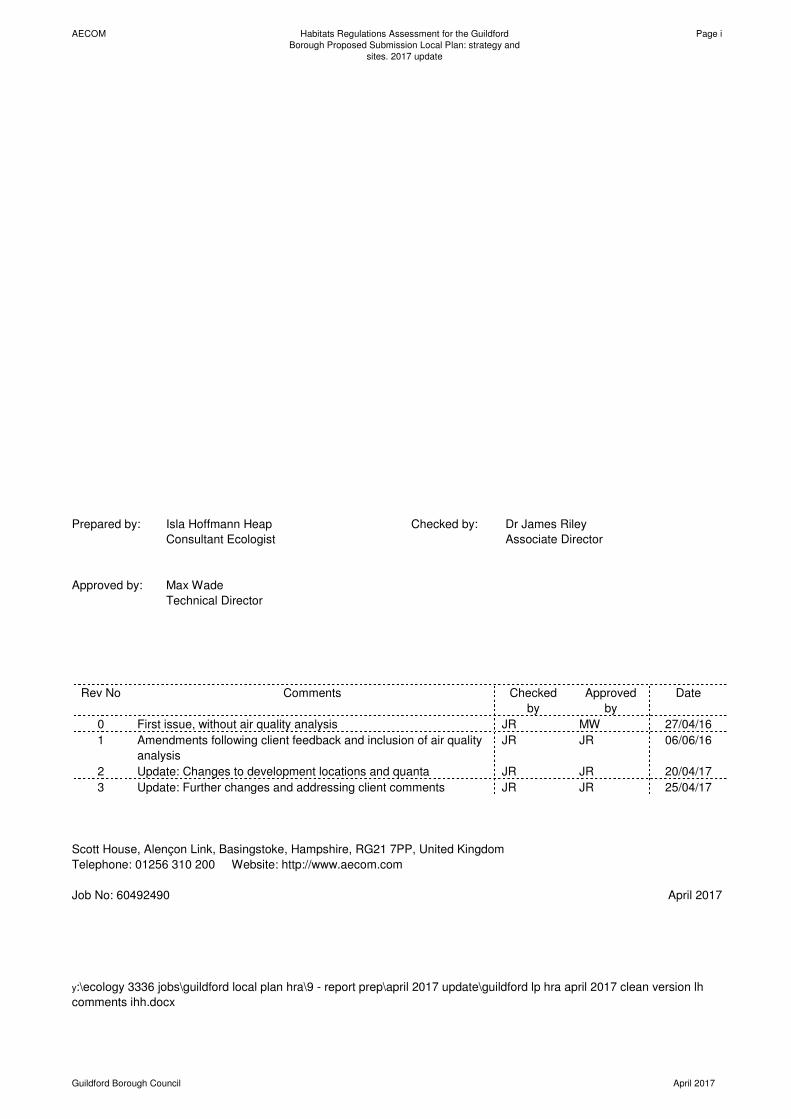
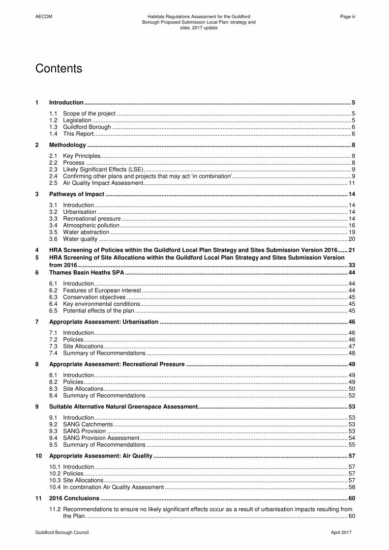

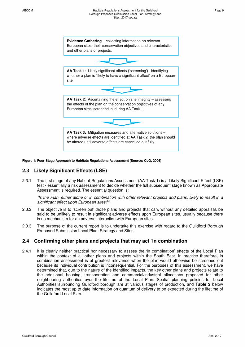
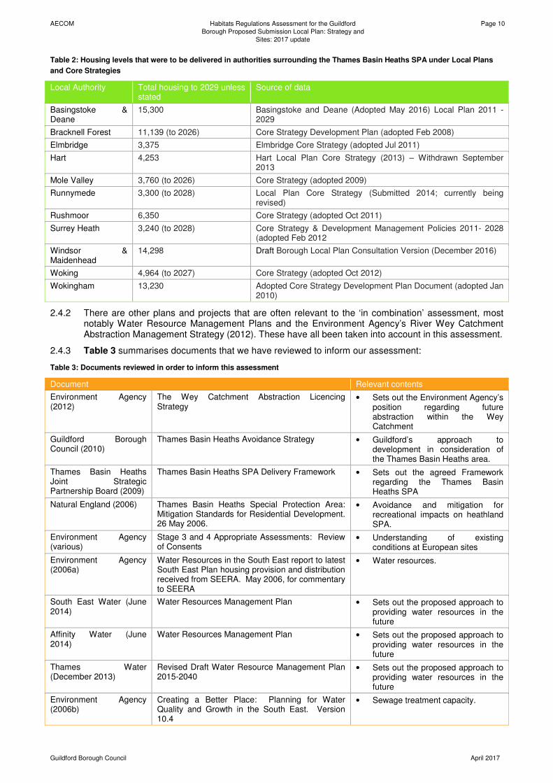
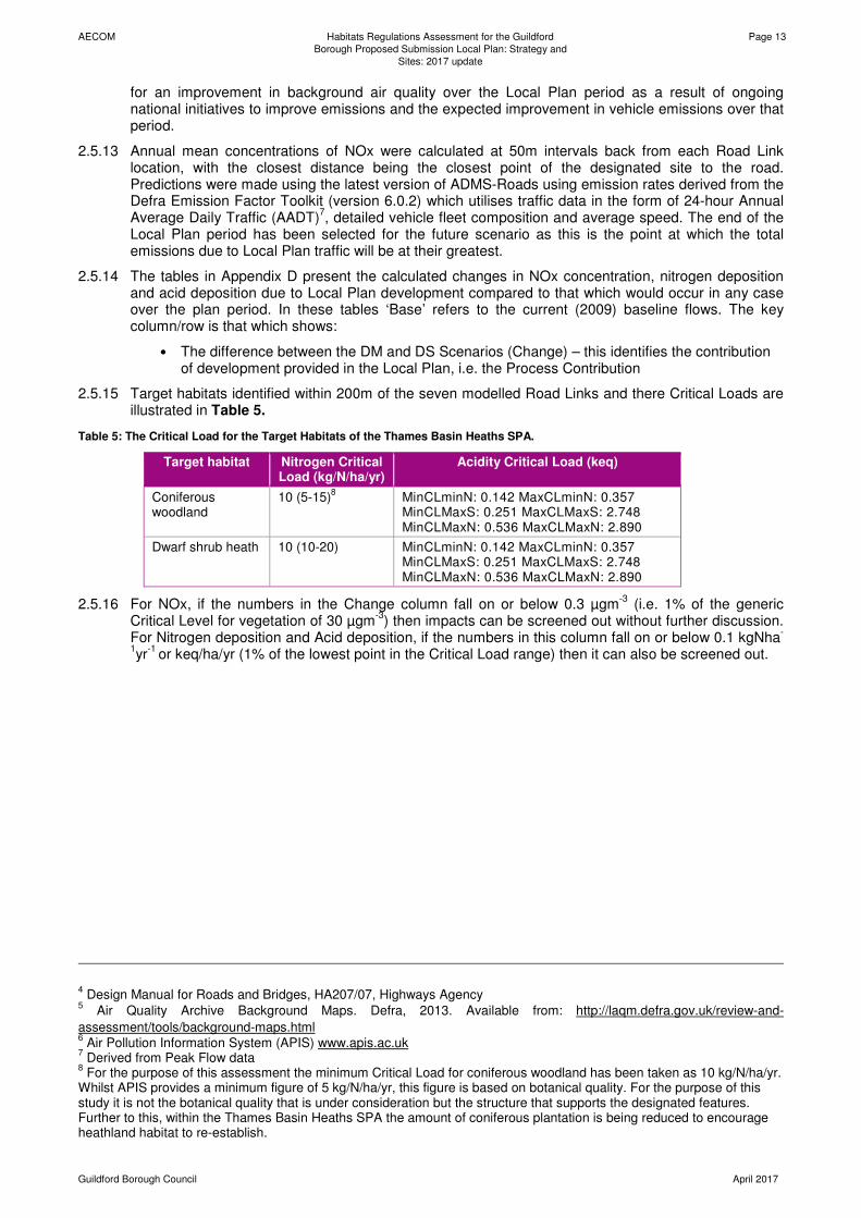
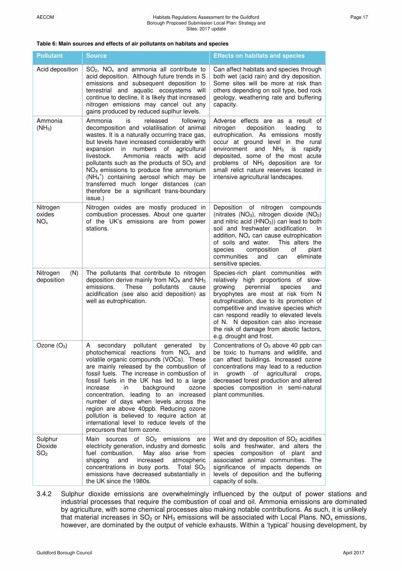
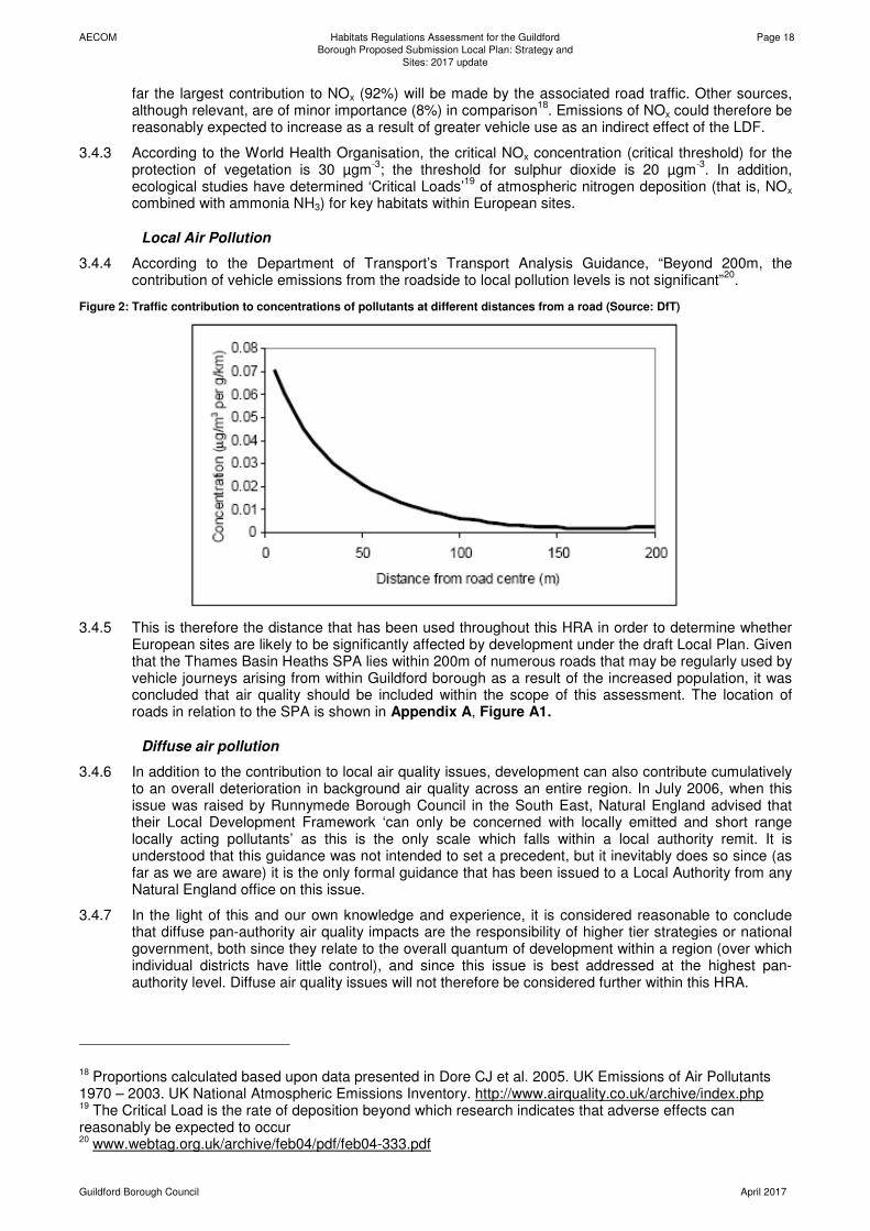
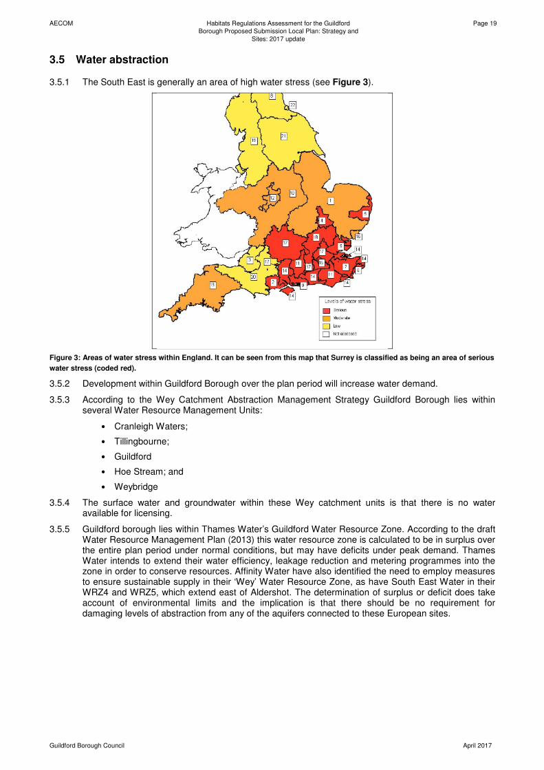
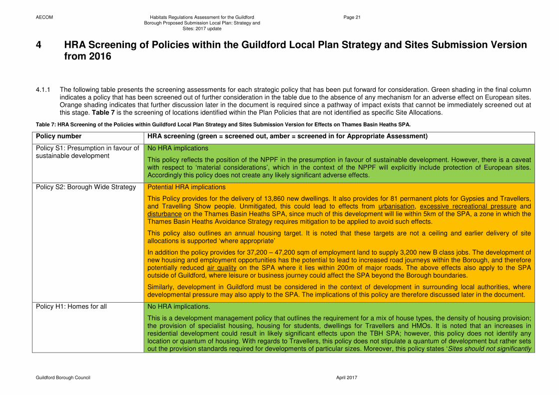
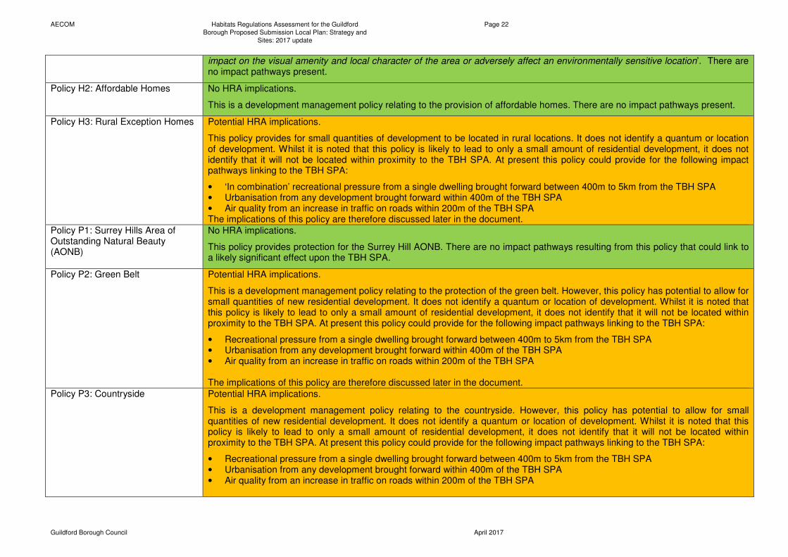
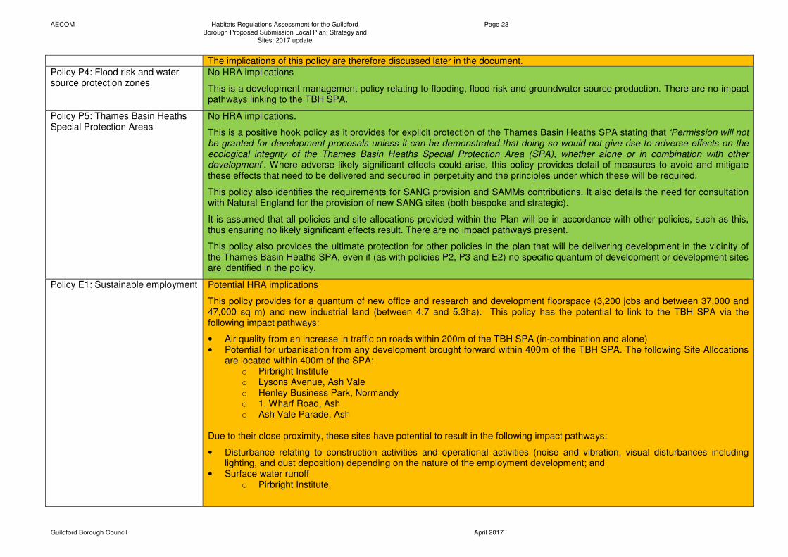
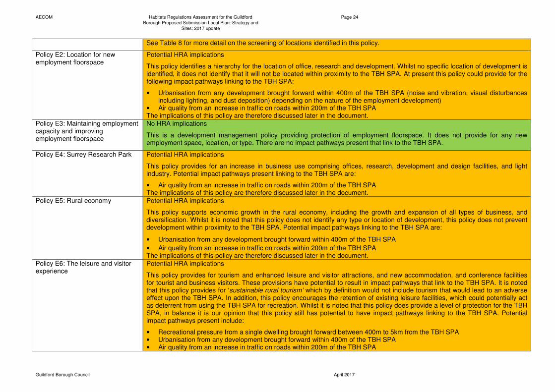
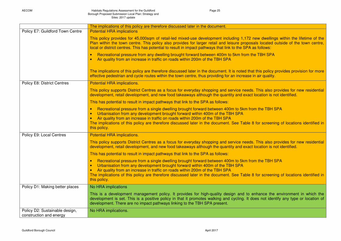
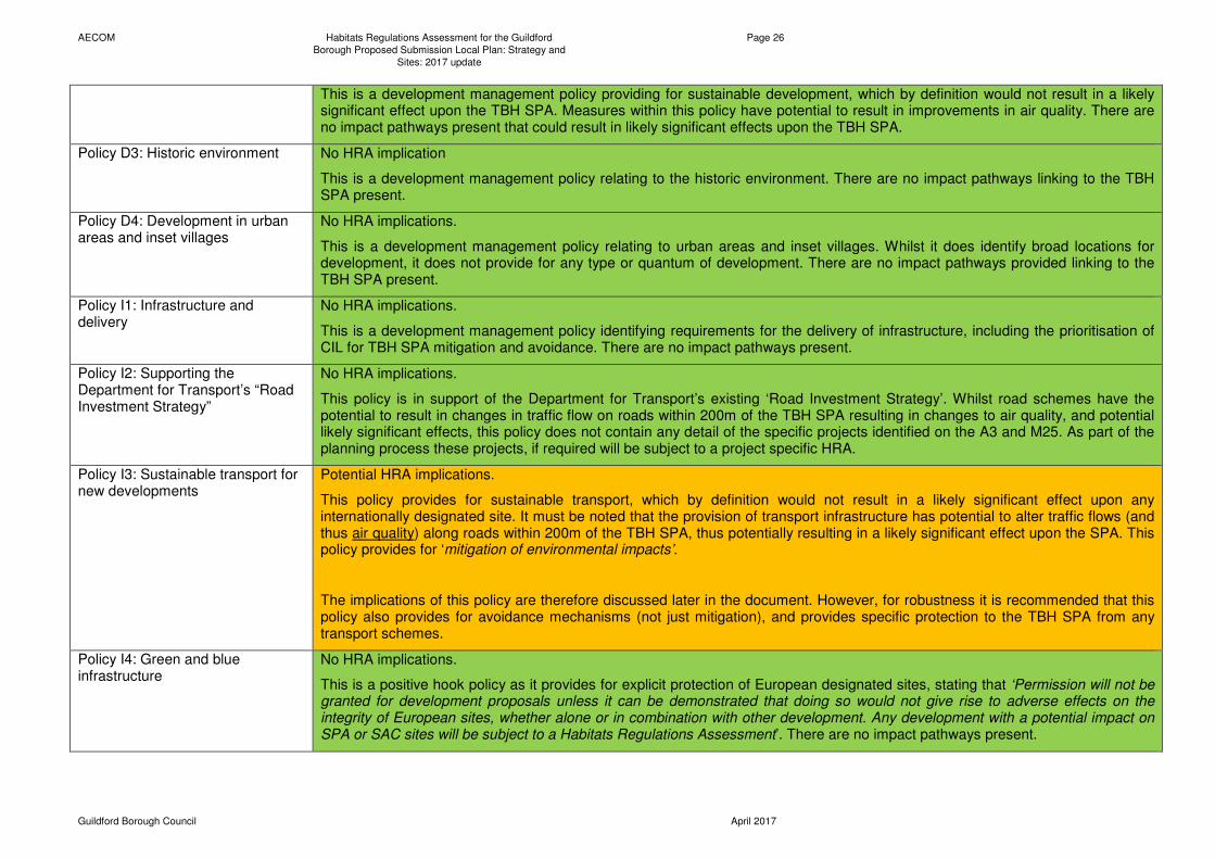
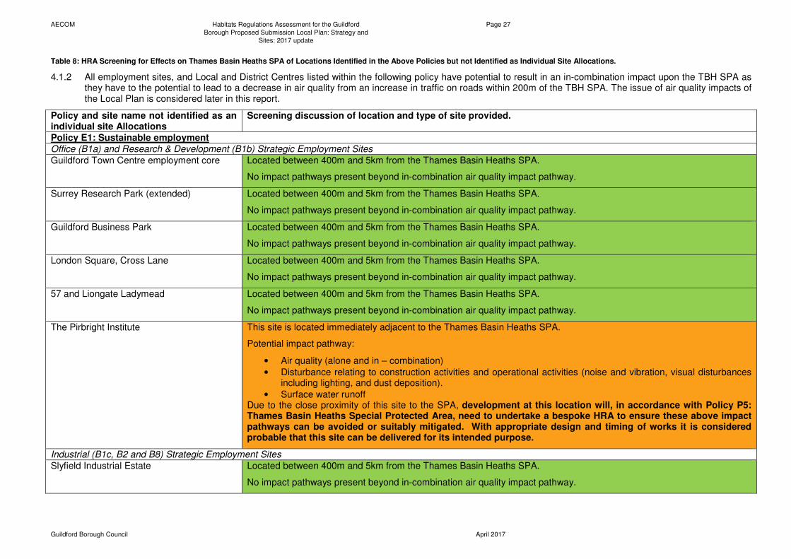
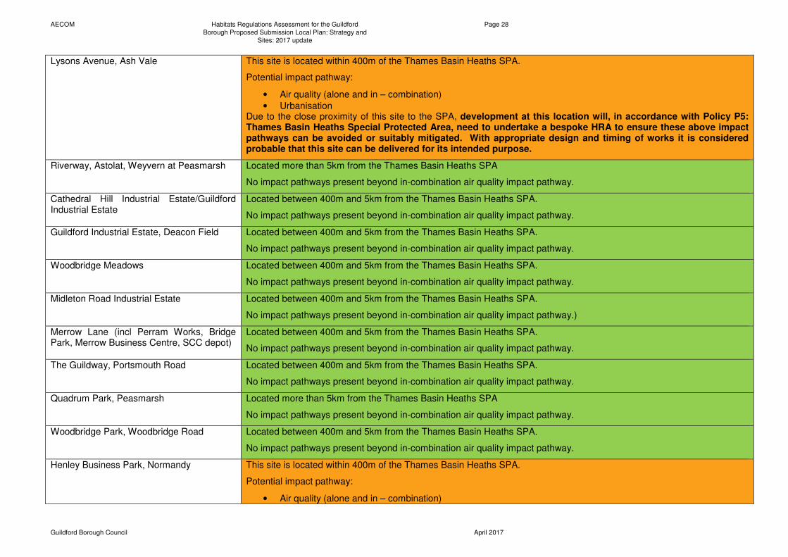
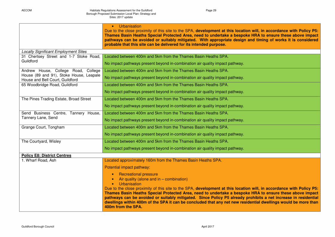
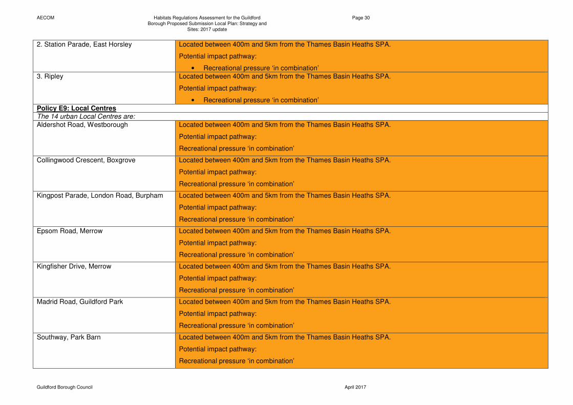
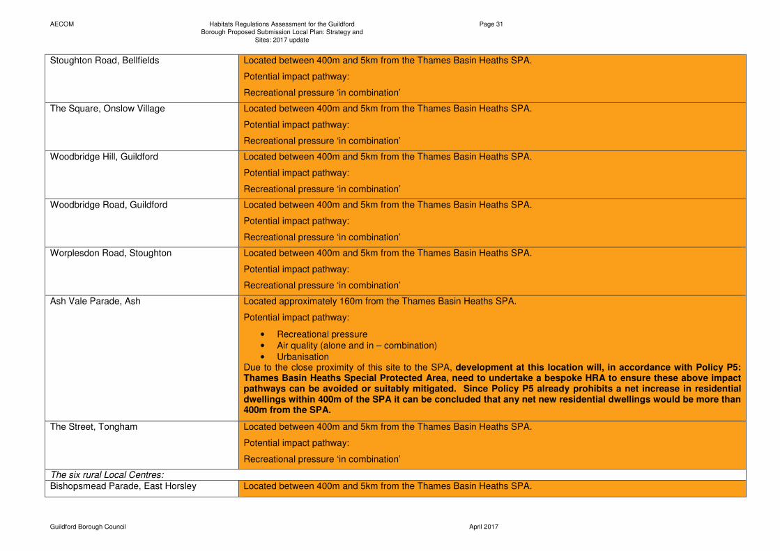
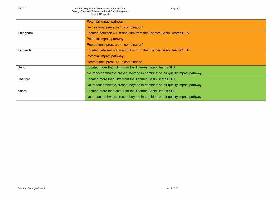
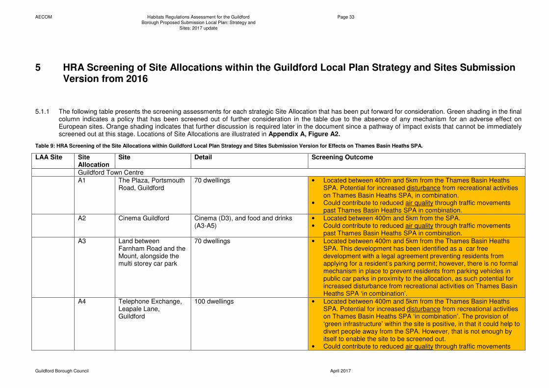
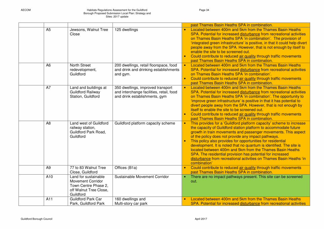
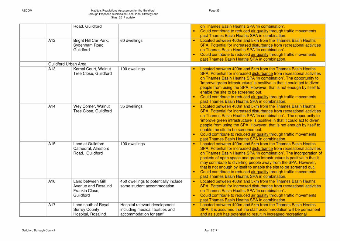
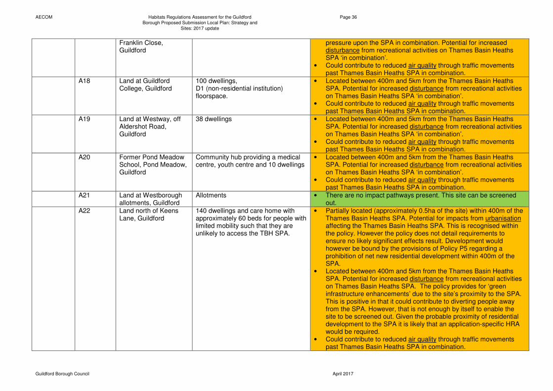
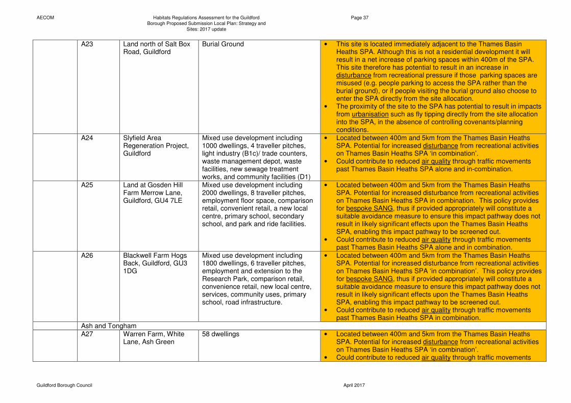

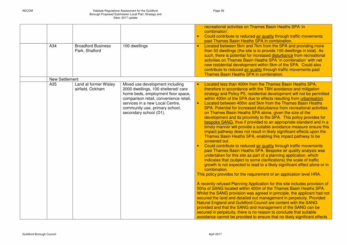
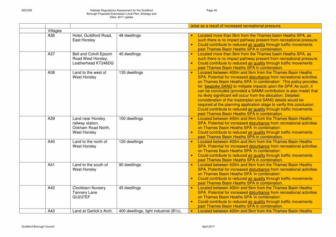
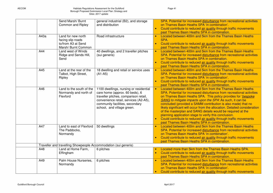
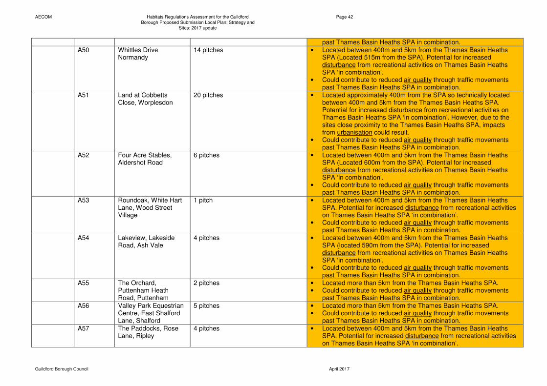
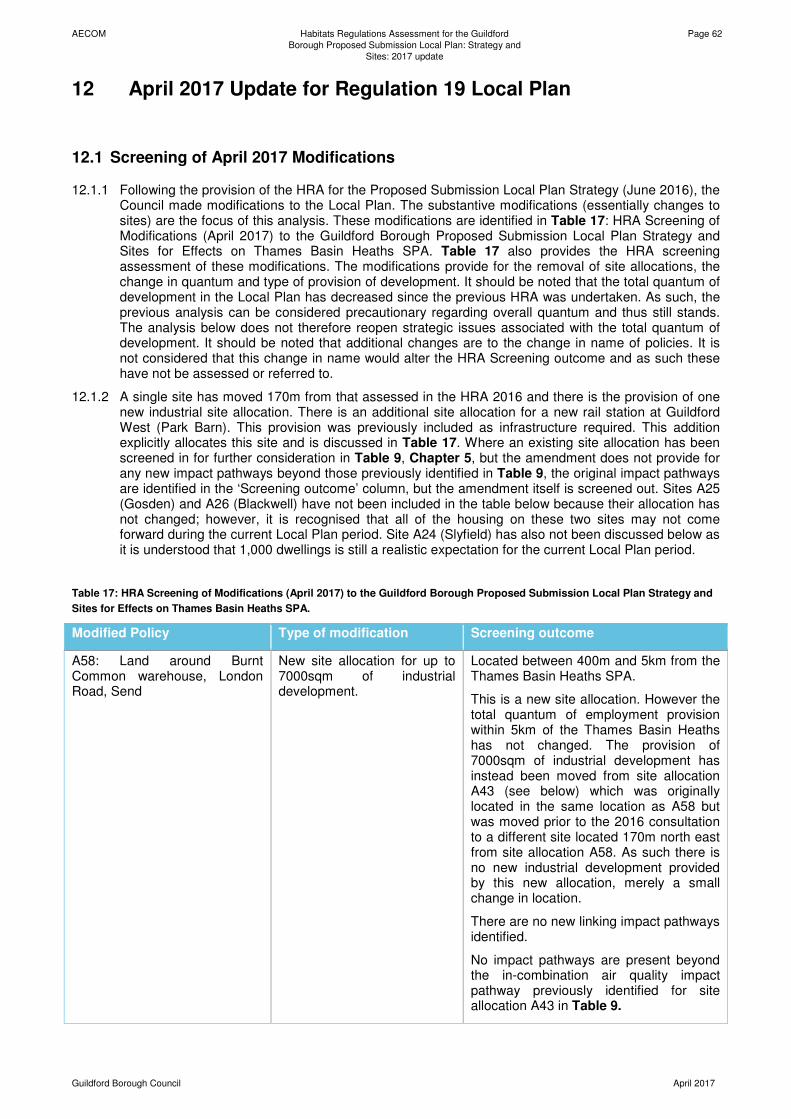
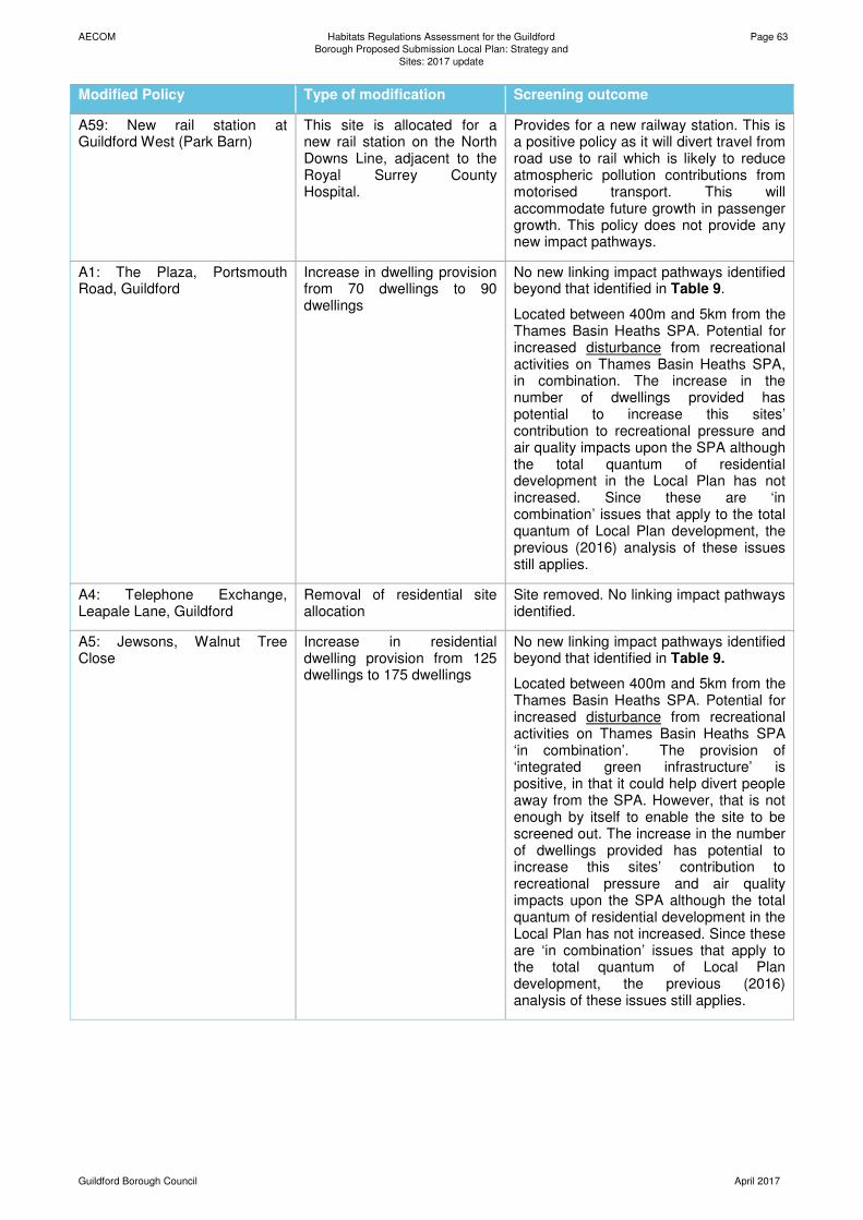
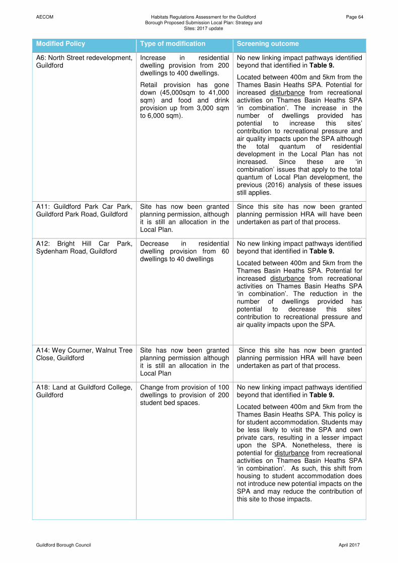
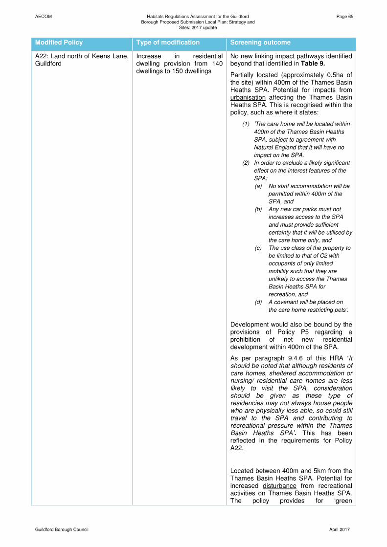
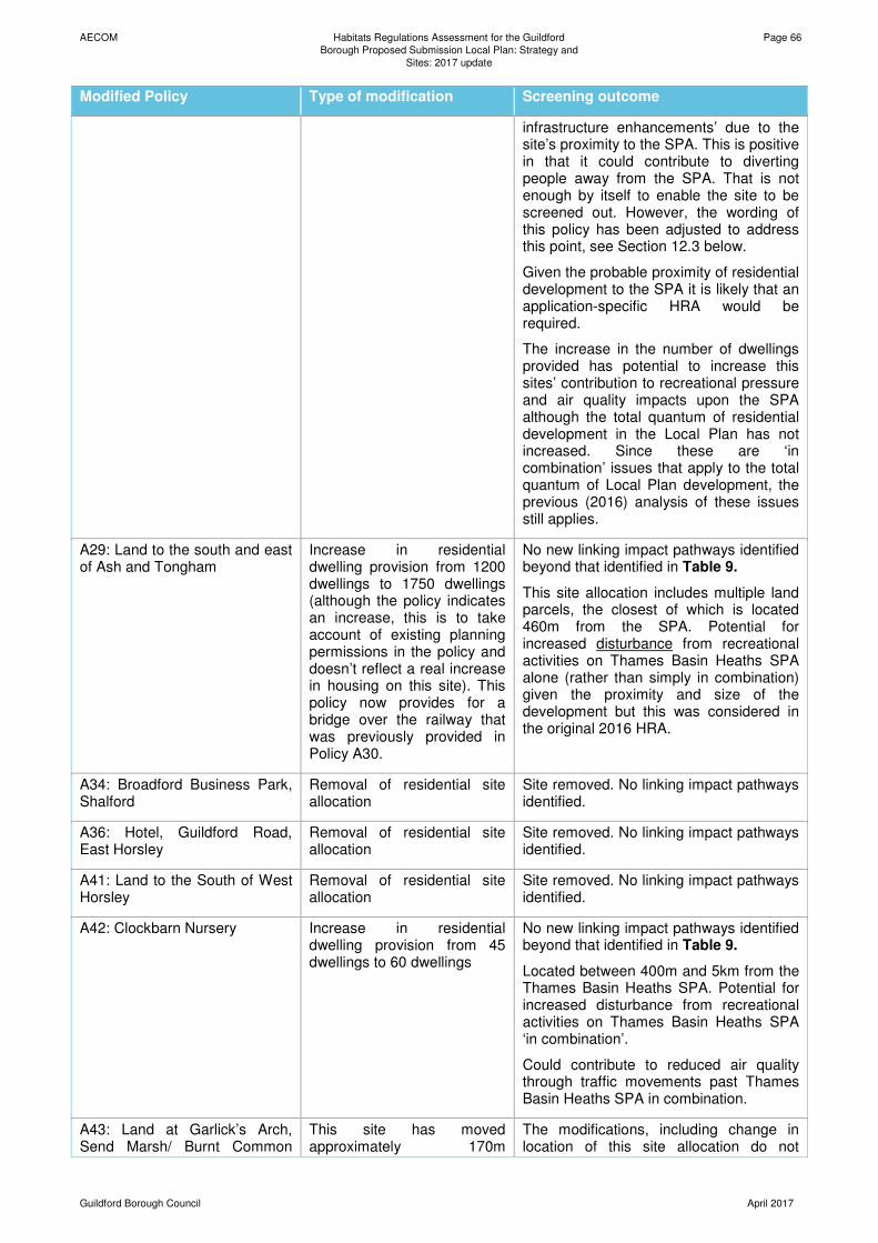
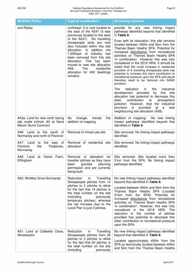
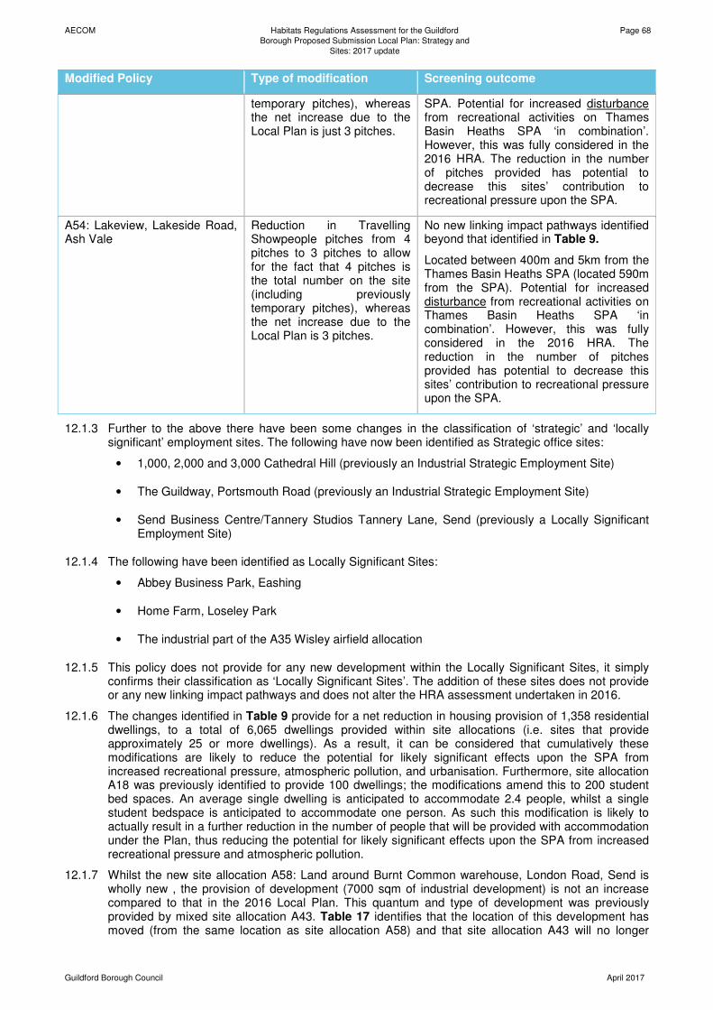
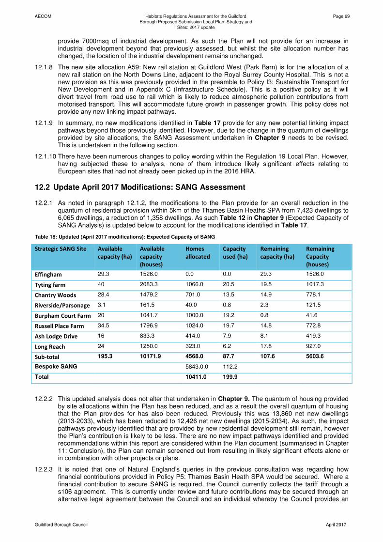

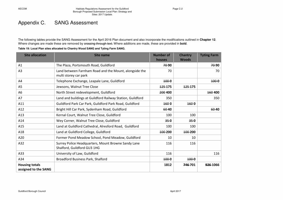
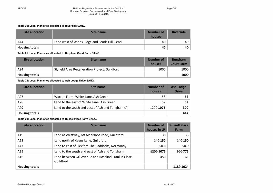
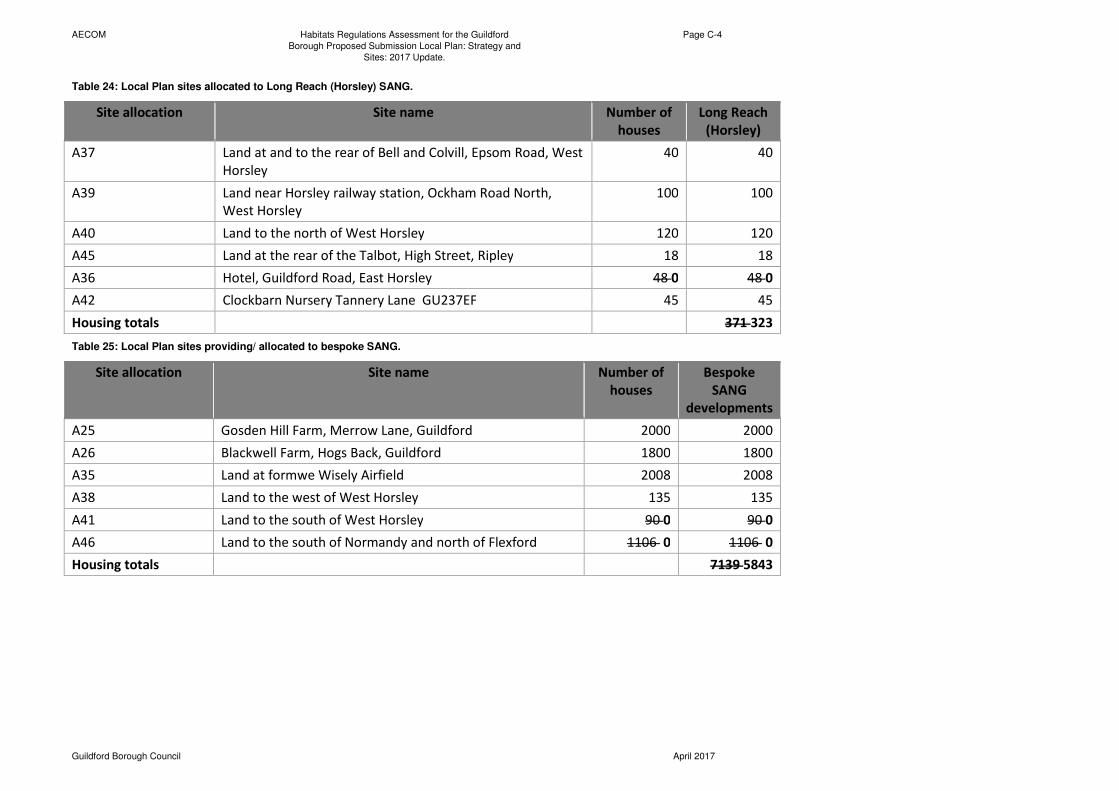
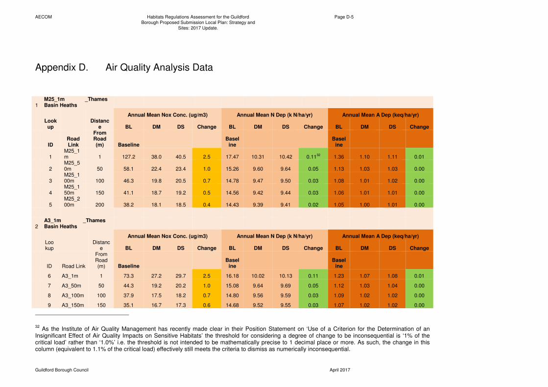
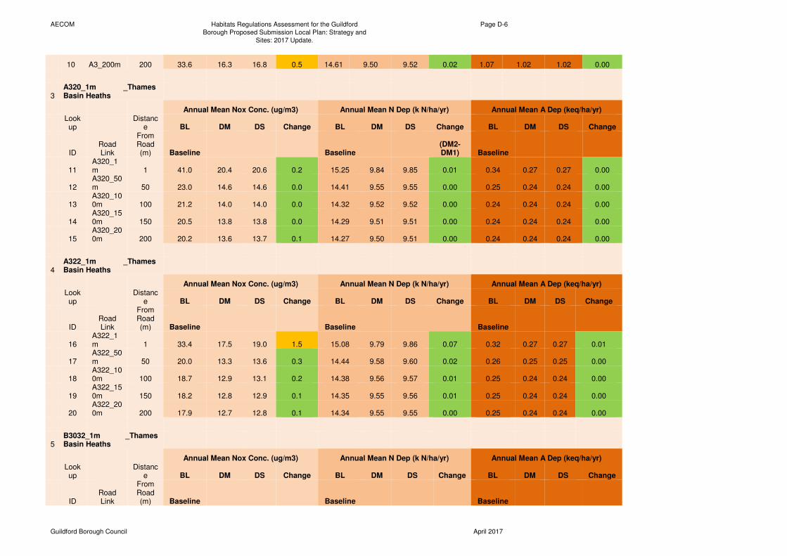
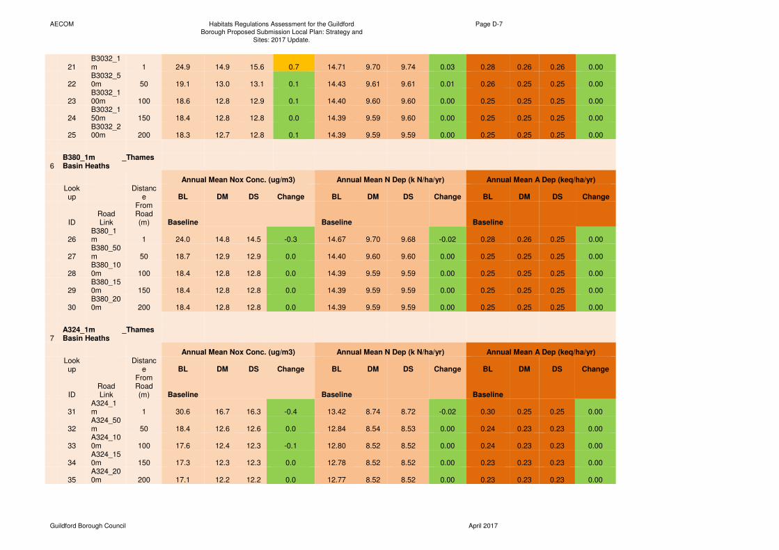


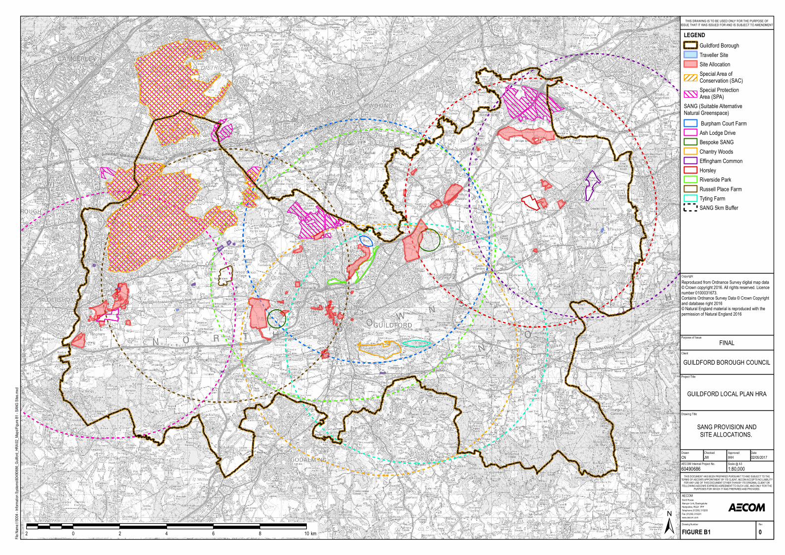

![Habitat Regulations Assessment for the Carlton and Chellington … · 2019-06-11 · 1.1.1 The Conservation of Habitats and Species Regulations 2017 [the Habitats Regulations] require](https://static.documents.pub/doc/80x56/5e93cd95f98288519e1851ec/habitat-regulations-assessment-for-the-carlton-and-chellington-2019-06-11-111.jpg)


