below sea level sea level Nearly 18,000 ft. below sea level Haleakala Volcano Pacific Plate Pacific Ocean 28,000 ft. 10,023 ft. above sea level Our Earth is a water-rich and rocky planet currently covered with life. The science of “Geology,” from the Latin meaning “to study the Earth,” helps us read the rocky record of the past and perhaps allows us to prepare for the future. “Plate Tectonics” is the study of the movements of the great plates that push against each other on the planet’s surface. In 1974, the rate of drift of the enormous Pacific Plate (on which the Hawaiian Islands formed) was found to be about four inches (10cm.) per year and moving northwest. Hotspots are plumes of superheated rock that well up from deep in the Earth, melt through the crust, and build shield volcanoes like the ones found in Hawaiʻi. The drift of the Pacific Plate means that Haleakalā volcano will eventually be pulled away in a northwest direction, which will break its connection to the hot spot. The volcano will become extinct and erosion will devour it. Why Are There Volcanoes Here? All Hawaiian volcanoes are called “shield volcanoes” because the gradual buildup of many thin layers of lava erupting from the hot spot creates a shape like a warrior’s shield —long, broad, and gently curved. About 40% of the volcanoes on Earth are shield volcanoes. The shape of Haleakalā means that only the very top — only about 5% — is above sea level. Fourteen multicolored pu’u (cinder cones) can be seen dotting the summit valley of Haleakalā. Pu’u form when gas is trapped in lava during an eruption and forces the lava to eject as a fountain; much like when you shake a carbonated drink can and then break the seal. The hot lava falls as sticky cinders all around the base of the fountain and a pu’u is built. The summit of Haleakalā currently stands at 10,023ft. (3,055m.), but is believed to have once reached 15,000ft. (4,572m.) above sea level. Erosion has worked heavily upon Haleakalā and it is so heavy it has also begun to sink into the crust of the Earth. Even with this loss in height, however, the volcano stands 28,000ft. (2534m.) above the sea floor, making it the third-tallest mountain on Earth. Haleakala: Shield Volcano Geology of Haleakala - Written in the Rocks National Park Service U.S. Department of the Interior Haleakala National Park
Transcript
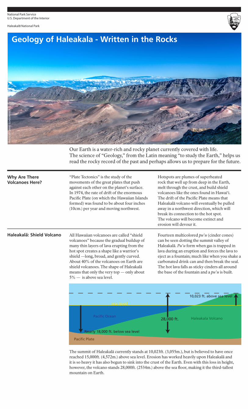
approx 20,000 ft. below sea level
sea level
Nearly 18,000 ft. below sea level
Haleakala Volcano
Pacific Plate
Pacific Ocean28,000 ft.
10,023 ft. above sea level
Our Earth is a water-rich and rocky planet currently covered with life. The science of “Geology,” from the Latin meaning “to study the Earth,” helps us read the rocky record of the past and perhaps allows us to prepare for the future.
“Plate Tectonics” is the study of the movements of the great plates that push against each other on the planet’s surface. In 1974, the rate of drift of the enormous Pacific Plate (on which the Hawaiian Islands formed) was found to be about four inches (10cm.) per year and moving northwest.
Hotspots are plumes of superheated rock that well up from deep in the Earth, melt through the crust, and build shield volcanoes like the ones found in Hawaiʻi. The drift of the Pacific Plate means that Haleakalā volcano will eventually be pulled away in a northwest direction, which will break its connection to the hot spot. The volcano will become extinct and erosion will devour it.
Why Are There Volcanoes Here?
All Hawaiian volcanoes are called “shield volcanoes” because the gradual buildup of many thin layers of lava erupting from the hot spot creates a shape like a warrior’s shield —long, broad, and gently curved. About 40% of the volcanoes on Earth are shield volcanoes. The shape of Haleakalā means that only the very top — only about 5% — is above sea level.
Fourteen multicolored pu’u (cinder cones) can be seen dotting the summit valley of Haleakalā. Pu’u form when gas is trapped in lava during an eruption and forces the lava to eject as a fountain; much like when you shake a carbonated drink can and then break the seal. The hot lava falls as sticky cinders all around the base of the fountain and a pu’u is built.
The summit of Haleakalā currently stands at 10,023ft. (3,055m.), but is believed to have once reached 15,000ft. (4,572m.) above sea level. Erosion has worked heavily upon Haleakalā and it is so heavy it has also begun to sink into the crust of the Earth. Even with this loss in height, however, the volcano stands 28,000ft. (2534m.) above the sea floor, making it the third-tallest mountain on Earth.
Haleakala: Shield Volcano
Geology of Haleakala - Written in the Rocks
National Park ServiceU.S. Department of the Interior
Haleakala National Park
Haleakalā actually rose .23ft. (.07m.) per year between 1981 and 1992. Satellites measured this change, and geologists theorized that it could have been due either to the movement of magma (lava that has not erupted yet) deep under the sea floor or as a reaction to the ongoing eruptions on Hawaiʻi Island. Constant eruptions on Hawaiʻi Island added mass to the island and caused it to sink, forcing Maui to rise up as a reaction, similar to when a person sits next to you on a couch and causes your cushion to push you up a bit.
Shield volcanoes like Haleakalā form where there are hotspots in the earth’s crust. Their lava is thin and flows easily. Composite volcanoes like Vesuvius or Mount St. Helens typically form where plates come together. Their lava is thicker and doesn’t flow easily so these volcanoes tend to explode a mix (a “composite”) of lava, rock, and ash.
From Kahului, look back at Haleakalā. The rows of pu`u you see on both sides of the volcano mark “rift zones” — long lines of stress fractures on the flanks of the volcano where eruptions can occur. The last eruption on Maui occurred on the southwest flank of Haleakalā, along the southwest rift zone near Wailea. Because the volcano is not yet extinct, this rift zone could be the location of a future eruption.
Lava comes from the Italian word lavare, “to wash.” Originally referring to a stream formed by sudden rain, the term was also applied to the streams of molten lava coming down from Mt. Vesuvius.
It is a common practice for geologic forms to be named after the place where they were first described or where the best examples are found. Local names for these formations are also used.
Pāhoehoe is a combination of Hawaiian words: pā, for stone wall and hoe, for paddling a canoe. The combination can refer to the ripples of stone often seen as this type of lava flows and cools.
ʻAʻā is a Hawaiian word that can refer to burning, blazing, or glowing.
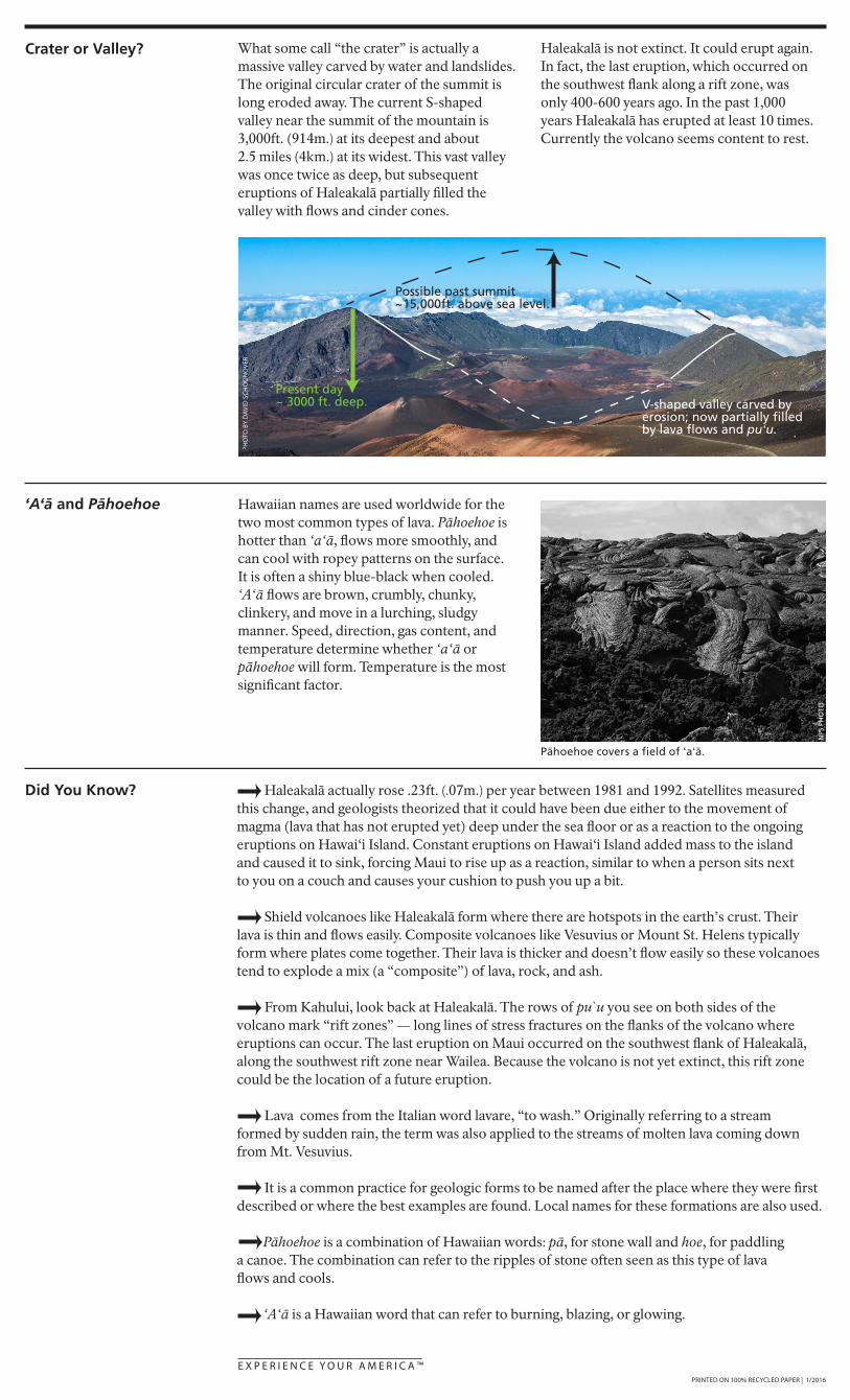
What some call “the crater” is actually a massive valley carved by water and landslides. The original circular crater of the summit is long eroded away. The current S-shaped valley near the summit of the mountain is 3,000ft. (914m.) at its deepest and about 2.5 miles (4km.) at its widest. This vast valley was once twice as deep, but subsequent eruptions of Haleakalā partially filled the valley with flows and cinder cones.
Haleakalā is not extinct. It could erupt again. In fact, the last eruption, which occurred on the southwest flank along a rift zone, was only 400-600 years ago. In the past 1,000 years Haleakalā has erupted at least 10 times. Currently the volcano seems content to rest.
Crater or Valley?
E X P E R I E N C E Y O U R A M E R I C A ™PRINTED ON 100% RECYCLED PAPER | 1/2016
Hawaiian names are used worldwide for the two most common types of lava. Pāhoehoe is hotter than ʻaʻā, flows more smoothly, and can cool with ropey patterns on the surface. It is often a shiny blue-black when cooled. ʻAʻā flows are brown, crumbly, chunky, clinkery, and move in a lurching, sludgy manner. Speed, direction, gas content, and temperature determine whether ʻaʻā or pāhoehoe will form. Temperature is the most significant factor.
‘A‘ā and Pāhoehoe
Did You Know?
Present day~ 3000 ft. deep.
Possible past summit~15,000ft. above sea level.
V-shaped valley carved by erosion; now partially filledby lava flows and pu!u.