29
Hamlet Road Haverhill Conservation Area Appraisal and Management Plan September 2008

Hamlet Road Haverhill
Conservation Area Appraisal and Management Plan
September 2008

Hamlet Road, HaverhillConservation Area Appraisal
and Management Plan
Planning & Engineering ServicesSt Edmundsbury Borough Council
PO Box 122Bury St Edmunds
IP33 3YS
1
Contents
Introduction
Summary of special interest of the conservation area
Assessing special interest:
1 Location and setting:
• context• map of the conservation area • general character and plan form
2 Historic development and archaeology:
• origins and historic development of the conservation area • archaeology and scheduled ancient monuments
3 Spatial analysis:
• character and interrelationship of spaces• key views and vistas
4 Character analysis:• definition and description of character areas:
Eden Road, Duddery Road, Mount Road,Waveney Terrace and Meeting WalkHamlet RoadAtterton and Ellis Site
• surfaces and street furniture• neutral and negative areas• general condition of the area and buildings at risk • problems, pressures and capacity for change
5 Key characteristics to inform new development
6 Management proposals for the Hamlet Road Conservation Areafor 2008-2012
7 Useful information and contacts
Bibliography

2

Introduction The conservation area appraisal and management plan has been approved as planningguidance by the Borough Council on 23 September 2008.
It has been the subject of consultation. Comments received as a result of theconsultation have been considered and, where appropriate, the document has beenamended to address these comments. This document will, along with the ReplacementSt Edmundsbury Borough Local Plan 2016, provide a basis by which any planningapplication for development in or adjacent to the conservation area will be determined.
A conservation area is ‘an area of special architectural or historic interest, the characteror appearance of which it is desirable to preserve or enhance’. The Borough Council hasa duty to designate conservation areas and to have regard to their special character andappearance when considering planning applications for development. The Planning(Listed Buildings and Conservation Areas) Act 1990 contains the legislation regarding thedesignation of conservation areas and the duties of the Borough Council. Nationalguidance on conservation areas is contained in Planning Policy Guidance Note (PPG) 15:Planning and the Historic Environment. Detailed local policies about how the BoroughCouncil will consider planning applications in conservation areas are set out in theReplacement St Edmundsbury Borough Local Plan.
This document is an appraisal of the special character and appearance of the HamletRoad Conservation Area, Haverhill, and includes a summary of key features andcharacteristics to guide future development in the conservation area. It has beenproduced in accordance with the advice contained in the English Heritage publications‘Guidance on conservation area appraisals’ and ‘Guidance on the management ofconservation areas’, both published February 2006 by English Heritage.
This document expands on the information within the policies in the Replacement St Edmundsbury Borough Local Plan, particularly policies HC4: buildings of localarchitectural or historic significance; HC5: the demolition of unlisted buildings, structuresor features within a conservation area; HC6: new development in conservation areas;DS3: development design and impact; TCR1: shopping centres; TCR2: protection ofprimary shopping centres; TCR3: shopfronts and advertisements; TCR4: amusementarcades, T6: off-street car parking and HAV5: Haverhill Town Centre Masterplan.
This document supports the priority in the Council’s Corporate Plan to secure asustainable and attractive environment and the long-term visions of St Edmundsbury2025 which:
• values, protects and enhances the distinct landscapes and biodiversity of the Borough
• has successfully retained and enhanced its built and natural heritage and environment
Much detailed research has been carried out into the history of the town of Haverhilland it is not the purpose of this appraisal to repeat that. A brief history is included,however, as much of what we value today and seek to protect in the conservation areais a direct result of historical events and developments. A bibliography is included at theend for those wishing to learn more about Haverhill’s rich history.
The Ordnance Survey mapping included within this publication is provided by StEdmundsbury Borough Council under licence from the Ordnance Survey in order to fulfilits public function as planning authority. Persons viewing this mapping should contactOrdnance Survey copyright for advice where they wish to licence Ordnance Surveymapping for their own use.
3
Summary of special interest of theConservation AreaThe original settlement of Haverhill was located towards Burton End, however by the13th century the town centre and its market moved to Market Hill following theestablishment of St Mary’s Church. The town developed along the High Street andMarket Hill establishing its linear plan form, extending further south to Hamlet Road.Due to a number of natural disasters, however, the majority of the original medievalbuildings were lost and gradually replaced by many of the buildings we see today. Withthe exception of the church, the Rose and Crown, The Queens Head and Weavers inHamlet Road, little has survived of the medieval period. The erection of Chauntry Milltogether with the introduction of the railway lines in the 19th century were significantlyinfluential in the town’s development throughout this period, witnessing its largestexpansion to date and providing us with a town of notable interest worthy of recognitionand protection.
4

Assessing special interest
1 Location and settingContext
Haverhill is an historic market town located in the south west corner of Suffolk, close to theEssex and Cambridgeshire borders and approximately 22 miles south of Bury St Edmunds.The town has a population of around 22,000 in a borough of just over 100,000.
The Hamlet Road Conservation Area in Haverhill largely focuses on the residential areaof the town centre with a number of shops towards the centre and an industrial areatowards the eastern boundary.
In recognition of its architectural and historic importance, the Hamlet Road area ofHaverhill was designated a conservation area on 22 July 2002 together with the QueenStreet Conservation Area. Map 1 shows the boundary of the Hamlet RoadConservation Area.
Map 1: Hamlet Road Conservation Area
5

Plan form and general character
Hamlet Road provides access to the centre of Haverhill from the south continuing thelinear plan form of Queen Street and High Street. With the exception of Atterton andEllis and the former silk mill, the road is largely residential in use. Houses are typicallytwo storeys in height, semi-detached, slightly set back from the road behind small frontgardens to the west whilst fronting directly onto the pavement to the east. Eden Road,Duddery Road, Mount Road and Meeting Walk provide a series of terraces branching offHamlet Road and High Street and within walking distance of the centre of town. Houseshere are typically two storeys in height and front directly onto the pavement, with theexception of Meeting Walk where houses benefit from small front gardens.
6
2 Historic development and archaeology
Origins and historic development of the conservation area
A permanent settlement is thought to have been established at Burton End around thebeginning of the 11th century, where there was a market, an 11th century parishchurch, and an ancient burial ground. Today, no trace of the Burton End church remainsand a housing development named Overchurch Close now occupies the site. Haverhillwas recorded in the Domesday survey of 1086 as operating a market (one of only 11recorded in Suffolk, evidence of Haverhill’s importance).
Haverhill’s second church, St Mary’s, was established on the main highway by the 13thcentury and the town centre together with the market moved from Burton End to itspresent position. The market place was called Market Hill, a large space runningalongside the High Street from Camps Road as far as Duddery Hill. All the town’s accessroutes were designed to traverse the market place. High Street was originally twice aswide as it is today to accommodate the market stalls. Over time these were replaced bybuildings which encroached into the space, narrowing the street.
For the next 300 years there were two churches less than 1/2 mile apart. The Burton Endchurch became known as Upper, or Bovetown, (i.e. above town) Church while the marketplace church was called Lowerchurch. Eventually, in 1551, the people decided they couldno longer maintain the old church and petitioned King Edward VI to remove it.
Until the 14th century Haverhill was an agricultural town with a weekly market and twoannual fairs held in May and October. The fairs sold goods from a wider area than theweekly market and were used for hiring servants and farm labourers. By October 1872,however, both fairs had been abolished.
During the latter part of the middle ages Haverhill prospered as a significant tradingcentre, establishing itself as a weaving town, a characteristic it maintained for severalcenturies.
On 27 January 1541 Henry VIII’s fourth wife Anne of Cleves, was granted a parsonagetogether with lands and the right to appoint clergy. It is thought the parsonage awardedto Anne burnt down in 1667 and the house which bears her name today did not becomea vicarage until much later.
By 1520 the population had only increased to 560, the main reason being the blackdeath. However as the 16th century progressed, a boom in agriculture brought moreprosperity leading to the erection of permanent buildings along the line of the marketprobably along Withersfield Road, Queen Street, High Street and Hamlet Road.
On 14 June 1667 a great fire started at the Swan Inn and destroyed the centre ofHaverhill from Swan Lane to Duddery Hill, affecting parts of Queen Street and CampsRoad, gutting St Mary’s Church and destroying several buildings of note includingPrenticehall, the Guildhall, Chauntry House, the Town House and the vicarage all locatedaround Market Hill. Today only three buildings are known to survive from the medievalperiod; the Rose and Crown, the Queens Head and Weavers in Hamlet Road.
In 1674 a quarter of an acre was left in Thomas Ewin’s will for a burying ground forQuakers and another for the erection of a meeting house, hence the name ofQuaker’s Lane.
A tannery yard was established at the end of Hamlet Road in 1770 on the site knowtoday as Atterton and Ellis. The site was bought by Stephen Walters, a Spitalfieldweaver, and a three storey silk factory was built producing silk until shortly before 1882.
By the 18th century weaving began to expand in the town, notably by the decendants ofDaniel Gurton (whose name changed to Gurteen), which had a significant effect on thetown. 1811 saw the first silk production come to Haverhill with drabbet coming in 1814.Between 1856 and 1865 the new Chauntry Mill was erected by the Gurteen family,housing 320 steam powered looms. By the end of the 19th century most of the peoplein Haverhill worked in some way for the Gurteen family.
In 1863 the Colne Valley and Halstead railway arrived in Haverhill. Known as HaverhillSouth, this station closed to passengers in 1924 following the LNER take over, althoughthe goods service remained until 1962. By 1865 the Great Eastern Railway (GER) arrivedin the town from Cambridge, using the Haverhill North station. Within a couple of 7

months Haverhill was also linked up to Sudbury. The Sturmer Arches, originally calledJunction Bridge, were completed to link the Colne Valley railway to the Great EasternLine. The Stour Valley line of the GER closed down in 1967.
In 1875 John Atterton moved to Haverhill and set up the firm Duddery Iron Works onDuddery Road. By 1878 Atterton’s Patent Lawn Mower Grinding Machine was introducedto the world. The iron works moved to Hamlet Green following closure of the silk worksin 1882. By the end of 1883 the site had reopened following the refurbishment of thesilk factory to provide show rooms and the construction of a number of new workshops.Following several successful inventions, Atterton collaborated with William Ellis and thefirm became Atterton and Ellis. The firm was taken over in 1943 by Boardmans ofSturmer following the deaths of both John Atterton and William Ellis.
In 1876 the Cangle School (originally the Board School) was built at the junction ofWithersfield Road and Wratting Road under the Education Act of 1870 which madeeducation compulsory. In 1889 a new corn exchange was built in Withersfield Road anda livestock market was held on the site behind it and the Rose and Crown. This marketwas declining by 1960, however, and officially closed in February of that year.
By the 1890’s most of the terraced houses that were to form the majority of local homeswere built. Eden Road, Waveney Terrace, Duddery Road, Mount Road and WithersfiledRoad all date from this period.
A severe flood hit Haverhill in June 1903, particularly affecting Queen Street andWithersfield Road. June 1958 saw a second flood, this time affecting the High Street,Queen Street and The Pightle and all main roads out of the town were closed. In 1968the third flood hit the town, once again causing roads to be closed.
By 1911 the town’s population was 4,749, rising to 4,900 by 1914, but by 1946 it haddropped to under 4,000, with many men and boys leaving to find employment. The passingof the Town Development Act in 1952 led to Haverhill’s expansion to accommodate overspillpopulation from London and by 1961 population had risen to 5,200.
Archaeology and scheduled ancient monuments
Based upon post-medieval mapping and the surviving historic landscape, it is believedthat the medieval urban core followed the south side of the valley floor and embracedboth sides of Queen Street and High Street (which is taken to be the early Medievalroad line), with the medieval church and Market Hill towards the north end. Both theroad to Bury St Edmunds and Camps Road to Hazel Stub are also on an early line andare part of the medieval historic landscape. The probability is that the town had a linearlayout, almost ribbon development, very distinct from the planned blocks of medievalBury St Edmunds, but with a significant off-shoot up Camps Road towards the site of thesettlement's original church at Burton End. Archaeological discoveries show that therewere significant areas of secondary medieval settlement at Hazel Stub and north-east ofBoyton Hall.
The river valley was a favoured location with unusually concentrated occupation sincethe late Bronze Age (a large enclosure off the Withersfield Road, near the junction withthe Stour Brook) and an extensive but probably dispersed pattern of Late Iron Age andearly Roman settlement right down the north side of the Haverhill valley from the StourBrook at least as far as Coupals Road/Chalkstone Way. There is no suggestion of aRoman town, but rather a series of individual farming estates, at least one of some sizeand significance. There has been less opportunity to carry out archaeological surveys onthe south of the valley, but Roman finds off Crowland Road suggest that there wassettlement on this side also.
Enthusiastic development during the 19th century, early 20th century industrial wealthand re-development of the old urban core in the post-world war II period of growth nowdominate the initial impression of this town. In fact, the surviving historic landscape ofthe town centre identifies one of the earliest and more significant medieval towns of theCounty (particularly the old West Suffolk); lying in a favoured valley, it occupies muchthe same location as notable late Prehistoric and Roman settlement concentrations.
In 1997 an excavation at the southern end of Crowland Road uncovered the ancientburial ground belonging to the Burton End church where 355 graves and some lateSaxon and early medieval pottery were found.
There are no Scheduled Ancient Monuments within the Hamlet Road Conservation Area.8

3 Spatial analysis
Character and interrelationship of spaces
The streets of the Hamlet Road Conservation Area vary from the densely populated terracedareas, where houses typically front directly onto the pavement, to the more generous plotsof Hamlet Road, where a mix of semi-detached and detached houses sit back from thepavement behind small front gardens on the west side and front directly onto the pavementon the east side. Open spaces are largely limited to the two extremities of the conservationarea where both back onto and follow the line of Stour Brook.
Stour Brook North
Map 2: Stour Brook North
Bounded by the rear elevations of WaveneyTerrace and Stour Brook to the west andEhringshausen Way to the east this open space isa grassy area with several mature trees (photo1). It provides a welcome break in an area whichis predominantly built up, helping to define thetransition between the residential areas west ofEhringshausen Way and the industrial areas eastof Ehringshausen Way.
9Photo 1: Stour Brook North

Stour Brook South
Map 3: Stour Brook South
The densely packed trees, obscuring Stour Brook, demark the northern boundary of thisopen space whilst Sturmer Road defines its boundary to the south. A small triangularpiece of land (photo 2) occupied by a number of trees is sited opposite whilst theimpressive scale of the viaduct terminates the view out of the conservation area andreminds us of the success of Haverhill’s industrial past (photo 3).
10
Photo 2: Open space to the south Photo 3: Sturmer Arches which terminate theview out of the conservation area to the south
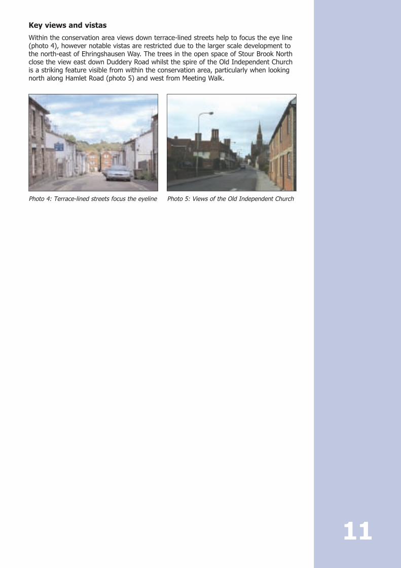
Key views and vistas
Within the conservation area views down terrace-lined streets help to focus the eye line(photo 4), however notable vistas are restricted due to the larger scale development tothe north-east of Ehringshausen Way. The trees in the open space of Stour Brook Northclose the view east down Duddery Road whilst the spire of the Old Independent Churchis a striking feature visible from within the conservation area, particularly when lookingnorth along Hamlet Road (photo 5) and west from Meeting Walk.
11
Photo 4: Terrace-lined streets focus the eyeline Photo 5: Views of the Old Independent Church
4 Character analysis
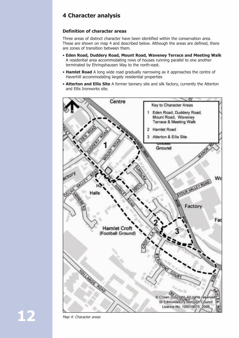
Definition of character areas
Three areas of distinct character have been identified within the conservation area.These are shown on map 4 and described below. Although the areas are defined, thereare zones of transition between them.
• Eden Road, Duddery Road, Mount Road, Waveney Terrace and Meeting WalkA residential area accommodating rows of houses running parallel to one anotherterminated by Ehringshausen Way to the north-east.
• Hamlet Road A long wide road gradually narrowing as it approaches the centre ofHaverhill accommodating largely residential properties
• Atterton and Ellis Site A former tannery site and silk factory, currently the Attertonand Ellis Ironworks site.
Map 4: Character areas 12
11

Eden Road, Duddery Road, Mount Road, WaveneyTerrace and Meeting Walk
Prevailing and former uses
This is a residential area off Hamlet Road just on the outskirts of the main shoppingcentre. Built in the 19th century and within walking distance of Chauntry Mill it is likelythat it housed some of the many employees of the factory at a time when productionwas increasing tenfold due to the introduction of the steam looms in 1856.
Buildings
This area provides the most densely developed residential zone within the Hamlet RoadConservation Area. Buildings are of a domestic scale, largely two storeys in height,constructed in groups on account of the land’s natural topography. All roads with theexception of Waveney Terrace are constructed parallel to each other and perpendicularto Hamlet Road. With the exception of Meeting Walk all have vehicular access withhouses lining either side of the road. Similarities between the different streets areevident relying on detailing to distinguish their individuality. Eden Road (photo 6) is anotably narrower and steeper road than Duddery Road (photo 7), Mount Road andWaveney Terrace with the possibility of parking limited to the south side only. Housesare constructed in groups of four. Roofs are slate and each property has a chimney.Houses front eaves on to a restricted pavement emphasising the narrowness of thestreet. Terraces in Duddery Road are two storeys in height, built in blocks of two andalso sit eaves on to the narrow pavement. The carriageway is slightly wider and as aresult allows for parking either side.
13
Photo 6: Eden Road,houses sit directly ontothe narrow pavementand display littledecoration
Photo 7: Duddery Road,houses have contrastingbrick banding
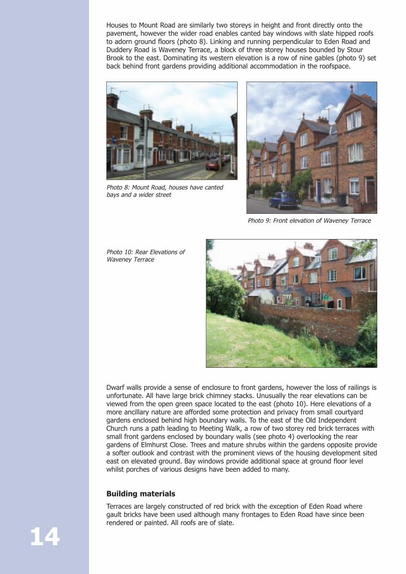
Houses to Mount Road are similarly two storeys in height and front directly onto thepavement, however the wider road enables canted bay windows with slate hipped roofsto adorn ground floors (photo 8). Linking and running perpendicular to Eden Road andDuddery Road is Waveney Terrace, a block of three storey houses bounded by StourBrook to the east. Dominating its western elevation is a row of nine gables (photo 9) setback behind front gardens providing additional accommodation in the roofspace.
Dwarf walls provide a sense of enclosure to front gardens, however the loss of railings isunfortunate. All have large brick chimney stacks. Unusually the rear elevations can beviewed from the open green space located to the east (photo 10). Here elevations of amore ancillary nature are afforded some protection and privacy from small courtyardgardens enclosed behind high boundary walls. To the east of the Old IndependentChurch runs a path leading to Meeting Walk, a row of two storey red brick terraces withsmall front gardens enclosed by boundary walls (see photo 4) overlooking the reargardens of Elmhurst Close. Trees and mature shrubs within the gardens opposite providea softer outlook and contrast with the prominent views of the housing development sitedeast on elevated ground. Bay windows provide additional space at ground floor levelwhilst porches of various designs have been added to many.
Building materials
Terraces are largely constructed of red brick with the exception of Eden Road wheregault bricks have been used although many frontages to Eden Road have since beenrendered or painted. All roofs are of slate.
14
Photo 8: Mount Road, houses have cantedbays and a wider street
Photo 9: Front elevation of Waveney Terrace
Photo 10: Rear Elevations ofWaveney Terrace
Details
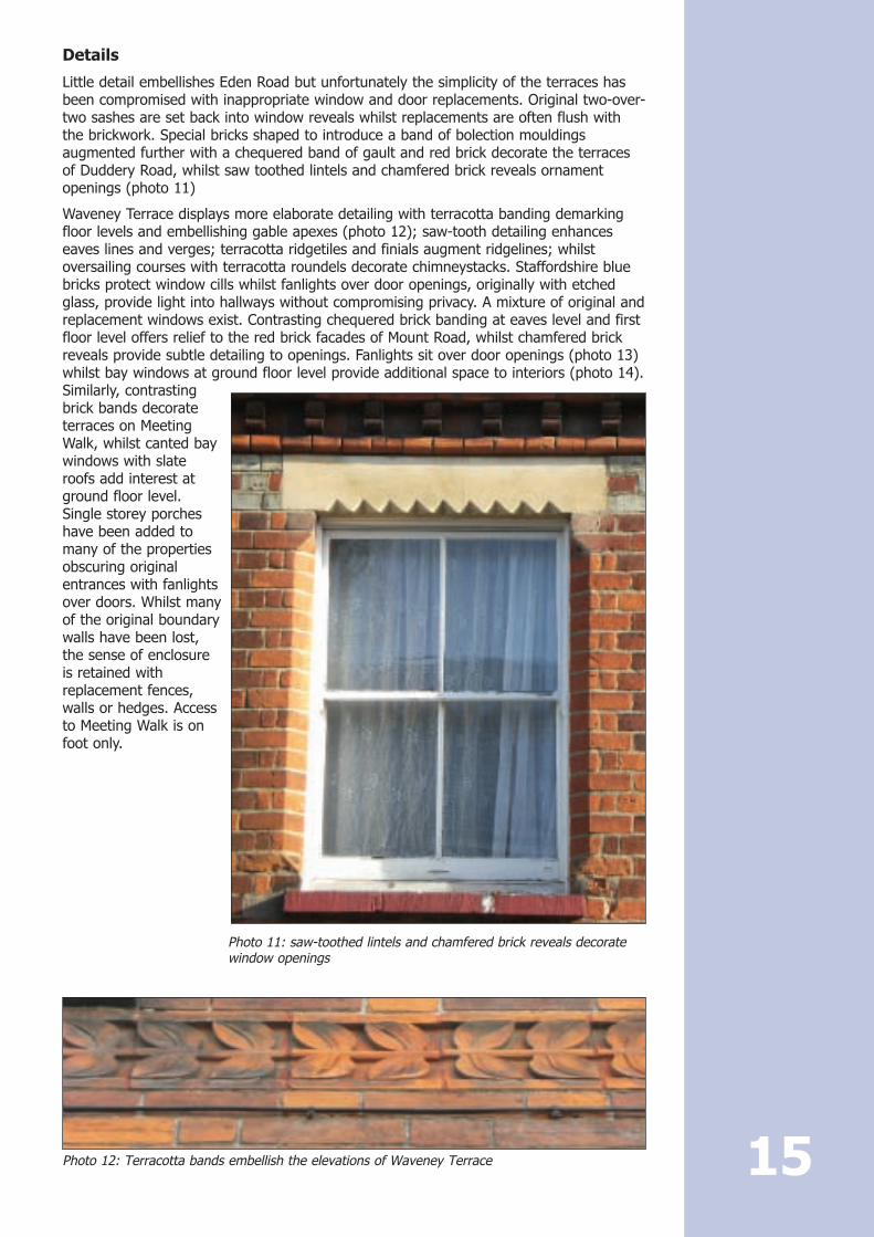
Little detail embellishes Eden Road but unfortunately the simplicity of the terraces hasbeen compromised with inappropriate window and door replacements. Original two-over-two sashes are set back into window reveals whilst replacements are often flush withthe brickwork. Special bricks shaped to introduce a band of bolection mouldingsaugmented further with a chequered band of gault and red brick decorate the terracesof Duddery Road, whilst saw toothed lintels and chamfered brick reveals ornamentopenings (photo 11)
Waveney Terrace displays more elaborate detailing with terracotta banding demarkingfloor levels and embellishing gable apexes (photo 12); saw-tooth detailing enhanceseaves lines and verges; terracotta ridgetiles and finials augment ridgelines; whilstoversailing courses with terracotta roundels decorate chimneystacks. Staffordshire bluebricks protect window cills whilst fanlights over door openings, originally with etchedglass, provide light into hallways without compromising privacy. A mixture of original andreplacement windows exist. Contrasting chequered brick banding at eaves level and firstfloor level offers relief to the red brick facades of Mount Road, whilst chamfered brickreveals provide subtle detailing to openings. Fanlights sit over door openings (photo 13)whilst bay windows at ground floor level provide additional space to interiors (photo 14).Similarly, contrastingbrick bands decorateterraces on MeetingWalk, whilst canted baywindows with slateroofs add interest atground floor level.Single storey porcheshave been added tomany of the propertiesobscuring originalentrances with fanlightsover doors. Whilst manyof the original boundarywalls have been lost,the sense of enclosureis retained withreplacement fences,walls or hedges. Accessto Meeting Walk is onfoot only.
15
Photo 11: saw-toothed lintels and chamfered brick reveals decoratewindow openings
Photo 12: Terracotta bands embellish the elevations of Waveney Terrace

Over time many of the original sash windows and panelled doors have been lost toinappropriate modern replacements. Consequently, the underlying rhythm fundamentalto the appearance of these terraces has been weakened, compromising the regularity soimportant to the collective character of these buildings.
Green spaces
The front gardens of Waveney Terrace and Meeting Walk together with the open spaceto the rear of Waveney Terrace (see photo 10) and that adjacent to the church providea welcome break to the otherwise densely populated built environment.
Hamlet Road
Prevailing and former uses
Hamlet Road is largely a residential area providing access into the centre of Haverhillfrom the south. Houses are a mixture of 19th century and later with the exception ofAnne of Cleves and Weavers, which are two of the few surviving buildings in Haverhill ofearlier date.
Buildings
Terminating the southern end of the Hamlet Road Conservation Area is the three roundarches of the red brick viaduct constructed in 1863 for the railway (photo 15). Its massivescale provides an impressive gateway into and out of Haverhill. Development alongSturmer Road is restricted at this point to the south side where Vale Place, a late Georgianbrick building set back from the road enclosed by a high boundary wall to the east andrailings to the north, can be found. An elaborate entrance suggests a building of
16
Photo 13: Fanlights over door openings provideadditional light
Photo 14: Original bay windows provide additional spaceand are an important characteristic to the terraces ofMount Road

importance. Further west are a group offive semi-detached, two storey, 19thcentury, red brick houses set back from thepavement and slightly elevated behindsmall front gardens bounded by dwarfretaining walls. Entrances tend to berecessed back from the main building lineunder a catslide roof occasionally extendedto incorporate a canopy. Where this doesnot occur the addition of a flat roofedporch is not uncommon. Elsewhere doorsare located within the flank wall. Steps upto the doors account for their elevatedposition. Roofs are protected by slate andaccommodate large chimney stacks.
Immediately opposite the Atterton and Ellissite (described later) sits the AustralianArms (photo 16), a three storey red brickbuilding with cellars. Eight-over-eightsashes set within chamfered brick openingslight each floor. Brick hood mouldsembellish ground floor window openings,whilst a pair of identical flat roofed, leadcanopies protect recessed, panelled dooropenings accessed via two sets of steps.Projecting brick bands add furtherdecoration to this otherwise simplefrontage. Cornering Beaumont Court andHamlet Road on elevated ground is a pairof early 20th century detached houses.Both properties are one and a half storeysin height with steeply pitched roofs oneclad in plaintiles and the other in pantiles.Half hips address flank elevations whilstoversized hipped dormers dominate theprinciple elevation. Their appearance iscompromised where the original crittlewindows have been replaced with inappropriate upvc substitutes. Opposite sits HamletHouse, an early 18th century two storey timber framed house with basement, frontingeaves on to the road. The plain tiled roof together with a flat topped dormer is partiallyobscured behind a plain parapet over dentilled timber eaves cornice. Attached is the 19thcentury silk factory (photo 17). Standing three storeys in height and 11 bays long, with ashallow pitched hipped roof fronting directly onto the pavement, its presence is ratheroppressive but is an important reminder of Haverhill’s successful industrial background.
17
Photo 15: The Sturmer Arches provide animpressive gateway into Haverhill
Photo 16: The Australian Arms
Photo 17: Hamlet House and 19th century silk mill

Houses continue to be elevated on the south side of Hamlet Road, set back behind smallfront gardens enclosed by low brick walls and hedging. In contrast, developmentopposite sits on level ground and largely fronts directly onto the pavement. Buildings aretypically detached or semi-detached accommodating reasonable plots to the rear witheaves lines fronting onto the pavement. Anne of Cleves House (photo 18) is an early16th century exposed close studded timber framed building with a jettied first floor andsteeply pitched, uninterrupted, tiled hipped roof. An impressive external brick stack withoctagonal shafts and star tops adorns the southern side whilst triple stacks, diagonallyset, sit on the ridge to the northern end. A high red brick garden wall runsapproximately 20m along Hamlet Road, south east of Anne of Cleves House, detailing asaw-toothed eaves cornice below a deep brick coping. In contrast and opposite,Heazeworth House is a two storey gault brick building with six-over-six sashes with Ytracery. Openings to the cellar are evident but have since been blocked.
Detached houses continue to line either sideof Hamlet Road either fronting directly ontothe pavement or set behind boundary walls.The domestic scale of properties isinterrupted only by the Old IndependentChurch (photo 19). A five light centralwindow with geometric tracery flanked bypolygonal turrets rising to pinnacles with ablind six bay arcade below adorns the westfront. Single pointed traceried windows oftwo lights over two bay blind arcades siteither side of the turrets together withgabled porches with trefoiled entrancedoorways. To the south west corner is a fourstage tower lit through lancets at each stage,which supports an octagonal spire with fourpepper pot pinnacles at its base. Oppositesits Weavers, a 15th century timber framed,single storey house, weatherboarded to thestreet with an early 17th century two storeyrendered wing, gable end onto the street. 18
Photo 18: Anne of Cleves House
Photo 19: Old Independent Church

Building materials
Materials vary (photo 20), however typically a sense of hierarchy is achieved with theuse of gault brick for the more prestigious buildings and red brick for others or forboundary walls. The church is obviously the exception to this. Earlier buildings aretimber framed and are either rendered, weatherboarded or have exposed timberframing. Plain tiles or pantiled roofs typically protect the earlier steeper roofs whilstshallow pitched roofs are covered with slate.
Details
Detail to elevations is more subtle and individual with contrasting brick bands occurringless frequently and decorated or projecting banding of matching brick colour morecommon. Saw-toothed banding, unusually laid vertically, embellishes the eaves level ofManor House (photo 21).
Door openings vary considerably from the grand entrance of Vale Place, where steps upto a central portico porch of two reeded and fluted Doric columns rising to a flatentablature suggest an important building, to the inconspicuously located entrances inthe flank walls of semi detached buildings. Modest canopies supported by consolebrackets provide an element of protection to some entrances whilst others haverecessed openings, providing an external porch flush with the building line but decoratedwith stone arches with acanthus leafed capitals. Others simply sit flush with the buildingline typically stepping out directly onto the pavement on the eastern side of HamletRoad and protected by small front gardens on elevated ground to the western side.These properties quite often have projecting canted bay windows at ground floor level.Hamlet House has a central entrance elevated above the basement on six steps withcast-iron handrail. 19
Photo 20: Materials vary from weatherboardingand brickwork to exposed timber framing
Photo 21: Saw-tooth banding laid vertically

The door has six panels with a seven vane fanlight in a doorcase of narrow panelledpilasters with dentilled hood on elongated fluted consoles and panelled reveals. Generally,original doors are uncommon but where they exist have four panels with bolectionmouldings or a large upper glazed panel to later houses with bolection moulded panelsbelow. The earlier timber framed houses have solid plank doors (photo 22).
A variety of windows are found, ranging from original sashes varying in detail dependingon age, to crittle windows in 1930’s developments, the cruciform windows with top hungfanlights and leaded light casements to earlier timber framed properties (photo 23).Tripartite windows to Manor House are subdivided with brick mullions at first floor leveland chamfered stone mullions at ground floor level, whilst stained glass margin lightsflank either side of the main entrance protected by an extended stone hood mould overthe door with fanlight above.
20
Photo 22: An array of elaborate door openings adorn the more prestigious buildings
Photo 23: Windows range from sashes to casements
Green spaces
Public green spaces can be enjoyed towards the southern end of the conservation areaimmediately abutting the eastern boundaries of the Atterton and Ellis site together withthe open land opposite. The mature trees and shrubs provide a verdant contrast to theindustrial areas east of Ehringshausen Way when approaching through the SturmerArches. A small unrestrained green space immediately adjacent to the Old IndependentChurch provides further relief together with the modest front gardens afforded to theproperties on the western side of Hamlet road.
Atterton and Ellis SitePrevailing and former uses
Formerly a tannery yard established in 1770, the Atterton and Ellis site then enjoyedsuccess accommodating the textile industry with the construction of the silk factorywhich still stands today. The site was then taken over by John Atterton who set up thelong and now established use of the iron works site.
Buildings
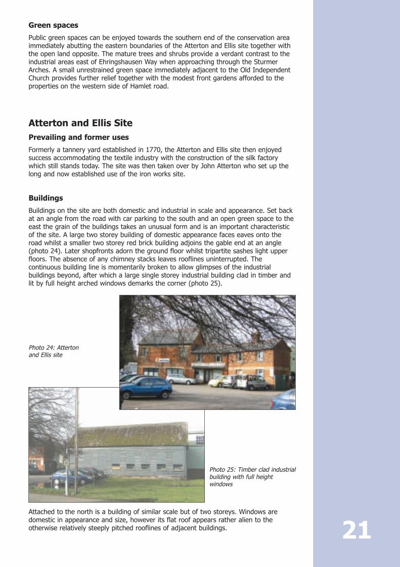
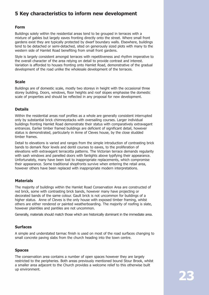
Buildings on the site are both domestic and industrial in scale and appearance. Set backat an angle from the road with car parking to the south and an open green space to theeast the grain of the buildings takes an unusual form and is an important characteristicof the site. A large two storey building of domestic appearance faces eaves onto theroad whilst a smaller two storey red brick building adjoins the gable end at an angle(photo 24). Later shopfronts adorn the ground floor whilst tripartite sashes light upperfloors. The absence of any chimney stacks leaves rooflines uninterrupted. Thecontinuous building line is momentarily broken to allow glimpses of the industrialbuildings beyond, after which a large single storey industrial building clad in timber andlit by full height arched windows demarks the corner (photo 25).
Attached to the north is a building of similar scale but of two storeys. Windows aredomestic in appearance and size, however its flat roof appears rather alien to theotherwise relatively steeply pitched rooflines of adjacent buildings. 21
Photo 24: Atterton and Ellis site
Photo 25: Timber clad industrialbuilding with full heightwindows

Building materials
Render, weatherboarding and red brick provide contrast to the different buildings on thesite, whilst slate and corrugated sheeting dominates rooflines.
Details
The original use of the buildings has dictated their appearance and as a result,embellishments are minimal limited to contrasting brick banding. Windows are largelydomestic in appearance ranging from tripartite sashes to small paned cast ironcasements with arched heads.
Green spaces A large open green space corners the Atterton and Ellis site to the east, whilst treessoften and camouflage the more industrial elevations.
Surfaces and street furniture
SurfacesBlacktop is common to all areas with the exception of footpaths outside the church andheading into the town centre. Here small module concrete slabs are used.
Street furniture
With narrow streets there is little or no room for street furniture, which is limited to abench on the open green to the eastern end of the conservation area.
Neutral and negative areasMuch of the Hamlet Road Conservation Area dates from the 19th century or later withthe exception of a few listed buildings. There are no negative areas as such, howeverresidential properties have suffered from the gradual erosion of traditional details mostcommonly the replacement of windows, doors and boundary walls.
Satellite dishes conspicuously located on front elevations detract from their repetitivenature, whilst overhead wiring to Meeting Walk is a further distraction.
General condition of the area and buildings at risk
The conservation area is generally in a reasonable condition although Hamlet House, aGrade II listed building, is on the Buildings at Risk Register. Houses would howeverbenefit from a general overhaul, replacing inappropriate windows and doors withtraditional styles, removing satellite dishes and reinstating traditional boundary wallswhere they have been lost.
Problems, pressures and capacity for change
Commercial issues
With few commercial areas within the Hamlet Road Conservation Area pressures are limited.
Residential issues
There is a high demand for satellite dishes and plastic windows in the residential areaswithin the conservation area. There are restrictions affecting both of these and planningpermission and/or listed building consent may be required in many instances. The BoroughCouncil takes enforcement action where windows and satellite dishes are unauthorised.
22
5 Key characteristics to inform new development
Form
Buildings solely within the residential areas tend to be grouped in terraces with amixture of gables but largely eaves fronting directly onto the street. Where small frontgardens exist they are typically protected by dwarf boundary walls. Elsewhere, buildingstend to be detached or semi-detached, sited on generously sized plots with many to thewestern side of Hamlet Road benefiting from small front gardens.
Style is largely consistent amongst terraces with repetitiveness and rhythm imperative tothe overall character of the area relying on detail to provide contrast and interest.Variation is afforded to houses fronting onto Hamlet Road, demonstrative of the gradualdevelopment of the road unlike the wholesale development of the terraces.
Scale
Buildings are of domestic scale, mostly two storeys in height with the occasional threestorey building. Doors, windows, floor heights and roof slopes emphasise the domesticscale of properties and should be reflected in any proposal for new development.
Details
Within the residential areas roof profiles as a whole are generally consistent interruptedonly by substantial brick chimneystacks with oversailing courses. Larger individualbuildings fronting Hamlet Road demonstrate their status with comparatively extravagantentrances. Earlier timber framed buildings are deficient of significant detail, howeverstatus is demonstrated, particularly in Anne of Cleves house, by the close studdedtimber frames.
Detail to elevations is varied and ranges from the simple introduction of contrasting brickbands to demark floor levels and dentil courses to eaves, to the proliferation ofelevations with extravagant terracotta patterns. The Victorian terrace demands regularitywith sash windows and panelled doors with fanlights above typifying their appearance.Unfortunately, many have been lost to inappropriate replacements, which compromisetheir appearance. Some traditional shopfronts survive when entering the retail area,however others have been replaced with inappropriate modern interpretations.
Materials
The majority of buildings within the Hamlet Road Conservation Area are constructed ofred brick, some with contrasting brick bands, however many have projecting ordecorated bands of the same colour. Gault brick is not uncommon for buildings of ahigher status. Anne of Cleves is the only house with exposed timber framing, whilstothers are either rendered or painted weatherboarding. The majority of roofing is slate,however plaintiles and pantiles are not uncommon.
Generally, materials should match those which are historically dominant in the immediate area.
Surfaces
A simple and understated tarmac finish is used on most of the road surfaces changing tosmall concrete paving slabs from the church heading into the town centre.
Spaces
The conservation area contains a number of open spaces however they are largelyrestricted to the peripheries. Both areas previously mentioned bound Stour Brook, whilsta smaller area adjacent to the Church provides a welcome relief to this otherwise builtup environment.
23

6 Management proposals for the Hamlet RoadConservation Area of Haverhill for 2008
Policy HC6 “new development in conservation areas” of the adopted replacement StEdmundsbury Borough Local Plan 2016 states:
Proposals for new development within a Conservation Area must have regard to thespecial architectural or historic character or appearance of their setting in thefollowing respects:
i) the scale, height, massing, alignment, style and materials of existing buildings
ii) the form, function and manner of construction of the existing buildings;
iii) the relationship between building and spaces;
and
iv) plot divisions and boundary treatments.
This section sets out a medium to long-term strategy to preserve and enhance thecharacter and appearance of the conservation area and in particular to deal with thenegative areas, problems and pressures identified in the appraisal
It has been produced in accordance with the advice contained in the English Heritageguidance ‘Guidance on the management of conservation areas’, published February 2006.
The following issues have been identified whilst writing the conservation area appraisal.
Article 4 Directions should be reviewed within the conservation area to monitor theireffectiveness and deal promptly with any enforcement action which might be required. Evenminor alterations, which may individually seem to be of no importance, can cumulatively bevery detrimental to the character and appearance of the conservation area.
The list of ‘Buildings of Local Architectural or Historic Significance’ should beupdated to identify those buildings which, although not listed, are important to thehistory and appearance of the town and should be retained.
Commercial pressures for corporate signs – the Borough Council is producing a designguide for shopfronts to which businesses and owners will be referred. The Town CentreManager is often the first point of contact a business owner has with the BoroughCouncil. In order to prevent unacceptable signs being installed without consent, theBorough Council will work with the Town Centre Manager to raise awareness of therequirements affecting commercial users within the conservation area, advise businessowners of them and encourage them to discuss their proposals with the planningdepartment at an early stage.
A scheme for undergrounding of overhead cables should be investigated to improvethe appearance of the conservation area particularly in Meeting Walk.
24
7 Useful Information and Contacts
If you have any queries about the Hamlet Road Conservation Area, or need advice aboutdevelopment and alterations within the conservation area, please contact:
Planning HelpdeskPlanning and Engineering ServicesSt Edmundsbury Borough CouncilWestern WayBury St EdmundsIP33 3YS
Tel: 01284 757675E-mail: [email protected]
Or
the conservation team at the above address
Tel: 01284 757356 or 757339E-mail: [email protected]
25

Bibliography
Blackwood, G Tudor and Stuart Suffolk Carnegie Publishing 2001
Brazier, R Images of England, Haverhill Tempus Publishing Ltd 2000
D.o.E & D.o.E.H. Planning Policy Guidance: Planning and the Historic Environment(PPG 15) HMSO 1994
Domesday Book - Suffolk Pillimore 1986
Dymond, D & Martin, E (eds) An Historical Atlas of Suffolk Suffolk County Council 1988
English Heritage Guidance on conservation area appraisals 2006
English Heritage Guidance on the management of conservation areas 2006
Jennings, C (ed) Suffolk for Ever The Alastair Press 1989
Pevsner, N The Buildings of England: Suffolk Penguin 1976
Suffolk County Council Sites and Monuments Record 1997
26


