32
Hampshire Avon Operational Catchment 1 Catchment Information Pack (CIP) Hampshire Avon Operational Catchment Author: Wessex Area Environment Programme Delivery Team 16 September 2013
| Date post: | 06-Apr-2016 |
| Category: |
Documents |
| Upload: | hampshire-avon-catchment-partnership |
| View: | 213 times |
| Download: | 0 times |

Hampshire Avon Operational Catchment 1
Catchment Information Pack (CIP)
Hampshire Avon Operational
Catchment
Author: Wessex Area Environment Programme Delivery Team
16 September 2013
Hampshire Avon Operational Catchment 2
We are the Environment Agency. We protect and improve the environment and make it a
better place for people and wildlife.
We operate at the place where environmental change has its greatest impact on people’s
lives. We reduce the risks to people and properties from flooding; make sure there is
enough water for people and wildlife; protect and improve air, land and water quality and
apply the environmental standards within which industry can operate.
Acting to reduce climate change and helping people and wildlife adapt to its
consequences are at the heart of all that we do.
We cannot do this alone. We work closely with a wide range of partners including
government, business, local authorities, other agencies, civil society groups and the
communities we serve.
Hampshire Avon Operational Catchment 3
Foreword
Waterbody Information Packs (WIPs) and associated Action Plans were introduced by the
Environment Planning Team to look at priority waterbodies that were scheduled for delivery by 2015
in the first River Basin Management Plan. They have provided a basis for identifying measures to
deliver Good Ecological Status in our target waterbodies.
In light of our experience with this way of working and in accordance with guidance from DEFRA and
the Environment Agency, it has been decided that we should look at improvements for Water
Framework Directive in the next cycle on a catchment wide scale with particular reference to
working in partnership with other organizations where this can help deliver the required outcomes.
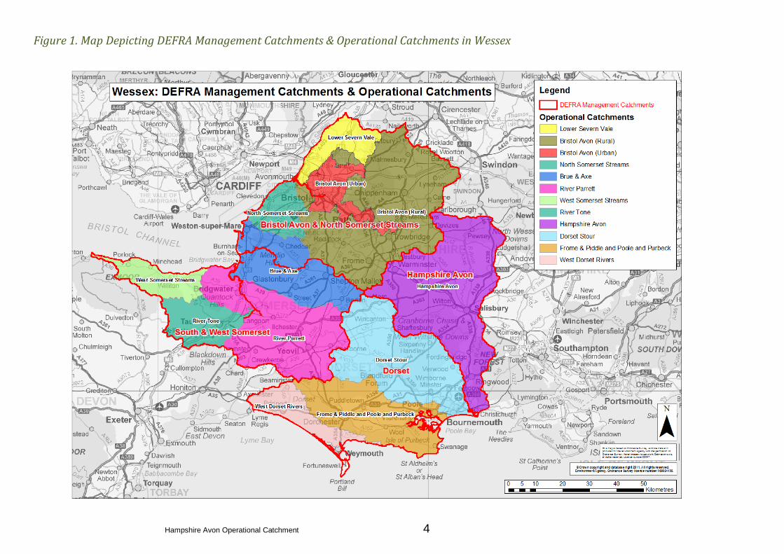
The Wessex Area has been subdivided into 12 Operational Catchments. The table below shows each
Operational catchment along with the number of waterbodies and Artificial or Heavily Modified
Water Bodies (A/HMWB) they contain. A map depicting the Wessex Operational Catchments is
shown in Figure 1.
Wessex Operational Catchments
Operational Catchment Number of Waterbodies (Rivers)
Bristol Avon – Urban 12 (10 A/HMWB)
Bristol Avon – Rural 93 (7 A/HMWB)
Brue & Axe 23 (12 A/HMWB)
Dorset Stour 46 (5 A/HMWB)
Frome & Piddle and Poole and Purbeck 34 (8 A/HMWB)
Hampshire Avon 39 (5 A/HMWB)
Lower Severn Vale 12 (4 A/HMWB)
North Somerset Streams 13 (11 A/HMWB)
River Parrett 60 (20 A/HMWB)
River Tone 15 (3 A/HMWB)
West Dorset 22 (2 A/HMWB)
West Somerset Streams 23 (2 A/HMWB)
Hampshire Avon Operational Catchment 4
Figure 1. Map Depicting DEFRA Management Catchments & Operational Catchments in Wessex
Hampshire Avon Operational Catchment 5
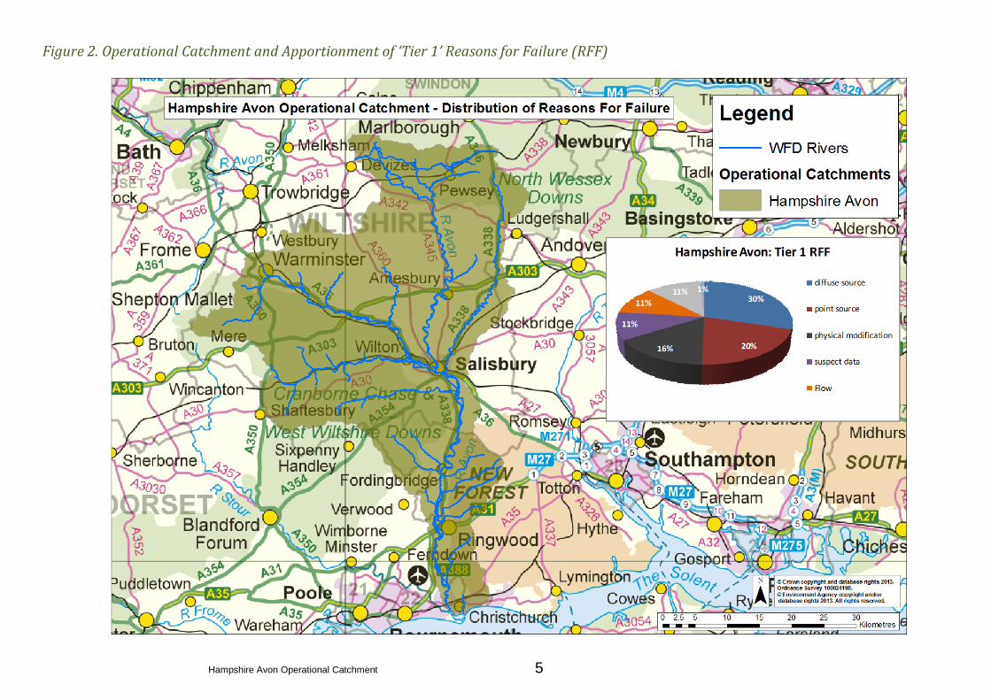
Figure 2. Operational Catchment and Apportionment of ‘Tier 1’ Reasons for Failure (RFF)

Hampshire Avon Operational Catchment 6
1. Summary of Catchment Data
Table 1.1 Summary of Catchment Data
Rivers
Transitional and
Coastal Waters
(TraC)
Groundwater Lakes
Total Number of Waterbodies
39 1 3 11
Good Status at Baseline (2009)
10 1 2 4
% of Total 26 100 67 36.4
Moderate Status at Baseline (2009)
23 N/A N/A 6
% of Total 59 N/A N/A 54.5
Poor Status at Baseline (2009)
6 N/A 1 1
% of Total 15 N/A 33 9.1
Bad Status at Baseline (2009)
N/A N/A N/A N/A
% of Total N/A N/A N/A N/A
Table 1.1 shows that only 26% of the river waterbodies within the catchment achieved the required Good
Ecological Status in the baseline year (2009).
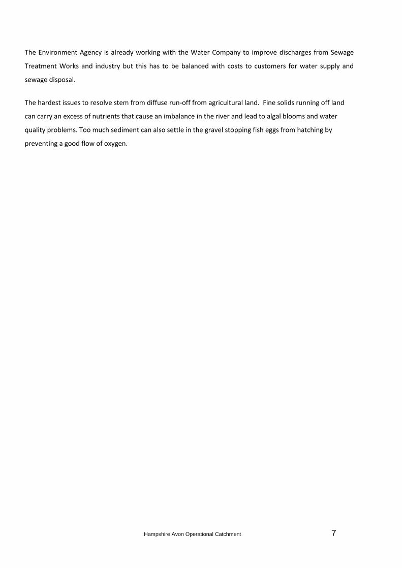
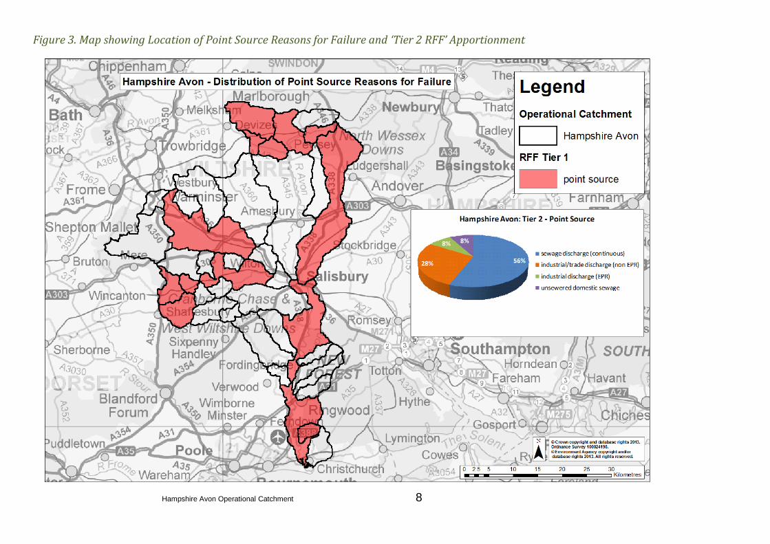
The significant reasons for failure (known as ‘Tier 1’ RFF) in Hampshire Avon Catchment are diffuse pollution
from agricultural sources, point source pollution from Water Industry, and physical modification, the
apportionment of each is shown graphically in Figure 2 and the location of each in Figures 3, 4 and 5. The
more specific reasons for failure (known as ‘Tier 2’ RFF) within Point Source, Diffuse Source and Physical
Modification categories are shown in Figures 3, 4 and 5. The proportions within pie charts shown in figures
2,3,4, and 5 represent the percentage of recorded reasons for failure. It is important to note that there can
be multiple reasons for failure per waterbody.
Hampshire Avon Operational Catchment 7
The Environment Agency is already working with the Water Company to improve discharges from Sewage
Treatment Works and industry but this has to be balanced with costs to customers for water supply and
sewage disposal.
The hardest issues to resolve stem from diffuse run-off from agricultural land. Fine solids running off land
can carry an excess of nutrients that cause an imbalance in the river and lead to algal blooms and water
quality problems. Too much sediment can also settle in the gravel stopping fish eggs from hatching by
preventing a good flow of oxygen.
Hampshire Avon Operational Catchment 8
Figure 3. Map showing Location of Point Source Reasons for Failure and ‘Tier 2 RFF’ Apportionment

Hampshire Avon Operational Catchment 9
Figure 4. Map showing Location of Diffuse Source Reasons for Failure and ‘Tier 2 RFF’ Apportionment
Hampshire Avon Operational Catchment 10
Figure 5. Map showing Location of Physical Modification Reasons for Failure and ‘Tier 2 RFF’ Apportionment
Hampshire Avon Operational Catchment 11
2. Catchment Overview
2.1 Executive Summary of Current Actions
Scope delivery of schemes to modify physical barriers and allow fish passage
Work with partners and the agricultural community to resolve diffuse pollution problems
Work with Water Company through periodic review to resolve sewage issues
Work with industry to ensure permits are fit for purpose and discharges are compliant
2.2 Brief Description of Catchment
The Hampshire Avon rises in the Vale of Pewsey to the north of Salisbury and then flows south towards Christchurch
Harbour and Christchurch Bay on the south coast. The water bodies within this Operational Catchment contain
significant baseflow from groundwater within the chalk aquifers underlying Salisbury Plain. At Salisbury, the Avon is
joined by two of its major tributaries - the Rivers Bourne and Nadder (including the River Wylye), and a short distance
downstream by the River Ebble. The overall catchment area is about 1,750 square kilometres, and has a population of
around 230,000. Only two per cent of the catchment is urbanised. As well as Salisbury and Christchurch, the urban
areas include Warminster. The Hampshire Avon catchment is characterised by open chalk downland with steep scarp
slopes, sheltered valleys, chalk hills, ridges and limestone plateaux. Variations in the topography have a strong
influence on the rivers’ response to rainfall. The upper Avon catchment is typified by undulating chalk downlands on
Salisbury Plain, which are cut by steep combes and river valleys. The lower catchment is characterised by rolling
farmland and the New Forest. The main watercourses have wide floodplains and flow through farmland, woodland,
scrub and open heathland. There are a number of reservoirs in the Ibsley area, created by backfilling previous gravel
extraction pits. They are used for potable water supply and recreation.
2.3 Setting
The River Avon is one of the most important river systems in the UK, supporting internationally and nationally
important habitats and species. Within the Hampshire Avon catchment there are a number of sites designated for
their environmental importance including part of the New Forest National Park and the World Heritage Site of
Stonehenge. Important environmental sites in the catchment include two Areas of Outstanding Natural Beauty, two
Environmentally Sensitive Areas, nine Special Areas of Conservation (SAC), six National Nature Reserves, 71 Sites of
Special Scientific Interest (SSSIs) and 1,061 Scheduled Monuments. The river itself is designated as the River Avon
System Site of Special Scientific Interest. The SSSI covers the River Avon, its major tributaries and parts of the
floodplain. The River Till, a tributary of the River Wylye is also designated as a separate SSSI. The river system is richer
and more varied than most rivers in the UK with over 180 species of river plant, one of the most diverse fish
Hampshire Avon Operational Catchment 12
populations in Britain and a wide range of river invertebrates. Habitats associated with the river include swamp, wet
woodland and wet grassland habitats. These floodplain habitats would once have dominated the Upper Avon.
The River Avon System SSSI and River Till SSSI are also designated internationally through the Habitats Directive as a
Special Area of Conservation (SAC). The SAC supports internationally rare and threatened species. The lower reaches
of the River Avon and it’s floodplain, one of the largest expanses of unimproved floodplain grazing marsh in Britain, is
designated as the Avon Valley (Bickton to Christchurch) SSSI, Ramsar site and Special Protection Area (SPA). It supports
a complex mosaic of wetland habitats including fens, mires, wet grassland, wet woodland and unimproved floodplain
grassland. Important species include populations of breeding and over-wintering wetland birds and rare wetland
plants and insects. The River Avon and its tributaries have been shaped and influenced by a long history of human use.
It’s many and diverse uses continue to influence management of the Avon and are integral to the landscape, heritage,
social and economic value of the river.
The water in the catchment is used by many and supports a variety of different uses. It provides drinking water, is
used in sewage treatment, recreationally for walking, fishing and other pastimes, as well as being used by local
business and industry.

Hampshire Avon Operational Catchment 13
2.4 Statutory Designations
Table 2. Statutory Designations within the Catchment
Statutory Designations Location/Description
Special area of Conservation (SAC) River Avon System, River Till
Special Protection Area (SPA) Avon Valley
Sites of Specific Interest (SSSI) River Avon System, Avon Valley, River Till
Ramsar Avon Valley
Area of Outstanding Beauty (AONB) and an
Environmentally Sensitive Area Cranbourne Chase & West Wiltshire Downs AONB
EC Bathing Waters Directive Friars Cliff, Highcliffe, Mudeford Sandbank, Avon Beach
EU Freshwater Fish Directive 68 Salmonid waters (385km)
Urban Waste Water Treatment Directive Salisbury, Ringwood, Fordingbridge STW
Other Protected Sites Location/Description
National Character Area Salisbury Plain & West Wiltshire Downs
Source Protection Zones and Groundwater Vulnerability
Zones Across catchment
Nitrate Vulnerability Zones
With the exception of the Nadder and Sem, the whole
catchment is covered by Nitrate Vulnerability Zones
(NVZs).

Hampshire Avon Operational Catchment 14
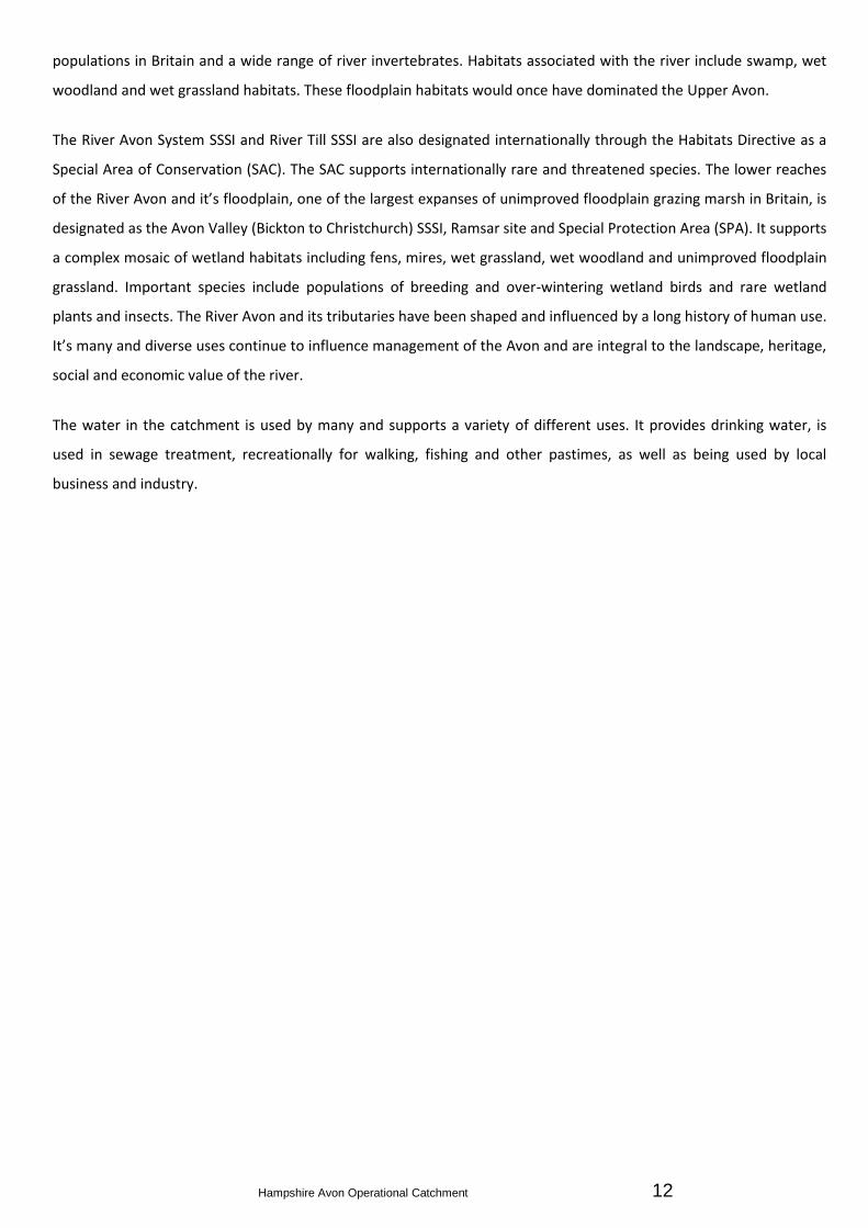
2.5 Regulated Sites
There are 1321 consented discharges in the Operational Catchment. These are for private discharges, water
companies, trade and agriculture. The largest discharges are for fish farms, watercress farms and Sewage Treatment
Works (there are 42 of these in the catchment).
There are 708 abstractions in the catchment. These include several for public water supply and large abstractions for
fish farms and watercress beds.
There are a number of public water supply reservoirs within the catchment, mainly at Ibsley and Blashford Lakes.
There are 33 sites issued with Pollution Prevention Control (PPC) permits under the Integrated Pollution Prevention
and Control (IPPC) Directive.
Since 1997 the water company has reduced their total load of phosphate to the river by 80%. This was delivered
though the phosphate stripping schemes in the Asset Management Plans AMP3 and AMP4. These schemes were
required to meet the needs of the Urban Waste Water Treatment Directive, Habitats Directive and the CROW Act
(SSSIs). Further reductions are proposed for AMP6 (2014). Wessex Water’s investment in treatment processes for
Phosphorus removal at these 17 STWs discharging into the Hampshire Avon amounts to £30 million. The additional
annual operating cost for Phosphorus removal at these sites amounts to over £2million/year.
Figure 6. below shows consented discharges in the Hampshire Avon catchment. These have been separated for water
companies, private and trade/agriculture. The paragraphs below explain the types of flow used to describe the volume
of consented discharges. An explanation of dry weather flow and maximum flow discharge consents is explained
below:
Dry Weather Flow (DWF) The quantity of sewage arriving at most Sewage Treatment Works (STW) increases
considerably in response to rainfall even though the amount of actual sewage has not changed. In the permit we set a
maximum limit on the amount of treated sewage discharged in ‘dry weather’, and we call this the ‘Dry Weather Flow’
(DWF). The DWF will include domestic sewage, discharges to sewer from traders, and infiltration. Infiltration is water
that gets into the sewers through cracks and breaks in the pipes. The DWF is normally measured in cubic metres per
day (m3/d).
Maximum Daily Flow (MDF) For most private discharges of sewage (e.g. caravan sites), rainfall does not influence the
flow of sewage. In these circumstances, we do set maximum limits on the amount of sewage that can be discharged
each day. This is referred to as the ‘Maximum Daily Flow’ which is also measured in m3/d.
Hampshire Avon Operational Catchment 15
Figure 6. Map showing Consented Discharges for Water Companies, Trade/Agriculture & Private
Hampshire Avon Operational Catchment 16
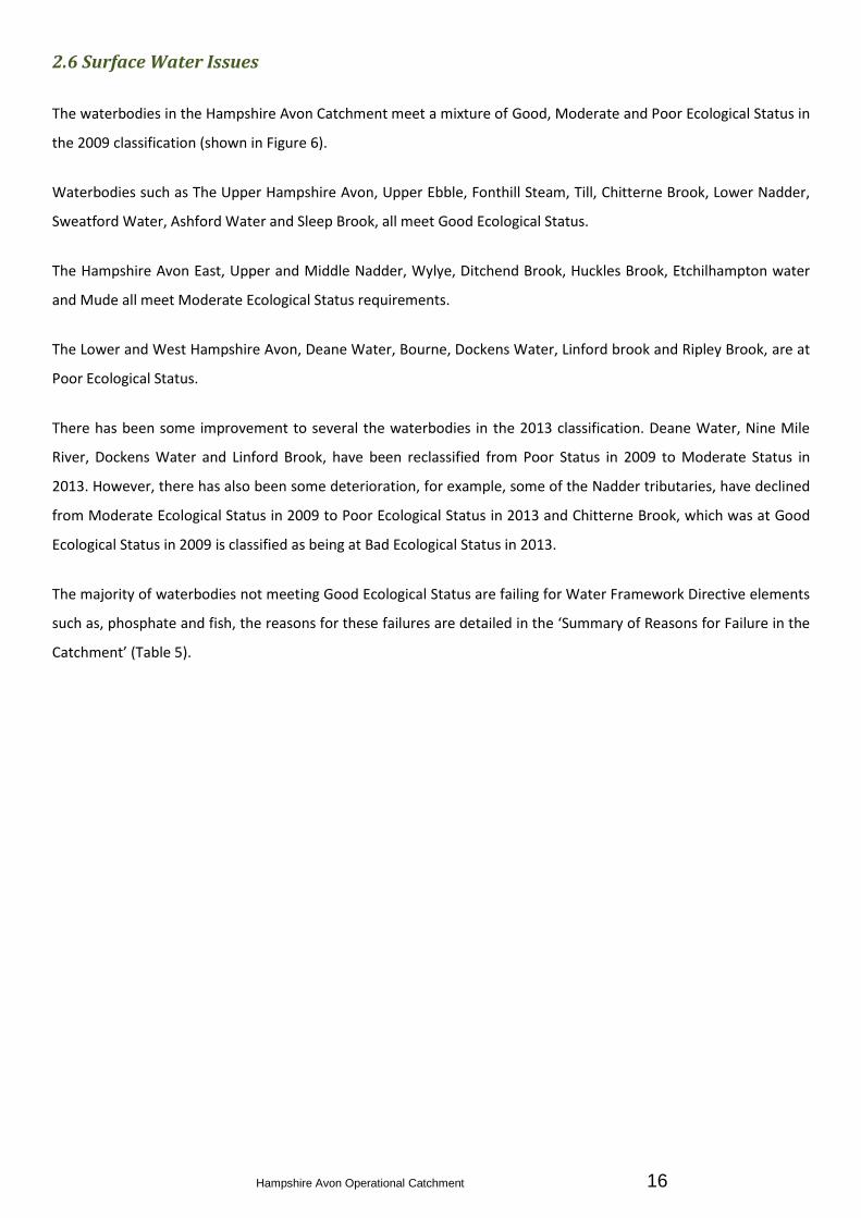
2.6 Surface Water Issues
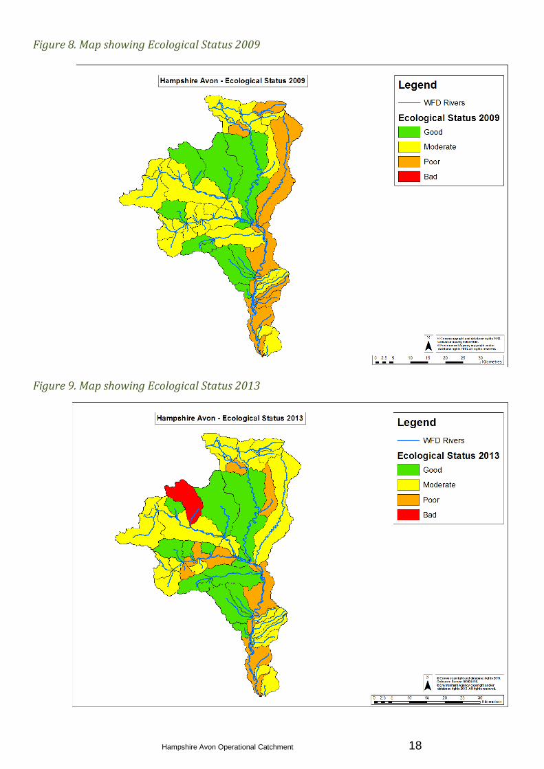
The waterbodies in the Hampshire Avon Catchment meet a mixture of Good, Moderate and Poor Ecological Status in
the 2009 classification (shown in Figure 6).
Waterbodies such as The Upper Hampshire Avon, Upper Ebble, Fonthill Steam, Till, Chitterne Brook, Lower Nadder,
Sweatford Water, Ashford Water and Sleep Brook, all meet Good Ecological Status.
The Hampshire Avon East, Upper and Middle Nadder, Wylye, Ditchend Brook, Huckles Brook, Etchilhampton water
and Mude all meet Moderate Ecological Status requirements.
The Lower and West Hampshire Avon, Deane Water, Bourne, Dockens Water, Linford brook and Ripley Brook, are at
Poor Ecological Status.
There has been some improvement to several the waterbodies in the 2013 classification. Deane Water, Nine Mile
River, Dockens Water and Linford Brook, have been reclassified from Poor Status in 2009 to Moderate Status in
2013. However, there has also been some deterioration, for example, some of the Nadder tributaries, have declined
from Moderate Ecological Status in 2009 to Poor Ecological Status in 2013 and Chitterne Brook, which was at Good
Ecological Status in 2009 is classified as being at Bad Ecological Status in 2013.
The majority of waterbodies not meeting Good Ecological Status are failing for Water Framework Directive elements
such as, phosphate and fish, the reasons for these failures are detailed in the ‘Summary of Reasons for Failure in the
Catchment’ (Table 5).
Hampshire Avon Operational Catchment 17
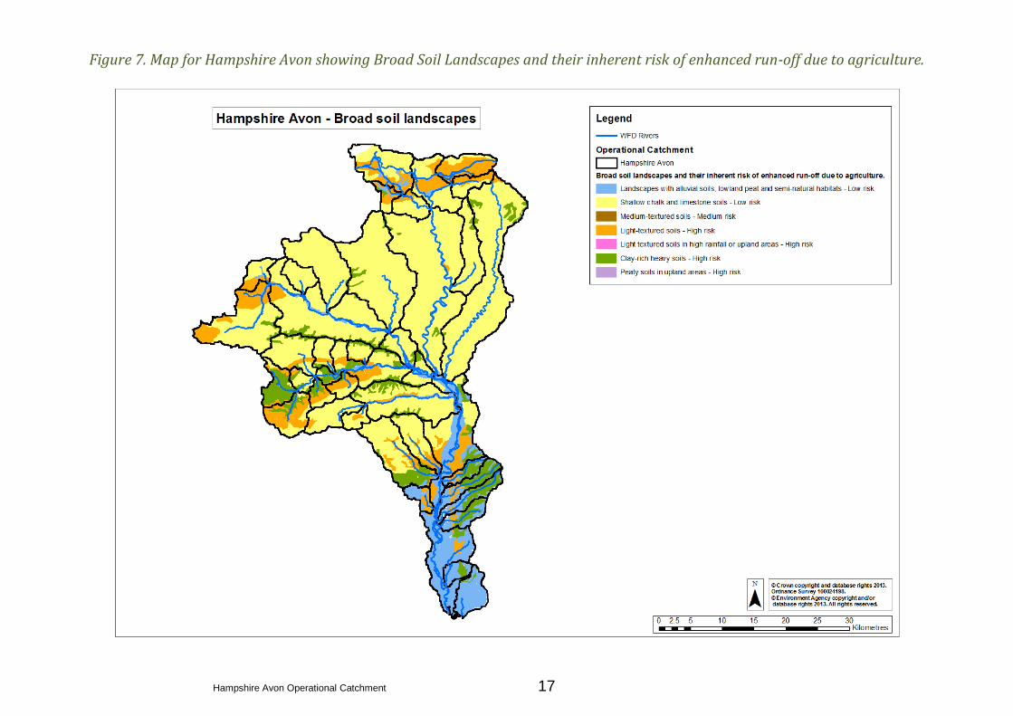
Figure 7. Map for Hampshire Avon showing Broad Soil Landscapes and their inherent risk of enhanced run-off due to agriculture.
Hampshire Avon Operational Catchment 18
Figure 8. Map showing Ecological Status 2009
Figure 9. Map showing Ecological Status 2013
Hampshire Avon Operational Catchment 19
2.7 Groundwater Issues
There are three groundwater bodies that underlie the Hampshire Avon Catchment Operational Catchment, the
majority of the Northern half of the catchment is underlain by the ‘Upper Hampshire Avon’ groundwater body, this
groundwater has been classified as being at Poor Quantitative Status and Poor Qualitative Status (overall Poor
Status) in 2009 and 2012, with Rising Chemical Trends for Nitrates (Drinking Water Protected Area) and Phosphate
(Impact on surface waters). The Groundwater Body is also at risk of failure with a rising trend for Nitrates and Zinc.
Beneath the southern half of the Hampshire Avon Catchment, is the ‘Lower Dorset Stour and Lower Hampshire
Avon’ groundwater body this has been classified as being at Good Quantitative Status and Poor Qualitative Status,
(overall Poor Status) in both 2009 and 2012. The ‘Reading Beds’ groundwater body, also to the South of the
catchment, is classified as being at Good Quantitative and Good Qualitative Status (overall Good Status) in both 2009
and 2012.
2.8 Flood and Coastal Risk Management – Partnerships and strategic overview
The catchment has a history of flood risk, generally due to the high rainfall that can lead to extensive flooding of the
river valleys, and prolonged wet periods that can lead to groundwater flooding.
Over the last 25 years, engineering schemes have been implemented to reduce flood risk in the catchment, including
at Tisbury, Downton, Fordingbridge, Ringwood and Christchurch. Various structures have also been constructed
around Salisbury and Wilton. These measures have all reduced flood risk.
In addition to these engineering schemes, other flood risk management activities are carried out in the catchment.
These include activities which help to reduce the probability of flooding, for example, maintaining and improving
existing flood defences, river channels and road drainage and sewers) and those that address the consequences of
flooding such as mapping, forecasting and planning.
2.9 Bathing Water Issues
There are four designated bathing beaches in the Hampshire Avon Operational Catchment. The Avon discharges at
Christchurch Harbour and the outflow under certain tidal conditions reaches the bathing waters at Friars Cliff,
Highcliffe, Mudeford and Avon Beach. None are currently failing, although they are at risk of pollution from
Christchurch Harbour. Pollution in the harbour can be attributed to the River Stour as well as the Avon.
Hampshire Avon Operational Catchment 20
2.10 Specific Risks of Deterioration
Much of the Hampshire Avon catchment is designated as SSSI and Natura 2000 sites. This limits the types of work we
can do to improve the environment, due to restrictions on the protected areas. Careful planning needs to be
undertaken; to ensure the requirements to get SSSIs to favourable condition are met, alongside measures to get all
waterbodies to Good Ecological Status. Work on the protected areas will take priority, it is important the remaining
water bodies do not deteriorate as a result of this.
Urban development and population increase, particularly in the Upper Avon and tributaries; will increase pressure on
water companies regarding nutrient content in sewage effluent. Although water companies have done a lot of work to
remove 80% of the phosphate from sewage treatment works; point source pollution is still a risk in this catchment.
If rising chemical trends for nitrate and zinc are not addressed, deterioration of the groundwater bodies is a risk.
There are 207 weirs and sluices on the River Avon and it is also embanked in some locations. The channel has been
widened and deepened in many places, for land drainage. Many of the structures cause barriers to migration for
Salmonids, Cyprinids and eels. If these barriers are not addressed there is a risk that current fish populations will
deteriorate. The channel form and lack of habitat diversity and floodplain connection need to be improved by
implementation of the River Avon Restoration Plan.
Rising temperatures due to global warming and a lack of shade on the waterbodies within this catchment; put the
Hampshire Avon at risk of dissolved oxygen failures, as well as reduction in the numbers of Salmonids able to spawn.
There is a tree shading project in progress in the catchment.
Hampshire Avon Operational Catchment 21
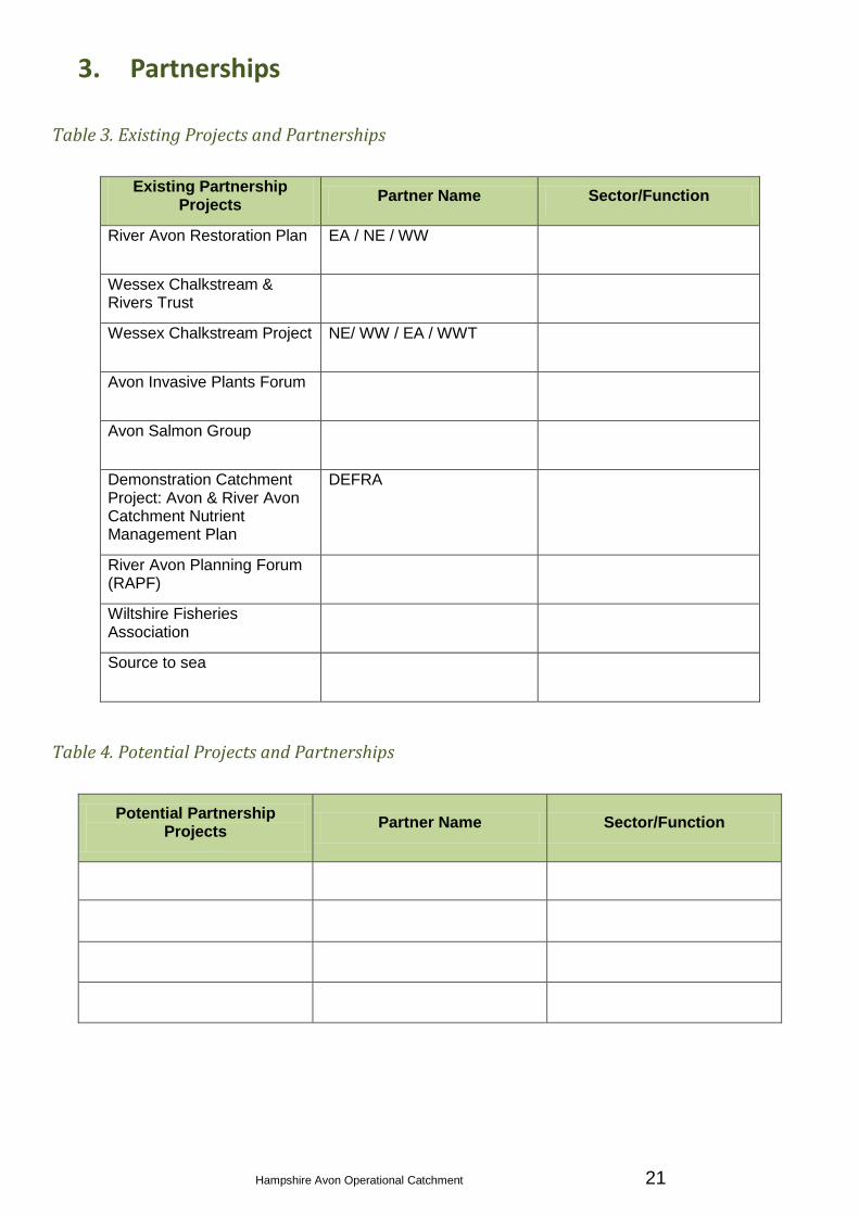
3. Partnerships
Table 3. Existing Projects and Partnerships
Existing Partnership Projects
Partner Name Sector/Function
River Avon Restoration Plan EA / NE / WW
Wessex Chalkstream & Rivers Trust
Wessex Chalkstream Project NE/ WW / EA / WWT
Avon Invasive Plants Forum
Avon Salmon Group
Demonstration Catchment Project: Avon & River Avon Catchment Nutrient Management Plan
DEFRA
River Avon Planning Forum (RAPF)
Wiltshire Fisheries Association
Source to sea
Table 4. Potential Projects and Partnerships
Potential Partnership Projects
Partner Name Sector/Function

Hampshire Avon Operational Catchment 22
4. Summary of Reasons for Failure for the Catchment (Table 5)
Waterbody ID Waterbody
Name
HMWB/
Artificial/No *P1/P2/SI Objective
Eco Status
2009
Eco Status
2013 Failing Elements (2009) Reasons for failure
GB108043011020 Mude No 1 GES by 2015 Moderate Moderate Moderate - Fish (Uncertain) Physical Modification - land drainage structures
Suspect Data
GB108043016160 Nadder
(Headwaters) No 0 GES by 2027 Moderate Moderate Moderate - Phosphate
Point source-industrial/trade discharge (non
EPR)
Diffuse source-sewage discharge (diffuse),
mixed agricultural run-off, farm infrastructure
GB108043016180 Nadder Trib
(Swallowcliffe) No 1 GES by 2015 Moderate Poor Moderate - Phosphate (Uncertain)
Diffuse source- mixed agricultural run-off
Suspect data
GB108043016190 Fovant Brook No 1 GES by 2015 Moderate Moderate
Moderate - Phosphate (Very
Certain)
Moderate - Hydrology (HR2a)
Diffuse source- mixed agricultural run-off
Suspect data
GB108043016200 Nadder (Upper) Yes 1 GEP by 2015 Moderate Moderate
Poor - Fish (Very Certain)
Moderate - Dissolved Oxygen
(Uncertain)
Moderate - Phosphate (Very
Certain)
Point source-sewage discharge (continuous)
Diffuse source-mixed agricultural run-off,farm
infrastructure
physical modification-wider environment -
other
GB108043011010 Ripley Brook No 1 GES by 2015 Moderate Moderate
Moderate - Macrophytes (Quite
Certain)
Moderate - Fish (Quite Certain)
Moderate - pH (Very Certain)
Moderate - Copper (Very Certain)
Point source-industrial/trade discharge (non
EPR)
Natural mineralisation
Suspect data
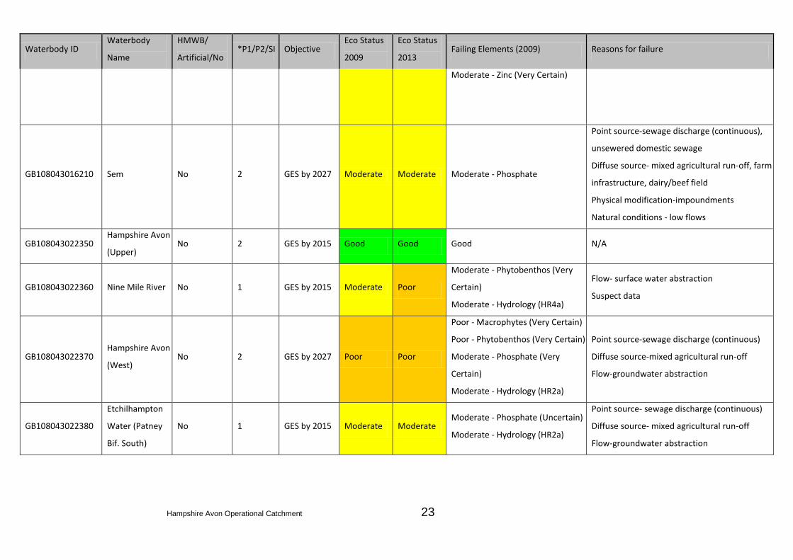
Hampshire Avon Operational Catchment 23
Waterbody ID Waterbody
Name
HMWB/
Artificial/No *P1/P2/SI Objective
Eco Status
2009
Eco Status
2013 Failing Elements (2009) Reasons for failure
Moderate - Zinc (Very Certain)
GB108043016210 Sem No 2 GES by 2027 Moderate Moderate Moderate - Phosphate
Point source-sewage discharge (continuous),
unsewered domestic sewage
Diffuse source- mixed agricultural run-off, farm
infrastructure, dairy/beef field
Physical modification-impoundments
Natural conditions - low flows
GB108043022350 Hampshire Avon
(Upper) No 2 GES by 2015 Good Good Good N/A
GB108043022360 Nine Mile River No 1 GES by 2015 Moderate Poor
Moderate - Phytobenthos (Very
Certain)
Moderate - Hydrology (HR4a)
Flow- surface water abstraction
Suspect data
GB108043022370 Hampshire Avon
(West) No 2 GES by 2027 Poor Poor
Poor - Macrophytes (Very Certain)
Poor - Phytobenthos (Very Certain)
Moderate - Phosphate (Very
Certain)
Moderate - Hydrology (HR2a)
Point source-sewage discharge (continuous)
Diffuse source-mixed agricultural run-off
Flow-groundwater abstraction
GB108043022380
Etchilhampton
Water (Patney
Bif. South)
No 1 GES by 2015 Moderate Moderate Moderate - Phosphate (Uncertain)
Moderate - Hydrology (HR2a)
Point source- sewage discharge (continuous)
Diffuse source- mixed agricultural run-off
Flow-groundwater abstraction

Hampshire Avon Operational Catchment 24
Waterbody ID Waterbody
Name
HMWB/
Artificial/No *P1/P2/SI Objective
Eco Status
2009
Eco Status
2013 Failing Elements (2009) Reasons for failure
GB108043022390 Bourne No 2 GES by 2021 Poor Moderate
Poor - Fish (Very Certain)
Moderate - Invertebrates
(Uncertain)
Moderate - Phosphate (Quite
Certain)
Moderate - Hydrology (HR2a)
Point source-sewage discharge (continuous)
Diffuse source-mixed agricultural run-off
Flow-groundwater abstraction
Physical modification-barriers to fish migration,
urbanisation-other
GB108043022400 Hampshire Avon
(East) No 0 GES by 2027 Moderate Moderate Moderate - Phosphate (Uncertain)
Point source- sewage discharge (continuous)
Diffuse source- mixed agricultural run-off
Natural mineralisation
GB108043022410
Hampshire Avon
(East) &
Woodborough
Stream
No 0 GES by 2027 Moderate Moderate Moderate - Phosphate (Very
Certain)
Point source-sewage discharge (continuous)
Diffuse source-mixed agricultural run-off
GB108043022420 Deane Water No 2 GES by 2027 Poor Moderate
Poor - Invertebrates (Quite Certain)
Moderate - Phosphate (Quite
Certain)
Diffuse source- mixed agricultural run-off
Invasive non-native species- North American
Signal crayfish
GB108043022430 Etchilhampton
Water No 0 GES by 2027 Moderate Moderate
Moderate - Phosphate (Very
Certain)
Moderate - Hydrology (HR2a)
Point source-sewage discharge (continuous)
Diffuse source-mixed agricultural run-off
Flow-groundwater abstraction
GB108043015720 Linford Brook No 2 GES by 2027 Poor Moderate
Poor - Fish (Very Certain)
Moderate - Copper (Very Certain)
Moderate - Zinc (Very Certain)
Physical modification- barriers to fish migration
Natural mineralisation
Natural conditions-low flows
GB108043015730 Sleep Brook No 0 GES by 2015 Good Good Good N/A

Hampshire Avon Operational Catchment 25
Waterbody ID Waterbody
Name
HMWB/
Artificial/No *P1/P2/SI Objective
Eco Status
2009
Eco Status
2013 Failing Elements (2009) Reasons for failure
GB108043015740 Dockens Water No 1 GES by 2015 Poor Moderate
Poor - Fish (Very Certain)
Moderate - Copper (Very Certain)
Moderate - Zinc (Very Certain)
Natural mineralisation
Suspect data
GB108043015750 Huckles Brook No 1 GES by 2015 Moderate Moderate Moderate - Copper (Very Certain)
Moderate - Zinc (Quite Certain) Natural Mineralisation
GB108043015770 Ditchend Brook No 1 GES by 2015 Moderate Moderate
Moderate - Macrophytes
(Uncertain)
Moderate - Fish (Uncertain)
Moderate - Copper (Very Certain)
Moderate - Zinc (Very Certain)
Natural Mineralisation
Suspect data
GB108043015800 Ashford Water
(Allen River) Yes 2 GEP by 2015 Good Good Good N/A
GB108043015810 Sweatsford
Water No 0 GES by 2015 Good Good Good N/A
GB108043015830 Ebble No 1 GES by 2015 Moderate Good Moderate - Fish (Uncertain) Physical Modification- barriers to fish
Suspect data
GB108043022460 Nadder Trib
(Baverstock) No 0 GES by 2027 Moderate Good Moderate - Phosphate (Uncertain) N/A
GB108043022470 Nadder (Middle) No 1 GES by 2015 Moderate Poor Moderate - Phosphate (Uncertain) Point source-sewage discharge (continuous)
diffuse source- mixed agricultural run-off
GB108043022500 Fonthill Stream No 0 GES by 2015 Good Good Good N/A
GB108043022510 Wylye (Lower) Yes 2 GEP by 2027 Moderate Moderate Moderate - Fish (Uncertain)
Diffuse source-arable field, drainage-road run-
off
Flow-groundwater abstraction

Hampshire Avon Operational Catchment 26
Waterbody ID Waterbody
Name
HMWB/
Artificial/No *P1/P2/SI Objective
Eco Status
2009
Eco Status
2013 Failing Elements (2009) Reasons for failure
Physical modification-flood protection
structures, urbanisation (urban development
infrastructure)
GB108043022480
Nadder Trib
(Chilmark
Stream)
No 1 GES by 2015 Moderate Good Moderate - Phosphate (Uncertain) Suspect data
GB108043022570 Till No 2 GES by 2015 Good Good Good (Uncertain) N/A
GB108043015840 Hampshire Avon
(Lower) Yes 2 GEP by 2027 Poor Poor
Moderate - Fish (Uncertain)
Moderate - Macrophytes (Quite
Certain)
Poor - Phytobenthos (Very Certain)
Moderate - Mitigation Measures
Assessment
Moderate - Hydrology (HR2a)
Point source-sewage discharge (continuous),
industrial discharge (EPR), industrial/trade
discharge (non EPR)
Diffuse source- mixed agricultural run-off,
mixed drainage
Physical modification- barriers to fish
migration, land drainage structures, flood
protection structures, urban development
infrastructure
Flow-groundwater abstraction
GB108043015860
Ebble Trib
(Chalke Valley
Stream)
No 0 GES by 2015 Good Good Good N/A
GB108043015870 Ebble (Upper) No 0 GES by 2015 Good Good Good N/A
GB108043022520 Wylye
(Headwaters) No 1 GES by 2015 Moderate Moderate Moderate - Fish (Quite Certain) Suspect data

Hampshire Avon Operational Catchment 27
Waterbody ID Waterbody
Name
HMWB/
Artificial/No *P1/P2/SI Objective
Eco Status
2009
Eco Status
2013 Failing Elements (2009) Reasons for failure
GB108043022530
Wylye Trib
(Heytesbury
Stream)
No 1 GES by 2015 Moderate Good Moderate - Phosphate (Uncertain)
Moderate - Hydrology (HR4a)
Flow-groundwater abstraction
Suspect data
GB108043022540 Wylye Trib (The
Were or Swab) Yes 0 GEP by 2027 Moderate Moderate
Moderate - Phosphate (Uncertain)
Moderate -Mitigation Measures
Assessment
Diffuse source-mixed agricultural run-off,
drainage-road run-off
Physical modification-flood protection-
structures, urbanisation- urban development
infrastructure
GB108043022550 Wylye (Middle) No 2 GES by 2027 Moderate Moderate
Moderate - Fish (Uncertain)
Moderate - Phosphate (Very
Certain)
Point source-sewage discharge (continuous),
unsewered domestic sewage
Diffuse source- mixed agricultural run-off,
drainage-road run-off
Physical modification- flood protection
(sediment management)
Flow-groundwater abstraction
Suspect data
GB108043022560 Chitterne Brook No 2 GES by 2015 Good Bad Good (Uncertain - WoE) N/A
GB108043015880 Nadder (Lower) No 2 GES by 2015 Good Good Good N/A
*Priority 1 (P1): GES by 2015
*Priority 2 (P2): Improve one failing element by 2015
*Status Investigation (SI): Further evidence required to confirm the failure of a particular element
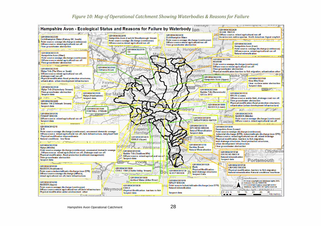
The current status of waterbodies within the catchment, along with the reasons for failure are shown in figure 9.
Hampshire Avon Operational Catchment 28
Figure 10: Map of Operational Catchment Showing Waterbodies & Reasons for Failure
Hampshire Avon Operational Catchment 29
5. Summary of Existing Measures /Interventions for Catchment (Table 6)
Issue Measure/Intervention Waterbody ID Waterbody Name Who
Unsuitable fish sampling
point
Review fish status from classification data at new survey location.
Fordingbridge Bypass FDS - Midgeham Drain. GB108043015800 Ashford Water (Allen River) EA
Impacts on fish Assess risk of fish deterioration due to ongoing maintenance of
road bridge GB108043015770 Ditchend Brook EA
WFD failures in
Groundwater underlying
the catchment
We are investigating the cause of any groundwater body chemical
failures and a "groundwater body action plan" will be in place by 22
December 2012. This will identify further pollution prevention
activities necessary to try and achieve Good Status by 2027
GB108043015770
GB40801G806900
GB108043011020
Ditchend Brook
Upper Hampshire Avon
Groundwater
H Avon East catchment
Ebble catchment
Mude
Nadder catchment
Nine Mile catchment
H Avon West catchment
Wylye catchment
EA

Hampshire Avon Operational Catchment 30
Issue Measure/Intervention Waterbody ID Waterbody Name Who
WFD upward trends in the
concentration of any
pollutant in groundwater
underlying the catchment
The Water Framework Directive (WFD) requires that we implement
measures to reverse any significant and sustained upward trends in
the concentration of any pollutant resulting from human activity. In
order to meet this objective we are undertaking investigations.
GB108043015770
GB40801G806900
GB40801G806900
Ditchend Brook
Upper Hampshire Avon
Groundwater body
Ebble catchment
Upper Hampshire Avon
Groundwater body
Nadder catchment
Wylye catchment
EA
Impacts of groundwater
abstractions on ecology
Hydrological investigations have been undertaken for surface water
bodies across all catchments. Where these investigations have
identified an ecological impact from over abstraction or
quantitative status failure as a result of groundwater abstractions,
H Avon East catchment
Ebble catchment
Nine Mile catchment
H Avon West catchment
Wylye catchment
EA

Hampshire Avon Operational Catchment 31
Issue Measure/Intervention Waterbody ID Waterbody Name Who
WFD upward trends in the
concentration of any
pollutant in groundwater
underlying the catchment
The Water Framework Directive (WFD) requires that we implement
measures to reverse any significant and sustained upward trends in
the concentration of any pollutant resulting from human activity. In
order to meet this objective we are undertaking investigations.
H Avon East catchment
Nine Mile catchment
H Avon West catchment
EA
Barriers to fish Investigate impact of gauging weirs and low flows to fish passage. GB108043015720 Linford Brook EA
Impacts on fish Review fish class with respect to the impact of the quarry
discharge. Resurvey after discharge stops (Sept 2013) GB108043011010 Ripley Brook EA
Potential sources of
Phosphate
Ensure that the Groundwater modelling work looking at natural
geological sources of Phosphate in the Upper Hampshire Avon
catchment is joined with proposed plans to monitor phosphates in
the catchment.
GB108043022390
GB108043022350
Bourne
H Avon East catchment
Hampshire Avon Upper
H Avon West catchment
Wylye catchment
EA
Coarse fish entrainment
When the Salmon and Freshwater Fisheries Act 1975 includes
coarse fish entrainment (as well as salmonids) , there is a need to:
review which sites pose a significant risk to coarse fish stocks and
assess what measures are appropriate provide protection.
GB108043015840 Hampshire Avon Lower EA
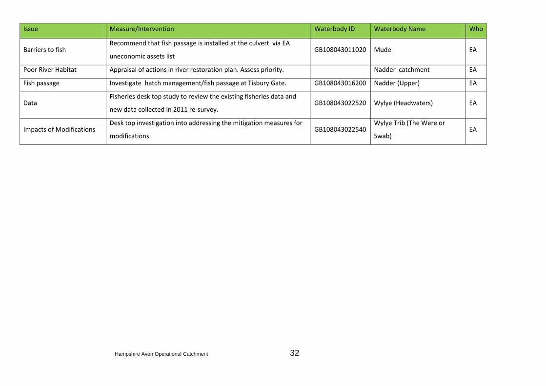
Hampshire Avon Operational Catchment 32
Issue Measure/Intervention Waterbody ID Waterbody Name Who
Barriers to fish Recommend that fish passage is installed at the culvert via EA
uneconomic assets list GB108043011020 Mude EA
Poor River Habitat Appraisal of actions in river restoration plan. Assess priority.
Nadder catchment EA
Fish passage Investigate hatch management/fish passage at Tisbury Gate. GB108043016200 Nadder (Upper) EA
Data Fisheries desk top study to review the existing fisheries data and
new data collected in 2011 re-survey. GB108043022520 Wylye (Headwaters) EA
Impacts of Modifications Desk top investigation into addressing the mitigation measures for
modifications. GB108043022540
Wylye Trib (The Were or
Swab) EA


