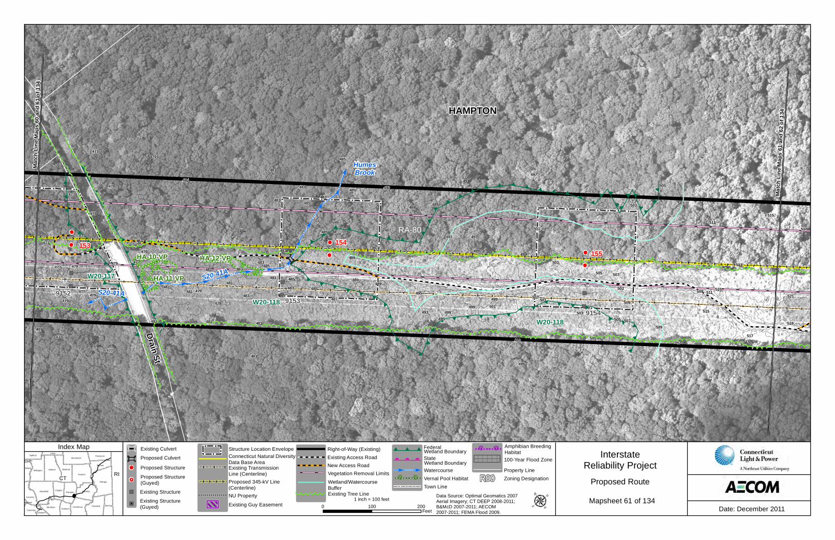
Drain St
Drain St
Drain St
153
HAMPTON
HumesBrook
RA-80
S20-41AS20-41A
91529153
9154 9155
154155 156
Match
Line
Map
s 60 a
nd 61
of 13
4
Match
Line
Map
s 61 a
nd 62
of 13
4
W20-118
W20-117
W20-118
499
497
503
477
487
499
499
497
481
479
479491
477
507
517
495
479
479
479
501
479
503485
477489
481
513
483
503
483
485
499
477
489481
505
479
477
495
485
505
481
487
515
485
505
483
519
477481
479
481
485
481
507
481
505
483
511481
501
489
499
495
477
487
477
489
515
483
483
483
509
481
509
481
483509
483
479
499
493
499
481
515517
503
511
477
479
507
481
521515
489
493
503
487
485
477
501
505485
511
479
HA-10-VP
HA-11-VP
HA-12-VP
CT RIKillingly
Pomfret
Ashford
Mansfield
EastfordWillington
Plainfield
Brooklyn
Woodstock
Hampton
Windham
Putnam
Sterling
Chaplin
Canterbury
Coventry
Thompson
Tolland
Stafford
ScotlandColumbia
Union
Lebanon
Ellington
Andover
InterstateReliability Project
Date: December 20110 100 200Feet
1 inch = 100 feet
Proposed Route
Index Map
Data Source: Optimal Geomatics 2007 Aerial Imagery; CT DEEP 2008-2011; B&McD 2007-2011; AECOM 2007-2011; FEMA Flood 2009.
Existing Transmission Line (Centerline)Proposed 345-kV Line(Centerline)
Connecticut Natural Diversity Data Base Area
NU Property
Structure Location EnvelopeExisting Access RoadNew Access Road
Right-of-Way (Existing)
Vernal Pool HabitatTown Line
Watercourse
Wetland Boundary
Vegetation Removal LimitsWetland BoundaryStateFederal
Wetland/WatercourseBuffer
Existing Guy EasementExisting Tree Line
Zoning DesignationR80Property Line100-Year Flood Zone
Amphibian BreedingHabitat
Mapsheet 61 of 134 Existing Structure
Proposed StructureProposed CulvertExisting Culvert
Existing Structure(Guyed)
Proposed Structure(Guyed)
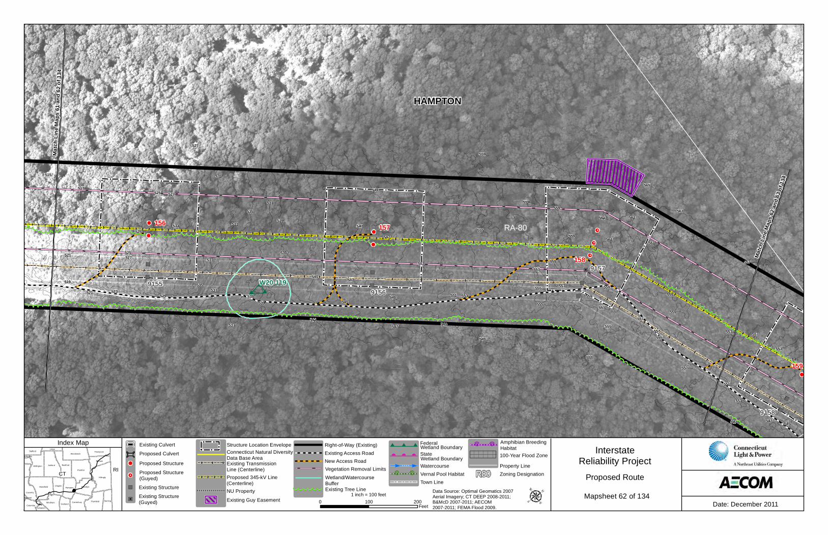
Drain St
Drain St
Drain St
153
HAMPTON
RA-80
91579155
9156
9158
155156 157
158
159
Match
Line
Map
s 62 a
nd 63
of 13
4
Match
Line
Map
s 61 a
nd 62
of 13
4
W20-119
553
559
557
559
547
523
557
557
517
551
529
559
559
539549
547
539
545
557
559
537
561
555
547
531
549
559
527
557
563
555
557
547
565
559
561
519
561
555
535
561
535
547
549
527
521
555
559
533
559
557
545
515
551
537
527
525
557
547
551
559
531
537
555
555
521
543
551
549
525
525
561
541
553
533
557
535539
549
CT RIKillingly
Pomfret
Ashford
Mansfield
EastfordWillington
Plainfield
Brooklyn
Woodstock
Hampton
Windham
Putnam
Sterling
Chaplin
Canterbury
Coventry
Thompson
Tolland
Stafford
ScotlandColumbia
Union
Lebanon
Ellington
Andover
InterstateReliability Project
Date: December 20110 100 200Feet
1 inch = 100 feet
Proposed Route
Index Map
Data Source: Optimal Geomatics 2007 Aerial Imagery; CT DEEP 2008-2011; B&McD 2007-2011; AECOM 2007-2011; FEMA Flood 2009.
Existing Transmission Line (Centerline)Proposed 345-kV Line(Centerline)
Connecticut Natural Diversity Data Base Area
NU Property
Structure Location EnvelopeExisting Access RoadNew Access Road
Right-of-Way (Existing)
Vernal Pool HabitatTown Line
Watercourse
Wetland Boundary
Vegetation Removal LimitsWetland BoundaryStateFederal
Wetland/WatercourseBuffer
Existing Guy EasementExisting Tree Line
Zoning DesignationR80Property Line100-Year Flood Zone
Amphibian BreedingHabitat
Mapsheet 62 of 134 Existing Structure
Proposed StructureProposed CulvertExisting Culvert
Existing Structure(Guyed)
Proposed Structure(Guyed)
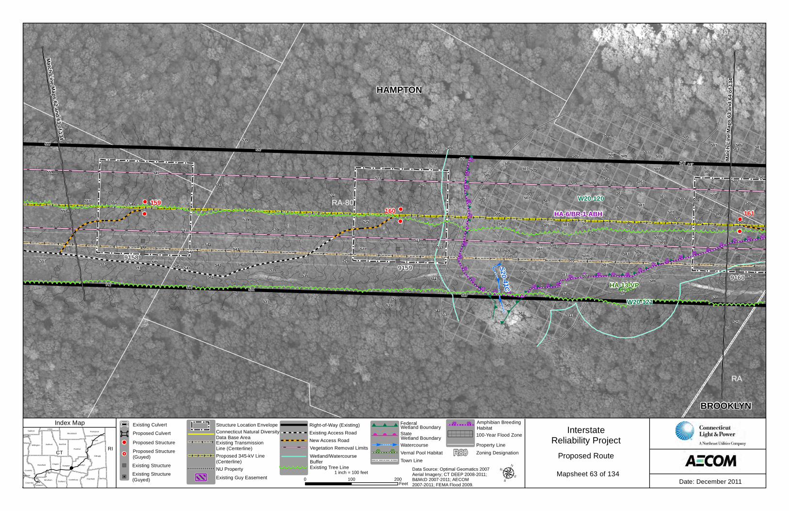
HAMPTON
BROOKLYN
RA
RA-80
S20-41C
9157
91599158
9160
159160 161
Match Line Maps 62 and 63 of 134Ma
tch Li
ne M
aps 6
3 and
64 of
134
W20-120
W20-121
507
553
507
505
509
507
547519
505
505
505
505
507
551
513
537
539
505
505
557
507
509
539507
505507
507
507509
505 505505
505
505
531
509
507
511
525
505
557
541
507
533
507
509
505
527
541
507
541
507
509
507
505
505
537
507529
505
545
507
507 507
517545
543
539
519
505
515
507
505
509
507
535547
505
505
505
541
507
507
507
507
505
557
505
543507
521
505
545
545
509
507
505
507
511
505 509
507
557
507
505
525
541
559 547
543
505 505
511
509
507
507
509
513
549
507539
539
505
517
505
509
523
511
543
507
541
505HA-13-VP
HA-6/BR-1-ABH
CT RIKillingly
Pomfret
Ashford
Mansfield
EastfordWillington
Plainfield
Brooklyn
Woodstock
Hampton
Windham
Putnam
Sterling
Chaplin
Canterbury
Coventry
Thompson
Tolland
Stafford
ScotlandColumbia
Union
Lebanon
Ellington
Andover
InterstateReliability Project
Date: December 20110 100 200Feet
1 inch = 100 feet
Proposed Route
Index Map
Data Source: Optimal Geomatics 2007 Aerial Imagery; CT DEEP 2008-2011; B&McD 2007-2011; AECOM 2007-2011; FEMA Flood 2009.
Existing Transmission Line (Centerline)Proposed 345-kV Line(Centerline)
Connecticut Natural Diversity Data Base Area
NU Property
Structure Location EnvelopeExisting Access RoadNew Access Road
Right-of-Way (Existing)
Vernal Pool HabitatTown Line
Watercourse
Wetland Boundary
Vegetation Removal LimitsWetland BoundaryStateFederal
Wetland/WatercourseBuffer
Existing Guy EasementExisting Tree Line
Zoning DesignationR80Property Line100-Year Flood Zone
Amphibian BreedingHabitat
Mapsheet 63 of 134 Existing Structure
Proposed StructureProposed CulvertExisting Culvert
Existing Structure(Guyed)
Proposed Structure(Guyed)
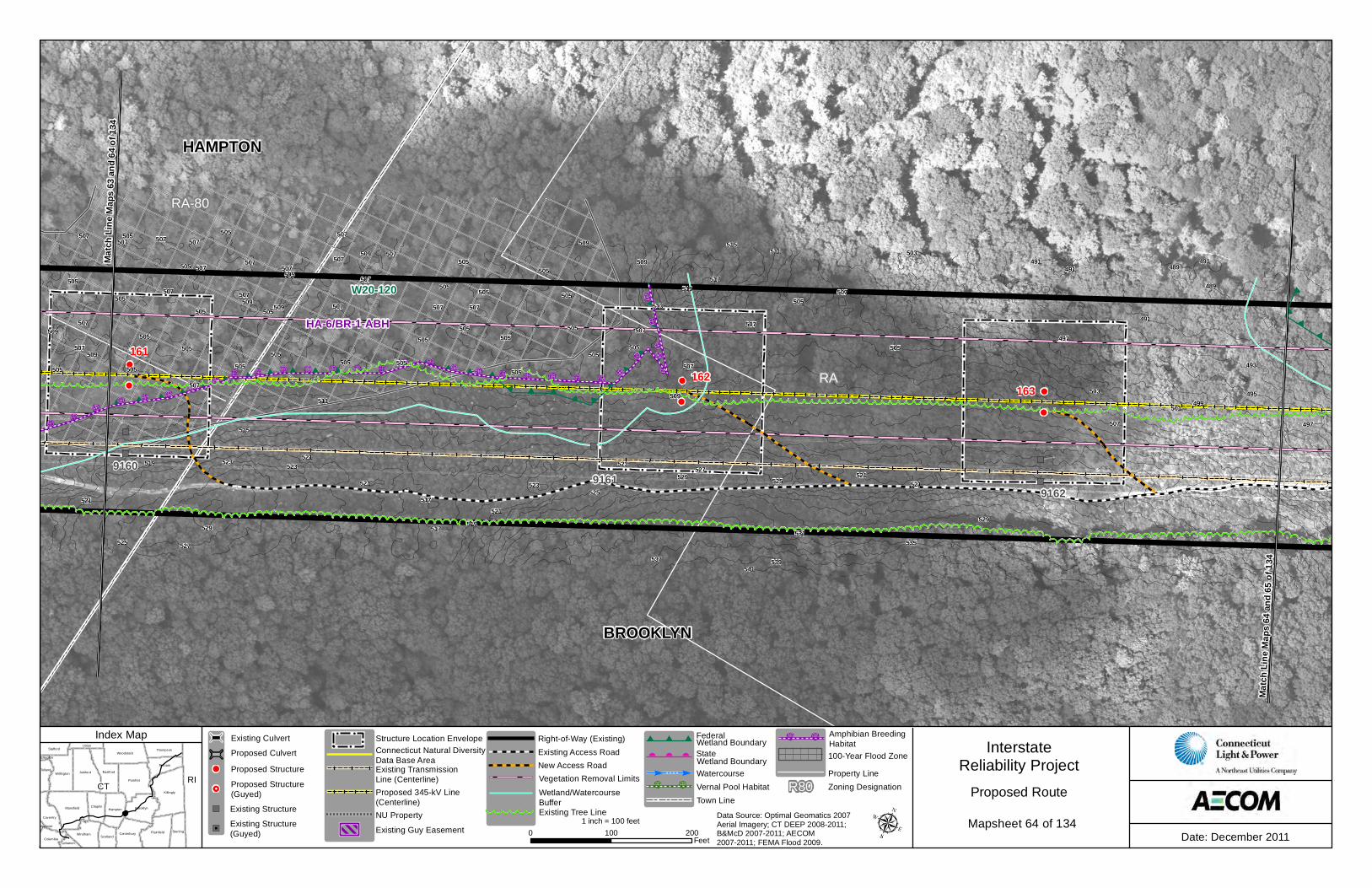
HAMPTON
BROOKLYN
RA
RA-80
91609161
9162
164
161162
163
Match
Line
Map
s 64 a
nd 65
of 13
4
Match
Line
Map
s 63 a
nd 64
of 13
4
W20-121
W20-120
499
527
507
491
505
503507
505
539
521
505
509
505
519
537
513
507
507
507
511
519
505
509
505507
525
505507 505
505
523
491
505
525
491
517
493
507
505
505
505 507
523
507
519
505
527
507
501
507
523
505505
507
521
507
507
507
521
509
505
507
505
505505
507
489
505
491
507
515
505 505
507
521
505 505
505
525
497
505
505
535
523
509
517507
507
489
495
541
509
521
507
517
529
515
509 505
503
531
505
529
509
509
529521
507
511
497HA-6/BR-1-ABH
CT RIKillingly
Pomfret
Ashford
Mansfield
EastfordWillington
Plainfield
Brooklyn
Woodstock
Hampton
Windham
Putnam
Sterling
Chaplin
Canterbury
Coventry
Thompson
Tolland
Stafford
ScotlandColumbia
Union
Lebanon
Ellington
Andover
InterstateReliability Project
Date: December 20110 100 200Feet
1 inch = 100 feet
Proposed Route
Index Map
Data Source: Optimal Geomatics 2007 Aerial Imagery; CT DEEP 2008-2011; B&McD 2007-2011; AECOM 2007-2011; FEMA Flood 2009.
Existing Transmission Line (Centerline)Proposed 345-kV Line(Centerline)
Connecticut Natural Diversity Data Base Area
NU Property
Structure Location EnvelopeExisting Access RoadNew Access Road
Right-of-Way (Existing)
Vernal Pool HabitatTown Line
Watercourse
Wetland Boundary
Vegetation Removal LimitsWetland BoundaryStateFederal
Wetland/WatercourseBuffer
Existing Guy EasementExisting Tree Line
Zoning DesignationR80Property Line100-Year Flood Zone
Amphibian BreedingHabitat
Mapsheet 64 of 134 Existing Structure
Proposed StructureProposed CulvertExisting Culvert
Existing Structure(Guyed)
Proposed Structure(Guyed)
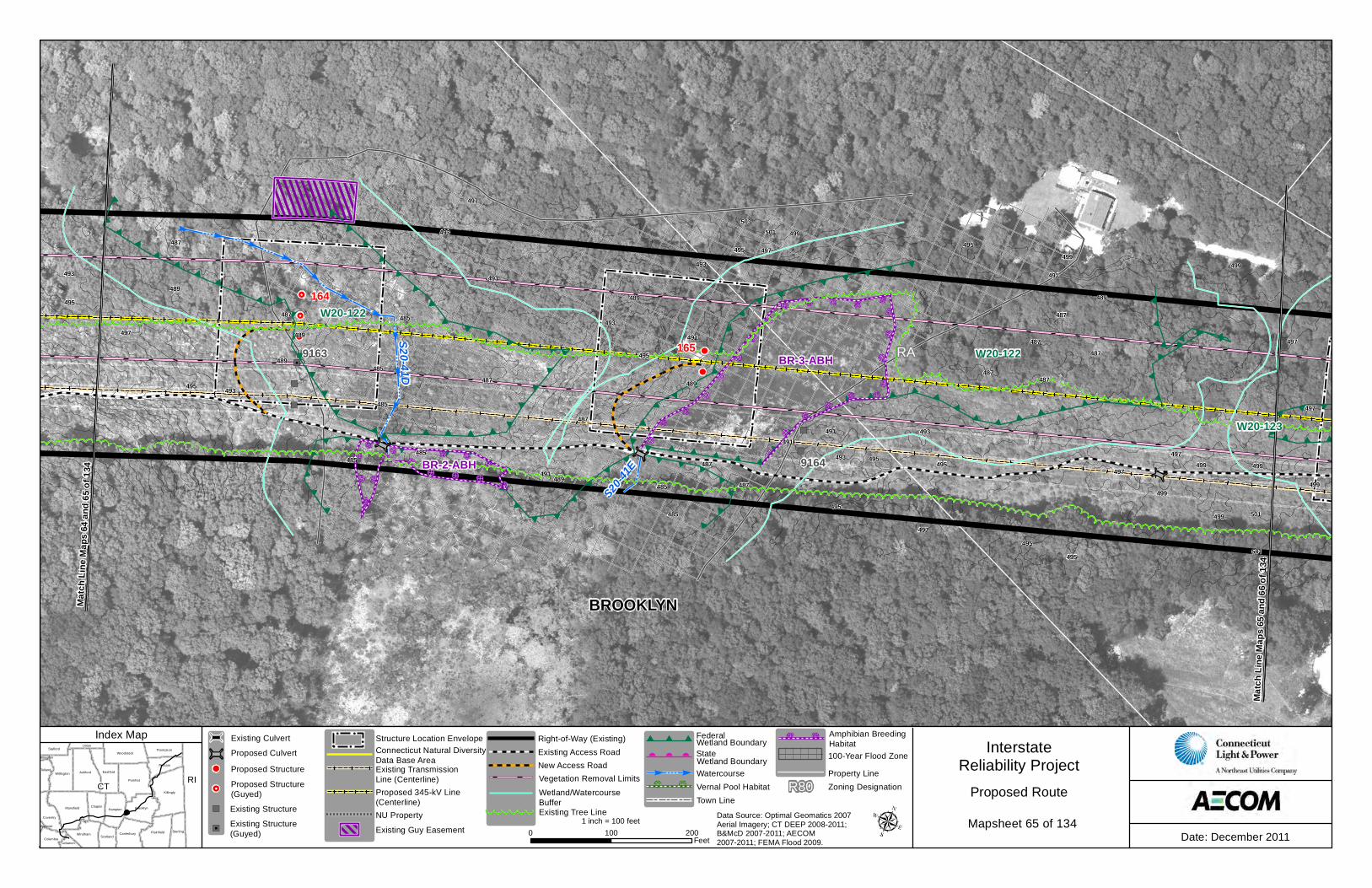
Stetson Rd
Stetso
n Rd
BROOKLYN
RA
S20-4
1E
S20-41D
9165
9163
9164
164
165
166
Match
Line
Map
s 65 a
nd 66
of 13
4
Match
Line
Map
s 64 a
nd 65
of 13
4
W20-123
W20-122
W20-122487
487
489
485
495
495493
499
501493
489485
495
499
495
485
493
495
499
495
487
493
497
491497
503
501
495497
487
491
495
487
491 487
485
499
499
497
491
487
485
489
497
493
487
501
487
499
497
489
499
497
491
495
489
489
487
493
497
489
487
495
491
485
485
493
499
BR-2-ABH
BR-3-ABH
CT RIKillingly
Pomfret
Ashford
Mansfield
EastfordWillington
Plainfield
Brooklyn
Woodstock
Hampton
Windham
Putnam
Sterling
Chaplin
Canterbury
Coventry
Thompson
Tolland
Stafford
ScotlandColumbia
Union
Lebanon
Ellington
Andover
InterstateReliability Project
Date: December 20110 100 200Feet
1 inch = 100 feet
Proposed Route
Index Map
Data Source: Optimal Geomatics 2007 Aerial Imagery; CT DEEP 2008-2011; B&McD 2007-2011; AECOM 2007-2011; FEMA Flood 2009.
Existing Transmission Line (Centerline)Proposed 345-kV Line(Centerline)
Connecticut Natural Diversity Data Base Area
NU Property
Structure Location EnvelopeExisting Access RoadNew Access Road
Right-of-Way (Existing)
Vernal Pool HabitatTown Line
Watercourse
Wetland Boundary
Vegetation Removal LimitsWetland BoundaryStateFederal
Wetland/WatercourseBuffer
Existing Guy EasementExisting Tree Line
Zoning DesignationR80Property Line100-Year Flood Zone
Amphibian BreedingHabitat
Mapsheet 65 of 134 Existing Structure
Proposed StructureProposed CulvertExisting Culvert
Existing Structure(Guyed)
Proposed Structure(Guyed)


![Index [] · index, 557 index to, 514–515 indirect, 559 logical, 470 volume control, 546 block ciphers, 676 block devices, 598, 600, 815–816 block groups, 812 blocking, indefinite,](https://static.documents.pub/doc/80x56/5ec56626fd680a51054103ec/index-index-557-index-to-514a515-indirect-559-logical-470-volume-control.jpg)


