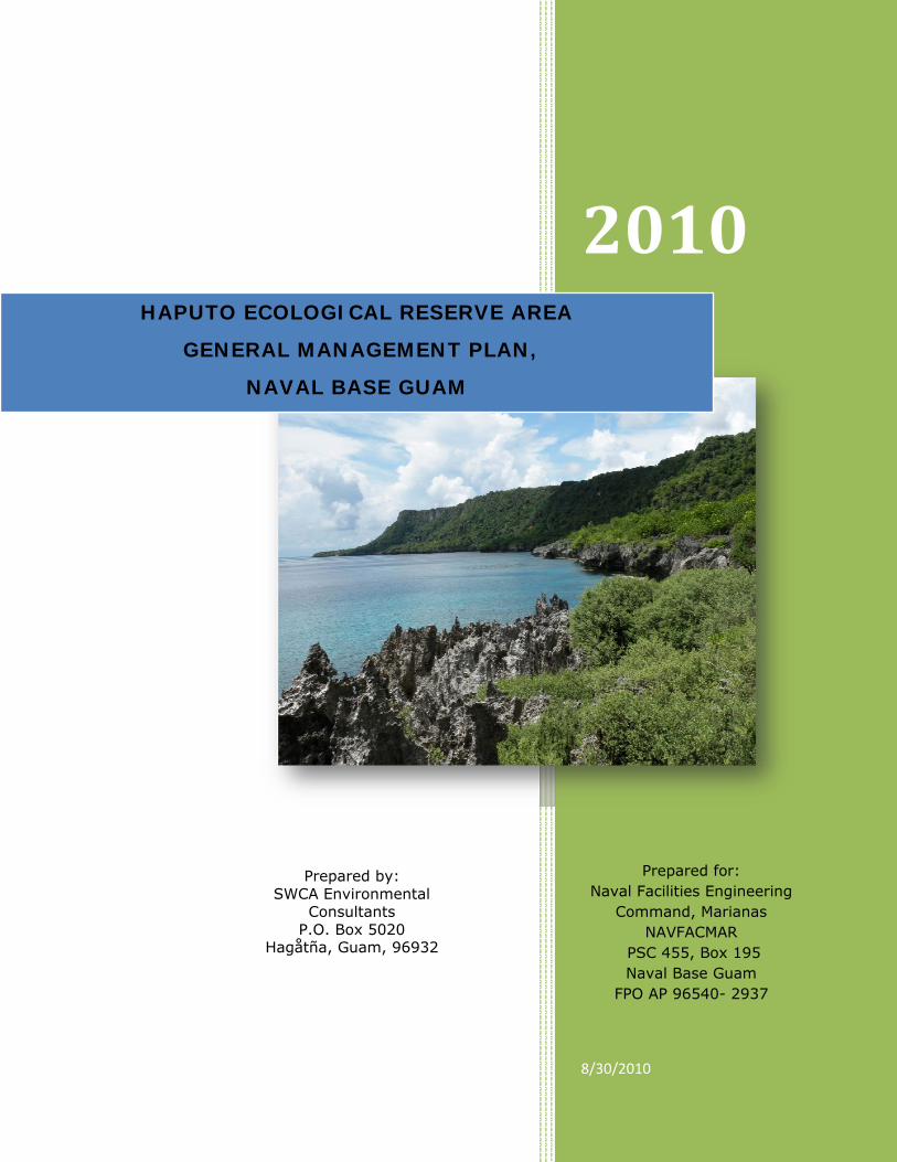
2010 8/30/2010 HAPUTO ECOLOGICAL RESERVE AREA GENERAL MANAGEMENT PLAN, NAVAL BASE GUAM Prepared by: SWCA Environmental Consultants P.O. Box 5020 Hagåtña, Guam, 96932 Prepared for: Naval Facilities Engineering Command, Marianas NAVFACMAR PSC 455, Box 195 Naval Base Guam FPO AP 96540- 2937
Transcript
2010
8/30/2010
HAPUTO ECOLOGICAL RESERVE AREA
GENERAL MANAGEMENT PLAN,
NAVAL BASE GUAM
Prepared by: SWCA Environmental
Consultants P.O. Box 5020
Hagåtña, Guam, 96932
Prepared for: Naval Facilities Engineering
Command, Marianas NAVFACMAR
PSC 455, Box 195 Naval Base Guam
FPO AP 96540- 2937
Haputo ERA General Management Plan, Naval Base Guam
SWCA Environmental Consultants i
This page intentionally left blank
Haputo ERA General Management Plan, Naval Base Guam
SWCA Environmental Consultants ii
TABLE OF CONTENTS
ACRONYMS and KEY TERMS .......................................................................................... v 1.0 EXECUTIVE SUMMARY ........................................................................................... vii 2.0 INTRODUCTION .................................................................................................... xi
2.1 Purpose and Objectives ....................................................................................... 4 2.2 Management Responsibilities ................................................................................ 5 2.3 ERA Access ........................................................................................................ 8
3.1.1 Climate ...................................................................................................... 9 3.1.2 Geology and Soils ...................................................................................... 12 3.1.3 Hydrology and Water Features ..................................................................... 14 3.1.4 Air Quality ................................................................................................ 15 3.1.5 Aesthetic and Visual Resources .................................................................... 16 3.1.6 Land Use .................................................................................................. 16
3.1.6.1 Pre-Historic and Historic Uses and Features ............................................. 16 3.1.6.2 Recent Land Uses ................................................................................ 17
3.2 Marine Environment .......................................................................................... 21 3.2.1 Federally Listed and Candidate Endangered and Threatened Species ................. 22
3.2.1.1 Sea Turtles ......................................................................................... 22 3.2.1.2 Other Species ..................................................................................... 23
3.2.2 Marine Species of Interest ........................................................................... 24 3.2.2.1 Algae and Corals ................................................................................. 24 3.2.2.2 Macroinvertebrates .............................................................................. 24 3.2.2.3 Fish ................................................................................................... 25 3.2.2.4 Marine Mammals ................................................................................. 26
3.2.3 Introduced and Invasive Species .................................................................. 26 3.3 Terrestrial Environment ..................................................................................... 26
4.0 PERMITTED AND PROHIBITED USES IN THE ERA ...................................................... 41 4.1 Permitted Activities ........................................................................................... 41 4.2 Prohibited Activities .......................................................................................... 42
7.1 Objective 1: Control and Eradicate Invasive Species .............................................. 67 7.1.1 Control and Eradicate Feral Ungulates ........................................................... 67 7.1.2 Control Feral Cats and Dogs ........................................................................ 67 7.1.3 Control and Eradicate Invasive Flora and Invertebrates ................................... 67 7.1.4 Implementation of Brown Treesnake Control .................................................. 68 7.1.5 Adopt Adaptive Management Strategy for the Control of COT Starfish ................ 68 7.1.6 Develop an Early Detection and Rapid Response Plan for Invasive Species .......... 69 7.1.7 Establish Protocols for Minimizing or Preventing Non-native Species invasions ..... 69
7.2 Objective 2: Prevent Harvest of Coconut Crabs ..................................................... 69 7.3 Objective 3: Maintain and Restore Valuable Habitat ............................................... 70
7.3.1 Prohibit All Forms of Fishing ........................................................................ 70 7.3.2 Implement Ecological Restoration ................................................................. 70 7.3.3 Maintenance of Habitat without Restoration ................................................... 71
7.4 Objective 4: Support Monitoring Surveys, Research and Protocols ........................... 71 7.4.1 Implement Regularly Scheduled Flora and Fauna Assessments and Monitoring .... 71 7.4.2 Monitor Impacts from the Outdoor Recreation and Visitor Use .......................... 72 7.4.3 Execute Long-term Monitoring of Threatened or Endangered Species ................. 73
7.5 Objective 5: Fence the Reserve Boundaries .......................................................... 74 7.6 Objective 6: Develop an Outdoor Recreation and Visitor Use Plan ............................ 75
7.6.1 Develop a Visitor Access Policy for Periods of Range Closure ............................. 75 7.6.2 Access Maintenance Plan ............................................................................. 75 7.6.3 Develop Training for NBG Security Force Conservation Law Enforcement ............ 76 7.6.4 Signs for Terrestrial and Marine Boundaries ................................................... 76 7.6.5 Develop Natural Resources Educational Programs ........................................... 76 7.6.6 Establish Boat Permit Program ..................................................................... 77 7.6.7 Establish a No-Drop-Anchor Policy Requiring Use of Mooring Buoys ................... 78 7.6.8 Develop a Scuba Dive Permitting/Reservation System ..................................... 78 7.6.9 Develop a Tsunami Warning and Evacuation Plan ............................................ 78
8.0 CONSTRAINTS AND OPPORTUNITIES ...................................................................... 81 8.1 Potential Conflicts between Programs .................................................................. 81 8.2 Potential Expansion of the ERA ........................................................................... 81
Appendix 1. List of Regulatory Drivers on Policies for the Management of the HERA ....... 102 Appendix 2: Legal Description of Haputo Ecological Reserve Area ............................... 108 Appendix 3: Cooperative Agreement with the U.S. Air Force, Dated March 10, 1994 ...... 111 Appendix 4: Federally and Locally Listed, Proposed or Candidate Species ..................... 129
Haputo ERA General Management Plan, Naval Base Guam
SWCA Environmental Consultants iv
Appendix 5. Endangered and Threatened Species List for Guam ................................. 131 Appendix 6. Policy for Research and Scientific Studies ............................................... 133 Appendix 7: Checklist of Procedures Following a Tsunami .......................................... 137
LIST OF TABLES
Table 1. Permitted and prohibited activities in the HERA. ................................................. 44 Table 2. Extent of natural and human-related threats to the marine ecosystem in Guam ...... 47 Table 3. List projects to consider for implementation in the HERA ..................................... 83
TABLE OF FIGURES
Figure 1. The island of Guam location of Haputo and Orote Peninsula ERA. .......................... 2 Figure 2. Marine and terrestrial boundaries of the HERA. ................................................... 3 Figure 3. Graphs showing average monthly temperature, rainfall and relative humidity........ 11 Figure 4. Geology of the HERA. .................................................................................... 13 Figure 5. The HERA has many areas of limestone karst outcrops. ..................................... 14 Figure 6. The HERA and vicinity showing boundaries, and SDZ. ........................................ 18 Figure 7. A shallow reef flat fronts Haputo Beach. .......................................................... 19 Figure 8. The Pinnacle is a popular dive spot in the Haputo Ecological Reserve Area. ........... 19 Figure 9. Diving Pugua Patch Reef (Double Reef) in the HERA. ......................................... 20 Figure 10. Green sea turtles are often seen in the HERA. ................................................. 23 Figure 11. Haputo beach of the HERA with coastal strand and large coconut forest. ............. 27 Figure 12. A juvenile Pacific tree snail in the HERA in 2009. ............................................. 28 Figure 13. Marianas eight spot butterfly at the HERA in 2010. .......................................... 29 Figure 14. Maytenus thompsonii, host tree of Marianas wandering butterfly ....................... 30 Figure 15. The HERA historically supported the Mariana crow .......................................... 31 Figure 16. Mariana fruit bat are known to utilize the HERA ............................................... 32 Figure 17. Faniok trees in the HERA. ............................................................................ 32 Figure 18. Fadang is relatively common in the HERA. ...................................................... 33 Figure 19. Relatively large coconut crabs are present in the HERA. ................................... 33 Figure 20. Moth skink found on Andersen Air Force Base in 2009. ..................................... 34 Figure 21. Pacific slender-toed gecko found on Andersen Air Force Base. ........................... 34 Figure 22. Philippine deer fighting on the HERA. ............................................................. 38 Figure 23. Ungulate pathways cause severe erosion. ...................................................... 39 Figure 24. Evidence of deer rubs in the HERA. ............................................................... 39 Figure 25. Four caves within the HERA. ........................................................................ 52 Figure 26. Coconut crabs are illegally trapped in the HERA. ............................................. 53
Haputo ERA General Management Plan, Naval Base Guam
SWCA Environmental Consultants v
ACRONYMS and KEY TERMS AAFB Andersen Air Force Base ac Acre ACE Army Corps of Engineers BTS Brown treesnake CA Cooperative Agreements CNO Chief of Naval Operations CO carbon monoxide CO2 carbon dioxide COMNAVMAR Commander, U.S. Naval Forces Marianas CZMA National Coastal Zone Management Act of 1972 (16 USC 1451 et seq.) DLNR Division of Land and Natural Resources DoD Department of Defense ENSO El Niño/Southern Oscillation ERA Ecological Reserve Area ESA Endangered Species Act of 1973, as amended, 16 USC 1531 et seq. ft feet GCWCS Guam Comprehensive Wildlife Conservation Strategy GDAWR Guam Division of Aquatic and Wildlife Resources GHG greenhouse gases GHPO Guam Historic Preservation Officer GIS Geographic Information System GMP General management plan GNWR Guam National Wildlife Refuge GovGuam Government of Guam ha hectare HSC-25 Helicopter Sea Combat Squadron Two Five HERA Haputo Ecological Reserve Area in inch INRMP Integrated Natural Resources Management Plan IUCN International Union for Conservation of Nature and Natural Resources km kilometer km2 square kilometer kph kilometer per hour m meter m2 square meters Marianas Mariana Islands MBTA Migratory Bird Treaty Act of 1918 [16 USC §§ 703-712] MGD Million gallons per day mi miles mi2 square miles MLD Million liters per day MLLW Mean lower low water (line) MMPA Marine Mammal Protection Act of 1972, as amended [16 USC 1361-1421] MOU Memorandum of Understanding mph Mile per hour MSA Munitions Storage Area MSFCMA/SFA Magnuson-Stevens Fishery Conservation and Management Act/Sustainable
Fisheries Act MSL Mean Sea Level MU Marine Unit NAVCAMS WESTPAC Naval Communication Area Master Station, Western Pacific NAVFACMAR Naval Facilities Engineering Command Marianas NBG Naval Base Guam NCTS Naval Computer and Telecommunications Station NEPA National Environmental Policy Act
Haputo ERA General Management Plan, Naval Base Guam
SWCA Environmental Consultants vi
NGLA Northern Guam Lens Aquifer NMFS National Oceanic and Atmospheric Administration, National Marine Fisheries
Service
NOAA National Oceanic and Atmospheric Administration Fisheries Service OPERA Orote Peninsula Ecological Reserve Area OPNAVINST Chief of Naval Operations Instruction PACDIVNAVFACENGCOM Pacific Division Naval Facilities Engineering Command PTWC Pacific Tsunami Warning Center Pugua Patch Reef Double Reef SCUBA Self-contained Underwater Breathing Apparatus SDZ Surface Danger Zone Sikes Act Sikes Act of 1960, 16 USC §670a et seq. (1996) SUV Sport Utility Vehicle T/E Threatened and Endangered TU Terrestrial unit US United States USDA-WS U.S. Department of Agriculture Wildlife Services USFWS U.S. Fish and Wildlife Service WPWP Western Pacific Warm Pool WWII World War II
Haputo ERA General Management Plan, Naval Base Guam
SWCA Environmental Consultants vii
This page intentionally left blank
Haputo ERA General Management Plan, Naval Base Guam
SWCA Environmental Consultants viii
1.0 EXECUTIVE SUMMARY
The Haputo Ecological Reserve Area (HERA) was established by the Chief of Naval Operations
(CNO) on March 15, 1984 under authority of Chapter 15, OPNAVINST 5090.1; Chapter 17 of
the NAVFAC P-73 Real Estate Manual; 36 CFR 251.23; 40 FR 38; and HR 5602, The National
Heritage Policy Act of 1979. The HERA serves as one of several mitigation measures proposed
by resource agencies of the Federal Government and Government of Guam (GovGuam) for the
construction of Kilo Wharf at Adotgan Point in Outer Apra Harbor. The creation of the ERA is
arguably a keystone mitigation that allowed for the construction at Kilo Wharf’s location. The
HERA (total acreage: 252 acres [102 ha]) was established to protect two biological units; (1)
the 180 acre (73 ha) terrestrial unit encompassing a remnant native limestone forest that
provides habitat for native forest species, and (2) the 72 ac (29 ha) marine unit, which
includes Pugua Patch Reef (more commonly known as Double Reef), a valuable fringing reef,
providing a nursery for marine species of commercial and recreational fishery value.
Since its establishment, numerous concerns over potentially conflicted uses have arisen within
the HERA. These conflicts between recreational and visitor use, and habitat preservation are
expected to become more acute in light of the increased military build-up scheduled to take
place over the next five years (JGPO 2009). The pending relocation of 8,000 US Marines and
their dependents to new facilities being planned for the Finegayan area starting in 2010
provides an impetus to revise the HERA management plan so that effective management
guidance will be in place to protect the natural resources of the HERA and uphold the original
intent of the ERA.
The Naval Facilities Engineering Command Marianas (NAVFACMAR) has an overall objective to
ensure that the natural resources within the HERA is protected from physical, biological and
human induced stressors that result in adverse changes to the ecological characteristics that
made it eligible to be an ERA. Interest in the reserve’s use for the protection of endangered
species, mitigation requirements, urban encroachment and public recreation interests has
increased in recent times. In response, NAVFACMAR EV has instigated the creation of a
General Management Plan (GMP) for HERA. This GMP aims to:
1. provide a document that can be modified and updated regularly based on adaptive
management outcomes;
2. provide direction for the preservation and management of the ERAs and their natural
resources;
3. provide guidance to prioritize and seek opportunities for preservation and
management;
4. identify stakeholders and public users;
Haputo ERA General Management Plan, Naval Base Guam
SWCA Environmental Consultants ix
5. describe potential threats or destructive activities; and
6. list activities and/or projects for the protection and maintenance of healthy ecological
systems that integrate typical native flora and fauna over geologic, pedological and/or
marine aquatic features and/or processes.
This GMP should help in complying with the terms of the Army Corps of Engineers (ACE)
permit for allowing Kilo Wharf.
The HERA contains a wealth of natural and cultural resources including federally listed and
locally protected sea turtles, birds, reptiles, invertebrates, plants, and unique marine and
terrestrial environments. These resources require carefully planned management to ensure
they persist. The following management objectives are recommended to assist in achieving
the goals of the HERA GMP. These recommended management objectives apply to both the
terrestrial and marine units of the HERA and were developed given the physical and land use
settings of the reserve, as well as the known condition of the HERA.
Objective 1: Control and Eradicate Invasive Species
Control and eradicate feral ungulates such as Philippine deer and wild pig
Control feral cats and dogs
Control and eradicate invasive flora and invertebrates
Implement brown treesnake control
Adopt adaptive management strategy for the control of crown of thorns starfish, and
other harmful marine species
Develop an early detection and rapid response plan
Establish protocols for monitors and researchers
Objective 2: Prevent Harvest of Coconut Crabs Objective 3: Maintain and Restore Valuable Habitat
Prohibit all forms of fishing
Implement ecological restoration
Maintenance of habitat without restoration
Objective 4: Support Monitoring Surveys and Research
Implement systematic baseline and regularly scheduled flora and fauna assessments
and monitoring
Monitor impacts of outdoor recreation and visitor use
Execute long-term monitoring of Threatened or Endangered species
Haputo ERA General Management Plan, Naval Base Guam
SWCA Environmental Consultants x
Objective 5: Fence the Reserve Boundaries
Prevent entry of unauthorized individuals
Prevent damage by ungulates
Promote public safety
Objective 6: Develop an Outdoor Recreation and Use Plan
Develop a visitor access policy for periods of range closure
Access maintenance plan
Signs for terrestrial and marine boundaries
Develop natural resources educational programs
Establish a boat permit program
Establish a No-Drop-Anchor Policy Requiring Use of Mooring Buoys
Develop a scuba dive permitting/reservation system
Develop a tsunami warning and evacuation plan
Objective 7: Minimize Risks from Oil Spills and Hazardous Waste Objective 8: Incorporate Adaptive Management Practices
SWCA Preparers
Michelle Christy, PhD John Ford, MS
Nathan Johnson, MS Candidtate Peter Reynolds Ryan Taira, BA
Tiffany Thair, MS Candidate Rachel Hansen, MS David DeFant, MS
Haputo ERA General Management Plan, Naval Base Guam
SWCA Environmental Consultants xi
This page intentionally left blank
Haputo ERA General Management Plan, Naval Base Guam
SWCA Environmental Consultants 1
2.0 INTRODUCTION
The Navy has jurisdiction over approximately 18,000 ac (7,300 ha) of land on Guam in
addition to 36,000 ac (14,600 ha) of submerged lands (JGPO 2009). It is the policy of the
Navy that the Natural Resources under its jurisdiction be managed to support and be
consistent with the military mission, while protecting and enhancing resources for biological
integrity, sustainable yield and multiple use (OPINVINST 5090.1C). This is achieved by
incorporating ecosystem management as the basis for planning and management of Navy
installations. Furthermore, the Navy is responsible for complying with Federal environmental
and natural resources laws and regulations that apply to the marine environment. This
includes (but is not limited to) the National Environmental Policy Act (NEPA), the Marine
Mammal Protection Act (MMPA), the Endangered Species Act (ESA), the Magnuson-Stevens
Fishery Conservation and Management Act/Sustainable Fisheries Act (MSFCMA/SFA), the Sikes
Act (10 U.S.C. 670), and Executive Order 13089 on Coral Reef Protection (Appendix 1).
Incorporated within Navy lands on Guam are Ecological Reserve Areas (ERA). An ERA is
defined as an area dedicated primarily or exclusively to preserving examples of ecosystems
and genetic diversity while providing opportunities for scientific research and education
(OPINVINST 5090.1C; 24-5 § k (5)). Recognizing the national and international need to
maintain areas in natural and near-natural conditions, and to have available such areas for
baseline research and scientific manipulation, natural areas on Navy lands that warrant special
conservation efforts may be identified as ERAs. These special natural areas should include
characteristic or outstanding botanical, ecological, geological, and scenic features or
processes.
There are currently two ERAs situated on Naval Base Guam (NBG) property; Haputo ERA
(HERA) and Orote Peninsula ERA (OPERA). This document focuses on the HERA (see Appendix
2 for a legal description of HERA).
The HERA is located on the northwest coast of Guam in the Finegayan area of Dededo
municipality about 2.5 mi (4.0 km) north of the village of Dededo and within the boundaries of
the Naval Computer and Telecommunications Station (NCTS) (Figure 1). The HERA extends
from Haputo Beach to just north of Pugua Patch Reef (more commonly known as Double Reef)
offshore of the Naval Reserve. The 252 ac (102 ha) HERA consists of a Terrestrial Unit (TU)
area of 180 ac (73 ha) from the cliff boundary line to the mean lower low water (MLLW) line
and the remaining 72 ac (29 ha) are the submerged Marine Unit (MU) from the MLLW seaward
including the Double Reef area (Figure 2). The MU of the ERA is listed as being part of the
“U.S. Marine Managed Area”. Although managed by the U.S. Navy, the entire TU lies within
the Guam National Wildlife Refuge (GNWR) Overlay.
Haputo ERA General Management Plan, Naval Base Guam
SWCA Environmental Consultants 2
Figure 1. The island of Guam showing location of Haputo and Orote Peninsula Ecological Reserve Areas.
DDeeddeeddoo
Haputo ERA General Management Plan, Naval Base Guam
SWCA Environmental Consultants 3
Figure 2. Marine and terrestrial boundaries of the Haputo Ecological Reserve Area, Guam.
Haputo ERA General Management Plan, Naval Base Guam
SWCA Environmental Consultants 4
The HERA was established by the Chief of Naval Operations (CNO) on March 15, 1984 under
authority of Chapter 15, OPNAVINST 5090.1; Chapter 17 of the NAVFAC P-73 Real Estate
Manual; 36 CFR 251.23; 40 FR 38; and HR 5602, The National Heritage Policy Act of 1979.
The reserve was initially created as compensation mitigation for construction of an ammunition
wharf (Kilo Wharf) at Adotgan Point in Outer Apra Harbor (GDAWR 2006). Creation of the
HERA was key to gaining approval from various Federal and Government of Guam (GovGuam)
entities for the wharf’s construction (U.S. Navy 1986). Kilo Wharf would not exist without the
creation and ongoing management of OPERA. The ERA is on the U.S. Marine Managed Area
Inventory and has the potential to be designated as a Marine Protected Area under Executive
Order 13158 in the future. Since its establishment, the HERA has remained essentially
unmodified.
The HERA encompasses a variety of terrestrial and marine habitats and is intended for limited
research, education, and recreational purposes. The first management plan for HERA,
prepared the Pacific Division, Naval Facilities Engineering Command in January 1986 (U.S.
Navy 1986), allocated management responsibilities among the Commanding Officer NAVCAMS
WESTPAC, PACDIVNAVFACENGCOM, the U.S. Fish and Wildlife Service (USFWS), National
Marine Fisheries Service (NMFS), and GovGuam. It provided for natural resource surveys,
boundary identification, control measures, habitat protection and improvement, and
maintenance of HERA. The management plan also identified access procedures for permitted
activities. Marine resource investigations funded by the Navy were conducted by the USFWS
and NMFS in 1986 and 1988, Amesbury et al. (2001), and SWCA (2009) to establish baseline
conditions and monitor populations of fishes, corals, and macroinvertebrates within HERA. A
terrestrial vegetation survey and an archeological inventory of the Haputo Village are currently
being conducted within HERA by SWCA and University of Guam respectively. Both surveys are
approximately 12 months duration and are due for completion in 2010.
2.1 Purpose and Objectives
The overall management objectives of NBG are to ensure that the natural resources within
each ERA are protected from physical, biological and human induced stressors that result in
adverse changes to the ecological characteristics that made them eligible to be an ERA. After
24 years, the 1986 Management Plan is in need of an update to reaffirm original management
objectives while addressing current management needs in terms of the evaluation of impacts
to the HERA and the application of modern techniques. The HERA continues to be of interest
for the protection of endangered species, mitigation requirements, urban encroachment and
public recreation.
Haputo ERA General Management Plan, Naval Base Guam
SWCA Environmental Consultants 5
In response, NAVFACMAR EV has instigated the creation of a General Management Plan (GMP)
for HERA. This GMP is designed to:
1. provide a document that can be modified and updated regularly based on adaptive
management outcomes;
2. provide direction for the preservation and management of the ERAs and their natural
resources;
3. provide guidance to prioritize and seek opportunities for preservation and
management;
4. identify stakeholders and public users;
5. describe potential threats or destructive activities; and
6. list activities and/or projects for the protection and maintenance of healthy ecological
systems that integrate typical native flora and fauna over geologic, pedological and/or
marine aquatic features and/or processes.
This GMP will provide the tools for long-term compliance assurance with the ACE permit for
the construction of Kilo Wharf at Adotgan Point in Apra Harbor by providing lasting
management strategy options designed to allow opportunities for updating as management
projects are completed or in need of reevaluation. Under adaptive management strategies, the
GMP will provide a document that can be modified and updated as the need arises.
2.2 Management Responsibilities
Management of the HERA calls for protection against activities that directly and/or indirectly
impact normal ecological processes. Joint Region Marianas (JRM) has ultimate management
jurisdiction for the ERA, with regulatory and/or programmatic authority or input from Naval
Facilities Engineering Command Marianas (NAVFACMAR) including NAVFACMAR Environmental
Business Line (EV). Input can also be sought from:
1. U.S. Fish and Wildlife Service (USFWS)
2. National Oceanic and Atmospheric Administration Fisheries (NOAA)
Final approval for all actions within the ERA, including access, is determined at the discretion
and guidance of JRM.
NAVFACMAR provides technical expertise to JRM on various management aspects of the ERA
including resource management (cultural and natural) and development of maintenance,
security and visitor use plans. Additional responsibilities of NAVFACMAR include future
planning, advising, approving and/or monitoring research projects and serving as the point of
contact for other Federal, Territorial, and private natural resource agencies desiring use of the
Haputo ERA General Management Plan, Naval Base Guam
SWCA Environmental Consultants 6
HERA. Within the HERA, NAVFACMAR also provides technical assistance to JRM on all aspects
of archaeological and historic site resource management.
The terrestrial unit of the HERA is part of the Navy Overlay Unit (total area 4,855 ha; 12,000
ac). The overlay unit is managed in cooperation with the USFWS to protect federally
threatened and endangered species and their habitat (USFWS memo dated March 25, 1994).
The following purposes for the Overlay Units are specified in Cooperative Agreements (CA)
with the U.S. Navy and U.S. Air Force, dated March 4, 1994, and March 10, 1994, respectively
(see Appendix 3 for March 10, 1994 CA).
a. “…to conserve (A) fish or wildlife which are listed as endangered species or threatened
species...or (B) plants...(C) the ecosystems upon which endangered species and
threatened species depend...” (Endangered Species Act of 1973, 16 U.S.C. 1534);
b. “…shall be administered by him [Secretary of the Interior] directly or in accordance
with cooperative agreements…and in accordance with such rules and regulations for
the conservation, maintenance, and management of wildlife, resources thereof, and its
habitat thereon…” (Fish and Wildlife Coordination Act, 16 U.S.C. 664);
c. “…for the development, advancement, management, conservation, and protection of
fish and wildlife resources” (Fish and Wildlife Act of 1956, 16 U.S.C. 742f(a)(4));
d. “…for the benefit of the United States Fish and Wildlife Service, in performing its
activities and services. Such acceptance may be subject to the terms of any restrictive
or affirmative covenant, or condition of servitude, if such terms are deemed by the
Secretary to be in accordance with law and compatible with the purposes for which
acceptance is sought.”
e. (Fish and Wildlife Act of 1956, 16 U.S.C. 742f(b)(1));
f. “…(1) incidental fish and wildlife-oriented recreational development, (2) the protection
of natural resources, (3) the conservation of endangered species and threatened