59
Harrington Multimodal Freight Terminal Feasibility Study Harrington, Delaware August 5, 2021 Dover/Kent County Metropolitan Planning Organization City of Harrington
Harrington Multimodal Freight Terminal Feasibility Study
Harrington, Delaware
August 5, 2021
Dover/Kent County Metropolitan Planning Organization
City of Harrington
HARRINGTON MULTIMODAL FREIGHT TERMINAL FEASIBILITY STUDY | i
CONTENTS
Executive Summary ....................................................................................................................................... 1
Multimodal Freight Terminal .................................................................................................................... 1
Industrial Park ........................................................................................................................................... 1
Road Access ............................................................................................................................................... 1
Planning-Level Cost ................................................................................................................................... 2
Next Steps ................................................................................................................................................. 2
Introduction .................................................................................................................................................. 4
Purpose of the Study ................................................................................................................................. 4
Site Description ......................................................................................................................................... 4
Purpose and Need Statement ....................................................................................................................... 6
Existing Conditions ........................................................................................................................................ 7
Existing Roadways ..................................................................................................................................... 7
Existing Traffic/Truck Volumes................................................................................................................ 10
Existing Intersection Operations ............................................................................................................. 13
Existing Rail Operations .......................................................................................................................... 15
Multimodal Freight Terminal Potential ...................................................................................................... 17
General Operations of a Transload Freight Terminal ............................................................................. 17
Anticipated Commodity Types and Number of Rail Car Loads ............................................................... 20
Alternatives ................................................................................................................................................. 28
Conceptual Rail Alternatives ................................................................................................................... 28
Vehicle and Truck Access ........................................................................................................................ 29
Utilities .................................................................................................................................................... 30
Stakeholder Input .................................................................................................................................... 30
Preferred Alternative .................................................................................................................................. 31
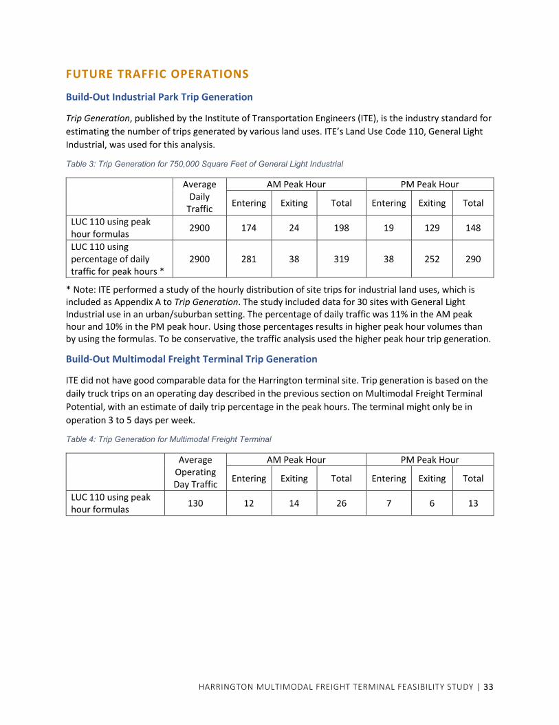
Future Traffic Operations ............................................................................................................................ 33
Build-Out Industrial Park Trip Generation .............................................................................................. 33
Build-Out Multimodal Freight Terminal Trip Generation ....................................................................... 33
Clukey Drive Access Improvements ........................................................................................................ 34
Future AM and PM Traffic Volumes ........................................................................................................ 38
Anticipated Future Intersection Levels of Service .................................................................................. 41
Potential Access to SR 14 ........................................................................................................................ 41
Implementation Plan .................................................................................................................................. 43
Rail and Terminal Cost ............................................................................................................................ 43
Roadway and Water/Sewer Infrastructure Cost ..................................................................................... 43
Potential Funding Sources ...................................................................................................................... 44
Implementation ...................................................................................................................................... 47
Next Steps ............................................................................................................................................... 49
Appendix ..................................................................................................................................................... 50
HARRINGTON MULTIMODAL FREIGHT TERMINAL FEASIBILITY STUDY | ii
LIST OF FIGURES
Figure 1: Site Location and Zoning ................................................................................................................ 5
Figure 2: Existing AM Peak Hour Traffic Volumes ....................................................................................... 11
Figure 3: Existing PM Peak Hour Traffic Volumes ....................................................................................... 12
Figure 4: Delmarva Central Railroad facilities ............................................................................................. 16
Figure 5: 2040 Freight Production and Consumption Estimates for the Delmarva Peninsula by
Commodity Group ................................................................................................................................ 20
Figure 6: 2040 National/Regional Freight Perspectives * ........................................................................... 22
Figure 7: 2040 County Freight Perspectives * ............................................................................................ 23
Figure 8: 2040 Kent County Local Freight Zones * ...................................................................................... 24
Figure 9: Estimated Truck Distribution (based on County-Level Freight Activities) ................................... 26
Figure 10: Estimated Daily Truck Trips (based on Projected Site Operations) ........................................... 27
Figure 11: Examples of Alternative Terminal Concepts .............................................................................. 28
Figure 12: Preferred Alternative ................................................................................................................. 32
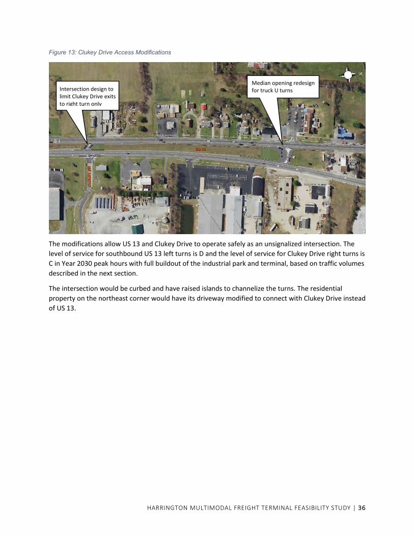
Figure 13: Clukey Drive Access Modifications ............................................................................................ 36
Figure 14: Clukey Drive Intersection ........................................................................................................... 37
Figure 15: US 13 Median Modification for Truck U Turn and Acceleration Lane ....................................... 37
Figure 16: 2030 AM Peak Hour Volumes with Terminal and Industrial Park Buildout -
single access at Clukey Drive ................................................................................................................ 39
Figure 17: 2030 PM Peak Hour Volumes with Terminal and Industrial Park Buildout -
single access at Clukey Drive ................................................................................................................ 40
LIST OF TABLES
Table 1: Level of Service Criteria ................................................................................................................. 13
Table 2: 2020 Peak Hour Levels of Service ................................................................................................. 15
Table 3: Trip Generation for 750,000 Square Feet of General Light Industrial .......................................... 33
Table 4: Trip Generation for Multimodal Freight Terminal ........................................................................ 33
Table 5: Trip Generation for Harmill Village ............................................................................................... 38
Table 6: Anticipated Future Intersection Levels of Service......................................................................... 41
HARRINGTON MULTIMODAL FREIGHT TERMINAL FEASIBILITY STUDY | 1
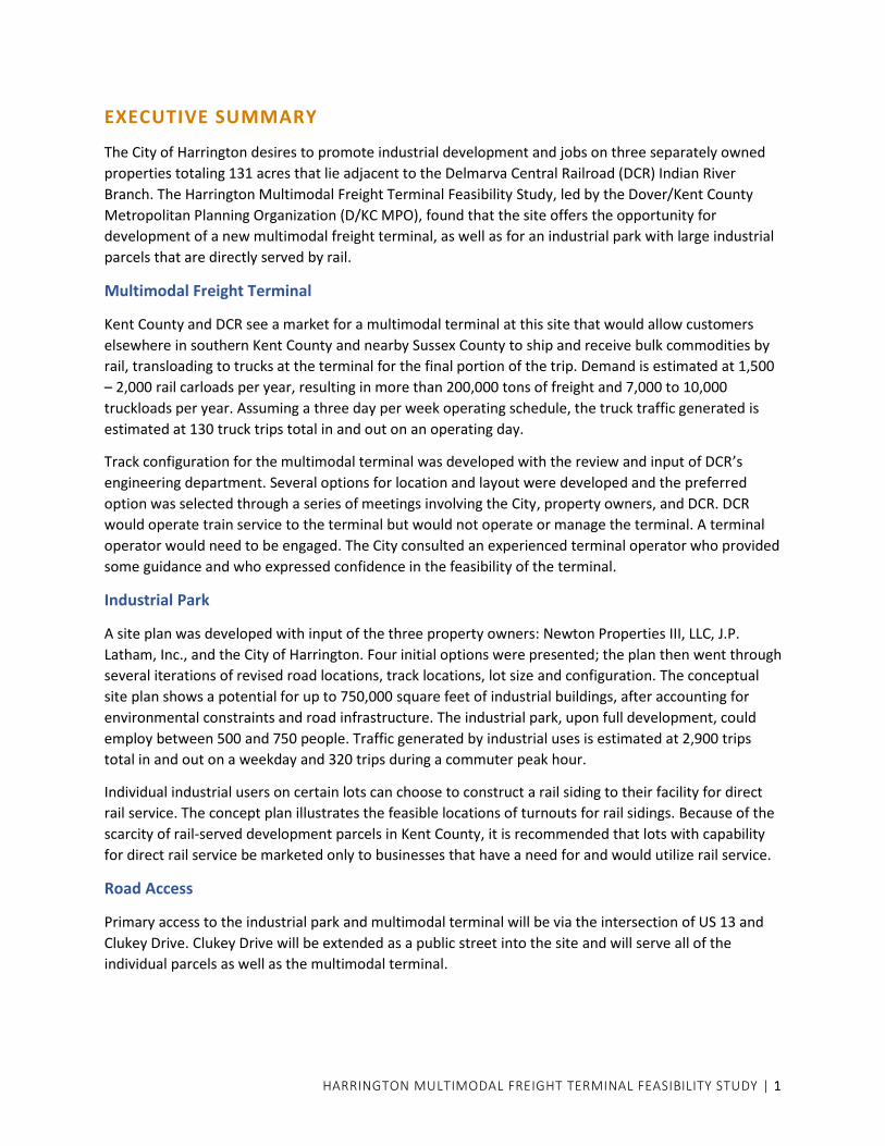
EXECUTIVE SUMMARY
The City of Harrington desires to promote industrial development and jobs on three separately owned
properties totaling 131 acres that lie adjacent to the Delmarva Central Railroad (DCR) Indian River
Branch. The Harrington Multimodal Freight Terminal Feasibility Study, led by the Dover/Kent County
Metropolitan Planning Organization (D/KC MPO), found that the site offers the opportunity for
development of a new multimodal freight terminal, as well as for an industrial park with large industrial
parcels that are directly served by rail.
Multimodal Freight Terminal
Kent County and DCR see a market for a multimodal terminal at this site that would allow customers
elsewhere in southern Kent County and nearby Sussex County to ship and receive bulk commodities by
rail, transloading to trucks at the terminal for the final portion of the trip. Demand is estimated at 1,500
– 2,000 rail carloads per year, resulting in more than 200,000 tons of freight and 7,000 to 10,000
truckloads per year. Assuming a three day per week operating schedule, the truck traffic generated is
estimated at 130 truck trips total in and out on an operating day.
Track configuration for the multimodal terminal was developed with the review and input of DCR’s
engineering department. Several options for location and layout were developed and the preferred
option was selected through a series of meetings involving the City, property owners, and DCR. DCR
would operate train service to the terminal but would not operate or manage the terminal. A terminal
operator would need to be engaged. The City consulted an experienced terminal operator who provided
some guidance and who expressed confidence in the feasibility of the terminal.
Industrial Park
A site plan was developed with input of the three property owners: Newton Properties III, LLC, J.P.
Latham, Inc., and the City of Harrington. Four initial options were presented; the plan then went through
several iterations of revised road locations, track locations, lot size and configuration. The conceptual
site plan shows a potential for up to 750,000 square feet of industrial buildings, after accounting for
environmental constraints and road infrastructure. The industrial park, upon full development, could
employ between 500 and 750 people. Traffic generated by industrial uses is estimated at 2,900 trips
total in and out on a weekday and 320 trips during a commuter peak hour.
Individual industrial users on certain lots can choose to construct a rail siding to their facility for direct
rail service. The concept plan illustrates the feasible locations of turnouts for rail sidings. Because of the
scarcity of rail-served development parcels in Kent County, it is recommended that lots with capability
for direct rail service be marketed only to businesses that have a need for and would utilize rail service.
Road Access
Primary access to the industrial park and multimodal terminal will be via the intersection of US 13 and
Clukey Drive. Clukey Drive will be extended as a public street into the site and will serve all of the
individual parcels as well as the multimodal terminal.
HARRINGTON MULTIMODAL FREIGHT TERMINAL FEASIBILITY STUDY | 2
The intersection of US 13 and Clukey Drive is recommended to be physically modified to provide left-
and right-turn entry into Clukey Drive, with all traffic exiting the site turning right, or to the north. Traffic
exiting Clukey Drive that is destined to the south on US 13 will be accommodated by relocating and
improving the existing U-turn median opening located 1,120 feet north of Clukey Drive. The northbound
to southbound U-turn will be designed for large trucks and have a southbound acceleration lane in the
median. Traffic signal control was considered at US 13 and Clukey Drive since that would provide direct
left turn exits. However, the unsignalized option was selected to improve safety and minimize overall
delay.
A second site access to SR 14 could be constructed in the future that would facilitate industrial park and
terminal trips to and from the east on SR 14. An existing private road that is built to City standards
currently connects SR 14 to the Latham property. The Independent Bible Fellowship Church, which owns
the road between Brown’s Branch and SR 14, allows only traffic to the Latham property in the easement
agreement. Therefore, this roadway cannot serve the industrial park or multimodal terminal. It is
proposed to be used only as an emergency access. The City should seek to acquire this easement as a
street right of way to allow for full access to the industrial park. It is anticipated that the church would
require visual and noise buffering along the road. Another option exists for access to SR 14 through an
easement owned by Amazon Steel, which is located east of the church’s road. The Amazon Steel
easement leads to the City property and fits well into the preferred site plan road layout. However, it
would require a new bridge or culvert crossing Brown’s Branch, with associated environmental permits.
Planning-Level Cost
The cost of roadway and water and sewer utility infrastructure construction is estimated at
approximately $5.3 million not including future road access to SR 14. Cost of a future road connection to
SR 14 is not known at this time. It is assumed that gas, electric, and telecommunications utilities will
install their facilities at their own expense and build the cost into their rates and hookup fees.
Rail cost is estimated at approximately $15 million for the terminal and for rail and track modifications
within the railroad right of way. That cost does not include sidings at buildings.
Funding to support infrastructure construction can be sought from several state and federal sources.
The City should be the applicant for funding. Private funds might also be contributed by the terminal
operator for terminal improvements as a strategic investment.
Next Steps
The City of Harrington has agreed to take the lead in overall coordination of activities needed to
implement the multimodal terminal and industrial park. Any funding from the City for implementation is
subject to the approval of City Council. Activities for implementation include approval of the study,
identification of funding, and ultimately design and construction. Specific implementation steps are
addressed in the study.

HARRINGTON MULTIMODAL FREIGHT TERMINAL FEASIBILITY STUDY | 3

HARRINGTON MULTIMODAL FREIGHT TERMINAL FEASIBILITY STUDY | 4
INTRODUCTION
Purpose of the Study
The City of Harrington is currently updating its Comprehensive Plan and has identified three parcels for a
possible multimodal freight terminal supporting industrial, warehouse, and office park uses. The overall
goal is to master plan these three parcels to allow the City to proceed with all necessary road, rail,
water, and sewer infrastructure to accommodate potential employers looking to locate in the City.
In addition to the City’s Comprehensive Plan Update, the Kent Economic Partnership (KEP) had an
Economic Analysis completed in 20181. The analysis, among other things, recommended warehousing,
distribution, and logistics as a key sector to target in the future regarding Kent County’s economic
development initiatives. As such, this Multimodal Freight Terminal Feasibility Study supports the goals
outlined in that report.
The purpose of this study is to explore the feasibility of establishing a multimodal freight terminal
servicing rail and truck freight logistical operations throughout Kent County and the region, and to
develop a master plan for the terminal and associated industrial development on the three parcels.
Site Description
The development site consists of three adjacent properties located along the Delmarva Central Railroad
(DCR). From west to east, the properties are:
• Parcel 6-09-18005-01-5900-00001; Property owner is Newton Properties III, LLC; 44.55 acres; the zoning is M-Manufacturing.
• Parcel 6-09-18000-01-0700-00001; Property owner is J.P. Latham, Inc.; 48.40 acres; the zoning is M- Manufacturing.
• Parcel 6-09-18000-01-1400-00001; Property owner is City of Harrington; 38.32 acres; the zoning is IMP-Industrial Park.
The boundaries of the combined development site coincide with Brown’s Branch on the north and west,
DCR right of way on the south, and the property line of Schiff Farms agricultural property on the east.
1 Fostering Growth, Living Standards, and the Quality of Life in Kent County, September 2018
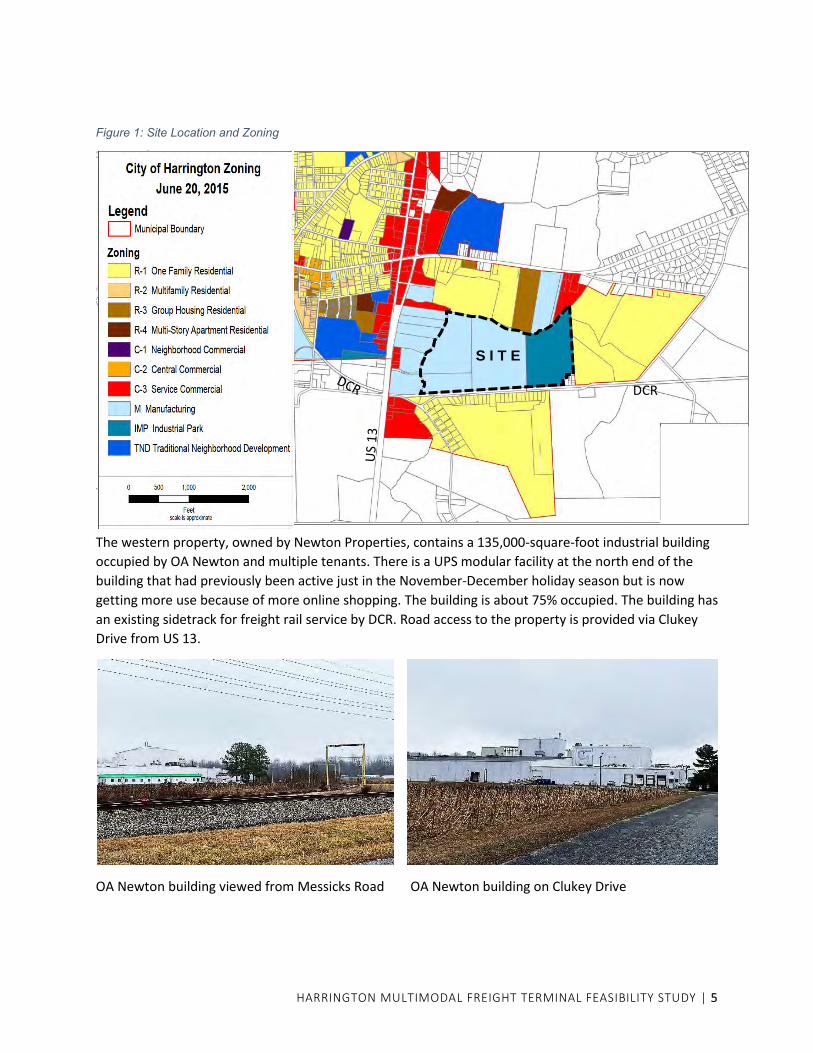
HARRINGTON MULTIMODAL FREIGHT TERMINAL FEASIBILITY STUDY | 5
Figure 1: Site Location and Zoning
The western property, owned by Newton Properties, contains a 135,000-square-foot industrial building
occupied by OA Newton and multiple tenants. There is a UPS modular facility at the north end of the
building that had previously been active just in the November-December holiday season but is now
getting more use because of more online shopping. The building is about 75% occupied. The building has
an existing sidetrack for freight rail service by DCR. Road access to the property is provided via Clukey
Drive from US 13.
OA Newton building viewed from Messicks Road OA Newton building on Clukey Drive
S I T E
DCR
HARRINGTON MULTIMODAL FREIGHT TERMINAL FEASIBILITY STUDY | 6
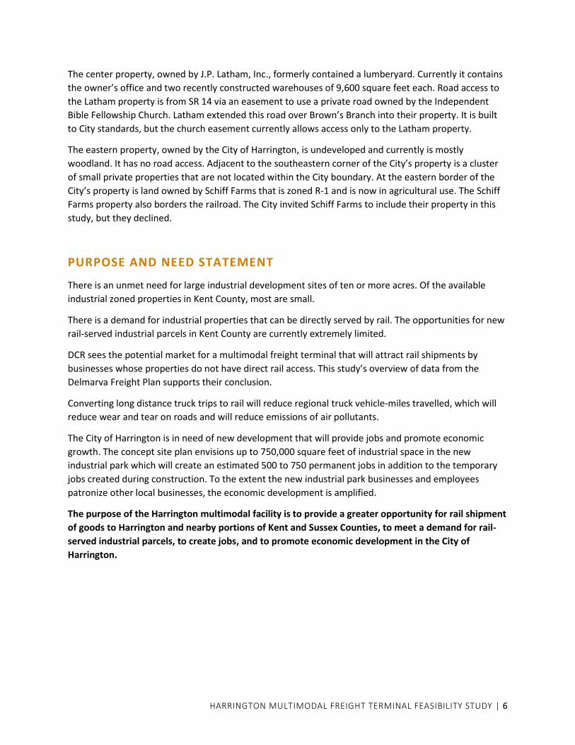
The center property, owned by J.P. Latham, Inc., formerly contained a lumberyard. Currently it contains
the owner’s office and two recently constructed warehouses of 9,600 square feet each. Road access to
the Latham property is from SR 14 via an easement to use a private road owned by the Independent
Bible Fellowship Church. Latham extended this road over Brown’s Branch into their property. It is built
to City standards, but the church easement currently allows access only to the Latham property.
The eastern property, owned by the City of Harrington, is undeveloped and currently is mostly
woodland. It has no road access. Adjacent to the southeastern corner of the City’s property is a cluster
of small private properties that are not located within the City boundary. At the eastern border of the
City’s property is land owned by Schiff Farms that is zoned R-1 and is now in agricultural use. The Schiff
Farms property also borders the railroad. The City invited Schiff Farms to include their property in this
study, but they declined.
PURPOSE AND NEED STATEMENT
There is an unmet need for large industrial development sites of ten or more acres. Of the available
industrial zoned properties in Kent County, most are small.
There is a demand for industrial properties that can be directly served by rail. The opportunities for new
rail-served industrial parcels in Kent County are currently extremely limited.
DCR sees the potential market for a multimodal freight terminal that will attract rail shipments by
businesses whose properties do not have direct rail access. This study’s overview of data from the
Delmarva Freight Plan supports their conclusion.
Converting long distance truck trips to rail will reduce regional truck vehicle-miles travelled, which will
reduce wear and tear on roads and will reduce emissions of air pollutants.
The City of Harrington is in need of new development that will provide jobs and promote economic
growth. The concept site plan envisions up to 750,000 square feet of industrial space in the new
industrial park which will create an estimated 500 to 750 permanent jobs in addition to the temporary
jobs created during construction. To the extent the new industrial park businesses and employees
patronize other local businesses, the economic development is amplified.
The purpose of the Harrington multimodal facility is to provide a greater opportunity for rail shipment
of goods to Harrington and nearby portions of Kent and Sussex Counties, to meet a demand for rail-
served industrial parcels, to create jobs, and to promote economic development in the City of
Harrington.
HARRINGTON MULTIMODAL FREIGHT TERMINAL FEASIBILITY STUDY | 7
EXISTING CONDITIONS
For purposes of the traffic analysis, the study area is bounded by SR 14 on the north, Messicks Road on
the south, Butler Road on the east, and US 13 on the west.
Existing Roadways
US 13
US 13, or Dupont Highway, is a primary arterial roadway that traverses the entire north-south length of
Delaware. US 13 connects many important cities and towns in Delaware, including Seaford, Harrington,
Dover, and Wilmington. In the study area, US 13 has two lanes and a shoulder in each direction
separated by a wide median. Left and right turn lanes are provided at intersections and the median
openings at intersections also provide the opportunity for U turns. As US 13 approaches SR 14, the
northbound and southbound lanes diverge and in effect become one-way roadways separated by a
median approximately 300 feet wide. Businesses occupy the median in this widened area. The
intersection of US 13 and SR 14 is signalized. There are no signals south of SR 14 in the study area.
The Indian River Branch of the Delmarva Central Railroad crosses US 13 approximately 500 feet south of
Clukey Drive and just north of the intersection with Corn Crib Road/Fairground Road. The crossing is
protected with gates and flashers. The distance from the edge of the US 13 crossing to the signal circuit
on the east side of US 13 that activates the gates is 930 feet. Maximum train speed at the crossing is 20
mph. Because of the proximity of the intersection of Corn Crib Road/Fairground Road to the railroad,
left turns and U turns are prohibited from southbound US 13 at Corn Crib Road, and Fairground Road is
channelized to allow only right turn exits to southbound US 13.
The speed limit on US 13 is 50 mph south of the study area. The speed limit is reduced to 40 mph just
north of the railroad crossing, and further reduced to 35 mph approaching the intersection with SR 14.
The speed limit remains 35 mph in the Harrington commercial area and returns to 50 mph north of the
City.
SR 14
SR 14, or Milford-Harrington Highway, is a 40-foot-wide roadway that has one 12-foot travel lane in each
direction and 8-foot shoulders. In the study area, the functional classification of SR 14 is a minor arterial.
The speed limit is 25 mph in the vicinity of US 13 and the entrance to the Harrington Midway Park
Center, becomes 35 mph at the Independent Bible Fellowship Church property, 40 mph in the vicinity of
Doctor Smith Road, and increases to 50 mph east of Doctor Smith Road. The only signalized intersection
in the study area is the intersection of SR 14 and US 13. There are side-mounted intersection ahead
warning signs with yellow flashers for Butler Road/Airport Road located approximately 700 feet in
advance of that intersection in both directions.
Trucks other than local deliveries are prohibited on SR 14 in downtown Harrington, west of US 13. A
truck route is established that directs westbound through trucks on SR 14 to turn south on US 13, travel
approximately two miles to Tower Hill Road, turn right and follow Tower Hill Road and Farmington Road
back north to meet SR 14 west of downtown. Through trucks on eastbound SR 14 follow the reverse
route. The intersection of US 13 and Tower Hill Road is channelized with turn lanes and also has a
median acceleration lane for trucks turning left onto US 13 north.

HARRINGTON MULTIMODAL FREIGHT TERMINAL FEASIBILITY STUDY | 8
SR 14 westbound west of Butler Road
MESSICKS ROAD
Messicks Road (K432) is a 20-foot-wide uncurbed roadway with no shoulders that runs between Corn
Crib Road and Butler Road. Messicks Road runs along the south side of the DCR track opposite the
development site. There is a private grade crossing of the DCR track called Earl Street that provides
access to Messicks Road for a cluster of small properties at the southeastern corner of the City’s
development parcel. These properties are not located within the City boundary.
East of these properties, Messicks Road crosses the track at grade to the north side. The grade crossing
is protected by side-mounted crossbuck signs with flashers. East of the grade crossing, Messicks Road
turns north and becomes Butler Road.
Messicks Road
HARRINGTON MULTIMODAL FREIGHT TERMINAL FEASIBILITY STUDY | 9
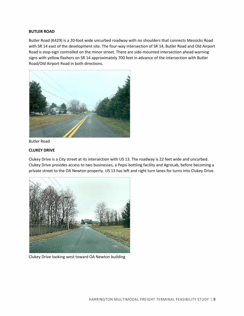
BUTLER ROAD
Butler Road (K429) is a 20-foot wide uncurbed roadway with no shoulders that connects Messicks Road
with SR 14 east of the development site. The four-way intersection of SR 14, Butler Road and Old Airport
Road is stop-sign controlled on the minor street. There are side-mounted intersection ahead warning
signs with yellow flashers on SR 14 approximately 700 feet in advance of the intersection with Butler
Road/Old Airport Road in both directions.
Butler Road
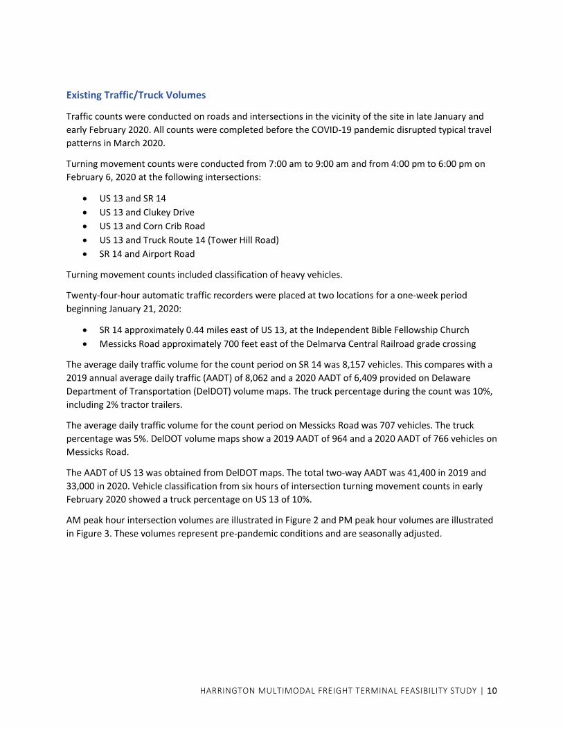
CLUKEY DRIVE
Clukey Drive is a City street at its intersection with US 13. The roadway is 22 feet wide and uncurbed.
Clukey Drive provides access to two businesses, a Pepsi bottling facility and AgroLab, before becoming a
private street to the OA Newton property. US 13 has left and right turn lanes for turns into Clukey Drive.
Clukey Drive looking west toward OA Newton building
HARRINGTON MULTIMODAL FREIGHT TERMINAL FEASIBILITY STUDY | 10
Existing Traffic/Truck Volumes
Traffic counts were conducted on roads and intersections in the vicinity of the site in late January and
early February 2020. All counts were completed before the COVID-19 pandemic disrupted typical travel
patterns in March 2020.
Turning movement counts were conducted from 7:00 am to 9:00 am and from 4:00 pm to 6:00 pm on
February 6, 2020 at the following intersections:
• US 13 and SR 14
• US 13 and Clukey Drive
• US 13 and Corn Crib Road
• US 13 and Truck Route 14 (Tower Hill Road)
• SR 14 and Airport Road
Turning movement counts included classification of heavy vehicles.
Twenty-four-hour automatic traffic recorders were placed at two locations for a one-week period
beginning January 21, 2020:
• SR 14 approximately 0.44 miles east of US 13, at the Independent Bible Fellowship Church
• Messicks Road approximately 700 feet east of the Delmarva Central Railroad grade crossing
The average daily traffic volume for the count period on SR 14 was 8,157 vehicles. This compares with a
2019 annual average daily traffic (AADT) of 8,062 and a 2020 AADT of 6,409 provided on Delaware
Department of Transportation (DelDOT) volume maps. The truck percentage during the count was 10%,
including 2% tractor trailers.
The average daily traffic volume for the count period on Messicks Road was 707 vehicles. The truck
percentage was 5%. DelDOT volume maps show a 2019 AADT of 964 and a 2020 AADT of 766 vehicles on
Messicks Road.
The AADT of US 13 was obtained from DelDOT maps. The total two-way AADT was 41,400 in 2019 and
33,000 in 2020. Vehicle classification from six hours of intersection turning movement counts in early
February 2020 showed a truck percentage on US 13 of 10%.
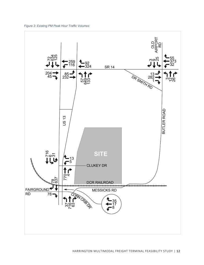
AM peak hour intersection volumes are illustrated in Figure 2 and PM peak hour volumes are illustrated
in Figure 3. These volumes represent pre-pandemic conditions and are seasonally adjusted.

HARRINGTON MULTIMODAL FREIGHT TERMINAL FEASIBILITY STUDY | 11
Figure 2: Existing AM Peak Hour Traffic Volumes
HARRINGTON MULTIMODAL FREIGHT TERMINAL FEASIBILITY STUDY | 12
Figure 3: Existing PM Peak Hour Traffic Volumes
HARRINGTON MULTIMODAL FREIGHT TERMINAL FEASIBILITY STUDY | 13
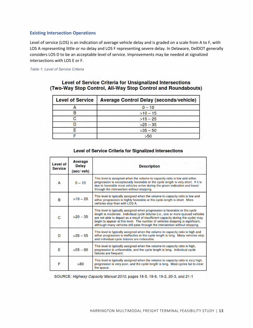
Existing Intersection Operations
Level of service (LOS) is an indication of average vehicle delay and is graded on a scale from A to F, with
LOS A representing little or no delay and LOS F representing severe delay. In Delaware, DelDOT generally
considers LOS D to be an acceptable level of service. Improvements may be needed at signalized
intersections with LOS E or F.
Table 1: Level of Service Criteria
HARRINGTON MULTIMODAL FREIGHT TERMINAL FEASIBILITY STUDY | 14
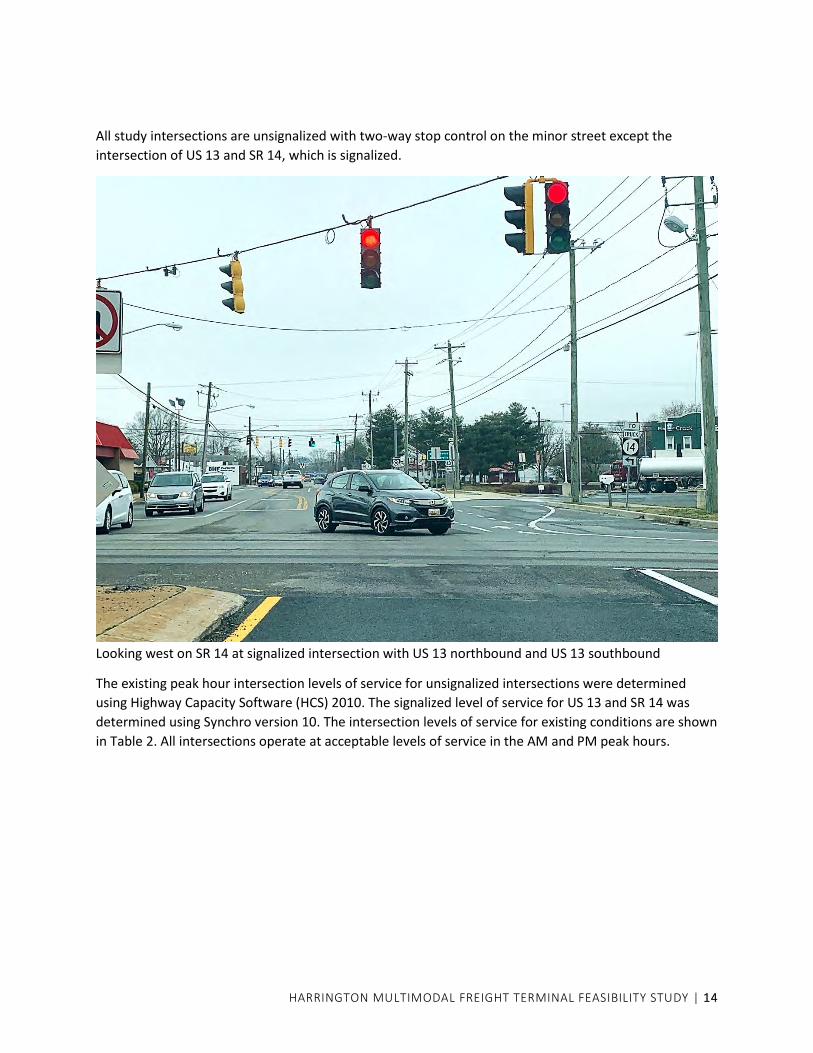
All study intersections are unsignalized with two-way stop control on the minor street except the
intersection of US 13 and SR 14, which is signalized.
Looking west on SR 14 at signalized intersection with US 13 northbound and US 13 southbound
The existing peak hour intersection levels of service for unsignalized intersections were determined
using Highway Capacity Software (HCS) 2010. The signalized level of service for US 13 and SR 14 was
determined using Synchro version 10. The intersection levels of service for existing conditions are shown
in Table 2. All intersections operate at acceptable levels of service in the AM and PM peak hours.

HARRINGTON MULTIMODAL FREIGHT TERMINAL FEASIBILITY STUDY | 15
Table 2: 2020 Peak Hour Levels of Service
Intersection Approach AM Peak Hour PM Peak Hour
LOS Avg. Delay
(sec/vehicle) LOS
Avg. Delay (sec/vehicle)
US 13 northbound and SR 14 (signal)
US 13 NB left B 15.7 B 19.3
US 13 NB through B 19.1 C 24.8
US 13 NB right B 15.8 B 19.5
SR 14 EB left B 17.1 C 23.5
SR 14 EB through B 19.3 C 22.6
SR 14 WB through D 38.2 D 48.0
SR 14 WB right C 31.6 C 33.2
OVERALL C 22.3 C 28.9
US 13 southbound and SR 14 (signal)
US 13 SB left B 16.6 C 20.3
US 13 SB through B 18.8 C 23.6
US 13 SB right B 15.5 B 18.9
SR 14 EB through/right D 39.6 D 41.3
SR 14 WB left B 14.4 B 13.7
SR 14 WB through B 10.9 B 13.3
OVERALL C 22.0 C 23.5
US 13 and Clukey Drive
US 13 SB left and U turn B 13.7 B 14.1
Clukey Drive left and right turn B 12.8 B 14.4
US 13 and Corn Crib Rd./ Fairground Rd.
US 13 NB left A 9.1 A 9.8
Corn Crib Road all movements C 18.0 D 26.4
Fairground Road (right turn only) B 10.4 B 11.4
SR 14 and Butler Rd./ Old Airport Rd.
SR 14 EB left (in shared lane) A 7.8 A 8.3
SR 14 WB left (in shared lane) A 7.9 A 8.0
Butler Rd. all movements B 12.7 B 13.8
Old Airport Rd. all movements C 15.8 C 20.9
Existing Rail Operations
Carload Express, Inc. is a short line railroad and transportation company serving Pennsylvania, Delaware,
Maryland, Virginia, and the surrounding region. The Delmarva Central Railroad Company (DCR) is a
subsidiary of Carload Express Inc. and operates 188 miles of rail line in Delaware, Maryland, and Virginia.
The lines run from near Porter, Delaware, (south of Wilmington) south to Hillwood, Virginia; and from
Harrington, Delaware, to Frankford, Delaware; with branches to Milton and Gravel Hill. DCR
interchanges with Norfolk Southern (NS), as well as the Maryland & Delaware Railroad, in several
locations on the Delmarva Peninsula.
The Indian River Branch of DCR that runs to Frankford crosses US 13 approximately 500 feet south of
Clukey Drive. The crossing is protected with gates and flashers. Approximately one mile east of US 13,
the line crosses Messicks Road; the track is straight and Messicks Road makes an S-curve to cross the
track. This grade crossing is protected by side-mounted crossbuck signs with flashers.
HARRINGTON MULTIMODAL FREIGHT TERMINAL FEASIBILITY STUDY | 16
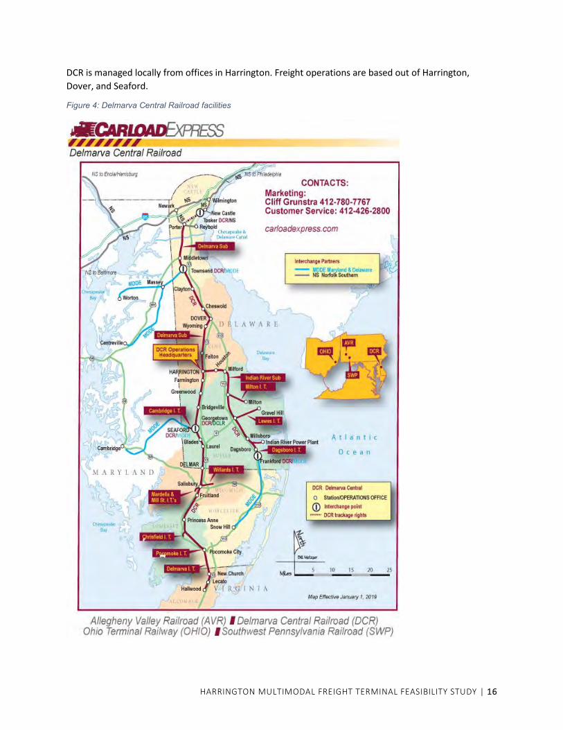
DCR is managed locally from offices in Harrington. Freight operations are based out of Harrington,
Dover, and Seaford.
Figure 4: Delmarva Central Railroad facilities

HARRINGTON MULTIMODAL FREIGHT TERMINAL FEASIBILITY STUDY | 17
MULTIMODAL FREIGHT TERMINAL POTENTIAL
General Operations of a Transload Freight Terminal
BACKGROUND
Transload terminals have grown in popularity with railroads of all classes over the past 40 years as a very
effective way for railroads to serve customers that are either not located on an existing rail line or
whose volume of business is not great enough to justify the cost of having their own sidetrack. The
concept is almost as old as railroading, having begun as tracks that were designated for access by teams
of horses with wagons which would pull alongside railroad cars and load the products into the wagons
by hand labor. The practice gave rise to the term “team track” which was commonly used by railroads
through the 1970’s and is still recognized today. Team tracks are now frequently clustered into terminals
supported by services and infrastructure suited to the products, transportation methods, and safety
regulations of our current times.
Most traffic at these terminals consists of inbound loads that are transferred to local trucks that make
the “last mile” delivery to the customer. The loads are generally bulk solids and liquids of every
description, and sometimes finished products such as building materials, that are used in the local
manufacture of finished products or for distribution through retail sales. Terminals may be of any size
from one- or two-track operations closely resembling the old team track practice to large multi-track
facilities specializing in handling a specific product. Because the terminals do not necessarily require
large areas of land or large investments in infrastructure, typically do not receive large numbers of
railcars at one time, and can attract business from far beyond the reach of a railroad’s tracks, they are
especially popular with short line, industrial, and regional railroads which are also more suited to
performing the railcar switching operations typically required by these facilities.
RELEVANT EXAMPLES
Two examples of transload facilities of the size contemplated for Harrington are located in Baltimore
City on CSXT and on the Canton Railroad. A third example is located in the City of Philadelphia at CSXT’s
East Side Yard, but it is larger and approximately half of its original size was dedicated to the shipping of
a single product (potash).
In Baltimore, the CSXT facility is located at Fort Avenue and Andre Street in Locust Point. It began as a 7-
track facility in 1986 but quickly expanded to a 15-track facility by the early 1990s. The site is about 14
acres and was a former lumber distribution and retail sales facility. The facility features an office, truck
scales, storage and maintenance facilities for the unloading/loading equipment, paired tracks with some
pairs equipped with package boilers for providing steam heat to tank cars for unloading viscous liquid
products, and drive aisles wide enough to permit trucks to pass other trucks that are loading/unloading
products. The facility was, and probably still is, operated by a contractor to CSXT.
The Canton Railroad facility in Baltimore is located on Boston Street between Haven Street and Newkirk
Street and is operated by the railroad. It began as a 4-track facility in 2002 and expanded to a 5-track
facility in 2019. The site is 5 acres and was formerly an aggregate unloading and stockpile facility. Facility
features include an office, truck scale, storage and maintenance facilities for unloading/loading
equipment, one pair of tracks set up to be equipped with a package boiler for providing steam heat to
tank cars for unloading viscous liquid products, drive aisles wide enough to permit trucks to pass other

HARRINGTON MULTIMODAL FREIGHT TERMINAL FEASIBILITY STUDY | 18
trucks that are loading/unloading products, one track with adjacent space for ground stockpiling of
products for unloading/loading boxcars, and two tracks set up for unloading propane tank cars. The
Canton Railroad facility, with improvements, was used as the basic pattern for the Harrington concepts.
Transloading facilities need to be set up to be flexible as to the types of products that will be handled at
those facilities since traffic patterns change over time as the railroad’s customers change. The CSXT
facility was originally designed to handle bulk solids but now handles as much, or more, liquids in tank
cars. The Canton Railroad facility was originally designed to handle loads in boxcars and bulk solids in
covered hopper cars, but now handles more tank cars of liquids and liquified propane gas. With the
diversity of products that move through transloading facilities, the American Railway Engineering and
Maintenance of Way Association (AREMA) has established recommended practices for their general
design.
FACILITY BEST PRACTICES
AREMA Chapter 14, Part 4 “Specialized Freight Terminals,” plus experience with the Canton Railroad
Boston Street facility, was used as design guidance for the Harrington facility. AREMA does not provide
specific details or criteria for how a facility should be designed, but rather provides a discussion of the
elements that need to be considered for inclusion in the terminal depending on the anticipated products
to be handled and the type of train operation. Section 4.5 of the chapter provides the recommendations
for facilities handling bulk and fluid products. Within this section there are articles discussing site
selection, unloading and loading facilities, commodity storage, buildings, security, environment and
maintenance, and terminal configuration.
Experience with the Canton Railroad facility shows the importance of providing as much space as
possible for storage and support facilities. Originally designed on speculation with just drive aisles and
maximum railroad car storage, the facility has provided the railroad with diverse business beyond their
expectations. While most traffic during the last 18 years has been transferring product from railcars to
trucks, there have at various times been a tank car cleaning facility, grain storage silos, bagged product
storage under a tent-like structure, ground storage for pallets of roofing shingles, and most recently the
addition of a fifth track to provide a paired track arrangement serving a tank car unloading rack for
propane and two above-ground 10,000-gallon propane storage tanks, which also required the railroad
to relocate its fence to slightly expand the size of the site.
In general, the Harrington site satisfies the recommendations regarding short- and long-term
development of the terminal, truck access, rail access, environment, size, available utilities, and zoning
and permitting with the only concerns being those of light pollution, proximity to residential areas, and
proximity to sensitive environmental areas such as wetlands. For unloading and loading facilities, this
was considered to be a low-volume terminal that would use small portable pump and vacuum
equipment, and each aisle provides a 21-foot lane adjacent to each track for that purpose. The aisles
also provide two 12-foot through lanes so that trucks can always pull through an aisle in either direction
without backing up to avoid opposing traffic or other trucks being loaded. A track was also provided
with 30 feet of clear space on either side to allow forklifts to unload/load centerbeam cars and boxcars
which are typically used for transporting building materials. Adjacent to each 30-foot clear space, an
additional 50-foot-wide space is provided for ground storage of materials so that the railcars may be
unloaded whether or not a truck is available. This allows the railcar to be released more quickly to avoid
demurrage payments. Propane is a popular commodity on the Delmarva Peninsula, so space has been
HARRINGTON MULTIMODAL FREIGHT TERMINAL FEASIBILITY STUDY | 19
provided for above-ground storage tanks, and the track centers of the paired tracks are wide enough to
permit the erection of a propane car unloading rack and/or a package boiler that could provide steam
heat for unloading tank cars. An office, truck scale, and entrance road can be configured to
accommodate the selected facility location. The site perimeter fences, where parallel to tracks, were set
a minimum distance of 20 feet from the centerline of the nearest track to accommodate a typical
sidetrack roadbed section with drainage ditch that is common to most railroads and AREMA
recommended practices.
TRACK BEST PRACTICES
The conceptual terminal design followed the AREMA recommended practice for a typical transloading
facility that would receive non-unit train traffic (meaning individual or small groups of cars consigned to
various customers) as well as the design criteria of CSXT and NS. For track in transloading facilities
AREMA provides minimal guidance for track curvature, grades, turnouts, and length of lead tracks. The
conceptual design meets or exceeds all AREMA recommendations and generally meets all CSXT and NS
requirements.
The initial conceptual design criteria included the following:
• Maximum curvature – 12°
• Minimum turnout angle within the facility – No. 8
• Minimum turnout angle off the mainline – No. 10
• Minimum tangent distance between reverse curves – 100 feet
• Minimum tangent distance ahead of or beyond turnouts – 50 feet
• All grades are anticipated to be flat (0.00%) or sloped very slightly downgrade away from the
mainline (not to exceed 0.1%) to avoid the possibility of cars rolling out of the facility
• Roadbed width of 24 feet (12 feet on each side of the track centerline) for each track with 2:1
slope to perimeter ditches
The conceptual design was reviewed by Carload Express engineering staff and the plan incorporates
their recommendations. Some modifications were necessary to meet their specific sidetrack design
criteria which in some cases exceeds those of CSXT and NS.
HARRINGTON MULTIMODAL FREIGHT TERMINAL FEASIBILITY STUDY | 20
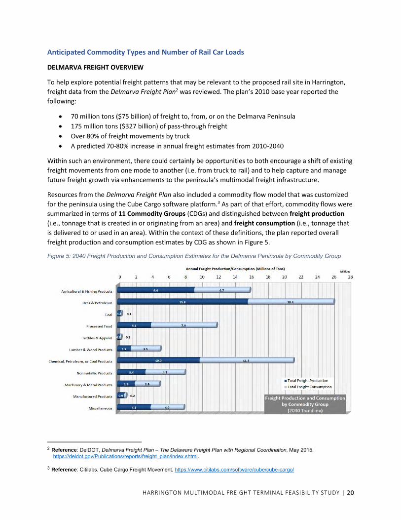
Anticipated Commodity Types and Number of Rail Car Loads
DELMARVA FREIGHT OVERVIEW
To help explore potential freight patterns that may be relevant to the proposed rail site in Harrington,
freight data from the Delmarva Freight Plan2 was reviewed. The plan’s 2010 base year reported the
following:
• 70 million tons ($75 billion) of freight to, from, or on the Delmarva Peninsula
• 175 million tons ($327 billion) of pass-through freight
• Over 80% of freight movements by truck
• A predicted 70-80% increase in annual freight estimates from 2010-2040
Within such an environment, there could certainly be opportunities to both encourage a shift of existing
freight movements from one mode to another (i.e. from truck to rail) and to help capture and manage
future freight growth via enhancements to the peninsula’s multimodal freight infrastructure.
Resources from the Delmarva Freight Plan also included a commodity flow model that was customized
for the peninsula using the Cube Cargo software platform.3 As part of that effort, commodity flows were
summarized in terms of 11 Commodity Groups (CDGs) and distinguished between freight production
(i.e., tonnage that is created in or originating from an area) and freight consumption (i.e., tonnage that
is delivered to or used in an area). Within the context of these definitions, the plan reported overall
freight production and consumption estimates by CDG as shown in Figure 5.
Figure 5: 2040 Freight Production and Consumption Estimates for the Delmarva Peninsula by Commodity Group
2 Reference: DelDOT, Delmarva Freight Plan – The Delaware Freight Plan with Regional Coordination, May 2015,
https://deldot.gov/Publications/reports/freight_plan/index.shtml. 3 Reference: Citilabs, Cube Cargo Freight Movement, https://www.citilabs.com/software/cube/cube-cargo/

HARRINGTON MULTIMODAL FREIGHT TERMINAL FEASIBILITY STUDY | 21
COMMODITY GROUPS (CDGs) OF INTEREST
Discussions with DCR noted that potential rail
freight may span a variety of types. Examples
could include stone and aggregate, construction
materials, lumber, agricultural products
(particularly as related to Delmarva’s poultry
industry), chemical products, propane, or
recyclable materials. While many opportunities
may be possible, it is anticipated based on
overall freight trends on the peninsula in
general, and for the proposed rail site in
Harrington specifically, that those opportunities
may be especially represented within six of the
commodity groups from the freight plan’s Cargo
model, including CDGs 1-2, 6-8, and 11 (see
sidebar).
FREIGHT ACTIVITY AREAS
To identify potential insights into where future rail demands may occur, the origins and destinations (O-
D) of the six CDGs noted above were explored based on available Cargo model data. This approach
compiles 2040 production and consumption estimates for review using a simplified perspective to
determine where relevant freight activities may exist on the peninsula. This approach does not attempt
to reflect specific freight sites, predict new industry creation, or account for possible diversion of pass-
through freight that does not have an origin or destination on the peninsula today. Rather, the O-D
perspectives here aim to understand where certain types of freight activity are generally located across
the peninsula, as those same locations may inform how truck patterns might unfold to/from a new rail
site in Harrington. Such insights, alongside a review of existing truck volumes in the area, may support a
broader understanding of future truck patterns and related site accessibility needs for the overall site
feasibility study.
Relevant freight activity perspectives4 were compiled at three levels as follows:
• National/Regional Freight Perspectives (Figure 6) provide a high-level overview of domestic
freight flows for the Delmarva Peninsula (Zone 1) as a whole. Such insights represent a pool
of freight activity from which new truck-to-rail demands could potentially draw including,
for example, millions of tons to/from the adjacent Mid and South Atlantic regions (Zones 3
and 5), or more distant areas across the Great Lakes, Plains, or Southwest regions (Zones 7-
9).
4 In all cases, it is important to keep in mind that these perspectives do NOT reflect overall freight activity; rather, they
intentionally focus only on activities that are more likely to generate truck-rail traffic through Harrington with an emphasis on (1) only the six CDG’s of interest noted previously, and (2) only external freight activity that moves onto or off of the peninsula. By default, this approach excludes freight movements for other CDG’s, for pass-through freight that does not start/stop on the peninsula, and for intercounty freight that is wholly contained on the peninsula (i.e. short-distance movements that would be far less likely to shift from truck to rail).
Delmarva Freight Plan Commodity Groups (CDG)
1. Agricultural & Fishing Products 2. Ores & Petroleum 3. Coal 4. Processed Food 5. Textiles & Apparel 6. Lumber & Wood Products 7. Chemical, Petroleum, or Coal
Products 8. Nonmetallic Products 9. Machinery & Metal Products 10. Manufactured Products 11. Miscellaneous (e.g. waste, scrap,
mixed)
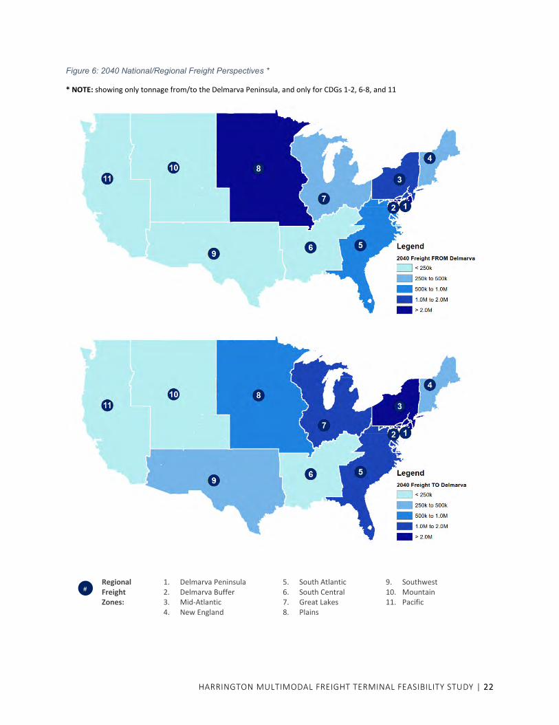
HARRINGTON MULTIMODAL FREIGHT TERMINAL FEASIBILITY STUDY | 22
Figure 6: 2040 National/Regional Freight Perspectives *
* NOTE: showing only tonnage from/to the Delmarva Peninsula, and only for CDGs 1-2, 6-8, and 11
Regional Freight Zones:
1. Delmarva Peninsula 2. Delmarva Buffer 3. Mid-Atlantic 4. New England
5. South Atlantic 6. South Central 7. Great Lakes 8. Plains
9. Southwest 10. Mountain 11. Pacific
#
HARRINGTON MULTIMODAL FREIGHT TERMINAL FEASIBILITY STUDY | 23
• County Freight Perspectives (
• Figure 7) represent freight production and consumption by county for the CDGs of interest
and for activity that has an external origin or destination off the peninsula (i.e. related to
longer-distance freight flows that may be more likely to shift from truck to rail). The tonnage
distributions may help to inform future truck distributions relative to a new rail site in
Harrington based on, for example, a higher tonnage draw to the south (e.g. Sussex or
Wicomico Counties) compared to lower tonnage levels in the Maryland counties to the
west.
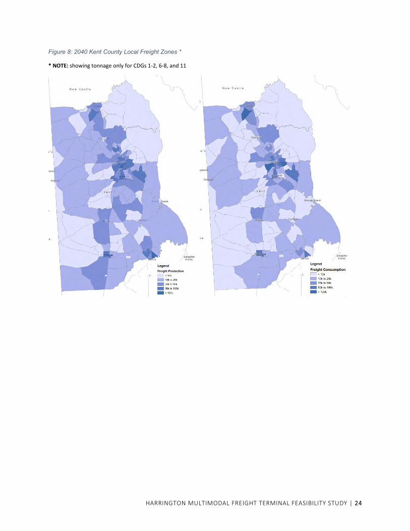
• Localized Freight Activity (Figure 8) was detailed only for Kent County to supplement the
broader county insights above, but relative to estimating intra-county draws around
Harrington.
Figure 7: 2040 County Freight Perspectives *
* NOTE: showing only tonnage with origin/destination off the Delmarva Peninsula, and only for CDGs 1-2, 6-8, and 11
HARRINGTON MULTIMODAL FREIGHT TERMINAL FEASIBILITY STUDY | 24
Figure 8: 2040 Kent County Local Freight Zones *
* NOTE: showing tonnage only for CDGs 1-2, 6-8, and 11
HARRINGTON MULTIMODAL FREIGHT TERMINAL FEASIBILITY STUDY | 25
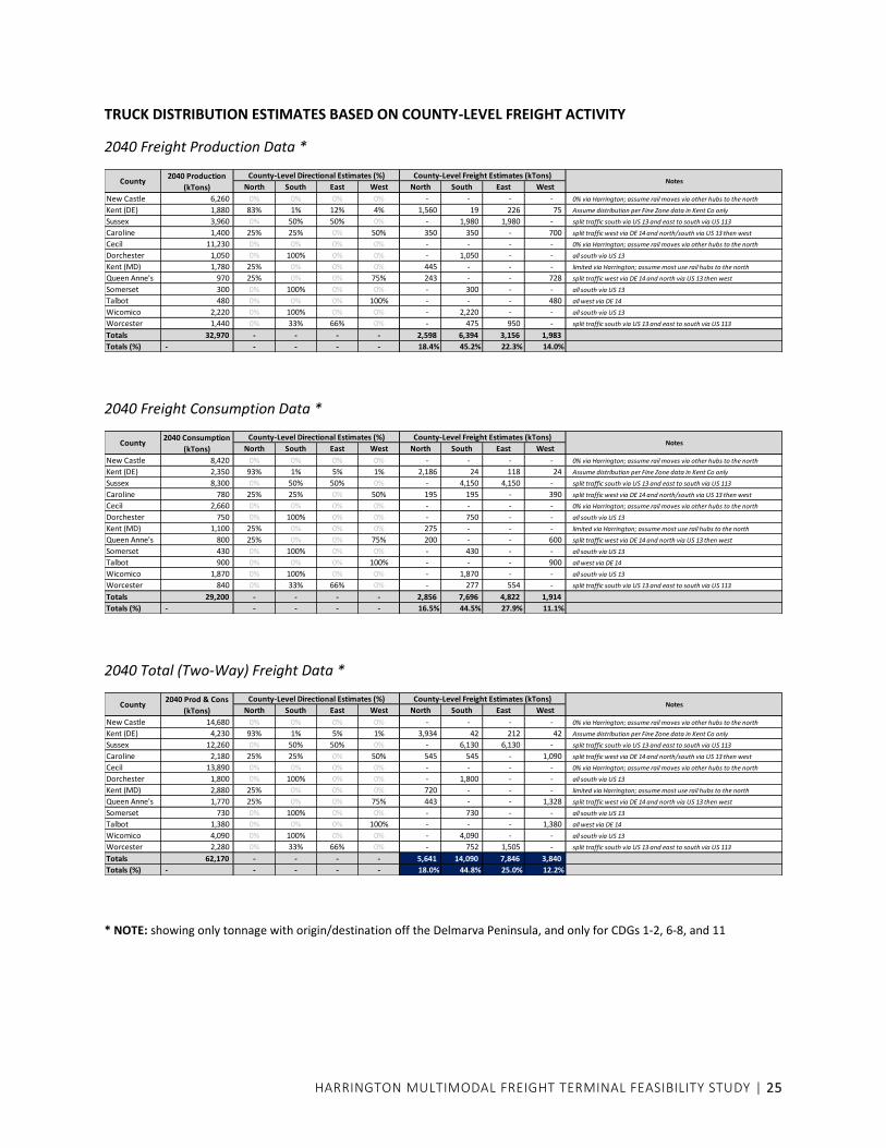
TRUCK DISTRIBUTION ESTIMATES BASED ON COUNTY-LEVEL FREIGHT ACTIVITY
2040 Freight Production Data *
2040 Freight Consumption Data *
2040 Total (Two-Way) Freight Data *
* NOTE: showing only tonnage with origin/destination off the Delmarva Peninsula, and only for CDGs 1-2, 6-8, and 11
North South East West North South East West
New Castle 6,260 0% 0% 0% 0% - - - - 0% via Harrington; assume rail moves via other hubs to the north
Kent (DE) 1,880 83% 1% 12% 4% 1,560 19 226 75 Assume distribution per Fine Zone data in Kent Co only
Sussex 3,960 0% 50% 50% 0% - 1,980 1,980 - split traffic south via US 13 and east to south via US 113
Caroline 1,400 25% 25% 0% 50% 350 350 - 700 split traffic west via DE 14 and north/south via US 13 then west
Cecil 11,230 0% 0% 0% 0% - - - - 0% via Harrington; assume rail moves via other hubs to the north
Dorchester 1,050 0% 100% 0% 0% - 1,050 - - all south via US 13
Kent (MD) 1,780 25% 0% 0% 0% 445 - - - limited via Harrington; assume most use rail hubs to the north
Queen Anne's 970 25% 0% 0% 75% 243 - - 728 split traffic west via DE 14 and north via US 13 then west
Somerset 300 0% 100% 0% 0% - 300 - - all south via US 13
Talbot 480 0% 0% 0% 100% - - - 480 all west via DE 14
Wicomico 2,220 0% 100% 0% 0% - 2,220 - - all south via US 13
Worcester 1,440 0% 33% 66% 0% - 475 950 - split traffic south via US 13 and east to south via US 113
Totals 32,970 - - - - 2,598 6,394 3,156 1,983
Totals (%) - - - - - 18.4% 45.2% 22.3% 14.0%
NotesCounty-Level Directional Estimates (%) County-Level Freight Estimates (kTons)
County2040 Production
(kTons)
North South East West North South East West
New Castle 8,420 0% 0% 0% 0% - - - - 0% via Harrington; assume rail moves via other hubs to the north
Kent (DE) 2,350 93% 1% 5% 1% 2,186 24 118 24 Assume distribution per Fine Zone data in Kent Co only
Sussex 8,300 0% 50% 50% 0% - 4,150 4,150 - split traffic south via US 13 and east to south via US 113
Caroline 780 25% 25% 0% 50% 195 195 - 390 split traffic west via DE 14 and north/south via US 13 then west
Cecil 2,660 0% 0% 0% 0% - - - - 0% via Harrington; assume rail moves via other hubs to the north
Dorchester 750 0% 100% 0% 0% - 750 - - all south via US 13
Kent (MD) 1,100 25% 0% 0% 0% 275 - - - limited via Harrington; assume most use rail hubs to the north
Queen Anne's 800 25% 0% 0% 75% 200 - - 600 split traffic west via DE 14 and north via US 13 then west
Somerset 430 0% 100% 0% 0% - 430 - - all south via US 13
Talbot 900 0% 0% 0% 100% - - - 900 all west via DE 14
Wicomico 1,870 0% 100% 0% 0% - 1,870 - - all south via US 13
Worcester 840 0% 33% 66% 0% - 277 554 - split traffic south via US 13 and east to south via US 113
Totals 29,200 - - - - 2,856 7,696 4,822 1,914
Totals (%) - - - - - 16.5% 44.5% 27.9% 11.1%
NotesCounty-Level Directional Estimates (%) County-Level Freight Estimates (kTons)2040 Consumption
(kTons)County
North South East West North South East West
New Castle 14,680 0% 0% 0% 0% - - - - 0% via Harrington; assume rail moves via other hubs to the north
Kent (DE) 4,230 93% 1% 5% 1% 3,934 42 212 42 Assume distribution per Fine Zone data in Kent Co only
Sussex 12,260 0% 50% 50% 0% - 6,130 6,130 - split traffic south via US 13 and east to south via US 113
Caroline 2,180 25% 25% 0% 50% 545 545 - 1,090 split traffic west via DE 14 and north/south via US 13 then west
Cecil 13,890 0% 0% 0% 0% - - - - 0% via Harrington; assume rail moves via other hubs to the north
Dorchester 1,800 0% 100% 0% 0% - 1,800 - - all south via US 13
Kent (MD) 2,880 25% 0% 0% 0% 720 - - - limited via Harrington; assume most use rail hubs to the north
Queen Anne's 1,770 25% 0% 0% 75% 443 - - 1,328 split traffic west via DE 14 and north via US 13 then west
Somerset 730 0% 100% 0% 0% - 730 - - all south via US 13
Talbot 1,380 0% 0% 0% 100% - - - 1,380 all west via DE 14
Wicomico 4,090 0% 100% 0% 0% - 4,090 - - all south via US 13
Worcester 2,280 0% 33% 66% 0% - 752 1,505 - split traffic south via US 13 and east to south via US 113
Totals 62,170 - - - - 5,641 14,090 7,846 3,840
Totals (%) - - - - - 18.0% 44.8% 25.0% 12.2%
County2040 Prod & Cons
(kTons)
County-Level Directional Estimates (%) County-Level Freight Estimates (kTons)Notes

HARRINGTON MULTIMODAL FREIGHT TERMINAL FEASIBILITY STUDY | 26
HARRINGTON TRUCK DISTRIBUTION ESTIMATES
Without a future customer base to establish specific origins and destinations for truck trips to/from the
proposed rail site in Harrington, the distribution of site traffic (and related influences on access points or
connecting roadways) is a broader unknown that may change as new rail customers and site operations
evolve over time. However, one approach to establishing a distribution would be to review the relevant
freight activities by county (previous
Figure 7 and Figure 8) to estimate a weighted or directional draw to/from Harrington based on the
locations of higher versus lower tonnage areas. Considering the major connecting routes near the site –
including US 13 to the north and south and DE 14 to the east and west – gross assumptions can be made
as to which routes may link the county-level activities with the site, and a sum of the corresponding
tonnage estimates by county or zone can be used to establish a distribution percentage based on the
potential freight draw in each direction.
For this exercise, it was assumed that freight activity in Cecil and New Castle Counties would be ignored
relative to potential rail traffic through Harrington, as movements to/from those counties may use rail
hubs further to the north in lieu of continuing by rail down to Harrington, only to back-track north by
truck. Kent County, Maryland was treated similarly, though a small portion of that county’s freight
activity was retained for movements that may occur to the northwest of Harrington. All remaining
county tonnages were proportioned to the north, south, east, or west of Harrington, as applicable, while
details for Kent County, Delaware (Figure 8) were referenced to estimate similar proportioning for any
local/intra-county movements.
Based on these insights, it was determined that on a percentage basis, the directional distribution of
potential freight opportunities would be similar whether based on freight production, consumption, or
total (two-way) tonnage (typically less than ±3% difference for any given direction). Therefore, as a gross
estimate for overall truck distribution for a new rail site in Harrington, summary insights for the total
(two-way) proportions are illustrated below (Figure 9).
Figure 9: Estimated Truck Distribution (based on County-Level Freight Activities)
18% NORTH to Kent, Queen Anne’s,
Caroline
25% EAST to Sussex, Worcester
12% WEST to Queen Anne’s, Caroline,
Talbot
45% SOUTH to Caroline, Sussex,
Dorchester, Worcester, Wicomico, Somerset

HARRINGTON MULTIMODAL FREIGHT TERMINAL FEASIBILITY STUDY | 27
HARRINGTON TRUCK TRIP ESTIMATES
Based on anticipated site operations, coordination with DCR has
estimated that potential freight activity at the site could reach
1,500 to 2,000 rail cars per year. As a quick validation, it can be
assumed that rail car freight capacities will vary by type of
railroad equipment (e.g. box car, flat car, gondola, hopper, tank
car, etc.) but may typically range from 70-110 tons per car5,6.
Based on these assumptions, a potential operating demand of
1,500 to 2,000 cars per year could translate to more than
200,000 tons of freight annually. Compared to the regional and
county-specific freight demands above (Figure 6 and
Figure 7), a new freight site that moves 200,000 tons would be a significant freight operation, but still
only a small portion of the millions of annual tons that move to/from the area as a whole, implying that
more than enough background demand exists for the projected site operations to come to fruition.
Assuming truck capacities of 20 to 30 tons per truck, the projected freight operations could yield a
corresponding demand of approximately 7,000 to 10,000 truckloads per year. While demands to/from
the site could vary based on delivery schedules, seasonal operations, or similar factors, an assumption of
service for 3-5 days per week would yield 156 to 260 operating days annually. Projected operations,
therefore, could range between 25 and 65 truckloads per operating day, or the equivalent of
approximately 50 to 130 one-way truck trips per day. Combining these insights with the previously
estimated truck distribution percentages (Figure 9) yields a potential distribution of future daily truck
trips to/from the site as illustrated below (Figure 10). Coupling such insights with localized truck volume
details can help to refine an assessment of the site’s needs and influences relative to site access points
and the surrounding roadway network or critical intersections as detailed elsewhere in this study.
Figure 10: Estimated Daily Truck Trips (based on Projected Site Operations)
5 Reference: CSX, Railroad Equipment, https://www.csx.com/index.cfm/customers/resources/equipment/railroad-equipment/ 6 Reference: Wikipedia, DOT-111 tank car, https://en.wikipedia.org/wiki/DOT-111_tank_car
Assuming 1,500 to 2,000 rail
cars annually, projected
freight operations for the
site could move more
200,000 tons of freight per
year with an estimated truck
demand of 50-130 one-way
truck trips per day.
10-25 trips NORTH
15-35 trips EAST
5-15 trips WEST
20-60 trips SOUTH

HARRINGTON MULTIMODAL FREIGHT TERMINAL FEASIBILITY STUDY | 28
ALTERNATIVES
Alternatives were developed with consideration of site-specific requirements and constraints, including rail infrastructure and operations, road access, industrial park development potential, and environmental constraints.
Conceptual Rail Alternatives
A primary focus of this study is the feasibility of the multimodal freight terminal. The horizontal and
vertical geometry required for railroad construction places constraints on possible terminal locations
and dictates where, and in what configuration, rail-served buildings can be located on a site.
Therefore, as an initial step in the study, alternative terminal location and layout concepts were
prepared for review with DCR and the City. Greater detail on the site development process is provided in
the Appendix.
Figure 11: Examples of Alternative Terminal Concepts
DCR’s preferred rail option was the alternative at upper right. The City desires to provide the capability
for future rail access to the adjacent Schiff property to the east. Therefore, the concept was modified to
add a track that can be extended into the Schiff property.
Alternatives were explored that would have rail enter the terminal site from the east. This would have
the operational benefit of allowing the locomotive to pull the train from the Harrington Yard across US

HARRINGTON MULTIMODAL FREIGHT TERMINAL FEASIBILITY STUDY | 29
13, past the terminal and then reverse to push cars into the terminal. These alternatives were not
pursued further for several reasons:
• The terminal configuration alternatives that provide entry from the east without a new grade
crossing (by having the terminal track depart from the main track somewhere between US 13
and Messicks Road) were not acceptable to the property owners and/or did not provide the
desired capacity in the terminal.
• It is not feasible to have a new track crossing of Messicks Road to enter the proposed industrial
park from the east, because DelDOT would require the closure of an existing crossing. Since
there would be great difficulty with closing an existing crossing in the Harrington area it was
decided to avoid that situation.
• A terminal configuration with entry from the east precludes future rail access to the adjacent
Schiff property.
• A terminal configuration with entry from the west has better space for truck circulation and
keeps most of the terminal facility on the City property.
DCR determined that they could serve the terminal with entry from the west either by having the
locomotive push cars across US 13 or by serving the terminal when the train is heading back toward the
Harrington Yard.
As the plan for industrial park lots and roadways was developed, the potential for direct rail service to
industrial park buildings was analyzed. The concept site plan was modified based on the requirements of
rail design for turnouts to sidetracks at buildings. Six new lots have the capability of direct rail service, in
addition to the OA Newton building which is currently rail served.
Because of the large number of switches that will be involved with turnouts to the individual properties
and to the terminal, DCR recommended that a new runaround track be installed north of the main line
track. The runaround track would depart from the main track just east of US 13. All switches to turnouts
would be located on the runaround track. The signal circuit on the main track east of US 13 that
activates the crossing gates and flashers is 930 feet from the edge of the US 13 crossing. By having all
switching movements from the runaround track, the US 13 grade crossing gates and flashers will be
activated only when the train is crossing US 13. In addition, switch problems or maintenance will not
affect operations of the main line track.
The railroad right-of-way width is 66 feet. The right of way appears wide enough to accommodate the
addition of a runaround track.
Vehicle and Truck Access
Primary access to the industrial park and multimodal terminal will be via the intersection of US 13 and
Clukey Drive. Clukey Drive will be extended as a public street into the site and will serve all the individual
parcels as well as the multimodal terminal.
An existing private road that is built to City standards currently connects SR 14 to the Latham property.
As described later in this report, that road cannot now be used for access to the industrial park and
multimodal terminal, but it could become a second vehicle and truck access in the future.
HARRINGTON MULTIMODAL FREIGHT TERMINAL FEASIBILITY STUDY | 30
The possibility for site access from Messicks Road was examined but was found not to be feasible at this
time. It would require a new rail crossing unless the access were located east of the existing rail crossing.
Access east of the crossing would be to the landlocked City parcel and would require right of way
acquisition or an access easement from the Schiff property. If, in the future, Schiff Farms becomes
interested in developing its property with industrial use, that property could be integrated into the
industrial park and a new access could be created on Messicks Road.
Utilities
Utilities in the site vicinity are provided by the following organizations:
• Electricity: Delmarva Power
• Telecommunications: Comcast
• Gas: Chesapeake
• Water: City of Harrington
• Sewer: City of Harrington
Utilities that currently extend from US 13 along Clukey Drive are water, sewer, gas, electric, and
telephone. Primary electric (25 kV) is available from a pole line in a 20-foot utility easement just north of
the railroad right of way. A pole line that extends north from that easement along the OA
Newton/Latham property line provides electricity to the OA Newton building. A gas line exists along the
north side of the railroad right of way.
A plan for water and sewer was developed since those utilities are owned by the City and generally are
built in the road right of way. Those utilities were laid out using the site plan road network that was
agreed upon by the stakeholders. Additionally, the site plan was advanced to the point that lots and
estimated building sizes were known before the water and sewer concept plan was developed.
It is assumed that gas, electric, and telecommunications utilities will install their facilities at their own
expense and build the cost into their rates and hookup fees. They will determine the most cost-effective
way to extend service to the individual lots. Easements will need to be established for utilities that want
to cross proposed new terminal tracks.
Stakeholder Input
After the initial concept was drafted, a series of meetings was held between September 2020 and June
2021 with stakeholders. The Appendix shows how the site plan changed over time based on input
received in these meetings. Meeting participants included the City, property owners, DCR, KEP, and the
MPO. At a later stage in the study, a terminal operator joined in several meetings to review the
feasibility of the plan. The terminal operator contributed recommendations that were incorporated in
the plan. They concurred that there is a market for a transload terminal.
For a time, the possibility of including an additional property in the project was considered. The 36-acre
property immediately east of the City’s parcel is owned by Schiff Farms. Mr. TJ Schiff participated in two
group meetings and talked with the City about a formal agreement to join the project. Although they
ultimately did not participate, the City directed that rail and roadway should be planned to allow
extension into the Schiff property in the future if it becomes desired.

HARRINGTON MULTIMODAL FREIGHT TERMINAL FEASIBILITY STUDY | 31
In addition to the group meetings, the City coordinated privately with the Independent Bible Fellowship
Church, which owns the easement for the existing driveway from the Latham property to SR 14. The City
attempted to reach an agreement that would allow use of this easement by traffic to the entire
development site. This did not occur in the timeframe of this study, although the City intends to
continue its outreach to the Church. The access plan for the multimodal terminal is therefore phased
with initial access only via Clukey Drive. Site access is discussed further in the traffic analysis section of
this report.
PREFERRED ALTERNATIVE
The preferred alternative consists of a multimodal freight terminal and associated industrial park
spanning all three sites in the study area, with layout of lots, roadways and rail improvements as shown
in Figure 12.
The freight terminal would allow customers elsewhere in southern Kent County and nearby Sussex
County to ship and receive bulk commodities by rail, transloading to trucks at the terminal for the final
portion of the trip. Demand is estimated at 1,500 – 2,000 rail carloads per year, resulting in more than
200,000 tons of freight and 7,000 to 10,000 truckloads per year. It consists of a 16-acre parcel along the
north side of the existing DCR track on the south side of the Latham and City properties.
The industrial park consists of ten lots with areas ranging from 5 to 25 acres. Access is provided solely
through an extension of Clukey Drive from the west. As described later in the study, future access north
to SR 14 is desirable but not essential for development of the park. The conceptual site plan shows a
potential for up to 750,000 square feet of industrial buildings, after accounting for environmental
constraints and road infrastructure. Individual industrial users on certain lots can choose to construct a
rail siding to their facility for direct rail service. The concept plan illustrates the feasible locations of
turnouts for rail sidings. Because of the scarcity of rail-served development parcels in Kent County, it is
recommended that lots with capability for direct rail service be marketed only to businesses that have a
need for and would utilize rail service.
The industrial park, upon full development, could employ between 500 and 750 people.

HARRINGTON MULTIMODAL FREIGHT TERMINAL FEASIBILITY STUDY | 32
Figure 12: Preferred Alternative
HARRINGTON MULTIMODAL FREIGHT TERMINAL FEASIBILITY STUDY | 33
FUTURE TRAFFIC OPERATIONS
Build-Out Industrial Park Trip Generation
Trip Generation, published by the Institute of Transportation Engineers (ITE), is the industry standard for
estimating the number of trips generated by various land uses. ITE’s Land Use Code 110, General Light
Industrial, was used for this analysis.
Table 3: Trip Generation for 750,000 Square Feet of General Light Industrial
Average Daily
Traffic
AM Peak Hour PM Peak Hour
Entering Exiting Total Entering Exiting Total
LUC 110 using peak hour formulas
2900 174 24 198 19 129 148
LUC 110 using percentage of daily traffic for peak hours *
2900 281 38 319 38 252 290
* Note: ITE performed a study of the hourly distribution of site trips for industrial land uses, which is included as Appendix A to Trip Generation. The study included data for 30 sites with General Light Industrial use in an urban/suburban setting. The percentage of daily traffic was 11% in the AM peak hour and 10% in the PM peak hour. Using those percentages results in higher peak hour volumes than by using the formulas. To be conservative, the traffic analysis used the higher peak hour trip generation.
Build-Out Multimodal Freight Terminal Trip Generation
ITE did not have good comparable data for the Harrington terminal site. Trip generation is based on the
daily truck trips on an operating day described in the previous section on Multimodal Freight Terminal
Potential, with an estimate of daily trip percentage in the peak hours. The terminal might only be in
operation 3 to 5 days per week.
Table 4: Trip Generation for Multimodal Freight Terminal
Average Operating Day Traffic
AM Peak Hour PM Peak Hour
Entering Exiting Total Entering Exiting Total
LUC 110 using peak hour formulas
130 12 14 26 7 6 13

HARRINGTON MULTIMODAL FREIGHT TERMINAL FEASIBILITY STUDY | 34
Clukey Drive Access Improvements
The intersection of US 13 and Clukey
Drive will serve as the primary access
point to the multimodal terminal and
industrial park. US 13 has a southbound
left turn lane and a northbound right
turn lane for turns into Clukey Drive. The
intersection is not curbed.
On the northeast corner is a residential
property that is not occupied by the
owner. The driveway for this property
intersects US 13 in the radius of Clukey
Drive.
The intersection is located 500 feet
north of the DCR grade crossing of US
13, which has gates and overhead
flashers.
Improvements are recommended for
the safe and efficient operation of the
intersection.
US 13 median at Clukey Drive. The DCR grade crossing of US 13 is seen just to the south.

HARRINGTON MULTIMODAL FREIGHT TERMINAL FEASIBILITY STUDY | 35
Looking east at Clukey Drive from southbound US 13.
Looking south on US 13 from Clukey Drive.
All turn movements are now allowed. It is recommended that the intersection be physically modified to
prohibit left turn exits from Clukey Drive, with all traffic exiting the site turning right, or to the north.
Traffic exiting Clukey Drive that is destined to the south on US 13 will be accommodated by relocating
and improving the existing U-turn median opening located 1,120 feet north of Clukey Drive. The
northbound to southbound U-turn will be designed for large trucks and have a southbound acceleration
lane in the median.
HARRINGTON MULTIMODAL FREIGHT TERMINAL FEASIBILITY STUDY | 36
Figure 13: Clukey Drive Access Modifications
The modifications allow US 13 and Clukey Drive to operate safely as an unsignalized intersection. The
level of service for southbound US 13 left turns is D and the level of service for Clukey Drive right turns is
C in Year 2030 peak hours with full buildout of the industrial park and terminal, based on traffic volumes
described in the next section.
The intersection would be curbed and have raised islands to channelize the turns. The residential
property on the northeast corner would have its driveway modified to connect with Clukey Drive instead
of US 13.
Intersection design to limit Clukey Drive exits to right turn only
Median opening redesign for truck U turns

HARRINGTON MULTIMODAL FREIGHT TERMINAL FEASIBILITY STUDY | 37
Figure 14: Clukey Drive Intersection
Figure 15: US 13 Median Modification for Truck U Turn and Acceleration Lane

HARRINGTON MULTIMODAL FREIGHT TERMINAL FEASIBILITY STUDY | 38
Traffic signal control was considered at US 13 and Clukey Drive, since that would provide direct left turn
exits. However, because of the following considerations, the unsignalized option described above was
selected to improve safety and to minimize overall delay.
• In the initial stages of industrial park development, site volumes would not warrant a traffic
signal at Clukey Drive. During this interim period, the existing median opening on US 13 would
be problematic. The frequent U turns that occur here and southbound left turns entering Clukey
Drive would conflict in the median with left turns exiting Clukey Drive. In addition, the median is
not wide enough to allow large trucks turning left out of Clukey Drive to make a two-stage turn,
i.e. to cross the northbound lanes of US 13 and wait in the median for a gap in southbound US
13 traffic.
• The proximity of a gated railroad crossing just to the south would complicate the operation of a
traffic signal and might pose safety concerns associated with traffic queues.
• US 13 is part of the State of Delaware’s Corridor Capacity Preservation Program, where DelDOT
seeks to limit delays caused by adding traffic signals.
Future AM and PM Traffic Volumes
Future peak hour traffic volumes were calculated for the year 2030. As a first step, a growth factor was
applied to existing traffic volumes. Annual growth factors were provided by DelDOT for each of the
study area roadways according to its Traffic Pattern Group (TPG). Ten years of annual growth was
applied to each of the study area roadways to account for background growth. It is noted that traffic
volumes actually decreased in 2020 due to the pandemic. However, the annual growth was applied to
pre-pandemic volumes.
Information on other proposed developments was obtained from the City of Harrington. Of several
residential developments that had been proposed, only one was still actively proceeding through
reviews. That development, Harmill Village, is located on the north side of SR 14 just east of the
Harrington Midway Park Center. Anticipated traffic generated by that development was provided in the
PLUS review letter from the Office of State Planning Coordination in February 2020.
Table 5: Trip Generation for Harmill Village
Average Daily Traffic
AM Peak Hour PM Peak Hour
Entering Exiting Total Entering Exiting Total
61 single-family detached houses
660 12 36 48 40 23 63
119 low-rise multi-family houses
859 13 43 56 43 26 69
Total 1,519 25 79 104 83 49 132
These residential trips and the trips generated by full buildout of the multimodal terminal and industrial
park were added to the background growth to obtain year 2030 peak hour volumes illustrated in Figures
16 and 17.

HARRINGTON MULTIMODAL FREIGHT TERMINAL FEASIBILITY STUDY | 39
Figure 16: 2030 AM Peak Hour Volumes with Terminal and Industrial Park Buildout - single access at Clukey Drive
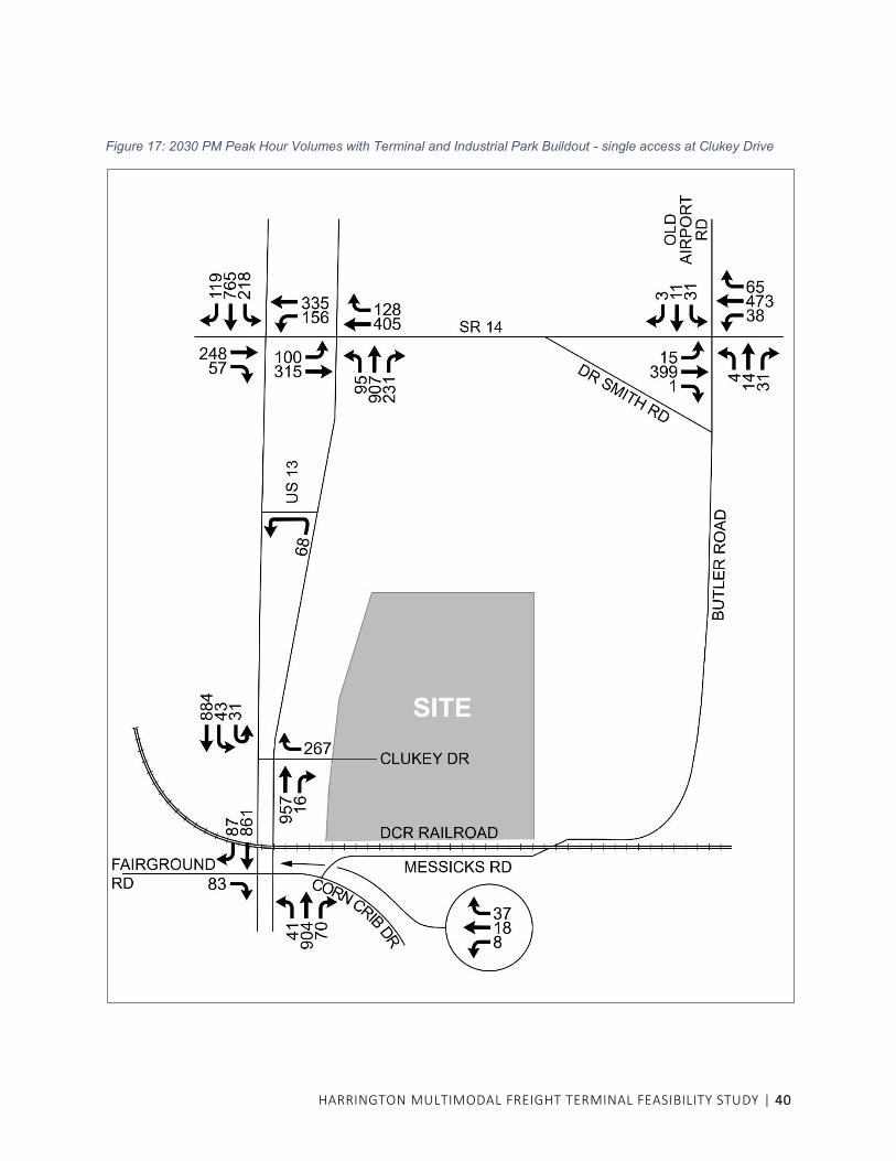
HARRINGTON MULTIMODAL FREIGHT TERMINAL FEASIBILITY STUDY | 40
Figure 17: 2030 PM Peak Hour Volumes with Terminal and Industrial Park Buildout - single access at Clukey Drive
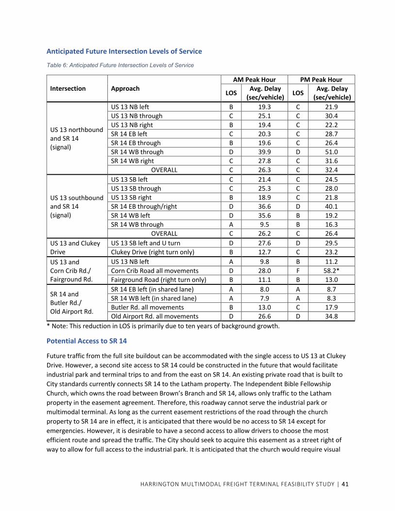
HARRINGTON MULTIMODAL FREIGHT TERMINAL FEASIBILITY STUDY | 41
Anticipated Future Intersection Levels of Service
Table 6: Anticipated Future Intersection Levels of Service
Intersection Approach AM Peak Hour PM Peak Hour
LOS Avg. Delay
(sec/vehicle) LOS
Avg. Delay (sec/vehicle)
US 13 northbound and SR 14 (signal)
US 13 NB left B 19.3 C 21.9
US 13 NB through C 25.1 C 30.4
US 13 NB right B 19.4 C 22.2
SR 14 EB left C 20.3 C 28.7
SR 14 EB through B 19.6 C 26.4
SR 14 WB through D 39.9 D 51.0
SR 14 WB right C 27.8 C 31.6
OVERALL C 26.3 C 32.4
US 13 southbound and SR 14 (signal)
US 13 SB left C 21.4 C 24.5
US 13 SB through C 25.3 C 28.0
US 13 SB right B 18.9 C 21.8
SR 14 EB through/right D 36.6 D 40.1
SR 14 WB left D 35.6 B 19.2
SR 14 WB through A 9.5 B 16.3
OVERALL C 26.2 C 26.4
US 13 and Clukey Drive
US 13 SB left and U turn D 27.6 D 29.5
Clukey Drive (right turn only) B 12.7 C 23.2
US 13 and Corn Crib Rd./ Fairground Rd.
US 13 NB left A 9.8 B 11.2
Corn Crib Road all movements D 28.0 F 58.2*
Fairground Road (right turn only) B 11.1 B 13.0
SR 14 and Butler Rd./ Old Airport Rd.
SR 14 EB left (in shared lane) A 8.0 A 8.7
SR 14 WB left (in shared lane) A 7.9 A 8.3
Butler Rd. all movements B 13.0 C 17.9
Old Airport Rd. all movements D 26.6 D 34.8
* Note: This reduction in LOS is primarily due to ten years of background growth.
Potential Access to SR 14
Future traffic from the full site buildout can be accommodated with the single access to US 13 at Clukey
Drive. However, a second site access to SR 14 could be constructed in the future that would facilitate
industrial park and terminal trips to and from the east on SR 14. An existing private road that is built to
City standards currently connects SR 14 to the Latham property. The Independent Bible Fellowship
Church, which owns the road between Brown’s Branch and SR 14, allows only traffic to the Latham
property in the easement agreement. Therefore, this roadway cannot serve the industrial park or
multimodal terminal. As long as the current easement restrictions of the road through the church
property to SR 14 are in effect, it is anticipated that there would be no access to SR 14 except for
emergencies. However, it is desirable to have a second access to allow drivers to choose the most
efficient route and spread the traffic. The City should seek to acquire this easement as a street right of
way to allow for full access to the industrial park. It is anticipated that the church would require visual

HARRINGTON MULTIMODAL FREIGHT TERMINAL FEASIBILITY STUDY | 42
and noise buffering along the road. Assuming that the City will succeed in reaching an agreement with
the Church, this study briefly considered future traffic conditions with a full access on SR 14.
The number of vehicle trips will not change; however, the distribution would change. It is assumed that
all trips to and from the east on SR 14, whether for the industrial park or the terminal, would use the SR
14 access. It is also assumed that up to half of traffic to and from the north on US 13 could switch to the
SR 14 access, since half of the potential building area is located on the Latham and City properties.
Traffic to and from the south would still utilize Clukey Drive. Truck traffic to and from the west is
obligated to use Truck Route 14 which intersects US 13 south of the site, so those trucks will also utilize
Clukey Drive. The net result is that approximately 40-45% of site traffic would utilize the SR 14 driveway,
assuming all movements are permitted.
Using DelDOT’s standard for auxiliary lanes as described in the Development Coordination procedures,
the SR 14 access intersection would require a 265-foot right turn deceleration lane and a 120-foot left
turn lane on SR 14.
Existing access from SR 14 in the Church easement (left) and at the Brown’s Branch crossing (right)
SR 14 looking east at frontage of Independent Bible Fellowship Church
Another option exists for access to SR 14 through an easement owned by Amazon Steel, which is located
east of the church’s road. The Amazon Steel easement leads to the City property and fits well into the
preferred site plan road layout. However, it would require a new bridge or culvert crossing Brown’s
Branch, with associated environmental permits. Right turn and left turn lanes on would also be required
on SR 14.

HARRINGTON MULTIMODAL FREIGHT TERMINAL FEASIBILITY STUDY | 43
IMPLEMENTATION PLAN
Rail and Terminal Cost
Estimating the cost of rail improvements is challenging given the current fluctuating costs for steel and
the uncertainty over when materials will be available. Some basic track components have long lead
times. The terminal facility consists primarily of tracks and paving with a truck scale, small office and
perimeter fencing. The facility operator typically provides the equipment that is required for servicing
the tenants, and the requirements usually evolve over time.
The following assumptions were made:
• Initial paving within the terminal will be approximately 8 acres
• All rail is to be new 115RE section
• All grade crossings within the terminal will be asphalt and rubber type with heavy duty paving
• Grading includes clearing and grubbing of the entire site and general excavation to a depth of two feet
• Any required relocation of a utility in the railroad right of way will be performed by the utility at their cost
Following are the estimates for grading, paving and trackwork. These major items will comprise 85% to
90% of the rail and terminal cost. Each item has a 40% contingency applied, which is an appropriate
contingency for an estimate at the planning/concept design level.
Grading: approximately $3.0 million including grading for all tracks in the terminal and the runaround
track, and all clearing and grading within the terminal.
Paving: approximately $4.3 million including 8 acres of heavy-duty paving within the terminal only.
Trackwork: approximately $5.9 million including all new track and turnouts in the terminal, the
runaround track, and relocation of the existing turnout to O. A. Newton to the new runaround track
using the existing turnout material.
The total of the major terminal items, including contingency, is about $13.2 million. Adding 10%-15% to
cover the other costs associated with the terminal, such as the truck scale, office building, site lighting,
utilities, fencing, stormwater management facilities, spill containment, and storm drainage, brings the
estimated total cost to approximately $15 million.
Roadway and Water/Sewer Infrastructure Cost
Roadway and stormwater management costs are estimated at about $3.3 million and water/sewer costs
at about $2.0 million, bringing the total site improvements costs outside the terminal to approximately
$5.3 million.

HARRINGTON MULTIMODAL FREIGHT TERMINAL FEASIBILITY STUDY | 44
Potential Funding Sources
RAISE DISCRETIONARY GRANTS
In FY 2021, the U.S. Department of Transportation’s Better Utilizing Investments to Leverage
Development (BUILD) grants were renamed to Rebuilding American Infrastructure with Sustainability
and Equity (RAISE) grants. Funds for FY 2021 RAISE grants will be awarded on a competitive basis for
projects that will have a significant local or regional impact. The deadline for all application materials for
FY 2021 was July 12; in 2022 a similar deadline is assumed for FY 2022 applications. Applications are
evaluated based on merit criteria that include safety, environmental sustainability, quality of life,
economic competitiveness, state of good repair, innovation, and partnership. Within these criteria,
USDOT will prioritize projects that can demonstrate improvements to racial equity, reduce impacts of
climate change and create good-paying jobs. Since funding requests always greatly exceed the amount
of funds available, the selection process is highly competitive.
Eligible applicants for RAISE grants include state and local governments, metropolitan planning
organizations (MPOs), and other political subdivisions of state or local governments. Roadway, freight
rail, and intermodal projects are eligible.
Harrington is classified as “rural” for purposes of this program. For capital projects located in rural areas,
the minimum award is $1 million. The primary method of grant disbursement for RAISE Grants is
through reimbursements. RAISE grant recipients will not receive a lump-sum cash disbursement at the
time of award announcement or obligation of funds. Instead, the recipient must pay project costs as
they are incurred and submit to DOT requests for reimbursement. This means that the recipient must
have access to sufficient non-RAISE funding sources to manage cash flow associated with the project.
The minimum total project cost for a project located in a rural area must be $1.25 million to meet 20%
non-federal (State, local, or private) match requirements. However, most selected projects have a non-
federal match of at least 50%. To be competitive, the application needs to show a high benefit-cost
ratio. The maximum award for any project is $25 million. Not more than $100 million can be awarded to
a single state. Planning and preconstruction activities (such as NEPA and design expenses) are eligible for
RAISE grants.
INFRASTRUCTURE FOR REBUILDING AMERICA (INFRA)
INFRA is a federal discretionary grant program to fund transportation projects of national and regional
significance that are in line with the Biden Administration’s principles for national infrastructure projects
that result in good-paying jobs, improve safety, apply transformative technology, and explicitly address
climate change and racial equity. Eligible project types include a freight project that is an intermodal or
rail project.
The INFRA grant application deadline for FY 2021 was March 21, 2021. In 2022 a similar deadline is
assumed for FY 2022 applications.
Eligible applicants for INFRA grants include a state or group of states, a metropolitan planning
organization that serves an urbanized area (as defined by the Bureau of the Census) with a population of
more than 200,000 individuals, a unit of local government or group of local governments, a political
HARRINGTON MULTIMODAL FREIGHT TERMINAL FEASIBILITY STUDY | 45
subdivision of a state or local government. The Dover/Kent County MPO is a qualifying metropolitan
planning organization under these criteria.
By statute, INFRA funds must be obligated within three years of the end of the fiscal year for which they
are authorized. Obligation occurs when a selected applicant enters a written, project-specific agreement
with the Department and is generally after the applicant has satisfied applicable administrative
requirements, including transportation planning and NEPA requirements. Because of this deadline for
obligation, it is important that the application package include sufficient evidence of project milestones
(including planning, NEPA, and permitting milestones) achieved and remaining, as well as financial
capacity and commitment in order to support project readiness.
To maximize the value of INFRA funds, the USDOT seeks applications which leverage federal funding to
attract non-federal sources of infrastructure investment.
COMMUNITY PROJECT FUNDING
Federal Community Project Funding (CPF) is a one-year appropriation that must be obligated within 12
months of enactment. The application deadline for FY 2022 has passed, but this will become an annual
process (unless discontinued by Congress in the future), so next year will present a new opportunity.
Formerly referred to as earmarks, Community Project Funding is defined as any congressionally directed
spending, tax benefit or tariff benefit that would benefit an entity or a specific state, locality or
congressional district.7 Since the funding is specified to a recipient, it is by nature not subject to
competitive award processes. Potentially eligible projects include infrastructure, community programs,
university research, hospitals, and other local initiatives.
Members of Congress will be allowed to request funding to support specific community projects as part
of the annual appropriations process to fund the federal government. House members are limited to 10
requests across all the spending bills open to CPF. Funding can only be requested for nonprofits or a
specific state, locality, or congressional district.
US DEPARTMENT OF AGRICULTURE RURAL DEVELOPMENT
USDA Rural Development offers loans, grants, and loan guarantees to help create jobs and support
economic development and essential services in eligible areas. Harrington is an eligible area. Of the
many different assistance program categories, the most applicable to this project are the Business
Programs, which provide financial backing and technical assistance to stimulate business creation and
growth.
One of the Business Programs, the Water & Waste Water Loan & Grant Program, can be used for
drinking water, sewer, and stormwater infrastructure. The program provides long-term, low-interest
loans. If funds are available, a grant may be combined with a loan.
7 Lifting the Earmark Moratorium: Frequently Asked Questions, Congressional Research Service report,
updated December 3, 2020

HARRINGTON MULTIMODAL FREIGHT TERMINAL FEASIBILITY STUDY | 46
ECONOMIC DEVELOPMENT ADMINISTRATION (EDA)
EDA’s Public Works program is intended to help communities attract new industry, encourage business
expansion, and generate private sector jobs and investment through the acquisition or development of
land and infrastructure improvements needed for the successful establishment of industrial or
commercial enterprises. EDA investments include water and sewer systems improvements. Applicants
must demonstrate a matching share of non-Federal funds. EDA evaluates project applications on how
well they align with EDA’s investment priorities, create or retain high-quality jobs, leverage other
resources, and provide a clear scope of work with measurable project outputs.
TRANSPORTATION INFRASTRUCTURE INVESTMENT FUND (TIIF)
The TIIF was established by the State of Delaware to provide economic assistance for renovation,
construction, or any other type of improvements to roads and related transportation infrastructure in
order to attract new businesses to the state, or expand existing businesses in the state, when such an
economic development opportunity would create a significant number of direct, permanent, quality full-
time jobs.
TIIF is a mechanism to reimburse developers for offsite improvements if their developments have
strategic economic importance.
A project must have at least one public endorser and expand employment in Delaware. Grants are only
authorized for transportation infrastructure located within the public right of way or on public land.
Funds are disbursed as reimbursement for construction of transportation infrastructure.
Eligible projects include “Any project that would construct, maintain, extend or enhance any highway,
and/or road, and/or bridge” and “Any project that would construct, maintain, extend or enhance access
to any transit and/or intermodal system.” The access enhancements on US 13 for Clukey Drive fall into
the latter category, as they enhance access to an intermodal freight terminal.
The extension of Clukey Drive and other roads internal to the industrial park may become eligible if the
City acquires the right of way up front to satisfy the requirement that all TIIF projects must be located
within the public right of way. Rail improvements are not eligible for TIIF grants.
TIIF does not have scheduled application deadlines. Deadlines are chosen based on a variety of factors
but at least two weeks’ notice is provided. The last deadline was in April 2021 and the TIIF Council
meeting is in July 2021. Another deadline is likely to be established in the following few months.
CONSOLIDATED RAIL INFRASTRUCTURE AND SAFETY IMPROVEMENTS PROGRAM (CRISI)
This Federal Railroad Administration program may fund projects applicable to the Harrington terminal,
i.e. projects to improve short-line or regional railroad infrastructure and projects necessary to enhance
multimodal connections or facilitate service integration between rail service and other modes.
CRISI awarded $320 million for grants in FY 2020 but is not accepting applications as of now. It is unclear
if this program will continue or be replaced by another program.

HARRINGTON MULTIMODAL FREIGHT TERMINAL FEASIBILITY STUDY | 47
PUBLIC/PRIVATE PARTNERSHIP
The terminal operator might make strategic investments in the terminal, building out a small footprint,
starting to become operational, generating some cash flow, and then expanding. This could accelerate
the start-up of the terminal compared with waiting for grant funds.
DELDOT CAPITAL TRANSPORTATION PROGRAM (CTP)
DelDOT is currently seeking input from its County and local partners for projects to include in the FY
2023-2028 CTP. Public hearings will be conducted this September. The recommendation of the Council
on Transportation will be made by the end of the year. Federal approval would occur in fall of 2022.
While projects on the CTP can take several years before construction occurs, it may be useful to get a
project on the CTP as evidence of state support. This provides credibility when applying for federal
grants that could accelerate implementation.
CTP funding would likely be limited to intersection improvements within the right of way of US 13.
Implementation
DCR/Carload Express has indicated that they will provide their time (design, construction services) for
new rail, but no dollars toward construction. They clarified their expected role in implementation.
1) Individual sidetracks serving industrial properties, such as for Lots 1, 4, 5, 6, 7, and 10
When a property along a branch line requests a turnout and rail service, Carload Express will
typically help with the track design, getting bids from railroad approved contractors,
construction management and inspections.
They have committed to designing the tracks free of charge for the customers at the facility.
Customers are responsible for the construction of their mainline switches. As long as they ship
over 12 railcars a year, DCR will maintain the track and switches for customers that are in DCR’s
right of way.
DCR offers to inspect all customer tracks each year to provide information on their condition
and recommend improvements/repairs when needed.
2) Multimodal terminal
The City has said it will retain ownership of the terminal, at least initially. For construction of the
new track, Carload Express would view the City of Harrington as a new valued customer and
partner and offer the same service to them as other customers.
3) Runaround track
The runaround track that will be located wholly within the Carload Express right of way is
fundamental to DCR’s operations in serving both the tracks to the individual lots and the
multimodal terminal. DCR will be contributing their time to help design, construct, and market
the terminal. All other construction costs will be borne by other entities.

HARRINGTON MULTIMODAL FREIGHT TERMINAL FEASIBILITY STUDY | 48
There is a gas line located north of the track that may need to be relocated for track
construction. If the gas line is in the right of way, the utility company would need to relocate the
line to accommodate the new track at their cost.
DCR and a prospective terminal operator have indicated they would explore what the most cost-
effective manner is to phase in working/operational tracks. They may not need all the infrastructure up
front, which could reduce up front capital to become operational.
Tracks to the individual lots can be built as/when required. The lead track that provides capability for
future extension to the Schiff property would not have to be built initially. However, it is recommended
that the four tracks in the terminal facility and the runaround track be constructed simultaneously as an
early phase of site development.
The whole terminal site should be set up initially. Anything that will be buried, such as storm drains,
utilities, and spill containment systems need to be installed prior to tracks and paving to avoid having to
dig up areas that have already been installed and patchwork repairs. Making sure these critical parts of
the infrastructure are installed first will also speed the future build-out. A temporary office trailer and a
semi-portable truck scale can be installed to start up operations, but they shouldn’t be located where
the construction of the permanent facilities will be located. Some track and paving in the terminal may
be able to be deferred, but those savings should be weighed against additional costs to rebid, remobilize
and build at a later date, and also against construction interference with operations that have already
begun.

HARRINGTON MULTIMODAL FREIGHT TERMINAL FEASIBILITY STUDY | 49
Next Steps
The City of Harrington has agreed to take the lead in overall coordination of activities needed to
implement the multimodal terminal and industrial park. Any funding from the City for implementation is
subject to the approval of City Council. Activities for implementation include approval of the study,
identification of funding, and ultimately design and construction. Specific implementation steps are as
follows:
• Approval of the study report by Dover/Kent County MPO
• Presentation to Harrington City Council
• Adoption of a written agreement between the City and the two other property owners
• Initiation of site subdivision approvals by the City based on the lot lines in the locally preferred
site plan
• DelDOT review and approval of the initial site access plan and improvements on US 13
• Coordination with gas and electric utilities for establishment of utility easements
• Engagement of an engineer for design, pre-construction activities, and permits
• Determination of financial and other responsibilities of the City, property owners, DCR, and lot
developers, and the amount of local and private resources that will be available
• Adoption of industrial park protective covenants to ensure proper use, development, and
maintenance of each parcel within the industrial park
• Approval by Harrington City Council for any proposed financial commitments from the City
• Pursuit of state and federal funding opportunities for road and utility infrastructure after
determining the local and private commitments.
• Phased construction of road and utility infrastructure
• Marketing of the industrial park lots; lots with potential for direct rail service should be
marketed only to businesses with a need for direct rail service
• Continued negotiations with the Independent Bible Fellowship Church regarding the use of its
easement for site access to SR 14; even though the Clukey Drive access can accommodate full
buildout of the site, a secondary access is desirable
• Engagement of a terminal operator to advise on multimodal terminal implementation, including
funding sources, and who is prepared to operate and maintain a City-owned terminal
• Pursuit of funding for design and construction of rail infrastructure
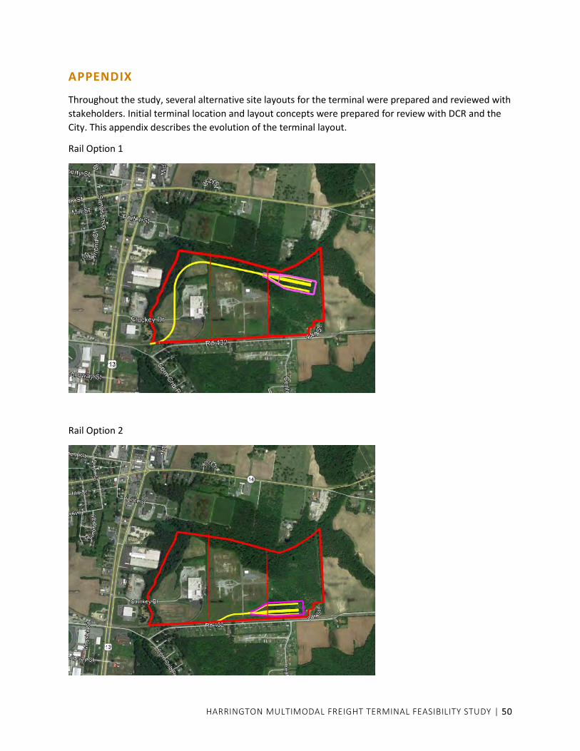
HARRINGTON MULTIMODAL FREIGHT TERMINAL FEASIBILITY STUDY | 50
APPENDIX
Throughout the study, several alternative site layouts for the terminal were prepared and reviewed with
stakeholders. Initial terminal location and layout concepts were prepared for review with DCR and the
City. This appendix describes the evolution of the terminal layout.
Rail Option 1
Rail Option 2

HARRINGTON MULTIMODAL FREIGHT TERMINAL FEASIBILITY STUDY | 51
Rail Option 3
Rail Option 4
The preferred rail option was Option 2, modified to add track that can be extended in the future into the
adjacent Schiff property east of the City property.

HARRINGTON MULTIMODAL FREIGHT TERMINAL FEASIBILITY STUDY | 52
Environmental constraints were mapped, including the wetlands and floodplain along Brown’s Branch.
Initial road layouts and parcels were then prepared for review with property owners.
Version 1 - Clukey Drive extension hugs rail to maximize buildable site on City property.
Version 1A - Alternative initial road layout for review with property owners.
Mr. Latham preferred to use his existing east-west road.
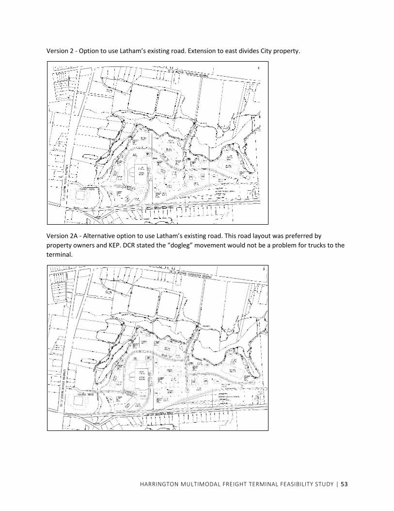
HARRINGTON MULTIMODAL FREIGHT TERMINAL FEASIBILITY STUDY | 53
Version 2 - Option to use Latham’s existing road. Extension to east divides City property.
Version 2A - Alternative option to use Latham’s existing road. This road layout was preferred by
property owners and KEP. DCR stated the “dogleg” movement would not be a problem for trucks to the
terminal.

HARRINGTON MULTIMODAL FREIGHT TERMINAL FEASIBILITY STUDY | 54
Version 2A option 1 - Intended to enlarge buildable site on City property.
Version 2A option 2 - Another option to enlarge buildable site on City property. Property owners
preferred original Version 2A; City agreed.
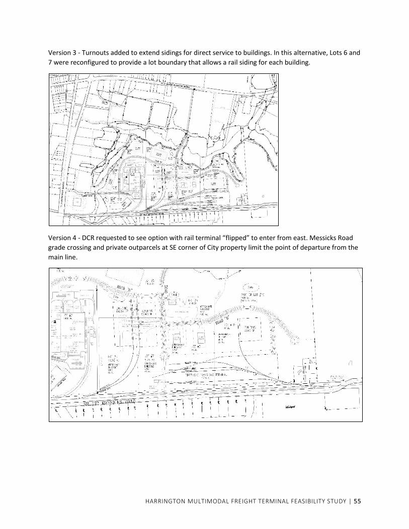
HARRINGTON MULTIMODAL FREIGHT TERMINAL FEASIBILITY STUDY | 55
Version 3 - Turnouts added to extend sidings for direct service to buildings. In this alternative, Lots 6 and
7 were reconfigured to provide a lot boundary that allows a rail siding for each building.
Version 4 - DCR requested to see option with rail terminal “flipped” to enter from east. Messicks Road
grade crossing and private outparcels at SE corner of City property limit the point of departure from the
main line.


![Multimodal Movement of Freight - Transportation.org · Multimodal Movement of Freight 2017 SCORT Annual Meeting Oakland, CA [Insert RR Graphic] Stephen O’Connor. FRA – Office](https://static.documents.pub/doc/80x56/5edc3e73ad6a402d6666d4a2/multimodal-movement-of-freight-multimodal-movement-of-freight-2017-scort-annual.jpg)


