5
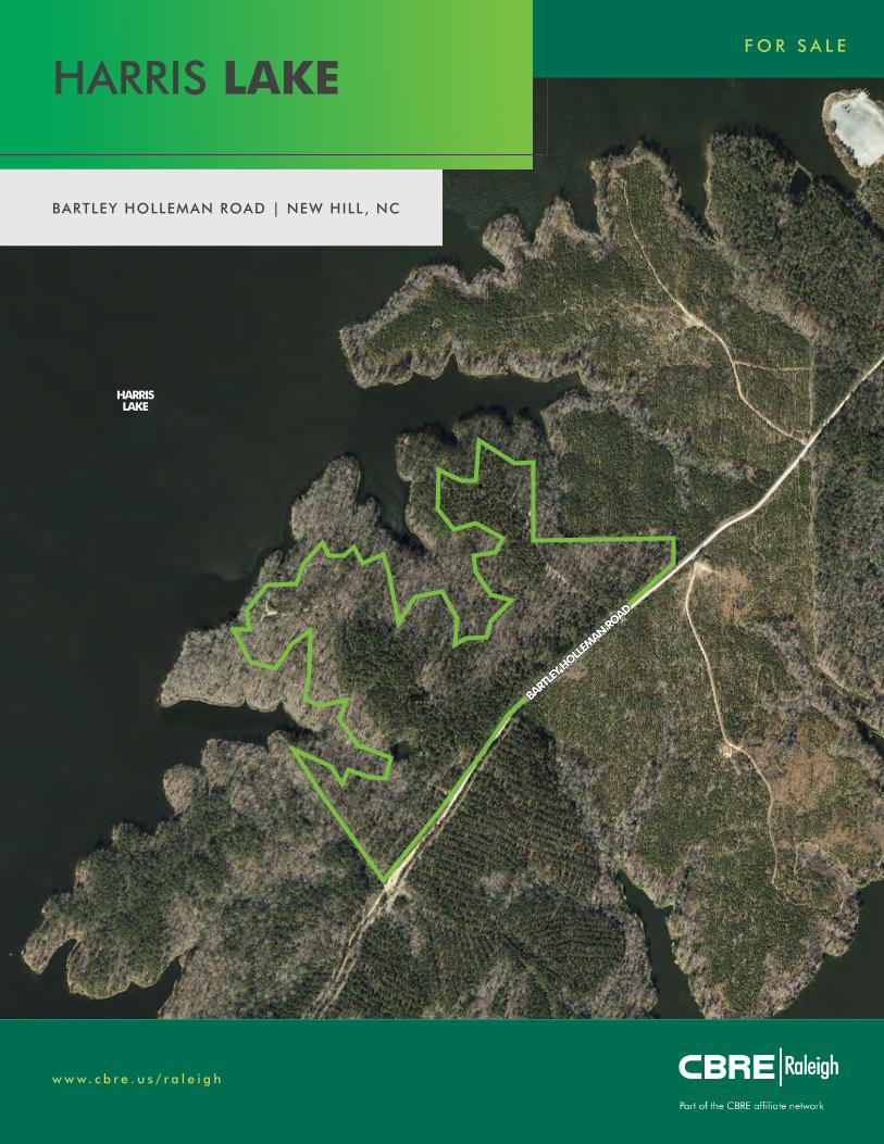
www.cbre.us/raleigh BARTLEY HOLLEMAN ROAD | NEW HILL, NC FOR SALE HARRIS LAKE BARTLEY HOLLEMAN ROAD BARTLEY HOLLEMAN ROAD HARRIS HARRIS LAKE LAKE
DisclaimeriMaps makes every effort to produce and publish the most current and accurate information possible.However, the maps are produced for information purposes,and are NOT surveys. No warranties, expressed or implied,are provided for the data therein, its use,or its interpretation.
0 870 1,740435 ft
1 inch = 400 feet
±
w w w. c b r e . u s / r a l e i g h
BARTLEY HOLLEMAN ROAD | NEW HILL , NC
F O R S A L E
HARRIS LAKE
BART
LEY H
OLLEMAN RO
AD
BART
LEY H
OLLEMAN RO
AD
HARRIS HARRIS LAKELAKE
DisclaimeriMaps makes every effort to produce and publish the most current and accurate information possible.However, the maps are produced for information purposes,and are NOT surveys. No warranties, expressed or implied,are provided for the data therein, its use,or its interpretation.
0 870 1,740435 ft
1 inch = 400 feet
±
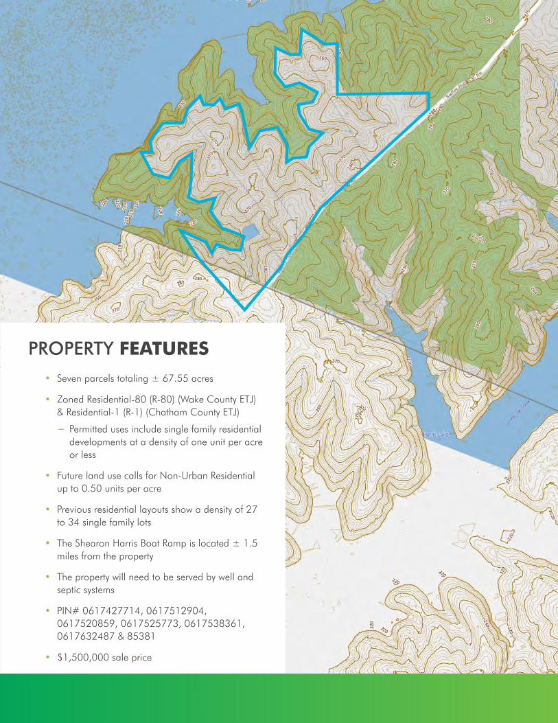
PROPERTY FEATURES• Seven parcels totaling ± 67.55 acres
• Zoned Residential-80 (R-80) (Wake County ETJ) & Residential-1 (R-1) (Chatham County ETJ)
− Permitted uses include single family residential developments at a density of one unit per acre or less
• Future land use calls for Non-Urban Residential up to 0.50 units per acre
• Previous residential layouts show a density of 27 to 34 single family lots
• The Shearon Harris Boat Ramp is located ± 1.5 miles from the property
• The property will need to be served by well and septic systems
• PIN# 0617427714, 0617512904, 0617520859, 0617525773, 0617538361, 0617632487 & 85381
• $1,500,000 sale price

PROPERTY LAYOUT• Top layout:
− 27 lots; 12 potential waterfront lots
− Sizes average between 1.75 and 2.25 acres
− Community well
• Left layout:
− 34 lots; 17 potential waterfront lots
− Sizes average around 1 and 1.5 acres
© 2019 CBRE Limited. Data © TeleAtlas, Google, AerialExpress, DigitalGlobe, Landiscor, USGS, i-cubed. The information contained herein (the “Information”) is intended for informational purposes only and should not be relied upon by recipients hereof. Although the Information is believed to be correct, its accuracy, correctness or completeness cannot be guaranteed and has not beenverified by either CBRE Limited or any of its affiliates (CBRE Limited and its affiliates are collectively referred to herein as “CBRE”). CBRE neither guarantees, warrants nor assumes any responsibility or liability of any kind with respect to the accuracy, correctness, completeness, or suitability of, or decisions based upon or in connection with, the Information. The recipient of the Informationshould take such steps as the recipient may deem appropriate with respect to using the Information. The Information may change and any property described herein may be withdrawn from the market at any time without notice or obligation of any kind on the part of CBRE. The Information is protected by copyright and shall be fully enforced.
Layout ID:P04 MapId:6670728
540
1
1
64
401
401
55
55
55
751
I-540 PLANNED EXT.
HOLLY SPRINGSHOLLY SPRINGS
FUQUAY VARINAFUQUAY VARINA
NEW HILLNEW HILL
APEXAPEX
CARYCARY
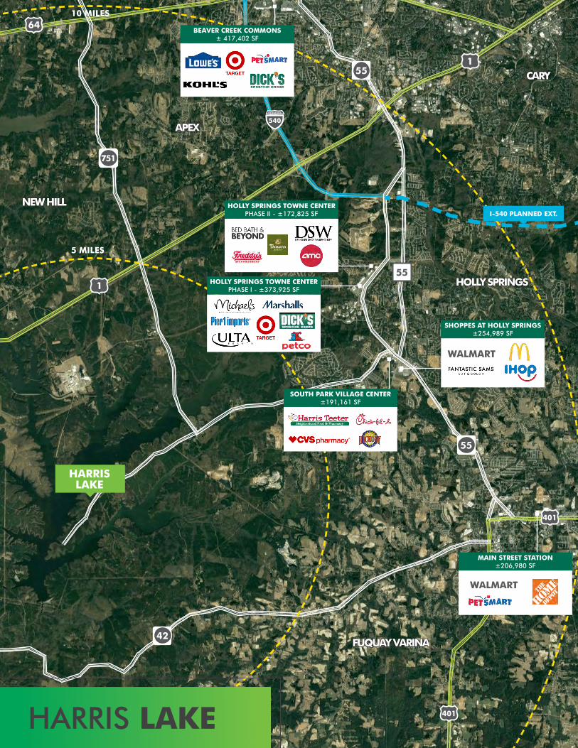
HOLLY SPRINGS TOWNE CENTER PHASE I - ±373,925 SF
HOLLY SPRINGS TOWNE CENTER PHASE II - ±172,825 SF
SOUTH PARK VILLAGE CENTER±191,161 SF
SHOPPES AT HOLLY SPRINGS±254,989 SF
WALMART
BEAVER CREEK COMMONS± 417,402 SF
MAIN STREET STATION±206,980 SF
WALMART
HARRISLAKE
HARRIS LAKE
5 MILES
10 MILES
42
RTP
CARY
MORRISVILLE
APEX
ALAMANCECOUNTY
LEECOUNTY
Pittsboro
HILLSBOROUGH
Knightdale
Rolesville
WakeForest
Creedmoor Franklinton Louisburg
DURHAMCHAPEL
HILL
Eli Whitney
Oaks
Teer
Haw�elds
Mandale
Bynum
Fearrington
Gulf
Fuquay-Varina
Clayton
Smithfield
Wakefield
Eno Trace
Eno
Bunn
Meadowmont
CARRBORO
HollySprings
GARNER
ZebulonWendell
E. Center St.
S. 5
th S
t.
S. 3rd
St. Ext.
Chapel Hill Rd.
S. C
hurt
on S
t.
Old State Hwy 10
Plea
sant G
reen
Rd.
Cole Mill Rd.
N. Roxboro Rd.
W. B
. St.
Baptist Church Rd.
Sledge Rd.
Mor
t Har
ris R
d.
Edw
a rd
Best
Rd.
S. N
ash
St.
S. Pol
lock
St.
Bagley Rd.
Monroe Pittsboro Rd.
Deep R
iver R
d.
Haw
kins
Ave
.
Je�erson Davis
Hwy.
Carbonton Rd.
N. P
ark
Rd.
Thorn R d .
Sanford-LeeCounty Regional
Airport
FallsLake
B. EverettJordan Lake
Shearon HarrisReservoir
LakeWheeler
LakeBenson
LakeCrabtree
LakeJohnson
Eno RiverState Park
70
86
70
70
70
87
85
85
15
15
85
85
8540
54
54
86
86
50115
50115
50115
70BYP
70BUS
16487
902
64
64
64
1
1
55
401
401
40
540
40
40
40
50115
50115
50115
64BYP
64BUS
96
96
70
1
1
96
64
64
401
401
39
39
56
39
98
98
96
540
540
440
440
40
540
95
95
147
147
147
50
64
264
264
64
70
70
231
231
222
222
96
1
42
42
42
39
39
39
64
64
301
301
98
97
97
581
96
96
210210
42
42
540
50
40
40
264
264
70
70
70
70
70
70
70
401
42
42
42
42
210
55401
401
902
1
50115
421
421
421BYP
40
56
581
RALEIGHUmsteadState Park
DowntownRaleigh
RDUAirport
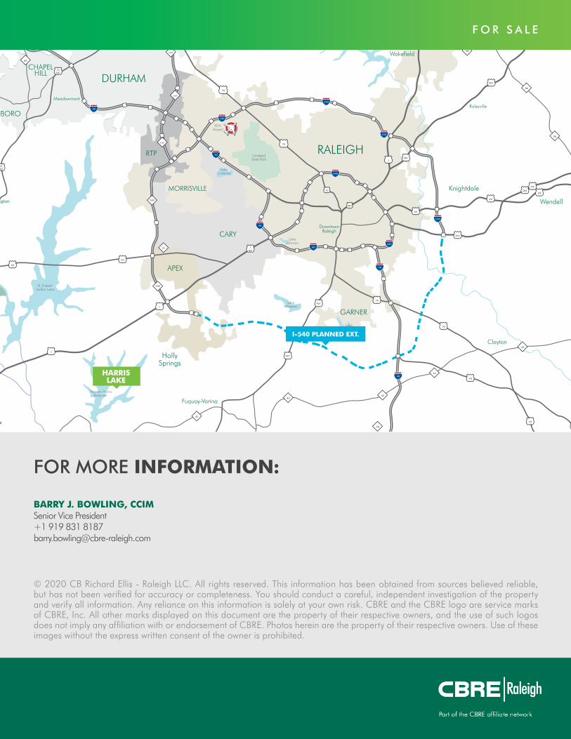
540
F O R S A L E
© 2020 CB Richard Ellis - Raleigh LLC. All rights reserved. This information has been obtained from sources believed reliable, but has not been verified for accuracy or completeness. You should conduct a careful, independent investigation of the property and verify all information. Any reliance on this information is solely at your own risk. CBRE and the CBRE logo are service marks of CBRE, Inc. All other marks displayed on this document are the property of their respective owners, and the use of such logos does not imply any affiliation with or endorsement of CBRE. Photos herein are the property of their respective owners. Use of these images without the express written consent of the owner is prohibited.
HARRISLAKE
I-540 PLANNED EXT.
BARRY J. BOWLING, CCIMSenior Vice President+1 919 831 [email protected]
FOR MORE INFORMATION:


