140
HARYANA SERIES-07 PART XII-B DISTRICT CENSUS HANDBOOK VILLAGE AND TOWN WISE PRIMARY CENSUS ABSTRACT (PCA) PANCHKULA DIRECTORATE OF CENSUS OPERATIONS HARYANA Census of India 2011

HARYANA
SERIES-07 PART XII-B
DISTRICT CENSUS HANDBOOK
VILLAGE AND TOWN WISE
PRIMARY CENSUS ABSTRACT (PCA)
PANCHKULA
DIRECTORATE OF CENSUS OPERATIONS
HARYANA
Census of India 2011


CENSUS OF INDIA 2011 HARYANA
SERIES-07 PART XII - B
DISTRICT CENSUS HANDBOOK
PANCHKULA
VILLAGE AND TOWN WISE
PRIMARY CENSUS ABSTRACT (PCA)
Directorate of Census Operations HARYANA

MOTIF
Shri Mata Mansa Devi Temple
Mata Mansa Devi is a Hindu temple dedicated to goddess Mansa Devi, a form of Shakti, in Panchkula district. The temple complex is spread over 100 acres (0.40 km2) in the Shivalik foothills in village Bilaspur, near Mani Majra and Panchkula towns.
It is one of the prominent Shakti temples of North India. Thousands of devotees visit the shrine from various parts of the country especially during the Navratra mela. This number rises to lakhs everyday for the nine auspicious days. Shardiya Navratra Mela is organized at the shrine complex during Chaitra and Ashvin months.
Maharaja Gopal Singh of Mani Majra constructed the present main temple of Shri Mansa Devi, which is situated in the Shivalik foothills in village Bilaspur, Tehsil and District Panchkula, during the period 1811-1815. At a distance of 200 meters from the main temple is the Patiala temple which was constructed by Karam Singh, the then Maharaja of Patiala in the year 1840. This temple had the patronage of Manimajra State.
The temple complex and its environment are presently looked after by Shri Mata Mansa Devi Shrine Board (SMMDSB), Panchkula. In view of the popularity of the temple for its mythological and historical significance and also for fulfilling the wishes of the lakhs of devotees thronging the complex, Haryana Government took over the control of this temple in 1991 to provide better infrastructure development, management, administration and governance of Shri Mata Mansa Devi Shrine and its endowments including lands and buildings attached to the Shrine. The Shrine Board was constituted for running of the Temple and preserving the heritage of the region.

Pages
1 1
2 3
3 4
4 5
5 7
6 9
7 12
8 13
9
(i) 16
(ii) 21
(iii) 29
(iv) 47
(v) 55
(vi) 57
(vii) 101
10 Section –II Tables based on Households Amenities and Assets (Rural/Urban) at District and Sub-District level.
(i) Table -1: Households by Ownership status and by Number of Dwellingrooms occupied in the District, 2011 117
Contents
Administrative Setup
Important Statistics
District Highlights - 2011 Census
Brief History of the District
Foreword
Preface
Acknowledgement
History and Scope of the District Census Handbook
Urban PCA-Town wise Primary Census Abstract
Section - I Primary Census Abstract (PCA)
Brief note on Primary Census Abstract
District Primary Census Abstract
Appendix to District Primary Census Abstract Total, Scheduled Castes andScheduled Tribes Population - Urban Block wise
Primary Census Abstract for Scheduled Castes (SC)
Primary Census Abstract for Scheduled Tribes (ST)
Rural PCA-C.D. blocks wise Village Primary Census Abstract
(ii) Table -2: Percentage distribution of Households living in Permanent,Semi permanent and Temporary houses, 2011 118
(iii) Table -3: Number and Percentage of Households by main source ofDrinking water, 2011 120
(iv) Table -4: Number and Percentage of Households by main source ofLighting, 2011 122
(v) Table -5: Number and Percentage of Households by type of Latrinefacility, 2011 124
(vi) Table -6: Number and Percentage of Households by type of Drainageconnectivity for waste water outlet, 2011 126
(vii) Table -7: Number and Percentage of Households by availability ofKitchen facility, 2011 127
(viii) Table -8: Number and Percentage of Households by type of fuel used forCooking, 2011 128
(ix) Table -9:Number and Percentage of Households availing Bankingservices and number of Households having each of thespecified Assets, 2011
130
1
FOREWORD
The District Census Handbook (DCHB) is an important publication of the CensusOrganization since 1951. It contains both Census and non Census data of urban and rural areas for each District. The Census data provide information on demographic and socio-economic characteristics of population at the lowest administrative unit i.e. of each Village, Town and Ward of the District. The Primary Census Abstract (PCA) part of this publication contains Census data including data on household amenities collected during 1st phase of the Census i.e. House Listing and Housing Census. The non Census data presented in the DCHB is in the form of Village Directory and Town Directory contain information on various infrastructure facilities available in the village and town viz; education, medical, drinking water, communication and transport, post and telegraph, electricity, banking, and other miscellaneous facilities. Later on, the Telegraph Services were closed by the Government of India on 15th July, 2013. The data of DCHB are of considerable importance in the context of planning and development at the grass-root level.
2. In the 1961 Census, DCHB provided a descriptive account of the District, administrativestatistics, Census tables and Village and Town Directory including Primary Census Abstract. This pattern was changed in 1971 Census and the DCHB was published in three parts: Part-A related to Village and Town Directory, Part-B to Village and Town PCA and Part-C comprised analytical report, administrative statistics, District Census tables and certain analytical tables based on PCA and amenity data in respect of Villages. The 1981 Census DCHB was published in two parts: Part-A contained Village and Town Directory and Part-B the PCA of Village and Town including the SCs and STs PCA up to Tahsil/Town levels. New features along with restructuring of the formats of Village and Town Directory were added. In Village Directory, all amenities except electricity were brought together and if any amenity was not available in the referent Village, the distance in broad ranges from the nearest place having such an amenity, was given.
3. The pattern of 1981 Census was followed by and large for the DCHB of 1991 Censusexcept the format of PCA. It was restructured. Nine-fold industrial classification of main workers was given against the four-fold industrial classification presented in the 1981 Census. In addition, sex wise population in 0-6 age group was included in the PCA for the first time with a view to enable the data users to compile more realistic literacy rate as all children below 7 years of age had been treated as illiterate at the time of 1991 Census. One of the important innovations in the 1991 Census was the Community Development Block (CD Block) level presentation of Village Directory and PCA data instead of the traditional Tahsil/Taluk/PS level presentation.
4. As regards DCHB of 2001 Census, the scope of Village Directory was improved byincluding some other amenities like banking, recreational and cultural facilities, newspapers & magazines and `most important commodity’ manufactured in a Village in addition to prescribed facilities of earlier Censuses. In Town Directory, the statement on Slums was modified and its coverage was enlarged by including details on all slums instead of ‘notified slums’.
5. The scope and coverage of Village Directory of 2011 DCHB has been widened by includinga number of new amenities in addition to those of 2001. These newly added amenities are: Pre-Primary School, Engineering College, Medical College, Management Institute, Polytechnic, Non-formal Training Centre, Special School for Disabled, Community Health Centre, Veterinary Hospital, Mobile Health Clinic, Medical Practitioner with MBBS Degree,
2
Medical Practitioner with no degree, Traditional Practitioner and faith Healer, Medicine Shop, Community Toilet, Rural Sanitary Mart or Sanitary Hardware Outlet in the Village, Community Bio- gas, Sub Post Office, Village Pin Code, Public Call Office, Mobile Phone Coverage, Internet Cafes/ Common Service Centre, Private Courier Facility, Auto/Modified Autos, Taxis and Vans, Tractors, Cycle-pulled Rickshaws, Carts driven by Animals, Village connected to National Highway, State Highway, Major District Road, and Other District Road, Availability of Water Bounded Macadam Roads in Village, ATM, Self-Help Group, Public Distribution System(PDS) Shop, Mandis/Regular Market, Weekly Haat, Agricultural Marketing Society, Nutritional Centers (ICDS), Anganwadi Centre, ASHA (Accredited Social Health Activist), Sports Field, Public Library, Public Reading Room, Assembly Polling station, Birth & Death Registration Office. In the Town Directory, seven Statements containing the details and the data of each Town have been presented viz.; (i)-Status and Growth History of Towns,(ii)- Physical Aspects and Location of Towns, (iii)-Civic and other Amenities, (iv)-Medical Facilities, (v)-Educational, Recreational & Cultural Facilities, (vi)- Industry & Banking, and (vii)- Civic & other amenities in Slums respectively. CD Block wise data of Village Directory and Village PCA have been presented in DCHB of 2011 Census as presented in earlier Census. 6. The data of DCHB 2011 Census have been presented in two parts, Part-A contains Village and Town Directory and Part-B contains Village and Town wise Primary Census Abstract. Both the Parts have been published in separate volumes in 2011 Census. 7. The Village and Town level amenities data have been collected, compiled and computerized under the supervision of Smt. Neerja Sekhar, IAS, Director of Census Operation, Haryana. The task of Planning, Designing and Co-ordination of this publication was carried out by Dr. Pratibha Kumari, Assistant Registrar General (SS) under the guidance & supervision of Dr. R.C.Sethi, Ex-Addl. RGI and Shri Deepak Rastogi present Addl.RGI. Shri A.P. Singh, Deputy Registrar General, (Map) provided the technical guidance in the preparation of maps. Shri A.K. Arora, Joint Director of Data Processing Division under the overall supervision of Shri M.S.Thapa, Addl. Director (EDP) provided full cooperation in preparation of record structure for digitization and validity checking of Village and Town Directory data and the programme for the generation of Village Directory and Town Directory including various analytical inset tables as well as Primary Census Abstract (PCA). The work of preparation of DCHB, 2011 Census has been monitored in the Social Studies Division. I am thankful to all of them and others who have contributed to bring out this publication in time.
(C.Chandramouli) Registrar General &
Census Commissioner, India New Delhi. Dated:- 16-06-2014

3
Preface The District Census Handbook (DCHB) is one of the important and
most valuable publications of Census Organisation which is brought out for each district. It contains several demographic and socio-economic characteristics village-wise and town-wise of the district along with the status of availability of civic amenities, infrastructural facilities etc.
DCHB reflects an overview of the district and is widely used by administrators, planners, academicians, researchers, various departments and general public. For DCHB publication, population data was taken from Census 2011, whereas non-census data was collected with the active collaboration of State Govt.
The Census 2011 was conducted under the able guidance of Dr. C. Chandramouli, IAS, Registrar General & Census Commissioner, India. The credit of the successful accomplishment of this huge task goes to him for his tremendous and spontaneous work. On behalf of this Directorate I am highly grateful to him and also extend my thanks to Sh. Deepak Rastogi, Additional Registrar General for timely guidance. I extend my thanks to Dr. Pratibha Kumari, Assistant Registrar General (Social Studies), under whose guidance this publication was finalised. Further I extend my special thanks to Sh. A. P. Singh, Deputy Registrar General (MAP) and Sh. A.K. Arora, Joint Director, EDP, who took great pains in bringing out this publication.
I am very grateful on behalf of this Directorate to Smt. Neerja Sekhar, IAS, the then Director under whose able guidance the specified task was mostly completed and I would like to acknowledge all the staff members of DCO Haryana, particularly the team headed by Sh. Vinod Kumar Babbar, DDCO, Sh. B.V.L. Sai Sekhar, the then ADCO and the entire team of DCO Haryana. Lastly I record my appreciation for the best efforts put in by the staff of DCHB, Map and Census Sections.
I hope this publication will provide more useful information for all the data users.
Chandigarh G. Bapuji 18-06-2014 JDCO, Haryana.

4
Acknowledgement
Drafting of DCHB Sh. Amarjit Singh Toor Assistant Director (Retd.) Ms. Kavita Panchal St. Investigator Gr. II Editing and Scrutiny of DCHB Sh. Vinod Kumar Babbar Deputy Director Finalisation of DCHB Sh. G. Bapuji Joint Director DCHB Section Ms. Kavita Panchal St. Investigator Gr. II Sh. Amrit Lal St. Investigator Gr. II Sh. Lekh Raj St. Investigator Gr. II
Sh. Nagesh Kumar Seth (Retd.) St. Investigator Gr. II Sh. R.K. Yadav (Retd.) St. Investigator Gr. II
Ms. Anju Sem Senior Drawing Assistant Ms. Rashmi Saini Compiler Map Section Sh. Tej Pal Singh Research Officer Dr. Radha Raman Senior Geographer Sh. Vidya Sagar Senior Draftsman Ms. Neelam Lakhanpal Senior Draftsman Sh. Ashwani Kumar Senior Draftsman Sh. Gautam Kumar Roy Senior Draftsman Printing Section Sh. K.M. Deshmukh Proof Reader Others associated with the Project Sh. Om Prakash St. Investigator Gr. II Ms. Raksha Devi Sr. Compiler Ms. Ram Dasso Compiler Ms. Pinki L.D.C. ORGI- Data Processing Division
Sh. Jaspal Singh Lamba Deputy Director (EDP) Ms. Usha Assistant Director (EDP) Sh. Anurag Gupta DPA Grade ‘A’ Sh. Mukesh Kumar Mahawar DPA Grade ‘A’ Ms. Shagufta Nasreen Bhat DPA Grade ‘A’ Ms. Shashi Seth Sr. Supervisor Sh. Khem Verma Jadon Sr. Consultant Sh. Yashwant Singh Jr. Consultant

5
HISTORY AND SCOPE OF THE DISTRICT CENSUS HANDBOOK
The need of data at the grass root level for the administrative and planning purposes at sub micro level as well as academic studies prompted the innovation of District Census Handbook. District Census Handbook is a unique publication from the Census organization which provides most authentic details of census and non-census information from village and town level to district level. The District Census Handbook was firstly introduced during the 1951 Census. It contains both census and non census data of urban as well as rural areas for each district. The census data contain several demographic and socio-economic characteristics of the lowest administrative unit i.e. of each village and town and ward of the district. The non census data comprise of data on availability of various civic amenities and infrastructural facilities etc. at the town and village level which constitute Village Directory and Town Directory part of the DCHB. The data of DCHB are of considerable importance in the context of planning and development at grass-root level.
In 1961 census DCHB provided a descriptive account of the district, administrative statistics, census tables and village and town directory including Primary Census Abstract. This pattern was changed in 1971 Census and the DCHB was published in three parts: Part-A related to village and town directory, Part-B to village and town PCA and Part-C comprised analytical report, administrative statistics, district census tables and certain analytical tables based on PCA and amenity data in respect of villages. The 1981 census DCHB was published in two parts: Part-A contained village and town directory and Part-B the PCA of village and town including the SCs and STs PCA up to tahsil/town levels. New features along with restructuring of the formats of village and town directory were added into it. In Village Directory, all amenities except electricity were brought together and if any amenity was not available in the referent village, the distance in broad ranges from the nearest place having such an amenity, was given. The pattern of 1981 census was followed by and large for the DCHB of 1991 Census except the format of PCA. It was restructured. Nine-fold industrial classification of main workers was given against the four-fold industrial classification presented in the 1981 census. In addition, sex wise population in 0-6 age group was included in the PCA for the first time with a view to enable the data users to compile more realistic literacy rate as all children below 7 years of age had been treated as illiterate at the time of 1991 census. One of the important innovations in the 1991 census was the Community Development Block (CD Block) level presentation of village directory and PCA data instead of the traditional tahsil/taluk/PS level presentation.

6
As regards DCHB of 2001 Census, the scope of Village Directory was improved by including some other amenities like banking, recreational and cultural facilities, newspapers & magazines and `most important commodity’ manufactured in a village in addition to prescribed facilities of earlier censuses. In Town Directory, the statement on Slums was modified and its coverage was enlarged by including details on all slums instead of ‘notified slums’.
The scope and coverage of Village Directory of 2011 DCHB has been widened by including a number of new amenities in addition to those of 2001. In the Town Directory, seven Statements containing the details and the data of each town have been presented viz.; (i)-Status and Growth History of towns,(ii)- Physical Aspects and Location of Towns, (iii)-Civic and other Amenities, (iv)-Medical Facilities, (v)-Educational, Recreational & Cultural Facilities, (vi)- Industry & Banking, and (vii)- Civic & other amenities in Slums respectively. CD Block wise data of Village Directory and Village PCA have been presented in DCHB of 2011 census as presented in earlier census. The data of DCHB 2011 Census have been presented in two parts, Part-A contains Village and Town Directory and Part-B contains Village and Town wise Primary Census Abstract. Both the Parts have been published in separate volumes in 2011 Census.
--------------------------------------------------------

7
Brief History of the District
The district derives its name from ‘Panch’ meaning five and ‘kuhls’ meaning natural springs which are located in the area. The antiquity of the region can be traced back to pre-historic times as Pinjore, the famous historical town finds its mention in ancient Indian literature. Towards the close of the seventh century and first half of the eighth century the district fell a prey to the imperial ambitions of Yasovarman of Kanauj and Lalitaditya, the ruler of Kashmir. It was included in the empire of Parthian Mihira Bhoja (AD 833 – AD 890) which extended upto the Takkadesa in the north. In the tenth century AD Mahmud Ghazni and his successors raided this tract several times. During the 12th Century AD, peace and order was restored in the area by the Chauhanas of Delhi. The area finally passed on to the muslim rule as a result of the decisive victory of Shihab-ud-din Ghuri over Prithviraja III(AD 1192). In the medieval period, Pinjore finds its mention in Minhaj-ud-din bin Siraj-ud-din‘s Tabakat-I-Nasiri. Sultan Nasirudin Mohammed plundered the riches of Pinjore in AD 1254. The place was again ravaged by Timur on his way back from Delhi. After the departure of Timur, confusion prevailed over large part of northwestern India. In 1450, Bahlol Lodhi, the then Governor of Punjab brought the area under his sway which lasted, under him and his successors, right until 1526 when the Great Mughal emperor Babur wrested the areas from Lodhis. During the reign of Aurangzeb, Fidai khan, Aurangzeb’s Master of Ordnance laid a beautiful Mughal garden at Pinjore. After Aurangzeb’s death in 1707, political position changed and various forces rose in opposition to the empire. Banda Bahadur, a disciple of Guru Gobind Singh, launched a fierce attack on this region and ravaged the major part of the then Ambala district which also included the present Panchkula district. In 1710 Banda Bahadur gave a tough fight to the Mughals at Sadhaura but lost the ground. Nadir Shah plundered the region in 1739. After his retreat, many ambitious powers occupied the territories and they could be dotted with a number of small principalities important among them were Ramgarh, Raipur, Kotaha and Khizrabad. In 1755 Adina Beg overpowered Qutab Shah at Karnal. With this daring feat of Adina Beg, Delhi authorities were pleased and gave to him the entire sirkar of Sirhind which also included the then Ambala region. Later, since 1757 Ahmed Shah Abdali made several invasions for several years. In 1763, the Sikhs slew Abdali‘s Governor Zain Khan and several misaldars from central Punjab occupied this region.
The British came on the scene in 1805. Power of Sikh chiefs in Ambala region was completely broken by this time. After taking the chiefs in the Ambala area under their protection, the British controlled the affairs of all the States in the region in a most effective manner through the political agency at Ambala. In 1845, when the first Anglo- Sikh war broke out, the Sikh chiefs showed open hostility to the British which resulted in curtailment of their privileges in 1846. The region played a significant part in the uprising of 1857. During the freedom movement Lala Murlidhar of Ambala toured the areas of the district and exhorted the people to rise against the British government. The people took part with full commitment in non-cooperation movement and the civil disobedience movement organized by Mahatma Gandhi.

8
As elsewhere in the country, the then Ambala district, which also included the present Panchkula district, had played a significant role in the uprising of the mutiny of 1857. The Indian troops stationed at Ambala and the civilian population of the district too,were vaguely disaffected towards the Colonial rule. Although the mutiny of 1857 was suppressed by the British, it gained sufficient ground for political struggle thereafter. Many socio-religious organizations emerged on the scene.
Lala Murlidhar of Ambala (1850-1924) was one of the founding fathers of the Indian National Congress at Bombay in 1885. Though the people of Ambala district helped the government during First World War by joining army and contributing to war loans and funds, yet after the war was over the people felt disaffected as thousands of recruits were discharged from the army which gave an opportunity to the discontented people to join the Non-Co-operation Movement of Mahatma Gandhi in 1919 and Civil Disobedience Movement in 1930. The Swadeshi Movement gained great momentum, both in the urban as well as in rural areas. Quit India Movement was launched in 1942. Although the movement failed by 1944 due to suppressive methods adopted by the colonial government, yet the people gave them a tough fight. After a great deal of sacrifices to the cause of freedom, as done by our countrymen elsewhere too, the country got Independence on 15th August, 1947.
At the time of Independence, the then Ambala district formed part of the erstwhile Punjab State and included Kharar, Ropar, Naraingarh, Ambala and Jagadhri tahsils. The district experienced jurisdictional changes thereafter. Under the Provinces and States Order in 1950 Ambala district lost Kasauli and Sanawar to Kohistan district and 17 villages to Fatehgarh Sahib district of PEPSU and gained 6 villages from Patiala district and 115 villages alongwith some forest area from erstwhile Kalsia State. In 1959 Nalagarh tahsil and Pinjore circle were added to Kharar tahsil. It was on 1st November, 1966 that a new State of Haryana comprising the districts of Ambala, Karnal, Panipat, Rohtak, Mahendragarh, Hisar and Jind was carved out of the then Punjab State. At the time of formation of Haryana State on November 1, 1966, Ambala district lost Kharar tahsil and Ropar tahsil to Ropar district in Punjab and Nalagarh tahsil to Himachal Pradesh. Kalka tahsil was created out of Naraingarh tahsil in 1967. Later, in 1989 Panchkula tahsil was created out of Naraingarh tahsil. Panchkula district came into being in August 1995. It was a newly added district at the Census 2001 and formed part of Ambala division.

9
Administrative set up
The State has been experiencing inter-district and inter-tahsil jurisdictional transfers ever since its formation on Ist November, 1966. There were 7 districts at the 1971 Census which increased to 12 in 1981, 16 in 1991, 19 in 2001 and 21 in 2011. Likewise the number of tahsils has increased from 32 to 74 and towns from 65 to154 in 1971and 2011 respectively.
Haryana State is divided into four administrative Divisions, namely
Ambala, Rohtak, Hisar and Gurgaon, each headed by Divisional Commissioner. Ambala Division covered Panchkula, Ambala, Yamunanagar, Kurukshetra and Kaithal districts; Rohtak Division extended over Karnal, Panipat, Sonipat, Rohtak and Jhajjar districts; Hisar Division is spread over Jind, Bhiwani, Hisar, Fatehabad and Sirsa districts; Gurgaon Division is spread over Mahendragarh, Rewari, Gurgaon, Mewat, Faridabad and Palwal districts. Panchkula town was given the status of tahsil on 1st November, 1989 and Sub Divisional Headquarter was shifted here from Kalka. Kalka was again upgraded to Sub-Division in 1993.
Panchkula district was created in August, 1995 by transferring all the
106 villages of Kalka tahsil, Kalka M.C., H.M.T. Pinjore M.C.and Pinjore (Rural) Census Town, Panchkula tahsil having 92 villages and Panchkula Urban Estate town and 45 villages of Naraingarh tahsil of Ambala district. Further, six villages of Kalka tahsil, namely; Deval (HB114), Ratpur (HB116), Dharampur (HB152), Ferozepur (HB117), Abdulapur (HB115) had been fully merged in Pinjore MC along with parts of area of some surrounding villages. Village Baglana (HB112) was either under Pinjore MC or under H.M.T. Pinjore which was treated as outgrowth of Pinjore MC. Hence the whole village had been treated as urban and got excluded from the village list. Pinjore (Rural) Census Town had been notified as Pinjore M.C. In Panchkula tahsil one village viz. Raipur Rani (HB6) had been treated as Census Town and thus excluded from the list of villages of Panchkula tahsil. In 2001 Census, Panchkula district consisted of two tahsils, Kalka and Panchkula. Kalka tahsil contained 100 villages and two towns namely, Kalka M.C. and Pinjore M.C. Panchkula tahsil comprised of 136 villages and two towns namely Panchkula Urban Estate and Raipur Rani Census town.
During 2001-11, due to jurisdictional changes number of villages came down from 236 to 219 and number of towns increased from 4 to 8. One village namely, Khera Sita Ram of Kalka tahsil has been treated as outgrowth of Kalka Urban Agglomeration; 13 villages of Panchkula tahsil had been merged in Panchkula MCL in January, 2001 and three villages, namely, Chandi Mandir, Bir Ghaghar and Ramgarh have been treated as Census Towns in 2011, hence excluded from the village list of Panchkula tahsil. The present status of Panchkula district in 2011 census is that, the number of tahsils are the same i.e. Kalka and Panchkula. Kalka tahsil contains 99 villages and 3 towns, namely Kalka MC, Pinjore MC, and HMT Pinjore Census Town. Panchkula tahsil includes 120 villages and five towns namely Panchkula MCL, Chandi Mandir C.T., Bir Ghaghar C.T., Ramgarh C.T. and Raipur Rani C.T.

10
Administratively, the Deputy Commissioner is the overall in charge of the general administration in the district and performs the duties of the District Magistrate and the District Collector. Below the Deputy Commissioner is the Additional Deputy Commissioner who assists the Deputy Commissioner in the work relating to general administration, rural development, etc. The Deputy Commissioner along with ADC, Chief Executive Officer of Zila Parishad, Superintendent of Police and other senior officers of the district looks after the development and regulatory functions in the district.
JURISDICTIONAL CHANGES 2001- 2011, DISTRICT PANCHKULA
Name of District /
Tahsil
Number of villages
Number of
Villages Newly
Created
Number of Towns
Changes since 2001 and Government Notification Number*
2001 2011 2001 2011 1 2 3 4 5 6 7
District Panchkula
236 219 - 4 8 13 Villages have been merged in Panchkula MCL vide Notification no. 18/4/96-2C1 dated 25th January 2001. Village Khera Sitaram declared as Out Growth of Kalka U.A..
1.TahsilKalka
100 99 - 2 3 Village Khera Sitaram declared as Out Growth.
2.TahsilPanchkula
136 120 - 2 5 13 Villages have been merged in Panchkula MCL vide Notification no. 18/4/96-2C1 dated 25th January 2001. 3 Villages namely Chandi Mandir(391), Bir Ghaghar(392) and Ramgarh(232) have been treated as census towns in 2011 census.
*Source: Financial commissioner, Revenue Deptt. Haryana.
To decentralize the authority in the administrative set up, the district is divided into two sub-divisions, Kalka and Panchkula. Sub-divisions are not necessarily co-terminus with the name of their respective tahsils. However, in Panchkula district both the tahsils have sub-divisional status also. Zila Parishad and Panchayat Samitis correspond to the district and C.D. Block boundaries respectively except that the municipal areas are not covered by them.
The Zila Parishad, elects its President and Vice-President from amongst the elected members. The term of office of members is five years. An officer in the senior scale of I.A.S. is deputed by the State government as the Chief Executive Officer to the Zila Parishad. The Parishad is also assisted by various departments of the district. At the community Development Block level, each Panchayat Samiti has an elected Chairman and Vice Chairman. The Block Development and Panchayat Officer works as Executive Officer of
11
the Panchayat Samiti. The executive authority for the purpose of carrying out the provisions of the Haryana Zila Parishad and Panchayat Samitis (C.D. Blocks) Act vests in the Chief Executive Officer and the Block Development and Panchayat Officer respectively.
The statutory urban local bodies are municipal councils, municipal committees, etc. The urban local bodies elect councilors from each of the ward and their term is five years.
Process of governance at the lowest level is Gram Panchayat which makes adequate arrangements for development in various fields in rural areas.
12
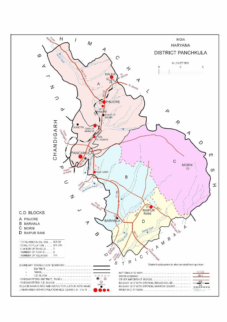
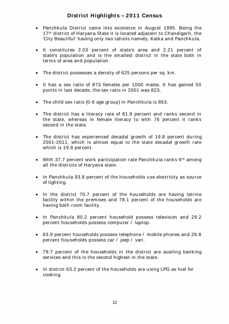
District Highlights – 2011 Census
Panchkula District came into existence in August 1995. Being the17th district of Haryana State it is located adjacent to Chandigarh, the‘City Beautiful’ having only two tahsils namely, Kalka and Panchkula.
It constitutes 2.03 percent of state’s area and 2.21 percent ofstate’s population and is the smallest district in the state both interms of area and population.
The district possesses a density of 625 persons per sq. km.
It has a sex ratio of 873 females per 1000 males. It has gained 50points in last decade, the sex ratio in 2001 was 823.
The child sex ratio (0-6 age group) in Panchkula is 863.
The district has a literacy rate of 81.9 percent and ranks second inthe state, whereas in female literacy to with 76 percent it rankssecond in the state.
The district has experienced decadal growth of 19.8 percent during2001-2011, which is almost equal to the state decadal growth ratewhich is 19.9 percent.
With 37.7 percent work participation rate Panchkula ranks 6th amongall the districts of Haryana state.
In Panchkula 93.8 percent of the households use electricity as sourceof lighting.
In the district 70.7 percent of the households are having latrinefacility within the premises and 78.1 percent of the households arehaving bath room facility.
In Panchkula 80.2 percent household possess television and 29.2percent households possess computer / laptop.
83.9 percent households possess telephone / mobile phones and 26.8percent households possess car / jeep / van.
79.7 percent of the households in the district are availing bankingservices and this is the second highest in the state.
In district 63.2 percent of the households are using LPG as fuel forcooking.

Number of Villages Total 6,841 219
Inhabited 6,642 206
Uninhabited 199 13
Number of Towns Statutory 80 3
Census 74 5
Total 154 8
Number of Households Normal 4,835,765 116,195
Institutional 10,124 586
Houseless 11,635 326
Population Total Persons 25,351,462 561,293
Males 13,494,734 299,679
Females 11,856,728 261,614
Rural Persons 16,509,359 248,063
Males 8,774,006 133,153
Females 7,735,353 114,910
Urban Persons 8,842,103 313,230
Males 4,720,728 166,526
Females 4,121,375 146,704
Percentage Urban Population 34.88 55.81
Number Percentage Number Percentage
Persons 4,206,898 19.90 92,882 19.83
Males 2,130,781 18.75 42,740 16.63
Females 2,076,117 21.23 50,142 23.71
Area (in sq Km.) 44212 898.00
573 625
Sex Ratio Total 879 873
(Number of females per 1000 males) Rural 882 863
Urban 873 881
District
Important Statistics
Decadal Population Growth 2001-2011
Density of Population (Persons per sq Km.)
State
13
Important Statistics
Number Percentage Number Percentage
Literates Persons 16,598,988 75.55 405,318 81.88
Males 9,794,067 84.06 229,862 87.04
Females 6,804,921 65.94 175,456 75.99
Scheduled Castes Persons 5,113,615 20.17 101,830 18.14
Males 2,709,656 20.08 53,868 17.98
Females 2,403,959 20.28 47,962 18.33
Scheduled Tribes Persons - 0 - 0.00
Males - 0 - 0.00
Females - 0 - 0.00
Workers and Non-WorkersPersons 8,916,508 35.17 211,479 37.68
Males 6,806,636 50.44 164,865 55.01
Females 2,109,872 17.79 46,614 17.82
(i) Main Workers Persons 7,015,283 27.67 182,831 32.57
Males 5,860,600 43.43 148,695 49.62
Females 1,154,683 9.74 34,136 13.05
(ii) Marginal Workers Persons 1,901,225 7.5 28,648 5.10
Males 946,036 7.01 16,170 5.40
Females 955,189 8.06 12,478 4.77
Non-Workers Persons 16,434,954 64.83 349,814 62.32
Males 6,688,098 49.56 134,814 44.99
Females 9,746,856 82.21 215,000 82.18
(i) Cultivators Persons 2,480,801 27.82 26,682 12.62
Males 1,789,122 26.28 19,285 11.70
Females 691,679 32.78 7,397 15.87
(ii)Agricultural Labourers Persons 1,528,133 17.14 12,827 6.07
Males 1,041,241 15.3 9,975 6.05
Females 486,892 23.08 2,852 6.12
Persons 262,280 2.94 9,870 4.67
Males 186,533 2.74 7,064 4.28
Females 75,747 3.59 2,806 6.02
(iv) Other Workers Persons 4,645,294 52.1 162,100 76.65
Males 3,789,740 55.68 128,541 77.97
Females 855,554 40.55 33,559 71.99
Total Workers (Main and Marginal)
Category of Workers (Main & Marginal)
(iii)Workers in household industry
State District
14

Section - I
Primary Census Abstract (PCA)
16
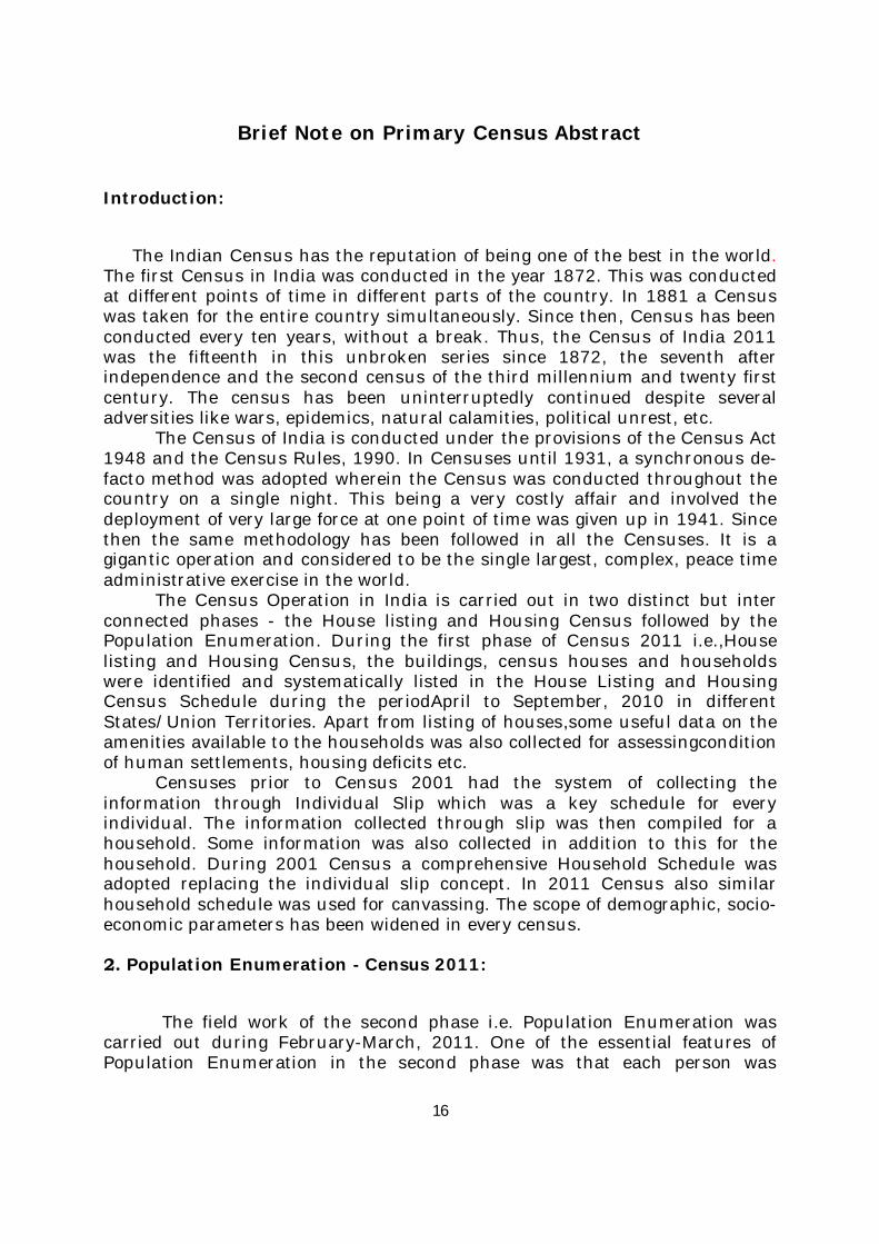
Brief Note on Primary Census Abstract
Introduction:
The Indian Census has the reputation of being one of the best in the world. The first Census in India was conducted in the year 1872. This was conducted at different points of time in different parts of the country. In 1881 a Census was taken for the entire country simultaneously. Since then, Census has been conducted every ten years, without a break. Thus, the Census of India 2011 was the fifteenth in this unbroken series since 1872, the seventh after independence and the second census of the third millennium and twenty first century. The census has been uninterruptedly continued despite several adversities like wars, epidemics, natural calamities, political unrest, etc.
The Census of India is conducted under the provisions of the Census Act 1948 and the Census Rules, 1990. In Censuses until 1931, a synchronous de-facto method was adopted wherein the Census was conducted throughout the country on a single night. This being a very costly affair and involved the deployment of very large force at one point of time was given up in 1941. Since then the same methodology has been followed in all the Censuses. It is a gigantic operation and considered to be the single largest, complex, peace time administrative exercise in the world.
The Census Operation in India is carried out in two distinct but inter connected phases - the House listing and Housing Census followed by the Population Enumeration. During the first phase of Census 2011 i.e.,House listing and Housing Census, the buildings, census houses and households were identified and systematically listed in the House Listing and Housing Census Schedule during the periodApril to September, 2010 in different States/Union Territories. Apart from listing of houses,some useful data on the amenities available to the households was also collected for assessingcondition of human settlements, housing deficits etc.
Censuses prior to Census 2001 had the system of collecting the information through Individual Slip which was a key schedule for every individual. The information collected through slip was then compiled for a household. Some information was also collected in addition to this for the household. During 2001 Census a comprehensive Household Schedule was adopted replacing the individual slip concept. In 2011 Census also similar household schedule was used for canvassing. The scope of demographic, socio-economic parameters has been widened in every census.
2. Population Enumeration - Census 2011:
The field work of the second phase i.e. Population Enumeration was carried out during February-March, 2011. One of the essential features of Population Enumeration in the second phase was that each person was
17
enumerated and her/his individual particulars were collected at a well-defined point of time.
The Census moment and the reference date for the Census of India 2011 was 00:00 hours of 1st March, 2011. The enumeration was conducted from 9th February to 28th February, 2011 alongwith a revisional round from 1st March, 2011 to 5th March, 2011 synchronously all over the country except for few specific areas of the Jammu & Kashmir, Himachal Pradesh and Uttarakhand states that remain snowbound in February. In these locations the population enumeration was done from 11th September, 2010 to 30th September, 2010 along with a revisional round from 1st October, 2010 to 5th October, 2010. The reference date for the census in snow bound non-synchronous areas of these states was 00.00 hours of the first day of October, 2010. In addition to the coverage during House listing& Housing Census, the enumeration of the Houseless population was carried out on the night of 28th February, 2011, as has been the usual practice. For the purpose of Census, certain areas where the access of the civilian enumerators was not permissible due to security reasons termed as ‘Special Charges’ such as the Defence and strictly Military/Para-Military areas, including operational areas were also covered. Such areas were not covered during the House listing& Housing Census. In addition to the defence/para-military areas, Special Charges also included certain factory areas, certain colonies, sensitive areas, scientific establishments, etc. These also formed Special Charges as these were not accessible by the usual census enumerator.
3. Quality Assurance:
A Task Force for Quality Assurance (TFQA) functioned under the chairmanship of the RG & CCI. Experienced officers of the different divisions of the organization i.e. Heads and senior officers of the Census Division, Data Processing Division, Map Division, Demography Division and Social Studies Division comprised the TFQA. The Directors of Census Operations were co-opted as members whenever the TFQA discussed the data for their States/Union territories. The main objective of constituting the TFQA was to subject the data to stringent validation checks and ensure its quality before release as it was expedient to be satisfied itself about the quality of data before putting the same in public domain.
The Directors and their senior officers were involved at all levels with respect to the quality and the coverage of their States/UTs. The TFQA intensively scrutinized coverage and content parameters including edit and imputation logic. The most important aspect of the data quality was to ensure complete coverage of all geographical areas especially for the population enumeration phase where the data is disseminated right up to the village level in the rural areas and the ward level in the urban areas. Thus ensuring the complete coverage and correct geographical linkage of each enumeration block was one of the major planks of the quality control, especially for small area population statistics. The content was scrutinized mainly through the process of internal consistency, comparison with similar data in the past and also through validation with likewise data if available, from external sources. Quite often the local knowledge and perception was looked at to understand both the
18
existing and the new emerging trends of population distribution and characteristics. A very comprehensive check and edit mechanism was put in place to objectively examine the preliminary Census 2011 Population Enumeration results and finally clear them for use. The population data was cleared only after the full possible satisfaction of the TFQA.
The entire work relating to the data validation and scrutiny was completed by all the States/Union territories under the overall supervision and monitoring of the Census Division of the Office of the Registrar General, India with active cooperation and support of the Social Studies Division, Data Processing Division, Data Dissemination Division and Map Division.
4. Primary Census Abstract:
The Primary Census Abstract which is an important publication of 2011 Census gives basicinformation on Area, Total Number of Households, Total Population, Scheduled Castes, Scheduled TribesPopulation, Population in the age group 0-6, Literates, Main Workers and Marginal Workers classified by thefour broad industrial categories, namely, (i) Cultivators, (ii) Agricultural Labourers, (iii) Household Industry Workers, and (iv) Other Workers and also Non-Workers. The characteristics of the Total Population includeScheduled Castes, Scheduled Tribes, Institutional and Houseless Population and are presented by sex andrural-urban residence.
In 1981 census main workers were presented into four categories. As regards 1991 Census, the nine-fold industrialclassification of main workers has been given in the Primary Census Abstract. One of the important features of the Primary Census Abstract of 1991 Census was the presentation of population of the age group 0-6 which is continued in 2001 and 2011 Census.All the children of age 6 years or less have been treated as illiterate even if the child is going to a school and may have picked up reading and writing. This will help the data users in better analysis and understanding of the literacy data as the literacy rate is calculated with 7 years and above population and it is referred as effective literacy rate.In 2001 and 2011 census four categories of main workers have been given in the Primary Census Abstract.
5. Level of Presentation of PCA data in District CensusHandbooks:
The format of Primary Census Abstract (PCA) adopted in the DCHB of 2001 Census has been continued for 2011 Census as the data on four categories of works have been presented similar to 2001 census. The Primary Census Abstract data in different PCAs are presented at different levels. The level of presentation of Primary Census Abstracts in DCHB is as under:
1.District Primary Census Abstract -District/C.D. Block/Town.2. Primary Census Abstract for Scheduled Castes- District/C.D. Block/Town.3.Primary Census Abstract for Scheduled Tribes -District/C.D. Block/Town.4. Village Primary Census Abstract -C.D. Block/Village wise.5. Urban Primary Census Abstract- Town/Ward level.

19
The PCA Data for villages was presented C.D. Block wise for the first time in 1991 Census. Thispractice is continued in 2001 and 2011 Census. The term ‘Total Population’ includes the Scheduled Castes, the Scheduled Tribes, the Institutional and the Houseless populations. An appendix to District Primary Census Abstract has also been furnished showing urban enumeration block-wise particulars on Total Population, the Scheduled Castes Population and the Scheduled Tribes Population for each town.
6. Area Figures:
The area figures supplied by local revenue authorities of the district in respect of tahsils, Police Stations and by the local bodies in respect of towns are given in square kilometers. The area figures of the villages supplied by the Tahsildars in acres have been converted and shown in hectares. The area figures of the C.D. Block are the total of the village areas coming under each C.D. Block. The area figures for the district are the same as adopted by the Surveyor General of India to maintain uniformity at the national level.
-----------------------------------------------------------------

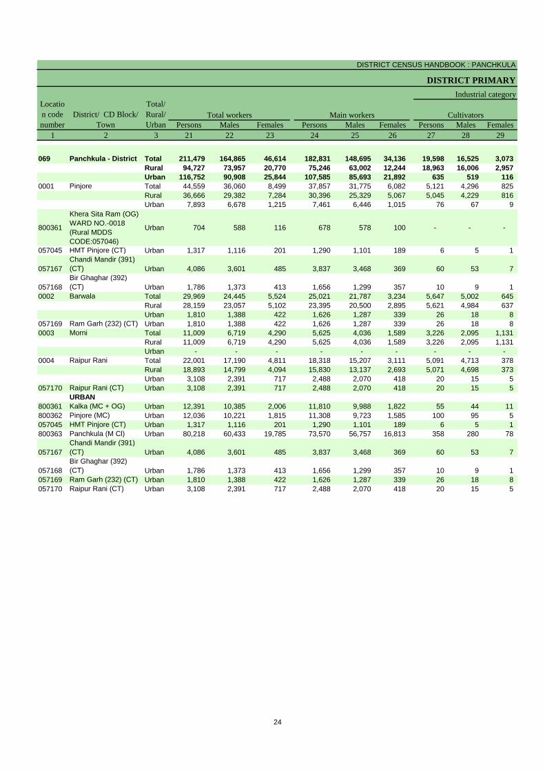
District Primary Census Abstract

DISTRICT CENSUS HANDBOOK : PANCHKULA
DISTRICT PRIMARY
Persons Males Females Persons Males Females1 2 3 4 5 6 7 8 9 10 11
069 Panchkula - District Total 898.00 117,107 561,293 299,679 261,614 66,302 35,583 30,719 Rural 827.51 46,154 248,063 133,153 114,910 32,010 17,107 14,903 Urban 70.49 70,953 313,230 166,526 146,704 34,292 18,476 15,816
0001 Pinjore Total 178.38 24,450 124,021 66,034 57,987 16,663 8,736 7,927 Rural 170.24 20,133 104,275 54,977 49,298 14,300 7,461 6,839 Urban 8.14 4,317 19,746 11,057 8,689 2,363 1,275 1,088
800361
Khera Sita Ram (OG) WARD NO.-0018 (Rural MDDS CODE:057046)
Urban NA 491 1,879 1,050 829 255 131 124
057045 HMT Pinjore (CT) Urban 3.44 913 3,873 2,074 1,799 276 151 125
057167Chandi Mandir (391) (CT) Urban 3.00 1,861 9,051 5,417 3,634 1,166 649 517
057168 Bir Ghaghar (392) (CT) Urban 1.70 1,052 4,943 2,516 2,427 666 344 322 0002 Barwala Total 177.08 14,046 77,307 42,526 34,781 9,308 5,137 4,171
Rural 173.68 13,104 72,373 39,959 32,414 8,777 4,841 3,936 Urban 3.40 942 4,934 2,567 2,367 531 296 235
057169 Ram Garh (232) (CT) Urban 3.40 942 4,934 2,567 2,367 531 296 235 0003 Morni Total 37.41 3,939 21,330 11,254 10,076 2,588 1,337 1,251
Rural 37.41 3,939 21,330 11,254 10,076 2,588 1,337 1,251 Urban 0.00 - - - - - - -
0004 Raipur Rani Total 134.76 10,771 59,113 31,716 27,397 7,395 4,048 3,347 Rural 128.13 8,978 50,085 26,963 23,122 6,345 3,468 2,877 Urban 6.63 1,793 9,028 4,753 4,275 1,050 580 470
057170 Raipur Rani (CT) Urban 6.63 1,793 9,028 4,753 4,275 1,050 580 470 URBAN
800361 Kalka (MC + OG) Urban 3.72 7,868 34,134 18,311 15,823 3,559 1,886 1,673 800362 Pinjore (MC) Urban 16.00 7,752 35,912 19,157 16,755 4,190 2,276 1,914 057045 HMT Pinjore (CT) Urban 3.44 913 3,873 2,074 1,799 276 151 125 800363 Panchkula (M Cl) Urban 32.60 48,772 211,355 111,731 99,624 22,854 12,294 10,560
057167Chandi Mandir (391) (CT) Urban 3.00 1,861 9,051 5,417 3,634 1,166 649 517
057168 Bir Ghaghar (392) (CT) Urban 1.70 1,052 4,943 2,516 2,427 666 344 322 057169 Ram Garh (232) (CT) Urban 3.40 942 4,934 2,567 2,367 531 296 235 057170 Raipur Rani (CT) Urban 6.63 1,793 9,028 4,753 4,275 1,050 580 470
Location code number
District/ CD Block/ Town
Total/ Rural/ Urban
Area in Square
KilometreNumber of households
Total population (including institutional and houseless population) Population in the age-group 0-6
22
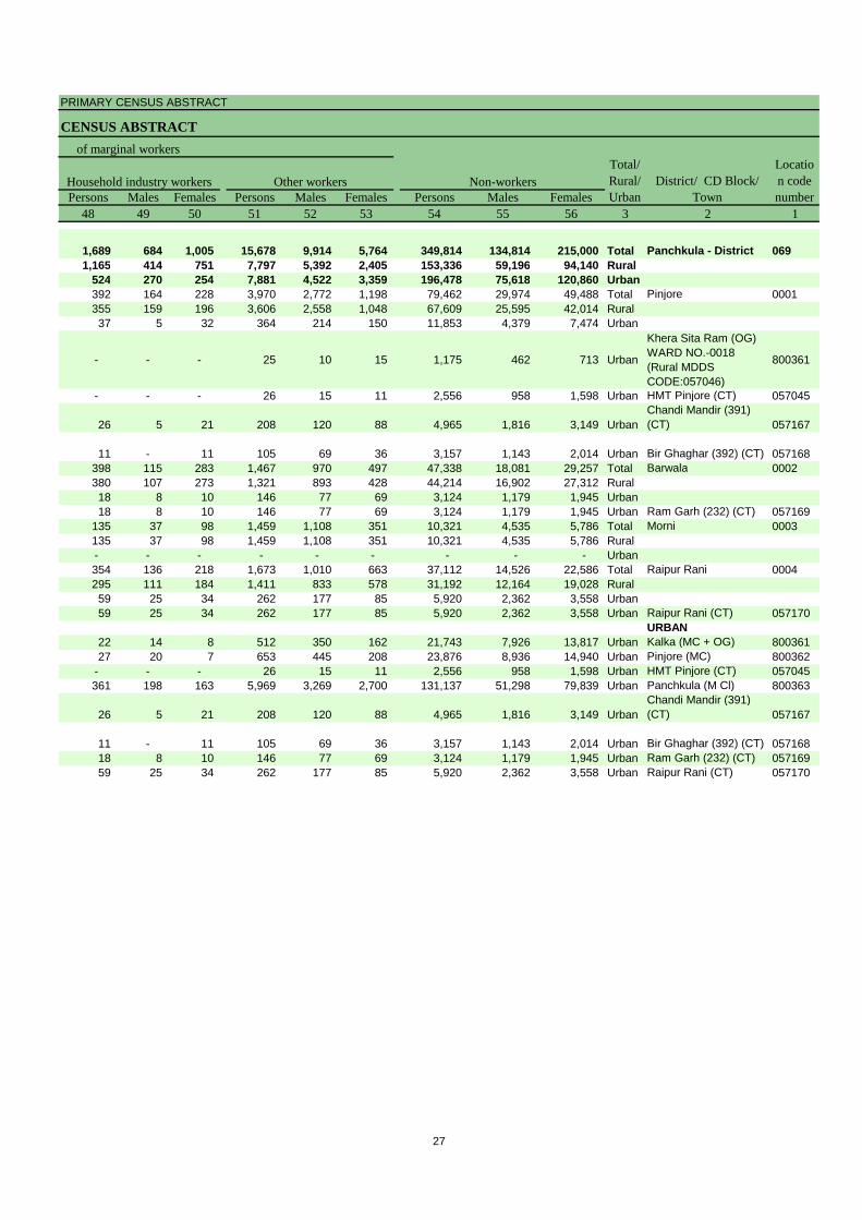
PRIMARY CENSUS ABSTRACT
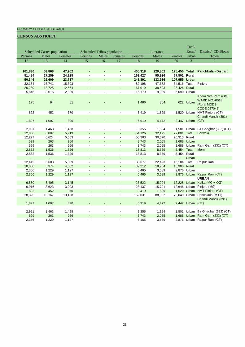
CENSUS ABSTRACT
Persons Males Females Persons Males Females Persons Males Females12 13 14 15 16 17 18 19 20 3 2
101,830 53,868 47,962 - - - 405,318 229,862 175,456 Total Panchkula - District51,484 27,259 24,225 - - - 163,427 95,926 67,501 Rural50,346 26,609 23,737 - - - 241,891 133,936 107,955 Urban32,134 16,741 15,393 - - - 82,198 47,682 34,516 Total Pinjore26,289 13,725 12,564 - - - 67,019 38,593 28,426 Rural5,845 3,016 2,829 - - - 15,179 9,089 6,090 Urban
175 94 81 - - - 1,486 864 622 Urban
Khera Sita Ram (OG) WARD NO.-0018 (Rural MDDS CODE:057046)
822 452 370 - - - 3,419 1,899 1,520 Urban HMT Pinjore (CT)
1,897 1,007 890 - - - 6,919 4,472 2,447 UrbanChandi Mandir (391) (CT)
2,951 1,463 1,488 - - - 3,355 1,854 1,501 Urban Bir Ghaghar (392) (CT)12,806 6,887 5,919 - - - 54,126 32,125 22,001 Total Barwala12,277 6,624 5,653 - - - 50,383 30,070 20,313 Rural
529 263 266 - - - 3,743 2,055 1,688 Urban529 263 266 - - - 3,743 2,055 1,688 Urban Ram Garh (232) (CT)
2,862 1,536 1,326 - - - 13,813 8,359 5,454 Total Morni2,862 1,536 1,326 - - - 13,813 8,359 5,454 Rural
- - - - - - - - - Urban12,412 6,603 5,809 - - - 38,677 22,493 16,184 Total Raipur Rani10,056 5,374 4,682 - - - 32,212 18,904 13,308 Rural2,356 1,229 1,127 - - - 6,465 3,589 2,876 Urban2,356 1,229 1,127 - - - 6,465 3,589 2,876 Urban Raipur Rani (CT)
URBAN6,550 3,405 3,145 - - - 27,522 15,294 12,228 Urban Kalka (MC + OG)6,916 3,623 3,293 - - - 28,437 15,791 12,646 Urban Pinjore (MC)
822 452 370 - - - 3,419 1,899 1,520 Urban HMT Pinjore (CT)28,325 15,167 13,158 - - - 162,031 88,982 73,049 Urban Panchkula (M Cl)
1,897 1,007 890 - - - 6,919 4,472 2,447 UrbanChandi Mandir (391) (CT)
2,951 1,463 1,488 - - - 3,355 1,854 1,501 Urban Bir Ghaghar (392) (CT)529 263 266 - - - 3,743 2,055 1,688 Urban Ram Garh (232) (CT)
2,356 1,229 1,127 - - - 6,465 3,589 2,876 Urban Raipur Rani (CT)
Scheduled Castes population Scheduled Tribes population LiteratesTotal/ Rural/ Urban
District/ CD Block/ Town
23
DISTRICT CENSUS HANDBOOK : PANCHKULA
DISTRICT PRIMARY
Persons Males Females Persons Males Females Persons Males Females1 2 3 21 22 23 24 25 26 27 28 29
069 Panchkula - District Total 211,479 164,865 46,614 182,831 148,695 34,136 19,598 16,525 3,073 Rural 94,727 73,957 20,770 75,246 63,002 12,244 18,963 16,006 2,957 Urban 116,752 90,908 25,844 107,585 85,693 21,892 635 519 116
0001 Pinjore Total 44,559 36,060 8,499 37,857 31,775 6,082 5,121 4,296 825 Rural 36,666 29,382 7,284 30,396 25,329 5,067 5,045 4,229 816 Urban 7,893 6,678 1,215 7,461 6,446 1,015 76 67 9
800361
Khera Sita Ram (OG) WARD NO.-0018 (Rural MDDS CODE:057046)
Urban 704 588 116 678 578 100 - - -
057045 HMT Pinjore (CT) Urban 1,317 1,116 201 1,290 1,101 189 6 5 1
057167Chandi Mandir (391) (CT) Urban 4,086 3,601 485 3,837 3,468 369 60 53 7
057168Bir Ghaghar (392) (CT) Urban 1,786 1,373 413 1,656 1,299 357 10 9 1
0002 Barwala Total 29,969 24,445 5,524 25,021 21,787 3,234 5,647 5,002 645 Rural 28,159 23,057 5,102 23,395 20,500 2,895 5,621 4,984 637 Urban 1,810 1,388 422 1,626 1,287 339 26 18 8
057169 Ram Garh (232) (CT) Urban 1,810 1,388 422 1,626 1,287 339 26 18 8 0003 Morni Total 11,009 6,719 4,290 5,625 4,036 1,589 3,226 2,095 1,131
Rural 11,009 6,719 4,290 5,625 4,036 1,589 3,226 2,095 1,131 Urban - - - - - - - - -
0004 Raipur Rani Total 22,001 17,190 4,811 18,318 15,207 3,111 5,091 4,713 378 Rural 18,893 14,799 4,094 15,830 13,137 2,693 5,071 4,698 373 Urban 3,108 2,391 717 2,488 2,070 418 20 15 5
057170 Raipur Rani (CT) Urban 3,108 2,391 717 2,488 2,070 418 20 15 5 URBAN
800361 Kalka (MC + OG) Urban 12,391 10,385 2,006 11,810 9,988 1,822 55 44 11 800362 Pinjore (MC) Urban 12,036 10,221 1,815 11,308 9,723 1,585 100 95 5 057045 HMT Pinjore (CT) Urban 1,317 1,116 201 1,290 1,101 189 6 5 1 800363 Panchkula (M Cl) Urban 80,218 60,433 19,785 73,570 56,757 16,813 358 280 78
057167Chandi Mandir (391) (CT) Urban 4,086 3,601 485 3,837 3,468 369 60 53 7
057168Bir Ghaghar (392) (CT) Urban 1,786 1,373 413 1,656 1,299 357 10 9 1
057169 Ram Garh (232) (CT) Urban 1,810 1,388 422 1,626 1,287 339 26 18 8 057170 Raipur Rani (CT) Urban 3,108 2,391 717 2,488 2,070 418 20 15 5
CultivatorsDistrict/ CD Block/ Town
Total/ Rural/ Urban
Total workers Main workers
Industrial categoryLocation code number
24

PRIMARY CENSUS ABSTRACT
CENSUS ABSTRACT
Persons Males Females Persons Males Females Persons Males Females30 31 32 33 34 35 36 37 38 3 2
8,630 7,163 1,467 8,181 6,380 1,801 146,422 118,627 27,795 Total Panchkula - District7,061 5,923 1,138 2,285 1,547 738 46,937 39,526 7,411 Rural1,569 1,240 329 5,896 4,833 1,063 99,485 79,101 20,384 Urban1,377 1,190 187 1,075 814 261 30,284 25,475 4,809 Total Pinjore1,311 1,139 172 879 668 211 23,161 19,293 3,868 Rural
66 51 15 196 146 50 7,123 6,182 941 Urban
8 7 1 88 80 8 582 491 91 Urban
Khera Sita Ram (OG) WARD NO.-0018 (Rural MDDS CODE:057046)
- - - - - - 1,284 1,096 188 Urban HMT Pinjore (CT)
43 33 10 64 36 28 3,670 3,346 324 UrbanChandi Mandir (391) (CT)
15 11 4 44 30 14 1,587 1,249 338 Urban Bir Ghaghar (392) (CT)2,770 2,429 341 634 446 188 15,970 13,910 2,060 Total Barwala2,691 2,369 322 555 398 157 14,528 12,749 1,779 Rural
79 60 19 79 48 31 1,442 1,161 281 Urban79 60 19 79 48 31 1,442 1,161 281 Urban Ram Garh (232) (CT)
354 247 107 61 53 8 1,984 1,641 343 Total Morni354 247 107 61 53 8 1,984 1,641 343 Rural- - - - - - - - - Urban
2,782 2,225 557 994 602 392 9,451 7,667 1,784 Total Raipur Rani2,705 2,168 537 790 428 362 7,264 5,843 1,421 Rural
77 57 20 204 174 30 2,187 1,824 363 Urban77 57 20 204 174 30 2,187 1,824 363 Urban Raipur Rani (CT)
URBAN87 81 6 745 632 113 10,923 9,231 1,692 Urban Kalka (MC + OG)
130 101 29 420 337 83 10,658 9,190 1,468 Urban Pinjore (MC)- - - - - - 1,284 1,096 188 Urban HMT Pinjore (CT)
1,138 897 241 4,340 3,576 764 67,734 52,004 15,730 Urban Panchkula (M Cl)
43 33 10 64 36 28 3,670 3,346 324 UrbanChandi Mandir (391) (CT)
15 11 4 44 30 14 1,587 1,249 338 Urban Bir Ghaghar (392) (CT)79 60 19 79 48 31 1,442 1,161 281 Urban Ram Garh (232) (CT)77 57 20 204 174 30 2,187 1,824 363 Urban Raipur Rani (CT)
Agricultural labourers Household industry workers Other workersTotal/ Rural/ Urban
District/ CD Block/ Town
of main workers
25
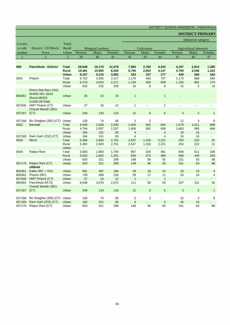
DISTRICT CENSUS HANDBOOK : PANCHKULA
DISTRICT PRIMARY
Persons Males Females Persons Males Females Persons Males Females1 2 3 39 40 41 42 43 44 45 46 47
069 Panchkula - District Total 28,648 16,170 12,478 7,084 2,760 4,324 4,197 2,812 1,385 Rural 19,481 10,955 8,526 6,750 2,603 4,147 3,769 2,546 1,223 Urban 9,167 5,215 3,952 334 157 177 428 266 162
0001 Pinjore Total 6,702 4,285 2,417 1,170 463 707 1,170 886 284 Rural 6,270 4,053 2,217 1,154 455 699 1,155 881 274 Urban 432 232 200 16 8 8 15 5 10
800361
Khera Sita Ram (OG) WARD NO.-0018 (Rural MDDS CODE:057046)
Urban 26 10 16 1 - 1 - - -
057045 HMT Pinjore (CT) Urban 27 15 12 1 - 1 - - -
057167Chandi Mandir (391) (CT) Urban 249 133 116 12 6 6 3 2 1
057168 Bir Ghaghar (392) (CT) Urban 130 74 56 2 2 - 12 3 9 0002 Barwala Total 4,948 2,658 2,290 1,404 562 842 1,679 1,011 668
Rural 4,764 2,557 2,207 1,400 562 838 1,663 995 668 Urban 184 101 83 4 - 4 16 16 -
057169 Ram Garh (232) (CT) Urban 184 101 83 4 - 4 16 16 - 0003 Morni Total 5,384 2,683 2,701 3,537 1,316 2,221 253 222 31
Rural 5,384 2,683 2,701 3,537 1,316 2,221 253 222 31 Urban - - - - - - - - -
0004 Raipur Rani Total 3,683 1,983 1,700 807 326 481 849 511 338 Rural 3,063 1,662 1,401 659 270 389 698 448 250 Urban 620 321 299 148 56 92 151 63 88
057170 Raipur Rani (CT) Urban 620 321 299 148 56 92 151 63 88 URBAN
800361 Kalka (MC + OG) Urban 581 397 184 28 18 10 19 15 4 800362 Pinjore (MC) Urban 728 498 230 28 17 11 20 16 4 057045 HMT Pinjore (CT) Urban 27 15 12 1 - 1 - - - 800363 Panchkula (M Cl) Urban 6,648 3,676 2,972 111 58 53 207 151 56
057167Chandi Mandir (391) (CT) Urban 249 133 116 12 6 6 3 2 1
057168 Bir Ghaghar (392) (CT) Urban 130 74 56 2 2 - 12 3 9 057169 Ram Garh (232) (CT) Urban 184 101 83 4 - 4 16 16 - 057170 Raipur Rani (CT) Urban 620 321 299 148 56 92 151 63 88
Marginal workers CultivatorsLocation code number
District/ CD Block/ Town
Total/ Rural/ Urban
Industrial category
Agricultural labourers
26
PRIMARY CENSUS ABSTRACT
CENSUS ABSTRACT
Persons Males Females Persons Males Females Persons Males Females48 49 50 51 52 53 54 55 56 3 2 1
1,689 684 1,005 15,678 9,914 5,764 349,814 134,814 215,000 Total Panchkula - District 0691,165 414 751 7,797 5,392 2,405 153,336 59,196 94,140 Rural
524 270 254 7,881 4,522 3,359 196,478 75,618 120,860 Urban392 164 228 3,970 2,772 1,198 79,462 29,974 49,488 Total Pinjore 0001355 159 196 3,606 2,558 1,048 67,609 25,595 42,014 Rural37 5 32 364 214 150 11,853 4,379 7,474 Urban
- - - 25 10 15 1,175 462 713 Urban
Khera Sita Ram (OG) WARD NO.-0018 (Rural MDDS CODE:057046)
800361
- - - 26 15 11 2,556 958 1,598 Urban HMT Pinjore (CT) 057045
26 5 21 208 120 88 4,965 1,816 3,149 UrbanChandi Mandir (391) (CT) 057167
11 - 11 105 69 36 3,157 1,143 2,014 Urban Bir Ghaghar (392) (CT) 057168398 115 283 1,467 970 497 47,338 18,081 29,257 Total Barwala 0002380 107 273 1,321 893 428 44,214 16,902 27,312 Rural18 8 10 146 77 69 3,124 1,179 1,945 Urban18 8 10 146 77 69 3,124 1,179 1,945 Urban Ram Garh (232) (CT) 057169
135 37 98 1,459 1,108 351 10,321 4,535 5,786 Total Morni 0003135 37 98 1,459 1,108 351 10,321 4,535 5,786 Rural- - - - - - - - - Urban354 136 218 1,673 1,010 663 37,112 14,526 22,586 Total Raipur Rani 0004295 111 184 1,411 833 578 31,192 12,164 19,028 Rural59 25 34 262 177 85 5,920 2,362 3,558 Urban59 25 34 262 177 85 5,920 2,362 3,558 Urban Raipur Rani (CT) 057170
URBAN22 14 8 512 350 162 21,743 7,926 13,817 Urban Kalka (MC + OG) 80036127 20 7 653 445 208 23,876 8,936 14,940 Urban Pinjore (MC) 800362
- - - 26 15 11 2,556 958 1,598 Urban HMT Pinjore (CT) 057045361 198 163 5,969 3,269 2,700 131,137 51,298 79,839 Urban Panchkula (M Cl) 800363
26 5 21 208 120 88 4,965 1,816 3,149 UrbanChandi Mandir (391) (CT) 057167
11 - 11 105 69 36 3,157 1,143 2,014 Urban Bir Ghaghar (392) (CT) 05716818 8 10 146 77 69 3,124 1,179 1,945 Urban Ram Garh (232) (CT) 05716959 25 34 262 177 85 5,920 2,362 3,558 Urban Raipur Rani (CT) 057170
Other workers Non-workers
of marginal workersTotal/ Rural/ Urban
District/ CD Block/ Town
Location code number
Household industry workers
27

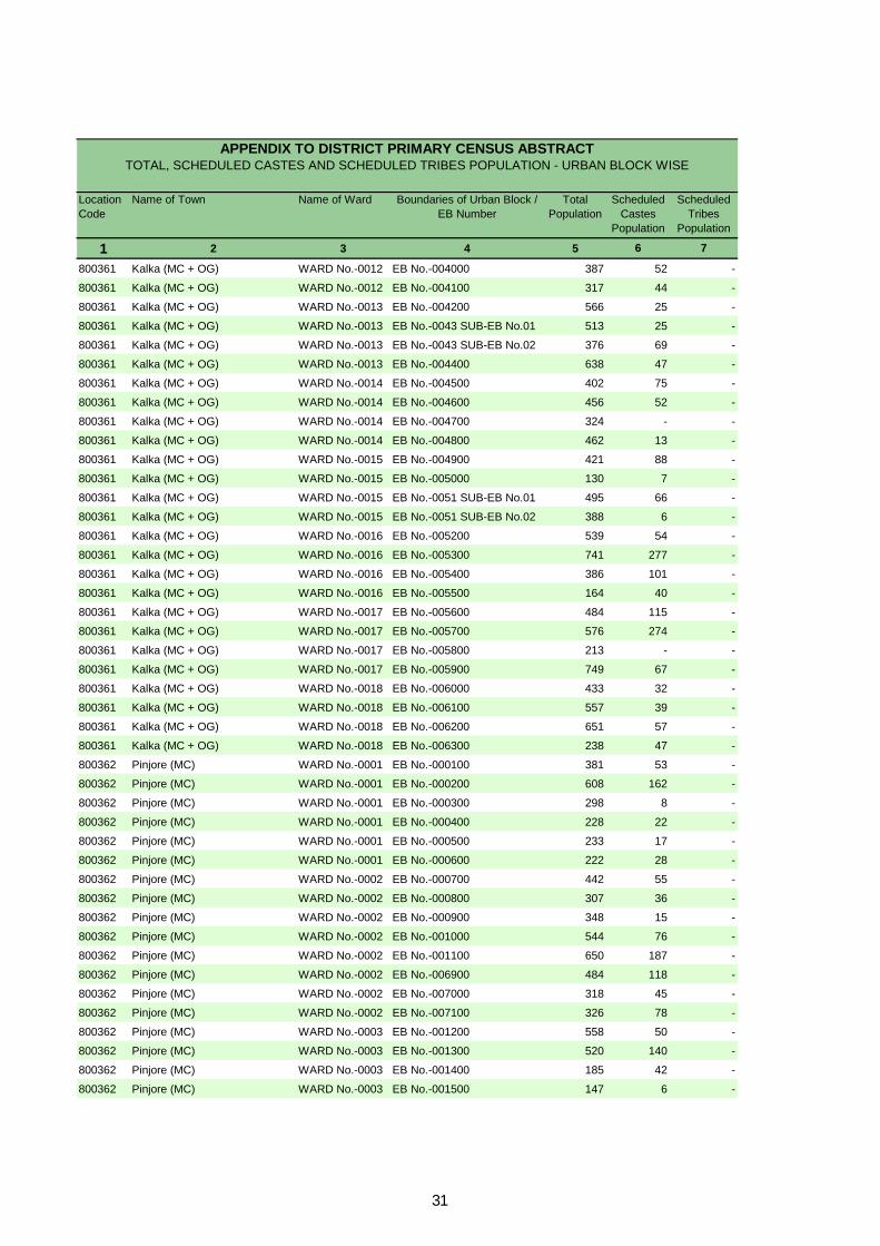
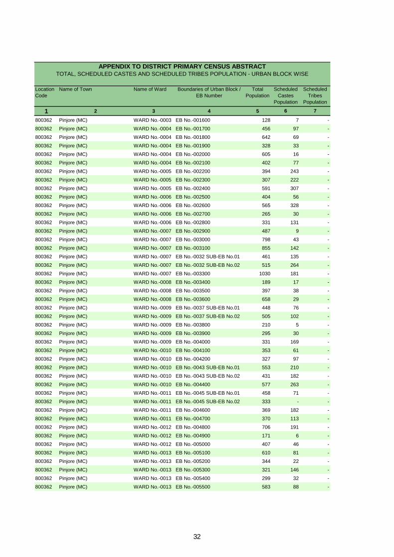
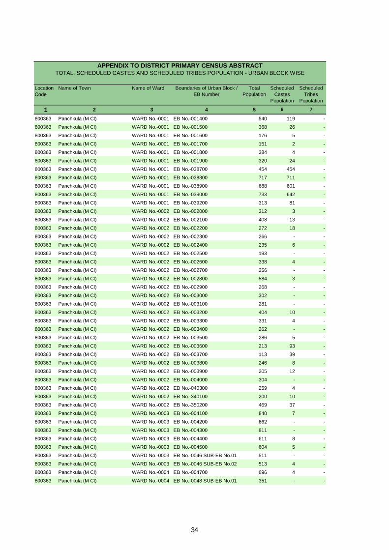
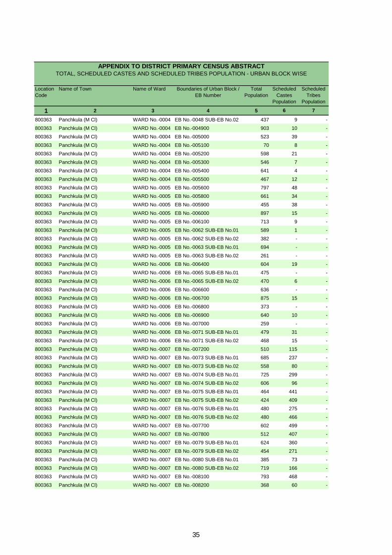
Appendix to District Primary Census Abstract Total, Scheduled Castes and
Scheduled Tribes Population - Urban Block wise

Location Code
Name of Town Name of Ward Boundaries of Urban Block / EB Number
Total Population
Scheduled Castes
Population
Scheduled Tribes
Population
1 2 3 4 5 6 7
800361 Kalka (MC + OG) WARD No.-0001 EB No.-000100 899 290 -
800361 Kalka (MC + OG) WARD No.-0001 EB No.-0002 SUB-EB No.01 525 370 -
800361 Kalka (MC + OG) WARD No.-0001 EB No.-0002 SUB-EB No.02 373 243 -
800361 Kalka (MC + OG) WARD No.-0001 EB No.-000300 474 69 -
800361 Kalka (MC + OG) WARD No.-0001 EB No.-314100 669 22 -
800361 Kalka (MC + OG) WARD No.-0002 EB No.-000400 598 33 -
800361 Kalka (MC + OG) WARD No.-0002 EB No.-000500 528 87 -
800361 Kalka (MC + OG) WARD No.-0002 EB No.-000600 412 119 -
800361 Kalka (MC + OG) WARD No.-0003 EB No.-000700 394 13 -
800361 Kalka (MC + OG) WARD No.-0003 EB No.-000800 702 75 -
800361 Kalka (MC + OG) WARD No.-0003 EB No.-000900 569 25 -
800361 Kalka (MC + OG) WARD No.-0004 EB No.-001000 766 186 -
800361 Kalka (MC + OG) WARD No.-0004 EB No.-001100 802 767 -
800361 Kalka (MC + OG) WARD No.-0004 EB No.-0012 SUB-EB No.01 431 351 -
800361 Kalka (MC + OG) WARD No.-0004 EB No.-0012 SUB-EB No.02 436 317 -
800361 Kalka (MC + OG) WARD No.-0005 EB No.-001300 501 162 -
800361 Kalka (MC + OG) WARD No.-0005 EB No.-001400 518 2 -
800361 Kalka (MC + OG) WARD No.-0005 EB No.-001500 445 - -
800361 Kalka (MC + OG) WARD No.-0006 EB No.-001600 339 35 -
800361 Kalka (MC + OG) WARD No.-0006 EB No.-0017 SUB-EB No.01 550 24 -
800361 Kalka (MC + OG) WARD No.-0006 EB No.-0017 SUB-EB No.02 562 76 -
800361 Kalka (MC + OG) WARD No.-0006 EB No.-001800 570 48 -
800361 Kalka (MC + OG) WARD No.-0007 EB No.-001900 739 27 -
800361 Kalka (MC + OG) WARD No.-0007 EB No.-002000 778 18 -
800361 Kalka (MC + OG) WARD No.-0007 EB No.-002100 752 34 -
800361 Kalka (MC + OG) WARD No.-0007 EB No.-002200 406 7 -
800361 Kalka (MC + OG) WARD No.-0007 EB No.-006400 204 23 -
800361 Kalka (MC + OG) WARD No.-0008 EB No.-002300 379 - -
800361 Kalka (MC + OG) WARD No.-0008 EB No.-002400 456 8 -
800361 Kalka (MC + OG) WARD No.-0008 EB No.-002500 487 15 -
800361 Kalka (MC + OG) WARD No.-0008 EB No.-002600 557 8 -
800361 Kalka (MC + OG) WARD No.-0009 EB No.-002700 369 160 -
800361 Kalka (MC + OG) WARD No.-0009 EB No.-002800 684 52 -
800361 Kalka (MC + OG) WARD No.-0009 EB No.-002900 552 28 -
800361 Kalka (MC + OG) WARD No.-0010 EB No.-003000 405 85 -
800361 Kalka (MC + OG) WARD No.-0010 EB No.-003100 700 139 -
800361 Kalka (MC + OG) WARD No.-0010 EB No.-003200 685 118 -
800361 Kalka (MC + OG) WARD No.-0011 EB No.-003300 438 353 -
800361 Kalka (MC + OG) WARD No.-0011 EB No.-003400 246 66 -
800361 Kalka (MC + OG) WARD No.-0011 EB No.-003500 341 28 -
800361 Kalka (MC + OG) WARD No.-0011 EB No.-003600 408 135 -
800361 Kalka (MC + OG) WARD No.-0011 EB No.-003700 240 53 -
800361 Kalka (MC + OG) WARD No.-0012 EB No.-003800 324 71 -
800361 Kalka (MC + OG) WARD No.-0012 EB No.-003900 315 136 -
APPENDIX TO DISTRICT PRIMARY CENSUS ABSTRACT TOTAL, SCHEDULED CASTES AND SCHEDULED TRIBES POPULATION - URBAN BLOCK WISE
30
Location Code
Name of Town Name of Ward Boundaries of Urban Block / EB Number
Total Population
Scheduled Castes
Population
Scheduled Tribes
Population
1 2 3 4 5 6 7
APPENDIX TO DISTRICT PRIMARY CENSUS ABSTRACT TOTAL, SCHEDULED CASTES AND SCHEDULED TRIBES POPULATION - URBAN BLOCK WISE
800361 Kalka (MC + OG) WARD No.-0012 EB No.-004000 387 52 -
800361 Kalka (MC + OG) WARD No.-0012 EB No.-004100 317 44 -
800361 Kalka (MC + OG) WARD No.-0013 EB No.-004200 566 25 -
800361 Kalka (MC + OG) WARD No.-0013 EB No.-0043 SUB-EB No.01 513 25 -
800361 Kalka (MC + OG) WARD No.-0013 EB No.-0043 SUB-EB No.02 376 69 -
800361 Kalka (MC + OG) WARD No.-0013 EB No.-004400 638 47 -
800361 Kalka (MC + OG) WARD No.-0014 EB No.-004500 402 75 -
800361 Kalka (MC + OG) WARD No.-0014 EB No.-004600 456 52 -
800361 Kalka (MC + OG) WARD No.-0014 EB No.-004700 324 - -
800361 Kalka (MC + OG) WARD No.-0014 EB No.-004800 462 13 -
800361 Kalka (MC + OG) WARD No.-0015 EB No.-004900 421 88 -
800361 Kalka (MC + OG) WARD No.-0015 EB No.-005000 130 7 -
800361 Kalka (MC + OG) WARD No.-0015 EB No.-0051 SUB-EB No.01 495 66 -
800361 Kalka (MC + OG) WARD No.-0015 EB No.-0051 SUB-EB No.02 388 6 -
800361 Kalka (MC + OG) WARD No.-0016 EB No.-005200 539 54 -
800361 Kalka (MC + OG) WARD No.-0016 EB No.-005300 741 277 -
800361 Kalka (MC + OG) WARD No.-0016 EB No.-005400 386 101 -
800361 Kalka (MC + OG) WARD No.-0016 EB No.-005500 164 40 -
800361 Kalka (MC + OG) WARD No.-0017 EB No.-005600 484 115 -
800361 Kalka (MC + OG) WARD No.-0017 EB No.-005700 576 274 -
800361 Kalka (MC + OG) WARD No.-0017 EB No.-005800 213 - -
800361 Kalka (MC + OG) WARD No.-0017 EB No.-005900 749 67 -
800361 Kalka (MC + OG) WARD No.-0018 EB No.-006000 433 32 -
800361 Kalka (MC + OG) WARD No.-0018 EB No.-006100 557 39 -
800361 Kalka (MC + OG) WARD No.-0018 EB No.-006200 651 57 -
800361 Kalka (MC + OG) WARD No.-0018 EB No.-006300 238 47 -
800362 Pinjore (MC) WARD No.-0001 EB No.-000100 381 53 -
800362 Pinjore (MC) WARD No.-0001 EB No.-000200 608 162 -
800362 Pinjore (MC) WARD No.-0001 EB No.-000300 298 8 -
800362 Pinjore (MC) WARD No.-0001 EB No.-000400 228 22 -
800362 Pinjore (MC) WARD No.-0001 EB No.-000500 233 17 -
800362 Pinjore (MC) WARD No.-0001 EB No.-000600 222 28 -
800362 Pinjore (MC) WARD No.-0002 EB No.-000700 442 55 -
800362 Pinjore (MC) WARD No.-0002 EB No.-000800 307 36 -
800362 Pinjore (MC) WARD No.-0002 EB No.-000900 348 15 -
800362 Pinjore (MC) WARD No.-0002 EB No.-001000 544 76 -
800362 Pinjore (MC) WARD No.-0002 EB No.-001100 650 187 -
800362 Pinjore (MC) WARD No.-0002 EB No.-006900 484 118 -
800362 Pinjore (MC) WARD No.-0002 EB No.-007000 318 45 -
800362 Pinjore (MC) WARD No.-0002 EB No.-007100 326 78 -
800362 Pinjore (MC) WARD No.-0003 EB No.-001200 558 50 -
800362 Pinjore (MC) WARD No.-0003 EB No.-001300 520 140 -
800362 Pinjore (MC) WARD No.-0003 EB No.-001400 185 42 -
800362 Pinjore (MC) WARD No.-0003 EB No.-001500 147 6 -
31
Location Code
Name of Town Name of Ward Boundaries of Urban Block / EB Number
Total Population
Scheduled Castes
Population
Scheduled Tribes
Population
1 2 3 4 5 6 7
APPENDIX TO DISTRICT PRIMARY CENSUS ABSTRACT TOTAL, SCHEDULED CASTES AND SCHEDULED TRIBES POPULATION - URBAN BLOCK WISE
800362 Pinjore (MC) WARD No.-0003 EB No.-001600 128 7 -
800362 Pinjore (MC) WARD No.-0004 EB No.-001700 456 97 -
800362 Pinjore (MC) WARD No.-0004 EB No.-001800 642 69 -
800362 Pinjore (MC) WARD No.-0004 EB No.-001900 328 33 -
800362 Pinjore (MC) WARD No.-0004 EB No.-002000 605 16 -
800362 Pinjore (MC) WARD No.-0004 EB No.-002100 402 77 -
800362 Pinjore (MC) WARD No.-0005 EB No.-002200 394 243 -
800362 Pinjore (MC) WARD No.-0005 EB No.-002300 307 222 -
800362 Pinjore (MC) WARD No.-0005 EB No.-002400 591 307 -
800362 Pinjore (MC) WARD No.-0006 EB No.-002500 404 56 -
800362 Pinjore (MC) WARD No.-0006 EB No.-002600 565 328 -
800362 Pinjore (MC) WARD No.-0006 EB No.-002700 265 30 -
800362 Pinjore (MC) WARD No.-0006 EB No.-002800 331 131 -
800362 Pinjore (MC) WARD No.-0007 EB No.-002900 487 9 -
800362 Pinjore (MC) WARD No.-0007 EB No.-003000 798 43 -
800362 Pinjore (MC) WARD No.-0007 EB No.-003100 855 142 -
800362 Pinjore (MC) WARD No.-0007 EB No.-0032 SUB-EB No.01 461 135 -
800362 Pinjore (MC) WARD No.-0007 EB No.-0032 SUB-EB No.02 515 264 -
800362 Pinjore (MC) WARD No.-0007 EB No.-003300 1030 181 -
800362 Pinjore (MC) WARD No.-0008 EB No.-003400 189 17 -
800362 Pinjore (MC) WARD No.-0008 EB No.-003500 397 38 -
800362 Pinjore (MC) WARD No.-0008 EB No.-003600 658 29 -
800362 Pinjore (MC) WARD No.-0009 EB No.-0037 SUB-EB No.01 448 76 -
800362 Pinjore (MC) WARD No.-0009 EB No.-0037 SUB-EB No.02 505 102 -
800362 Pinjore (MC) WARD No.-0009 EB No.-003800 210 5 -
800362 Pinjore (MC) WARD No.-0009 EB No.-003900 295 30 -
800362 Pinjore (MC) WARD No.-0009 EB No.-004000 331 169 -
800362 Pinjore (MC) WARD No.-0010 EB No.-004100 353 61 -
800362 Pinjore (MC) WARD No.-0010 EB No.-004200 327 97 -
800362 Pinjore (MC) WARD No.-0010 EB No.-0043 SUB-EB No.01 553 210 -
800362 Pinjore (MC) WARD No.-0010 EB No.-0043 SUB-EB No.02 431 182 -
800362 Pinjore (MC) WARD No.-0010 EB No.-004400 577 263 -
800362 Pinjore (MC) WARD No.-0011 EB No.-0045 SUB-EB No.01 458 71 -
800362 Pinjore (MC) WARD No.-0011 EB No.-0045 SUB-EB No.02 333 - -
800362 Pinjore (MC) WARD No.-0011 EB No.-004600 369 182 -
800362 Pinjore (MC) WARD No.-0011 EB No.-004700 370 113 -
800362 Pinjore (MC) WARD No.-0012 EB No.-004800 706 191 -
800362 Pinjore (MC) WARD No.-0012 EB No.-004900 171 6 -
800362 Pinjore (MC) WARD No.-0012 EB No.-005000 407 46 -
800362 Pinjore (MC) WARD No.-0013 EB No.-005100 610 81 -
800362 Pinjore (MC) WARD No.-0013 EB No.-005200 344 22 -
800362 Pinjore (MC) WARD No.-0013 EB No.-005300 321 146 -
800362 Pinjore (MC) WARD No.-0013 EB No.-005400 299 32 -
800362 Pinjore (MC) WARD No.-0013 EB No.-005500 583 88 -
32

Location Code
Name of Town Name of Ward Boundaries of Urban Block / EB Number
Total Population
Scheduled Castes
Population
Scheduled Tribes
Population
1 2 3 4 5 6 7
APPENDIX TO DISTRICT PRIMARY CENSUS ABSTRACT TOTAL, SCHEDULED CASTES AND SCHEDULED TRIBES POPULATION - URBAN BLOCK WISE
800362 Pinjore (MC) WARD No.-0014 EB No.-005600 362 49 -
800362 Pinjore (MC) WARD No.-0014 EB No.-005700 275 41 -
800362 Pinjore (MC) WARD No.-0014 EB No.-005800 311 32 -
800362 Pinjore (MC) WARD No.-0014 EB No.-005900 472 74 -
800362 Pinjore (MC) WARD No.-0014 EB No.-006000 785 - -
800362 Pinjore (MC) WARD No.-0015 EB No.-006100 642 111 -
800362 Pinjore (MC) WARD No.-0015 EB No.-006200 721 8 -
800362 Pinjore (MC) WARD No.-0015 EB No.-006300 509 15 -
800362 Pinjore (MC) WARD No.-0015 EB No.-006400 509 30 -
800362 Pinjore (MC) WARD No.-0015 EB No.-006500 445 8 -
800362 Pinjore (MC) WARD No.-0015 EB No.-006600 254 16 -
800362 Pinjore (MC) WARD No.-0015 EB No.-006700 183 53 -
800362 Pinjore (MC) WARD No.-0015 EB No.-006800 276 30 -
800362 Pinjore (MC) WARD No.-0015 EB No.-310100 291 53 -
800362 Pinjore (MC) WARD No.-0015 EB No.-310200 272 77 -
800362 Pinjore (MC) WARD No.-0015 EB No.-310300 264 81 -
800362 Pinjore (MC) WARD No.-0015 EB No.-310400 257 72 -
800362 Pinjore (MC) WARD No.-0015 EB No.-310500 285 46 -
800362 Pinjore (MC) WARD No.-0015 EB No.-310600 267 40 -
800362 Pinjore (MC) WARD No.-0015 EB No.-310700 298 61 -
800362 Pinjore (MC) WARD No.-0015 EB No.-310800 337 48 -
800362 Pinjore (MC) WARD No.-0015 EB No.-310900 189 10 -
800362 Pinjore (MC) WARD No.-0015 EB No.-311000 741 108 -
800362 Pinjore (MC) WARD No.-0015 EB No.-311100 359 68 -
057045 HMT Pinjore (CT) WARD No.-0001 EB No.-000100 497 161 -
057045 HMT Pinjore (CT) WARD No.-0001 EB No.-000200 703 154 -
057045 HMT Pinjore (CT) WARD No.-0001 EB No.-000300 572 103 -
057045 HMT Pinjore (CT) WARD No.-0001 EB No.-000400 611 - -
057045 HMT Pinjore (CT) WARD No.-0001 EB No.-000500 464 82 -
057045 HMT Pinjore (CT) WARD No.-0001 EB No.-000600 572 151 -
057045 HMT Pinjore (CT) WARD No.-0001 EB No.-000700 454 171 -
800363 Panchkula (M Cl) WARD No.-0001 EB No.-000100 264 19 -
800363 Panchkula (M Cl) WARD No.-0001 EB No.-000200 544 77 -
800363 Panchkula (M Cl) WARD No.-0001 EB No.-000300 313 52 -
800363 Panchkula (M Cl) WARD No.-0001 EB No.-000400 731 173 -
800363 Panchkula (M Cl) WARD No.-0001 EB No.-000500 296 20 -
800363 Panchkula (M Cl) WARD No.-0001 EB No.-000600 213 9 -
800363 Panchkula (M Cl) WARD No.-0001 EB No.-000700 194 15 -
800363 Panchkula (M Cl) WARD No.-0001 EB No.-000800 402 1 -
800363 Panchkula (M Cl) WARD No.-0001 EB No.-000900 326 - -
800363 Panchkula (M Cl) WARD No.-0001 EB No.-001000 197 - -
800363 Panchkula (M Cl) WARD No.-0001 EB No.-001100 231 - -
800363 Panchkula (M Cl) WARD No.-0001 EB No.-001200 274 - -
800363 Panchkula (M Cl) WARD No.-0001 EB No.-001300 236 - -
33
Location Code
Name of Town Name of Ward Boundaries of Urban Block / EB Number
Total Population
Scheduled Castes
Population
Scheduled Tribes
Population
1 2 3 4 5 6 7
APPENDIX TO DISTRICT PRIMARY CENSUS ABSTRACT TOTAL, SCHEDULED CASTES AND SCHEDULED TRIBES POPULATION - URBAN BLOCK WISE
800363 Panchkula (M Cl) WARD No.-0001 EB No.-001400 540 119 -
800363 Panchkula (M Cl) WARD No.-0001 EB No.-001500 368 26 -
800363 Panchkula (M Cl) WARD No.-0001 EB No.-001600 176 5 -
800363 Panchkula (M Cl) WARD No.-0001 EB No.-001700 151 2 -
800363 Panchkula (M Cl) WARD No.-0001 EB No.-001800 384 4 -
800363 Panchkula (M Cl) WARD No.-0001 EB No.-001900 320 24 -
800363 Panchkula (M Cl) WARD No.-0001 EB No.-038700 454 454 -
800363 Panchkula (M Cl) WARD No.-0001 EB No.-038800 717 711 -
800363 Panchkula (M Cl) WARD No.-0001 EB No.-038900 688 601 -
800363 Panchkula (M Cl) WARD No.-0001 EB No.-039000 733 642 -
800363 Panchkula (M Cl) WARD No.-0001 EB No.-039200 313 81 -
800363 Panchkula (M Cl) WARD No.-0002 EB No.-002000 312 3 -
800363 Panchkula (M Cl) WARD No.-0002 EB No.-002100 408 13 -
800363 Panchkula (M Cl) WARD No.-0002 EB No.-002200 272 18 -
800363 Panchkula (M Cl) WARD No.-0002 EB No.-002300 266 - -
800363 Panchkula (M Cl) WARD No.-0002 EB No.-002400 235 6 -
800363 Panchkula (M Cl) WARD No.-0002 EB No.-002500 193 - -
800363 Panchkula (M Cl) WARD No.-0002 EB No.-002600 338 4 -
800363 Panchkula (M Cl) WARD No.-0002 EB No.-002700 256 - -
800363 Panchkula (M Cl) WARD No.-0002 EB No.-002800 584 3 -
800363 Panchkula (M Cl) WARD No.-0002 EB No.-002900 268 - -
800363 Panchkula (M Cl) WARD No.-0002 EB No.-003000 302 - -
800363 Panchkula (M Cl) WARD No.-0002 EB No.-003100 281 - -
800363 Panchkula (M Cl) WARD No.-0002 EB No.-003200 404 10 -
800363 Panchkula (M Cl) WARD No.-0002 EB No.-003300 331 4 -
800363 Panchkula (M Cl) WARD No.-0002 EB No.-003400 262 - -
800363 Panchkula (M Cl) WARD No.-0002 EB No.-003500 286 5 -
800363 Panchkula (M Cl) WARD No.-0002 EB No.-003600 213 93 -
800363 Panchkula (M Cl) WARD No.-0002 EB No.-003700 113 39 -
800363 Panchkula (M Cl) WARD No.-0002 EB No.-003800 246 8 -
800363 Panchkula (M Cl) WARD No.-0002 EB No.-003900 205 12 -
800363 Panchkula (M Cl) WARD No.-0002 EB No.-004000 304 - -
800363 Panchkula (M Cl) WARD No.-0002 EB No.-040300 259 4 -
800363 Panchkula (M Cl) WARD No.-0002 EB No.-340100 200 10 -
800363 Panchkula (M Cl) WARD No.-0002 EB No.-350200 469 37 -
800363 Panchkula (M Cl) WARD No.-0003 EB No.-004100 840 7 -
800363 Panchkula (M Cl) WARD No.-0003 EB No.-004200 662 - -
800363 Panchkula (M Cl) WARD No.-0003 EB No.-004300 811 - -
800363 Panchkula (M Cl) WARD No.-0003 EB No.-004400 611 8 -
800363 Panchkula (M Cl) WARD No.-0003 EB No.-004500 604 5 -
800363 Panchkula (M Cl) WARD No.-0003 EB No.-0046 SUB-EB No.01 511 - -
800363 Panchkula (M Cl) WARD No.-0003 EB No.-0046 SUB-EB No.02 513 4 -
800363 Panchkula (M Cl) WARD No.-0004 EB No.-004700 696 4 -
800363 Panchkula (M Cl) WARD No.-0004 EB No.-0048 SUB-EB No.01 351 - -
34
Location Code
Name of Town Name of Ward Boundaries of Urban Block / EB Number
Total Population
Scheduled Castes
Population
Scheduled Tribes
Population
1 2 3 4 5 6 7
APPENDIX TO DISTRICT PRIMARY CENSUS ABSTRACT TOTAL, SCHEDULED CASTES AND SCHEDULED TRIBES POPULATION - URBAN BLOCK WISE
800363 Panchkula (M Cl) WARD No.-0004 EB No.-0048 SUB-EB No.02 437 9 -
800363 Panchkula (M Cl) WARD No.-0004 EB No.-004900 903 10 -
800363 Panchkula (M Cl) WARD No.-0004 EB No.-005000 523 39 -
800363 Panchkula (M Cl) WARD No.-0004 EB No.-005100 70 8 -
800363 Panchkula (M Cl) WARD No.-0004 EB No.-005200 598 21 -
800363 Panchkula (M Cl) WARD No.-0004 EB No.-005300 546 7 -
800363 Panchkula (M Cl) WARD No.-0004 EB No.-005400 641 4 -
800363 Panchkula (M Cl) WARD No.-0004 EB No.-005500 467 12 -
800363 Panchkula (M Cl) WARD No.-0005 EB No.-005600 797 48 -
800363 Panchkula (M Cl) WARD No.-0005 EB No.-005800 661 34 -
800363 Panchkula (M Cl) WARD No.-0005 EB No.-005900 455 38 -
800363 Panchkula (M Cl) WARD No.-0005 EB No.-006000 897 15 -
800363 Panchkula (M Cl) WARD No.-0005 EB No.-006100 713 9 -
800363 Panchkula (M Cl) WARD No.-0005 EB No.-0062 SUB-EB No.01 589 1 -
800363 Panchkula (M Cl) WARD No.-0005 EB No.-0062 SUB-EB No.02 382 - -
800363 Panchkula (M Cl) WARD No.-0005 EB No.-0063 SUB-EB No.01 694 - -
800363 Panchkula (M Cl) WARD No.-0005 EB No.-0063 SUB-EB No.02 261 - -
800363 Panchkula (M Cl) WARD No.-0006 EB No.-006400 604 19 -
800363 Panchkula (M Cl) WARD No.-0006 EB No.-0065 SUB-EB No.01 475 - -
800363 Panchkula (M Cl) WARD No.-0006 EB No.-0065 SUB-EB No.02 470 6 -
800363 Panchkula (M Cl) WARD No.-0006 EB No.-006600 636 - -
800363 Panchkula (M Cl) WARD No.-0006 EB No.-006700 875 15 -
800363 Panchkula (M Cl) WARD No.-0006 EB No.-006800 373 - -
800363 Panchkula (M Cl) WARD No.-0006 EB No.-006900 640 10 -
800363 Panchkula (M Cl) WARD No.-0006 EB No.-007000 259 - -
800363 Panchkula (M Cl) WARD No.-0006 EB No.-0071 SUB-EB No.01 479 31 -
800363 Panchkula (M Cl) WARD No.-0006 EB No.-0071 SUB-EB No.02 468 15 -
800363 Panchkula (M Cl) WARD No.-0007 EB No.-007200 510 115 -
800363 Panchkula (M Cl) WARD No.-0007 EB No.-0073 SUB-EB No.01 685 237 -
800363 Panchkula (M Cl) WARD No.-0007 EB No.-0073 SUB-EB No.02 558 80 -
800363 Panchkula (M Cl) WARD No.-0007 EB No.-0074 SUB-EB No.01 725 299 -
800363 Panchkula (M Cl) WARD No.-0007 EB No.-0074 SUB-EB No.02 606 96 -
800363 Panchkula (M Cl) WARD No.-0007 EB No.-0075 SUB-EB No.01 464 441 -
800363 Panchkula (M Cl) WARD No.-0007 EB No.-0075 SUB-EB No.02 424 409 -
800363 Panchkula (M Cl) WARD No.-0007 EB No.-0076 SUB-EB No.01 480 275 -
800363 Panchkula (M Cl) WARD No.-0007 EB No.-0076 SUB-EB No.02 480 466 -
800363 Panchkula (M Cl) WARD No.-0007 EB No.-007700 602 499 -
800363 Panchkula (M Cl) WARD No.-0007 EB No.-007800 512 407 -
800363 Panchkula (M Cl) WARD No.-0007 EB No.-0079 SUB-EB No.01 624 360 -
800363 Panchkula (M Cl) WARD No.-0007 EB No.-0079 SUB-EB No.02 454 271 -
800363 Panchkula (M Cl) WARD No.-0007 EB No.-0080 SUB-EB No.01 385 73 -
800363 Panchkula (M Cl) WARD No.-0007 EB No.-0080 SUB-EB No.02 719 166 -
800363 Panchkula (M Cl) WARD No.-0007 EB No.-008100 793 468 -
800363 Panchkula (M Cl) WARD No.-0007 EB No.-008200 368 60 -
35

Location Code
Name of Town Name of Ward Boundaries of Urban Block / EB Number
Total Population
Scheduled Castes
Population
Scheduled Tribes
Population
1 2 3 4 5 6 7
APPENDIX TO DISTRICT PRIMARY CENSUS ABSTRACT TOTAL, SCHEDULED CASTES AND SCHEDULED TRIBES POPULATION - URBAN BLOCK WISE
800363 Panchkula (M Cl) WARD No.-0008 EB No.-008300 652 42 -
800363 Panchkula (M Cl) WARD No.-0008 EB No.-0084 SUB-EB No.01 537 338 -
800363 Panchkula (M Cl) WARD No.-0008 EB No.-0084 SUB-EB No.02 809 222 -
800363 Panchkula (M Cl) WARD No.-0008 EB No.-0085 SUB-EB No.01 743 151 -
800363 Panchkula (M Cl) WARD No.-0008 EB No.-0085 SUB-EB No.02 351 264 -
800363 Panchkula (M Cl) WARD No.-0008 EB No.-0086 SUB-EB No.01 504 219 -
800363 Panchkula (M Cl) WARD No.-0008 EB No.-0086 SUB-EB No.02 466 152 -
800363 Panchkula (M Cl) WARD No.-0008 EB No.-0087 SUB-EB No.01 663 132 -
800363 Panchkula (M Cl) WARD No.-0008 EB No.-0087 SUB-EB No.02 623 155 -
800363 Panchkula (M Cl) WARD No.-0008 EB No.-0393 SUB-EB No.01 601 95 -
800363 Panchkula (M Cl) WARD No.-0008 EB No.-0393 SUB-EB No.02 538 10 -
800363 Panchkula (M Cl) WARD No.-0008 EB No.-041900 848 165 -
800363 Panchkula (M Cl) WARD No.-0008 EB No.-042000 199 83 -
800363 Panchkula (M Cl) WARD No.-0009 EB No.-008800 660 387 -
800363 Panchkula (M Cl) WARD No.-0009 EB No.-0089 SUB-EB No.01 409 353 -
800363 Panchkula (M Cl) WARD No.-0009 EB No.-0089 SUB-EB No.02 522 306 -
800363 Panchkula (M Cl) WARD No.-0009 EB No.-0090 SUB-EB No.01 424 50 -
800363 Panchkula (M Cl) WARD No.-0009 EB No.-0090 SUB-EB No.02 526 166 -
800363 Panchkula (M Cl) WARD No.-0009 EB No.-009100 722 114 -
800363 Panchkula (M Cl) WARD No.-0009 EB No.-009200 347 36 -
800363 Panchkula (M Cl) WARD No.-0009 EB No.-0093 SUB-EB No.01 311 13 -
800363 Panchkula (M Cl) WARD No.-0009 EB No.-0093 SUB-EB No.02 639 198 -
800363 Panchkula (M Cl) WARD No.-0009 EB No.-0094 SUB-EB No.01 397 144 -
800363 Panchkula (M Cl) WARD No.-0009 EB No.-0094 SUB-EB No.02 228 80 -
800363 Panchkula (M Cl) WARD No.-0009 EB No.-009500 568 90 -
800363 Panchkula (M Cl) WARD No.-0010 EB No.-009600 621 10 -
800363 Panchkula (M Cl) WARD No.-0010 EB No.-0097 SUB-EB No.01 466 4 -
800363 Panchkula (M Cl) WARD No.-0010 EB No.-0097 SUB-EB No.02 395 - -
800363 Panchkula (M Cl) WARD No.-0010 EB No.-009800 789 9 -
800363 Panchkula (M Cl) WARD No.-0010 EB No.-0099 SUB-EB No.01 454 8 -
800363 Panchkula (M Cl) WARD No.-0010 EB No.-0099 SUB-EB No.02 420 13 -
800363 Panchkula (M Cl) WARD No.-0010 EB No.-010000 868 15 -
800363 Panchkula (M Cl) WARD No.-0010 EB No.-010100 672 - -
800363 Panchkula (M Cl) WARD No.-0010 EB No.-010200 701 - -
800363 Panchkula (M Cl) WARD No.-0010 EB No.-010300 601 22 -
800363 Panchkula (M Cl) WARD No.-0011 EB No.-010400 605 6 -
800363 Panchkula (M Cl) WARD No.-0011 EB No.-010500 613 - -
800363 Panchkula (M Cl) WARD No.-0011 EB No.-010600 634 3 -
800363 Panchkula (M Cl) WARD No.-0011 EB No.-010700 815 6 -
800363 Panchkula (M Cl) WARD No.-0011 EB No.-0108 SUB-EB No.01 389 6 -
800363 Panchkula (M Cl) WARD No.-0011 EB No.-0108 SUB-EB No.02 463 - -
800363 Panchkula (M Cl) WARD No.-0011 EB No.-0109 SUB-EB No.01 468 6 -
800363 Panchkula (M Cl) WARD No.-0011 EB No.-0109 SUB-EB No.02 491 - -
800363 Panchkula (M Cl) WARD No.-0011 EB No.-0110 SUB-EB No.01 448 10 -
36
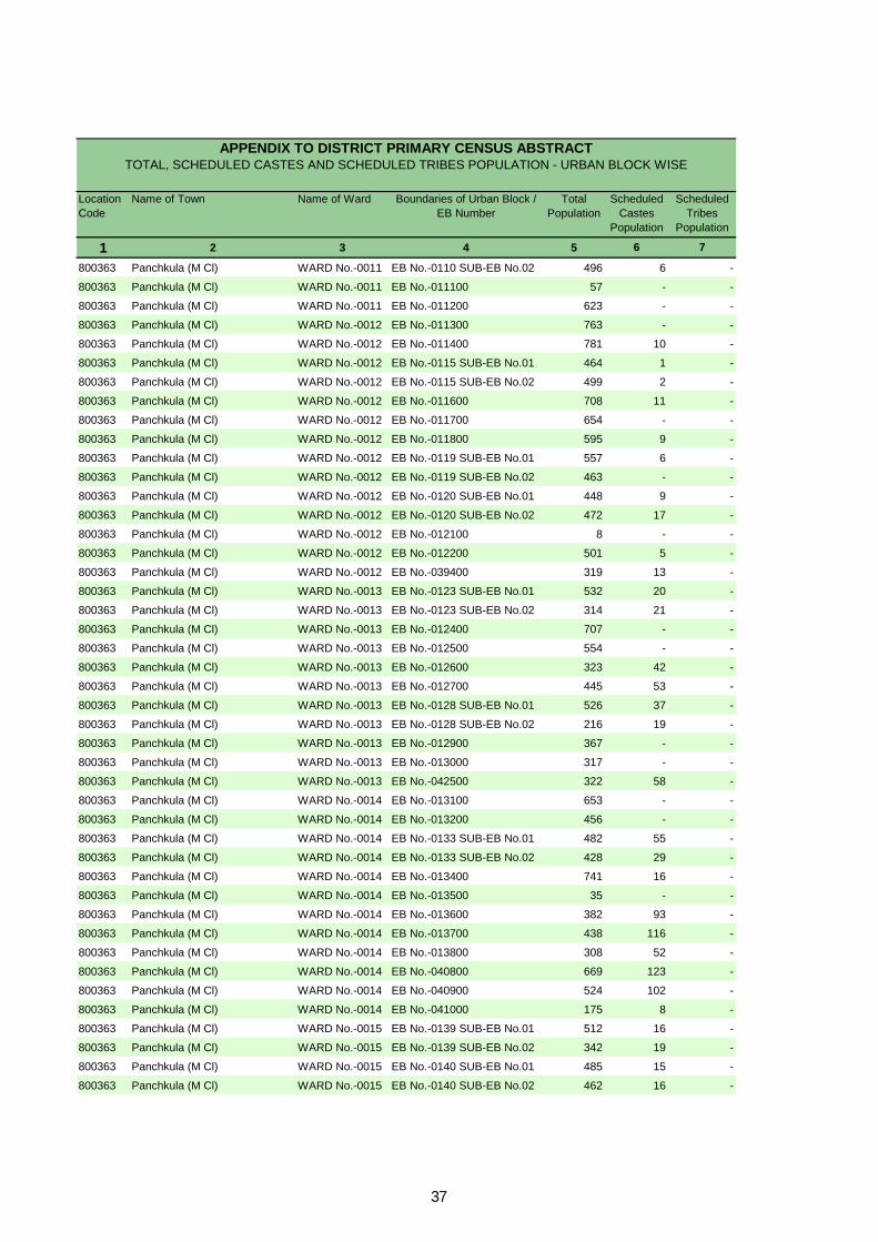
Location Code
Name of Town Name of Ward Boundaries of Urban Block / EB Number
Total Population
Scheduled Castes
Population
Scheduled Tribes
Population
1 2 3 4 5 6 7
APPENDIX TO DISTRICT PRIMARY CENSUS ABSTRACT TOTAL, SCHEDULED CASTES AND SCHEDULED TRIBES POPULATION - URBAN BLOCK WISE
800363 Panchkula (M Cl) WARD No.-0011 EB No.-0110 SUB-EB No.02 496 6 -
800363 Panchkula (M Cl) WARD No.-0011 EB No.-011100 57 - -
800363 Panchkula (M Cl) WARD No.-0011 EB No.-011200 623 - -
800363 Panchkula (M Cl) WARD No.-0012 EB No.-011300 763 - -
800363 Panchkula (M Cl) WARD No.-0012 EB No.-011400 781 10 -
800363 Panchkula (M Cl) WARD No.-0012 EB No.-0115 SUB-EB No.01 464 1 -
800363 Panchkula (M Cl) WARD No.-0012 EB No.-0115 SUB-EB No.02 499 2 -
800363 Panchkula (M Cl) WARD No.-0012 EB No.-011600 708 11 -
800363 Panchkula (M Cl) WARD No.-0012 EB No.-011700 654 - -
800363 Panchkula (M Cl) WARD No.-0012 EB No.-011800 595 9 -
800363 Panchkula (M Cl) WARD No.-0012 EB No.-0119 SUB-EB No.01 557 6 -
800363 Panchkula (M Cl) WARD No.-0012 EB No.-0119 SUB-EB No.02 463 - -
800363 Panchkula (M Cl) WARD No.-0012 EB No.-0120 SUB-EB No.01 448 9 -
800363 Panchkula (M Cl) WARD No.-0012 EB No.-0120 SUB-EB No.02 472 17 -
800363 Panchkula (M Cl) WARD No.-0012 EB No.-012100 8 - -
800363 Panchkula (M Cl) WARD No.-0012 EB No.-012200 501 5 -
800363 Panchkula (M Cl) WARD No.-0012 EB No.-039400 319 13 -
800363 Panchkula (M Cl) WARD No.-0013 EB No.-0123 SUB-EB No.01 532 20 -
800363 Panchkula (M Cl) WARD No.-0013 EB No.-0123 SUB-EB No.02 314 21 -
800363 Panchkula (M Cl) WARD No.-0013 EB No.-012400 707 - -
800363 Panchkula (M Cl) WARD No.-0013 EB No.-012500 554 - -
800363 Panchkula (M Cl) WARD No.-0013 EB No.-012600 323 42 -
800363 Panchkula (M Cl) WARD No.-0013 EB No.-012700 445 53 -
800363 Panchkula (M Cl) WARD No.-0013 EB No.-0128 SUB-EB No.01 526 37 -
800363 Panchkula (M Cl) WARD No.-0013 EB No.-0128 SUB-EB No.02 216 19 -
800363 Panchkula (M Cl) WARD No.-0013 EB No.-012900 367 - -
800363 Panchkula (M Cl) WARD No.-0013 EB No.-013000 317 - -
800363 Panchkula (M Cl) WARD No.-0013 EB No.-042500 322 58 -
800363 Panchkula (M Cl) WARD No.-0014 EB No.-013100 653 - -
800363 Panchkula (M Cl) WARD No.-0014 EB No.-013200 456 - -
800363 Panchkula (M Cl) WARD No.-0014 EB No.-0133 SUB-EB No.01 482 55 -
800363 Panchkula (M Cl) WARD No.-0014 EB No.-0133 SUB-EB No.02 428 29 -
800363 Panchkula (M Cl) WARD No.-0014 EB No.-013400 741 16 -
800363 Panchkula (M Cl) WARD No.-0014 EB No.-013500 35 - -
800363 Panchkula (M Cl) WARD No.-0014 EB No.-013600 382 93 -
800363 Panchkula (M Cl) WARD No.-0014 EB No.-013700 438 116 -
800363 Panchkula (M Cl) WARD No.-0014 EB No.-013800 308 52 -
800363 Panchkula (M Cl) WARD No.-0014 EB No.-040800 669 123 -
800363 Panchkula (M Cl) WARD No.-0014 EB No.-040900 524 102 -
800363 Panchkula (M Cl) WARD No.-0014 EB No.-041000 175 8 -
800363 Panchkula (M Cl) WARD No.-0015 EB No.-0139 SUB-EB No.01 512 16 -
800363 Panchkula (M Cl) WARD No.-0015 EB No.-0139 SUB-EB No.02 342 19 -
800363 Panchkula (M Cl) WARD No.-0015 EB No.-0140 SUB-EB No.01 485 15 -
800363 Panchkula (M Cl) WARD No.-0015 EB No.-0140 SUB-EB No.02 462 16 -
37
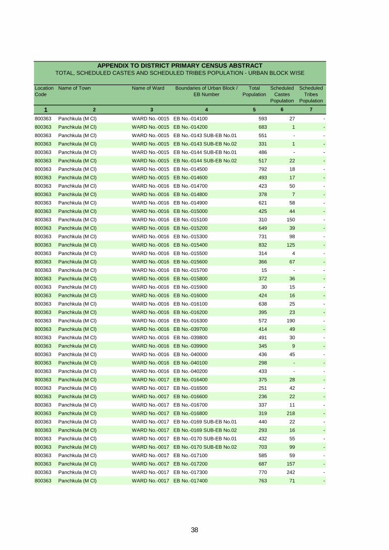
Location Code
Name of Town Name of Ward Boundaries of Urban Block / EB Number
Total Population
Scheduled Castes
Population
Scheduled Tribes
Population
1 2 3 4 5 6 7
APPENDIX TO DISTRICT PRIMARY CENSUS ABSTRACT TOTAL, SCHEDULED CASTES AND SCHEDULED TRIBES POPULATION - URBAN BLOCK WISE
800363 Panchkula (M Cl) WARD No.-0015 EB No.-014100 593 27 -
800363 Panchkula (M Cl) WARD No.-0015 EB No.-014200 683 1 -
800363 Panchkula (M Cl) WARD No.-0015 EB No.-0143 SUB-EB No.01 551 - -
800363 Panchkula (M Cl) WARD No.-0015 EB No.-0143 SUB-EB No.02 331 1 -
800363 Panchkula (M Cl) WARD No.-0015 EB No.-0144 SUB-EB No.01 486 - -
800363 Panchkula (M Cl) WARD No.-0015 EB No.-0144 SUB-EB No.02 517 22 -
800363 Panchkula (M Cl) WARD No.-0015 EB No.-014500 792 18 -
800363 Panchkula (M Cl) WARD No.-0015 EB No.-014600 493 17 -
800363 Panchkula (M Cl) WARD No.-0016 EB No.-014700 423 50 -
800363 Panchkula (M Cl) WARD No.-0016 EB No.-014800 378 7 -
800363 Panchkula (M Cl) WARD No.-0016 EB No.-014900 621 58 -
800363 Panchkula (M Cl) WARD No.-0016 EB No.-015000 425 44 -
800363 Panchkula (M Cl) WARD No.-0016 EB No.-015100 310 150 -
800363 Panchkula (M Cl) WARD No.-0016 EB No.-015200 649 39 -
800363 Panchkula (M Cl) WARD No.-0016 EB No.-015300 731 98 -
800363 Panchkula (M Cl) WARD No.-0016 EB No.-015400 832 125 -
800363 Panchkula (M Cl) WARD No.-0016 EB No.-015500 314 4 -
800363 Panchkula (M Cl) WARD No.-0016 EB No.-015600 366 67 -
800363 Panchkula (M Cl) WARD No.-0016 EB No.-015700 15 - -
800363 Panchkula (M Cl) WARD No.-0016 EB No.-015800 372 36 -
800363 Panchkula (M Cl) WARD No.-0016 EB No.-015900 30 15 -
800363 Panchkula (M Cl) WARD No.-0016 EB No.-016000 424 16 -
800363 Panchkula (M Cl) WARD No.-0016 EB No.-016100 638 25 -
800363 Panchkula (M Cl) WARD No.-0016 EB No.-016200 395 23 -
800363 Panchkula (M Cl) WARD No.-0016 EB No.-016300 572 190 -
800363 Panchkula (M Cl) WARD No.-0016 EB No.-039700 414 49 -
800363 Panchkula (M Cl) WARD No.-0016 EB No.-039800 491 30 -
800363 Panchkula (M Cl) WARD No.-0016 EB No.-039900 345 9 -
800363 Panchkula (M Cl) WARD No.-0016 EB No.-040000 436 45 -
800363 Panchkula (M Cl) WARD No.-0016 EB No.-040100 298 - -
800363 Panchkula (M Cl) WARD No.-0016 EB No.-040200 433 - -
800363 Panchkula (M Cl) WARD No.-0017 EB No.-016400 375 28 -
800363 Panchkula (M Cl) WARD No.-0017 EB No.-016500 251 42 -
800363 Panchkula (M Cl) WARD No.-0017 EB No.-016600 236 22 -
800363 Panchkula (M Cl) WARD No.-0017 EB No.-016700 337 11 -
800363 Panchkula (M Cl) WARD No.-0017 EB No.-016800 319 218 -
800363 Panchkula (M Cl) WARD No.-0017 EB No.-0169 SUB-EB No.01 440 22 -
800363 Panchkula (M Cl) WARD No.-0017 EB No.-0169 SUB-EB No.02 293 16 -
800363 Panchkula (M Cl) WARD No.-0017 EB No.-0170 SUB-EB No.01 432 55 -
800363 Panchkula (M Cl) WARD No.-0017 EB No.-0170 SUB-EB No.02 703 99 -
800363 Panchkula (M Cl) WARD No.-0017 EB No.-017100 585 59 -
800363 Panchkula (M Cl) WARD No.-0017 EB No.-017200 687 157 -
800363 Panchkula (M Cl) WARD No.-0017 EB No.-017300 770 242 -
800363 Panchkula (M Cl) WARD No.-0017 EB No.-017400 763 71 -
38

Location Code
Name of Town Name of Ward Boundaries of Urban Block / EB Number
Total Population
Scheduled Castes
Population
Scheduled Tribes
Population
1 2 3 4 5 6 7
APPENDIX TO DISTRICT PRIMARY CENSUS ABSTRACT TOTAL, SCHEDULED CASTES AND SCHEDULED TRIBES POPULATION - URBAN BLOCK WISE
800363 Panchkula (M Cl) WARD No.-0017 EB No.-038600 661 - -
800363 Panchkula (M Cl) WARD No.-0017 EB No.-041300 19 - -
800363 Panchkula (M Cl) WARD No.-0017 EB No.-042200 609 - -
800363 Panchkula (M Cl) WARD No.-0017 EB No.-042300 679 206 -
800363 Panchkula (M Cl) WARD No.-0018 EB No.-017500 587 21 -
800363 Panchkula (M Cl) WARD No.-0018 EB No.-017600 606 25 -
800363 Panchkula (M Cl) WARD No.-0018 EB No.-017700 210 41 -
800363 Panchkula (M Cl) WARD No.-0018 EB No.-017800 713 96 -
800363 Panchkula (M Cl) WARD No.-0018 EB No.-017900 886 151 -
800363 Panchkula (M Cl) WARD No.-0018 EB No.-018000 238 175 -
800363 Panchkula (M Cl) WARD No.-0018 EB No.-018100 545 171 -
800363 Panchkula (M Cl) WARD No.-0018 EB No.-018200 594 76 -
800363 Panchkula (M Cl) WARD No.-0018 EB No.-018300 681 58 -
800363 Panchkula (M Cl) WARD No.-0018 EB No.-018400 312 6 -
800363 Panchkula (M Cl) WARD No.-0018 EB No.-018500 451 92 -
800363 Panchkula (M Cl) WARD No.-0018 EB No.-039500 639 84 -
800363 Panchkula (M Cl) WARD No.-0018 EB No.-039600 667 138 -
800363 Panchkula (M Cl) WARD No.-0019 EB No.-018600 564 - -
800363 Panchkula (M Cl) WARD No.-0019 EB No.-018700 1004 7 -
800363 Panchkula (M Cl) WARD No.-0019 EB No.-018800 574 24 -
800363 Panchkula (M Cl) WARD No.-0019 EB No.-018900 468 32 -
800363 Panchkula (M Cl) WARD No.-0019 EB No.-019000 438 - -
800363 Panchkula (M Cl) WARD No.-0019 EB No.-019100 428 - -
800363 Panchkula (M Cl) WARD No.-0019 EB No.-019200 643 32 -
800363 Panchkula (M Cl) WARD No.-0019 EB No.-019300 498 9 -
800363 Panchkula (M Cl) WARD No.-0019 EB No.-019400 601 30 -
800363 Panchkula (M Cl) WARD No.-0019 EB No.-019500 474 72 -
800363 Panchkula (M Cl) WARD No.-0019 EB No.-019600 470 122 -
800363 Panchkula (M Cl) WARD No.-0019 EB No.-0197 SUB-EB No.01 437 146 -
800363 Panchkula (M Cl) WARD No.-0019 EB No.-0197 SUB-EB No.02 403 56 -
800363 Panchkula (M Cl) WARD No.-0019 EB No.-019800 449 144 -
800363 Panchkula (M Cl) WARD No.-0019 EB No.-019900 285 11 -
800363 Panchkula (M Cl) WARD No.-0019 EB No.-020000 405 48 -
800363 Panchkula (M Cl) WARD No.-0019 EB No.-040400 353 - -
800363 Panchkula (M Cl) WARD No.-0019 EB No.-040500 472 20 -
800363 Panchkula (M Cl) WARD No.-0019 EB No.-040600 114 1 -
800363 Panchkula (M Cl) WARD No.-0020 EB No.-020100 850 19 -
800363 Panchkula (M Cl) WARD No.-0020 EB No.-020200 572 1 -
800363 Panchkula (M Cl) WARD No.-0020 EB No.-020300 502 - -
800363 Panchkula (M Cl) WARD No.-0020 EB No.-020400 371 6 -
800363 Panchkula (M Cl) WARD No.-0020 EB No.-020500 401 13 -
800363 Panchkula (M Cl) WARD No.-0020 EB No.-020600 698 2 -
800363 Panchkula (M Cl) WARD No.-0020 EB No.-0207 SUB-EB No.01 375 5 -
800363 Panchkula (M Cl) WARD No.-0020 EB No.-0207 SUB-EB No.02 416 12 -
39

Location Code
Name of Town Name of Ward Boundaries of Urban Block / EB Number
Total Population
Scheduled Castes
Population
Scheduled Tribes
Population
1 2 3 4 5 6 7
APPENDIX TO DISTRICT PRIMARY CENSUS ABSTRACT TOTAL, SCHEDULED CASTES AND SCHEDULED TRIBES POPULATION - URBAN BLOCK WISE
800363 Panchkula (M Cl) WARD No.-0020 EB No.-020800 439 6 -
800363 Panchkula (M Cl) WARD No.-0021 EB No.-0209 SUB-EB No.01 460 5 -
800363 Panchkula (M Cl) WARD No.-0021 EB No.-0209 SUB-EB No.02 411 96 -
800363 Panchkula (M Cl) WARD No.-0021 EB No.-021000 16 8 -
800363 Panchkula (M Cl) WARD No.-0021 EB No.-0211 SUB-EB No.01 428 12 -
800363 Panchkula (M Cl) WARD No.-0021 EB No.-0211 SUB-EB No.02 539 - -
800363 Panchkula (M Cl) WARD No.-0021 EB No.-0212 SUB-EB No.01 509 - -
800363 Panchkula (M Cl) WARD No.-0021 EB No.-0212 SUB-EB No.02 431 - -
800363 Panchkula (M Cl) WARD No.-0021 EB No.-0213 SUB-EB No.01 578 8 -
800363 Panchkula (M Cl) WARD No.-0021 EB No.-0213 SUB-EB No.02 302 5 -
800363 Panchkula (M Cl) WARD No.-0021 EB No.-021400 28 - -
800363 Panchkula (M Cl) WARD No.-0021 EB No.-021500 104 39 -
800363 Panchkula (M Cl) WARD No.-0021 EB No.-021600 753 69 -
800363 Panchkula (M Cl) WARD No.-0021 EB No.-021700 750 22 -
800363 Panchkula (M Cl) WARD No.-0021 EB No.-0218 SUB-EB No.01 480 - -
800363 Panchkula (M Cl) WARD No.-0021 EB No.-0218 SUB-EB No.02 453 18 -
800363 Panchkula (M Cl) WARD No.-0021 EB No.-021900 33 - -
800363 Panchkula (M Cl) WARD No.-0022 EB No.-022000 547 11 -
800363 Panchkula (M Cl) WARD No.-0022 EB No.-022100 498 29 -
800363 Panchkula (M Cl) WARD No.-0022 EB No.-022200 34 11 -
800363 Panchkula (M Cl) WARD No.-0022 EB No.-022300 657 - -
800363 Panchkula (M Cl) WARD No.-0022 EB No.-022400 619 25 -
800363 Panchkula (M Cl) WARD No.-0022 EB No.-022500 712 8 -
800363 Panchkula (M Cl) WARD No.-0022 EB No.-022600 658 15 -
800363 Panchkula (M Cl) WARD No.-0022 EB No.-022700 454 20 -
800363 Panchkula (M Cl) WARD No.-0022 EB No.-022800 683 32 -
800363 Panchkula (M Cl) WARD No.-0022 EB No.-022900 716 13 -
800363 Panchkula (M Cl) WARD No.-0023 EB No.-0230 SUB-EB No.01 538 - -
800363 Panchkula (M Cl) WARD No.-0023 EB No.-0230 SUB-EB No.02 367 4 -
800363 Panchkula (M Cl) WARD No.-0023 EB No.-023100 808 10 -
800363 Panchkula (M Cl) WARD No.-0023 EB No.-023200 401 34 -
800363 Panchkula (M Cl) WARD No.-0023 EB No.-023300 371 46 -
800363 Panchkula (M Cl) WARD No.-0023 EB No.-023400 319 107 -
800363 Panchkula (M Cl) WARD No.-0023 EB No.-023500 444 65 -
800363 Panchkula (M Cl) WARD No.-0023 EB No.-023600 290 16 -
800363 Panchkula (M Cl) WARD No.-0023 EB No.-023700 310 154 -
800363 Panchkula (M Cl) WARD No.-0023 EB No.-023800 308 - -
800363 Panchkula (M Cl) WARD No.-0023 EB No.-023900 253 26 -
800363 Panchkula (M Cl) WARD No.-0023 EB No.-024000 397 11 -
800363 Panchkula (M Cl) WARD No.-0023 EB No.-024100 125 12 -
800363 Panchkula (M Cl) WARD No.-0024 EB No.-024200 285 5 -
800363 Panchkula (M Cl) WARD No.-0024 EB No.-024300 527 2 -
800363 Panchkula (M Cl) WARD No.-0024 EB No.-024400 732 12 -
800363 Panchkula (M Cl) WARD No.-0024 EB No.-024500 474 5 -
40

Location Code
Name of Town Name of Ward Boundaries of Urban Block / EB Number
Total Population
Scheduled Castes
Population
Scheduled Tribes
Population
1 2 3 4 5 6 7
APPENDIX TO DISTRICT PRIMARY CENSUS ABSTRACT TOTAL, SCHEDULED CASTES AND SCHEDULED TRIBES POPULATION - URBAN BLOCK WISE
800363 Panchkula (M Cl) WARD No.-0024 EB No.-024600 669 6 -
800363 Panchkula (M Cl) WARD No.-0024 EB No.-024700 508 9 -
800363 Panchkula (M Cl) WARD No.-0024 EB No.-024800 578 60 -
800363 Panchkula (M Cl) WARD No.-0024 EB No.-024900 446 88 -
800363 Panchkula (M Cl) WARD No.-0024 EB No.-025000 568 240 -
800363 Panchkula (M Cl) WARD No.-0024 EB No.-025100 668 247 -
800363 Panchkula (M Cl) WARD No.-0024 EB No.-025200 421 25 -
800363 Panchkula (M Cl) WARD No.-0024 EB No.-025300 222 127 -
800363 Panchkula (M Cl) WARD No.-0024 EB No.-025400 318 288 -
800363 Panchkula (M Cl) WARD No.-0024 EB No.-025500 745 659 -
800363 Panchkula (M Cl) WARD No.-0025 EB No.-025600 557 - -
800363 Panchkula (M Cl) WARD No.-0025 EB No.-0257 SUB-EB No.01 456 6 -
800363 Panchkula (M Cl) WARD No.-0025 EB No.-0257 SUB-EB No.02 448 29 -
800363 Panchkula (M Cl) WARD No.-0025 EB No.-025800 826 20 -
800363 Panchkula (M Cl) WARD No.-0025 EB No.-025900 422 - -
800363 Panchkula (M Cl) WARD No.-0025 EB No.-026000 589 - -
800363 Panchkula (M Cl) WARD No.-0025 EB No.-026100 442 95 -
800363 Panchkula (M Cl) WARD No.-0025 EB No.-026200 8 - -
800363 Panchkula (M Cl) WARD No.-0025 EB No.-026300 557 71 -
800363 Panchkula (M Cl) WARD No.-0025 EB No.-026400 99 20 -
800363 Panchkula (M Cl) WARD No.-0026 EB No.-026500 534 361 -
800363 Panchkula (M Cl) WARD No.-0026 EB No.-026600 409 392 -
800363 Panchkula (M Cl) WARD No.-0026 EB No.-026700 568 429 -
800363 Panchkula (M Cl) WARD No.-0026 EB No.-026800 620 261 -
800363 Panchkula (M Cl) WARD No.-0026 EB No.-026900 593 401 -
800363 Panchkula (M Cl) WARD No.-0026 EB No.-027000 334 145 -
800363 Panchkula (M Cl) WARD No.-0026 EB No.-027100 439 183 -
800363 Panchkula (M Cl) WARD No.-0026 EB No.-027200 431 224 -
800363 Panchkula (M Cl) WARD No.-0026 EB No.-027300 384 98 -
800363 Panchkula (M Cl) WARD No.-0026 EB No.-027400 272 151 -
800363 Panchkula (M Cl) WARD No.-0026 EB No.-027500 393 309 -
800363 Panchkula (M Cl) WARD No.-0026 EB No.-027600 370 243 -
800363 Panchkula (M Cl) WARD No.-0026 EB No.-027700 453 242 -
800363 Panchkula (M Cl) WARD No.-0026 EB No.-027800 88 - -
800363 Panchkula (M Cl) WARD No.-0026 EB No.-027900 450 132 -
800363 Panchkula (M Cl) WARD No.-0026 EB No.-028000 456 98 -
800363 Panchkula (M Cl) WARD No.-0026 EB No.-028100 336 40 -
800363 Panchkula (M Cl) WARD No.-0027 EB No.-028200 413 75 -
800363 Panchkula (M Cl) WARD No.-0027 EB No.-028300 502 83 -
800363 Panchkula (M Cl) WARD No.-0027 EB No.-028400 646 147 -
800363 Panchkula (M Cl) WARD No.-0027 EB No.-028500 601 64 -
800363 Panchkula (M Cl) WARD No.-0027 EB No.-028600 507 28 -
800363 Panchkula (M Cl) WARD No.-0027 EB No.-028700 596 17 -
800363 Panchkula (M Cl) WARD No.-0027 EB No.-028800 530 49 -
41

Location Code
Name of Town Name of Ward Boundaries of Urban Block / EB Number
Total Population
Scheduled Castes
Population
Scheduled Tribes
Population
1 2 3 4 5 6 7
APPENDIX TO DISTRICT PRIMARY CENSUS ABSTRACT TOTAL, SCHEDULED CASTES AND SCHEDULED TRIBES POPULATION - URBAN BLOCK WISE
800363 Panchkula (M Cl) WARD No.-0027 EB No.-028900 663 105 -
800363 Panchkula (M Cl) WARD No.-0027 EB No.-029000 341 163 -
800363 Panchkula (M Cl) WARD No.-0027 EB No.-029100 623 182 -
800363 Panchkula (M Cl) WARD No.-0027 EB No.-029200 465 222 -
800363 Panchkula (M Cl) WARD No.-0027 EB No.-029300 407 44 -
800363 Panchkula (M Cl) WARD No.-0027 EB No.-042600 416 164 -
800363 Panchkula (M Cl) WARD No.-0028 EB No.-029400 463 7 -
800363 Panchkula (M Cl) WARD No.-0028 EB No.-029500 478 18 -
800363 Panchkula (M Cl) WARD No.-0028 EB No.-0296 SUB-EB No.01 531 21 -
800363 Panchkula (M Cl) WARD No.-0028 EB No.-0296 SUB-EB No.02 645 496 -
800363 Panchkula (M Cl) WARD No.-0028 EB No.-029700 575 10 -
800363 Panchkula (M Cl) WARD No.-0028 EB No.-029800 687 16 -
800363 Panchkula (M Cl) WARD No.-0028 EB No.-029900 656 16 -
800363 Panchkula (M Cl) WARD No.-0028 EB No.-030000 712 43 -
800363 Panchkula (M Cl) WARD No.-0028 EB No.-030100 297 41 -
800363 Panchkula (M Cl) WARD No.-0028 EB No.-030200 463 111 -
800363 Panchkula (M Cl) WARD No.-0028 EB No.-030300 387 98 -
800363 Panchkula (M Cl) WARD No.-0029 EB No.-030400 187 - -
800363 Panchkula (M Cl) WARD No.-0029 EB No.-030500 460 33 -
800363 Panchkula (M Cl) WARD No.-0029 EB No.-030600 758 6 -
800363 Panchkula (M Cl) WARD No.-0029 EB No.-030700 600 27 -
800363 Panchkula (M Cl) WARD No.-0029 EB No.-030800 385 10 -
800363 Panchkula (M Cl) WARD No.-0029 EB No.-030900 732 3 -
800363 Panchkula (M Cl) WARD No.-0029 EB No.-031000 731 15 -
800363 Panchkula (M Cl) WARD No.-0029 EB No.-031100 265 4 -
800363 Panchkula (M Cl) WARD No.-0029 EB No.-031200 444 51 -
800363 Panchkula (M Cl) WARD No.-0029 EB No.-031300 369 27 -
800363 Panchkula (M Cl) WARD No.-0029 EB No.-041100 100 14 -
800363 Panchkula (M Cl) WARD No.-0029 EB No.-042400 680 20 -
800363 Panchkula (M Cl) WARD No.-0030 EB No.-031400 440 10 -
800363 Panchkula (M Cl) WARD No.-0030 EB No.-031500 350 - -
800363 Panchkula (M Cl) WARD No.-0030 EB No.-031600 330 - -
800363 Panchkula (M Cl) WARD No.-0030 EB No.-031700 365 3 -
800363 Panchkula (M Cl) WARD No.-0030 EB No.-031800 423 10 -
800363 Panchkula (M Cl) WARD No.-0030 EB No.-031900 395 - -
800363 Panchkula (M Cl) WARD No.-0030 EB No.-032000 445 - -
800363 Panchkula (M Cl) WARD No.-0030 EB No.-032100 372 - -
800363 Panchkula (M Cl) WARD No.-0030 EB No.-032200 346 10 -
800363 Panchkula (M Cl) WARD No.-0030 EB No.-032300 327 4 -
800363 Panchkula (M Cl) WARD No.-0030 EB No.-032400 384 18 -
800363 Panchkula (M Cl) WARD No.-0030 EB No.-032500 359 - -
800363 Panchkula (M Cl) WARD No.-0030 EB No.-032600 318 - -
800363 Panchkula (M Cl) WARD No.-0030 EB No.-032700 504 10 -
800363 Panchkula (M Cl) WARD No.-0030 EB No.-032800 407 3 -
42

Location Code
Name of Town Name of Ward Boundaries of Urban Block / EB Number
Total Population
Scheduled Castes
Population
Scheduled Tribes
Population
1 2 3 4 5 6 7
APPENDIX TO DISTRICT PRIMARY CENSUS ABSTRACT TOTAL, SCHEDULED CASTES AND SCHEDULED TRIBES POPULATION - URBAN BLOCK WISE
800363 Panchkula (M Cl) WARD No.-0030 EB No.-032900 481 - -
800363 Panchkula (M Cl) WARD No.-0030 EB No.-0330 SUB-EB No.01 366 - -
800363 Panchkula (M Cl) WARD No.-0030 EB No.-0330 SUB-EB No.02 122 8 -
800363 Panchkula (M Cl) WARD No.-0030 EB No.-033100 311 3 -
800363 Panchkula (M Cl) WARD No.-0030 EB No.-033200 408 37 -
800363 Panchkula (M Cl) WARD No.-0030 EB No.-033300 357 19 -
800363 Panchkula (M Cl) WARD No.-0030 EB No.-033400 393 2 -
800363 Panchkula (M Cl) WARD No.-0030 EB No.-033500 377 13 -
800363 Panchkula (M Cl) WARD No.-0030 EB No.-033600 207 - -
800363 Panchkula (M Cl) WARD No.-0030 EB No.-033700 327 - -
800363 Panchkula (M Cl) WARD No.-0030 EB No.-033800 389 13 -
800363 Panchkula (M Cl) WARD No.-0030 EB No.-033900 252 5 -
800363 Panchkula (M Cl) WARD No.-0030 EB No.-034000 201 126 -
800363 Panchkula (M Cl) WARD No.-0030 EB No.-034100 318 15 -
800363 Panchkula (M Cl) WARD No.-0030 EB No.-034200 469 36 -
800363 Panchkula (M Cl) WARD No.-0030 EB No.-034300 643 67 -
800363 Panchkula (M Cl) WARD No.-0030 EB No.-040700 649 41 -
800363 Panchkula (M Cl) WARD No.-0030 EB No.-041600 307 3 -
800363 Panchkula (M Cl) WARD No.-0030 EB No.-041700 172 3 -
800363 Panchkula (M Cl) WARD No.-0030 EB No.-041800 164 - -
800363 Panchkula (M Cl) WARD No.-0031 EB No.-034400 222 38 -
800363 Panchkula (M Cl) WARD No.-0031 EB No.-034500 80 - -
800363 Panchkula (M Cl) WARD No.-0031 EB No.-034600 71 7 -
800363 Panchkula (M Cl) WARD No.-0031 EB No.-034800 34 - -
800363 Panchkula (M Cl) WARD No.-0031 EB No.-035000 19 - -
800363 Panchkula (M Cl) WARD No.-0031 EB No.-035100 372 34 -
800363 Panchkula (M Cl) WARD No.-0031 EB No.-035200 312 51 -
800363 Panchkula (M Cl) WARD No.-0031 EB No.-035400 322 15 -
800363 Panchkula (M Cl) WARD No.-0031 EB No.-035500 303 29 -
800363 Panchkula (M Cl) WARD No.-0031 EB No.-035600 599 14 -
800363 Panchkula (M Cl) WARD No.-0031 EB No.-035700 288 22 -
800363 Panchkula (M Cl) WARD No.-0031 EB No.-035800 339 20 -
800363 Panchkula (M Cl) WARD No.-0031 EB No.-035900 494 6 -
800363 Panchkula (M Cl) WARD No.-0031 EB No.-036000 346 54 -
800363 Panchkula (M Cl) WARD No.-0031 EB No.-036100 309 18 -
800363 Panchkula (M Cl) WARD No.-0031 EB No.-036200 457 40 -
800363 Panchkula (M Cl) WARD No.-0031 EB No.-036300 186 14 -
800363 Panchkula (M Cl) WARD No.-0031 EB No.-036400 513 18 -
800363 Panchkula (M Cl) WARD No.-0031 EB No.-036500 33 4 -
800363 Panchkula (M Cl) WARD No.-0031 EB No.-036600 111 34 -
800363 Panchkula (M Cl) WARD No.-0031 EB No.-036700 163 27 -
800363 Panchkula (M Cl) WARD No.-0031 EB No.-036800 372 45 -
800363 Panchkula (M Cl) WARD No.-0031 EB No.-036900 147 8 -
800363 Panchkula (M Cl) WARD No.-0031 EB No.-037000 213 7 -
43
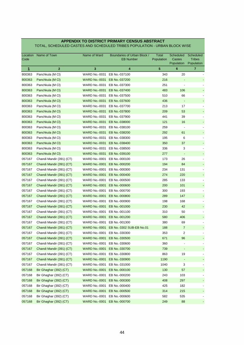
Location Code
Name of Town Name of Ward Boundaries of Urban Block / EB Number
Total Population
Scheduled Castes
Population
Scheduled Tribes
Population
1 2 3 4 5 6 7
APPENDIX TO DISTRICT PRIMARY CENSUS ABSTRACT TOTAL, SCHEDULED CASTES AND SCHEDULED TRIBES POPULATION - URBAN BLOCK WISE
800363 Panchkula (M Cl) WARD No.-0031 EB No.-037100 343 20 -
800363 Panchkula (M Cl) WARD No.-0031 EB No.-037200 216 - -
800363 Panchkula (M Cl) WARD No.-0031 EB No.-037300 251 - -
800363 Panchkula (M Cl) WARD No.-0031 EB No.-037400 483 106 -
800363 Panchkula (M Cl) WARD No.-0031 EB No.-037500 510 66 -
800363 Panchkula (M Cl) WARD No.-0031 EB No.-037600 436 - -
800363 Panchkula (M Cl) WARD No.-0031 EB No.-037700 213 17 -
800363 Panchkula (M Cl) WARD No.-0031 EB No.-037800 209 53 -
800363 Panchkula (M Cl) WARD No.-0031 EB No.-037900 441 39 -
800363 Panchkula (M Cl) WARD No.-0031 EB No.-038000 121 16 -
800363 Panchkula (M Cl) WARD No.-0031 EB No.-038100 259 - -
800363 Panchkula (M Cl) WARD No.-0031 EB No.-038200 292 61 -
800363 Panchkula (M Cl) WARD No.-0031 EB No.-038300 195 6 -
800363 Panchkula (M Cl) WARD No.-0031 EB No.-038400 350 37 -
800363 Panchkula (M Cl) WARD No.-0031 EB No.-038500 336 3 -
800363 Panchkula (M Cl) WARD No.-0031 EB No.-039100 277 - -
057167 Chandi Mandir (391) (CT) WARD No.-0001 EB No.-000100 173 26 -
057167 Chandi Mandir (391) (CT) WARD No.-0001 EB No.-000200 194 84 -
057167 Chandi Mandir (391) (CT) WARD No.-0001 EB No.-000300 234 131 -
057167 Chandi Mandir (391) (CT) WARD No.-0001 EB No.-000400 274 220 -
057167 Chandi Mandir (391) (CT) WARD No.-0001 EB No.-000500 285 133 -
057167 Chandi Mandir (391) (CT) WARD No.-0001 EB No.-000600 200 101 -
057167 Chandi Mandir (391) (CT) WARD No.-0001 EB No.-000700 300 193 -
057167 Chandi Mandir (391) (CT) WARD No.-0001 EB No.-000800 289 147 -
057167 Chandi Mandir (391) (CT) WARD No.-0001 EB No.-000900 198 168 -
057167 Chandi Mandir (391) (CT) WARD No.-0001 EB No.-001000 230 42 -
057167 Chandi Mandir (391) (CT) WARD No.-0001 EB No.-001100 310 50 -
057167 Chandi Mandir (391) (CT) WARD No.-0001 EB No.-001200 580 406 -
057167 Chandi Mandir (391) (CT) WARD No.-0001 EB No.-001300 380 69 -
057167 Chandi Mandir (391) (CT) WARD No.-0001 EB No.-3302 SUB-EB No.01 188 7 -
057167 Chandi Mandir (391) (CT) WARD No.-0001 EB No.-330300 353 2 -
057167 Chandi Mandir (391) (CT) WARD No.-0001 EB No.-330500 671 96 -
057167 Chandi Mandir (391) (CT) WARD No.-0001 EB No.-330600 360 - -
057167 Chandi Mandir (391) (CT) WARD No.-0001 EB No.-330700 739 - -
057167 Chandi Mandir (391) (CT) WARD No.-0001 EB No.-330800 863 19 -
057167 Chandi Mandir (391) (CT) WARD No.-0001 EB No.-330900 1190 - -
057167 Chandi Mandir (391) (CT) WARD No.-0001 EB No.-331000 1040 3 -
057168 Bir Ghaghar (392) (CT) WARD No.-0001 EB No.-000100 130 57 -
057168 Bir Ghaghar (392) (CT) WARD No.-0001 EB No.-000200 243 103 -
057168 Bir Ghaghar (392) (CT) WARD No.-0001 EB No.-000300 408 297 -
057168 Bir Ghaghar (392) (CT) WARD No.-0001 EB No.-000400 425 182 -
057168 Bir Ghaghar (392) (CT) WARD No.-0001 EB No.-000500 314 215 -
057168 Bir Ghaghar (392) (CT) WARD No.-0001 EB No.-000600 582 535 -
057168 Bir Ghaghar (392) (CT) WARD No.-0001 EB No.-000700 249 88 -
44

Location Code
Name of Town Name of Ward Boundaries of Urban Block / EB Number
Total Population
Scheduled Castes
Population
Scheduled Tribes
Population
1 2 3 4 5 6 7
APPENDIX TO DISTRICT PRIMARY CENSUS ABSTRACT TOTAL, SCHEDULED CASTES AND SCHEDULED TRIBES POPULATION - URBAN BLOCK WISE
057168 Bir Ghaghar (392) (CT) WARD No.-0001 EB No.-000800 260 231 -
057168 Bir Ghaghar (392) (CT) WARD No.-0001 EB No.-000900 271 21 -
057168 Bir Ghaghar (392) (CT) WARD No.-0001 EB No.-001000 202 36 -
057168 Bir Ghaghar (392) (CT) WARD No.-0001 EB No.-001100 195 149 -
057168 Bir Ghaghar (392) (CT) WARD No.-0001 EB No.-001200 171 127 -
057168 Bir Ghaghar (392) (CT) WARD No.-0001 EB No.-001300 324 255 -
057168 Bir Ghaghar (392) (CT) WARD No.-0001 EB No.-001400 442 329 -
057168 Bir Ghaghar (392) (CT) WARD No.-0001 EB No.-001500 419 256 -
057168 Bir Ghaghar (392) (CT) WARD No.-0001 EB No.-0016 SUB-EB No.01 128 40 -
057168 Bir Ghaghar (392) (CT) WARD No.-0001 EB No.-0016 SUB-EB No.02 180 30 -
057169 Ram Garh (232) (CT) WARD No.-0001 EB No.-000100 28 - -
057169 Ram Garh (232) (CT) WARD No.-0001 EB No.-000200 258 10 -
057169 Ram Garh (232) (CT) WARD No.-0001 EB No.-000300 691 3 -
057169 Ram Garh (232) (CT) WARD No.-0001 EB No.-000400 549 5 -
057169 Ram Garh (232) (CT) WARD No.-0001 EB No.-000500 204 - -
057169 Ram Garh (232) (CT) WARD No.-0001 EB No.-000600 417 - -
057169 Ram Garh (232) (CT) WARD No.-0001 EB No.-000700 516 8 -
057169 Ram Garh (232) (CT) WARD No.-0001 EB No.-000800 282 - -
057169 Ram Garh (232) (CT) WARD No.-0001 EB No.-000900 544 34 -
057169 Ram Garh (232) (CT) WARD No.-0001 EB No.-001000 402 340 -
057169 Ram Garh (232) (CT) WARD No.-0001 EB No.-001100 448 33 -
057169 Ram Garh (232) (CT) WARD No.-0001 EB No.-310100 595 96 -
057170 Raipur Rani (CT) WARD No.-0001 EB No.-000100 629 - -
057170 Raipur Rani (CT) WARD No.-0001 EB No.-000200 556 285 -
057170 Raipur Rani (CT) WARD No.-0001 EB No.-000300 320 320 -
057170 Raipur Rani (CT) WARD No.-0001 EB No.-000400 564 555 -
057170 Raipur Rani (CT) WARD No.-0001 EB No.-000500 466 212 -
057170 Raipur Rani (CT) WARD No.-0001 EB No.-000600 373 291 -
057170 Raipur Rani (CT) WARD No.-0001 EB No.-000700 333 95 -
057170 Raipur Rani (CT) WARD No.-0001 EB No.-000800 803 47 -
057170 Raipur Rani (CT) WARD No.-0001 EB No.-000900 616 67 -
057170 Raipur Rani (CT) WARD No.-0001 EB No.-001000 837 67 -
057170 Raipur Rani (CT) WARD No.-0001 EB No.-001100 844 - -
057170 Raipur Rani (CT) WARD No.-0001 EB No.-001200 715 11 -
057170 Raipur Rani (CT) WARD No.-0001 EB No.-001300 565 4 -
057170 Raipur Rani (CT) WARD No.-0001 EB No.-001400 442 40 -
057170 Raipur Rani (CT) WARD No.-0001 EB No.-001500 426 335 -
057170 Raipur Rani (CT) WARD No.-0001 EB No.-001600 539 27 -
45

Primary Census Abstract for Scheduled Castes (SC)

DISTRICT CENSUS HANDBOOK : PANCHKULA
PRIMARY CENSUS ABSTRACT
Persons Males Females Persons Males Females1 2 3 4 5 6 7 8 9 10
069 Panchkula - District Total 20,375 1,01,830 53,868 47,962 14,039 7,400 6,639 Rural 9,926 51,484 27,259 24,225 7,050 3,674 3,376 Urban 10,449 50,346 26,609 23,737 6,989 3,726 3,263
0001 Pinjore Total 6,261 32,134 16,741 15,393 4,484 2,302 2,182 Rural 5,083 26,289 13,725 12,564 3,725 1,899 1,826 Urban 1,178 5,845 3,016 2,829 759 403 356
0002 Barwala Total 2,410 12,806 6,887 5,919 1,680 902 778 Rural 2,302 12,277 6,624 5,653 1,632 877 755 Urban 108 529 263 266 48 25 23
0003 Morni Total 566 2,862 1,536 1,326 350 179 171 Rural 566 2,862 1,536 1,326 350 179 171 Urban - - - - - - -
0004 Raipur Rani Total 2,462 12,412 6,603 5,809 1,670 901 769 Rural 1,975 10,056 5,374 4,682 1,343 719 624 Urban 487 2,356 1,229 1,127 327 182 145
URBAN800361 Kalka (MC + OG) Urban 1,293 6,550 3,405 3,145 812 408 404 800362 Pinjore (MC) Urban 1,365 6,916 3,623 3,293 857 441 416 057045 HMT Pinjore (CT) Urban 181 822 452 370 66 35 31 800363 Panchkula (M Cl) Urban 6,053 28,325 15,167 13,158 4,216 2,284 1,932
057167Chandi Mandir (391) (CT) Urban 377 1,897 1,007 890 241 142 99
057168 Bir Ghaghar (392) (CT) Urban 585 2,951 1,463 1,488 422 209 213 057169 Ram Garh (232) (CT) Urban 108 529 263 266 48 25 23 057170 Raipur Rani (CT) Urban 487 2,356 1,229 1,127 327 182 145
Population in the age-group 0-6Location
code number
District/ CD Block/ Town
Total/ Rural/ Urban
Number of households with SC as
head
Total population (including institutional and houseless population)
48

PRIMARY CENSUS ABSTRACT
FOR SCHEDULED CASTES
Persons Males Females Persons Males Females Persons Males Females11 12 13 14 15 16 17 18 19 3 2
62,637 36,356 26,281 39,193 17,512 21,681 36,750 28,353 8,397 Total Panchkula - District31,810 18,467 13,343 19,674 8,792 10,882 18,694 14,291 4,403 Rural30,827 17,889 12,938 19,519 8,720 10,799 18,056 14,062 3,994 Urban20,021 11,437 8,584 12,113 5,304 6,809 11,341 8,798 2,543 Total Pinjore15,991 9,153 6,838 10,298 4,572 5,726 9,225 7,163 2,062 Rural4,030 2,284 1,746 1,815 732 1,083 2,116 1,635 481 Urban8,207 4,846 3,361 4,599 2,041 2,558 4,748 3,694 1,054 Total Barwala7,810 4,629 3,181 4,467 1,995 2,472 4,484 3,545 939 Rural
397 217 180 132 46 86 264 149 115 Urban1,846 1,112 734 1,016 424 592 1,350 856 494 Total Morni1,846 1,112 734 1,016 424 592 1,350 856 494 Rural
- - - - - - - - - Urban7,565 4,377 3,188 4,847 2,226 2,621 4,422 3,312 1,110 Total Raipur Rani6,163 3,573 2,590 3,893 1,801 2,092 3,635 2,727 908 Rural1,402 804 598 954 425 529 787 585 202 Urban
URBAN4,651 2,608 2,043 1,899 797 1,102 2,246 1,878 368 Urban Kalka (MC + OG)4,969 2,795 2,174 1,947 828 1,119 2,174 1,919 255 Urban Pinjore (MC)
692 409 283 130 43 87 271 235 36 Urban HMT Pinjore (CT)15,509 9,251 6,258 12,816 5,916 6,900 10,527 7,942 2,585 Urban Panchkula (M Cl)
1,312 762 550 585 245 340 697 541 156 UrbanChandi Mandir (391) (CT)
1,895 1,043 852 1,056 420 636 1,090 813 277 UrbanBir Ghaghar (392) (CT)
397 217 180 132 46 86 264 149 115 Urban Ram Garh (232) (CT)1,402 804 598 954 425 529 787 585 202 Urban Raipur Rani (CT)
Literates Illiterates District/ CD Block/ Town
Total/ Rural/ Urban
Total workers
49
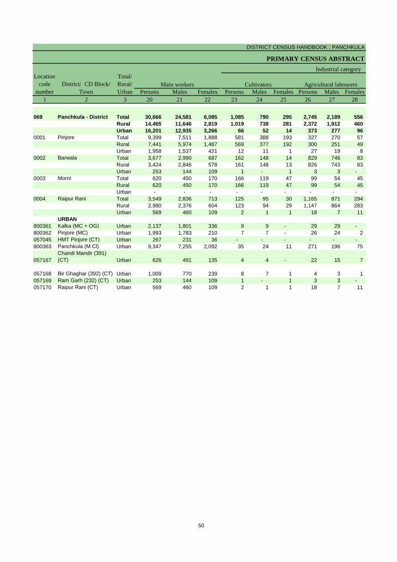
DISTRICT CENSUS HANDBOOK : PANCHKULA
PRIMARY CENSUS ABSTRACT
Persons Males Females Persons Males Females Persons Males Females1 2 3 20 21 22 23 24 25 26 27 28
069 Panchkula - District Total 30,666 24,581 6,085 1,085 790 295 2,745 2,189 556 Rural 14,465 11,646 2,819 1,019 738 281 2,372 1,912 460 Urban 16,201 12,935 3,266 66 52 14 373 277 96
0001 Pinjore Total 9,399 7,511 1,888 581 388 193 327 270 57 Rural 7,441 5,974 1,467 569 377 192 300 251 49 Urban 1,958 1,537 421 12 11 1 27 19 8
0002 Barwala Total 3,677 2,990 687 162 148 14 829 746 83 Rural 3,424 2,846 578 161 148 13 826 743 83 Urban 253 144 109 1 - 1 3 3 -
0003 Morni Total 620 450 170 166 119 47 99 54 45 Rural 620 450 170 166 119 47 99 54 45 Urban - - - - - - - - -
0004 Raipur Rani Total 3,549 2,836 713 125 95 30 1,165 871 294 Rural 2,980 2,376 604 123 94 29 1,147 864 283 Urban 569 460 109 2 1 1 18 7 11
URBAN800361 Kalka (MC + OG) Urban 2,137 1,801 336 9 9 - 29 29 - 800362 Pinjore (MC) Urban 1,993 1,783 210 7 7 - 26 24 2 057045 HMT Pinjore (CT) Urban 267 231 36 - - - - - - 800363 Panchkula (M Cl) Urban 9,347 7,255 2,092 35 24 11 271 196 75
057167Chandi Mandir (391) (CT) Urban 626 491 135 4 4 - 22 15 7
057168 Bir Ghaghar (392) (CT) Urban 1,009 770 239 8 7 1 4 3 1 057169 Ram Garh (232) (CT) Urban 253 144 109 1 - 1 3 3 - 057170 Raipur Rani (CT) Urban 569 460 109 2 1 1 18 7 11
CultivatorsLocation
code number
District/ CD Block/ Town
Total/ Rural/ Urban
Industrial category
Agricultural labourersMain workers
50

PRIMARY CENSUS ABSTRACT
FOR SCHEDULED CASTES
Persons Males Females Persons Males Females Persons Males Females29 30 31 32 33 34 35 36 37 3 2
682 482 200 26,154 21,120 5,034 6,084 3,772 2,312 Total Panchkula - District256 207 49 10,818 8,789 2,029 4,229 2,645 1,584 Rural426 275 151 15,336 12,331 3,005 1,855 1,127 728 Urban166 126 40 8,325 6,727 1,598 1,942 1,287 655 Total Pinjore119 98 21 6,453 5,248 1,205 1,784 1,189 595 Rural47 28 19 1,872 1,479 393 158 98 60 Urban89 64 25 2,597 2,032 565 1,071 704 367 Total Barwala84 63 21 2,353 1,892 461 1,060 699 361 Rural5 1 4 244 140 104 11 5 6 Urban2 2 - 353 275 78 730 406 324 Total Morni2 2 - 353 275 78 730 406 324 Rural
- - - - - - - - - Urban62 54 8 2,197 1,816 381 873 476 397 Total Raipur Rani51 44 7 1,659 1,374 285 655 351 304 Rural11 10 1 538 442 96 218 125 93 Urban
URBAN69 29 40 2,030 1,734 296 109 77 32 Urban Kalka (MC + OG)31 27 4 1,929 1,725 204 181 136 45 Urban Pinjore (MC)
- - - 267 231 36 4 4 - Urban HMT Pinjore (CT)266 183 83 8,775 6,852 1,923 1,180 687 493 Urban Panchkula (M Cl)
18 10 8 582 462 120 71 50 21 UrbanChandi Mandir (391) (CT)
26 15 11 971 745 226 81 43 38 UrbanBir Ghaghar (392) (CT)
5 1 4 244 140 104 11 5 6 Urban Ram Garh (232) (CT)11 10 1 538 442 96 218 125 93 Urban Raipur Rani (CT)
Household industry workers Marginal workersTotal/ Rural/ Urban
District/ CD Block/ Town
Other workers
of main workers
51
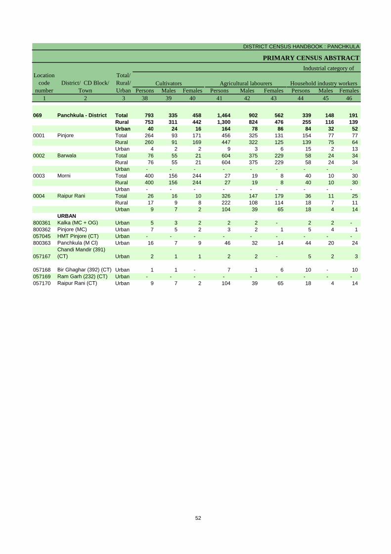
DISTRICT CENSUS HANDBOOK : PANCHKULA
PRIMARY CENSUS ABSTRACT
Persons Males Females Persons Males Females Persons Males Females1 2 3 38 39 40 41 42 43 44 45 46
069 Panchkula - District Total 793 335 458 1,464 902 562 339 148 191 Rural 753 311 442 1,300 824 476 255 116 139 Urban 40 24 16 164 78 86 84 32 52
0001 Pinjore Total 264 93 171 456 325 131 154 77 77 Rural 260 91 169 447 322 125 139 75 64 Urban 4 2 2 9 3 6 15 2 13
0002 Barwala Total 76 55 21 604 375 229 58 24 34 Rural 76 55 21 604 375 229 58 24 34 Urban - - - - - - - - -
0003 Morni Total 400 156 244 27 19 8 40 10 30 Rural 400 156 244 27 19 8 40 10 30 Urban - - - - - - - - -
0004 Raipur Rani Total 26 16 10 326 147 179 36 11 25 Rural 17 9 8 222 108 114 18 7 11 Urban 9 7 2 104 39 65 18 4 14
URBAN800361 Kalka (MC + OG) Urban 5 3 2 2 2 - 2 2 - 800362 Pinjore (MC) Urban 7 5 2 3 2 1 5 4 1 057045 HMT Pinjore (CT) Urban - - - - - - - - - 800363 Panchkula (M Cl) Urban 16 7 9 46 32 14 44 20 24
057167Chandi Mandir (391) (CT) Urban 2 1 1 2 2 - 5 2 3
057168 Bir Ghaghar (392) (CT) Urban 1 1 - 7 1 6 10 - 10 057169 Ram Garh (232) (CT) Urban - - - - - - - - - 057170 Raipur Rani (CT) Urban 9 7 2 104 39 65 18 4 14
Industrial category of
Cultivators Household industry workersLocation
code number
District/ CD Block/ Town
Total/ Rural/ Urban
Agricultural labourers
52

PRIMARY CENSUS ABSTRACT
FOR SCHEDULED CASTES
Persons Males Females Persons Males Females47 48 49 50 51 52 3 2 1
3,488 2,387 1,101 65,080 25,515 39,565 Total Panchkula - District 0691,921 1,394 527 32,790 12,968 19,822 Rural1,567 993 574 32,290 12,547 19,743 Urban1,068 792 276 20,793 7,943 12,850 Total Pinjore 0001
938 701 237 17,064 6,562 10,502 Rural130 91 39 3,729 1,381 2,348 Urban333 250 83 8,058 3,193 4,865 Total Barwala 0002322 245 77 7,793 3,079 4,714 Rural11 5 6 265 114 151 Urban
263 221 42 1,512 680 832 Total Morni 0003263 221 42 1,512 680 832 Rural- - - - - - Urban485 302 183 7,990 3,291 4,699 Total Raipur Rani 0004398 227 171 6,421 2,647 3,774 Rural87 75 12 1,569 644 925 Urban
URBAN100 70 30 4,304 1,527 2,777 Urban Kalka (MC + OG) 800361166 125 41 4,742 1,704 3,038 Urban Pinjore (MC) 800362
4 4 - 551 217 334 Urban HMT Pinjore (CT) 0570451,074 628 446 17,798 7,225 10,573 Urban Panchkula (M Cl) 800363
62 45 17 1,200 466 734 UrbanChandi Mandir (391) (CT) 057167
63 41 22 1,861 650 1,211 Urban Bir Ghaghar (392) (CT) 05716811 5 6 265 114 151 Urban Ram Garh (232) (CT) 05716987 75 12 1,569 644 925 Urban Raipur Rani (CT) 057170
marginal workers
District/ CD Block/ Town
Location code
numberOther workers Non-workers
Total/ Rural/ Urban
53


Primary Census Abstract for
Scheduled Tribes (ST)
__________________________________________________________
** There is no Scheduled Tribes notified **

Rural PCA-C.D. blocks wise Village Primary Census
Abstract

DISTRICT CENSUS HANDBOOK : PANCHKULA
VILLAGE PRIMARY
Persons Males Females Persons Males Females1 2 3 4 5 6 7 8 9 10
0001 Pinjore (Total) 17,838.00 24,450 1,24,021 66,034 57,987 16,663 8,736 7,927 0001 Pinjore (Rural) 17,024.00 20,133 1,04,275 54,977 49,298 14,300 7,461 6,839 0001 Pinjore (Urban) 814.00 4,317 19,746 11,057 8,689 2,363 1,275 1,088
RURAL056946 Shahpur (99) 118.00 146 740 383 357 87 46 41 056947 Khokhra (100) 315.00 188 1,119 600 519 195 108 87 056948 Nawannagar (98) 231.00 245 1,388 788 600 177 101 76 056949 Gorakhnath (97) 159.00 114 586 302 284 77 36 41 056950 Sitoo Majra (96) 88.00 54 300 148 152 44 26 18 056951 Lehroundi (94) 109.00 48 255 129 126 45 24 21 056952 Maranwala (95) 221.00 757 3,964 2,088 1,876 538 276 262 056953 Kona (93) 266.00 331 1,800 950 850 270 135 135
056954 Rampur Jangi (92) 207.00 264 1,429 724 705 217 114 103 056955 Khol Mola (101) 168.00 74 364 195 169 66 36 30
056956 Khol Fatehsingh (102) 106.00 75 466 237 229 74 38 36 056957 Nanakpur (91) 345.00 456 2,436 1,272 1,164 317 171 146 056958 Khol Albala (89) 142.00 42 215 109 106 34 13 21 056959 Ramnagar (90) 127.00 82 505 284 221 59 38 21 056960 Karanpur (88) 333.00 543 2,988 1,584 1,404 405 216 189 056961 Johlowal (129) 285.00 298 1,711 962 749 256 146 110 056962 Charnian (128) 272.00 281 1,618 873 745 212 114 98 056963 Kheranwali (130) 242.00 372 1,899 983 916 243 122 121
056964 Banoi Khuda Bax (131) 150.00 82 510 261 249 101 51 50
056965 Banoi Sanwalia (132) 115.00 19 96 54 42 11 5 6
056966 Thane Ki Ser (134) 68.00 146 814 428 386 107 49 58
056967 Nagal Rootal (133) 204.00 119 703 368 335 82 42 40 056968 Bar (135) 475.00 153 773 413 360 121 63 58 056969 Pargian (136) 73.00 33 186 105 81 18 8 10
056970 Nagal Bhaga (138) 83.00 84 427 214 213 57 25 32 056971 Paploha (139) 315.00 530 2,670 1,421 1,249 391 192 199 056972 Kiratpur (127) 238.00 392 1,996 1,048 948 300 151 149 056973 Gariran (126) 279.00 195 1,021 540 481 151 70 81
056974 Majra Mehtab (140) 165.00 283 1,567 791 776 251 122 129 056975 Kandiala (137) 141.00 113 572 303 269 68 40 28 056976 Orian (147) 57.00 72 336 169 167 33 19 14
056977 Tagra Kali Ram (145) 61.00 417 1,957 1,022 935 243 137 106
056978 Tagra Hari Singh (144) 28.00 139 606 316 290 66 35 31
056979 Tagra Kangan (141) 77.00 64 328 170 158 34 11 23 056980 Basawal (125) 174.00 247 1,364 718 646 199 110 89 056981 Majri Jattan (123) 146.00 118 676 354 322 81 31 50 056982 Khera (124) 129.00 121 624 331 293 73 40 33
056983 Tagra Sahoo (142) 63.00 58 343 182 161 48 22 26
056984 Tagra Hasua (143) 46.00 147 733 389 344 96 50 46
056985 Tagra Hakimpur (150) 59.00 182 987 512 475 140 75 65
056986 Basdevpura (151) 255.00 225 1,210 617 593 189 85 104
C D Block -
Population in the age-group 0-6Name of Village
Location code
number
Total population (including institutional and houseless
population)Area of
Village in hectares
Number of households
58
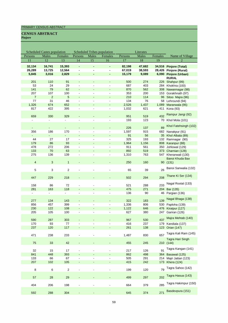
PRIMARY CENSUS ABSTRACT
CENSUS ABSTRACTPinjore
Persons Males Females Persons Males Females Persons Males Females11 12 13 14 15 16 17 18 19 2
32,134 16,741 15,393 - - - 82,198 47,682 34,516 Pinjore (Total)26,289 13,725 12,564 - - - 67,019 38,593 28,426 Pinjore (Rural)5,845 3,016 2,829 - - - 15,179 9,089 6,090 Pinjore (Urban)
RURAL201 110 91 - - - 500 274 226 Shahpur (99)53 24 29 - - - 687 403 284 Khokhra (100)
141 79 62 - - - 870 562 308 Nawannagar (98)207 107 100 - - - 353 200 153 Gorakhnath (97)
7 2 5 - - - 210 114 96 Sitoo Majra (96)77 31 46 - - - 134 76 58 Lehroundi (94)
1,326 674 652 - - - 2,526 1,437 1,089 Maranwala (95)817 422 395 - - - 1,032 621 411 Kona (93)
659 330 329 - - - 951 519 432 Rampur Jangi (92)
- - - - - - 193 123 70 Khol Mola (101)
- - - - - - 226 137 89 Khol Fatehsingh (102)
356 186 170 - - - 1,597 915 682 Nanakpur (91)- - - - - - 91 56 35 Khol Albala (89)44 27 17 - - - 325 193 132 Ramnagar (90)
179 86 93 - - - 1,964 1,156 808 Karanpur (88)478 272 206 - - - 911 561 350 Johlowal (129)133 70 63 - - - 892 519 373 Charnian (128)275 136 139 - - - 1,310 763 547 Kheranwali (130)
4 3 1 - - - 250 160 90 Banoi Khuda Bax (131)
5 3 2 - - - 65 39 26 Banoi Sanwalia (132)
447 229 218 - - - 502 294 208 Thane Ki Ser (134)
158 86 72 - - - 521 288 233 Nagal Rootal (133)
281 163 118 - - - 475 271 204 Bar (135)- - - - - - 136 90 46 Pargian (136)
277 134 143 - - - 322 183 139 Nagal Bhaga (138)
856 457 399 - - - 1,336 806 530 Paploha (139)230 122 108 - - - 1,122 646 476 Kiratpur (127)205 105 100 - - - 627 380 247 Gariran (126)
590 287 303 - - - 967 530 437 Majra Mehtab (140)
170 93 77 - - - 416 237 179 Kandiala (137)237 120 117 - - - 261 138 123 Orian (147)
471 238 233 - - - 1,487 830 657 Tagra Kali Ram (145)
75 33 42 - - - 455 245 210 Tagra Hari Singh (144)
32 15 17 - - - 217 126 91 Tagra Kangan (141)
841 448 393 - - - 862 498 364 Basawal (125)133 66 67 - - - 505 291 214 Majri Jattan (123)207 102 105 - - - 415 242 173 Khera (124)
8 6 2 - - - 199 120 79 Tagra Sahoo (142)
57 28 29 - - - 499 297 202 Tagra Hasua (143)
404 206 198 - - - 664 379 285 Tagra Hakimpur (150)
592 288 304 - - - 645 374 271 Basdevpura (151)
Scheduled Castes population Scheduled Tribes populationName of Village
Literates
59
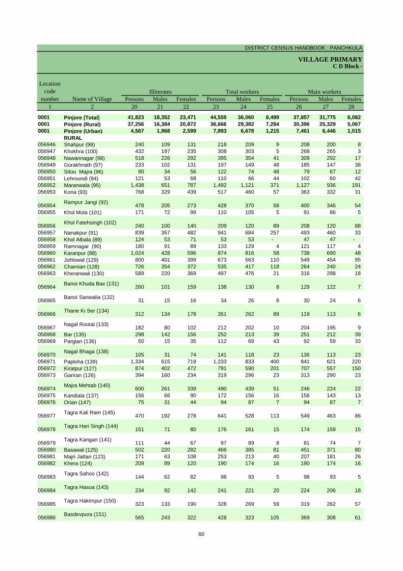
DISTRICT CENSUS HANDBOOK : PANCHKULA
VILLAGE PRIMARYC D Block -
Persons Males Females Persons Males Females Persons Males Females1 2 20 21 22 23 24 25 26 27 28
0001 Pinjore (Total) 41,823 18,352 23,471 44,559 36,060 8,499 37,857 31,775 6,082 0001 Pinjore (Rural) 37,256 16,384 20,872 36,666 29,382 7,284 30,396 25,329 5,067 0001 Pinjore (Urban) 4,567 1,968 2,599 7,893 6,678 1,215 7,461 6,446 1,015
RURAL056946 Shahpur (99) 240 109 131 218 209 9 208 200 8 056947 Khokhra (100) 432 197 235 308 303 5 268 265 3 056948 Nawannagar (98) 518 226 292 395 354 41 309 292 17 056949 Gorakhnath (97) 233 102 131 197 149 48 185 147 38 056950 Sitoo Majra (96) 90 34 56 122 74 48 79 67 12 056951 Lehroundi (94) 121 53 68 110 66 44 102 60 42 056952 Maranwala (95) 1,438 651 787 1,492 1,121 371 1,127 936 191 056953 Kona (93) 768 329 439 517 460 57 363 332 31
056954 Rampur Jangi (92) 478 205 273 428 370 58 400 346 54 056955 Khol Mola (101) 171 72 99 110 105 5 91 86 5
056956 Khol Fatehsingh (102) 240 100 140 209 120 89 208 120 88 056957 Nanakpur (91) 839 357 482 941 684 257 493 460 33 056958 Khol Albala (89) 124 53 71 53 53 - 47 47 - 056959 Ramnagar (90) 180 91 89 133 129 4 121 117 4 056960 Karanpur (88) 1,024 428 596 874 816 58 738 690 48 056961 Johlowal (129) 800 401 399 673 563 110 549 454 95 056962 Charnian (128) 726 354 372 535 417 118 264 240 24 056963 Kheranwali (130) 589 220 369 497 476 21 316 298 18
056964 Banoi Khuda Bax (131) 260 101 159 138 130 8 129 122 7
056965 Banoi Sanwalia (132) 31 15 16 34 26 8 30 24 6
056966 Thane Ki Ser (134) 312 134 178 351 262 89 119 113 6
056967 Nagal Rootal (133) 182 80 102 212 202 10 204 195 9 056968 Bar (135) 298 142 156 252 213 39 251 212 39 056969 Pargian (136) 50 15 35 112 69 43 92 59 33
056970 Nagal Bhaga (138) 105 31 74 141 118 23 136 113 23 056971 Paploha (139) 1,334 615 719 1,233 833 400 841 621 220 056972 Kiratpur (127) 874 402 472 791 590 201 707 557 150 056973 Gariran (126) 394 160 234 319 296 23 313 290 23
056974 Majra Mehtab (140) 600 261 339 490 439 51 246 224 22 056975 Kandiala (137) 156 66 90 172 156 16 156 143 13 056976 Orian (147) 75 31 44 94 87 7 94 87 7
056977 Tagra Kali Ram (145) 470 192 278 641 528 113 549 463 86
056978 Tagra Hari Singh (144) 151 71 80 176 161 15 174 159 15
056979 Tagra Kangan (141) 111 44 67 97 89 8 81 74 7 056980 Basawal (125) 502 220 282 466 385 81 451 371 80 056981 Majri Jattan (123) 171 63 108 253 213 40 207 181 26 056982 Khera (124) 209 89 120 190 174 16 190 174 16
056983 Tagra Sahoo (142) 144 62 82 98 93 5 98 93 5
056984 Tagra Hasua (143) 234 92 142 241 221 20 224 206 18
056985 Tagra Hakimpur (150) 323 133 190 328 269 59 319 262 57
056986 Basdevpura (151) 565 243 322 428 323 105 369 308 61
Illiterates Total workers Main workersName of Village
Location code
number
60

PRIMARY CENSUS ABSTRACT
CENSUS ABSTRACTPinjore
Persons Males Females Persons Males Females Persons MalesFemales Persons Males Females29 30 31 32 33 34 35 36 37 38 39 40 2
5,121 4,296 825 1,377 1,190 187 1,075 814 261 30,284 25,475 4,809 Pinjore (Total)5,045 4,229 816 1,311 1,139 172 879 668 211 23,161 19,293 3,868 Pinjore (Rural)
76 67 9 66 51 15 196 146 50 7,123 6,182 941 Pinjore (Urban)RURAL
24 24 - 38 37 1 6 5 1 140 134 6 Shahpur (99)60 60 - - - - - - - 208 205 3 Khokhra (100)53 52 1 13 13 - 1 - 1 242 227 15 Nawannagar (98)48 44 4 1 1 - - - - 136 102 34 Gorakhnath (97)40 35 5 2 2 - 1 1 - 36 29 7 Sitoo Majra (96)42 16 26 6 2 4 - - - 54 42 12 Lehroundi (94)44 41 3 15 14 1 22 20 2 1,046 861 185 Maranwala (95)86 79 7 9 9 - 9 7 2 259 237 22 Kona (93)
51 42 9 22 21 1 25 21 4 302 262 40 Rampur Jangi (92)
7 7 - 1 1 - 1 1 - 82 77 5 Khol Mola (101)
- - - - - - 3 - 3 205 120 85 Khol Fatehsingh (102)
147 144 3 10 10 - - - - 336 306 30 Nanakpur (91)9 9 - 1 1 - - - - 37 37 - Khol Albala (89)
27 27 - 42 42 - 1 1 - 51 47 4 Ramnagar (90)134 131 3 28 28 - 12 9 3 564 522 42 Karanpur (88)179 171 8 8 7 1 5 3 2 357 273 84 Johlowal (129)91 87 4 8 8 - 9 5 4 156 140 16 Charnian (128)67 65 2 - - - 11 10 1 238 223 15 Kheranwali (130)
17 17 - 25 25 - - - - 87 80 7 Banoi Khuda Bax (131)
- - - 6 5 1 1 1 - 23 18 5 Banoi Sanwalia (132)
39 37 2 - - - 2 2 - 78 74 4 Thane Ki Ser (134)
118 117 1 - - - 1 1 - 85 77 8 Nagal Rootal (133)
1 1 - 48 48 - 17 14 3 185 149 36 Bar (135)55 29 26 - - - 2 - 2 35 30 5 Pargian (136)
16 10 6 - - - 13 10 3 107 93 14 Nagal Bhaga (138)
33 32 1 13 11 2 55 41 14 740 537 203 Paploha (139)130 118 12 9 9 - 2 2 - 566 428 138 Kiratpur (127)12 12 - 99 92 7 24 16 8 178 170 8 Gariran (126)
38 36 2 12 12 - 17 16 1 179 160 19 Majra Mehtab (140)
52 51 1 6 4 2 6 5 1 92 83 9 Kandiala (137)14 14 - - - - - - - 80 73 7 Orian (147)
43 33 10 1 1 - 10 9 1 495 420 75 Tagra Kali Ram (145)
14 14 - - - - - - - 160 145 15 Tagra Hari Singh (144)
- - - 4 4 - - - - 77 70 7 Tagra Kangan (141)
63 61 2 2 2 - 2 2 - 384 306 78 Basawal (125)83 82 1 - - - 14 11 3 110 88 22 Majri Jattan (123)46 45 1 - - - 2 2 - 142 127 15 Khera (124)
1 1 - 1 1 - - - - 96 91 5 Tagra Sahoo (142)
15 15 - - - - 6 6 - 203 185 18 Tagra Hasua (143)
76 44 32 7 6 1 11 1 10 225 211 14 Tagra Hakimpur (150)
44 43 1 67 54 13 1 1 - 257 210 47 Basdevpura (151)
CultivatorsName of Village
Household industry workersAgricultural labourers
Industrial category of main workers
Other workers
61

DISTRICT CENSUS HANDBOOK : PANCHKULA
VILLAGE PRIMARYC D Block -
Persons Males Females Persons Males Females Persons Males Females1 2 41 42 43 44 45 46 47 48 49
0001 Pinjore (Total) 6,702 4,285 2,417 1,170 463 707 1,170 886 284 0001 Pinjore (Rural) 6,270 4,053 2,217 1,154 455 699 1,155 881 274 0001 Pinjore (Urban) 432 232 200 16 8 8 15 5 10
RURAL056946 Shahpur (99) 10 9 1 2 2 - 4 4 - 056947 Khokhra (100) 40 38 2 - - - 31 31 - 056948 Nawannagar (98) 86 62 24 1 - 1 20 18 2 056949 Gorakhnath (97) 12 2 10 - - - - - - 056950 Sitoo Majra (96) 43 7 36 29 1 28 3 1 2 056951 Lehroundi (94) 8 6 2 2 2 - - - - 056952 Maranwala (95) 365 185 180 32 27 5 77 62 15 056953 Kona (93) 154 128 26 4 1 3 2 1 1
056954 Rampur Jangi (92) 28 24 4 2 2 - 8 8 - 056955 Khol Mola (101) 19 19 - - - - 9 9 -
056956 Khol Fatehsingh (102) 1 - 1 - - - - - - 056957 Nanakpur (91) 448 224 224 281 97 184 60 28 32 056958 Khol Albala (89) 6 6 - - - - 2 2 - 056959 Ramnagar (90) 12 12 - - - - 8 8 - 056960 Karanpur (88) 136 126 10 1 1 - 3 3 - 056961 Johlowal (129) 124 109 15 - - - 19 18 1 056962 Charnian (128) 271 177 94 7 6 1 17 15 2 056963 Kheranwali (130) 181 178 3 26 26 - 1 1 -
056964Banoi Khuda Bax (131) 9 8 1 - - - 2 2 -
056965 Banoi Sanwalia (132) 4 2 2 - - - - - -
056966 Thane Ki Ser (134) 232 149 83 5 1 4 100 81 19
056967 Nagal Rootal (133) 8 7 1 3 3 - 1 1 - 056968 Bar (135) 1 1 - - - - - - - 056969 Pargian (136) 20 10 10 7 1 6 2 1 1
056970 Nagal Bhaga (138) 5 5 - 1 1 - - - - 056971 Paploha (139) 392 212 180 93 25 68 114 83 31 056972 Kiratpur (127) 84 33 51 3 1 2 10 3 7 056973 Gariran (126) 6 6 - 1 1 - 3 3 -
056974 Majra Mehtab (140) 244 215 29 6 6 - 109 105 4 056975 Kandiala (137) 16 13 3 5 4 1 3 2 1 056976 Orian (147) - - - - - - - - -
056977 Tagra Kali Ram (145) 92 65 27 2 - 2 4 2 2
056978 Tagra Hari Singh (144) 2 2 - 1 1 - - - -
056979 Tagra Kangan (141) 16 15 1 1 1 - 11 10 1 056980 Basawal (125) 15 14 1 - - - 3 3 - 056981 Majri Jattan (123) 46 32 14 1 - 1 - - - 056982 Khera (124) - - - - - - - - -
056983 Tagra Sahoo (142) - - - - - - - - -
056984 Tagra Hasua (143) 17 15 2 3 2 1 - - -
056985 Tagra Hakimpur (150) 9 7 2 1 1 - 1 1 -
056986 Basdevpura (151) 59 15 44 - - - 12 2 10
Location code
number Name of VillageMarginal workers Cultivators Agricultural labourers
Industrial category
62
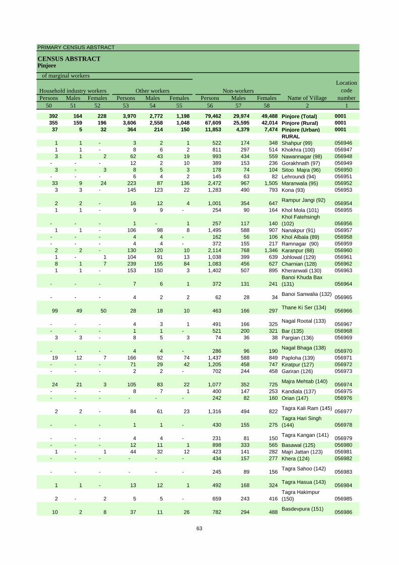
PRIMARY CENSUS ABSTRACT
CENSUS ABSTRACTPinjore
Persons Males Females Persons Males Females Persons Males Females50 51 52 53 54 55 56 57 58 2 1
392 164 228 3,970 2,772 1,198 79,462 29,974 49,488 Pinjore (Total) 0001355 159 196 3,606 2,558 1,048 67,609 25,595 42,014 Pinjore (Rural) 000137 5 32 364 214 150 11,853 4,379 7,474 Pinjore (Urban) 0001
RURAL1 1 - 3 2 1 522 174 348 Shahpur (99) 0569461 1 - 8 6 2 811 297 514 Khokhra (100) 0569473 1 2 62 43 19 993 434 559 Nawannagar (98) 056948
- - - 12 2 10 389 153 236 Gorakhnath (97) 0569493 - 3 8 5 3 178 74 104 Sitoo Majra (96) 056950
- - - 6 4 2 145 63 82 Lehroundi (94) 05695133 9 24 223 87 136 2,472 967 1,505 Maranwala (95) 0569523 3 - 145 123 22 1,283 490 793 Kona (93) 056953
2 2 - 16 12 4 1,001 354 647 Rampur Jangi (92) 0569541 1 - 9 9 - 254 90 164 Khol Mola (101) 056955
- - - 1 - 1 257 117 140 Khol Fatehsingh (102) 056956
1 1 - 106 98 8 1,495 588 907 Nanakpur (91) 056957- - - 4 4 - 162 56 106 Khol Albala (89) 056958- - - 4 4 - 372 155 217 Ramnagar (90) 056959
2 2 - 130 120 10 2,114 768 1,346 Karanpur (88) 0569601 - 1 104 91 13 1,038 399 639 Johlowal (129) 0569618 1 7 239 155 84 1,083 456 627 Charnian (128) 0569621 1 - 153 150 3 1,402 507 895 Kheranwali (130) 056963
- - - 7 6 1 372 131 241 Banoi Khuda Bax (131) 056964
- - - 4 2 2 62 28 34 Banoi Sanwalia (132) 056965
99 49 50 28 18 10 463 166 297 Thane Ki Ser (134) 056966
- - - 4 3 1 491 166 325 Nagal Rootal (133) 056967- - - 1 1 - 521 200 321 Bar (135) 056968
3 3 - 8 5 3 74 36 38 Pargian (136) 056969
- - - 4 4 - 286 96 190 Nagal Bhaga (138) 05697019 12 7 166 92 74 1,437 588 849 Paploha (139) 056971
- - - 71 29 42 1,205 458 747 Kiratpur (127) 056972- - - 2 2 - 702 244 458 Gariran (126) 056973
24 21 3 105 83 22 1,077 352 725 Majra Mehtab (140) 056974- - - 8 7 1 400 147 253 Kandiala (137) 056975- - - - - - 242 82 160 Orian (147) 056976
2 2 - 84 61 23 1,316 494 822 Tagra Kali Ram (145) 056977
- - - 1 1 - 430 155 275 Tagra Hari Singh (144) 056978
- - - 4 4 - 231 81 150 Tagra Kangan (141) 056979- - - 12 11 1 898 333 565 Basawal (125) 056980
1 - 1 44 32 12 423 141 282 Majri Jattan (123) 056981- - - - - - 434 157 277 Khera (124) 056982
- - - - - - 245 89 156 Tagra Sahoo (142) 056983
1 1 - 13 12 1 492 168 324 Tagra Hasua (143) 056984
2 - 2 5 5 - 659 243 416 Tagra Hakimpur (150) 056985
10 2 8 37 11 26 782 294 488 Basdevpura (151) 056986
Non-workers
of marginal workersLocation
code number
Household industry workersName of Village
Other workers
63
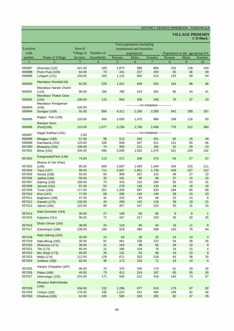
DISTRICT CENSUS HANDBOOK : PANCHKULA
VILLAGE PRIMARY
Persons Males Females Persons Males Females1 2 3 4 5 6 7 8 9 10
C D Block -
Population in the age-group 0-6Name of Village
Location code
number
Total population (including institutional and houseless
population)Area of
Village in hectares
Number of households
056987 Dhamala (122) 421.00 328 1,873 989 884 232 128 104 056988 Prem Pura (103) 64.00 74 441 237 204 65 36 29 056989 Lohgarh (121) 150.00 205 1,115 600 515 133 69 64
056990 Manakpur Devilal(118) 62.00 229 1,201 649 552 164 98 66
056991Manakpur Nanak Chand (119) 95.00 150 780 419 361 85 44 41
056992Manakpur Thakar Dass (120) 106.00 115 554 308 246 70 37 33
056993Manakpur Kholgaman (104) 140.00
056994 Surajpur (109) 91.00 856 4,311 2,256 2,055 542 285 257
056995 Rajipur Part (108) 120.00 456 2,055 1,075 980 199 116 83
056996Rampur Seori (Part)(106) 115.00 1,077 5,236 2,768 2,468 776 412 364
056997 Nagal Sodhian (191) 2.00056998 Bhogpur (190) 57.00 98 513 262 251 65 25 40 056999 Damdama (154) 123.00 159 848 437 411 131 65 66 057000 Bhawana (155) 106.00 74 393 211 182 52 29 23 057001 Bitna (153) 335.00 695 3,608 1,932 1,676 421 229 192
057002 Kanguwala(Part) (146) 74.00 113 571 296 275 64 27 37
057003Bharon Ki Ser (Part) (149) 85.00 609 2,837 1,493 1,344 426 215 211
057004 Tipra (157) 90.00 714 3,587 1,851 1,736 449 237 212 057005 Noulta (158) 55.00 55 309 167 142 46 27 19 057006 Jaithal (156) 59.00 32 191 95 96 37 15 22 057007 Dakrog (169) 166.00 73 415 215 200 55 24 31 057008 Janouli (162) 87.00 53 278 145 133 34 18 16 057009 Toran (159) 117.00 261 1,320 687 633 184 85 99 057010 Khoi (167) 77.00 58 295 149 146 38 15 23 057011 Bagharni (168) 47.00 32 152 83 69 22 14 8 057012 Gawahi (170) 132.00 44 260 142 118 39 18 21 057013 Jabrot (166) 122.00 89 457 247 210 50 31 19
057014 Nala Domehar (164) 30.00 27 139 83 56 9 8 1 057015 Kajiyana (161) 96.00 71 437 217 220 45 20 25
057016 Dhato Ghran (160) 38.00 24 119 65 54 19 11 8 057017 Ganeshpur (188) 108.00 166 918 480 438 140 76 64
057018 Nala Dakrog (163) 40.00 13 64 39 25 14 10 4 057019 Nala Bloug (165) 35.00 91 461 239 222 54 28 26 057020 Dhamsoo (171) 38.00 31 163 98 65 28 19 9 057021 Tibi (172) 65.00 31 180 104 76 19 15 4 057022 Ber Ghati (173) 69.00 26 131 63 68 19 10 9 057023 Malla (174) 112.00 129 671 353 318 63 38 25 057024 Jodhpur (186) 82.00 36 173 102 71 14 10 4
057025 Haripur Chopahar (187) 95.00 70 370 200 170 61 29 32 057026 Patan (189) 40.00 73 411 214 197 65 35 30 057027 Islamnagar (192) 215.00 171 930 512 418 140 73 67
057028
Miranpur Bakhshiwala (194) 334.00 232 1,296 677 619 179 97 82
057029 Chikan (185) 178.00 195 1,023 541 482 108 62 46 057030 Kharkua (183) 62.00 105 585 303 282 82 47 35
-------------Un-inhabited--------------
-------------Un-inhabited--------------
64
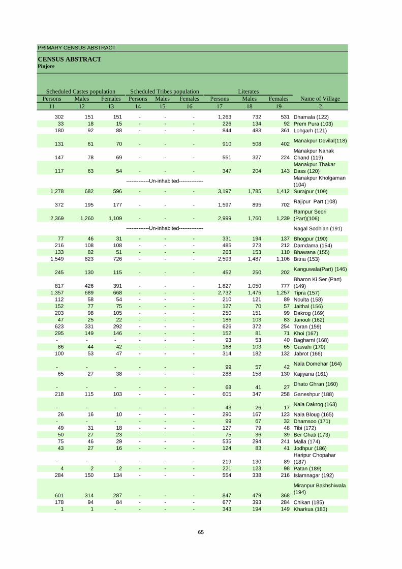
PRIMARY CENSUS ABSTRACT
CENSUS ABSTRACTPinjore
Persons Males Females Persons Males Females Persons Males Females11 12 13 14 15 16 17 18 19 2
Scheduled Castes population Scheduled Tribes populationName of Village
Literates
302 151 151 - - - 1,263 732 531 Dhamala (122)33 18 15 - - - 226 134 92 Prem Pura (103)
180 92 88 - - - 844 483 361 Lohgarh (121)
131 61 70 - - - 910 508 402 Manakpur Devilal(118)
147 78 69 - - - 551 327 224 Manakpur Nanak Chand (119)
117 63 54 - - - 347 204 143 Manakpur Thakar Dass (120)Manakpur Kholgaman (104)
1,278 682 596 - - - 3,197 1,785 1,412 Surajpur (109)
372 195 177 - - - 1,597 895 702 Rajipur Part (108)
2,369 1,260 1,109 - - - 2,999 1,760 1,239 Rampur Seori (Part)(106)
Nagal Sodhian (191)
77 46 31 - - - 331 194 137 Bhogpur (190)216 108 108 - - - 485 273 212 Damdama (154)133 82 51 - - - 263 153 110 Bhawana (155)
1,549 823 726 - - - 2,593 1,487 1,106 Bitna (153)
245 130 115 - - - 452 250 202 Kanguwala(Part) (146)
817 426 391 - - - 1,827 1,050 777 Bharon Ki Ser (Part) (149)
1,357 689 668 - - - 2,732 1,475 1,257 Tipra (157)112 58 54 - - - 210 121 89 Noulta (158)152 77 75 - - - 127 70 57 Jaithal (156)203 98 105 - - - 250 151 99 Dakrog (169)47 25 22 - - - 186 103 83 Janouli (162)
623 331 292 - - - 626 372 254 Toran (159)295 149 146 - - - 152 81 71 Khoi (167)- - - - - - 93 53 40 Bagharni (168)86 44 42 - - - 168 103 65 Gawahi (170)
100 53 47 - - - 314 182 132 Jabrot (166)
- - - - - - 99 57 42 Nala Domehar (164)
65 27 38 - - - 288 158 130 Kajiyana (161)
- - - - - - 68 41 27 Dhato Ghran (160)
218 115 103 - - - 605 347 258 Ganeshpur (188)
- - - - - - 43 26 17 Nala Dakrog (163)
26 16 10 - - - 290 167 123 Nala Bloug (165)- - - - - - 99 67 32 Dhamsoo (171)49 31 18 - - - 127 79 48 Tibi (172)50 27 23 - - - 75 36 39 Ber Ghati (173)75 46 29 - - - 535 294 241 Malla (174)43 27 16 - - - 124 83 41 Jodhpur (186)
- - - - - - 219 130 89 Haripur Chopahar (187)
4 2 2 - - - 221 123 98 Patan (189)284 150 134 - - - 554 338 216 Islamnagar (192)
601 314 287 - - - 847 479 368
Miranpur Bakhshiwala (194)
178 94 84 - - - 677 393 284 Chikan (185)1 1 - - - - 343 194 149 Kharkua (183)
-------------Un-inhabited--------------
-------------Un-inhabited--------------
65

DISTRICT CENSUS HANDBOOK : PANCHKULA
VILLAGE PRIMARYC D Block -
Persons Males Females Persons Males Females Persons Males Females1 2 20 21 22 23 24 25 26 27 28
Illiterates Total workers Main workersName of Village
Location code
number
056987 Dhamala (122) 610 257 353 615 559 56 540 508 32 056988 Prem Pura (103) 215 103 112 129 122 7 125 122 3 056989 Lohgarh (121) 271 117 154 422 349 73 399 335 64
056990 Manakpur Devilal(118) 291 141 150 446 356 90 384 311 73
056991Manakpur Nanak Chand (119) 229 92 137 216 205 11 214 203 11
056992Manakpur Thakar Dass (120) 207 104 103 197 180 17 186 173 13
056993Manakpur Kholgaman (104)
056994 Surajpur (109) 1,114 471 643 1,403 1,165 238 1,265 1,066 199
056995 Rajipur Part (108) 458 180 278 779 611 168 667 548 119
056996Rampur Seori (Part)(106) 2,237 1,008 1,229 1,855 1,445 410 1,658 1,307 351
056997 Nagal Sodhian (191)
056998 Bhogpur (190) 182 68 114 170 134 36 89 75 14 056999 Damdama (154) 363 164 199 246 226 20 233 216 17 057000 Bhawana (155) 130 58 72 169 122 47 166 119 47 057001 Bitna (153) 1,015 445 570 1,219 986 233 1,154 953 201
057002 Kanguwala(Part) (146) 119 46 73 182 156 26 170 145 25
057003Bharon Ki Ser (Part) (149) 1,010 443 567 958 809 149 916 778 138
057004 Tipra (157) 855 376 479 1,191 935 256 1,111 898 213 057005 Noulta (158) 99 46 53 108 90 18 107 89 18 057006 Jaithal (156) 64 25 39 57 55 2 22 21 1 057007 Dakrog (169) 165 64 101 190 128 62 80 74 6 057008 Janouli (162) 92 42 50 143 82 61 88 72 16 057009 Toran (159) 694 315 379 598 369 229 197 103 94 057010 Khoi (167) 143 68 75 157 91 66 121 73 48 057011 Bagharni (168) 59 30 29 57 36 21 55 35 20 057012 Gawahi (170) 92 39 53 125 77 48 11 5 6 057013 Jabrot (166) 143 65 78 147 125 22 130 114 16
057014 Nala Domehar (164) 40 26 14 74 46 28 26 20 6 057015 Kajiyana (161) 149 59 90 136 114 22 106 90 16
057016 Dhato Ghran (160) 51 24 27 69 39 30 65 37 28 057017 Ganeshpur (188) 313 133 180 278 247 31 200 176 24
057018 Nala Dakrog (163) 21 13 8 21 21 - 20 20 - 057019 Nala Bloug (165) 171 72 99 234 138 96 215 133 82 057020 Dhamsoo (171) 64 31 33 84 58 26 49 43 6 057021 Tibi (172) 53 25 28 110 67 43 69 64 5 057022 Ber Ghati (173) 56 27 29 63 35 28 58 32 26 057023 Malla (174) 136 59 77 243 187 56 207 168 39 057024 Jodhpur (186) 49 19 30 62 53 9 58 51 7
057025 Haripur Chopahar (187) 151 70 81 114 108 6 113 107 6 057026 Patan (189) 190 91 99 113 95 18 99 86 13 057027 Islamnagar (192) 376 174 202 311 277 34 307 274 33
057028
Miranpur Bakhshiwala (194) 449 198 251 508 341 167 452 312 140
057029 Chikan (185) 346 148 198 330 303 27 314 288 26 057030 Kharkua (183) 242 109 133 161 152 9 154 145 9
-------------Un-inhabited--------------
-------------Un-inhabited--------------
66

PRIMARY CENSUS ABSTRACT
CENSUS ABSTRACTPinjore
Persons Males Females Persons Males Females Persons MalesFemales Persons Males Females29 30 31 32 33 34 35 36 37 38 39 40 2
CultivatorsName of Village
Household industry workersAgricultural labourers
Industrial category of main workers
Other workers
209 196 13 41 38 3 11 10 1 279 264 15 Dhamala (122)- - - - - - - - - 125 122 3 Prem Pura (103)99 97 2 4 4 - 22 13 9 274 221 53 Lohgarh (121)
16 11 5 67 63 4 22 18 4 279 219 60 Manakpur Devilal(118)
29 29 - 8 8 - 16 16 - 161 150 11 Manakpur Nanak Chand (119)
96 93 3 2 2 - 8 8 - 80 70 10 Manakpur Thakar Dass (120)Manakpur Kholgaman (104)
60 46 14 52 40 12 21 18 3 1,132 962 170 Surajpur (109)
23 19 4 35 28 7 54 45 9 555 456 99 Rajipur Part (108)
30 22 8 20 13 7 26 18 8 1,582 1,254 328 Rampur Seori (Part)(106)Nagal Sodhian (191)
12 11 1 - - - 4 2 2 73 62 11 Bhogpur (190)34 26 8 23 23 - 9 9 - 167 158 9 Damdama (154)30 21 9 - - - - - - 136 98 38 Bhawana (155)
156 99 57 31 22 9 45 34 11 922 798 124 Bitna (153)
9 9 - 3 3 - 1 1 - 157 132 25 Kanguwala(Part) (146)
54 46 8 18 18 - 8 7 1 836 707 129 Bharon Ki Ser (Part) (149)
43 25 18 17 12 5 24 21 3 1,027 840 187 Tipra (157)20 20 - - - - - - - 87 69 18 Noulta (158)2 2 - - - - 1 1 - 19 18 1 Jaithal (156)
10 7 3 23 23 - - - - 47 44 3 Dakrog (169)53 45 8 2 1 1 - - - 33 26 7 Janouli (162)
161 79 82 - - - 2 2 - 34 22 12 Toran (159)121 73 48 - - - - - - - - - Khoi (167)
3 3 - - - - - - - 52 32 20 Bagharni (168)1 - 1 2 1 1 - - - 8 4 4 Gawahi (170)
34 28 6 30 28 2 12 11 1 54 47 7 Jabrot (166)
- - - 11 10 1 7 4 3 8 6 2 Nala Domehar (164)
9 6 3 12 10 2 39 33 6 46 41 5 Kajiyana (161)
59 31 28 - - - - - - 6 6 - Dhato Ghran (160)
32 29 3 25 24 1 10 9 1 133 114 19 Ganeshpur (188)
17 17 - 1 1 - - - - 2 2 - Nala Dakrog (163)
40 39 1 - - - - - - 175 94 81 Nala Bloug (165)29 26 3 6 6 - - - - 14 11 3 Dhamsoo (171)13 9 4 39 38 1 - - - 17 17 - Tibi (172)1 1 - 56 30 26 - - - 1 1 - Ber Ghati (173)
53 41 12 4 4 - 10 9 1 140 114 26 Malla (174)5 5 - 6 6 - - - - 47 40 7 Jodhpur (186)
6 6 - 1 1 - - - - 106 100 6 Haripur Chopahar (187)
26 24 2 47 41 6 5 5 - 21 16 5 Patan (189)89 88 1 11 11 - 2 2 - 205 173 32 Islamnagar (192)
128 73 55 55 39 16 42 24 18 227 176 51
Miranpur Bakhshiwala (194)
108 102 6 17 17 - 6 6 - 183 163 20 Chikan (185)70 66 4 8 8 - 7 5 2 69 66 3 Kharkua (183)
-------------Un-inhabited--------------
-------------Un-inhabited--------------
67

DISTRICT CENSUS HANDBOOK : PANCHKULA
VILLAGE PRIMARYC D Block -
Persons Males Females Persons Males Females Persons Males Females1 2 41 42 43 44 45 46 47 48 49
Location code
number Name of VillageMarginal workers Cultivators Agricultural labourers
Industrial category
056987 Dhamala (122) 75 51 24 28 6 22 16 16 - 056988 Prem Pura (103) 4 - 4 - - - - - - 056989 Lohgarh (121) 23 14 9 2 2 - 3 2 1
056990 Manakpur Devilal(118) 62 45 17 2 - 2 21 15 6
056991Manakpur Nanak Chand (119) 2 2 - 1 1 - - - -
056992Manakpur Thakar Dass (120) 11 7 4 2 - 2 6 4 2
056993Manakpur Kholgaman (104)
056994 Surajpur (109) 138 99 39 4 2 2 32 24 8
056995 Rajipur Part (108) 112 63 49 12 10 2 7 7 -
056996Rampur Seori (Part)(106) 197 138 59 7 4 3 10 8 2
056997 Nagal Sodhian (191)
056998 Bhogpur (190) 81 59 22 - - - 4 4 - 056999 Damdama (154) 13 10 3 - - - 2 - 2 057000 Bhawana (155) 3 3 - - - - 1 1 - 057001 Bitna (153) 65 33 32 9 1 8 2 1 1
057002 Kanguwala(Part) (146) 12 11 1 1 1 - 1 1 -
057003Bharon Ki Ser (Part) (149) 42 31 11 6 3 3 2 2 -
057004 Tipra (157) 80 37 43 31 3 28 9 7 2 057005 Noulta (158) 1 1 - - - - - - - 057006 Jaithal (156) 35 34 1 3 3 - 2 2 - 057007 Dakrog (169) 110 54 56 103 49 54 6 4 2 057008 Janouli (162) 55 10 45 39 1 38 6 3 3 057009 Toran (159) 401 266 135 4 3 1 127 68 59 057010 Khoi (167) 36 18 18 36 18 18 - - - 057011 Bagharni (168) 2 1 1 - - - - - - 057012 Gawahi (170) 114 72 42 73 43 30 35 25 10 057013 Jabrot (166) 17 11 6 8 3 5 8 7 1
057014 Nala Domehar (164) 48 26 22 - - - 24 21 3 057015 Kajiyana (161) 30 24 6 4 4 - 1 1 -
057016 Dhato Ghran (160) 4 2 2 - - - 3 2 1 057017 Ganeshpur (188) 78 71 7 2 2 - 28 26 2
057018 Nala Dakrog (163) 1 1 - 1 1 - - - - 057019 Nala Bloug (165) 19 5 14 - - - - - - 057020 Dhamsoo (171) 35 15 20 31 12 19 4 3 1 057021 Tibi (172) 41 3 38 39 2 37 2 1 1 057022 Ber Ghati (173) 5 3 2 - - - 5 3 2 057023 Malla (174) 36 19 17 2 - 2 2 2 - 057024 Jodhpur (186) 4 2 2 - - - - - -
057025Haripur Chopahar (187) 1 1 - - - - 1 1 -
057026 Patan (189) 14 9 5 1 - 1 6 5 1 057027 Islamnagar (192) 4 3 1 - - - 1 1 -
057028
Miranpur Bakhshiwala (194) 56 29 27 19 8 11 20 10 10
057029 Chikan (185) 16 15 1 6 6 - 4 4 - 057030 Kharkua (183) 7 7 - 1 1 - 2 2 -
-------------Un-inhabited--------------
-------------Un-inhabited--------------
68

PRIMARY CENSUS ABSTRACT
CENSUS ABSTRACTPinjore
Persons Males Females Persons Males Females Persons Males Females50 51 52 53 54 55 56 57 58 2 1
Non-workers
of marginal workersLocation
code number
Household industry workersName of Village
Other workers
- - - 31 29 2 1,258 430 828 Dhamala (122) 056987- - - 4 - 4 312 115 197 Prem Pura (103) 056988
1 1 - 17 9 8 693 251 442 Lohgarh (121) 056989
3 2 1 36 28 8 755 293 462 Manakpur Devilal(118) 056990
- - - 1 1 - 564 214 350 Manakpur Nanak Chand (119) 056991
- - - 3 3 - 357 128 229 Manakpur Thakar Dass (120) 056992Manakpur Kholgaman (104) 056993
1 - 1 101 73 28 2,908 1,091 1,817 Surajpur (109) 056994
15 3 12 78 43 35 1,276 464 812 Rajipur Part (108) 056995
3 1 2 177 125 52 3,381 1,323 2,058 Rampur Seori (Part)(106) 056996
Nagal Sodhian (191) 0569975 3 2 72 52 20 343 128 215 Bhogpur (190) 056998
- - - 11 10 1 602 211 391 Damdama (154) 056999- - - 2 2 - 224 89 135 Bhawana (155) 057000
2 - 2 52 31 21 2,389 946 1,443 Bitna (153) 057001
- - - 10 9 1 389 140 249 Kanguwala(Part) (146) 057002
2 2 - 32 24 8 1,879 684 1,195 Bharon Ki Ser (Part) (149) 057003
1 - 1 39 27 12 2,396 916 1,480 Tipra (157) 057004- - - 1 1 - 201 77 124 Noulta (158) 057005
2 1 1 28 28 - 134 40 94 Jaithal (156) 057006- - - 1 1 - 225 87 138 Dakrog (169) 057007- - - 10 6 4 135 63 72 Janouli (162) 057008
2 1 1 268 194 74 722 318 404 Toran (159) 057009- - - - - - 138 58 80 Khoi (167) 057010- - - 2 1 1 95 47 48 Bagharni (168) 057011
3 1 2 3 3 - 135 65 70 Gawahi (170) 057012- - - 1 1 - 310 122 188 Jabrot (166) 057013
7 1 6 17 4 13 65 37 28 Nala Domehar (164) 0570148 8 - 17 11 6 301 103 198 Kajiyana (161) 057015
- - - 1 - 1 50 26 24 Dhato Ghran (160) 0570162 2 - 46 41 5 640 233 407 Ganeshpur (188) 057017
- - - - - - 43 18 25 Nala Dakrog (163) 057018- - - 19 5 14 227 101 126 Nala Bloug (165) 057019- - - - - - 79 40 39 Dhamsoo (171) 057020- - - - - - 70 37 33 Tibi (172) 057021- - - - - - 68 28 40 Ber Ghati (173) 057022
1 1 - 31 16 15 428 166 262 Malla (174) 057023- - - 4 2 2 111 49 62 Jodhpur (186) 057024
- - - - - - 256 92 164 Haripur Chopahar (187) 057025
1 - 1 6 4 2 298 119 179 Patan (189) 057026- - - 3 2 1 619 235 384 Islamnagar (192) 057027
2 2 - 15 9 6 788 336 452
Miranpur Bakhshiwala (194) 057028
- - - 6 5 1 693 238 455 Chikan (185) 057029- - - 4 4 - 424 151 273 Kharkua (183) 057030
-------------Un-inhabited--------------
-------------Un-inhabited--------------
69
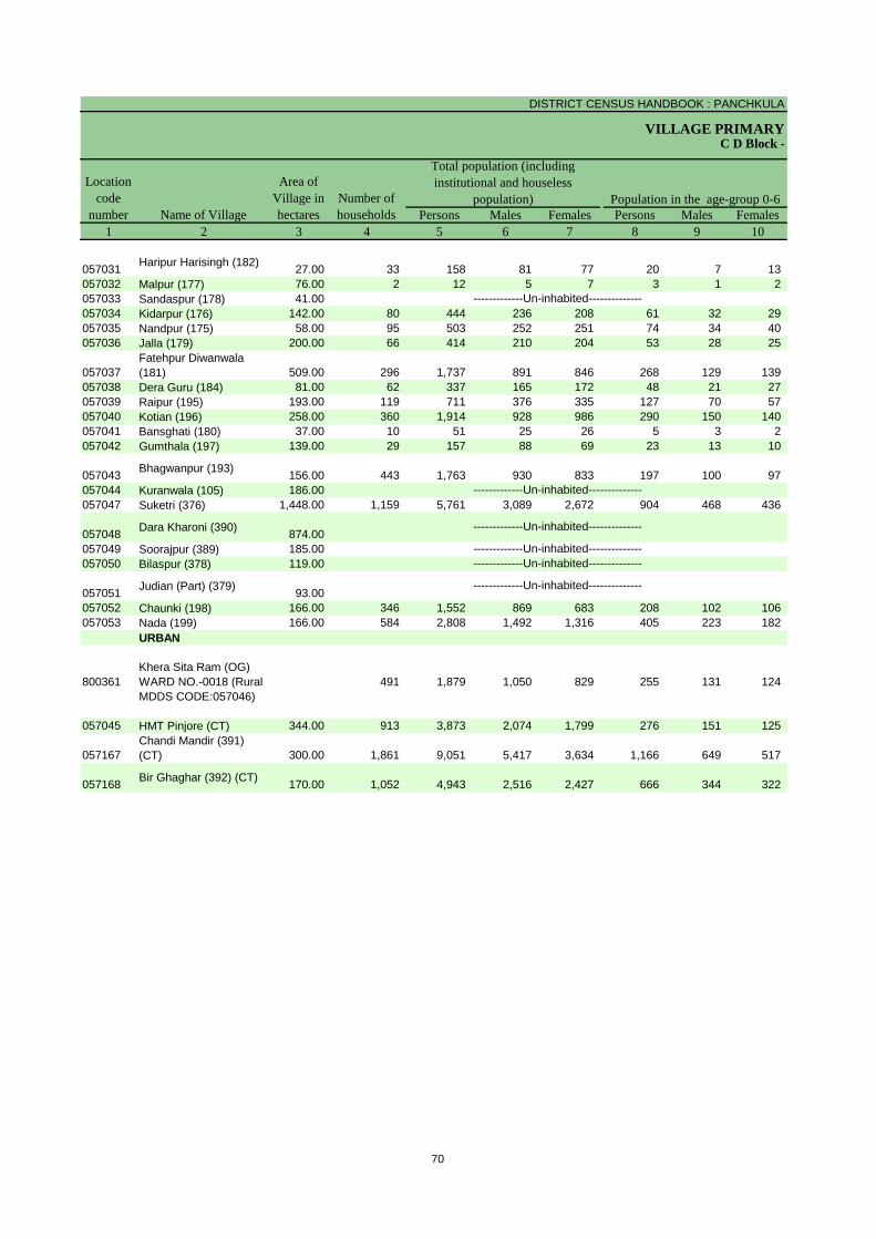
DISTRICT CENSUS HANDBOOK : PANCHKULA
VILLAGE PRIMARY
Persons Males Females Persons Males Females1 2 3 4 5 6 7 8 9 10
C D Block -
Population in the age-group 0-6Name of Village
Location code
number
Total population (including institutional and houseless
population)Area of
Village in hectares
Number of households
057031 Haripur Harisingh (182) 27.00 33 158 81 77 20 7 13 057032 Malpur (177) 76.00 2 12 5 7 3 1 2 057033 Sandaspur (178) 41.00057034 Kidarpur (176) 142.00 80 444 236 208 61 32 29 057035 Nandpur (175) 58.00 95 503 252 251 74 34 40 057036 Jalla (179) 200.00 66 414 210 204 53 28 25
057037Fatehpur Diwanwala (181) 509.00 296 1,737 891 846 268 129 139
057038 Dera Guru (184) 81.00 62 337 165 172 48 21 27 057039 Raipur (195) 193.00 119 711 376 335 127 70 57 057040 Kotian (196) 258.00 360 1,914 928 986 290 150 140 057041 Bansghati (180) 37.00 10 51 25 26 5 3 2 057042 Gumthala (197) 139.00 29 157 88 69 23 13 10
057043 Bhagwanpur (193) 156.00 443 1,763 930 833 197 100 97 057044 Kuranwala (105) 186.00057047 Suketri (376) 1,448.00 1,159 5,761 3,089 2,672 904 468 436
057048 Dara Kharoni (390) 874.00057049 Soorajpur (389) 185.00057050 Bilaspur (378) 119.00
057051 Judian (Part) (379) 93.00057052 Chaunki (198) 166.00 346 1,552 869 683 208 102 106 057053 Nada (199) 166.00 584 2,808 1,492 1,316 405 223 182
URBAN
800361Khera Sita Ram (OG) WARD NO.-0018 (Rural MDDS CODE:057046)
491 1,879 1,050 829 255 131 124
057045 HMT Pinjore (CT) 344.00 913 3,873 2,074 1,799 276 151 125
057167Chandi Mandir (391) (CT) 300.00 1,861 9,051 5,417 3,634 1,166 649 517
057168 Bir Ghaghar (392) (CT) 170.00 1,052 4,943 2,516 2,427 666 344 322
-------------Un-inhabited--------------
-------------Un-inhabited---------------------------Un-inhabited--------------
-------------Un-inhabited--------------
-------------Un-inhabited--------------
-------------Un-inhabited--------------
70
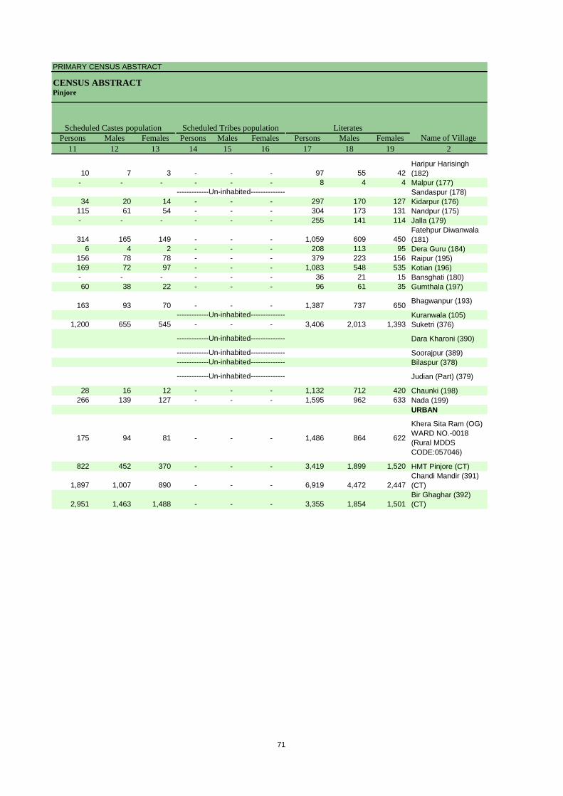
PRIMARY CENSUS ABSTRACT
CENSUS ABSTRACTPinjore
Persons Males Females Persons Males Females Persons Males Females11 12 13 14 15 16 17 18 19 2
Scheduled Castes population Scheduled Tribes populationName of Village
Literates
10 7 3 - - - 97 55 42 Haripur Harisingh (182)
- - - - - - 8 4 4 Malpur (177)Sandaspur (178)
34 20 14 - - - 297 170 127 Kidarpur (176)115 61 54 - - - 304 173 131 Nandpur (175)- - - - - - 255 141 114 Jalla (179)
314 165 149 - - - 1,059 609 450 Fatehpur Diwanwala (181)
6 4 2 - - - 208 113 95 Dera Guru (184)156 78 78 - - - 379 223 156 Raipur (195)169 72 97 - - - 1,083 548 535 Kotian (196)- - - - - - 36 21 15 Bansghati (180)60 38 22 - - - 96 61 35 Gumthala (197)
163 93 70 - - - 1,387 737 650 Bhagwanpur (193)
Kuranwala (105)1,200 655 545 - - - 3,406 2,013 1,393 Suketri (376)
Dara Kharoni (390)
Soorajpur (389)Bilaspur (378)
Judian (Part) (379)
28 16 12 - - - 1,132 712 420 Chaunki (198)266 139 127 - - - 1,595 962 633 Nada (199)
URBAN
175 94 81 - - - 1,486 864 622
Khera Sita Ram (OG) WARD NO.-0018 (Rural MDDS CODE:057046)
822 452 370 - - - 3,419 1,899 1,520 HMT Pinjore (CT)
1,897 1,007 890 - - - 6,919 4,472 2,447 Chandi Mandir (391) (CT)
2,951 1,463 1,488 - - - 3,355 1,854 1,501 Bir Ghaghar (392) (CT)
-------------Un-inhabited--------------
-------------Un-inhabited---------------------------Un-inhabited--------------
-------------Un-inhabited--------------
-------------Un-inhabited--------------
-------------Un-inhabited--------------
71

DISTRICT CENSUS HANDBOOK : PANCHKULA
VILLAGE PRIMARYC D Block -
Persons Males Females Persons Males Females Persons Males Females1 2 20 21 22 23 24 25 26 27 28
Illiterates Total workers Main workersName of Village
Location code
number
057031 Haripur Harisingh (182) 61 26 35 95 53 42 75 41 34 057032 Malpur (177) 4 1 3 3 3 - 3 3 - 057033 Sandaspur (178)057034 Kidarpur (176) 147 66 81 232 140 92 177 109 68 057035 Nandpur (175) 199 79 120 164 140 24 152 132 20 057036 Jalla (179) 159 69 90 111 104 7 98 97 1
057037Fatehpur Diwanwala (181) 678 282 396 639 504 135 438 384 54
057038 Dera Guru (184) 129 52 77 98 92 6 45 41 4 057039 Raipur (195) 332 153 179 184 178 6 138 133 5 057040 Kotian (196) 831 380 451 836 507 329 740 432 308 057041 Bansghati (180) 15 4 11 15 14 1 15 14 1 057042 Gumthala (197) 61 27 34 56 43 13 37 33 4
057043 Bhagwanpur (193) 376 193 183 657 534 123 613 502 111 057044 Kuranwala (105)057047 Suketri (376) 2,355 1,076 1,279 2,126 1,663 463 1,858 1,532 326
057048 Dara Kharoni (390)
057049 Soorajpur (389)057050 Bilaspur (378)
057051 Judian (Part) (379)
057052 Chaunki (198) 420 157 263 699 568 131 678 561 117 057053 Nada (199) 1,213 530 683 992 799 193 881 718 163
URBAN
800361
Khera Sita Ram (OG) WARD NO.-0018 (Rural MDDS CODE:057046)
393 186 207 704 588 116 678 578 100
057045 HMT Pinjore (CT) 454 175 279 1,317 1,116 201 1,290 1,101 189
057167Chandi Mandir (391) (CT) 2,132 945 1,187 4,086 3,601 485 3,837 3,468 369
057168 Bir Ghaghar (392) (CT) 1,588 662 926 1,786 1,373 413 1,656 1,299 357
-------------Un-inhabited--------------
-------------Un-inhabited---------------------------Un-inhabited--------------
-------------Un-inhabited--------------
-------------Un-inhabited--------------
-------------Un-inhabited--------------
72

PRIMARY CENSUS ABSTRACT
CENSUS ABSTRACTPinjore
Persons Males Females Persons Males Females Persons MalesFemales Persons Males Females29 30 31 32 33 34 35 36 37 38 39 40 2
CultivatorsName of Village
Household industry workersAgricultural labourers
Industrial category of main workers
Other workers
32 15 17 26 14 12 3 2 1 14 10 4 Haripur Harisingh (182)
3 3 - - - - - - - - - - Malpur (177)Sandaspur (178)
141 79 62 10 9 1 8 6 2 18 15 3 Kidarpur (176)64 60 4 3 3 - 1 1 - 84 68 16 Nandpur (175)80 79 1 2 2 - 6 6 - 10 10 - Jalla (179)
268 234 34 9 8 1 4 3 1 157 139 18 Fatehpur Diwanwala (181)
1 1 - 3 1 2 - - - 41 39 2 Dera Guru (184)50 49 1 2 2 - 1 1 - 85 81 4 Raipur (195)76 65 11 37 33 4 30 22 8 597 312 285 Kotian (196)
- - - - - - - - - 15 14 1 Bansghati (180)16 16 - - - - - - - 21 17 4 Gumthala (197)
10 9 1 16 5 11 20 16 4 567 472 95 Bhagwanpur (193)
Kuranwala (105)106 93 13 13 12 1 78 40 38 1,661 1,387 274 Suketri (376)
Dara Kharoni (390)Soorajpur (389)Bilaspur (378)Judian (Part) (379)
141 67 74 3 2 1 7 4 3 527 488 39 Chaunki (198)48 43 5 6 5 1 15 13 2 812 657 155 Nada (199)
URBAN
- - - 8 7 1 88 80 8 582 491 91
Khera Sita Ram (OG) WARD NO.-0018 (Rural MDDS CODE:057046)
6 5 1 - - - - - - 1,284 1,096 188 HMT Pinjore (CT)
60 53 7 43 33 10 64 36 28 3,670 3,346 324 Chandi Mandir (391) (CT)
10 9 1 15 11 4 44 30 14 1,587 1,249 338 Bir Ghaghar (392) (CT)
-------------Un-inhabited--------------
-------------Un-inhabited---------------------------Un-inhabited--------------
-------------Un-inhabited--------------
-------------Un-inhabited--------------
-------------Un-inhabited--------------
73
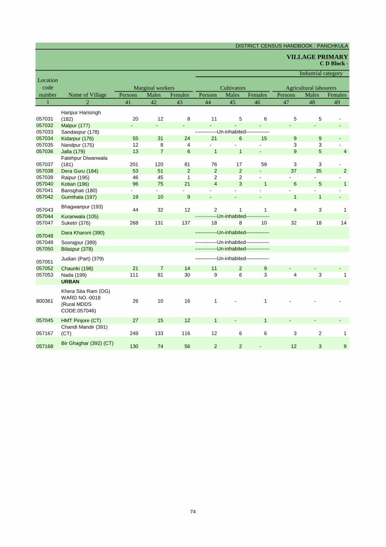
DISTRICT CENSUS HANDBOOK : PANCHKULA
VILLAGE PRIMARYC D Block -
Persons Males Females Persons Males Females Persons Males Females1 2 41 42 43 44 45 46 47 48 49
Location code
number Name of VillageMarginal workers Cultivators Agricultural labourers
Industrial category
057031Haripur Harisingh (182) 20 12 8 11 5 6 5 5 -
057032 Malpur (177) - - - - - - - - - 057033 Sandaspur (178)057034 Kidarpur (176) 55 31 24 21 6 15 9 9 - 057035 Nandpur (175) 12 8 4 - - - 3 3 - 057036 Jalla (179) 13 7 6 1 1 - 9 5 4
057037Fatehpur Diwanwala (181) 201 120 81 76 17 59 3 3 -
057038 Dera Guru (184) 53 51 2 2 2 - 37 35 2 057039 Raipur (195) 46 45 1 2 2 - - - - 057040 Kotian (196) 96 75 21 4 3 1 6 5 1 057041 Bansghati (180) - - - - - - - - - 057042 Gumthala (197) 19 10 9 - - - 1 1 -
057043 Bhagwanpur (193) 44 32 12 2 1 1 4 3 1 057044 Kuranwala (105)057047 Suketri (376) 268 131 137 18 8 10 32 18 14
057048 Dara Kharoni (390)
057049 Soorajpur (389)057050 Bilaspur (378)
057051 Judian (Part) (379)
057052 Chaunki (198) 21 7 14 11 2 9 - - - 057053 Nada (199) 111 81 30 9 6 3 4 3 1
URBAN
800361
Khera Sita Ram (OG) WARD NO.-0018 (Rural MDDS CODE:057046)
26 10 16 1 - 1 - - -
057045 HMT Pinjore (CT) 27 15 12 1 - 1 - - -
057167Chandi Mandir (391) (CT) 249 133 116 12 6 6 3 2 1
057168 Bir Ghaghar (392) (CT) 130 74 56 2 2 - 12 3 9
-------------Un-inhabited--------------
-------------Un-inhabited---------------------------Un-inhabited--------------
-------------Un-inhabited--------------
-------------Un-inhabited--------------
-------------Un-inhabited--------------
74
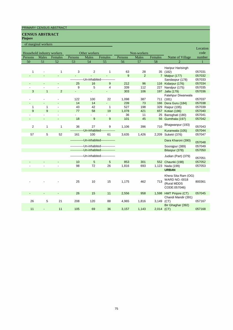
PRIMARY CENSUS ABSTRACT
CENSUS ABSTRACTPinjore
Persons Males Females Persons Males Females Persons Males Females50 51 52 53 54 55 56 57 58 2 1
Non-workers
of marginal workersLocation
code number
Household industry workersName of Village
Other workers
1 - 1 3 2 1 63 28 35 Haripur Harisingh (182) 057031
- - - - - - 9 2 7 Malpur (177) 057032Sandaspur (178) 057033
- - - 25 16 9 212 96 116 Kidarpur (176) 057034- - - 9 5 4 339 112 227 Nandpur (175) 057035
3 1 2 - - - 303 106 197 Jalla (179) 057036
- - - 122 100 22 1,098 387 711 Fatehpur Diwanwala (181) 057037
- - - 14 14 - 239 73 166 Dera Guru (184) 0570381 1 - 43 42 1 527 198 329 Raipur (195) 0570399 9 - 77 58 19 1,078 421 657 Kotian (196) 057040
- - - - - - 36 11 25 Bansghati (180) 057041- - - 18 9 9 101 45 56 Gumthala (197) 057042
2 1 1 36 27 9 1,106 396 710 Bhagwanpur (193) 057043Kuranwala (105) 057044
57 5 52 161 100 61 3,635 1,426 2,209 Suketri (376) 057047
Dara Kharoni (390) 057048Soorajpur (389) 057049Bilaspur (378) 057050
Judian (Part) (379) 057051- - - 10 5 5 853 301 552 Chaunki (198) 057052- - - 98 72 26 1,816 693 1,123 Nada (199) 057053
URBAN
- - - 25 10 15 1,175 462 713
Khera Sita Ram (OG) WARD NO.-0018 (Rural MDDS CODE:057046)
800361
- - - 26 15 11 2,556 958 1,598 HMT Pinjore (CT) 057045
26 5 21 208 120 88 4,965 1,816 3,149 Chandi Mandir (391) (CT) 057167
11 - 11 105 69 36 3,157 1,143 2,014 Bir Ghaghar (392) (CT) 057168
-------------Un-inhabited--------------
-------------Un-inhabited--------------
-------------Un-inhabited--------------
-------------Un-inhabited--------------
-------------Un-inhabited--------------
-------------Un-inhabited--------------
75
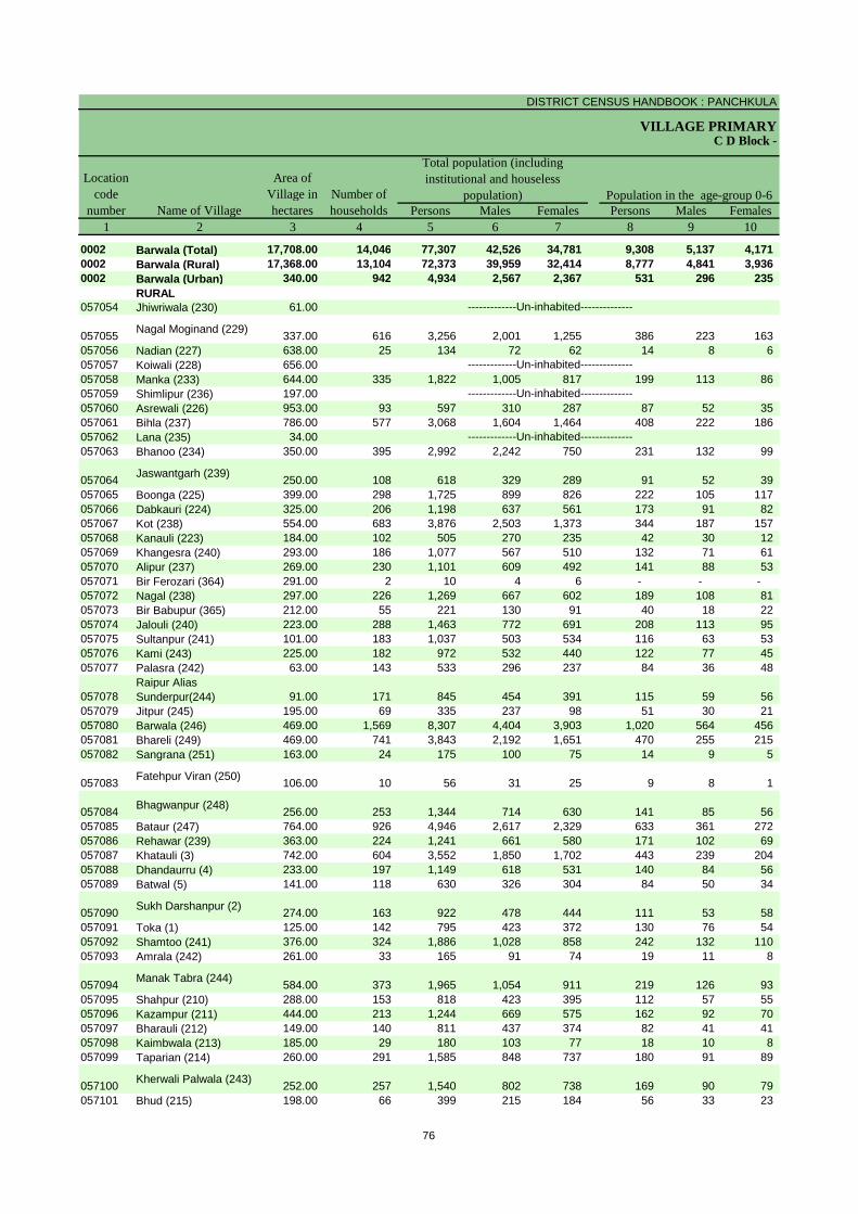
DISTRICT CENSUS HANDBOOK : PANCHKULA
VILLAGE PRIMARY
Persons Males Females Persons Males Females1 2 3 4 5 6 7 8 9 10
0002 Barwala (Total) 17,708.00 14,046 77,307 42,526 34,781 9,308 5,137 4,171 0002 Barwala (Rural) 17,368.00 13,104 72,373 39,959 32,414 8,777 4,841 3,936 0002 Barwala (Urban) 340.00 942 4,934 2,567 2,367 531 296 235
RURAL057054 Jhiwriwala (230) 61.00
057055 Nagal Moginand (229) 337.00 616 3,256 2,001 1,255 386 223 163 057056 Nadian (227) 638.00 25 134 72 62 14 8 6 057057 Koiwali (228) 656.00057058 Manka (233) 644.00 335 1,822 1,005 817 199 113 86 057059 Shimlipur (236) 197.00057060 Asrewali (226) 953.00 93 597 310 287 87 52 35 057061 Bihla (237) 786.00 577 3,068 1,604 1,464 408 222 186 057062 Lana (235) 34.00057063 Bhanoo (234) 350.00 395 2,992 2,242 750 231 132 99
057064 Jaswantgarh (239) 250.00 108 618 329 289 91 52 39 057065 Boonga (225) 399.00 298 1,725 899 826 222 105 117 057066 Dabkauri (224) 325.00 206 1,198 637 561 173 91 82 057067 Kot (238) 554.00 683 3,876 2,503 1,373 344 187 157 057068 Kanauli (223) 184.00 102 505 270 235 42 30 12 057069 Khangesra (240) 293.00 186 1,077 567 510 132 71 61 057070 Alipur (237) 269.00 230 1,101 609 492 141 88 53 057071 Bir Ferozari (364) 291.00 2 10 4 6 - - - 057072 Nagal (238) 297.00 226 1,269 667 602 189 108 81 057073 Bir Babupur (365) 212.00 55 221 130 91 40 18 22 057074 Jalouli (240) 223.00 288 1,463 772 691 208 113 95 057075 Sultanpur (241) 101.00 183 1,037 503 534 116 63 53 057076 Kami (243) 225.00 182 972 532 440 122 77 45 057077 Palasra (242) 63.00 143 533 296 237 84 36 48
057078Raipur Alias Sunderpur(244) 91.00 171 845 454 391 115 59 56
057079 Jitpur (245) 195.00 69 335 237 98 51 30 21 057080 Barwala (246) 469.00 1,569 8,307 4,404 3,903 1,020 564 456 057081 Bhareli (249) 469.00 741 3,843 2,192 1,651 470 255 215 057082 Sangrana (251) 163.00 24 175 100 75 14 9 5
057083 Fatehpur Viran (250) 106.00 10 56 31 25 9 8 1
057084 Bhagwanpur (248) 256.00 253 1,344 714 630 141 85 56 057085 Bataur (247) 764.00 926 4,946 2,617 2,329 633 361 272 057086 Rehawar (239) 363.00 224 1,241 661 580 171 102 69 057087 Khatauli (3) 742.00 604 3,552 1,850 1,702 443 239 204 057088 Dhandaurru (4) 233.00 197 1,149 618 531 140 84 56 057089 Batwal (5) 141.00 118 630 326 304 84 50 34
057090 Sukh Darshanpur (2) 274.00 163 922 478 444 111 53 58 057091 Toka (1) 125.00 142 795 423 372 130 76 54 057092 Shamtoo (241) 376.00 324 1,886 1,028 858 242 132 110 057093 Amrala (242) 261.00 33 165 91 74 19 11 8
057094 Manak Tabra (244) 584.00 373 1,965 1,054 911 219 126 93 057095 Shahpur (210) 288.00 153 818 423 395 112 57 55 057096 Kazampur (211) 444.00 213 1,244 669 575 162 92 70 057097 Bharauli (212) 149.00 140 811 437 374 82 41 41 057098 Kaimbwala (213) 185.00 29 180 103 77 18 10 8 057099 Taparian (214) 260.00 291 1,585 848 737 180 91 89
057100 Kherwali Palwala (243) 252.00 257 1,540 802 738 169 90 79 057101 Bhud (215) 198.00 66 399 215 184 56 33 23
Name of Village
Location code
number
Total population (including institutional and houseless
population)Area of
Village in hectares
Number of households
C D Block -
Population in the age-group 0-6
-------------Un-inhabited--------------
-------------Un-inhabited--------------
-------------Un-inhabited--------------
-------------Un-inhabited--------------
76
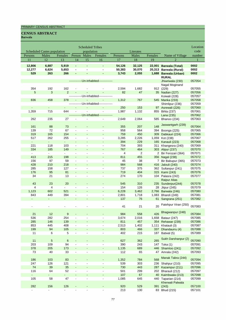
PRIMARY CENSUS ABSTRACT
CENSUS ABSTRACTBarwala
Persons Males Females Persons Males Females Persons Males Females11 12 13 14 15 16 17 18 19 2 1
12,806 6,887 5,919 - - - 54,126 32,125 22,001 Barwala (Total) 000212,277 6,624 5,653 - - - 50,383 30,070 20,313 Barwala (Rural) 0002
529 263 266 - - - 3,743 2,055 1,688 Barwala (Urban) 0002RURALJhiwriwala (230) 057054
354 192 162 - - - 2,594 1,682 912 Nagal Moginand (229) 057055
5 3 2 - - - 82 47 35 Nadian (227) 057056Koiwali (228) 057057
836 458 378 - - - 1,312 767 545 Manka (233) 057058Shimlipur (236) 057059
- - - - - - 250 153 97 Asrewali (226) 0570601,359 715 644 - - - 1,987 1,132 855 Bihla (237) 057061
Lana (235) 057062262 235 27 - - - 2,649 2,064 585 Bhanoo (234) 057063
161 88 73 - - - 355 207 148 Jaswantgarh (239) 057064139 72 67 - - - 958 564 394 Boonga (225) 057065319 165 154 - - - 759 450 309 Dabkauri (224) 057066517 262 255 - - - 3,285 2,226 1,059 Kot (238) 057067- - - - - - 394 229 165 Kanauli (223) 057068221 118 103 - - - 704 393 311 Khangesra (240) 057069334 185 149 - - - 767 464 303 Alipur (237) 057070- - - - - - 4 2 2 Bir Ferozari (364) 057071413 215 198 - - - 811 455 356 Nagal (238) 057072156 97 59 - - - 45 38 7 Bir Babupur (365) 057073428 210 218 - - - 984 568 416 Jalouli (240) 057074285 158 127 - - - 737 375 362 Sultanpur (241) 057075176 95 81 - - - 719 404 315 Kami (243) 05707634 21 13 - - - 274 170 104 Palasra (242) 057077
43 23 20 - - - 545 310 235 Raipur Alias Sunderpur(244) 057078
4 4 - - - - 154 126 28 Jitpur (245) 0570791,123 602 521 - - - 6,228 3,462 2,766 Barwala (246) 057080
843 449 394 - - - 2,801 1,718 1,083 Bhareli (249) 057081- - - - - - 137 76 61 Sangrana (251) 057082
- - - - - - 41 21 20 Fatehpur Viran (250) 057083
21 12 9 - - - 984 558 426 Bhagwanpur (248) 057084536 282 254 - - - 3,674 2,016 1,658 Bataur (247) 057085285 146 139 - - - 811 457 354 Rehawar (239) 057086853 445 408 - - - 2,513 1,402 1,111 Khatauli (3) 057087199 94 105 - - - 803 466 337 Dhandaurru (4) 05708811 6 5 - - - 402 215 187 Batwal (5) 057089
11 5 6 - - - 627 362 265 Sukh Darshanpur (2) 057090203 109 94 - - - 390 243 147 Toka (1) 057091378 205 173 - - - 1,135 689 446 Shamtoo (241) 05709273 40 33 - - - 112 65 47 Amrala (242) 057093
186 103 83 - - - 1,352 784 568 Manak Tabra (244) 057094247 126 121 - - - 539 303 236 Shahpur (210) 05709574 39 35 - - - 730 443 287 Kazampur (211) 057096
116 64 52 - - - 501 299 202 Bharauli (212) 057097- - - - - - 107 67 40 Kaimbwala (213) 057098105 58 47 - - - 1,085 645 440 Taparian (214) 057099
282 156 126 - - - 920 529 391 Kherwali Palwala (243) 057100
- - - - - - 213 130 83 Bhud (215) 057101
Name of Village
Location code
numberLiteratesScheduled Castes population
Scheduled Tribes population
-------------Un-inhabited--------------
-------------Un-inhabited--------------
-------------Un-inhabited--------------
-------------Un-inhabited--------------
77

DISTRICT CENSUS HANDBOOK : PANCHKULA
VILLAGE PRIMARYC D Block -
Persons Males Females Persons Males Females Persons Males Females2 20 21 22 23 24 25 26 27 28
Barwala (Total) 23,181 10,401 12,780 29,969 24,445 5,524 25,021 21,787 3,234 Barwala (Rural) 21,990 9,889 12,101 28,159 23,057 5,102 23,395 20,500 2,895 Barwala (Urban) 1,191 512 679 1,810 1,388 422 1,626 1,287 339 RURALJhiwriwala (230)
Nagal Moginand (229) 662 319 343 1,730 1,360 370 1,643 1,316 327 Nadian (227) 52 25 27 50 35 15 30 29 1 Koiwali (228)Manka (233) 510 238 272 636 513 123 627 505 122 Shimlipur (236)Asrewali (226) 347 157 190 219 174 45 177 158 19 Bihla (237) 1,081 472 609 1,071 829 242 883 791 92 Lana (235)Bhanoo (234) 343 178 165 2,004 1,870 134 1,956 1,849 107
Jaswantgarh (239) 263 122 141 259 178 81 148 131 17 Boonga (225) 767 335 432 733 501 232 422 383 39 Dabkauri (224) 439 187 252 602 316 286 287 256 31 Kot (238) 591 277 314 2,085 1,830 255 1,767 1,656 111 Kanauli (223) 111 41 70 175 139 36 161 130 31 Khangesra (240) 373 174 199 373 307 66 301 278 23 Alipur (237) 334 145 189 351 324 27 257 238 19 Bir Ferozari (364) 6 2 4 6 4 2 6 4 2 Nagal (238) 458 212 246 371 345 26 358 336 22 Bir Babupur (365) 176 92 84 158 97 61 140 90 50 Jalouli (240) 479 204 275 497 412 85 451 384 67 Sultanpur (241) 300 128 172 347 278 69 313 262 51 Kami (243) 253 128 125 303 288 15 299 285 14 Palasra (242) 259 126 133 266 192 74 261 191 70 Raipur Alias Sunderpur(244) 300 144 156 346 263 83 242 201 41 Jitpur (245) 181 111 70 230 193 37 230 193 37 Barwala (246) 2,079 942 1,137 2,727 2,356 371 2,427 2,158 269 Bhareli (249) 1,042 474 568 1,498 1,402 96 1,249 1,184 65 Sangrana (251) 38 24 14 53 49 4 47 45 2
Fatehpur Viran (250) 15 10 5 16 16 - 16 16 -
Bhagwanpur (248) 360 156 204 447 400 47 438 396 42 Bataur (247) 1,272 601 671 1,577 1,378 199 1,516 1,338 178 Rehawar (239) 430 204 226 336 300 36 298 269 29 Khatauli (3) 1,039 448 591 1,066 948 118 862 836 26 Dhandaurru (4) 346 152 194 337 312 25 333 310 23 Batwal (5) 228 111 117 189 176 13 186 174 12
Sukh Darshanpur (2) 295 116 179 320 259 61 293 244 49 Toka (1) 405 180 225 320 234 86 303 220 83 Shamtoo (241) 751 339 412 870 590 280 617 498 119 Amrala (242) 53 26 27 44 42 2 44 42 2
Manak Tabra (244) 613 270 343 491 442 49 405 376 29 Shahpur (210) 279 120 159 330 227 103 143 95 48 Kazampur (211) 514 226 288 541 350 191 388 242 146 Bharauli (212) 310 138 172 361 223 138 313 213 100 Kaimbwala (213) 73 36 37 51 44 7 25 24 1 Taparian (214) 500 203 297 488 439 49 323 292 31
Kherwali Palwala (243) 620 273 347 834 511 323 314 292 22 Bhud (215) 186 85 101 328 173 155 251 136 115
Name of VillageIlliterates Total workers Main workers
-------------Un-inhabited--------------
-------------Un-inhabited--------------
-------------Un-inhabited--------------
-------------Un-inhabited--------------
78

PRIMARY CENSUS ABSTRACT
CENSUS ABSTRACTBarwala
Persons Males Females Persons Males Females PersonsMalesFemales Persons Males Females29 30 31 32 33 34 35 36 37 38 39 40 2
5,647 5,002 645 2,770 2,429 341 634 446 188 15,970 13,910 2,060 Barwala (Total)5,621 4,984 637 2,691 2,369 322 555 398 157 14,528 12,749 1,779 Barwala (Rural)
26 18 8 79 60 19 79 48 31 1,442 1,161 281 Barwala (Urban)RURALJhiwriwala (230)
128 58 70 11 7 4 109 41 68 1,395 1,210 185 Nagal Moginand (229)
2 2 - - - - 12 12 - 16 15 1 Nadian (227)Koiwali (228)
97 94 3 98 95 3 - - - 432 316 116 Manka (233)Shimlipur (236)
91 79 12 43 39 4 - - - 43 40 3 Asrewali (226)198 190 8 309 288 21 32 21 11 344 292 52 Bihla (237)
Lana (235)32 31 1 40 34 6 10 7 3 1,874 1,777 97 Bhanoo (234)
32 32 - 7 7 - 13 8 5 96 84 12 Jaswantgarh (239)
187 177 10 154 141 13 4 3 1 77 62 15 Boonga (225)170 142 28 67 65 2 11 10 1 39 39 - Dabkauri (224)79 61 18 15 3 12 4 3 1 1,669 1,589 80 Kot (238)64 62 2 5 2 3 - - - 92 66 26 Kanauli (223)65 61 4 31 28 3 16 15 1 189 174 15 Khangesra (240)95 91 4 1 1 - 3 3 - 158 143 15 Alipur (237)
- - - 4 2 2 - - - 2 2 - Bir Ferozari (364)61 54 7 5 5 - 12 11 1 280 266 14 Nagal (238)2 1 1 - - - - - - 138 89 49 Bir Babupur (365)
71 71 - 44 37 7 16 15 1 320 261 59 Jalouli (240)59 54 5 34 31 3 1 1 - 219 176 43 Sultanpur (241)
107 105 2 83 81 2 26 25 1 83 74 9 Kami (243)8 4 4 7 6 1 1 1 - 245 180 65 Palasra (242)
6 4 2 12 9 3 3 3 - 221 185 36 Raipur Alias Sunderpur(244)
2 2 - 2 2 - 1 1 - 225 188 37 Jitpur (245)342 325 17 144 143 1 69 58 11 1,872 1,632 240 Barwala (246)297 296 1 236 198 38 10 8 2 706 682 24 Bhareli (249)34 32 2 6 6 - 2 2 - 5 5 - Sangrana (251)
16 16 - - - - - - - - - - Fatehpur Viran (250)
172 165 7 30 18 12 4 4 - 232 209 23 Bhagwanpur (248)
356 350 6 132 90 42 26 19 7 1,002 879 123 Bataur (247)116 108 8 74 64 10 3 3 - 105 94 11 Rehawar (239)273 271 2 172 167 5 24 22 2 393 376 17 Khatauli (3)88 86 2 139 122 17 1 1 - 105 101 4 Dhandaurru (4)53 51 2 116 113 3 3 3 - 14 7 7 Batwal (5)
149 117 32 41 37 4 9 8 1 94 82 12 Sukh Darshanpur (2)
93 93 - 11 11 - 2 2 - 197 114 83 Toka (1)226 203 23 79 75 4 3 2 1 309 218 91 Shamtoo (241)17 17 - 16 15 1 - - - 11 10 1 Amrala (242)
100 94 6 87 84 3 10 9 1 208 189 19 Manak Tabra (244)
16 13 3 10 8 2 32 5 27 85 69 16 Shahpur (210)318 184 134 12 5 7 - - - 58 53 5 Kazampur (211)69 65 4 92 37 55 11 5 6 141 106 35 Bharauli (212)17 17 - 2 1 1 - - - 6 6 - Kaimbwala (213)
137 122 15 47 43 4 15 15 - 124 112 12 Taparian (214)
212 202 10 1 1 - 3 3 - 98 86 12 Kherwali Palwala (243)
212 106 106 8 3 5 2 2 - 29 25 4 Bhud (215)
CultivatorsName of Village
Household industry workersAgricultural labourers
Industrial category of main workers
Other workers
-------------Un-inhabited--------------
-------------Un-inhabited--------------
-------------Un-inhabited--------------
-------------Un-inhabited--------------
79
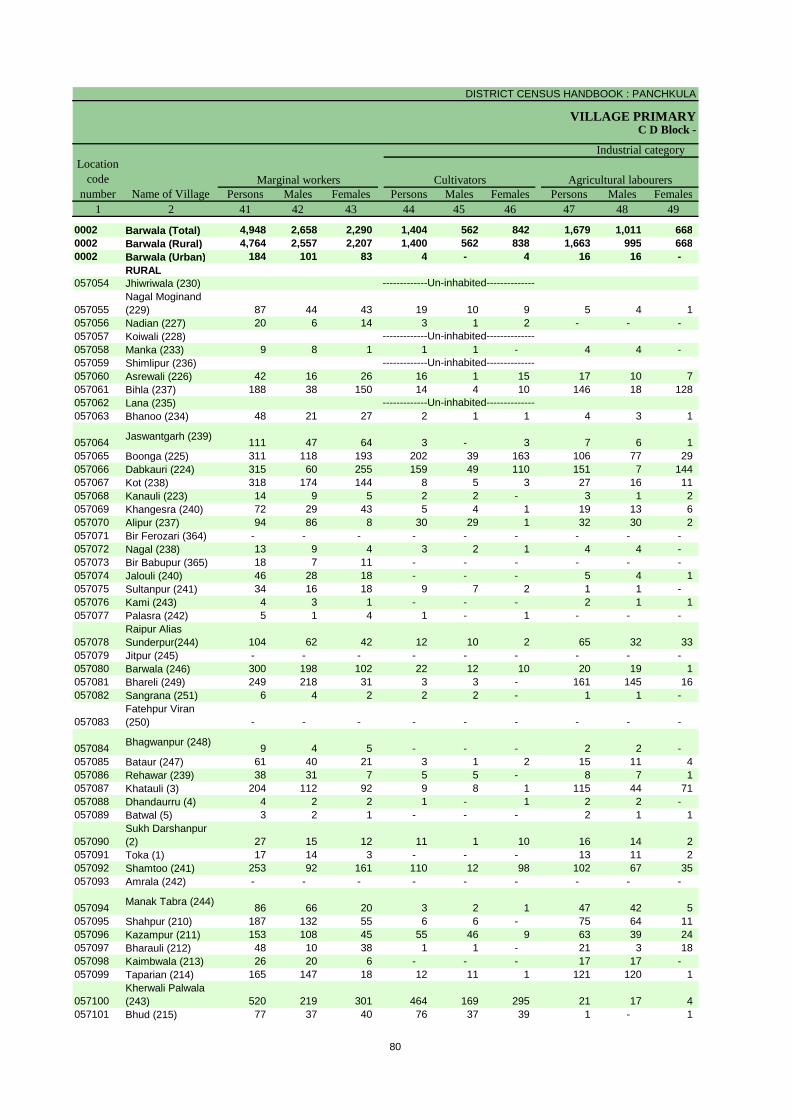
DISTRICT CENSUS HANDBOOK : PANCHKULA
VILLAGE PRIMARYC D Block -
Persons Males Females Persons Males Females Persons Males Females1 2 41 42 43 44 45 46 47 48 49
0002 Barwala (Total) 4,948 2,658 2,290 1,404 562 842 1,679 1,011 668 0002 Barwala (Rural) 4,764 2,557 2,207 1,400 562 838 1,663 995 668 0002 Barwala (Urban) 184 101 83 4 - 4 16 16 -
RURAL057054 Jhiwriwala (230)
057055Nagal Moginand (229) 87 44 43 19 10 9 5 4 1
057056 Nadian (227) 20 6 14 3 1 2 - - - 057057 Koiwali (228)057058 Manka (233) 9 8 1 1 1 - 4 4 - 057059 Shimlipur (236)057060 Asrewali (226) 42 16 26 16 1 15 17 10 7 057061 Bihla (237) 188 38 150 14 4 10 146 18 128 057062 Lana (235)057063 Bhanoo (234) 48 21 27 2 1 1 4 3 1
057064 Jaswantgarh (239) 111 47 64 3 - 3 7 6 1 057065 Boonga (225) 311 118 193 202 39 163 106 77 29 057066 Dabkauri (224) 315 60 255 159 49 110 151 7 144 057067 Kot (238) 318 174 144 8 5 3 27 16 11 057068 Kanauli (223) 14 9 5 2 2 - 3 1 2 057069 Khangesra (240) 72 29 43 5 4 1 19 13 6 057070 Alipur (237) 94 86 8 30 29 1 32 30 2 057071 Bir Ferozari (364) - - - - - - - - - 057072 Nagal (238) 13 9 4 3 2 1 4 4 - 057073 Bir Babupur (365) 18 7 11 - - - - - - 057074 Jalouli (240) 46 28 18 - - - 5 4 1 057075 Sultanpur (241) 34 16 18 9 7 2 1 1 - 057076 Kami (243) 4 3 1 - - - 2 1 1 057077 Palasra (242) 5 1 4 1 - 1 - - -
057078Raipur Alias Sunderpur(244) 104 62 42 12 10 2 65 32 33
057079 Jitpur (245) - - - - - - - - - 057080 Barwala (246) 300 198 102 22 12 10 20 19 1 057081 Bhareli (249) 249 218 31 3 3 - 161 145 16 057082 Sangrana (251) 6 4 2 2 2 - 1 1 -
057083Fatehpur Viran (250) - - - - - - - - -
057084 Bhagwanpur (248) 9 4 5 - - - 2 2 - 057085 Bataur (247) 61 40 21 3 1 2 15 11 4 057086 Rehawar (239) 38 31 7 5 5 - 8 7 1 057087 Khatauli (3) 204 112 92 9 8 1 115 44 71 057088 Dhandaurru (4) 4 2 2 1 - 1 2 2 - 057089 Batwal (5) 3 2 1 - - - 2 1 1
057090Sukh Darshanpur (2) 27 15 12 11 1 10 16 14 2
057091 Toka (1) 17 14 3 - - - 13 11 2 057092 Shamtoo (241) 253 92 161 110 12 98 102 67 35 057093 Amrala (242) - - - - - - - - -
057094 Manak Tabra (244) 86 66 20 3 2 1 47 42 5 057095 Shahpur (210) 187 132 55 6 6 - 75 64 11 057096 Kazampur (211) 153 108 45 55 46 9 63 39 24 057097 Bharauli (212) 48 10 38 1 1 - 21 3 18 057098 Kaimbwala (213) 26 20 6 - - - 17 17 - 057099 Taparian (214) 165 147 18 12 11 1 121 120 1
057100Kherwali Palwala (243) 520 219 301 464 169 295 21 17 4
057101 Bhud (215) 77 37 40 76 37 39 1 - 1
Name of VillageMarginal workers Cultivators Agricultural labourers
Industrial category Location
code number
-------------Un-inhabited--------------
-------------Un-inhabited--------------
-------------Un-inhabited--------------
-------------Un-inhabited--------------
80

PRIMARY CENSUS ABSTRACT
CENSUS ABSTRACTBarwala
Persons Males Females Persons Males Females Persons Males Females50 51 52 53 54 55 56 57 58 2 1
398 115 283 1,467 970 497 47,338 18,081 29,257 Barwala (Total) 0002380 107 273 1,321 893 428 44,214 16,902 27,312 Barwala (Rural) 000218 8 10 146 77 69 3,124 1,179 1,945 Barwala (Urban) 0002
RURALJhiwriwala (230) 057054
43 19 24 20 11 9 1,526 641 885 Nagal Moginand (229) 05705515 3 12 2 2 - 84 37 47 Nadian (227) 057056
Koiwali (228) 057057- - - 4 3 1 1,186 492 694 Manka (233) 057058
Shimlipur (236) 057059- - - 9 5 4 378 136 242 Asrewali (226) 057060
6 2 4 22 14 8 1,997 775 1,222 Bihla (237) 057061Lana (235) 057062
- - - 42 17 25 988 372 616 Bhanoo (234) 057063
66 7 59 35 34 1 359 151 208 Jaswantgarh (239) 0570641 1 - 2 1 1 992 398 594 Boonga (225) 0570654 3 1 1 1 - 596 321 275 Dabkauri (224) 057066
86 7 79 197 146 51 1,791 673 1,118 Kot (238) 057067- - - 9 6 3 330 131 199 Kanauli (223) 05706827 2 25 21 10 11 704 260 444 Khangesra (240) 0570692 2 - 30 25 5 750 285 465 Alipur (237) 057070
- - - - - - 4 - 4 Bir Ferozari (364) 057071- - - 6 3 3 898 322 576 Nagal (238) 057072- - - 18 7 11 63 33 30 Bir Babupur (365) 057073
5 3 2 36 21 15 966 360 606 Jalouli (240) 057074- - - 24 8 16 690 225 465 Sultanpur (241) 057075- - - 2 2 - 669 244 425 Kami (243) 057076- - - 4 1 3 267 104 163 Palasra (242) 057077
5 3 2 22 17 5 499 191 308 Raipur Alias Sunderpur(244) 057078
- - - - - - 105 44 61 Jitpur (245) 05707918 16 2 240 151 89 5,580 2,048 3,532 Barwala (246) 057080
- - - 85 70 15 2,345 790 1,555 Bhareli (249) 057081- - - 3 1 2 122 51 71 Sangrana (251) 057082
- - - - - - 40 15 25 Fatehpur Viran (250) 057083
3 - 3 4 2 2 897 314 583 Bhagwanpur (248) 0570844 2 2 39 26 13 3,369 1,239 2,130 Bataur (247) 0570851 1 - 24 18 6 905 361 544 Rehawar (239) 0570865 3 2 75 57 18 2,486 902 1,584 Khatauli (3) 057087
- - - 1 - 1 812 306 506 Dhandaurru (4) 057088- - - 1 1 - 441 150 291 Batwal (5) 057089
- - - - - - 602 219 383 Sukh Darshanpur (2) 0570901 - 1 3 3 - 475 189 286 Toka (1) 0570913 - 3 38 13 25 1,016 438 578 Shamtoo (241) 057092
- - - - - - 121 49 72 Amrala (242) 057093
3 1 2 33 21 12 1,474 612 862 Manak Tabra (244) 05709428 1 27 78 61 17 488 196 292 Shahpur (210) 057095
- - - 35 23 12 703 319 384 Kazampur (211) 0570968 - 8 18 6 12 450 214 236 Bharauli (212) 0570973 2 1 6 1 5 129 59 70 Kaimbwala (213) 057098
18 7 11 14 9 5 1,097 409 688 Taparian (214) 057099
7 7 - 28 26 2 706 291 415 Kherwali Palwala (243) 057100
- - - - - - 71 42 29 Bhud (215) 057101
Location code
numberHousehold industry workers
Name of VillageOther workers Non-workers
of marginal workers
-------------Un-inhabited--------------
-------------Un-inhabited--------------
-------------Un-inhabited--------------
-------------Un-inhabited--------------
81
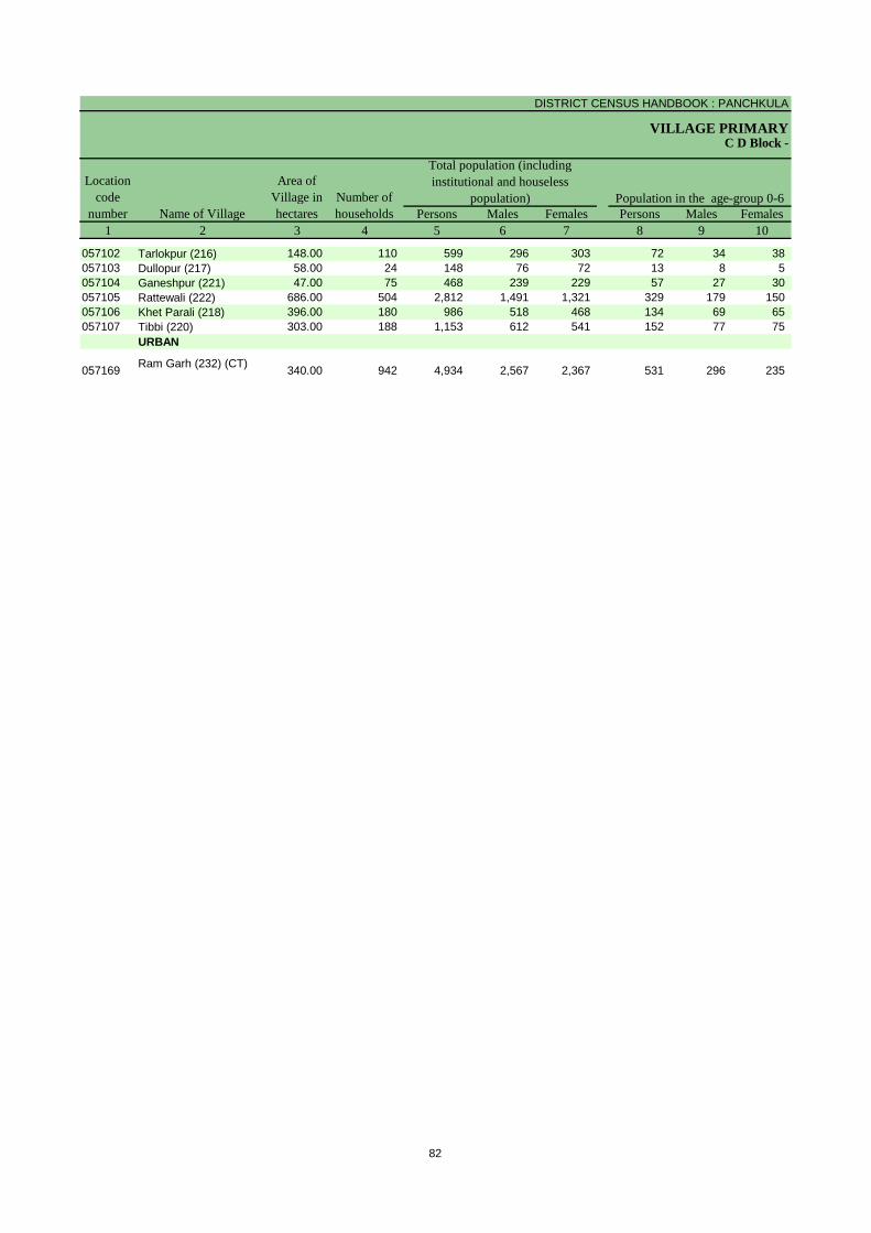
DISTRICT CENSUS HANDBOOK : PANCHKULA
VILLAGE PRIMARY
Persons Males Females Persons Males Females1 2 3 4 5 6 7 8 9 10
Name of Village
Location code
number
Total population (including institutional and houseless
population)Area of
Village in hectares
Number of households
C D Block -
Population in the age-group 0-6
057102 Tarlokpur (216) 148.00 110 599 296 303 72 34 38 057103 Dullopur (217) 58.00 24 148 76 72 13 8 5 057104 Ganeshpur (221) 47.00 75 468 239 229 57 27 30 057105 Rattewali (222) 686.00 504 2,812 1,491 1,321 329 179 150 057106 Khet Parali (218) 396.00 180 986 518 468 134 69 65 057107 Tibbi (220) 303.00 188 1,153 612 541 152 77 75
URBAN
057169 Ram Garh (232) (CT) 340.00 942 4,934 2,567 2,367 531 296 235
82
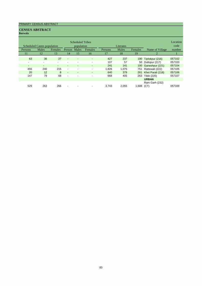
PRIMARY CENSUS ABSTRACT
CENSUS ABSTRACTBarwala
Persons Males Females Persons Males Females Persons Males Females11 12 13 14 15 16 17 18 19 2 1
Name of Village
Location code
numberLiteratesScheduled Castes population
Scheduled Tribes population
63 36 27 - - - 427 237 190 Tarlokpur (216) 057102- - - - - - 107 57 50 Dullopur (217) 057103- - - - - - 241 141 100 Ganeshpur (221) 057104455 240 215 - - - 1,826 1,075 751 Rattewali (222) 05710520 12 8 - - - 640 379 261 Khet Parali (218) 057106
147 79 68 - - - 668 405 263 Tibbi (220) 057107URBAN
529 263 266 - - - 3,743 2,055 1,688 Ram Garh (232) (CT) 057169
83

DISTRICT CENSUS HANDBOOK : PANCHKULA
VILLAGE PRIMARYC D Block -
Persons Males Females Persons Males Females Persons Males Females2 20 21 22 23 24 25 26 27 28
Name of VillageIlliterates Total workers Main workers
Tarlokpur (216) 172 59 113 150 137 13 64 52 12 Dullopur (217) 41 19 22 126 64 62 80 40 40 Ganeshpur (221) 227 98 129 238 134 104 140 130 10 Rattewali (222) 986 416 570 922 796 126 833 721 112 Khet Parali (218) 346 139 207 262 235 27 139 131 8 Tibbi (220) 485 207 278 425 372 53 389 360 29 URBAN
Ram Garh (232) (CT) 1,191 512 679 1,810 1,388 422 1,626 1,287 339
84
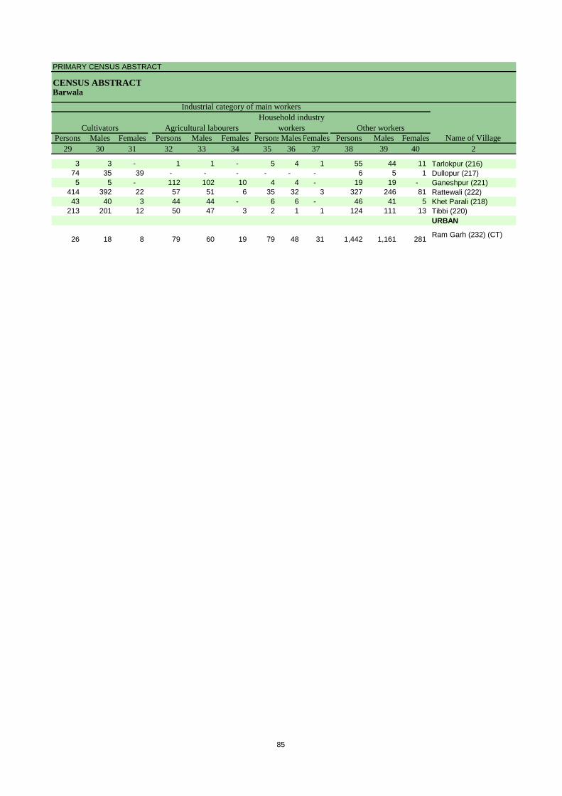
PRIMARY CENSUS ABSTRACT
CENSUS ABSTRACTBarwala
Persons Males Females Persons Males Females PersonsMalesFemales Persons Males Females29 30 31 32 33 34 35 36 37 38 39 40 2
CultivatorsName of Village
Household industry workersAgricultural labourers
Industrial category of main workers
Other workers
3 3 - 1 1 - 5 4 1 55 44 11 Tarlokpur (216)74 35 39 - - - - - - 6 5 1 Dullopur (217)5 5 - 112 102 10 4 4 - 19 19 - Ganeshpur (221)
414 392 22 57 51 6 35 32 3 327 246 81 Rattewali (222)43 40 3 44 44 - 6 6 - 46 41 5 Khet Parali (218)
213 201 12 50 47 3 2 1 1 124 111 13 Tibbi (220)URBAN
26 18 8 79 60 19 79 48 31 1,442 1,161 281 Ram Garh (232) (CT)
85
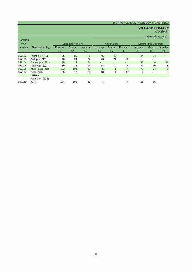
DISTRICT CENSUS HANDBOOK : PANCHKULA
VILLAGE PRIMARYC D Block -
Persons Males Females Persons Males Females Persons Males Females1 2 41 42 43 44 45 46 47 48 49
Name of VillageMarginal workers Cultivators Agricultural labourers
Industrial category Location
code number
057102 Tarlokpur (216) 86 85 1 45 45 - 24 24 - 057103 Dullopur (217) 46 24 22 46 24 22 - - - 057104 Ganeshpur (221) 98 4 94 - - - 98 4 94 057105 Rattewali (222) 89 75 14 14 10 4 39 36 3 057106 Khet Parali (218) 123 104 19 5 1 4 79 74 5 057107 Tibbi (220) 36 12 24 18 1 17 2 - 2
URBAN
057169Ram Garh (232) (CT) 184 101 83 4 - 4 16 16 -
86
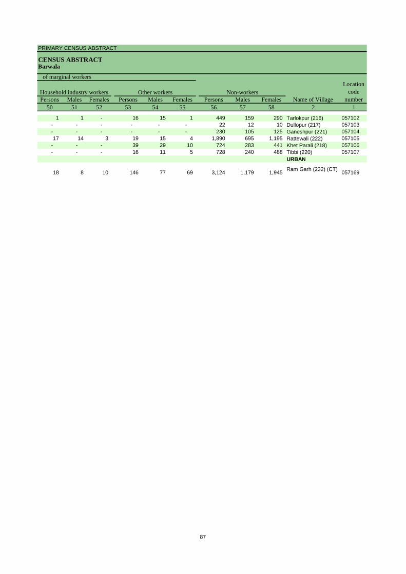
PRIMARY CENSUS ABSTRACT
CENSUS ABSTRACTBarwala
Persons Males Females Persons Males Females Persons Males Females50 51 52 53 54 55 56 57 58 2 1
Location code
numberHousehold industry workers
Name of VillageOther workers Non-workers
of marginal workers
1 1 - 16 15 1 449 159 290 Tarlokpur (216) 057102- - - - - - 22 12 10 Dullopur (217) 057103- - - - - - 230 105 125 Ganeshpur (221) 05710417 14 3 19 15 4 1,890 695 1,195 Rattewali (222) 057105
- - - 39 29 10 724 283 441 Khet Parali (218) 057106- - - 16 11 5 728 240 488 Tibbi (220) 057107
URBAN
18 8 10 146 77 69 3,124 1,179 1,945 Ram Garh (232) (CT) 057169
87
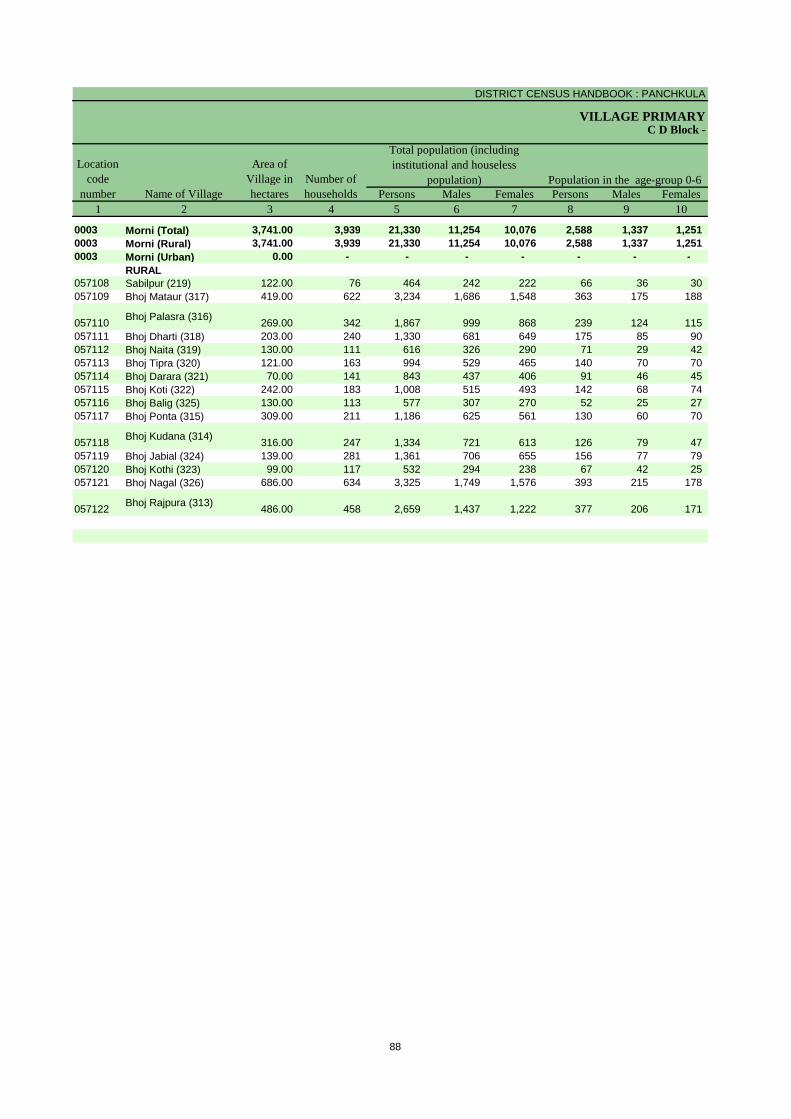
DISTRICT CENSUS HANDBOOK : PANCHKULA
VILLAGE PRIMARY
Persons Males Females Persons Males Females1 2 3 4 5 6 7 8 9 10
0003 Morni (Total) 3,741.00 3,939 21,330 11,254 10,076 2,588 1,337 1,251 0003 Morni (Rural) 3,741.00 3,939 21,330 11,254 10,076 2,588 1,337 1,251 0003 Morni (Urban) 0.00 - - - - - - -
RURAL057108 Sabilpur (219) 122.00 76 464 242 222 66 36 30 057109 Bhoj Mataur (317) 419.00 622 3,234 1,686 1,548 363 175 188
057110 Bhoj Palasra (316) 269.00 342 1,867 999 868 239 124 115 057111 Bhoj Dharti (318) 203.00 240 1,330 681 649 175 85 90 057112 Bhoj Naita (319) 130.00 111 616 326 290 71 29 42 057113 Bhoj Tipra (320) 121.00 163 994 529 465 140 70 70 057114 Bhoj Darara (321) 70.00 141 843 437 406 91 46 45 057115 Bhoj Koti (322) 242.00 183 1,008 515 493 142 68 74 057116 Bhoj Balig (325) 130.00 113 577 307 270 52 25 27 057117 Bhoj Ponta (315) 309.00 211 1,186 625 561 130 60 70
057118 Bhoj Kudana (314) 316.00 247 1,334 721 613 126 79 47 057119 Bhoj Jabial (324) 139.00 281 1,361 706 655 156 77 79 057120 Bhoj Kothi (323) 99.00 117 532 294 238 67 42 25 057121 Bhoj Nagal (326) 686.00 634 3,325 1,749 1,576 393 215 178
057122 Bhoj Rajpura (313) 486.00 458 2,659 1,437 1,222 377 206 171
Name of Village
Location code
number
Total population (including institutional and houseless
population)Area of
Village in hectares
Number of households
C D Block -
Population in the age-group 0-6
88

PRIMARY CENSUS ABSTRACT
CENSUS ABSTRACTMorni
Persons Males Females Persons Males Females Persons Males Females11 12 13 14 15 16 17 18 19 2
2,862 1,536 1,326 - - - 13,813 8,359 5,454 Morni (Total)2,862 1,536 1,326 - - - 13,813 8,359 5,454 Morni (Rural)
- - - - - - - - - Morni (Urban)RURAL
- - - - - - 290 172 118 Sabilpur (219)244 131 113 - - - 2,242 1,342 900 Bhoj Mataur (317)
342 197 145 - - - 1,124 684 440 Bhoj Palasra (316)
131 72 59 - - - 902 527 375 Bhoj Dharti (318)22 13 9 - - - 417 265 152 Bhoj Naita (319)
- - - - - - 651 411 240 Bhoj Tipra (320)28 20 8 - - - 613 363 250 Bhoj Darara (321)
205 105 100 - - - 651 397 254 Bhoj Koti (322)- - - - - - 376 235 141 Bhoj Balig (325)15 9 6 - - - 782 467 315 Bhoj Ponta (315)
11 8 3 - - - 888 549 339 Bhoj Kudana (314)
375 193 182 - - - 1,024 590 434 Bhoj Jabial (324)267 145 122 - - - 337 208 129 Bhoj Kothi (323)762 395 367 - - - 2,187 1,340 847 Bhoj Nagal (326)
460 248 212 - - - 1,329 809 520 Bhoj Rajpura (313)
Name of VillageLiteratesScheduled Castes population Scheduled Tribes population
89
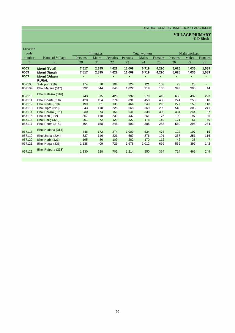
DISTRICT CENSUS HANDBOOK : PANCHKULA
VILLAGE PRIMARYC D Block -
Persons Males Females Persons Males Females Persons Males Females1 2 20 21 22 23 24 25 26 27 28
0003 Morni (Total) 7,517 2,895 4,622 11,009 6,719 4,290 5,625 4,036 1,589 0003 Morni (Rural) 7,517 2,895 4,622 11,009 6,719 4,290 5,625 4,036 1,589 0003 Morni (Urban) - - - - - - - - -
RURAL057108 Sabilpur (219) 174 70 104 224 121 103 23 23 - 057109 Bhoj Mataur (317) 992 344 648 1,022 919 103 949 905 44
057110 Bhoj Palasra (316) 743 315 428 992 579 413 655 432 223 057111 Bhoj Dharti (318) 428 154 274 891 458 433 274 256 18 057112 Bhoj Naita (319) 199 61 138 464 249 215 277 159 118 057113 Bhoj Tipra (320) 343 118 225 668 369 299 549 308 241 057114 Bhoj Darara (321) 230 74 156 641 338 303 331 244 87 057115 Bhoj Koti (322) 357 118 239 437 261 176 102 97 5 057116 Bhoj Balig (325) 201 72 129 327 178 149 121 61 60 057117 Bhoj Ponta (315) 404 158 246 593 305 288 560 296 264
057118 Bhoj Kudana (314) 446 172 274 1,009 534 475 122 107 15 057119 Bhoj Jabial (324) 337 116 221 567 376 191 367 251 116 057120 Bhoj Kothi (323) 195 86 109 282 170 112 42 35 7 057121 Bhoj Nagal (326) 1,138 409 729 1,678 1,012 666 539 397 142
057122 Bhoj Rajpura (313) 1,330 628 702 1,214 850 364 714 465 249
Name of Village
Location code
numberIlliterates Total workers Main workers
90

PRIMARY CENSUS ABSTRACT
CENSUS ABSTRACTMorni
Persons Males Females Persons Males Females PersonsMalesFemales Persons Males Females29 30 31 32 33 34 35 36 37 38 39 40 2
3,226 2,095 1,131 354 247 107 61 53 8 1,984 1,641 343 Morni (Total)3,226 2,095 1,131 354 247 107 61 53 8 1,984 1,641 343 Morni (Rural)
- - - - - - - - - - - - Morni (Urban)RURAL
1 1 - 14 14 - - - - 8 8 - Sabilpur (219)492 477 15 21 21 - 33 32 1 403 375 28 Bhoj Mataur (317)
224 110 114 53 20 33 - - - 378 302 76 Bhoj Palasra (316)
31 27 4 2 1 1 - - - 241 228 13 Bhoj Dharti (318)251 137 114 7 5 2 - - - 19 17 2 Bhoj Naita (319)526 291 235 - - - - - - 23 17 6 Bhoj Tipra (320)296 211 85 1 1 - - - - 34 32 2 Bhoj Darara (321)70 69 1 - - - - - - 32 28 4 Bhoj Koti (322)18 8 10 - - - - - - 103 53 50 Bhoj Balig (325)
504 248 256 19 17 2 9 6 3 28 25 3 Bhoj Ponta (315)
74 70 4 14 13 1 - - - 34 24 10 Bhoj Kudana (314)
62 25 37 - - - 9 8 1 296 218 78 Bhoj Jabial (324)5 5 - - - - - - - 37 30 7 Bhoj Kothi (323)
293 202 91 14 14 - 9 6 3 223 175 48 Bhoj Nagal (326)
379 214 165 209 141 68 1 1 - 125 109 16 Bhoj Rajpura (313)
CultivatorsName of Village
Household industry workersAgricultural labourers
Industrial category of main workers
Other workers
91

DISTRICT CENSUS HANDBOOK : PANCHKULA
VILLAGE PRIMARYC D Block -
Persons Males Females Persons Males Females Persons Males Females1 2 41 42 43 44 45 46 47 48 49
0003 Morni (Total) 5,384 2,683 2,701 3,537 1,316 2,221 253 222 31 0003 Morni (Rural) 5,384 2,683 2,701 3,537 1,316 2,221 253 222 31 0003 Morni (Urban) - - - - - - - - -
RURAL057108 Sabilpur (219) 201 98 103 101 1 100 63 61 2 057109 Bhoj Mataur (317) 73 14 59 53 3 50 2 - 2
057110 Bhoj Palasra (316) 337 147 190 77 22 55 8 1 7 057111 Bhoj Dharti (318) 617 202 415 573 183 390 7 2 5 057112 Bhoj Naita (319) 187 90 97 184 87 97 - - - 057113 Bhoj Tipra (320) 119 61 58 110 56 54 1 - 1 057114 Bhoj Darara (321) 310 94 216 310 94 216 - - - 057115 Bhoj Koti (322) 335 164 171 264 99 165 3 2 1 057116 Bhoj Balig (325) 206 117 89 7 3 4 - - - 057117 Bhoj Ponta (315) 33 9 24 9 4 5 2 2 -
057118 Bhoj Kudana (314) 887 427 460 691 238 453 89 85 4 057119 Bhoj Jabial (324) 200 125 75 95 43 52 24 24 - 057120 Bhoj Kothi (323) 240 135 105 215 119 96 1 1 - 057121 Bhoj Nagal (326) 1,139 615 524 615 229 386 43 37 6
057122 Bhoj Rajpura (313) 500 385 115 233 135 98 10 7 3
Name of VillageMarginal workers Cultivators Agricultural labourers
Industrial category Location
code number
92
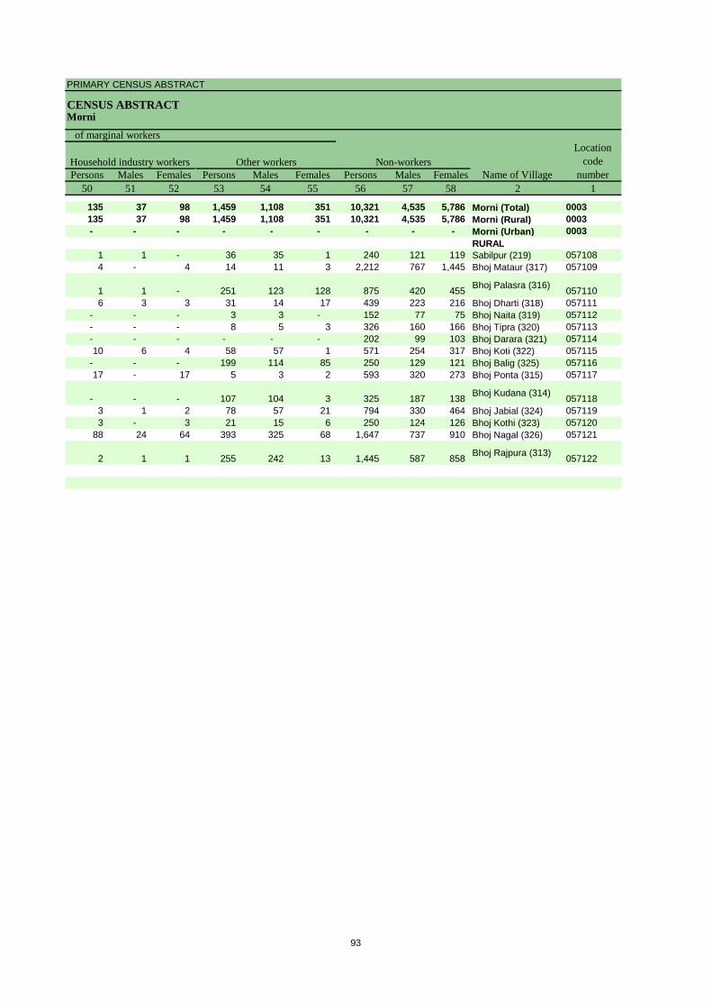
PRIMARY CENSUS ABSTRACT
CENSUS ABSTRACTMorni
Persons Males Females Persons Males Females Persons Males Females50 51 52 53 54 55 56 57 58 2 1
135 37 98 1,459 1,108 351 10,321 4,535 5,786 Morni (Total) 0003135 37 98 1,459 1,108 351 10,321 4,535 5,786 Morni (Rural) 0003- - - - - - - - - Morni (Urban) 0003
RURAL1 1 - 36 35 1 240 121 119 Sabilpur (219) 0571084 - 4 14 11 3 2,212 767 1,445 Bhoj Mataur (317) 057109
1 1 - 251 123 128 875 420 455 Bhoj Palasra (316) 0571106 3 3 31 14 17 439 223 216 Bhoj Dharti (318) 057111
- - - 3 3 - 152 77 75 Bhoj Naita (319) 057112- - - 8 5 3 326 160 166 Bhoj Tipra (320) 057113- - - - - - 202 99 103 Bhoj Darara (321) 05711410 6 4 58 57 1 571 254 317 Bhoj Koti (322) 057115
- - - 199 114 85 250 129 121 Bhoj Balig (325) 05711617 - 17 5 3 2 593 320 273 Bhoj Ponta (315) 057117
- - - 107 104 3 325 187 138 Bhoj Kudana (314) 0571183 1 2 78 57 21 794 330 464 Bhoj Jabial (324) 0571193 - 3 21 15 6 250 124 126 Bhoj Kothi (323) 057120
88 24 64 393 325 68 1,647 737 910 Bhoj Nagal (326) 057121
2 1 1 255 242 13 1,445 587 858 Bhoj Rajpura (313) 057122
Location code
numberHousehold industry workers
Name of VillageOther workers Non-workers
of marginal workers
93

DISTRICT CENSUS HANDBOOK : PANCHKULA
VILLAGE PRIMARY
Persons Males Females Persons Males Females1 2 3 4 5 6 7 8 9 10
0004 Raipur Rani (Total) 13,476.00 10,771 59,113 31,716 27,397 7,395 4,048 3,347
0004 Raipur Rani (Rural) 12,813.00 8,978 50,085 26,963 23,122 6,345 3,468 2,877
0004 Raipur Rani (Urban) 663.00 1,793 9,028 4,753 4,275 1,050 580 470 RURAL
057123 Mandlai (198) 513.00 139 811 454 357 113 64 49 057124 Bhud (199) 397.00 201 1,206 634 572 174 89 85 057125 Ganauli (200) 364.00 148 831 442 389 101 53 48 057126 Debar (202) 132.00 90 523 267 256 97 48 49 057127 Masumpur (201) 195.00 79 435 229 206 54 26 28 057128 Rahna (204) 226.00 227 1,449 752 697 247 117 130 057129 Gobindpur (205) 311.00 38 255 137 118 33 16 17 057130 Badhaur (208) 310.00 303 1,790 953 837 276 162 114 057131 Rampur (209) 326.00 198 1,121 610 511 125 73 52 057132 Narainpur (207) 137.00 80 402 205 197 47 20 27 057133 Alipur (206) 122.00057134 Sultanpur (203) 191.00 129 939 478 461 131 64 67 057135 Garhi (245) 486.00 752 3,885 2,103 1,782 446 257 189 057136 Dandlawar (249) 284.00 158 834 441 393 104 59 45 057137 Pyarewala (250) 335.00 424 2,288 1,354 934 316 168 148 057138 Qasampur (251) 76.00 1 3 2 1 1 1 - 057139 Bhagpur (248) 118.00 44 285 155 130 37 22 15 057140 Ferozepur (247) 278.00 174 1,019 541 478 119 72 47 057141 Hangola (265) 564.00 307 1,669 876 793 173 97 76 057142 Bhanvli (264) 120.00 147 860 462 398 86 47 39
057143 Shahjahanpur (246) 450.00 113 728 382 346 105 53 52 057144 Samlehri (11) 152.00 237 1,283 681 602 173 100 73 057145 Barauna Chhota (7) 94.00 109 598 308 290 67 39 28 057146 Tibi Majra (8) 89.00 102 569 300 269 56 37 19 057147 Barauna Kalan (9) 161.00 220 1,198 621 577 120 67 53 057148 Kheri (10) 287.00 288 1,605 823 782 216 107 109 057149 Haripur (13) 383.00 286 1,449 760 689 169 92 77 057150 Bazidpur (267) 61.00 25 132 76 56 16 9 7 057151 Haruli (12) 205.00 190 1,178 652 526 120 72 48 057152 Hangoli (266) 831.00 342 1,932 1,012 920 246 130 116 057153 Samanwa (268) 208.00 77 436 263 173 34 22 12 057154 Tharwa (18) 214.00 170 966 509 457 114 60 54 057155 Golpura (17) 283.00 186 861 504 357 140 72 68 057156 Mauli (16) 867.00 817 4,404 2,413 1,991 586 327 259 057157 Sarakpur (14) 152.00 71 377 192 185 36 19 17 057158 Tabar (15) 176.00 208 1,202 733 469 143 78 65
057159Nawagaon Urf Khader (24) 284.00 214 1,097 588 509 122 70 52
057160 Natwal (23) 662.00 418 2,312 1,255 1,057 335 174 161 057161 Bahbalpur (21) 123.00 52 321 166 155 53 30 23 057162 Bagwali (19) 310.00 226 1,289 670 619 159 82 77 057163 Bagwala (20) 416.00 146 891 485 406 107 68 39 057164 Kakrali (22) 239.00 277 1,609 847 762 185 102 83 057165 Toda (25) 393.00 395 2,238 1,195 1,043 251 138 113 057166 Jaspur (32) 288.00 170 805 433 372 112 65 47
URBAN057170 Raipur Rani (CT) 663.00 1,793 9,028 4,753 4,275 1,050 580 470
Name of Village
Location code
number
Total population (including institutional and houseless
population)Area of
Village in hectares
Number of households
C D Block -
Population in the age-group 0-6
-------------Un-inhabited--------------
94

PRIMARY CENSUS ABSTRACT
CENSUS ABSTRACTRaipur Rani
Persons Males Females Persons Males Females Persons Males Females11 12 13 14 15 16 17 18 19 2
12,412 6,603 5,809 - - - 38,677 22,493 16,184 Raipur Rani (Total)
10,056 5,374 4,682 - - - 32,212 18,904 13,308 Raipur Rani (Rural)
2,356 1,229 1,127 - - - 6,465 3,589 2,876 Raipur Rani (Urban)
RURAL91 55 36 - - - 495 315 180 Mandlai (198)
348 188 160 - - - 688 412 276 Bhud (199)225 126 99 - - - 482 275 207 Ganauli (200)39 20 19 - - - 252 144 108 Debar (202)85 46 39 - - - 278 163 115 Masumpur (201)57 28 29 - - - 636 415 221 Rahna (204)6 4 2 - - - 149 92 57 Gobindpur (205)
279 150 129 - - - 1,060 629 431 Badhaur (208)- - - - - - 667 415 252 Rampur (209)51 29 22 - - - 247 143 104 Narainpur (207)
Alipur (206)- - - - - - 426 257 169 Sultanpur (203)
1,202 654 548 - - - 2,402 1,387 1,015 Garhi (245)71 37 34 - - - 537 299 238 Dandlawar (249)8 4 4 - - - 1,445 951 494 Pyarewala (250)
- - - - - - 2 1 1 Qasampur (251)- - - - - - 179 106 73 Bhagpur (248)100 55 45 - - - 632 347 285 Ferozepur (247)710 364 346 - - - 1,129 643 486 Hangola (265)125 61 64 - - - 539 336 203 Bhanvli (264)
- - - - - - 437 255 182 Shahjahanpur (246)
507 268 239 - - - 847 490 357 Samlehri (11)171 90 81 - - - 428 233 195 Barauna Chhota (7)- - - - - - 406 227 179 Tibi Majra (8)374 197 177 - - - 868 473 395 Barauna Kalan (9)509 257 252 - - - 1,101 610 491 Kheri (10)278 147 131 - - - 972 554 418 Haripur (13)- - - - - - 78 52 26 Bazidpur (267)369 197 172 - - - 786 475 311 Haruli (12)242 132 110 - - - 1,247 711 536 Hangoli (266)- - - - - - 312 192 120 Samanwa (268)279 148 131 - - - 681 400 281 Tharwa (18)155 82 73 - - - 499 326 173 Golpura (17)
1,012 556 456 - - - 3,085 1,772 1,313 Mauli (16)11 6 5 - - - 276 150 126 Sarakpur (14)
107 51 56 - - - 900 596 304 Tabar (15)
557 306 251 - - - 735 422 313 Nawagaon Urf Khader (24)
832 453 379 - - - 1,309 789 520 Natwal (23)34 21 13 - - - 218 115 103 Bahbalpur (21)
296 153 143 - - - 898 516 382 Bagwali (19)103 59 44 - - - 663 363 300 Bagwala (20)300 165 135 - - - 1,178 661 517 Kakrali (22)379 197 182 - - - 1,532 892 640 Toda (25)144 68 76 - - - 511 300 211 Jaspur (32)
URBAN2,356 1,229 1,127 - - - 6,465 3,589 2,876 Raipur Rani (CT)
Name of VillageLiteratesScheduled Castes population
Scheduled Tribes population
-------------Un-inhabited--------------
95
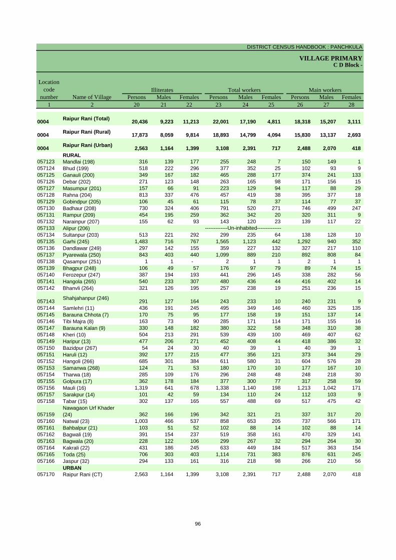
DISTRICT CENSUS HANDBOOK : PANCHKULA
VILLAGE PRIMARYC D Block -
Persons Males Females Persons Males Females Persons Males Females1 2 20 21 22 23 24 25 26 27 28
0004 Raipur Rani (Total) 20,436 9,223 11,213 22,001 17,190 4,811 18,318 15,207 3,111
0004 Raipur Rani (Rural) 17,873 8,059 9,814 18,893 14,799 4,094 15,830 13,137 2,693
0004 Raipur Rani (Urban) 2,563 1,164 1,399 3,108 2,391 717 2,488 2,070 418 RURAL
057123 Mandlai (198) 316 139 177 255 248 7 150 149 1 057124 Bhud (199) 518 222 296 377 352 25 102 93 9 057125 Ganauli (200) 349 167 182 465 288 177 374 241 133 057126 Debar (202) 271 123 148 263 165 98 171 156 15 057127 Masumpur (201) 157 66 91 223 129 94 117 88 29 057128 Rahna (204) 813 337 476 457 419 38 395 377 18 057129 Gobindpur (205) 106 45 61 115 78 37 114 77 37 057130 Badhaur (208) 730 324 406 791 520 271 746 499 247 057131 Rampur (209) 454 195 259 362 342 20 320 311 9 057132 Narainpur (207) 155 62 93 143 120 23 139 117 22 057133 Alipur (206)057134 Sultanpur (203) 513 221 292 299 235 64 138 128 10 057135 Garhi (245) 1,483 716 767 1,565 1,123 442 1,292 940 352 057136 Dandlawar (249) 297 142 155 359 227 132 327 217 110 057137 Pyarewala (250) 843 403 440 1,099 889 210 892 808 84 057138 Qasampur (251) 1 1 - 2 1 1 2 1 1 057139 Bhagpur (248) 106 49 57 176 97 79 89 74 15 057140 Ferozepur (247) 387 194 193 441 296 145 338 282 56 057141 Hangola (265) 540 233 307 480 436 44 416 402 14 057142 Bhanvli (264) 321 126 195 257 238 19 251 236 15
057143 Shahjahanpur (246) 291 127 164 243 233 10 240 231 9 057144 Samlehri (11) 436 191 245 495 349 146 460 325 135 057145 Barauna Chhota (7) 170 75 95 177 158 19 151 137 14 057146 Tibi Majra (8) 163 73 90 285 171 114 171 155 16 057147 Barauna Kalan (9) 330 148 182 380 322 58 348 310 38 057148 Kheri (10) 504 213 291 539 439 100 469 407 62 057149 Haripur (13) 477 206 271 452 408 44 418 386 32 057150 Bazidpur (267) 54 24 30 40 39 1 40 39 1 057151 Haruli (12) 392 177 215 477 356 121 373 344 29 057152 Hangoli (266) 685 301 384 611 580 31 604 576 28 057153 Samanwa (268) 124 71 53 180 170 10 177 167 10 057154 Tharwa (18) 285 109 176 296 248 48 248 218 30 057155 Golpura (17) 362 178 184 377 300 77 317 258 59 057156 Mauli (16) 1,319 641 678 1,338 1,140 198 1,213 1,042 171 057157 Sarakpur (14) 101 42 59 134 110 24 112 103 9 057158 Tabar (15) 302 137 165 557 488 69 517 475 42
057159Nawagaon Urf Khader (24) 362 166 196 342 321 21 337 317 20
057160 Natwal (23) 1,003 466 537 858 653 205 737 566 171 057161 Bahbalpur (21) 103 51 52 102 88 14 102 88 14 057162 Bagwali (19) 391 154 237 519 358 161 470 329 141 057163 Bagwala (20) 228 122 106 299 267 32 294 264 30 057164 Kakrali (22) 431 186 245 633 449 184 517 363 154 057165 Toda (25) 706 303 403 1,114 731 383 876 631 245 057166 Jaspur (32) 294 133 161 316 218 98 266 210 56
URBAN057170 Raipur Rani (CT) 2,563 1,164 1,399 3,108 2,391 717 2,488 2,070 418
Name of Village
Location code
numberIlliterates Total workers Main workers
-------------Un-inhabited--------------
96

PRIMARY CENSUS ABSTRACT
CENSUS ABSTRACTRaipur Rani
Persons Males Females Persons Males Females PersonsMales Females Persons Males Females29 30 31 32 33 34 35 36 37 38 39 40 2
5,091 4,713 378 2,782 2,225 557 994 602 392 9,451 7,667 1,784 Raipur Rani (Total)
5,071 4,698 373 2,705 2,168 537 790 428 362 7,264 5,843 1,421 Raipur Rani (Rural)
20 15 5 77 57 20 204 174 30 2,187 1,824 363 Raipur Rani (Urban)
RURAL132 132 - - - - 3 3 - 15 14 1 Mandlai (198)56 55 1 1 1 - 1 1 - 44 36 8 Bhud (199)32 28 4 102 94 8 154 49 105 86 70 16 Ganauli (200)
110 105 5 16 13 3 - - - 45 38 7 Debar (202)87 74 13 3 3 - - - - 27 11 16 Masumpur (201)
174 171 3 65 51 14 1 1 - 155 154 1 Rahna (204)52 48 4 - - - - - - 62 29 33 Gobindpur (205)
333 276 57 88 59 29 5 2 3 320 162 158 Badhaur (208)183 182 1 11 11 - 4 3 1 122 115 7 Rampur (209)41 37 4 52 44 8 - - - 46 36 10 Narainpur (207)
Alipur (206)110 104 6 4 3 1 6 5 1 18 16 2 Sultanpur (203)259 214 45 415 260 155 158 60 98 460 406 54 Garhi (245)101 82 19 6 2 4 11 - 11 209 133 76 Dandlawar (249)209 192 17 75 68 7 28 20 8 580 528 52 Pyarewala (250)- - - 1 - 1 - - - 1 1 - Qasampur (251)65 56 9 6 5 1 - - - 18 13 5 Bhagpur (248)
194 156 38 29 20 9 6 4 2 109 102 7 Ferozepur (247)83 79 4 138 133 5 13 13 - 182 177 5 Hangola (265)
149 149 - 19 17 2 - - - 83 70 13 Bhanvli (264)
194 191 3 2 1 1 4 - 4 40 39 1 Shahjahanpur (246)
103 89 14 96 76 20 43 21 22 218 139 79 Samlehri (11)37 36 1 31 27 4 2 2 - 81 72 9 Barauna Chhota (7)71 67 4 13 10 3 2 2 - 85 76 9 Tibi Majra (8)96 92 4 16 6 10 4 4 - 232 208 24 Barauna Kalan (9)78 76 2 93 74 19 52 38 14 246 219 27 Kheri (10)58 56 2 65 58 7 71 66 5 224 206 18 Haripur (13)19 19 - 4 4 - - - - 17 16 1 Bazidpur (267)
184 181 3 36 34 2 10 4 6 143 125 18 Haruli (12)269 261 8 77 74 3 4 4 - 254 237 17 Hangoli (266)97 92 5 58 56 2 3 2 1 19 17 2 Samanwa (268)67 64 3 70 66 4 19 8 11 92 80 12 Tharwa (18)
155 139 16 26 24 2 - - - 136 95 41 Golpura (17)233 228 5 261 230 31 34 32 2 685 552 133 Mauli (16)39 39 - 10 10 - - - - 63 54 9 Sarakpur (14)88 86 2 35 28 7 4 4 - 390 357 33 Tabar (15)
114 109 5 170 164 6 21 20 1 32 24 8 Nawagaon Urf Khader (24)
131 128 3 73 50 23 8 8 - 525 380 145 Natwal (23)45 45 - 16 16 - 1 1 - 40 26 14 Bahbalpur (21)
108 80 28 26 19 7 14 11 3 322 219 103 Bagwali (19)162 156 6 30 28 2 6 6 - 96 74 22 Bagwala (20)58 40 18 372 254 118 1 1 - 86 68 18 Kakrali (22)
227 216 11 87 69 18 97 33 64 465 313 152 Toda (25)68 68 - 7 6 1 - - - 191 136 55 Jaspur (32)
URBAN20 15 5 77 57 20 204 174 30 2,187 1,824 363 Raipur Rani (CT)
CultivatorsName of Village
Household industry workersAgricultural labourers
Industrial category of main workers
Other workers
-------------Un-inhabited--------------
97

DISTRICT CENSUS HANDBOOK : PANCHKULA
VILLAGE PRIMARYC D Block -
Persons Males Females Persons Males Females Persons Males Females1 2 41 42 43 44 45 46 47 48 49
0004 Raipur Rani (Total) 3,683 1,983 1,700 807 326 481 849 511 338
0004Raipur Rani (Rural) 3,063 1,662 1,401 659 270 389 698 448 250
0004Raipur Rani (Urban) 620 321 299 148 56 92 151 63 88 RURAL
057123 Mandlai (198) 105 99 6 22 22 - 6 4 2 057124 Bhud (199) 275 259 16 64 61 3 5 3 2 057125 Ganauli (200) 91 47 44 - - - 1 1 - 057126 Debar (202) 92 9 83 57 9 48 10 - 10 057127 Masumpur (201) 106 41 65 5 3 2 4 2 2 057128 Rahna (204) 62 42 20 4 3 1 41 23 18 057129 Gobindpur (205) 1 1 - 1 1 - - - - 057130 Badhaur (208) 45 21 24 11 7 4 22 9 13 057131 Rampur (209) 42 31 11 3 2 1 6 5 1 057132 Narainpur (207) 4 3 1 - - - 1 1 - 057133 Alipur (206)057134 Sultanpur (203) 161 107 54 1 1 - 134 104 30 057135 Garhi (245) 273 183 90 55 32 23 81 55 26 057136 Dandlawar (249) 32 10 22 6 3 3 6 - 6 057137 Pyarewala (250) 207 81 126 132 48 84 14 6 8 057138 Qasampur (251) - - - - - - - - - 057139 Bhagpur (248) 87 23 64 71 17 54 14 5 9 057140 Ferozepur (247) 103 14 89 76 6 70 16 3 13 057141 Hangola (265) 64 34 30 10 6 4 18 8 10 057142 Bhanvli (264) 6 2 4 - - - 1 - 1
057143 Shahjahanpur (246) 3 2 1 - - - 1 - 1 057144 Samlehri (11) 35 24 11 2 1 1 21 15 6 057145 Barauna Chhota (7) 26 21 5 1 - 1 11 8 3 057146 Tibi Majra (8) 114 16 98 89 10 79 4 2 2 057147 Barauna Kalan (9) 32 12 20 4 3 1 7 - 7 057148 Kheri (10) 70 32 38 5 4 1 19 6 13 057149 Haripur (13) 34 22 12 1 - 1 4 2 2 057150 Bazidpur (267) - - - - - - - - - 057151 Haruli (12) 104 12 92 - - - 15 8 7 057152 Hangoli (266) 7 4 3 1 1 - 2 1 1 057153 Samanwa (268) 3 3 - - - - 1 1 - 057154 Tharwa (18) 48 30 18 4 3 1 10 10 - 057155 Golpura (17) 60 42 18 1 1 - 27 26 1 057156 Mauli (16) 125 98 27 9 8 1 48 34 14 057157 Sarakpur (14) 22 7 15 1 1 - 1 1 - 057158 Tabar (15) 40 13 27 1 1 - 17 5 12
057159Nawagaon Urf Khader (24) 5 4 1 1 1 - - - -
057160 Natwal (23) 121 87 34 6 6 - 79 68 11 057161 Bahbalpur (21) - - - - - - - - - 057162 Bagwali (19) 49 29 20 3 2 1 2 2 - 057163 Bagwala (20) 5 3 2 1 - 1 - - - 057164 Kakrali (22) 116 86 30 3 2 1 26 15 11 057165 Toda (25) 238 100 138 8 5 3 18 10 8 057166 Jaspur (32) 50 8 42 - - - 5 5 -
URBAN057170 Raipur Rani (CT) 620 321 299 148 56 92 151 63 88
Name of VillageMarginal workers Cultivators Agricultural labourers
Industrial category Location
code number
-------------Un-inhabited--------------
98

PRIMARY CENSUS ABSTRACT
CENSUS ABSTRACTRaipur Rani
Persons Males Females Persons Males Females Persons Males Females50 51 52 53 54 55 56 57 58 2 1
354 136 218 1,673 1,010 663 37,112 14,526 22,586 Raipur Rani (Total) 0004
295 111 184 1,411 833 578 31,192 12,164 19,028 Raipur Rani (Rural) 0004
59 25 34 262 177 85 5,920 2,362 3,558 Raipur Rani (Urban) 0004RURAL
- - - 77 73 4 556 206 350 Mandlai (198) 0571231 1 - 205 194 11 829 282 547 Bhud (199) 057124
35 18 17 55 28 27 366 154 212 Ganauli (200) 0571251 - 1 24 - 24 260 102 158 Debar (202) 0571262 - 2 95 36 59 212 100 112 Masumpur (201) 0571271 1 - 16 15 1 992 333 659 Rahna (204) 057128
- - - - - - 140 59 81 Gobindpur (205) 0571291 1 - 11 4 7 999 433 566 Badhaur (208) 057130
- - - 33 24 9 759 268 491 Rampur (209) 057131- - - 3 2 1 259 85 174 Narainpur (207) 057132
Alipur (206) 05713320 1 19 6 1 5 640 243 397 Sultanpur (203) 05713433 14 19 104 82 22 2,320 980 1,340 Garhi (245) 0571354 - 4 16 7 9 475 214 261 Dandlawar (249) 057136
11 2 9 50 25 25 1,189 465 724 Pyarewala (250) 057137- - - - - - 1 1 - Qasampur (251) 057138
1 - 1 1 1 - 109 58 51 Bhagpur (248) 0571395 3 2 6 2 4 578 245 333 Ferozepur (247) 057140
14 11 3 22 9 13 1,189 440 749 Hangola (265) 057141- - - 5 2 3 603 224 379 Bhanvli (264) 057142
- - - 2 2 - 485 149 336 Shahjahanpur (246) 0571432 1 1 10 7 3 788 332 456 Samlehri (11) 057144
- - - 14 13 1 421 150 271 Barauna Chhota (7) 057145- - - 21 4 17 284 129 155 Tibi Majra (8) 057146
1 - 1 20 9 11 818 299 519 Barauna Kalan (9) 05714714 1 13 32 21 11 1,066 384 682 Kheri (10) 0571486 3 3 23 17 6 997 352 645 Haripur (13) 057149
- - - - - - 92 37 55 Bazidpur (267) 05715013 - 13 76 4 72 701 296 405 Haruli (12) 057151
- - - 4 2 2 1,321 432 889 Hangoli (266) 057152- - - 2 2 - 256 93 163 Samanwa (268) 057153
2 - 2 32 17 15 670 261 409 Tharwa (18) 057154- - - 32 15 17 484 204 280 Golpura (17) 057155
3 2 1 65 54 11 3,066 1,273 1,793 Mauli (16) 057156- - - 20 5 15 243 82 161 Sarakpur (14) 057157
2 1 1 20 6 14 645 245 400 Tabar (15) 057158
4 3 1 - - - 755 267 488 Nawagaon Urf Khader (24) 057159
2 1 1 34 12 22 1,454 602 852 Natwal (23) 057160- - - - - - 219 78 141 Bahbalpur (21) 057161
1 - 1 43 25 18 770 312 458 Bagwali (19) 0571622 1 1 2 2 - 592 218 374 Bagwala (20) 0571632 1 1 85 68 17 976 398 578 Kakrali (22) 057164
112 45 67 100 40 60 1,124 464 660 Toda (25) 057165- - - 45 3 42 489 215 274 Jaspur (32) 057166
URBAN59 25 34 262 177 85 5,920 2,362 3,558 Raipur Rani (CT) 057170
Location code
numberHousehold industry workers
Name of VillageOther workers Non-workers
of marginal workers
-------------Un-inhabited--------------
99

Urban PCA-Town wise Primary Census Abstract

DISTRICT CENSUS HANDBOOK : PANCHKULA
URBAN PRIMARY
Persons Males Females Persons Males Females1 2 3 4 5 6 7 8 9 10
800361 Kalka (MC + OG) 3.72 7,868 34,134 18,311 15,823 3,559 1,886 1,673 0001 Ward No. 1 655 2,940 1,765 1,175 359 185 174 0002 Ward No. 2 360 1,538 824 714 161 97 64 0003 Ward No. 3 383 1,665 832 833 138 65 73 0004 Ward No. 4 449 2,435 1,271 1,164 325 163 162 0005 Ward No. 5 310 1,464 770 694 161 90 71 0006 Ward No. 6 478 2,021 1,082 939 202 99 103 0007 Ward No. 7 671 2,879 1,549 1,330 329 173 156 0008 Ward No. 8 499 1,879 972 907 149 79 70 0009 Ward No. 9 381 1,605 848 757 181 94 87 0010 Ward No. 10 434 1,790 965 825 197 117 80 0011 Ward No. 11 374 1,673 892 781 215 115 100 0012 Ward No. 12 339 1,343 739 604 100 45 55 0013 Ward No. 13 446 2,093 1,075 1,018 210 123 87 0014 Ward No. 14 401 1,644 890 754 135 65 70 0015 Ward No. 15 326 1,434 752 682 134 70 64 0016 Ward No. 16 420 1,830 982 848 145 91 54 0017 Ward No. 17 451 2,022 1,053 969 163 84 79 0018 Ward No. 18 491 1,879 1,050 829 255 131 124 800362 Pinjore (MC) 16.00 7,752 35,912 19,157 16,755 4,190 2,276 1,914 0001 Ward No. 1 444 1,970 1,044 926 240 149 91 0002 Ward No. 2 731 3,419 1,821 1,598 391 230 161 0003 Ward No. 3 333 1,538 804 734 145 66 79 0004 Ward No. 4 524 2,433 1,282 1,151 281 151 130 0005 Ward No. 5 241 1,292 675 617 204 110 94 0006 Ward No. 6 343 1,565 819 746 167 99 68 0007 Ward No. 7 900 4,146 2,107 2,039 506 244 262 0008 Ward No. 8 279 1,244 643 601 122 65 57 0009 Ward No. 9 395 1,789 952 837 214 119 95 0010 Ward No. 10 467 2,241 1,200 1,041 314 174 140 0011 Ward No. 11 320 1,530 786 744 187 87 100 0012 Ward No. 12 297 1,284 686 598 151 83 68 0013 Ward No. 13 490 2,157 1,081 1,076 254 135 119 0014 Ward No. 14 474 2,205 1,181 1,024 294 155 139 0015 Ward No. 15 1,514 7,099 4,076 3,023 720 409 311 057045 HMT Pinjore (CT) 3.44 913 3,873 2,074 1,799 276 151 125 0001 Ward No. 1 913 3,873 2,074 1,799 276 151 125 800363 Panchkula (M Cl) 32.60 48,772 2,11,355 1,11,731 99,624 22,854 12,294 10,560 0001 Ward No. 1 2,097 9,065 4,833 4,232 1,286 701 585 0002 Ward No. 2 1,840 7,007 3,660 3,347 621 332 289 0003 Ward No. 3 1,040 4,552 2,331 2,221 368 203 165 0004 Ward No. 4 1,206 5,232 2,721 2,511 390 214 176 0005 Ward No. 5 1,206 5,449 2,852 2,597 422 218 204 0006 Ward No. 6 1,228 5,279 2,748 2,531 478 255 223 0007 Ward No. 7 1,981 9,389 5,024 4,365 1,314 684 630 0008 Ward No. 8 1,620 7,534 4,122 3,412 1,036 567 469 0009 Ward No. 9 1,228 5,753 3,217 2,536 892 458 434 0010 Ward No. 10 1,329 5,987 3,059 2,928 536 299 237 0011 Ward No. 11 1,343 6,102 3,139 2,963 571 298 273 0012 Ward No. 12 1,660 7,232 3,697 3,535 644 317 327 0013 Ward No. 13 1,016 4,623 2,387 2,236 393 214 179 0014 Ward No. 14 1,281 5,291 2,807 2,484 534 278 256 0015 Ward No. 15 1,415 6,247 3,222 3,025 643 360 283 0016 Ward No. 16 2,322 9,912 5,186 4,726 1,099 610 489 0017 Ward No. 17 2,033 8,159 4,849 3,310 1,161 627 534 0018 Ward No. 18 1,677 7,129 3,780 3,349 596 332 264 0019 Ward No. 19 2,017 9,080 4,740 4,340 1,007 542 465 0020 Ward No. 20 1,101 4,624 2,333 2,291 355 174 181 0021 Ward No. 21 1,402 6,275 3,299 2,976 530 287 243 0022 Ward No. 22 1,351 5,578 2,877 2,701 443 243 200
Name of Town/ Ward
Location code
number
Total population (including institutional and houseless
population)
Area in Square
Kilometre
Number of households
Population in the age-group 0-6
102

PRIMARY CENSUS ABSTRACT
CENSUS ABSTRACT
Persons Males Females Persons Males Females Persons Males Females11 12 13 14 15 16 17 18 19 2
6,550 3,405 3,145 - - - 27,522 15,294 12,228 Kalka (MC + OG)994 519 475 - - - 2,217 1,447 770 Ward No. 1239 127 112 - - - 1,254 687 567 Ward No. 2113 48 65 - - - 1,395 718 677 Ward No. 3
1,621 835 786 - - - 1,705 958 747 Ward No. 4164 84 80 - - - 1,181 636 545 Ward No. 5183 96 87 - - - 1,630 889 741 Ward No. 6109 57 52 - - - 2,398 1,305 1,093 Ward No. 731 18 13 - - - 1,676 881 795 Ward No. 8
240 135 105 - - - 1,316 720 596 Ward No. 9342 179 163 - - - 1,460 804 656 Ward No. 10635 331 304 - - - 1,131 649 482 Ward No. 11303 167 136 - - - 1,131 649 482 Ward No. 12166 83 83 - - - 1,705 896 809 Ward No. 13140 72 68 - - - 1,434 796 638 Ward No. 14167 84 83 - - - 1,208 647 561 Ward No. 15472 246 226 - - - 1,502 838 664 Ward No. 16456 230 226 - - - 1,693 910 783 Ward No. 17175 94 81 - - - 1,486 864 622 Ward No. 18
6,916 3,623 3,293 - - - 28,437 15,791 12,646 Pinjore (MC)290 146 144 - - - 1,549 833 716 Ward No. 1610 315 295 - - - 2,711 1,507 1,204 Ward No. 2245 119 126 - - - 1,248 698 550 Ward No. 3292 162 130 - - - 2,006 1,102 904 Ward No. 4772 399 373 - - - 714 403 311 Ward No. 5545 269 276 - - - 1,207 647 560 Ward No. 6774 383 391 - - - 3,370 1,777 1,593 Ward No. 784 46 38 - - - 1,071 560 511 Ward No. 8
382 204 178 - - - 1,489 820 669 Ward No. 9813 424 389 - - - 1,613 913 700 Ward No. 10366 183 183 - - - 1,174 644 530 Ward No. 11243 131 112 - - - 1,018 550 468 Ward No. 12369 174 195 - - - 1,761 909 852 Ward No. 13196 103 93 - - - 1,631 923 708 Ward No. 14935 565 370 - - - 5,875 3,505 2,370 Ward No. 15822 452 370 - - - 3,419 1,899 1,520 HMT Pinjore (CT)822 452 370 - - - 3,419 1,899 1,520 Ward No. 1
28,325 15,167 13,158 - - - 1,62,031 88,982 73,049 Panchkula (M Cl)3,035 1,630 1,405 - - - 5,595 3,156 2,439 Ward No. 1
269 145 124 - - - 6,103 3,229 2,874 Ward No. 224 13 11 - - - 4,020 2,072 1,948 Ward No. 3
114 64 50 - - - 4,641 2,435 2,206 Ward No. 4145 74 71 - - - 4,741 2,501 2,240 Ward No. 596 50 46 - - - 4,571 2,399 2,172 Ward No. 6
4,722 2,527 2,195 - - - 5,028 3,107 1,921 Ward No. 72,028 1,086 942 - - - 4,021 2,501 1,520 Ward No. 81,937 1,034 903 - - - 3,124 1,925 1,199 Ward No. 9
81 41 40 - - - 5,315 2,719 2,596 Ward No. 1043 22 21 - - - 5,284 2,754 2,530 Ward No. 1183 51 32 - - - 6,335 3,303 3,032 Ward No. 12
250 118 132 - - - 4,021 2,119 1,902 Ward No. 13594 309 285 - - - 4,249 2,368 1,881 Ward No. 14152 76 76 - - - 5,416 2,792 2,624 Ward No. 15
1,080 573 507 - - - 8,146 4,384 3,762 Ward No. 161,248 744 504 - - - 5,442 3,629 1,813 Ward No. 171,134 612 522 - - - 5,881 3,215 2,666 Ward No. 18
754 388 366 - - - 6,888 3,790 3,098 Ward No. 1964 32 32 - - - 4,105 2,105 2,000 Ward No. 20
282 148 134 - - - 5,431 2,931 2,500 Ward No. 21164 95 69 - - - 4,942 2,569 2,373 Ward No. 22
Name of Town/ WardScheduled Castes population Scheduled Tribes population Literates
103
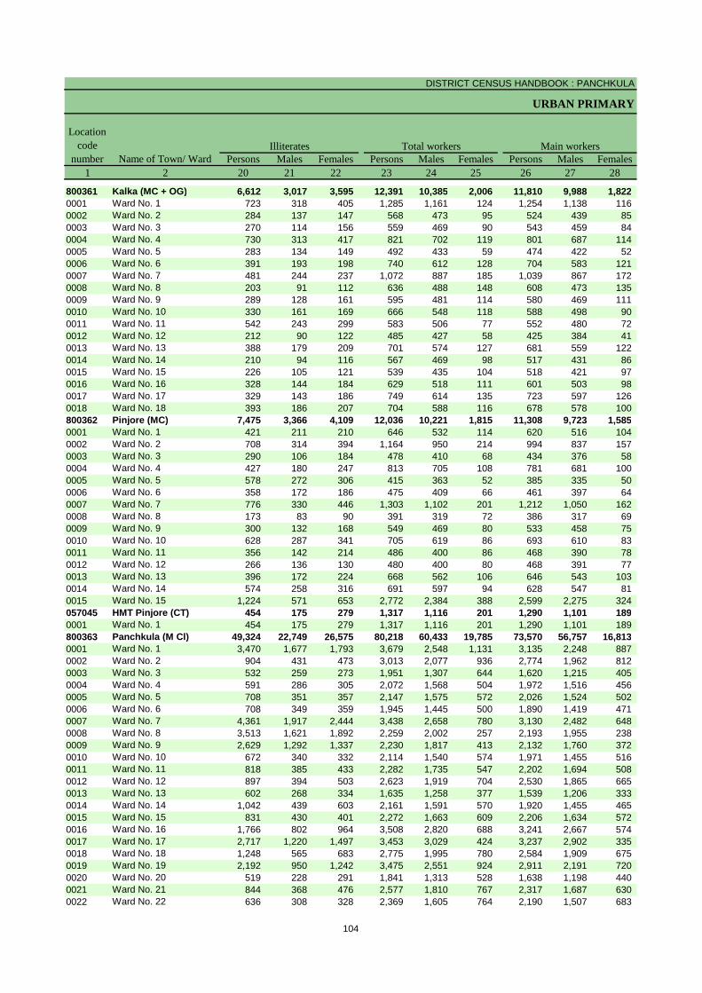
DISTRICT CENSUS HANDBOOK : PANCHKULA
URBAN PRIMARY
Persons Males Females Persons Males Females Persons Males Females1 2 20 21 22 23 24 25 26 27 28
800361 Kalka (MC + OG) 6,612 3,017 3,595 12,391 10,385 2,006 11,810 9,988 1,822 0001 Ward No. 1 723 318 405 1,285 1,161 124 1,254 1,138 116 0002 Ward No. 2 284 137 147 568 473 95 524 439 85 0003 Ward No. 3 270 114 156 559 469 90 543 459 84 0004 Ward No. 4 730 313 417 821 702 119 801 687 114 0005 Ward No. 5 283 134 149 492 433 59 474 422 52 0006 Ward No. 6 391 193 198 740 612 128 704 583 121 0007 Ward No. 7 481 244 237 1,072 887 185 1,039 867 172 0008 Ward No. 8 203 91 112 636 488 148 608 473 135 0009 Ward No. 9 289 128 161 595 481 114 580 469 111 0010 Ward No. 10 330 161 169 666 548 118 588 498 90 0011 Ward No. 11 542 243 299 583 506 77 552 480 72 0012 Ward No. 12 212 90 122 485 427 58 425 384 41 0013 Ward No. 13 388 179 209 701 574 127 681 559 122 0014 Ward No. 14 210 94 116 567 469 98 517 431 86 0015 Ward No. 15 226 105 121 539 435 104 518 421 97 0016 Ward No. 16 328 144 184 629 518 111 601 503 98 0017 Ward No. 17 329 143 186 749 614 135 723 597 126 0018 Ward No. 18 393 186 207 704 588 116 678 578 100 800362 Pinjore (MC) 7,475 3,366 4,109 12,036 10,221 1,815 11,308 9,723 1,585 0001 Ward No. 1 421 211 210 646 532 114 620 516 104 0002 Ward No. 2 708 314 394 1,164 950 214 994 837 157 0003 Ward No. 3 290 106 184 478 410 68 434 376 58 0004 Ward No. 4 427 180 247 813 705 108 781 681 100 0005 Ward No. 5 578 272 306 415 363 52 385 335 50 0006 Ward No. 6 358 172 186 475 409 66 461 397 64 0007 Ward No. 7 776 330 446 1,303 1,102 201 1,212 1,050 162 0008 Ward No. 8 173 83 90 391 319 72 386 317 69 0009 Ward No. 9 300 132 168 549 469 80 533 458 75 0010 Ward No. 10 628 287 341 705 619 86 693 610 83 0011 Ward No. 11 356 142 214 486 400 86 468 390 78 0012 Ward No. 12 266 136 130 480 400 80 468 391 77 0013 Ward No. 13 396 172 224 668 562 106 646 543 103 0014 Ward No. 14 574 258 316 691 597 94 628 547 81 0015 Ward No. 15 1,224 571 653 2,772 2,384 388 2,599 2,275 324 057045 HMT Pinjore (CT) 454 175 279 1,317 1,116 201 1,290 1,101 189 0001 Ward No. 1 454 175 279 1,317 1,116 201 1,290 1,101 189 800363 Panchkula (M Cl) 49,324 22,749 26,575 80,218 60,433 19,785 73,570 56,757 16,813 0001 Ward No. 1 3,470 1,677 1,793 3,679 2,548 1,131 3,135 2,248 887 0002 Ward No. 2 904 431 473 3,013 2,077 936 2,774 1,962 812 0003 Ward No. 3 532 259 273 1,951 1,307 644 1,620 1,215 405 0004 Ward No. 4 591 286 305 2,072 1,568 504 1,972 1,516 456 0005 Ward No. 5 708 351 357 2,147 1,575 572 2,026 1,524 502 0006 Ward No. 6 708 349 359 1,945 1,445 500 1,890 1,419 471 0007 Ward No. 7 4,361 1,917 2,444 3,438 2,658 780 3,130 2,482 648 0008 Ward No. 8 3,513 1,621 1,892 2,259 2,002 257 2,193 1,955 238 0009 Ward No. 9 2,629 1,292 1,337 2,230 1,817 413 2,132 1,760 372 0010 Ward No. 10 672 340 332 2,114 1,540 574 1,971 1,455 516 0011 Ward No. 11 818 385 433 2,282 1,735 547 2,202 1,694 508 0012 Ward No. 12 897 394 503 2,623 1,919 704 2,530 1,865 665 0013 Ward No. 13 602 268 334 1,635 1,258 377 1,539 1,206 333 0014 Ward No. 14 1,042 439 603 2,161 1,591 570 1,920 1,455 465 0015 Ward No. 15 831 430 401 2,272 1,663 609 2,206 1,634 572 0016 Ward No. 16 1,766 802 964 3,508 2,820 688 3,241 2,667 574 0017 Ward No. 17 2,717 1,220 1,497 3,453 3,029 424 3,237 2,902 335 0018 Ward No. 18 1,248 565 683 2,775 1,995 780 2,584 1,909 675 0019 Ward No. 19 2,192 950 1,242 3,475 2,551 924 2,911 2,191 720 0020 Ward No. 20 519 228 291 1,841 1,313 528 1,638 1,198 440 0021 Ward No. 21 844 368 476 2,577 1,810 767 2,317 1,687 630 0022 Ward No. 22 636 308 328 2,369 1,605 764 2,190 1,507 683
Name of Town/ Ward
Location code
numberIlliterates Total workers Main workers
104

PRIMARY CENSUS ABSTRACT
CENSUS ABSTRACT
Persons Males Females Persons Males Females Persons Males Females Persons Males Females29 30 31 32 33 34 35 36 37 38 39 40 2
55 44 11 87 81 6 745 632 113 10,923 9,231 1,692 Kalka (MC + OG)3 3 - 6 6 - 4 4 - 1,241 1,125 116 Ward No. 14 3 1 - - - 25 25 - 495 411 84 Ward No. 24 3 1 4 4 - 144 126 18 391 326 65 Ward No. 31 1 - 22 22 - 46 6 40 732 658 74 Ward No. 42 - 2 13 13 - 42 42 - 417 367 50 Ward No. 56 4 2 2 1 1 30 24 6 666 554 112 Ward No. 64 4 - 1 1 - 91 75 16 943 787 156 Ward No. 73 3 - 1 1 - 34 30 4 570 439 131 Ward No. 82 2 - - - - 5 4 1 573 463 110 Ward No. 9
11 9 2 2 2 - 1 1 - 574 486 88 Ward No. 103 3 - 2 2 - 4 3 1 543 472 71 Ward No. 111 1 - - - - - - - 424 383 41 Ward No. 122 2 - 9 8 1 109 102 7 561 447 114 Ward No. 133 2 1 4 3 1 16 14 2 494 412 82 Ward No. 142 - 2 1 1 - 5 5 - 510 415 95 Ward No. 151 1 - 9 8 1 - - - 591 494 97 Ward No. 163 3 - 3 2 1 101 91 10 616 501 115 Ward No. 17
- - - 8 7 1 88 80 8 582 491 91 Ward No. 18100 95 5 130 101 29 420 337 83 10,658 9,190 1,468 Pinjore (MC)
8 8 - 17 14 3 86 70 16 509 424 85 Ward No. 143 39 4 13 13 - 19 14 5 919 771 148 Ward No. 22 2 - 5 3 2 40 29 11 387 342 45 Ward No. 32 2 - 2 2 - 29 24 5 748 653 95 Ward No. 41 1 - 13 3 10 20 18 2 351 313 38 Ward No. 5
- - - 4 4 - 1 1 - 456 392 64 Ward No. 64 4 - 11 10 1 10 9 1 1,187 1,027 160 Ward No. 72 2 - - - - 3 2 1 381 313 68 Ward No. 82 2 - 9 6 3 3 1 2 519 449 70 Ward No. 91 1 - 4 4 - 16 12 4 672 593 79 Ward No. 101 1 - 7 7 - 8 7 1 452 375 77 Ward No. 111 1 - 1 1 - 8 6 2 458 383 75 Ward No. 124 4 - 11 7 4 61 55 6 570 477 93 Ward No. 131 1 - 20 16 4 29 19 10 578 511 67 Ward No. 14
28 27 1 13 11 2 87 70 17 2,471 2,167 304 Ward No. 156 5 1 - - - - - - 1,284 1,096 188 HMT Pinjore (CT)6 5 1 - - - - - - 1,284 1,096 188 Ward No. 1
358 280 78 1,138 897 241 4,340 3,576 764 67,734 52,004 15,730 Panchkula (M Cl)16 13 3 50 35 15 62 47 15 3,007 2,153 854 Ward No. 111 11 - 7 4 3 107 92 15 2,649 1,855 794 Ward No. 24 3 1 8 8 - 267 229 38 1,341 975 366 Ward No. 36 5 1 6 5 1 176 140 36 1,784 1,366 418 Ward No. 46 4 2 19 15 4 92 79 13 1,909 1,426 483 Ward No. 5
12 10 2 7 7 - 149 127 22 1,722 1,275 447 Ward No. 67 5 2 70 61 9 66 24 42 2,987 2,392 595 Ward No. 75 5 - 131 128 3 17 10 7 2,040 1,812 228 Ward No. 86 3 3 52 47 5 228 158 70 1,846 1,552 294 Ward No. 91 1 - 3 2 1 59 54 5 1,908 1,398 510 Ward No. 105 4 1 7 5 2 183 165 18 2,007 1,520 487 Ward No. 117 2 5 9 8 1 336 304 32 2,178 1,551 627 Ward No. 127 6 1 6 6 - 145 135 10 1,381 1,059 322 Ward No. 137 4 3 8 8 - 118 88 30 1,787 1,355 432 Ward No. 141 1 - 5 4 1 108 98 10 2,092 1,531 561 Ward No. 15
11 7 4 17 13 4 137 120 17 3,076 2,527 549 Ward No. 1616 15 1 12 11 1 45 40 5 3,164 2,836 328 Ward No. 1710 5 5 11 8 3 41 33 8 2,522 1,863 659 Ward No. 1829 21 8 21 18 3 74 61 13 2,787 2,091 696 Ward No. 1911 7 4 10 6 4 149 124 25 1,468 1,061 407 Ward No. 204 2 2 12 10 2 255 222 33 2,046 1,453 593 Ward No. 21
13 12 1 10 7 3 306 199 107 1,861 1,289 572 Ward No. 22
CultivatorsName of Town/ Ward
Household industry workersAgricultural labourers
Industrial category of main workers
Other workers
105
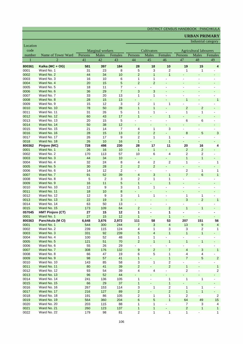
DISTRICT CENSUS HANDBOOK : PANCHKULA
URBAN PRIMARY
Persons Males Females Persons Males Females Persons Males Females1 2 41 42 43 44 45 46 47 48 49
800361 Kalka (MC + OG) 581 397 184 28 18 10 19 15 4 0001 Ward No. 1 31 23 8 5 3 2 1 1 - 0002 Ward No. 2 44 34 10 2 1 1 - - - 0003 Ward No. 3 16 10 6 1 1 - - - - 0004 Ward No. 4 20 15 5 2 2 - - - - 0005 Ward No. 5 18 11 7 - - - - - - 0006 Ward No. 6 36 29 7 3 3 - - - - 0007 Ward No. 7 33 20 13 1 1 - - - - 0008 Ward No. 8 28 15 13 - - - 1 - 1 0009 Ward No. 9 15 12 3 2 1 1 - - - 0010 Ward No. 10 78 50 28 1 1 - 2 2 - 0011 Ward No. 11 31 26 5 1 1 - 1 1 - 0012 Ward No. 12 60 43 17 1 - 1 - - - 0013 Ward No. 13 20 15 5 - - - 6 6 - 0014 Ward No. 14 50 38 12 - - - - - - 0015 Ward No. 15 21 14 7 4 1 3 - - - 0016 Ward No. 16 28 15 13 2 2 - 8 5 3 0017 Ward No. 17 26 17 9 2 1 1 - - - 0018 Ward No. 18 26 10 16 1 - 1 - - - 800362 Pinjore (MC) 728 498 230 28 17 11 20 16 4 0001 Ward No. 1 26 16 10 1 1 - 2 2 - 0002 Ward No. 2 170 113 57 10 6 4 2 2 - 0003 Ward No. 3 44 34 10 - - - 1 1 - 0004 Ward No. 4 32 24 8 4 2 2 1 - 1 0005 Ward No. 5 30 28 2 2 2 - - - - 0006 Ward No. 6 14 12 2 - - - 2 1 1 0007 Ward No. 7 91 52 39 4 3 1 7 6 1 0008 Ward No. 8 5 2 3 2 1 1 - - - 0009 Ward No. 9 16 11 5 1 - 1 - - - 0010 Ward No. 10 12 9 3 1 1 - - - - 0011 Ward No. 11 18 10 8 - - - - - - 0012 Ward No. 12 12 9 3 1 1 - 1 1 - 0013 Ward No. 13 22 19 3 - - - 3 2 1 0014 Ward No. 14 63 50 13 - - - - - - 0015 Ward No. 15 173 109 64 2 - 2 1 1 - 057045 HMT Pinjore (CT) 27 15 12 1 - 1 - - - 0001 Ward No. 1 27 15 12 1 - 1 - - - 800363 Panchkula (M Cl) 6,648 3,676 2,972 111 58 53 207 151 56 0001 Ward No. 1 544 300 244 7 3 4 13 9 4 0002 Ward No. 2 239 115 124 4 1 3 3 2 1 0003 Ward No. 3 331 92 239 5 4 1 1 1 - 0004 Ward No. 4 100 52 48 1 1 - - - - 0005 Ward No. 5 121 51 70 2 1 1 1 1 - 0006 Ward No. 6 55 26 29 - - - - - - 0007 Ward No. 7 308 176 132 9 2 7 4 3 1 0008 Ward No. 8 66 47 19 6 5 1 4 4 - 0009 Ward No. 9 98 57 41 1 - 1 7 5 2 0010 Ward No. 10 143 85 58 3 1 2 - - - 0011 Ward No. 11 80 41 39 2 - 2 1 - 1 0012 Ward No. 12 93 54 39 4 4 - 2 - 2 0013 Ward No. 13 96 52 44 - - - - - - 0014 Ward No. 14 241 136 105 1 - 1 1 1 - 0015 Ward No. 15 66 29 37 1 - 1 - - - 0016 Ward No. 16 267 153 114 3 1 2 1 1 - 0017 Ward No. 17 216 127 89 2 - 2 1 1 - 0018 Ward No. 18 191 86 105 2 1 1 2 - 2 0019 Ward No. 19 564 360 204 6 5 1 64 49 15 0020 Ward No. 20 203 115 88 1 1 - 7 3 4 0021 Ward No. 21 260 123 137 1 1 - 2 1 1 0022 Ward No. 22 179 98 81 2 1 1 1 - 1
Name of Town/ WardMarginal workers Cultivators Agricultural labourers
Industrial categoryLocation
code number
106
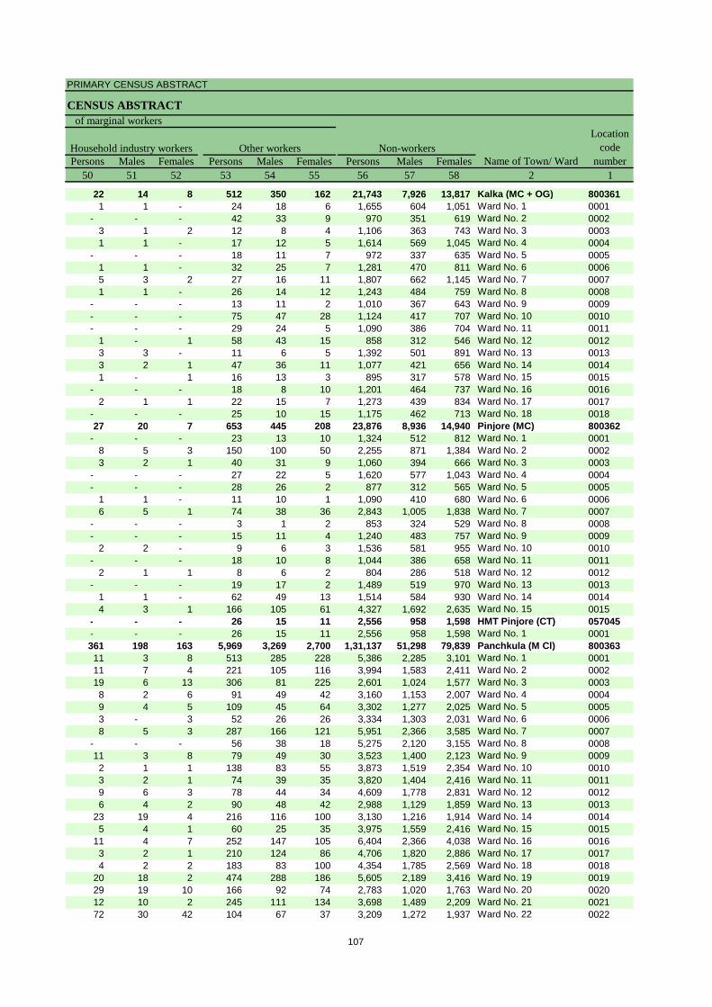
PRIMARY CENSUS ABSTRACT
CENSUS ABSTRACT
Persons Males Females Persons Males Females Persons Males Females50 51 52 53 54 55 56 57 58 2 1
22 14 8 512 350 162 21,743 7,926 13,817 Kalka (MC + OG) 8003611 1 - 24 18 6 1,655 604 1,051 Ward No. 1 0001
- - - 42 33 9 970 351 619 Ward No. 2 00023 1 2 12 8 4 1,106 363 743 Ward No. 3 00031 1 - 17 12 5 1,614 569 1,045 Ward No. 4 0004
- - - 18 11 7 972 337 635 Ward No. 5 00051 1 - 32 25 7 1,281 470 811 Ward No. 6 00065 3 2 27 16 11 1,807 662 1,145 Ward No. 7 00071 1 - 26 14 12 1,243 484 759 Ward No. 8 0008
- - - 13 11 2 1,010 367 643 Ward No. 9 0009- - - 75 47 28 1,124 417 707 Ward No. 10 0010- - - 29 24 5 1,090 386 704 Ward No. 11 0011
1 - 1 58 43 15 858 312 546 Ward No. 12 00123 3 - 11 6 5 1,392 501 891 Ward No. 13 00133 2 1 47 36 11 1,077 421 656 Ward No. 14 00141 - 1 16 13 3 895 317 578 Ward No. 15 0015
- - - 18 8 10 1,201 464 737 Ward No. 16 00162 1 1 22 15 7 1,273 439 834 Ward No. 17 0017
- - - 25 10 15 1,175 462 713 Ward No. 18 001827 20 7 653 445 208 23,876 8,936 14,940 Pinjore (MC) 800362
- - - 23 13 10 1,324 512 812 Ward No. 1 00018 5 3 150 100 50 2,255 871 1,384 Ward No. 2 00023 2 1 40 31 9 1,060 394 666 Ward No. 3 0003
- - - 27 22 5 1,620 577 1,043 Ward No. 4 0004- - - 28 26 2 877 312 565 Ward No. 5 0005
1 1 - 11 10 1 1,090 410 680 Ward No. 6 00066 5 1 74 38 36 2,843 1,005 1,838 Ward No. 7 0007
- - - 3 1 2 853 324 529 Ward No. 8 0008- - - 15 11 4 1,240 483 757 Ward No. 9 0009
2 2 - 9 6 3 1,536 581 955 Ward No. 10 0010- - - 18 10 8 1,044 386 658 Ward No. 11 0011
2 1 1 8 6 2 804 286 518 Ward No. 12 0012- - - 19 17 2 1,489 519 970 Ward No. 13 0013
1 1 - 62 49 13 1,514 584 930 Ward No. 14 00144 3 1 166 105 61 4,327 1,692 2,635 Ward No. 15 0015
- - - 26 15 11 2,556 958 1,598 HMT Pinjore (CT) 057045- - - 26 15 11 2,556 958 1,598 Ward No. 1 0001361 198 163 5,969 3,269 2,700 1,31,137 51,298 79,839 Panchkula (M Cl) 80036311 3 8 513 285 228 5,386 2,285 3,101 Ward No. 1 000111 7 4 221 105 116 3,994 1,583 2,411 Ward No. 2 000219 6 13 306 81 225 2,601 1,024 1,577 Ward No. 3 00038 2 6 91 49 42 3,160 1,153 2,007 Ward No. 4 00049 4 5 109 45 64 3,302 1,277 2,025 Ward No. 5 00053 - 3 52 26 26 3,334 1,303 2,031 Ward No. 6 00068 5 3 287 166 121 5,951 2,366 3,585 Ward No. 7 0007
- - - 56 38 18 5,275 2,120 3,155 Ward No. 8 000811 3 8 79 49 30 3,523 1,400 2,123 Ward No. 9 00092 1 1 138 83 55 3,873 1,519 2,354 Ward No. 10 00103 2 1 74 39 35 3,820 1,404 2,416 Ward No. 11 00119 6 3 78 44 34 4,609 1,778 2,831 Ward No. 12 00126 4 2 90 48 42 2,988 1,129 1,859 Ward No. 13 0013
23 19 4 216 116 100 3,130 1,216 1,914 Ward No. 14 00145 4 1 60 25 35 3,975 1,559 2,416 Ward No. 15 0015
11 4 7 252 147 105 6,404 2,366 4,038 Ward No. 16 00163 2 1 210 124 86 4,706 1,820 2,886 Ward No. 17 00174 2 2 183 83 100 4,354 1,785 2,569 Ward No. 18 0018
20 18 2 474 288 186 5,605 2,189 3,416 Ward No. 19 001929 19 10 166 92 74 2,783 1,020 1,763 Ward No. 20 002012 10 2 245 111 134 3,698 1,489 2,209 Ward No. 21 002172 30 42 104 67 37 3,209 1,272 1,937 Ward No. 22 0022
Location code
numberHousehold industry workers
Name of Town/ WardOther workers
of marginal workers
Non-workers
107

DISTRICT CENSUS HANDBOOK : PANCHKULA
URBAN PRIMARY
Persons Males Females Persons Males Females1 2 3 4 5 6 7 8 9 10
Name of Town/ Ward
Location code
number
Total population (including institutional and houseless
population)
Area in Square
Kilometre
Number of households
Population in the age-group 0-6
0023 Ward No. 23 1,147 4,931 2,647 2,284 546 295 251 0024 Ward No. 24 1,645 7,161 3,768 3,393 813 431 382 0025 Ward No. 25 1,066 4,404 2,278 2,126 363 198 165 0026 Ward No. 26 1,570 7,130 3,732 3,398 1,098 583 515 0027 Ward No. 27 1,462 6,710 3,720 2,990 981 496 485 0028 Ward No. 28 1,343 5,894 3,124 2,770 662 354 308 0029 Ward No. 29 1,297 5,711 2,996 2,715 567 327 240 0030 Ward No. 30 3,228 12,678 6,606 6,072 1,225 692 533 0031 Ward No. 31 2,621 11,237 5,977 5,260 1,280 705 575
057167Chandi Mandir (391) (CT) 3.00 1,861 9,051 5,417 3,634 1,166 649 517
0001 Ward No. 1 1,861 9,051 5,417 3,634 1,166 649 517
057168 Bir Ghaghar (392) (CT) 1.70 1,052 4,943 2,516 2,427 666 344 322 0001 Ward No. 1 1,052 4,943 2,516 2,427 666 344 322 057169 Ram Garh (232) (CT) 3.40 942 4,934 2,567 2,367 531 296 235 0001 Ward No. 1 942 4,934 2,567 2,367 531 296 235 057170 Raipur Rani (CT) 6.63 1,793 9,028 4,753 4,275 1,050 580 470 0001 Ward No. 1 1,793 9,028 4,753 4,275 1,050 580 470
108
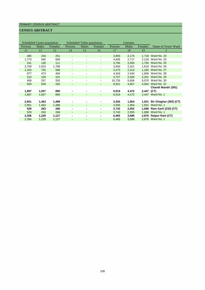
PRIMARY CENSUS ABSTRACT
CENSUS ABSTRACT
Persons Males Females Persons Males Females Persons Males Females11 12 13 14 15 16 17 18 19 2
Name of Town/ WardScheduled Castes population Scheduled Tribes population Literates
485 234 251 - - - 3,893 2,175 1,718 Ward No. 231,773 945 828 - - - 4,935 2,717 2,218 Ward No. 24
241 130 111 - - - 3,794 2,000 1,794 Ward No. 253,709 1,923 1,786 - - - 3,940 2,321 1,619 Ward No. 261,343 755 588 - - - 3,473 2,313 1,160 Ward No. 27
877 473 404 - - - 4,343 2,434 1,909 Ward No. 28210 109 101 - - - 4,707 2,506 2,201 Ward No. 29459 257 202 - - - 10,726 5,656 5,070 Ward No. 30929 509 420 - - - 8,921 4,857 4,064 Ward No. 31
1,897 1,007 890 - - - 6,919 4,472 2,447 Chandi Mandir (391) (CT)
1,897 1,007 890 - - - 6,919 4,472 2,447 Ward No. 1
2,951 1,463 1,488 - - - 3,355 1,854 1,501 Bir Ghaghar (392) (CT)2,951 1,463 1,488 - - - 3,355 1,854 1,501 Ward No. 1
529 263 266 - - - 3,743 2,055 1,688 Ram Garh (232) (CT)529 263 266 - - - 3,743 2,055 1,688 Ward No. 1
2,356 1,229 1,127 - - - 6,465 3,589 2,876 Raipur Rani (CT)2,356 1,229 1,127 - - - 6,465 3,589 2,876 Ward No. 1
109

DISTRICT CENSUS HANDBOOK : PANCHKULA
URBAN PRIMARY
Persons Males Females Persons Males Females Persons Males Females1 2 20 21 22 23 24 25 26 27 28
Name of Town/ Ward
Location code
numberIlliterates Total workers Main workers
0023 Ward No. 23 1,038 472 566 1,923 1,406 517 1,546 1,203 343 0024 Ward No. 24 2,226 1,051 1,175 2,575 2,024 551 2,319 1,882 437 0025 Ward No. 25 610 278 332 1,638 1,188 450 1,508 1,110 398 0026 Ward No. 26 3,190 1,411 1,779 2,479 1,982 497 2,097 1,716 381 0027 Ward No. 27 3,237 1,407 1,830 2,348 1,982 366 2,185 1,882 303 0028 Ward No. 28 1,551 690 861 2,446 1,755 691 2,141 1,569 572 0029 Ward No. 29 1,004 490 514 2,127 1,582 545 2,028 1,529 499 0030 Ward No. 30 1,952 950 1,002 4,567 3,436 1,131 4,395 3,340 1,055 0031 Ward No. 31 2,316 1,120 1,196 4,296 3,252 1,044 3,993 3,075 918
057167Chandi Mandir (391) (CT) 2,132 945 1,187 4,086 3,601 485 3,837 3,468 369
0001 Ward No. 1 2,132 945 1,187 4,086 3,601 485 3,837 3,468 369
057168 Bir Ghaghar (392) (CT) 1,588 662 926 1,786 1,373 413 1,656 1,299 357 0001 Ward No. 1 1,588 662 926 1,786 1,373 413 1,656 1,299 357 057169 Ram Garh (232) (CT) 1,191 512 679 1,810 1,388 422 1,626 1,287 339 0001 Ward No. 1 1,191 512 679 1,810 1,388 422 1,626 1,287 339 057170 Raipur Rani (CT) 2,563 1,164 1,399 3,108 2,391 717 2,488 2,070 418 0001 Ward No. 1 2,563 1,164 1,399 3,108 2,391 717 2,488 2,070 418
110
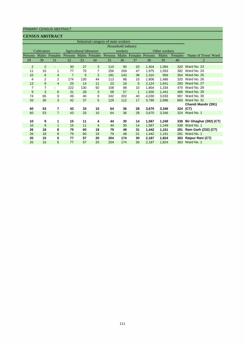
PRIMARY CENSUS ABSTRACT
CENSUS ABSTRACT
Persons Males Females Persons Males Females Persons Males Females Persons Males Females29 30 31 32 33 34 35 36 37 38 39 40 2
CultivatorsName of Town/ Ward
Household industry workersAgricultural labourers
Industrial category of main workers
Other workers
2 2 - 30 27 3 110 90 20 1,404 1,084 320 Ward No. 2311 10 1 77 70 7 256 209 47 1,975 1,593 382 Ward No. 2410 6 4 7 5 2 181 143 38 1,310 956 354 Ward No. 254 2 2 174 130 44 113 98 15 1,806 1,486 320 Ward No. 26
13 9 4 25 14 11 23 18 5 2,124 1,841 283 Ward No. 277 7 - 222 130 92 108 98 10 1,804 1,334 470 Ward No. 289 3 6 31 28 3 58 57 1 1,930 1,441 489 Ward No. 29
74 65 9 49 40 9 242 202 40 4,030 3,033 997 Ward No. 3033 30 3 42 37 5 129 112 17 3,789 2,896 893 Ward No. 31
60 53 7 43 33 10 64 36 28 3,670 3,346 324 Chandi Mandir (391) (CT)
60 53 7 43 33 10 64 36 28 3,670 3,346 324 Ward No. 1
10 9 1 15 11 4 44 30 14 1,587 1,249 338 Bir Ghaghar (392) (CT)10 9 1 15 11 4 44 30 14 1,587 1,249 338 Ward No. 126 18 8 79 60 19 79 48 31 1,442 1,161 281 Ram Garh (232) (CT)26 18 8 79 60 19 79 48 31 1,442 1,161 281 Ward No. 120 15 5 77 57 20 204 174 30 2,187 1,824 363 Raipur Rani (CT)20 15 5 77 57 20 204 174 30 2,187 1,824 363 Ward No. 1
111
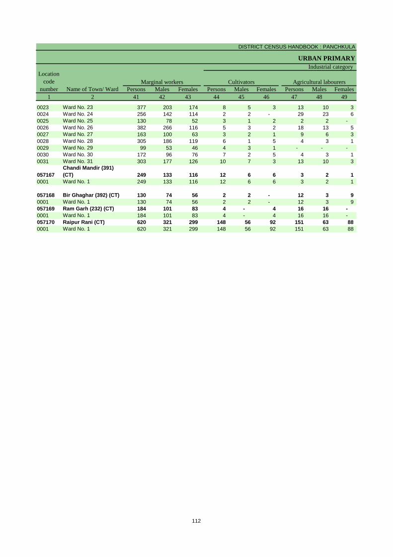
DISTRICT CENSUS HANDBOOK : PANCHKULA
URBAN PRIMARY
Persons Males Females Persons Males Females Persons Males Females1 2 41 42 43 44 45 46 47 48 49
Name of Town/ WardMarginal workers Cultivators Agricultural labourers
Industrial categoryLocation
code number
0023 Ward No. 23 377 203 174 8 5 3 13 10 3 0024 Ward No. 24 256 142 114 2 2 - 29 23 6 0025 Ward No. 25 130 78 52 3 1 2 2 2 - 0026 Ward No. 26 382 266 116 5 3 2 18 13 5 0027 Ward No. 27 163 100 63 3 2 1 9 6 3 0028 Ward No. 28 305 186 119 6 1 5 4 3 1 0029 Ward No. 29 99 53 46 4 3 1 - - - 0030 Ward No. 30 172 96 76 7 2 5 4 3 1 0031 Ward No. 31 303 177 126 10 7 3 13 10 3
057167Chandi Mandir (391) (CT) 249 133 116 12 6 6 3 2 1
0001 Ward No. 1 249 133 116 12 6 6 3 2 1
057168 Bir Ghaghar (392) (CT) 130 74 56 2 2 - 12 3 9 0001 Ward No. 1 130 74 56 2 2 - 12 3 9 057169 Ram Garh (232) (CT) 184 101 83 4 - 4 16 16 - 0001 Ward No. 1 184 101 83 4 - 4 16 16 - 057170 Raipur Rani (CT) 620 321 299 148 56 92 151 63 88 0001 Ward No. 1 620 321 299 148 56 92 151 63 88
112

PRIMARY CENSUS ABSTRACT
CENSUS ABSTRACT
Persons Males Females Persons Males Females Persons Males Females50 51 52 53 54 55 56 57 58 2 1
Location code
numberHousehold industry workers
Name of Town/ WardOther workers
of marginal workers
Non-workers
29 18 11 327 170 157 3,008 1,241 1,767 Ward No. 23 002317 6 11 208 111 97 4,586 1,744 2,842 Ward No. 24 00246 5 1 119 70 49 2,766 1,090 1,676 Ward No. 25 0025
10 7 3 349 243 106 4,651 1,750 2,901 Ward No. 26 00263 - 3 148 92 56 4,362 1,738 2,624 Ward No. 27 00272 2 - 293 180 113 3,448 1,369 2,079 Ward No. 28 00281 - 1 94 50 44 3,584 1,414 2,170 Ward No. 29 00294 3 1 157 88 69 8,111 3,170 4,941 Ward No. 30 0030
10 6 4 270 154 116 6,941 2,725 4,216 Ward No. 31 0031
26 5 21 208 120 88 4,965 1,816 3,149 Chandi Mandir (391) (CT) 057167
26 5 21 208 120 88 4,965 1,816 3,149 Ward No. 1 0001
11 - 11 105 69 36 3,157 1,143 2,014 Bir Ghaghar (392) (CT) 05716811 - 11 105 69 36 3,157 1,143 2,014 Ward No. 1 000118 8 10 146 77 69 3,124 1,179 1,945 Ram Garh (232) (CT) 05716918 8 10 146 77 69 3,124 1,179 1,945 Ward No. 1 000159 25 34 262 177 85 5,920 2,362 3,558 Raipur Rani (CT) 05717059 25 34 262 177 85 5,920 2,362 3,558 Ward No. 1 0001
113


Section – II
Tables based on Households Amenities and Assets
(Rural /Urban) at District and Sub-District level


Total Rural Urban Total Rural Urban Total Rural Urban1 2 3 4 5 6 7 8 9 10 11 12
Owned No exclusive room 695 335 360 216 124 92 - - -One room 12,447 5,514 6,933 5,672 2,138 3,534 - - -Two rooms 18,453 11,141 7,312 5,453 3,216 2,237 - - -Three rooms 18,445 8,921 9,524 2,809 1,759 1,050 - - -3+ rooms 28,682 11,696 16,986 2,661 1,574 1,087 - - -
Rented No exclusive room 321 84 237 69 17 52 - - -One room 8,954 1,577 7,377 1,955 431 1,524 - - -Two rooms 7,422 700 6,722 1,024 150 874 - - -Three rooms 4,577 379 4,198 382 52 330 - - -3+ rooms 2,841 85 2,756 104 11 93 - - -
Others No exclusive room 434 212 222 134 62 72 - - -One room 4,428 1,522 2,906 1,420 431 989 - - -Two rooms 1,556 332 1,224 461 130 331 - - -Three rooms 684 94 590 151 33 118 - - -3+ rooms 297 59 238 35 11 24 - - -
Total No exclusive room 1,450 631 819 419 203 216 - - -One room 25,829 8,613 17,216 9,047 3,000 6,047 - - -Two rooms 27,431 12,173 15,258 6,938 3,496 3,442 - - -Three rooms 23,706 9,394 14,312 3,342 1,844 1,498 - - -3+ rooms 31,820 11,840 19,980 2,800 1,596 1,204 - - -
Data Source:-Census of India, 2011, HH- series Tables on Houses, Household amenities and assets
District - Panchkula
(06069)
Table -1: Households by Ownership Status and by Number of Dwelling rooms occupied in the District, 2011
Name of district
Number of householdsTotal Scheduled Castes Scheduled Tribes
Ownership status
Number of dwelling rooms
117
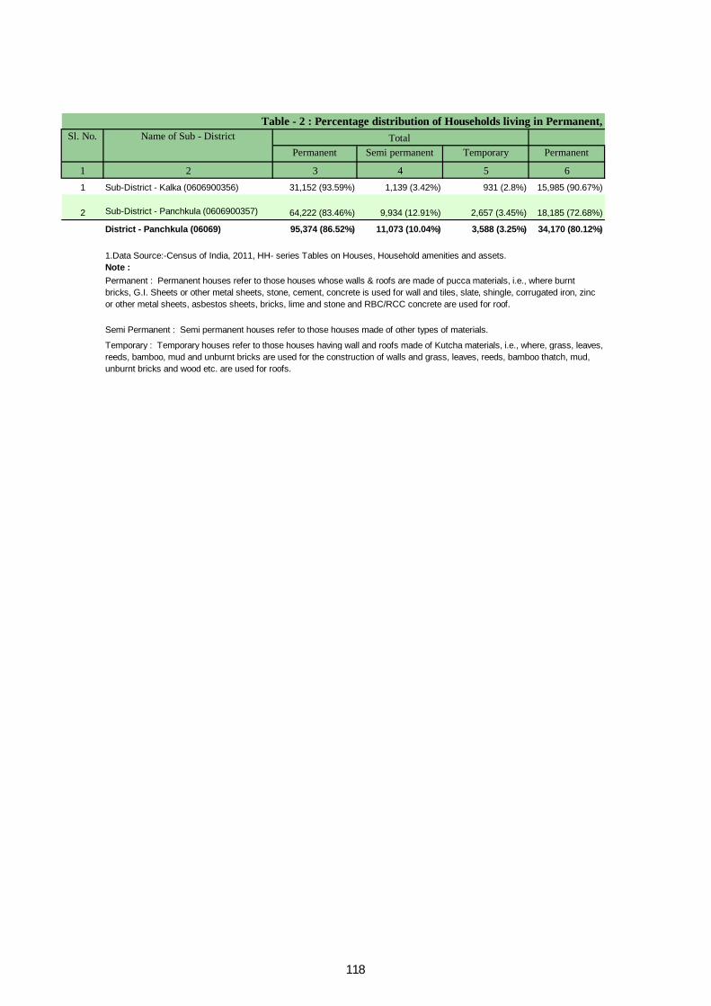
Permanent Semi permanent Temporary Permanent
1 2 3 4 5 61 Sub-District - Kalka (0606900356) 31,152 (93.59%) 1,139 (3.42%) 931 (2.8%) 15,985 (90.67%)
2 Sub-District - Panchkula (0606900357) 64,222 (83.46%) 9,934 (12.91%) 2,657 (3.45%) 18,185 (72.68%)
District - Panchkula (06069) 95,374 (86.52%) 11,073 (10.04%) 3,588 (3.25%) 34,170 (80.12%)
Note :
Sl. No. Name of Sub - District Total
1.Data Source:-Census of India, 2011, HH- series Tables on Houses, Household amenities and assets.
Permanent : Permanent houses refer to those houses whose walls & roofs are made of pucca materials, i.e., where burnt bricks, G.I. Sheets or other metal sheets, stone, cement, concrete is used for wall and tiles, slate, shingle, corrugated iron, zinc or other metal sheets, asbestos sheets, bricks, lime and stone and RBC/RCC concrete are used for roof.
Semi Permanent : Semi permanent houses refer to those houses made of other types of materials.
Temporary : Temporary houses refer to those houses having wall and roofs made of Kutcha materials, i.e., where, grass, leaves, reeds, bamboo, mud and unburnt bricks are used for the construction of walls and grass, leaves, reeds, bamboo thatch, mud, unburnt bricks and wood etc. are used for roofs.
Table - 2 : Percentage distribution of Households living in Permanent,
118

Semi permanent Temporary Permanent Semi permanent Temporary
7 8 9 10 11 2876 (4.97%) 733 (4.16%) 15,167 (96.87%) 263 (1.68%) 198 (1.26%) Sub-District - Kalka (0606900356)
6,087 (24.33%) 710 (2.84%) 46,037 (88.66%) 3,847 (7.41%) 1,947 (3.75%) Sub-District - Panchkula (0606900357)
6,963 (16.33%) 1,443 (3.38%) 61,204 (90.56%) 4,110 (6.08%) 2,145 (3.17%) District - Panchkula (06069)
Semi permanent and Temporary Houses , 2011Urban Name of Sub-DistrictRural
119

Tap water from treated source
Tap water from untreated source
Covered well Un-covered well
1 2 3 4 5 6 7 81 Total 33,286 26,912 (80.85%) 1,215 (3.65%) 2,430 (7.3%) 184 (0.55%)
Rural 17,629 14,510 (82.31%) 1,047 (5.94%) 109 (0.62%) 111 (0.63%)Urban 15,657 12,402 (79.21%) 168 (1.07%) 2,321 (14.82%) 73 (0.47%)
2 Total 76,950 65,799 (85.51%) 5,794 (7.53%) 191 (0.25%) 374 (0.49%)Rural 25,022 19,766 (78.99%) 1,991 (7.96%) 43 (0.17%) 180 (0.72%)Urban 51,928 46,033 (88.65%) 3,803 (7.32%) 148 (0.29%) 194 (0.37%)Total 110,236 92,711 (84.1%) 7,009 (6.36%) 2,621 (2.38%) 558 (0.51%)Rural 42,651 34,276 (80.36%) 3,038 (7.12%) 152 (0.36%) 291 (0.68%)Urban 67,585 58,435 (86.46%) 3,971 (5.88%) 2,469 (3.65%) 267 (0.4%)
Data Source:-Census of India, 2011, HH- series Tables on Houses, Household amenities and assets.
Table -3 : Number and Percentage of Households Sl. No.
Name of Sub-District Total/ Rural/ Urban
Total Number of households
Number and percentage of Household
Note: Percentage is given in brackets after the number of households.
Sub-District - Kalka (0606900356)
Sub-District - Panchkula (0606900357)
District - Panchkula (06069)
120

Handpump Tubewell/borehole
Spring River/ canal Tank/ pond/ lake
Other Sources
9 10 11 12 13 14 3 2223 (0.67%) 1,215 (3.65%) 153 (0.46%) 95 (0.29%) 412 (1.24%) 447 (1.34%) Total130 (0.74%) 1,168 (6.63%) 95 (0.54%) 93 (0.53%) 256 (1.45%) 110 (0.62%) Rural93 (0.59%) 47 (0.3%) 58 (0.37%) 2 (0.01%) 156 (1%) 337 (2.15%) Urban
1,666 (2.17%) 2,114 (2.75%) 324 (0.42%) 223 (0.29%) 32 (0.04%) 433 (0.56%) Total901 (3.6%) 1,240 (4.96%) 315 (1.26%) 221 (0.88%) 13 (0.05%) 352 (1.41%) Rural
765 (1.47%) 874 (1.68%) 9 (0.02%) 2 (0%) 19 (0.04%) 81 (0.16%) Urban1,889 (1.71%) 3,329 (3.02%) 477 (0.43%) 318 (0.29%) 444 (0.4%) 880 (0.8%) Total1,031 (2.42%) 2,408 (5.65%) 410 (0.96%) 314 (0.74%) 269 (0.63%) 462 (1.08%) Rural
858 (1.27%) 921 (1.36%) 67 (0.1%) 4 (0.01%) 175 (0.26%) 418 (0.62%) Urban
by main source of Drinking water, 2011.Name of Sub-Districthaving following source of drinking water Total/
Rural/ Urban
Sub-District - Kalka (0606900356)
Sub-District - Panchkula (0606900357)
District - Panchkula (06069)
121
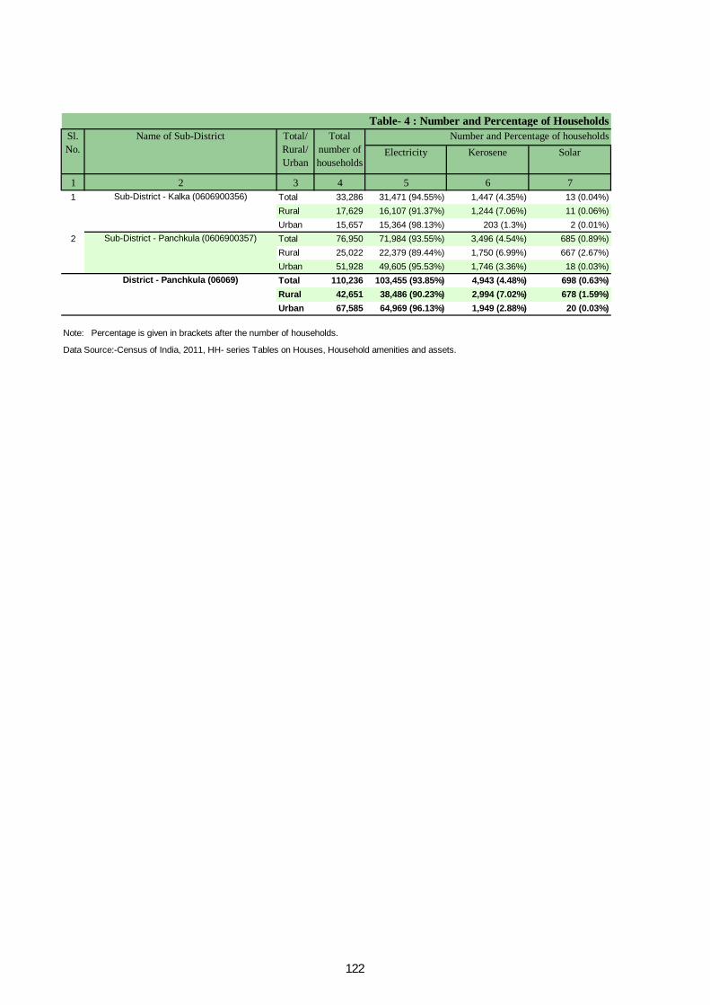
Electricity Kerosene Solar
1 2 3 4 5 6 71 Total 33,286 31,471 (94.55%) 1,447 (4.35%) 13 (0.04%)
Rural 17,629 16,107 (91.37%) 1,244 (7.06%) 11 (0.06%)Urban 15,657 15,364 (98.13%) 203 (1.3%) 2 (0.01%)
2 Total 76,950 71,984 (93.55%) 3,496 (4.54%) 685 (0.89%)Rural 25,022 22,379 (89.44%) 1,750 (6.99%) 667 (2.67%)Urban 51,928 49,605 (95.53%) 1,746 (3.36%) 18 (0.03%)Total 110,236 103,455 (93.85%) 4,943 (4.48%) 698 (0.63%)Rural 42,651 38,486 (90.23%) 2,994 (7.02%) 678 (1.59%)Urban 67,585 64,969 (96.13%) 1,949 (2.88%) 20 (0.03%)
Data Source:-Census of India, 2011, HH- series Tables on Houses, Household amenities and assets.
Note: Percentage is given in brackets after the number of households.
Sub-District - Kalka (0606900356)
Sub-District - Panchkula (0606900357)
District - Panchkula (06069)
Table- 4 : Number and Percentage of Households Sl. No.
Name of Sub-District Total/ Rural/ Urban
Total number of households
Number and Percentage of households
122

Other oil Any other No lighting
8 9 10 3 259 (0.18%) 153 (0.46%) 143 (0.43%) Total53 (0.3%) 103 (0.58%) 111 (0.63%) Rural6 (0.04%) 50 (0.32%) 32 (0.2%) Urban
168 (0.22%) 265 (0.34%) 352 (0.46%) Total53 (0.21%) 52 (0.21%) 121 (0.48%) Rural
115 (0.22%) 213 (0.41%) 231 (0.44%) Urban227 (0.21%) 418 (0.38%) 495 (0.45%) Total106 (0.25%) 155 (0.36%) 232 (0.54%) Rural121 (0.18%) 263 (0.39%) 263 (0.39%) Urban
Sub-District - Kalka (0606900356)
Sub-District - Panchkula (0606900357)
District - Panchkula (06069)
Name of Sub-Districtby main source of Lighting, 2011. having following main source of lighting Total/
Rural/ Urban
123
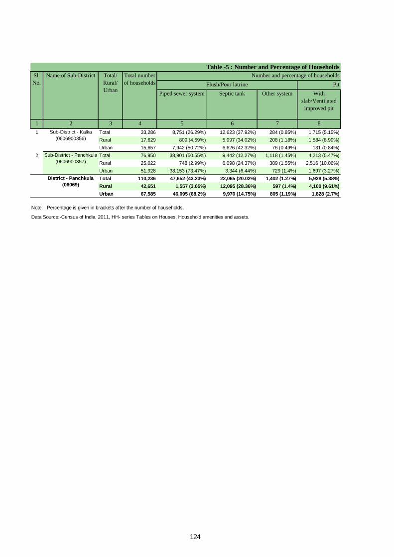
Pit Piped sewer system Septic tank Other system With
slab/Ventilated improved pit
1 2 3 4 5 6 7 81 Total 33,286 8,751 (26.29%) 12,623 (37.92%) 284 (0.85%) 1,715 (5.15%)
Rural 17,629 809 (4.59%) 5,997 (34.02%) 208 (1.18%) 1,584 (8.99%)Urban 15,657 7,942 (50.72%) 6,626 (42.32%) 76 (0.49%) 131 (0.84%)
2 Total 76,950 38,901 (50.55%) 9,442 (12.27%) 1,118 (1.45%) 4,213 (5.47%)Rural 25,022 748 (2.99%) 6,098 (24.37%) 389 (1.55%) 2,516 (10.06%)Urban 51,928 38,153 (73.47%) 3,344 (6.44%) 729 (1.4%) 1,697 (3.27%)Total 110,236 47,652 (43.23%) 22,065 (20.02%) 1,402 (1.27%) 5,928 (5.38%)Rural 42,651 1,557 (3.65%) 12,095 (28.36%) 597 (1.4%) 4,100 (9.61%)Urban 67,585 46,095 (68.2%) 9,970 (14.75%) 805 (1.19%) 1,828 (2.7%)
Data Source:-Census of India, 2011, HH- series Tables on Houses, Household amenities and assets.
Table -5 : Number and Percentage of Households Sl. No.
Name of Sub-District Total/ Rural/ Urban
Total number of households Flush/Pour latrine
Number and percentage of households
Note: Percentage is given in brackets after the number of households.
Sub-District - Kalka (0606900356)
Sub-District - Panchkula (0606900357)
District - Panchkula (06069)
124
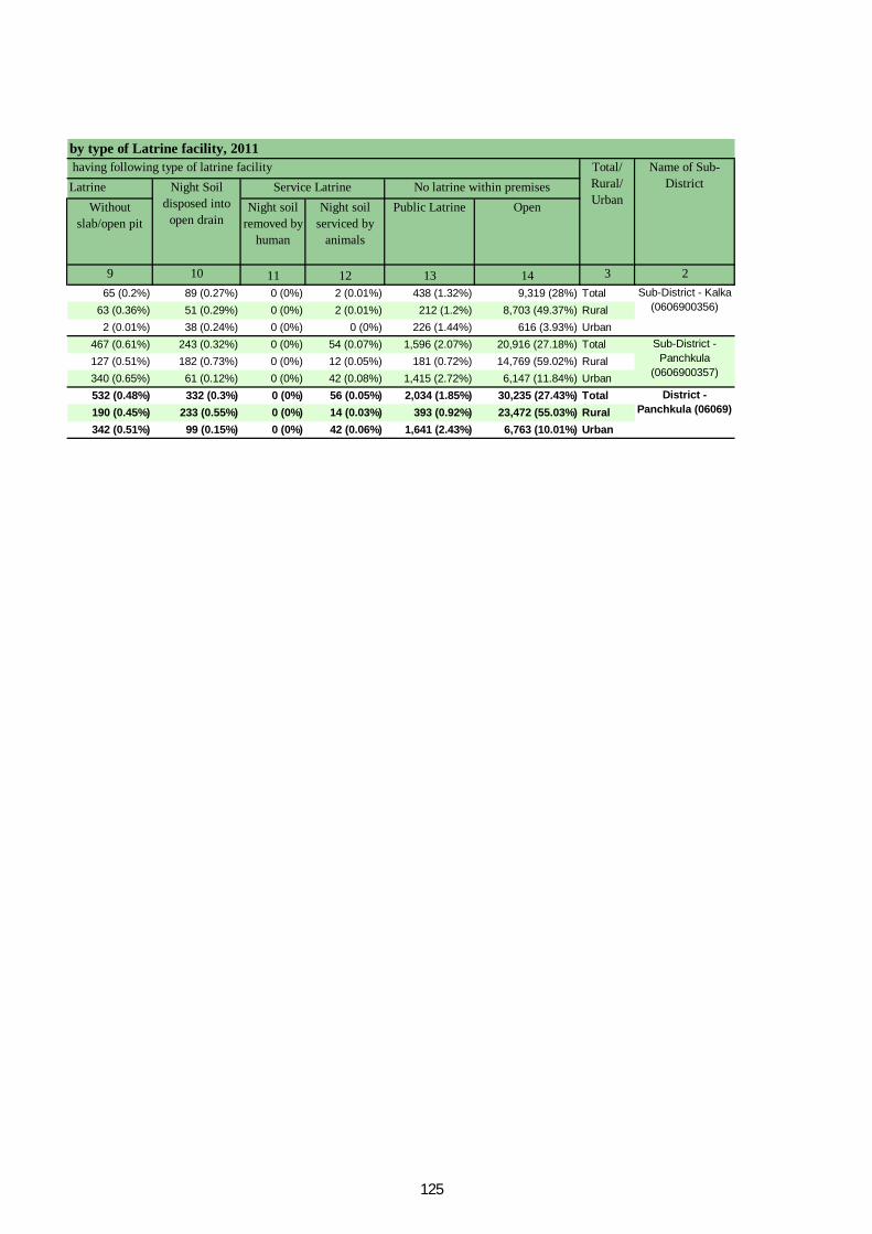
LatrineWithout
slab/open pitNight soil
removed by human
Night soil serviced by
animals
Public Latrine Open
9 10 11 12 13 14 3 265 (0.2%) 89 (0.27%) 0 (0%) 2 (0.01%) 438 (1.32%) 9,319 (28%) Total
63 (0.36%) 51 (0.29%) 0 (0%) 2 (0.01%) 212 (1.2%) 8,703 (49.37%) Rural2 (0.01%) 38 (0.24%) 0 (0%) 0 (0%) 226 (1.44%) 616 (3.93%) Urban
467 (0.61%) 243 (0.32%) 0 (0%) 54 (0.07%) 1,596 (2.07%) 20,916 (27.18%) Total127 (0.51%) 182 (0.73%) 0 (0%) 12 (0.05%) 181 (0.72%) 14,769 (59.02%) Rural340 (0.65%) 61 (0.12%) 0 (0%) 42 (0.08%) 1,415 (2.72%) 6,147 (11.84%) Urban532 (0.48%) 332 (0.3%) 0 (0%) 56 (0.05%) 2,034 (1.85%) 30,235 (27.43%) Total190 (0.45%) 233 (0.55%) 0 (0%) 14 (0.03%) 393 (0.92%) 23,472 (55.03%) Rural342 (0.51%) 99 (0.15%) 0 (0%) 42 (0.06%) 1,641 (2.43%) 6,763 (10.01%) Urban
by type of Latrine facility, 2011Name of Sub-
DistrictNo latrine within premisesNight Soil disposed into
open drain
Service Latrine having following type of latrine facility Total/
Rural/ Urban
Sub-District - Kalka (0606900356)
Sub-District - Panchkula
(0606900357)
District - Panchkula (06069)
125
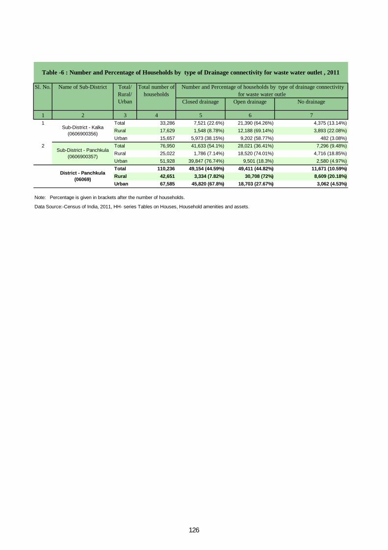
Closed drainage Open drainage No drainage
1 2 3 4 5 6 71 Total 33,286 7,521 (22.6%) 21,390 (64.26%) 4,375 (13.14%)
Rural 17,629 1,548 (8.78%) 12,188 (69.14%) 3,893 (22.08%)Urban 15,657 5,973 (38.15%) 9,202 (58.77%) 482 (3.08%)
2 Total 76,950 41,633 (54.1%) 28,021 (36.41%) 7,296 (9.48%)Rural 25,022 1,786 (7.14%) 18,520 (74.01%) 4,716 (18.85%)Urban 51,928 39,847 (76.74%) 9,501 (18.3%) 2,580 (4.97%)Total 110,236 49,154 (44.59%) 49,411 (44.82%) 11,671 (10.59%)Rural 42,651 3,334 (7.82%) 30,708 (72%) 8,609 (20.18%)Urban 67,585 45,820 (67.8%) 18,703 (27.67%) 3,062 (4.53%)
Data Source:-Census of India, 2011, HH- series Tables on Houses, Household amenities and assets.
Note: Percentage is given in brackets after the number of households.
Sub-District - Kalka (0606900356)
Sub-District - Panchkula (0606900357)
District - Panchkula (06069)
Table -6 : Number and Percentage of Households by type of Drainage connectivity for waste water outlet , 2011
Sl. No. Name of Sub-District Total/ Rural/ Urban
Total number of households
Number and Percentage of households by type of drainage connectivity for waste water outle
126

Has kitchen Does not have kitchen
Has kitchen Does not have kitchen
1 2 3 4 5 6 7 8 91 Total 33,286 27,077 (81.35%) 3,990 (11.99%) 837 (2.51%) 1,267 (3.81%) 115 (0.35%)
Rural 17,629 12,899 (73.17%) 2,817 (15.98%) 748 (4.24%) 1,096 (6.22%) 69 (0.39%)Urban 15,657 14,178 (90.55%) 1,173 (7.49%) 89 (0.57%) 171 (1.09%) 46 (0.29%)
2 Total 76,950 59,939 (77.89%) 12,313 (16%) 1,296 (1.68%) 3,070 (3.99%) 332 (0.43%)Rural 25,022 19,238 (76.88%) 3,469 (13.86%) 683 (2.73%) 1,567 (6.26%) 65 (0.26%)Urban 51,928 40,701 (78.38%) 8,844 (17.03%) 613 (1.18%) 1,503 (2.89%) 267 (0.51%)Total 110,236 87,016 (78.94%) 16,303 (14.79%) 2,133 (1.93%) 4,337 (3.93%) 447 (0.41%)Rural 42,651 32,137 (75.35%) 6,286 (14.74%) 1,431 (3.36%) 2,663 (6.24%) 134 (0.31%)Urban 67,585 54,879 (81.2%) 10,017 (14.82%) 702 (1.04%) 1,674 (2.48%) 313 (0.46%)
Data Source:-Census of India, 2011, HH- series Tables on Houses, Household amenities and assets.
Note: Percentage is given in brackets after the number of households.
Sub-District - Kalka
(0606900356)
Sub-District - Panchkula
(0606900357)
District - Panchkula
(06069)
Table -7 : Number and Percentage of Households by availablity of Kitchen facility, 2011Sl. No.
Name of Sub-District
Total/ Rural/ Urban
Total number of households
Number and Percentage of households having kitchenCooking inside house Cooking outside house No cooking
127
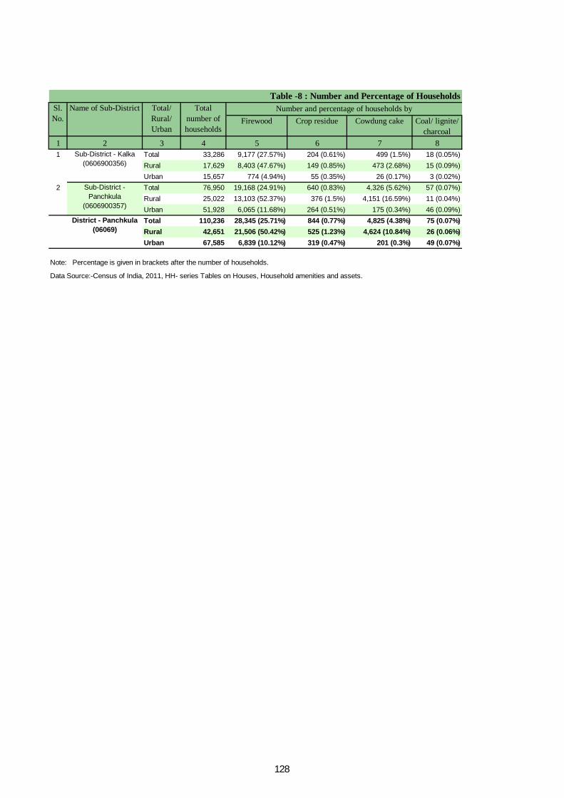
Firewood Crop residue Cowdung cake Coal/ lignite/ charcoal
1 2 3 4 5 6 7 81 Total 33,286 9,177 (27.57%) 204 (0.61%) 499 (1.5%) 18 (0.05%)
Rural 17,629 8,403 (47.67%) 149 (0.85%) 473 (2.68%) 15 (0.09%)Urban 15,657 774 (4.94%) 55 (0.35%) 26 (0.17%) 3 (0.02%)
2 Total 76,950 19,168 (24.91%) 640 (0.83%) 4,326 (5.62%) 57 (0.07%)Rural 25,022 13,103 (52.37%) 376 (1.5%) 4,151 (16.59%) 11 (0.04%)Urban 51,928 6,065 (11.68%) 264 (0.51%) 175 (0.34%) 46 (0.09%)Total 110,236 28,345 (25.71%) 844 (0.77%) 4,825 (4.38%) 75 (0.07%)Rural 42,651 21,506 (50.42%) 525 (1.23%) 4,624 (10.84%) 26 (0.06%)Urban 67,585 6,839 (10.12%) 319 (0.47%) 201 (0.3%) 49 (0.07%)
Data Source:-Census of India, 2011, HH- series Tables on Houses, Household amenities and assets.
Number and percentage of households bySl. No.
Name of Sub-District Total/ Rural/ Urban
Total number of households
Table -8 : Number and Percentage of Households
Note: Percentage is given in brackets after the number of households.
Sub-District - Kalka (0606900356)
Sub-District - Panchkula
(0606900357)
District - Panchkula (06069)
128
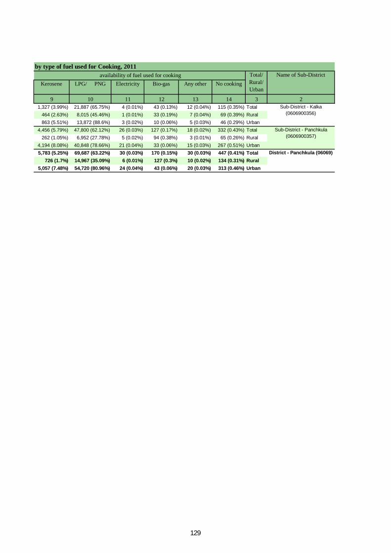
Kerosene LPG/ PNG Electricity Bio-gas Any other No cooking
9 10 11 12 13 14 3 21,327 (3.99%) 21,887 (65.75%) 4 (0.01%) 43 (0.13%) 12 (0.04%) 115 (0.35%) Total
464 (2.63%) 8,015 (45.46%) 1 (0.01%) 33 (0.19%) 7 (0.04%) 69 (0.39%) Rural863 (5.51%) 13,872 (88.6%) 3 (0.02%) 10 (0.06%) 5 (0.03%) 46 (0.29%) Urban
4,456 (5.79%) 47,800 (62.12%) 26 (0.03%) 127 (0.17%) 18 (0.02%) 332 (0.43%) Total262 (1.05%) 6,952 (27.78%) 5 (0.02%) 94 (0.38%) 3 (0.01%) 65 (0.26%) Rural
4,194 (8.08%) 40,848 (78.66%) 21 (0.04%) 33 (0.06%) 15 (0.03%) 267 (0.51%) Urban5,783 (5.25%) 69,687 (63.22%) 30 (0.03%) 170 (0.15%) 30 (0.03%) 447 (0.41%) Total
726 (1.7%) 14,967 (35.09%) 6 (0.01%) 127 (0.3%) 10 (0.02%) 134 (0.31%) Rural5,057 (7.48%) 54,720 (80.96%) 24 (0.04%) 43 (0.06%) 20 (0.03%) 313 (0.46%) Urban
by type of fuel used for Cooking, 2011 availability of fuel used for cooking Name of Sub-DistrictTotal/
Rural/ Urban
Sub-District - Kalka (0606900356)
Sub-District - Panchkula (0606900357)
District - Panchkula (06069)
129
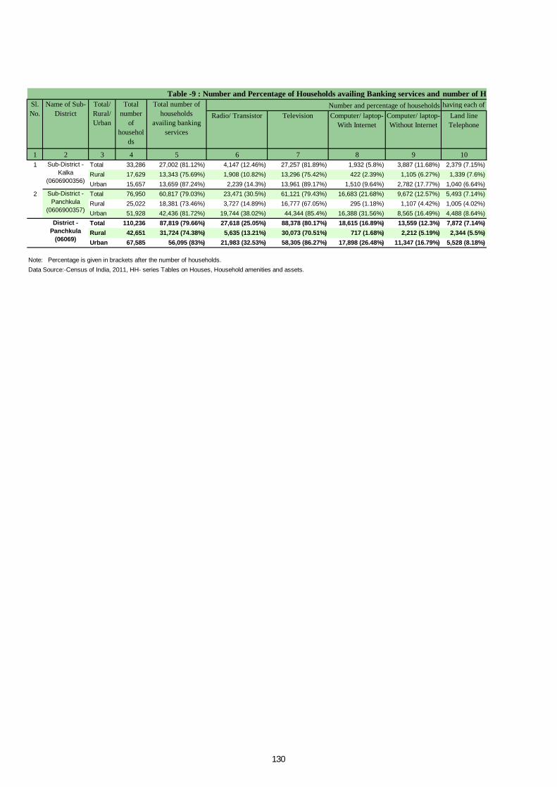
Radio/ Transistor Television Computer/ laptop- With Internet
Computer/ laptop- Without Internet
Land line Telephone
1 2 3 4 5 6 7 8 9 101 Total 33,286 27,002 (81.12%) 4,147 (12.46%) 27,257 (81.89%) 1,932 (5.8%) 3,887 (11.68%) 2,379 (7.15%)
Rural 17,629 13,343 (75.69%) 1,908 (10.82%) 13,296 (75.42%) 422 (2.39%) 1,105 (6.27%) 1,339 (7.6%)Urban 15,657 13,659 (87.24%) 2,239 (14.3%) 13,961 (89.17%) 1,510 (9.64%) 2,782 (17.77%) 1,040 (6.64%)
2 Total 76,950 60,817 (79.03%) 23,471 (30.5%) 61,121 (79.43%) 16,683 (21.68%) 9,672 (12.57%) 5,493 (7.14%)Rural 25,022 18,381 (73.46%) 3,727 (14.89%) 16,777 (67.05%) 295 (1.18%) 1,107 (4.42%) 1,005 (4.02%)Urban 51,928 42,436 (81.72%) 19,744 (38.02%) 44,344 (85.4%) 16,388 (31.56%) 8,565 (16.49%) 4,488 (8.64%)Total 110,236 87,819 (79.66%) 27,618 (25.05%) 88,378 (80.17%) 18,615 (16.89%) 13,559 (12.3%) 7,872 (7.14%)Rural 42,651 31,724 (74.38%) 5,635 (13.21%) 30,073 (70.51%) 717 (1.68%) 2,212 (5.19%) 2,344 (5.5%)Urban 67,585 56,095 (83%) 21,983 (32.53%) 58,305 (86.27%) 17,898 (26.48%) 11,347 (16.79%) 5,528 (8.18%)
Table -9 : Number and Percentage of Households availing Banking services and number of Households having each of the specified assets in, 2011 Total
number of
households
Total number of households
availing banking services
Number and percentage of households having each of the following specified assetsSl. No.
Name of Sub-District
Total/ Rural/ Urban
Data Source:-Census of India, 2011, HH- series Tables on Houses, Household amenities and assets.Note: Percentage is given in brackets after the number of households.
Sub-District - Kalka
(0606900356)
Sub-District - Panchkula
(0606900357)
District - Panchkula
(06069)
130

Mobile Telephone
Both Land line and
MobileTelephone
Bicycle Scooter/ Motor Cycle/ Moped
Car/ Jeep/ Van None of the specified asset
11 12 13 14 15 16 3 220,093 (60.36%) 4,954 (14.88%) 6,393 (19.21%) 13,641 (40.98%) 4,578 (13.75%) 2,436 (7.32%) Total10,377 (58.86%) 1,606 (9.11%) 3,875 (21.98%) 6,369 (36.13%) 1,709 (9.69%) 1,890 (10.72%) Rural9,716 (62.06%) 3,348 (21.38%) 2,518 (16.08%) 7,272 (46.45%) 2,869 (18.32%) 546 (3.49%) Urban
40,848 (53.08%) 18,719 (24.33%) 36,344 (47.23%) 36,331 (47.21%) 24,919 (32.38%) 3,908 (5.08%) Total16,454 (65.76%) 1,550 (6.19%) 9,825 (39.27%) 8,893 (35.54%) 1,537 (6.14%) 2,415 (9.65%) Rural24,394 (46.98%) 17,169 (33.06%) 26,519 (51.07%) 27,438 (52.84%) 23,382 (45.03%) 1,493 (2.88%) Urban60,941 (55.28%) 23,673 (21.47%) 42,737 (38.77%) 49,972 (45.33%) 29,497 (26.76%) 6,344 (5.75%) Total26,831 (62.91%) 3,156 (7.4%) 13,700 (32.12%) 15,262 (35.78%) 3,246 (7.61%) 4,305 (10.09%) Rural34,110 (50.47%) 20,517 (30.36%) 29,037 (42.96%) 34,710 (51.36%) 26,251 (38.84%) 2,039 (3.02%) Urban
Sub-District - Kalka
(0606900356)
Sub-District - Panchkula
(0606900357)
District - Panchkula
(06069)
number of Households having each of the specified assets in, 2011 having each of the following specified assets Name of Sub-
DistrictTotal/ Rural/ Urban
131

ORGI - HARYANA English – (10-2011)
Directorate of Census Operations, Haryana Ministry of Home Affairs,
Government of India, Janganana Bhawan, Plot No. 2-B, Sector-19 A,
Madhya Marg, Chandigarh-160019
Email: [email protected] Website: http://www.censusindia.gov.in


