HAZARD MITIGATION PLAN UPDATE ANNEX FOR THE CITY OF GROTON Southeastern Connecticut Council of Governments Multi-Jurisdictional Hazard Mitigation Plan Update , 2012 MMI #3570-05 Prepared for: CITY OF GROTON 295 Meridian Street Groton, Connecticut 06340 (860) 446-4169 www.cityofgroton.com Prepared by: MILONE & MACBROOM, INC. 99 Realty Drive Cheshire, Connecticut 06410 (203) 271-1773 www.miloneandmacbroom.com
Transcript
HAZARD MITIGATION PLAN UPDATE ANNEX FOR THE CITY OF GROTON
Southeastern Connecticut Council of Governments
Multi-Jurisdictional Hazard Mitigation Plan Update
November 05, 2012
MMI #3570-05
Prepared for:
CITY OF GROTON
295 Meridian Street Groton, Connecticut 06340
(860) 446-4169 www.cityofgroton.com
Prepared by:
MILONE & MACBROOM, INC. 99 Realty Drive
Cheshire, Connecticut 06410 (203) 271-1773
www.miloneandmacbroom.com
HAZARD MITIGATION PLAN UPDATE ANNEX CITY OF GROTON, CONNECTICUT JULY 2012 AK-1
ACKNOWLEDGEMENTS This HMP annex update could not have been completed without the time and dedication of the following individuals at the local level: Phillip Tuthill Civil Preparedness Director, Local Coordinator City Hall 295 Meridian Street City of Groton, Connecticut 06340 (860) 446-4191 Barbara Goodrich Director of Planning City Hall 295 Meridian Street City of Groton, Connecticut 06340 (860) 446-4169 [email protected] Carlton Smith Zoning and Building Official Timothy Umrysz Public Works (Highway) Department
HAZARD MITIGATION PLAN UPDATE ANNEX CITY OF GROTON, CONNECTICUT JULY 2012 TC-1
TABLE OF CONTENTS Section Page 1.0 INTRODUCTION 1.1 Purpose of Annex..........................................................................................................................1-1 1.2 Setting ...........................................................................................................................................1-1 1.3 Plan Development.........................................................................................................................1-1 1.4 Progress Monitoring .....................................................................................................................1-2 2.0 COMMUNITY PROFILE 2.1 Physical Setting.............................................................................................................................2-1 2.2 Land Use and Development Trends..............................................................................................2-1 2.3 Drainage Basins and Hydrology ...................................................................................................2-2 2.4 Governmental Structure ................................................................................................................2-2 2.5 Review of Existing Plans and Regulations ...................................................................................2-4 2.6 Critical Facilities, Sheltering Capacity, and Evacuation...............................................................2-8 2.7 Status of 2005 Plan Recommendations.......................................................................................2-10 3.0 INLAND FLOODING 3.1 Setting / Historic Record...............................................................................................................3-1 3.2 Existing Programs, Policies, and Mitigation Measures ................................................................3-1 3.3 Vulnerabilities and Risk Assessment............................................................................................3-1
3.3.1 Vulnerability Analysis of Areas Along Watercourses.............................................................3-2 3.3.2 Vulnerability Analysis of Private Properties..........................................................................3-2 3.3.3 Vulnerability Analysis of Critical Facilities...........................................................................3-3
3.4 Potential Mitigation Measures, Strategies, and Alternatives ........................................................3-3
4.3.1 Vulnerability Analysis of Areas Along Watercourses.............................................................4-5 4.3.2 Vulnerability Analysis of Private Properties..........................................................................4-7 4.3.3 Vulnerability Analysis of Critical Facilities...........................................................................4-8
4.4 Potential Mitigation Measures, Strategies, and Alternatives ........................................................4-8
HAZARD MITIGATION PLAN UPDATE ANNEX CITY OF GROTON, CONNECTICUT JULY 2012 TC-2
TABLE OF CONTENTS (Continued) 5.0 HURRICANES AND TROPICAL STORMS 5.1 Setting / Historic Record...............................................................................................................5-1 5.2 Existing Programs, Policies, and Mitigation Measures ................................................................5-1 5.3 Vulnerabilities and Risk Assessment............................................................................................5-2 5.4 Potential Mitigation Measures, Strategies, and Alternatives ........................................................5-2 6.0 SUMMER STORMS AND TORNADOES 6.1 Setting ...........................................................................................................................................6-1 6.2 Vulnerabilities and Risk Assessment............................................................................................6-1 6.3 Existing Programs, Policies, and Mitigation Measures ................................................................6-1 6.4 Potential Mitigation Measures, Strategies, and Alternatives ........................................................6-2 7.0 WINTER STORMS AND NOR'EASTERS 7.1 Setting ...........................................................................................................................................7-1 7.2 Vulnerabilities and Risk Assessment............................................................................................7-1 7.3 Existing Programs, Policies, and Mitigation Measures ................................................................7-1 7.4 Potential Mitigation Measures, Strategies, and Alternatives ........................................................7-2 8.0 EARTHQUAKES 8.1 Setting ...........................................................................................................................................8-1 8.2 Vulnerabilities and Risk Assessment............................................................................................8-1 8.3 Existing Programs, Policies, and Mitigation Measures ................................................................8-1 8.4 Potential Mitigation Measures, Strategies, and Alternatives ........................................................8-2 9.0 WILDFIRES
9.1 Setting ...........................................................................................................................................9-1 9.2 Vulnerabilities and Risk Assessment............................................................................................9-1 9.3 Existing Programs, Policies, and Mitigation Measures ................................................................9-1 9.4 Potential Mitigation Measures, Strategies, and Alternatives ........................................................9-1 10.0 DAM FAILURE 10.1 Setting .........................................................................................................................................10-1 10.2 Vulnerabilities and Risk Assessment..........................................................................................10-1 10.3 Existing Programs, Policies, and Mitigation Measures ..............................................................10-1 10.4 Potential Mitigation Measures, Strategies, and Alternatives ......................................................10-1
HAZARD MITIGATION PLAN UPDATE ANNEX CITY OF GROTON, CONNECTICUT JULY 2012 TC-3
TABLE OF CONTENTS (Continued) 11.0 RECOMMENDATIONS 11.1 Summary of Specific Recommendations....................................................................................11-1
11.1.1 Recommendations Applicable to All Hazards ......................................................................11-1 11.1.2 Recommendations Applicable to Inland and Coastal Flooding...........................................11-2 11.1.3 Recommendations Applicable to Wind Damage from Hurricanes, Tropical Storms, Tornadoes, and Winter Storms.............................................................................................11-6 11.1.4 Recommendations Applicable to Other Damage from Winter Storms .................................11-7 11.1.5 Recommendations Applicable to Earthquakes .....................................................................11-7 11.1.6 Recommendations Applicable to Wildfires...........................................................................11-7 11.1.7 Recommendations Applicable to Dam Failure.....................................................................11-8
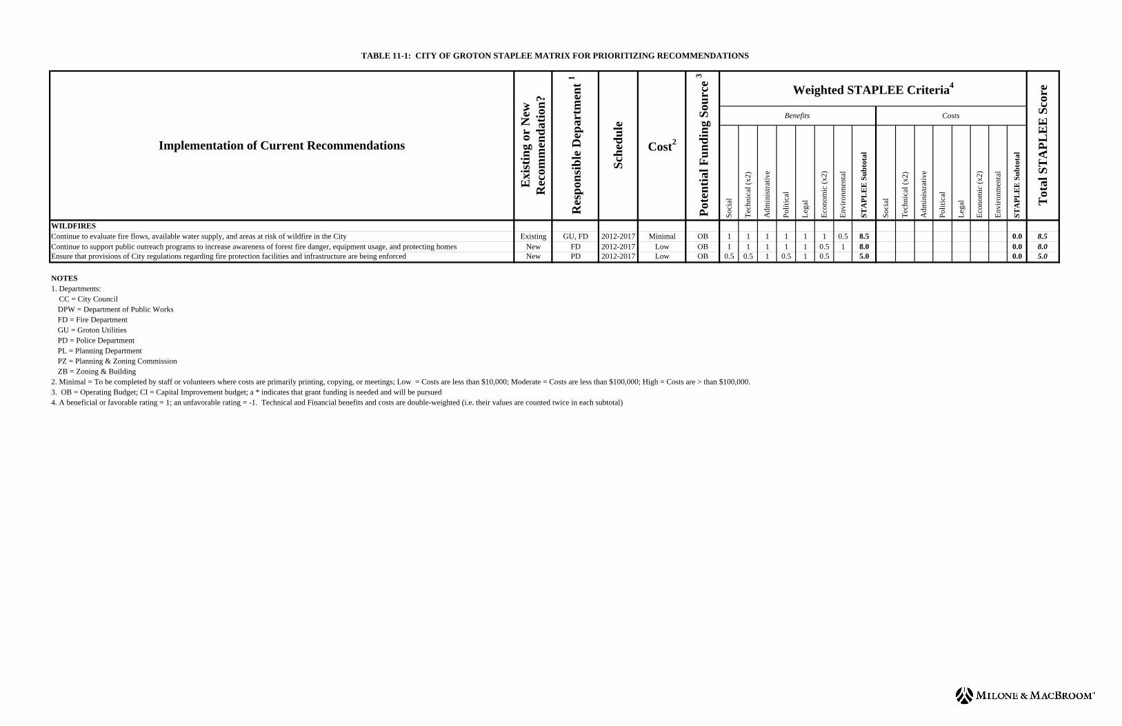
11.2 Prioritization of Specific Recommendations ..............................................................................11-8
Tables
Table 2-1 Critical Facilities..............................................................................................................2-9 Table 11-1 City of Groton STAPLEE Matrix for Prioritizing Recommendations...........................11-9
Figures
Figure 4-1 FEMA Special Flood Hazard Areas ................................................................................4-3 Figure 4-2 Potential Hurricane Storm Surge Areas ...........................................................................4-4
Appendices
Appendix A Record of Local Adoption
HAZARD MITIGATION PLAN UPDATE ANNEX CITY OF GROTON, CONNECTICUT JULY 2012 1-1
1.0 INTRODUCTION 1.1 Purpose of Annex
The purpose of this HMP annex is to provide an update to the natural hazard risk assessment and capability assessment provided in the previous HMP, and to evaluate potential natural hazard mitigation measures and prioritize natural hazard mitigation projects specific to mitigating the effects of natural hazards to the City of Groton. Background information and the regional effects of pertinent natural hazards are discussed in the main body of the Southeastern Connecticut Council of Governments (SCCOG) Multi-Jurisdictional Hazard Mitigation Plan. Thus, this annex is designed to supplement the information presented in the Multi-Jurisdictional HMP with more specific detail for the City of Groton and is not to be considered a standalone document. The primary goal of this hazard mitigation plan annex is to identify particular vulnerability to natural hazards and potential mitigation measures for such natural hazards in order to reduce the loss of or damage to life, property, infrastructure, and natural, cultural, and economic resources. This includes the reduction of public and private damage costs. Limiting losses of and damage to life and property will also reduce the social, emotional, and economic disruption associated with a natural disaster.
1.2 Setting
The City of Groton is an urbanized political subdivision of the municipality of Groton, Connecticut. The City of Groton was established as a borough in 1903 and incorporated as a city in 1964. It is approximately 3.2 square miles in area and had a population of 10,389 as of the 2010 census. It is located in the south-central portion of the southeastern Connecticut shoreline. It is bordered by the Town of Groton (the remaining political subdivision of Groton) to the north and east, the Thames River to the west, and Fishers Island Sound to the south. The City of Groton can be accessed by Interstate 95 and the Clarence B. Sharp Highway (State Route 349).
1.3 Plan Development The 2005 HMP and its annexes were developed through a series of meetings and the completion of written questionnaires, personal interviews, and workshops as described in the Multi-Jurisdictional HMP update. Since that time, the HMP has been available in local governmental offices and available to emergency personnel. Residents were encouraged to contact the Emergency Management Director with any concerns regarding emergency response or potential projects related to natural hazard damage. Based on the existing plan, existing information, and hazards that have occurred since 2005, SCCOG determined that the following data collection program would be sufficient to collect data to update the Multi-Jurisdictional plan and each annex.
The SCCOG issued a press release on November 20, 2011 announcing a public information meeting on the multi-jurisdictional HMP update. This press release was published in the Norwich Bulletin and The Day. This notice was also posted on the SCCOG website and the Groton Patch (a popular internet newspaper). The public information meeting was held on December 13, 2011 at the SCCOG office.
HAZARD MITIGATION PLAN UPDATE ANNEX CITY OF GROTON, CONNECTICUT JULY 2012 1-2
A data collection meeting was held with the City on January 12, 2012 to discuss the scope and process for updating the plan and to collect information. The Director of Planning coordinated the local planning team which included members of the building and highway departments. The meeting focused on reviewing each section of the existing hazard mitigation plan and annex, critical facilities, and various types of hazards that have affected the City and that should be addressed in the update.
The draft that is sent for State review will be posted on the City website
(http://www.cityofgroton.com/) as well as the SCCOG website (http://www.seccog.org) for public review and comment. In addition, a hard copy will be made available in the SCCOG office in Norwich. A press release will announce the availability of the HMP for review. This will provide residents, business owners, and other stakeholders throughout the SCCOG region the opportunity to review and comment on a relatively complete draft with all annexes. Comments received from the public will be incorporated into the final draft where applicable following State and Federal comments.
The adoption of this HMP update by the City of Groton will be coordinated by SCCOG and the Planning Department. The HMP update must be adopted within one year of conditional approval by FEMA, or the City will need to update the HMP and resubmit it to FEMA for review. The adoption resolution is located in Appendix A of this annex.
1.4 Progress Monitoring Following adoption, the Civil Preparedness Director under the authority of the Mayor and City Council and will continue to be the local coordinator of the HMP. The Civil Preparedness Director will coordinate with responsible departments as listed in Table 11-1 and ensure that the recommendations of this HMP are considered or enacted. Refer to Section 1.8 of the Multi-Jurisdictional HMP for a description of how the local coordinator will perform progress monitoring. The majority of recommendations in this annex can be accomplished within or with only a slight increase in the operating budgets of the various departments. Projects that require capital improvements or additional funding will need to be approved by the City Council. The HMP will be on file with the Civil Preparedness Director and at the Planning Department to assist in guiding growth decisions. See Section 2.5 for recommendations related to integrating the findings of this HMP into other City planning documents. The City will encourage residents to contact the Planning Department or Emergency Management Director with concerns related to natural hazards or emergency response via the City’s website. Such announcements will also state that the HMP is available for public review at the Planning Department as well as available on the City’s and the SCCOG’s website. The City of Groton will review the status of plan recommendations each year. The Planning Department will be in charge of overseeing recommended projects and coordinating an annual meeting with applicable departments (those listed in Table 11-1) and other interested departments. Refer to Section 1.8 of the Multi-Jurisdictional HMP for a list of matters to be discussed at the annual meeting, including a review of each recommendation and progress achieved to date, or reasons for why the recommendation has not been enacted. The Planning Department will keep a written record of meeting minutes and the status of the recommendations. These records of progress monitoring will form the basis for the next HMP update.
HAZARD MITIGATION PLAN UPDATE ANNEX CITY OF GROTON, CONNECTICUT JULY 2012 1-3
The City of Groton understands that the multi-jurisdictional HMP and this annex will be effective for five years from the date of FEMA approval of the first SCCOG jurisdiction regardless of the date of adoption by the City. The Planning Department will coordinate with SCCOG for the next HMP update which is expected to occur in 2016-2017.
HAZARD MITIGATION PLAN UPDATE ANNEX CITY OF GROTON, CONNECTICUT JULY 2012 2-1
2.0 COMMUNITY PROFILE 2.1 Physical Setting
The City of Groton is a coastal community located on the Connecticut shoreline. Elevations range from sea level along the Thames River and Fishers Island Sound to just over 150 feet in the northeastern corner of the City. Three islands also lie within the City limits; of these, only Hobs Island is inhabited (by one home). Geology is important to the occurrence and relative effects of natural hazards such as earthquakes. Thus, it is important to understand the geologic setting and variation of bedrock and surficial formations in lands underlying the City of Groton. The City of Groton lays above four bedrock types which trend northwest to southeast across the area. The area near Interstate 95 is underlain by the Potter Hill Granite Gneiss, the Plainfield Formation, and the Mamacoke Formation, while the remainder of the City is underlain by New London Gneiss except for two small intrusions of Westerly Granite. Each of these formations consists primarily of gneiss, a relatively hard metamorphic rock except for the hard, igneous granite intrusions. There are no faults mapped within or near the City of Groton boundary. The City’s different surficial geologic formations include glacial till, stratified drift, and coastal formations. Refer to the Multi-Jurisdictional HMP for a generalized view of surficial materials. The majority of the City is underlain by glacial till. The exceptions are an area along the Thames River near Interstate 95 which is underlain by stratified drift; areas along Birch Plain Creek in which are underlain by alluvium, stratified drift, and swamp; and coastal beach and dune deposits along Shennecossett Beach located in the southwestern part of the City along Fishers Island Sound. Till contains an unsorted mixture of clay, silt, sand, gravel, and boulders deposited by glaciers as a ground moraine. The amount of stratified drift present is important as areas of stratified materials are generally coincident with floodplains. These materials were deposited at lower elevations by glacial streams, and these valleys were later inherited by the larger of our present day streams and rivers. However, the smaller glacial till watercourses can also cause flooding. The amount of stratified drift also has bearing on the relative intensity of earthquakes and the likelihood of soil subsidence in areas of fill.
2.2 Land Use and Development Trends The City of Groton is nearly fully-developed with the exception of a few areas of dedicated open space. According to the 2008 Plan of Conservation and Development for the City, remaining vacant developable land was equal to 3% of the overall land area. The City includes 28.65 miles of improved streets and 4.9 miles of State of Connecticut highways. A mix of residential, commercial, and industrial development is found along the City’s shoreline, with predominantly residential development occupying the central area of the City. The majority of development has occurred in the northern part of the City near Electric Boat and in Groton Heights. Much of the southern portion of the City is institutional land associated with the University of Connecticut’s Avery Point campus and undeveloped land associated with the Shennecossett Golf Course. Other open space properties include Fort Griswold State Park and
HAZARD MITIGATION PLAN UPDATE ANNEX CITY OF GROTON, CONNECTICUT JULY 2012 2-2
George Washington Park in the northern section of the City and Birch Plain Creek Open Space located on the east side of the City. The Thames River has played an important part in the development of the City of Groton. The city is well known as the home of General Dynamics - Electric Boat, a company that designs and builds submarines. Electric Boat and Pfizer, a pharmaceutical manufacturer, are the two largest employers in the city and are both located along the Thames River. The Hess Oil Corporation is also a large employer located adjacent to Pfizer. In additional to coastal and roadway access, a branch of the Providence/Worcester Railroad line passes through the northern part of the City with a spur entering from the east with a terminus at Electric Boat. The 2000 census population of the City was 9,288. Despite adding approximately 800 people through 2010, there have been no major changes in development since the last HMP in 2005. As there are almost no developable properties remaining in the City, the only development has been small infill projects consisting of single and two-family homes along the shoreline. Large redevelopment projects are currently being undertaken on the Electric Boat and Pfizer campuses, although the footprints of existing buildings and the amount of impervious surfaces are not significantly changing. No new major developments or residences are currently proposed, and population growth is expected to be modest in the future. According to the 2008 Plan of Conservation and Development, approximately 36% of the housing units in the City are single-family detached units, approximately 36% are two- to four-family dwellings, and the remaining 28% are larger multi-family structures and apartments. More than half of the housing units were built in the 1950s through 1970s during the height of “Cold War” era submarine production at Electric Boat and as such do not meet current building codes. Over 60% of all housing units in the City are renter-occupied.
2.3 Drainage Basins and Hydrology The City of Groton is divided among two sub-regional watersheds as delineated by the Connecticut DEEP. The western side of the City drains directly to the Thames River, whereas the remainder of the City drains to Fishers Island Sound. The northeastern section of the City drains to Fishers Island Sound via Birch Plain Creek and Bakers Cove. The City of Groton does not have issues with runoff entering from the Town of Groton. In addition to the water bodies listed above, two unnamed coastal ponds located along Beach Pond Road and Shennecossett Road in the vicinity of Avery Point empty into the Thames River and Baker Cove.
2.4 Governmental Structure
The City of Groton is governed by a Mayor-City Council government as authorized by the City Charter of 1987. The Mayor is the chief executive officer of the City and is directly responsible for the administration of all departments, agencies, and offices. The six-member City Council consists of a Deputy Mayor who administers the City in the Mayor’s absence and five City Councilors. Together, Mayor and the City Council review and approve all City business. The Mayor casts the deciding vote on Council business in case of a tie.
HAZARD MITIGATION PLAN UPDATE ANNEX CITY OF GROTON, CONNECTICUT JULY 2012 2-3
The City of Groton has several departments that provide municipal services. Departments pertinent to natural hazard mitigation include the Finance, Fire, Planning, Police, Public Works, Utilities, and Zoning & Building Departments. In addition, there are several boards and commissions that can take an active role in hazard mitigation, including the Conservation Commission, the Harbor Management Commission, the Planning & Zoning Commission, and the Zoning Board of Appeals. The general roles of most of these departments and commissions are common to most municipalities in SCCOG and were described in Section 2.8 of the Multi-Jurisdictional HMP. More specific information for certain departments and commissions of the City of Groton is noted below:
The Conservation Commission is the Inland Wetlands Regulatory Agency for the City of Groton and reviews plans for compliance with said regulations and maintains the City’s inland wetlands map.
The City of Groton Fire Department has two fire stations with career personnel on duty 24
hours per day as well as volunteer personnel. They provide Fire suppression, fire / disaster prevention, rescue, hazardous materials, disaster mitigation, and emergency medical services to the City.
The Harbor Management Commission oversees the development and use of the coastal
waters in and around the City of Groton. They maintain the City’s Harbor Management Plan, work with the Harbor Master and City staff on emergent vegetation issues, and oversee the City’s mooring program.
The Planning & Zoning Commission oversees orderly and appropriate use and development
of residential, commercial, and industrial land and the conservation of natural resources. They review and approve a wide range of land use applications, zoning regulation amendments, planning and development projects, and grant opportunities to ensure that development and growth in the City is consistent with existing land use, environmental policy, and the objectives of the Plan of Conservation and Development. They are assisted by the professional staff of the Planning Department who administers the City’s Zoning and Subdivision regulations, administers the Coastal Management Program, performs planning studies, and provides technical assistance to developers.
The Police Department maintains the evacuation plan for the City in addition to providing
law enforcement services. The City of Groton has a total of 31 officers and nine non-sworn staff members.
The Public Works (Highway) Department provides services including comprehensive solid
waste collection, recycling and disposal; safe, efficient and well-maintained infrastructure of roads, bridges and stormwater management. The Public Works Department also conducts snow removal and deicing on roads; tree and tree limb removal in rights-of-way; and maintains and upgrades storm drainage systems to prevent flooding caused by rainfall.
Groton Utilities provides electricity, potable water, cable television, high-speed internet
access, and digital phone services to the City of Groton and the surrounding region. They maintain and test fire hydrants utilized by the Fire Department.
HAZARD MITIGATION PLAN UPDATE ANNEX CITY OF GROTON, CONNECTICUT JULY 2012 2-4
The Zoning & Building Department performs inspections of new and existing development to ensure compliance with appropriate building codes and City regulations, including wetland regulations for the Conservation Commission.
The Zoning Board of Appeals has jurisdiction over variances to the City’s zoning regulations
and has, for example, issued variances for special circumstances in flood plain zones.
In addition to the departments described above, the City of Groton has several other departments similar to surrounding municipalities, including Human Resources, attorneys, etc. The roles of City departments have not changed since the time of the previous HMP. Thus, the City of Groton is technically, financially, and legally capable of implementing mitigation projects for natural hazards. As discussed in the next section and the historic record throughout this annex, the City of Groton is densely developed and thus has particular vulnerability to certain types of natural hazards.
2.5 Review of Existing Plans and Regulations
The City has several Plans and regulations that suggest or create policies related to hazard mitigation. These policies and regulations are outlined in the Emergency Operations Plan, Plan of Conservation and Development, Harbor Management Plan and Ordinance, Zoning Regulations, Subdivision Regulations, Inland Wetland Regulations. The Plan of Conservation and Development and the Zoning Regulations have incorporated information from the previous HMP. Emergency Operations Plan The City has an Emergency Operations Plan (EOP) that is updated and certified by the Mayor annually. This document provides general procedures to be instituted by the Mayor and/or designee and other tasked departments including the Police Department, Fire Department, Groton Utilities, and Public Works in case of an emergency. Emergencies can include but are not limited to natural hazard events such as hurricanes and nor’easters. The EOP is directly related to providing emergency services prior to, during, and following a natural hazard event. Plan of Conservation and Development (2008) The Plan of Conservation and Development was adopted on August 1, 2008 with contributions from local boards and commissions, citizens, and citizen groups. The purpose of the plan is to balance growth with maintaining the quality of life that citizens within the City embrace. Building on the information in the previous HMP, the Plan includes many strategies pertinent to hazard mitigation. Recommendation strategies were noted as being high, moderate, or lower priority or being policies. The Plan encourages the City to protect natural resources, preserve open space and scenic resources, and notes specifically that the City should continue to require setbacks and buffers from water resources and coastal resources, and that new development in coastal "V" flood zones should be minimized. Additional recommendations related to natural hazards include:
HAZARD MITIGATION PLAN UPDATE ANNEX CITY OF GROTON, CONNECTICUT JULY 2012 2-5
High Priority
Implement the Harbor Management Plan since it allows the City to better control in-water activities (such as docks and moorings) and helps ensure in-water and upland activities are better coordinated. This recommendation was enacted by the City in 2007 prior to the final publication of the Plan.
Work with the Town of Groton to create an open space corridor along Birch Plan Creek
(called the “Greenbreak”) and add land to the existing Birch Plain Creek Park.
Seek to identify and preserve any areas which are potentially high in passive recreational potential (including beaches, coastal bluffs and escarpments, tidal wetlands, or islands) as open space and as part of a waterfront pathway network.
Strive to ensure that any open space acquired be preserved as open space in perpetuity.
Modify the open space provisions in the subdivision regulations (Section 4.4) to require that
every residential subdivision make some provision for open space either through deeding at least 10% of the land or by making a payment to the Open Space Fund.
Consider expanding the open space set-aside requirement above to all other types of
residential development.
Require the underground installation of utilities for all new development and, when opportunities arise, put existing overhead utilities underground.
In order to protect areas with marina uses (and preclude heavier marine commercial or
industrial uses), consider establishing a new recreational boating zoning classification that would prevent replacing water-dependent uses with residential uses.
Moderate Priority
Consider requiring the deduction of wetlands, watercourses, steep slopes greater than 20%, and floodplains from parcel area when determining residential density for multi-family developments.
Support the Open Space Fund with an annual contribution from the City Budget so desirable
land can be purchased when it becomes available.
In the event of an expansion / redevelopment of the industrial Thames River area, promote such redevelopment so that non-water dependent uses are located further inland, public access and attractions along the waterfront are encouraged and supported, and scenic views are preserved to the extent possible.
Lower Priority
To enhance public access to the Thames River, consider establishing a formal program to purchase strategically located waterfront parcels as they become available for open space or other municipal purposes.
HAZARD MITIGATION PLAN UPDATE ANNEX CITY OF GROTON, CONNECTICUT JULY 2012 2-6
Undertake a study to determine the best way to address the long-term space needs of the Fire
Department. Policies
Continue to protect watercourses, tidal and inland wetlands, steep slopes greater than 15%, and coastal and inland floodplains.
Work with State and Federal agencies to ensure that flood protection regulations reflect
current thinking and standards especially with regard to long-term rise in sea levels.
Consider expanding street tree planting programs and recommend trees appropriate for each area (since tall-growing trees are not appropriate under overhead wires and flowering or fruit-bearing trees may not be appropriate in some locations.
Encourage maintenance of street-side areas.
Consider strategies to maintain and improve the capacity of Route 349 as the major roadway
providing access to Electric Boat and Pfizer.
Encourage Groton Utilities to continue to identify additional water supply sources in order to support existing uses in the service area and possible expansions.
Harbor Management Plan
The Harbor Management Plan of the City of Groton, as enacted under City Ordinance 167 approved on March 5, 2007, authorizes the Harbor Master to carry out harbor management directives and enforce all provisions of the Plan, including collecting fees for mooring permits and assigning mooring locations; standardizing mooring tackle requirements; and enforcing wake and speed, waterskiing, motor, noise, and refuse regulations. In particular, this ordinance allows the City to have a list of persons who currently have boats moored such that removal or emergency response can be coordinated.
Zoning Regulations The Zoning Regulations of the City of Groton, Connecticut were last updated in July 2011. The recent updates were performed concurrently with the release of the FIS and DFIRM for New London County in July 2011. They include a variety of preventative regulations pertinent to mitigating flooding hazards. These regulations are applied during the permitting process for new construction and during substantial improvement of existing structures. Section 4.6 discusses coastal area management and potential exemptions from local permitting. The City of Groton enforces a 25-foot setback from any tidal water body or watercourse or from coastal resource areas within the Coastal Area Management Boundary defined by the Connecticut DEEP. In addition, new single-family homes cannot be constructed within 100 feet of tidal wetlands, coastal bluffs and escarpments, or beaches and dunes.
HAZARD MITIGATION PLAN UPDATE ANNEX CITY OF GROTON, CONNECTICUT JULY 2012 2-7
Section 4.7 of the regulations covers flood protection. The City of Groton utilizes the 1% annual chance floodplain (commonly referred to as the “100-year” floodplain) to manage development in floodplains. The 1% annual chance floodplain is depicted on the DFIRM published in July 2011 by FEMA and includes areas in Zone A, Zone AE, and Zone VE including floodways. The degree of protection required by this regulation is the minimum reasonable for regulatory purposes. In particular,
All applications for building permits within the flood hazard area must include the base flood elevation data from the FIRM for the portions of the activity located within the flood hazard area. The Building Official will record as-built elevation of the lowest floor and lowest horizontal structural member (for VE zones) and keep this information on file.
The applicant must demonstrate to the commission that the development is consistent with
the need to minimize flood damage within floodprone areas and that the building sites will be reasonably safe from flooding. In addition to confirming that the design is consistent with the Connecticut Building Code, the Building Official must confirm that the development is designed and constructed so as to minimize flood damage prior to building permit approval. Electrical, heating, ventilation, plumbing, air conditioning, and other service facilities must be designed and/or located so as to prevent water from entering or accumulating within the components during flooding.
The Planning and Zoning Commission will coordinate with neighboring communities, the
Connecticut DEEP, and FEMA prior to approving any activity that alters or relocates a watercourse.
New construction, substantial improvements, and manufactured homes must be elevated and
anchored to resist floatation, collapse, or lateral movement.
New construction and substantial improvements require that fully-enclosed areas below the lowest floor must be wet-floodproofed and used solely for the parking of vehicles, building access, or storage. The area cannot be used as furnished living space. Utilities are prohibited in the space below the base flood elevation.
In coastal VE zones, all new construction or substantial improvement must be located
landward of the reach of the mean high tide and elevated so that the bottom of the lowest supporting horizontal member is located above the base flood elevation level. Fill may not be used as a structural support.
Encroachment in floodways is not allowed unless the applicant can demonstrate that the
proposed activity will result in no net increase in flood levels during the base flood discharge. The City can require floodway data be provided for watercourses without FEMA-established floodways.
Subdivision Regulations The City of Groton Subdivision Regulations were last amended on February 18, 2005. These regulations address developments near steep slopes, watercourses and wetlands. Specific design requirements for flood-prone areas are noted in Section 4.2 and 6.4 and are similar to the more specific requirements presented in the Zoning Regulations. In particular,
HAZARD MITIGATION PLAN UPDATE ANNEX CITY OF GROTON, CONNECTICUT JULY 2012 2-8
Section 4.2 states that drainage systems shall be designed to reduce exposure to flood
hazards.
Section 4.4 states that the Planning and Zoning Commission may require open space of up to 10% of a subdivision to be reserved for active recreation (parks and playgrounds) or for passive recreation; for the protection and buffering of wetlands and watercourses; or for preserving outstanding natural or historical features. The Planning and Zoning Commission may also collect a fee in lieu of requiring the open space set aside, with the money going into the City’s Open Space Fund.
Section 4.8 states that underground utilities are allowed in all subdivisions and that they are
required in subdivisions of five lots or more. Inland Wetland and Watercourses Regulations The Regulations for the Preservation of Inland Wetlands and Watercourses in the City of Groton were last amended on September 1, 2007. The regulations require a permit for certain regulated activities which take place within 200 feet of a wetland or watercourse. These regulations build on the preventative flood mitigation provided by the Zoning and Subdivision regulations by preventing fill and sedimentation that could lead to increased flood stages.
2.6 Critical Facilities, Sheltering Capacity, and Evacuation
The City of Groton considers several facilities to be critical to ensure that emergencies are addressed while day-to-day management of the City continues. In addition, locations with populations that may be at additional risk during an emergency are also considered to be critical. Critical facilities are presented on figures throughout this annex and summarized in Table 2-1. Municipal Complex
The Emergency Operations Center (EOC), Police Department, and Public Works (Highway) facility are all located on the same campus as the Municipal Building (City Hall) on Meridian Street. This building is also the headquarters for Groton Utilities, which provides electricity and drinking water to residents in the City and throughout the region. Groton Utilities has its own EOC to manage emergencies to its lands and infrastructure in this building. The campus is served by a generator and the City’s primary shelter is here as well. Approximately 250 people can be sheltered at this location. Backup Shelters Fitch High School in the Town of Groton is the City’s backup shelter. This facility can shelter approximately 1,260 people, but is also the primary shelter for Town of Groton residents. It has a generator and is staffed by the American Red Cross. Fire Department The City of Groton has two fire stations located on Broad Street and Eastern Point Road. They both have generators.
HAZARD MITIGATION PLAN UPDATE ANNEX CITY OF GROTON, CONNECTICUT JULY 2012 2-9
TABLE 2-1
Critical Facilities
Facility Address or Location Emergency
Power Supply?
Shelter?
In Floodplain or Coastal
Flood Hazard Area?
In Surge Zones?
Emergency Services Fire Station Broad Street Fire Station Benham Road Municipal Facilities City Hall (EOC, Police, Groton Utilities, Public Works, Shelter,)
295 Meridian Street *
Water Pollution Control Authority Thames Street
Fitch High School (Shelter)
Groton Long Point Road, Town of Groton
Health Care and Senior Living Facilities Avery Heights (Elderly Housing) 300 Brandegee Avenue
Other Infrastructure and Facilities Pfizer Eastern Point Road Electric Boat Thames Street University of Connecticut at Avery Point
Shennecossett Road
*Public Works is located within the 0.2% annual chance floodplain. Water Pollution Control Authority The Water Pollution Control Facility located along the Thames River is a critical facility, along with the ten or so sewer pumping stations located throughout the City. These facilities are a high priority for power restoration following any outage to prevent sewer backups. Private Facilities Electric Boat, Pfizer, and the University of Connecticut Avery Point regional campus are each considered to be critical facilities. Each facility attracts a transient population in the thousands each day. Each has its own security/police detail and Electric Boat and Pfizer have their own Fire Departments. The City of Groton has mutual aid agreements with both Fire Departments. Each facility has limited backup power generation capability. Other Facilities No advanced care medical facilities are located in the City. Residents of the City typically access Lawrence & Memorial Hospital in New London for advanced care needs.
HAZARD MITIGATION PLAN UPDATE ANNEX CITY OF GROTON, CONNECTICUT JULY 2012 2-10
Avery Heights Elderly Housing is located on Brandegee Road and provides federally subsidized, low-cost apartments to elderly and disabled residents. The facility includes 104 one bedroom apartments. Marine Transportation Two private marinas are located in the city – Pine Island and Shennecossett. The City does not consider the two private marinas to be critical facilities. No major ferries operate out of the City. Evacuation Routes The Police Chief has an evacuation plan on file that considers an evacuation required because of an emergency at the Millstone Nuclear Power Plant in Waterford, a coastal flooding emergency, or a hurricane. The evacuation map includes evacuation routing connected to primary shelters in the City and the Town of Groton. Evacuation routes should not include roads that can become submerged during coastal storms and riverine flooding (See Section 4). Any changes in shelter status or shelter locations will necessarily require modifications to the evacuation map. In addition, any changes in routing will necessarily require modifications to the evacuation map. Additional Groups In addition to City offices, The American Red Cross and the Salvation Army help provide shelter and vital services during disasters and participate in public education activities.
2.7 Status of 2005 Plan Recommendations The previous HMP included several general recommendations related to mitigating natural hazards. The recommendations and a summary of actions taken over the past several years towards those actions are listed below. Where progress was indicated, the progress was paid for out of the City’s operating budget.
Perform Structural Elevation, Drainage Improvements, and Culvert Replacements at Jupiter Point and Eastern Point – The City has conducted outreach to residents about flood mitigation, structural elevation, etc. The City attempted to submit a PDM grant application to the Connecticut DEEP in 2011 for drainage improvements but DEEP reportedly did not believe that the project was consistent with PDM criteria. The City does not have enough funding to perform these projects at this time without grant funding. This recommendation is still appropriate for mitigating coastal flooding in these areas.
Evaluate the Hazard Resistant Nature of Critical Facilities – This is ongoing as part of the
City’s annual EOP update. In general, City-owned critical facilities are considered disaster-resilient since they are not located in FEMA Special Flood hazard areas or hurricane surge zones, and are constructed to building codes that meet or exceed industry standards. The exception is the Waste Water Treatment Facility which located along the Thames River. This recommendation is still valid but is subsumed into the EOP recommendation.
Evaluate Drainage Structures and Construct Drainage Improvements Including Culvert
Replacements – The City has evaluated the drainage on Thames Street and Mitchell Street and along Eastern Point Road to the extent possible but has limited access to Electric Boat
HAZARD MITIGATION PLAN UPDATE ANNEX CITY OF GROTON, CONNECTICUT JULY 2012 2-11
and Pfizer, particularly the high-security Electric Boat facility. Water damage is known to occur on the Electric Boat site but the company performs its own repairs. Electric Boat is undertaking its own study of drainage and developing flood mitigation options.
Elevate Shennecossett Road at Avery Point – This area remains at risk of being inundated
during a coastal flooding event and isolating the Avery Point campus since funding is not currently available to elevate the roadway. The work would require elevating the southern terminus of Eastern Point Road (State Route 349) along with a locally-owned portion of Shennecossett Road such that it would need to be a joint project with the State. This remains a recommendation.
Perform an Inventory and Assessment of Floodprone Structures to Develop Flood Audits –
The majority of flooding in the City affects roadways but does not affect structures. While the City understands that a major coastal flooding event could inundate structures (particularly those in the 1% annual chance floodplain), it does not have funding to perform a formal flood audit of the 205 floodprone properties located in the 1% annual chance floodplain without significant grant funding. While this recommendation remains valid, it is unlikely that formal flood audits will ever be performed. Alternatively, it is within the City’ budget to inventory potential properties at risk for emergency response purposes.
Review of Transportation Facilities to Identify Critical Risks – This is ongoing annually as
part of the Emergency Operations Plan update.
Hazardous Materials Spills on Major Roadways / Railroads – The City has improved all of its roads. They are also part of the Eastern Connecticut Hazardous Materials Response Team as well as having a limited capability to respond to spills. This recommendation is not carried forward in this HMP update.
Implement a Reverse 9-1-1 System to Relay Important Information During an Emergency –
The City is part of the Statewide CT Alerts “Everbridge Community Notification” System. The City should continue using this system.
Distribute or Post Public Information Regarding Hazards – General information regarding
how to prepare for natural hazards is available at the Municipal Complex and at each Fire Department. This recommendation remains valid and there are additional opportunities for additional public information such as additional brochures at more locations and the posting of information on the City and Groton Utilities webpage.
Evaluate Emergency Shelters, Update Supplies, and Check Communication Equipment –
This is done at least annually or following any use of the facility. The City should continue this action.
Maintain Emergency Personnel Training as Well as Maintaining and Updating Emergency
Equipment and Response Protocols – This is done regularly, with equipment upgrades occurring to the extent the budget will allow. The City should continue this action.
Evaluate and Consider Burying Power Lines Underground and Away from Possible Tree
Damage – The placement of utilities underground is required for certain types of new development. A recommendation in the 2008 Plan of Conservation and Development is to
HAZARD MITIGATION PLAN UPDATE ANNEX CITY OF GROTON, CONNECTICUT JULY 2012 2-12
expand this requirement to additional types of development. There is no funding currently available to place existing utilities underground.
Complete an Earthquake Survey of all Critical Facilities and Infrastructures – A specific
survey has not been performed and there are no plans to perform such a survey in the future given the low occurrence of this hazard type. New buildings are designed to meet or exceed the Connecticut Building Code and as such are believed to be generally disaster-resilient.
Complete Catch Basin and Culvert Surveys to Identify Structures in Need of Maintenance or
Replacement – Inspections are performed by the Public Works Department annually as part of regularly scheduled cleaning activities. Basins are cleaned by vacuum truck. If the inspections or any complaints reveal vulnerabilities, then a more detailed inspection is performed. The City regularly repairs, replaces, or budgets for large-scale infrastructure as needed.
Complete a Survey of Fire Hydrants to Assess Vulnerabilities and Capabilities for Fire
Protection and Consider Dry Hydrants as a Means for Emergency Equipment – The City believes that its fire protection is adequate. Groton Utilities maintains and tests fire hydrants and relays this information to City fire fighters so they know how much flow is available from each hydrant. There are no dry hydrants in the City and no plans to install any since the City is nearly fully-developed and has extensive public water service.
Improve Property Protection with Storm Shutters and When Possible Elevate Properties
Above the Base Flood Elevation, Consider Acquisition of Properties that are Repeatedly Flooded, and Consider Acquiring a Fireboat as a Means of Emergency Equipment – The City has conducted outreach to residents about acquisitions and structural elevation, etc. The City has encouraged property owners to purchase storm shutters and to install flood vents and many have done so. These activities should continue to be performed. The City now has a fire boat housed at the Fire Department on Broad Street, so this part of the recommendation is no longer needed.
HAZARD MITIGATION PLAN UPDATE ANNEX CITY OF GROTON, CONNECTICUT JULY 2012 3-1
3.0 INLAND FLOODING
3.1 Setting/Historic Record There are no notable inland flooding issues due to watercourses in the City. The primary inland flooding problem is due to drainage issues on the western side of the City. Such flooding occurs at least twice per year and is associated with heavy rainfall overwhelming drainage systems. Recent examples include the March 2010 and March 2011 heavy rainfall and associated flooding. Basement flooding can also occasionally be an issue in the City.
3.2 Existing Programs, Policies, and Regulations The City attempts to mitigate inland flood damage and flood hazards by utilizing a wide range of measures including restricting activities in floodprone areas, replacing bridges and culverts, promoting flood insurance, maintaining drainage systems, through education and outreach, and by utilizing warning systems. As noted in Section 2.5, the Zoning and Subdivision Regulations of the City of Groton restrict development and require mitigation for projects constructed within the 1% annual chance floodplains as defined by FEMA. Such Special Flood Hazard Areas are delineated on the DFIRM published with the Flood Insurance Study for New London County that was released on July 18, 2011. Most of the SFHAs mapped by FEMA in the City of Groton do not appear to be associated with a watercourse and thus are more closely related to coastal flooding (Section 4). Birch Plain Creek is the only notable exception on the eastern edge of the City. Public Works cleans and inspects catch basins and culverts at least annually or more often if problems are noted. The Civil Preparedness Director, Fire Department, and Police Department accesses weather reports through the National Weather Service, but personnel are not typically concerned about the effects of inland flooding except for the largest of storm events. When inland flooding occurs, the Public Works department or the Fire Department would handle the complaints depending on the location.
The City of Groton completed the “John Street Drainage Study” with the goal of dividing the storm drainage that runs along John Street and Thames Street. This area is a recurring drainage problem (see below). This project was nearly completed in summer 2012 (at the time of writing) and when complete will properly direct the flow of water into the Thames River to avoid flooding of Thames Street, Eastern Point Road, Mitchell Street, and John Street. The project cost was approximately $110,000. The City attempted to submit a PDM grant application to the Connecticut DEEP in 2011 for drainage improvements but DEEP reportedly did not believe that the project was consistent with PDM criteria.
3.3 Vulnerabilities and Risk Assessment
This section discusses specific areas at risk to inland flooding within the City. Areas at risk from coastal flooding are discussed in Section 4 of this annex. Inland flooding due to poor drainage is the most common type of flooding experienced by the City.
HAZARD MITIGATION PLAN UPDATE ANNEX CITY OF GROTON, CONNECTICUT JULY 2012 3-2
Note that HAZUS-MH, FEMA’s hazard loss estimation software, was utilized to calculate the potential damages to the City of Groton from a combined 1% annual chance riverine and coastal flood. Results were presented in Section 3.5.2 of the Multi-Jurisdictional HMP.
3.3.1 Vulnerability Analysis of Areas Along Watercourses The major inland watercourse in the City of Groton is Birch Plain Creek on the eastern side of the City. This creek drains from the vicinity of the Interstate 95 past the municipal complex and then east into the Town of Groton. The watercourse re-enters the City of Groton at Poquonock Road and forms the eastern boundary of the City until its confluence with Bakers Cove. Four homes are located within the 1% annual chance floodplain of Birch Plain Creek on Paul Revere Road, Madison Place, and Nathan Hale Road. An additional property on Thomas Road and a pump station are also in the 1% annual chance floodplain (refer to Figure 4-1 in the next Section). As stated in Section 10, a dam formerly owned by Electric Boat was removed by the State upstream of Poquonnock Road on Birch Plain Creek. The removal of the dam has increased the frequency of flooding on Poquonnock Road and along Birch Plain Creek. The State should be encouraged to clean, repair, and correct, as needed, the drainage across Poquonnock Road from the dam site in accordance with the approved plan to breach the dam. In addition, many of the City’s drainage systems are equipped with flapper valves near the shoreline. These valves allow water to pass in the downstream direction but close when tidal flow moves upstream. Many of the valves in the City are old and require repair or replacement to prevent exacerbating backwater flooding.
3.3.2 Vulnerability Analysis of Private Properties In terms of inland flooding, very few structures are regularly affected in the City. City officials have indicated that the most frequent flooding issue occurs on Thames Street in the vicinity of Smith Street and John Street (Figure 4-1). The City (through GEI Consultants, Inc.) completed a drainage evaluation in 2004 that indicated that the storm drainage in this area could not pass a 10-year storm event without backing up. Drainage from this area (the roads and the Eastern Point Road parking lots) reportedly enters a vault and then makes a 90-degree turn and is funneled through pipes under the EB campus. Heavy flows cannot be conveyed effectively by the 90-degree turn in the system. According to City personnel, the parking areas at the Electric Boat facility near Thames Street have been repaved without comprehensive consideration to drainage impacts. This has exacerbated the effects of flooding from the inadequate existing storm drainage system components in this area. This flooding has posed a significant hazard during major storm events, with flood depths of 30 inches or more on the roadway being common during heavy rainfall events. The force of water rising through the manholes removes the covers, creating a more hazardous travel situation. City officials have estimated that a fifty-inch diameter storm drainage main would be necessary in order to handle the resulting storm water discharge. As noted above, a drainage upgrade project was nearly complete at the time of this writing summer 2012. This project is expected to significantly reduce the frequency of flooding along Thames Street, Smith Street, and John Street. However, an ongoing concern for the City is that
HAZARD MITIGATION PLAN UPDATE ANNEX CITY OF GROTON, CONNECTICUT JULY 2012 3-3
Electric Boat utilizes steel rods in drainage pipes for security purposes. These rods also block debris and cause clogging such that additional maintenance needs to be performed. An additional vulnerability occurs as the result of the diversion of an intermittent waterway performed many years ago at the Shennecossett Golf Course. The drainage work was reportedly not completed as designed resulting in occasional flooding at private properties downstream. The City should encourage the Town of Groton to complete or redo the drainage from the golf course down to Shore Avenue. In addition, Grove Avenue on the City’s northern boundary has flooding issues related to poor drainage and an intermittent stream in the area. In addition, culvert repairs and cleaning are reportedly needed in the vicinity of Shennecossett Beach.
3.3.3 Vulnerability Analysis of Critical Facilities As noted in Section 2.6, the only City-owned critical facilities located within the 1% annual chance floodplain is the waste water treatment facility on the Thames River. This facility, along with Electric Boat, Pfizer, and the University of Connecticut Avery Point Campus, is affected by coastal flooding. Critical facilities in the City do not normally have issues with inland flooding, although City personnel note that the basement of the municipal complex was flooded during recent heavy rains and many records were destroyed. The basement of this facility is often damp. The risk of inland flooding to critical facilities is therefore considered to be low.
3.4 Potential Mitigation Measures, Strategies, and Alternatives General potential mitigation measures that can be taken to reduce the effects of inland flooding were discussed in Section 3.7 and in Section 11.2.2 of the Multi-Jurisdictional HMP. General recommendations pertinent to all natural hazards that could affect the City are listed in Section 11 of this annex, as well as general and specific measures pertinent to reducing inland flooding under the categories of prevention, property protection, emergency services, public education and awareness, natural resource protection, and structural projects.
HAZARD MITIGATION PLAN UPDATE ANNEX CITY OF GROTON, CONNECTICUT JULY 2012 4-1
4.0 COASTAL FLOODING AND SHORELINE CHANGE
4.1 Setting/Historic Record The shorefront of the City of Groton contains developed shorefront along the Thames River, areas of rocky shorefront and modified bluffs and escarpments near Eastern Point, Avery Point, and Jupiter Point, and beaches and dunes at Shennecossett Beach. The mapped islands include the uninhabited Pine Island (surrounded by rocky shorefront and a small beach and dune area) and Hobs Island that has one structure and is surrounded by rocky shorefront. In addition, the lower section of Birch Plain Creek is a State-regulated tidal wetland area, and Bakers Cove is an estuarine embayment (defined as a protected coastal water body with a direct connection to Fishers Island Sound). The coastal resources found in Connecticut and described by DEEP can be found in the Multi-Jurisdictional HMP. Homes, businesses, and industry are located in close proximity to the coastline along the Thames River and Fishers Island Sound. Structures and infrastructure in the southern section of the City are closer to sea level than in northern areas and are therefore more susceptible to coastal flooding. Hurricanes and tropical storms have the potential to induce coastal flooding and storm surge that can impact structures. Primarily, roadway closures have occurred due to coastal flooding since 2005. Only a few structures are known to have received damage by coastal floodwaters. However, the City is also concerned with the potential long-term effects of sea level rise and its potential to exacerbate flooding conditions in the future.
4.2 Existing Programs, Policies, and Regulations The City primarily attempts to mitigate coastal flood damage and flood hazards by controlling and restricting activities in floodprone areas, encouraging the elevation of homes and roadways, maintaining hard structures in good condition, and providing signage and warning systems. Many of the existing programs, policies, and mitigation measures utilized in the City for inland flood mitigation (Section 3.2) are also applicable to coastal flood mitigation. As noted in Section 3.2 and Section 2.5, the City utilizes the 1% annual chance floodplains delineated by FEMA. These consist of the 1% annual chance floodplain with elevations (Zone AE), and the 1% annual chance floodplain subject to wave velocity (Zone VE). As noted by the Zoning Regulations and the Subdivision Regulations, building activities in these areas are restricted and new construction or substantial redevelopment must prove that the lowest horizontal member of the new construction will be above the base flood elevation. The Planning and Zoning Commission, Planning Department, and the Zoning and Building Department are all required to review and approve portions of applications that involve structures within FEMA Special Flood Hazard Areas. The City has conducted outreach to residents about flood mitigation but residents. In addition, the City has attempted to streamline floodplain restrictions in its regulations through its recent amendments to the Zoning Regulations, and through planning guidelines in the 2008 Plan of Conservation and Development. Recommendations from the Plan of Conservation and Development pertinent to coastal mitigation include:
In order to protect areas with marina uses (and preclude heavier marine commercial or industrial uses), consider establishing a new recreational boating zoning classification that
HAZARD MITIGATION PLAN UPDATE ANNEX CITY OF GROTON, CONNECTICUT JULY 2012 4-2
would prevent replacing water-dependent uses with residential uses.
Work with State and Federal agencies to ensure that flood protection regulations reflect current thinking and standards especially with regard to long-term rise in sea levels.
As explained elsewhere in this HMP, the National Weather Service issues a flood watch or a flash flood watch for an area when conditions in or near the area are favorable for a flood or flash flood, respectively. A flash flood watch or flood watch does not necessarily mean that flooding will occur. The National Weather Service issues a flood warning or a flash flood warning for an area when parts of the area are either currently flooding, highly likely to flood, or when flooding is imminent. The City of Groton utilizes these warnings and forecasts to prepare emergency responders for flooding events. Although the City of Groton lacks inland flood control structures such as dams and channelized sections of rivers, the shoreline of Groton contains many coastal flood control structures. Small, private seawalls and bulkheads can be found in many of the residentially developed coastal neighborhoods such as on Jupiter Point. Larger seawall structures are associated with the University of Connecticut Avery Point Campus, groins along the privately-owned Shennecossett Beach, the seawall along Eastern Point, and the large stone riprap located along Pfizer. Electric Boat also has a variety of natural and manufactured seawalls. Most of these structures were designed to retain land as well as protect against wave action, but have the secondary effect of reducing coastal erosion. Like many communities, the City lacks existing policies and mitigation measures that are specifically designed to address sea level rise, although the 2008 Plan of Conservation and Development has taken the first step towards getting the City thinking about a long term regulatory solution. Although the City of Groton does not currently have a specific plan to address sea level rise, important pieces are in place in the form of the codes and regulations cited in this HMP that have been enacted to minimize storm, erosion, and flood damage.
4.3 Vulnerabilities and Risk Assessment This section discusses specific areas at risk to coastal flooding within the City. This flooding can be the result of astronomical high tides, hurricanes, nor’easters, or storm surge. As shown by the historic record, coastal flooding can impact many roads and neighborhoods, potentially cause severe damage, and impede transportation in the City. Refer to Figure 4-1 for a depiction of areas susceptible to coastal flooding, and Figure 4-2 for areas susceptible to storm surge from hurricanes. Note that HAZUS-MH, FEMA’s hazard loss estimation software, was utilized to calculate the potential damages to the City of Groton from a combined 1% annual chance riverine and coastal flood. Results were presented in Section 3.5.2 of the Multi-Jurisdictional HMP.
City of Groton, FEMA, Microsoft (basemap)
SCCOG HMP UpdateCity of Groton Annex
City of Groton, ConnecticutFigure 4-1: FEMA Special Flood Hazard Areas Location:SOURCE(S):
HAZARD MITIGATION PLAN UPDATE ANNEX CITY OF GROTON, CONNECTICUT JULY 2012 4-5
4.3.1 Vulnerability Analysis of Areas Along Coastal Waters The low-lying shoreline areas of the city are subject to periodic flooding. Tidally-influenced flooding also occurs along Birch Plain Creek and the Thames River. FEMA has defined 1% annual chance and 0.2% annual chance floodplains associated with coastal flooding, as well as 1% annual chance floodplains with wave velocity for the City. The southern portion of the city is exposed to the wave action from Fishers Island Sound. An additional concern for this area of the City is that the primary roadways flood before structures are affected, making subsequent evacuation very difficult. The City of Groton has identified several secondary roads in the Eastern Point and Jupiter Point areas that could potentially flood during major storms. City officials are interested in identifying alternate evacuation routes for these areas during floods and other emergencies. This is a particular issue along Shennecossett Road to the east of the Avery Point campus and immediately northwest of the Avery Point campus at the intersection of Eastern Point Road and Shennecossett Road. Residences are heavily concentrated along the coastline in the Jupiter Point neighborhood and located within velocity zone from Fishers Island Sound. During major storms or hurricanes these areas are also very susceptible to flooding and damage from wave action. Inland areas in this neighborhood are also located in the 1% annual chance floodplain. This area has experienced the most damage from coastal flooding in the past. Road closures from coastal flooding and poor drainage in this area occur at Jupiter Point Road and Pine Island Road, as well as on Bayberry Lane. City officials have expressed a need to improve drainage structures in the vicinity of Bayberry Lane, Jupiter Point Road, and Pine Island Road in order to prevent property and roadway damage. Avery Point, located to the west of Jupiter Point, is a busy area where the University of Connecticut’s regional campus is located. Most structures located at the Avery Point campus are above the base flood elevation; however, as noted above two sections of Shennecossett Road in the vicinity of the campus are at risk of being impassable during a major flood event. Therefore, these two sections in the flood zone could restrict emergency access to, and egress from, the Avery Point campus during an emergency. Homes in the vicinity of Eastern Point are also within the 1% annual chance floodplain, but they are protected from velocity action by the seawalls in the area. Roadways in this area flood prior to structures typically being affected, notably Shore Avenue, South Prospect Street, Tyler Avenue, Beach Pond Road, and Thomas Road. Water is generally a foot deep and some vehicles can pass through, but evacuation would be difficult during a 1% annual chance flood event when depths of water could be significantly greater. More specifically, Shore Road is flooded during extreme high tides partially exacerbated by drainage from the upstream golf course (as noted in Section 3.3). A portion of Beach Pond Road in the Eastern Point area has been elevated due to the roadway repeatedly flooding; however, coastal flooding still occurs in the area away from the elevated portion of the road. A malfunctioning backwater valve is suspected to be exacerbating flooding conditions in the area. South Prospect Street is a dead-end road that is also often flooded during regular high tides and the road becomes impassable.
HAZARD MITIGATION PLAN UPDATE ANNEX CITY OF GROTON, CONNECTICUT JULY 2012 4-6
Upstream on the Thames River, both Pfizer and Electric Boat have areas located within the 1% annual chance floodplain, although only Electric Boat appears to have infrastructure located within velocity zones. Additional areas off of Thames Street moving north towards Interstate 95 are also within the velocity zone, with other areas within the 1% annual chance floodplain. In general, the floodplain in this area does not extend east of Thames Street. A few homes are located along Paul Revere Road and Nathan Hale Road that are located within the 1% annual chance floodplain of the tidally-influenced section of Birch Plain Creek. While the connecting road (Madison Place) could be inundated, evacuation is uphill and to the west via either road and therefore not an issue in this area.
One roadway structure of concern near Jupiter Point and Baker Cove is the Thomas Road viaduct. Drainage structures in this area are old and need repair and are supposed to be maintained by the railroad company. In particular, the City notes the drainage system from Kamaha Street that flows beneath the railroad tracks to be a “structure of concern”. Thomas Road is a primary thoroughfare into the Town of Groton could be compromised during a major storm event since it lies below the base flood elevation of Birch Plain Creek. The railroad bridge located downstream is also potentially in need of repairs. The railroad company should be encouraged to inspect, clear, and maintain this area regularly. While improvements in this area could improve egress and evacuation capability during flooding events less than the 1% annual chance flood event, the entire Thomas Road area in the Town of Groton would be impassable during a 1% annual chance coastal flood since it is all mapped floodplain. Thus, emergency evacuation improvements in this area should not be prioritized.
Areas of storm surge are generally coincident with the areas of coastal flooding described above. However, the areas affected by storm surge are predicted to be more widespread than the 0.2% annual chance floodplain for Category Two hurricanes, with stronger hurricanes pushing storm surge even further inland. Areas along the Thames River such as Electric Boat and Pfizer appear to be at particular risk, while storm surge presses north to the vicinity of Tyler Avenue from Fishers Island Sound in the southern part of the City. The timing of evacuations from the southern part of the City prior to a hurricane event are therefore very important as the majority of the roads in this area will be flooded or washed out by a major hurricane.
In general, it is assumed that as sea level rises, the frequency and magnitude of coastal flooding in the City will increase, with structures and roadways closest to existing sea level being affected more quickly. In addition, tidal marsh areas along Birch Plain Creek will either migrate inland or be eroded by constant inundation. Coastal erosion is generally not an issue in the City of Groton since the majority of the shorefront is either developed (particularly along the industrial areas of the Thames River), rocky shorefronts consisting of stones and boulders, or modified bluffs and escarpments consisting of seawalls, bulkheads, or revetments. Shennecossett Beach is susceptible to coastal erosion but is protected by groins such that erosion has not been a major issue. However, as sea level rises, the effectiveness of these structures will be undermined such that erosion will be able to occur landward of the walls necessitating expansion of the structures.
HAZARD MITIGATION PLAN UPDATE ANNEX CITY OF GROTON, CONNECTICUT JULY 2012 4-7
4.3.2 Vulnerability Analysis of Private Properties The coastal areas of the City of Groton have properties that are inhabited year-round. This intensifies risk to life and property in coastal areas. Beachfront properties are very susceptible to damage, not only as a result of flooding but also due to the velocity zones located along the City of Groton’s shoreline. Shoreline erosion is a relatively minor concern for private property owners at this point in time since most have seawalls or rocky shorefront protecting their structures. Buildings located in flood hazard areas are primarily residential but also include some commercial, industrial, and critical facility structures. Most of the structures that are threatened by flooding are located within the 1% annual chance floodplain, but some are also in the coastal velocity zone. Location in the velocity zone poses an increased threat to structures due to high wind and potential wave damage, as well as inundation by flood waters. Other areas located more inland or behind protective seawalls are only subject to coastal flooding without wave action.
Two repetitive loss properties are located in the City of Groton. These are associated with coastal flooding in the Jupiter Point and the Eastern Point areas, respectively. As stated above, coastal flooding is a particular concern in these areas because these areas are low-lying and existing drainage systems do not operate effectively. The City recognizes that many private properties may suffer coastal flood damage that is not reported because the structures are not insured under the NFIP, or because they choose to not report the damage. These residents and business owners are likely repairing structures on their own. Coastal flood mitigation as recommended in this HMP will likely help many of these property owners. Jupiter Point, which is a highly populated area along the shore of Fishers Island Sound, is located to the east of Avery Point with Baker Cove bordering the eastern shoreline. Jupiter Point has many areas in the flood zone with structures that are susceptible to flooding including Pine Island Road, Jupiter Point Road, along Baker Cove, and Shennecossett Road near the intersection of Plant Street. Eastern Point also has a notable concentration of residential development in the flood zone. Roads with residential development in this area include Shore Avenue, Tyler Avenue, and Beach Pond Road. Several houses on Beach Pond Road are also in the flood zone. The City of Groton has no formalized program currently in place to identify the location or the number of structures that are susceptible to flooding. Such information would be valuable in directing hazard mitigation efforts to locations with the greatest risk. City planners should use the recently released DFIRM to identify the approximately 205 structures in the City that are located in the 1% annual chance floodplain (with and without wave velocity). This could provide a list of areas to inspect following a storm event and allow for the City to track building permits from repairs following a natural hazard. This information, in turn, would provide supporting data for future grant applications.
There are various scattered areas of commercial and industrial properties throughout the city that have been identified as being located within the 1% annual chance floodplain or the coastal velocity area and are considered to be susceptible to damage. Several of these buildings are owned by Pfizer and Electric Boat on the Thames River and include their offices of operation. Others include two marinas located between Avery Point and Jupiter Point, a few smaller buildings on the Avery Point Campus, a few non-residential buildings at Eastern Point, and
HAZARD MITIGATION PLAN UPDATE ANNEX CITY OF GROTON, CONNECTICUT JULY 2012 4-8
several smaller commercial and industrial properties located along the Thames River upstream from Electric Boat.
4.3.3 Vulnerability Analysis of Critical Facilities As shown on Figure 4-1, critical facilities located within the 1% annual chance floodplain include the City’s waste water treatment facility on the Thames River and portions of the Electric Boat, Pfizer, and Avery Point campuses as described above. No additional facilities are located in hurricane storm surge zones as shown on Figure 4-2.
4.4 Potential Mitigation Measures, Strategies, and Alternatives
General potential mitigation measures that can be taken to reduce the effects of coastal flooding were discussed in Section 4.7 and in Section 11.2.2 of the Multi-Jurisdictional HMP. General recommendations pertinent to all natural hazards that could affect the City are listed in Section 11 of this annex along with general and specific measures pertinent to reducing coastal flooding under the categories of prevention, property protection, emergency services, public education and awareness, natural resource protection, and structural projects.
HAZARD MITIGATION PLAN UPDATE ANNEX CITY OF GROTON, CONNECTICUT JULY 2012 5-1
5.0 HURRICANES AND TROPICAL STORMS 5.1 Setting/Historic Record
Several types of hazards may be associated with tropical storms and hurricanes including heavy or tornado winds, heavy rains, and flooding. Flooding and storm surge hazards are discussed in Section 3 and Section 4 of this annex. Wind hazards are widespread and can affect any part of the City. However, some buildings in the City are more susceptible to wind damage than others. The last major hurricane or tropical storm wind event to affect the City was associated with Tropical Storm Irene in August 2011. While trees fell throughout the City, power outages were limited to only a day or two because of the developed nature of area. Debris removal took three weeks, however, since a significant amount of trees were damaged.
5.2 Existing Programs, Policies, and Mitigation Measures Wind loading requirements for new buildings are addressed through the Connecticut Building Code which is utilized by the City. Effective December 31, 2005, the design wind speed for the City of Groton is 120 miles per hour. City personnel note that recent buildings all meet the building code for wind loading. In addition, all utilities in new subdivisions greater than five lots in size must be located underground whenever possible in order to mitigate storm-related wind damages. Parts of trees (limbs) or entire tall and older trees may fall during heavy wind events, potentially damaging structures, utility lines, and vehicles. Utility lines are located underground in only a few areas of the City. The City has three tree wardens who can post notification and schedule tree removal. The Public Works staff also monitors trees as part of their normal rounds and includes a budget for minor tree maintenance. The City hires outside contractors for larger jobs, and Groton Utilities has contractors who trim feeder lines. The City is considering a City ordinance establishing a process for how to notify private property owners about dangerous trees and what their responsibilities and liability are should they fall and cause damage. The City of Groton receives utility service from Groton Utilities. Groton Utilities provides electric, cable and water service to the city (sanitary sewer operations fall under the jurisdiction of a separate city department). Groton Utilities has an active tree pruning program. In the case of an extended power outage, residents would be directed to the shelter at the municipal complex or to Fitch High School in the Town of Groton. Warning is one of the best ways to prevent damage from hurricanes and tropical storms, as these storms often are tracked well in advance of reaching Connecticut. The City can access National Weather Service forecasts via the internet as well as listen to local media outlets (television, radio) to receive information about the relative strength of the approaching storm. This information allows the City to activate its EOP and encourage residents to take protective or evacuation measures if appropriate. The City is considering development of a plan to notify residents about approved areas for storage of boats during high wind events.
HAZARD MITIGATION PLAN UPDATE ANNEX CITY OF GROTON, CONNECTICUT JULY 2012 5-2
Prior to severe storm events, the City ensures that warning/notification systems and communication equipment are working properly and prepares for the possible evacuation of impacted areas. The statewide CT Alerts “Everbridge Community Notification” System can be utilized to warn coastal residents of an impending evacuation. Although hurricanes that have impacted Groton have historically passed in a day's time, additional shelters could be outfitted following a storm with the assistance of the American Red Cross on an as-need basis for long-term evacuees.
5.3 Vulnerabilities and Risk Assessment The entire City is vulnerable to hurricane and tropical storm wind damage and from any tornadoes (Section 5) accompanying the storm, as well as inland flooding (Section 3) and coastal flooding and storm surge (Section 4). Of particular concern are the blockage of roads and the damage to the electrical power supply from falling trees and tree limbs. The City had very limited outages during Irene and Alfred as Groton Utilities continued to deliver power. Direct wind damage to newer buildings from hurricane or tropical storm-level winds is rare in the City since the new buildings were constructed to meet or exceed current building codes. Many buildings in the City were built in the 1960s and 1970s and do not meet current building codes. Older buildings in the City are particularly susceptible to roof and window damage from high wind events, although this risk will be reduced with time as these buildings are replaced with buildings that meet current codes. The strength of a large hurricane could cause a significant economic impact to the City. The potential economic effect of wind damage to SCCOG was evaluated in the Multi-Jurisdictional HMP. A separate analysis was not performed specifically for the City of Groton.
5.4 Potential Mitigation Measures, Strategies, and Alternatives
General potential mitigation measures that can be taken to reduce the effects of wind damage from hurricanes and tropical storms were discussed in Section 5.7 and in Section 11.2.3 of the Multi-Jurisdictional HMP. General recommendations pertinent to all natural hazards that could affect the City are listed in Section 11 of this annex along with general and specific measures under the categories of prevention, property protection, emergency services, public education and awareness, natural resource protection, and structural projects.
HAZARD MITIGATION PLAN UPDATE ANNEX CITY OF GROTON, CONNECTICUT JULY 2012 6-1
6.0 SUMMER STORMS AND TORNADOES 6.1 Setting/Historic Record
Similar to hurricanes and winter storms, wind damage associated with summer storms and tornadoes has the potential to affect any area of the City. Furthermore, because these types of storms and the hazards that result (flash flooding, wind, hail, and lightning) might have limited geographic extent, it is possible for a summer storm to harm one area within the City without harming another. Such storms occur in the City each year, although hail and direct lightning strikes to the City are rarer. No tornadoes have occurred in the City since the last HMP, although a funnel cloud was spotted on August 5, 2010 near Electric Boat in Groton as reported to the NCDC. The NCDC also reported that strong straight-line thunderstorm winds overturned a boat at Eastern Point on July 31, 2009 causing minor damage.
6.2 Existing Programs, Policies, and Mitigation Measures Warning is the most viable and therefore the primary method of existing mitigation for tornadoes and thunderstorm-related hazards. The NOAA National Weather Service issues watches and warnings when severe weather is likely to develop or has developed, respectively. The City can access National Weather Service forecasts via the internet as well as listen to local media outlets (television, radio) to receive information about the relative strength of the approaching storm. This information allows the City to activate its EOP and encourage residents to take protective measures if appropriate. Aside from warnings, several other methods of mitigation for wind damage are employed by the City as explained in Section 5.2 within the context of hurricanes and tropical storms. In addition, the Connecticut Building Code includes guidelines for the proper grounding of buildings and electrical boxes to protect against lightning damage.
6.3 Vulnerabilities and Risk Assessment Summer storms are expected to occur each year and are expected to at times produce heavy winds, heavy rainfall, lightning, and hail. All areas of the City are equally likely to experience the effects of summer storms. The density of damage is expected to be greater near the more densely populated area of the City. Most thunderstorm damage is caused by straight-line winds exceeding 100 mph. Experience has generally shown that wind in excess of 50 miles per hour (mph) will cause significant tree damage during the summer season as the effects of wind on trees is exacerbated when the trees are in full leaf. The damage to buildings and overhead utilities due to downed trees has historically been the biggest problem associated with wind storms. Heavy winds can take down trees near power lines, leading to the start and spread of fires. Such fires can be extremely dangerous during the summer months during dry and drought conditions. Fortunately, most fires are quickly extinguished due to the City’s strong fire response. Lightning and hail are generally associated with severe thunderstorms and can produce damaging effects. All areas of the City are equally susceptible to damage from lightning and hail, although lightning damage is typically mitigated by warnings and proper grounding of buildings and equipment. Hail is primarily mitigated by warning, although vehicles and watercraft can often
HAZARD MITIGATION PLAN UPDATE ANNEX CITY OF GROTON, CONNECTICUT JULY 2012 6-2
not be secured prior to the relatively sudden onset of a hailstorm. Lightning and hail are considered likely events each year, but typically cause limited damage in the City. Older buildings are most susceptible to lightning and hail damage since they were constructed prior to current building codes. Although tornadoes pose a threat to all areas of Connecticut, their occurrence is least frequent in New London County as compared with the rest of the State. Thus, while the possibility of a tornado striking the City exists, it is considered to be an event with a very low probability of occurrence.
6.4 Potential Mitigation Measures, Strategies, and Alternatives
General potential mitigation measures that can be taken to reduce the effects of wind damage were discussed in Section 5.7 and in Section 11.2.3 of the Multi-Jurisdictional HMP. No additional recommendations are available specific to reducing damage from summer storms and tornadoes. Refer to Section 11 of this annex for recommendations related to wind damage and general recommendations related to emergency services. General recommendations pertinent to all natural hazards that could affect the City are also listed in Section 11 of this annex.
HAZARD MITIGATION PLAN UPDATE ANNEX CITY OF GROTON, CONNECTICUT JULY 2012 7-1
7.0 WINTER STORMS AND NOR'EASTERS 7.1 Setting/Historic Record
Similar to hurricanes and summer storms, winter storms have the potential to affect any area of the City. However, unlike summer storms, winter storms and the hazards that result (wind, snow, and ice) have more widespread geographic extent. In general, winter storms are considered highly likely to occur each year (major storms are less frequent), and the hazards that result (nor'easter winds, snow, and blizzard conditions) can potentially have a significant effect over a large area of the City. Winter storms and nor’easters have affected the City since the last HMP, but only the storms during the winter of 2010-2011 had a significant effect.
7.2 Existing Programs, Policies, and Mitigation Measures Existing programs applicable to winter storm winds are the same as those discussed in Sections 5.2 and 6.2. Programs that are specific to winter storms are generally those related to preparing plows and sand and salt trucks; tree trimming and maintenance to protect power lines, roads, and structures; and other associated snow removal and response preparations. As it is almost guaranteed that winter storms will occur annually in Connecticut, it is important to locally budget fiscal resources toward snow management. Snow is the most common natural hazard requiring additional overtime effort from City staff, as parking lots and roadways need constant maintenance during storms. The Public Works Department oversees snow removal in the City. Salt and sand is stored at the Public Works facility. The City has established plowing routes that prioritize access to and from critical facilities. The Connecticut Department of Transportation plows Route 349 and Interstate 95, although the City feels that the State’s snow removal on these roads is not timely and creates driving risk. The Connecticut Building Code specifies that a pressure of 30 pounds per square foot be used as the base “ground snow load” for computing snow loading for roofs. The City did not have snowload problems during the winter of 2010-2011, although some residents shoveled roofs.
7.3 Vulnerabilities and Risk Assessment Severe winter storms can produce an array of hazardous weather conditions, including heavy snow, blizzards, freezing rain and ice pellets, flooding, heavy winds, and extreme cold. Further "flood" damage could be caused by flooding from frozen water pipes. Often, tree limbs on roadways are not suited to withstand high wind and snow or ice loads. This section focuses on those effects commonly associated with winter storms, including those from blizzards, ice storms, heavy snow, freezing rain, and extreme cold. Warning and education can prevent most injuries from winter storms. Most deaths from winter storms are indirectly related to the storm, such as from traffic accidents on icy roads and hypothermia from prolonged exposure to cold. Damage to trees and tree limbs and the resultant downing of utility cables are a common effect of these types of events. Secondary effects can include loss of power and heat. The majority of City buildings are recently constructed and therefore not susceptible to damage from heavy snow. While some City buildings could be susceptible to heavy snow loads, they will
HAZARD MITIGATION PLAN UPDATE ANNEX CITY OF GROTON, CONNECTICUT JULY 2012 7-2
be cleared quickly if safety is a concern. Many buildings in the City have flat roofs which are more susceptible to damage from heavy snow than sloped roofs. Icing is not a common issue in the City. In general, there are few steep slopes such that extra sanding and salting of the roadways in necessary locations alleviates any trouble spots.
7.4 Potential Mitigation Measures, Strategies, and Alternatives
Potential mitigation measures for flooding caused by nor'easters include those appropriate for flooding that were discussed in Section 3.7 and Section 4.7 of the Multi-Jurisdictional HMP and Section 11 of this annex. However, winter storm mitigation measures must also address blizzards, snow, and ice hazards. General potential mitigation measures that can be taken to reduce the effects of wind damage were discussed in Section 5.7 and in Section 11.2.3 of the Multi-Jurisdictional HMP. General recommendations pertinent to all natural hazards that could affect the City are listed in Section 11 of this annex along with general and specific measures pertinent to reducing damage from winter storms under the categories of prevention, property protection, emergency services, public education and awareness, natural resource protection, and structural projects.
HAZARD MITIGATION PLAN UPDATE ANNEX CITY OF GROTON, CONNECTICUT JULY 2012 8-1
8.0 EARTHQUAKES 8.1 Setting/Historic Record
An earthquake is a sudden rapid shaking of the earth caused by the breaking and shifting of rock beneath the earth's surface. Earthquakes can cause buildings and bridges to collapse; disrupt gas, electric, and telephone lines; and often cause landslides, flash floods, fires, avalanches, and tsunamis. Earthquakes can occur at any time and often without warning. Detailed descriptions of earthquakes, scales, and effects can be found in Section 8 of the Multi-Jurisdictional HMP. Despite the low probability of an earthquake occurrence, earthquake damage presents a potentially catastrophic hazard to the City. However, it is very unlikely that the City would be at the epicenter of such a damaging earthquake. No major earthquakes have affected the City since the last HMP.
8.2 Existing Programs, Policies, and Mitigation Measures
The Connecticut Building Codes include design criteria for buildings specific to each region as adopted by International Code Council. These include the seismic coefficients for building design in the City. The City has adopted these codes for new construction, and they are enforced by the Zoning and Building Department. Due to the infrequent nature of damaging earthquakes, City land use policies do not directly address earthquake hazards. However, the potential for an earthquake and emergency response procedures is addressed in the City’s EOP.
8.3 Vulnerabilities and Risk Assessment Surficial earth materials behave differently in response to seismic activity. Unconsolidated materials such as sand and artificial fill can amplify the shaking associated with an earthquake. As noted in Section 2.1, very few areas of the City are underlain by stratified drift. These areas are potentially more at risk of earthquake damage than the areas of the City underlain by glacial till. The best mitigation for future development in areas of sandy material is the application of the most stringent standards in the Connecticut Building Code, exceeding the building code requirements, or, if the City deems necessary, the possible prohibition of new construction. The areas that are not at increased risk during an earthquake due to unstable soils are the areas underlain by glacial till. No fault lines exist within or nearby the City of Groton. Unlike seismic activity in California, earthquakes in Connecticut are not associated with specific known active faults. In addition, bedrock in Connecticut and New England in general is typically formed from relatively hard metamorphic rock that is highly capable of transmitting seismic energy over great distances. For example, the relatively strong earthquake that occurred recently in Virginia was felt in Connecticut because the energy was transmitted over a great distance through such hard bedrock. The built environment in the City primarily includes some more recent construction that is seismically designed. However, most buildings were built in the 1960s and 1970s and therefore are not built to current building codes. Thus, it is believed that most buildings would be at least moderately damaged by a significant earthquake. Those City residents who live or work in older, non-reinforced masonry buildings are at the highest risk for experiencing earthquake damage.
HAZARD MITIGATION PLAN UPDATE ANNEX CITY OF GROTON, CONNECTICUT JULY 2012 8-2
Areas of steep slopes can collapse during an earthquake, creating landslides. Fortunately, the City has relatively limited areas of steep slopes and the majority of developed areas have been reinforced. Thus, landslides are not a concern in the City. Seismic activity can also break utility lines such as water mains, gas mains, electric and telephone lines, and stormwater management systems. Damage to utility lines can lead to fires, especially in electric and gas mains. Dam failure can also pose a significant threat to developed areas during an earthquake. For this HMP, dam failure has been addressed separately in Section 10.0. As noted previously, several types of utility infrastructure in the City is located above ground. A quick and coordinated response with Groton Utilities will be necessary to inspect damaged utilities following an earthquake, to isolate damaged areas, and to bring backup systems online. This is covered in the City’s and Groton Utilities’ EOPs. A HAZUS-MH analysis of the potential economic and societal impacts to the SCCOG region from earthquake damage is detailed in the Multi-Jurisdictional HMP. The analysis addresses a range of potential impacts from any earthquake scenario, estimated damage to buildings by building type, potential damage to utilities and infrastructure, predicted sheltering requirements , estimated casualties, and total estimated losses and direct economic impact that may result from various earthquake scenarios.
8.4 Potential Mitigation Measures, Strategies, and Alternatives Due to the low probability of occurrence, potential mitigation measures related to earthquake damage primarily include adherence to building codes and emergency response services. Both of these are mitigation measures common to all hazards as noted in Section 11 of this annex. The Multi-Jurisdictional HMP also includes additional recommendations for mitigating the effects of earthquakes. The pertinent recommendations to the City of Groton are reprinted below:
Ensure that City departments have adequate backup supplies and facilities for continued functionality in case earthquake damage occurs to these buildings where these critical facilities are housed. This should be part of the regional critical facility study discussed in in the Multi-Jurisdictional HMP.
Consider preventing residential development in areas prone to collapse such as below steep
slopes or in areas prone to liquefaction.
HAZARD MITIGATION PLAN UPDATE ANNEX CITY OF GROTON, CONNECTICUT JULY 2012 9-1
9.0 WILDFIRES
9.1 Setting/Historic Record
Wildfires are considered to be highly destructive, uncontrollable fires. The most common causes of wildfires are arson, lightning strikes, and fires started from downed trees hitting electrical lines. Thus, wildfires have the potential to occur anywhere and at any time in both undeveloped and lightly developed areas of the City. Structural fires in higher density areas of the City are not directly addressed herein. No wildfires have occurred in the City since the last HMP.
9.2 Existing Programs, Policies, and Mitigation Measures Monitoring of potential fire conditions is an important part of mitigation. The Connecticut DEEP Forestry Division uses the rainfall data recorded by the Automated Flood Warning system to compile forest fire probability forecasts. This allows the DEEP to monitor drier areas to be prepared for forest fire conditions. The City can access this information over the internet. The City also receives “Red Flag” warnings via local media outlets.
Existing mitigation for wildland fire control is typically focused on building codes, public education, Fire Department training, and maintaining an adequate supply of equipment. The Fire Department goes to fires as quickly as possible in the City. Groton Utilities provides fire protection water. Fire pumps are tested and are considered to provide excellent pressure. Each hydrant is banded such that the Fire Department knows how much pressure is available. The City does not have any dry hydrants since public water service is available throughout the City.
9.3 Vulnerabilities and Risk Assessment The risk for wildlife in the City is very low for several reasons. First, the City is mostly developed such that there are few outlying areas where a wildfire could advance undetected. As such, there have been no major fires in recent history. Secondly, all developed areas of the City have public water service provided by Groton Utilities. This public water service provides sufficient water volume and pressure to fight nearly any fire. Third, the Thames River and Fishers Island Sound are nearby if additional firefighting water was necessary. Fourth, there are few notable dead ends or one-way roads that are difficult to access in the City. Finally, the City has agreements with its neighbors to provide assistance in case of an emergency. Thus, if a wildfire did occur, it would likely be contained to within only a few acres.
9.4 Potential Mitigation Measures, Strategies, and Alternatives Potential mitigation measures for wildfires include a combination of prevention, education, and emergency planning as presented in Section 11.
HAZARD MITIGATION PLAN UPDATE ANNEX CITY OF GROTON, CONNECTICUT JULY 2012 10-1
10.0 DAM FAILURE 10.1 Setting/Historic Record
Dam failures can be triggered suddenly with little or no warning and often in connection with natural disasters such as floods and earthquakes. Dam failures can occur during flooding when the dam breaks under the additional force of floodwaters. In addition, a dam failure can cause a chain reaction where the sudden release of floodwaters causes the next dam downstream to fail. While flooding from a dam failure generally has a limited geographic extent, the effects are potentially catastrophic depending on the downstream population. A dam failure affecting the City of Groton is considered a possible event each year although the damage would likely be minimal. No dam failures affected the City since the time of the last HMP.
10.2 Existing Programs, Policies, and Mitigation Measures
The City of Groton has no dams known to be inventoried with the Connecticut DEEP. The Lake George Dam in the northeast section of the city formerly impounded a small water body known as Lake George in George Washington Park. The park is located on Park Avenue and Meridian Street. The park has been developed to include athletic fields, necessitating the drainage of the pond. Electric Boat formerly had a dam in the Town of Groton on Trails Pond, an impoundment of Birch Plain Creek. This dam has recently been removed and the pond drained. Dams in the region whose failure could impact the Thames River are under the jurisdiction of the Connecticut DEEP. The dam safety statutes are codified in Section 22a-401 through 22a-411 inclusive of the Connecticut General Statutes. Sections 22a-409-1 and 22a-409-2 of the Regulations of Connecticut State Agencies have been enacted, which govern the registration, classification, and inspection of dams. Dams must be registered by the owner with the DEEP according to Connecticut Public Act 83-38. Owners of high and significant hazard dams are required to maintain EOPs for such dams.
10.3 Vulnerabilities and Risk Assessment
The Connecticut DEEP administers the Dam Safety Section and designates a classification to each state-registered dam based on its potential hazard as detailed in the regional plan. No inventoried dams are located in the City. In addition, there are no dams in adjacent municipalities whose failure would have an effect on the city. While dams upstream in the Thames River basin could potentially cause a rise in water levels in the Thames River if they failed, their failure is expected to have a minimal effect on the City of Groton due to the distance involved and the significant ability of Long Island Sound and the Thames River to absorb flood waters.
10.4 Potential Mitigation Measures, Strategies, and Alternatives
Given the fact that the City of Groton is unlikely to be affected by flooding from dam failure, there are no mitigation measures recommended at this time.
HAZARD MITIGATION PLAN UPDATE ANNEX CITY OF GROTON, CONNECTICUT JULY 2012 11-1
11.0 RECOMMENDATIONS 11.1 Summary of Specific Recommendations
All recommendations presented in this plan for each hazard are summarized below: 11.1.1 Recommendations Applicable to All Hazards
Regional Coordination
Continue to promote inter-jurisdictional coordination efforts for emergency response.
Continue to promote local and regional planning exercises that increase readiness to respond to disasters.
Continue to evaluate communication capabilities and pursue upgrades to communication and
ensure redundant layers of communication are in place within the City and with other SCCOG communities, New London County, and the State of Connecticut.
Continue to promote regional transportation planning through SCCOG to balance general
transportation, shipping, and potential evacuation needs.
Work with SCCOG to perform a regional study to identify the vulnerability of critical facilities that may be unable to withstand natural hazard damage. Emphasis should be placed on critical infrastructure, shelters and other sites to ensure structural integrity against various hazards and adequacy of backup supplies.
Work with SCCOG to develop regional evacuation scenarios that include but build upon the
Millstone evacuation plan.
Local Emergency Response
Continue to review and update the City EOP at least once annually.
Continue to maintain emergency response training and equipment and upgrade equipment when possible.
Encourage City officials to attend FEMA-sponsored training seminars at the Emergency
Management Institute (EMI) in Emmitsburg, Maryland. All of these workshops are free of charge. Tuition, travel and lodging are provided by FEMA for the EMI training. Annual training sessions include emergency management, environmental reviews, the FEMA grant programs, the NFIP and CRS and others related to other hazards.
Continue to evaluate emergency shelters, update supplies, and check communication
equipment.
Continue to promote dissemination of public information regarding natural hazard effects and mitigation measures into local governmental and community buildings. Specifically,
HAZARD MITIGATION PLAN UPDATE ANNEX CITY OF GROTON, CONNECTICUT JULY 2012 11-2
Obtain copies of the disaster planning guides and manuals from the "Are You Ready?" series (http://www.ready.gov/are-you-ready-guide).
Post hazard preparedness information on the City’s website and the website of Groton
Utilities. Include links to established sources at the State of Connecticut and FEMA.
Utilize the CT Alerts “Everbridge Community Notification” System to telephone warnings into potentially affected areas. Incorporate the 1% annual chance and the 0.2% annual chance inland and coastal floodplains based on the recent DFIRM.
Prevention
Integrate additional elements of this HMP into the Plan of Conservation and Development
during the next update of that plan.
Encourage the underground installation of utilities for all new development and, when opportunities arise, put existing overhead utilities underground.
Continue expanding street tree planting programs and recommend trees appropriate for each
area (since tall-growing trees are not appropriate under overhead wires and flowering or fruit-bearing trees may not be appropriate in some locations). Encourage maintenance of street-side areas.
Continue reviewing building plans to ensure proper access for emergency vehicles.
Continue to enforce the appropriate building code for new building projects.
Natural Resource Protection & Open Space
Work with the Town of Groton to create an open space corridor along Birch Plan Creek (called the “Greenbreak”) and add land to the existing Birch Plain Creek Park.
Continue to protect watercourses, tidal and inland wetlands, steep slopes greater than 15%,
and coastal and inland floodplains.
Consider requiring the deduction of wetlands, watercourses, steep slopes greater than 20%, and floodplains from parcel area when determining residential density for multi-family developments.
Seek to identify and preserve any areas which are potentially high risk for flooding as
recreational open space.
11.1.2 Recommendations Applicable to Inland and Coastal Flooding
Prevention
Continue to regulate new development activities within SFHAs to the greatest extent possible within the local land use regulations.
HAZARD MITIGATION PLAN UPDATE ANNEX CITY OF GROTON, CONNECTICUT JULY 2012 11-3
Require developers to demonstrate whether detention or retention of stormwater is the best option for reducing peak flows downstream.
Review local Subdivision Regulations and evaluate the possibility of incorporating changes
to place further limitations on areas of impermeable surfaces in new subdivision developments in flood prone areas. If warranted, make necessary changes to the Subdivision Regulations.
Conduct an annual inspection of floodprone areas that are accessible to City officials.
Determine if potential flood damage is stormwater facility related and make recommendations as appropriate.
In order to protect areas with marina uses (and preclude heavier marine commercial or
industrial uses), consider establishing a new recreational boating zoning classification that would prevent replacing water-dependent uses with residential uses.
Consider regulating development activities within potential storm surge areas as mapped by
FEMA.
Work with State and Federal agencies to ensure that flood protection regulations reflect current thinking and standards especially with regard to long-term rise in sea levels.
Utilize the recently released DFIRM to compile a list of addresses with structures within the
1% annual chance floodplain. Track the cost of repairs to these properties following major storm events through outreach or building permits to develop a database of information for potential future grant funding.
Encourage the railroad company to regularly inspect, clear, and maintain its culverts and
bridges in the vicinity of Thomas Road.
Encourage the Town of Groton to complete or redo the drainage from the golf course down to Shore Avenue.
Encourage the State to clean, repair, and correct, as needed, the drainage across Poquonnock
Road from the dam site in accordance with the approved plan to breach the dam. Property Protection
Incorporate information on the availability of flood insurance into all hazard-related public education workshops as appropriate.
Make available FEMA-provided flood insurance brochures at public accessible places such as the local government buildings. Encourage residents to purchase flood insurance if they are located within a FEMA SFHA.
Consider providing technical assistance to owners of non-residential structures that suffer
flood damage regarding floodproofing techniques such as wet and dry floodproofing.
HAZARD MITIGATION PLAN UPDATE ANNEX CITY OF GROTON, CONNECTICUT JULY 2012 11-4
If property owners become interested, consider elevation or acquisition of residential properties that suffer flood damage.
Consider applying freeboard standards of one foot when requiring structure elevations for
renovations and new construction in coastal A and V zones.
Consider reminding residents that their flood insurance rates will not increase if they make a claim since the insurance is federally subsidized and encourage them to submit claims following damage events.
Emergency Services
Identify alternative evacuation routes for the Jupiter Point, Avery Point, and Eastern Point areas to ensure residents can still evacuate if Route 349 is flooded.
Ensure that the EOP provides up-to-date, detailed instructions regarding the timing of
evacuations from the southern part of the City, since these roads will be significantly flooded or washed out by a major hurricane.
Evaluate alternative evacuation methods for if residents are stranded after Route 349 begins
to flood and include in the EOP.
Investigate locations and necessary labor involvement for the pre-event stockpiling of sand bags for use in floodprone areas.
Pursue mutual aid agreements with such organizations as the American Red Cross and the
Boy Scouts of America to provide volunteer labor prior to or during flood events to fill sand bags and assist with other response activities.
Implement a roadway-specific warning system to alert motorists to the dangers present during
times of flooding. Warning may take the form of dedicated signage or traffic control lights.
Public Education and Awareness
Make flood information such as the risks of flood prone areas, mitigation and preparedness strategies, and contacts available at the Municipal Building and on the City’s website.
Encourage builders, developers, and architects to become familiar with the NFIP land use and building standards.
Natural Resource Protection
Encourage owners of Shennecossett Beach to conduct beach nourishment and vegetation replacement to keep up with erosion.
Structural Projects
Encourage the use of floodplain storage, diversions, berms, dikes, and other flood control methods in new developments and at existing properties where appropriate.
HAZARD MITIGATION PLAN UPDATE ANNEX CITY OF GROTON, CONNECTICUT JULY 2012 11-5
Utilize recently available extreme rainfall data to determine existing sizing of culverts.
Encourage bridge replacements and culvert replacements in areas found to be undersized.
Continue to perform catch basin and culvert surveys to perform maintenance and cleaning and to identify and prioritize structures in need of replacement.
Investigate funding sources and feasibility of improvements to mitigate frequent and repeated flooding problems. Improvements could include elevation of roads and replacement of storm drainage systems. Work with CT DOT to facilitate these actions if State roads are involved.
Determine the cause of flooding and dampness in the basement of the municipal complex and
install measures to prevent future occurrences.
Evaluate the drainage in the vicinity of Bayberry Lane and make improvements to reduce the damage from coastal flooding.
Upgrade stormwater collection and discharge systems to keep up with rising sea level.
Maintain existing hard structures along the coast in good condition.
Investigate funding sources and feasibility of elevating portions Shore Avenue with an
emphasis on those needed for inland evacuation.
Work with the Connecticut DOT to elevate the intersection of Eastern Point Road & Shennecossett Road to the northwest of Avery Point. The University of Connecticut could be interested in providing some funding for this work.
Consider elevating Shennecossett Road immediately east of Avery Point above the 1%
annual chance floodplain.
Perform more frequent cleaning of the drainage systems near Electric Boat.
Repair and clean the culverts near Shennecossett Beach.
Repair or replace all flapper valves as appropriate.
Investigate and remediate the malfunctioning backwater valve exacerbating flooding conditions near Shore Avenue.
Ensure that the City’s waste water treatment facility is adequately protected from coastal
flooding and storm surge, and perform improvements if necessary.
HAZARD MITIGATION PLAN UPDATE ANNEX CITY OF GROTON, CONNECTICUT JULY 2012 11-6
11.1.3 Recommendations Applicable to Wind Damage from Hurricanes, Tropical Storms, Summer Storms, Tornados, and Winter Storms Prevention
Consider working with the State to locate NOAA weather radios in commercial buildings with large population clusters, and educating building managers on the proper use of the radios.
Work with the City marinas to ensure that personal watercraft can be removed in a timely
manner or brought out to sea prior to a hurricane or tropical storm event.
Develop a plan for notifying residents and businesses about approved areas for storing boats during high wind events.
Work with the SCCOG to develop a region-wide Marina Management Plan addressing wind
damage mitigation. Share the plan with local marinas and yacht clubs and encourage them to develop plans on their own.
Consider a City ordinance establishing a process for how to notify property owners about
dangerous trees on private property and their responsibility and liability for addressing trees if they fall and cause damage.
Property Protection
Promote the use of functional shutters for older buildings in the City to guard against window
breakage which can result in structural failure. Investigate funding sources to promote this relatively inexpensive type of retrofitting on a large scale.
The Building Department should make information on wind-resistant construction techniques
(such as hurricane straps) available to all building permit applicants where applicable.
Consider encouraging commercial building owners or managers of buildings with large population clusters to not only develop emergency response plans, but also to identify mitigation opportunities for long-range planning.
Emergency Services
Identify a location or locations in the City for a brush disposal operation for dealing with
debris after wind storms. Determine how these trees can be reused within the City (chips, firewood, composting) to reduce costs of exporting.
Consider surveying all City-owned buildings to determine their ability to withstand wind
loading.
Consider developing agreements with land owners and with companies to chop/chip in order to ensure that plans are in place prior to damage and cleanup needs (as is done for snow plow operations).
HAZARD MITIGATION PLAN UPDATE ANNEX CITY OF GROTON, CONNECTICUT JULY 2012 11-7
Prioritize any wind-related retrofitting for the City’s shelters over other critical facilities. If analysis reveals that another City building is a more appropriate shelter space, consider relocating the shelter to that location.
Public Education and Awareness
Post and maintain signs signifying evacuation routes from coastal areas.
Explore ways to perform public outreach to the community regarding wind hazards and continue to provide educational information on wind-associated risks at the Municipal Building.
Natural Resource Protection
Consider acquisition of coastal shorefront land at risk of flooding and convert to open space. 11.1.4 Recommendations Applicable to Other Damage from Winter Storms
Consider drafting a written plan for inspecting and prioritizing the removal of snow from City-owned structures.
Continue making funding available to the Public Works Department each budget year for clearing snow from roads and parking lots.
Continue to provide information for generally protecting City residents during cold weather and for mitigating icing and insulating pipes at residences.
Continue to identify areas that are difficult to access during winter storm events and develop contingency plans for emergency personnel.
Encourage the Connecticut DOT to remove snow from State roads in the City in a timelier
manner.
11.1.5 Recommendations Applicable to Earthquakes
Ensure that City departments have adequate backup supplies and facilities for continued functionality in case earthquake damage occurs to these buildings where these critical facilities are housed. This should be part of the regional critical facility study discussed in the Multi-Jurisdictional HMP.
Consider preventing residential development in areas prone to collapse such as below steep
slopes or in areas prone to liquefaction.
11.1.6 Recommendations Applicable to Wildfires
Continue to evaluate fire flows, available water supply, and areas at risk of wildfire in the City.
HAZARD MITIGATION PLAN UPDATE ANNEX CITY OF GROTON, CONNECTICUT JULY 2012 11-8
Continue to support public outreach programs to increase awareness of forest fire danger, equipment usage, and protecting homes from wildfires. Educational materials should be made available online or at the Municipal Building.
Ensure that provisions of City regulations regarding fire protection facilities and infrastructure are being enforced.
11.1.7 Recommendations Applicable to Dam Failure
None.
11.2 Prioritization of Specific Recommendations
As explained in Section 11.3 of the Multi-Jurisdictional HMP, the STAPLEE method was utilized in this annex to prioritize recommendations. Table 11-1 presents the STAPLEE matrix for the City of Groton. Each recommendation includes the City department responsible for implementing the recommendation, a proposed schedule, and whether or not the recommendation is new or originally from the previous HMP. Refer to Section 2.7 for the list of previous plan recommendations and whether or not each recommendation was carried forward into this HMP.
ALL HAZARDSRegional CoordinationContinue to promote inter-jurisdictional coordination efforts for emergency response New CC, FD 2012-2017 Minimal OB 1 1 1 1 1 1 1 9.0 0.0 9.0Continue to promote local and regional planning exercises that increase readiness to respond to disasters New FD 2012-2017 Low OB 1 1 1 1 1 0.5 1 8.0 0.0 8.0Continue to evaluate communication capabilities and pursue upgrades to communication and ensure redundant equipment is available Existing FD 2012-2017 Low OB, CI 1 1 1 1 1 1 1 9.0 0.0 9.0Continue to promote regional transportation planning through SCCOG Existing PL 2012-2017 Low OB 0.5 1 1 1 1 0.5 6.5 0.0 6.5Work with the SCCOG to perform a regional study of the vulnerability of critical facilities to natural hazard damage New CC, ZB 2012-2017 Low OB 0.5 0.5 0.5 0.5 1 0.5 4.5 -0.5 -0.5 -2.0 2.5Work with the SCCOG to develop regional evacuation scenarios that include but build upon the Millstone evacuation plan New PD, FD 2012-2017 Low OB 1 0.5 1 0.5 1 0.5 5.5 -0.5 -1.0 4.5
Local Emergency Response & Public InformationContinue to review and update the City EOP at least once annually Existing PD, FD, CC 2012-2017 Low OB 1 1 1 1 1 1 1 9.0 0.0 9.0Continue to maintain emergency response training and equipment and upgrade equipment when possible Existing PD, FD, CC 2012-2017 Moderate OB, CI 1 1 1 1 1 0.5 1 8.0 -0.5 -1.0 7.0Encourage City officials to attend FEMA-sponsored training seminars New CC 2012-2017 Minimal OB 0.5 0.5 1 1 1 1 0.5 7.0 0.0 7.0Continue to evaluate emergency shelters, update supplies, and check communication equipment Existing PD, FD 2012-2017 Low OB 1 1 1 1 1 1 8.0 0.0 8.0Continue to promote dissemination of public information regarding natural hazard effects into Government buildings, with additions Existing FD, ZB 2012-2017 Minimal OB 1 1 1 1 1 1 1 9.0 0.0 9.0Utilize the Everbridge system to telephone warnings into affected areas, and add DFIRM floodplain areas to the database Existing FD, PL 2012-2017 Minimal OB 1 1 1 1 1 0.5 0.5 7.5 -0.5 -0.5 7.0
PreventionIntegrate additional elements of this HMP into the Plan of Conservation and Development during the next update New PL 2012-2017 Low OB 1 1 1 1 1 1 1 9.0 -0.5 -0.5 8.5Continue reviewing building plans to ensure proper access for emergency vehicles New FD 2012-2017 Minimal OB 1 1 1 1 1 1 8.0 0.0 8.0Encourage underground installation of utilities for all new development and pursue opportunities to put existing lines underground Existing PZC, CC 2012-2017 Minimal OB 1 1 1 1 1 0.5 7.0 -0.5 -0.5 6.5Consider expanding street tree planting programs and maintainence while recommending appropriate trees near overhead wires New PL, CC 2017-2022 Moderate OB 0.5 0.5 1 1 1 0.5 0.5 6.0 -0.5 -1.0 5.0Continue to enforce the appropriate building code for new building projects New ZB 2012-2017 Minimal OB 1 1 1 1 1 1 8.0 0.0 8.0
Natural Resource Protection & Open SpaceWork with the Town of Groton to create an open space corridor along Birch Plain Creek and add land to the existing park New PL 2017-2022 High CI 1 0.5 1 1 1 0.5 1 7.0 0.0 7.0Continue to protect watercourses, tidal and inland wetlands, steep slopes greater than 15%, and coastal and inland floodplains New ZB 2012-2017 Minimal OB 1 1 1 1 1 1 1 9.0 0.0 9.0Consider requiring the deduction of wetlands, watercourses, steep slopes greater than 20%, and floodplains from development area calcs New PZC 2012-2017 Minimal OB 0.5 1 1 1 1 1 1 8.5 0.0 8.5Seek to identify and preserve areas at risk of flooding as recreational open space New PL, CC 2017-2022 Low OB 1 0.5 0.5 1 1 1 0.5 7.0 -0.5 -0.5 -1.5 5.5
FLOODING RECOMMENDATIONSPreventionContinue to regulate new development activities within SFHAs to the greatest extent possible within City land use regulations New PZC 2012-2017 Minimal OB 1 1 1 1 1 1 1 9.0 0.0 9.0Require developers to demonstrate whether detention or retention of stormwater is the best option for reducing peak flows downstream New PZC, ZB 2012-2017 Minimal OB 0.5 1 1 1 1 1 0.5 8.0 0.0 8.0Review local Subdivision Regulations and evaluate incorporating further limitations on impermeable surfaces in floodprone areas New PZC, PL 2012-2017 Low OB 1 0.5 1 1 1 0.5 1 7.0 -0.5 -0.5 6.5Conduct an annual inspection of floodprone areas that are publically accessible. Recommend drainage improvements as appropriate. New DPW, ZB 2012-2017 Low OB 1 1 1 0.5 1 0.5 0.5 7.0 0.0 7.0Consider establishing a recreational boating zoning classification to prevent water-dependent uses being replaced with residential uses New PZC 2012-2017 Low OB 1 1 0.5 1 1 1 7.5 -0.5 -0.5 -1.0 6.5Consider regulating development activities within potential storm surge areas as mapped by FEMA New PZC 2012-2017 Minimal OB 0.5 1 1 0.5 0.5 1 1 7.5 -0.5 -0.5 -1.5 6.0Work with State and Federal agencies to ensure that flood protection regulations reflect current standards regarding sea level rise New PL 2012-2017 Low OB 1 1 1 1 1 1 8.0 0.0 8.0Compile a list of addresses of structures within the 1% annual chance floodplain, and track repair costs following disasters Existing PL, ZB 2012-2017 Low OB 0.5 1 0.5 0.5 1 1 6.5 -0.5 -0.5 6.0Encourage the railroad company to regularly inspect, clear, and maintain its culverts and bridges in the vicinity of Thomas Road New CC, PW 2012-2017 Minimal OB 0.5 1 1 1 1 1 0.5 8.0 0.0 8.0Encourage the Town of Groton to complete or redo the drainage from the golf course down to Shore Avenue New CC 2012-2017 Minimal OB 0.5 1 1 1 1 1 7.5 0.0 7.5Encourage the State to clean, repair, and correct, as needed, the drainage across Poquonnock Road from the former Trails Pond dam site New CC 2012-2017 Minimal OB 1 1 1 1 1 1 0.5 8.5 0.0 8.5
TABLE 11-1: CITY OF GROTON STAPLEE MATRIX FOR PRIORITIZING RECOMMENDATIONS
Exi
stin
g or
New
R
ecom
men
datio
n?
Sche
dule
Benefits Costs
Soci
al
Implementation of Current Recommendations
Res
pons
ible
Dep
artm
ent 1
Cost2
Econ
omic
(x2)
Tot
al S
TA
PLE
E S
core
Tech
nica
l (x2
)
Adm
inis
trativ
e
Polit
ical
Lega
l
STA
PLE
E S
ubto
tal
Envi
ronm
enta
l
STA
PLE
E S
ubto
tal
Lega
l
Econ
omic
(x2)
Polit
ical
Envi
ronm
enta
l
Weighted STAPLEE Criteria4
Pote
ntia
l Fun
ding
Sou
rce
3
Soci
al
Tech
nica
l (x2
)
Adm
inis
trativ
e
Property ProtectionIncorporate information on the availability of flood insurance into all hazard-related public education workshops as appropriate New PL 2012-2017 Low OB 1 1 0.5 0.5 1 1 7.0 -0.5 -0.5 6.5Make available FEMA-provided flood insurance brochures and encourage residents to purchase insurance if they are in a SFHA New ZB, PL 2012-2017 Minimal OB 1 1 1 1 1 1 8.0 0.0 8.0Consider providing technical assistance to owners of non-residential structures regarding floodproofing techniques New ZB 2012-2017 Low OB 1 0.5 0.5 1 1 1 0.5 7.0 0.0 7.0If property owners become interested, consider elevation or acquisition of floodprone residential properties Existing PL, CC 2012-2017 High CI* 0.5 1 1 1 1 0.5 1 7.5 -1 -1 -3.0 4.5Consider applying one foot freeboard standards for structure elevations for renovations and new construction in coastal A and V zones New PZC, ZB 2012-2017 Minimal OB 1 1 1 1 1 1 8.0 0.0 8.0Encourage residents to submit flood insurance claims following damage events New All 2012-2017 Minimal OB 1 1 1 1 1 1 8.0 0.0 8.0
Emergency ServicesIdentify alternate evacuation routes for the Jupiter Point, Avery Point, and Eastern Point areas other than Route 349 New PD, FD 2012-2017 Low OB 1 0.5 1 1 1 0.5 6.0 -0.5 -0.5 -0.5 -2.0 4.0Ensure that the EOP provides current detailed instructions regarding the timing of evacuations from the southern part of the City New PD, FD 2012-2017 Low OB 1 1 1 1 1 1 8.0 0.0 8.0Evaluate alternative evacuation methods for residents stranded after Route 349 begins to flood New FD 2012-2017 Low OB 1 0.5 1 1 1 1 7.0 0.0 7.0Investigate locations and labor involvment for the pre-event stockpiling of sand bags for use in floodprone areas New FD, DPW 2012-2017 Low OB 1 1 1 1 1 1 8.0 -0.5 -0.5 -1.0 7.0Pursue mutual aid agreements with non-profits to provide volunteer labor for filling sand bags and other response activities New FD 2012-2017 Low OB 1 1 1 1 1 1 8.0 0.0 8.0Implement a roadway-specific warning system to alert motorists to flooding dangers New PL, CC 2012-2017 Moderate CI 1 1 1 1 1 1 8.0 0.0 8.0
Public Education and AwarenessMake information available outlining the risks of floodprone areas, mitigation strategies, and contacts at City Hall and on the City website New PL 2012-2017 Low OB 1 1 1 1 1 1 8.0 -0.5 -0.5 7.5Encourage builders, developers, and architects to become familiar with NFIP land use and building standards New PL, ZB 2012-2017 Low OB 1 1 1 1 1 1 8.0 -0.5 -0.5 7.5
Natural Resource ProtectionEncourage owners of Shennecosset Beach to conduct beach nourishment and vegetation replacement to keep up with erosion New CC 2012-2017 Moderate OB 1 1 1 1 0.5 0.5 6.5 -0.5 -1.0 5.5
Structural ProjectsEncourage the use of floodplain storage and other flood control methods in new devleopments and at existing properties where appropriate New PZC 2012-2017 Minimal OB 1 1 0.5 1 0.5 1 7.0 -0.5 -1 -2.0 5.0Utilize the recently available extreme rainfall data to determine existing culvert sizing and encourage upgrades where undersized New DPW 2012-2017 Moderate CI 0.5 1 1 1 0.5 5.5 -1 -0.5 -2.0 3.5Continue to perform catch basin and culvert surveys to prioritize upgrades and perform maintenance and cleaning Existing DPW 2012-2017 Moderate OB 1 1 1 1 1 0.5 0.5 7.5 0.0 7.5Investigate funding and feasibility of mitigating frequent drainage problems Existing DPW, PL, CC 2012-2017 Low OB 1 1 1 1 1 1 8.0 0.0 8.0Determine the cause of flooding and dampness in the basement of the Municipal Complex and install measures to prevent future occurrences New DPW, CC 2012-2017 Moderate CI 0.5 1 1 1 0.5 5.5 0.0 5.5Evaluate the drainage on Bayberry Lane and make improvements if possible Existing DPW 2012-2017 Moderate CI 0.5 0.5 0.5 1 1 0.5 5.0 0.0 5.0Upgrade stormwater collection and discharge systems to keep up with rising sea level New DPW, CC 2022-2027 High CI 0.5 1 0.5 2.5 -0.5 -1 -1 -4.0 -1.5Maintain existing hard structures along the coast in good condition New DPW 2012-2017 Moderate CI 1 1 1 1 0.5 1 7.5 -1 -1.0 6.5Investigate funding sources and the feasibility of elevating portions of Shore Avenue New DPW, PL, CC 2012-2017 Moderate CI* 1 1 1 0.5 1 0.5 6.5 -0.5 -1.0 5.5Work with the State DOT to elevate Shennecossett Road and Route 349 in the vicinity of the Avery Point campus Existing DPW, PL, CC 2012-2017 High CI* 1 1 1 1 1 1 8.0 0.0 8.0Consider elevating Shennecossett Road immediately east of Avery Point above the 1% annual chance flood elevation Existing DPW, CC 2012-2017 High CI 0.5 1 1 0.5 1 0.5 6.0 -1 -2.0 4.0Perform more frequent cleaning of the drainage systems near Electric Boat New DPW 2012-2017 Moderate OB 1 1 1 1 0.5 1 7.5 -0.5 -0.5 -1.5 6.0Repair and clean the culverts near Shennecossett Beach New DPW 2012-2017 Moderate OB 1 1 1 1 0.5 1 7.5 -0.5 -1.0 6.5Repair or replace all flapper valves as appropriate New DPW 2012-2017 Moderate CI 1 1 1 1 1 1 8.0 -1 -1 -3.0 5.0Investigate and remediate the malfunctioning backwater valve near Shore Avenue Existing DPW, CC 2012-2017 Moderate CI 1 1 1 1 1 1 8.0 -0.5 -1.0 7.0Ensure that the City's waste water treatment facility is protected from coastal flooding and storm surge, and make improvements if needed New PL, CC 2012-2017 Moderate OB, CI* 1 1 1 1 1 1 1 9.0 0.0 9.0
TABLE 11-1: CITY OF GROTON STAPLEE MATRIX FOR PRIORITIZING RECOMMENDATIONS
Exi
stin
g or
New
R
ecom
men
datio
n?
Sche
dule
Benefits Costs
Soci
al
Implementation of Current Recommendations
Res
pons
ible
Dep
artm
ent 1
Cost2
Econ
omic
(x2)
Tot
al S
TA
PLE
E S
core
Tech
nica
l (x2
)
Adm
inis
trativ
e
Polit
ical
Lega
l
STA
PLE
E S
ubto
tal
Envi
ronm
enta
l
STA
PLE
E S
ubto
tal
Lega
l
Econ
omic
(x2)
Polit
ical
Envi
ronm
enta
l
Weighted STAPLEE Criteria4
Pote
ntia
l Fun
ding
Sou
rce
3
Soci
al
Tech
nica
l (x2
)
Adm
inis
trativ
e
WIND DAMAGE RELATED TO HURRICANES, SUMMER STORMS, TORNADOES, AND WINTER STORMSPreventionConsider working with the State to locate NOAA weather radios in buildings with large populations and educate managers to use them New FD 2012-2017 Low OB 0.5 1 0.5 0.5 1 1 6.5 0.0 6.5Work with City marinas to ensure that personal watercraft can be removed in a timely manner or removed to sea prior to severe winds New PL 2012-2017 Low OB 0.5 0.5 0.5 1 4.0 -0.5 -0.5 3.5Develop a plan for notifying residents and business about approved areas for storing boats during high wind events New PL 2012-2017 Low OB 1 1 1 1 1 0.5 7.0 -1 -1.0 6.0Work with SCCOG to develop a regional marina management plan addressing wind damage, and encourage local marinas to develop plans New PL 2012-2017 Low OB 0.5 1 1 0.5 0.5 0.5 0.5 6.0 -0.5 -0.5 -1.0 5.0Consider a City ordinance to establish how to notify property owners about dangerous trees, their responsibilities, and potential liabilities New CC 2012-2017 Low OB 1 1 1 1 1 1 0.5 8.5 -0.5 -0.5 -1.0 7.5
Property ProtectionPromote the use of functional shutters for older buildings in the City, and investigate funding sources Existing PL 2012-2017 Low OB, CI 1 0.5 1 1 1 0.5 6.0 0.0 6.0Make information on wind-resistant construction techniques available to all building permit applicants where applicable New ZB 2012-2017 Low OB 1 1 1 1 1 1 8.0 0.0 8.0Consider encouraging commercial building owners to develop emergency response plans and identify mitigation opportunities New PL, FD 2012-2017 Low OB 0.5 1 1 0.5 1 1 7.0 -0.5 -0.5 6.5
Emergency ServicesIdentify a location for a brush-disposal operation for dealing with debris following wind storms and determine potential reuse New DPW 2012-2017 Minimal CI 0.5 1 1 1 1 1 7.5 0.0 7.5Consider surveying all City-owned buildings, particularly historic buildings to determine their ability to withstand wind loading New ZB 2012-2017 Low OB 1 0.5 1 0.5 1 0.5 5.5 0.0 5.5Consider developing agreements with landowners and companies to chop/chip to ensure backup plans are in place for debris removal New DPW 2012-2017 Low OB 0.5 0.5 1 0.5 1 0.5 5.0 0.0 5.0Prioritize wind-related retrofitting for the City's shelters over other critical facilties. New CC 2012-2017 Moderate CI* 0.5 0.5 1 0.5 1 0.5 5.0 -0.5 -1.0 4.0
Public Education and AwarenessPost and maintain signs signifying evacuation routes from coastal areas New DPW 2012-2017 Moderate CI 1 0.5 1 1 1 1 7.0 0.0 7.0Explore ways to perform public outreach to the community regarding wind hazards and continue to provide information at City Hall New PL 2012-2017 Moderate OB 1 1 0.5 0.5 1 1 7.0 -0.5 -0.5 -1.0 6.0
Natural Resource ProtectionConsider acquisition of coastal shorefront land at risk of flooding and convert to open space New PL, CC 2017-2022 High CI* 1 1 1 1 1 0.5 1 8.0 -1 -1 -3.0 5.0
WINTER STORMSConsider drafting a written plan for inspecting and prioritizing the removal of snow from City-owned structures New DPW 2012-2017 Low OB 0.5 1 1 1 1 0.5 6.5 0.0 6.5Continue making funding available to the Public Works Department each year for clearing snow from roads and parking lots New CC 2012-2017 High OB 1 1 1 1 1 0.5 7.0 0.0 7.0Continue to provide information for protecting City residents during cold weather and for mitigating icing and insulating pipes at residences New FD, ZB 2012-2017 Low OB 1 1 1 1 1 1 8.0 0.0 8.0Continue to identify areas that are difficult to access during winter storm events and develop contingency plans to access such areas New PD, FD 2012-2017 Minimal OB 1 1 1 1 1 1 8.0 0.0 8.0Encourage the Connecticut DOT to remove snow from State roads in the City in a timelier manner. New CC 2012-2017 Minimal OB 1 1 1 1 1 1 8.0 0.0 8.0
EARTHQUAKESEnsure that City departments have adequate backup supplies and facilities for continued functionality following an earthquake New CC 2012-2017 Moderate OB, CI 0.5 1 0.5 0.5 3.0 -0.5 -1 -2.0 1.0Consider preventing residential development in areas prone to collapse such as below steep slopes or areas prone to liquefaction New PZC 2012-2017 Minimal OB 0.5 1 1 0.5 0.5 1 0.5 7.0 -0.5 -0.5 6.5
TABLE 11-1: CITY OF GROTON STAPLEE MATRIX FOR PRIORITIZING RECOMMENDATIONS
Exi
stin
g or
New
R
ecom
men
datio
n?
Sche
dule
Benefits Costs
Soci
al
Implementation of Current Recommendations
Res
pons
ible
Dep
artm
ent 1
Cost2
Econ
omic
(x2)
Tot
al S
TA
PLE
E S
core
Tech
nica
l (x2
)
Adm
inis
trativ
e
Polit
ical
Lega
l
STA
PLE
E S
ubto
tal
Envi
ronm
enta
l
STA
PLE
E S
ubto
tal
Lega
l
Econ
omic
(x2)
Polit
ical
Envi
ronm
enta
l
Weighted STAPLEE Criteria4
Pote
ntia
l Fun
ding
Sou
rce
3
Soci
al
Tech
nica
l (x2
)
Adm
inis
trativ
e
WILDFIRESContinue to evaluate fire flows, available water supply, and areas at risk of wildfire in the City Existing GU, FD 2012-2017 Minimal OB 1 1 1 1 1 1 0.5 8.5 0.0 8.5Continue to support public outreach programs to increase awareness of forest fire danger, equipment usage, and protecting homes New FD 2012-2017 Low OB 1 1 1 1 1 0.5 1 8.0 0.0 8.0Ensure that provisions of City regulations regarding fire protection facilities and infrastructure are being enforced New PD 2012-2017 Low OB 0.5 0.5 1 0.5 1 0.5 5.0 0.0 5.0
NOTES1. Departments: CC = City Council
DPW = Department of Public WorksFD = Fire DepartmentGU = Groton UtilitiesPD = Police DepartmentPL = Planning DepartmentPZ = Planning & Zoning CommissionZB = Zoning & Building
2. Minimal = To be completed by staff or volunteers where costs are primarily printing, copying, or meetings; Low = Costs are less than $10,000; Moderate = Costs are less than $100,000; High = Costs are > than $100,000.3. OB = Operating Budget; CI = Capital Improvement budget; a * indicates that grant funding is needed and will be pursued4. A beneficial or favorable rating = 1; an unfavorable rating = -1. Technical and Financial benefits and costs are double-weighted (i.e. their values are counted twice in each subtotal)