163
TBG100410153435HNL Appendix H Complete Streets Task Force Meeting #3 Materials
TBG
1004
1015
3435
HN
L
Appendix HComplete Streets Task Force Meeting #3 Materials

NAMES IN BOLD ARE TASK FORCE/ALTERNATE MEMBERS. 1
COPYRIGHT 2010 BY CH2M HILL, INC. • COMPANY CONFIDENTIAL
M E E T I N G S U M M A R Y
Complete Streets Task Force Meeting #3 Minutes
DATE: April 27, 2010
LOCATIONS: HDOT Office on Oahu (Punchbowl Street) and Kauai, Maui and Hawaii District Offices
FROM: Kathleen Chu, CH2M HILL Kirsten Pennington, CH2M HILL Cheryl Yoshida, CH2M HILL Paul Luersen, CH2M HILL Kit Ieong, CH2M HILL
COPIES: Ken Tatsuguchi, HDOT Rachel Roper, HDOT
ATTENDEES: TASK FORCE MEMBERS/ ALTERNATES:
Rob Miyasaki, Bryan Kimura, Ed Sniffen, Rudy Tamayo, Wayne Yoshioka, Claude Matsuo, Tom Fee, Tom Dinell, Reg White, Gareth Sakakida, Dr. Peter Flachsbart, Kari Benes, David Arakawa, Joel Kurokawa, Liz Fischer, Michael Miyamoto (Maui), Don Medeiros (Maui), Ray McCormick (Kauai), Marie Williams (Kauai), Bob Ward, Laura Dierenfield, Daryn Arai (Hawaii)
STAFF/TECHNICAL TEAM:
Brennon Morioka, Ken Tatsuguchi, Rachel Roper, Kathleen Chu, Cheryl Yoshida, Paul Luersen, Kirsten Pennington, Kit Ieong, Chris Dacus, Chris Sayers, Ferdinand Cajigal (Maui), Sal Panem (Hawaii), Aaron Takada (Hawaii), Curtis Motoyama, Mayor Thomas Nitta, George Abcede, Jaimie Ho
FRIENDS/ INTERESTED PARTIES:
Ben Gorospe, Tammy Lee, Susan Uejo, Tom Smyth, Sandra McGuiness (Maui), Ervin Pigao (Maui), Thomas Noyes (Kauai), Daniel Alexander, Councilmember Tim Bynum (Kauai), Randy Blake (Kauai), Eudie Schick
TASK FORCE MEMBERS NOT IN ATTENDANCE:
Mark Behrens, Bobby Jean Leithead-Todd,
Meeting commenced at 1:36 PM.
Welcome & Introductions Brennon Morioka opened the meeting by thanking everyone for coming to the Complete Streets Task Force meeting and participating in this effort. Brennon has been impressed by the Task Force’s involvement and he is pleased with the progress. Brennon is also aware that the Task Force has voted to come up with a statewide Complete Streets policy. He reminded the Task Force that it is critical to focus on big picture items (consistent design
MEETING SUMMARY_4272010_FINAL_V5.DOCX 2 COPYRIGHT 2010 BY CH2M HILL, INC. • COMPANY CONFIDENTIAL
standards and guidelines) and the end goal of submitting a report to the legislature by November this year. Brennon also asked the Task Force to acknowledge that Hawaii is one of few states initiating the Complete Streets effort. As new technologies and treatments launch, the Complete Streets policy, Complete Streets standards, as well as Bike Plan Hawaii and the Statewide Pedestrian Master Plan will continue to be updated. They are “living” documents. Therefore, the Task Force should focus on establishing the foundation for the Complete Streets Policy, which offers flexibility to accommodate different treatments and to be adopted by different counties. Ken Tatsuguchi asked everyone to introduce themselves. After the round table introductions, Paul Luersen reminded attendees that the meeting is primarily focused on Task Force members’ discussion. Friends can submit questions or comments via writing. It time allows, the discussion might be opened to Friends periodically during the meeting.
Work Plan Review Paul reviewed the overall work plan for the Complete Streets Task Force and summarized what the Task Force has accomplished in the past two meetings. Paul mentioned that meeting minutes from Meeting #2 were sent to the Task Force via email. Comments received have been addressed. Paul asked for Task Force action to approve the meeting minutes. Rob Miyasaki made a motion to approve the meeting minutes. Reg White seconded the motion. All Task Force members on Oahu said ayes. All Task Force members on Neighbor Islands raised their hands to signal their approval of the meeting minutes. The Complete Streets Task Force Meeting #2 Minutes was approved. Paul went on and continued the review of the rest of the work plan. Paul also introduced the meeting goals and meeting agenda.
Design Standards & Guidelines Cheryl Yoshida mentioned that this part of the presentation would share some research on the high-priority standards and guidelines identified by the Task Force at the last meeting. After this part of the presentation, the Task Force would be assigned into investigative groups for further analysis of the priority design standards and guidelines. Investigative groups will report back to the entire group on June 7, 2010 with their recommendations. Cheryl reminded the Task Force why design standards and guidelines matter. Design standards and guidelines are tools to aid in implementing the Complete Streets Policy. They provide consistency and are based on best practices, national research, safety, and operations. The Task Force is strongly encouraged to review current design standards and guidelines while they are preparing their design standard and guideline recommendations.

MEETING SUMMARY_4272010_FINAL_V5.DOCX 3 COPYRIGHT 2010 BY CH2M HILL, INC. • COMPANY CONFIDENTIAL
Cheryl went over the list of priority standards and guidelines that were identified through a vote by the Task Force at the last meeting. These priority standards and guidelines include:
Pedestrian Countdown Signals Crosswalk Markings Landscape Buffer Width Street Tree Placement Bicycle Lane Width Bikeway Location Bicycle Intersection Design Bus and Service Vehicle Pull Out Lanes
Cheryl noted that these priority design standards and guidelines were not listed in any particular order. She also noted that these are not the only standards or guidelines on which the Task Force could make recommendations. However, given the tight timeframe for this effort, the Task Force would need to focus on these high priorities first. Cheryl also reminded the Task Force to refer to the Design Standards and Guidelines Review memo for more information. Cheryl shared the research on priority design standards and guidelines covered by relevant federal requirements, state and local standards, guidelines, and practices, and any other notable best practices. Pedestrian Countdown Signals Cheryl mentioned that the MUTCD requires countdown signals. A countdown signal is included at signalized crosswalks where the pedestrian change interval is more than 7 seconds. Cheryl also mentioned that the State DOT will provide pedestrian countdown signals on all new installations and on projects that involve traffic signal modifications. Cheryl suggested that the Task Force not focus their research on pedestrian countdown signal details. Instead, the Task Force should focus on making a recommendation on whether or not all new signal installations and signal modification projects should include a pedestrian countdown signal. Cheryl asked the counties if they have any guidance on implementing pedestrian countdown signals. No specific guidance was provided. Claude Matsuo mentioned that the City and County of Honolulu’s practices in implementing pedestrian countdown signals are similar to the State DOT’s. CH2M Hill was provided with the City’s practices last week. Daryn Arai added that Hawaii County would consider the installation of pedestrian countdown signals pending cost and need. Tom Smyth mentioned the variance in crossing times at some intersections in Downtown Honolulu. He thought that the time given to the pedestrians to cross a street did not seem associated with the width of the street.

MEETING SUMMARY_4272010_FINAL_V5.DOCX 4 COPYRIGHT 2010 BY CH2M HILL, INC. • COMPANY CONFIDENTIAL
Brennon Morioka replied that the crossing times are more associated with the through traffic volume rather than the street width. Bob Ward mentioned that there should be some acknowledgement that the system is activated and that it would be nice to let the pedestrians know how long they will need to wait. Bryan Kimura pointed out that motorists at a red light do not know how long they have to wait for a green – equal treatment for both users. Bryan also expressed concerns that the pedestrian would be too eager to cross the street and anticipate when the countdown occurred versus ensuring that it is safe to cross. He agreed that some indication that the pedestrian signal is activated would be good. There are some timers that have a button that turns from red to green when the button is pushed. The City has installed some of those. Tom Dinell asked if a copy of the HDOT Final Report on Act 232, which states the requirement of pedestrian countdown signals, could be provided to the Task Force. Kathleen mentioned that the report is not just about pedestrian countdown signals but a copy of the report could be provided. Crosswalk Markings Cheryl introduced the MUCTD guidance on crosswalk markings. Cheryl also noted that design standards would focus on striping details instead of warrants for installation or removal of crosswalks. Tom Fee asked if the distance between the stop bar and the crosswalk could be increased. Cheryl responded that the State standard distance between the stop bar and the crosswalk varies from four feet to ten feet. Tom Fee also asked if the sight distance was considered when placing the stop bar. This seems to be an issue on multi-lane roadways when a large vehicle stops for someone in the crosswalk and blocks the sight distance in the next lane Kari Benes mentioned that the City and County of Honolulu requires 40 feet offset from the stop bar at signalized intersections and 20 to 50 feet offset from the stop bar at unsignalized intersections for mid-block crossing. Liz Fischer mentioned that there has been success in using staggered striping in some states. Kari Benes also expressed her concern with the MUTCD guidance on the location of new marked crosswalks (Draft Design Standards and Guidelines Review Memo, Page 5). The MUTCD states that new marked crosswalks alone should not be installed across uncontrolled roadways where the speed limit exceeds 40 mph. However, roadways are often designed with a higher speed and drivers often travel above the posted speed limit.

MEETING SUMMARY_4272010_FINAL_V5.DOCX 5 COPYRIGHT 2010 BY CH2M HILL, INC. • COMPANY CONFIDENTIAL
Kari would like to see the speed limit factor included in the determination of crosswalk locations. Cheryl indicated that the location of crosswalks is more a policy decision rather than a design standard. Cheryl believed that the County of Hawaii has done some studies regarding this issue. She will follow up with Ron Thiel. This issue was put on the “parking lot”. Tom Dinell asked if there are any design guidelines on when all-stop crossings (Barnes Dance crossings) are appropriate. He believes that all-stop crossing design is appropriate for some intersections. Brennon responded that the use of an all-stop crossing is more of a policy decision. All-stop crossing should only be considered for special cases where high pedestrian volume is present at multiple directions along with traffic flow and turning movements in multiple directions, such as the Waikiki district. All-stop crossings may not be appropriate on State highways. Cheryl agreed with Brennon. Wayne Yoshioka echoed Brennon and Cheryl that all-stop crossings are case by case and that there is no hard fast rule. They should only be considered for a unique situation where there is significant number of pedestrians and vehicles experience difficulty making a turn. Cheryl asked the Task Force on neighbor islands if they had any comments regarding the above discussion. No comment was provided. Cheryl continued to show examples of crosswalk markings from different counties. She reminded the Task Force to refer to the Design Standards and Guidelines Review memo for more information. Cheryl also mentioned the visibility associated with crosswalk markings styles. It shows that the lateral marking style has higher visibility. Tom Smyth mentioned that the lateral crosswalk striping is more slippery. He has seen pedestrians fall down because the paint was slicked. However, longitudinal marking provides gaps, which allows pedestrian to avoid stepping on the paint. Liz Fischer also mentioned that the lateral crosswalk striping often wears more quickly with tires (path of travel). Bob Ward mentioned the confusion caused by raised crosswalk markings since both the crosswalk marking and the speed table/speed hump marking are painted. There is an approach pattern on the “ramp” of the raised crossing. Bob would like to see something physical and more visible; such as flexible pavement markers. As an example, curb ramps use truncated domes.

MEETING SUMMARY_4272010_FINAL_V5.DOCX 6 COPYRIGHT 2010 BY CH2M HILL, INC. • COMPANY CONFIDENTIAL
Tom Dinell asked about using zebra markings in the approach. Liz Fischer mentioned that the Zebra Crossing marking is used in Europe. She can send out information about that. Cheryl asked the Task Force on neighbor islands if they had any comments regarding the crosswalk markings. No comments were provided. Landscape Buffer Width Cheryl introduced AASHTO and FHWA’s minimum width requirement for a planter strip and guidance on street tree placement. Liz Fischer mentioned that FHWA has new guidance on landscape buffer design and she would provide the information to the Task Force. She also mentioned that a 4-feet landscape buffer is not wide enough to accommodate street trees. Joel Kurokawa agreed with Liz. Bob Ward mentioned the pedestrian path of travel across driveways. Often the driveway slope across the sidewalk is great than 2%. An increased area for landscaping could reduce the driveway slope. Liz Fischer commented that it is more an ADA issue related to accessibility and mobility. Kathleen Chu mentioned that new driveway details accommodate the required 2% cross slope across driveways. Bob Ward mentioned his concern that increased landscape buffer width could reduce sidewalk width. Cheryl asked the Task Force on neighbor islands if they had any comments regarding the landscape buffer. No comment was provided Street Tree Placement Liz Fischer mentioned that she will provide updated information in regards to FHWA guidelines on street tree placement. Kathleen mentioned that many local agencies require a minimum planter area that is greater than FHWA’s minimum requirement of 4-feet. Wayne Yoshioka asked for clarification on the intent of this exercise and review of design guidelines and standards. He mentioned that often the type of roadway influences the minimum planter area requirement.

MEETING SUMMARY_4272010_FINAL_V5.DOCX 7 COPYRIGHT 2010 BY CH2M HILL, INC. • COMPANY CONFIDENTIAL
Kathleen responded that there should be flexibility to accommodate the different types of roadways and surrounding land use. Brennon reminded the Task Force that the goal of this Complete Streets Task Force effort is to create a policy (and design standards) that are as consistent as possible throughout the State while giving the counties flexibility to accommodate their own needs. The counties will have to make their own decisions. Cheryl added that street tree placement should also depend on the context of the area such as the function of the roadway, the posted speed limit, sight distance, and any utilities within the area. Cheryl asked the Task Force on neighbor islands if they had any comments regarding street tree placement. No comment was provided. Bike Lane Width Cheryl introduced the AASHTO and FHWA guidelines on bike lane width. Bob Ward mentioned level of service for bikes, travel lanes and widths. He will share the information with the Task Force. Tom Smyth mentioned that guard rails extend into the bike lane on some highways (i.e. Kalanianaole Hwy). Bicyclists cannot fully utilize the bike lane. Tom Fee mentioned that the AASHTO Guide for the Development of Bicycle Facilities (1999) is out of date and is in the process of updating its bike design guidelines, and thus the minimum requirement for bike lane width might be updated as well. Kirsten Pennington will check with AASHTO. Liz Fischer recommended that the Task Force check out the FHWA and the PBIC website (www.pedbikeinfo.org) for more information. Laura Dierenfield mentioned that the new AASTHO Guidelines have a lot more information. Bob Ward asked that Task Force members look at monolithic bike lanes (monolithic curb, gutter, and bike lane). Often, the curb and gutter joint acts as a debris collector. Daniel Alexander asked if there is any guidance on street sweeping. George Abcede stated that the goal is to sweep the streets once a month. Cheryl asked the Task Force on neighbor islands if they had any input. None was provided. Bikeway Locations

MEETING SUMMARY_4272010_FINAL_V5.DOCX 8 COPYRIGHT 2010 BY CH2M HILL, INC. • COMPANY CONFIDENTIAL
Cheryl shared FHWA’s bike treatments and their widths. The treatments include wide curb lane, shoulder, shared lane, and bike lane facilities. Cheryl noted that the selection of a bike treatment needs to tie into the context of the area. Bicyclists’ experience and age should also be considered. These criteria are addressed in Bike Plan Hawaii as well. Tom Fee commented that installing a bikeway in some urban areas is not feasible due to limited right-of-way. Liz Fischer mentioned that some FHWA guidelines have been either replaced or superseded. She cautioned the Task Force members on only using FHWA guidelines. Wayne Yoshioka asked about the intent. Are Task Force members looking into specific guidelines for bikeway locations or are they reviewing the types of bikeway facility pavement markings? Locations should be based on the context of the area. Cheryl replied that the Task Force should look into specific guidelines and also pay attention to the context of the area. Cheryl explained Portland’s approach in selecting a bike treatment. Wayne Yoshioka mentioned that it is difficult to include a bike facility given the limited right-of-way on many retrofit projects. Wayne also mentioned the issue with bikes using areas beyond the curb. Currently, the City and County of Honolulu (DPP) has design standards that allow bike facilities to be located on multi-users facilities, which are located outside the curb (shared use facility). They should also be considering the use of shared lanes and installing “sharrows.” These are the issues that need to be addressed and standardized. Liz Fischer mentioned that it is the difference between a recreational-used bikeway and a community-used bikeway. Tom Fee mentioned that an on road bicycle facility should not be omitted in place of an off road shared use facility. Cheryl asked the Task Force on neighbor islands if they had any input. None was provided. Bike Intersection Treatments Cheryl introduced different bike intersection treatments. Cheryl mentioned that important elements to consider include line types, distances, and signing for turning movements. Other treatments include colored pavement and the use of a bike box. Wayne Yoshioka asked that Task Force members look at locations where there are exclusive turn lanes or not. Tom Fee mentioned that treatment at freeway on-ramps/off-ramps is needed. Better visibility is needed.

MEETING SUMMARY_4272010_FINAL_V5.DOCX 9 COPYRIGHT 2010 BY CH2M HILL, INC. • COMPANY CONFIDENTIAL
Bob Ward mentioned that the intersection treatment presented on page 42 of the Design Standards and Guidelines Review memo (from Bike Plan Hawaii) seems to favor bicyclists. HDOT isn’t using it. Bryan Kimura responded that the State no longer uses the bike lane symbol in intersections due to a court ruling. Cheryl asked the Task Force on neighbor islands for comments. No comment was provided. Bus and Service Vehicle Pullout Lanes Cheryl introduced the bus pullout design guidelines from the AASHTO Green Book and design standards from HDOT. Wayne Yoshioka mentioned that the value of having a bus pullout is observed on higher speed roadways. There is a disadvantage to bus drivers on roadways with posted speed limits less than 35 mph. Cheryl went on and talked about far-side bus bays and near-side bus bays at intersections. Cheryl mentioned that far-side bus bays should be placed at a signalized intersection so that the signal provides gaps in traffic that permit bus re-entry into the travel lane. Near-side bus bays should be avoided because conflicts with right-turning vehicles and delays in service resulting from the difficulty associated with bus re-entry into the travel lane. This needs to be reviewed on a case-by-case basis. Gareth Sakakida mentioned that there isn’t a standard detail for loading zones and service vehicle pullouts. In Waikiki, there are not enough loading zone areas. Cheryl asked the Task Force on neighbor islands for comments. No comments were provided.
Assignment of Investigative Groups and Exercise Kathleen assigned groups based on islands. There is one group on each neighbor island (Maui, Hawaii, Kauai) and four groups on Oahu. Kathleen handed out the assignments to the Task Force and asked them to meet with their groups during the break and discuss:
How (logistically) they would develop their recommendations (in-person, phone) How they would make decisions
Task Force members are allowed to swap groups if all parties agree. Investigative groups can also make recommendations on other design standards and guidelines, which they feel are important to share with the rest of the Task Force members. However, investigative

MEETING SUMMARY_4272010_FINAL_V5.DOCX 10 COPYRIGHT 2010 BY CH2M HILL, INC. • COMPANY CONFIDENTIAL
group must first present their recommendation on their assigned standard and guideline before making a recommendation on others. See attachment for group assignments and topics on design standards and guidelines. A break was called at 2:57 PM. After the break, Kirsten explained the investigative group exercise and went over the presentation outline which investigative groups should follow to present their recommendation. Investigative groups are asked to develop a five-minute presentation for the June 9, 2010 Complete Streets Task Force meeting that covers the following:
1) Describe how your group made its recommendations regarding the design standards/guidelines you were assigned.
2) Did you consult others? 3) What are your recommendations? 4) How do your recommendations tie to the Complete Streets policy?
Kirsten asked each investigative group to share how they would logistically develop their recommendations and how they would make decisions. Answers from each investigative group are as follow: Kauai will get together in person and make decisions based on majority consensus. Hawaii will initially develop their recommendation via email and make decisions based
on majority consensus. Maui will meet in person and exchange information and data via email. They will also
make decisions by consensus. Oahu
Rob Miyasaki’s group will try to get together in person and make decisions by consensus.
Liz Fischer’s group will communicate via email. They will look into crosswalk markings, bike facilities, and bus pullouts. Liz Fischer will also look into landscape buffer width and street tree placement.
Rudy Tamayo’s group will try to get together in person and exchange information via email. They would make decisions by consensus.
Dr. Peter Flachsbart’s group will meet in person at HDOT Punchbowl office on May 24th and make decisions based on consensus.
Kirsten reminded the Task Force to review the Design Standards and Guidelines Review memo and check out some of the references. The project management team will prepare a list of resources and send out to the Task Force. Kirsten also encouraged the Task Force to share any helpful information with the project management team so that it can be included in the list.

MEETING SUMMARY_4272010_FINAL_V5.DOCX 11 COPYRIGHT 2010 BY CH2M HILL, INC. • COMPANY CONFIDENTIAL
Draft Complete Streets Policy Kirsten mentioned that a consensus was reached on the Complete Streets Policy outline during the last meeting. At today’s meeting, the Task Force will discuss the first few sections of the draft Complete Streets Policy. Kirsten also mentioned that the draft Complete Streets Policy was put together based on the Task Force’s input from earlier meetings and the best practices that have been shared with the Task Force and the Act 54. Vision and Purpose Kirsten asked the Task Force if they had any comments on this section and the principles. Tom Dinell suggested the use of active verbs and more direct statements. Liz Fischer seconded Tom Dinell’s comment on using “active” language. The Task Force accepted the above comment. Liz Fischer also mentioned the relationship of Context Sensitive Solution (CSS) and the Complete Streets Policy. She commented that the contextual piece is missing in the Vision. Bob Ward mentioned it is often hard to incorporate CSS with budget constraints and working with retrofit and maintenance projects. Tom Fee agreed with Liz Fischer and suggested adding the land use context. The Task Force accepted the above comment. Tom Dinell asked to change “the statewide system” in the first sentence of the draft Complete Streets Policy to “State and County system”. Kathleen pointed out that the “State and County system” was noted in the Vision. The Task Force agreed to use the term “State and County system” Daryn Arai asked to clarify that the Complete Streets Policy does not apply to private roadways. Kirsten responded that this issue is mentioned in the Applicability section and it could be specifically addressed if needed. Kirsten opened the discussion to Friends. Laura Dierenfield suggested referencing the Hawaii Revised Statute (HRS) where Act 54 is codified in the first paragraph of the Complete Streets Policy.

MEETING SUMMARY_4272010_FINAL_V5.DOCX 12 COPYRIGHT 2010 BY CH2M HILL, INC. • COMPANY CONFIDENTIAL
Bob Ward mentioned that both the HRS and Act 54 should be included because Act 54 has more details. The Task Force accepted the above comment. Ken Tatsuguchi mentioned that the State system includes other roadways that are within the State jurisdiction so coordination will be necessary (i.e. Department of Land and Natural Resources). Definitions Kirsten mentioned that the list of definitions will be revised and updated as the policy is finalized. Some definitions are added based on other Complete Streets policies and some are directly taken from the HRS. Definitions taken from the HRS might be removed at the final Complete Streets Policy because of redundancy. Kirsten asked the Task Force to comment on the list of definitions. Gareth Sakakida asked why school buses are excluded from the definition of “Bus.” Kirsten responded that the “Bus” definition is taken directly from the HRS and that the entire statute will need to be reviewed before making any changes to the established statute. Dr. Peter Flachsbart suggested including the definition of the Stop sign and Yield sign. Bryan Kimura mentioned that the MUTCD provides definitions on signage and all traffic control devices. Rob Miyasaki asked if it is necessary to repeat the definitions that are already listed on the HRS. Kirsten explained that the definitions provide common understanding to the Task Force and would be helpful for the Task Force discussion. The list will be revised to avoid redundancy. Liz Fischer agreed with including the definitions for now until the Complete Streets Policy is finalized. She also suggested including hyperlinks on the references memo which will be sent out by the project management team. Thomas Noyes asked for references related to mobility assistance devices, such as wheel chair, that would be used on pedestrian environment. There is no definition for wheelchairs. The reason the question is being asked is to clarify the definition of a motorized wheelchair mentioned in the definition of “Shared Use Path.” Tom Dinell agreed with including as many definitions as possible at this point. Bryan Kimura requested to add a definition of a shoulder.

MEETING SUMMARY_4272010_FINAL_V5.DOCX 13 COPYRIGHT 2010 BY CH2M HILL, INC. • COMPANY CONFIDENTIAL
Kirsten asked attendees on neighbor islands if they had any comments. Ray McCormick favored the idea of being inclusive on definitions. Daryn Arai suggested adding a definition for shared used lane, which is different from shared use path. Bob Ward mentioned that counties have different definitions of a moped. He also mentioned the shoulder bikeway concept. Dr. Peter Flachsbart mentioned that runners are different from pedestrians. Tom Dinell mentioned that a list of users was provided in the first meeting (Typology memo). Kirsten asked attendees on neighbor islands if they had any additional comments. No comment was provided. Kirsten then asked Friends to comment. Laura Dierenfield mentioned vulnerable users and asked whether they should be included. Kirsten asked the Task Force to comment. Liz Fischer suggested checking with ADA and also the Safe Routes to School program for definition. Chris Sayers suggested referencing the definition for bikeway from AASHTO, rather than the definition listed on the HRS. Applicability The word “statewide” will be changed to “State and Counties” based on the comment mentioned earlier. Tom Dinell suggested that the Complete Streets principles should be “incorporated” instead of being “considered.” David Arakawa pointed out the difference between “being considered” and “being incorporated.” Tom Fee mentioned that the applicability may get clearer when we get to the discussion on Exceptions in the next section. Bryan Kimura commented that “long-term planning” often doesn’t go into detail and so this process does not seem to make sense.

MEETING SUMMARY_4272010_FINAL_V5.DOCX 14 COPYRIGHT 2010 BY CH2M HILL, INC. • COMPANY CONFIDENTIAL
Bob Ward commented that the Complete Streets principles should also be taken into account in long-term planning even though long-term planning won’t go into details. David Arakawa wondered if long-term planning would imply the City and County of Honolulu’s transit and rail projects. Reg White mentioned that it is important to consider access and room requirements in long-term planning. Bob Ward mentioned that some roads are not well defined and could be argued that they are private, public, or federal. Reg White mentioned the need of identifying the minimum lane widths to accommodate buses and trucks. This should be included in the Design Standards and Guidelines. Sal Panem asked for the definition of reconstruction and to what extent that reconstruction is required to incorporate Complete Streets principles. Kathleen suggested looking up a definition for reconstruction from other jurisdictions such as FHWA and ADA. Reg White commented that definitions from the ADA regulations would be good. The project management team will conduct research on the definition of reconstruction and share with the Task Force at the next meeting. Bob Ward mentioned the reconstruction may be tied to different types of funding. Rob Miyasaki reminded the Task Force that they need to be cautious with the cost and impacts associated with the Complete Streets requirements, especially from the maintenance perspective. There is a serious impact to the maintenance budget (system preservation) if those funds are used to build bike and pedestrian facilities. Tom Fee mentioned the need for an order of magnitude. Is there a way to define major/minor reconstruction? Kirsten asked the Task Force if they had additional comments. No additional comment was added. Kirsten asked Friends to comment. Daniel Alexander asked if a timeline would be considered for implementing the Complete Streets Policy since some roads would never be reconstructed. Kirsten responded that problem areas could be identified in the Statewide Pedestrian Master Plan and the Bike Plan Hawaii, and these areas would be targeted for projects.

MEETING SUMMARY_4272010_FINAL_V5.DOCX 15 COPYRIGHT 2010 BY CH2M HILL, INC. • COMPANY CONFIDENTIAL
Rob Miyasaki responded that the reason a roadway may be low priority for maintenance or reconstruction is that the use is not as high. From a long-range planning perspective, if a corridor is critical and valuable to communities, the HDOT would initiate a project to examine and reconstruct to ensure Complete Streets principles are incorporated. George Abcede commented that the reconstruction triggers in ADA are well defined and have been accepted by the HDOT. George suggested referencing the definitions from ADA. Kari Benes suggested directing bikes and pedestrians to less-used roads if a major arterial has limited right-of-way to achieve Complete Streets standards. David Arakawa expressed concern with exposing agencies to lawsuits when principles or standards become rigid and not flexible. Some people may abuse the design standards and sue the City for not having a “Complete Street” in front of their home. He was at the City when they were faced with a huge lawsuit over accessibility. George Abcede again mentioned the ADA triggers, which could potentially help public agencies avoid exposure to lawsuits. Bob Ward reminded everyone that Complete Street principles/standards may not be applicable to rural areas. Laura Dierenfield suggested including an energy and/or security statement in the Complete Streets policy under the Purpose and Vision section. The Task Force agreed to include an energy/security statement in the Complete Streets Purpose and Vision section. Next Steps Kathleen reminded the Task Force that the next meeting will be on June 9, 2010, 1:30 PM. The Task Force will present their recommendations regarding design standards and guidelines and also continue the Complete Streets Policy review. Kathleen thanked everyone and closed the meeting.
AGENDA Complete Streets Task Force
Meeting #3 April 27, 2010
1:30 – 4:30 p.m.
Meeting Goals: Review Meeting #2 outcomes Review priority design standards and guidelines research; assign investigative groups Review and discuss first half of draft Complete Streets policy
Time Agenda Item Facilitator(s)
1:30 – 1:45 p.m. Welcome and Introductions Roundtable Self-introductions Approve Meeting #2 minutes
Brennon Morioka, HDOT Jiro Sumada, HDOT
1:45 – 1:50 p.m. Agenda Review Workplan Review Meeting Goals
Paul Luersen, CH2M HILL
1:50 – 2:20 p.m. State/County Design Standards and Guidelines, Part 1 Review priority design standards and
guidelines research Assign investigative groups
Cheryl Yoshida, CH2M HILL
2:20 – 2:30 p.m. Break
2:30 – 3:20 p.m. State/County Design Standards and Guidelines, Part 2 Small group discussions
Kirsten Pennington, CH2M HILL
3:20 – 4:25 p.m. Draft Complete Streets Policy – Part 1 Vision and Purpose Definitions Applicability
Kirsten Pennington, CH2M HILL
4:25- 4:30 p.m. Next Steps Meeting #4, June 9, 2010, 1:30 PM
Kathleen Chu, CH2M HILL
*To request language interpretation, an auxiliary aid or service (i.e. sign language interpreter, accessible parking, or materials in alternative format), contact Kathleen Chu at [email protected] or (808) 440-0283, seven (7) days prior to the meeting date.
HDOT Punchbowl Office 869 Punchbowl St. 5th fl.
Honolulu, HI 96813
HDOT Kauai District Office 1720 Haleukana Street
Lihue, HI 96766
HDOT Maui District Office 650 Palapala Drive Kahului, HI 96732
HDOT Hawaii District Office 50 Makaala Street
Hilo, HI 96720

TB
G0
12
21
00
04
32
1H
NL
Complete Streets Task Force Meeting #3
April 27, 2010April 27, 2010
2
1. Welcome & Introductions
� Welcome!
� Roundtable
Introductions
� Approve Meeting #2
Minutes
3
2. Workplan Review
We are here
4
Today’s Meeting Goals
� Review Meeting #2 Outcomes (DONE!)
� Review priority design standards and
guidelines research
� Assign design standards and guidelines
investigative groups
� Review and discuss first half of draft
Complete Streets policy
5
Meeting Agenda
1. Welcome & Introductions
2. Workplan and Agenda Review
3. Priority Design Standards and Guidelines
– Presentation
– Assign investigative groups
---------------------- BREAK -------------------------
4. Design Standards and Guidelines – Small Group
Exercise
5. Discussion: Draft Policy Sections 1-3
6
3. Design Standards & Guidelines
Purpose of this piece of the agenda:
�Share research on high-priority standards and
guidelines identified by the Task Force
�Assign investigative groups
�Purpose: Allow Task Force members a chance to
work with each other to develop
recommendations
�Participate in small group exercise and discussion

7
Reminder: Why do they matter?
Why do design standards and guidelines matter?
�They are a key instrument to implementing Complete
Streets policy
�They provide technical guidance on best practices
and serve as a basis for planning & designing
transportation facilities
�They are based on current knowledge about
safety and operations
�They provide consistency for transportation
facility users
8
Priority Standards & Guidelines
Task Force Priorities:
� Pedestrian Countdown Signals
� Crosswalk Markings
� Landscaped Buffer Width
� Street Tree Placement
� Bicycle Lane Width
� Bikeway Location
� Bicycle Intersection Design
� Bus and Service Vehicle Pull Out Lanes
Standards and Guidelines Research�Research is based on the standards and guidelines
identified by this group as a priority
�Basic information:
�MUTCD, AASHTO or FHWA guidance
�State guidance
�Local (city, county) guidance
�Any other notable best practices
�You will have a chance to review this in greater detail
with your investigative group
9
Pedestrian Countdown Signals
10
Source: MUTCD
�MUTCD recommends
countdown signals
�HDOT Final Report on
Act 232 (Jan 2010):
DOT will require ped
countdown signals on
new installations and
projects including
signal mods
�Applies to crosswalks
where the pedestrian
change interval is
more than 7 seconds
Source: MUTCD 2009 Edition, Figure 3B-19
Crosswalk MarkingsMUTCD Standard – Section 3B.18
Purpose: • Delineate paths on approaches to
and within signalized intersections
• Delineate approaches to other intersections where traffic stops
Standard:• Solid white lines must be used
• If transverse, lines not less than 6’apart
• If diagonal or longitudinal, crosswalk not less than 6’ wide
11
Focus is on the striping, and not on warrants for installation
or removal of crosswalks
Crosswalk MarkingsState Standard
State of Hawaii, Highways Division
Standard Plans, 2008
TE-28A, 07/11/08
Nimitz and Bishop Street
12

Crosswalk MarkingsCounty Standard - Hawaii
La`aloa Avenue and Lae Lae Street
Standard Details for Public Works
Construction, 1984
T4, County of Hawaii
13
Crosswalk MarkingsCounty Standard - Oahu
Waialae Avenue and 9th Avenue
Kalakaua Avenue and Lewers Street
14
Crosswalk Markings Other Best Practices
15
According to
FHWA
safety
training,
longitudinal
markings
are more
visible to
drivers than
lateral
stripes.
Source: CH2M HILL
Landscaped Buffer Width AASHTO & FHWA Standard
16
AASHTO :
• Minimum of 2’ between sidewalk and traveled way curb
FHWA:
• Minimum width of 2’
• If it has trees, should be 4’
Landscaped Buffer Width State/County Standard
17
Street Tree Placement FHWA Guidelines
18
FHWA:
• Trees need a minimum of 4’x4’ for planting area
• Use trees with downward growing roots
• Use tree gratings
• Avoid placement near intersections where they could decrease visibility
• Trim regularly
Source: FHWA – Designing Sidewalks and Trails for Access

Street Tree Placement State and Local Guidelines
19
State:
• Tree grate flush with surrounding paving
City/County Honolulu:
• Standards and Procedures for the Planting of Street Trees
Source: HDOT Standards
Bike Lane WidthAASHTO & FHWA Guidelines
20
AASHTO:
• 5’ minimum width (with curb and gutter)
• Can include gutter pan
• 4’ without curb & gutter
FHWA:
• 5’-6’ dependent on roadway and land uses
Source: AASHTO’s Guide for theDevelopment of BicycleFacilities, 1999
Figure 6
Bike Lane Width State Standard
21
Source: Bike Plan Hawaii 2003,
Figure 7-5
Bike Lane Width - Minimum 4’, prefer 5’
Bikeway LocationFHWA Guidelines
22
Bikeway LocationState Guidelines (Bike Plan Hawaii)
23
Dependent on the following factors:
• User groups
• Environment
• On-Street Parking
• Traffic Volume
• Traffic Speed
• Heavy Vehicles
• Other Parameters (accident history, etc.)
Bikeway LocationState Guidelines (Bike Plan Hawaii)
24
Dependent on the following factors:
• User groups
• Environment
• On-Street Parking
• Traffic Volume
• Traffic Speed
• Heavy Vehicles
• Other Parameters (accident history, etc.)
Is also dependent on island context . .
.

Bikeway LocationOther Examples (Portland, OR)
25
Source: 1996 Portland Bicycle Plan
Source: MUTCD 2009 Edition, Figure 9C-1
Bike Intersection Treatments MUTCD Standard – Section 9C.04
Purpose: • To provide a safe environment for
bicyclists entering and leaving an intersection
Standards:• A through bicycle lane shall not be
positioned to the right of a right turn only lane or to the left of a left turn only lane
• Bicycle lanes shall not be provided on the circular roadway of a roundabout
26
Bike Intersection Treatments State Guideline
Honoapiilani Highway
27
Source: Bike Plan Hawaii 2003,
Figure 7-1 & 7-2
Bike Intersection Treatments City and County of Honolulu Test
St. Louis Drive at Waialae Avenue
28
Bike Intersection TreatmentsOther Examples
Source: City of San Francisco Bicycle Plan Update: Supplemental Design Guidelines
29
Bike Intersection TreatmentsOther Examples
Source: CH2M HILL
Source: City of San Francisco Bicycle Plan Update: Supplemental Design Guidelines
30

Source: AASHTO Green Book, Exhibit 4-28
Bus & Service Vehicle Pull OutsAASHTO Green Book
Freeways:
• Deceleration, standing and acceleration of buses take place in areas clear of and separated from the traveled way
• Width should be 20’
Arterials:
• 50’ loading area for each bus
• Width 10’-12’
• Deceleration lane or taper to permit easy entrance to the loading area
• Standing space sufficiently long enough for number of vehicles
• Merging lane to enable easy reentry
31
Source: State of Hawaii, Highways Division Standard Plans, 2008: standard plan te-28A
Bus & Service Vehicle Pull OutsState Standard
32
33
Assignment of Investigative Groups
� Maui, Big Island, Kauai – 1 each
� 3 on Oahu
� Exchange contact info – you will need to meet
with this group between now and our next
meeting
� After break, we will have a group exercise
34
BREAK
35
4. Small Group Exercise
Right Now: Answer the following questions:
� Discuss your assignment.
� How (logistically) will we develop our
recommendations (in-person, phone)?
� How will we make decisions?
� How does it tie back to Complete Streets?
Assignment:
Develop a 5-minute presentation for our next meeting
Which standard & guideline do you recommend?
36
4. Small Group Exercise
Presentation Outline (5 minutes max):
1) Describe how your group made its
recommendations.
2) Did you consult others?
3) What are your recommendations?
4) How does this tie to Complete Streets?
•You can use PowerPoint or whatever format you choose for
the presentation (for one).
•Submit your findings on all assigned design standards•Align recommendations with the CS policy.
•Deadline

37
5. Draft Complete Streets Policy
� Vision and Purpose
� Definitions
� Applicability
� 2nd half next meeting
38
Vision and Purpose
� Based on Act 54
� Based on Task Force Input
from earlier meetings
� Is there anything missing?
39
Principles
� Safety
� Flexible Design
� Accessibility and mobility for all
� Use and Comfort of all users
� Building partnerships with organizations
statewide
40
Definitions
� Hawaii Revised Statute
(HRS)
� Terms will be fleshed
out as remainder of
draft policy is written
� Are there any glaring
omissions?
41
Applicability
� Based on Act 54
� Types of roadways
� Types of users?
42
6. Next Steps
� Revise first half of Complete Streets policy draft, per
Task Force comment
� Develop second half of Complete Streets policy
� Investigative groups meet to prepare for
presentation at next meeting
� Next Meeting: June 9, 2010, 1:30 PM
– Topic: Investigative Group Reports/Recommendations
regarding design standards and guidelines
– Topic: Complete Streets Policy review
Mahalo!

COMPLETE STREETS TASK FORCE DRAFT DESIGN STANDARDS AND GUIDELINES REVIEW
CSTF_PRIORITYSTANDARDS&GUIDELINES_V6.DOCX 1
T E C H N I C A L M E M O R A N D U M
Complete Streets Task Force DRAFT Design Standards and Guidelines Review
PREPARED FOR: Complete Streets Task Force Rachel Roper, HDOT Ken Tatsuguchi, HDOT
PREPARED BY: CH2M HILL
DATE: April 21, 2010
Table of Contents
Overview ...........................................................................................................................1
Pedestrian Countdown Signals ......................................................................................2
Crosswalk Markings ........................................................................................................5
Landscape Buffer Width................................................................................................11
Street Tree Placement.....................................................................................................14
Bicycle Lane Width.........................................................................................................20
Bikeway Location ...........................................................................................................24
Bicycle Intersection Design ...........................................................................................33
Bus and Service Vehicle Pull Out Lanes......................................................................48
References........................................................................................................................50
Overview
The Complete Streets Task Force (CSTF), along with the Hawaii Department of Transportation (HDOT), is in the process of developing a Complete Streets policy. To ensure that the Complete Streets policy is a success, it is important to coordinate recommendations regarding implementation of the policy. One means to implement a Complete Streets policy is through roadway design and construction standards or guidelines.
During their meeting on March 17, 2010 the CSTF identified several design standards or guidelines that they believed were most important to focus on for implementation of Complete Streets. It is important to note that these high-priority design standards and guidelines do not represent the full breadth of design standards and guidelines on which the CSTF may make recommendations – they just were chosen as the most important for narrowing initial focus and research.

COMPLETE STREETS TASK FORCE DRAFT DESIGN STANDARDS AND GUIDELINES REVIEW
CSTF_PRIORITYSTANDARDS&GUIDELINES_V6.DOCX 2
This memorandum is to be used as resource material for the CSTF as members develop their recommendations related to design standards and guidelines for implementation of Complete Streets. For each high-priority standard or guideline, the Manual on Uniform Traffic Devices (MUTCD) or Federal Highway Administration (FHWA) or American Association of State Highway and Transportation Officials (AASHTO) standard or guideline, state and local standard or guideline is summarized. In some cases, this is followed with examples of other best practices.
The eight standards and guidelines chosen as high-priority (listed in no particular order) include the following:
• Pedestrian Countdown Signals
• Crosswalk Markings
• Landscape Buffer Width
• Street Tree Placement
• Bicycle Lane Width
• Bikeway Location
• Bicycle Intersection Design
• Bus and Service Vehicle Pull Out Lanes
Pedestrian Countdown Signals
MUTCD Standard
MUTCD ‘Section 4E.07: Countdown Pedestrian Signals’ standard:
All pedestrian signal heads used at crosswalks where the pedestrian change interval is more than 7 seconds shall include a pedestrian change interval countdown display in order to inform pedestrians of the numbers of seconds remaining in the pedestrian change interval.
Where countdown pedestrian signals are used, the countdown shall always be displayed simultaneously with the flashing UPRAISED HAND (symbolizing DONT WALK) signal indication displayed for that crosswalk.
Countdown pedestrian signals shall consist of Portland orange numbers that are at least 6 inches in height on a black opaque background. The countdown pedestrian signal shall be located immediately adjacent to the associated UPRAISED HAND (symbolizing DONT WALK) pedestrian signal head indication. (Figure 1)
The display of the number of remaining seconds shall begin only at the beginning of the pedestrian change interval (flashing UPRAISED HAND). After the countdown displays zero, the display shall remain dark until the beginning of the next countdown.
The countdown pedestrian signal shall display the number of seconds remaining until the termination of the pedestrian change interval (flashing UPRAISED HAND). Countdown displays shall not be used during the walk interval or during the red clearance interval of a concurrent vehicular phase.
MUTCD ‘Section 4E.07: Countdown Pedestrian Signals’ guidance:

COMPLETE STREETS TASK FORCE DRAFT DESIGN STANDARDS AND GUIDELINES REVIEW
CSTF_PRIORITYSTANDARDS&GUIDELINES_V6.DOCX 3
If used with a pedestrian signal head that does not have a concurrent vehicular phase, the pedestrian change interval (flashing UPRAISED HAND) should be set to be approximately 4 seconds less than the required pedestrian clearance time and an additional clearance interval (during which a steady UPRAISED HAND is displayed) should be provided prior to the start of the conflicting vehicular phase.
For crosswalks where the pedestrian enters the crosswalk more than 100 feet from the countdown pedestrian signal display, the numbers should be at least 9 inches in height.
Because some technology includes the countdown pedestrian signal logic in a separate timing device that is independent of the timing in the traffic signal controller, care should be exercised by the engineer when timing changes are made to pedestrian change intervals.
If the pedestrian change interval is interrupted or shortened as a part of a transition into a preemption sequence the countdown pedestrian signal display should be discontinued and go dark immediately upon activation of the preemption transition.
FIGURE 1: MUTCD FIGURE 4E-1. TYPICAL PEDESTRIAN SIGNAL INDICATIONS

COMPLETE STREETS TASK FORCE DRAFT DESIGN STANDARDS AND GUIDELINES REVIEW
CSTF_PRIORITYSTANDARDS&GUIDELINES_V6.DOCX 4
FIGURE 2: MUTCD FIGURE 4E-2. PEDESTRIAN INTERVALS
State of Hawaii Standard
Information on pedestrian countdown signals is not included in the latest standard plans. However, the Hawaii Department of Transportation’s Final Report to Legislature of the State of Hawaii on Act 232, dated January 2010, states that the DOT is proceeding to require pedestrian countdown signals on all new installations and where projects involve traffic signal modifications.
Local Standard Examples
County of Maui - The County of Maui has been installing pedestrian countdown signals for all new traffic signals and changing existing traffic signals to countdown signals as funding allows. In areas where a significant number of senior citizens present, the walk interval has been adjusted to 3.5 feet per second as opposed to the MUTCD standard of 4 feet per second.

COMPLETE STREETS TASK FORCE DRAFT DESIGN STANDARDS AND GUIDELINES REVIEW
CSTF_PRIORITYSTANDARDS&GUIDELINES_V6.DOCX 5
Crosswalk Markings
MUTCD Standard
MUTCD ‘Section 3B.18: Crosswalk Markings’ standard:
When crosswalk lines are used, they shall consist of solid white lines that mark the crosswalk. They shall not be less than 6 inches or greater than 24 inches in width.
MUTCD ‘Section 3B.18: Crosswalk Markings’ guidance:
If transverse lines are used to mark a crosswalk, the gap between the lines should not be less than 6 feet. If diagonal or longitudinal lines are used without transverse lines to mark a crosswalk, the crosswalk should be not less than 6 feet wide.
Crosswalk lines, if used on both sides of the crosswalk, should extend across the full width of pavement or to the edge of the intersecting crosswalk to discourage diagonal walking between crosswalks. (See Figure 3)
At locations controlled by traffic control signals or on approaches controlled by STOP or YIELD signs, crosswalk lines should be installed where engineering judgment indicates they are needed to direct pedestrians to the proper crossing path(s).
Crosswalk lines should not be used indiscriminately. An engineering study should be performed before a marked crosswalk is installed at a location away from a traffic control signal or an approach controlled by a STOP or YIELD sign. The engineering study should consider the number of lanes, the presence of a median, the distance from adjacent signalized intersections, the pedestrian volumes and delays, the average daily traffic (ADT), the posted or statutory speed limit or 85th-percentile speed, the geometry of the location, the possible consolidation of multiple crossing points, the availability of street lighting, and other appropriate factors.
New marked crosswalks alone, without other measures designed to reduce traffic speeds, shorten crossing distances, enhance driver awareness of the crossing, and/or provide active warning of pedestrian presence, should not be installed across uncontrolled roadways where the speed limit exceeds 40 mph and either:
A. The roadway has four or more lanes of travel without a raised median or pedestrian refuge island and an ADT of 12,000 vehicles per day or greater; or
B. The roadway has four or more lanes of travel with a raised median or pedestrian refuge island and an ADT of 15,000 vehicles per day or greater.
If used, the diagonal or longitudinal lines should be 12 to 24 inches wide and separated by gaps of 12 to 60 inches. The design of the lines and gaps should avoid the wheel paths if possible, and the gap between the lines should not exceed 2.5 times the width of the diagonal or longitudinal lines.
Crosswalk markings should be located so that the curb ramps are within the extension of the crosswalk markings.
MUTCD ‘Section 3B.18: Crosswalk Markings’ options:
For added visibility, the area of the crosswalk may be marked with white diagonal lines at a 45-degree angle to the line of the crosswalk or with white longitudinal lines parallel to traffic flow as shown in Figure 3.

COMPLETE STREETS TASK FORCE DRAFT DESIGN STANDARDS AND GUIDELINES REVIEW
CSTF_PRIORITYSTANDARDS&GUIDELINES_V6.DOCX 6
When diagonal or longitudinal lines are used to mark a crosswalk, the transverse crosswalk lines may be omitted. This type of marking may be used at locations where substantial numbers of pedestrians cross without any other traffic control device, at locations where physical conditions are such that added visibility of the crosswalk is desired, or at places where a pedestrian crosswalk might not be expected.
FIGURE 3: MUTCD FIGURE 3B-19. EXAMPLES OF CROSSWALK MARKINGS
State of Hawaii Standard
The State of Hawaii Department of Transportation standard plans show pedestrian crosswalk details. Crosswalk stripes are to be 12 inches wide separated by 18 inches gaps. Striping length is typically 10 feet in length and offset 4 feet from the intersection stop bar unless shown otherwise on the plans. Where two crosswalk stripes intersect at a diagonal curb ramp, the diagonal overlap should be a minimum of 4 feet with 5 feet preferred. (See Figure 4)

COMPLETE STREETS TASK FORCE DRAFT DESIGN STANDARDS AND GUIDELINES REVIEW
CSTF_PRIORITYSTANDARDS&GUIDELINES_V6.DOCX 7
FIGURE 4: STATE OF HAWAII, HIGHWAYS DIVISION STANDARD PLANS, 2008: STANDARD PLAN TE-28A, MISCELLANEAOUS PAVEMENT MARKINGS
Local Standard Examples
County of Hawaii - The County of Hawaii standard details show parallel 12 inch stripes spaced a minimum of 8 feet apart at intersection crossings. The stripe nearest the intersection is to be 2 feet offset from the cross street curb line and the stripe furthest from the intersection is to be 4 feet offset from the stop bar. (See Figure 5)

COMPLETE STREETS TASK FORCE DRAFT DESIGN STANDARDS AND GUIDELINES REVIEW
CSTF_PRIORITYSTANDARDS&GUIDELINES_V6.DOCX 8
FIGURE 5: COUNTY OF HAWAII, STANDARD DETAILS, 1984: STANDARD DETAIL T-4, TYPICAL DETAIL FOR CROSSWALK AND STOP LINES
City and County of Honolulu - The City and County of Honolulu Typical Crosswalk Details show 12 inches wide crosswalk stripes separated by 18 inches gaps. Striping length is typically 10 feet. At either unsignalized or signalized intersection, the stripe nearest the intersection is typically to be 2 feet offset from the cross street curb line and the stripe furthest from the intersection is typically to be 4 feet offset from the stop bar. For mid-block crossing, the stripe nearest the stop bar is to be 40 feet offset from the stop bar at signalized intersection and 20 feet to 50 feet offset from the stop bar at unsignalized intersection. (See Figure 6)
County of Maui - The County of Maui follows the MUTCD standards and generally utilizes the crosswalk marking with longitudinal lines parallel to traffic flow.

COMPLETE STREETS TASK FORCE DRAFT DESIGN STANDARDS AND GUIDELINES REVIEW
CSTF_PRIORITYSTANDARDS&GUIDELINES_V6.DOCX 9
FIGURE 6: CITY AND COUNTY OF HONOLULU, TYPICAL CROSSWALK DETAILS
COMPLETE STREETS TASK FORCE DRAFT DESIGN STANDARDS AND GUIDELINES REVIEW
CSTF_PRIORITYSTANDARDS&GUIDELINES_V6.DOCX 10
Other Best Practices
‘Safety Effects of Marked Versus Unmarked Crosswalks at Uncontrolled Locations’ FHWA, 2005:
Marked pedestrian crosswalks may be used to delineate preferred pedestrian paths across roadways under the following conditions:
• At locations with stop signs or traffic signals to direct pedestrians to those crossing locations and to prevent vehicular traffic from blocking the pedestrian path when stopping for a stop sign or red light.
• At non-signalized street crossing locations in designated school zones. Use of adult crossing guards, school signs and markings, and/or traffic signals with pedestrian signals (when warranted) should be considered in conjunction with the marked crosswalk, as needed.
• At non-signalized locations where engineering judgment dictates that the number of motor vehicle lanes, pedestrian exposure, average daily traffic (ADT), posted speed limit, and geometry of the location would make the use of specially designated crosswalks desirable for traffic/pedestrian safety and mobility.
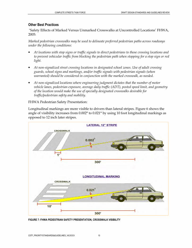
FHWA Pedestrian Safety Presentation:
Longitudinal markings are more visible to drivers than lateral stripes. Figure 6 shows the angle of visibility increases from 0.002° to 0.021° by using 10 foot longitudinal markings as opposed to 12 inch later stripes.
FIGURE 7: FHWA PEDESTRIAN SAFETY PRESENTATION, CROSSWALK VISIBILITY

COMPLETE STREETS TASK FORCE DRAFT DESIGN STANDARDS AND GUIDELINES REVIEW
CSTF_PRIORITYSTANDARDS&GUIDELINES_V6.DOCX 11
Landscape Buffer Width
AASHTO/FHWA Guidelines
AASHTO – Geometric Design of Highways and Streets ‘Chapter 4: Cross Section Elements: Sidewalks’:
The width of a planted strip between the sidewalk and traveled-way curb, if provided, should be a minimum of 2 feet to allow for maintenance activities.
FHWA – Designing Sidewalks and Trails for Access ‘Chapter 4: Sidewalk Corridors’:
The minimum width of the planter/furniture zone (see Figure 8) should be 2 feet (4 feet if planting trees).
FIGURE 8: FHWA. SIDEWALK CORRIDOR: THE ZONE SYSTEM
State of Hawaii Standard
When trees are installed in the landscape buffer, the width is to be two times the diameter of the root ball with a distance of 5 feet on either side of the trunk to the curb and the sidewalk. See Figure 9.

COMPLETE STREETS TASK FORCE DRAFT DESIGN STANDARDS AND GUIDELINES REVIEW
CSTF_PRIORITYSTANDARDS&GUIDELINES_V6.DOCX 12
FIGURE 9: STATE OF HAWAII, HIGHWAYS DIVISION STANDARD PLANS, 2008: STANDARD PLAN L-08, LANDSCAPE DETAILS, ROOT BARRIER DETAIL
Local Standard Examples
County of Hawaii - The County of Hawaii standard details show a typical cross section for a street with a sidewalk as having a grass area between the curb and the sidewalk. (See Figure 10) However, the width of the grass area is not specified.

COMPLETE STREETS TASK FORCE DRAFT DESIGN STANDARDS AND GUIDELINES REVIEW
CSTF_PRIORITYSTANDARDS&GUIDELINES_V6.DOCX 13
FIGURE 10: COUNTY OF HAWAII, STANDARD DETAILS, 1984: STANDARD DETAIL R-34, ROAD PAVEMENT AND SHOULDERS, HALF SECTION OF STREET WITH SIDEWALK
City and County of Honolulu - The City and County of Honolulu’s Subdivision Street Standards show roadway details having 10 feet planting strips between the curb and the sidewalk on both side of the road. (See Figure 11) The width of a planting strip could be 4 feet on private streets.
FIGURE 11: CITY AND COUNTY OF HONOLULU SUBDISION STREET STANDARDS, 2000: APPENDIX A, TO THE SUBDIVISION STREET STANDARDS

COMPLETE STREETS TASK FORCE DRAFT DESIGN STANDARDS AND GUIDELINES REVIEW
CSTF_PRIORITYSTANDARDS&GUIDELINES_V6.DOCX 14
Street Tree Placement
FHWA Guidelines
FHWA Report: Designing Sidewalks and Trail for Access (1999):
• Trees need a minimum of 4 feet x 4 feet planting area.
• Trees should be chosen with care for their branch patterns, leaf and fruit litter (some fruits and leaves are slippery when dropped).
• Plant trees whose roots tend to grow down rather than out or use root control systems to guide the direction of growth.
• Use tree gratings or planting strips to allow enough water to reach roots. When trees do not get enough water they tend to spread their roots out, which can break up the surface of the sidewalk. See Figure 12.
• Avoid planting trees near intersections because they may decrease visibility between pedestrians and drivers.
• Trim tree branches regularly to less than 80 inches or place trees far enough apart for roots and the trunk to grow and provide open space for food, air, and water.

COMPLETE STREETS TASK FORCE DRAFT DESIGN STANDARDS AND GUIDELINES REVIEW
CSTF_PRIORITYSTANDARDS&GUIDELINES_V6.DOCX 15
FIGURE 12: FHWA. TREE GRATES
State of Hawaii Standard
The State of Hawaii Department of Transportation standard plans show the details of a street tree planting in a grate. (See Figure 13) The tree grate is to be set flush with surrounding paving (i.e. top of curb).

COMPLETE STREETS TASK FORCE DRAFT DESIGN STANDARDS AND GUIDELINES REVIEW
CSTF_PRIORITYSTANDARDS&GUIDELINES_V6.DOCX 16
FIGURE 13: STATE OF HAWAII, HIGHWAYS DIVISION STANDARD PLANS, 2008: STANDARD PLAN L-02, STREET PLANTING, STREET TREE PLANTING IN GRATE TREE DETAIL
Local Standard Examples
City and County of Honolulu – The City and County of Honolulu Standards and Procedures for the Planting of Street Trees (1999) provides standards on tree spacing, minimum tree size, and tree location etc. (See Figure 14)
A street tree planting detail is shown in Figure 15. A detail of street tree planting with cover is also included in the Standards.

COMPLETE STREETS TASK FORCE DRAFT DESIGN STANDARDS AND GUIDELINES REVIEW
CSTF_PRIORITYSTANDARDS&GUIDELINES_V6.DOCX 17
FIGURE 14: CITY AND COUNTY OF HONOLULU, STANDARDS AND PROCUDURES FOR THE PLANTING OF STREET TREES, JULY 1999

COMPLETE STREETS TASK FORCE DRAFT DESIGN STANDARDS AND GUIDELINES REVIEW
CSTF_PRIORITYSTANDARDS&GUIDELINES_V6.DOCX 18
FIGURE 15: CITY AND COUNTY OF HONOLULU, STANDARDS AND PROCUDURES FOR THE PLANTING OF STREET TREES, JULY 1999

COMPLETE STREETS TASK FORCE DRAFT DESIGN STANDARDS AND GUIDELINES REVIEW
CSTF_PRIORITYSTANDARDS&GUIDELINES_V6.DOCX 19
Hawaii Electric Company Inc. (HECO) – HECO has the following guidelines in regards to planting trees near overhead lines and near underground lines:
Planting Trees Near Overhead Lines
Tall trees that can contact wires, poles or equipment should not be planted near overhead lines. Trees contacting overhead electric lines can cause electric service outages and may pose safety hazards. Trees and shrubs also block physical and visual access to poles and equipment for inspection, maintenance and repair. As a result, tall trees must occasionally be pruned, which increases operating and maintenance costs.
Guide to help select the right trees for planting near overhead lines:
� Trees that mature at heights below 20’ may be planted under lines; � Trees that mature at heights 20’ to 30’ should be planted at least 10’ horizontally from
overhead lines; � Taller, columnar trees (e.g. palms, Formosa koa (Acacia confusa)) should not be planted
closer than 15’ horizontally from overhead lines; � Taller trees with spreading crowns that mature at heights greater than 30’ should be planted
at least 30’ horizontally from overhead lines. Planting Trees Near Underground Lines
Large trees and/or trees with invasive roots must not be planted over or near underground lines. Invasive roots can infiltrate electrical conduits and create electrical service outages and hazards. The weight of large trees over underground lines can crush the electrical conduit, thus resulting in costly repairs and interruption or disturbance of electric service to customers and the general public. Future maintenance and/or excavation of the underground lines can result in severe tree damage or may require the removal of the trees planted too close to the lines. In addition, irrigation water can transport salt from fertilizers and corrode underground line connections resulting in electric service outages.
Guide to help select the right tree for planting near underground lines:
� Always locate and identify all underground utilities prior to performing any digging. Do so by contacting the Hawaii One Call Center at 811;
� Do not plant any trees or shrubs directly over underground electric lines; � As a rule, plant the tree or shrub far away from the underground line so that the tree or shrub
crown, at maturity, does not extend over the underground line.

COMPLETE STREETS TASK FORCE DRAFT DESIGN STANDARDS AND GUIDELINES REVIEW
CSTF_PRIORITYSTANDARDS&GUIDELINES_V6.DOCX 20
Bicycle Lane Width
AASHTO/FHWA Guidelines
AASHTO Guide for the Development of Bicycle Facilities (1999) guidelines:
For roadways with curb and gutter, the recommended width of a bike lane is 5 feet from the face of curb to the bike lane stripe. The 5 foot width should be sufficient in cases where a 1-2 foot wide concrete gutter pan exists, given that a minimum of 3 feet of ridable surface is provided, and the longitudinal joint between the gutter pan and pavement surface is smooth.
The width of the gutter pan should not be included in the measurement of the ridable or usable surface, with the possible exception of those communities that use an extra wide, smoothly pave gutter pan that is 4 feet wide as a bike lane. If the joint is not smooth, 4 feet of ridable surface should be provided.
For roadways with no curb and gutter, the minimum width of a bike lane should be 4 feet. For roadways in outlying areas with no curb and gutter, infrequent parking is handled off the pavement and bike lanes should be located within the limits of the paved shoulder at the outside edge. Bike lanes may have a minimum width of 4 feet, where area beyond the paved shoulder can provide additional maneuvering width. A width of 5 feet or greater is preferable and additional widths are desirable where substantial truck traffic is present, or where motor vehicle speeds exceed 50mph.
If parking is permitted, the bike lane should be placed between the parking area and the travel lane and have a minimum width of 5 feet. Where parking is permitted but a parking stripe or stalls are not utilized, the shared area should be a minimum of 11 feet without a curb face and 12 feet adjacent to a curb face. If the parking volume is substantial or turnover is high, an additional 1 to 2 feet of width is desirable.

COMPLETE STREETS TASK FORCE DRAFT DESIGN STANDARDS AND GUIDELINES REVIEW
CSTF_PRIORITYSTANDARDS&GUIDELINES_V6.DOCX 21
FIGURE 16: AASHTO GUIDE FOR THE DEVELOPMENT OF BICYCLE FACILITIES: TYPICAL BIKE LANE CROSS SECTIONS

COMPLETE STREETS TASK FORCE DRAFT DESIGN STANDARDS AND GUIDELINES REVIEW
CSTF_PRIORITYSTANDARDS&GUIDELINES_V6.DOCX 22
FHWA Guidelines
FHWA Selecting Roadway Design Treatments to Accommodate Bicycles (1994) guidelines:
In Tables 1 through 6, recommendations are provided for the width of the various recommended design treatments. These recommended dimensions are considered to be "desirable widths." They should be treated as "minimum widths" unless special circumstances preclude such development. Any treatment specifically designated for bicycle use must meet the minimum design standards called for in the AASHTO Guide or the appropriate State standard. Bike lane widths vary between 5 and 6 feet. See ‘Bikeway Location’ section for more details.
State of Hawaii Standard
The 2003 State of Hawaii Bike Plan requires a minimum bike lane width of 4 feet and a preferred bike lane width of 5 feet for lanes exclusive of the gutter pan and curb. (See Figure 17) A 5 foot width is required for lanes adjacent to barrier curb, other static obstructions on the side of the roadway or on-street parking. The minimum width for combining a bike lane and parking is 13 feet.
Local Standard Examples
City and County of Honolulu - The City and County of Honolulu Subdivision Street Standards require a minimum bike lane width of 6 feet with or without gutter.
County of Maui – The County of Maui requires a minimum bike lane width of 4 feet. Typically, 5 feet bike lane is preferred.

COMPLETE STREETS TASK FORCE DRAFT DESIGN STANDARDS AND GUIDELINES REVIEW
CSTF_PRIORITYSTANDARDS&GUIDELINES_V6.DOCX 23
FIGURE 17: 2003 STATE OF HAWAII BIKE PLAN. FIGURE 7-5, DETAILS OF BIKE LANE STRIPING AND STENCILS
Other Best Practices
From Portland Department of Transportation (PDOT) Bicycle Master Plan:
PDOT’s preferred standards for bicycle lane dimensions are as follows:
For a bicycle lane adjacent to curb or parking:
• 5 foot preferred width
Bicycle lane widths of 6 feet maximum may be desirable when one or a combination of the following conditions exists:

COMPLETE STREETS TASK FORCE DRAFT DESIGN STANDARDS AND GUIDELINES REVIEW
CSTF_PRIORITYSTANDARDS&GUIDELINES_V6.DOCX 24
• traffic volumes and speeds are high
• adjacent parking use and turnover is high
• catch basin grates, gutter joints, and other features in the bicycle lane may present an obstacle to cyclists
• steep grades exist
• truck volumes are high
• bicycle volumes are high
Bicycle lane widths of 4 feet minimum may be acceptable when:
• physical constraints exist, for a segment of less than 1 mile that links to existing bikeways on both ends
• implemented in conjunction with traffic calming devices (see section B7)
• adjacent to parking with [very] low use and turnover
• adjacent to an uncurbed street shoulder
Additionally, for on-street parking, PDOT recommends that there be an 8 foot preferred (7 foot minimum) parking area width adjacent to the bicycle lane.
PDOT recommends that the travel lane width adjacent to a bicycle lane be 11 foot (10 foot minimum). A four-foot bicycle lane should not be used in combination with a 7 foot parking lane and/or a 10 foot travel lane.
Bikeway Location
There are many factors to consider when determining a bikeway location, such as:
• traffic volume
• average motor vehicle operating speed
• traffic mix
• on-street parking
• sight distance
• topography
• number of intersections
FHWA provides guidance on selecting roadway design treatments to accommodate bicycles. The cross sections shown in Figure 18 illustrate different type of bike facilities with the FHWA tables to follow.

COMPLETE STREETS TASK FORCE DRAFT DESIGN STANDARDS AND GUIDELINES REVIEW
CSTF_PRIORITYSTANDARDS&GUIDELINES_V6.DOCX 25
Wide Curb Lane/Shared Lane
Shoulder Lane
Bike Lane
FIGURE 18: ROADWAY CROSS SECTIONS WITH DIFFERENT TYPE OF BIKE FACILITIES
Wide Curb
Lane/Shared
Lane
Wide Curb
Lane/Shared
Lane

COMPLETE STREETS TASK FORCE DRAFT DESIGN STANDARDS AND GUIDELINES REVIEW
CSTF_PRIORITYSTANDARDS&GUIDELINES_V6.DOCX 26
FHWA Guidelines
FHWA Selecting Roadway Design Treatments to Accommodate Bicycles (1994) guidelines:
Recommended roadway design treatments and widths to accommodate bicycles are presented in Tables 1 through 6. There are separate tables for group A and group B/C bicyclists. Group A cyclists are advanced riders that are experienced and can operate under most traffic conditions. Group B/C cyclists are basic riders/children that are less confident of the ability to operate in traffic and prefer low-speed, low traffic-volume roadways. The design treatments for group A bicyclists should be used as a guide to the minimum design for any roadway on which bicycle use is permitted. The recommended design treatments for group B/C bicyclists should be considered the desirable design for any route on which this type of bicyclist is likely to ride.
There are separate tables for the two basic types of roadway sections: urban (with curb and gutter) and rural (without curb and gutter). Separate tables are provided for highways with urban sections with on-street parking and with no on-street parking.
The tables indicate the appropriate design treatment given various sets of traffic operations and design factors. The tables do not include any specific recommendations for separate bike paths. The use of separate bike paths depends on specific right-of-way conditions (e.g., very few intersections, adequate set-back) that do not exist along most highways. These conditions are most often found along parkways, river and lake shores, in park and recreation areas, on abandoned railroad rights of way, and on the right of way of some controlled-access freeways. Where such suitable conditions exist, separate bike paths can be pleasant additions to the facilities available to bicyclists. However, they cannot take the place of access to the roadway of the street and highway system.

COMPLETE STREETS TASK FORCE DRAFT DESIGN STANDARDS AND GUIDELINES REVIEW
CSTF_PRIORITYSTANDARDS&GUIDELINES_V6.DOCX 27
TABLE 1 FHWA SELECTING ROADWAY DESIGN TREATMENTS TO ACCOMMODATE BICYCLES: GROUP A BICYCLIST, URBAN SECTION, NO PARKING

COMPLETE STREETS TASK FORCE DRAFT DESIGN STANDARDS AND GUIDELINES REVIEW
CSTF_PRIORITYSTANDARDS&GUIDELINES_V6.DOCX 28
TABLE 2 FHWA SELECTING ROADWAY DESIGN TREATMENTS TO ACCOMMODATE BICYCLES: GROUP A BICYCLIST, URBAN SECTION, WITH PARKING
TABLE 3 FHWA SELECTING ROADWAY DESIGN TREATMENTS TO ACCOMMODATE BICYCLES: GROUP A BICYCLIST, RURAL SECTION
TABLE 4 FHWA SELECTING ROADWAY DESIGN TREATMENTS TO ACCOMMODATE BICYCLES: GROUP B/C BICYCLISTS, NO PARKING

COMPLETE STREETS TASK FORCE DRAFT DESIGN STANDARDS AND GUIDELINES REVIEW
CSTF_PRIORITYSTANDARDS&GUIDELINES_V6.DOCX 29
TABLE 5 FHWA SELECTING ROADWAY DESIGN TREATMENTS TO ACCOMMODATE BICYCLES: GROUP B/C BICYCLISTS, URBAN SECTION, WITH PARKING
TABLE 6 FHWA SELECTING ROADWAY DESIGN TREATMENTS TO ACCOMMODATE BICYCLES: GROUP B/C BICYCLISTS, RURAL SECTION

COMPLETE STREETS TASK FORCE DRAFT DESIGN STANDARDS AND GUIDELINES REVIEW
CSTF_PRIORITYSTANDARDS&GUIDELINES_V6.DOCX 30
State of Hawaii Standard
State of Hawaii Bike Plan:
Selecting the most appropriate type of bikeway is dependent on many factors, including the targeted user group(s), specific corridor conditions, potential impacts, and facility costs. The FHWA has developed procedures to assist transportation professionals in making appropriate recommendations for on-road bicycle facilities in its publication Selecting Roadway Design Treatments to Accommodate Bicycles. This document includes tables that suggest appropriate design treatments given various factors related to traffic operation and design and the environment. (See ‘FHWA Guidelines’ section above). HDOT routinely incorporates recommendations derived from this document into the bikeway planning and engineering process.
Key parameters that need to be considered when identifying and evaluating roadway treatments to better accommodate bicycling include the following:
User Groups. The intended user needs are identified based on the three types of bicycle users: A-Advanced, B-Basic, and C-Children. Group A riders can generally be accommodated on the majority of roadways by making these facilities more “bicycle friendly.” Group B/C riders can generally be accommodated by identifying select travel corridors (often those with lower traffic demands or lower speeds) and by providing designated bicycle facilities on these routes.
Environment. Urban and rural settings may need different design treatments to appropriately reflect their surroundings.
On-street Parking. The presence of on-street parking increases the width needed in the adjacent travel lane or bike lane to accommodate bicycles. Extended mirrors, inadequate sight lines, and opening car doors can pose potential hazards for bicyclists.
Traffic Volume. Roadways with relatively higher traffic volumes generally represent greater potential risk for bicyclists. Frequent passing and overtaking situations are less comfortable for Group B/C bicyclists unless special design treatments are provided.
Traffic Speed. The average operating speed is more important than the posted speed limit. Wind turbulence caused by higher speed levels can cause bicyclists traveling within the roadway to become unstable and lose control.
Heavy Vehicles. The regular presence of trucks and buses can increase risk and have a negative impact on the comfort of bicyclists. At high speeds, the wind blast from such vehicles can increase the risk of falls. Even at lower operating speeds, shared lane use is less compatible. Bicyclists prefer extra roadway width to accommodate greater separation from such vehicles.
Other Parameters. Other parameters that need to be considered may include curb-cut (driveway) frequency, high crash locations, rumble strips, and grade. Each roadway is unique, and proper measures need to be taken to identify all potential obstacles and opportunities for bicycle travel. For off-road facilities, considerations include landownership, conditions of use, surrounding land uses, and environmental resources.
Local Standard Examples
State of Hawaii Bike Plan:
Objectives of bikeway proposals for the Island of Kauai:

COMPLETE STREETS TASK FORCE DRAFT DESIGN STANDARDS AND GUIDELINES REVIEW
CSTF_PRIORITYSTANDARDS&GUIDELINES_V6.DOCX 31
• Except where bicycling will be prohibited, include bicycle facilities in new roadway construction and during rehabilitation of existing roadways.
• Develop a circumferential bikeway facility along the existing highways.
• Identify scenic routes along existing highways and off-highway corridors to promote areas of safe, comfortable, and attractive bike rides.
• Develop designated bike lanes in communities with relatively high populations or smaller communities with high through-traffic volumes.
• Identify opportunities to incorporate former cane haul roads and other backroads into the bikeway network.
• Where appropriate, provide non-motorized access to the island’s ecologically and culturally important sites.
Objectives of bikeway proposals for the Island of Oahu:
• Except where bicycling will be prohibited, include bicycle facilities in new roadway construction and during rehabilitation of existing roadways.
• Develop a circumferential bikeway along existing highways, including Farrington Highway, Kamehameha Highway, Kalanianaole Highway, Ala Moana Boulevard, and Nimitz Highway.
• Identify scenic routes along existing highways and off-highway corridors to promote areas of safe, comfortable, and attractive bike rides.
• Develop designated bike lanes within communities with high through-traffic volumes. Where bike lanes are not provided on collector roads and arterials, encourage the installation of 14-foot curb lanes.
• Identify routes that promote bicycle commuting and interregional travel.
Objectives of bikeway proposals for the Island of Maui:
• Except where bicycling will be prohibited, include bicycle facilities in new roadway construction and during rehabilitation of existing roadways.
• Develop a circumferential bikeway facility along the existing highways.
• Identify scenic routes along existing highways and off-highway corridors to promote areas of safe, comfortable, and attractive bike rides.
• Develop designated bike lanes within certain communities/districts (e.g., between Wailuku and Kahului) with relatively large populations or smaller communities with high through traffic volumes (e.g., Kihei and Paia).
Objectives of bikeway proposals for the Island of Molokai:
• Except where bicycling will be prohibited, include bicycle facilities in new roadway construction and during rehabilitation of existing roadways.
• Develop bikeway facilities along the existing highways.

COMPLETE STREETS TASK FORCE DRAFT DESIGN STANDARDS AND GUIDELINES REVIEW
CSTF_PRIORITYSTANDARDS&GUIDELINES_V6.DOCX 32
• Identify scenic routes along existing highways to promote areas of safe, comfortable, and attractive bike rides.
Objectives of bikeway proposals for the Island of Lanai:
• Except where bicycling will be prohibited, include bicycle facilities in new roadway construction and during rehabilitation of existing roadways.
• Develop bikeway facilities along the existing highways.
• Identify scenic routes along existing highways to promote areas of safe, comfortable, and attractive bike rides.
Objectives of bikeway proposals for the Island of Hawaii:
• Except where bicycling will be prohibited, include bicycle facilities in new roadway construction and during rehabilitation of existing roadways.
• Develop a circumferential bikeway facility along the existing highways.
• Identify scenic routes along existing highways (e.g., Hawaii Belt Road, Queen Kaahumanu Highway, Mamalahoa Highway) and off-highway corridors to promote areas of safe, comfortable, and attractive bike rides.
• Develop designated bike lanes (e.g., Ali`i Drive, Kuakini Highway) with higher density communities or smaller communities with high volumes of through traffic (Waimea).
• Consider utility easements, abandoned railroad rights-of-way, and old government roads as potential corridors for shared use paths.
• Improve connectivity and access between subdivisions by linking dead-end streets with pathways for bicycle and foot traffic.
City and County of Honolulu – The City and County of Honolulu Subdivision Street Standards require a bike lane on both sides of an arterial and on both sides of a collector serving more than 1000 dwelling units.
Other Best Practices
Portland Bikeway Facility Design: Survey of Best Practices (Portland Bicycle Plan for 2030, Appendix D):
Application of bike lanes:
• On roadways with ≥3,000 motor vehicle trips per day
• Any street with excessive curb to curb space where bike lanes could help reduce vehicle lane widths.
Application of narrow width shared roadway:
• Low traffic residential street with a mixed profile for bicycle and motor vehicle traffic.
1996 Portland Bicycle Plan:

COMPLETE STREETS TASK FORCE DRAFT DESIGN STANDARDS AND GUIDELINES REVIEW
CSTF_PRIORITYSTANDARDS&GUIDELINES_V6.DOCX 33
FIGURE 19: 1996 PORTLAND BICYCLE PLAN. TABLE 3.2: GUIDELINES FOR SELECTING BIKEWAY FACILITIES
Bicycle Intersection Design
MUTCD Standard/AASHTO Guidelines
MUTCD ‘Section 4C.04: Markings For Bicycle Lanes’ standard:
A through bicycle lane shall not be positioned to the right of a right-turn or to the left of a left turn only lane.
MUTCD ‘Section 4C.04: Markings For Bicycle Lanes’ support:
A bicyclist continuing straight through an intersection from the right of a right-turn lane or from the left of a left-turn lane would be inconsistent with normal traffic behavior and would violate the expectations of right- or left-turning motorists.
MUTCD ‘Section 4C.04: Markings For Bicycle Lanes’ guidance:
When the right through lane is dropped to become a right turn only lane, the bicycle lane markings should stop at least 100 feet before the beginning of the right-turn lane. Through bicycle lane markings should resume to the left of the right turn only lane.
An optional through-right turn lane next to a right turn only lane should not be used where there is a through bicycle lane. If a capacity analysis indicates the need for an optional through-right lane, the bicycle lane should be discontinued at the intersection approach.

COMPLETE STREETS TASK FORCE DRAFT DESIGN STANDARDS AND GUIDELINES REVIEW
CSTF_PRIORITYSTANDARDS&GUIDELINES_V6.DOCX 34
FIGURE 20: MUTCD FIGURE 9-C1. EXAMPLE OF INTERSECTION PAVEMENT MARKINGS – DESIGNATED BICYCLE LANE WITH LEFT-TURN AREA, HEAVY TURN VOLUMES, PARKING, ONE-WAY TRAFFIC, OR DIVIDED HIGHWAY

COMPLETE STREETS TASK FORCE DRAFT DESIGN STANDARDS AND GUIDELINES REVIEW
CSTF_PRIORITYSTANDARDS&GUIDELINES_V6.DOCX 35
FIGURE 21: MUTCD FIGURE 9-C6 EXAMPLE OF INTERSECTION PAVEMENT MARKINGS – DESIGNATED BICYCLE LANE WITH LEFT-TURN AREA, HEAVY TURN VOLUMES, PARKING, ONE-WAY TRAFFIC, OR DIVIDED HIGHWAY

COMPLETE STREETS TASK FORCE DRAFT DESIGN STANDARDS AND GUIDELINES REVIEW
CSTF_PRIORITYSTANDARDS&GUIDELINES_V6.DOCX 36
AASHTO Guide for the Development of Bicycle Facilities (1999) guidelines:
Bike lane striping should not be installed across any pedestrian crosswalks, and, in most cases, should not continue through any street intersections. The striping should stop at the near side cross street property line extended and then resume at the far side property line extended if there are no painted crosswalks. However, dotted guidelines may be extended through complex intersections.
At signalized or stop-controlled intersections with right-turning motor vehicles, the solid striping to the approach should be replaced with a broken line with 2-foot dots and 6-foot spaces. The length of the broken line section is usually 50 to 200 feet.
At non-signalized minor intersections with no stop controls, solid bike lane striping can continue all the way to the crosswalk on the near side of the intersection since there are usually small volumes of right-turning motor vehicles.
At T-intersections with no painted crosswalks, the bike lane striping on the side across from the T-intersection should continue through the intersection area with no break. If there are painted crosswalks, the bike lane striping on the side across from the T-intersection should be discontinued only at the crosswalks. (See Figure 22)

COMPLETE STREETS TASK FORCE DRAFT DESIGN STANDARDS AND GUIDELINES REVIEW
CSTF_PRIORITYSTANDARDS&GUIDELINES_V6.DOCX 37
FIGURE 22: AASHTO GUIDE FOR THE DEVELOPMENT OF BICYCLE FACILITIES: TYPICAL BIKE LANE STRIPING AT T-INTERSECTIONS
At intersections, bicyclists proceeding straight through and motorists turning right must cross paths. Striping and signing configurations which encourage crossings in advance of the intersection are preferable to those that force the crossing close to the intersection. The same is true for left-turning bicyclists. Most vehicle codes allow the bicyclist the option of making either a “vehicular style” left turn (where the bicyclist merges leftward to the same lane used for motor vehicle left turns) or a “pedestrian style” left turn (where the bicyclist proceeds straight through the intersection, turns left at the far side, then proceeds across the intersection again on the cross street). (See Figure 23) A separate bicycle left-turn lane can be considered where there are numerous left turning bicyclists.

COMPLETE STREETS TASK FORCE DRAFT DESIGN STANDARDS AND GUIDELINES REVIEW
CSTF_PRIORITYSTANDARDS&GUIDELINES_V6.DOCX 38
FIGURE 23: AASHTO GUIDE FOR THE DEVELOPMENT OF BICYCLE FACILITIES: TYPICAL BICYCLE AND AUTO MOVEMENTS AT MAJOR INTERSECTIONS
Where a bike lane approaches a motorist right-turn-only lane, several options are available. (See Figure 24) The design of bike lanes should also include appropriate signing at intersections to warn of conflicts. The approach shoulder width should be provided through the intersection, where feasible, to accommodate right-turning bicyclists or bicyclists who prefer to use crosswalks to negotiate the intersection.

COMPLETE STREETS TASK FORCE DRAFT DESIGN STANDARDS AND GUIDELINES REVIEW
CSTF_PRIORITYSTANDARDS&GUIDELINES_V6.DOCX 39
FIGURE 24: AASHTO GUIDE FOR THE DEVELOPMENT OF BICYCLE FACILITIES: BIKE LANES APPROACHING RIGHT-TURN-ONLY LANES
Intersections with throat widening at approaches that provide an exclusive left-turn bay can also provide an exclusive right-turn lane for motor vehicles. The bike lane striping should be discontinued following a regulatory sign in situations where widening has reduced the available pavement width

COMPLETE STREETS TASK FORCE DRAFT DESIGN STANDARDS AND GUIDELINES REVIEW
CSTF_PRIORITYSTANDARDS&GUIDELINES_V6.DOCX 40
below the minimum requirements for bike lane operation and it is not possible to widen the pavement. Bicyclist proceeding straight through the intersection should be directed to merge with motor vehicle traffic to cross the intersection. (See Figure 25)
FIGURE 25: AASHTO GUIDE FOR THE DEVELOPMENT OF BICYCLE FACILITIES: BIKE LANE APPROACHING AN INTERSECTION WITH THROAT WIDENING

COMPLETE STREETS TASK FORCE DRAFT DESIGN STANDARDS AND GUIDELINES REVIEW
CSTF_PRIORITYSTANDARDS&GUIDELINES_V6.DOCX 41
State of Hawaii Standard
State of Hawaii Bike Plan:
At intersections with exclusive right-turn lanes, the bike lane should continue along the left side of the right-turn lane (see Figure 26). In addition, the approach shoulder width should continue through the intersection, where feasible, to accommodate right-turning bicyclists or bicyclists who prefer to use crosswalks. The solid striping to the approach should be replaced with a broken line consisting of 2-foot dashes and 6-foot spaces. The length of the broken line section is usually 50 to 200 feet.
When significant bicycle volumes are present, a left-turn bike lane may be provided, in which case it should be located to the right of the right-most left-turn only lane. (See Figure 26)
FIGURE 26: 2003 STATE OF HAWAII BIKE PLAN. FIGURE 7-1 BIKE LANE STRIPING FOR THROUGH TRAVEL AT INTERSECTIONS WITH RIGHT-TURN ONLY LANE AND FIGURE 7-2 STRIPING FOR LEFT-TURN BIKE LANE
Where adequate road space is available, bike lane-type striping through intersections is recommended even in areas with shoulder bikeways or wide curb lanes.
Stencils should be placed after most intersections; this alerts drivers and bicyclists entering the roadway of the exclusive nature of the bike lanes. Stencils should be placed after every intersection where a parking lane is placed between the bike lane and the curb. Supplementary stencils may also be placed at the end of a block to warn cyclists not to enter a bike lane on the wrong side of the road. To prevent premature wear, care must be taken to avoid placing stencils in an area where motor vehicles are expected to cross a bike lane—usually driveways and the area immediately after an intersection.
Figure 27 shows a typical intersection layout, including bike lane striping and placement of stencils and signs. The intersection is made bike friendly by providing space near the traffic islands, as well as pavement markings and signs denoting shared lanes.
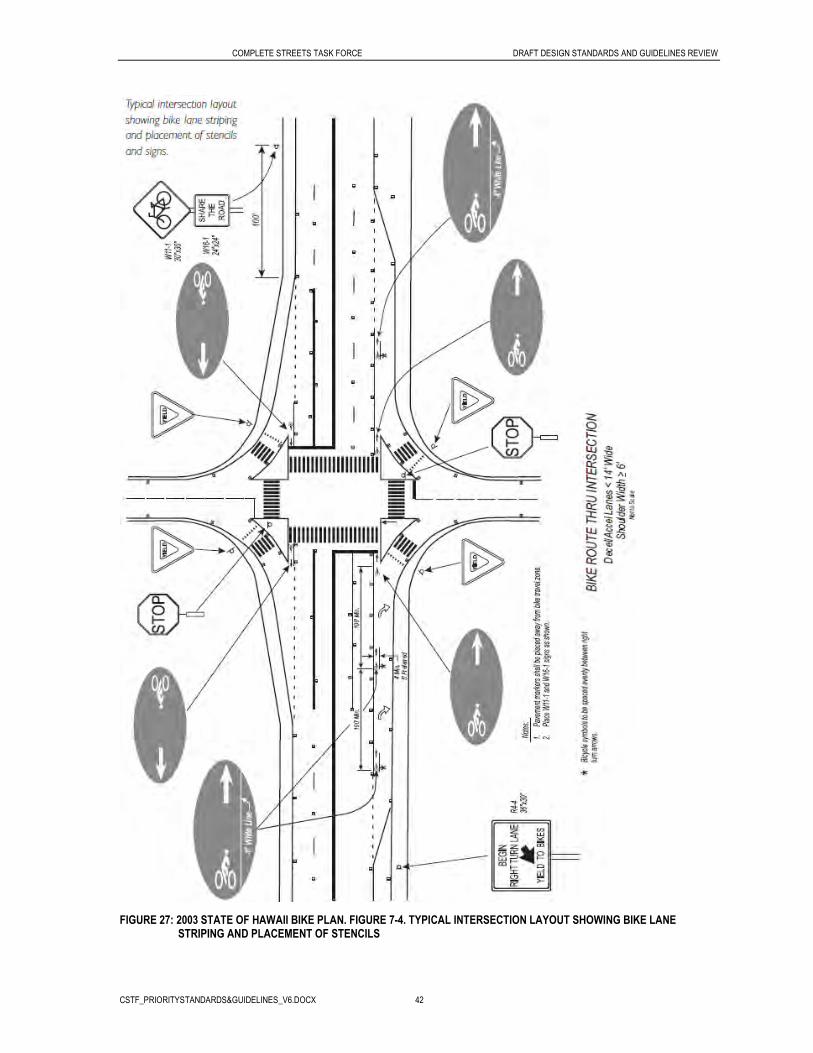
COMPLETE STREETS TASK FORCE DRAFT DESIGN STANDARDS AND GUIDELINES REVIEW
CSTF_PRIORITYSTANDARDS&GUIDELINES_V6.DOCX 42
FIGURE 27: 2003 STATE OF HAWAII BIKE PLAN. FIGURE 7-4. TYPICAL INTERSECTION LAYOUT SHOWING BIKE LANE STRIPING AND PLACEMENT OF STENCILS

COMPLETE STREETS TASK FORCE DRAFT DESIGN STANDARDS AND GUIDELINES REVIEW
CSTF_PRIORITYSTANDARDS&GUIDELINES_V6.DOCX 43
Local Standard Examples
State of Hawaii Bike Plan:
Figure 28 shows an actual example of pavement markings at an intersection involving a right-turn deceleration lane (Kaahumanu Avenue at Kahului Beach Road, Kahului, Maui). While Figure 27 shows a more desirable lane configuration, not all roadways have the option of being designed with a separate deceleration lane. Figure 28 illustrates a way to make the lane drop more “bike friendly,” with pavement markings that make the bicycle travel zone more predictable to motorists and cyclists.
FIGURE 28: 2003 STATE OF HAWAII BIKE PLAN. FIGURE 7-3. EXAMPLE OF BIKE LANE WITH DEDICATED RIGHT-TURN LANE. KAAHUMANU AVENUE, KAHULUI, MAUI
Figure 29 shows a bicycle box located in Honolulu that allows bicycles to get in front of queues at traffic signals and make the left turn as well as move out of the way of right turning vehicles. The City of Honolulu Bicycle Plan is currently in draft stage.

COMPLETE STREETS TASK FORCE DRAFT DESIGN STANDARDS AND GUIDELINES REVIEW
CSTF_PRIORITYSTANDARDS&GUIDELINES_V6.DOCX 44
FIGURE 29: ST. LOUIS DRIVE AND WAIALAE AVENUE, HONOLULU, HA. SOURCE: CH2M HILL
Other Best Practices
1996 Portland Bicycle Plan:
Basic principles to be followed when designing intersections are:
• Unusual conflicts should be avoided.
• Intersection design should create a path for bicyclists that is direct, logical and as close to the path of motor vehicle traffic as possible.
• Bicyclists following the intended trajectory should be visible and their movements should be predictable.
• Potential safety problems associated with the difference between auto and bicycle speeds should be minimized.
Simple right angle intersections are usually the simplest to treat for bicycle movement. Bicyclists must be allowed to follow a path that is as direct as possible, using the following techniques:
• Bicycle lanes should be striped to a marked or unmarked crosswalk.
• The bicycle lane stripe should be a solid stripe all the way to the crosswalk.
• The lanes should resume at the other side of the intersection.
COMPLETE STREETS TASK FORCE DRAFT DESIGN STANDARDS AND GUIDELINES REVIEW
CSTF_PRIORITYSTANDARDS&GUIDELINES_V6.DOCX 45
Intersections with multiple streets entering from different angles can create confusion for users. Such intersections should be avoided and designed instead as simple right angle intersections whenever possible. For an already existing complicated intersection, or if a complex intersection is absolutely needed, bicycle lanes may be striped with dashes to guide bicyclists through a long undefined area.
Right-turn lanes present special problems for cyclists because right-turning cars and through bicyclists must cross paths. To alleviate these concerns, the design in Figure 30 should be used for bicycle lanes. The paths of the through bicyclist and the right-turning motor vehicle should cross prior to the intersection.
This configuration has three advantages:
• It allows this conflict to occur away from the intersection where other conflicts could occur.
• The difference in travel speeds is an advantage, as a motor vehicle driver can pass a bicyclist rather than ride side-by-side.
• All users are encouraged to follow the rules of the road: through vehicles (including bicyclists) proceed to the left of right-turning vehicles.
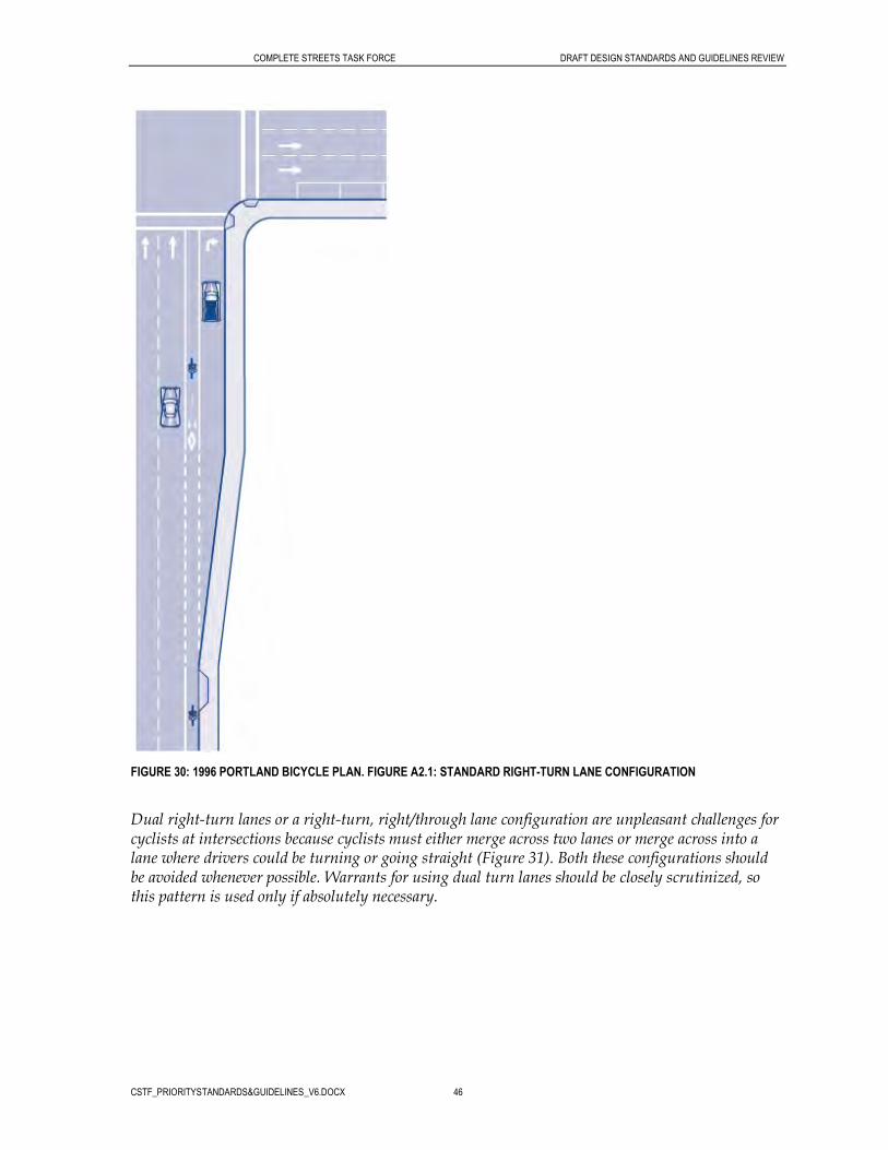
COMPLETE STREETS TASK FORCE DRAFT DESIGN STANDARDS AND GUIDELINES REVIEW
CSTF_PRIORITYSTANDARDS&GUIDELINES_V6.DOCX 46
FIGURE 30: 1996 PORTLAND BICYCLE PLAN. FIGURE A2.1: STANDARD RIGHT-TURN LANE CONFIGURATION
Dual right-turn lanes or a right-turn, right/through lane configuration are unpleasant challenges for cyclists at intersections because cyclists must either merge across two lanes or merge across into a lane where drivers could be turning or going straight (Figure 31). Both these configurations should be avoided whenever possible. Warrants for using dual turn lanes should be closely scrutinized, so this pattern is used only if absolutely necessary.

COMPLETE STREETS TASK FORCE DRAFT DESIGN STANDARDS AND GUIDELINES REVIEW
CSTF_PRIORITYSTANDARDS&GUIDELINES_V6.DOCX 47
FIGURE 31: 1996 PORTLAND BICYCLE PLAN. FIGURE A2.4: BIKE LANE THROUGH DUAL RIGHT-TURN LANES
At intersections, bicycle traffic should be considered in the timing of the traffic signal and vehicle detection. Consideration should be given to ensure that adequate clearance intervals are provided for bicyclists where appropriate based on analysis by the City of Portland Bureau of Traffic Management. A bicyclist’s speed, perception/reaction time, and intersection geometry should be factored in when the intervals are analyzed.
Where bicycle traffic is channelized such that bicycles can be detected exclusive of the detection of motor vehicles, loop detectors should be use to provide for the needs of bicyclists.
Traffic detectors for traffic-actuated signals should be set to detect bicycles. Loops should be located in bicycle lanes in the bicyclist’s expected path. All signalized locations with vehicular actuation and without bicycle lanes for the left turn and outside through lanes should have pavement markings to

COMPLETE STREETS TASK FORCE DRAFT DESIGN STANDARDS AND GUIDELINES REVIEW
CSTF_PRIORITYSTANDARDS&GUIDELINES_V6.DOCX 48
indicate to bicyclists where they should be to activate signal detection. If the loop is invisible, the pavement marking should be installed; if the loop is visible and bicycle use anticipated to be low (e.g., in a remote location), a pavement marking may not be necessary.
In some cases, the use of pedestrian-actuated buttons may be an alternative to the use of detectors, provided the button can be pushed by a cyclist from the street.
Bus and Service Vehicle Pull Out Lanes
AASHTO Green Book Guidelines
Arterials:
The interface between buses and other traffic can be considerably reduced by providing turnouts on arterials. It is somewhat rare that sufficient right-of-way is available on the lower type arterial streets to permit turnouts in the border area, but advantage should be taken of every opportunity to do so.
To be fully effective, bus turnouts should incorporate:
• A deceleration lane or taper to permit easy entrance to the loading area
• A standing space sufficiently long to accommodate the maximum number of vehicles expected to occupy the space at one time
• A merging lane to enable easy reentry into the traveled way
The deceleration lane should be tapered at an angle flat enough to encourage the bus operator to pull completely clear of the through lane before stopping. Usually it is not practical to provide a length sufficient to permit deceleration from highway speeds clear of the traveled way. A taper of about 5:1, longitudinal to traverse, is a desirable minimum. When the bus stop is on the far side of an intersection, the intersection area may be used at the entry area to the stop.
The loading area should provide about 50 feet of length for each bus. The width should be at least 10 feet and preferably 12 feet. The merging or reentry taper may be more abrupt than the deceleration taper but should not be sharper than 3:1. Where the turnout is on the near side of an intersection, the width of the cross street is usually great enough to provide the needed merging space.
The minimum total length of turnout for a two-bus loading area should be about 180 feet for a midblock location, 150 feet for a near-side location, and 130 feet for a far-side location. These dimensions are based on a loading area width of 10 feet. They should be increased by 13 to 16 feet for a width of 12 feet. Greater lengths of bus turnouts expedite bus maneuvers, encourage full compliance on the part of bus drivers, and lessen interference with through traffic.
Figure 32 shows a bus turnout at a midblock location. The width of the turnout is 10 feet and the length of the turnout, including tapers, is 210 feet. The deceleration and acceleration tapers are 4:1.

COMPLETE STREETS TASK FORCE DRAFT DESIGN STANDARDS AND GUIDELINES REVIEW
CSTF_PRIORITYSTANDARDS&GUIDELINES_V6.DOCX 49
FIGURE 32: AASHTO A POLICY ON GEOMETRIC DESIGN OF HIGHWAYS AND STREETS: EXHIBIT 4-28: MIDBLOCK BUS TURNOUT
State of Hawaii Standard
The State of Hawaii standard plans include a bus bay detail as shown in Figure 33.
FIGURE 33: STATE OF HAWAII, HIGHWAYS DIVISION STANDARD PLANS, 2008: STANDARD PLAN TE-28A, MISCELLANEAOUS PAVEMENT MARKINGS, BUS BAY
FIGURE 34: KAMEHAMEHA HIGHWAY, NORTH SHORE, HI. SOURCE: CH2M HILL

COMPLETE STREETS TASK FORCE DRAFT DESIGN STANDARDS AND GUIDELINES REVIEW
CSTF_PRIORITYSTANDARDS&GUIDELINES_V6.DOCX 50
Local Standard Examples
Section 5-08 of the Hawaii Statewide Uniform Design Manual for Streets and Highways reiterates bus turnout standards found in the AASHTO Green Book.
City and County of Honolulu – The City and County of Honolulu provides the following policies and guidelines for bus bay design:
Bus bays are not desired over curbside operations. Bus bays do not enhance bus transit operations. In fact, bus bays are used to increase traffic flow while sacrificing bus transit operations. Bus bays are designed to give priority to non-transit vehicles. Nonetheless, when the goal is to provide priority to non-transit vehicles bus bays are used as follows: • Areas characterized by high traffic volumes and traffic speeds of up to 40 mph; • Areas where other vehicles have a history of colliding with the rears of stopped buses; • Areas where there are high volumes of buses at peak hours. Bus bays at far-side stops should be placed at signalized intersections so that the signal provides gaps in traffic that permit bus re-entry into the travel lane. Near-side bus bays should be avoided because of conflicts with right-hand turning vehicles and delays in service resulting from the difficulty associated with bus re-entry into the travel lane. Total length of the bus bay should allow for an entrance taper, a deceleration lane, a stopping area, an acceleration lane, and an exit taper. When no bus shelter is used, the sidewalk should be extended to provide an ADA landing pad with a minimum clear length of 8 feet and a minimum clear width of 5 feet. In rural areas where there are no sidewalks, it is desirable to construct an 8-foot sidewalk connection to the location being served, so that if sidewalks are provided in the future, the connection will exist. Drainage structures are not to be located within the bus bay stopping area. Additionally, drainage structures should be kept away from sidewalk or accessible to the shoulder.
Other Best Practices
In one study published in the Transportation Research Board, the effect of bus turnouts on traffic congestion and fuel consumption was analyzed. A simulation model was employed to determine the energy impacts of using bus turnouts. Two sets of computer runs were made. The first one consisted of 80 runs of a single intersection with different values of independent variables. The second consisted of six runs of three different networks. The result was that bus turnouts were found to have some potential for improving the fuel efficiency of the general traffic stream but only at high values of volume-to-capacity ratios, high bus volumes, and long bus-loading times (Effect, 1983).
References
AASHTO. Guide for the Development of Bicycle Facilities, Washington, D.C.: AASHTO, 1999.
Bicycle Master Plan. City of Portland. Office of Transportation. 1996.

COMPLETE STREETS TASK FORCE DRAFT DESIGN STANDARDS AND GUIDELINES REVIEW
CSTF_PRIORITYSTANDARDS&GUIDELINES_V6.DOCX 51
Bike Plan Hawaii. A State of Hawaii Master Plan. Highways Division. Department of Transportation. State of Hawaii. September 2003.
Designing Sidewalks and Trail for Access. U.S. Department of Transportation. Federal Highway Administration. 1999.
Effect of Bus Turnouts on Traffic Congestion and Fuel Consumption. Transportation Research Record No. 901. p. 33-28. Transportation Research Board. Washington, DC. 1983.
Guidelines for Planting Trees Near Overhead and Underground Lines. Hawaii Electric Company Inc. September, 2008.
Manual on Uniform Traffic Control Devices (MUTCD). Federal Highway Administration, National Advisory Committee on Uniform Traffic Control Devices, 2009.
A Policy on Geometric Design of Highways and Streets (Green Book), American Association of State Highway and Transportation Officials, 2004.
Safety Effects of Marked Versus Unmarked Crosswalks at Uncontrolled Locations. FHWA Publication Number HRT-04-100, September 2005.
Selecting Roadway Design Treatments to Accommodate Bicycles (Publication No. FHWA-RD-92-073), Federal Highway Administration, January 1994.
Standard Details for Public Works Construction. Department of Public Works for County of Kauai, City and County of Honolulu, County of Maui, County of Hawaii of the State of Hawaii. September 1984
Standard Plans. State of Hawaii, Department of Transportation, Highways Division, Design Branch. 2008.
Standards and Procedures for the Planting of Street Trees. City and County of Honolulu. July 1999.
Statewide Uniform Design Manual for Streets and Highways. State of Hawaii Department of Transportation. October 1980.
Subdivision Street Standards. Department of Planning and Permitting, City and County of Honolulu. December 2000.

CSTF Input on Complete StreetDesign Guidelines and Standards
# Date Design Standard/Guideline RecommendedFacility-Oriented User-Oriented
Enforcement-Related
Task Force Member/Category
Recommended Source Material Priority
1 3/6/2010 Bicycle facilities - Bike lane standards (minimum width guidelines) X
Janice MarstersBicyclistsTom DinellSeniors/Aging
Chicago Bike Lane Design Guide
San Francisco Design 3
2 3/6/2010Bicycle facilities - Guidance on how to Incorporate bicycle sensitive intersection design
Janice MarsterBicyclistsBryan KimuraHDOT Traffic
San Francisco Design Guidelines Draft 6
3 3/5/2010Bicycle facilities - Location of bikeways (What are the guidelines that should be used to determine the location of a bikeway?) X
Tom DinellSeniors/Aging 3
4 3/5/2010 Bicycle facilities - Maximum cross slope for bikeways XTom DinellSeniors/Aging 0
5 3/7/2010Bicycles - Require the use of bicycle bells so pedestrians can hear them approaching from the rear X
Reg WhiteHighway Users 1
6 3/5/2010 Bicyclists - Rules for turning left or right from a bike lane X XTom DinellSeniors/Aging 0
7 3/10/2010 Bus Stop - Guidance on the location and spacing of bus stops XX (Transit Agency)
Byran KimuraHDOT Traffic 2
8 3/5/2010 Crosswalks - Effective and consistent crosswalk markings X
Tom DinellSeniors/AgingBob WardPedestrians 4
9 3/5/2010Crosswalks - Guidelines for the location of crosswalks (especially near bus stops) X
Tom DinellSeniors/AgingBryan KimuraHDOT Traffic 1
10 3/5/2010Crosswalks - How close should parking vehicles be allowed to park near crosswalks X
Tom DinellSeniors/Aging 0
11 3/5/2010Crosswalks - Installation of illuminated crosswalks (embedded crosswalk markers) X
Dr. Peter FlaschsbartAcademia
A Citizen’s Guide to Better Streets: How to Engage Your Transportation 1
12 3/8/2010Landscape - Establish green drainage requirements, such as bioswales and rain gardens X
Joel KurokawaEnvironment 2
CSTF_Standards_Prioritization_Results.xlsx Page 1 of 3 4/23/2010

CSTF Input on Complete StreetDesign Guidelines and Standards
# Date Design Standard/Guideline RecommendedFacility-Oriented User-Oriented
Enforcement-Related
Task Force Member/Category
Recommended Source Material Priority
13 3/8/2010Landscape - Establish minimum requirements and spacing for landscaping (planter strips, street trees) X
Joel KurokawaEnvironment 3
14 3/5/2010Law related to when a vehicle is to stop for a pedestrian at crosswalks on varying road types (top 3) X
Tom DinellSeniors/Aging 0
15 3/7/2010Parking - Provide parking along thoroughfares for the conveniene of small businesses X
Reg WhiteHighway Users 1
16 3/7/2010 Pedestrian Lighting - Use pedestrian scale lighting XBob WardPedestrians 0
17 3/5/2010Pedestrian Signal Technology - Installation of pedestrian signal facilities at mid-block crosswalks on principle arterials (5-6 lanes) X
Tom DinellSeniors/Aging 1
18 3/8/2010Roadway design - Establish guidelines forf flexible lane width design guidelines dependent on context of the roadway facility X
Joel KurokawaEnvironment 1
19 3/7/2010
Roadway design - prioritize the "Path of Travel" design for Peds/Bicyclists/other non-motorized users over motorized users (examples: facility widths, slopes, etc.) X
Bob WardPedestrians 2
20 3/7/2010
Roadway Facilities - Install Bus and Service Vehicle Pull Out Lanes (and other drop-off lanes - ex. schools) so traffic can continue with minimal disruption X
Reg WhiteHighway UsersKari BenesHealth 3
21 3/7/2010Sidewalks - Separated area for bicycle/skateboard, and powered sidewalk traffic away from pedestrians X X
Reg WhiteHighway Users 0
22 3/12/2010
Sidewalks - Installation of sidewalks in rural areas on shoulders where guardrails exist (should the guardrail be located at the front or back of sidewalk) X
Kari BenesHealth 1
23 3/7/2010Sidewalks and Crosswalks - Employ ADA design and technology features X
Bob WardPedestriansKari BenesHealth 2
24 3/7/2010Sidewalks and Crosswalks - higher awareness and visibility of non-motorized users X X
Bob WardPedestrians 0
25 3/7/2010 Signage - Consistant signage at crosswalks XBob WardPedestrians 1
26 3/10/2010 Signage - Guidance on use of "No U Turn" or "U Turn Okay" signs XByran KimuraHDOT Traffic 0
CSTF_Standards_Prioritization_Results.xlsx Page 2 of 3 4/23/2010
CSTF Input on Complete StreetDesign Guidelines and Standards
# Date Design Standard/Guideline RecommendedFacility-Oriented User-Oriented
Enforcement-Related
Task Force Member/Category
Recommended Source Material Priority
27 3/5/2010Signal Technology - Allow additional time for pedestrians to cross (top 3) X
Tom DinellSeniors/Aging 0
28 3/7/2010Signal Technology - Install state of the art Traffic Signal Synchronization system X
Reg WhiteHighway Users 0
29 3/5/2010Signal Technology - Exclusive pedestrian phase (walk signal for peds only-diagonal crosswalks) X
Tom DinellSeniors/AgingDr. Peter FlaschsbartAcademia 1
30 3/6/2010Signal Technology - Provide marked traffic signal actuator loops that can be triggered by bicyclists X
Janice MarstersBicyclists 0
31 3/5/2010Signal Technology - Provide pedestrian countdown clock at traffic signals X
Dr. Peter FlaschsbartAcademia 3
CSTF_Standards_Prioritization_Results.xlsx Page 3 of 3 4/23/2010
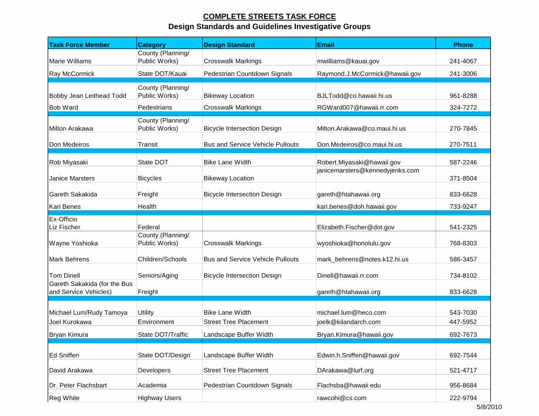
COMPLETE STREETS TASK FORCEDesign Standards and Guidelines Investigative Groups
Task Force Member Category Design Standard Email Phone
Marie WilliamsCounty (Planning/ Public Works) Crosswalk Markings [email protected] 241-4067
Ray McCormick State DOT/Kauai Pedestrian Countdown Signals [email protected] 241-3006
Bobby Jean Leithead ToddCounty (Planning/ Public Works) Bikeway Location [email protected] 961-8288
Bob Ward Pedestrians Crosswalk Markings [email protected] 324-7272
Milton ArakawaCounty (Planning/ Public Works) Bicycle Intersection Design [email protected] 270-7845
Don Medeiros Transit Bus and Service Vehicle Pullouts [email protected] 270-7511
Rob Miyasaki State DOT Bike Lane Width [email protected] 587-2246
Janice Marsters Bicycles Bikeway [email protected]
371-8504
Gareth Sakakida Freight Bicycle Intersection Design [email protected] 833-6628
Kari Benes Health [email protected] 733-9247
Ex-OfficioLiz Fischer Federal [email protected] 541-2325@ g
Wayne YoshiokaCounty (Planning/ Public Works) Crosswalk Markings [email protected] 768-8303
Mark Behrens Children/Schools Bus and Service Vehicle Pullouts [email protected] 586-3457
Tom Dinell Seniors/Aging Bicycle Intersection Design [email protected] 734-8102Gareth Sakakida (for the Bus and Service Vehicles) Freight [email protected] 833-6628
Michael Lum/Rudy Tamoya Utility Bike Lane Width [email protected] 543-7030
Joel Kurokawa Environment Street Tree Placement [email protected] 447-5952
Bryan Kimura State DOT/Traffic Landscape Buffer Width [email protected] 692-7673
Ed Sniffen State DOT/Design Landscape Buffer Width [email protected] 692-7544
David Arakawa Developers Street Tree Placement [email protected] 521-4717
Dr. Peter Flachsbart Academia Pedestrian Countdown Signals [email protected] 956-8684
Reg White Highway Users [email protected] 222-97945/8/2010

COMPLETE STREETS TASK FORCE HOMEWORK ASSIGNMENT
1
Complete Streets Task Force Homework Assignment
Homework Assignment At the April 29th, 2010 Complete Streets Task Force meeting, you were assigned an investigative group and design standard/guideline topics (see attached list of groups and topics). With your investigative group, develop a 5-minute presentation for the June 9, 2010 Task Force meeting that covers the following:
Presentation Outline:
1) Describe how your group made its recommendations regarding the design standards/guidelines you were assigned.
2) Did you consult others?
3) What are your recommendations?
4) How do your recommendations tie to the Complete Streets policy?
Parameters:
The presentation should be up to 5 minutes long (maximum). You may use any format for your presentation (PowerPoint, speaking points, etc.). One or more of your team members may present (keeping within the time limit). Your group may decide to investigate other design standards/guidelines in addition
to those assigned. Please submit your findings on all assigned standards to Kathleen by June 2, 2010 in
preparation for the Task Force meeting.
Potential Sources The following represent some potential sources for review in your investigative groups. Please note that there are others – this is just a representative list.
Accessible Rights-of-Way: A Design Guide (ADAAG. November, 1999) http://www.access-board.gov/prowac/guide/PROWGuide.htm
Accessible Pedestrian Signals: A Guide to Best Practice. (TRB’s National Cooperative
Highway Research Program. June 2008). http://www.trb.org/Main/Blurbs/Accessible_Pedestrian_Signals_A_Guide_to_Best_Prac_159938.aspx)
AASHTO Green Book: Policy on Geometric Design of Streets and Highways (American
Association of State Highway and Transportation Officials, 2001). www.transportation.org

HOMEWORK ASSIGNMENT HOMEWORK ASSIGNMENT
2
AASHTO Guide for the Development of Bicycle Facilities, Washington, D.C. (American
Association of State Highway and Transportation Officials, 1999).
(http://www.sccrtc.org/bikes/AASHTO_1999_BikeBook.pdf )1
Bike Lane Design Guide. (City of Chicago and Pedestrian and Bicycle Information Center,
2002). http://www.bicyclinginfo.org/pdf/bike_lane.pdf
Bike Plan Hawaii. A State of Hawaii Master Plan. Highways Division. (Department of
Transportation. State of Hawaii. September 2003). http://hawaii.gov/dot/highways/Bike/bikeplan
Context Sensitive Solutions In Designing Major Urban Thoroughfares for Walkable
Communities. (Institute of Transportation Engineers. 2006). http://www.google.com/search?q=ite+context+sensitive+solutions&rls=com.microsoft:*&ie=UTF-8&oe=UTF-8&startIndex=&startPage=1&rlz=1I7SKPB_en
Evaluation of Pedestrian Countdown Signals in Montgomery County, Maryland
(Transportation Research Board, 2004) http://pubsindex.trb.org/view.aspx?id=746487
FHWA Bicycle and Pedestrian Program. http://www.fhwa.dot.gov/environment/bikeped/
International Scan Summary Report On Pedestrian and Bicyclist Safety and Mobility.
(FHWA, AASHTO, NCHRP. June 2009) http://www.walkinginfo.org/library/details.cfm?id=4447
Manual on Uniform Traffic Control Devices (MUTCD). Federal Highway Administration,
National Advisory Committee on Uniform Traffic Control Devices, 2009. http://mutcd.fhwa.dot.gov/pdfs/2009/pdf_index.htm
National Complete Streets Coalition: http://www.completestreets.org/
Pedestrian and Bicycle Information Center. (U.S. Department of Transportation).
(http://www.pedbikeinfo.org/) (www.walkinginfo.org) (www.bicyclinginfo.org) Portland Bicycle Plan for 2030. City of Portland. Office of Transportation. 2010.
http://www.portlandonline.com/transportation/index.cfm?c=44597
1 There is a draft AASHTO Bicycle Guide still under review. That is located at: http://design.transportation.org/Documents/DraftBikeGuideFeb2010.pdf. Please remember that this is a draft and has not yet been endorsed by AASHTO.
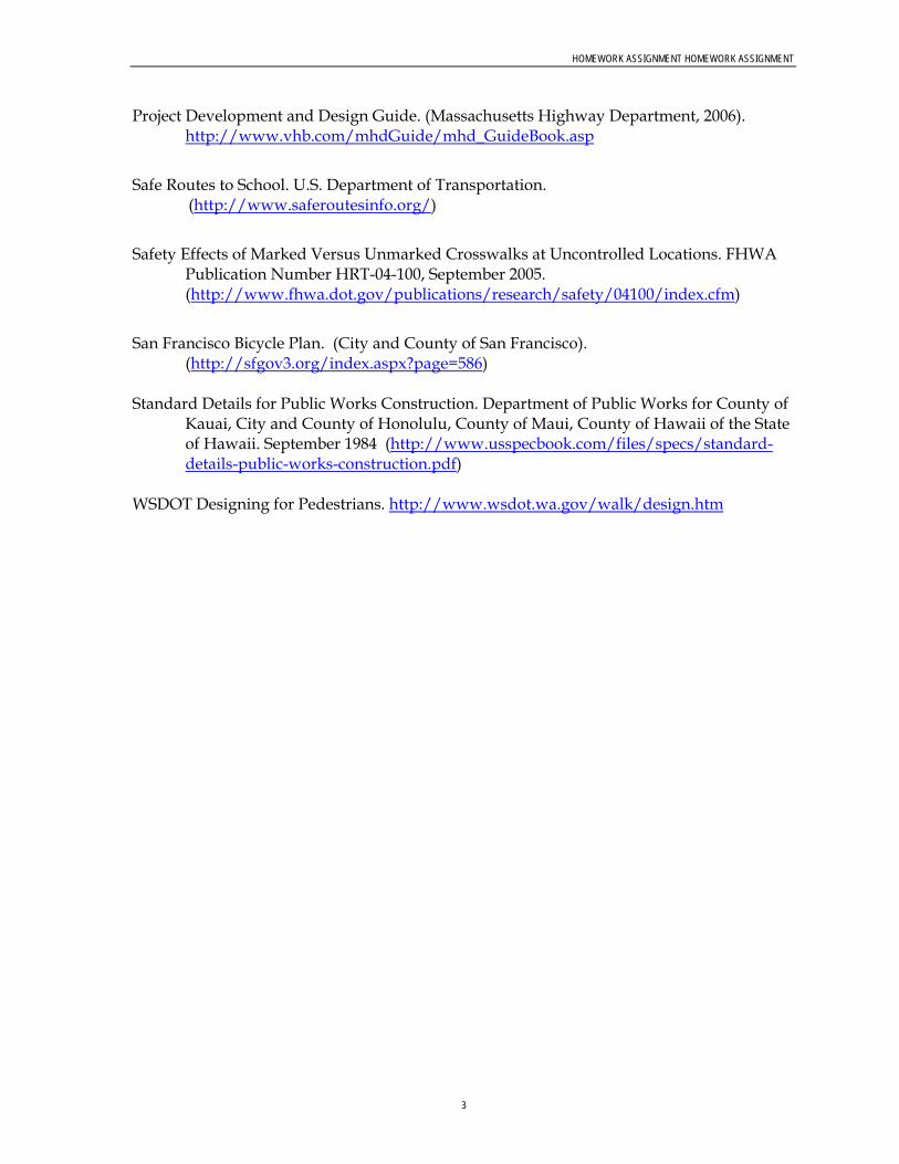
HOMEWORK ASSIGNMENT HOMEWORK ASSIGNMENT
3
Project Development and Design Guide. (Massachusetts Highway Department, 2006). http://www.vhb.com/mhdGuide/mhd_GuideBook.asp
Safe Routes to School. U.S. Department of Transportation.
(http://www.saferoutesinfo.org/)
Safety Effects of Marked Versus Unmarked Crosswalks at Uncontrolled Locations. FHWA Publication Number HRT-04-100, September 2005. (http://www.fhwa.dot.gov/publications/research/safety/04100/index.cfm)
San Francisco Bicycle Plan. (City and County of San Francisco).
(http://sfgov3.org/index.aspx?page=586) Standard Details for Public Works Construction. Department of Public Works for County of
Kauai, City and County of Honolulu, County of Maui, County of Hawaii of the State of Hawaii. September 1984 (http://www.usspecbook.com/files/specs/standard-details-public-works-construction.pdf)
WSDOT Designing for Pedestrians. http://www.wsdot.wa.gov/walk/design.htm

1
Complete Streets Task Force DRAFT Complete Streets Statewide Policy Recommendations DATE: April 12, 2010
This policy serves as a draft framework for implementing Complete Streets throughout Hawaii to allow the statewide system to better serve all transportation users. This draft is based on direction from the Complete Streets Task Force as well as guidance from Complete Streets best practices across the country and the provisions of Act 54. The framework is separated into seven sections:
1. Vision and Purpose 2. Definitions 3. Applicability 4. Exceptions 5. Requirements for Development Design Standards and Guidelines 6. Authority/Responsibilities 7. Penalties for Violations and Incentives for Success
Vision and Purpose
Vision - The statewide Complete Streets Policy seeks to reasonably accommodate convenient access and mobility for all users of public highways and roadways within the State/County system, including pedestrians, bicyclists, transit users, motorists, and persons of all ages and abilities. The policy also allows for the efficient movement of people and goods throughout the system. Purpose - The purpose of the policy is to provide policy direction for the incorporation of Complete Streets principles into the statewide transportation system and design and construction of transportation projects throughout Hawaii. Complete Streets principles for Hawaii include the following:
Safety – Streets should be designed and constructed to create an environment that supports safety for all modes
Flexible design (Context Sensitive Solutions) – Street design and best practices should recognize the importance of the surrounding context and integrate community values and environmental surroundings
Accessibility and mobility for all – The street system should be designed for ease of use and access to destinations for all populations, and the ability to move people and goods throughout the system.

COMPLETE STREETS TASK FORCE DRAFT COMPLETE STREETS STATEWIDE POLICY RECOMMENDATIONS
2
Use and Comfort of all users – All users, including bicyclists, pedestrians, transit riders, and drivers of all abilities should feel comfortable using the transportation system
Building partnerships with organizations statewide – HDOT should work with local entities to implement Complete Streets throughout the state
Definitions
This section includes definitions of key terms used in the Complete Streets policy. Definitions consistent with the Statewide Traffic Code (HRS §0291C-0001) are noted. Accessibility – The ability to reach desired goods, services, activities, and destinations for all transportation systems users. Bicycle – Every vehicle propelled solely by human power upon which any person may ride, having two tandem wheels, and including any vehicle generally recognized as a bicycle though equipped with two front or two rear wheels except a toy bicycle. (From HRS 291C) Bicycle Boulevard – Low-volume and low-speed streets that have been optimized for bicycle travel through treatments such as traffic calming and traffic reduction, signage and pavement markings, and intersection crossing treatments. Bicycle Facility – A general term describing improvements and provisions made specifically to accommodate or encourage bicycling, including bicycle lanes, bicycle paths, bicycle routes, shared use paths, bikeways, improved shoulders, bicycle boulevards and bicycle parking and storage facilities. Bicycle Lane – That portion of the highway which has been set aside for the preferential or exclusive use of bicycles. (From HRS 291C) Bicycle Path – Any facility set aside for the preferential or exclusive use of bicycles and physically separated from a highway. (From HRS 291C) Bicycle Route – Any highway that is designated to be shared by bicycles and pedestrians or motor vehicles, or both. (From HRS 291C) Bikeway – A bicycle lane, bicycle path, or bicycle route, or any traffic control device, shelter, parking facility, or other support facility to serve bicycles and persons using bicycles. (From HRS 291C) Bicyclist – A person on a vehicle propelled solely by human power upon which any person may ride, having two tandem wheels, and including any vehicle generally recognized as a bicycle though equipped with two front or two rear wheels except a toy bicycle. (Consistent with HRS 291C)

COMPLETE STREETS TASK FORCE DRAFT COMPLETE STREETS STATEWIDE POLICY RECOMMENDATIONS
3
Bus – Every motor vehicle designed for carrying more than ten passengers and used for the transportation of persons; and every motor vehicle, other than a school bus or taxicab, designed and used for the transportation of persons for compensation. (From HRS 291C) Context Sensitive Solutions (CSS) – A process in which a full range of stakeholders are involved in developing transportation solutions, and solutions are designed to fit into to the surrounding environment, or context. Complete Street – A transportation facility that is planned, designed, operated, and maintained to provide safe mobility for all users, including bicyclists, pedestrians, transit riders, freight, and motorists appropriate to the function and context of the facility. Crosswalk – 1) That part of a roadway at an intersection included within the connections of the lateral lines of the sidewalks on opposite sides of the highway measured from the curbs or, in the absence of curbs, from the edges of the traversable roadway; or 2) Any portion of a roadway at an intersection or elsewhere distinctly indicated for pedestrian crossing by lines or other markings on the surface. (From HRS 291C) Driver – Every person who drives or is in actual physical control of a vehicle. (From HRS 291C) Electric Personal Assistive Mobility Device – A self-balancing, two-wheeled, non-tandem-wheeled device, designed to transport only one person, using an electric propulsion system that limits the maximum speed of the device to twelve and a half miles per hour or less. (From HRS 291C) Highway – The entire width between the boundary lines of every way publicly maintained and those private streets, as defined in section 46-16, over which the application of HRS §0291C-0001 has been extended by ordinance, when part thereof is open to the use of the public for purposes of vehicular travel. (Consistent with HRS 291C) Moped – A device upon which a person may ride which has two or three wheels in contact with the ground, a motor having a maximum power output capability measured at the motor output shaft, in accordance with the Society of Automotive Engineers standards, of two horsepower (one thousand four hundred ninety-two watts) or less and, if it is a combustion engine, a maximum piston or rotor displacement of 3.05 cubic inches (fifty cubic centimeters) and which will propel the device unassisted, on a level surface at a maximum speed no greater than thirty miles per hour; and a direct or automatic power drive system which requires no clutch or gear shift operation by the moped driver after the drive system is engaged with the power unit. (From HRS 291C) Motorcycle – Every motor vehicle having a seat or saddle for the use of the rider and designed to travel on not more than three wheels in contact with the ground but excludes a farm tractor and a moped. (From HRS 291C) Motor Scooter – Every motorcycle which produces not more than five horsepower, and excludes a moped. (From HRS 291C)

COMPLETE STREETS TASK FORCE DRAFT COMPLETE STREETS STATEWIDE POLICY RECOMMENDATIONS
4
Motor Vehicle – Every vehicle which is self-propelled and every vehicle which is propelled by electric power but not operated upon rails but excludes a moped. (From HRS 291C) Neighborhood Electric Vehicle – A self-propelled electrically powered motor vehicle to which all of the following apply:
(1) The vehicle is emission free; (2) The vehicle is design to carry four or fewer persons; (3) The vehicles is designed to be and is operated at speeds of twenty-five miles per
hour or less; (4) The vehicle has at least four wheels in contact with the ground; (5) The vehicle has an unladen weight of less than one thousand eight hundred
pounds; (6) The vehicle conforms to the minimum safety equipment requirements as
adopted in the Federal Motor Vehicle Safety Standard No. 500, Low Speed Vehicles (49 C.F.R. 571.500). (From HRS 291C)
Multi-modal – The movement of people and goods by more than one method of transportation. For example, a multi-modal street may accommodate walking, bicycling, transit, and driving. Pedestrian – Any person afoot, in an invalid chair, or in a vehicle propelled by a person afoot. (From HRS 291C) Private Road or Driveway– Every way or place in private ownership and used for vehicular travel by the owner and those having express or implied permission from the owner, but not by other persons. (From HRS 291C) Right of way – The right of one vehicle or pedestrian to proceed in a lawful manner in preference to another vehicle or pedestrian approaching under such circumstances of direction, speed, and proximity as to give rise to danger of collision unless one grants precedence to the other. (From HRS 291C) Roadway – That portion of a highway improved, designed or ordinarily used for vehicular travel, exclusive of the berm or the shoulder. In the event a highway includes two or more separate roadways the term “roadway” as used herein refers to any such roadway separately but not to all such roadways collectively. (From HRS 291C) Shared Use Path – A bikeway physically separated from motorized vehicular travel by an open space or barrier. Shared use paths may be used by but are not limited to non-motorized users such as: bicyclists, in-line skaters, wheelchair users (both non-motorized and motorized), and pedestrians. Sidewalk – That portion of a street between the curb lines, or the lateral lines of a roadway, and the adjacent property lines, intended for use of pedestrians. (From HRS 291C)

COMPLETE STREETS TASK FORCE DRAFT COMPLETE STREETS STATEWIDE POLICY RECOMMENDATIONS
5
Street – The entire width between boundary lines of every way publicly maintained when any part thereof is open to the use of the public for purposes of vehicular travel. (From HRS 291C) Toy Bicycle – Every device propelled solely by human power upon which any person may ride, having two tandem wheels, including any device generally recognized as a bicycle though equipped with two front or two rear wheels, which has a seat height of not more than twenty-five inches from the ground when the seat is adjusted to its highest position; or a scooter or similar device regardless of the seat height. (From HRS 291C) Traffic – Pedestrians, ridden or herded animals, vehicles, and other conveyances either singly or together while using any highway for purposes of travel. (From HRS 291C) Users – Motorists, bicyclists, transit riders, pedestrians, and anyone else who depends on the transportation system to move people and goods. Vehicle – Every device in, upon, or by which any person or property is or may be transported or drawn upon a roadway or highway, including mopeds and bicycles, but excluding toy bicycles, devices other than bicycles moved by human power, and devices used exclusively upon stationary rails or tracks. (From HRS 291C)
Applicability
This Complete Streets policy will be implemented on all public roads statewide; applying to new construction and reconstruction. Complete Streets principles should be considered when updating long-term planning documents that provide guidance on street design and transportation projects.
Exceptions To Be Discussed Next CSTF Meeting
Requirement for Development of Design Standards and Guidelines
To Be Discussed Next CSTF Meeting
Authority/Responsibilities
To Be Discussed Next CSTF Meeting
Penalty for Violations and Incentives for Success
To Be Discussed Next CSTF Meeting
TBG
1004
1015
3435
HN
L
Appendix IComplete Streets Task Force Meeting #4 Materials

NAMES IN BOLD ARE TASK FORCE/ALTERNATE MEMBERS. 1
COPYRIGHT 2010 BY CH2M HILL, INC. • COMPANY CONFIDENTIAL
M E E T I N G S U M M A R Y
Complete Streets Task Force Meeting #4 Minutes DATE: June 9, 2010
LOCATIONS: HDOT Office on Oahu (Punchbowl Street) and Kauai, Maui and Hawaii District Offices
FROM: Kathleen Chu, CH2M HILL Kirsten Pennington, CH2M HILL Cheryl Yoshida, CH2M HILL Paul Luersen, CH2M HILL Kit Ieong, CH2M HILL
COPIES: Ken Tatsuguchi, HDOT Rachel Roper, HDOT
ATTENDEES: TASK FORCE MEMBERS/ ALTERNATES:
Rob Miyasaki, Bryan Kimura, Michael Lum, Claude Matsuo, Tom Dinell, Reg White, Bob Sumitomo, Mel Hirayama, Dr. Peter Flachsbart, Kari Benes, David Arakawa, Joel Kurokawa, Liz Fischer, Milton Arakawa (Maui), Ray McCormick (Kauai), Marie Williams (Kauai), Bob Ward, Laura Dierenfield, Janice Marsters
STAFF/TECHNICAL TEAM:
Jiro Sumada, Ken Tatsuguchi, Rachel Roper, Kathleen Chu, Cheryl Yoshida, Paul Luersen, Kirsten Pennington, Kit Ieong, Chris Dacus, Chris Sayers, Ferdinand Cajigal (Maui), Sal Panem (Hawaii), Aaron Takada (Hawaii), Curtis Motoyama, Francine Wai, Capt. Keith Lima
FRIENDS/ INTERESTED PARTIES:
Ben Gorospe, Tammy Lee, Tom Smyth, Daniel Alexander, Randy Blake (Kauai), Craig (Kauai), Charlene Ota, David Shimokawa, Brian Gibson, Hans Riecke (Maui), Sandra McGuiness (Maui)
TASK FORCE MEMBERS NOT IN ATTENDANCE:
Mark Behrens, Bobby Jean Leithead-Todd, Don Medeiros, Gareth Sakakida
Meeting commenced at 1:44 PM.
Welcome & Introductions Jiro Sumada opened the meeting by thanking everyone for coming to the fourth Complete Streets Task Force meeting. Jiro introduced himself and asked everyone to introduce themselves. After the round table introductions, Paul Luersen asked for Task Force action to approve the meeting minutes from the last meeting. Reg White made a motion to approve the meeting minutes. Rob Miyasaki seconded the motion. All Task Force members raised their hands to signal their approval of the meeting minutes. The Complete Streets Task Force Meeting #3 Minutes was approved. A quorum of more than 11 was present.

MEETING SUMMARY_06092010_DRAFT_V4.DOCX 2 COPYRIGHT 2010 BY CH2M HILL, INC. • COMPANY CONFIDENTIAL
Paul mentioned that a letter was received by the HDOT director, Brennon Morioka, requesting an additional seat be added to the CSTF for the City and County of Honolulu, Department of Planning and Permitting. The letter recommended Robert Sumitomo to serve as task force member and Mel Hirayama to serve as alternate. Paul asked for Task Force action to respond to the request. A motion of approval was made by David Arakawa. Claude Matsuo seconded the motion. The request was approved. Robert Sumitomo and Mel Hirayama were added as a Task Force member and an alternate. Paul went on and reviewed the work plan (tasks completed, current tasks, and next steps) and the meeting agenda.
Draft Complete Streets Policy Kirsten Pennington reminded the Task Force of their discussion on the draft Complete Streets Statewide Policy Recommendations memo at the last meeting. She pointed out that changes were made based on Task Force comments and are shown in a track-changes mode. Kirsten suggested that the Task Force review Sections 1-3 on their own after the meeting and focus on Sections 4-7 for today’s discussion.
Section 4 – Exceptions Related to the second exception listed on the memo (cost), David Arakawa suggested that a statement about available State and/or County funding be added to the Vision and Purpose statement. The intent is to secure Legislative and City/County Council support for budgets for implementing the Complete Streets policy.
Janice Marsters suggested defining or adding examples of what “excessively disproportionate” means in terms of the costs and the need or probable use of the particular highway, road, street, way or lane.
Bob Ward agreed that a definition of “excessively disproportionate” should be included. He also mentioned that routine maintenance should not be exempted from the Complete Streets policy. Janice Marsters mentioned that the bicycle community would find excluding re-surfacing objectionable. Tom Dinell asked for the purpose of the last exception – “The project is routine maintenance, such as preventative maintenance and re-surfacing.” Kathleen responded that this exception is included to be consistent with the ADA compliance and legal liabilities as discussed in the last meeting. The agreement was to try to come up with language that is consistent with the ADA triggers. Francine Wai suggested that re-surfacing should not be listed as an example of routine maintenance. Kathleen suggested verifying the definition and practices with George Abcede from HDOT’s Operations and Maintenance Section.

MEETING SUMMARY_06092010_DRAFT_V4.DOCX 3 COPYRIGHT 2010 BY CH2M HILL, INC. • COMPANY CONFIDENTIAL
Bryan Kimura suggested checking against current definitions. Reg White mentioned that re-surfacing should not trigger major rebuild of the roadway. Janice Marsters responded that re-surfacing includes re-striping, which could possibly accommodate a bike lane. David Arakawa responded that the State and Counties can look for opportunities to incorporate Complete Streets elements into facilities while doing routine maintenance. However, if the application of the Complete Streets policy is mandatory for all routine maintenance projects, it could open up law suits that would negatively impact operations. Jiro suggested adding “may” (instead of shall) exceptions for re-surfacing. Rob Miyasaki mentioned the statement under the Applicability section, which states that “Complete Streets principles shall be incorporated…“ If the “shall” is changed for the Exceptions, the “shall” needs to be changed for the Applicability section as well. Reg White mentioned the distinction between the definitions of restoration and alteration from the ADA rules. Janice Marsters suggested excluding re-surfacing and leaving routine maintenance and preventative maintenance. Bob Sumitomo mentioned that re-surfacing and re-striping to add bike lanes changes the basic use (usability) of the roadway and will trigger ADA. Reg White suggested language stating that routine maintenance should not reduce compliance or accommodations. David Arakawa suggested leaving the language as it is now and re-visiting this issue later. Kirsten asked the neighbor islands if they had any comments. Milton Arakawa stated his concern about having additional requirements, which could result in less roads being re-surfaced. He mentioned that a lot of other factors need to be considered including the need for additional right-of-way. In some cases, they would no longer be able to proceed with the project. Sal Panem shares the same concern as County of Maui and suggested separating out re-surfacing. They do not want a mandate, but feel it should be considered and accommodated when possible. Jiro reminded the Task Force to focus on the intent of this Complete Streets policy. He recognized the difficulty of covering all the issues in simple language. He challenged the Task Force to think of ways to create an intent and how to make it work.

MEETING SUMMARY_06092010_DRAFT_V4.DOCX 4 COPYRIGHT 2010 BY CH2M HILL, INC. • COMPANY CONFIDENTIAL
David Arakawa suggested adding another section to clarify that the application of the Complete Streets policy is not mandatory to re-surfacing projects. Liz Fischer proposed conducting additional research to see how other Complete Streets policies have addressed this issue related to re-surfacing projects. She also mentioned that funding should not always be the constraining issue for implementing the Complete Streets policy. She encouraged the Task Force to figure out ways to leverage the funding issue. Kari Benes mentioned the HRS 264-20, titled Flexibility in Highway Design. She suggested that it could compliment this Complete Streets effort. Joel Kurokawa mentioned a Complete Streets policy example from www.completestreets.org and suggested forming an investigative group to conduct research on how other Complete Streets policies have addressed this issue. The Task Force favored Joel’s suggestion. Claude Matsuo, Janice Marsters, Bob Ward, Bob Sumitomo, Kari Benes, David Arakawa, and Rob Miyasaki volunteered to be members of the investigative group. Liz Fischer volunteered to support the investigative group with technical information. The investigative group will report their findings to the Task Force at the next meeting in August. Tom Dinell suggested researching existing definitions for “routine maintenance” as well. Dr. Peter Flachsbart, referring to the fourth exception bullet, asked if safety includes health. He mentioned that pedestrians and cyclists have an increased chance of having heart/lung problems due to the exposure to diesel exhaust along roadways. If safety includes health, he suggested including the health concern as an exception. David Arakawa mentioned that including health along with safety might not be possible since the exceptions might be constrained by the HRS. Laura Dierenfield mentioned that there are additional exceptions in the draft Complete Streets policy, than in Act 54. Bob Ward asked which would govern. Kathleen responded that the intent of developing this Complete Streets policy is to replace/update the Complete Streets policy in the HRS. Jiro suggested including public health in the fifth exception, so it reads as “…the quality of the environment and/or public health is degraded.” Kari Benes mentioned that overall health needs to be considered. Being able to use the road to exercise is important to public health. She was concerned that the policy could overly restrict usage or prevent bicycle facilities from being built.

MEETING SUMMARY_06092010_DRAFT_V4.DOCX 5 COPYRIGHT 2010 BY CH2M HILL, INC. • COMPANY CONFIDENTIAL
Dr. Peter Flachsbart mentioned that the government is responsible for alerting the general public of any potential risks, and suggested placing warning signs on the sidewalk or bike lane to alert pedestrians or cyclists that they are exposed to diesel exhaust on arterials such as Nimitz Highway. Rob Miyasaki mentioned that adding this many details to the Complete Streets policy actually dilutes its purpose and too many signs clutters the roadways. Kirsten suggested allowing the project management team to draft a statement related to the health issue. Kathleen reminded the Task Force to focus on the appropriate context when developing this Complete Streets policy. Complete Streets is not about accommodating ALL modes on every street. A roadway with a designated truck route may not be an appropriate location to stripe a bike lane. A good transportation system will designate bike routes, pedestrian routes, truck routes, etc. that is appropriate for the surrounding context and accommodates the users. Tom Smyth mentioned his concern about disruption to marathon routes since they are sometimes along “diesel roads.” Kirsten suggested that the Task Force should move on to a discussion on the implementation of the Complete Streets policy.
Section 5 – Implementation of the Complete Streets Policy Kirsten led the discussion on the implementation of the Complete Streets policy. She mentioned that the implementation of this Complete Streets policy will vary depending on agency (State or County). Tom Dinell suggested changing the phrase “at least one” in the last sentence of the first paragraph to “one or more” – more positive language. Liz Fischer asked if the Task Force is developing a statewide Complete Streets policy for both the State and Counties. She suggested deleting the first sentence of the first paragraph and also the verbs in the bullet points. She also suggested including a list of available tools and specific common ground design guidelines to help agencies and jurisdictions implement the Complete Streets policy. Bob Sumitomo commented that the verbs are necessary. The Task Force is just developing the Complete Streets policy. The agencies are actually the ones who are implementing the Complete Streets policy. Bob Ward added that some differences are inherent since different agencies have different requirements. David Arakawa recommended that each County should have the flexibility to implement the Complete Streets policy.

MEETING SUMMARY_06092010_DRAFT_V4.DOCX 6 COPYRIGHT 2010 BY CH2M HILL, INC. • COMPANY CONFIDENTIAL
Section 6 – Authority and Responsibilities Kirsten explained that this section describes who at the State/County has the authority to implement the Complete Streets policy, grant exceptions, and sign off on projects. She also mentioned that additional levels of approval may vary depending on the implementing jurisdiction. Tom Dinell asked to whom an agency reports to and if the accountability is missing. David Arakawa suggested including additional state agencies to the approval list, such as the Department of Hawaiian Home Lands (DHHL) and the University of Hawaii system. Bob Sumitomo mentioned that developers typically build private roads to City standards because they want the City to accept and maintain their facilities. Other agencies such as Department of Land and Natural Resources (DLNR), Harbors, Airports and National Parks (federal) could be added.
Section 7 – Penalty for Violations and Incentives for Success Kirsten asked the Task Force to consider if this section is needed. A section on accountability could be added and could include potential performance measures for agencies/jurisdictions and describe ways of reporting.
Liz Fischer suggested including performance measures.
Janice Marsters mentioned that accountability is more important than penalties.
This section and the additional section on accountability will be discussed at the next CSTF meeting. A break was called at 2:55 PM.
Investigative Group Presentations At the April 29, 2010 Complete Streets Task Force meeting, the Task Force was assigned into investigative groups and asked to develop a five-minute presentation sharing their recommendations on the assigned design standards/guideline topics. See Table 1 for a summary of the investigative group presentations.
Next Steps Kathleen mentioned that the next steps for the following meeting would be (1) revising the draft Complete Streets policy per Task Force’s comments, (2) investigating exceptions by the voluntary investigative committee, (3) continued discussion on recommendations regarding design standards and guidelines, and (4) discussion on the draft legislative report. Kathleen reminded the Task Force that the next meeting will be on August 4, 2010, 1:30 PM. Kathleen thanked everyone and closed the meeting.

Table 1: Complete Streets Task ForceInvestigative Group Reports on Design Standards
Design Standard Group Number Discussion Recommendation
Pedestrian Countdown Signals
1Pedestrian countdown signals should be standard in high pedestrian locations
Use countdown signals
5
Countdown based on crossing speed 3.5 feet per second
Large/visible numbers
Combine with audio at heavily used crossings
None
7
Clearance interval is effective -Less people ran when flashing "don't walk" starts
More people start crossing with flashing hand - do not comply with the walk signal
Education of proper use needed
Numbers can change colors (white/green with allowable walking
None
Numbers can change colors (white/green with allowable walking period, red with don't walk)
Cross-traffic watches countdown and start very fast
Street Tree Placement
6
Consider Street Trees as infrastructure - same as utilities
Street Tree placement: Honolulu Standards and Procedures for Planting of Street Trees (1999)
HECO guidelines
Street Tree placement: Honolulu Standards and Procedures for Planting of Street Trees (1999)
HECO guidelines
Reference future HDOT Highways Statewide Sustainable Landscape Master Plan
Landscape Buffer Width
6Design for maximum buffer widths, minimum pavement given specific context
4' minimum (for small trees)
Reference future HDOT Highways Statewide Sustainable Landscape Master Plan
Page 1 of 6

Table 1: Complete Streets Task ForceInvestigative Group Reports on Design Standards
Design Standard Group Number Discussion Recommendation
Bike Lane Width
4
AASHTO Guide for the Development of Bicycle Facilities is very complete/comprehensive - straying away may open up liability issues
Where adequate width cannot be physically provided, add signs to help with the designation of the lane
AASHTO Guide for the Development of Bicycle Facilities
6 Federal guidance6' preferred5' minimum
Crosswalk Markings
1Crosswalk markings that have stripes that are both parallel and perpendicular to traffic are recommended. The combination will be more durable and have better visibility
Zebra pattern or ladder
2
MUTCD - type, width, alignment
Visible signage in combination
Medians for safe refuge (offset for pedestrians to face traffic)
Lighting
Confirm activation of signal call
Raised Crosswalks
None
Page 2 of 6

Table 1: Complete Streets Task ForceInvestigative Group Reports on Design Standards
Design Standard Group Number Discussion Recommendation
5
MUTCD provides options, and continues to be amended with new/innovative solutions
Heavily used crosswalks should have zebra striping, or longitudinal striping or a combination of lateral/longitudinal
Use retro-reflective paint for visibility
Have a ped activated signal or warning activation for midblock crossings that cross 4 or more lanes
Establish criteria for installation of Barnes Dance
Prohibit use of cell phones etc by peds and bikes
Establish median safety islands w/ staggered crosswalks
MUTCD
Bikeway Location
2
Future AASHTO guidance
All alterials/collector roads, all other roads that exceed 30 mph, and roads that wxceed minimum volumes of bicycle and pedestrian traffic
Designate routes/locations in Community plans
None
Page 3 of 6
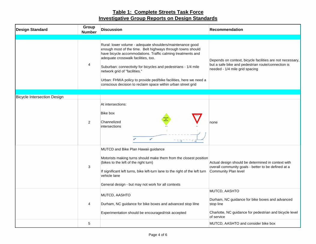
Table 1: Complete Streets Task ForceInvestigative Group Reports on Design Standards
Design Standard Group Number Discussion Recommendation
4
Rural: lower volume - adequate shoulders/maintenance good enough most of the time. Belt highways through towns should have bicycle accommodations. Traffic calming treatments and adequate crosswalk facilities, too.
Suburban: connectivity for bicycles and pedestrians - 1/4 mile network grid of "facilities."
Urban: FHWA policy to provide ped/bike facilities, here we need a conscious decision to reclaim space within urban street grid
Depends on context, bicycle facilities are not necessary, but a safe bike and pedestrian route/connection is needed - 1/4 mile grid spacing
Bicycle Intersection Design
2
At intersections:
Bike box
Channelizedintersections
none
3
MUTCD and Bike Plan Hawaii guidance
Motorists making turns should make them from the closest position (bikes to the left of the right turn)
If significant left turns, bike left-turn lane to the right of the left turn vehicle lane
General design - but may not work for all contexts
Actual design should be determined in context with overall community goals - better to be defined at a Community Plan level
4
MUTCD, AASHTO
Durham, NC guidance for bike boxes and advanced stop lilne
Experimentation should be encouraged/risk accepted
MUTCD, AASHTO
Durham, NC guidance for bike boxes and advanced stop line
Charlotte, NC guidance for pedestrian and bicycle level of service
5 MUTCD, AASHTO and consider bike box
Page 4 of 6

Table 1: Complete Streets Task ForceInvestigative Group Reports on Design Standards
Design Standard Group Number Discussion Recommendation
Bus and Service Vehicle Pull Out Lanes
5
Length of the bus bay allow for an entrance taper, a deceleration lane, a stopping area, an acceleration lane and an exit taper
Bus stop sidewalk area extended for a clear 8' long and 5' wide ADA landing pad
No drainage structures
Adequately size curbside space for peak demand
Page 5 of 6

Table 1: Complete Streets Task ForceInvestigative Group Reports on Design Standards
"Other" Design Standard Discussions
Group Number Discussion
Sidewalks 1
Require ADA accessible curb/gutter/sidewalk in new residential subdivisions
New schools should be connected by a pedestrian networkSidewalks 1 New schools should be connected by a pedestrian network
Policy should be created about handling drainage when a new sidwalk is built within an existing shoulder/drainage area
Surface treatment - smoother, more contrast
Add pavement markings as an education tool
Bike facilities 2
Add pavement markings as an education tool
LED bike symbol (indication that bike activates signal)
Assymetrical design for different non-motorized mode accommodation
Shoulder bikeways, bike lanes, and shared use paths
CS Policy 3 New York City DOT "Street Design Manual" 2009
Sidewalk Widths (min) 5
Heavy use: 8'Moderate use: 6'Light use: 4'
S de a dt s ( )
Avoid obstructions in effective pedestrian area
Lighting 5 Pedestrian scaled lighting along sidewalks
Transit stops 5
Transit stop benches with natural or constructed covering for shade
Streets 5 Design for proximity not speed, with good sight distance
Page 6 of 6

AGENDA Complete Streets Task Force
Meeting #4 June 9, 2010
1:30 – 4:30 p.m.
HDOT Punchbowl Office 869 Punchbowl St. 5th fl. Honolulu, HI 96813
HDOT Hawaii District Office50 Makaala Street Hilo, HI 96720
HDOT Kauai District Office1720 Haleukana Street
Lihue, HI 96766
HDOT Maui District Office650 Palapala Drive Kahului, HI 96732
Meeting Goals: Review Meeting #3 outcomes Review and discuss second half of draft Complete Streets policy Discuss investigative group presentations on design standards/guidelines recommendations
Time Agenda Item Facilitator(s)
1:30 – 1:40 p.m. Welcome and Introductions Roundtable Self-introductions Approve Meeting #3 minutes
Brennon Morioka, HDOT Jiro Sumada, HDOT
1:40 – 1:50 p.m. Agenda Review Work plan Review Meeting Goals
Paul Luersen, CH2M HILL
1:50 – 2:50 p.m. Draft Complete Streets Policy – Part 2 Exceptions Requirement for Development of Design
Standards/Guidelines Authority/Responsibilities Penalties for Violation & Incentives for Success
Kirsten Pennington, CH2M HILL
2:50 – 3:00 p.m. BREAK
3:00 – 4:20 p.m. Investigative Group Presentations & Discussion Group Presentations followed by discussion
Kathleen Chu, CH2M HILL
4:20- 4:30 p.m. Next Steps Meeting #5, August 4, 2010, 1:30 PM
Kathleen Chu, CH2M HILL
*To request language interpretation, an auxiliary aid or service (i.e. sign language interpreter, accessible parking, or materials in alternative format), contact Kathleen Chu at [email protected] or (808) 440-0283, seven (7) days prior to the meeting date.
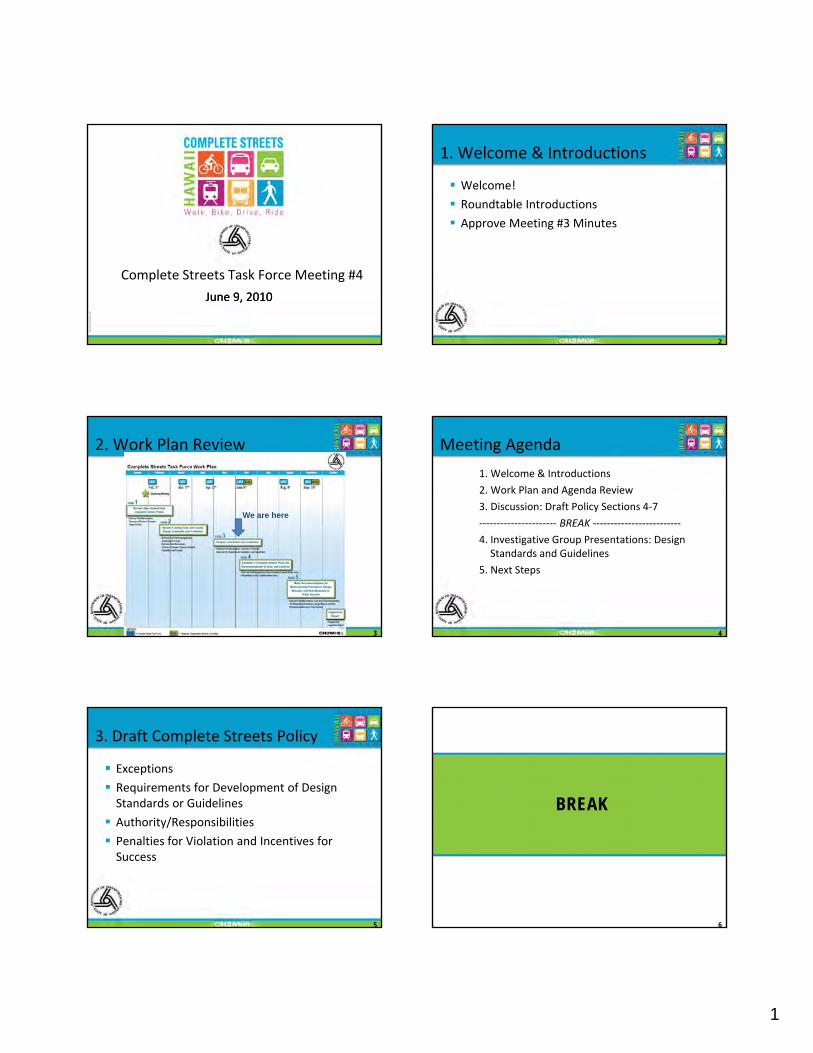
1
TBG
0122
1000
4321
HN
L
Complete Streets Task Force Meeting #4
June 9, June 9, 20102010
1. Welcome & Introductions
Welcome!
Roundtable Introductions
Approve Meeting #3 Minutes
2
2. Work Plan Review
We are here
3
Meeting Agenda
1. Welcome & Introductions
2. Work Plan and Agenda Review
3. Discussion: Draft Policy Sections 4‐7
‐‐‐‐‐‐‐‐‐‐‐‐‐‐‐‐‐‐‐‐‐‐ BREAK ‐‐‐‐‐‐‐‐‐‐‐‐‐‐‐‐‐‐‐‐‐‐‐‐‐
4
BREAK
4. Investigative Group Presentations: Design Standards and Guidelines
5. Next Steps
3. Draft Complete Streets Policy
Exceptions
Requirements for Development of Design Standards or Guidelines
h i / ibili i
5
Authority/Responsibilities
Penalties for Violation and Incentives for Success
BREAK
6

2
4. Group Presentations
Goal:
Investigative groups share research and recommendations on design standards and guidelines
7
guidelines Start group discussion about specific design standards and guidelines
Priority Standards & Guidelines
Task Force Priorities: Pedestrian Countdown Signals
Crosswalk Markings
Landscaped Buffer Width
8
Landscaped Buffer Width
Street Tree Placement
Bicycle Lane Width
Bikeway Location
Bicycle Intersection Design
Bus and Service Vehicle Pull Out Lanes
Presentation Outline In 5 minutes or less:
1) Describe how your group made its recommendations.
2) Did you consult others?
9
y
3) What are your recommendations?
4) How does this tie to Complete Streets?
5. Next Steps
Revise Complete Streets policy draft, per Task Force comment
Next Meeting: August 4, 2010, 1:30 PM– Topic: Policy Revision Discussion
10
Topic: Policy Revision Discussion
– Topic: Continued Discussion of Task Force Recommendations regarding Design Standards and Guidelines
Mahalo!
1
Complete Streets Task Force DRAFT Complete Streets Statewide Policy Recommendations DATE: April 12, 2010, updated May 24, 2010
This policy serves as a draft framework for implementing Complete Streets throughout Hawaii to allow the State and Countystatewide systems to better serve all transportation users. This draft is based on direction from the Complete Streets Task Force as well as guidance from Complete Streets best practices across the country, and the provisions of Act 54, and Hawaii Revised Statute (HRS) 264-20.5. The framework is separated into seven sections:
1. Vision and Purpose 2. Definitions 3. Applicability 4. Exceptions 5. Requirements for Development Design Standards and Guidelines 6. Authority/Responsibilities 7. Penalties for Violations and Incentives for Success
Vision and Purpose
Vision - The statewide Complete Streets Policy seeks to reasonably accommodate convenient access and mobility for all users of public highways and roadways within the State/County system, including pedestrians, bicyclists, transit users, motorists, and persons of all ages and abilities. The policy also allows for the efficient movement of people and goods throughout the system. The application of Complete Streets shall be context sensitive and compliment the surrounding area, land use and community. Hawaii’s clean and secure energy future depends upon a flexible, safe and resilient transportation system that embraces Complete Streets principles and design in order to accommodate safe transit, walking, bicycling and alternative fuel vehicles that, together, will decrease demand for imported oil and prioritize imported fuel for shipping, aviation and freight to ensure a prosperous economic future for Hawaii’s people. Purpose - The purpose of the policy is to provide policy direction for the incorporation of Complete Streets principles into the State and Countystatewide transportation systems and planning, design and construction of transportation projects throughout Hawaii. Complete Streets principles for Hawaii include the following:

COMPLETE STREETS TASK FORCE DRAFT COMPLETE STREETS STATEWIDE POLICY RECOMMENDATIONS
2
Safety – Streets should be dPlan, designed and constructed transportation facilities to create an environment that supports safety for all modes
Flexible design (Context Sensitive Solutions) – Street dDesign transportation facilities using best practices thatshould recognize the importance of the surrounding context and integrate community values and environmental surroundings
Accessibility and mobility for all – The street system should be dPlan and designed transportation facilities for ease of use and access to destinations for all populations, and the ability to move people and goods throughout the system.
Use and Comfort of all users – All users, including bicycles, pedestrians, transit riders, and drivers of all abilities should feel comfortable using the transportation system
Consistency of design standards and guidelines – Encourage consistent use of national best practices from the Manual of Uniform Traffic Control Devices (MUTCD) and A Policy on Geometric Design of Highways and Streets (AASHTO Green Book) as appropriate to generate consistency in the application of striping and pavement markings for all users on all islands
Energy efficiency – Plan, design and construct a transportation system that offers transportation choices for citizens and visitors and reduces reliance on single-occupant vehicles and mitigates tailpipe emissions.
Building partnerships with organizations statewide – HDOT and other agencies should work with local entities to implement Complete Streets throughout the state
Definitions
This section includes definitions of key terms used in the Complete Streets policy. Definitions consistent with the Statewide Traffic Code (HRS §0291C-0001) are noted, however will be removed in the final draft presented to the Legislature.. Accessibility – The ability to reach desired goods, services, activities, and destinations for all transportation systems users. Accessible Route – A continuous, unobstructed path connecting all accessible elements and spaces of a building or facility that meets the requirements of ADAAG. (From USDOT, FHWA, Designing Sidewalks and Trails for Access) Assistive Device – A device that assists users in accomplishing day-to-day functions. For example, a wheelchair is an assistive devices to assist a person who cannot walk. (From USDOT, FHWA, Designing Sidewalks and Trails for Access) Bicycle – Every vehicle propelled solely by human power upon which any person may ride, having two tandem wheels, and including any vehicle generally recognized as a bicycle though equipped with two front or two rear wheels except a toy bicycle. (From HRS 291C)

COMPLETE STREETS TASK FORCE DRAFT COMPLETE STREETS STATEWIDE POLICY RECOMMENDATIONS
3
Bicycle Boulevard – Low-volume and low-speed streets that have been optimized for bicycle travel through treatments such as traffic calming and traffic reduction, signage and pavement markings, and intersection crossing treatments. Bicycle Facility – A general term describing improvements and provisions made specifically to accommodate or encourage bicycling, including bicycle lanes, bicycle paths, bicycle routes, shared use paths, bikeways, improved shoulders, bicycle boulevards and bicycle parking and storage facilities. Bicycle Lane – That portion of the highway which has been set aside for the preferential or exclusive use of bicycles. (From HRS 291C) Bicycle Path – Any facility set aside for the preferential or exclusive use of bicycles and physically separated from a highway. (From HRS 291C) Bicycle Route – Any highway that is designated to be shared by bicycles and pedestrians or motor vehicles, or both. (From HRS 291C) Bikeway – A bicycle lane, bicycle path, or bicycle route, or any traffic control device, shelter, parking facility, or other support facility to serve bicycles and persons using bicycles. (From HRS 291C)
Bikeway - A generic term for any road, street, path or way which in some manner is specifically designated for bicycle travel, regardless of whether such facilities are designated for the exclusive use of bicycles or are to be shared with other transportation modes. (From Draft AASHTO Guide for the Planning, Design, and Operation of Bicycle Facilities, 2010)
Bicyclist – A person on a vehicle propelled solely by human power upon which any person may ride, having two tandem wheels, and including any vehicle generally recognized as a bicycle though equipped with two front or two rear wheels except a toy bicycle. (Consistent with HRS 291C) Bus – Every motor vehicle designed for carrying more than ten passengers and used for the transportation of persons; and every motor vehicle, other than a school bus or taxicab, designed and used for the transportation of persons for compensation. (From HRS 291C) Context Sensitive Solutions (CSS) – A process in which a full range of stakeholders are involved in developing transportation solutions, and solutions are designed to fit into to the surrounding environment, or context. Complete Street – A transportation facility that is planned, designed, operated, and maintained to provide safe mobility for all users, including bicyclists, pedestrian, transit riders, freight, and motorists appropriate to the function and context of the facility.

COMPLETE STREETS TASK FORCE DRAFT COMPLETE STREETS STATEWIDE POLICY RECOMMENDATIONS
4
Crosswalk – 1) That part of a roadway at an intersection included within the connections of the lateral lines of the sidewalks on opposite sides of the highway measured from the curbs or, in the absence of curbs, from the edges of the traversable roadway; or 2) Any portion of a roadway at an intersection or elsewhere distinctly indicated for pedestrian crossing by lines or other markings on the surface. (From HRS 291C) Driver – Every person who drives or is in actual physical control of a vehicle. (From HRS 291C) Electric Personal Assistive Mobility Device – A self-balancing, two-wheeled, non-tandem-wheeled device, designed to transport only one person, using an electric propulsion system that limits the maximum speed of the device to twelve and a half miles per hour or less. (From HRS 291C) Highway – The entire width between the boundary lines of every way publicly maintained and those private streets, as defined in section 46-16, over which the application of HRS §0291C-0001 has been extended by ordinance, when part thereof is open to the use of the public for purposes of vehicular travel. (Consistent with HRS 291C) Moped – A device upon which a person may ride which has two or three wheels in contact with the ground, a motor having a maximum power output capability measured at the motor output shaft, in accordance with the Society of Automotive Engineers standards, of two horsepower (one thousand four hundred ninety-two watts) or less and, if it is a combustion engine, a maximum piston or rotor displacement of 3.05 cubic inches (fifty cubic centimeters) and which will propel the device unassisted, on a level surface at a maximum speed no greater than thirty miles per hour; and a direct or automatic power drive system which requires no clutch or gear shift operation by the moped driver after the drive system is engaged with the power unit. (From HRS 291C) Motorcycle – Every motor vehicle having a seat or saddle for the use of the rider and designed to travel on not more than three wheels in contact with the ground but excludes a farm tractor and a moped. (From HRS 291C) Motor Scooter – Every motorcycle which produces not more than five horsepower, and excludes a moped. (From HRS 291C) Motor Vehicle – Every vehicle which is self-propelled and every vehicle which is propelled by electric power but not operated upon rails but excludes a moped. (From HRS 291C) Neighborhood Electric Vehicle – A self-propelled electrically powered motor vehicle to which all of the following apply:
(1) The vehicle is emission free; (2) The vehicle is design to carry four or fewer persons; (3) The vehicles is designed to be and is operated at speeds of twenty-five miles per
hour or less; (4) The vehicle has at least four wheels in contact with the ground;

COMPLETE STREETS TASK FORCE DRAFT COMPLETE STREETS STATEWIDE POLICY RECOMMENDATIONS
5
(5) The vehicle has an unladen weight of less than one thousand eight hundred pounds;
(6) The vehicle conforms to the minimum safety equipment requirements as adopted in the Federal Motor Vehicle Safety Standard No. 500, Low Speed Vehicles (49 C.F.R. 571.500). (From HRS 291C)
Multi-modal – The movement of people and goods by more than one method of transportation. For example, a multi-modal street may accommodate walking, bicycling, transit, and driving. Pedestrian – Any person afoot, in an invalid chair, or in a vehicle propelled by a person afoot. (From HRS 291C) Preventative Maintenance – This work is directed towards maintaining the existing roadway and related appurtenances as necessary for the safe and efficient operation. Design improvements are not the normal intent of maintenance operations. Pavement repairs such as seal coats, full width patching, crack sealing, and thin plant mix resurfacing for sealing of the pavement surface to correct minor surface irregularities, etc., are generally considered as maintenance activities. Private Road or Driveway– Every way or place in private ownership and used for vehicular travel by the owner and those having express or implied permission from the owner, but not by other persons. (From HRS 291C) Re-surfacing – This work consists of the application of a new or recycled layer or layers of pavement material in excess of 1-1/2 inch depth including inlays to existing pavement to provide additional structural integrity or improved ride. Right of way – The right of one vehicle or pedestrian to proceed in a lawful manner in preference to another vehicle or pedestrian approaching under such circumstances of direction, speed, and proximity as to give rise to danger of collision unless one grants precedence to the other. (From HRS 291C) Roadway – That portion of a highway improved, designed or ordinarily used for vehicular travel, exclusive of the berm or the shoulder. In the event a highway includes two or more separate roadways the term “roadway” as used herein refers to any such roadway separately but not to all such roadways collectively. (From HRS 291C) School Bus – Is defined as every motor vehicle as defined in Section 286-181 and any regulations promulgated pursuant thereto by the Department of Education. (From HRS 291C) Shared Use Lane – A lane of a traveled way that is open to bicycle travel and vehicular use. (From Draft AASHTO Guide for the Planning, Design, and Operation of Bicycle Facilities, 2010) Shared Use Path – A bikeway physically separated from motorized vehicular travel by an open space or barrier. Shared use paths may be used by but are not limited to non-

COMPLETE STREETS TASK FORCE DRAFT COMPLETE STREETS STATEWIDE POLICY RECOMMENDATIONS
6
motorized users such as: bicyclists, in-line skaters, wheelchair users (both non-motorized and motorized), and pedestrians. Shoulder – The portion of the roadway contiguous with the traveled way, for accommodation of stopped vehicles, emergency use and lateral support os sub-base, base and surface courses, often used by cyclists and/or pedestrians where paved. (From Draft AASHTO Guide for the Planning, Design, and Operation of Bicycle Facilities, 2010) Sidewalk – That portion of a street between the curb lines, or the lateral lines of a roadway, and the adjacent property lines, intended for use of pedestrians. (From HRS 291C) Street – The entire width between boundary lines of every way publicly maintained when any part thereof is open to the use of the public for purposes of vehicular travel. (From HRS 291C) Toy Bicycle – Every device propelled solely by human power upon which any person may ride, having two tandem wheels, including any device generally recognized as a bicycle though equipped with two front or two rear wheels, which has a seat height of not more than twenty-five inches from the ground when the seat is adjusted to its highest position; or a scooter or similar device regardless of the seat height. (From HRS 291C) Traffic – Pedestrians, ridden or herded animals, vehicles, and other conveyances either singly or together while using any highway for purposes of travel. (From HRS 291C) Users – Motorists, bicyclists, transit riders, pedestrians, and anyone else who depends on the transportation system to move people and goodsi. Vehicle – Every device in, upon, or by which any person or property is or may be transported or drawn upon a roadway or highway, including mopeds and bicycles, but excluding toy bicycles, devices other than bicycles moved by human power, and devices used exclusively upon stationary rails or tracks. (From HRS 291C)
Applicability
This Complete Streets policy will be implemented on all public roads statewide (State and County facilities); applying to new construction and reconstruction. Complete Streets principles shallould be considered incorporated when updating long-term planning documents that provide guidance on street design and/or transportation projects.
Exceptions To Be Discussed Next CSTF MeetingThis Complete Streets policy shall not apply if:
Use of a particular highway, road, street, way, or lane by bicyclists or pedestrians is prohibited by law, including within interstate highway corridors;

COMPLETE STREETS TASK FORCE DRAFT COMPLETE STREETS STATEWIDE POLICY RECOMMENDATIONS
7
The costs would be excessively disproportionate to the need or probable use of the particular highway, road, street, way or lane;
There exists a sparseness of population, or there exists other available means, or similar factors indicating an absence of a future need;
The safety of vehicular, pedestrian, or bicycle traffic may be placed at unacceptable risk;
The quality of the environment is degraded;
The project is routine maintenance, such as preventative maintenance and re-surfacing.
Implementation of the Complete Streets Policy Requirement for Development of Design Standards and Guidelines
To Be Discussed Next CSTF Meeting The implementation of this Complete Streets policy will vary depending on agency (State or County). Agencies shall implement this Complete Streets policy through at least one of the following implementation tools:
Develop a Complete Streets checklist
Create/update design guidelines that integrate Complete Streets elements
Develop performance measures
Conduct training sessions and/or workshops
Collaborate with agencies to agree on the common design standards and guidelines to create consistency in pavement markings among the islands
Authority and/ Responsibilities
[This section describes who at the State/County has the authority to implement the Complete Streets policy, grant exceptions, and sign off on projects.]
To Be Discussed Next CSTF MeetingThe authority of implementing this Complete Streets policy, granting exceptions, and signing off on projects will vary throughout the different State and County jurisdictions. A high level approval is important to ensure that exceptions are consistent and legitimate. Additional levels of approval may vary dependent on implementing jurisdiction.
State Department of Transportation
Department of Transportation Director or his/her designee
City and County of Honolulu
Department of Transportation Services Director or his/her designee
Department of Planning and Permitting

COMPLETE STREETS TASK FORCE DRAFT COMPLETE STREETS STATEWIDE POLICY RECOMMENDATIONS
8
Director or his/her designee County of Kauai Department of Public Works Director or
his/her designee Department of Planning Director or
his/her designee County of Maui Department of Public Works Director or
his/her designee Department of Planning Director or
his/her designee County of Hawaii
Department of Public Works Director or his/her designee
Department of Planning Director or his/her designee
Penalty for Violations and Incentives for Success
[This section describes the enforcement mechanisms for the Complete Streets policy (i.e. what happens to a developer/constructor/etc. when the Complete Streets policy process is not followed).] To Be Discussed Next CSTF Meeting i The definition for a user is very broad and may include other types of users at varying skill levels.

Complete Streets Task Force Requests/Inquiries
No. Comment/Request Requestor CSTF or Friend Date Response
1 Typology of Complete Street Users Tom Dinell CSTF 2/16/10
Parking lot until Task #4: Est. CS policy for recommendation to State/Counties. The CS policy focuses on access for all users. (Discussion of user types will be up to the CSTF.)
2Effective mechanisms assuring State-Local governments' cooperation and coordination in CS endeavors Tom Dinell CSTF 2/15/10
Parking lot until Task #5: Recommendations for restructuring procedures, design manuals, & new measures to track success. (More geared towards implementation/perf meas)
3 Program effectiveness measures Tom Dinell CSTF 2/15/10 Same as #2
4Means to assure program implementation and effectiveness Tom Dinell CSTF 2/15/10 Same as #2
5
Approaches used in reallocating available space among all users where there is a fixed right-of-way. Any cross section models? Tom Dinell CSTF 2/15/10
The approaches to reallocating space for all users within a fixed right-of-way depends on multiple variables, such as land use, demand, topography, type of roadway, urban/rural, design speed, etc (depending on the context). We would suggest context-sensitive language in a Complete Streets policy and that the TF make recommendations on tools/procedures for staff to use (such as a CS checklist) to implement the policy.
6
What approaches [e.g., education, enforcement, and engineering (including the employment of specific technologies)] have been employed in Complete Street programs to enhance pedestrian safety? Are there measures of their effectiveness? If yes, which measures are most effective? Are the approaches general or age-cohort specific? Tom Dinell CSTF 2/15/10
Because of their Complete Streets policy, different agencies have developed separate bicycle and pedestrian efforts and programs, but typically, it's not part of the CS policy. This is probably more appropriate for the Statewide Pedestrian Master Plan efforts.
7
Provide data for motor vehicle violation of pedestrian right-of-way since 2000 by months and geographical subdivisions Tom Dinell CSTF 2/15/10
Parking lot. CSTF doesn't have the expertise to interpret causes of accidents/violations. Location specific recommendations is not part of the CS workplan.
8Provide data for pedestrian violations of illegal crossing since 2000 by months and geographical subdivisions Tom Dinell CSTF 2/15/10
Parking lot. Not sure if this data is available. Analysis of this data is not part of the CS workplan.
CSTF_Requests_v4.xlsx Page 1 of 3 6/1/2010

Complete Streets Task Force Requests/Inquiries
9
Provide the number of pedestrian fatal accidents caused by motor vehicles since 2000 by months, age of victim, geographical subdivisions, whether the victim was in a marked crosswalk or not Tom Dinell CSTF 2/15/10 Same of #7
10
Provide the number of pedestrian injuries caused by motor vehicles since 2000 by months, age of victim, geographical subdivisions, whether the victim was in a marked crosswalk or not Tom Dinell CSTF 2/15/10 Same of #7
11
Copies of the relevant sections of Hawai‘i state law and county ordinances governing the behavior and responsibilities of pedestrians and drivers when pedestrians are crossing roadways used by motor vehicles. Tom Dinell CSTF 2/15/10
Parking lot. HDOT does not have juridiction over enforcement.
12
Copies of the relevant sections of Hawai‘i state law and county ordinances governing the behavior and responsibilities of pedestrians and drivers when pedestrians are crossing roadways used by motor vehicles. Tom Dinell CSTF 2/15/10 Same as #11
13 Provide information on Greenroads Programs Bob Ward CSTF 2/8/10
Parking lot until Task #4: Est. CS policy for recommendation to State/Counties and Task #5: Recommendations for restructuring procedures, design manuals, new measures to track success. (CSTF decide whether to include Greenroads Programs in policy
14 HDOT's development of Best Practices of TIAR and AM Bob Ward CSTF 2/8/10Will provide summary/timeline with information from #16
15 Provide the HRS version of the Complete Streets bill CSTF 2/2/10Will provide with the Meeting Minutes to the Task Force
16Provide the timeline for other planning projects and how they will be integrated Tom Dinell CSTF 2/2/10
Will provide for the SWPedMP, LRLTPs, HSTP, OBP, TIAR/AM, BPH Phase II, SHSP
17Copy of the Interim Complete Streets Task Force Legislative Report Thomas Noyes Friend 2/2/10
Available on the web: http://hawaii.gov/dot/administration/library/legislature/rpts-to-leg
18 Can subgroups or subcommittees be formed? Tom Dinell CSTF 2/2/10Sunshine Law allows permitted investigation groups - provided via email
19Examples of other Complete Street Programs, i.e. Portland Randy Ching Friend 2/2/10
Already covered in our review of other States/Cities CS policies
20 Copy of HDOT Report to Legislature on Act 232. Tom Dinell CSTF 4/27/10 Provided via email.
CSTF_Requests_v4.xlsx Page 2 of 3 6/1/2010

Complete Streets Task Force Requests/Inquiries
21 Pedestrian Countdowns for the people waiting to cross Bob Ward CSTF 4/27/10
All modes have to wait at signalized intersections, not knowing exactly when they will receive a "green" light. There are pedestrian buttons that indicate when they have been activated.
22 Is there guidance on the location of crosswalks? Kari Benes CSTF 4/27/10
The location of crosswalks is largely a policy discussion versus a design standard. They are many factors (including speed) that are considered for crosswalk warrants.
23
Shares that State roadways often include paved shoulders. Advocates for paved shoulders on County roads wherever feasible as well due to their benefits for different user groups (bicyclists, walkers, joggers, motorists, etc.) and the fact that they can be maintained as part of the roadway. Provides Hanamu Road (Maui) above Seabury Hall as an example of a County Road with a paved shoulder that is heavily utilized by bicyclists, pedestrians. Also provides suggested roadway cross sections. Hans Riecke Friend 5/14/10
This can be a recommendation in the report to the Legislature. However, there are competing interests: reducing impervious surfaces helps to reduce storm drainage runoff and improves water quality. Gravel shoulders are usually adequate for walkers, joggers, and motorists.
24
Concerned with the design, construction, and maintenance of County roads. Suggests improved drainage and base construction. Hans Riecke Friend 5/14/10
Parking lot. The focus of the CSTF is not necessarily drainage or roadway base construction.
CSTF_Requests_v4.xlsx Page 3 of 3 6/1/2010

TBG
1004
1015
3435
HN
L
Appendix JComplete Streets Task Force Meeting #5 Materials

NAMES IN BOLD ARE TASK FORCE/ALTERNATE MEMBERS. 1
COPYRIGHT 2010 BY CH2M HILL, INC. • COMPANY CONFIDENTIAL
M E E T I N G S U M M A R Y
Complete Streets Task Force Meeting #5 Minutes DATE: August 4, 2010
LOCATIONS: HDOT Office on Oahu (Punchbowl Street) and Kauai, Maui and Hawaii District Offices
FROM: Kathleen Chu, CH2M HILL Cheryl Yoshida, CH2M HILL Paul Luersen, CH2M HILL Kit Ieong, CH2M HILL
COPIES: Ken Tatsuguchi, HDOT Rachel Roper, HDOT
ATTENDEES: TASK FORCE MEMBERS/ ALTERNATES:
Rob Miyasaki, Liz Fischer, Reg White, Mike Lum, Tom Dinell, Tom Fee, Joel Kurokawa, Kari Benes, Mark Behrens, Wayne Yoshioka, Claude Matsuo (alternate), Bob Sumitomo, Mel Hirayama (alternate), David Arakawa, Bob Ward, Laura Dierenfield (alternate), Heidi Hansen-Smith (alternate), Ray McCormick (Kauai), Ka’aina Hull (Kauai), Milton Arakawa (Maui), Don Medeiros (Maui)
STAFF/TECHNICAL TEAM:
Jiro Sumada, Ken Tatsuguchi, Rachel Roper, Kathleen Chu, Cheryl Yoshida, Paul Luersen, Kit Ieong, Chris Sayers, Lieutenant Maurice Asato, Curtis Motoyama, Sal Panem (Hawaii), Ron Thiel (Hawaii), Stanley Tamura (Hawaii)
FRIENDS/ INTERESTED PARTIES:
David Shimokawa, Ben Gorospe, Tom Smyth, Brian Gibson, Charlene Ota, Daniel Alexander, Fred Gutierrez (Maui), Ervin Pigao (Maui), Randy Blake (Kauai), Thomas Noyes (Kauai)
TASK FORCE MEMBERS NOT IN ATTENDANCE:
Bryan Kimura, Ed Sniffen, Bobby Jean Leithead Todd, Gareth Sakakida, Dr. Peter Flachsbart
Meeting commenced at 1:37 PM.
Welcome & Introductions Jiro Sumada opened the meeting by thanking everyone for coming to the fifth Complete Streets Task Force (CSTF) meeting. Jiro introduced himself and asked everyone to introduce themselves. After the round table introductions, Paul Luersen reminded everyone of the ground rules and asked for a Task Force motion to approve the minutes from the June 9th meeting. Rob Miyasaki made a motion to approve the meeting minutes. The motion was seconded. Tom Fee abstained because he was not present at the last meeting. The remaining Task Force members raised their

MEETING SUMMARY_08042010_V6 2 COPYRIGHT 2010 BY CH2M HILL, INC. • COMPANY CONFIDENTIAL
hands to signal their approval of the meeting minutes. The Complete Streets Task Force Meeting #4 Minutes was approved. A quorum of more than 11 task force members was present. Paul continued and reviewed the work plan (tasks completed, current tasks, and next steps) and the meeting agenda. He reminded the Task Force that this is the second to the last CSTF meeting and a lot of work needs to be accomplished.
Overview on the Complete Streets Policy Updates Kathleen Chu gave a brief description of the draft Complete Streets Policy handouts and the investigative group results. In general, the group referred back to Act 54 for guidance and chose to focus on a policy with broader visionary language that all agencies would feel comfortable adopting. Kathleen asked Rob Miyasaki to give a summary of the investigative group meeting. Investigative Group Results Rob Miyasaki mentioned that the investigative group carefully reviewed Act 54 again to ensure that the Task Force is satisfying its requirements and achieving its objectives. Per Act 54, Task Force was created to develop recommended design criteria but learned, through the small group efforts, finding consensus on so many different issues and different contexts was extremely difficult in such a short time. Task Force felt that there was value in crafting a Statewide Complete Streets Policy that could be offered to and adopted by the various agencies. The investigative group also supported the decision to move the Implementation of the Complete Streets Policy and Design Standards and Guidelines Recommendation sections to the Legislative Report. The Task Force learned that design standards and guidelines are different for each agency. Thus making recommendations on the design standards and guidelines was not easy. The investigative group recommends focusing on basic practices rather than specific details. Rob asked if other members of the investigative group had anything to add. Bob Ward agreed with Rob’s summary and suggested focusing on the Legislative Report. Rob Miyasaki also summarized the investigative group discussion on the Exceptions section. The investigative group felt that there should not be any categorical exclusion. Each agency should consider the Complete Streets policy for all projects, while recognizing that there may be circumstances when a project would need to be excluded, such as when completing recovery projects after a natural disaster. As a result, the investigative group proposed changes to the Applicability section and renamed the Exceptions section to the Evaluation section. Rob added that he also proposed edits to the Vision and Purpose sections of the draft Complete Streets policy (which were not the Investigative Group’s edits). He felt that the document had become very wordy due to many different editorial changes. Kathleen thanked Rob for summarizing the Investigative Group meeting.

MEETING SUMMARY_08042010_V6 3 COPYRIGHT 2010 BY CH2M HILL, INC. • COMPANY CONFIDENTIAL
Introduction and Vision and Purpose Sections Kathleen stated that the draft Complete Streets policy was reduced from seven to four sections to be consistent with the Investigative Group’s decision to focus on a broader statewide policy. The four sections are:
1) Vision and Purpose 2) Definitions 3) Applicability 4) Evaluation
Kathleen asked the Task Force for agreement on the revised draft policy outline. Reg White suggested changing the word “Requirement” to “Suggestions” on the original “Requirement for Development of Design Standards and Guidelines” section of the draft policy. He felt that the time and effort spent reviewing and trying to develop recommendations for the design standards and guidelines would be wasted if they were not included in the policy. Rob Miyasaki responded that the design standards and guidelines recommendations would be included in the Legislative Report. Tom Dinell suggested attaching the Task Force recommendations on design standards and guidelines to the policy. Liz Fischer mentioned that the Complete Streets policy would be embedded in the Legislative Report. She acknowledged Reg White and Tom Dinell’s concern, but felt that it was also important that the policy be kept general so that it could be adopted by all counties. Rob Miyasaki asked the Task Force to consider where to draw the line in term of the extent of detail appropriate for the policy. Kathleen responded that policies are high-level plans or directives and usually don’t address design standards and guidelines. They are too detail oriented for a policy and their application changes to address varying context. Bob Sumitomo shared Rob’s sentiments and stated that the City and County of Honolulu (CCH) already went through a similar effort (2000 Standards) with the new subdivisions. It is very difficult to get consensus statewide. Milton Arakawa favored the language proposed by Rob and the investigative group. He shared that the County of Maui supports the general principles of the Complete Streets policy. He mentioned that it would be easier to apply to new developments, but acknowledged that a more detailed policy would be difficult to implement on retrofit or small town projects. He suggested that the policy be considered and encouraged for all projects but not required. He shared that context and other concerns, such as historic preservation areas and locations where merchants’ support angled parking along the roadway, need to be considered as well. He suggested the policy be kept more general.

MEETING SUMMARY_08042010_V6 4 COPYRIGHT 2010 BY CH2M HILL, INC. • COMPANY CONFIDENTIAL
Reg White suggested changing the word “Requirement” to “Suggestions” on the original “Requirement for Development of Design Standards and Guidelines” section of the draft policy again. Tom Dinell suggested adding the design standards and guidelines recommendations as an appendix to the policy. David Arakawa reminded the Task Force that Act 54 states that the findings and recommendations (including the Complete Streets policy) of the CSTF are to be included in the Legislative Report. Tom Fee reminded the Task Force that this is a complex effort that will require a learning curve. He recognized that it will take additional time to develop, build, and refine the Complete Streets culture and warrants. He suggested adding a statement to the Legislative Report explaining that this reflects only the first step of the Complete Streets effort, and the effort should keep improving from this first step and that agencies will need to look “out of the box.” Bob Ward suggested that a checklist, similar to the New York City checklist process, be added to the policy, which could help to avoid adding too many details to the policy. Rob Miyasaki responded that each agency will have different opinions on how to implement the policy and may handle specific situations differently. A checklist would be too prescriptive for the policy. The Task Force should focus on developing a policy that can get consensus from all agencies. Kathleen asked the Task Force for consensus on the four sections of the revised draft Complete Streets policy and Reg’s suggestion to include the recommendations on design standards and guidelines in the policy. Liz Fischer suggested keeping the policy simple for now and building upon it later, as agencies get more comfortable with the Complete Streets principles. David Arakawa made a motion to approve the revised outline of the Complete Streets policy. Bob Sumitomo seconded the motion. Kathleen asked the Task Force for approval on the revised outline. Reg White disapproved the changes, Tom Dinell abstained, and the rest of the Task Force approved the four sections. Kathleen continued and reviewed the wording and content of the draft Complete Streets policy. Mark Behrens asked for clarification on the phrase “imported fuel for shipping” in the second paragraph under Vision and questioned if it is clear to others. Rob Miyasaki responded that the intent was to encourage alternate modes of travel. Kathleen mentioned that the wording could be revised to clarify the statement.
MEETING SUMMARY_08042010_V6 5 COPYRIGHT 2010 BY CH2M HILL, INC. • COMPANY CONFIDENTIAL
David Arakawa agreed that the concept is complex and could be misunderstood to promote non-fossil fuel modes, such as rail. Joel Kurokawa suggested removing “and prioritizes imported fuel for shipping, aviation and freight” at the end of the sentence. Definitions Kathleen mentioned that definitions already in the Hawaii Revised Status (HRS) were taken out so that duplication would be avoided. Tom Dinell asked why the definition for maintenance was removed. Kathleen responded that as a result of the Investigative Group’s discussion, the intent of this policy is to focus on the process of evaluation rather than specific exclusions. Thus, all projects shall consider the Complete Streets principles. Maintenance is not specifically mentioned, so a definition for it is not needed. Bob Sumitomo mentioned that the term “road” in the first sentence under Applicability is not defined. Instead, the term “roadway” is defined in the Definitions section. A discussion followed on the different types of terminology (road, roadway, highway, street, lane, driveway, way, shoulders, etc.) included in the report. David Arakawa suggested using the terminology from Act 54 that is defined in the HRS. Applicability Bob Ward felt that the first sentence of the Applicability paragraph needed to be sharpened. He also suggested including recommendations in the Legislative Report that explain how to implement/consider the Complete Streets principles. Mark Behrens asked if the word “shall” in the last sentence of the Applicability paragraph should be changed to “should.” Tom Dinell responded that the overall policy is a suggestion. It is not a requirement to the agencies. Tom also pointed out a typo in the last sentence of the Applicability paragraph. The word “principals” should be “principles.” Evaluation Sal Panem asked for clarification on who is considered a high level representative of the implementing agency. Kathleen responded that it could be the director or his/her designee. It needs to be flexible because different agencies have different organizational structures.

MEETING SUMMARY_08042010_V6 6 COPYRIGHT 2010 BY CH2M HILL, INC. • COMPANY CONFIDENTIAL
Tom Fee asked where the limits of a “corridor or facility” would be for a limited access facility (this was in regards to the first example of an exception - Use of a particular highway, roadway, or street by bicyclists or pedestrians is prohibited by law). Rob Miyasaki mentioned the Interstate Highway System is an example of a limited access facility. Joel Kurokawa mentioned that pedestrians and bicyclists are prohibited from the Interstate Highway System by law. Liz Fischer added that overpasses/underpasses would not be considered as access limited and would not be part of the Interstate Highway System. Bob Ward suggested that it would be helpful to look at what an example may include. Rob Miyasaki reminded the Task Force to focus on broader policy recommendations again. Each agency may have a different example of what their exceptions may be. David Arakawa suggested leaving it as it is currently stated in Act 54. Wayne Yoshioka reminded the Task Force of what they are trying to accomplish and to avoid being prescriptive. Tom Dinell suggested changing the word “will” in the first sentence of the Evaluation paragraph to “shall.” Tom Fee asked if the evaluation process considers urban/rural areas and the cost/benefit of the improvement. He is concerned that the policy may be too urban-centric (in regards to the third bullet – There exists a sparseness of population). David Arakawa suggested leaving it up to the Counties to define their own evaluation processes and determine where those areas may be. Kathleen added that the intent is to do what is appropriate for specific area and surrounding context. Tom Dinell suggested removing “a sparseness of population” from the third bullet under the Evaluation section. Kathleen concluded the discussion on the draft Complete Streets policy. The Project Management Team will revise the draft policy and send out the revised draft for Task Force review before the next meeting. The Task Force will be asked for a motion to approve the policy in the next (and last) meeting. A break was called at 3:05 PM. Kathleen asked for input from “Friends” on the draft Complete Streets policy.

MEETING SUMMARY_08042010_V6 7 COPYRIGHT 2010 BY CH2M HILL, INC. • COMPANY CONFIDENTIAL
Laura Dierenfield suggested providing a checklist of plans for agencies to consider in their evaluation process, such as the Long Range Land Transportation Plan, Bike Plan Hawaii, etc. Kathleen responded that the agencies will choose what to adopt. Bob Ward suggested recommending tools to help implement the Complete Streets principles, such as a check list. He asked what the next steps will be after the policy is completed. Kathleen responded that implementation tools can be included in the Legislative Report. Liz Fischer agreed that the checklist could be included in the Legislative Report, where it is more appropriate. Ken Tatsuguchi added that the counties will decide how the Complete Streets principles can be implemented. Wayne Yoshioka also added that all four counties are part of the Task Force and each county representative will take the Task Force’s recommendations to County officials.
Draft Legislative Report Cheryl Yoshida reviewed the Legislative Report outline, which was revised based on Task Force feedback from Meeting 2. The revised Legislative Report outline is as follow:
1. Introduction 2. Complete Streets Policy Recommendations 3. Implementation Recommendations 4. Design Standards Recommendations 5. Performance Measures Recommendations 6. Enforcement/Incentives 7. Next Steps
Appendices
a) Background b) Task Force Recommendation Development c) Attachments
The Task Force discussion at this meeting focused on the bold items. Introduction Cheryl mentioned that the Introduction section will include a brief introduction of Complete Streets, which covers the Complete Streets definition and why it is important to Hawaii. Cheryl asked the Task Force for comments.

MEETING SUMMARY_08042010_V6 8 COPYRIGHT 2010 BY CH2M HILL, INC. • COMPANY CONFIDENTIAL
Tom Dinell suggested revising the wording of the introduction to make it more inclusive and visionary. Tom will send the revised wording to the Project Management Team. Mark Behrens asked if the term “transportation means” is more appropriate than the term “transportation facility.” Both Liz Fischer and Wayne Yoshioka responded that “transportation facility” is a standard term and should remain as is. Liz Fischer also added that a statement about energy efficiency should be added and made consistent with the Complete Streets policy recommendation. David Arakawa suggested including alternate fuel vehicles as one of the travel modes. Implementation Recommendations Cheryl pointed out the draft Implementation and Agency Project Development and Design Review Procedures memo. The memo discusses five strategic points of integration, which include:
Long-Range Community Visioning and Goal Setting Plan Making Standards, Policies, and Incentives Development Work Public Investment
Addressing all or some of these integration opportunities will allow Complete Streets principles to be widely implemented. Liz Fischer stated that appropriate parts of the Implementation Memo should be added to the Legislative Report. Rob Miyasaki commented that the Long-Range Community Visioning and Goal Setting section is very helpful and relevant to Hawaii. He also suggested including the State Land Use Commission. David Arakawa commented that land use is typically consistent with the General Plan; it is hard to go to the State Land Use Commission if a proposed project is not consistent with the General Plan. Bob Ward commented that County General Plans/Community Plans might not address current zoning and that there are a variety of approvals that occur at all levels.
Cheryl agreed that individual review and needs should be included at all levels.
Tom Fee asked if education is to be included; the other “E’s.”
Kari Benes added that the Strategic Highway Safety Plan should be referenced, since it touches on the “E’s.”

MEETING SUMMARY_08042010_V6 9 COPYRIGHT 2010 BY CH2M HILL, INC. • COMPANY CONFIDENTIAL
Liz Fischer mentioned that education (one of the five “E’s”) is included in the Strategic Highway Safety Plan.
Kathleen suggested a performance measure that includes training and education programs.
Wayne Yoshioka questioned the source of the information under the Development Work, City and County of Honolulu: Department of Planning and Permitting, in regards to the traffic calming requirements, grid pattern, and shared parking (page 5 of the memo). He was concerned that some may need additional clarification to ensure accuracy.
Tom Dinell was okay with the five implementation points. He also suggested showing the hierarchy of plans in the Plan Making section and separating the functional plans.
Bob Sumitomo mentioned that there are eight development plans, as well as sustainable community plans.
Kathleen reminded the Task Force that the intent of developing this draft Implementation and Agency Project Development and Design Review Procedures memo is to share examples and best practices with the Task Force on how/where Complete Streets principles can be implemented. The Task Force needs to consider what recommendations to make on the Legislative Report (and focus less on all the types of specific plans there are in Hawaii).
Cheryl reminded the Task Force to focus their discussion on the strategic points of implementation and what to include in the Legislative Report.
Tom Dinell commented that there is a big gap between the five strategic points and the Legislative Report. The Long-Range Community Visioning and Goal Setting strategic point is good, but the Plan Making strategic point is not clear. He felt that it is necessary to describe the hierarchy of the plans.
Kathleen explained what the comprehensive plans and functional plans are and their difference.
Rob Miyasaki mentioned that Act 54 states that the policy be adopted by agencies’ Department of Transportation, however, often roadways are dictated by land use. It will be important to find the champion to tie everything together.
David Arakawa agreed with Rob. It will be important to integrate Complete Streets at the beginning of the planning process.
Cheryl concluded the discussion and mentioned that the Project Management Team will revise the Legislative Report according to Task Force discussion.
Design Standards Recommendations Cheryl explained that this section of the Legislative Report includes the design standards recommendations agreed to by the Task Force and the process.
She reminded the Task Force of the eight standards and guidelines that the Task Force thought were most important and of their recommendations presented at the last meeting. These include:
1) Pedestrian Countdown Signals 2) Crosswalk Markings 3) Landscaped Buffer Width

MEETING SUMMARY_08042010_V6 10 COPYRIGHT 2010 BY CH2M HILL, INC. • COMPANY CONFIDENTIAL
4) Street Tree Placement 5) Bicycle Lane Width 6) Bikeway Location 7) Bicycle Intersection Design 8) Bus and Service Vehicle Pull out Lanes
Recommendations were made and provided on the bold items as shown. Some Investigative Groups were not able to reach consensus and a recommendation was not made. Cheryl asked the Task Force to review and comment.
Tom Fee stated that the Task Force needs to recognize the expertise of national standards and guidelines. The group wasn’t able to do a comprehensive review and therefore it may not be appropriate for them to provide detailed recommendations.
Wayne Yoshioka commented that some of the recommendations are not consistent with national best practices or anything.
Kathleen reminded the Task Force that Act 54 suggests focusing on design standards and guidelines that provide consistency for all users. The goal of the Task Force is to focus on developing design standards and guidelines that can be consistent, such as crosswalk pavement markings (not the location of the crosswalk – which may vary depending on the surrounding context).
Kari Benes commented that the recommendations should not be limited to eight. Otherwise, other best practices may be overlooked. In response to Kari’s comment, Reg White suggested providing an explanation in the legislative report pointing out that these eight were selected by the Task Force as a priority for their review.
Rob Miyasaki reminded the Task Force of what they have learned from the process of trying to come up with design standards and guidelines recommendations. It was difficult to reach consensus. Rob suggested documenting the Task Force effort in reviewing the design standards and guidelines and their discussion and thoughts.
David Arakawa suggested encouraging the State and Counties to get together to work through these issues.
Liz Fischer suggested the use of Context Sensitive Solutions to resolve.
Ron Thiel mentioned the use of thermoplastic striping in crosswalk striping.
Milton Arakawa asked for a copy of the landscaped buffer width and street tree placement recommendations and discussion.
Randy Blake suggested leaving the design standards and guidelines recommendations in the Legislative Report but including the discussions in the Appendix.
Bob Ward suggested noting that further study on design standards and guidelines is needed.
Laura Dierenfield reminded everyone to consider the incorporation of a draft checklist.
Cheryl briefly went through the Appendices and asked the Task Force to review after the meeting and provide comments via email to Kathleen.

MEETING SUMMARY_08042010_V6 11 COPYRIGHT 2010 BY CH2M HILL, INC. • COMPANY CONFIDENTIAL
Tom Dinell suggested that a list of available Complete Streets resources be included in an appendix to the legislative report.
Next Steps Kathleen mentioned that the next steps will be to prepare the final draft of the Complete Streets policy per Task Force’s comments and revising and completing the draft Legislative Report. Final drafts will be sent to Task Force to review and comment before the next meeting. Kathleen also mentioned that the director of the State Department of Transportation has the authority to make changes to both the Complete Streets policy and the Legislative Report. The next and last Task Force meeting will be on September 15, 2010, 1:30 PM. Kathleen asked the Task Force to be prepared to make a motion to pass the Complete Streets policy and the Legislative Report. Kathleen thanked everyone and closed the meeting.

AGENDA Complete Streets Task Force
Meeting #5 August 4, 2010 1:30 – 4:30 p.m.
HDOT Punchbowl Office 869 Punchbowl St. 5th fl. Honolulu, HI 96813
HDOT Hawaii District Office50 Makaala Street Hilo, HI 96720
HDOT Kauai District Office1720 Haleukana Street
Lihue, HI 96766
HDOT Maui District Office650 Palapala Drive Kahului, HI 96732
Meeting Goals: Review updates on draft Complete Streets policy Review and discuss Year-End Legislative Report Review and discuss investigative group recommendations on design standards/guidelines
Time Agenda Item Facilitator(s)
1:30 – 1:40 p.m. Welcome and Introductions Roundtable Self-introductions Approve Meeting #4 minutes
Jiro Sumada, HDOT Paul Luersen, CH2M HILL
1:40 – 1:50 p.m. Work Plan and Agenda Review Work Plan Review Meeting Goals
Paul Luersen, CH2M HILL
1:50 – 2:45 p.m. Overview on the Complete Streets Policy Updates Investigative Group Results
Applicability and Exceptions
Implementation of the Complete Streets Policy
Authority/Accountability
Kathleen Chu, CH2M HILL
2:45 – 3:00 p.m. BREAK
3:00 – 4:15 p.m. Draft Legislative Report Introduction
Design Standards Recommendations - Discuss Investigative Group Design Recommendations
Appendices - Background and TF Recommendation Development
Cheryl Yoshida, CH2M HILL
4:15 – 4:30 p.m. Next Steps Meeting #6, September 15, 2010, 1:30 PM
Kathleen Chu, CH2M HILL
*To request language interpretation, an auxiliary aid or service (i.e. sign language interpreter, accessible parking, or materials in alternative format), contact Kathleen Chu at [email protected] or (808) 440-0283, seven (7) days prior to the meeting date.

1
TB
G0
12
21
00
04
32
1H
NL
Complete Streets Task Force Meeting #5
August 4, 2010August 4, 2010
2
1. Welcome & Introductions
� Welcome!
� Roundtable
Introductions
� Approve Meeting
#4 Minutes
3
2. Work Plan Review
We are here
4
Meeting Agenda
1. Welcome & Introductions
2. Work Plan and Agenda Review
3. Overview on the CS Policy Updates
---------------------- BREAK -------------------------
4. Draft Legislative Report and Review
Investigative Group Recommendations on
Design Standards/Guidelines
5. Next Steps
5
3. Draft Complete Streets Policy
� Investigative Group Results
� “Back to the Basics” approach
� Requirements of Act 54
� Adoptable policy
� Positive, encouraging language
A policy is a high-level plan or
directive that embraces
general goals and objectives
(ex. County General Plan)
���������� �� �
������
6
3. Draft Complete Streets Policy
� Vision and Purpose
� Broad Vision and Purpose Statements
� Definitions
� Definitions as needed.
� HRS definitions to be removed in final draft
� Applicability
� Considered for all public roads
� Evaluation
� Meaningful, clear and documented process

2
7
BREAK
8
4. Legislative Report Outline
1. Introduction
2. Complete Streets Policy Recommendations
3. Implementation Recommendations
4. Design Standards Recommendations
5. Performance Measures Recommendations
6. Enforcement/Incentives
7. Next Steps
Appendices
a) Background
b) Task Force Recommendation Development
c) Attachments
9
Legislative Report
1. Introduction
Brief introduction includes:
� Complete Streets definition
� Why Complete Streets is important to Hawaii
10
Legislative Report 3. Implementation Recommendations
Strategic Points of Integration:
�Long-Range Community Visioning & Goal Setting
�Plan Making
�Standards, Policies, and Incentives
�Development Work
�Public Investment
11
Legislative Report 4. Design Standards Recommendations
Includes:
� Design standards
recommendations agreed
to by the CSTF and the
Investigative Groups
MUTCD: Crosswalk spacing for a 10’ travel lane
12
Priority Standards & Guidelines
Task Force Priorities:
� Pedestrian Countdown Signals
� Crosswalk Markings
� Landscaped Buffer Width
� Street Tree Placement
� Bicycle Lane Width
� Bikeway Location
� Bicycle Intersection Design
� Bus and Service Vehicle Pull Out Lanes

3
13
Legislative Report Appendices
A. Background related to the Complete Streets
process, Including:
� Requirements of Act 54, SLH 2009
� Definition & Relevance of Complete Streets
B. Task Force Recommendation Development
� Membership
� Decision-Making Process and
Communication Protocol
� CSTF Meetings and Key Decisions14
5. Next Steps
� Prepare final draft of the Complete Streets policy
� Revise and complete the draft Legislative Report
� Final Meeting: September 15, 2010, 1:30 PM
– Finalize the Complete Streets policy
– Finalize discussion on the Legislative Report
Mahalo!

1
Complete Streets Task Force DRAFT Complete Streets Statewide Policy Recommendations DATE: April 12, 2010, updated May 24, 2010, July 9, 2010, July 29, 2010,
July 30, 2010
This policy serves as a draft framework for implementing Complete Streets throughout Hawaii to allow the State and County systems to better serve all transportation users. This draft is based on direction from the Complete Streets Task Force as well as guidance from Complete Streets best practices across the country, and the provisions of Act 54, and Hawaii Revised Statute (HRS) 264-20.5. As Act 54 requires that the State Department of Transportation, the City and County of Honolulu and the Counties of Hawaii, Maui, and Kauai adopt a Complete Streets Policy, these agencies are encourages to collectively adopt this draft policy as a way to achieve statewide consistency for Complete Streets. The framework is separated into seven sections:
1. Vision and Purpose 2. Definitions 3. Applicability 4. ExceptionsEvaluation 5. Requirements for Development Design Standards and GuidelinesImplementation of
the Complete Streets Policy 6. Authority and Accountability/Responsibilities 7.5. Penalties for Violations and Incentives for Success
Vision and Purpose
Vision -– We envision a statewide transportation system that rThe statewide Complete Streets Policy seeks to reasonably accommodates convenient access and mobility for all users of public highways and roadways within the State/County system, including pedestrians, bicyclists, transit users, motorists, and persons of all ages and abilities. The policy also allows for the while ensuring the safe and efficient movement of people and goods throughout the system. We envision that the The application of Complete Streetssuch transportation improvements shall be context sensitive and compliment the surrounding area, land use and community. Whereas, Hawaii’s clean and secure energy future depends upon a flexible, safe and resilient transportation systems; we that embraces Complete Streets principles and design in order to accommodate safe transit, walking, bicycling and alternative fuel vehicles that, together, will decrease demand for imported oil and prioritize imported fuel for shipping, aviation and freight to ensure a prosperous economic future for Hawaii’s people.
Comment [k1]: Yellow highlights are changes from the Investigative Group meeting members, unless otherwise noted in the comments.
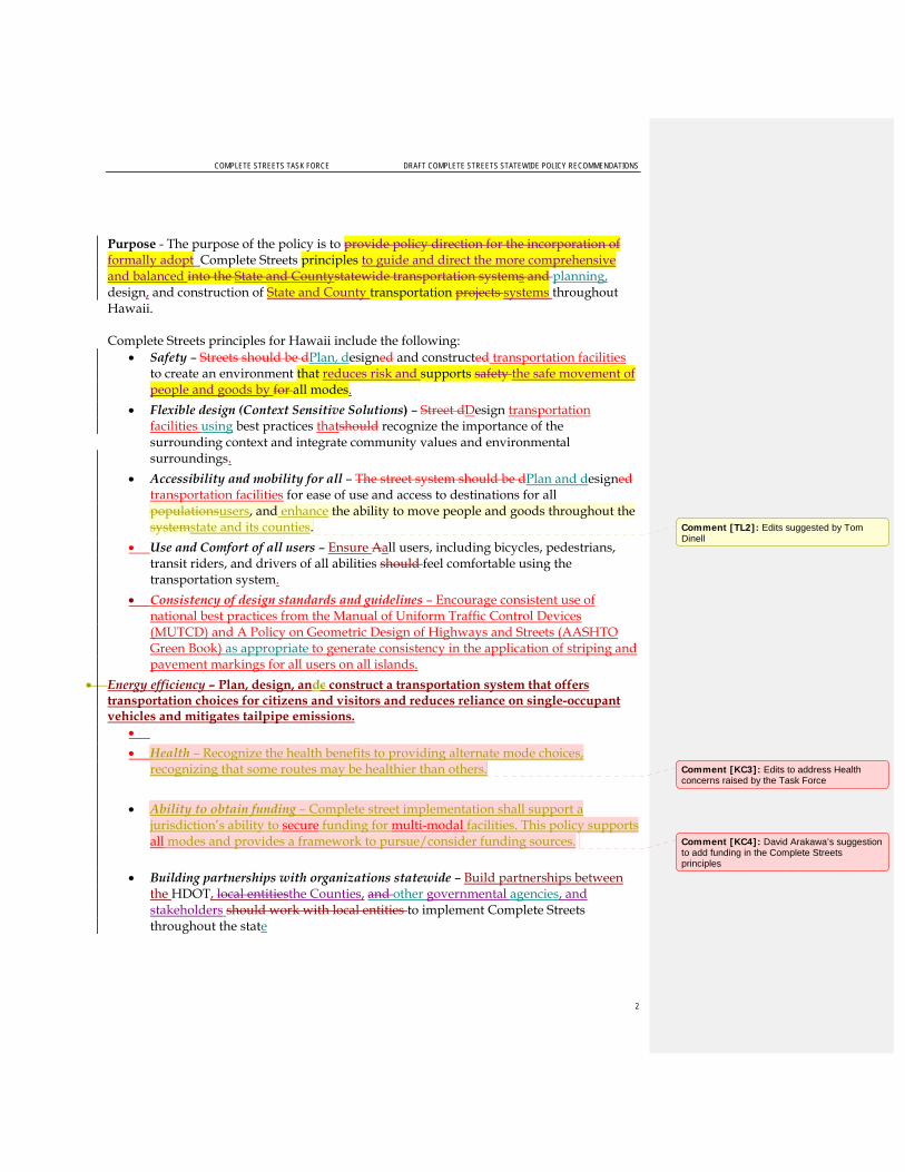
COMPLETE STREETS TASK FORCE DRAFT COMPLETE STREETS STATEWIDE POLICY RECOMMENDATIONS
2
Purpose - The purpose of the policy is to provide policy direction for the incorporation of formally adopt Complete Streets principles to guide and direct the more comprehensive and balanced into the State and Countystatewide transportation systems and planning, design, and construction of State and County transportation projects systems throughout Hawaii. Complete Streets principles for Hawaii include the following:
Safety – Streets should be dPlan, designed and constructed transportation facilities to create an environment that reduces risk and supports safety the safe movement of people and goods by for all modes.
Flexible design (Context Sensitive Solutions) – Street dDesign transportation facilities using best practices thatshould recognize the importance of the surrounding context and integrate community values and environmental surroundings.
Accessibility and mobility for all – The street system should be dPlan and designed transportation facilities for ease of use and access to destinations for all populationsusers, and enhance the ability to move people and goods throughout the systemstate and its counties.
Use and Comfort of all users – Ensure Aall users, including bicycles, pedestrians, transit riders, and drivers of all abilities should feel comfortable using the transportation system.
Consistency of design standards and guidelines – Encourage consistent use of national best practices from the Manual of Uniform Traffic Control Devices (MUTCD) and A Policy on Geometric Design of Highways and Streets (AASHTO Green Book) as appropriate to generate consistency in the application of striping and pavement markings for all users on all islands.
Energy efficiency – Plan, design, andc construct a transportation system that offers transportation choices for citizens and visitors and reduces reliance on single-occupant vehicles and mitigates tailpipe emissions.
Health – Recognize the health benefits to providing alternate mode choices, recognizing that some routes may be healthier than others.
Ability to obtain funding – Complete street implementation shall support a jurisdiction’s ability to secure funding for multi-modal facilities. This policy supports all modes and provides a framework to pursue/consider funding sources.
Building partnerships with organizations statewide – Build partnerships between
the HDOT, local entitiesthe Counties, and other governmental agencies, and stakeholders should work with local entities to implement Complete Streets throughout the state
Comment [TL2]: Edits suggested by Tom Dinell
Comment [KC3]: Edits to address Health concerns raised by the Task Force
Comment [KC4]: David Arakawa’s suggestion to add funding in the Complete Streets principles

COMPLETE STREETS TASK FORCE DRAFT COMPLETE STREETS STATEWIDE POLICY RECOMMENDATIONS
3
Definitions
This section includes definitions of key terms used in the Complete Streets policy. Definitions consistent with the Statewide Traffic Code (HRS §0291C-0001) are noted, however will be removed in the final draft presented to the Legislature.. Accessibility – The ability to reach desired goods, services, activities, and destinations for all transportation systems users. Accessible Route – A continuous, unobstructed path connecting all accessible elements and spaces of a building or facility that meets the requirements of ADAAG. (From USDOT, FHWA, Designing Sidewalks and Trails for Access) Assistive Device – A device that assists users in accomplishing day-to-day functions. For example, a wheelchair is an assistive device to assist a person who cannot walk. (From USDOT, FHWA, Designing Sidewalks and Trails for Access) Bicycle – Every vehicle propelled solely by human power upon which any person may ride, having two tandem wheels, and including any vehicle generally recognized as a bicycle though equipped with two front or two rear wheels except a toy bicycle. (From HRS 291C) Bicycle Boulevard – Low-volume and low-speed streets that have been optimized for bicycle travel through treatments such as traffic calming and traffic reduction, signage and pavement markings, and intersection crossing treatments. Bicycle Facility – A general term describing improvements and provisions made specifically to accommodate or encourage bicycling, including bicycle lanes, bicycle paths, bicycle routes, shared use paths, bikeways, improved shoulders, bicycle boulevards and bicycle parking and storage facilities. Bicycle Lane – That portion of the highway which has been set aside for the preferential or exclusive use of bicycles. (From HRS 291C) Bicycle Path – Any facility set aside for the preferential or exclusive use of bicycles and physically separated from a highway. (From HRS 291C) Bicycle Route – Any highway that is designated to be shared by bicycles and pedestrians or motor vehicles, or both. (From HRS 291C) Bikeway – A bicycle lane, bicycle path, or bicycle route, or any traffic control device, shelter, parking facility, or other support facility to serve bicycles and persons using bicycles. (From HRS 291C)
Bikeway - A generic term for any road, street, path or way which in some manner is specifically designated for bicycle travel, regardless of whether such facilities are designated for the exclusive use of bicycles or are to be shared with other

COMPLETE STREETS TASK FORCE DRAFT COMPLETE STREETS STATEWIDE POLICY RECOMMENDATIONS
4
transportation modes. (From Draft AASHTO Guide for the Planning, Design, and Operation of Bicycle Facilities, 2010)
Bicyclist – A person on a vehicle propelled solely by human power upon which any person may ride, having two tandem wheels, and including any vehicle generally recognized as a bicycle though equipped with two front or two rear wheels except a toy bicycle. (Consistent with HRS 291C) Bus – Every motor vehicle designed for carrying more than ten passengers and used for the transportation of persons; and every motor vehicle, other than a school bus or taxicab, designed and used for the transportation of persons for compensation. (From HRS 291C) Context Sensitive Solutions (CSS) – A process in which a full range of stakeholders are involved in developing transportation solutions, and solutions are designed to fit into to the surrounding environment, or context. Complete Street – A transportation facility that is planned, designed, operated, and maintained to provide safe mobility for all users, including bicyclists, pedestrian, transit riders, freight, and motorists appropriate to the function and context of the facility. Crosswalk – 1) That part of a roadway at an intersection included within the connections of the lateral lines of the sidewalks on opposite sides of the highway measured from the curbs or, in the absence of curbs, from the edges of the traversable roadway; or 2) Any portion of a roadway at an intersection or elsewhere distinctly indicated for pedestrian crossing by lines or other markings on the surface. (From HRS 291C) Driver – Every person who drives or is in actual physical control of a vehicle. (From HRS 291C) Electric Personal Assistive Mobility Device – A self-balancing, two-wheeled, non-tandem-wheeled device, designed to transport only one person, using an electric propulsion system that limits the maximum speed of the device to twelve and a half miles per hour or less. (From HRS 291C) Highway – The entire width between the boundary lines of every way publicly maintained and those private streets, as defined in section 46-16, over which the application of HRS §0291C-0001 has been extended by ordinance, when part thereof is open to the use of the public for purposes of vehicular travel. (Consistent with HRS 291C) Moped – A device upon which a person may ride which has two or three wheels in contact with the ground, a motor having a maximum power output capability measured at the motor output shaft, in accordance with the Society of Automotive Engineers standards, of two horsepower (one thousand four hundred ninety-two watts) or less and, if it is a combustion engine, a maximum piston or rotor displacement of 3.05 cubic inches (fifty cubic centimeters) and which will propel the device unassisted, on a level surface at a maximum speed no greater than thirty miles per hour; and a direct or automatic power drive system

COMPLETE STREETS TASK FORCE DRAFT COMPLETE STREETS STATEWIDE POLICY RECOMMENDATIONS
5
which requires no clutch or gear shift operation by the moped driver after the drive system is engaged with the power unit. (From HRS 291C) Motorcycle – Every motor vehicle having a seat or saddle for the use of the rider and designed to travel on not more than three wheels in contact with the ground but excludes a farm tractor and a moped. (From HRS 291C) Motor Scooter – Every motorcycle which produces not more than five horsepower, and excludes a moped. (From HRS 291C) Motor Vehicle – Every vehicle which is self-propelled and every vehicle which is propelled by electric power but not operated upon rails but excludes a moped. (From HRS 291C) Neighborhood Electric Vehicle – A self-propelled electrically powered motor vehicle to which all of the following apply:
(1) The vehicle is emission free; (2) The vehicle is design to carry four or fewer persons; (3) The vehicles is designed to be and is operated at speeds of twenty-five miles per
hour or less; (4) The vehicle has at least four wheels in contact with the ground; (5) The vehicle has an unladen weight of less than one thousand eight hundred
pounds; (6) The vehicle conforms to the minimum safety equipment requirements as
adopted in the Federal Motor Vehicle Safety Standard No. 500, Low Speed Vehicles (49 C.F.R. 571.500). (From HRS 291C)
Multi-modal – The movement of people and goods by more than one method of transportation. For example, a multi-modal street may accommodate walking, bicycling, transit, and driving. Pedestrian – Any person afoot, in an invalid chair, or in a vehicle propelled by a person afoot. (From HRS 291C) Preventative Maintenance – This work is directed towards maintaining the existing roadway and related appurtenances as necessary for the safe and efficient operation. Design improvements are not the normal intent of maintenance operations. Pavement repairs such as seal coats, full width patching, crack sealing, and thin plant mix resurfacing for sealing of the pavement surface to correct minor surface irregularities, etc., are generally considered as maintenance activities. Private Road or Driveway– Every way or place in private ownership and used for vehicular travel by the owner and those having express or implied permission from the owner, but not by other persons. (From HRS 291C) Re-surfacing – This work consists of the application of a new or recycled layer or layers of pavement material in excess of 1-1/2 inch depth including inlays to existing pavement to provide additional structural integrity or improved ride.

COMPLETE STREETS TASK FORCE DRAFT COMPLETE STREETS STATEWIDE POLICY RECOMMENDATIONS
6
Right of way – The right of one vehicle or pedestrian to proceed in a lawful manner in preference to another vehicle or pedestrian approaching under such circumstances of direction, speed, and proximity as to give rise to danger of collision unless one grants precedence to the other. (From HRS 291C) Roadway – That portion of a highway improved, designed or ordinarily used for vehicular travel, exclusive of the berm or the shoulder. In the event a highway includes two or more separate roadways the term “roadway” as used herein refers to any such roadway separately but not to all such roadways collectively. (From HRS 291C) School Bus – Is defined as every motor vehicle as defined in Section 286-181 and any regulations promulgated pursuant thereto by the Department of Education. (From HRS 291C) Shared Use Lane – A lane of a traveled way that is open to bicycle travel and vehicular use. (From Draft AASHTO Guide for the Planning, Design, and Operation of Bicycle Facilities, 2010) Shared Use Path – A bikeway physically separated from motorized vehicular travel by an open space or barrier. Shared use paths may be used by but are not limited to non-motorized users such as: bicyclists, in-line skaters, wheelchair users (both non-motorized and motorized), and pedestrians. Shoulder – The portion of the roadway contiguous with the traveled way, for accommodation of stopped vehicles, emergency use and lateral support of sub-base, base and surface courses, often used by cyclists and/or pedestrians where paved. (From Draft AASHTO Guide for the Planning, Design, and Operation of Bicycle Facilities, 2010) Sidewalk – That portion of a street between the curb lines, or the lateral lines of a roadway, and the adjacent property lines, intended for use of pedestrians. (From HRS 291C) Street – The entire width between boundary lines of every way publicly maintained when any part thereof is open to the use of the public for purposes of vehicular travel. (From HRS 291C) Toy Bicycle – Every device propelled solely by human power upon which any person may ride, having two tandem wheels, including any device generally recognized as a bicycle though equipped with two front or two rear wheels, which has a seat height of not more than twenty-five inches from the ground when the seat is adjusted to its highest position; or a scooter or similar device regardless of the seat height. (From HRS 291C) Traffic – Pedestrians, ridden or herded animals, vehicles, and other conveyances either singly or together while using any highway for purposes of travel. (From HRS 291C) Users – Motorists, bicyclists, transit riders, pedestrians, and anyone else who depends on the transportation system to move people and goodsi.

COMPLETE STREETS TASK FORCE DRAFT COMPLETE STREETS STATEWIDE POLICY RECOMMENDATIONS
7
Vehicle – Every device in, upon, or by which any person or property is or may be transported or drawn upon a roadway or highway, including mopeds and bicycles, but excluding toy bicycles, devices other than bicycles moved by human power, and devices used exclusively upon stationary rails or tracks. (From HRS 291C)
Applicability
This Complete Streets policy will be implemented on all public roads statewide (State and County facilities); applying to new construction and reconstruction. Complete Streets principles shallould be considered considered incorporated on all public roads statewide when updating long-term planning documents and when considering project alternatives. Agency design standards shall also be updated to incorporated Complete Streets principals. that provide guidance on street design and/or transportation projects.
Evaluationxceptions The consideration of Complete Streets will be applied on all planning efforts, as well as development, capital, and maintenance projects. A meaningful process should be utilized to evaluate the appropriateness and feasibility of the application of Complete Streets. The evaluation process will be clear and decisions will be documented. The decision to grant an exception should occur at a high-level from the governing agency to ensure that such exceptions are consistent and legitimate. Examples of exceptions are: Exceptions to the policy are: To Be Discussed Next CSTF MeetingThis Complete Streets policy shall not apply if:
Use of a particular highway, road, street, way, or lane by bicyclists or pedestrians is prohibited by law, including within interstate highway corridors;
The costs would be excessively disproportionate to the need or probable use of the particular highway, road, street, way or lane (Excessively disproportionate is defined as exceeding twenty percent of the cost of the larger transportation project);
There exists a sparseness of population, or there exists other available means, or similar factors indicating an absence of a future need;
The safety of vehicular, pedestrian, or bicycle traffic may be placed at unacceptable risk;
The quality of the environment is degraded.;
The project is routine maintenance, such as preventative maintenance and re-surfacing.
Comment [KC5]: I would suggest that the CSTF reconsider the use of the word “consider” vs. “incorporate”. Incorporate suggests that an agency has to incorporate/build complete streets components on all streets when it may not be contextually appropriate. Use of “consider” would also allow agencies more flexibility with their maintenance projects and the last bullet under exceptions could be removed. July 29, 2010: Complete Streets PIG: The Investigative Group agreed that it would be more appropriate to allow agencies flexibility in the application of Complete Streets. The policy is a living document and this first step is to encourage agencies to adopt and implement the policy. Language that is too prescriptive may lead to unintended consequences. In addition, it will be less likely that agencies will adopt this draft policy.
Comment [k6]: Suggestion from Janice Marsters “accessible to the public” removed because all project information is open to the public per the Freedom of Information Act.
Comment [TL7]: Both Wisconsin’s Complete Streets Policy and the US DOT’s policy on integrating bicycling and walking into transportation infrastructure cite more than 20 percent of the total project cost as being “Excessive” July 29, 2010: Complete Streets PIG: The Investigative Group agreed that it would be more appropriate to allow agencies flexibility in the application of Complete Streets and determining what is considered excessively disproportionate or not.
Comment [KC8]: This bullet could be removed if the applicability statement is changed to “considered” vs. “incorporated”. Preventative maintenance projects will need to evaluate/consider the incorporation of Complete Streets elements (such as re-striping). However, if it is determined that the incorporation is not contextually supported or the costs are excessively disproportionate – the agency would not have to incorporate Complete Streets elements.

COMPLETE STREETS TASK FORCE DRAFT COMPLETE STREETS STATEWIDE POLICY RECOMMENDATIONS
8
Implementation of the Complete Streets Policy Requirement for Development of Design Standards and Guidelines
To Be Discussed Next CSTF Meeting The implementation of this Complete Streets policy will vary depending on agency (State or County). Agencies shall implement this Complete Streets policy through at least one or more of the following implementation tools:
Develop a Complete Streets checklist
Create/update design guidelines that integrate Complete Streets elements
Develop performance measures
Conduct training sessions and/or workshops
Collaborate with agencies to agree on the common design standards and guidelines to create consistency in pavement markings among the islands
Authority and/ResponsibilitiesAccountability
[This section describes who at the State/County has the authority to implement the Complete Streets policy, grant exceptions, and sign off on projects.]
To Be Discussed Next CSTF MeetingThe authority of implementing this Complete Streets policy, granting exceptions, and signing off on projects will vary throughout the different State and County jurisdictions. A high level approval is important to ensure that exceptions are consistent and legitimate. The exceptions process will be clear and decisions will be documented. and accessible to the public. Additional levels of approval may vary dependent on implementing jurisdiction.
State Department of Transportation
Department of Transportation Director or his/her designee
City and County of Honolulu
Department of Transportation Services Director or his/her designee
Department of Planning and Permitting Director or his/her designee
County of Kauai Department of Public Works Director or his/her designee
Department of Planning Director or his/her designee
County of Maui Department of Public Works Director or his/her designee
Department of Planning Director or his/her designee
County of Hawaii
Department of Public Works Director or his/her designee
Comment [k9]: July 29, 2010: Complete Streets PIG: The Investigative Group agreed that it would be more appropriate to move this section to the Legislative Report. The Complete Streets Policy should be a broad vision statement and not include the implementation specifics. Providing recommendations to the Leg and agencies would add more value in the Leg Report.
Comment [k10]: July 29, 2010: Complete Streets PIG: The Investigative Group discussed the necessity of this section. Parts of this section have been included in the Evaluation Section (the intent to have a clear and documented process). The goal and vision of the Complete Streets policy is to have all public entities apply Complete Streets, as appropriate. Act 54 only specifies that the state, city and counties departments of transportation adopt a Complete Streets policy. In the spirit of applying Complete Streets statewide (as stated in this draft policy), listing some agencies and not all would seem exclusive and listing all agencies would not be appropriate, especially the ones that have not been part of the process.

COMPLETE STREETS TASK FORCE DRAFT COMPLETE STREETS STATEWIDE POLICY RECOMMENDATIONS
9
Department of Planning Director or his/her designee
State Department of Hawaiian Home Lands
Department of Hawaiian Home Lands Director or his/her designee
State Department of Land and Natural Resources
Department of Land and Natural Resources Director or his/her designee
University of Hawaii President of the University or his/her designee
Penalty for Violations and Incentives for SuccessAccountability
To Be Discussed Next CSTF Meeting i The definition for a user is very broad and may include other types of users at varying skill levels.

PAGE 1 OF 7
M E M O R A N D U M
Draft Implementation and Agency Project Development and Design Review Procedures TO: Complete Streets Task Force
Ken Tatsuguchi, HDOT Rachel Roper, HDOT
DATE: June 23, 2010
Complete Streets: Best Policy and Implementation Practices The Complete Streets: Best Policy and Implementation Practices book issued by the American Planning Association contains a chapter that describes how complete streets policies can be institutionalized through five strategic points of integration. These points include:
Long-Range Community Visioning and Goal Setting
Plan Making
Standards, Policies, and Incentives
Development Work
Public Investment
Addressing all or some of these integration opportunities will allow complete streets to be widely implemented. Included below is a summary of these strategic points and an explanation of how they are relevant to Hawaii.
Long-Range Community Visioning and Goal Setting Long-range community visioning and goal setting is the first chance to identify new opportunities and practices related to complete streets. These long-range visioning and goal exercises are usually a first step to a comprehensive community plan or plan-making process, and usually include goals that support the complete streets vision. Examples of vision statements and goals that are consistent with complete streets include: creating a walkable or bikeable community, including sidewalks and bicycle lanes, emphasizing active transportation modes, providing safe transportation choices, and establishing an integrated network of transportation opportunities. Planners and community leaders should recognize and take advantage of these opportunities to identify and include complete streets aspects important to the community into visions and goals.

PAGE 2 OF 7
Relevance to Hawaii As mentioned above, long-range community visioning and goal setting is typically the first step to a comprehensive plan or other plan-making process. For communities and planners in Hawaii this is a great place to identify new opportunities and priorities related to complete streets. There are several community visioning and goal setting projects that are currently underway.
Current Efforts in the State of Hawaii: State Department of Transportation, Statewide Transportation Planning Office: Hawaii
Statewide Transportation Plan City and County of Honolulu, Department of Planning and Permitting: Aiea-Pearl City
Neighborhood Transit-Oriented Development Plan State Department of Transportation, Highways Planning Branch: Statewide Pedestrian
Master Plan
Plan Making Planning departments are responsible for producing a variety of documents affecting infrastructure and facilities, land-use patterns, open space, transportation options, housing choice and affordability. They are responsible for the framework that coordinates planned population and land use growth with supportive infrastructure improvements. It is possible to integrate complete streets considerations into comprehensive, neighborhood, corridor, and other planning documents. The types of plans are discussed below.
Comprehensive Plans Comprehensive plans are the documents that guide the future of a community and its development. These plans describe existing conditions, identify goals and priorities, and lay out action items for achieving goals. Integrating complete streets concepts ensures communities consider the concepts during design and development. A comprehensive plan allows communities to encourage integration of complete streets practices in various aspects of planning, policy and design decisions and provide the framework and guidance for complete streets development.
Community Development and Specific Area Plans These plans are more specific than comprehensive plans and provide an opportunity to include specific details on complete streets elements in a particular area of a community. They allow for context sensitive considerations and should be consistent with the comprehensive plan while providing more guidance on street design, local street networks, and design features for a specific neighborhood or corridor.
Transportation Plans and Corridor Plans Transportation master plans or related plans such as bicycle plans, pedestrian plans, or transit plans guide the future of a community’s transportation systems. Integrating complete streets makes it easier to implement appropriate goals, and allows complete streets principles to be

PAGE 3 OF 7
addressed from the initial stages of a development project instead of during the review of an already conceptualized or designed project.
Corridor Plans are similar to Community Development Plans in the sense that they are more specific than a transportation plan and provide an opportunity to include specific details on complete streets elements and principles within a particular corridor. They allow for context sensitive considerations and should be consistent with the comprehensive transportation plan while providing more guidance on street design, local street networks, and design features for a specific corridor.
Relevance to Hawaii In Hawaii, planning occurs at all levels of government from the State Office of Planning to the Counties’ neighborhood plans. The Office of Planning works to maintain an overall framework to guide the development of the State through a continuous process of comprehensive, long-range, and strategic planning to meet the physical, economic, and social needs of Hawaii’s people. Within the State Department of Transportation (DOT), the Statewide Transportation Planning Office is responsible for establishing a comprehensive, multi-modal statewide transportation planning process and developing a balanced, multi-modal statewide transportation plan. At the City and County of Honolulu (CCH), the Department of Planning and Permitting (DPP), Planning Division helps establish, promote, and implement long-range planning programs for Honolulu which reflect the community’s values, priorities, and visions for the future. They are responsible for the framework that coordinates planned population and land use growth with supportive infrastructure improvements. The Counties of Maui, Hawaii, and Kauai, Planning Departments are responsible for the implementation of long-range planning programs for the islands of Maui, Molokai, Lanai, Hawaii and Kauai.
Examples of Comprehensive Plans in the State of Hawaii: DOT, Statewide Transportation Planning Office: Hawaii Statewide Transportation Plan DOT, Highways Planning Branch: Statewide Long-Range Land Transportation Plan CCH, DPP: Oahu General Plan County of Maui, Planning Department: Maui County General Plan (Countywide Policy
Plan) County of Hawaii, Planning Department: County of Hawaii General Plan County of Kauai, Planning Department: Kauai General Plan
Examples of Community Development and Specific Area Plans in the State of Hawaii: CCH, DPP: Ewa Development Plan CCH, DPP: Aiea-Pearl City Neighborhood Transit-Oriented Development Plan CCH, DPP: North Shore Sustainable Communities Plan County of Hawaii, Planning Dept.: EnVision Downtown Hilo County of Kauai, Planning Dept.: Kilauea Town Plan County of Maui, Planning Dept: Hana Community Plan
Examples of Transportation and Corridor Plans in the State of Hawaii: DOT, Highways Planning Branch: Regional Long-Range Land Transportation Plans for
Maui, Kauai and Hawaii DOT, Highways Planning Branch: Statewide Pedestrian Master Plan

PAGE 4 OF 7
DOT, Highways Planning Branch: Bike Plan Hawaii CCH, Department of Transportation Services: Oahu Bike Plan County of Maui, Department of Transportation: Short Range Transit Plan
Standards, Policies, and Incentives Standards, policies, and incentives allow planners and engineers guide what, where, and how things get built. These documents include zoning codes, subdivision ordinances, design guidelines and manuals, and other regulations and ordinances. These are the tools for implementing plan goals, policies, and ideas, and are integral to addressing, accommodating, and removing barriers to creating complete streets. Policies and standards can require developers to include sidewalks and bikeways in developments in accordance with adopted plans, creating a consistent expectation for developers, and a way to implement adopted bicycle and pedestrian plans.
Relevance to Hawaii Planners and engineers in Hawaii are also bound by standards and policies. At the State level, the Hawaii Revised Statutes (HRS) provides the governing authority. At the DOT, Administrative Regulations, procedures and standards are the tools that staff uses to guide what, where and how things get built. At the City and County level, City and County codes, ordinances, and standards provide the guidance.
Examples of Standards and Policies in the State of Hawaii: DOT, Highways Division: Hawaii Administrative Rules, Chapter 19-127.1 Design,
Construction, and Maintenance of Public Streets and Highways CCH, DPP: Subdivision Street Standards and Subdivision Checklist County of Maui, Planning Department: Title 19 Zoning Code County of Hawaii, Planning Department: Chapter 23 Subdivision Code County of Kauai, Department of Public Works: Standard Details for Public Works
Construction
Development Work Development work includes reviewing project applications for consistency with applicable plans and regulations. Planners and engineers are responsible for ensuring that complete streets goals and standards are met and encouraged in the development process.
Project Review Planners and engineers are responsible for determining a development project’s consistency with applicable standards. The development of a checklist of relevant standards or goals for new projects can help ensure that complete streets principles and standards are considered. Checklists cover details about street planning and design, prompting staff to consider opportunities for natural drainage, transit access improvements and efficiency, bicycle and pedestrian route improvements to local schools, and other elements. Checklists can encourage

PAGE 5 OF 7
staff to work with other departments to include complete streets considerations in road design and development. These review processes help developers understand required improvements and ensure appropriate inclusion and implementation of complete street principles.
Relevance to Hawaii City and County of Honolulu: Department of Planning and Permitting DPP works with developers to require that developments have internal bicycle and pedestrian facilities and considerations. For initial developments, a Traffic Impact Analysis (TIA) is required based on the land use and number of units. As a condition for rezoning, the developer needs to prepare a roadway master plan and a traffic management plan, which must address various modes of transportation.
The final development includes considerations for bicycles, pedestrians and transit. Bicycle and pedestrian routes are required; preferably grade separated if space allows. For transit, the focus is on direct routes. The City would prefer 85 percent of the homes to be within ½ mile or 10 minutes of a transit stop in a development.
There are roadway standards for various classifications of roadways. For example, collectors are required to have bike lanes. Curb ramps are required at every intersection, with a 2 percent cross-grade.
Traffic calming may also be preferred, especially near schools, and can include bulb-outs and roundabouts. The City works with the Department of Education to institute residential and school connectivity.
The City and County prefers interconnectivity between developments and roundabouts within subdivisions.
Public Investments Public project investment decisions are important to include when developing and implementing complete streets. Without funding commitments or consideration during decision processes, complete streets are difficult to build. Funding decisions affect the design and location of transit, streets, sidewalks, bikeways, and other public infrastructure and facilities. Public project investments are an important opportunity for meeting complete streets goals.
Capital Improvement Programs These programs, known as CIPs lay out public improvements and associated costs for a five year period. Planners, engineers, and transportation staff need to be involved in creating the CIP to ensure public investment supports the commitment to complete streets. Criteria for funding prioritization should also include complete streets considerations to help ensure the implementation of projects with Complete Streets elements.
Street Resurfacing Street resurfacing can be an opportunity to add a range of complete streets elements. Reconfiguring existing roadways during resurfacing can be accomplished by adding bicycle
PAGE 6 OF 7
lanes, reconfiguring parking, or adding sidewalks and crosswalks. Even small projects can be an opportunity to make meaningful improvements, such as shifting an edge stripe to create more room for cyclists. Careful consideration is needed during the evaluation process to ensure that the restriping of roadways occurs in a holistic manner that does not directly impact the roadway network, or trigger additional improvements (like drainage) that could jeopardize the preservation project. The evaluation process should address any accessibility requirements that may be needed.
Relevance to Hawaii County of Maui: Department of Public Works County roadway standards are the basis for how roadways are designed. There are also code requirements and development codes. For Federal-Aid projects and street renovations that are more extensive, the County completes in-depth design reviews, and considers aspects such as accessibility and bicycle facilities.
County resurfacing projects are reviewed by the Disability and Communication Access Board
If ramps exist, they must be brought up to ADA standards
If the public requests sidewalks or ramps specifically, there is a separate line item in the budget to pay for the project, which comes out of the CIP program.
State Department of Transportation: Highways Division Context and modal considerations occur during the project planning phase, which includes the NEPA/HRS 343 processes. The ability to implement Complete Streets may depend on the type of project (ex. guardrail repair project, signing, etc.) and funding category.
The DOT is taking a broader perspective of how to use its highway rights of way by looking at multi-modal transportation alternatives and solutions. The travel modes include bicycle, pedestrian, freight transport, transit, motor vehicles and ADA considerations. They are also taking a comprehensive approach to planning safe and efficient roads by considering how enforcement and education can complement engineering solutions.
The DOT is also implementing Context Sensitive Solutions (CSS) in some of its projects, further exemplifying their commitment to working to develop a holistic transportation system. CSS considers not only the geometric and mobility requirements of the design, but the broader purpose and need for the community and community values such as aesthetics, environmental quality, historic resources, and economic development. This process is inclusive of all stakeholders and provides meaningful opportunities to contribute in defining outcomes.
Hawaii Statewide Transportation Improvement Program (STIP) The Hawaii Statewide Transportation Improvement Program (STIP) is a multimodal transportation program that provides a multi-year listing of State and County projects identified for federal or special funding. The STIP is developed by drawing from existing transportation plans and policies, and current highway, transit and transportation planning processes. It is prepared by HDOT in cooperation with the Oahu Metropolitan Planning Organization (OMPO), Department of Transportation Services, City and County of Honolulu,

PAGE 7 OF 7
County of Hawaii, County of Maui, and County of Kauai. To qualify for funding, STIP projects must be consistent with each county’s long range plan and/or the Statewide Transportation Plan. In addition, STIP projects can only be located on roadways functionally classified greater than collector roads, and local neighborhood roads are not eligible for STIP funding.
Current Complete Streets Efforts in the DOT Safe Routes to School: Promotes bicycling/walking with a focus on elementary and middle school aged children. Receive proposals from government agencies, businesses, communities, and organizations statewide.
Walkwise Hawaii: Coalition (with the City Department of Transportation Services and Honolulu Police Department) that focuses on safe crossing techniques and driver awareness for senior pedestrians.
Pedestrian Safety Action Plan workshops: Hosted by HDOT, LTAP and FHWA. Brought together a diverse mix of people from government & community organizations who were able to form strategies to improve pedestrian safety in their communities.
Bike Plan Hawaii (BPH) and BPH Implementation Project: BPH integrates bicycling into Hawaii’s transportation system. It was most recently updated in 2003. The HDOT has initiated an effort to advance implementation of high priority projects found in this plan. The 2003 update was a comprehensive effort that included an extensive public involvement process. This project will build off of this and gather additional information through field review and consultations with stakeholders form community organizations and government agencies.
ADA Improvements: These projects were initiated to bring the HDOT in compliance with its ADA Consent Decree and provided persons with disabilities access to HDOT facilities.
Pedestrian countdown timers: Installation of pedestrian countdown timers is the current standard for the DOT. There are current projects in place that are specifically installing the countdown timers.

TBG
1004
1015
3435
HN
L
Appendix KComplete Streets Task Force Meeting #6 Materials

NAMES IN BOLD ARE TASK FORCE/ALTERNATE MEMBERS. 1
COPYRIGHT 2010 BY CH2M HILL, INC. • COMPANY CONFIDENTIAL
M E E T I N G S U M M A R Y
Complete Streets Task Force Meeting #6 Minutes DATE: September 15, 2010
LOCATIONS: HDOT Office on Oahu (Punchbowl Street) and Kauai, Maui and Hawaii District Offices
FROM: Kathleen Chu, CH2M HILL Cheryl Yoshida, CH2M HILL Kit Ieong, CH2M HILL
COPIES: Ken Tatsuguchi, HDOT Rachel Roper, HDOT
ATTENDEES: TASK FORCE MEMBERS/ ALTERNATES:
Rob Miyasaki, Bryan Kimura, Paul Santo, Gareth Sakakida, Dr. Peter Flachsbart, Liz Fischer, Reg White, Tom Dinell, Janice Marsters, Joel Kurokawa, Kari Benes, Mark Behrens, Wayne Yoshioka, Claude Matsuo (alternate), Bob Sumitomo, Mel Hirayama (alternate), David Arakawa, Bob Ward, Ray McCormick (Kauai), Marie Williams (Kauai), Milton Arakawa (Maui), Don Medeiros (Maui), Bobby Jean Leithead Todd (Hawaii)
STAFF/TECHNICAL TEAM:
Brennon Morioka, Ken Tatsuguchi, Rachel Roper, Kathleen Chu, Cheryl Yoshida, Paul Luersen, Kit Ieong, George Abcede, Chris Sayers, David Nilsen, Curtis Motoyama, Ron Thiel (Hawaii), Stanley Tamura (Hawaii), Ferdinand Cajigal (Maui)
FRIENDS/ INTERESTED PARTIES:
Tom Smyth, Susan Papuga, Daniel Alexander, Maury King (Maui), Ervin Pigao (Maui), Thomas Noyes (Kauai)
TASK FORCE MEMBERS NOT IN ATTENDANCE:
Michael Lum
Meeting commenced at 1:35 PM.
Welcome & Introductions Brennon Morioka opened the meeting by thanking everyone for attending the last Complete Streets Task Force (CSTF) meeting. Brennon hoped that everyone learned and was educated about the government decision-making process through this effort. He believes that everyone has also realized the struggle and difficulty of trying to find a balance and compromise with all users. It is a long process but is educational and beneficial to staff. He looks forward to moving the policy forward and making the recommendations to the Legislature. Brennon thanked the Task Force members again for their time, effort and commitment. Kathleen Chu led the round table introductions.

MEETING SUMMARY_09152010_V4 2 COPYRIGHT 2010 BY CH2M HILL, INC. • COMPANY CONFIDENTIAL
Work Plan and Agenda Review After the round table introductions, Kathleen asked for a Task Force motion to approve the August 4th meeting minutes. Bob Sumitomo clarified his statement from the last meeting about sustainable community plans. He made it clear that there are nine community plans in addition to the sustainable community plans. Bob Ward made a motion to approve the revised minutes. Wayne Yoshioka seconded. The remaining Task Force members raised their hands to signal their approval of the meeting minutes. All approved with no nays. The Complete Streets Task Force Meeting #5 Minutes was approved with the clarification. A quorum of more than 11 task force members was present (20 members were present). Kathleen continued and stated that the Task Force had accomplished a lot of work in a short period of time. She reviewed the work plan and meeting agenda, which included the goal of arriving at a final recommended Complete Streets Policy and final recommended Legislative Report by the end of the meeting. Kathleen also mentioned that the final draft of the Legislative Report is due to the HDOT’s Legislative Coordinator at the end of next month.
Complete Streets Policy Updates Kathleen mentioned that two versions of the Complete Streets Policy, Versions 15 and 16 (with track changes) were provided. Janice Marsters asked for clarification on the changes that had been made to the two different versions. Rob Miyasaki explained that Version 14 is the one that was sent to Task Force members after Meeting #5. It gave agencies more flexibility and kept the policy broad. He suggested going back to the wording in Version 14, which is essentially Version 16 with the track changes. Kathleen clarified that Version 14 incorporates comments from the Task Force from Meeting #5. After Meeting #5, additional comments were received from Jackie Boland and Tom Dinell, who suggested some editorial changes. Their comments are reflected as Version 15. Tom Dinell explained that during the last meeting, the Task Force reached censuses to revise the Vision to make it more visionary. Rob Miyasaki responded that the Task Force should focus to keep the Complete Streets Policy a broad policy that all agencies will adopt. Wayne Yoshioka asked the other Task Force members if they have any issues with the last two sentences of the revised policy (Version 16). Liz Fischer suggested not deleting the second to the last sentence of the first paragraph of Vision. Bob Ward said that he’s happy with the last two sentences. He felt that the last sentence is also important as it relates to development.

MEETING SUMMARY_09152010_V4 3 COPYRIGHT 2010 BY CH2M HILL, INC. • COMPANY CONFIDENTIAL
Wayne Yoshioka thought that the last sentence is redundant. Janice Marsters asked what “application” means in the second sentence of the first paragraph of Vision. Kathleen responded that “application” refers to the evaluation process, i.e. content sensitive solution. Kathleen asked the Task Force if they were in favor of the proposed changes to the Vision paragraph. All Task Force members agreed. Some Task Force members suggested grammatical and editorial comments in the Vision and Purpose and Definitions sections:
Dr. Peter Flachsbart suggested moving the phrase “whether it is new construction or reconstruction” to be located after “transportation improvements” in the first paragraph of the vision.
Bob Sumitomo suggested that it should be “a statewide transportation system” instead of
“a statewide transportation systems” in the second paragraph of the vision.
Tom Dinell suggested using the word “bicyclists” instead of “bicycles” on page 2 under the Use and Comfort of all Users principle.
Liz Fischer suggested adding “Green Streets” to the Green Infrastructure Principle on page
2 and the Green Infrastructure definition on page 3. It will be “Green Infrastructure/Green Streets.”
Bob Sumitomo also pointed out that the word “to” should be deleted in the Context
Sensitive Solution definition on page 3 so it reads “…designed to fit into the surrounding environment, or context”.
Moving on to the Applicability section, Liz Fischer asked what project alternatives are. Kathleen responded that it includes all alternatives when doing long-range planning and developing projects. Bob Ward mentioned that the term “public roads” is not defined in the HRS. The term “public roads” means all roads used by the public to him. Rob Miyasaki reminded the Task Force that the policy they are developing is only a draft for the agencies. Each agency may have a different definition and enforce the policy differently. Kathleen added that public agencies cannot force Complete Streets principles to be applied to privately owned roadways.
MEETING SUMMARY_09152010_V4 4 COPYRIGHT 2010 BY CH2M HILL, INC. • COMPANY CONFIDENTIAL
Bob Ward thought that it was a jurisdiction’s decision and did not want to exclude private developments in the policy. Bob Sumitomo mentioned that the City and County of Honolulu requires private roads to be built to public road standards, but explained that not every development will turn the private roads over to the City. Janice Marsters suggested going back to “public highways, roadways and streets” instead of “public roads,” which is more consistent with the HRS definitions and Act 54. Tom Dinell suggested including ordinances since ordinances are not long-term planning documents. Bryan Kimura questioned if the State has the authority to say that. Wayne Yoshioka added that the Counties typically operate by ordinance. Kathleen asked the neighbor islands if they have any comments. None was provided. All Task Force members agreed with adding “and/or ordinances.” The discussion moved to the Evaluation section. Dr. Peter Flachsbart asked what is meant by the last example exception, “the quality of the environment is degraded.” He mentioned that the addition of cars to a roadway degrades the environment. He suggested defining what “degrading the environment” would mean. Rob Miyasaki responded that it is just an example for agencies to consider. Bobby Jean Leithead Todd mentioned that if the statement is revised, then burials and endangered sites, etc. should be added as well, not just air quality concerns. Liz Fischer suggested cross-referencing existing Federal and State laws. Janice Marsters expressed concern with making the exceptions too black and white. She suggested mentioning projects that provide unacceptable impacts to the environment, which will be evaluated in the environmental process. Bob Ward mentioned that not all projects require environment permits. Janice Marsters suggested taking that exception example out. She reminded the task force that they were not setting specific exceptions, but providing for an exception process and listing examples. Kathleen asked other Task Force members if they thought it would be okay to take out the last example related to environmental impacts. The majority of the Task Force said yes.

MEETING SUMMARY_09152010_V4 5 COPYRIGHT 2010 BY CH2M HILL, INC. • COMPANY CONFIDENTIAL
Gareth Sakakida disagreed and raised his concern that leaving out the last bullet could impact commercial vehicles and require only alternate fuel vehicles. David Arakawa mentioned that the proposed policy should be consistent with Act 54, which does not list the last bullet about the environment. He suggested taking the example out and leaving it up to the agencies and their attorneys. Rob Miyasaki asked the Task Force to strive for consensus. Tom Dinell mentioned that the last bullet could be dropped because current laws address environmental impacts and define what an unacceptable environmental impact could be. Bob Ward added that environmental law allows mitigation. Janice Marsters suggested the removal of all the examples. Wayne Yoshioka added that the examples are helpful, although he is in favor of eliminating the last example as the majority of the Task Force members are. Gareth Sakakida said he will keep his nay vote. Tom Dinell pointed out that the word “will” in the first sentence should be “shall” to keep it consistent throughout the entire policy document. Bobby Jean Leithead Todd mentioned that there are a lot of maintenance projects in the County of Hawaii. If Complete Streets principles are required, she is concerned that the cost of maintenance projects will significantly increase, which could result in fewer/no maintenance projects. Kathleen responded that similar concerns were discussed and resolved during previous meetings. Cases like that can be considered as exceptions. Janice Marsters mentioned resurfacing and restriping projects that were discussed in Meeting #4. She also mentioned the Lunalilo Home Road example where the entire roadway was resurfaced except for the shoulder/parking lane. Including the shoulder/parking lane would have included a new, smooth surface for bicycles. David Arakawa mentioned that the consideration is required and agencies are covered by the law. Kathleen reviewed the changes to be made as discussed. Bob Ward moved to approve the policy as amended. Wayne Yoshioka seconded the motion. All Task Force members said ayes. The Complete Streets policy as amended by the Task Force was approved.

MEETING SUMMARY_09152010_V4 6 COPYRIGHT 2010 BY CH2M HILL, INC. • COMPANY CONFIDENTIAL
Draft Legislative Report Cheryl Yoshida reviewed the changes that were made to the draft Legislative Report, which included changes to the Introduction, Implementation Recommendations and Design Standards and Guidelines Recommendations sections based on Task Force comments during Meeting #5. Cheryl suggested that the Task Force focus their discussions on the content of the Legislative Report rather than editorial comments during the meeting. Editorial comments can be sent to the Project Management Team after the meeting. The sections to be discussed today are:
Performance Measures Recommendations Enforcement Next Steps
A break was called at 2:55 PM. Meeting resumed at 3:10 PM. David Arakawa mentioned that he is okay with the changes that have been made to date. Milton Arakawa commented that Maui task force members are also fine with the revised draft Legislative Report as well. Bobby Jean Leithead Todd commented that allowing agencies to have flexibility is good. Janice Marsters suggested moving the last sentence in the first paragraph of Design Standard Recommendations, “CSTF would like to encourage agencies to work together to create a consistent complete streets experience for transportation system users” to the end of the section. Cheryl went on and reviewed the list of appendices. Cheryl asked Task Force members for comments. Tom Dinell suggested adding Complete Streets references (not only design guidance references) to Appendix E. Bob Ward suggested mentioning in the Legislative Report the limited time that the Task Force was given to look at the design standards and guidelines and that only eight prioritized design standards were researched and discussed. He also reiterated that consensus was not reached on design standards recommendations. Tom Dinell suggested clarifying that cell phone usage by pedestrians and bicyclists should be prohibited “while using the crosswalk” under the last discussion bullet of Crosswalk Markings under Appendix D. Cheryl went over the Performance Measures section and reminded the Task Force of why they are important and how they can be used.
MEETING SUMMARY_09152010_V4 7 COPYRIGHT 2010 BY CH2M HILL, INC. • COMPANY CONFIDENTIAL
Bob Ward suggested including a list of measures or examples. Tom Dinell suggested revising the wording in the last paragraph of page 8 to stress that it will be a continued process to develop an effective performance measurement approach. Kathleen mentioned the difference between outcomes and outputs. She also reminded the Task Force that some measures might be data intensive; some agencies may not collect certain data. Janice Marsters suggested adding the word “expectations” at the end of the first sentence on page 9. Neighbor island task force members did not have any comments on the Performance Measures Recommendations section. Moving onto Enforcement, Cheryl mentioned that the Project Management Team found that it was not typical to provide an incentive for applying Complete Streets principles, especially when it is required. An incentive would lend one to think that it was optional. The Project Management Team suggested the removal of “incentives.” Cheryl asked the Task Force if they have any comments. Janice Marsters commented on the inconsistency of capitalizing the term “Complete Streets Policy.” It needs to be consistent throughout the document. Bobby Jean Leithead Todd commented that since the cost of implementing the Complete Streets principles is high, giving some incentive/tax break might encourage the practice. Tom Dinell also commented that counties might want to use incentives to stimulate the implementation of the Complete Streets principles. Kathleen mentioned that the agencies have the authority to enforce the Complete Streets Policy. Bob Sumitomo suggested changing the section title “Enforcement” to “Implementation.” David Arakawa suggested allowing counties to have the flexibility if they would like to provide an incentive. Bobby Jean Leithead Todd agreed with David Arakawa in allowing counties to have the flexibility to choose to offer incentives. In response to Bob Sumitomo, Tom Dinell suggested changing the Section 2 title to “Framework for Recommendations” so that Section 5 could be called “Implementation.” All Task Force members were in favor with the change of titles and proposed section changes. Cheryl continued and explained the Next Steps section, where the primary focus is on funding strategies in the Legislative Report. Cheryl mentioned that implementing the Complete Streets

MEETING SUMMARY_09152010_V4 8 COPYRIGHT 2010 BY CH2M HILL, INC. • COMPANY CONFIDENTIAL
principles is a long-term investment. The Project Management Team encourages agencies to develop diverse funding strategies to incorporate the Complete Streets principles into their projects. Janice Marsters commented that the first sentence implies that all Complete Streets improvements are costly, when even simple, less costly improvements (such as striping and sharrows) may be fairly easily incorporated into a project to move a street toward being a “Complete Street”. Dr. Peter Flachsbart suggested changing the section title “Next Steps” to “Funding Strategies.” David Arakawa suggested adding other strategies to fund Complete Streets projects, such as improvement districts or community facilities districts. Kathleen asked for Task Force motion to approve the Legislative Report as amended. Bob Ward made a motion to approve the Legislative Report as amended. Wayne Yoshioka seconded the motion. All Task Force members said ayes. The draft Legislative Report as amended was approved.
Next Steps Kathleen mentioned that the next steps will be to prepare the final draft of the Complete Streets policy and that it will be included in the Legislative Report. The Project Management Team will also revise and finish up the draft Legislative Report. All the appendices will be added, along with pictures. A copy of the Legislative Report that goes to the Legislative Coordinator will be forwarded to the Task Force. It is possible that the Director or Attorney General’s office may make changes to the Legislative Report that the Project Management Team will be unaware of. Kathleen also explained the next steps for the HDOT to adopt the Complete Streets policy. Ken Tatsuguchi thanked everyone for their time, energy and commitment to the Task Force and officially disbanded the Task Force. The meeting was adjourned at 4:20 PM.

AGENDA
Complete Streets Task Force
Meeting #6
September 15, 2010
1:30 – 4:30 p.m.
HDOT Punchbowl Office
869 Punchbowl St. 5th
fl.
Honolulu, HI 96813
HDOT Hawaii District Office
50 Makaala Street
Hilo, HI 96720
HDOT Kauai District Office
1720 Haleukana Street
Lihue, HI 96766
HDOT Maui District Office
650 Palapala Drive
Kahului, HI 96732
Meeting Goals:
• Recommend Complete Streets Policy
• Recommend Legislative Report
• Task Force Wrap Up
Time Agenda Item Facilitator(s)
1:30 – 1:40 p.m. Welcome and Introductions
• Roundtable Self-introductions
• Approve Meeting #5 minutes
Jiro Sumada, HDOT
Paul Luersen,
CH2M HILL
1:40 – 1:50 p.m. Work Plan and Agenda Review
• Work Plan Review
• Meeting Goals
Paul Luersen,
CH2M HILL
1:50 – 2:50 p.m. Complete Streets Policy Updates
• Overview of the latest Complete Streets Policy
• Recommend Complete Streets Policy
Kathleen Chu,
CH2M HILL
2:50 – 3:00 p.m. BREAK
3:00 – 4:00 p.m. Draft Legislative Report
• Performance Measures
• Enforcement
• Next Steps
• Recommend Legislative Report
Cheryl Yoshida,
CH2M HILL
4:00 – 4:30 p.m. Closing
• Administrative Next Steps for the Legislative Report and Complete Streets Policy
• Task Force Wrap Up
• Disband Task Force
Kathleen Chu,
CH2M HILL
Jiro Sumada, HDOT
*To request language interpretation, an auxiliary aid or service (i.e. sign language interpreter, accessible parking, or materials in alternative format), contact Kathleen Chu at [email protected] or (808) 440-0283, seven (7) days prior to the meeting date.

1
TBG
0122
1000
4321
HN
L
Complete Streets Task Force Meeting #6
September 15, 2010September 15, 2010
1. Welcome & Introductions
Welcome!
Roundtable Introductions
i
2
Approve Meeting #5 Minutes
2. Work Plan Review
3
We are here
Meeting Agenda
1. Welcome & Introductions
2. Work Plan and Meeting Goals
3. Complete Streets Policy Recommendation
– Latest Edits
4
‐‐‐‐‐‐‐‐‐‐‐‐‐‐‐‐‐‐‐‐‐‐ BREAK ‐‐‐‐‐‐‐‐‐‐‐‐‐‐‐‐‐‐‐‐‐‐‐‐‐
4. Legislative Report Recommendation
– Performance Measures
– Enforcement
– Next Steps
5. Closing
3. Draft Complete Streets Policy
Two Versions: Version 15 – revisions based on CSTF comments received after Meeting #5
Version 16 – Rob’s comments on Version 15
5
Version 16 Rob s comments on Version 15
Keeps the policy broader
A policy is a high‐level plan or directive that embraces
general goals and objectives (ex. County General Plan)
Definition of a Policy
BREAK
6

2
4. Legislative Report Outline
1. Introduction
2. Complete Streets Policy Recommendations
3. Implementation Recommendations
7
4. Design Standards Recommendations
5. Performance Measures Recommendations
6. Enforcement
7. Next Steps
4. Legislative Report Outline
Appendices
a) Background
b) Task Force Recommendation Development
c) City of Seattle Complete Streets Checklist
d) D i S d d d G id li
8
d) Design Standards and Guidelines Recommendations
e) Design Standards and Guidelines References
f) Complete Streets Task Force Meeting Agendas, Presentations, Technical Memorandums, and Meeting Minutes
Legislative ReportPerformance Measures
•Tool to help evaluate the effects of a complete streets policy
•Determine whether or not the policy is achieving its goal. l l h d f h l
9
•Closely tie to the vision and purpose of the policy•Add transparency and more visible relevance to transportation planning
•Communicate value of projects•Better inform agencies in their decision making
Legislative ReportPerformance MeasuresUsed throughout the planning, programming, project development, and evaluation process to:
Set goals and standards
10
Detect and correct problems
Manage, describe, and improve processes
Document accomplishments
Legislative Report Enforcement
Agency Review Ensure that zoning codes, subdivision codes, design guidelines and manuals, and other regulations and ordinances are
i i h h l li
11
consistent with the complete streets policy.
These documents can serve as tools to help agencies influence what, where, and how things get built.
Legislative Report Next Steps
Funding Strategies
Explore diversified funding sourcesMake Complete Streets principles a priority
12

3
5. Next Steps
Legislative Report Recommendation
Report goes to HDOT’s Legislative Coordinator
Coordinator routes Report to Administration for
13
review (Director and Deputy Directors)
Legislative Report to the Governor’s Office
Legislative Report to Legislature
Mahalo!
5. Next Steps
Final Thoughts
Disband Task Force
14
Mahalo Nui Loa!Project Management Team

1
Complete Streets Task Force DRAFT Complete Streets Statewide Policy Recommendations DATE: August 30, 2010
This policy serves as a draft framework for implementing Complete Streets throughout Hawaii to allow the State and County systems to better serve all transportation users. This draft is based on direction from the Complete Streets Task Force as well as guidance from Complete Streets best practices across the country, the provisions of Act 54, and Hawaii Revised Statute (HRS) 264-20.5. As Act 54 requires that the State Department of Transportation, the City and County of Honolulu and the Counties of Hawaii, Maui, and Kauai adopt a Complete Streets Policy, these agencies are encouraged to collectively adopt this draft policy as a way to achieve statewide consistency for Complete Streets. The framework is separated into four sections:
1. Vision and Purpose 2. Definitions 3. Applicability 4. Evaluation
Vision and Purpose
Vision – We envision a statewide transportation system that reasonably accommodates convenient access and mobility for all users of public highways, roadways, and streets statewide, including pedestrians, bicyclists, transit users, motorists, and persons of all ages and abilities while providing the safe and efficient movement of people and goods. We envision that the application of such transportation improvements shall be context sensitive and compliment the surrounding area, land use and community, whether it is new construction or reconstruction. Every transportation project will provide the opportunity to apply Complete Streets principles in Hawaii. Every endeavor, whether it is a new development or the restoration of an existing neighborhood, will provide the opportunity to apply Complete Streets principles in Hawaii. Whereas, Hawaii’s clean and secure energy future depends upon a flexible, safe and resilient transportation systems; we embrace Complete Streets principles and design in order to accommodate safe transit, walking, bicycling, other non-motorized transport and alternative fuel vehicles that, together, will decrease demand for imported oil. There is acknowledgement that the moves may be incremental and measured and the trade-offs numerous and necessary, but the desired outcome is a transportation system that accommodates all users and the efficient movement of people and goods.

COMPLETE STREETS TASK FORCE DRAFT COMPLETE STREETS STATEWIDE POLICY RECOMMENDATIONS
2
Purpose - The purpose of the policy is to formally adopt Complete Streets principles to guide and direct the more comprehensive and balanced planning, design, and construction of all projects for the of State and County transportation systems throughout Hawaii. Complete Streets principles for Hawaii include the following:
Safety – Plan, design and construct transportation facilities and land-use developments to create an environment that reduces risk and supports the safe movement of people and goods by all modes.
Flexible design (Context Sensitive Solutions) – Design transportation facilities using best practices that integrate community values and recognize the importance of the surrounding context and environment.
Accessibility and mobility for all – Plan and design transportation facilities for ease of use and access to destinations by providing an appropriate path of travel for all users, and enhance the ability to move people and goods throughout the state and its counties.
Use and Comfort of all users – Ensure all users of all abilities, including bicycles, pedestrians, transit riders, and drivers feel comfortable and safe using the transportation system.
Consistency of design standards and guidelines – Encourage consistent use of national best practices to generate consistency in the application of striping and pavement markings for all users on all islands. References of national best practices include the Manual on Uniform Traffic Control Devices (MUTCD) and A Policy on Geometric Design of Highways and Streets (AASHTO Green Book).
Energy efficiency – Plan, design, and construct a transportation system that offers transportation choices for residents and visitors and reduces reliance on single-occupant vehicles and mitigates vehicle emissions.
Health – Recognize the health benefits to providing alternate mode choices, while acknowledging that some routes may be healthier than others.
Appropriate funding – Support a jurisdiction’s ability to secure funding for multi-modal facilities and provide a framework to consider and pursue funding sources and opportunities.
Building partnerships with organizations statewide – Build partnerships between the HDOT, the Counties, other governmental agencies, and stakeholders to implement Complete Streets throughout the state
Green Infrastructure – Utilize trees and landscape as integral components of a Complete Street, which provide both human and ecosystem benefits, such as providing shade to reduce urban heat island effect, carbon sequestration, reducing/filtering non-point source pollution and sediments, retaining stormwater, groundwater recharge and providing wildlife habitat.

COMPLETE STREETS TASK FORCE DRAFT COMPLETE STREETS STATEWIDE POLICY RECOMMENDATIONS
3
Definitions
This section includes definitions of key terms used in the Complete Streets policy. Definitions consistent with the Statewide Traffic Code (HRS §0291C-0001) are Bicycle, Bicycle Lane, Bicycle Path, Bicycle route, Bikeway, Bicyclist, Bus, Crosswalk, Driver, Electric Personal Assistive Mobility Device, Highway, Moped, Motorcycle, Motor Scooter, Motor Vehicle, Neighborhood Electric Vehicle, Pedestrian, Private Road or Driveway, Right of way, Roadway, School Bus, Sidewalk, Street, Toy Bicycle, Traffic, and Vehicle, and are not noted here. Accessibility – The ability to reach desired goods, services, activities, and destinations for all transportation systems users. Context Sensitive Solutions (CSS) – A process in which a full range of stakeholders are involved in developing transportation solutions, and solutions are designed to fit into to the surrounding environment, or context. Complete Street – A transportation facility that is planned, designed, operated, and maintained to provide safe mobility for all users, including bicyclists, pedestrian, transit riders, freight, and motorists appropriate to the function and context of the facility. Green Infrastructure – Green Infrastructure is the integration of green, low-impact drainage techniques within a street right-of-way. It is an approach to stormwater management that is sustainable, cost effective, and environmentally friendly. Green Infrastructure management approaches and technologies infiltrate, evapotranspire, capture and reuse stormwater to maintain or restore natural hydrologies. Multi-modal – The movement of people and goods by more than one method of transportation. For example, a multi-modal street may accommodate walking, bicycling, transit, and driving. Users – Motorists, bicyclists, transit riders, pedestrians, and others who depends on the transportation system to move people and goodsi.
COMPLETE STREETS TASK FORCE DRAFT COMPLETE STREETS STATEWIDE POLICY RECOMMENDATIONS
4
Applicability
This Complete Streets policy shall be applicable to all public highways, roadways and streets statewide in accordance with HRS 264-20.5. Complete Streets principles and practices shall be considered on all public roads statewide when updating long-term planning documents and ordinances that provide guidance on roadway design and/or transportation related projects and when considering project alternatives. Agency design standards shall also be updated to incorporate Complete Streets principles.
Evaluation Consideration of Complete Streets principles shallwill be consideredapplied to on all planning efforts, as well as development, capital, and maintenance projects. A meaningful process will be used should be utilized to evaluate the appropriateness and feasibility of the application of Complete Streets principles and practices and principles. The evaluation process will be clear and decisions documented. The decision to grant an exception shouldwill occur at a high-level (ex. Director or his/her designee) from the governing agency to ensure that such exceptions are consistent and legitimate. Examples of exceptions are where:
Use of a particular highway, roadway, or street by bicyclists or pedestrians is prohibited by law;
The costs would be excessively disproportionate to the need or probable use of the particular highway, roadway, or street;
There exists other available means, or similar factors indicating an absence of a future need;
The safety of vehicular, pedestrian, or bicycle traffic may be placed at unacceptable risk;
The quality of the environment is degraded.
i The definition for a user is very broad and may include other types of users at varying skill levels.


![INSTALLATION OF SEISMIC INSTRUMENTATION ON THE … · 2016. 5. 17. · This bridge serves as the main transportation access between Hilo and Kailua-Kona communities [HDOT, 1995].](https://static.documents.pub/doc/80x56/6148c91c2918e2056c22ea1f/installation-of-seismic-instrumentation-on-the-2016-5-17-this-bridge-serves.jpg)


