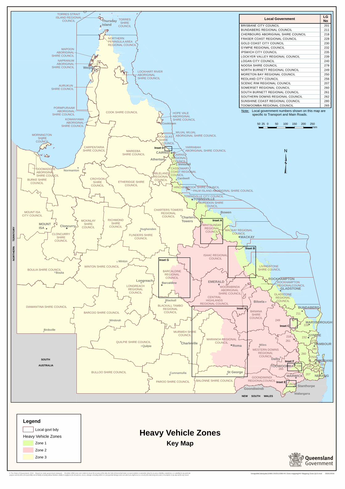
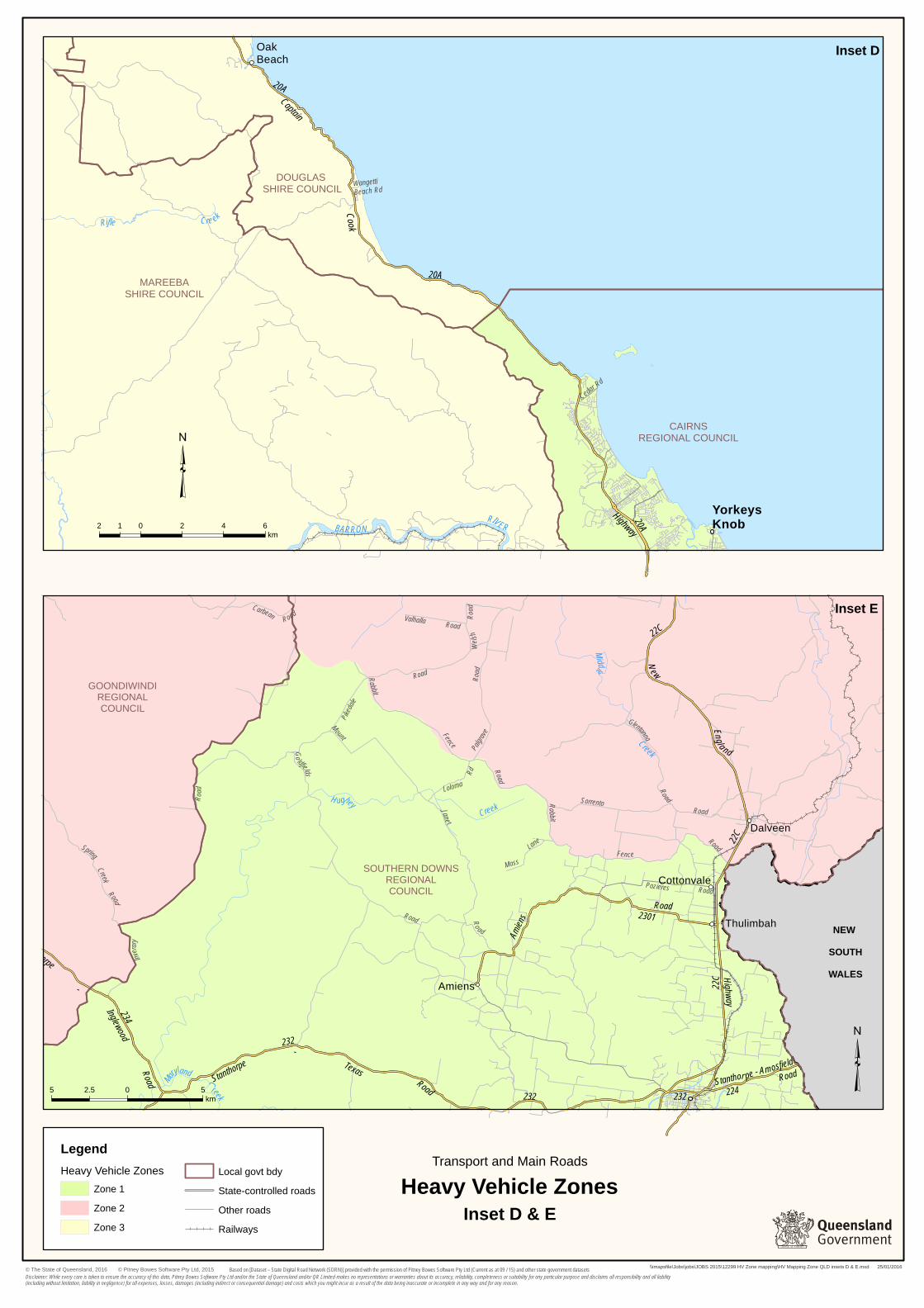
Listed below are Local Government Areas included in each Zone. The list below reflects the Local Government area boundaries as of 1 January 2016. Where previous Local Government boundaries have not matched current Local Government boundaries an inset map has been developed to show where the Zone boundaries are situated. Z Zone 1 Zone 2 Zone 3 Brisbane City Council Bundaberg Regional Council Burdekin Shire Council Cairns Regional Council -*Inset D Cassowary Coast Regional Council Fraser Coast Regional Council Gladstone Regional Council Gold Coast City Council Gympie Regional Council Hinchinbrook Shire Council Ipswich City Council Isaac Regional Council -*Inset B Logan City Council Lockyer Valley Regional Council Livingstone Shire Council-*Inset B Mackay Regional Council Moreton Bay Regional Council Noosa Shire Council North Burnett Regional Council -*Inset C Palm Island Aboriginal Shire Council Redland City Council Rockhampton Regional Council-*Inset B Scenic Rim Regional Council Somerset Regional Council Southern Downs Regional Council -*Inset E Sunshine Coast Regional Council Toowoomba Regional Council-*Inset F Townsville City Council Whitsunday Regional Council-*Inset A Yarrabah Aboriginal Shire Council Banana Shire Council Barcaldine Regional Council -*Inset G Central Highlands Regional Council-*Inset B Cherbourg Aboriginal Shire Council Goondiwindi Regional Council Isaac Regional Council -*Inset B Livingstone Shire Council Maranoa Regional Council-*Inset H North Burnett Regional Council -*Inset C South Burnett Regional Council Southern Downs Regional Council -*Inset E Toowoomba Regional Council -*Inset F Western Downs Regional Council Whitsunday Regional Council-*Inset A Woorabinda Aboriginal Shire Council Aurukun Shire Council Balonne Shire Council Barcoo Shire Council Barcaldine Regional Council -*Inset G Blackall Tambo Regional Council Boulia Shire Council Bulloo Shire Council Burke Shire Council Carpentaria Shire Council Charters Towers Regional Council Cloncurry Shire Council Cook Shire Council Croydon Shire Council Diamantina Shire Council Doomadgee Aboriginal Shire Council Douglas Shire Council-*Inset D Etheridge Shire Council Flinders Shire Council Hope Vale Aboriginal Shire Council Kowanyama Aboriginal Shire Council Lockhart River Aboriginal Shire Council Longreach Regional Council Mapoon Aboriginal Shire Council Mareeba Shire Council Maranoa Regional Council-*Inset H McKinlay Shire Council Mornington Shire Council Mount Isa City Council Murweh Shire Council Napranum Aboriginal Shire Council Northern Peninsula Area Regional Council Paroo Shire Council Pormpuraaw Aboriginal Shire Council Quilpie Shire Council Richmond Shire Council Tablelands Regional Council Torres Shire Council Torres Straight Island Regional Council Weipa Town Authority Winton Shire Council Wujal Wujal Aboriginal Shire Council
Transcript
Listed below are Local Government Areas included in each Zone.
The list below reflects the Local Government area boundaries as of 1 January 2016. Where previous Local Government boundaries have not matched current Local Government boundaries an inset map has been developed to show where the Zone boundaries are situated.
Z
Zone 1 Zone 2 Zone 3 Brisbane City Council Bundaberg Regional Council Burdekin Shire Council Cairns Regional Council-*Inset D
Cassowary Coast Regional Council Fraser Coast Regional Council Gladstone Regional Council Gold Coast City Council Gympie Regional Council Hinchinbrook Shire Council Ipswich City Council
Isaac Regional Council-*Inset B Logan City Council Lockyer Valley Regional Council Livingstone Shire Council-*Inset B Mackay Regional Council Moreton Bay Regional Council Noosa Shire Council
North Burnett Regional Council-*Inset C
Palm Island Aboriginal Shire Council Redland City Council Rockhampton Regional Council-*Inset B Scenic Rim Regional Council Somerset Regional Council Southern Downs Regional Council-*Inset E
Sunshine Coast Regional Council Toowoomba Regional Council-*Inset F
Townsville City Council Whitsunday Regional Council-*Inset A Yarrabah Aboriginal Shire Council
Banana Shire Council Barcaldine Regional Council-*Inset G
Central Highlands Regional Council-*Inset B
Cherbourg Aboriginal Shire Council Goondiwindi Regional Council Isaac Regional Council-*Inset B
Livingstone Shire Council Maranoa Regional Council-*Inset H
North Burnett Regional Council-*Inset C
South Burnett Regional Council Southern Downs Regional Council-*Inset E
Toowoomba Regional Council-*Inset F
Western Downs Regional Council Whitsunday Regional Council-*Inset A
Woorabinda Aboriginal Shire Council
Aurukun Shire Council Balonne Shire Council Barcoo Shire Council Barcaldine Regional Council-*Inset G
Blackall Tambo Regional Council Boulia Shire Council Bulloo Shire Council Burke Shire Council Carpentaria Shire Council Charters Towers Regional Council Cloncurry Shire Council Cook Shire Council Croydon Shire Council Diamantina Shire Council Doomadgee Aboriginal Shire Council Douglas Shire Council-*Inset D Etheridge Shire Council
Flinders Shire Council Hope Vale Aboriginal Shire Council Kowanyama Aboriginal Shire Council Lockhart River Aboriginal Shire Council Longreach Regional Council Mapoon Aboriginal Shire Council Mareeba Shire Council Maranoa Regional Council-*Inset H
McKinlay Shire Council Mornington Shire Council Mount Isa City Council Murweh Shire Council Napranum Aboriginal Shire Council Northern Peninsula Area Regional Council Paroo Shire Council Pormpuraaw Aboriginal Shire Council Quilpie Shire Council Richmond Shire Council Tablelands Regional Council Torres Shire Council Torres Straight Island Regional Council Weipa Town Authority Winton Shire Council Wujal Wujal Aboriginal Shire Council
!
SOUTH
AUSTRALIA
NEW SOUTH WALES
NO
RTH
ERN
TER
RIT
ORY
LONGREACHREGIONALCOUNCIL
MACKAY REGIONALCOUNCIL
MAPOONABORIGINAL
SHIRE COUNCIL
MARANOA REGIONALCOUNCIL
MCKINLAYSHIRE
COUNCIL
MORNINGTON SHIRE
COUNCIL
MOUNT ISACITY COUNCIL
MURWEH SHIRECOUNCIL
NAPRANUMABORIGINAL
SHIRE COUNCIL
249
NORTHERNPENINSULA AREA REGIONAL COUNCIL
PALM ISLAND ABORIGINAL SHIRE COUNCIL
PAROO SHIRE COUNCIL
PORMPURAAWABORIGINAL
SHIRE COUNCIL
QUILPIE SHIRE COUNCIL
RICHMONDSHIRE
COUNCIL
ROCKHAMPTONREGIONAL COUNCIL
261
TABLELANDSREGIONALCOUNCIL
265
TORRESSHIRE
COUNCIL
TORRES STRAITISLAND REGIONAL
COUNCIL
TOWNSVILLE CITY COUNCIL
WESTERN DOWNSREGIONALCOUNCIL
WHITSUNDAYREGIONALCOUNCIL
WINTON SHIRE COUNCIL
WOORABINDAABORIGINAL
SHIRE COUNCIL
WUJAL WUJALABORIGINAL SHIRE COUNCIL
YARRABAHABORIGINAL SHIRE COUNCIL
AURUKUN SHIRE COUNCIL
BALONNE SHIRE COUNCIL
BANANASHIRE
COUNCIL
BARCALDINEREGIONALCOUNCIL
BARCOO SHIRE COUNCIL
BLACKALL TAMBOREGIONALCOUNCIL
BOULIA SHIRE COUNCIL
BULLOO SHIRE COUNCIL
BURDEKIN SHIRECOUNCIL
BURKE SHIRECOUNCIL
CAIRNS REGIONAL COUNCIL
CARPENTARIASHIRE COUNCIL
CASSOWARYCOAST REGIONALCOUNCIL
CENTRALHIGHLANDS
REGIONAL COUNCIL
CHARTERS TOWERSREGIONALCOUNCIL
CLONCURRYSHIRE
COUNCIL
COOK SHIRE COUNCIL
CROYDONSHIRE
COUNCIL
DIAMANTINA SHIRE COUNCIL
DOOMADGEEABORIGINALSHIRE COUNCIL
ETHERIDGE SHIRECOUNCIL
FLINDERS SHIRECOUNCIL
GLADSTONEREGIONALCOUNCIL
GOONDIWINDIREGIONAL COUNCIL
HINCHINBROOK SHIRE COUNCIL
HOPE VALEABORIGINALSHIRE COUNCIL
ISAAC REGIONALCOUNCIL
KOWANYAMAABORIGINAL
SHIRE COUNCIL
LOCKHART RIVERABORIGINALSHIRE COUNCIL
LIVINGSTONE SHIRE COUNCIL
MAREEBA SHIRE COUNCIL
DOUGLAS SHIRE COUNCIL
240
250
256
207
260
262
280
201
211
218
228
230
232
235239
278
ROCKHAMPTON
WARWICK
BUNDABERG
CAIRNS
BRISBANE
TOWNSVILLE
TOOWOOMBA
GYMPIE
EMERALD
NERANG
MACKAY
Roma
Cloncurry
Barcaldine
NAMBOUR
MOUNTISA
GLADSTONE
MARYBOROUGH
ThursdayIsland
Charleville
Dalby
Biloela
Bowen
Goondiwindi
St George
Stanthorpe
Atherton
Longreach
Innisfail
Weipa
ChartersTowers
Cooktown
Blackall
Cardwell
Normanton
Cunnamulla
Miles
Hughenden
Wallangarra
Quilpie
Birdsville
Boulia
Winton
Windorah
50 0 50 100 150 200 25025km
³
\\imapsfile\Jobs\jobs\JOBS 2015\12299 HV Zone mapping\HV Mapping Zone QLD.mxd 25/01/2016
Heavy Vehicle Zones
Inset G
Inset H
Inset D
Inset A
Inset B
Inset C
Inset F
Inset E
Note: Local government numbers shown on this map are specific to Transport and Main Roads.
BRISBANE CITY COUNCIL 201 BUNDABERG REGIONAL COUNCIL 211 CHERBOURG ABORIGINAL SHIRE COUNCIL 218 FRASER COAST REGIONAL COUNCIL 228 GOLD COAST CITY COUNCIL 230 GYMPIE REGIONAL COUNCIL 232 IPSWICH CITY COUNCIL 235 LOCKYER VALLEY REGIONAL COUNCIL 239 LOGAN CITY COUNCIL 240 NOOSA SHIRE COUNCIL 278 NORTH BURNETT REGIONAL COUNCIL 249 MORETON BAY REGIONAL COUNCIL 250 REDLAND CITY COUNCIL 256 SCENIC RIM REGIONAL COUNCIL 207 SOMERSET REGIONAL COUNCIL 260 SOUTH BURNETT REGIONAL COUNCIL 261 SOUTHERN DOWNS REGIONAL COUNCIL 262 SUNSHINE COAST REGIONAL COUNCIL 280 TOOWOOMBA REGIONAL COUNCIL 265
"
!
!
!
!!
!
"
!
!
!
"
!
!
!
!
"
!
Middlemount
Nebo
St Lawrence
Clairview
Carmila
Orkabie
Ilbilbie
Koumala
Croydon
MountStewart Honeycomb
Ogmore
Marlborough
Tooloombah Kooltandra
MayDowns
OxfordDowns
Killarney
Manly
Junee
Tierawoomba Road
Angle
wood
Road
May DownsCarfax
Road
Barmount Road
Clifton
Road
Carfax Rd
Manl y Ac ce s s
Lot u s C re ek
Rd
Valkyrie
Road
33B
5101
33A
519
514
5122
10G
85C
5124
10F
858
82A5126
512
512
198
Peak
Down
sHw
y
Bru ce
Highway
St. Lawren ce
- Croyden Road
May
Downs
Road
Oxford Downs - Sarina Road
Bruce
Highway
Marlborough-
Sarina
Road
Fitzroy
Developmental
Road
Duar
inga - Ap
isCr
eek
Road
Marlborough
-
Sarina
Road
Amity
Ck
Waverley Ck
Funnel
CreekSarsfie ld Creek
CollaroyCreek
Granite C k
Bee
Creek
ISA AC
RIVER
MACKENZIE
RIVER
Denison
Creek
MACKAYREGIONALCOUNCIL
ROCKHAMPTONREGIONALCOUNCIL
CENTRAL HIGHLANDSREGIONALCOUNCIL
ISAAC REGIONALCOUNCIL
LIVINGSTONESHIRE COUNCIL
"
!
!
"
Glenden
CollinsvilleScottville
Dalbeg
MountCoolon
Turrawalla
Strathmore
Johnny
Cake
Road
Turrawulla
Road
Em uPlains
Road
BarkerRo ad
B lue Valley
Road
MyunaRoad
Exmoor
Road
Strathmore Road
545
88A
5307
88B
Bowen
Develop
mental
Road
Colli ns ville-
Elphinstone
Road
Bowe
nDe
velop
men
tal
Road
B O W EN
RIV ER
Ja
ck C ree k
BO
WEN
RIVER
Brawl
Creek
Sutto rCreek
BOWEN
R IVER
Pelican
C reek
BR OK EN
RIV ER
Sand
alw
ood
Cree
k
Roset ta
Creek
BOGI
E
RIVE
R
EmuCreek
DON
RIVER
SUTTOR
RIVER
BU
RDEKI
NRI
VER
MACKAYREGIONALCOUNCIL
WHITSUNDAYREGIONALCOUNCIL
ISAAC REGIONAL COUNCIL
BURDEKINSHIRE
COUNCILCHARTERSTOWERS
REGIONALCOUNCIL
LakeProserpine
Heavy Vehicle Zones
\\imapsfile\Jobs\jobs\JOBS 2015\12299 HV Zone mapping\HV Mapping Zone QLD insets A & B.mxd 25/01/2016