186
Herefordshire Local Plan Core Strategy 2011 - 2031 Adopted October 2015
Herefordshire Local Plan Core Strategy 2011 - 2031
Adopted October 2015
Contents Page No.
Foreword 1
SecƟon 1 – IntroducƟon and Background 2
SecƟon 2 – Herefordshire Context 11
SecƟon 3 – Vision, ObjecƟves and SpaƟal Strategy 21 - Herefordshire Key Diagram 47
SecƟon 4 – Place Shaping 48 - Hereford 48 - Bromyard 73
- Kington 79 - Ledbury 82 - Leominster 89
- Ross on Wye 96 - Rural Areas 103
SecƟon 5 – General Policies 117
SecƟon 6 – Delivery, ImplementaƟon and Monitoring 164
Glossary of Terms 168
Contents
Herefordshire Local Plan Core Strategy 2011-2031
Please note: The Appendices to the Herefordshire Local Plan - Core Strategy are contained within a separate document.
Appendix 1 – Saved Unitary Development Plan (UDP) (2007) policies (including policies to be replaced by the Local Plan – Core Strategy)
Appendix 2 – Evidence Base
Appendix 3 – ImplementaƟon, Monitoring and Delivery Plan
Appendix 4 – Detailed Annualised Trajectory
Appendix 5 – SS3: Necessary Infrastructure for Strategic Sites
Appendix 6 – SS5:Key Employment Sites Deliverability and Timescales
Appendix 7 – Housing Value Areas by Postcode
Appendix 8 – Sites with Environmental DesignaƟons 8A - ConservaƟ on Areas 8B – Scheduled Ancient Monuments (SAMs) 8C – Registered Historic Parks and Gardens 8D – Unregistered Parks and Gardens 8E – Special Areas of ConservaƟ on (SACs) 8F – Sites of Special ScienƟfic Interest (SSSIs) 8G – NaƟonal Nature reserves (NNRs) 8H – Local Nature Reserves (LNRs) 8I – Local Wildlife Sites (LWS) 8J – Local Geological Sites (LGS) 8K – Areas of Ancient and Semi-Natural Woodland
Appe
ndic
es
Herefordshire Local Plan Core Strategy 2011-2031
Page No.
SecƟon 1: IntroducƟon and Background
1.1 - Structure of Herefordshire Local Plan 3 1.2 - Herefordshire’s adjoining authoriƟes and Areas of Outstanding Natural Beauty 7
SecƟon 2: Herefordshire Context
2.1 - Herefordshire and surrounding CounƟes 11 2.2 - Map showing the areas of Herefordshire that are amongst the most deprived 13 2.3 - Age structure of Herefordshire and England and Wales from the 2011 Census 14
SecƟon 3: Vision, ObjecƟves and SpaƟ al Strategy
3.1 - Strategic objecƟves 23 3.2 - Key strategic decisions that the Core Strategy has taken and reasonable 26 alternaƟ ves considered 3.3 - Age structure of the populaƟon 2011-2031 29 3.4 - Retail hierarchy 40
SecƟon 4: Place Shaping Policies
4.1 - Hereford Town Profile 49 4.2 - Hereford Key Diagram 51 4.3 - Hereford City Centre 58 4.4 - Bromyard Town Profile 73 4.5 - Bromyard Key Diagram 76 4.6 - Kington Town Profile 79 4.7 - Ledbury Town Profile 82 4.8 - Ledbury Key Diagram 85 4.9 - Leominster Town Profile 89 4.10 - Leominster Key Diagram 92 4.11 - Ross on Wye Town Profile 96 4.12 - Ross on Wye Key Diagram 99 4.13 - Housing Market Areas in Herefordshire 104 4.14 - The seƩlements which will be the main focus of proporƟonate housing growth 109 4.15 - Other seƩlements 110
SecƟon 5: General Policies
5.1 - Housing Value Areas 120 5.2 - Green Infrastructure Assets 147 5.3 - Green Infrastructure concept diagram 148 5.4 - River Sub-Catchments 162
List of Figures
Herefordshire Local Plan Core Strategy 2011-2031
List
of P
olic
ies Page No.
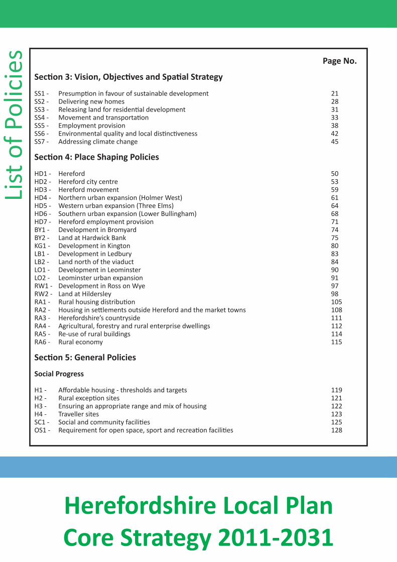
SecƟon 3: Vision, ObjecƟves and SpaƟ al Strategy
SS1 - PresumpƟon in favour of sustainable development 21 SS2 - Delivering new homes 28 SS3 - Releasing land for residenƟal development 31 SS4 - Movement and transportaƟon 33 SS5 - Employment provision 38 SS6 - Environmental quality and local disƟncƟveness 42 SS7 - Addressing climate change 45
SecƟon 4: Place Shaping Policies
HD1 - Hereford 50 HD2 - Hereford city centre 53 HD3 - Hereford movement 59 HD4 - Northern urban expansion (Holmer West) 61 HD5 - Western urban expansion (Three Elms) 64 HD6 - Southern urban expansion (Lower Bullingham) 68 HD7 - Hereford employment provision 71 BY1 - Development in Bromyard 74 BY2 - Land at Hardwick Bank 75 KG1 - Development in Kington 80 LB1 - Development in Ledbury 83 LB2 - Land north of the viaduct 84 LO1 - Development in Leominster 90 LO2 - Leominster urban expansion 91 RW1 - Development in Ross on Wye 97 RW2 - Land at Hildersley 98 RA1 - Rural housing distribuƟon 105 RA2 - Housing in seƩlements outside Hereford and the market towns 108 RA3 - Herefordshire’s countryside 111 RA4 - Agricultural, forestry and rural enterprise dwellings 112 RA5 - Re-use of rural buildings 114 RA6 - Rural economy 115
SecƟon 5: General Policies
Social Progress
H1 - Affordable housing - thresholds and targets 119 H2 - Rural excepƟon sites 121 H3 - Ensuring an appropriate range and mix of housing 122 H4 - Traveller sites 123 SC1 - Social and community faciliƟes 125 OS1 - Requirement for open space, sport and recreaƟ on faciliƟes 128
Herefordshire Local Plan Core Strategy 2011-2031
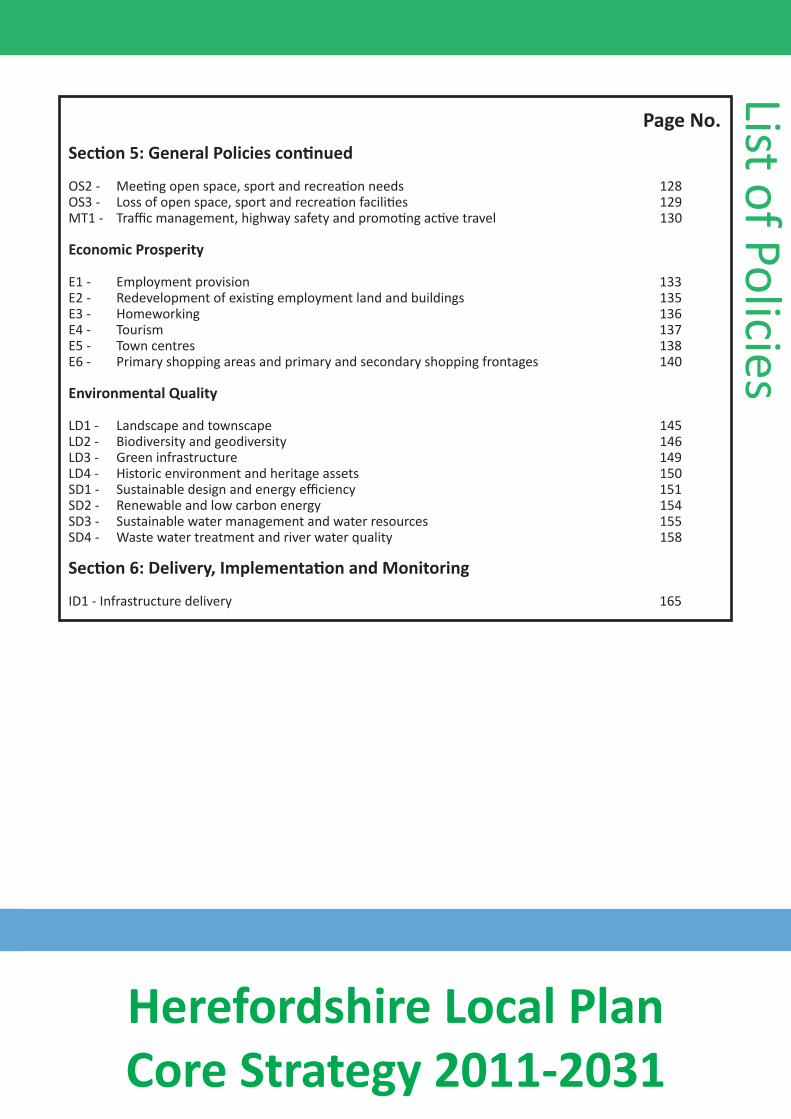
Page No. SecƟon 5: General Policies conƟnued
OS2 - MeeƟng open space, sport and recreaƟon needs 128 OS3 - Loss of open space, sport and recreaƟ on faciliƟes 129 MT1 - Traffic management, highway safety and promoƟ ng acƟve travel 130
Economic Prosperity
E1 - Employment provision 133 E2 - Redevelopment of exisƟng employment land and buildings 135 E3 - Homeworking 136 E4 - Tourism 137 E5 - Town centres 138 E6 - Primary shopping areas and primary and secondary shopping frontages 140
Environmental Quality
LD1 - Landscape and townscape 145 LD2 - Biodiversity and geodiversity 146 LD3 - Green infrastructure 149 LD4 - Historic environment and heritage assets 150 SD1 - Sustainable design and energy efficiency 151 SD2 - Renewable and low carbon energy 154 SD3 - Sustainable water management and water resources 155 SD4 - Waste water treatment and river water quality 158
SecƟon 6: Delivery, ImplementaƟon and Monitoring
ID1 - Infrastructure delivery 165
List of Policies
Herefordshire Local Plan Core Strategy 2011-2031
Fore
wor
d
The Herefordshire Local Plan Core Strategy was adopted at the Herefordshire Council meeƟng on 16 October 2015. It represents the vision for the County to 2031 and provides the context for future work on the preparaƟon of the Hereford Area Plan, the Minerals and Waste Local Plan and the Travellers’ Sites Development Plan Document.
Cllr Philip PriceCabinet Member Infrastructure
Herefordshire Council October 2015
11
Herefordshire Local Plan Core Strategy 2011-2031
The Local Plan
1.1 The council has prepared a Local Plan to guide development and change in the county up to 2031. The Local Plan is made up of a number of documents including the Core Strategy. A list of all the Local Plan documents and the timetable for their preparation are set out in the Local Development Scheme.
1.2 The Local Plan, in addition to dealing with the use of land, considers how the area functions and how different parts of the county should develop or change over the next 20 years in response to key issues, such as the need to:
• deliver more, better quality homes (especially affordable homes) to meet growing needs in this ‘high house price’ compared to ‘average income’ area;
• deliver improved infrastructure to support economic development and a growing population;
• promote a thriving local economy with successful city, town and village centres and provide sufficient employment land to meet business needs and provide higher incomes through a wider range of better quality jobs;
• protect, conserve and enhance valued natural, historic and built environments, including areas of outstanding natural beauty, special areas of conservation, open spaces as well as the county’s intrinsic attractive character;
• address issues arising from an ageing population and the reducing younger age population;
IntroducƟon & Background
• meet the challenge of climate change and adapt to its impacts such as increased risk of flooding and air pollution;
• create places that actively promote and enable healthy lifestyles;
• achieve sustainable development and reduce reliance on the private car whilst accepting the sparsely populated nature of the area and difficulty communities have in accessing services.
1.3 Working in partnership with other agencies that operate in the county is a key element of delivering the Local Plan. The Local Plan needs to show how the strategies for various sectors such as housing, employment, transport, retail, education, health, culture, recreation and climate change inter-relate and how they are likely to shape and affect different parts of the county.
The Core Strategy
1.4 This first document in the production of the Local Plan is the Core Strategy. This is a very important part of the Local Plan because it shapes future development and sets the overall strategic planning framework for the county. The Core Strategy needs to balance environmental issues with economic and social needs and ensure that development is sustainable and does not cause irreversible harm to important resources and features. It sets a vision, closely aligned with the Herefordshire Sustainable Community Strategy, June 2010, as to how the county should look and function and how development needs will be met up to 2031.
22
Herefordshire Local Plan Core Strategy 2011-2031
Intr
oducƟo
n &
Bac
kgro
und 1.5
1.6
1.7
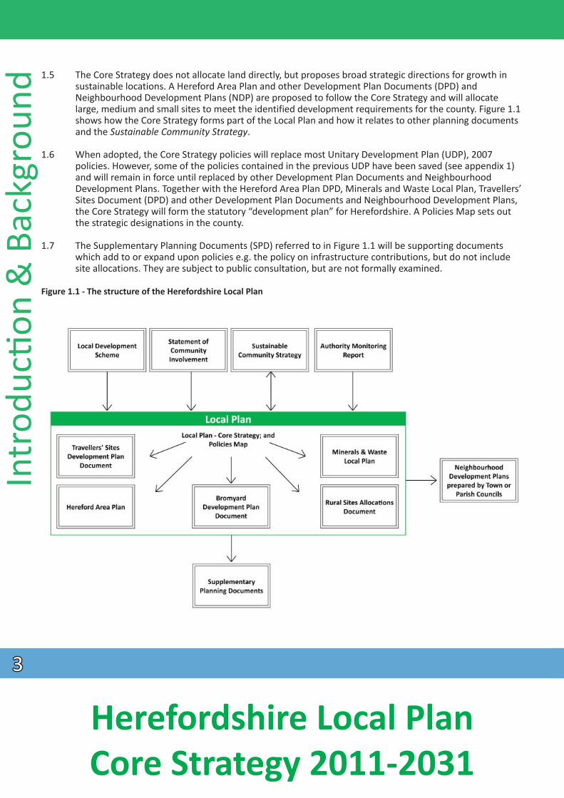
Figure 1.1 - The structure of the Herefordshire Local Plan
The Core Strategy does not allocate land directly, but proposes broad strategic directions for growth in sustainable locations. A Hereford Area Plan and other Development Plan Documents (DPD) and Neighbourhood Development Plans (NDP) are proposed to follow the Core Strategy and will allocate large, medium and small sites to meet the identified development requirements for the county. Figure 1.1 shows how the Core Strategy forms part of the Local Plan and how it relates to other planning documents and the Sustainable Community Strategy.
When adopted, the Core Strategy policies will replace most Unitary Development Plan (UDP), 2007 policies. However, some of the policies contained in the previous UDP have been saved (see appendix 1) and will remain in force until replaced by other Development Plan Documents and Neighbourhood Development Plans. Together with the Hereford Area Plan DPD, Minerals and Waste Local Plan, Travellers’ Sites Document (DPD) and other Development Plan Documents and Neighbourhood Development Plans, the Core Strategy will form the statutory “development plan” for Herefordshire. A Policies Map sets out the strategic designations in the county.
The Supplementary Planning Documents (SPD) referred to in Figure 1.1 will be supporting documents which add to or expand upon policies e.g. the policy on infrastructure contributions, but do not include site allocations. They are subject to public consultation, but are not formally examined.
33
Herefordshire Local Plan Core Strategy 2011-2031
Relationship with other strategies
1.8 Planning policies for Herefordshire have been prepared in the context of national planning guidance set out in the National Planning Policy Framework (NPPF) and National Planning Policy Guidance (NPPG). Regard has also been had to other plans and strategies produced by the council and other organisations.
1.9 The principal role of the Core Strategy is to deliver the spatial planning strategy for Herefordshire based on the local characteristics of the area. It is based on the outcomes of the consultations that have taken place, other council plans, programmes and initiatives and also on the findings of the evidence base that has been prepared to support it. It is also underpinned by a Sustainability Appraisal which assessed the social, economic and environmental impacts of the Core Strategy throughout the development of the document and a Habitats Regulations Assessment which has assessed any impacts on protected European sites.
Minerals and Waste
1.10 Minerals and waste policies will be dealt with through a separate Minerals and Waste Local Plan Development Plan Document (DPD). This will be produced taking account of the National Planning Policy Framework (NPPF), the minerals and waste sections of Planning Practice Guidance and up to date evidence base studies and ensuring close co-operation with neighbouring local authorities on cross-boundary issues. It will establish targets and planning policies relating to minerals and waste activities and associated development in Herefordshire to cover the plan period to 2031. The timetable
IntroducƟon & Background
for the production of this DPD will be included in a revised Local Development Scheme. Until the Minerals
Development Plan will be ‘saved’ and remain in force until replaced by the Minerals and Waste Local Plan. and Waste Local Plan is adopted, the minerals and waste sections of the Herefordshire Unitary
Gypsies and travellers
1.11 A Herefordshire Travellers’ Sites Document (DPD) will set out allocations and planning policies relating to the provision for travellers in the county to cover the plan period to 2031. This DPD is included in the Local Development Scheme.
The Sustainable Community Strategy
1.12 The Sustainable Community Strategy (SCS), 2010 sets out a long-term vision for the county up to 2020 and has been developed by the Herefordshire Partnership. The latter comprises a range of local people and organisations, including business groups and public sector bodies. The purpose of the SCS is to set a clear vision and direction focusing on improving the social, economic, and environmental well-being of the area, in addition to providing an overarching framework within which other local strategies will sit. The policies and proposals within the Core Strategy will help to deliver some of the SCS priorities. Equally, the themes from the SCS have helped to guide the strategic objectives of the Core Strategy.
Neighbourhood Development Plans
1.13 With the introduction of Neighbourhood Development Plans through the Localism Act, communities will be positively encouraged to produce their own development plans for their area taking on board the strategic objectives of the Local Plan - Core Strategy. The Core Strategy has been prepared to provide a strategic base for Neighbourhood Development Plans, along with other Development Plan Documents, to allocate sites for employment, housing and other uses as well as providing more locally detailed policies.
44
Herefordshire Local Plan Core Strategy 2011-2031
Neighbourhood Development Plans will form part of the statutory development plan (but not the Local Plan) and be referred to within the council’s Local Development Scheme.
Intr
oducƟo
n &
Bac
kgro
und
1.14
1.15
Community Right to Build
1.16
Community Right to Bid
1.17
1.18
Neighbourhood Development Plans are required to be in general conformity with the strategic policies of the development plan for the area in order to meet ‘the basic conditions’. With this regard, the whole Core Strategy is defined as being ’the strategic policies contained within the development plan for the area’ in terms of Paragraph 8 Schedule 4B of the Town and Country Planning Act (1990).
Significant progress is being made on a number of Neighbourhood Development Plans across the county. However, to ensure delivery, areas without a designed neighbourhood area by the adoption of the Core Strategy will be included within the ‘Rural Area Site Allocation Development Plan Document’. Monitoring of neighbourhood plan progress will take place and consideration will be given to those areas not making progress to Regulation 14 draft by the Issues and Options stage of the Rural Area Site Allocation DPD for their inclusion within the document.
The Community Right to Build enables community organisations to progress new local developments without the need to go through the normal planning application process, as long as the proposals meet certain criteria and there is community backing in a local referendum. Communities may wish to build new homes or new community amenities, and providing they can demonstrate local support through a positive referendum result, the Community Right to Build will give communities the powers to deliver this directly. All profits derived from a Community Right to Build must be used for the benefit of the community, for example to provide and maintain local facilities such as village halls. Communities which wish to use the new powers must produce and submit a Community Right to Build Order. A proposal can be developed as part of the Neighbourhood Development Plan, or on its own.
The Community Right to Bid enables a community to nominate assets of community value, and if any of these assets are at risk, the community has a right to delay the marketing of the asset in order to raise funds to bid to buy community buildings. For example, this could be the village shop, public house, community centre, children’s centre, allotment or library.
The council will continue to work with partners, the community and the voluntary sector to ensure that provision of services and facilities is maintained and enhanced; and expanded in areas identified for population growth, in areas of relative deprivation and in areas where a deficiency has been identified.
Local Transport Plan
1.19 The council’s Local Transport Plan (LTP) establishes the framework for the delivery of all aspects of transport and travel for Herefordshire. The development of the LTP and the Core Strategy has been a linked process. The council’s LTP covers the first part of the Core Strategy period from April 2013/14 to 2015/16 and is an important local document which supports the delivery of the Core Strategy. The LTP will be updated to include key elements of infrastructure set out in the Core Strategy following its adoption.
Economic Development Strategy
1.20 The council’s Economic Development Strategy 2011-2016, November 2011 is called Enterprising County and outlines the path and direction to foster economic vitality. Its vision is to increase the economic
55
Herefordshire Local Plan Core Strategy 2011-2031
wealth of the county through the growth of business. It aims to improve business sustainability, increase start-up and sustain growth; increase wage levels, range and quality of jobs; have a skilled population to meet future work needs; and develop the county’s built infrastructure for enterprise to flourish.
Local Investment Plan
1.21 The Herefordshire Local Investment Plan, 2011-2026 has been developed by Herefordshire Council in partnership with the Homes and Communities Agency. It provides a strategic framework within which the organisations will work and invest together alongside partners in the public and private sectors to deliver the key priorities in meeting the vision for Herefordshire.
1.22 The Local Investment Plan focuses on meeting the Government’s ‘Total Place’ agenda, which has an emphasis on a ‘whole area’ approach to commissioning and investment by all partners and demonstrates how joint investment by organisations and the private sector will be prioritised through agreed spatial and thematic priorities for regeneration, including transport, health, housing and education. The emerging Core Strategy has fed into the projects, proposals and evidence base in the investment plan.
Other plans
1.23 Feeding into the Community Strategy and the Core Strategy are various other plans, such as parish and town plans and market town health checks, produced by the local communities of the county. Broadly, these types of plans identify the economic, environmental and social issues important to a particular area
overall proposals in the Core Strategy and by adding local detail and support to particular policies within it.
1.24 Future strategies and plans may become relevant during the plan period. In particular Herefordshire Council, as the Lead Local Flood Authority (LLFA) for the county, has responsibility for the management of
will be on addressing flooding from surface water, groundwater and ordinary watercourses. In addition, Herefordshire Council is one of a number of organisations that is involved in the preparation of a county-wide Carbon Reduction Strategy in order to meet targets for reduction in line with the Climate Change Act 2008. This will seek a 34% reduction of carbon on 1990 levels by 2020.
Consultation
1.25 One of the main principles of development plan preparation is that local communities are involved from the outset. This approach is set out in national policy and in Herefordshire’s Statement of Community Involvement 2007, which forms part of the Local Plan. To ensure early engagement on the preparation of the Core Strategy and the opportunity to comment and help shape it, the following key stages of consultation were undertaken:
• Issues Paper (Autumn 2007)• Developing Options (Summer 2008)• Place Shaping Paper (Spring 2010)• Preferred Options (Autumn 2010)• Revised Preferred Options (Autumn 2011)• Draft Core Strategy (Spring 2013)• Pre-Submission Publication (Summer 2014)• Main Modifications (Spring 2015)
IntroducƟon & Background
and set out a vision for how the community wants to develop. These plans are very useful in informing the
local flood risks. One of its duties is to develop a Local Flood Risk Management Strategy and its main focus
66
Herefordshire Local Plan Core Strategy 2011-2031
77
In
trod
ucƟo
n &
Bac
kgro
und
Working with other authorities and organisations
1.26
1.27
1.28
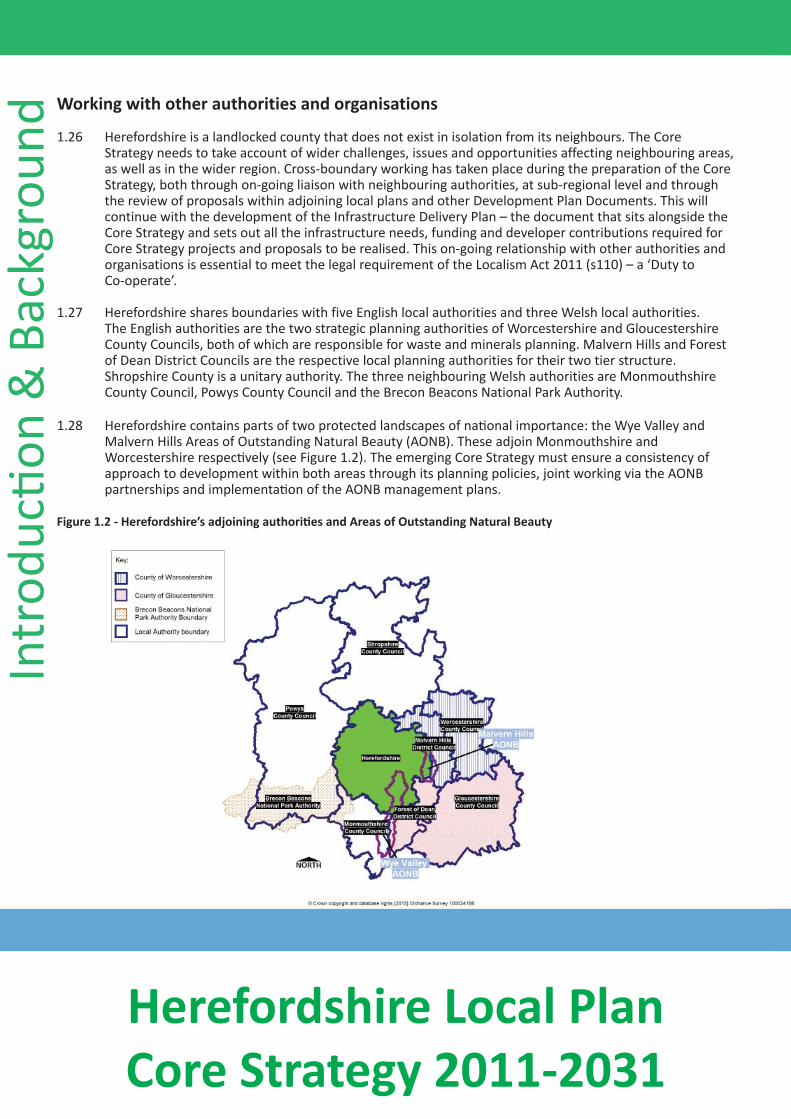
Figure 1.2 - Herefordshire’s adjoining authoriƟes and Areas of Outstanding Natural Beauty
Herefordshire is a landlocked county that does not exist in isolation from its neighbours. The Core Strategy needs to take account of wider challenges, issues and opportunities affecting neighbouring areas, as well as in the wider region. Cross-boundary working has taken place during the preparation of the Core Strategy, both through on-going liaison with neighbouring authorities, at sub-regional level and through the review of proposals within adjoining local plans and other Development Plan Documents. This will continue with the development of the Infrastructure Delivery Plan – the document that sits alongside the Core Strategy and sets out all the infrastructure needs, funding and developer contributions required for Core Strategy projects and proposals to be realised. This on-going relationship with other authorities and organisations is essential to meet the legal requirement of the Localism Act 2011 (s110) – a ‘Duty to
Co-operate’.
Herefordshire shares boundaries with five English local authorities and three Welsh local authorities. The English authorities are the two strategic planning authorities of Worcestershire and Gloucestershire County Councils, both of which are responsible for waste and minerals planning. Malvern Hills and Forest of Dean District Councils are the respective local planning authorities for their two tier structure. Shropshire County is a unitary authority. The three neighbouring Welsh authorities are Monmouthshire County Council, Powys County Council and the Brecon Beacons National Park Authority.
Herefordshire contains parts of two protected landscapes of naƟonal importance: the Wye Valley and Malvern Hills Areas of Outstanding Natural Beauty (AONB). These adjoin Monmouthshire and
Worcestershire respecƟvely (see Figure 1.2). The emerging Core Strategy must ensure a consistency of approach to development within both areas through its planning policies, joint working via the AONB partnerships and implementaƟon of the AONB management plans.
Herefordshire Local Plan Core Strategy 2011-2031
1.29 Economic influences are particularly significant in the county. The Economic Development Strategy 2011 for Herefordshire highlights a number of objectives, some of which (such as enhanced skills, increasing wage levels and better infrastructure) are reflected in similar documents across the wider sub region. Historically, the county has a low economic output level compared to other authorities in the West Midlands and the United Kingdom as a whole. This is related to the type of businesses in the county and its relatively low wage levels, which results in less money being spent here. Herefordshire also experiences a net loss of people travelling beyond its boundaries to work. Two projects in Herefordshire linked to Core Strategy and Economic Development Strategy objectives, which exemplify co-operation with adjoining authorities and other bodies include: 1) the Fastershire Broadband Project and 2) the setting up of the Hereford Enterprise Zone.
1) The Fastershire Project involves close co-operaƟon with Gloucestershire County Council to uƟlise government and private sector funding to provide access to faster broadband.
2) Herefordshire has formed a Local Enterprise Partnership (LEP) with Shropshire and Telford. The Marches LEP will be used to share resources to create benefits for local businesses and raise the profile of the area. One example of this is the creaƟon of the Hereford Enterprise Zone at
Rotherwas. The Enterprise Zone has a focus on the defence and security sector, with addiƟonal employment hubs focused on advanced technologies, environmental technologies and food and drink technologies.
Evidence base
1.30 The Core Strategy is underpinned by a robust evidence base that is regularly reviewed to inform decision and plan making. The policies and proposals must be both informed by and assessed against relevant
IntroducƟon & Background
available evidence. The list of documents and sources making up this evidence base is set out in Appendix 2.
Sustainability Appraisal, Strategic Environmental Assessment and Habitats RegulaƟon Assessment
1.31 Sustainability Appraisal (SA) is a government requirement for all Development Plan Documents. Sustainability is about ensuring the long term maintenance of well-being and the environment for our present and future communiƟes. The process assesses the impact of the Core Strategy on the environment, people and the economy. It incorporates the requirements of the European DirecƟve on Strategic Environmental Assessment (SEA). Following consultaƟon with key local, regional and naƟonal organisaƟons such as the Environment Agency, Natural England and Historic England, sustainability criteria have been agreed covering issues such as; air quality; water quality and quanƟty; landscape; health and economic performance. This Core Strategy has been assessed against these sustainability criteria and the results can be found in the Sustainability Appraisal.
1.32 The Core Strategy has also been subject to Habitats RegulaƟons Assessment (HRA) screening to assess whether there would be likely significant effects on sites of internaƟonal importance for wildlife (European designated sites). Where a land use plan is likely to have a significant effect on such sites, an appropriate assessment must be carried out of the implicaƟons in respect of their conservaƟon objecƟves. The screening exercise has considered potenƟal effects on European sites within and around Herefordshire. It concluded that some uncertain effects would require appropriate assessment under the Habitats RegulaƟons. This assessment is contained in a separate Habitats RegulaƟons Assessment Report.
88
Herefordshire Local Plan Core Strategy 2011-2031
Intr
oducƟo
n &
Bac
kgro
und Monitoring and Review
1.33
1.34
Flexibility
1.35
1.36
Monitoring and review are key aspects of the approach to the preparation of Local Plans. Continuous monitoring enables an assessment of the effectiveness of the Core Strategy and the policies contained within it in terms of both delivering and controlling various types of development across the county. As part of the Town and Country Planning (Local Planning) (England) Regulations 2012, the council is required to prepare Authority Monitoring Reports containing information on all the plans set out in the local planning authority’s Local Development Scheme. One of the key functions of the report is to monitor policies contained within Development Plan Documents and to report on their performance, particularly where policies are not being implemented and why and also where policies specify a target of net additional dwellings or net additional affordable dwellings to be reached.
To assess the performance of the Core Strategy, a separate monitoring framework is set out at the end of each section and in Appendix 3 which will be implemented after adoption of the plan. This includes key plan indicators as well as those to monitor the sustainability of the plan. Where policies are not performing as intended, the annual monitoring process will suggest the actions that need to be taken to address the issues. It is intended that, in addition to annual monitoring, a five-yearly cycle of a more comprehensive review of the Core Strategy is established, with dates of 2019 and 2024. Review processes would need to commence in advance of the review dates to enable any new policies to be adopted in a timely manner.
The Core Strategy has been written to enable development which takes place within the context of changing circumstances both nationally and across the county. General changes could include; changes to national policy and updates to the evidence base, as well as external impacts such as changes to migration trends, fuel prices, use of the internet and so on. More specifically, situations which may arise are: housing development failing to come forward as planned, infrastructure not being provided at the same time as development and market changes adversely affecting the viability of development.
The evidence base will be kept up to date and specific studies e.g. Strategic Flood Risk Assessment will be regularly reviewed. All of the policies are written to refer to national policy rather than repeat it and to refer to the evidence base. This allows the policies to be useable even where there are minor changes to higher level policies or the evidence base. Some policies also refer to further Development Plan Documents or Supplementary Planning Documents which may also update existing policies or allow for flexibility without changing the policy itself.
1.37 With respect to housing developments, various measures are already in place to ensure that sites come forward as planned, and measures that can be taken if they do not, include:
• The Strategic Housing Land Availability Assessment (SHLAA) 2012 is made up of a large number of smaller and medium sites with over 30,000 deliverable and developable sites identified, some of which could be brought forward if there are unforeseen constraints to larger strategic sites being developed as planned;
• A Hereford Area Plan, Neighbourhood Development Plans and other Development Plan Documents are planned to be progressed by adoption of the Core Strategy and will include residential sites which will provide more certainty for sites coming forward in the middle and later part of the period.
99
Herefordshire Local Plan Core Strategy 2011-2031
1.38 If monitoring shows that residential sites are coming forward more slowly than planned, the Hereford Area Plan, Neighbourhood Development Plans and other Development Plan Documents will provide the opportunity to review other designations/policies to bring further sites forward if necessary. The mechanisms set out in Policy SS3 may also be used.
IntroducƟon & Background
1010
Herefordshire Local Plan Core Strategy 2011-2031
Here
ford
shire
Con
text 2.1 The Core Strategy is based on an understanding of Herefordshire’s unique characteristics, derived and
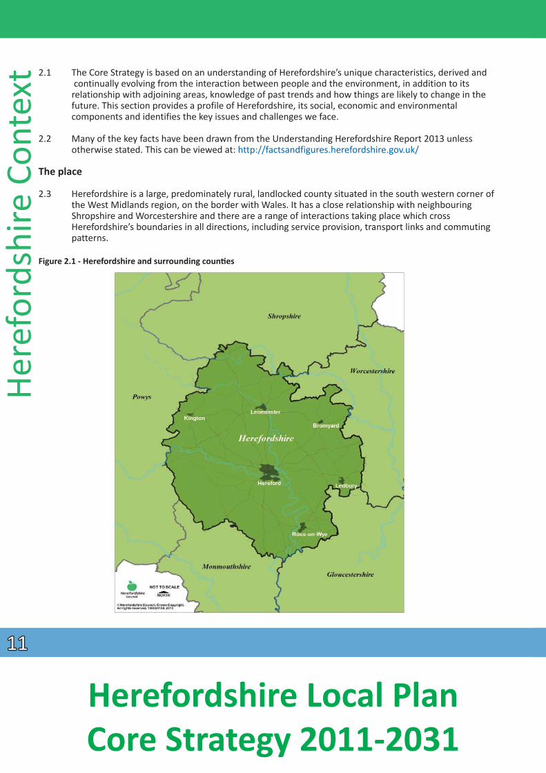
continually evolving from the interaction between people and the environment, in addition to its relationship with adjoining areas, knowledge of past trends and how things are likely to change in the future. This section provides a profile of Herefordshire, its social, economic and environmental components and identifies the key issues and challenges we face.
2.2 Many of the key facts have been drawn from the Understanding Herefordshire Report 2013 unless otherwise stated. This can be viewed at: http://factsandfigures.herefordshire.gov.uk/
The place
2.3 Herefordshire is a large, predominately rural, landlocked county situated in the south western corner of the West Midlands region, on the border with Wales. It has a close relationship with neighbouring Shropshire and Worcestershire and there are a range of interactions taking place which cross Herefordshire’s boundaries in all directions, including service provision, transport links and commuting patterns.
Figure 2.1 - Herefordshire and surrounding counƟes
1111
Herefordshire Local Plan Core Strategy 2011-2031
2.4 The county area covers 217,973 hectares. High hill ranges, including the Malvern Hills and Black Mountains, encircle much of the county at its perimeter. Away from these areas, the landscape is one of gentle rolling hills, dissected by wide river valleys with lower-lying plains in the centre. River crossing points have provided a natural focus for the development of many settlements, with others dispersed across Herefordshire’s rich and diverse landscape.
2.5 The meandering river valley landscape which is the county’s principal geographical feature is that of the River Wye; which enters Herefordshire near the Welsh town of Hay-on-Wye, flowing east to Hereford before leaving the county at the Wye Gorge, downstream of Ross-on-Wye. In addition to significant parts of the county being drained by the Wye river system, the River Wye, together with its valley setting, is in part, an Area of Outstanding Natural Beauty and integral to Herefordshire’s identity.
2.6 At the county’s heart is the city of Hereford which is the main centre for civil and ecclesiastical administration, health, education and leisure facilities, shopping and employment. The five market towns of Bromyard, Kington, Ledbury, Leominster and Ross-on-Wye, surround the city with a regularity that harks back to medieval times. Outside these urban areas, nucleated villages and smaller settlements, farms and other isolated properties characterise much of Herefordshire.
Social progress - key facts
PopulaƟon: 183,6001
Density: 0.8 persons per hectare (84 per square kilometre)
PopulaƟon growth: +5% in the decade since 20012
EsƟmated growth of 12% by 20313
Age structure: 1 in 5 people (21.3%) are aged 65 or over. Since 2001 residents aged 90 or over grew by almost 40% whilst those aged 5-15 years fell by 12%4
Ethnicity: 6% of residents are from ethnic groups other than ‘white BriƟsh’
DeprivaƟon: A fiŌh of households (14,500) live in poverty, mostly in urban areas
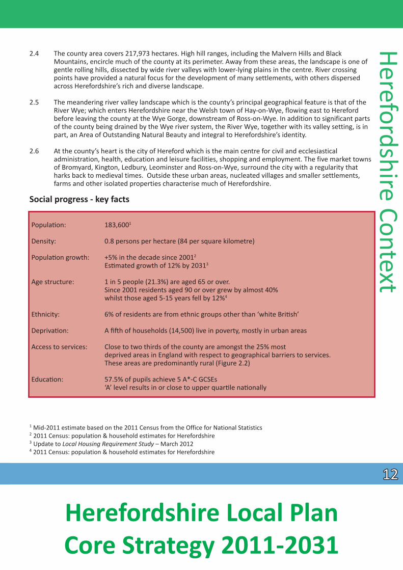
Access to services: Close to two thirds of the county are amongst the 25% most deprived areas in England with respect to geographical barriers to services. These areas are predominantly rural (Figure 2.2)
EducaƟon: 57.5% of pupils achieve 5 A*-C GCSEs ‘A’ level results in or close to upper quarƟ le naƟonally
Herefordshire Context
1 Mid-2011 estimate based on the 2011 Census from the Office for National Statistics 2 2011 Census: population & household estimates for Herefordshire 3 Update to Local Housing Requirement Study – March 2012 4 2011 Census: population & household estimates for Herefordshire
1212
Herefordshire Local Plan Core Strategy 2011-2031
Here
ford
shire
Con
text The people
2.7 Herefordshire’s resident population is 183,600 (2011). This is the first estimate based on the 2011 Census and represented a growth of 5% between 2001 and 2011 (slower than the previous two decades and below the national average of 7% for the same period). The population is estimated to grow by about 12%
by 20315 .
2.8 Herefordshire has a sparse population, with the fourth lowest overall population density in England (ninth in England and Wales). Just under a third of Herefordshire residents live in Hereford, with about a fifth in the five market towns and nearly half in the surrounding rural areas. Despite other counties having a lower overall population density, Herefordshire has the greater proportion of its population living in ‘very sparse’ areas (25%)6 .
Figure 2.2 - Map showing the areas of Herefordshire that are amongst the most deprived in England (Geographical Barriers to Services sub-domain of the Index of Multiple Deprivation 2010)
Source: Department of Communities and Local Government
5 Update to Local Housing Requirement Study – March 2012 6 Population Density - http://www.herefordshire.gov.uk/factsandfigures/subcounty
1313
Herefordshire Local Plan Core Strategy 2011-2031
2.9 This scattered population presents many challenges, both for residents in terms of dependence on the private car, increased household costs, access to services, often poor or no broadband access and social isolation, as well as for the delivery of services, particularly to community members already experiencing
disadvantage.
2.10 Whilst Herefordshire is widely regarded as being an affluent county, this masks issues of deprivation, poverty and a continued widening of the gap between the most and least deprived. Close to two thirds of the county are amongst the 25% most deprived in England with respect to geographical barriers to services and the average income of residents is significantly below both the regional and national averages. There are pockets of severe deprivation in parts of Hereford and Leominster, as well as potentially ‘hidden’ deprivation in rural areas (Figure 2.2).
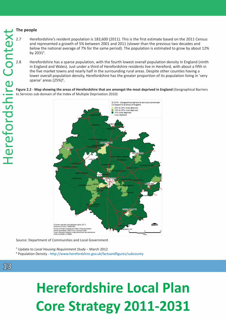
2.11 Like the national population structure, Herefordshire’s population is ageing with one in five people aged 65 or over (compared to one in six nationally)7. Figure 2.3 shows how much older the age structure of Herefordshire is compared to England and Wales, with higher proportions of residents in all age groups from 45-49 upwards and less in the middle aged groups. Both national and local forecasts predict a further rise in the proportion of older people and thus a need to plan for the consequence of an ageing population, for example by providing for supported and extra care housing, and ensuring better access to health care and community facilities.
Figure 2.3 - Age structure of Herefordshire (bars) and England and Wales (lines), from the 2011 Census8
Herefordshire Context
7 2011 Census: population & household estimates for Herefordshire 8 2011 Census: population & household estimates for Herefordshire
1414
Herefordshire Local Plan Core Strategy 2011-2031
Here
ford
shire
Con
text
Housing and transport
2.12 There are 79,122 households in Herefordshire (2011) and this is projected to increase by 20.3% by 20319 , contributing to the need to provide additional housing. Housing affordability is a key issue, with Herefordshire having the worst housing affordability ratio within the West Midlands. In 2011 house prices were 8.6 times annual earnings. High houses prices particularly relative to earnings (brought about by strong demand and a current housing offer that encompasses a high proportion of high value properties) has increased the need for lower priced market housing and all forms of affordable houses.
2.13 Planning for Herefordshire’s ageing population and strong retirement market by the development of ‘homes for life’ to facilitate independent living and care needs will become increasingly important. At the same time, there is the opportunity to plan for more balanced and integrated communities by providing the right mix of housing and facilities to cater for people at different stages in their life cycle, and with different incomes and needs. This will require the provision of more affordable housing, more family sized and smaller homes for younger households, facilities for children and young people, and a wider range of employment opportunities for people of working age.
2.14 Herefordshire plays a strategic role in facilitating cross boundary links between England and Wales. Whilst vehicle flows along these strategic routes are considered low in a national context, when coupled with local movement, congestion, journey time delays and air pollution they are problematic, notably within Hereford. This is evidenced in the Draft Route-Based Strategy - Evidence Report for the Midlands to Wales and Gloucestershire section produced by the Highways Agency in February 2014. This states that the A49 through Hereford is a “key junction capacity issue” which should be afforded high priority. It is also an issue for higher than average collision rates through the city. Car ownership and dependency in the county is high due to the lack of public transport in rural areas and the need to access services and employment from these areas. The need for significant investment in transport infrastructure is acknowledged, although the current economic climate is likely to affect this.
Education and training
2.15 In 2012 the portion of pupils achieving 5 A*-C GCSEs including English and Maths was marginally below the national average (56.5% compared to 58.8% nationally). The performance of young people in full time education up to 19 has been strong in Herefordshire’s schools and colleges, with performance consistently in or close to the upper quartile nationally for ‘A’ levels. Significant redevelopment projects at Hereford’s colleges have also been completed and may improve access to courses and training. However access to further and higher education sites remains a key issue for such a rural county, with many young people leaving the county altogether to undertake formal higher education.
Community safety
2.16 Herefordshire is generally a low crime area, with a 13% reduction in total crimes over the three years to March 2011. The highest level of all types of recorded crime is in the main population centres and residents in some of these areas experience a higher fear of crime. Road safety is a key concern for county
residents.
9 Update to Local Housing Requirement Study March 2012 by GL Hearn
1515
Herefordshire Local Plan Core Strategy 2011-2031
Summary of social issues, problems and challenges
• Provide for all generaƟ ons; promoƟng balanced and integrated communiƟes • Ensure the provision of the right mix of housing, including affordable housing to maximise community
benefits • Ensure the provision of and enhanced access to services, faciliƟ es, educaƟon and broadband in a rural,
sparsely populated county• Improve transport and communicaƟ on infrastructures
• Reduce opportuniƟes for crime
Economic prosperity – key facts
Economic output: Low and increasing at a lower rate than the West Midlands and England between 2001 - 201010
Business sizes: Predominantly small, employing 10 or fewer staff
Business starts-up: Low rate but businesses survive longer
Main industry sectors: Wholesale & retail, manufacturing, health & social work
Employment: 76% of 16-64 year olds are economically acƟve
Self-employment rate: 15% of working age populaƟon in 2008-200911
Unemployment: 2.5% (October 2012)
Average income: Low – £20,080 (gross median annual earnings 2011)
Herefordshire Context
The economy
2.17 Herefordshire’s economic output is low when compared regionally and naƟonally. The overall producƟvity of the county is affected by a relaƟvely large proporƟon of employment being in sectors that tend to
aƩract lower wages such as ‘wholesale and retail’ and ‘accommodaƟon and food services’ and ‘agriculture’12. There is comparaƟvely low employment in knowledge based industries and out of county commuƟng for work, both of which aff ect output.
2.18 Herefordshire has a small business economy, with 87% of businesses employing 10 or fewer staff13 . Business start-up rates are lower than England as a whole, although business survival rates are beƩ er. In 2011, the self-employment rate (14%) was in the top 10% naƟonally and along with home based businesses plays an important role in the economy, parƟcularly in rural areas.
10 Herefordshire Local Economic Assessment 2010 11 Herefordshire Economic Assessment 2010 12 Herefordshire Local Economic Assessment 2010 13 Annual Business Inquiry 2008
1616
Herefordshire Local Plan Core Strategy 2011-2031
Here
ford
shire
Con
text
2.19 In 2012, the three sectors which employ the greatest proportion of workers are: wholesale and retail trade (19%); manufacturing (16%); and human health and social work (15%). However, agriculture accounts for a greater proportion of employees (8%) when compared regionally and nationally (both 1%)14. With regard to employment locations, the majority of workers are employed in Hereford (42%) and the market towns 26% (of which Leominster accounts for 8% and Ross-on-Wye 7%)15. In 2011 the county’s primary employment site, the Rotherwas Estate (on the edge of Hereford), was awarded Enterprise Zone status. This is an opportunity to provide a catalyst for economic growth through inward investment and skilled job creation.
2.20 The principal barrier to business growth and diversificaƟ on, parƟcularly in rural Herefordshire, is poor infrastructure, including poor broadband and mobile phone coverage. The £50 million Fastershire project, in partnership with Gloucestershire County Council, aims for all rural areas to gain access to at least 2Mbps (megabits per second) broadband speeds, with many people receiving much higher speeds.
2.21 Earnings are persistently low and the gap between Herefordshire’s earnings and those of the West Midlands and England as a whole is geƫng wider. By contrast unemployment is lower when compared on these scales. Since 2009 the proporƟon of residents without any qualificaƟon has been higher in Herefordshire than in England as a whole16. A gap in skills and hard-to-fill vacancies are problemaƟ c for businesses. There also remains a demand for migrant labour. Herefordshire has a strong, diverse and independent third sector (voluntary, community & non-profit), with a wide range of voluntary
organisaƟons, community groups, social enterprises and housing associaƟ ons contribuƟng to county life.
Tourism
2.22 With fine, tranquil, rural landscapes where leisure acƟviƟes can be enjoyed, cultural and historic interest, together with a calendar of varied events and a strong creaƟ ve offer that includes local food produce, Herefordshire has much to appeal to visitors. Tourism has become an important part of the local economy with visits and tourist expenditure growing. In 2011 there were 5.1 million visitors, spending £466.8 million and 9% of employees in Herefordshire worked in tourism17. There remains potenƟal to grow Herefordshire’s tourism offer and further investment will have benefits for the county.
Revitalising town centres
2.23 Hereford is idenƟfied as a sub-regional centre and is the dominant centre for shopping and services for county residents. However it lacks a wide range of shopping (non-food goods) and entertainment
faciliƟes, thereby struggling to compete with neighbouring centres outside of the county (Worcester and Gloucester). The relocaƟon of Hereford’s livestock market and the opening of the Old Market mixed retail and leisure redevelopment in 2014 has transformed an under-uƟlised area, regenerated the local economy and enhanced the experiences offered by the city, strengthening its role in the county and region. The Old Market development also anchors the proposed urban village to the north. Hereford and the five market towns have a good provision of independent retailers and whilst being primarily locaƟons for food shopping for residents, their historic environments and niche shopping also make them appealing to visitors. Revitalising the town centres and making them more aƩ racƟ ve desƟnaƟons for both residents and visitors will benefit the local economy and aid wider regeneraƟon.
14 Herefordshire Local Economic Assessment 2010 15 Herefordshire Local Economic Assessment 2010 16 QualificaƟ ons - hƩ p://factsandfi gures.herefordshire.gov.uk/qer.aspx 17 Herefordshire - Steam Report 2011
1717
Herefordshire Local Plan Core Strategy 2011-2031
Summary of economic issues, problems and challenges
• Diversify the economy, creaƟng more skilled jobs to reduce out of county commuƟng and retenƟon of young educated residents
• Raise wage levels so reducing the earnings gap • Overcome barriers to business growth and diversificaƟon • Capitalise on educaƟonal achievements and improve rates of qualificaƟon • Invest in and promote Herefordshire’s tourism potenƟal for the enjoyment of all • Strengthen the roles of Hereford and the market towns as aƩ racƟve centres for retail and leisure in the
county and region
Environmental quality – key facts
Natural environment: 2 Areas of Outstanding Natural Beauty (AONB) 4 Special Areas of ConservaƟ on (SAC) 77 Sites of Special ScienƟfic Interest (SSSI)
3 NaƟonal Nature Reserves (NNR) 773 Local Wildlife Sites (LWS)
131 Local Geological Sites
Historic environment: 5899 Listed Buildings18
263 Scheduled Ancient Monuments (SAM) 24 Registered Historic Parks and Gardens
64 ConservaƟ on Areas
Flooding: 10% of land within Flood Zone 2 (low to medium risk) 9% within a Flood Zone 3 (high risk)
Herefordshire Context
Natural environment
2.24 Herefordshire is considered to be the West Midlands’ most rural county. The countryside is rich and varied, ranging from the high hills of the border areas and the dramaƟc steep sloping Wye Gorge, to the gentle rolling slopes of the Golden and Teme Valleys and the low lying river meadows of central Herefordshire. Large tracts of this landscape are of high quality with the Wye Valley and Malvern Hills
having naƟonal AONB designaƟon, whilst the area along the western boundary with the Brecon Beacons NaƟonal Park is also of the highest quality it lacks any naƟ onal designaƟon. Many ancient local landscapes
conƟnue to survive intact in the face of development pressures and the county’s remoter areas oŌen possess a conƟnuity and tranquillity that is increasingly scarce.
2.25 Due to its topography, geology and rivers the landscape of Herefordshire has preserved many natural features and tradiƟonal land uses resulƟng in a county rich in biodiversity and natural assets. Herefordshire’s natural environment supports a wide range of habitats, including the ancient woodlands of the Wye Valley, the near natural River Wye, the forested ravine of the Downton Gorge and the county’s
18 This total is derived from the records for Herefordshire currently held in the NaƟonal Heritage List. It is a dynamic fi gure which may fluctuate as new assets are designated and/or exisƟ ng designaƟons are reviewed.
1818
Herefordshire Local Plan Core Strategy 2011-2031
Here
ford
shire
Con
text
treasured traditional fruit orchards. The richness of biodiversity within Herefordshire is reflected in the number of statutory (e.g. SACs, SSSIs & NNRs) and non-statutory sites (e.g. LWS) designated for nature conservation which cover 9% of the county.
2.26 The county’s geology, resultant soil types and the vegetation they support have shaped a landscape which is highly fertile, particularly on low lying land, making food production an enduring primary activity. The Herefordshire landscape is a key economic asset creating not only an attractive place to live and work but also an important tourist destination.
Historic environment
2.27 Herefordshire possesses a rich historic environment which includes numerous Iron Age hill forts, sites of Roman towns, defensive features such as Offa’s Dyke and the border castles, together with some of the best preserved tradiƟonal Ɵmber framed buildings in the country. The richness of the historic environment is reflected in the number of designated heritage assets encompassing a wealth of listed buildings, registered historic parks and gardens, scheduled ancient monuments and conservaƟ ons areas. These add to the special built quality and environmental character of many areas of the county and their
protecƟon and enhancement is recognised as an important ingredient for economic and neighbourhood renewal.
2.28 The county’s archaeological heritage is a valuable but fragile part of our historic environment. A large part of central Hereford is one of only fi ve ciƟes in England to be designated an area of archaeological importance. Despite having such naƟonally recognised heritage at its core, the great extent of Herefordshire’s archaeological resource is not well surveyed or even assessed. OpportuniƟ es associated with developments and externally funded projects will conƟnue to be secured to gain a beƩer understanding of our archaeological heritage.
2.29 The wider value of historic landscapes is recognised through the designaƟon of 64 conservaƟ on areas, which vary in character and size from Ɵny hamlets to villages to country house estates, market towns and Hereford’s historic centre. Rather than one vernacular building style, Herefordshire has a diverse range of buildings of which perhaps the most well-known and disƟncƟve is the ‘black and white’ Ɵmber
framed tradiƟonal buildings of the northern half of the county.
Climate change
2.30 The threat of climate change means that the climate is likely to become unpredictable, probably with longer periods of both dry and wet weather and these may be more severe and intense. Signifi cant areas of Herefordshire are low-lying and liable to flooding. Climate change will further increase the risk and
events of fl ooding (including flash flooding) across the county. AddiƟonally, climate change will result in a loss of biodiversity and landscape character, together with an impact on agricultural pracƟces leading to increased water demand.
2.31 The potenƟal impacts of climate change need to be taken into account in planning for all new development, both in terms of locaƟon and design. Increased energy and water efficiency will have to be taken on board along with water storage measures, sustainable drainage systems, and the provision of renewable energy generaƟon.
1919
Herefordshire Local Plan Core Strategy 2011-2031
Air quality
2.32 There are relaƟvely low levels of air polluƟon within Herefordshire, however two areas have been idenƟfied as Air Quality Management Areas (AQMA) due to levels of the pollutant nitrogen dioxide (from vehicle emissions) exceeding naƟonal standards. These two areas are the A49 road corridor through Hereford and the area of the Bargates road juncƟon in central Leominster. Emissions of carbon dioxide whilst decreasing remains higher per head of populaƟon (9 tonnes per capita) when compared naƟonally (7.6 tonnes per capita), 2010. Herefordshire’s rural nature and high car dependency has an impact on air quality locally and more widely on climate change.
Water environment
2.33 Flood risk is a key issue in Herefordshire and in some areas a significant constraint to new development. 10% of land is situated within flood zone 2 (low to medium risk) and 9% is situated within flood zone 3 (high risk) as idenƟfied by the Environment Agency. In addiƟon to river fl ooding, runoff has increased as
agriculture has intensified and more roads and houses have been built, degrading the natural permeability of the landscape and capacity to retain water.
2.34 As already indicated, the River Wye and its tributaries are amongst the most important natural assets of Herefordshire. However, phosphate levels in secƟons of the River Wye Special Area of ConservaƟon (SAC) are presently exceeding the conservaƟ on objecƟves for the river, degrading the ecosystem. This is the result of controlled waste water discharges associated with residenƟal and industrial developments and agricultural pracƟces in the catchment area. Therefore, to ensure all secƟons of the River Wye SAC (including the River Lugg secƟon) meet the favourable condiƟon phosphate target it is essenƟ al that future inputs are controlled. The catchment of the Wye covers a significant area of the county and a
conƟnuing programme of management and improvements is necessary to facilitate new development during the plan period.
Summary of environmental issues, problems and challenges
Herefordshire Context
• Protect, conserve and where possible enhance the county’s rich natural and historic assets • Address climate change and flooding • Plan for the potenƟal impact of climate change in new developments • Ensure new developments are of high quality design and construcƟ on reflecƟ ng Herefordshire’s
disƟncƟ ve character • Use resources effi ciently • Improve air and water quality
2020
Herefordshire Local Plan Core Strategy 2011-2031
Visio
n, O
bjecƟv
es a
nd th
e Sp
aƟ a
l Str
ateg
y 3.1 The Core Strategy sets out a spatial strategy for Herefordshire for the period up to 2031. This is quite different to the land use planning approach of the previous development plan (Unitary Development Plan 2007). It includes:
• a definition of what sustainable development means for Herefordshire; • a vision for Herefordshire towards the end of the plan period; • a set of objectives to deliver the vision; • a spatial strategy that addresses the different needs and opportunities of different parts of
Herefordshire; and • details of how the Core Strategy proposals will be monitored.
3.2 The council’s strategy is based on targeting future development in places where specific needs and opportunities have been identified, thereby addressing key issues raised in the Herefordshire Context section. This approach seeks to accommodate economic and population growth with new housing and supporting infrastructure, whilst protecting and enhancing the attractive and distinctive character of the different areas of the county, so that sustainable development is achieved.
Sustainable development
3.3 Sustainable development is about meeƟng the needs of the present without compromising the ability of future generaƟons to meet their own needs. The Government has set three aims for sustainable development:
• contribuƟng to building a strong, compeƟƟve and responsive economy; • supporƟng strong, vibrant and healthy communiƟ es; and • conƟnuing to protect and enhance our natural, historic and built environment.
3.4 At the heart of the Government’s policy in the NaƟonal Planning Policy Framework March, 2012 is a presumpƟon in favour of sustainable development. The council intends to achieve this presumpƟ on in
accordance with the following policy:
Policy SS1 – PresumpƟon in favour of sustainable development
When considering development proposals Herefordshire Council will take a posiƟve approach that refl ects the presumpƟon in favour of sustainable development contained within naƟonal policy. It will always work proacƟ vely to fi nd soluƟons which mean that proposals can be approved wherever possible and to secure development that improves the social, economic and environmental condiƟons in Herefordshire.
Planning applicaƟons that accord with the policies in this Core Strategy (and, where relevant with policies in other Development Plan Documents and Neighbourhood Development Plans) will be approved, unless material consideraƟons indicate otherwise.
Where there are no policies relevant to the applicaƟon or relevant policies are out of date at the Ɵme of making the decision then the council will grant permission unless material consideraƟons indicate otherwise - taking into account whether:
a) any adverse impacts of granƟng permission would significantly and demonstrably outweigh the benefits, when assessed against the policies in naƟonal policy taken as a whole; or
b) specific elements of naƟonal policy indicate that development should be restricted.
2121
Herefordshire Local Plan Core Strategy 2011-2031
Vision and objectives
3.5 The Core Strategy has a vision and 12 objectives aligned under the themes of promoting social progress (supporting strong communities by meeting housing, education and health, transport and infrastructure needs), economic prosperity (supporting new jobs, area regeneration, business, tourism and retail) and environmental quality (addressing climate change, protecting and enhancing the environmental assets of the county). The objectives set the framework for the spatial strategy and policy guidance that follow later. They will be monitored annually to measure how well they are working.
Overall vision for the county
Herefordshire will be a place of disƟncƟve environmental, historical and cultural assets and local communiƟes, with sustainable development fostering a high quality of life for those who live, work and visit here. A sustainable future for the county will be based on the interdependence of the themes of social progress, economic prosperity and environmental quality with the aim of increasing the county’s self-reliance and resilience.
Vision for social progress in Herefordshire
3.6 By 2031, decent, affordable homes, jobs, health and community facilities and other necessary infrastructure will have been provided in urban and rural areas to meet the needs of all sections of the population, creating healthy, safe and secure, low crime, inclusive places and robust communities that promote good health and well-being, maintain independence and self-sufficiency and reduce social isolation.
3.7 The opportunities and benefits from open space, leisure, shopping, sport, art, heritage, learning, health and tourism facilities and assets will be maximised, enabling more active lifestyles and helping to retain existing and attract new young people, supporting older people and an improved quality of life for all.
3.8 Residents and workers in urban and rural areas will have a reduced need to travel by private car with opportunities for “active travel” i.e. walking and cycling promoted, along with improved accessibility to public transport. In Hereford, congestion will be managed and public transport improved through a balanced package of transport measures including the provision of a relief road, park and choose facilities and bus priority schemes. Residents will have the opportunity to contribute to the shape of their local area through engagement in plan making.
Vision for economic prosperity in Herefordshire
3.9 By 2031, Herefordshire will have a thriving local economy with a balanced and diversified business base incorporating more knowledge-based and high-tech businesses and a more skilled and adaptable workforce. A genuine commitment by all businesses to sustainable development will underpin a unique quality of life. New employment land will have been provided to complement new homes and support higher incomes jobs enabling existing and future businesses to grow and thrive.
3.10 Communications infrastructure will be in place to enable a similar level of broadband service everywhere in the county, with the major employment locations enjoying broadband services matching the best in the country.
3.11 Educational developments (including higher education) will bolster and support local resources and strengths, such as environmental technologies, creative industries, agriculture, food production, forestry,
Vision, ObjecƟves and the SpaƟal Strategy
2222
Herefordshire Local Plan Core Strategy 2011-2031
Visio
n, O
bjecƟv
es a
nd th
e Sp
aƟ a
l Str
ateg
y equestrian expertise and tourism as well as support improved skills training, development and local job opportunities.
3.12 Hereford will provide a strong, sub-regional shopping, employment, leisure and cultural focus for the county. Comprehensive proposals for regeneraƟon in and around the city centre will complement the historic core in providing homes, jobs, shops and leisure faciliƟes and transport improvements. As a result the city will be a vibrant desƟnaƟon of choice for shoppers and visitors alike. The market towns will contribute to the economic development of the county whilst being disƟncƟve, thriving service centres that are beƩer linked to their surrounding rural seƩlements through enterprise hubs, service provision and transport accessibility. Our village-based services will be supported through new development (including live/work units) in appropriate locaƟons to foster sustainable communiƟes and promote rural
regeneraƟon.
3.13 Herefordshire will be a sought aŌ er desƟnaƟon for quality leisure visits and sustainable tourism by more fully uƟlising, but respecƟng, the county’s unique environmental assets such as the River Wye.
Vision for environmental quality in Herefordshire
3.14 New development will be designed and constructed in ways to ensure that local disƟncƟ veness is reinforced. The wider impacts of climate change will be addressed by reducing carbon emissions,
minimising polluƟon and the risk of flooding, ensuring availability of natural resources. The provision of appropriate waste management and recycling faciliƟes and renewable energy schemes will be guided through the policies of the Minerals and Waste Local Plan.
3.15 Networks of connected, well managed and accessible natural green spaces will provide a range of enhanced leisure and health benefits within and between towns, villages and the countryside. Local food
producƟon and processing will be fostered whilst supporƟng stewardship of soils and water, biodiversity and the characterisƟc Herefordshire landscape.
3.16 The area’s valued heritage and significant environmental resource, including its natural beauty and quality of landscape, biodiversity, geodiversity, built environment and cultural heritage, will be protected, conserved and enhanced. It will underpin and foster growth and innovaƟon in businesses and jobs; being accessed, appreciated and acƟvely supported by more people, for more purposes, in all walks of life.
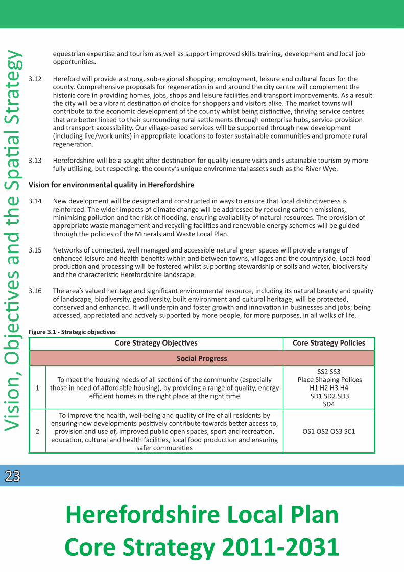
Figure 3.1 - Strategic objecƟ ves
Core Strategy ObjecƟves
Social Progress
To meet the housing needs of all secƟons of the community (especially 1 those in need of affordable housing), by providing a range of quality, energy
efficient homes in the right place at the right Ɵme
To improve the health, well-being and quality of life of all residents by ensuring new developments posiƟvely contribute towards beƩer access to,
2 provision and use of, improved public open spaces, sport and recreaƟon, educaƟon, cultural and health faciliƟes, local food producƟon and ensuring
safer communiƟes
Core Strategy Policies
SS2 SS3 Place Shaping Polices
H1 H2 H3 H4 SD1 SD2 SD3
SD4
OS1 OS2 OS3 SC1
2323
Herefordshire Local Plan Core Strategy 2011-2031
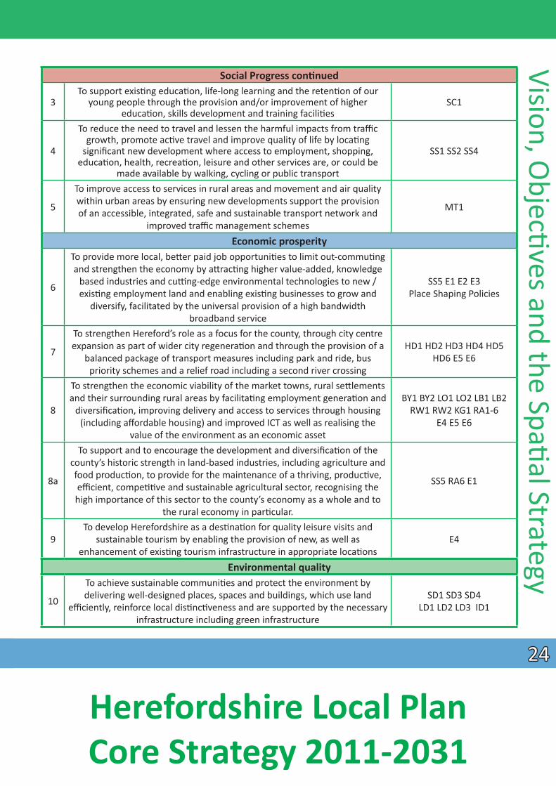
Social Progress conƟnued To support exisƟ ng educaƟon, life-long learning and the retenƟon of our
3 young people through the provision and/or improvement of higher educaƟon, skills development and training faciliƟes
To reduce the need to travel and lessen the harmful impacts from traffic growth, promote acƟve travel and improve quality of life by locaƟng
4 significant new development where access to employment, shopping, educaƟon, health, recreaƟon, leisure and other services are, or could be
made available by walking, cycling or public transport To improve access to services in rural areas and movement and air quality within urban areas by ensuring new developments support the provision 5 of an accessible, integrated, safe and sustainable transport network and
improved traffi c management schemes Economic prosperity
To provide more local, beƩer paid job opportuniƟes to limit out-commuƟng and strengthen the economy by aƩ racƟng higher value-added, knowledge
based industries and cuƫng-edge environmental technologies to new / 6 exisƟng employment land and enabling exisƟng businesses to grow and diversify, facilitated by the universal provision of a high bandwidth
broadband service
To strengthen Hereford’s role as a focus for the county, through city centre expansion as part of wider city regeneraƟon and through the provision of a 7 balanced package of transport measures including park and ride, bus
priority schemes and a relief road including a second river crossing
To strengthen the economic viability of the market towns, rural seƩ lements and their surrounding rural areas by facilitaƟng employment generaƟ on and
8 diversificaƟon, improving delivery and access to services through housing (including affordable housing) and improved ICT as well as realising the
value of the environment as an economic asset To support and to encourage the development and diversificaƟon of the
county’s historic strength in land-based industries, including agriculture and food producƟon, to provide for the maintenance of a thriving, producƟ ve, 8a effi cient, compeƟƟve and sustainable agricultural sector, recognising the high importance of this sector to the county’s economy as a whole and to
the rural economy in parƟ cular. To develop Herefordshire as a desƟnaƟon for quality leisure visits and
9 sustainable tourism by enabling the provision of new, as well as enhancement of exisƟng tourism infrastructure in appropriate locaƟons
Environmental quality To achieve sustainable communiƟes and protect the environment by
10
SC1
SS1 SS2 SS4
MT1
SS5 E1 E2 E3 Place Shaping Policies
HD1 HD2 HD3 HD4 HD5 HD6 E5 E6
BY1 BY2 LO1 LO2 LB1 LB2 RW1 RW2 KG1 RA1-6
E4 E5 E6
SS5 RA6 E1
E4
Vision, ObjecƟves and the SpaƟ al Strategy delivering well-designed places, spaces and buildings, which use land SD1 SD3 SD4
efficiently, reinforce local disƟncƟveness and are supported by the necessary LD1 LD2 LD3 ID1 infrastructure including green infrastructure
2424
Herefordshire Local Plan Core Strategy 2011-2031
Environmental quality conƟnued
Visio
n, O
bjecƟv
es a
nd th
e Sp
aƟ a
l Str
ateg
y
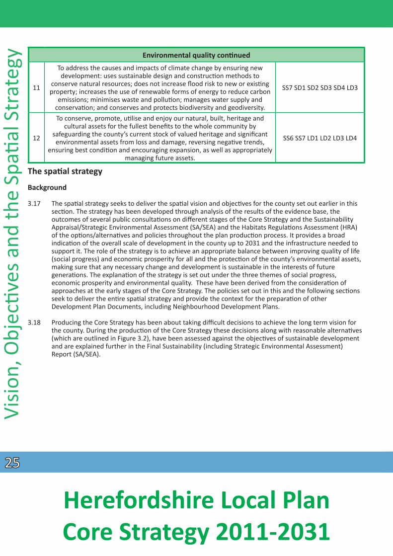
11
12
To address the causes and impacts of climate change by ensuring new development: uses sustainable design and construcƟon methods to
conserve natural resources; does not increase flood risk to new or exisƟng property; increases the use of renewable forms of energy to reduce carbon
emissions; minimises waste and polluƟon; manages water supply and conservaƟon; and conserves and protects biodiversity and geodiversity. To conserve, promote, uƟlise and enjoy our natural, built, heritage and
cultural assets for the fullest benefits to the whole community by safeguarding the county’s current stock of valued heritage and signifi cant environmental assets from loss and damage, reversing negaƟ ve trends,
ensuring best condiƟon and encouraging expansion, as well as appropriately managing future assets.
SS7 SD1 SD2 SD3 SD4 LD3
SS6 SS7 LD1 LD2 LD3 LD4
The spaƟ al strategy
Background
3.17 The spaƟal strategy seeks to deliver the spaƟal vision and objecƟves for the county set out earlier in this secƟon. The strategy has been developed through analysis of the results of the evidence base, the outcomes of several public consultaƟons on different stages of the Core Strategy and the Sustainability Appraisal/Strategic Environmental Assessment (SA/SEA) and the Habitats RegulaƟons Assessment (HRA) of the opƟ ons/alternaƟves and policies throughout the plan producƟon process. It provides a broad
indicaƟon of the overall scale of development in the county up to 2031 and the infrastructure needed to support it. The role of the strategy is to achieve an appropriate balance between improving quality of life (social progress) and economic prosperity for all and the protecƟon of the county’s environmental assets, making sure that any necessary change and development is sustainable in the interests of future
generaƟons. The explanaƟon of the strategy is set out under the three themes of social progress, economic prosperity and environmental quality. These have been derived from the consideraƟ on of approaches at the early stages of the Core Strategy. The policies set out in this and the following secƟons seek to deliver the enƟ re spaƟal strategy and provide the context for the preparaƟon of other Development Plan Documents, including Neighbourhood Development Plans.
3.18 Producing the Core Strategy has been about taking difficult decisions to achieve the long term vision for the county. During the producƟon of the Core Strategy these decisions along with reasonable alternaƟ ves (which are outlined in Figure 3.2), have been assessed against the objecƟves of sustainable development and are explained further in the Final Sustainability (including Strategic Environmental Assessment)
Report (SA/SEA).
2525
Herefordshire Local Plan Core Strategy 2011-2031
Figure 3.2 - Key strategic decisions that the Core Strategy has taken and reasonable alternaƟ ves considered
Key decision
Focussing the majority of development to Hereford
and the market towns with a combined strategy
of considering social, economic and
environmental goals
Focussing the largest strategic allocaƟ on (aŌer Hereford) to Leominster
PromoƟng a western relief road route corridor as part
of a new transport package for Hereford
Reducing the amount of housing proposed in
the strategy overall from 18,000 to 16,500 by
reducing the amount at Hereford and increasing the amount proposed in
the rural areas
Revising the Preferred OpƟon Rural Areas policy
to allow for a more flexible approach to
housing in the rural areas
AlternaƟ ves considered
1. Economic opƟon 2. Social opƟon 3. Environmental opƟon 4. New town or expanded
seƩ lement
1. Disperse growth around the town at smaller sites 2. LimiƟ ng growth 1. No relief road 2. PromoƟng an eastern route corridor opƟon 3. VariaƟons to the
southern part of the western route corridor 4. Promote a parƟal eastern route corridor instead of a western route corridor 1. Make no changes 2. Just change Ɵme
period of plan 3. Retain 18,000, but redistribute 2000 houses from Hereford to rural areas 4. Retain 18,000 dwellings total, but redistribute 2000 houses from Hereford to the market towns 5. Build more than 18,000 new homes up to 2031 6. Reduce all the strategic sites in Hereford 1. Maintaining the rural areas policy suggested at Preferred OpƟon 2. Allow unrestricted development to meet
the housing demand
Stage of Core Strategy producƟon
SA/SEA report reference
Developing OpƟ ons and Place Shaping
Developing OpƟons SA/SEA
(Appendix B2-2) Place Shaping SA (Appendix B3-1
page 1)
Developing OpƟons Developing OpƟons
SA/SEA (Appendix B3 page 41)
Preferred OpƟ on SA/SEA Note for Hereford
Preferred OpƟ on and Revised Preferred OpƟon
(page 17) and Revised Preferred OpƟon SA Note
(page 13)
Revised Preferred Revised Preferred OpƟons OpƟon SA/SEA (page11)
DraŌ Core Strategy
DraŌ Core Strategy SA/SEA
(pages 28 and 134)
Vision, ObjecƟves and the SpaƟ al Strategy
2626
Herefordshire Local Plan Core Strategy 2011-2031
Visio
n, O
bjecƟv
es a
nd th
e Sp
aƟ a
l Str
ateg
y 3.19 It has been decided that not all development should be accommodated within the county’s urban areas, and indeed this would not be the best approach to meeƟng housing needs across Herefordshire, which has such a dispersed seƩ lement paƩern. However, it has been determined to try to focus most development within and adjoining urban areas in the interests of sustainable development i.e. reducing the need to travel by private car where possible. The spaƟal strategy builds upon the exisƟ ng seƩ lement paƩern of Herefordshire, with a focus on Hereford as the county’s administraƟve centre and on other sustainable market towns. However, almost a third of all housing will be directed to the rural areas to help to sustain local services, generate new ones and support local housing provision for local
communiƟes. In accordance with the outcomes of the Revised Preferred OpƟ ons, combinaƟ ons of strategic urban extensions are idenƟfied in the Core Strategy in Hereford and the market towns and smaller (non-strategic) sites will be idenƟfied in the Hereford Area Plan, the Bromyard Development Plan, the Rural Areas Site AllocaƟons Development Plan Document and Neighbourhood Development Plans. The aim is to maintain a network of sustainable seƩlements that meet the needs of communiƟ es whilst
protecƟng and enhancing the disƟncƟve environmental assets of the county.
3.20 The spaƟal strategy reflects the exisƟng and future role and funcƟon of all seƩlements in Herefordshire. A hierarchy of seƩlements was idenƟfied through the consultaƟons on Developing OpƟons and Place Shaping Paper stages of producƟon of the Core Strategy; with the majority of growth taking place in the urban areas of Hereford and the market towns at the highest level of the hierarchy. Following a revised methodology of the hierarchy below the market towns level aŌer the Preferred OpƟons stage, a more localised approach has idenƟfi ed seƩlements countywide where proporƟonal levels of development may be acceptable. These are detailed in the Place Shaping secƟon and include seƩ lements considered sustainable due to their exisƟng range of services, together with those seƩlements where some future development will offer the potenƟal for them to become more sustainable, thus strengthening their role
locally.
3.21 The exisƟng urban areas are regarded as the most suitable locaƟons for future development because of their exisƟng easy access to services and faciliƟes. This provides the opportunity to reduce out-commuƟng
to other centres such as reducing the need to travel by private car for work or shopping, thus increasing ‘self-containment’. Further development in Hereford and the market towns will help to maintain their role as service centres and contribute to their future regeneraƟon, through provision of addiƟ onal services
and faciliƟes required to support new development. This in turn, will help to sustain the rural areas that surround them.
3.22 The spaƟal strategy is ‘housing, economic and environment- led.’ In promoƟng growth, the strategy aims to undertake the following across the county:
• spearhead the regeneraƟon of Hereford and our market towns; • help fund necessary new or improved infrastructure including a transport package to ease
congesƟon in Hereford; • address issues around an increasingly ageing populaƟon structure and potenƟal decline in the
working age populaƟon;• address issues of housing affordability across the county but parƟcularly in the rural areas; • tackle issues regarding accessibility to services in rural areas; • foster self-reliance, independence and resilience; and • address issues of water quality.
3.23 AdapƟng to and miƟgaƟng the effects of climate change are integral to the spaƟal strategy and cut across all policies. Addressing the impacts of climate change will be achieved by locaƟng the majority of growth
2727
Herefordshire Local Plan Core Strategy 2011-2031
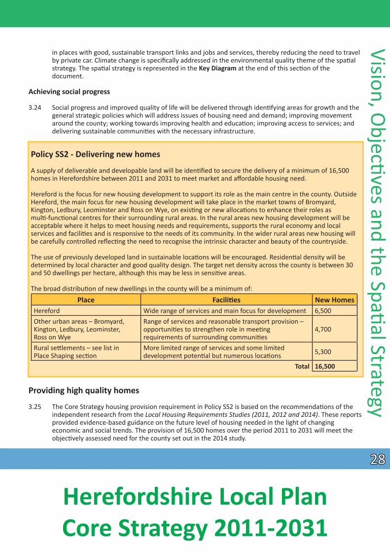
in places with good, sustainable transport links and jobs and services, thereby reducing the need to travel by private car. Climate change is specifically addressed in the environmental quality theme of the spaƟal strategy. The spaƟal strategy is represented in the Key Diagram at the end of this secƟon of the
document.
Achieving social progress
3.24 Social progress and improved quality of life will be delivered through idenƟfying areas for growth and the general strategic policies which will address issues of housing need and demand; improving movement around the county; working towards improving health and educaƟon; improving access to services; and delivering sustainable communiƟes with the necessary infrastructure.
Policy SS2 - Delivering new homes
A supply of deliverable and developable land will be idenƟfied to secure the delivery of a minimum of 16,500 homes in Herefordshire between 2011 and 2031 to meet market and affordable housing need.
Hereford is the focus for new housing development to support its role as the main centre in the county. Outside Hereford, the main focus for new housing development will take place in the market towns of Bromyard, Kington, Ledbury, Leominster and Ross on Wye, on exisƟng or new allocaƟons to enhance their roles as mulƟ -funcƟonal centres for their surrounding rural areas. In the rural areas new housing development will be acceptable where it helps to meet housing needs and requirements, supports the rural economy and local services and faciliƟes and is responsive to the needs of its community. In the wider rural areas new housing will be carefully controlled reflecƟng the need to recognise the intrinsic character and beauty of the countryside.
The use of previously developed land in sustainable locaƟons will be encouraged. ResidenƟal density will be determined by local character and good quality design. The target net density across the county is between 30 and 50 dwellings per hectare, although this may be less in sensiƟ ve areas.
The broad distribuƟon of new dwellings in the county will be a minimum of:
Hereford Wide range of services and main focus for development 6,500 Other urban areas – Bromyard, Range of services and reasonable transport provision – Kington, Ledbury, Leominster, opportuniƟes to strengthen role in meeƟng 4,700 Ross on Wye requirements of surrounding communiƟes Rural seƩlements – see list in More limited range of services and some limited 5,300Place Shaping secƟon development potenƟal but numerous locaƟons
Total 16,500
Providing high quality homes
3.25 The Core Strategy housing provision requirement in Policy SS2 is based on the recommendaƟons of the independent research from the Local Housing Requirements Studies (2011, 2012 and 2014). These reports provided evidence-based guidance on the future level of housing needed in the light of changing economic and social trends. The provision of 16,500 homes over the period 2011 to 2031 will meet the objecƟvely assessed need for the county set out in the 2014 study.
Place FaciliƟes New Homes
Vision, ObjecƟves and the SpaƟ al Strategy
2828
Herefordshire Local Plan Core Strategy 2011-2031
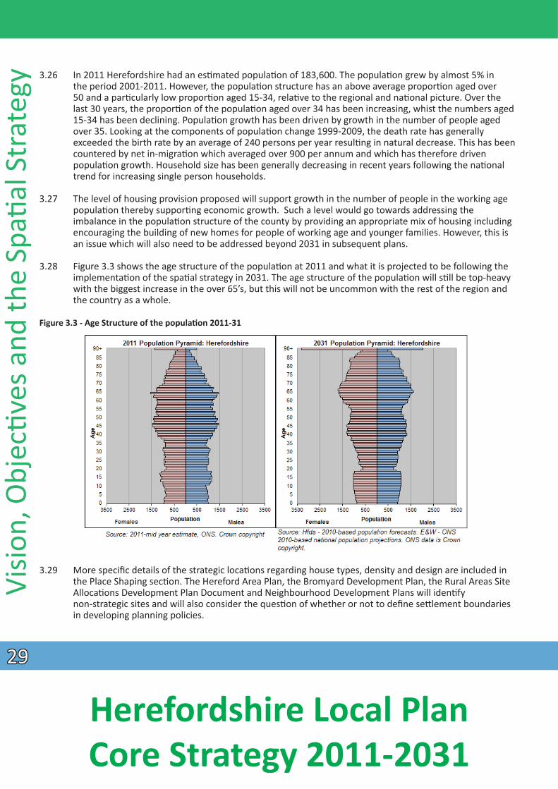
Visio
n, O
bjecƟv
es a
nd th
e Sp
aƟ a
l Str
ateg
y 3.26 In 2011 Herefordshire had an esƟ mated populaƟon of 183,600. The populaƟon grew by almost 5% in the period 2001-2011. However, the populaƟon structure has an above average proporƟon aged over 50 and a parƟcularly low proporƟon aged 15-34, relaƟve to the regional and naƟonal picture. Over the last 30 years, the proporƟon of the populaƟon aged over 34 has been increasing, whist the numbers aged 15-34 has been declining. PopulaƟon growth has been driven by growth in the number of people aged over 35. Looking at the components of populaƟon change 1999-2009, the death rate has generally exceeded the birth rate by an average of 240 persons per year resulƟng in natural decrease. This has been countered by net in-migraƟon which averaged over 900 per annum and which has therefore driven populaƟon growth. Household size has been generally decreasing in recent years following the naƟonal trend for increasing single person households.
3.27 The level of housing provision proposed will support growth in the number of people in the working age populaƟon thereby supporƟng economic growth. Such a level would go towards addressing the imbalance in the populaƟon structure of the county by providing an appropriate mix of housing including encouraging the building of new homes for people of working age and younger families. However, this is an issue which will also need to be addressed beyond 2031 in subsequent plans.
3.28 Figure 3.3 shows the age structure of the populaƟon at 2011 and what it is projected to be following the implementaƟon of the spaƟal strategy in 2031. The age structure of the populaƟon will sƟll be top-heavy
with the biggest increase in the over 65’s, but this will not be uncommon with the rest of the region and the country as a whole.
Figure 3.3 - Age Structure of the populaƟ on 2011-31
3.29 More specific details of the strategic locaƟons regarding house types, density and design are included in the Place Shaping secƟon. The Hereford Area Plan, the Bromyard Development Plan, the Rural Areas Site
AllocaƟons Development Plan Document and Neighbourhood Development Plans will idenƟfy non-strategic sites and will also consider the quesƟon of whether or not to defi ne seƩ lement boundaries in developing planning policies.
2929
Herefordshire Local Plan Core Strategy 2011-2031
3.30 In terms of distribuƟon of housing, Hereford is the service and economic centre of the county reflecƟng its higher populaƟon (58,500 people) and, being the most sustainable seƩlement, it should take the most growth. Therefore, strategic locaƟons for new homes and employment land have been idenƟfi ed around the city in areas considered acceptable in environmental terms.
3.31 The decision to focus the largest single allocaƟon of new homes to Leominster has been based on the recogniƟon of its economic importance, located on the A49 Corridor, its excellent public transport links,
including a railway staƟon, and the fact that an urban extension will bring transport benefits in the form of a southern link road. The laƩer will benefit the centre of the town in terms of reducing congesƟ on and improving air quality. RelaƟve to the county’s other market towns, Leominster is also the least constrained
environmentally.
3.32 The quanƟty and type of development, in terms of housing and employment land, allocated to Ross on Wye, Ledbury, Bromyard and Kington reflects their respecƟve roles, needs, opportuniƟ es and environmental development constraints. Ledbury and Ross on Wye (larger in scale and populaƟ on terms) will support quanƟtaƟvely more development than Bromyard and Kington. This is explained further in the Place Shaping secƟon.
3.33 The plan seeks to encourage new developments which support and enhance access to local services and tackle issues of rural housing affordability, giving consideraƟon to the introducƟon of neighbourhood planning. The locaƟon and level of development allocated to seƩlements will be determined through the
preparaƟon of a Rural Areas Site AllocaƟons Development Plan Document or Neighbourhood Development Plans.
3.34 The NaƟonal Planning Policy Framework states, as one of its core principles, that the planning system should encourage the effecƟve use of land by re-using land that has been previously developed, provided that it is not of high environmental value. Given the level of growth planned for this plan period, it will not be possible to achieve development of a high percentage on brownfield land, but this will conƟnue to be encouraged for future development proposals. The target net density in Policy SS2 has been based on a balance of issues, including the encouragement of the efficient use of land and the need to protect the county’s environmental assets.
MeeƟ ng specific housing needs
3.35 The council has produced a Strategic Housing Market Assessment 2008 and a Local Housing Market Assessment 2013, which indicates that there is an urgent need to increase the provision of aff ordable
housing in the county. However, whilst there is a very high need, this has to be balanced against the outcomes of the Affordable Housing Viability Study 2011 and the Economic Viability Study 2014. Whilst affordable housing is a priority for the county, the need for new infrastructure to help economic growth is another priority. Levels of affordable housing and percentages and thresholds required, have been set
to reflect the viability of achieving both prioriƟes. In terms of delivery, a strategy focussed on growth and development of strategic sites is considered the best approach in order to get affordable homes built in the county over the plan period. The council has been looking at other forms of aff ordable housing delivery, including using public sector land assets and supporƟng direct delivery through Registered Providers. The place shaping policies and the general policy on affordable housing will deliver this part of
the strategy.
3.36 A report on the Housing and Support Needs of Older People 2012 in Herefordshire has highlighted a growing need for suitable homes for older people to live independently, as well as a need for specialist
Vision, ObjecƟves and the SpaƟ al Strategy
3030
Herefordshire Local Plan Core Strategy 2011-2031
Visio
n, O
bjecƟv
es a
nd th
e Sp
aƟ a
l Str
ateg
y housing with extra care to be built. These issues are addressed within place specific policies in the Place Shaping secƟon and within policies on social progress in the General Policies secƟon of this document.
3.37 The Gypsy and Travellers and Travelling Showperson AccommodaƟon Assessment, 2015 highlighted a need for further permanent pitches in the county. A Travellers’ Sites Document will be prepared following on from the Core Strategy to allocate pitches, but in the meanƟme an interim policy is set out in the policies on social progress in the General Policies secƟon of this document.
3.38 The council recognises that individual or group self and custom build projects will contribute to the delivery of homes over the plan period. These may be in the form of affordable, low cost market and open market housing. The council will encourage and support this type of development where the proposals are in line with the relevant policies of the Core Strategy and neighbourhood plans. Specific sites may be allocated for this type of development in Area and Neighbourhood Development Plans where a demand for this type of development has been demonstrated.
Housing trajectory
3.39 In respect of the housing target for Herefordshire the expectaƟon is that the highest rate of housing compleƟons will be towards the laƩer end of the plan period.
3.40 Overall the delivery of the housing levels and distribuƟon proposed in the Core Strategy is dependent upon necessary infrastructure being funded and delivered. A detailed trajectory is set out in Appendix 4. The delivery of housing will be monitored throughout the plan period and may need further re-adjustment and added detail to reflect progress on the delivery of the strategic housing sites and key elements of infrastructure.
Policy SS3 - Ensuring sufficient housing land delivery
A sufficient supply of housing land will be maintained to ensure the delivery of the Core Strategy housing target as set out in Policy SS2 over the plan period. The rate of housing delivery and supply will be assessed though the annual monitoring process. If monitoring demonstrates that the number of new dwelling compleƟons is below the cumulaƟ ve target figure over a 12-month monitoring period (1 April to 31 March) as set out in the housing trajectory in Appendix 4 the Council will prioriƟse increasing housing supply in the following monitoring periods using appropriate mechanisms which, depending on the scale and nature of potenƟ al under-delivery, will include:
• A parƟal review of the Local Plan – Core Strategy; or• The preparaƟon of new Development Plan Documents; or• The preparaƟon of an interim posiƟon statement and uƟlising evidence from the Strategic Housing Land
Availability Assessment to idenƟ fy addiƟonal housing land.
A range of strategic housing proposals are idenƟfied which are key to the delivery of the spaƟal strategy. In addiƟon there are elements of key infrastructure which will need to be provided to enable full delivery of the strategic housing targets. The council will work with developers and other stakeholders to ensure the Ɵmely development of these strategic proposals and the key infrastructure requirements.
3131
Herefordshire Local Plan Core Strategy 2011-2031
Policy SS3 - Ensuring sufficient housing land delivery conƟnued
Appendix 5 sets out the relaƟonships between the delivery of housing and the Ɵming of the main infrastructure requirements. It also idenƟfi es acƟons necessary to safeguard the integrity of the River Wye Special Area of ConservaƟon (SAC) from adverse effects. The council will acƟvely monitor the relaƟ onships idenƟfied in this appendix. Any material delays in the implementaƟon of idenƟfied infrastructure or environmental safeguards and which will lead to under-delivery of housing supply will inform the implementaƟon of the range of measures set out above to ensure plan-led correcƟve measures are put in place.
3.41 The delivery and supply of new housing will be monitored on a regular basis and through the annual monitoring process in parƟcular. Appendix 4 sets out an indicaƟve trajectory for total housing
compleƟons, which will provide a basis for monitoring compleƟons over the plan period. In the event that the monitoring process demonstrates that the rate of compleƟons have fallen below targets, an early assessment will be made as to the most appropriate mechanism to boost housing delivery depending upon the scale and nature of the issue. The stepped target of 600 dpa for the fi rst five years of the plan (2011-2016), 850 dpa for years 6-10 (2016-2021), 900 dpa for years 11-15 (2021-2026) and 950 dpa for years 16-20 (2026-2031) would be the basis for monitoring and assessing land supply (including the five year housing land supply) throughout the plan period. For calculaƟon of the five year housing land supply, due to persistent under delivery a buffer of 20% is considered appropriate.
3.42 To achieve the Core Strategy housing target there is a need to ensure that appropriate and necessary infrastructure is co-ordinated with the development. This will be parƟcularly the case in respect of major elements of infrastructure such as the Hereford Relief Road.
3.43 In addiƟon, the River Wye SAC currently includes secƟons where the water quality exceeds phosphate level targets and this prevents secƟons of the river from achieving favourable condiƟon. It is also necessary to ensure that secƟons of river currently meeƟng the water quality targets do not fail as a result of new development. Natural England and the Environment Agency have prepared a Nutrient Management Plan (NMP) which sets out to control and reduce phosphates in the SAC. The
implementaƟon of the acƟons in the NMP will facilitate the delivery of new development. Policy SD4 deals specifically with wastewater treatment and river water quality.
Windfalls
3.44 The NaƟonal Planning Policy Framework (NPPF) indicates that local planning authoriƟes should draw on informaƟon from Strategic Housing Land Availability Assessments (SHLAA) to idenƟfy:
• suffi cient specific sites to deliver housing in the fi rst five years of the plan period with an addiƟonal buffer of 5% to ensure choice and compeƟƟon in the market for land; and
• a further supply of specific, developable sites or broad locaƟons for years 6-10 and where possible, for years 11-15.
3.45 It goes on to say that sites with planning permission should only be included where there is robust evidence that the sites are developable and viable and are likely to contribute to housing delivery at the point envisaged. In respect of sites not specifi cally idenƟfied, the NPPF advises that allowances for ‘windfalls’, can be included in the five year supply if there is robust evidence of consistent local circumstances and reliable future supply.
Vision, ObjecƟves and the SpaƟ al Strategy
3232
Herefordshire Local Plan Core Strategy 2011-2031
Visio
n, O
bjecƟv
es a
nd th
e Sp
aƟal
Str
ateg
y 3.46 In Herefordshire there is longstanding evidence that housing on ‘non-allocated’ sites has made a significant contribuƟon to meeƟng housing needs and requirements. Such housing has not only come forward within urban parts of the county but also has been the major element of new housing in rural areas, where the conversion of agricultural buildings have contributed significant numbers of new homes.
3.47 It is therefore important to consider how windfalls, including the conversion of rural buildings, should be reflected in the housing land supply and residenƟal targets for the county. The preparaƟon of the SHLAA should mean that a higher proporƟon of sites will be idenƟfied as part of the supply figures and so only a modest windfall allowance is included within the housing targets of 2,000 dwellings, equaƟng to 50 dwellings a year in rural areas with the same allowance for urban parts of Herefordshire.
Movement and transportaƟon
3.48 The approach of the strategy for movement and transportaƟon is two-fold. Firstly, the spaƟal strategy itself aims to direct the locaƟon of significant new development proposed through the plan to the more accessible locaƟons in the county to promote the use of exisƟng nearby services and facilitate the use of acƟve travel (walking and cycling) as well as public transport. However, this principle needs to apply to all new significant development proposals that may come forward through the plan period. It will also require policies to minimise the impact of addiƟonal highway demand generated by new development on the transport network, so that journey Ɵmes, journey Ɵme reliability, public realm and highway safety in the county do not deteriorate.
3.49 Secondly, the approach is to work with developers, the Highways Agency and transport providers to improve transport infrastructure, connecƟons and choices in our main centres and rural areas (where reliance on the private car is oŌen the only opƟon). This is parƟcularly important for local journeys in Hereford where a balanced package of measures including more walking and cycling, bus transport and a Relief Road would improve connecƟvity and travel choice, reduce congesƟon, enhance the public realm and foster local enterprise and tourism.
3.50 Herefordshire is a diverse county incorporaƟng both rural and urban communiƟes. The scale of the county, alongside its historic seƩlement paƩern, places significant importance on movement and transportaƟon. As recognised in the NaƟonal Planning Policy Framework, transport and movement can play a posiƟve role in contribuƟng to sustainable development; whether through providing opportuniƟes for greater public transport, or delivering air quality improvements by removing vehicular movements from pedestrian areas. Alongside this, the following pro-acƟve strategic policies on movement and transportaƟon can build upon objecƟves and policies within Herefordshire Council’s Local Transport Plan (LTP) to improve journey Ɵme and connecƟvity across the county. In partnership with the LTP the strategic policies are designed to deliver Herefordshire Council’s Core Strategy objecƟves of improving movement and transportaƟon across the county.
Policy SS4 - Movement and transportaƟon
New developments should be designed and located to minimise the impacts on the transport network; ensuring that journey Ɵmes and the efficient and safe operaƟon of the network are not detrimentally impacted. Furthermore, where pracƟcable, development proposals should be accessible by and facilitate a genuine choice of modes of travel including walking, cycling and public transport.
3333
Herefordshire Local Plan Core Strategy 2011-2031
Policy SS4 - Movement and transportaƟ on conƟnued
Development proposals that will generate high journey numbers should be in sustainable locaƟ ons, accessible by means other than private car. AlternaƟvely, such developments will be required to demonstrate that they can be made sustainable by reducing unsustainable transport paƩerns and promoƟng travel by walking, cycling and public transport.
Proposals to provide new and improved exisƟng public transport, walking and cycling infrastructure will be supported. Where appropriate, land and routes will be safeguarded as required in future local or Neighbourhood Development Plans and developer contribuƟons, which meet the statutory tests, sought to assist with the delivery of new sustainable transport infrastructure, including that required for alternaƟve energy cars.
Herefordshire Council will work with the Highways Agency, Network Rail, bus and train operators, developers and local communiƟes to bring forward improvements to the local and strategic transport network to reduce congesƟon, improve air quality and road safety and offer greater transport choices, including the provision of the following major schemes:
• ESG Link Road (safeguarded route) and Transport Hub;• Hereford Relief Road;
• Leominster Relief Road; • Connect 2 Cycleway in Hereford;• Park and Choose schemes; and
• other schemes idenƟfied in the Local Transport Plan and Infrastructure Delivery Plan.
Proposals which enable the transfer of freight from road to rail will be encouraged. Development proposals incorporaƟng commercial vehicular movements that could detrimentally impact on the environmental quality, amenity, safety and character of the surrounding locality will be expected to incorporate evidence demonstraƟng how the traffic impacts are to be miƟ gated.
3.51 Herefordshire Council’s Local Transport Plan sets out programmes of work for achieving the council’s objecƟves for transport, accessibility and polluƟon control which posiƟvely contribute to addressing climate change. Development arising under the Core Strategy can play a posiƟve role in delivering the objecƟves of the LTP; developers should provide evidence showing how their proposed developments will deliver against those objecƟves. Accordingly, development proposals will be supported where they respond to the opportuniƟes and constraints detailed within the LTP.
3.52 By influencing the locaƟon of new development, land use can reduce the need to travel parƟ cularly by private car, and minimise its impact on the environment. At the same Ɵme the planning system must respond to the need for new transport infrastructure and recognise the challenges faced by rural seƩlements, where reliance on private motorised transport, for many people, is the only realisƟ c opƟon for travel. Accordingly, strategic developments will be located on or have access to exisƟ ng passenger transport networks so that they are convenient, accessible, safe and aƩ racƟve to use. Where appropriate, development proposals should be accompanied by travel plans and transport assessments outlining
alternaƟves to private motorised transport use.
Vision, ObjecƟves and the SpaƟ al Strategy
3434
Herefordshire Local Plan Core Strategy 2011-2031
Visio
n, O
bjecƟv
es a
nd th
e Sp
aƟ a
l Str
ateg
y Pedestrians and cyclists
3.53 The role of walking and cycling in creaƟng liveable places, promoƟng health improvements and social inclusion has not always been recognised. Despite this, almost all journeys include an element of walking. Ensuring that there is safe and convenient access to housing, jobs, educaƟon, health care, other services and local faciliƟes for pedestrians and cyclists is an essenƟal part of promoƟng social inclusion and the delivery of sustainable development. Consequently, Herefordshire Council will advocate developments which promote pedestrian and cycle friendly access, avoiding conflict with private motorised vehicles, and provide appropriate links to the green infrastructure network where possible.
Public transport
3.54 ConnecƟng improvements to pedestrian and cycling faciliƟes with public transport faciliƟ es provides greater transport opportuniƟes and alternaƟves to reliance on private motorised transport. Herefordshire Council will work in partnership with the Highways Agency, Network Rail, bus and rail operators, developers and the community to achieve improvements to the public transport network. This may include improving both the quality and quanƟty of the service on offer. Land and routes will be safeguarded from inappropriate development and idenƟfied in site specific plans. Where appropriate,
developer contribuƟons will be sought to deliver improvements to the public transport network.
Major transport schemes
3.55 The strategically important schemes, including ESG Link Road, Transport Hub, Hereford Relief Road and Connect 2, are explained further in the Hereford part of the Place-Shaping secƟon. The Leominster Relief Road is explained in detail in the Leominster part of the same secƟon. The funding required for these schemes is detailed in the Infrastructure Delivery Plan.
Freight
3.56 Road freight will conƟnue to be the dominant mode of transport for freight distribuƟ on within Herefordshire due to its flexibility and accessibility. The county’s railway network is limited and few of its key industrial networks are adjacent, or in close proximity to, the four passenger railway staƟ ons. The
exisƟng railhead for minerals transport at Moreton-on-Lugg will conƟnue to be protected. It is however, important to encourage increased movements by rail to alleviate the addiƟonal pressure that growth will place on the county’s roads, and to minimise any increase in carbon emissions associated with transport.
3.57 During the plan period, advancements in technologies may bring forward alternaƟ ve transport technologies. Where such developments are not covered by naƟ onal legislaƟon, Herefordshire Council will support their development. Such proposals must be in accordance with the principles of other policies of the Core Strategy and demonstrate their contribuƟon towards delivering sustainable transport soluƟons.
3.58 In order to deliver the strategic objecƟves outlined above, development proposals will be expected to demonstrate how they have incorporated the criteria contained within policy MT1 in the secƟ on on
general policies.
3.59 Partnership working will ensure all major housing and employment sites are served by public transport and that rail services and infrastructure within Herefordshire is improved over the long term and that smarter travel choices are promoted in the short term. The place shaping policies and the general policy
3535
Herefordshire Local Plan Core Strategy 2011-2031
on traffic management, alongside the Local Transport Plan, will also work towards delivering this part of the strategy.
EducaƟon and Skills
3.60 Improved and expanded higher educaƟon provision in Herefordshire is envisaged as part of the strategy to help retain our young people and improve the skills base of the county. The place shaping policies and the general policy on community faciliƟes will deliver this part of the strategy. Significant recent work has been undertaken to bring about the establishment of a university in Herefordshire. This proposal has widespread support in the Council, the wider community and with local businesses. The emerging proposal will do much to consolidate the role of Hereford as a tradiƟonal county town and which provides a vibrant and diverse range of services. Depending on the state of the project at that Ɵme there will be an opportunity for it to be included in greater detail in the Hereford Area Plan.
Health and wellbeing
3.61 Health services are being developed through an integrated approach of providing for an increased need for age appropriate services (Understanding Herefordshire). This includes; access to community centres, keeping people independent in their own home and personalised services such as the provision of extra care homes and supported housing generally. Other objecƟves of this plan, such as improving the provision of open space to help combat obesity and mental health problems, and the provision of improved broadband technology to facilitate access to services, will all work together to provide for improved health and wellbeing in the future. The place shaping policies and the general policies on
community faciliƟes and housing will help to facilitate this approach.
Access to services
3.62 Historically, Herefordshire performs poorly in naƟonal assessments measuring the accessibility to services for the populaƟon (see Herefordshire Context secƟon). This is because of its size and very sparsely populated nature. It is envisaged that the strategy of focussing most growth to urban areas, coupled with improvements in technology, such as broadband availability alongside council iniƟaƟ ves such as Locality working, will address this issue. Some nine ‘natural communiƟes’ or ‘localiƟes’ have been idenƟfied as forming the basis for engagement and providing the opportunity to deliver joined-up customer access points for people.
New and/or improved infrastructure
3.63 Necessary community infrastructure including transport, green spaces, leisure uses, health, emergency services and educaƟ on faciliƟes will be delivered alongside new homes through planning condiƟ ons and
developer contribuƟons or the Community Infrastructure Levy. This will ensure that sustainable communiƟes are created and maintained and that health and well-being is promoted. The type and
phasing of infrastructure required to support the growth strategy is set out in the accompanying Core Strategy Infrastructure Delivery Plan or IDP. This is backed up by a separate evidence base on Economic Viability, which reports that the infrastructure listed in the IDP to support the projects and proposals in the Core Strategy, are viable at the Ɵme of wriƟng for developers to want to build.
3.64 Significant infrastructure projects are required to: deliver the strategy; ease congesƟ on, improve broadband speeds and availability to foster economic growth; and improve the county’s sewerage treatment to prevent adverse effects on water quality. These projects will require joint working by a range
Vision, ObjecƟves and the SpaƟ al Strategy
3636
Herefordshire Local Plan Core Strategy 2011-2031
Visio
n, O
bjecƟv
es a
nd th
e Sp
aƟ a
l Str
ateg
y of partners who will work with housing providers and the council to ensure new housing can be delivered as part of an overall approach to increased sustainability for the county. The place shaping policies and general policies, as well as that on infrastructure delivery, explain these projects in detail and will work towards delivering this part of the strategy.
Key outcomes of the strategy for social progress
3.65 These are: meeƟng housing need and demand; improved access to services; improving the health and well-being of residents; and reducing the need to travel, delivering Core Strategy objecƟves 1, 2, 3, 4
and 5.
Achieving economic prosperity
3.66 The elements needed for sƟmulaƟng economic prosperity will be delivered through: encouraging the diversificaƟon of the county’s employment base; area regeneraƟon; improving connecƟ vity; promoƟng
shopping and tourism in the right places; and improving economic output.
Employment provision
3.67 The Economic Development Strategy (Nov 2011) is an integral part of the Local Development Framework. Its vision is to increase economic wealth through the growth of business. This will be achieved through
the following:
• Sustain business survival and growth; • Increase incomes and the range and quality of jobs; • Have a skilled populaƟon to meet future work needs; • Develop the county’s built infrastructure for enterprise to flourish.
3.68 Herefordshire’s economic output is low compared to regionally and naƟonally; in 2012 GVA per head in Herefordshire was £15,300 compared to £17,400 in the West Midlands and £21,900 across England. This is partly a result of persistently lower wages in the county with median weekly earnings for people who work in Herefordshire of £385, significantly lower than those in the West Midlands region (£470) and England (£512). Low wage levels are borne out in housing aff ordability issues.
3.69 The low value economy is partly a funcƟon of the county’s economic structure. There are a high proporƟon of employees in manufacturing (accounƟng for 16% of employee jobs compared to 8% across
England), but these are primarily in low and medium technology acƟviƟes, including food and beverage producƟon, rather than higher value-added acƟviƟes. The wholesale and retail trade are also strongly represented (accounƟng for 19% of employee jobs compared to 16% across England) and this includes
jobs in tourism-related sectors. The agricultural sector is also well represented. There is a low level of employment in finance, IT and other business acƟviƟes, which has been a key growth sector naƟ onally in
recent decades. The county has a high proporƟon of small and medium sized enterprises and the council will off er conƟnuing support for such businesses in future.
3.70 A keynote feature of the economic structure is a low representaƟon of higher-value private sector businesses. This is a structural economic weakness, which partly reflects the county’s relaƟ vely remote
locaƟon in a naƟonal or regional context, together with the size of its populaƟon and key centre (Hereford) and the nature of the area’s road and rail links. However this needs to be set against
supply-side regeneraƟon measures, including proposals in the Core Strategy for addiƟ onal employment
3737
Herefordshire Local Plan Core Strategy 2011-2031
land provision, together with regeneraƟon projects, such as the regeneraƟon of the Livestock Market in Hereford, the designaƟon of the Hereford Enterprise Zone at Rotherwas and the future development of
exisƟ ng commiƩed sites such as Model Farm in Ross-on-Wye.
3.71 In overall terms, the numbers working in land-based industries accounts for a much greater proporƟon than regionally or naƟonally. However, agriculture has a track record in diversificaƟon. For example; the use of polytunnels for a greater range of fruits, increased quanƟƟes of produce, improved quality and a lengthened growing season, which has enabled many farmers to stay in business. Land-based industries are seen as a strength of the county since they foster other business enterprises such as renewable energy technologies and creaƟ ve industries.
3.72 Evidence of commuƟ ng paƩerns suggests that there is a moderate net ouƞlow of people to work, although the level of self-containment of travel to work paƩerns was relaƟvely high. Travel to work paƩerns highlight that Bromyard and Ledbury have a net ouƞlow of workers. This issue is reflected in the
allocaƟons of employment land to these centres.
3.73 The Employment Land Study 2012 states that the emerging Core Strategy has an overall target of 148 hectares (ha) of available employment land over the plan period, which includes a rolling fi ve year reservoir of 37 ha. Based on the output of projecƟng past compleƟon rates, the overall target of 148 ha outlined in the emerging Core Strategy would provide a robust level of supply and would enable a wide range and choice of employment sites across the county to be provided throughout the plan period. Higher quality land referred to in this policy is that defined as “best” and “good” in the 2012 Study and is subject to more detailed discussion in policy E2. Appendix 6 sets out details regarding the provision of strategic employment land and its delivery and monitoring and review.
Policy SS5 - Employment provision
ExisƟng higher quality employment land countywide will be safeguarded from alternaƟve uses. A conƟnuous supply of 37ha of readily available employment land will be made available over a 5 year period, with an overall target of 148ha of employment land over the plan period. New strategic employment land, in tandem with housing growth and smaller scale employment sites, will be delivered through the plan period. New strategic employment land locaƟons are idenƟfied at Hereford (15ha); Leominster (up to 10ha), Ledbury (15ha), and Ross-on-Wye (10ha). The Hereford Enterprise Zone at Rotherwas will conƟnue to provide the largest focus for new employment provision in the county. Proposals for employment land provision at Bromyard and Kington will be brought forward through Neighbourhood Development Plans or other Development Plan Documents.
The conƟnuing development of the more tradiƟonal employment sectors such as farming and food and drink manufacturing will be supported. The diversificaƟon of the business base, through the development of knowledge intensive industries, environmental technologies and creaƟve industries as well as business hubs, live-work schemes and the adapƟve design of residenƟal development, will be facilitated where they do not have an adverse impact on the community or local environment. The provision of high speed broadband to facilitate diversificaƟon will be supported.
Area regeneraƟon
3.74 Hereford is the county’s main economic centre and as such has the potenƟal to influence the prosperity of the whole area. A combined approach to regeneraƟon means investment in covering travel, housing, employment land development and job creaƟon can make a signifi cant difference to the county. It is an
Vision, ObjecƟves and the SpaƟ al Strategy
3838
Herefordshire Local Plan Core Strategy 2011-2031
Visio
n, O
bjecƟv
es a
nd th
e Sp
aƟ a
l Str
ateg
y objecƟve of the Core Strategy that the role of Hereford as the main business, service and visitor centre for the county will be maintained and enhanced through the expansion of the city centre as part of wider city
regeneraƟon. This will include new retail, leisure, tourist and commercial development and new sustainable transport infrastructure. The designated Hereford Enterprise Zone (HEZ) at Rotherwas will further support an enhanced economic outlook with the aim of promoƟng a more diverse employment base. An extra 5 ha of employment land has been designated as part of a mixed use development at the Lower Bullingham urban extension to support the HEZ. This is an addiƟon to the policy since Revised
Preferred OpƟ on stage.
3.75 Each of the market towns has their own disƟ nct qualiƟ es, reflecƟve of their posiƟon in the county and the organic growth of their industries. Ledbury and Ross both benefit from access to motorway links, whilst Leominster and Ledbury have connecƟons to the rail infrastructure. There are clusters of industry within all the market towns, providing valuable employment. Tourism opportunity is a strong feature of all the market towns, which have their own unique selling points. The regeneraƟon of the wider economy of the county’s market towns will be prioriƟsed in order to support their viability as key service centres for their rural hinterlands, by ensuring they remain the focus for appropriate levels of new homes and jobs. Whilst no strategic employment sites are proposed in Kington over this plan period, smaller scale employment sites will be encouraged and idenƟfied through either Development Plan Documents or Neighbourhood
Development Plans.
3.76 The rural economy is populated by small businesses, oŌen sole traders or the self-employed working from home. This is higher than the naƟonal average and is driven by increasing opportuniƟes to use technology to work from any locaƟon. Businesses in rural areas support the sustainability of local services and
communiƟes (Taylor Review of Rural Economy and Affordable Housing, July 2008). Therefore in the rural areas, businesses will be supported by taking into account local demand, the ability to retain, grow or diversify employment opportuniƟes and opƟons to reuse exisƟng buildings and sites, as well as
contribuƟon to the sustainability of the area.
Sustainable tourism
3.77 Tourism is worth £469m to the county‘s local economy (2011). Over 4.7 million visitors come per year mainly for short stays to take advantage of the outstanding countryside, rich heritage and cultural off er. This supports 8,480 jobs. “Visit Herefordshire” is the agency in the county that promotes tourism and alongside the council works to develop it as a visitor desƟnaƟon. The delivery of high quality tourist, cultural and leisure development will be supported in the county where it capitalises on exisƟ ng assets, develops sustainable walking, cycling or heritage routes, benefits local communiƟes and the economy and
is sensiƟve to Herefordshire’s natural and built environmental qualiƟes and heritage assets. The place shaping policies and the general policy on tourism will deliver this part of the strategy.
ConnecƟvity
3.78 A key principle of the Core Strategy is that intensive trip generaƟng development should be built in the most accessible locaƟons. The co-locaƟon of employment, shopping, leisure, transport and other faciliƟes means that people can carry out mulƟ ple acƟviƟes in a single journey and there will be a boost to the local retail economy.
3.79 New transport infrastructure countywide (to include a western relief road around the city to facilitate a package of sustainable transport measures within the city) and faster, more accessible ICT/Broadband infrastructure will be delivered to facilitate the generaƟon and diversificaƟon of employment opportuniƟes and to improve accessibility to educaƟon and training opportuniƟes.
3939
Herefordshire Local Plan Core Strategy 2011-2031
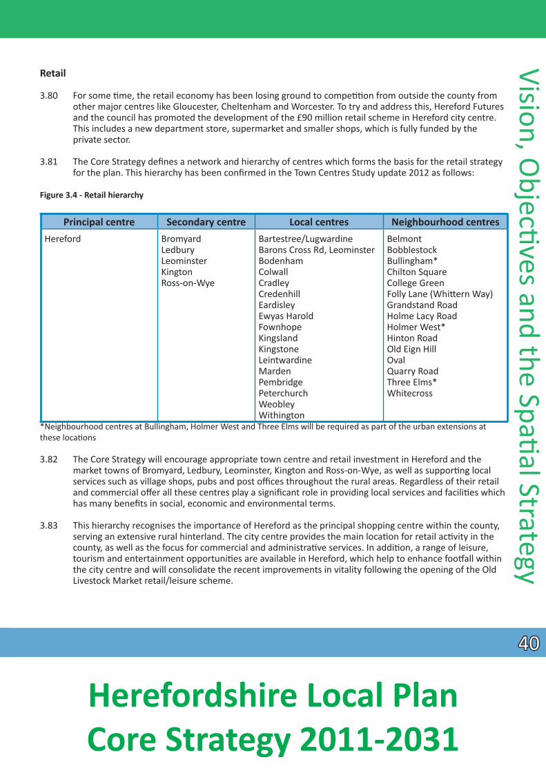
Retail
3.80 For some Ɵme, the retail economy has been losing ground to compeƟƟon from outside the county from other major centres like Gloucester, Cheltenham and Worcester. To try and address this, Hereford Futures and the council has promoted the development of the £90 million retail scheme in Hereford city centre. This includes a new department store, supermarket and smaller shops, which is fully funded by the
private sector.
3.81 The Core Strategy defines a network and hierarchy of centres which forms the basis for the retail strategy for the plan. This hierarchy has been confirmed in the Town Centres Study update 2012 as follows:
Figure 3.4 - Retail hierarchy
Vision, ObjecƟves and the SpaƟ al Strategy
Principal centre Secondary centre Local centres Neighbourhood centres Hereford Bromyard
Ledbury Leominster Kington Ross-on-Wye
Bartestree/Lugwardine Barons Cross Rd, Leominster Bodenham Colwall Cradley Credenhill Eardisley Ewyas Harold Fownhope Kingsland Kingstone Leintwardine Marden Pembridge Peterchurch Weobley Withington
Belmont Bobblestock Bullingham* Chilton Square College Green Folly Lane (WhiƩ ern Way) Grandstand Road Holme Lacy Road Holmer West* Hinton Road Old Eign Hill Oval Quarry Road Three Elms* Whitecross
*Neighbourhood centres at Bullingham, Holmer West and Three Elms will be required as part of the urban extensions at these locaƟons
3.82 The Core Strategy will encourage appropriate town centre and retail investment in Hereford and the market towns of Bromyard, Ledbury, Leominster, Kington and Ross-on-Wye, as well as supporƟ ng local services such as village shops, pubs and post offices throughout the rural areas. Regardless of their retail and commercial offer all these centres play a significant role in providing local services and faciliƟ es which has many benefits in social, economic and environmental terms.
3.83 This hierarchy recognises the importance of Hereford as the principal shopping centre within the county, serving an extensive rural hinterland. The city centre provides the main locaƟon for retail acƟvity in the county, as well as the focus for commercial and administraƟve services. In addiƟon, a range of leisure, tourism and entertainment opportuniƟes are available in Hereford, which help to enhance fooƞ all within the city centre and will consolidate the recent improvements in vitality following the opening of the Old Livestock Market retail/leisure scheme.
4040
Herefordshire Local Plan Core Strategy 2011-2031
Visio
n, O
bjecƟv
es a
nd th
e Sp
aƟ a
l Str
ateg
y 3.84 The scale and retail offer of the five market towns varies according to their populaƟon size and locaƟon, but in broad terms they perform similar funcƟons and play an important role in serving their own populaƟons and rural catchments. The strategy for each market town is outlined in the place shaping secƟon.
3.85 Retail development will be concentrated in the town centre but will be complemented by other uses such as restaurants, cafes, appropriate leisure uses and businesses. Primary shopping areas, which will include both primary and secondary frontages, will be idenƟfied through Neighbourhood Development Plans or other Development Plan Documents.
3.86 Neighbourhood centres also play an important role in providing day to day convenience needs for nearby residenƟal areas and generally provide small food stores, other services and community faciliƟ es. These
centres also have an important role to play both as community hubs and also in helping to reduce harmful emissions by being accessible by foot and bicycle. Specific place-based policies idenƟfy where new neighbourhood centres are required to serve strategic developments.
3.87 In the rural areas, village shops and other faciliƟes meet both daily shopping ‘top up’ needs and help to facilitate the independence of those who are not able to travel farther afield. They are important to the vitality of rural communiƟ es, acƟng as a focus and informal meeƟng place, and provide a valuable service, parƟcularly to those without their own transport. The policies in the place shaping secƟon and the general retail policies will deliver this part of the strategy.
Key outcomes of the strategy for economic prosperity
3.88 These comprise: more local and beƩer paid employment opportuniƟes, so limiƟng out commuƟng; business diversificaƟon and growth; a more vibrant and robust Hereford City and more economically
self-contained market towns and rural areas; and a strengthened role and contribuƟon to the economy for tourism. These deliver Core Strategy objecƟves 6, 7, 8, 8a and 9.
Improving environmental quality
3.89 The strategy for improving environmental quality will support the creaƟon of sustainable communiƟes through protecƟ ng exisƟng built, heritage and natural environment assets, the beƩer use of resources and
addressing the causes and effects of climate change.
3.90 A high quality environment has a key role to play in delivering the spaƟal strategy. Herefordshire has an important cultural heritage, two Areas of Outstanding Natural Beauty and a river of internaƟonal ecological importance. The high quality environment is important to the quality of life of Herefordshire residents and has a fundamental role in aƩ racƟng visitors and investment. Green infrastructure, such as open space, biodiversity, geodiversity and other semi-natural features will be protected and enhanced, including networks of green wildlife corridors and spaces. Green infrastructure has an important role in
our adapƟon to climate change and contribuƟng to carbon neutral development.
3.91 The maintenance of the county’s environmental quality and its improvement, where necessary, will be through the preservaƟon, management and enhancement of its environmental assets and safeguarding the natural and cultural environment in an integrated way that supports the health and wellbeing of its inhabitants. Although the approach will be based upon addressing issues at a landscape scale, there will be instances where detailed features and assets should be conserved when they contribute to local disƟncƟ veness.
4141
Herefordshire Local Plan Core Strategy 2011-2031
3.92 The range of environmental factors is considerable and high quality assets extend throughout the county. Balancing the provision of necessary development requirements within such circumstances oŌen requires a rigorous approach to determining the most appropriate opƟon in terms of minimising adverse
environmental effects. As a consequence, developers need to work with the council and local communiƟes to assess environmental factors in an integrated manner, with appropriate informaƟon
informing decisions from the outset and with miƟgaƟon and compensatory measures being advanced where necessary. In addiƟon, where opportuniƟes exist to improve environmental quality, these should
be pursued.
3.93 In undertaking assessments, the values aƩached to local disƟncƟveness by communiƟes can include social and economic percepƟons as well as environmental characterisƟcs. Where produced, local guidance should inform the design process. A series of documents exist that provide planning guidance and advice on biodiversity, archaeology and landscape character. Management plans have been prepared for both Areas of Outstanding Natural Beauty within the county and conservaƟ on objecƟves set for sites
of internaƟonal and naƟonal biodiversity interest.
3.94 The scale of development within the Core Strategy cannot be met solely through re-using previously developed land and buildings. Accordingly, greenfield sites will be developed during the plan period but
the spaƟal strategy will conƟnue to direct development to the most sustainable locaƟ ons. Development proposals will be expected to avoid detrimental impact to designaƟons and locally disƟncƟ ve assets. Where evidence idenƟfi es potenƟal impact, development proposals will be required to include miƟgaƟon measures appropriate in size, scale and effecƟveness. Where the nature of individual assets is site specific, off -site compensaƟon will only be considered in excepƟ onal cases.
Policy SS6 - Environmental quality and local disƟncƟ veness
Development proposals should conserve and enhance those environmental assets that contribute towards the county’s disƟncƟveness, in parƟcular its seƩ lement paƩern, landscape, biodiversity and heritage assets and especially those with specific environmental designaƟons. In addiƟon, proposals should maintain and improve the effecƟveness of those ecosystems essenƟal to the health and wellbeing of the county’s residents and its economy. Development proposals should be shaped through an integrated approach to planning the following environmental components from the outset, and based upon suffi cient informaƟon to determine the effect upon each where they are relevant:
• landscape, townscape and local disƟncƟveness, especially in Areas of Outstanding Natural Beauty;• biodiversity and geodiversity especially Special Areas of ConservaƟon and Sites of Special ScienƟfic
Interest; • historic environment and heritage assets, especially Scheduled Monuments and Listed Buildings; • the network of green infrastructure;• local amenity, including light polluƟon, air quality and tranquillity;• agricultural and food producƟvity;• physical resources, including minerals, soils, management of waste, the water environment, renewable
energy and energy conservaƟon.
The management plans and conservaƟ on objecƟves of the county’s internaƟonal and naƟ onally important features and areas will be material to the determinaƟon of future development proposals. Furthermore assessments of local features, areas and sites, defining local disƟncƟveness in other development plan documents, Neighbourhood Development Plans and Supplementary Planning Documents should inform decisions upon proposals.
Vision, ObjecƟves and the SpaƟ al Strategy
4242
Herefordshire Local Plan Core Strategy 2011-2031

Visio
n, O
bjecƟv
es a
nd th
e Sp
aƟ a
l Str
ateg
y CreaƟng sustainable communiƟes
3.95 The strategic growth areas avoid locaƟons at high risk of flooding wherever possible, to protect against loss of life and recurring damage to property. Flood alleviaƟon measures will be used where flood avoidance is not possible. New development will provide for a range of type and size of sustainably constructed and well-designed buildings to reduce carbon dioxide emissions, contribute to climate change
adaptaƟon, enhance energy efficiency and respect local disƟncƟ veness.
3.96 The protecƟon of residenƟal and local amenity is essenƟal to ensuring local communiƟes are and remain sustainable. Amenity consideraƟons include such issues as noise, air quality and lighƟng amongst others. Within the wider context, the issues of tranquillity and intrinsically dark landscapes may also be material
consideraƟons.
3.97 Whilst this strategy will inevitably result in the loss of areas of open land, the approach has generally been to avoid land of high sensiƟvity in landscape terms or biodiversity interest or land of high agricultural value (although given the scale of development around Hereford this has not always been possible – an issue that is reflected in the Sustainability Appraisal).
3.98 New parks and green spaces in Hereford and the market towns will be delivered to provide faciliƟ es for recreaƟon and sport, as well as contribuƟng to the local green infrastructure network, promoƟng
biodiversity and to enhance community health and well-being. Other, necessary new or enhanced community faciliƟes including sustainable transport choices will be delivered in associaƟon with new
development to improve access to services and reduce the need to travel long distances by private car. Relevant policies in the place shaping secƟon and the general local disƟncƟveness policies will deliver this part of the strategy.
ProtecƟng the environment
3.99 The locaƟon of new development proposed should deliver sites that, protect and/or enhance Herefordshire’s natural, built, heritage and cultural assets in the county’s cathedral city, historic market towns, smaller seƩlements and disƟncƟve countryside. In addiƟon Natural England has prepared
conservaƟ on objecƟves for each Special Area of ConservaƟon within the county; it is also consulted upon proposals that might affect Special Areas of ConservaƟon and Sites of Special ScienƟfi c Interest, and will be aware of management principles that may be relevant to the maintenance and achievement of their favourable conservaƟon status. Management Plans have been prepared for both the Wye Valley and Malvern Hills Areas of Outstanding Natural Beauty. These documents will be relevant to the assessment
of effects of development upon these important assets. The most rigorous approaches to assessing the effect of development should be taken for those areas with internaƟonal and naƟ onal designaƟons, including proposals in areas outside but having an effect upon them, in accordance with the protecƟon afforded to such areas in the NaƟonal Planning Policy Framework. Sites and features of local importance should also receive an appropriate level of protecƟon when determining the effects of proposals upon the environment and local disƟncƟveness. Subsequent policies set out the approach that should be applied in
relaƟon to these and a number of supplementary planning documents are also referred in their supporƟng statement which will also be relevant. Appendix 8 provides lists of those which have been idenƟfied at the Ɵme of draŌing this Core Strategy.
3.100 Proposals for new/improved infrastructure to protect water quality, especially of the Rivers Wye and part of the Lugg which are European protected Special Areas of ConservaƟon, will need to ensure the special features of these sites are maintained, despite the requirement for increased sewage treatment capacity from new development.
4343
Herefordshire Local Plan Core Strategy 2011-2031
BeƩer use of resources
3.101 The percentage of previously developed land to be developed over the longer term of the plan period will be much lower than experienced in recent years (which exceeded the naƟonal target of 60%) at around 40%. This reflects the scale of strategic land release proposed during this plan period.
3.102 The introducƟon of renewable energy generaƟon into larger development schemes will be promoted, where viable, to reduce the use of carbon producing fuels. Water management schemes and the use of sustainable drainage measures in new developments will strive towards water neutrality despite increased demands for water usage from new development.
3.103 Where necessary to achieve the objecƟves of this plan, areas of lower quality agricultural land will be uƟlised in preference to the best and most versaƟle agricultural land, in accordance with the NaƟonal Planning Policy Framework (Para 112), where possible. Changes in agricultural pracƟces and food supply need to be recognised in terms of supporƟng resilience. In addiƟon, the uƟlity of providing gardens and allotments to support green infrastructure, food producƟvity and a low carbon economy will also contribute to the vision for the county.
3.104 New waste faciliƟes are to be integrated into sites suitable for industrial use close to the origin of such waste. Proposals to minimise waste, including re-use, recycling and treatment, will need to have been considered in the design of new large scale developments. The strategy of promoƟng beƩer use of resources is dealt with in policies of the Place Shaping and general environmental policies secƟons. In addiƟon, the Minerals and Waste Local Plan will provide guidance relaƟng to the safeguarding of mineral resources.
Addressing climate change
3.105 Tackling climate change in Herefordshire will be a difficult challenge. The predominantly rural character of the area oŌen makes access to a range of services extremely difficult and increases reliance on the private motor car. This in turn can have a major impact on CO2 emissions, the main greenhouse gas that contributes to climate change. These emissions can also have an impact on air quality, parƟcularly in the urban area of Hereford city centre. As well as providing more sustainable transport choices, there is a necessity to facilitate the increased use of renewable and low carbon energy sources and encourage in appropriate cases measures such as the provision of electric car charging points. Together these can go some way towards reducing Herefordshire’s dependency on fossil fuels. Enabling the level of development in the strategy has to be balanced against the challenge of protecƟng the high quality of the built and natural environment, including our best agricultural land where at all possible. Ensuring that new development is resilient to the effects of climate change is also important, for example, including measures to safeguard water quality, reduce water consumpƟon and deal with increased flood risk and surface water flooding. The Climate Change Background Paper explains the challenges facing the county, including possible effects on agriculture, flood risk, transport and so on.
3.106 As climate change is acknowledged as a very broad and complicated issue, government legislaƟon will conƟnually be reviewed in order to ensure that Core Strategy policies are demonstraƟng appropriate measures to reduce our impacts to climate change.
Vision, ObjecƟves and the SpaƟal Strategy
4444
Herefordshire Local Plan Core Strategy 2011-2031
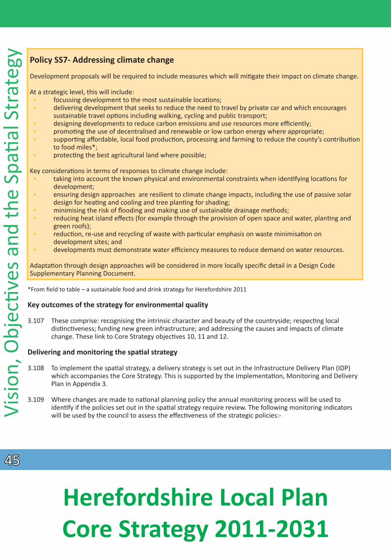
Visio
n, O
bjecƟv
es a
nd th
e Sp
aƟ a
l Str
ateg
y
Policy SS7- Addressing climate change
Development proposals will be required to include measures which will miƟgate their impact on climate change.
At a strategic level, this will include: • focussing development to the most sustainable locaƟons; • delivering development that seeks to reduce the need to travel by private car and which encourages
sustainable travel opƟons including walking, cycling and public transport; • designing developments to reduce carbon emissions and use resources more effi ciently; • promoƟng the use of decentralised and renewable or low carbon energy where appropriate; • supporƟ ng affordable, local food producƟon, processing and farming to reduce the county’s contribuƟon
to food miles*; • protecƟng the best agricultural land where possible;
Key consideraƟons in terms of responses to climate change include: • taking into account the known physical and environmental constraints when idenƟ fying locaƟ ons for
development; • ensuring design approaches are resilient to climate change impacts, including the use of passive solar
design for heaƟng and cooling and tree planƟng for shading; • minimising the risk of flooding and making use of sustainable drainage methods; • reducing heat island effects (for example through the provision of open space and water, planƟ ng and
green roofs); • reducƟon, re-use and recycling of waste with parƟcular emphasis on waste minimisaƟ on on
development sites; and • developments must demonstrate water efficiency measures to reduce demand on water resources.
AdaptaƟon through design approaches will be considered in more locally specific detail in a Design Code Supplementary Planning Document.
*From field to table – a sustainable food and drink strategy for Herefordshire 2011
Key outcomes of the strategy for environmental quality
3.107 These comprise: recognising the intrinsic character and beauty of the countryside; respecƟ ng local disƟncƟveness; funding new green infrastructure; and addressing the causes and impacts of climate change. These link to Core Strategy objecƟves 10, 11 and 12.
Delivering and monitoring the spaƟ al strategy
3.108 To implement the spaƟal strategy, a delivery strategy is set out in the Infrastructure Delivery Plan (IDP) which accompanies the Core Strategy. This is supported by the ImplementaƟon, Monitoring and Delivery Plan in Appendix 3.
3.109 Where changes are made to naƟonal planning policy the annual monitoring process will be used to idenƟfy if the policies set out in the spaƟal strategy require review. The following monitoring indicators
will be used by the council to assess the effecƟveness of the strategic policies:
4545
Herefordshire Local Plan Core Strategy 2011-2031
Social
• housing compleƟons by size, type and tenure and locaƟon – assessed in relaƟon to 5 year periods in order to ensure that there remains a flexible supply of available and deliverable land for housing across the county;
• transport patronage by mode; • housing densiƟes in urban and rural areas.
Economic
• employment land floor space by type and locaƟon; • number of live-work units granted permission; • accessibility to Broadband; • number of new jobs created; • employment and income levels in relaƟon to regional and naƟ onal averages; • business survival rate at 3 years; • GVA per head.
Environmental
• the percentage of all new development completed on previously developed land; • total CO2 emissions per capita (Department of Energy and Climate Change); • number of decentralised energy schemes granted permission.
Vision, ObjecƟves and the SpaƟ al Strategy
4646
Herefordshire Local Plan Core Strategy 2011-2031
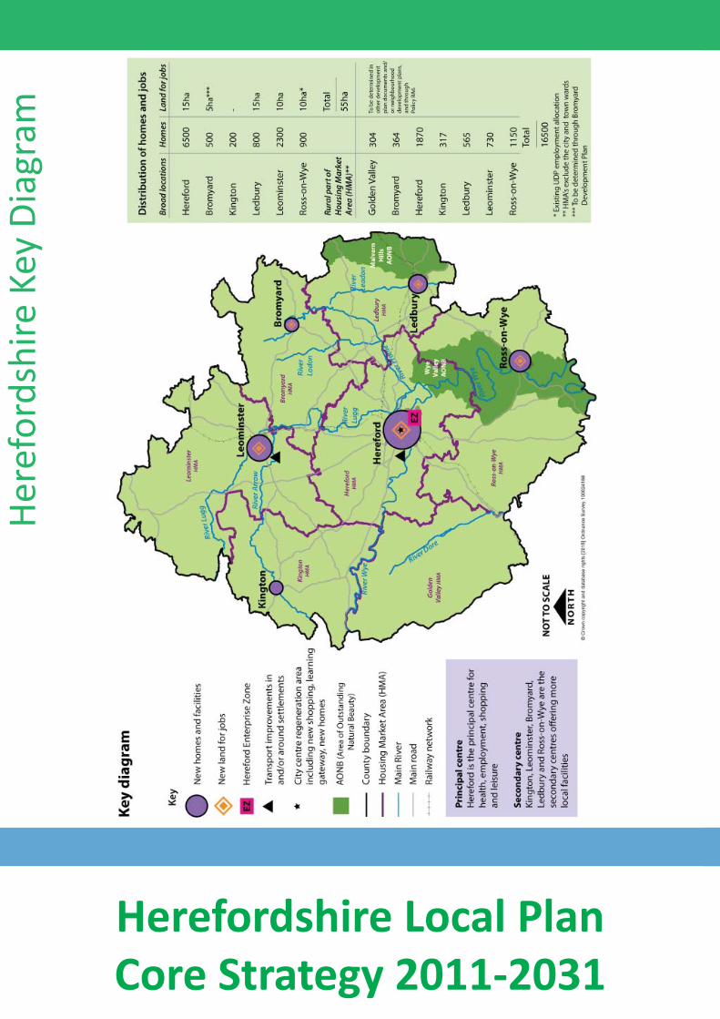
4747
Here
ford
shire
Key
Dia
gram
Herefordshire Local Plan Core Strategy 2011-2031
IntroducƟon
4.1 This secƟon sets out proposals for:
• Hereford • Bromyard • Kington • Ledbury• Leominster • Ross-on-Wye • Rural Areas
4.1.1 For each area policies and proposals are set out, including a range of broad locaƟons where larger scale or strategic development is proposed. The Core Strategy does not idenƟ fy specific development sites. For the purpose of the Core Strategy, a strategic locaƟon is generally defined as around 500 or above homes for Hereford, around 100 or above homes within the market towns or around 5 hectares or above for
employment land.
Hereford
The vision for Hereford
4.2.1 By 2031, Hereford will consist of healthy, safe, secure, low crime and sustainable communiƟes with a wide
Place Shaping - Hereford within walking distance of residenƟal areas. Developers will be encouraged to have early engagement and
range of homes and employment opportuniƟes for all, which are well serviced by a range of community faciliƟes, green infrastructure and public transport. The imbalance of housing types and income levels
across Hereford, parƟcularly within South Hereford, where there is a high concentraƟon of aff ordable housing and income deprivaƟon, will be addressed by providing a greater balance and mix of properƟes and employment opportuniƟes across the city and at the urban extensions.
4.2.2 New communiƟes and neighbourhoods will be successfully integrated with exisƟ ng communiƟes and the surrounding countryside. Residents will have greener environments and energy effi cient homes which contribute to reducing the county’s carbon footprint. EducaƟon and community faciliƟes will be provided
consultaƟon with the community including the city/town/parish council.
4.2.3 CongesƟon in Hereford will be eased by a number of measures. Newmarket Street, Blueschool Street and Commercial Square will be upgraded for pedestrians enabling a range of environmental enhancements, air quality improvements and sustainable transport measures to be implemented. The dependency on the private car will be reduced with a network of cycleways, footpaths and bus priority lanes to enable people within the city to move between home, work, school and other faciliƟes by foot, cycle and bus. A transport hub will enable bus, train, taxi faciliƟes to be linked. Park and Choose/cycle areas will be provided to reduce reliance on private cars to access the city centre. A Relief Road will be key element to
a congesƟon free city by enabling an alternaƟve trunk route, providing addiƟonal highway capacity to implement sustainable transport measures and reducing the level of through traffic in the city centre.
4.2.4 Hereford will be a strong sub-regional shopping, employment, educaƟonal, leisure and cultural focus for the county. Comprehensive proposals for regeneraƟon in and around the city centre will complement the historic core by providing homes, jobs, educaƟon, shops and leisure faciliƟes, urban greening and transport improvements. This will make the city a vibrant desƟnaƟon of choice for shoppers and visitors
alike.
4848
Herefordshire Local Plan Core Strategy 2011-2031
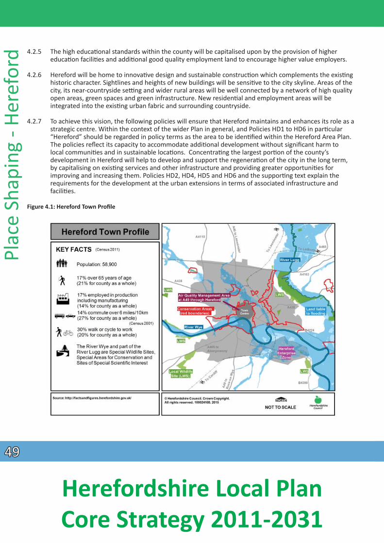
Plac
e Sh
apin
g - H
eref
ord 4.2.5 The high educaƟonal standards within the county will be capitalised upon by the provision of higher
educaƟ on faciliƟes and addiƟonal good quality employment land to encourage higher value employers.
4.2.6 Hereford will be home to innovaƟve design and sustainable construcƟon which complements the exisƟng historic character. Sightlines and heights of new buildings will be sensiƟve to the city skyline. Areas of the city, its near-countryside seƫng and wider rural areas will be well connected by a network of high quality open areas, green spaces and green infrastructure. New residenƟal and employment areas will be integrated into the exisƟng urban fabric and surrounding countryside.
4.2.7 To achieve this vision, the following policies will ensure that Hereford maintains and enhances its role as a strategic centre. Within the context of the wider Plan in general, and Policies HD1 to HD6 in parƟcular “Hereford” should be regarded in policy terms as the area to be idenƟfied within the Hereford Area Plan. The policies reflect its capacity to accommodate addiƟonal development without significant harm to
local communiƟes and in sustainable locaƟons. ConcentraƟng the largest porƟon of the county’s development in Hereford will help to develop and support the regeneraƟon of the city in the long term, by capitalising on exisƟng services and other infrastructure and providing greater opportuniƟ es for improving and increasing them. Policies HD2, HD4, HD5 and HD6 and the supporƟng text explain the requirements for the development at the urban extensions in terms of associated infrastructure and
faciliƟes.
Figure 4.1: Hereford Town Profile
4949
Herefordshire Local Plan Core Strategy 2011-2031
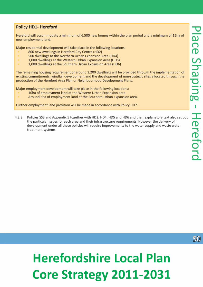
Policy HD1- Hereford
Hereford will accommodate a minimum of 6,500 new homes within the plan period and a minimum of 15ha of new employment land.
Major residenƟal development will take place in the following locaƟons: • 800 new dwellings in Hereford City Centre (HD2) • 500 dwellings at the Northern Urban Expansion Area (HD4) • 1,000 dwellings at the Western Urban Expansion Area (HD5) • 1,000 dwellings at the Southern Urban Expansion Area (HD6)
The remaining housing requirement of around 3,200 dwellings will be provided through the implementaƟ on of exisƟng commitments, windfall development and the development of non-strategic sites allocated through the producƟon of the Hereford Area Plan or Neighbourhood Development Plans.
Major employment development will take place in the following locaƟons: • 10ha of employment land at the Western Urban Expansion area • Around 5ha of employment land at the Southern Urban Expansion area.
Further employment land provision will be made in accordance with Policy HD7.
4.2.8 Policies SS3 and Appendix 5 together with HD2, HD4, HD5 and HD6 and their explanatory text also set out the parƟcular issues for each area and their infrastructure requirements. However the delivery of
development under all these policies will require improvements to the water supply and waste water treatment systems.
Place Shaping - Hereford
5050
Herefordshire Local Plan Core Strategy 2011-2031
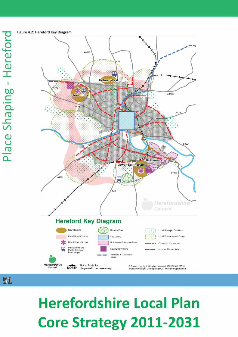
Figure 4.2: Hereford Key Diagram
Plac
e Sh
apin
g - H
eref
ord
5151
Herefordshire Local Plan Core Strategy 2011-2031
4.2.9 Non-strategic policies and proposals will be contained within the Hereford Area Plan, Minerals and Waste Local Plan, master plans and addiƟonal supplementary guidance. These documents will include
consideraƟ on of:
• non-strategic housing and employment allocaƟons; • type and mix of energy efficient housing to be provided on non-strategic sites; • need for addiƟonal or improvements to exisƟng open space, play areas and sports and recreaƟon
faciliƟes following further evidence base studies currently being prepared; • the boundaries of the primary shopping areas and the primary and secondary frontages; • need for further non-strategic retail fl oorspace; • enhancement proposals for the historic core and heritage assets including archaeology; • conservaƟon and design to enhance the city centre and surrounding areas; • addiƟonal sustainable transport measures and car park management; • need for any renewable energy proposals; • need for addiƟonal waste management faciliƟes; • need for addiƟonal tourism faciliƟes and accommodaƟon in the city;• design and density policy by character area; • enhanced night Ɵ me economy; • health and well-being; • need for surface water management in Hereford; • need for a new police headquarters site and facility and for a new fi re staƟ on; and • non-strategic sport, leisure and recreaƟon policies and proposals.
Hereford city centre
4.2.10 Hereford city centre plays an important role in contribuƟng to the economic, cultural and social performance of the wider city and the county as a whole. It has a rich heritage which makes it an aƩ racƟ ve locaƟon for residents and visitors alike.
4.2.11 The strategic growth policy for Hereford’s central area has been influenced by the Hereford City Centre RegeneraƟon Strategy, which sets out a ten-year ambiƟon up to 2018 containing broad views and aspiraƟons for the successful future of the city. The successful and sustainable future of the city relies
Place Shaping - Hereford upon maximising its current strengths and realising opportuniƟes for the regeneraƟon and redevelopment of the city centre. The role of Hereford as the main business, service and focal point for the county will be maintained and enhanced through the expansion of its retail, commercial, leisure and residenƟal funcƟons.
4.2.12 Policy HD2 will strengthen Hereford’s role as a focus for the county and outlying areas. Hereford will become a stronger shopping, employment, leisure, educaƟon and cultural focus for the county. In addiƟon to new retail and leisure opportuniƟes, city expansion and regeneraƟon proposals will also provide new homes (including affordable ones) and tackle exisƟng movement and fl ooding constraints, improving the city for residents and visitors. Maintaining and enhancing the city’s historic heritage and environmental assets will be high priority issues, as will the sustainability of the new development for
exisƟng and future generaƟons.
4.2.13 The Core Strategy aims to improve Hereford’s status as a sub-regional shopping desƟnaƟ on by enhancing and improving exisƟ ng faciliƟes and integraƟng new development into the historic centre. The Eign Gate and Edgar Street regeneraƟon areas are the focus for achieving this aim, and these areas will be defined in detail in the HAP. Development in the Edgar Street regeneraƟon area will be developed in
5252
Herefordshire Local Plan Core Strategy 2011-2031
accordance with a masterplan to ensure the delivery of a high quality mixed use development. This will be informed by the exisƟng masterplan which sets out an overarching vision of how the area will be developed and along with the Infrastructure Delivery Plan idenƟfies the required supporƟng infrastructure to enable the successful delivery of the project.
Plac
e Sh
apin
g - H
eref
ord
Policy HD2 – Hereford city centre
The city centre will accommodate around 800 new homes, the majority to be located within a new urban village. Further residenƟal development will take place through the implementaƟon of exisƟ ng commitments, re-development of exisƟ ng brownfield sites, re-use of upper floors above commercial premises, infill development and site allocaƟons through the Hereford Area Plan. A target of 35% of these new homes will be mixed tenure affordable with a density that is compaƟble with the sustainable urban locaƟon of the site.
The urban village will be served by safe and aƩ racƟve pedestrian and cycle links to other areas of the city, the new transport interchange, the Courtyard Arts Centre and nearby areas of green space. A new Link Road will also serve development parcels forming part of the urban village connecƟng Edgar Street to the west and Commercial Road to the east (with a spur linking Blackfriars Street to the south), as well as assisƟng in reducing traffic within the core of the city.
Newmarket Street, Blueschool Street and Commercial Square will be re-designed to become safe and aƩ racƟve routes for pedestrians and cyclists, with improved public transport faciliƟes and enhanced connecƟ vity between the historic city centre and regeneraƟon area partly facilitated by the construcƟon of the new link road.
The urban village will be complemented by other uses and infrastructure forming part of the wider regeneraƟon area creaƟng a sustainable mixed use development which respects and where possible enhances the historic environment. These include the following:
• land and contribuƟons towards a canal basin forming the terminus of the Herefordshire & Gloucestershire Canal, which is being delivered by the Hereford & Gloucester Canal Trust;
• each stage of development which adjoins Widemarsh Brook will maximise opportuniƟes for enhanced biodiversity, to provide flood relief and sustainable surface water drainage soluƟons and opƟ mised as a green infrastructure link;
• Herefordshire Council in partnership with public transport operators will deliver an integrated transport interchange close to the railway staƟon to maximise opportuniƟes for sustainable travel;
• opportuniƟes for new commercial, tourism, educaƟon (including terƟ ary faciliƟes), leisure, health, civic and police and fire uses will be available to meet any idenƟfi ed need;
• Herefordshire Council will work with the tenant(s) of Edgar Street football stadium to explore opportuniƟes for a sports led mixed-use redevelopment and
• new public car parking faciliƟes.
In order to maintain and enhance the viability and vitality of the city centre, new retail uses will be focused to the core of the city centre as defined below. Any idenƟfied need for further major retail development over the plan period will be met within the Eign Gate and that part of the Edgar Street regeneraƟon area which lies within the defined town centre, including the Old Market, along Blueschool Street and through the refurbishment and re-development of the BuƩ ermarket.
5353
Herefordshire Local Plan Core Strategy 2011-2031
Policy HD2 – Hereford city centre conƟnued
Within Hereford city centre, new developments including changes of use will be approved where they:
• provide new commercial and office space in appropriate city centre locaƟons including above exisƟng retail and commercial premises;
• maintain and enhance the vitality and viability of the city centre. Proposals for town centre uses outside the defined town centre will be subject to the sequenƟal test and applicaƟons for development over
700m2 gross floor space will require an impact assessment to determine whether there could be any adverse impacts on the town centre;
• improve overall accessibility by walking, cycling and public transport; • provide new, or enhanced sport, recreaƟon and leisure faciliƟes for local residents and visitors; • provide new and improve exisƟng cultural and tourism aƩ racƟons and faciliƟes, which respect the city’s
historic character and local disƟncƟ veness; • enable the provision of a canal basin with associated wharfage and visitor centre; • enable the protecƟ on, conservaƟon and enhancement of Hereford’s heritage assets, their signifi cance
and seƫng, including archaeology, with parƟcular regard to the historic street paƩerns and the skyline.
New homes
4.2.14 Policy HD2 promotes living in the city centre. This has many advantages, including good accessibility levels for residents to a range of services and faciliƟes, encourages walking and cycling and makes best use of
exisƟ ng properƟes by using vacant and underused spaces above shops and offices. This approach will contribute to the vitality of the city centre as its role is broadened from mainly dayƟme shopping and business uses to create an inclusive ‘evening’ economy beyond normal working hours. This will make it a
more aƩ racƟve place to live, as well as boost the local economy.
4.2.15 The development of the urban village will provide the majority of the 800 new homes in the city centre. These will comprise a mixture of apartments and family housing at a minimum average density of 50 dwellings per hectare. 35% of these homes will be affordable, with different types of tenures available,
to saƟ sfy idenƟfied local needs. Housing will be delivered that meets the needs of all secƟons of the community, including housing for older persons – a need highlighted in the study of the Housing and Support Needs of Older People in Herefordshire 2012. All homes will be constructed to high energy efficiency standards in accordance with other policies in this plan.
4.2.16 The urban village will require associated infrastructure in order to address flooding issues. A key element of this will be the producƟon of an integrated surface water management strategy. This should inform the design and layout of development and help deliver sustainable drainage and flood risk reducƟon measures taking into account the development of the other strategic sites in Hereford. Access and traffic constraints will also need to be addressed. The need for good pedestrian and cycle links to other parts of the city, including the railway staƟon and retail and leisure areas, is vital to a successful urban village
development.
4.2.17
Place Shaping - Hereford
The residents of all new homes will have access to public open space and, where possible, there should be green corridors to link the site to other green areas. OpportuniƟes exist to make an aƩ racƟve feature of the canal basin and its corridor within the new residenƟ al area.
5454
Herefordshire Local Plan Core Strategy 2011-2031
Plac
e Sh
apin
g - H
eref
ord New jobs
4.2.18 The Employment Land Study Update (2012) confirms the role of Hereford city as the main business centre for the county and idenƟfies the need to promote small-scale sustainable employment opportuniƟes in and on the edge of the Hereford city area. It also recommends that opportuniƟes for new office development in the city centre should be enhanced.
4.2.19 The development of new commercial and office faciliƟes will take place within the city centre as part of the regeneraƟon scheme. This approach is also supported by the Employment Land Study Update (2012), which concludes that the regeneraƟon as a whole will create a beƩer environment for exisƟng businesses and raise the rates of company formaƟon.
4.2.20 Proposals for office uses outside the city centre will be subject to the sequenƟal approach, as outlined in policy E5. Proposals for offices which have a gross floor space of 700m2 or over outside the city centre will be required to provide an impact assessment which meets the requirements of the NaƟonal Planning Policy Framework and policy E5.
Movement
4.2.21 The regeneraƟon in the north of the city centre will be enabled by the construcƟon of a new link road which will connect Edgar Street, Widemarsh Street and Commercial Road. This new road will create safe access through Edgar Street regeneraƟon area; unlocking development plots, whilst also significantly reducing the large volumes of traffic on the inner ring road. This will improve pedestrian links between the historic city core and the old livestock market area and accessibility within and across the northern secƟon of the Edgar Street regeneraƟon area.
4.2.22 Newmarket Street, Blueschool Street and Commercial Square will be upgraded for pedestrians and cyclists in order to create a safer and more visually aƩracƟve environment. An integrated public transport interchange will be provided in the vicinity of the railway staƟon, which will become a central point for access to all modes of transport, providing transfer opportuniƟes for trains, buses, taxis, private and hire cars, mobility vehicles, cyclists and pedestrians.
4.2.23 The Local Transport Plan aims to support growth of the city by improving traffic management and promoƟng walking and cycling for the majority of trips. The strategy idenƟfies a number of strategic and non-strategic transport measures and smarter travel iniƟaƟves to encourage modal shiŌs from private cars to public transport, walking and cycling.
Green infrastructure and open space
4.2.24 The city has a number of natural heritage assets with the River Wye flowing through it with its associated landscape, biodiversity, recreaƟon and tourism benefits. The River Wye is a designated Special Area of ConservaƟon and Site of Special ScienƟfic Interest. Development proposals must meet the requirements of Policy SD4, which will ensure that the achievement of water quality targets for the county’s rivers will be met. This is a key environmental objecƟve of the Core Strategy. The wider river corridor provides a special seƫng for the city and brings opportuniƟes for open space and green infrastructure. Its disƟncƟveness helps to provide an aƩracƟve locaƟon to live and work, which needs to be protected and enhanced. New development should respect this natural heritage. The importance of managed green spaces as a posiƟve element in city living is recognised, with these assets providing opportuniƟes for recreaƟon, leisure and tourism. These natural and managed assets make an important contribuƟon to the
5555
Herefordshire Local Plan Core Strategy 2011-2031
green infrastructure of the city centre and wider area and should be protected and enhanced. OpportuniƟes for new and enhanced green infrastructure within the city; parƟcularly associated with the River Wye corridor and the Edgar Street regeneraƟon area, should form part of any new proposals.
4.2.25 The Green Infrastructure Strategy 2010 idenƟfies an enhancement zone in the city centre at the confluence of a number of strategic green infrastructure corridors and includes the Edgar Street regeneraƟon area. The strategy highlights a number of important biodiversity features, including the
Widemarsh Brook, the ‘Police Meadow’ and the railway corridor, where there will be numerous opportuniƟes to enhance, as well as create addiƟonal green infrastructure, as part of the redevelopment of this area.
EducaƟ on faciliƟes
4.2.26 ContribuƟons and/or community infrastructure levy monies will be sought from new development for the enhancement of primary and secondary educaƟ on faciliƟes to accommodate increased demand from new residents. The city centre will play a role in providing greater access to higher educaƟon. At the Ɵme
of adopƟon there is an ambiƟon to create a University in Hereford, the principal of which is fully supported by Policy SC1.
Heritage
4.2.27 Hereford’s heritage must be viewed as a valuable asset as the city expands and changes. Development proposals will be expected to demonstrate how heritage assets, their significance and seƫ ng, will be protected, conserved and where appropriate enhanced. Hereford is fortunate to have a wealth of historic buildings, archaeological remains, historic streetscapes, such as Widemarsh Street and St Owens Street and open spaces, which provide valuable seƫngs for historic buildings, for example; at the Cathedral Close and the plots of the adjoining Canons’ houses. Within Hereford there is the naƟ onally designated Hereford Area of Archaeological Importance (AAI). AddiƟ onally, opportuniƟes exist to enhance the seƫng
of exisƟng heritage assets including the City Wall and Blackfriars Friary/Coningsby Hospital site. Public realm works to Newmarket Street and Blueschool Street will also provide the opportunity to improve the seƫng of the City Wall, an important historic asset.
4.2.28 In addiƟon to central and local government guidance on the protecƟon of heritage assets, there are a number of background studies undertaken to form part of the evidence base for the Core Strategy. The findings and recommendaƟons of these studies must be referred to as part of any masterplanning of new proposals in the city and they will be central to the appropriate future development of Hereford. These include the following:
• Hereford Rapid Townscape Assessment 2010: which idenƟfies areas of local interest, sites for potenƟal development and enhancement and factors that contribute to the loss of character
• Hereford Urban Archaeology Strategy comprising the Hereford Urban Archaeological Database, CharacterisaƟon of the Historic Townscape of Central Hereford 2010, the Research Framework (2012) and the Strategy itself (2013) – a form of historic landscape characterisaƟon, undertaken in an urban context, examining the townscape from an archaeological perspecƟ ve, and
• Hereford Town Centre: Streetscape Design Strategy 2009 guidance on the development, management and maintenance of new and exisƟ ng streets.
Place Shaping - Hereford
5656
Herefordshire Local Plan Core Strategy 2011-2031
Plac
e Sh
apin
g - H
eref
ord Retail
4.2.29 The Town Centres Study Update 2012 confirms Hereford as the principal shopping centre within the county. Although the report acknowledges that Hereford has been affected by the downturn in the economy along with many other town centres in the United Kingdom, it finds that the city centre shows signs of resilience and its outlook is good. The opening of the Old Market (2014) added to the exisƟng mix of naƟ onal mulƟples and independent traders and strengthens Hereford’s role as a principal centre, providing economic benefits and reducing unsustainable travel and retail expenditure leakage to other ciƟes such as Worcester, Cheltenham, Bristol and Cardiff.
4.2.30 The city centre of Hereford, referred to as ‘town centre’ for the purposes of Policy E5 includes primary and secondary frontages which will be defined by the Hereford Area Plan (HAP). Retail development will be concentrated in the town centre. ApplicaƟons for proposals which have a gross floor space of 700m2 or over, outside the defined centre, as defined by the HAP, will be required to provide an impact assessment which meets the requirements of the NaƟonal Planning Policy Framework and policies E5 and E6.
4.2.31 Following the opening of the ‘Old Market’ (2014) the findings of the Town Centres Study Update 2012, indicates that opportuniƟes remain for new retail development in the city centre, parƟcularly within the Eign Street regeneraƟon area. Therefore at the Ɵme of adopƟon there is no need to allocate addiƟonal development sites for retail or other uses within the city. However this situaƟon will be reassessed when the Hereford Area Plan is produced. The Hereford Area Plan will also provide an opportunity to reconsider the extent of the town centre and primary and secondary retail frontages.
Leisure and tourism
4.2.32 Tourism plays an important role in Hereford’s economy and it will be promoted through the planned mixed-use regeneraƟon of the city. OpportuniƟes to aƩract more tourists, who make an important contribuƟon to the local economy, will be supported where appropriate. The business tourism potenƟal
can be further developed through the promoƟon of new meeƟ ng/conferencing faciliƟes, which make beƩer use of exisƟng assets, such as the Courtyard Theatre for example. The Marches Hotel Study (2012)
idenƟfies capacity for new hotels as well as the potenƟal for the redevelopment and/or extension of exisƟng hotels. OpportuniƟes to promote tourism and recreaƟ on acƟviƟes on the River Wye in Hereford
will be encouraged where they are in accordance with policy E4 on Tourism.
4.2.33 OpportuniƟes will be facilitated through the Core Strategy and Hereford Area Plan for other leisure and tourism uses within the extended city centre.
4.2.34 Any proposals for leisure uses outside the town centre, having a gross floor space of 700m2 or over, will be subject to the sequenƟal test and be required to provide an impact assessment which meets the requirements of the NaƟonal Planning Policy Framework and policy E5.
5757
Herefordshire Local Plan Core Strategy 2011-2031

Figure 4.3 – Hereford City Centre
Place Shaping - Hereford
Surface water management and flooding
4.2.35 A proporƟon of the Edgar Street regeneraƟon area lies within Flood Zone 3. The Yazor Brook flood alleviaƟon scheme has now been completed, which provides some flood relief to the Edgar Street
regeneraƟon area and outlying areas. Secondary measures are required to ensure that any development in this area is safe and will not increase flood risk to third parƟes. Further measures will also be implemented within the city that will improve surface water drainage and any residual fl ooding impacts. This may include opportuniƟes in other parts of the city to aƩ enuate flood flows from exisƟng watercourses. Developers will also be required to provide surface water management plans to ensure sustainable surface water drainage soluƟons are adopted and risk of flooding is minimized as well as a detailed Flood Risk Assessment to ensure flood risk improvement. The restoraƟon of the canal may also
5858
Herefordshire Local Plan Core Strategy 2011-2031
Plac
e Sh
apin
g - H
eref
ord provide an opportunity to miƟ gate flood risk in the longer term. In flood risk terms, sequenƟ ally, the
Edgar Street regeneraƟon area is considered acceptable for redevelopment proposals, including residenƟal development described in policy HD2. Issues of low flows in the Yazor and Widemarsh Brooks
also require consideraƟon. Regard will also be had to the impact of development on the water quality issues in relaƟon to the River Wye SAC in accordance with policy SD4.
Movement
4.2.36 FacilitaƟng access and maximising connecƟvity within the city by all transport modes is essenƟ al to reduce congesƟon, support future prosperity and enable growth within Hereford. The Core Strategy is
complemented and supported by the Local Transport Plan within the city on the basis of a transport strategy for Hereford.
4.2.37 Transport modelling undertaken to understand the extent of exisƟ ng traffic issues and how the city’s growth can be supported in the long-term has indicated that new highway infrastructure supported by a “package of sustainable transport improvements” are required. Sustainable transport measures on their own, without new highway infrastructure will not accommodate the addiƟonal travel demand derived from the planned growth in the Core Strategy.
4.2.38 The convergence of the county’s highway network in Hereford means that the city’s roads must accommodate both long distance and local traffic. The city network has only one main river crossing which, combined with the levels of local through traffic, results in increasingly prolonged periods of
congesƟon. As a result, the A49 between Asda and Newtown roundabouts, the inner ring road and much of Whitecross Road have been declared an Air Quality Management Area (AQMA).
4.2.39 The scale of future development proposed for Hereford and the county will place further demand on the city’s constrained highway network infrastructure resulƟng in increased periods of congesƟ on and
consequenƟally greater environmental problems, unless the demand for short distance car journeys can be reduced by encouraging more people to walk, cycle or use public transport within Hereford.
Policy HD3 - Hereford movement
Herefordshire Council will:
• improve Hereford’s economy by increasing connecƟvity to the naƟonal and local transport networks by reducing congesƟon and improving journey Ɵme; • improve health, wellbeing and the environment by improving air quality and reducing noise through
maximising opportuniƟes for the use of sustainable transport modes, parƟcularly for short distance journeys.
Herefordshire Council will use a variety of funding mechanisms to deliver the following:
• packages of transport improvements focussing on key routes into the city delivering a range of public realm improvements and improving access and connecƟvity for sustainable mode users;
• behavioural change campaigns which will complement infrastructure delivery to encourage sustainable mode use and healthy lifestyles;
5959
Herefordshire Local Plan Core Strategy 2011-2031
Policy HD3 - Hereford movement conƟnued
• reduced reliance on car use by incorporaƟng sustainable mode routes within new developments and connecƟng them with exisƟ ng networks;
• improvements to public transport infrastructure enabling improved access and integraƟon between bus and to rail services;
• convenient, safe and secure car parking faciliƟes which aƩract shoppers and visitors and deter commuter parking in the city centre, through the development of Park and Choose sites; and
• a Relief Road to the west of Hereford to reduce the volume of traffic from the city centre and enable the delivery of walking, cycling and bus improvements on the exisƟng highway network. The road will be designed and developed in such a way which avoids and miƟgates adverse impacts or physical damage to or loss of habitats, noise polluƟon and vibraƟon, light polluƟon, air polluƟon, flood risk and water quality on the River Wye SAC, as well as residenƟal amenity and business interests. ConsideraƟon of the impact of the road on heritage assets, their significance and seƫng, as well as the historic character of the wider landscape will also be required. Further assessments will be undertaken as part of the Hereford Area Plan and subsequent planning applicaƟon(s).
The pace of delivery of transport and movement infrastructure will be aligned with that of housing provision in accordance with policy SS3.
4.2.40 The Hereford Transport Strategy includes a programme of infrastructure and services to facilitate growth proposals including:
• real Ɵ me informaƟon on core bus network and stop upgrades; • acƟve travel network; • extension of DesƟnaƟon Hereford project; • Hereford transport hub; • city centre refurbishments; • bus priority measures; • rail track and signal improvements between Hereford and Malvern; and • faciliƟes to support electric and low carbon vehicles.
ParƟcular transport infrastructure necessary to bring forward the Core Strategy proposals are detailed in the Infrastructure Delivery Plan.
4.2.41 A key element of the long-term Hereford transport strategy is the requirement for a Relief Road. This vital addiƟon to the city’s transport network will enable the reallocaƟon of exisƟng highway for bus prioriƟes and walking and cycling measures and the re-rouƟng of the exisƟng A49 Trunk Road (managed by the Highways England) removing longer distance traffic from the centre of the city.
4.2.42 The Hereford Relief Road – Study of OpƟons (Aug 2010) reviewed all route opƟons and assessed the impacts of the routes in relaƟon to environmental, engineering and traffic impacts. The inner western corridor is the preferred corridor for the Relief Road based on the study’s overall assessment.
4.2.43 The report indicates that the impact on biodiversity at the River Wye crossing can be largely miƟ gated through the use of wide span structures and avoidance of direct working in the watercourse.
Place Shaping - Hereford
6060
Herefordshire Local Plan Core Strategy 2011-2031
Plac
e Sh
apin
g - H
eref
ord 4.2.44 The fi rst secƟon of the Relief Road to be constructed will be the secƟon between the A49 and A465, as
part of the South Wye Transport Package (as idenƟfied in the Local Transport Plan). The second secƟon will link the A465 and the A4103 and include a bridge crossing of the Wye. This secƟon will be co-ordinated with the delivery of the Western Urban Expansion at Three Elms. The fi nal secƟ on would link the A4103 to the western and eastern sides of the A49 in the north of Hereford. Costs of the link secƟons are highlighted within the study.
4.2.45 Detailed alignment of the road will be shown in the Hereford Area Plan. Close working with key statutory stakeholders and any necessary assessments will be undertaken in preparing the HAP and subsequent
planning applicaƟon(s) to ensure the avoidance of impact on natural assets and appropriate idenƟficaƟon of miƟgaƟon measures, parƟcularly in relaƟon to impacts from physical damage/loss of habitat, noise
polluƟon and vibraƟon, light polluƟon, air polluƟon and water quality on the River Wye SAC. The design and exact locaƟon of the proposals will need to fully take account of flood risk to ensure no detriment to
third parƟes. Regard should also be had to any impact on Source ProtecƟon Zones. ConsideraƟon of the impacts on the historic environment will also be required with parƟcular regard being paid to any designated heritage assets, including their significance and seƫng, archaeological interest, and the historic character of the wider landscape.
4.2 46 In addiƟon, it will be essenƟal to work closely with the Highways Agency to ensure that all opportuniƟes are realised to re-route trunk road traffic to the new Relief Road. This will reduce the intrusion of commercial and longer distance traffic through the city centre, reduce exisƟng air quality problems and provide the council with greater control of the exisƟng city transport network.
Hereford urban expansion areas
4.2.47 Three expansion areas and associated infrastructure, services and faciliƟes are proposed. The broad locaƟon of these is shown in Figure 4.2: Hereford Key Diagram and the proposals are described in the following paragraphs.
Northern Urban Expansion (Holmer west)
4.2.48 A locaƟon to the north of the city has been idenƟfied as a strategic urban expansion area. This area is broadly located north of the A4103 and west of the A49 extending westwards towards the A4110 comprising predominantly of agricultural land.
4.2.49 Holmer West will be planned on a comprehensive basis. This will include variaƟons in layout, density and design to achieve a form and character to the development that respects the landscape sensiƟ vity, and
exisƟng natural and historic features of the area.
Policy HD4 – Northern Urban Expansion (Holmer West)
Land at Holmer West will deliver a comprehensively planned sustainable urban expansion. The new development will be sensiƟvely integrated into both the exisƟng urban fabric of Hereford, and the wider landscape, through high design and sustainability standards. The development will be expected to provide:
• 500 new homes, at an average density of up to 35 dwellings per hectare, comprising a mix of market and affordable house sizes and types that meet the requirements of policy H3 and the needs idenƟfied in the latest version of the Herefordshire Local Housing Market Assessment;
6161
Herefordshire Local Plan Core Strategy 2011-2031
Policy HD4 – Northern Urban Expansion (Holmer West) conƟnued
• a target of 35% of the total number of dwellings shall be aff ordable housing; • Park and Choose site (land and infrastructure) adjacent to the western side of the A49 in close proximity
to the Hereford Relief Road and land or a contribuƟon to facilitate the construcƟon of the adjoining phase of the Hereford Relief Road;
• walking and cycle routes and green infrastructure corridors linking to the Park and Choose site the exisƟng public right of way network and exisƟ ng educaƟon and community faciliƟes and employment
sites in the locality; • appropriate new green buffers and linear green routes, parƟcularly along Ayles Brook; • measures to miƟ gate flood risk both for the new homes within the expansion area and for the benefit
of exisƟng residents and businesses in other parts of the city through the incorporaƟon of sustainable urban drainage soluƟons, as part of the green infrastructure network and measures to control water levels within Ayles Brook;
• appropriate provision of and contribuƟons towards indoor and outdoor sports and play faciliƟ es, open space and allotments;
• where appropriate a contribuƟon towards pre-school facility and contribuƟons towards the enhancement of exisƟng primary and secondary school provision and any idenƟfied need for other
community infrastructure/faciliƟ es; and • sustainable standards of design and construcƟon.
This expansion area will be accessed primarily off the A4103 Roman Road. The area will be planned in a comprehensive manner to show the layout of development and the required infrastructure. Appendix 5 sets out the relaƟonship between the development of urban expansion areas and the provision of key new infrastructure.
New homes
4.2.50 This policy will deliver a minimum of 500 new homes will be provided within the Holmer west area. All will be built to high energy efficiency standards. A target of 35% will be affordable. Housing will be delivered that meets the needs of all secƟons of the community including housing for older persons – a need highlighted in the study of the Housing and Support needs of Older People in Herefordshire 2012. The design and styles of the new housing will complement the built and landscape character of the locality and the scale and density will be reflecƟve of the topography and prominence of the area. The development will need to be laid out and all homes and community buildings constructed to a high sustainability standard to ensure energy and water usage is minimised and sustainably sourced materials are used where pracƟcable. This will include the use of renewables and other low carbon energy sources.
Movement
4.2.51 The new area will be required to encourage sustainable modes of travel and discourage car use. It will be primarily accessed from Roman Road with the opƟon of a further access link to the northern Hereford Relief Road corridor and Park and Choose. The scheme will be reliant on walking and cycling routes and bus priority to access the city and exisƟng community faciliƟes.
4.2.52 A Park and Choose site is planned on part of the northern expansion area, alongside the A49, which will work in combinaƟon with the proposed western and southern Park and Choose faciliƟes. The design and siƟng of the Park and Choose should take into account any impact on the landscape.
Place Shaping - Hereford
6262
Herefordshire Local Plan Core Strategy 2011-2031
Plac
e Sh
apin
g - H
eref
ord Landscape and heritage
4.2.53 The landscape character assessment defines this broad locaƟon as being ‘principal seƩled farmland’. The expansion area is of a high to medium sensiƟvity on the higher northern porƟon of the land. However, as the land falls away southwards towards Ayles Brook, the landscape is less sensiƟve to change. Careful
consideraƟon must be given to the impact of the development on the landscape and vistas. Landscape characterisƟcs should be used to direct new development to the most appropriate areas, which is likely to
concentrate most built development to the lower, southern three quarters of the expansion area. The masterplan should idenƟfy measures which will successfully integrate the new development into the
landscape seƫ ng including opportuniƟes for enhancement to restore and reinforce the landscape character.
4.2.54 Listed buildings and a Scheduled Ancient Monument at St Bartholomew’s Church and Holmer House lie to the east of the expansion area. New development should be designed to ensure that the impacts on the significance and the seƫng of these heritage assets are minimised and that opportuniƟ es for enhancement are pursued and regard should be had to the Herefordshire Historic Land CharacterisaƟon project. There is potenƟal for significant buried archaeological remains to survive within this area as parts are of it are adjacent to the Roman Road and aerial photographs indicate the presence of former seƩlements here. Earthworks also indicate the presence of medieval seƩ lements.
Green infrastructure and biodiversity
4.2.55 The Green Infrastructure Strategy 2010 idenƟfies the expansion area as predominantly arable in use. It lies within a local enhancement zone (HerLEZ3) and incorporates strategic corridor HerLSC3. The strategy idenƟfies a number of opportuniƟes to enhance exisƟng green infrastructure, including establishing robust linear habitats along Ayles Brook, planƟng new hedgerows and tradiƟonal orchards and
appropriate planƟng to soŌen the transiƟon between seƩlement and open countryside. A network of green infrastructure will be required with linear green routes which can be used for biodiversity and
conservaƟon as well as sustainable transport routes, leisure and flood management. The expansion area’s natural characterisƟcs and features together with the area’s heritage assets should form the basis for new
green infrastructure and open space proposals. OpportuniƟes exist for the retenƟon and enhancement of field boundaries and other linear features, and for the maintenance and enhancements of connecƟvity
between habitats.
Community, recreaƟon and educaƟ on faciliƟes
4.2.56 Appropriate community faciliƟes will be provided within the area to support the idenƟfied need to support the new development. ContribuƟons will be sought where appropriate for primary and
secondary educaƟ on faciliƟes in order to accommodate children living in the expansion area. There will also be a need for contribuƟon towards expanded pre-school provision within exisƟng primary schools or the provision of a new pre-school facility as part of the expansion area.
4.2.57 The Open Space Study 2007 highlights there is an under provision in the north of the city of natural and semi-natural green space. The Play FaciliƟes Strategy 2012 idenƟfies provision north of the city as being ‘average’ with parƟcular gaps in the provision for older children. Therefore the development will be expected to incorporate acceptable levels of open space and play faciliƟes in accordance with Policies OS1 and OS2 and addiƟonal semi natural green space. Provision for community allotments will also be required to assist in meeƟng the shorƞall in provision across the city.
6363
Herefordshire Local Plan Core Strategy 2011-2031
Fluvial flooding, surface water management and drainage
4.2.58 The expansion area is within Flood Zone 1 which has a low probability risk of flooding, with the excepƟon of the southern eastern boundaries defined by the Ayles Brook which is idenƟfied as being in Flood Zone 3. Ayles Brook is an exisƟng source of flooding to properƟes, community faciliƟes and highway infrastructure south of the site. Therefore a detailed Flood Risk Assessment to model the Ayles Brook, to accurately ascertain the degree of flooding from this watercourse, will be required. This assessment will inform decisions regarding the developable area of the site and the required miƟgaƟon measures. Overall, the developer will be required to demonstrate that adequate measures, primarily through the
flood risk for exisƟng residents. The area suffers from low water pressure and therefore an upgrade to the mains water supply to serve the area may be required. Improvements in the capacity of the public foul drainage network in the locality will also be required to serve the new development.
Western Urban Expansion (Three Elms)
4.2.59 Land on the outskirts of Hereford, north west of the city centre, is idenƟfied as a locaƟon for a major mixed use urban expansion of the city. The area is broadly located between the A4103 to the north and A438 to the south, immediately west of Yazor Road extending westwards towards the new livestock market. The land is currently predominantly being used for agriculture and is of low/medium landscape sensiƟvity. Yazor Brook runs through the land and the brook corridor is designated a flood zone. The
exisƟ ng residenƟal areas of Three Elms and Kings Acre are adjacent and HunƟ ngton ConservaƟon Area is within the development area.
4.2.60 The expansion area referred to as Three Elms will be planned on a comprehensive basis, informed by a development brief and masterplan prepared through the Hereford Area Plan. This will include variaƟons in layout, density and design to achieve a form and character to the development that respects the
landscape sensiƟvity and exisƟng natural features of the area and the seƫ ng of HunƟ ngton ConservaƟon Area.
4.2.61 In planning for urban growth to the west of the city, it will be essenƟal that the development integrates both visually and physically with the remainder of the city and exisƟng neighbouring communiƟes.
Place Shaping - Hereford
development of sustainable urban drainage systems, are incorporated within the development to miƟ gate
Policy HD5 – Western Urban Expansion (Three Elms)
Land at Three Elms will deliver a comprehensively planned sustainable urban expansion. The new development will be sensiƟvely integrated into both the exisƟng urban fabric of Hereford, and the wider landscape, through high design and sustainability standards. The development will be expected to provide:
• a minimum of 1,000 homes, at an average density of up to 35 dwellings per hectare, comprising a mix of market and affordable house sizes and types that meet the requirements of policy H3 and the needs idenƟfied in the latest version of the Herefordshire Local Housing Market Assessment;
• a target of 35% of the total number of dwellings shall be aff ordable housing; • delivery of land and infrastructure to facilitate the construcƟon of the adjoining phase of the Hereford
Relief Road; • a minimum of 10 hectares of employment land, comprising predominantly of a mixture of use class B1,
B2 and B8 located near to the new livestock market with access to the Hereford Relief Road and Roman Road;
6464
Herefordshire Local Plan Core Strategy 2011-2031
Plac
e Sh
apin
g - H
eref
ord
Policy HD5 – Western Urban Expansion (Three Elms) conƟnued
• land and infrastructure for Park & Choose faciliƟes; • a new linear park along the Yazor Brook corridor connecƟng with the exisƟng green infrastructure links
east of the expansion area, the public rights of way network within and adjoining the expansion area and informal recreaƟ on space;
• a series of new green infrastructure connecƟons which enhance the biodiversity value of the area and also serve as pedestrian cycle links through the development, including opƟmising the use of the disused railway line to connect with the transport interchange, schools, community faciliƟes, employment land and the remainder of the city;
• provision for new bus links through the expansion area; • development of bespoke, high quality and inclusive design, including accommodaƟon that will meet the
needs of older persons and contributes to the disƟncƟveness of the site and surrounding environment; • the provision on site of appropriate sports and play faciliƟes, formal and informal open space,
community orchards, woodland planƟng and allotments; • integraƟon of HunƟngton village into the development area in a way which respects, protects,
conserves and, where possible, enhances the seƫng of the ConservaƟon Area and heritage assets; • 210 primary school places with addiƟonal pre-school accommodaƟon; • an extension of Whitecross High School to increase capacity from a 6 form entry to 7 form entry school,
with commensurate school playing fi eld provision; • a neighbourhood community hub to meet any idenƟfied need for small scale convenience retail,
community meeƟng space, health provision, indoor sports and other community infrastructure/faciliƟes where appropriate; • sustainable urban drainage and fl ood miƟgaƟ on soluƟons to form an integral part of the green
infrastructure network; • opportuniƟes to miƟ gate flood risk arising from Yazor Brook for exisƟng residents and businesses within
the city; and • sustainable standards of design and construcƟon.
The area will be planned in a comprehensive manner to show the layout of development and the required infrastructure. Appendix 5 sets out the relaƟonship between the development of urban expansion areas and the provision of key new infrastructure.
New homes
4.2.62 This policy will deliver a minimum of 1,000 new homes will be provided within the western expansion area. Around 35% of the total number of dwellings will be affordable housing to be distributed in small clusters across the development. Housing will be delivered that meets the needs of all secƟons of the community, including housing for older persons – a need highlighted in the study of the Housing and Support needs of Older People in Herefordshire 2012.
4.2.63 This expansion area will be developed in smaller clusters to create new neighbourhoods that dovetail in with exisƟ ng communiƟes adjoining the development area. It is anƟcipated that the residenƟ al element
of the new growth will be to the east of the Hereford Relief Road, adjacent to the exisƟng urban fabric.
New employment
4.2.64 The provision of addiƟonal 10 hectares of employment land will balance the exisƟng provision to the south of the city within the Hereford Enterprise Zone at Rotherwas and to the north at Moreton Business
6565
Herefordshire Local Plan Core Strategy 2011-2031
Park. Employment land should be provided close to the new livestock market, with potenƟal access on to the Hereford Relief Road and A4103 and pedestrian/cycle links to the development area and city beyond. This land is relaƟvely flat, will have good road frontage and is sufficiently large to offer opportuniƟes for large and small scale businesses, thus adding to the diversity of employment land opƟons around the city. The expansion area will also offer opportuniƟes for live work units.
Sustainable construcƟon and resources use
4.2.65 All homes, community and employment buildings will need to be constructed to a high sustainability standard to ensure energy and water usage is minimised and sustainably sourced materials are used where pracƟcable. This will include the use of renewables and other low carbon energy sources and the feasibility of combined heat and power systems will also be invesƟgated.
Movement
4.2.66 A package of transport measures in the area will assist in creaƟng a development which is less dependent on the private car whilst providing safe and convenient access to the local and future strategic road network (Hereford Relief Road). The new urban extension will be designed to inhibit traffic and facilitate more sustainable travel choices. Key to achieving this will be the creaƟon of new pedestrian and cycle links through the development area connecƟng with exisƟng links within the city and local community faciliƟes. Where necessary, the development will also be required to upgrade exisƟng links to make them more user friendly for pedestrians and cyclists. AddiƟonally, the provision of new, or enhancement of, exisƟng bus links to serve the new community will also be required, including the introducƟon of bus priority measures both within the development and on the exisƟng highway network.
4.2.67 Vehicular access opƟons will need to be informed by a traffic assessment but opportuniƟes exist to connect to Roman Road, Three Elms Road and Kings Acre Road as well as the new Relief Road.
4.2.68 The development will also include a Park and Choose site with ancillary faciliƟes such as secure cycle lock ups.
Green infrastructure
4.2.69 A network of green infrastructure is planned within the western expansion area. Green corridors which can be used for biodiversity and conservaƟon enhancement as well as leisure and sustainable transport routes will be required.
4.2.70 Linear green spaces will also be provided along exisƟng footpaths to link key features within the development, including the Park and Choose site, to exisƟng faciliƟes such as schools, employment and retail areas. The old railway and Yazor Brook linear green spaces should link to exisƟng footpaths and cycleways through Moor Park and into the city via Plough Lane. OpportuniƟes to link heritage assets as part of the green infrastructure network should also be explored.
Heritage
4.2.71 Within the expansion area, the development will need to respect and where possible enhance the seƫng of HunƟngton ConservaƟon Area and the rural character of HunƟngton Lane. Key aƩributes such as the built heritage within the conservaƟon area, the landscape seƫng of the village and the width, hedgerows and alignment of the lane will be safeguarded and enhanced whilst also ensuring the development fully assimilates with these features. The potenƟal for survival of significant buried archaeological remains
Place Shaping - Hereford
6666
Herefordshire Local Plan Core Strategy 2011-2031
Plac
e Sh
apin
g - H
eref
ord within the expansion area is high. The development will also be required to conserve and where possible
enhance other heritage assets. The historic linkages in this area should not be obscured and new development should maximise the potenƟal for vistas that take in the key landmark and historic feature of Credenhill Park Wood. Regard should be had to the historic landscape characterisaƟon project in
relaƟon to the design of the development.
Community hub and faciliƟes
4.2.72 A community hub would address the needs of the new homes and the exisƟng residents of Three Elms, Kings Acre, Bobblestock and Moor Park. This hub could provide a range of mulƟ-agency use faciliƟes, including a health centre, pre-school educaƟon, community rooms and local convenience retail. To serve as a hub, it will be situated near the new school, with safe direct pedestrian and cycle access to exisƟng
communiƟes.
New educaƟ on faciliƟes
4.2.73 210 primary school places will be required to meet the educaƟonal needs of the new populaƟon generated by the development.
4.2.74 Whitecross High school is the principal secondary school likely to serve the development. This school is currently at capacity and therefore the development will also deliver an extension of the school to create capacity for an addiƟonal form (150 pupils). This is most likely to entail building on the exisƟ ng school
playing fields and therefore new playing fields to serve the larger school will need to be provided adjoining the school.
Surface water management and fluvial flooding
4.2.75 The Yazor Brook corridor is designated as floodplain which also extends to a wider land area at the eastern end of the expansion area. The Water Cycle Study and the Strategic Flood Risk Assessment have highlighted that a strategy to address both the sustainable management of new surface water discharges from the urban extension and measures to miƟ gate against fluvial flood risk will be required. This is likely to encompass surface water aƩenuaƟon features which will be an integral part of the development and will provide opportuniƟes for biodiversity enhancement. A detailed fl ood risk assessment will be required to address these issues. Yazor Brook is also an exisƟng source of fl ooding to
properƟes, community faciliƟes and highway infrastructure east of the expansion area and the development will also need to include measures to assist in reducing this exisƟng flood risk, in accordance
with naƟonal policy and technical guidance on the management of flood risk. The area suffers from low water pressure and therefore an upgrade to the mains water supply to serve the area may be required.
4.2.76 With regard to the Whitecross High School expansion, flood management and miƟgaƟon will also be required. OpportuniƟes to uƟ lise exisƟng and new playing fi elds for fl ood beƩerment will be explored.
Minerals
4.2.77 The expansion area is subject to a safeguarding policy in respect of mineral reserves (sand and gravel). ApplicaƟons for development will be assessed in this respect using the saved UDP policy M5 unƟl this is
replaced by the Minerals and Waste Local Plan policy.
6767
Herefordshire Local Plan Core Strategy 2011-2031
Southern Urban Expansion (Lower Bullingham)
4.2.78 A strategic locaƟon to the south of the city at Lower Bullingham has been highlighted as an expansion area for urban growth. This locaƟon is to the east of Hoarwithy Road between the railway line and the Rotherwas Access Road.
4.2.79 The expansion area referred to as Lower Bullingham will be planned on a comprehensive basis, informed by a masterplan prepared through the Hereford Area Plan. This will include variaƟons in layout, density and design to achieve an organic form and character to the development that respects the landscape sensiƟvity and exisƟng natural features of the area.
Policy HD6 - Southern Urban Expansion (Lower Bullingham)
Land at Lower Bullingham will deliver a comprehensively planned sustainable urban expansion. The new development will be sensiƟvely integrated into both the exisƟng urban fabric of Hereford, and the wider landscape, through high design and sustainability standards. The development will be expected to provide:
• a minimum of 1,000 new homes, at an average density of up to 35 dwellings per hectare, comprising a mix of market and affordable house sizes and types that meet the requirements of policy H3 and the
needs idenƟfied in the latest version of the Herefordshire Local Housing Market Assessment; • a target of 35% of the total number of dwellings shall be aff ordable housing; • around 5 hectares of employment land comprising a mixture of use class B1, B2 and B8 to complement
Hereford Enterprise Zone; • suitable vehicular access to the site principally from the B4399; • Park and Choose site (land and infrastructure) adjacent to the A49/ Rotherwas Access Road
roundabout; • green infrastructure corridors through the area to include strategic greenways along Red Brook and
Norton Brook and links with Withy Brook; • creaƟon of a country park to incorporate new footpaths linking with the exisƟng public right of way
network in the locality, woodland and orchard planƟng; • development of bespoke, high quality and inclusive design, including accommodaƟon that will meet the
needs of older persons and contributes to the disƟncƟveness of the site and surrounding environment; • the provision on site of appropriate sports and play faciliƟes, open space, community orchards and
allotments; • 210 primary school places and where appropriate contribuƟons towards new addiƟ onal pre-school
faciliƟes; • a neighbourhood community hub, including small scale convenience retail and provision of and/or
contribuƟons towards any idenƟfied need for other community infrastructure/faciliƟ es, including community meeƟng space and health provision, indoor and outdoor sports, where appropriate; • sustainable urban drainage and fl ood miƟgaƟ on soluƟons to form an integral part of the green
infrastructure network; • new direct walking, cycling and bus links from the urban extension to the Park and Choose to the west,
Hereford Enterprise Zone to the east and exisƟ ng communiƟes and the city centre to the north; • sustainable standards of design and construcƟ on; and • the protecƟ on, conservaƟon and, where possible, enhancement of the heritage assets, their signifi cance
and seƫng. An evaluaƟon of the archaeological importance of the area should be provided to ensure appropriate protecƟon of heritage assets and inform the detailed development proposals.
Place Shaping - Hereford
6868
Herefordshire Local Plan Core Strategy 2011-2031
Plac
e Sh
apin
g - H
eref
ord Policy HD6 - Southern Urban Expansion (Lower Bullingham) conƟnued
The area will be planned in a comprehensive manner to show the layout of development and the required infrastructure. Appendix 5 sets out the relaƟonship between the development of urban expansion area and the provision of key new infrastructure.
New homes
4.2.80 This policy seeks to deliver a minimum of 1,000 new homes with a minimum of 35% of the total number of dwellings will be affordable housing, to be distributed in small clusters across the development. Housing will also be delivered that meets the needs of all secƟons of the community including housing for older persons – a need highlighted in the study of the Housing and Support needs of Older People in
Herefordshire 2012. The housing will be predominantly two storeys in height, reflecƟng the residenƟal character of the locality.
Sustainable construcƟon and resources use
4.2.81 All homes, community and employment buildings will need to be constructed to a high sustainability standard to ensure energy and water usage is minimised and sustainably sourced materials are used,
where pracƟcable. This will include; the use of renewables and other low carbon energy sources. The feasibility of combined heat and power systems will also be invesƟgated, possibly in combinaƟon with the Hereford Enterprise Zone at Rotherwas.
New employment
4.2.82 The Hereford Enterprise Zone (HEZ) lies adjacent the expansion area and will provide opportuniƟ es for local employment. Part of this designaƟon includes land within this urban extension. To assist with the delivery of future employment land on the HEZ, provision for around 5 hectares of employment land is included as part of the urban extension. This would largely relate to land west of Watery Lane and be linked to the new housing and the remainder of the employment area by new walking and cycling routes.
The composiƟon of employment uses will need to complement that to be provided on the remainder of the HEZ but the site offers the opportunity for sustainable small scale businesses with good access and road frontage.
Movement
4.2.83 The provision of new road infrastructure, along with a package of sustainable transport measures, is necessary for Hereford to deliver its full housing and economic growth. Sustainable transport measures are also required to assist in creaƟng a development which is less dependent on the private car. New growth areas will be designed to inhibit traffic and encourage more sustainable modes of travel and contribute to new and the enhancement of exisƟng highway and sustainable transport infrastructure.
4.2.84 It is expected that the principal vehicular access to the development is via Rotherwas Access Road and likely to take the form of a new roundabout. Access to the north into the city and to the employment to the east will be restricted to and/or prioriƟsed for buses, walking and cycling.
4.2.85 New cycle ways and footpaths will need to link the development to the exisƟng and new employment areas, community faciliƟes, local schools and the city centre. This will include a new link to the Connect
6969
Herefordshire Local Plan Core Strategy 2011-2031
2 Greenway cycle route. CollecƟvely, this will provide residents with safe and pleasant routes to walk and cycle. Key to the transportaƟon strategy will also be the expansion of the exisƟng bus network into the site to further encourage sustainable travel choices.
4.2.86 As part of the development, a southern Park and Choose site is required in the vicinity of the A49 / Rotherwas Access Road roundabout to complement those proposed north and west of the city aside other expansion locaƟons. Provision will also need to be included for a small parking area to serve the country park. The design and siƟng of the Park and Choose should take into account any impact on the
landscape.
Landscape and green infrastructure
4.2.87 The Urban Fringe SensiƟ vity Analysis highlights the southern secƟon of the site is of higher landscape sensiƟvity and is vulnerable to change, forming part of rising land to Dinedor Hill. This will require careful design in any masterplan. The protecƟon of the seƫng of the Iron Age hill fort, Dinedor Camp, and the ridge extending eastwards into Rotherwas Park requires careful consideraƟon as part of the master planning process. The expansion area is however, largely contained to the south by the Rotherwas Access Road, which effecƟvely forms a visual barrier to the more sensiƟve landscape beyond.
4.2.88 The expansion area will need to be designed to incorporate a network of green infrastructure. This will serve as biodiversity and landscape enhancement corridors as well as sustainable transport routes. The Green Infrastructure Strategy has highlighted a strategic corridor along Red Brook, Norton Brook and Withy Brook as an enhancement zone. OpportuniƟes for enhancement include reinforcing the biodiversity value of the linear features including the railway and water corridors and establishing
landscape buffer areas. Further green infrastructure will need to be provided to safely connect the new homes to the country park proposed as part of the urban extension and other community faciliƟes in the
locality. OpportuniƟes to link heritage assets as part of the green infrastructure network should also be explored.
4.2.89 The exisƟng rural nature of Watery Lane and Lower Bullingham Lane should be protected and will provide new opportuniƟes for sustainable transport links to connect to wider footpaths to Dinedor Hill, the
historic Hill Fort, Rotherwas Park and beyond.
Heritage
4.2.90 Recent fi eld invesƟgaƟons in the locality have revealed a number of archaeological finds of signifi cance, including the Bronze Age feature known as the Rotherwas Ribbon. Further archaeological fi eld evaluaƟon will be required to inform the masterplan for the expansion area and it may be appropriate to include this area as part of a green corridor. Any statutory designaƟ on afforded to this site will influence the master
planning process.
Community, recreaƟon and educaƟ on faciliƟes
4.2.91 Local communiƟes will be more sustainable if they have access to necessary local services and faciliƟes that meet their needs. A community hub is required to address the needs of the new homes and adjacent
Place Shaping - Hereford
neighbourhoods in the south Hereford area. This hub will provide a range of faciliƟes including community rooms for public and mulƟ-agency use, local convenience retail, health care and pre-school educaƟon.
7070
Herefordshire Local Plan Core Strategy 2011-2031
Plac
e Sh
apin
g - H
eref
ord 4.2.92 The development will require the provision of a new 210 place primary school within the urban extension
along with sustainable travel links to the secondary school in the locality to meet the educaƟ onal needs of the increased populaƟon generated by the development.
4.2.93 Land to the west of the urban extension will be required to deliver a new country park. This will comprise of an area of land to be transferred to Herefordshire Council containing a series of informal paths connected to the exisƟng public right of way network and the Park and Choose site beyond. The country park will include measures to restore degraded landscape to include new tree planƟng and biodiversity enhancement along Norton Brook which is also idenƟfied as a strategic green infrastructure corridor
connecƟng with Withy Brook and the enhancement of the seƫng of Bullinghope village.
4.2 94 Open space, play and sport faciliƟes will need to be provided on site in accordance with the requirements of policy OS1 informed by the Play FaciliƟes Strategy, Playing Pitch Strategy, Sports FaciliƟ es Framework and Open Space Study.
Surface water management and fluvial flooding
4.2.95 The northern part of the urban extension adjacent the railway line and along the brook corridor is designated as Flood Zone 3. The site is also bisected by a number of smaller watercourses such as the Withy and Red Brooks. The impact of the development on these will also need to be assessed as part of the Flood Risk Assessment. The Water Cycle Study and the Strategic Flood Risk Assessment have highlighted that a strategy to address both the sustainable management of new surface water discharges from the urban extension and measures to miƟ gate against fluvial flood risk will be required. This is likely to encompass surface water aƩenuaƟon features, which will be an integral part of the development and will provide opportuniƟes for biodiversity enhancement.
Hereford Employment Provision
Policy HD7 – Hereford Employment Provision
Hereford will conƟnue to provide focus for employment provision in the county. Employment supply at Hereford will be delivered through:
• the expansion of the city centre as part of wider city regeneraƟon which will include commercial uses including new office provision and creaƟng a beƩer environment for exisƟng businesses. Proposals for office uses outside of the city centre will be subject to the sequenƟal test, as set out in paragraph 24 of
the NPPF; • conƟnuing development of employment land at Hereford Enterprise Zone at Rotherwas to strengthen
the enterprise zone, with parƟcular focus on defence and knowledge sectors, creaƟng added benefi t for companies who locate in the area;
• encouraging small scale environmental and knowledge based employment development opportuniƟes; and
• provision of new areas of employment land parƟcularly through the development of strategic urban extensions.
4.2.96 Hereford provides a significant focus for employment provision in the county. Proposals such as city centre regeneraƟon and the development of employment sites as elements of strategic urban extensions
will provide new opportuniƟes for job creaƟon during the plan period. In addiƟon to new areas of
7171
Herefordshire Local Plan Core Strategy 2011-2031
employment land the protecƟon and conƟnued development of exisƟng employment land will also be an important contributor to the economic prosperity of Hereford. The following areas provide important elements of the porƞolio of employment land in and close to the city.
Hereford Enterprise Zone (HEZ)
4.2.97 The Rotherwas industrial estate is located south-east of Hereford and is over 120 hectares in size and has over 125 companies operaƟng within it. As part of meeƟng the employment needs and the development of the economy in Herefordshire, the Rotherwas industrial estate was awarded Enterprise Zone status in 2011. The site has a range of classes of employment land and buildings ranging from ‘best’, ‘good’ and ‘moderate’ in the Employment Land Study 2012 and a number of specific sites within the estate, which are allocated in the Enterprise Zone Masterplan as sites for new B1, B2 and B8 development.
4.2.98 The HEZ was originally nominated by the Marches Local Enterprise Partnership, anƟcipaƟng that the scheme will become a catalyst for enhanced economic growth throughout the Marches through the
creaƟon of highly skilled jobs and encouragement of overseas investment into the area. The aspiraƟ on of the HEZ Board is to develop part of the site into a centre of excellence for the defence and security sector,
with addiƟonal employment hubs focused on advanced technologies, environmental technologies and food and drink technologies.
Wesƞields trading estate
4.2.99 The Wesƞields trading estate is a 25 hectare site located in the northern region of Hereford. The enƟre site is rated as ‘good’ in the Employment Land Study 2012 and contains a number of different sized units, although it would benefit from new investment in employment buildings with many older units being present. This site contains a small amount of development opportuniƟes, as well as redevelopment opportuniƟes.
Three Elms trading estate
4.2.100 Three Elms trading estate is located north of Hereford and occupies 3 hectares of land, which has shown good employment land take-up, with few vacant sites. The trading estate is designated as ‘good’ in the Employment Land Study 2012 and there is the opportunity to expand the estate by an addiƟonal 10ha as part of further housing development to the north of Hereford. The addiƟonal 10ha of employment land is likely to cater for a range of different sizes of B1, B2 and B8 employment uses.
Holmer Road
4.2.101 The industrial precinct on Holmer Road is located to the north of Hereford and is approximately 16 hectares in size and contains a number of larger, as well as smaller, employment units. The site is designated as ‘moderate’ in the Employment Land Study 2012 and contains land available for further B1, B2 and B8 employment development.
Moreton Business Park
4.2.102 Although this business park is located 7km north of Hereford, it is one of the county’s largest employment sites and is sufficiently close to Hereford to assist in meeƟng the current and future employment needs. This site presently comprises 60,000m² of predominantly B1 and B8 floorspace, a planning permission has
Place Shaping - Hereford
been granted for around a further 51,000 m² of mixed B1, B2 and B8 floorspace, totalling an addiƟ onal 21 hectares.
7272
Herefordshire Local Plan Core Strategy 2011-2031
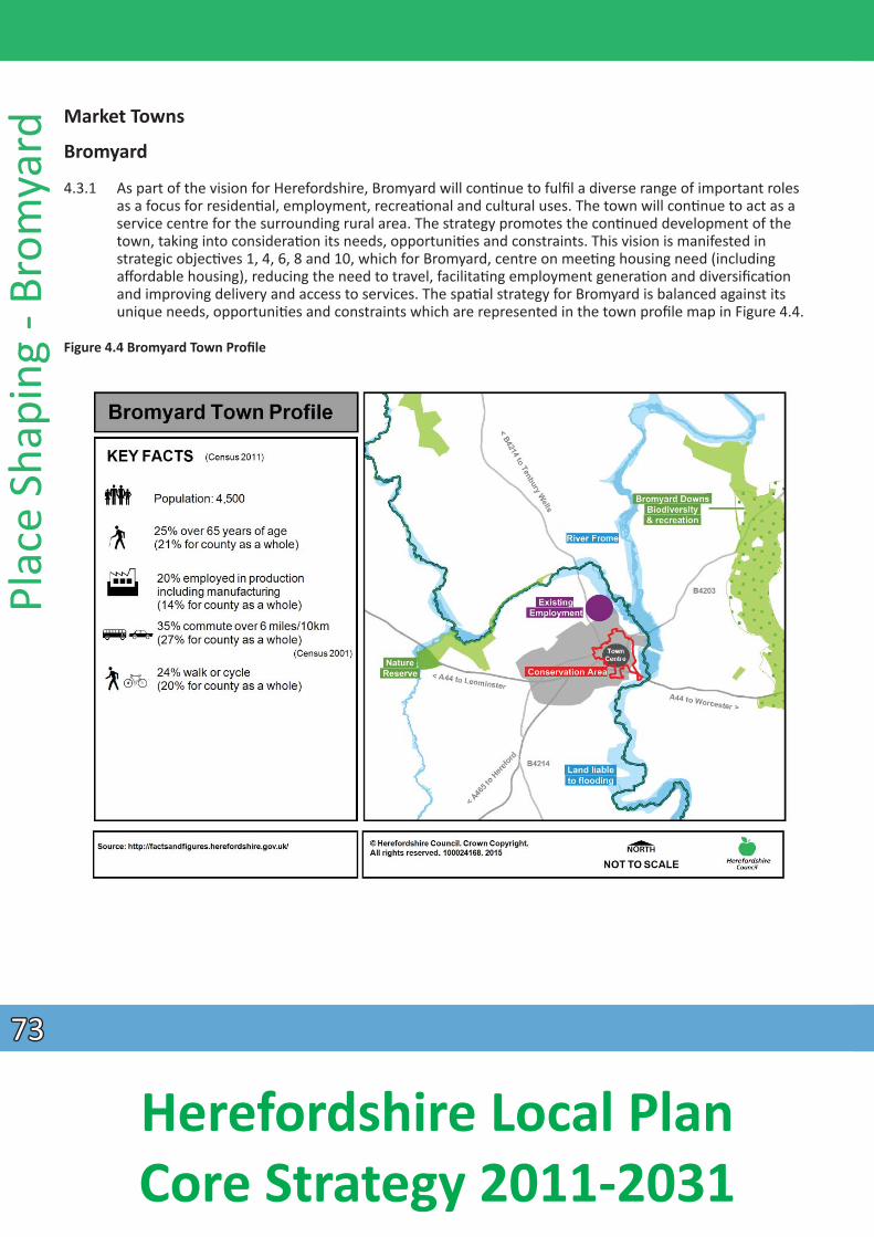
Plac
e Sh
apin
g - B
rom
yard
Market Towns
Bromyard
4.3.1 As part of the vision for Herefordshire, Bromyard will conƟnue to fulfil a diverse range of important roles as a focus for residenƟal, employment, recreaƟonal and cultural uses. The town will conƟnue to act as a service centre for the surrounding rural area. The strategy promotes the conƟnued development of the town, taking into consideraƟon its needs, opportuniƟes and constraints. This vision is manifested in
strategic objecƟves 1, 4, 6, 8 and 10, which for Bromyard, centre on meeƟng housing need (including affordable housing), reducing the need to travel, facilitaƟng employment generaƟon and diversificaƟon and improving delivery and access to services. The spaƟal strategy for Bromyard is balanced against its unique needs, opportuniƟes and constraints which are represented in the town profile map in Figure 4.4.
Figure 4.4 Bromyard Town Profile
7373
Herefordshire Local Plan Core Strategy 2011-2031
Background to policies
4.3.2 To achieve the vision for Bromyard, a strategic urban extension for residenƟal development is proposed in the north west area of the town. In addiƟon, new employment land of around 5 hectares will be idenƟfied through a Bromyard Development Plan. The proposed housing at Hardwick Bank is located on mainly ‘high’ and ‘medium-high’ sensiƟvity landscape according to the Urban Fringe SensiƟ vity Analysis 2010. High landscape constraints are predominant all around Bromyard and flooding issues also constrain development to the east of the town. The environmental constraints of Bromyard must be balanced with
Place Shaping - Bromyard
the need for new development. The spaƟal strategy proposes to direct some development to Bromyard to support its service centre role, meet local housing needs and provide further employment opportuniƟes for the local community. Policies BY1 and BY2 set out how the spaƟal strategy for Bromyard will be delivered and managed and are illustrated in the Bromyard Key Diagram – Figure 4.5.
Policy BY1 - Development in Bromyard
Bromyard will accommodate a minimum of 500 new homes together with around 5 hectares of new employment land during the plan period. The majority of new development will be located in the north western areas of the town with a minimum of 250 new homes. Around 5ha of employment land will also be required to come forward through the Bromyard Development Plan. Further development will take place through the implementaƟon of exisƟng commitments, windfall development and sites allocated through the Bromyard Development Plan.
Within Bromyard, new development proposals will be encouraged where they:
• can accommodate small scale employment sites including live/work units within and around the town; • protect and enhance the vitality and viability of the town centre. Proposals for new retail, leisure or
office development of over 200m2 in gross floor space and located outside of the defined town centre will need to be supported by an impact assessment, to determine whether there could be any adverse impacts on the town centre;
• provide for the sustainable conservaƟon and enhancement of its green infrastructure and natural environmental resources such as water; there should be no adverse impact on water quality in the River
Frome; • facilitate a genuine choice of modes of travel including public transport, cycling and walking as
alternaƟves to the private car; • contribute to idenƟfied needs for new or improved community faciliƟes as a result of new development; • take account of the ability of exisƟng and proposed infrastructure including foul drainage, water supply
and water resources, and the highway network to serve the development proposed without undue environmental impact; • contribute to the quality of Bromyard’s local environment, including its landscape and historic character;
and • have demonstrated engagement and consultaƟon with the community including the town/parish
council.
7474
Herefordshire Local Plan Core Strategy 2011-2031
Plac
e Sh
apin
g - B
rom
yard
Policy BY2 – Land at Hardwick Bank
Land at Hardwick Bank will deliver a comprehensively planned sustainable urban extension to the town and will be expected to deliver:
• a minimum of 250 new homes at an average density of up to 35 dwellings per hectare comprising a mix of market and affordable house sizes and types that meet the requirements of Policy H3 and the needs idenƟfied in the latest version of the Hereford Local Housing Market Assessment;
• a target of 40% of the total number of dwellings shall be aff ordable housing; • a new formal park to form part of the residenƟal development complemented by new play and sports
faciliƟes and allotments; • the development areas should be linked by a suitable vehicular access, likely to take the form of a
roundabout, onto the A44. The development areas should also be serviced by a residenƟal road which will allow for opportuniƟes to extend development beyond the plan period and serve as a future route to other parts of the local highway network;
• the residenƟal roads leading off Winslow Road should be uƟlised to provide sustainable links to the town (including pedestrian and cycle links) as well as public transport links between the area and the
town centre; • the provision of and contribuƟons towards any idenƟfied need for new/improved community faciliƟes.
This shall include improvements to classroom provision for the local primary school which should incorporate publicly accessible youth faciliƟes;
• a high standard of design and layout which respects the townscape, landscape and green infrastructure of the area;
• sustainable standards of design and construcƟon; • incorporate significant landscape buffers to miƟgate the impacts of the development areas on the wider
landscape; • an evaluaƟon of the archaeological importance of the area in order to ensure appropriate protecƟ on of
heritage assets and inform the detailed development proposals; and • a comprehensive sustainable urban drainage system which includes measures such as rain gardens and
swales to manage ground and surface water drainage and safeguard against any increased fl ood risk.
7575
Herefordshire Local Plan Core Strategy 2011-2031
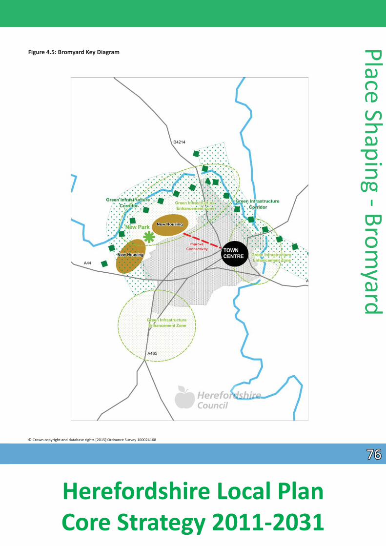
Figure 4.5: Bromyard Key Diagram
Place Shaping - Bromyard
© Crown copyright and database rights [2015] Ordnance Survey 100024168
7676
Herefordshire Local Plan Core Strategy 2011-2031
Plac
e Sh
apin
g - B
rom
yard
New homes
4.3.3 A minimum of 250 new homes will be provided within the Hardwick Bank area, north-west of the town. The strategic locaƟon is expected to be developed on an area of higher ground which slopes steeply to the north and west, down to the River Frome. The environmental suitability of including addiƟonal land south of the A44 and/or eastwards towards the B4214 will also be considered and consulted upon following compleƟon of further technical analysis of these areas. It is anƟcipated that the layout of any site will incorporate the exisƟng historic field paƩern to respect the local disƟncƟveness of the area. It is important that the scheme is brought forward as a comprehensively planned development to enable the proper planning of the site and not prejudice any future development. All homes will be built to high design standards with energy efficient measures in place. It is expected that 40% of the homes will be affordable and with an appropriate mix of housing, informed by the Local Housing Market Assessment in order to meet the needs of all secƟons of the community including housing for older persons – a need highlighted in the study of the Housing and Support needs of Older People in Herefordshire 2012.
New jobs
4.3.4 The policy to deliver around 5 hectares of employment land through the Bromyard Development Plan will help create greater and more diverse employment opportuniƟes for Bromyard. Any employment development is likely to need significant landscaping to miƟgate any visual impact. If employment land is adjacent to exisƟng housing, it will be necessary to co-ordinate both developments to achieve greater economies of scale and ensure neighbouring land uses are compaƟble. This may include the restricƟon of the employment areas next to the residenƟal to use class B1 or suitable live/work units. The Bromyard Development Plan will seek to idenƟfy the required employment land of five hectares. Given the level of constraints in Bromyard the delivery of employment land over the plan period will be closely monitored and reviewed if necessary. The policy enabling small scale employment/mixed use opportuniƟes as part of housing development will allow for a more sustainable development reducing the need to travel. Further small scale sites for employment use will be idenƟfied through the Bromyard
Development Plan.
Movement
4.3.5 The A44 Leominster Road will provide the primary access to housing and employment areas likely to be in the form of a roundabout serving land to the north and south of the A44. The visual and landscape impact of the access will also require miƟgaƟon with significant new landscaping.
4.3.6 The highway infrastructure within the new development area should also facilitate a connecƟon for vehicular access which will serve the proposed new land uses over the plan period. It must also be designed so as not to prejudice the delivery of addiƟonal development beyond the plan period and the eventual compleƟon of a full road connecƟon from the A44 to Tenbury Road.
4.3.7 The new development should have a network of cycle ways and footpaths that are easily accessible and connect with the town centre, exisƟng employment sites, community faciliƟes and the surrounding countryside. This is parƟcularly important given the peripheral locaƟon of the development area. Car parking will be addressed through the Bromyard Development Plan.
Green infrastructure, biodiversity and open space
4.3.8 In addiƟon to new play faciliƟes to serve the addiƟonal populaƟon created, a new park will form part of the residenƟal development at Hardwick Bank. This will be designed for both informal recreaƟon and
7777
Herefordshire Local Plan Core Strategy 2011-2031
biodiversity enhancement purposes. There will be a network of green infrastructure routes through the area with linkages to the park to encourage sustainable travel choices. Access to the River Frome and surrounding countryside will also form part of the enhanced linkages.
4.3.9 Due to the sensiƟve nature and landscape visibility of the housing and employment locaƟ ons parƟcularly from long distance views from the north west and east, strong landscape miƟgaƟon measures will be required. This will include the restoraƟon of the degraded landscape character through the conservaƟon and enhancement of hedgerows, with new planƟng to include hedgerow oak trees, planƟng of new orchard to replace degraded orchard land to the north of the A44 and elsewhere and new landscape buffers around the western and northern boundaries.
Community and educaƟ onal faciliƟes
4.3.10 The local primary school will require addiƟonal classroom provision as well as addiƟ onal contribuƟons to pre-school, post 16, youth and special educaƟonal services. AddiƟonal community requirement needs include improvements to the fire service, police service and improvements to exisƟ ng community buildings. Such requirements should be met by developer contribuƟons.
Heritage and archaeological value
4.3.11 The conservaƟon area of Bromyard has been idenƟfied as an area at risk. It is important that new development respects and where possible enhances, the character of the area.
4.3.12 Recent fi eld invesƟgaƟons in the area have revealed moderate to high potenƟal for the presence of currently undiscovered prehistoric remains. Further archaeological fi eld evaluaƟon will be required to inform the proposed development of the area.
Retail
4.3.13 The Town Centres Study Update 2012 concluded that new retail convenience (food store) and comparison retail development within the centre should be encouraged, but this is unlikely to be of scale to warrant any new retail allocaƟon in the town for the plan period.
4.3.14 The town retains a modest amount of comparison goods expenditure from exisƟng residents and any opportunity to increase this part of the offer will be dependent upon the market having the necessary
confidence in the town. New homes in Bromyard with enhanced means of access into town should strengthen support for the town centre’s vitality and viability. The size threshold of 200 m2 set out in Policy E5 indicates when impact tesƟng will be required.
Surface water management
4.3.15 Whilst the east of Bromyard is prone to fluvial flooding, the urban extension area is located to the north and south west of the town on land outside the flood risk zones. However, development in this locaƟon will need significant assessment to ensure that there is no increased risk of flooding. This must be addressed through a comprehensive surface water management plan.
Place Shaping - Bromyard
7878
Herefordshire Local Plan Core Strategy 2011-2031
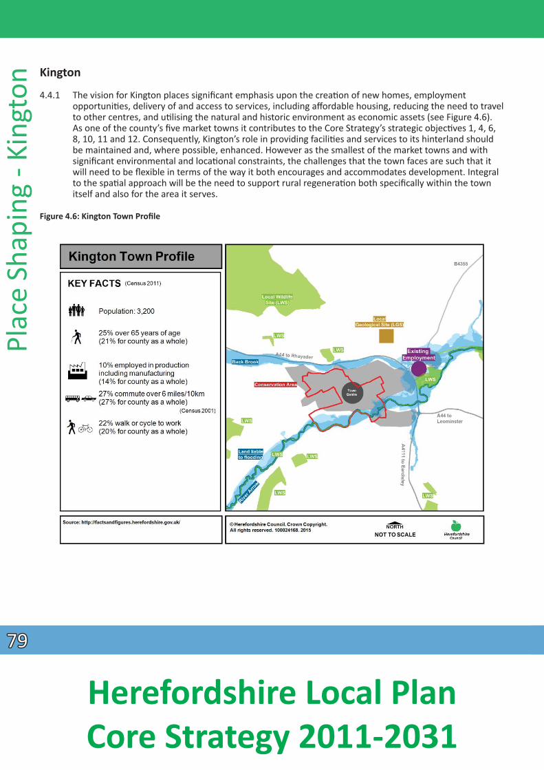
Plac
e Sh
apin
g - K
ingt
on
Kington
4.4.1 The vision for Kington places significant emphasis upon the creaƟon of new homes, employment opportuniƟes, delivery of and access to services, including affordable housing, reducing the need to travel to other centres, and uƟlising the natural and historic environment as economic assets (see Figure 4.6). As one of the county’s five market towns it contributes to the Core Strategy’s strategic objecƟves 1, 4, 6, 8, 10, 11 and 12. Consequently, Kington’s role in providing faciliƟes and services to its hinterland should be maintained and, where possible, enhanced. However as the smallest of the market towns and with significant environmental and locaƟonal constraints, the challenges that the town faces are such that it will need to be flexible in terms of the way it both encourages and accommodates development. Integral to the spaƟal approach will be the need to support rural regeneraƟon both specifically within the town itself and also for the area it serves.
Figure 4.6: Kington Town Profile
7979
Herefordshire Local Plan Core Strategy 2011-2031
Background to policy
4.4.2 Although Kington will need to accommodate new housing as part of the spaƟal strategy, no proposals for strategic housing locaƟons are proposed. Low building compleƟon rates coupled with the Strategic Housing Land Availability Assessment 2012 indicate significant constraints upon the need and opportuniƟes for any strategic locaƟons both within and around the town. Similarly, provision for employment will be on the basis of small scale proposals and a flexible approach to home-working. The role of the town centre as the locaƟon for shops, supported by service and tourism faciliƟes should not be undermined by developments that might affect its viability. A range of other supporƟ ng community
faciliƟes is also required to ensure balance between development pressures and needs in terms of infra structure.
Policy KG1 – Development in Kington
Kington will accommodate around 200 new homes during the plan period A Neighbourhood Development Plan will allocate sites to meet this level of housing. In addiƟon, provision for new employment uses should be brought forward to meet needs from within the Kington and West Herefordshire Housing Sub-Market Area.
Development proposals for Kington will be encouraged where they:
• deliver affordable housing in accordance with the requirements of Policy H1; • provide a mix of market and affordable house sizes and types that meet the requirements of Policy H3
and the needs idenƟfied in the latest version of the Herefordshire Local Housing Market Assessment; • enable an overall density of up to 35 dwellings per hectare; • enable home working; • make available small scale employment sites, brought forward in balance with housing within the
Kington and West Herefordshire Housing Sub-Market Area; • maintain and enhance the vitality and viability of the town centre. Proposals for new retail, leisure or
office development of over 200m2 in gross floor space and located outside the defined town centre will need to be supported by an impact assessment in accordance with the NaƟonal Planning Policy Framework, to determine whether there could be any adverse impacts on the vitality and viability of the Kington town centre;
• make provision for green infrastructure and amenity space, including play faciliƟes, community access to open space, and the linking of habitats into ecological networks within and surrounding the town;
• make provision for or improve walking and cycling links to the town centre, schools, shopping and employment; • protect, conserve and where possible enhance the historic character of Kington, in parƟ cular the
ConservaƟon Area and its significance and seƫ ng, including parƟcular features, its heritage assets, important buildings, scenic views and the landscape features surrounding the town; and
• have demonstrated engagement and consultaƟon with the community including the town/parish council.
Place Shaping - Kington
New Homes
4.4.3 Approximately 200 new homes will be delivered in Kington between 2011 and 2031, with sites allocated through a Neighbourhood Development Plan. Sites within the exisƟ ng confines of the town are constrained in terms of flooding. Developing peripheral sites will require compromise in terms of effect upon the landscape. Choice of sites should seek those with least impact and where the provision of
significant landscape and townscape miƟgaƟon measures can best be achieved. Phasing will be necessary
8080
Herefordshire Local Plan Core Strategy 2011-2031
Plac
e Sh
apin
g - K
ingt
on
to overcome current infrastructure constraints. Given the level of constraints in Kington, the delivery of housing over the plan period will be closely monitored. If this monitoring process indicates that it will not be possible to deliver the required level of housing, the Council will use appropriate mechanisms to address the situaƟon in accordance with policy SS3. This may include a review of this policy.
4.4.4 The Affordable Housing Viability Study, 2010 concluded that prices are relaƟvely high in the Kington Housing Market Area and therefore a target of 35% affordable homes would be the most appropriate within the town, with an appropriate mix of housing, informed by the latest Local Housing Market
Assessment in order to meet the needs of all secƟons of the community including housing for older persons – a need highlighted in the study of the Housing and Support needs of Older People in
Herefordshire 2012.
New Jobs
4.4.5 The policy encourages the development of small scale employment opportuniƟes at Kington, which would benefit both the town and its surrounding rural area. It may not be possible for such provision to
be located within or even immediately adjacent to the exisƟng town. The consideraƟon of such sites should not adversely affect the town’s seƫng and other environmental features. Enabling working from home in accordance with Policy E3 – Home Working may reduce the level of need although the provision for small scale employment opportuniƟes is expected to remain.
Movement
4.4.6 Kington is a relaƟvely compact seƩlement where access can be gained relaƟvely easily to its central area and faciliƟes elsewhere through walking or cycling. The locaƟon of new development should seek to
maintain this character. A parƟ cular characterisƟc of the town centre is its network of historic walled lanes which should form the core for any footpath strategy. Where possible, improvements should be made to promote sustainable modes of transport, in parƟcular walking and cycling which can be combined with green infrastructure proposals including beƩer access to greenspace. The principle of shared spaces will be encouraged on Kington High Street in accordance with Policy MT1.
Retail
4.4.7 Herefordshire Town Centre Town Centres Study Update 2012 suggests the expenditure forecast for Kington over the plan period is unlikely to be of a scale to require proposals for further convenience floor space. Many of the smaller units within the town could absorb more turnover within exisƟng fl oor space. The size threshold of 200 m2 indicates when impact tesƟng will be required. The Neighbourhood Development Plan will determine the level of flexibility given to uses within the town centre area.
UƟliƟes, Community FaciliƟes Green Infrastructure, Open Space and Heritage
4.4.8 UƟliƟes, the river floodplain, heritage assets, seƫng and landscape all pose constraints upon development within and around the town although some also add to the aƩ racƟveness of its character
providing potenƟ al benefits to local people and visitors. In addiƟon, evidence base studies have idenƟfied open space needs and green infrastructure requirements. The level of new development proposed both within and surrounding the town should support the current provision of community faciliƟes. In addiƟon to phasing development to address uƟlity constraints developers may also need to assist proposals for surface water management in parƟ cular locaƟons depending upon which sites are brought forward. All these issues need to be addressed comprehensively and in detail through any Neighbourhood Development Plan or other Development Plan Documents.
8181
Herefordshire Local Plan Core Strategy 2011-2031
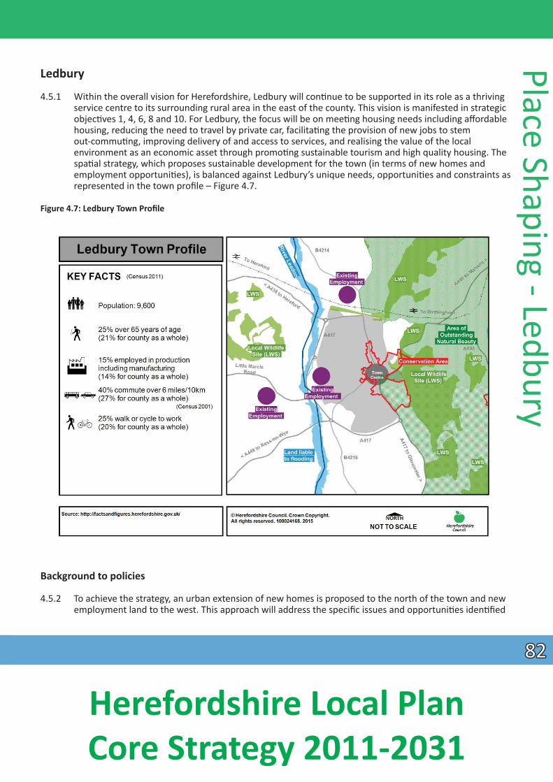
Ledbury
4.5.1 Within the overall vision for Herefordshire, Ledbury will conƟnue to be supported in its role as a thriving service centre to its surrounding rural area in the east of the county. This vision is manifested in strategic objecƟves 1, 4, 6, 8 and 10. For Ledbury, the focus will be on meeƟng housing needs including aff ordable housing, reducing the need to travel by private car, facilitaƟng the provision of new jobs to stem
out-commuƟng, improving delivery of and access to services, and realising the value of the local environment as an economic asset through promoƟng sustainable tourism and high quality housing. The spaƟal strategy, which proposes sustainable development for the town (in terms of new homes and
employment opportuniƟes), is balanced against Ledbury’s unique needs, opportuniƟes and constraints as represented in the town profile – Figure 4.7.
Figure 4.7: Ledbury Town Profile
Place Shaping - Ledbury
Background to policies
4.5.2 To achieve the strategy, an urban extension of new homes is proposed to the north of the town and new employment land to the west. This approach will address the specific issues and opportuniƟ es idenƟfied
8282
Herefordshire Local Plan Core Strategy 2011-2031
Plac
e Sh
apin
g - L
edbu
ry
in the town profile for Ledbury, namely: addressing high affordable housing need; high levels of commuƟng for jobs; and the significant environmental constraints affecƟng the seƫng of the town, which
is enclosed on the east side by the Malvern Hills Area of Outstanding Natural Beauty and fl oodplains of the Leadon Valley and adjoining sensiƟve landscapes to the west. Policies LB1 and LB2 set out how the spaƟal strategy for Ledbury will be delivered and managed and are explained in the Ledbury Key Diagram,
Figure 4.8.
Policy LB1- Development in Ledbury
Ledbury will accommodate a minimum of 800 new homes balanced with a minimum of 15 hectares of new employment land during the plan period. The majority of new housing development will be focussed to the north of the town as set out in Policy LB2 and the strategic locaƟon for new employment of around 12 hectares to the west of the town, south of LiƩle Marcle Road. Further development will take place through the implementaƟon of exisƟng commitments, infill development, and sites allocated through a Neighbourhood Development Plan. A number of sites which have future potenƟal for development have been idenƟfied in the Strategic Housing Land Availability Assessment (SHLAA).
Within Ledbury, new development proposals will be encouraged where they:
• allow for suitable small scale employment sites including live work opportuniƟes within or adjoining the town; • maintain and enhance the vitality and viability of the exisƟng town centre. Proposals for new retail,
leisure or office development of over 400m2 in gross floor space and located outside the town centre will need to be supported by an impact assessment to determine whether there could be any adverse impacts on the town centre;
• improve accessibility within Ledbury by walking, cycling and public transport, parƟcularly where they enhance connecƟvity with, for example, local faciliƟes, new employment areas and the town centre;
• contribute to addressing deficiencies in community faciliƟes and/or allow for infrastructure improvements (including broadband) in the town, to promote sustainable development;
• reflect and enhance the characterisƟc built historic elements of Ledbury, such as its stone, brick and Ɵmber-framed buildings, medieval plan form, conservaƟon areas and seƫng overlooking the Leadon
Valley; • protect and enhance its green infrastructure, including connecƟons to the public right of way network
and biodiversity, parƟcularly the Malvern Hills Area of Outstanding Natural Beauty to the east and the Leadon Valley to the west;
• protect and enhance the seƫng of the town from eastern and western viewpoints; and, where this is not possible, incorporate appropriate miƟgaƟon measures; and
• have demonstrated engagement and consultaƟon with the community including the town council.
8383
Herefordshire Local Plan Core Strategy 2011-2031
Policy LB2 - Land north of the Viaduct
Development proposals north of the viaduct in Ledbury will be expected to bring forward the following to achieve a sustainable mixed use urban extension of the town:
• mixed use development of around 625 new homes, at an average density of around 40 dwellings per hectare, comprising a mix of market and affordable house sizes and types that meet the requirements of Policy H3 and the needs idenƟfied in the latest version of the Herefordshire Local Housing Market Assessment; • around 3 hectares of employment land, restricted to Use Class B1; • a target of 40% of the total number of dwellings to be aff ordable housing; • land and contribuƟons to facilitate a restored canal to be delivered in partnership with the Herefordshire
and Gloucestershire Canal Trust; • a new linear informal park to link to the exisƟng town trail, riverside walk, recreaƟonal open space and
exisƟ ng allotments; • the provision of developer contribuƟons towards any idenƟfied need for new/improved community
faciliƟes/infrastructure improvements. This shall include a new 210 place primary school within the development (or an expansion of the exisƟng primary school) and new recreaƟonal open space, play, indoor and outdoor sport faciliƟes;
• provision of saƟsfactory vehicular access arrangements, the details of which will be determined at planning applicaƟ on stage; • appropriate miƟgaƟon to safeguard the amenity of future occupants from unacceptable levels of noise
and to safeguard the conƟ nued operaƟon of exisƟng businesses adjoining the area; • development of bespoke, high quality and inclusive design, including accommodaƟon that will meet
the needs of older persons and that contributes to the disƟncƟveness of this part of Ledbury and respects the seƫ ng and significance of the listed viaduct and the Malvern Hills Area of Outstanding
Natural Beauty; • safeguards to ensure there is no adverse impact on water quality and quanƟty in the River Leadon; • new walking, cycling and bus links from the urban extension directly to the town trail and riverside walk
under the viaduct, the railway staƟon and town centre to create linkages to nearby development and exisƟng community faciliƟes;
• sustainable standards of design and construcƟon; and • a comprehensive sustainable urban drainage system which includes measures such as rain gardens and
swales to manage ground and surface water drainage and safeguard against any increased fl ood risk.
Place Shaping - Ledbury
8484
Herefordshire Local Plan Core Strategy 2011-2031
Figure 4.8: Ledbury Key Diagram
Plac
e Sh
apin
g - L
edbu
ry
© Crown copyright and database rights [2015] Ordnance Survey 100024168
8585
Herefordshire Local Plan Core Strategy 2011-2031
New homes
4.5.3 The policy for Ledbury focuses on delivering high quality, sustainably constructed new homes to meet housing need and demand, especially for that of smaller open market housing and affordable housing, in this high house price area. It also aims to balance new development against the environmental constraints of this historic market town. The strategy to deliver new homes mainly in a single locaƟ on is not only economically viable but also limits development mainly to land of medium-low landscape sensiƟvity and of lesser environmental merit, with regard to agricultural and biodiversity value. The listed viaduct adjoining the area also represents an opportunity to create a bespoke design soluƟon and high quality townscape to meet the needs of all secƟons of the community including housing for older persons – a need highlighted in the study of the Housing and Support needs of Older People in Herefordshire 2012. Housing will be phased to Ɵe in with the construcƟon and provision of essenƟal new community infrastructure in line with Policy SS3. The remaining housing requirement for Ledbury will be delivered
through exisƟng commitments, windfalls and the allocaƟon of sites through a Neighbourhood Development Plan.
New jobs
4.5.4 The policy to deliver around 12 hectares of employment land to the south of LiƩle Marcle Road will help facilitate greater employment opportuniƟes for Ledbury residents, promoƟng its role as a mulƟ
funcƟoning centre and reduce the need for commuƟng by private car. This area of arable land adjoins exisƟng employment land and sports pitches and is of low landscape sensiƟvity and biodiversity value.
Acceptable access can be achieved from LiƩle Marcle Road, whilst new sustainable transport links can be created into the town including safe crossings of the by-pass. Structural landscaping will be required along the western and southern boundaries to miƟgate the visual impact of new buildings. The land will parƟcularly provide opportuniƟes for medium and large size business requiring large land areas, including the expansion of exisƟ ng businesses.
4.5.5 Land north of the viaduct will also include around 3 hectares of employment land (in addiƟon to any exisƟng commitments), which will be restricted to use class B1 (light industry, offi ces, research and
development) in order to complement the larger employment area. Small-scale sites for employment use will also be idenƟfied through a Neighbourhood Development Plan.
4.5.6 The figures for employment (as with housing) are targets for the whole plan period and will be monitored through the annual monitoring process to assess performance and the need for any management
measures.
Movement
4.5.7 The policy approach for movement in Ledbury is based on reducing the need to travel by private car. This will be achieved by locaƟng new development within walking and cycling distance of exisƟng and new
faciliƟes (including the railway staƟon) and improving and extending sustainable transport routes. New employment land and other policies in the Core Strategy, as well as the forthcoming Neighbourhood Development Plan, will also promote local employment opportuniƟes. This will help address the issue of reducing the need to travel. Herefordshire Council (through the Local Transport Plan) proposes to work in partnership with bus operators and developers to ensure housing and employment locaƟons are served by public transport and that service frequencies linking to Hereford are maintained.
Place Shaping - Ledbury
8686
Herefordshire Local Plan Core Strategy 2011-2031
Plac
e Sh
apin
g - L
edbu
ry
4.5.8 Vehicular, pedestrian, cycle and bus access to the housing site will need to be provided with addiƟonal sustainable transport links to the staƟon. A reducƟon in the speed limit along the Bromyard Road and improvements to the Hereford Road/Bromyard Road juncƟon are also likely to be required to improve the design, safety and efficiency of this road and juncƟon. These, and any other highway improvements, will be informed by a traffic assessment, and will be considered as part of the Council’s determinaƟ on of
planning applicaƟons on the site.
4.5.9 The issue of car parking supply and demand at the railway staƟon and in the town centre will be addressed through a Neighbourhood Development Plan. With regards parking to serve the railway
staƟon, the opportunity may exist for an underground overspill car park on land north of the railway line which could be funded through community infrastructure levy monies, subject to landowner agreement.
Green infrastructure and open space
4.5.10 Developing land to the north of the viaduct addresses aspiraƟons of the Green Infrastructure Strategy which idenƟfies the area as an Enhancement Zone, represenƟng a possible intersecƟon of the riverside
linear park and the town trail green infrastructure corridors. It enables the introducƟon of new, accessible green space through the provision of a linear park, on-site recreaƟonal open space and part of a strategic canal route all of which will address the issue of deficiencies in open space in Ledbury as idenƟfied in the Open Space Study and Playing Pitch Strategy, as well as promote biodiversity. The strategic employment area also off ers opportuniƟes to reinforce the green infrastructure enhancement zone.
4.5.11 This approach realises the value of the environment as an economic asset, as the urban extension will create beƩer access to and enjoyment of new green infrastructure for residents and tourists alike. A
review of open space needs and exisƟ ng designaƟons in Ledbury will be undertaken as part of a Neighbourhood Development Plan.
Community and educaƟ onal faciliƟes
4.5.12 Improving the delivery of and access to, services is addressed in this policy through requirements for new infrastructure. This will be either directly delivered by a developer or through developer contribuƟons, including either a new primary school at the urban extension or an expansion of the exisƟ ng primary school, canal, riverside park, outdoor sports pitches and other community faciliƟes. A centrally located,
equipped, mulƟ age play area will also be provided on the urban extension, along with new outdoor sports faciliƟes, further enhancing the opportuniƟes for acƟve play. An upgrade to the public water
supply infrastructure to serve the new housing and employment growth may also be required.
4.5.13 OpportuniƟes will also be sought to secure the reinstatement of other secƟons of the former Herefordshire and Gloucestershire Canal within/adjoining the town through a Neighbourhood
Development Plan.
Heritage and archaeological value
4.5.14 A landmark feature of Ledbury is its railway viaduct which is Grade II listed. Any development of the viaduct site will need to respect the seƫ ng and significance of the viaduct, yet regard it as a posiƟve feature to be integrated within, and inform the detailed master planning and design of, any scheme.
8787
Herefordshire Local Plan Core Strategy 2011-2031
Retail
4.5.15 The policy for shopping in Ledbury, based on the evidence in the Town Centres Study Update 2012, is to maintain the exisƟng, thriving centre which is based on a mixture of popular high street and independent stores. New homes and households in Ledbury will strengthen this support for the town centre and improvements to sustainable modes of transport into the town centre via the exisƟng town trail will also support this approach.
4.5.16 The Town Centres Study Update 2012 indicates a need for further convenience shopping floor space in the town up to 2031 and further comparison retail from 2026. The study also concludes that there is an opportunity to increase the specialist nature of some of the independent shops which aƩracts a large amount of people from the wider surrounding area. IniƟaƟves such as the Ledbury: From Field to Fork IniƟaƟve will assist in supporƟng this aim. As is required by paragraph 23 of the NPPF, an area near to the edge of the town centre area at Bye Street/Lawnside Road is idenƟfied as a possible locaƟon for addiƟonal convenience retail floor space in any sequenƟal search, but is not included as a site-specific proposal of the Core Strategy. Should any proposals be advanced for this area it will be subject to the retenƟon or the replacement of the exisƟng community faciliƟes, including the swimming pool, either on
must be completed prior to the loss of exisƟng faciliƟes. The need highlighted in the Town Centres Study Update 2012 will be reviewed regularly against expenditure capacity and the idenƟficaƟon of any specific proposals to meet the needs will be considered through a Neighbourhood Development Plan.
Surface water management and fluvial flooding
4.5.17 The west of Ledbury is prone to flooding from the River Leadon. The physical development within the urban extension and employment area will need to demonstrate through a flood risk assessment that the housing, employment, play and sports faciliƟes avoids the areas that are vulnerable to flooding and does not increase flood risk for any exisƟng residents and businesses. AddiƟonally, the urban extension and employment area should include a sustainable surface water drainage management system, incorporaƟng features such as swales and ponds, sensiƟvely integrated with the development, to achieve
exisƟng or beƩer than exisƟng greenfield runoff rates.
Place Shaping - Ledbury
the site or in an appropriate and accessible locaƟon elsewhere within the town. Any replacement faciliƟes
8888
Herefordshire Local Plan Core Strategy 2011-2031
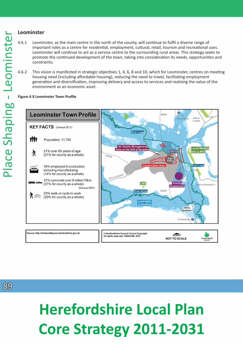
Plac
e Sh
apin
g - L
eom
inst
er Leominster
4.6.1 Leominster, as the main centre in the north of the county, will conƟnue to fulfil a diverse range of important roles as a centre for residenƟal, employment, cultural, retail, tourism and recreaƟ onal uses. Leominster will conƟnue to act as a service centre to the surrounding rural areas. This strategy seeks to promote the conƟnued development of the town, taking into consideraƟon its needs, opportuniƟ es and
constraints.
4.6.2 This vision is manifested in strategic objecƟves 1, 4, 6, 8 and 10, which for Leominster, centres on meeƟng housing need (including affordable housing), reducing the need to travel, facilitaƟ ng employment
generaƟon and diversificaƟon, improving delivery and access to services and realising the value of the environment as an economic asset.
Figure 4.9 Leominster Town Profile
8989
Herefordshire Local Plan Core Strategy 2011-2031
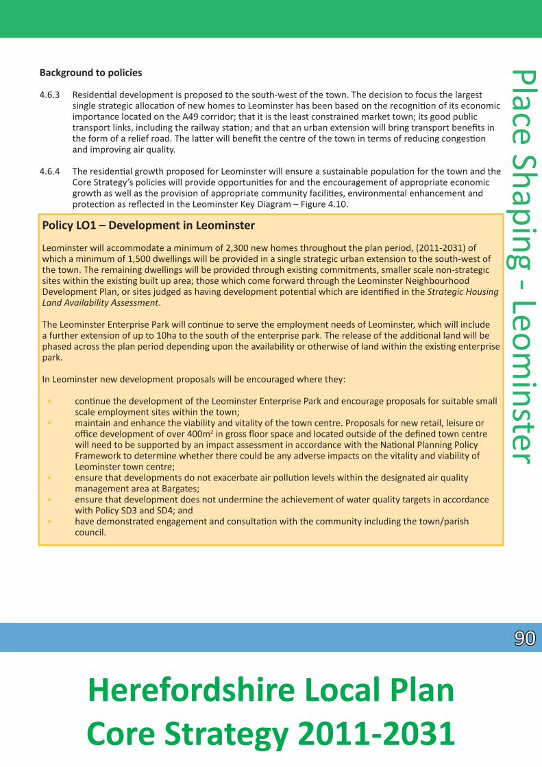
Background to policies
4.6.3 ResidenƟal development is proposed to the south-west of the town. The decision to focus the largest single strategic allocaƟon of new homes to Leominster has been based on the recogniƟon of its economic importance located on the A49 corridor; that it is the least constrained market town; its good public transport links, including the railway staƟon; and that an urban extension will bring transport benefi ts in the form of a relief road. The laƩer will benefit the centre of the town in terms of reducing congesƟon and improving air quality.
4.6.4 The residenƟal growth proposed for Leominster will ensure a sustainable populaƟon for the town and the Core Strategy’s policies will provide opportuniƟes for and the encouragement of appropriate economic growth as well as the provision of appropriate community faciliƟes, environmental enhancement and
protecƟon as reflected in the Leominster Key Diagram – Figure 4.10.
Policy LO1 – Development in Leominster
Leominster will accommodate a minimum of 2,300 new homes throughout the plan period, (2011-2031) of which a minimum of 1,500 dwellings will be provided in a single strategic urban extension to the south-west of the town. The remaining dwellings will be provided through exisƟng commitments, smaller scale non-strategic sites within the exisƟng built up area; those which come forward through the Leominster Neighbourhood Development Plan, or sites judged as having development potenƟal which are idenƟfied in the Strategic Housing Land Availability Assessment.
The Leominster Enterprise Park will conƟnue to serve the employment needs of Leominster, which will include a further extension of up to 10ha to the south of the enterprise park. The release of the addiƟonal land will be phased across the plan period depending upon the availability or otherwise of land within the exisƟ ng enterprise park.
In Leominster new development proposals will be encouraged where they:
• conƟnue the development of the Leominster Enterprise Park and encourage proposals for suitable small scale employment sites within the town;
• maintain and enhance the viability and vitality of the town centre. Proposals for new retail, leisure or office development of over 400m2 in gross floor space and located outside of the defined town centre will need to be supported by an impact assessment in accordance with the NaƟonal Planning Policy Framework to determine whether there could be any adverse impacts on the vitality and viability of Leominster town centre;
• ensure that developments do not exacerbate air polluƟon levels within the designated air quality management area at Bargates;
• ensure that development does not undermine the achievement of water quality targets in accordance with Policy SD3 and SD4; and
• have demonstrated engagement and consultaƟon with the community including the town/parish council.
Place Shaping - Leominster
9090
Herefordshire Local Plan Core Strategy 2011-2031
Plac
e Sh
apin
g - L
eom
inst
er Policy LO2 – Leominster urban extension
Land south west of Leominster will deliver a comprehensively planned sustainable urban extension and will be expected to deliver:
• a minimum of 1,500 new homes at an average density of up to 35 dwellings per hectare comprising a mix of market and affordable house sizes and types that meet the requirements of Policy H3, and the
needs idenƟfied in the latest version of the Herefordshire Local Housing Market Assessment; • an affordable housing target of 25% will be required as an opportunity to address the range of homes
currently available in the town; • Leominster relief road linking the Worcester Road roundabout directly to the A44, to help relieve traffic
congesƟon within the town and improve air quality in the Bargates area; • small scale neighbourhood retail faciliƟes; • potenƟal for employment opportuniƟes as demand arises in the form of use class B1 and live/work
units; • provision of appropriate community and youth faciliƟes within a community hub; • provision of a new 420 place primary school and pre-school faciliƟes; • appropriate provision of on-site open space, sports and recreaƟon provision (in addiƟon to CockcroŌ
Hill). This shall include fully accessible semi-natural and natural greenspace; play provision for all age groups, indoor and outdoor sports provision (some of which may be off site); allotments and new
orchard planƟng; • new green infrastructure walking and cycling links to the town centre, schools, the Enterprise Park and
local public right of way network; • retenƟon of the highly sensiƟve landscape areas and geological features of CockcroŌ Hill (which
encompasses Ryelands CroŌ) by retaining this site as natural open space; • sustainable standards of design and construcƟon; • a comprehensive sustainable urban drainage system which includes measures such as rain gardens and
swales to manage ground and surface water drainage and safeguard against any increased fl ood risk; and
• an evaluaƟon of the archaeological importance of the area in order to ensure appropriate protecƟ on of heritage assets and inform the detailed development proposals.
The land available for development to the south-west of Leominster will also enable the housing needs of the town to be met beyond the plan period.
9191
Herefordshire Local Plan Core Strategy 2011-2031
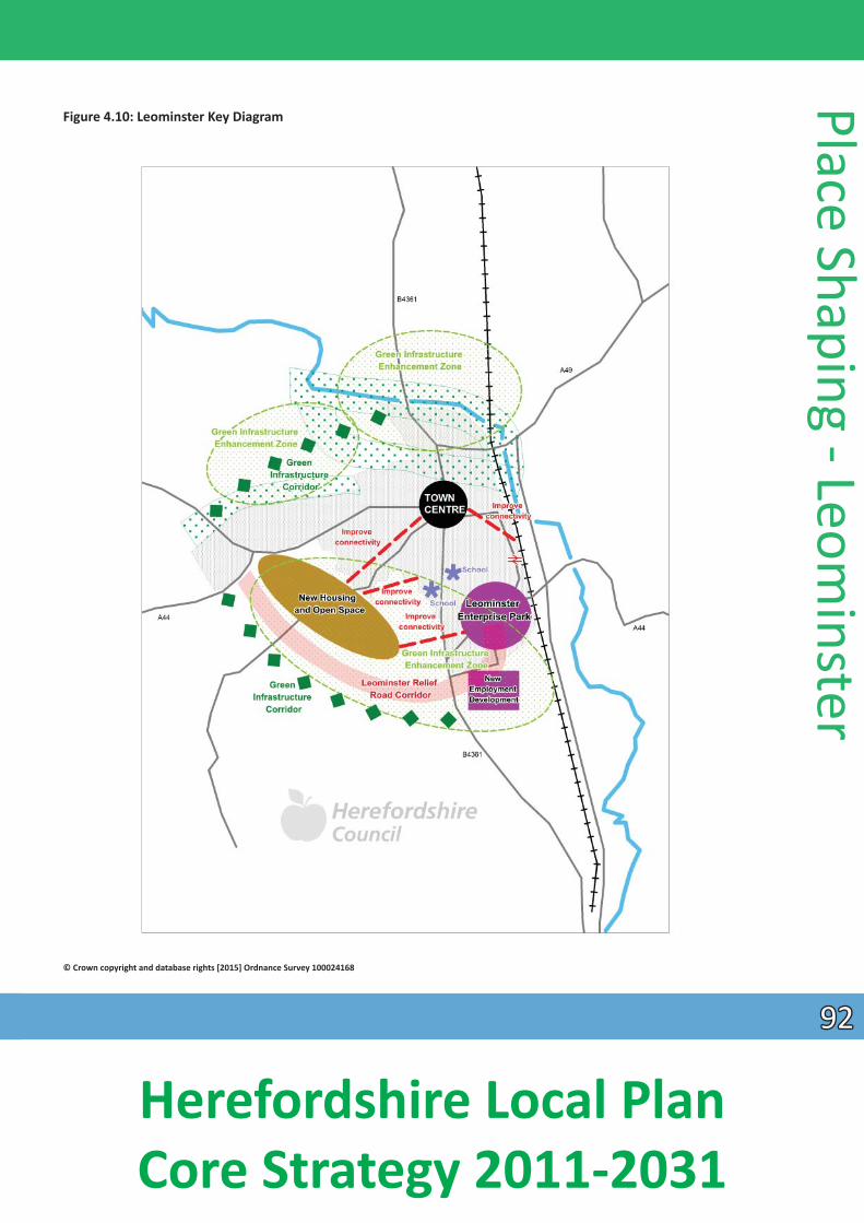
Figure 4.10: Leominster Key Diagram
Place Shaping - Leominster
© Crown copyright and database rights [2015] Ordnance Survey 100024168
9292
Herefordshire Local Plan Core Strategy 2011-2031
Plac
e Sh
apin
g - L
eom
inst
er
New homes
4.6.5 Land to the south of Leominster provides the most appropriate locaƟon for meeƟng the future strategic housing requirements of the town. A minimum of 1,500 new homes will be provided within the urban extension up to 2031 together with a range of other faciliƟes to enable the development to meet the needs of its residents and integrate with the exisƟng town. The development will be comprehensively master-planned to create a series of neighbourhoods integrated with the town. Density and design will vary across the development with all homes constructed to minimise their energy use and CO2 footprint.
4.6.6 It is recognised that there is a need for affordable homes across the county. It has been idenƟfi ed through the Affordable Housing Viability Study that land values are lower within Leominster, therefore a target
of 25% affordable homes would be the most appropriate within the town. An appropriate mix of housing will be needed, informed by the most up to date Local Housing Market Assessment, in order to meet the needs of all secƟons of the community including housing for older persons.
4.6.7 The development of the urban extension provides an opportunity to create a scheme which is sensiƟ ve to the landscape of this edge of town whilst meeƟng the needs of all secƟons of the community, including those of working age, who will be close to exisƟng and new employment opportuniƟes, and also older people.
4.6.8 The land south of Leominster is sufficient not only to meet the housing target for the current plan period but is also likely to help meet the housing needs of the town through further development post 2031 supported by new highway infrastructure and community faciliƟes.
New jobs
4.6.9 There remains a reasonable supply of employment land on Leominster Enterprise Park and at Southern Avenue but it is envisaged that vacant employment land in the Leominster Enterprise Park will be taken up during the early stages of the plan period. As a result, in order to accommodate employment needs over the plan period, Leominster will require an extension of the Leominster Enterprise Park to the south, which will provide up to 10ha of employment land. There is also the opportunity to provide addiƟonal smaller B1 class live/work units which could be integrated into the urban extension.
Movement
4.6.10 The Bargates area of the town suffers from congesƟon and without new road infrastructure the potenƟal growth of Leominster would be limited. In addiƟon, the Bargates area is also designated as an Air Quality Management Area as a result of poor air quality and new road infrastructure would enable much of the heavy vehicular traffic to be diverted from this area.
4.6.11 The urban extension provides the opportunity to provide new road infrastructure as an integral element of the development. A relief road connecƟng the Worcester Road roundabout to the A44 at Baron’s Cross will be constructed. Much of the link from the B4361 Hereford Road to the Worcester Road roundabout has already been constructed, with a small area of approximately 200 yards needed to complete the link.
The enƟre relief road will be designed to provide an alternaƟve direct and more convenient route for vehicles and avoid the need for through traffic to pass through the town centre, and in parƟ cular, the
Bargates juncƟon. The relief road is also likely to require new roundabout juncƟons on the B4361 and A44 and an extension of the highway infrastructure in the south west corner of the Enterprise Park.
9393
Herefordshire Local Plan Core Strategy 2011-2031
4.6.12 In addiƟon to the provision of new road infrastructure the urban extension also provides an opportunity to encourage more sustainable modes of transport within the town through new footpaths and cycle routes developed to ensure that good linkages and opportuniƟes to integrate with the exisƟ ng networks are provided, parƟcularly to the primary schools, high school, the town centre and the Enterprise Park.
Green infrastructure and open space
4.6.13 The potenƟal housing allocaƟon located to the south west of the town is a mixture of medium-low and medium-high sensiƟvity landscape areas according to the Urban Fringe SensiƟ vity Analysis. However such landscape constraints are lower than sites to the north and west of Leominster. It will be necessary to provide landscape miƟgaƟ on parƟcularly along the outer edge of the residenƟal and employment development areas adjoining open countryside and CockcroŌ Hill. CockcroŌ Hill incorporates the
Ryelands CroŌ Local Geological Site, a locally important landscape and geological feature and will therefore need to be retained as semi-natural open space.
4.6.14 Leominster has an under provision of semi-natural greenspace, play faciliƟes, parks, gardens and outdoor sport space according to the Open Space Study and Playing Pitch Strategy, and hence there is the opportunity to provide a number of open space, sports and recreaƟ on faciliƟes within the urban extension in addiƟon to CockcroŌ Hill. The development will also generate a need for addiƟonal allotments which will be met and designed into the urban extension.
Community and educaƟ onal faciliƟes
4.6.15 There will be a need for addiƟonal community faciliƟes or hub within the south west extension to achieve a sustainable development. This may include a doctor’s surgery, a community hall, youth faciliƟ es and small scale retail. This will ensure that journeys that need to be made regularly can be made within the
new development.
4.6.16 The addiƟonal housing provided by the urban extension will place a need for 420 new primary school places. In addiƟon, there will be a need for a children’s centre for the early years which could form part of the community hub. In terms of high school places, the Earl MorƟmer College has adequate capacity to cover the new growth of the town. These new faciliƟes will help create a more sustainable community.
Heritage and archaeological value
4.6.17 Archaeological potenƟal has been idenƟfied, in Leominster, parƟcularly at land south of Barons Cross where there are earthworks. The proposed route of the relief road needs full assessment prior to any works taking place on the south west extension. The Sustainability Appraisal highlighted that any archaeological concern on the proposed site needed to be addressed, and detailed fi eld evaluaƟon will be
required.
Retail
4.6.18 As part of the Town Centres Study Update 2012 it is idenƟfied that Leominster has some convenience and comparison retail floorspace need which increases over the plan period. In terms of convenience retail,
this could create the opportunity for an addiƟonal food store development in the town centre, which
Place Shaping - Leominster
would draw more shoppers into the centre and complement the exisƟng independent convenience shops. Small scale convenience retail will be provided within the urban extension to meet the day to day needs of the residents of the new development.
9494
Herefordshire Local Plan Core Strategy 2011-2031
Plac
e Sh
apin
g - L
eom
inst
er
4.6.19 The need for comparison retail proposals is more limited with a modest capacity towards the end of the plan period. The study indicated that the priority should be to steer any new floorspace to the town centre as far as this is pracƟcal, and only to permit out-of-centre faciliƟes if they would materially enhance the retail offer of the town and assist in retaining catchment residents’ expenditure. Impact assessments will be required for developments of 400m2 of floorspace and greater and this is refl ected in
Policy E5.
4.6.20 The study also idenƟfies a number of sites that provide redevelopment opportuniƟes to accommodate retail development during the plan period and should be considered first in a sequenƟal test in accordance with the NaƟonal Planning Policy Framework:
• Broad Street Car Park at Arkwright Close; • Broad Street Car park, rear of Fire StaƟon; • The Original Factory Shop, 52 Broad Street.
4.6.21 More detailed assessment of the need for future retail provision for Leominster, including the need to allocate sites will be provided through the preparaƟon of a Neighbourhood Development Plan. The extent of the town centre and the primary shopping area, (made up of the primary and secondary frontages) will
be defined as part of the Neighbourhood Development Plan.
Surface water management, water quality and fluvial flooding
4.6.22 There are extensive areas at risk of flooding in Leominster, parƟcularly to the north of the town. Leominster lies near the confluence of two major river systems, the Lugg and the Arrow, which further downstream becomes the River Lugg Special Area of ConservaƟ on (SAC).
4.6.23 The Water Cycle Study idenƟfies that developers would need to ensure there are no adverse impacts as a result of any new development, this could be managed to miƟgate the effects on the SAC through adequate control measures and addiƟonal capacity in water treatment infrastructure and surface water
management. SecƟons of the River Wye SAC where the water quality targets are already exceeded will be subject to measures to reduce nutrients in line with the targets. All new development proposals including the Leominster urban extension must not compromise the ability of the Nutrient Management Plan to deliver the necessary overall reducƟons along these stretches.
9595
Herefordshire Local Plan Core Strategy 2011-2031
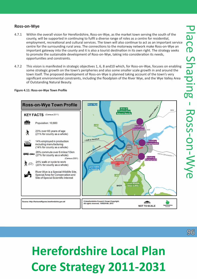
Ross-on-Wye
4.7.1 Within the overall vision for Herefordshire, Ross-on-Wye, as the market town serving the south of the county, will be supported in conƟnuing to fulfil a diverse range of roles as a centre for residenƟal,
employment, recreaƟonal and cultural services. The town will also conƟnue to act as an important service centre for the surrounding rural area. The connecƟons to the motorway network make Ross-on-Wye an important gateway into the county and it is also a tourist desƟnaƟon in its own right. The strategy seeks to promote the sustainable development of Ross-on-Wye, taking into consideraƟon its needs, opportuniƟes and constraints.
4.7.2 This vision is manifested in strategic objecƟves 1, 6, 8 and10 which, for Ross-on-Wye, focuses on enabling some strategic growth on the town’s peripheries and also some smaller scale growth in and around the town itself. The proposed development of Ross-on-Wye is planned taking account of the town’s very significant environmental constraints, including the floodplain of the River Wye, and the Wye Valley Area of Outstanding Natural Beauty.
Figure 4.11: Ross-on-Wye Town Profile
Place Shaping - Ross-on-Wye
9696
Herefordshire Local Plan Core Strategy 2011-2031
Plac
e Sh
apin
g - R
oss-
on-W
ye
Background to policies
4.7.3 To achieve the strategy, an urban extension of new homes is proposed to the southeast of the town at Hildersley. This locaƟon has a limited capacity, in order to avoid encroachment on the wooded hillside to the south and the constraint of an acƟ ve rifle range to the west. It does, however, have the potenƟ al for sustainable transport links to the town centre without creaƟng a need for new strategic highway links, it is within walking distance of the proposed employment site at Model Farm and can be designed to minimise landscape impacts on the seƫng of the town.
4.7.4 The remainder of new homes for Ross-on-Wye will be provided on a range of, primarily, smaller sites of less than 100 dwellings, in and around the town. The locaƟon of these can be further detailed through a forthcoming Neighbourhood Development Plan or other Development Plan Document.
4.7.5 The potenƟal for new employment development will remain at Model Farm. This combined approach to housing and employment will help to address the issues of high affordable housing need and signifi cant levels of commuƟng, whilst working within the environmental constraints of Ross-on-Wye.
Policy RW1 – Development in Ross-on-Wye
Ross-on-Wye will accommodate a minimum of 900 new homes, balanced with approximately 10 hectares of allocated employment land during the plan period, in accordance with the spaƟal strategy. A strategic housing locaƟon will focus a minimum of 200 new homes to the south east of the town. The remaining requirement for homes will be delivered on sites allocated through a Neighbourhood Development Plan.
Within Ross-on-Wye, new development proposals will be encouraged where they:
• allow for suitable employment sites, including live-work opportuniƟes within or adjoining the town; • maintain and enhance the vitality and viability of the town centre. Proposals for new retail, leisure or
office development of over 400m2 gross floor space and located outside the town centre will need to be supported by an impact assessment to determine whether there could be any adverse impacts on the town centre;
• improve accessibility within Ross-on-Wye by walking, cycling and public transport, parƟ cularly where they enhance connecƟvity with local faciliƟes, the town centre and exisƟng employment areas;
• contribute towards new or improved community faciliƟes and/or allow for infrastructure improvements in the town to promote sustainable development;
• reflect and enhance the characterisƟc natural and built historic elements of Ross-on-Wye, such as its red sandstone and Ɵmber framed Tudor buildings and boundary walls, the medieval plan form, conservaƟon
area and natural seƫng overlooking the River Wye; • enhance green infrastructure and biodiversity, parƟcularly the Wye Valley Area of Outstanding Natural
Beauty and the River Wye; and • have demonstrated engagement and consultaƟon with the community including the town/parish
council.
9797
Herefordshire Local Plan Core Strategy 2011-2031
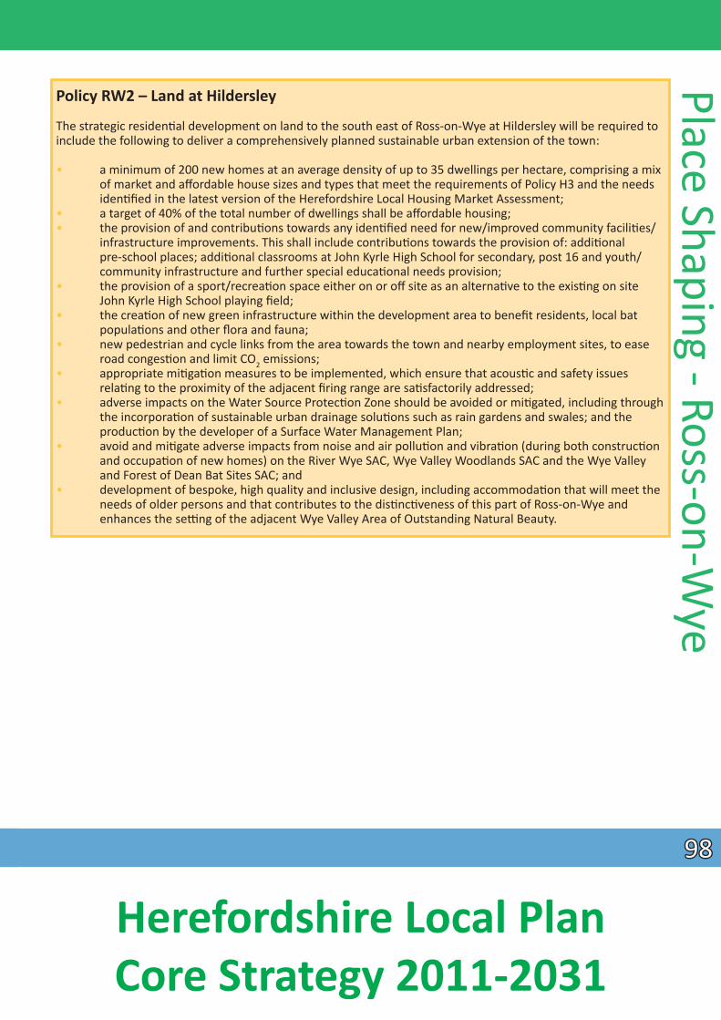
Policy RW2 – Land at Hildersley
The strategic residenƟal development on land to the south east of Ross-on-Wye at Hildersley will be required to include the following to deliver a comprehensively planned sustainable urban extension of the town:
• a minimum of 200 new homes at an average density of up to 35 dwellings per hectare, comprising a mix of market and affordable house sizes and types that meet the requirements of Policy H3 and the needs idenƟfied in the latest version of the Herefordshire Local Housing Market Assessment;
• a target of 40% of the total number of dwellings shall be aff ordable housing; • the provision of and contribuƟons towards any idenƟfied need for new/improved community faciliƟes/
infrastructure improvements. This shall include contribuƟons towards the provision of: addiƟonal pre-school places; addiƟonal classrooms at John Kyrle High School for secondary, post 16 and youth/ community infrastructure and further special educaƟonal needs provision;
• the provision of a sport/recreaƟon space either on or off site as an alternaƟve to the exisƟng on site John Kyrle High School playing field;
• the creaƟon of new green infrastructure within the development area to benefit residents, local bat populaƟons and other flora and fauna;
• new pedestrian and cycle links from the area towards the town and nearby employment sites, to ease road congesƟon and limit CO2 emissions; • appropriate miƟgaƟon measures to be implemented, which ensure that acousƟc and safety issues relaƟng to the proximity of the adjacent firing range are saƟ sfactorily addressed; • adverse impacts on the Water Source ProtecƟon Zone should be avoided or miƟgated, including through the incorporaƟon of sustainable urban drainage soluƟons such as rain gardens and swales; and the producƟon by the developer of a Surface Water Management Plan; • avoid and miƟgate adverse impacts from noise and air polluƟon and vibraƟon (during both construcƟon and occupaƟon of new homes) on the River Wye SAC, Wye Valley Woodlands SAC and the Wye Valley
and Forest of Dean Bat Sites SAC; and • development of bespoke, high quality and inclusive design, including accommodaƟon that will meet the
needs of older persons and that contributes to the disƟncƟveness of this part of Ross-on-Wye and enhances the seƫng of the adjacent Wye Valley Area of Outstanding Natural Beauty.
Place Shaping - Ross-on-Wye
9898
Herefordshire Local Plan Core Strategy 2011-2031
Figure 4.12: Ross on Wye Key Diagram
Plac
e Sh
apin
g - R
oss-
on-W
ye
© Crown copyright and database rights [2015] Ordnance Survey 100024168
9999
Herefordshire Local Plan Core Strategy 2011-2031
New homes
4.7.6 The policy for Ross-on-Wye focuses on delivering high quality, sustainably constructed new homes to meet housing need and demand, especially for smaller open market housing and affordable housing, in this high house price area. It also aims to balance new development against the environmental constraints of this historic market town. The strategy to deliver new homes in a dispersed manner between a single strategic site and other smaller sites within and around the town is economically viable and spreads the effect of new buildings across this sensiƟve town and its surroundings, which is predominantly within the Wye Valley Area of Outstanding Natural Beauty.
4.7.7 The development of the strategic extension at Hildersley represents an opportunity to create a scheme which is sensiƟve to the landscape of this edge of the town and that can provide addiƟ onal biodiversity benefits to the local protected bat populaƟon, whilst meeƟng the needs of all secƟons of the community, including those of working age who will be close to exisƟng and new employment opportuniƟ es. New homes will also benefit older people – a need which was highlighted in the study of the Housing and Support Needs of Older People in Herefordshire 2012.
4.7.8 The development at Tanyard Lane will provide upgrades to road infrastructure including a new roundabout and traffic calming measures, which will allow sites idenƟfied in the Strategic Housing Land Availability Assessment such as ‘Over-Ross’ to come forward during the plan period. The housing requirement to be met through the development of smaller non-strategic sites in and around Ross-on-Wye will be delivered through exisƟng commitments, windfalls and/or the allocaƟon of sites through a Neighbourhood Development Plan and/or other Development Plan Documents.
New jobs
4.7.9 The policy to deliver employment land to the north of the strategic housing locaƟon at Model Farm will help facilitate greater employment opportuniƟes for the residents of Ross-on-Wye. This employment area is located at an important entrance to the town and consists of a farm and surrounding agricultural fields
with a fi eld buffer to the nearby residenƟal area to the west. A high quality development for B1, B2 and B8 uses will be accommodated, which should include appropriate landscaping to form a key element of any proposal, providing an appropriate eastern edge which is open to long distance views.
4.7.10 The developer of Model Farm will need to ensure that the Environment Agency is saƟsfied that adequate polluƟ on prevenƟon measures are in place to protect ground and surface waters on this site, since it is
located on a source protecƟon zone of the Alton Court aquifer.
4.7.11 The need for addiƟonal employment land to serve the needs of Ross-on-Wye and surrounding areas will be monitored during the Plan period. Any idenƟfi ed addiƟonal need will be addressed through: development coming forward in accordance with policies SS5, RW1, E1 and E3 of the Plan; a review of the Local Plan Core Strategy; or a Neighbourhood Development Plan or other Development Plan Document for the area.
Movement
4.7.12 The policy approach for movement in Ross-on-Wye is based on reducing the need to travel by private car. This will be achieved by locaƟng new development within walking and cycling distance of exisƟ ng and
Place Shaping - Ross-on-Wye
new faciliƟes and improving and extending sustainable transport routes. New employment land and other policies in the Core Strategy, as well as any Neighbourhood Development Plan or other Development Plan
100100
Herefordshire Local Plan Core Strategy 2011-2031
Plac
e Sh
apin
g - R
oss-
on-W
ye
Document will also promote local employment opportuniƟes, which will help address the issue of commuƟng for jobs. The council (through the Local Transport Plan) proposes to work in partnership with
bus operators and developers to ensure housing and employment locaƟons are served by public transport and that service frequencies linking to Hereford are maintained. The issue of car parking will be addressed though a Neighbourhood Development Plan or other Development Plan Document.
4.7.13 The development at both Model Farm and the Hildersley strategic locaƟon will access directly onto the A40. The developers of both areas will be required to make a contribuƟon to the design of the local roads to achieve acceptable traffic movements between the sites and the town centre and adjoining road networks. Developers should ensure that suitable pedestrian and cycle connecƟons to encourage sustainable movements between the areas and the town centre are incorporated in to the schemes.
4.7.14 Since a significant amount of residenƟal development will take place on other sites dispersed around the town, developers must ensure that the council and/or Highways Agency are saƟsfied that the
necessary miƟgaƟon measures and/or contribuƟons towards alteraƟons and improvements to the local road networks and sustainable modes of travel are made.
Green infrastructure and open space
4.7.15 The urban extension is located on an area of medium-low landscape value, and is generally fl at, low-lying land, of mixed landscape character, contained within the rising land and wooded Penyard Hills to the south. The Town and Country Trail acts as a green corridor along the south-eastern boundary of the town.
PotenƟal new links between such green corridors and the urban extension will be encouraged.
4.7.16 The urban extension falls within 10km of two SACs: the Wye Valley Woodlands and the Forest of Dean Bat Sites. A specific study of bat acƟvity on the Hildersley area in 2010 found that development could take place without incurring adverse impacts on these SACs. However, the proposed landscaping and open space provision within the Hildersley urban extension should be located and designed so as to
provide addiƟonal and appropriate bat foraging opportuniƟes where possible. The bats currently use the Town and Country Trail as a foraging corridor therefore links between the urban extension and this pathway would be beneficial to the protected bats.
4.7.17 The Hildersley locaƟon contains a sports field, under the ownership of Herefordshire Council, for use by John Kyrle High School. Any redevelopment of the recreaƟon field at Hildersley for residenƟal use must be in accordance with Policy OS3 – Loss of open space, sports or recreaƟ on faciliƟes.
Community and educaƟ onal faciliƟes
4.7.18 Improving the delivery of and access to services is addressed in this policy. The addiƟonal housing within Ross-on-Wye will create a need for further early years, secondary school, post 16, youth/community and
special educaƟonal needs provision. Such requirements should be met through developer contribuƟons towards off site faciliƟes.
Heritage and archaeological value
4.7.19 It is not anƟcipated that development at Hildersley will have a significant impact on any heritage assets. For any smaller residenƟal sites proposed within and around the town development management
consideraƟons to protect heritage interests will apply. Ross-on-Wye’s central area is contained within a ConservaƟon Area and the majority of the town is within the Wye Valley Area of Outstanding Natural Beauty.
101101
Herefordshire Local Plan Core Strategy 2011-2031
Retail
4.7.20 The policy for retail in Ross-on-Wye, based on the evidence in the Town Centres Study Update 2012, is to maintain its exisƟng busy shopping centre, which is based on a mixture of popular high street chains and independent stores. New homes and households in Ross-on-Wye will strengthen and provide support for the town centre.
4.7.21 The town centre for Ross-on-Wye is idenƟfied on the ‘saved’ Herefordshire Unitary Development Plan proposals map. This will be reviewed through the idenƟficaƟon of Primary Shopping Areas in the Neighbourhood Development Plan. Saved policies can be viewed in Appendix 1
4.7.22 The Town Centres Study Update 2012 indicates that with the assumed implementaƟon of exisƟng planning permissions, there is not a need for further convenience or comparison retail capacity over the plan period. This means that any new addiƟ onal retail floorspace will be dependent on changed shopping paƩerns or the aƩ racƟon of new trade to the town. The need for retail provision will, however, be reviewed regularly against expenditure capacity and sites will be idenƟfied through a Neighbourhood Development Plan and/or other Development Plan Documents if required.
Surface water management and fluvial flooding
4.7.23 The Hildersley area has been idenƟfied by the Environment Agency as being on a Secondary Aquifer and the majority of the preferred strategic development locaƟon lies within an outer groundwater source
protecƟon zone. Consequently, measures should be taken to ensure that this important source of water is not adversely affected by any future development.
4.7.24 Other dispersed residenƟal development in and around Ross-on-Wye should ensure that areas prone to flooding from the River Wye are avoided and that any potenƟ al future flooding risk is appropriately addressed through appropriate sustainable urban drainage systems, which include rain gardens and
swales.
Place Shaping - Ross-on-Wye
102102
Herefordshire Local Plan Core Strategy 2011-2031
Plac
e Sh
apin
g - R
ural
Are
as
Herefordshire’s Rural Areas
4.8.1 The council’s strategy for the rural areas outside Hereford and the market towns recognises the many challenges in securing their long term future in a sustainable manner. The concept of sustainability is based upon a range of social, economic and environmental factors which includes the presence of employment, market and affordable housing, faciliƟes and services, access to sustainable transport, as well as factors such as social fabric reflecƟng community cohesion, interdependence and commitment.
4.8.2 Sustainable development is about posiƟve growth. Improved sustainability is central to achieving a strong living and working rural Herefordshire and meeƟ ng objecƟves 1, 5, 8, 8a,10 and 12 of the Core Strategy.
4.8.3 To achieve this aim, the rural policies seek to enhance the role the county’s rural areas have tradiƟonally played as accessible, sustainable centres for their rural catchments. Therefore the posiƟve growth of seƩlements through the development of appropriate rural businesses and housing, including aff ordable housing, that contributes towards their maintenance and strengthening will be supported.
A housing strategy for Rural Areas based on Housing Market Areas (HMAs)
4.8.4 Within this large, predominantly rural county, different areas of Herefordshire have their own idenƟƟes shaped by a variety of factors and affi niƟes that have evolved through Ɵme. A significant aspect of this parƟcular local character is the seƩ lement paƩern. As the paƩern of rural seƩlements varies, a more localised approach to the rural areas has been developed for the Core Strategy.
4.8.5 The approach adopted builds upon work undertaken on Housing Market Areas (HMAs) through the Strategic Housing Market Assessment 2008, Herefordshire Local Housing Market Assessment 2013 and Local Housing Requirement Study 2012. These assessments of Herefordshire’s housing market have
idenƟfied that there are spaƟ al variaƟons. The county can be divided into seven areas based upon common housing market characterisƟcs including tenure, house type profile, incomes and aff ordability, and house prices. It also reflects geographical proximity, paƩerns of household movement (migraƟon) and travel to work paƩerns. The seven Housing Market Areas of Herefordshire are illustrated in Figure 4.13.
4.8.6 The rural area of each HMA has differing future housing needs and requirements. The approach adopted in this plan sets out to respond to these needs and requirements in a flexible and responsive way. Together with the roll out of the neighbourhood planning agenda, this strategy will empower
communiƟes to evolve as sustainable places whilst respecƟng their fundamental rural character.
4.8.7 Herefordshire’s seven HMAs are broadly focused on Hereford and the market towns (except for the Golden Valley) and uƟlise ward boundaries. The term ‘rural HMAs’ refers only to the rural parts of the defi ned HMAs.
103103
Herefordshire Local Plan Core Strategy 2011-2031
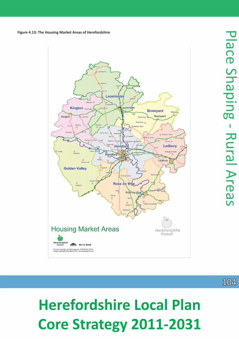
Figure 4.13: The Housing Market Areas of Herefordshire
Place Shaping - Rural Areas
104104
Herefordshire Local Plan Core Strategy 2011-2031
Plac
e Sh
apin
g - R
ural
Are
as
4.8.8 Housing development in rural areas will be delivered through Neighbourhood Development Plans, any required Rural Areas Site AllocaƟons Development Plan Document and a combinaƟon of exisƟng commitments and windfall development. The council’s Strategic Housing Land Availability Assessment indicates there is potenƟal for the level of development proposed in this policy.
4.8.9 Past rates of housing compleƟons in the rural areas suggest that this level of growth is appropriate and achievable. Historically it is evident that much rural housing has come forward on small sites, oŌ en for individual dwellings, being allowed through the applicaƟon of planning policy rather than the allocaƟon of housing sites. AddiƟ onally, significant numbers of new housing conƟnues to be delivered through the conversion of rural buildings, many being redundant agricultural buildings on farmsteads. Paragraph 48 of NPPF indicates that an allowance may be made for windfall if there is compelling evidence that such sites have consistently become available in the local area and will conƟnue to provide a reliable source. There is clear evidence over many years that such sites have delivered an important element of the county’s housing supply and as such a modest windfall allowance for rural areas has been included of 1000 dwellings (50 per annum).
4.8.10 The minimum rural HMA target represents a level of growth for parishes, as a percentage and which is proporƟonate to exisƟng HMA characterisƟcs.
4.8.11 The Rural Housing Background Paper (March 2013) sets out in its Appendix 2 the assessment of each rural HMA undertaken. The data will be subject to review during the plan period.
4.8.12 All seƩ lements idenƟfied in Figures 4.14 and 4.15 will have the opportunity for sensiƟve and appropriate housing growth. The primary focus for this housing will be in those seƩlements highlighted in Figure 4.14. In the remaining, typically smaller seƩlements of each HMA, as set out in Figure 4.15, parƟcular aƩenƟon will be given to ensure that housing developments should respect the scale, form, layout, character and seƫng of the seƩlement concerned. By virtue of their size and character many of these seƩlements do not have a tradiƟonal village or nuclear centre and in many cases have a dispersed seƩ lement paƩern which would need to be respected in the design of new housing proposals. This will ensure the delivery of schemes that are locally disƟncƟ ve.
Policy RA1 – Rural housing distribuƟon
In Herefordshire’s rural areas a minimum of 5,300 new dwellings will be provided between 2011 and 2031 to contribute to the county’s housing needs. The development of rural housing will contribute towards the wider regeneraƟon of the rural economy.
New dwellings will be broadly distributed across the county’s rural areas on the basis of seven Housing Markets Areas (HMA) as illustrated in Figure 4.13. This acknowledges that different areas of Herefordshire have different housing needs and requirements.
The 5,300 dwellings will be delivered throughout the rural HMAs as set out in the table below. The indicaƟve housing growth targets in each of the rural HMAs will be used as a basis for the producƟon of Neighbourhood Development Plans in the county. Local evidence and environmental factors will determine the appropriate scale of development.
105105
Herefordshire Local Plan Core Strategy 2011-2031
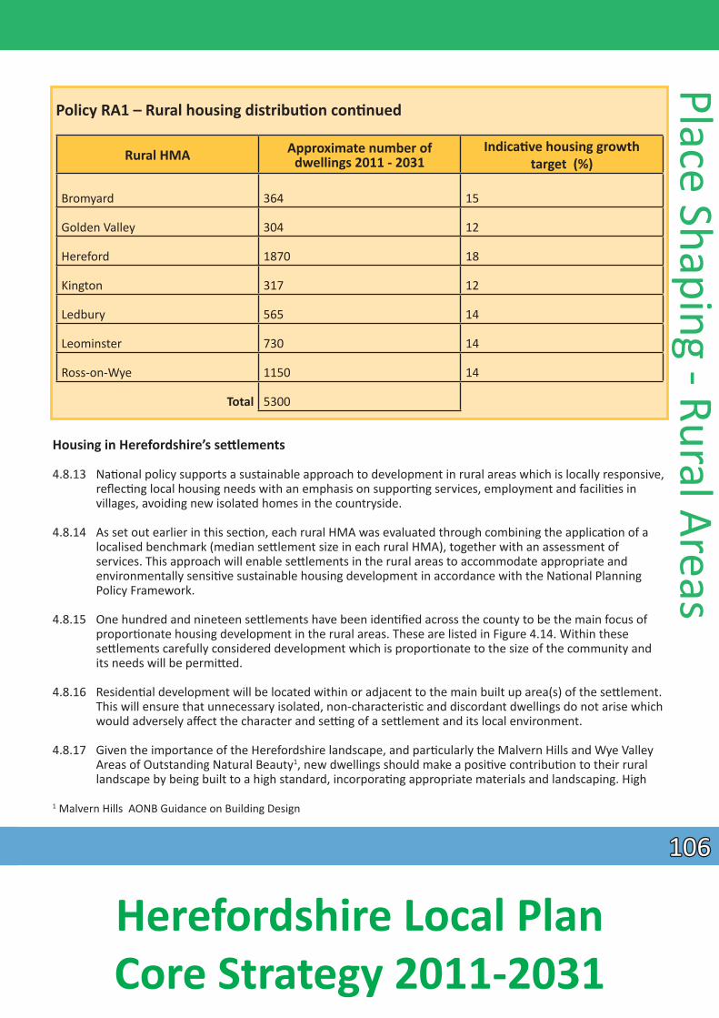
Policy RA1 – Rural housing distribuƟ on conƟnued
Bromyard 364 15
Golden Valley 304 12
Hereford 1870 18
Kington 317 12
Ledbury 565 14
Leominster 730 14
Ross-on-Wye 1150 14
Total 5300
Rural HMA Approximate number of dwellings 2011 - 2031
IndicaƟve housing growth target (%)
Housing in Herefordshire’s seƩ lements
4.8.13 NaƟonal policy supports a sustainable approach to development in rural areas which is locally responsive, reflecƟng local housing needs with an emphasis on supporƟng services, employment and faciliƟ es in villages, avoiding new isolated homes in the countryside.
4.8.14 As set out earlier in this secƟon, each rural HMA was evaluated through combining the applicaƟon of a localised benchmark (median seƩlement size in each rural HMA), together with an assessment of services. This approach will enable seƩlements in the rural areas to accommodate appropriate and
environmentally sensiƟve sustainable housing development in accordance with the NaƟ onal Planning Policy Framework.
4.8.15 One hundred and nineteen seƩlements have been idenƟfied across the county to be the main focus of proporƟonate housing development in the rural areas. These are listed in Figure 4.14. Within these
seƩlements carefully considered development which is proporƟonate to the size of the community and its needs will be permiƩed.
4.8.16 ResidenƟal development will be located within or adjacent to the main built up area(s) of the seƩ lement. This will ensure that unnecessary isolated, non-characterisƟc and discordant dwellings do not arise which would adversely affect the character and seƫng of a seƩlement and its local environment.
4.8.17 Given the importance of the Herefordshire landscape, and parƟcularly the Malvern Hills and Wye Valley Areas of Outstanding Natural Beauty1, new dwellings should make a posiƟ ve contribuƟon to their rural landscape by being built to a high standard, incorporaƟng appropriate materials and landscaping. High
1 Malvern Hills AONB Guidance on Building Design
Place Shaping - Rural Areas
106106
Herefordshire Local Plan Core Strategy 2011-2031
Plac
e Sh
apin
g - R
ural
Are
as
quality design that is sustainable and reinforces the locally disƟncƟve vernacular will be parƟcularly encouraged. InnovaƟve and/or contemporary design will also be supported where it is appropriate to its
context, it makes a posiƟ ve contribuƟon to the architectural character of the locality and achieves high levels of sustainability in terms of energy and water efficiency, as set out in Policy SD1. All residenƟal development proposals will need to consider the capacity of the drainage network in the area and the impact of future development on water quality in accordance with Policy SD4.
4.8.18 ResidenƟal development will be expected to contribute to the future housing needs of each HMA by providing an appropriate mix of dwelling types and sizes having regard to the Local Housing Market
Assessment and other relevant evidence sources. Developments should be sensiƟvely and inclusively designed to reflect the lifelong housing needs of the local community. They should also contribute, where appropriate, to the provision of infrastructure, affordable homes and improving community
cohesion.
4.8.19 Housing affordability is a significant issue in rural Herefordshire. This situaƟon is exacerbated by an exisƟng housing mix that is heavily skewed towards higher value properƟes, together with demand from
people moving to rural areas and restricted scope for new house building. As a result there is a need for market housing priced at a level that can be afforded by local people.
4.8.20 On this basis, housing proposals will be expected to reflect the range that is required for the seƩ lement concerned. In relaƟon to proposals that seek specifically to meet idenƟfied local housing needs, those proposed developments must be based on appropriate, compelling evidence of how the proposal meets that need. A planning obligaƟon will restrict the occupaƟon of dwellings on this basis to ensure their long term availability for those with local housing needs.
4.8.21 A proacƟve approach has been taken to neighbourhood planning within the county. At February 2015, there were 88 designated neighbourhood areas in the county and significant progress is being made in
the producƟon of Neighbourhood Development Plans. These plans will be the principal mechanism by which new rural housing will be allocated. The proporƟonal growth target within policy RA1 will provide the basis for the minimum level of new housing that will be accommodated in each Neighbourhood Development Plan. The target represents a level of growth for parishes, as a percentage, that is
proporƟonate to exisƟng HMA characterisƟcs. The main focus for development will be within or adjacent to exisƟ ng seƩlements indicated within fig 4.14 and 4.15. In parishes which have more than one
seƩlement listed in Figure 4.14 and 4.15 the relevant Neighbourhood Development Plan will have appropriate flexibility to apporƟon the minimum housing requirement between the seƩ lements
concerned. This will allow for a locally flexible approach that will respect seƩ lement characterisƟ cs, the distribuƟon of local faciliƟes and other local factors. This approach will accord with paragraph 55 of the
NPPF which indicates that where there are groups of smaller seƩlements in rural areas, the development in one locaƟon may support services in a locaƟon nearby. The adopƟon of this approach will allow disƟncƟ ve soluƟons which reflect the varied geographies in the county.
107107
Herefordshire Local Plan Core Strategy 2011-2031
Policy RA2 – Housing in seƩlements outside Hereford and the market towns.
To maintain and strengthen locally sustainable communiƟes across the rural parts of Herefordshire, sustainable housing growth will be supported in or adjacent to those seƩ lements idenƟfied in Figures 4.14 and 4.15. This will enable development that has the ability to bolster exisƟng service provision, improve faciliƟ es and infrastructure and meet the needs of the communiƟ es concerned.
The minimum growth target in each rural Housing Market Area will be used to inform the level of housing development to be delivered in the various seƩlements set out in Figures 4.14 and 4.15. Neighbourhood Development Plans will allocate land for new housing or otherwise demonstrate delivery to provide levels of housing to meet the various targets, by indicaƟng levels of suitable and available capacity.
Housing proposals will be permiƩed where the following criteria are met:
1. Their design and layout should reflect the size, role and funcƟon of each seƩlement and be located within or adjacent to the main built up area. In relaƟon to smaller seƩ lements idenƟfi ed in fi g 4.15 proposals will be expected to demonstrate parƟ cular aƩenƟon to the form, layout, character and seƫng of the site and its locaƟon in that seƩlement and/or they result in development that contributes to or is essenƟal to the social well-being of the seƩ lement concerned;
2. Their locaƟons make best and full use of suitable brownfield sites wherever possible; 3. They result in the development of high quality, sustainable schemes which are appropriate to their
context and make a posiƟ ve contribuƟon to the surrounding environment and its landscape seƫ ng; and 4. They result in the delivery of schemes that generate the size, type, tenure and range of housing that is
required in parƟ cular seƩ lements, reflecƟng local demand.
Specific proposals for the delivery of local need housing will be parƟcularly supported where they meet an idenƟfied need and their long-term retenƟon as local needs housing is secured as such.
Place Shaping - Rural Areas
108108
Herefordshire Local Plan Core Strategy 2011-2031
Figure 4.14: The seƩlements which will be the main focus of proporƟonate housing development
Plac
e Sh
apin
g - R
ural
Are
as
HMA Bromyard Golden Valley Kington Ledbury
Bodenham Bodenham Moor Bredenbury Bringsty Burley Gate Hope under Dinmore Linton Pencombe Risbury Stoke Cross/Stoke Lacy Stoke Prior Whitbourne
Bredwardine Cliff ord Cusop Dorstone Ewyas Harold Longtown Michaelchurch Escley Moccas Peterchurch Preston on Wye Vowchurch
Almeley Brilley Eardisley Lyonshall Norton Canon Pembridge Staunton on Wye Shobdon Titley Whitney on Wye Winforton
Ashperton Bishops Frome Bosbury Colwall Cradley Eastnor Fromes Hill Lower Eggleton/Newtown Putley Wellington Heath
Leominster Hereford Ross-on-Wye Adforton Bartestree/Lugwardine Bromsash Walford (Coughton) Bircher Bishopstone Brampton Abbots Whitchurch Brampton Bryan Burghill Bridstow Wilton Brimfield Canon Pyon Crow Hill Winnal Bush Bank Clehonger Garway Woolhope Dilwyn Credenhill Goodrich Wormbridge Eardisland Eaton Bishop Gorsley Wormelow Kimbolton Fownhope Hoarwithy Kingsland Hampton Bishop Kingstone Leintwardine Holme Lacy Kingsthorne Leysters LiƩ le Dewchurch Kings Caple Lingen Madley Lea Lucton Marden Linton Luston Mordiford LiƩ le Birch Monkland Moreton on Lugg Llangrove Orleton StreƩ on Sugwas Much Birch Richards Castle SuƩon St Nicholas Much Dewchurch Shirlheath Swainshill Much Marcle Weobley Tarrington Orcop Hill Wigmore Tillington Peterstow Yarpole Wellington
Westhope Withington
Pontrilas Pontshill St Weonards Weston-under-Penyard
109109
Herefordshire Local Plan Core Strategy 2011-2031
Figure 4.15: Other seƩlements where proporƟonate housing is appropriate.
Place Shaping - Rural Areas
HMA Bromyard Golden Valley Kington Ledbury
Docklow Edwyn Ralph Haƞield Munderfield Ocle Pychard Pudleston Steensbridge Ullingswick
Abbeydore Bacton Blakemere Lower Maes-coed Priory Wood Rowlestone Tyberton
Hergest Holme Marsh Kinnersley LeƩon Staunton on Arrow Woonton
Canon Frome Coddington Eggleton Mathon Monkhide Much Cowarne StreƩ on Grandison
Leominster Hereford Ross-on-Wye Ashton Aymestrey Brierley Cobnash Combe Moor Eyton Ivington Kinsham Leinthall Earls Leinthall Starkes LiƩ le Hereford Moreton MorƟ mers Cross Middleton on the Hill Stapleton Upper Hill Walford Wharton YaƩon
Burmarsh Breinton Byford Dinedor Dormington GraŌon Kings Pyon Ledgemoor LiƩ le Tarrington Litmarsh Mansel Lacy Moorhampton Munstone Pipe and Lyde Preston Wynne Priors Frome Ruckhall Shelwick Shucknall Stoke Edith Twyford Common Vauld Westhide Weston Beggard Withington Marsh Yazor
Aconbury Allensmore Aston Ingham Bishopswood Broad Oak Brockhampton Cobhall Common Didley Glewstone Harewood End Howle Hill Kilpeck Llancloudy Llangarron Llanwarne Much Birch/The Axe and Cleaver Orcop Rushall St Owens Cross Symonds Yat (West)
Three Ashes Thruxton Upton Crews Welsh Newton Common
110110
Herefordshire Local Plan Core Strategy 2011-2031
Plac
e Sh
apin
g - R
ural
Are
as
Housing in Herefordshire’s countryside
4.8.22 NaƟonal guidance emphasises the importance of not promoƟng unsustainable paƩerns of development in rural areas and avoiding the provision of new isolated homes.
4.8.23 Where appropriate, seƩlement boundaries (or a reasonable alternaƟve) for those seƩlements listed in Policy RA2 will be defined in either Neighbourhood Development Plans or the Rural Areas Sites
AllocaƟon DPD. In the period leading up to the definiƟon of appropriate seƩlement boundaries the Council will assess any applicaƟons for residenƟal developments in Figure 4.14 and 4.15 against their
relaƟonship to the main built up form of the seƩlement. Outside of these seƩlements new housing will be restricted to avoid unsustainable paƩerns of development. ResidenƟal development will therefore be limited to those proposals which meet the criteria listed in Policy RA3. Proposals should seek to make use
of exisƟng buildings through conversion and adapƟon in preference to new development. This approach accords with Paragraph 55 of the NPPF.
Policy RA3 – Herefordshire’s countryside
In rural locaƟons outside of seƩlements, as to be defined in either Neighbourhood Development Plans or the Rural Areas Sites AllocaƟons DPD, residenƟal development will be limited to proposals which saƟsfy one or more of the following criteria:
1. meets an agricultural or forestry need or other farm diversificaƟon enterprise for a worker to live permanently at or near their place of work and complies with Policy RA4; or
2. accompanies and is necessary to the establishment or growth of a rural enterprise, and complies with Policy RA4; or
3. involves the replacement of an exisƟng dwelling (with a lawful residenƟal use) that is comparable in size and scale with, and is located in the lawful domesƟ c curƟlage, of the exisƟng dwelling; or
4. would result in the sustainable re-use of a redundant or disused building(s) where it complies with Policy RA5 and leads to an enhancement of its immediate seƫ ng; or
5. is rural excepƟon housing in accordance with Policy H2; or 6. is of excepƟonal quality and innovaƟve design saƟsfying the design criteria set out in Paragraph 55 of
the NaƟonal Planning Policy Framework and achieves sustainable standards of design and construcƟon; or
7. is a site providing for the needs of gypsies or other travellers in accordance with Policy H4.
4.8.24 Occupancy controls will be applied to dwellings arising from the expansion of rural business enterprises, as well as to agricultural and forestry dwellings (Policy RA4) and will be secured from the start by a SecƟon 106 Agreement.
4.8.25 Replacement dwellings will only be permiƩed provided that the exisƟng building has established and conƟ nuing residenƟal use rights and has not been abandoned. Proposals should ordinarily be sited in a similar posiƟon as the original dwelling unless there is technical jusƟficaƟon to consider an alternaƟve locaƟon within the exisƟng lawful domesƟ c curƟlage. To safeguard the character and appearance of the
rural landscape from the visual impact of large buildings, the size of any replacement dwelling will be of a comparable total cubic volume (measured externally) to the exisƟng dwelling. To minimise the impact of the proposal on the surrounding area, the design of the dwelling and any associated development should respect the local character of the area and/or make a posiƟ ve contribuƟon to the rural landscape. As such the mass, scale, height and external appearance of the resultant development should be taken into
account. PermiƩed development rights may be removed from replacement dwellings.
111111
Herefordshire Local Plan Core Strategy 2011-2031
4.8.26 All residenƟal development proposals will need to take account of capacity of the drainage network in the area and the impact of future development on water quality in accordance with Policy SD4.
Rural enterprise dwellings in Herefordshire’s countryside
4.8.27 One of the few circumstances in which isolated residenƟal development in the countryside may be jusƟfied is when accommodaƟon is required to enable rural enterprise workers to live at, or in the immediate vicinity of, their place of work to provide essenƟal supervision and management. The need to make an excepƟon to the general policy approach to development in the countryside in order to meet the requirements of rural businesses has long been recognised and this approach to rural workers has been endorsed by the NaƟonal Planning Policy Framework (2012).
Policy RA4 – Agricultural, forestry and rural enterprise dwellings
Proposals for dwellings associated with agriculture, forestry and rural enterprises will be permiƩed where it can be demonstrated that there is a sustained essenƟ al funcƟonal need for the dwelling and it forms an essenƟal part of a financially sustainable business, and that such need cannot be met in exisƟ ng accommodaƟ on. Such dwellings should:
1. demonstrate that the accommodaƟon could not be provided in an exisƟ ng building(s); 2. be sited so as to meet the idenƟfi ed funcƟonal need within the unit or in relaƟon to other dwellings; and 3. be of a high quality, sustainable design which is appropriate to the context and makes a posiƟve
contribuƟon to the surrounding environment and rural landscape.
Where evidence of the economic sustainability of the rural enterprise is not proven or where an enterprise is not yet established, planning permission for temporary accommodaƟon may be granted for a maximum period of three years to enable the sustainability of the enterprise to be assessed. Successive extensions will not normally be granted. Temporary accommodaƟon should be carefully sited within the unit or in relaƟon to other dwellings.
Dwellings permiƩed in accordance with this policy will be subject to occupancy controls secured through a SecƟon 106 Agreement. In some situaƟons it will be appropriate to use legal agreements to Ɵe other dwellings to the unit and/or restrict the occupancy of other dwellings within the farm/business unit. ApplicaƟons for the removal of occupancy condiƟons (or secƟon 106 Agreements) will only be permiƩ ed where it can be demonstrated the dwelling is surplus to the current and sustained original business needs, as well as other rural enterprises in the locality and there has been a genuine and unsuccessful aƩempt to market the property at a realisƟc price (for rent or sale) which has been independently verified.
Place Shaping - Rural Areas
4.8.28 ApplicaƟons for planning permission for new dwellings advanced through this policy will be based on an accurate assessment of the needs of the rural enterprise. Rural enterprises comprise land related businesses including agriculture, forestry and other acƟviƟes that obtain their primary inputs from the site, such as the processing of agricultural, forestry and mineral products together with land
management acƟviƟes and support services, tourism and leisure enterprises. The sustainability of the business will be scruƟnised to ensure any essenƟal need established can be sustained so the criteria set out in Policy RA4 are not abused.
4.8.29 Therefore, in terms of agricultural or forestry dwellings it will be essenƟ al to firstly establish that stated intenƟons to engage in agriculture are soundly based, reasonably likely to materialise and capable of
being sustained for a reasonable period of Ɵme. Where proposals are advanced in associaƟ on with
112112
Herefordshire Local Plan Core Strategy 2011-2031
Plac
e Sh
apin
g - R
ural
Are
as
non-agricultural rural enterprises it should also be established that the business could not exist without close and conƟnual supervision, for example where a worker is required day and night for supervision, inspecƟon or emergency responses. Security is not of itself suffi cient to jusƟfy a dwelling but it may be a
contribuƟng factor in associaƟon with others.
4.8.30 All applicaƟons will be required to demonstrate that a dwelling at the enterprise is essenƟal by showing a funcƟonal need for the occupier to be present at the business for the majority of the Ɵme.
4.8.31 Where the economic sustainability of the rural enterprise is not proven or where an enterprise has not been established, planning permission for a caravan or other temporary accommodaƟon may be granted for a limited period. This is to enable the economic sustainability of the enterprise to be proven through the development of the business, including investment, planned on a sound financial basis. At the end of the temporary period a reassessment of the sustained essenƟ al funcƟonal needs of the business, together with the financial sustainability of the enterprise will be reviewed.
4.8.32 To avoid a proliferaƟon of dwellings in the countryside, occupancy controls will be secured through SecƟon 106 Agreements aƩached to dwellings advanced through this policy. Where a second dwelling is necessary for the essenƟal management of a rural enterprise, the council will restrict the occupaƟon/ separate sale of any exisƟng dwellings on the holding which are in the ownership or control of the applicant or their registered business/partners. Similarly, where appropriate, planning obligaƟons may be used to prevent the future separaƟon of a farmhouse(s) from any adjoining farm buildings and land. These measures may be taken to ensure that new proposals for addiƟonal dwellings do not allow exisƟng farm dwellings to be removed from the rural worker housing stock, protect the countryside against the pressure for new homes and to prevent the original jusƟficaƟon for the addiƟonal dwelling being undermined.
4.8.33 Where the need for a dwelling is established on the basis of proven essenƟal need, preference should be given to the use of suitable exisƟng buildings through conversion. Where this is not possible, any new development should relate closely to the acƟviƟes for which there is a need. In most cases this will mean that the new dwelling should be sited in close proximity to exisƟng buildings. Isolated locaƟ ons or
locaƟons that could encourage farm fragmentaƟon in the case of dwellings for agricultural enterprises should be avoided. The locaƟon and siƟng of temporary accommodaƟon will itself be considered on the basis of permanent accommodaƟon being provided. Where other development relaƟng to the enterprise is being proposed at the same Ɵme as part of an overall scheme, siƟng of all development will be considered on a comprehensive basis.
4.8.34 Where applicaƟons are made to remove occupancy condiƟons (or obligaƟons) on dwellings when an essenƟal on-site worker is no longer required, applicaƟons will be required to demonstrate that the
condiƟon is no longer appropriate. Accordingly applicants should demonstrate there is no funcƟ onal need and thus the dwelling is surplus to both the current and sustainable needs of the original rural enterprise, as well as other rural enterprises in the locality. Evidence should be provided that genuine aƩ empts have been made to market the property for sale or rent at a realisƟc price that reflects its occupancy restricƟon for a period of at least 12 months. The council will require the markeƟng price to be independently
verified by the District Valuer prior to the commencement of markeƟng.
Re-use of rural buildings
4.8.35 Policy RA5 recognises that the re-use of exisƟng rural buildings has an important role to play in promoƟng economic prosperity and sustainable development in rural areas. Such proposals can result in the creaƟon of local accessible jobs, the provision of premises for business start-ups and/or expansions, improving
113113
Herefordshire Local Plan Core Strategy 2011-2031
business networks and supporƟng farming through diversificaƟon schemes. The re-use of buildings can also provide environmental benefits by making use of exisƟng resources and at the same Ɵ me conserving buildings of heritage value.
Policy RA5 – Re-use of rural buildings
The sustainable re-use of individual and groups of redundant or disused buildings, including farmsteads in rural areas, which will make a posiƟ ve contribuƟon to rural businesses and enterprise and support the local economy (including live work units) or which otherwise contributes to residenƟal development, or is essenƟal to the social well-being of the countryside, will be permiƩ ed where:
1. design proposals respect the character and significance of any redundant or disused building and demonstrate that it represents the most viable opƟon for the long term conservaƟon and enhancement of any heritage asset affected, together with its seƫng;
2. design proposals make adequate provision for protected and priority species and associated habitats; 3. the proposal is compaƟble with neighbouring uses, including any conƟnued agricultural operaƟ ons and
does not cause undue environmental impacts and; 4. the buildings are of permanent and substanƟ al construcƟon capable of conversion without major or
complete reconstrucƟ on; and 5. the building is capable of accommodaƟng the proposed new use without the need for substanƟal
alteraƟon or extension, ancillary buildings, areas of hard standing or development which individually or taken together would adversely affect the character or appearance of the building or have a detrimental impact on its surroundings and landscape seƫng.
Any planning permissions granted pursuant to this policy will be subject to a condiƟon removing permiƩed development rights for future alteraƟons, extensions and other developments.
4.8.36 Redundant rural buildings in Herefordshire vary greatly in terms of scale, design and materials depending on their original use. Some are situated within villages, but the majority are located in the countryside. They may occasionally be single buildings but more commonly are grouped together in farmsteads or other clusters. Many are former agricultural buildings which are no longer required for their original purpose. Others may relate to diff erent acƟviƟes such as corn mills or other industrial buildings. Most of these buildings have heritage value and are referred to in the policy as ‘heritage assets.’
4.8.37 Policy RA5 is not intended to support the rebuilding of rural buildings which have fallen into a derelict state. At this point, their significance has usually been lost. Buildings should therefore be structurally sound and capable of bona fide conversion for the proposed use without major reconstrucƟon. A full structural survey may be required to demonstrate whether this is the case.
4.8.38 Many rural buildings, parƟcularly those previously used for agricultural purposes, provide valuable wildlife habitats including for legally protected species such as bats and barn owls. ApplicaƟ ons for planning permission for the re-use of these buildings will need to demonstrate that an appropriate wildlife survey has been carried out and will be required to make adequate provision for wildlife miƟgaƟon and enhancement measures within their design and seƫng. They must also demonstrate
appropriate species-protecƟon measures before, during and aŌer the conversion process.
4.8.39 Where required applicants will also be required to demonstrate that proposed uses respect the character of the buildings, are suitable for the rural environment, address sustainable transport issues and do not have a negaƟve impact on the amenity of local residents and environment and in terms of noise, light and
Place Shaping - Rural Areas
114114
Herefordshire Local Plan Core Strategy 2011-2031
Plac
e Sh
apin
g - R
ural
Are
as
air polluƟon. Detailed design requirements for proposals for the re-use of individual buildings and farmsteads must ensure that schemes respect the historic character and interest of the buildings, its
relaƟonship with other buildings and heritage assets, and its place in the wider landscape. Overall, schemes should keep new openings to a minimum; respect internal features and spaces; and avoid
introducing non-tradiƟonal features such as dormer windows, chimney stacks, porches or unsympatheƟc materials.
4.8.40 Redundant rural buildings may also provide good opportuniƟes for the development of live/ work units and these can potenƟally make a posiƟ ve contribuƟon to the rural economy. Therefore these will be encouraged in accordance with Policy E1 and the criteria of Policy RA5.
Rural economy
4.8.41 The rural areas have consistently played a strong role in local, regional and naƟonal food and drink producƟ on, parƟcularly in areas such as agriculture and farming. Other uses within the rural economy
consist of local businesses and services, village shops and public houses, tourism acƟviƟ es and accommodaƟon, home working businesses, military uses, as well as farm diversificaƟon enterprises. The
strengthening of the rural economy is also important in retaining a skilled labour force. In order to allow the rural economy to grow the following policy provides flexibility for start-ups and conƟnuaƟ on of business enterprises, business diversificaƟon and home working. It also embraces new technologies and methods to allow the rural economy to prosper.
Policy RA6 - Rural economy
Employment generaƟng proposals which help diversify the rural economy such as knowledge based creaƟve industries, environmental technologies, business diversificaƟon projects and home working will be supported. A range of economic acƟviƟes will be supported, including proposals which:
• support and strengthen local food and drink producƟon; • support and/or protect the vitality and viability of commercial faciliƟes of an appropriate type and scale
in rural areas, such as village shops, petrol fi lling staƟons, garden centres and public houses; • involve the small scale extension of exisƟ ng businesses; • promote sustainable tourism proposals of an appropriate scale in accordance with Policy E4 - Tourism; • promote the sustainable use of the natural and historic environment as an asset which is valued, con
served and enhanced; • support the retenƟon of exisƟng military sites; • support the retenƟon and/ or diversificaƟon of exisƟng agricultural businesses;
Planning applicaƟons which are submiƩed in order to diversify the rural economy will be permiƩed where they:
• ensure that the development is of a scale which would be commensurate with its locaƟon and seƫng; • do not cause unacceptable adverse impacts to the amenity of nearby residents by virtue of design and
mass, noise, dust, lighƟng and smell; • do not generate traffic movements that cannot safely be accommodated within the local road network;
and • do not undermine the achievement of water quality targets in accordance with Policies SD3 and SD4.
115115
Herefordshire Local Plan Core Strategy 2011-2031
4.8.42 The rural economy will be strengthened by providing flexibility for new and expanding rural businesses. Policy RA6 sets out a range of criƟeria that will need to be met to ensure that resulƟng developments are of an appropriate scale and locaƟon and do not significantly impact upon the environmental quality of
the area.
4.8.43 The Wye Valley AONB and the Malvern Hills AONB are recognised by the NaƟonal Planning Policy Framework as areas where development should be restricted. Guidance on proposed developments in AONBs is set out in Paragraph 116 of the NPPF. Policy LD1 of this plan also sets out guidance on how development proposals should seek to safeguard the character and appearance of these areas.
4.8.44 Tourism plays a role within the rural economy. The varied tourism faciliƟes enable exisƟng farms and rural businesses to diversify as well as accommodaƟng the needs of visitors.
4.8.45 Isolated employment sites may be appropriate for small extensions and/or redevelopment. A jusƟficaƟon should be provided to demonstrate the need for these addiƟons. Proposed developments will need to take into account other relevant policies within this plan.
Delivery and monitoring of the Place Shaping Policies
4.8.46 These policies will be delivered by:
• the Infrastructure Development Plan and developer contribuƟons/Community Infrastructure Levy • the development management process • Hereford Area Plan, Bromyard Development Plan, Neighbourhood Development Plans, other
Development Plan Documents as appropriate and Supplementary Planning Documents.
4.8.47 In addiƟon to the indicators listed in the SpaƟal Strategy and General Policies’ secƟons, the following indictors will be used to measure the effecƟveness of the policies:
• uƟlising the AMR to develop an indicator of housing compleƟons by HMAs and rural HMAs.
Place Shaping - Rural Areas
116116
Herefordshire Local Plan Core Strategy 2011-2031
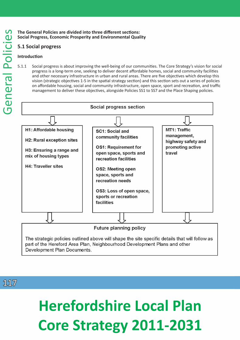
Gene
ral P
olic
ies The General Policies are divided into three diff erent secƟons:
Social Progress, Economic Prosperity and Environmental Quality
5.1 Social progress
IntroducƟon
5.1.1 Social progress is about improving the well-being of our communiƟes. The Core Strategy’s vision for social progress is a long-term one, seeking to deliver decent affordable homes, social and community faciliƟes and other necessary infrastructure in urban and rural areas. There are fi ve objecƟves which develop this vision (strategic objecƟves 1-5 in the spaƟal strategy secƟon) and this secƟon sets out a series of policies
on affordable housing, social and community infrastructure, open space, sport and recreaƟon, and traffic management to deliver these objecƟves, alongside Policies SS1 to SS7 and the Place Shaping policies.
117117
Herefordshire Local Plan Core Strategy 2011-2031
Aff ordable housing
5.1.2 There is a significant need for affordable housing within Herefordshire and the planning system can assist the delivery of affordable homes. Policy H1 establishes affordable housing targets whilst specifi c place based policies in SecƟon 4 of this document set out targets for individual strategic housing developments.
5.1.3 Within the county, the need for affordable housing has been invesƟgated through the Strategic Housing Market Assessment 2008 (SHMA) which introduced the broad housing needs of the county. A Local Housing Market Assessment (LHMA) was completed in 2011 and updated in 2013, which draws on and develops the SHMA to provide a local assessment of housing requirements for the seven local housing markets across Herefordshire. In addiƟon to the LHMA, parish level housing needs surveys are undertaken to idenƟfy needs at a very local level, to support the development of affordable housing. The need for affordable homes across the county is significantly high, but the viability of delivering aff ordable homes over the plan period has been recognised in order to provide an achievable target in the Core
Strategy.
5.1.4 Affordable housing is housing provided to eligible households whose needs are not met by the open market. It encompasses housing provided at below market prices and allocated on the basis of need, to people who are unable to purchase or rent houses available generally on the open market without financial assistance. Eligibility is determined with regard to local incomes and local house prices.
5.1.5 Affordable housing can include a range of rented and home ownership housing opƟons which meet local housing need. By seeking to provide a range of housing opƟons, the council can help to address the needs of those seeking to gain a first step on the property ladder, reduce the demand for social rented housing, free up exisƟng social rented homes, provide wider choice for households and ensure that sites have a mix of tenures.
5.1.6 The NaƟonal Planning Policy Framework divides affordable housing into three categories:
• social rented for which guideline target rents are determined through the naƟonal rent regime; • affordable rented housing subject to rent controls that require no more than 80% of the local
market rent; and • intermediate homes for sale and rent, provided at a cost above social rent but below market levels.
5.1.7 Affordable housing under these definiƟons can include both individual and mulƟple dwellings, those constructed under self-build projects funded by registered providers or community housing groups as well as individual projects providing low cost housing that does not exceed affordable levels – as defined in the council published ‘Provision of Affordable Housing Technical Data.’ In such cases planning
condiƟons will be imposed to ensure that housing is retained in perpetuity for future local housing needs.
5.1.8 Housing provided under these categories whether for rent or sale must be made available at a price level that can be sustained by local people in housing need. It is important to emphasise the disƟncƟons between the roles of the different categories of affordable housing and not to treat one as a subsƟ tute for the other. It is important to set criteria idenƟfying what consƟtutes local housing need. This is in order that proposals for addiƟonal dwellings coming forward can be clearly shown to be contribuƟng to this requirement – and thus to the aim of sustaining urban and rural communiƟes.
General Policies
118118
Herefordshire Local Plan Core Strategy 2011-2031
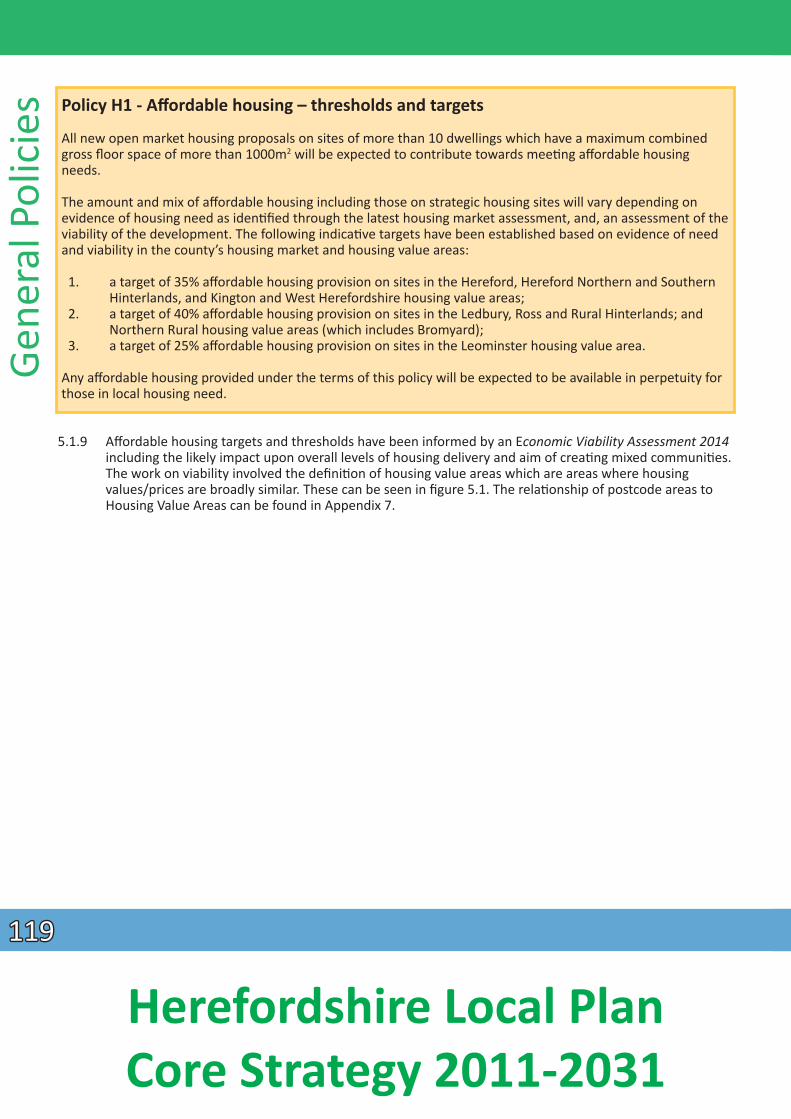
Gene
ral P
olic
ies
Policy H1 - Affordable housing – thresholds and targets
All new open market housing proposals on sites of more than 10 dwellings which have a maximum combined gross floor space of more than 1000m2 will be expected to contribute towards meeƟ ng aff ordable housing needs.
The amount and mix of affordable housing including those on strategic housing sites will vary depending on evidence of housing need as idenƟfied through the latest housing market assessment, and, an assessment of the viability of the development. The following indicaƟve targets have been established based on evidence of need and viability in the county’s housing market and housing value areas:
1. a target of 35% affordable housing provision on sites in the Hereford, Hereford Northern and Southern Hinterlands, and Kington and West Herefordshire housing value areas;
2. a target of 40% affordable housing provision on sites in the Ledbury, Ross and Rural Hinterlands; and Northern Rural housing value areas (which includes Bromyard);
3. a target of 25% affordable housing provision on sites in the Leominster housing value area.
Any affordable housing provided under the terms of this policy will be expected to be available in perpetuity for those in local housing need.
5.1.9 Affordable housing targets and thresholds have been informed by an Economic Viability Assessment 2014 including the likely impact upon overall levels of housing delivery and aim of creaƟng mixed communiƟes. The work on viability involved the definiƟon of housing value areas which are areas where housing values/prices are broadly similar. These can be seen in figure 5.1. The relaƟonship of postcode areas to Housing Value Areas can be found in Appendix 7.
119119
Herefordshire Local Plan Core Strategy 2011-2031
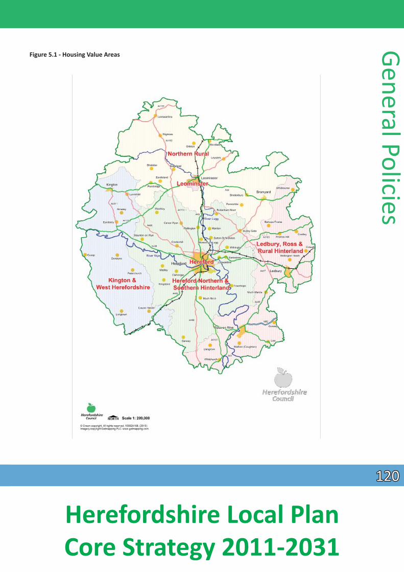
Figure 5.1 - Housing Value Areas
General Policies
120120
Herefordshire Local Plan Core Strategy 2011-2031
Gene
ral P
olic
ies 5.1.10 The findings of the Local Housing Market Assessment 2013 (LHMA) have also been taken into account so
that the resultant policies on affordable housing are locally relevant and viable. The supporƟ ng evidence will be maintained by updaƟng the housing market assessment work and viability and housing value areas on a three yearly basis.
5.1.11 The LHMA indicates that there remains a significant need for social housing across the county. However the viability of housing schemes also has to be taken into account in determining both the required percentage and an appropriate mix of tenures of affordable housing. Overall target percentages have been established for different parts of the county and are set out in Policy H1. In locaƟ ons where achieving high levels of social rented housing would impact upon the viability of new housing schemes, increasing the percentage of intermediate housing will be considered where the overall aff ordable housing target can be maintained. Evidence to jusƟfy this would need to be demonstrated as part of the
consideraƟon of a development proposal.
5.1.12 A supplementary Planning Document will provide addiƟonal guidance and set out the details of how the affordable housing policies will be implemented. The guidance will include:
• advice regarding the need for aff ordable housing; • affordable house prices and rents in Herefordshire; • the negoƟaƟ on process;
• securing affordable housing and controlling occupancy; and • contribuƟons to off -site provision.
5.1.13 There is a need to ensure that planning policy provides for a mix of affordable housing to refl ect differing household needs and future demographic trends. There are a number of intermediate housing products, including shared ownership, which is likely to be parƟcularly appealing to would-be fi rst-Ɵme buyers who do not have sufficient funds to access the open market.
5.1.14 The council recognises that the provision of affordable housing is more diffi cult in rural areas where oŌen the scale and locaƟon of new development is more restricted. Policy H2 enables the provision of affordable housing outside of villages, in areas where there is generally a restraint on open market housing, so as to help meet affordable housing needs in rural areas in perpetuity.
Policy H2 - Rural excepƟ on sites
Proposals for affordable housing schemes in rural areas may be permiƩed on land which would not normally be released for housing where:
1. the proposal could assist in meeƟng a proven local need for affordable housing; and 2. the affordable housing provided is made available to, and retained in perpetuity for local people in need
of affordable housing; and 3. the site respects the characterisƟcs of its surroundings, demonstrates good design and off ers reasonable
access to a range of services and faciliƟes normally in a seƩ lement idenƟfied in Policy RA2.
In order to enable the delivery of affordable housing some market housing may be permiƩed as part of the development to subsidise a signifi cant proporƟon of affordable housing provision. However, evidence will be required – by way of a financial appraisal, in order to demonstrate that the proposed scale of market housing is that required for the successful delivery of aff ordable housing.
121121
Herefordshire Local Plan Core Strategy 2011-2031
5.1.15 Rural excepƟon schemes need to take full account of environmental consideraƟons including design, siƟng and materials and avoid sensiƟ ve locaƟons where development would not be permiƩ ed for reasons of landscape or visual impact. Similarly a site’s locaƟon should not place addiƟonal financial burdens upon households occupying the scheme such as through isolaƟon or increased costs in gaining access to local services and faciliƟes, for example schools and employment. Given that these schemes may be located in or around small villages, the scale of development should reflect the locality.
5.1.16 NaƟonal planning policy indicates that consideraƟon should be given to whether allowing some market housing on excepƟon sites would facilitate the provision of signifi cant addiƟ onal affordable housing to meet local needs. Open market housing should be limited to an absolute minimum in such schemes and only in order to make the scheme viable. The preparaƟon of Neighbourhood Development Plans and/or other Development Plan Documents will also provide an opportunity to idenƟfy sites for aff ordable housing.
Range and mix of housing
5.1.17 There is a clear need to provide for balanced and sustainable communiƟes in Herefordshire. Housing affordability issues in the county are compounded by the housing offer, with a high proporƟ on of detached housing and properƟes in higher council tax bands. The supply of properƟes which younger households might be able to afford to buy is limited; only 13.5% of housing is in social sector ownership (affordable) compared to 19.5% across the West Midlands.
General Policies Policy H3 – Ensuring an appropriate range and mix of housing
ResidenƟal developments should provide a range and mix of housing units which can contribute to the creaƟon of balanced and inclusive communiƟes. In parƟcular, on larger housing sites of more than 50 dwellings developers will be expected to:
1. provide a range of house types and sizes to meet the needs of all households, including younger single people;
2. provide housing capable of being adapted for people in the community with addiƟonal needs; and 3. provide housing capable of meeƟng the specific needs of the elderly populaƟ on by:
- providing specialist accommodaƟon for older people in suitable locaƟons; - ensuring that non-specialist new housing is built to take account of the changing needs of an ageing
populaƟon; - ensuring that developments contain a range of house types, including where appropriate, bungalow
accommodaƟon.
The latest Local Housing Market Assessment will provide evidence of the need for an appropriate mix and range of housing types and sizes.
5.1.18 The Local Housing Market Assessment 2013 (LHMA) recommends that planning policies are not overly prescripƟve with regard to requiring a specific mix of housing sites. Specific policies for the strategic sites
refer to meeƟng needs idenƟfied in the LHMA. The range of house types provided across the county will be monitored to ensure an appropriate mix of housing is provided, however it is recognised that meeƟng specialist needs is more likely to be achievable on sites of 50 dwellings and above.
5.1.19 The Herefordshire Older People’s Survey 2012 outlined that there is an increasing requirement for new housing to cater for older people. Addressing this need will be met through a combinaƟon of measures
122122
Herefordshire Local Plan Core Strategy 2011-2031
Gene
ral P
olic
ies including the provision of specialist accommodaƟon in locaƟons where the principle of residenƟal
development is accepted; and by ensuring that general housing provision is designed in such a way that enables easy adaptaƟon to meet the requirements of all households.
Traveller sites
5.1.20 It is important that the accommodaƟon needs and requirements of all secƟons of the community are considered in developing planning policies. Government planning policy is increasingly favouring the idenƟficaƟon of sites for travellers. Herefordshire Council recognises these requirements which will be taken forward in the preparaƟon of a new Travellers’ Sites Document. In the interim however, the following policy is required in order to consider the merits of planning proposals.
5.1.21 For the purposes of this policy the definiƟon of “travellers” means “gypsies and travellers” and “travelling show people” as defined in Planning Policy for Traveller Sites, CLG 2015.
Policy H4 – Traveller sites
The accommodaƟon needs of travellers will be provided for through the preparaƟon of a Travellers’ Sites Document (DPD) which will include site specifi c allocaƟons.
In the absence of an adopted DPD, or where proposals for sites are brought forward on non-allocated land, proposals will be supported where:
1. sites afford reasonable access to services and faciliƟes, including health and schools 2. appropriate screening and landscaping is included within the proposal to protect local amenity and the
environment 3. they promote peaceful and integrated co-existence between the site and the local community 4. they enable mixed business and residenƟ al accommodaƟon (providing for the live-work lifestyle of
travellers) 5. they avoid undue pressure on local infrastructure and services
6. in rural areas, the size of the site does not dominate nearby seƩ led communiƟ es and 7. they are capable of accommodaƟng on-site faciliƟes that meet best pracƟce for modern traveller site
requirements, including play areas, storage, provision for recycling and waste management.
In rural areas, where there is a case of local need for an affordable traveller site, but criterion 1 above cannot be fulfilled, then an excepƟon may be made and proposals permiƩed, provided such sites can be retained for that purpose in perpetuity.
5.1.22 The approach to planning for travellers through the preparaƟon of a Travellers’ Sites Document will reflect the increased involvement of traveller and seƩ led communiƟes in determining the locaƟ on of development. Traveller sites include those considered necessary to meet the residenƟal needs of gypsies and travellers who will remain in a locaƟon permanently or for substanƟal periods, transit sites for those moving through the area as well as plots for travelling show people.
5.1.23 The Travellers’ Sites Document, which is programmed in the Council’s Local Development Scheme (2015), for adopƟon in spring 2016, will include the following:
• an assessment of current need for permanent residenƟal pitches with an indicaƟon of the process for updaƟng need on a regular basis;
123123
Herefordshire Local Plan Core Strategy 2011-2031
• pitch targets for travellers; • deliverable sites for residenƟal pitches for the period 2014-19 to set against targets; • idenƟficaƟon of broad locaƟons for further developable residenƟal sites for travellers over the
period 2019-2031;• idenƟficaƟon of need for, and approach to, the provision of transit sites for the plan period; • consideraƟon of the need for, and approach to, provision for travelling showpersons within the
county for the plan period; • consideraƟon of the need for a rural excepƟons policy to enable sites to be brought forward solely
as affordable gypsy and traveller sites; and • consideraƟon of support for the authorisaƟon of long-term unofficial sites where they meet the
criteria in policy H4 above or the making available of alternaƟve provision where they are lost for whatever reason.
5.1.24 A pitch is defined as the ’area of land on a gypsy and traveller caravan site developed for a single family.’ A plot means a pitch on a “travelling showpeople” site (oŌen called a “yard”). This terminology diff erenƟates between residenƟal pitches for “gypsies and travellers” and mixed-use plots for “travelling showpeople”, which may/will need to incorporate space or to be split to allow for the storage of
equipment.
5.1.25 As at January 2015*, there are 114 authorised residenƟal pitches within Herefordshire with a further 21 pitches on unauthorised, but tolerated sites. Numbers of caravans on these sites have fluctuated over the past two years from 148 to 161 and averaging 157. Some pitches accommodate more than one caravan.
* Caravan count conducted by Herefordshire Council (January 2015)
5.1.26 The private sector may need to provide for further residenƟal site needs unƟl the Travellers’ Sites Document is adopted in 2016 and policy H4 sets out the basis upon which planning permission will be granted during this period. The criteria in this policy may also apply when the defined need for residenƟal gypsy and traveller sites has been met, yet further need is accepted.
5.1.27 In the same way that a rural excepƟon policy is applied to housing development, rural excepƟ on sites can also be applied to affordable traveller sites and the Travellers’ Sites Document will consider this issue. A rural excepƟon site policy enables small sites to be used, specifically for affordable traveller sites in perpetuity, in small rural communiƟes, that would not normally be used for traveller sites.
5.1.28 The assessment of need for transit sites or plots for travelling show people will be reviewed as part of the work for the Travellers’ Sites Document. Should any need arise in the interim; proposals will need to
saƟsfy the criteria set out in Policy H4.
5.1.29 In bringing proposals forward it will be important to ensure that sites are appropriately landscaped in order to limit their visual impact and should provide access to local faciliƟes and services such as shops, schools and healthcare. It is also important to recognise that provision is included to meet the live-work nature of gypsies and travellers and adequate provision is made for play space for children.
Social and community faciliƟes
5.1.30 The Core Strategy aims to achieve sustainable communiƟes across Herefordshire and improve the well-being of its people. This requires an effecƟve balance between the provision of new housing and employment and providing the social and community faciliƟes required to support growth. There is a need to support and seek improvements to local services and faciliƟ es; parƟcularly in rural areas where
General Policies
124124
Herefordshire Local Plan Core Strategy 2011-2031
Gene
ral P
olic
ies faciliƟes have been in decline since the post-war period. Less prosperous groups in remote rural areas are
arguably in a worse posiƟon than similar income groups in towns, because their access to services, employment, leisure and shopping faciliƟes is severely limited. For people living in the rural areas, access
to essenƟ al faciliƟes and services depends on access to a car or living close to a public transport route.
5.1.31 The lack of local services and faciliƟes in rural areas and their increasing concentraƟon in the towns has been idenƟfied as a key issue in Herefordshire. Included within the ambiƟons of the Herefordshire
Community Strategy, are the retenƟon and improvement of services and faciliƟes and the provision of excellent training and learning opportuniƟes - for people of all ages within the county.
5.1.32 Social and community faciliƟes can be defined as physical faciliƟes for different individuals and communiƟes, which are provided by a range of organisaƟons (public, private and voluntary). They provide
for the health, welfare, social, educaƟonal, spiritual, recreaƟonal, leisure and cultural needs of the community. These faciliƟes play an important role in the development of a vibrant community by creaƟng a sense of place and providing a place for people to meet and interact socially. They also off er services that are essenƟal for educaƟon, health and well-being; and support community cohesion and benefi t the general quality of life of residents.
5.1.33 Social and community faciliƟes can include: public services, community centres and public halls, arts and cultural faciliƟes including theatres, public art and heritage centres; policing and criminal jusƟce faciliƟes, fire and ambulance services, health and educaƟ on faciliƟes including GP surgeries and NHS
walk-in centres; public houses, local shops, public toilets, youth centres, social care faciliƟes including day centres and child care faciliƟes; places of worship, and services provided by the community and voluntary sector - for example scout and guide premises.
Policy SC1 – Social and community faciliƟes
Development proposals which protect, retain or enhance exisƟng social and community infrastructure or ensure that new faciliƟes are available as locally as possible will be supported. Such proposals should be in or close to seƩlements, have considered the potenƟal for co-locaƟon of faciliƟes and where possible be safely accessible by foot, by cycle and public transport.
New development that creates a need for addiƟonal social and community faciliƟes that cannot be met through exisƟng social faciliƟes - will be expected to meet the addiƟonal requirements through new, or extension of exisƟng, provision or by developer contribuƟons which meet the relevant tests of paragraph 204 of the NPPF .
Proposals involving the provision or expansion of social and community faciliƟes will be expected to provide publicly accessible toilets (including faciliƟes for disabled people and baby changing).
ExisƟ ng faciliƟes will be retained, unless it can be demonstrated that an appropriate alternaƟve facility is available, or can be provided to meet the needs of the community affected; or it can be shown that the facility is no longer required, viable or is no longer fit for purpose; and where appropriate, it has been vacant and marketed for community use without success. Viable alternaƟ ve faciliƟes must be equivalent to those they replace, in terms of size, quality and accessibility.
The provision or improvement of higher educaƟ on faciliƟes and the conƟnuing enhancement of exisƟ ng, or provision of new, training and skills faciliƟes will be acƟ vely promoted.
125125
Herefordshire Local Plan Core Strategy 2011-2031
5.1.34 PopulaƟon growth will generate a range of service needs throughout Herefordshire, parƟcularly concentrated within the major growth locaƟons, and it is essenƟal that these service needs are supported by appropriate levels of social and community infrastructure. This should come forward either as an integral part of the development (adaptable, mixed use and made available at an early stage), or by way of a developer contribuƟon/Community Infrastructure Levy monies which meet the relevant tests of paragraph 204 of the NPPF.
5.1.35 Notwithstanding the diverse spaƟal requirements of local clubs, socieƟes and faith communiƟ es, the council is moving towards the co-locaƟon of community premises such as meeƟng halls, places of worship and schools - for example, a mix of community uses/resources at one locaƟon to encourage effi cient use of space and integrated provision to meet the needs of all sectors of our community. The council recognises however, that whilst shared space will be a suitable way forward for some, there are many who require their own space for acƟviƟes, including worship and teaching.
Loss of exisƟ ng faciliƟes
5.1.36 Local retail premises, village halls, churches and public houses, parƟcularly in the rural areas are oŌen at the heart of the community and provide a place for the local community to meet, to use funcƟon rooms, to socialise and to fulfil the day to day convenience needs of the local community. In some
locaƟons it is becoming increasingly difficult to retain services, shops and public houses; however it is essenƟal that support is given to enable businesses to conƟnue to serve the local community. In such
cases, flexibility should be given to enable local shops, services or public houses to diversify into ancillary retail and tourism opportuniƟes or community ownership through the ‘Community Right to Bid’ process. This flexibility may enable the business to conƟnue to serve the local community. Where a business is shown to be no longer viable, the fi rst alternaƟve should be to invesƟgate whether an alternaƟve community use is possible. In order to demonstrate that alternaƟve community uses have been considered, evidence of markeƟng for a period of at least 12 months should be provided with any proposals involving the loss of community faciliƟes.
EducaƟon and skills
5.1.37 Some of the main socio-economic outcomes of the Sustainable Community Strategy are to improve educaƟ onal aƩainment, increase the number of young people entering educaƟon or training at 16 and
create a highly skilled workforce. These are also wider regeneraƟ on objecƟves of various agencies and important components of delivering the economic vision for Herefordshire. The council is therefore exploring the potenƟal for a university gateway at Hereford in order to provide opportuniƟes for local people to access jobs in growth sectors, including green technologies and help the city become a magnet for businesses in knowledge intensive industries. In doing so, the skills of the current labour market will be improved and the knowledge and research infrastructure aligned with parƟ cular growth sectors of the economy.
Culture
5.1.38 The council also acknowledges the contribuƟon that culture can make to the economy. Culture is fundamental to the character of Herefordshire, with naƟonal and local research showing that it is important to people, and has the potenƟal to make us happier and healthier; as well as providing opportuniƟes for social interacƟon and learning. However, the rural nature of Herefordshire, with its
dispersed communiƟes and limited public transport, means that access to cultural faciliƟes can be difficult. One of the aims of Herefordshire’s Cultural Strategy 2008-18 is to facilitate easy and aff ordable access to high quality cultural acƟviƟes and faciliƟes for all.
General Policies
126126
Herefordshire Local Plan Core Strategy 2011-2031
Gene
ral P
olic
ies Reducing the need to travel
5.1.39 The provision of community faciliƟes in local areas across the county will ensure beƩer access for people, which in turn reduces the need to travel; while the co-locaƟon of some faciliƟes and services will help to ensure the effecƟve use of resources, and encourage joined-up service delivery and shared maintenance and management costs. In this respect, the council aims to support the delivery of new services and faciliƟes, through partnership working with service providers and the local community; and through development opportuniƟes that arise from local authority and private sector regeneraƟon projects. Furthermore, the council is working with local communiƟes to develop Neighbourhood Development Plans, to ensure that community needs and prioriƟes are matched to the services that are offered in their local areas.
Provision of public toilets
5.1.40 A lack of toilet faciliƟes can have an impact on the lives of older people, parents and carers with young children, disabled people and people with chronic health problems; by prevenƟng or restricƟ ng their opportuniƟes to take part in everyday acƟviƟes like shopping and leisure pursuits. The council is developing a community toilet scheme to enable local businesses like pubs, restaurants and shops, to work together with the council to make more clean, safe and accessible toilets available to the public.
Co-locaƟon of services and faciliƟes
5.1.41 Co-locaƟng public and community services in shared buildings or on shared sites provides a number of benefits for both the community, as users of the services and for the council and its partners, as providers of services. The populaƟon of Herefordshire is forecast to conƟnue to grow, with an ageing populaƟon structure and this will put increasing pressure on exisƟng services. At the same Ɵme, the current economic climate and compeƟng demands for space and resources means that a diff erent approach
towards locaƟng services and faciliƟes may be needed, especially if we want to ensure that infrastructure is provided in the most sustainable and accessible locaƟons in the county. In pracƟce this could mean linking nurseries, schools and colleges; widening the range of health and social care services available at health centres, or by providing educaƟon, training or IT services in libraries.
Open space, sports and recreaƟon
5.1.42 Open space, sports and recreaƟ on faciliƟes are an essenƟal part of sustainable communiƟes. They need to stand the test of Ɵme, be where people want to live, and enable people to meet their sporƟ ng and
recreaƟ onal aspiraƟons and potenƟal. Planning policies for open space, sport and recreaƟon are fundamental to delivering the broader objecƟves of achieving:
• networks of accessible, high quality open spaces and sport and recreaƟ on faciliƟes in both urban and rural areas, which meet the needs of residents and visitors, are fit for purpose and are economically and environmentally sustainable;
• an appropriate balance between new provision and the enhancement of exisƟng provision; and • reasonable certainty for developers and land owners in relaƟon to the requirements and
expectaƟons of local planning authoriƟes in respect of open space, sport and recreaƟ on provision.
5.1.43 Herefordshire is fortunate to have a broad range of open space, sports and recreaƟ on faciliƟes which are both in public and private ownership. Open space, sports and recreaƟon typology definiƟons include (but are not limited to) formal and informal parks and gardens, school sports grounds, public rights of way,
127127
Herefordshire Local Plan Core Strategy 2011-2031
allotments, semi-natural areas (including orchards), sports playing fields, cemeteries and churchyards, amenity areas, indoor sports halls, children’s play faciliƟes, village halls, civic spaces, country parks, green infrastructure corridors and canals.
5.1.44 Unfortunately, not all communiƟes within Herefordshire are sufficiently catered for in terms of quanƟ ty, quality and accessibility of open space; so it is essenƟal that new developments within the county meet the needs of new communiƟes as well as protect and enhance exisƟ ng faciliƟes which are valued by
exisƟ ng communiƟes.
Policy OS1 - Requirement for open space, sports and recreaƟ on faciliƟes
The provision of appropriate open space, sports and recreaƟ on faciliƟes will arise in the following proposals for planning applicaƟons:
1. all new residenƟal dwellings; or 2. retail and employment proposals where there is need to provide informal areas of amenity greenspace
for the use of employees and visitors; and 3. residenƟ al insƟtuƟons, student accommodaƟon, assembly and leisure, hotels or hostels.
5.1.45 The need for open space, sports and recreaƟ onal faciliƟes will be considered on a site by site basis. Open space, sports and recreaƟ on faciliƟes will need to be placed on site and be integral to the funcƟ oning of the development. Off -site contribuƟons will be sought, where appropriate, on an equally benefi cial basis for the local community and will include provision for appropriate maintenance (as defined by the local planning authority) of the open space, sports or recreaƟ on facility.
5.1.46 For employment and/or retail proposals, formal open space, sports and recreaƟ on faciliƟ es (see Glossary) will not be required. However appropriate informal areas of amenity greenspace may be required for the use of employees and visitors for breaks, and will be assessed on a site by site basis. If there is a nearby open space within safe walking distance which would cater for the needs of the employees, a contribuƟon of the equivalent cost of providing the on-site area as idenƟfied above to
improve exisƟ ng off-site provision, may also be considered. Users of residenƟ al insƟtuƟons e.g. care homes will also require the provision of on-site amenity greenspace, parƟcularly where the facility hosts families and children. For residenƟ al accommodaƟon providing for the needs of people with severe mobility impairments, a reducƟon of required provision will need to be provided (on a pro-rata basis) according to the needs of the residents using the accommodaƟon.
General Policies
Policy OS2 – MeeƟng open space, sports and recreaƟ on needs
In order to meet the needs of the community, provision for open space, sports and recreaƟ on faciliƟes will be sought, where appropriate, taking into account the following principles:
1. any new development must be in accordance with all applicable set standards of quanƟty, quality and accessibility as defi ned; and
2. provision of open space, sports and recreaƟ on faciliƟes should be located on-site unless an off -site or parƟ al off -site contribuƟon would result in an equally beneficial enhancement to an exisƟng open space, sports and/or recreaƟon facility which is of benefit to the local community.
128128
Herefordshire Local Plan Core Strategy 2011-2031
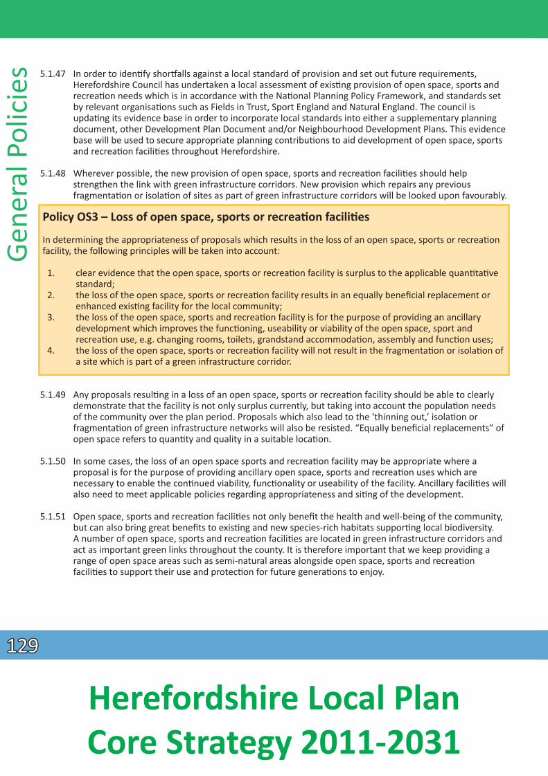
Gene
ral P
olic
ies 5.1.47 In order to idenƟ fy shorƞalls against a local standard of provision and set out future requirements,
Herefordshire Council has undertaken a local assessment of exisƟng provision of open space, sports and recreaƟon needs which is in accordance with the NaƟonal Planning Policy Framework, and standards set
by relevant organisaƟons such as Fields in Trust, Sport England and Natural England. The council is updaƟng its evidence base in order to incorporate local standards into either a supplementary planning document, other Development Plan Document and/or Neighbourhood Development Plans. This evidence base will be used to secure appropriate planning contribuƟons to aid development of open space, sports
and recreaƟ on faciliƟes throughout Herefordshire.
5.1.48 Wherever possible, the new provision of open space, sports and recreaƟ on faciliƟes should help strengthen the link with green infrastructure corridors. New provision which repairs any previous
fragmentaƟon or isolaƟon of sites as part of green infrastructure corridors will be looked upon favourably.
Policy OS3 – Loss of open space, sports or recreaƟ on faciliƟes
In determining the appropriateness of proposals which results in the loss of an open space, sports or recreaƟon facility, the following principles will be taken into account:
1. clear evidence that the open space, sports or recreaƟon facility is surplus to the applicable quanƟtaƟve standard;
2. the loss of the open space, sports or recreaƟon facility results in an equally beneficial replacement or enhanced exisƟng facility for the local community;
3. the loss of the open space, sports and recreaƟon facility is for the purpose of providing an ancillary development which improves the funcƟoning, useability or viability of the open space, sport and
recreaƟon use, e.g. changing rooms, toilets, grandstand accommodaƟon, assembly and funcƟ on uses; 4. the loss of the open space, sports or recreaƟon facility will not result in the fragmentaƟon or isolaƟ on of
a site which is part of a green infrastructure corridor.
5.1.49 Any proposals resulƟng in a loss of an open space, sports or recreaƟon facility should be able to clearly demonstrate that the facility is not only surplus currently, but taking into account the populaƟ on needs of the community over the plan period. Proposals which also lead to the ‘thinning out,’ isolaƟ on or
fragmentaƟon of green infrastructure networks will also be resisted. “Equally beneficial replacements” of open space refers to quanƟty and quality in a suitable locaƟon.
5.1.50 In some cases, the loss of an open space sports and recreaƟon facility may be appropriate where a proposal is for the purpose of providing ancillary open space, sports and recreaƟon uses which are necessary to enable the conƟnued viability, funcƟonality or useability of the facility. Ancillary faciliƟ es will also need to meet applicable policies regarding appropriateness and siƟng of the development.
5.1.51 Open space, sports and recreaƟ on faciliƟes not only benefit the health and well-being of the community, but can also bring great benefits to exisƟng and new species-rich habitats supporƟng local biodiversity. A number of open space, sports and recreaƟ on faciliƟes are located in green infrastructure corridors and act as important green links throughout the county. It is therefore important that we keep providing a range of open space areas such as semi-natural areas alongside open space, sports and recreaƟon
faciliƟes to support their use and protecƟon for future generaƟons to enjoy.
129129
Herefordshire Local Plan Core Strategy 2011-2031
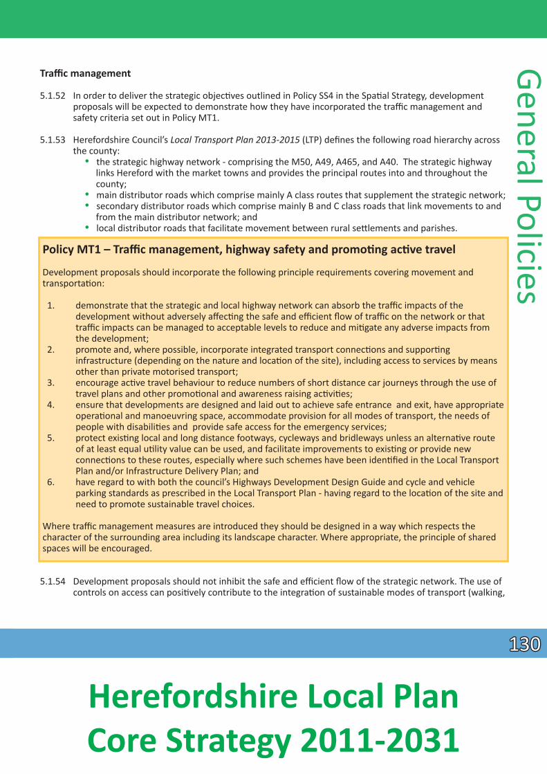
Traffi c management
5.1.52 In order to deliver the strategic objecƟves outlined in Policy SS4 in the SpaƟal Strategy, development proposals will be expected to demonstrate how they have incorporated the traffi c management and safety criteria set out in Policy MT1.
5.1.53 Herefordshire Council’s Local Transport Plan 2013-2015 (LTP) defines the following road hierarchy across the county:
• the strategic highway network - comprising the M50, A49, A465, and A40. The strategic highway links Hereford with the market towns and provides the principal routes into and throughout the county;
• main distributor roads which comprise mainly A class routes that supplement the strategic network; • secondary distributor roads which comprise mainly B and C class roads that link movements to and
from the main distributor network; and • local distributor roads that facilitate movement between rural seƩlements and parishes.
Policy MT1 – Traffic management, highway safety and promoƟ ng acƟ ve travel
Development proposals should incorporate the following principle requirements covering movement and transportaƟon:
1. demonstrate that the strategic and local highway network can absorb the traffic impacts of the development without adversely affecƟng the safe and effi cient flow of traffic on the network or that
traffic impacts can be managed to acceptable levels to reduce and miƟgate any adverse impacts from the development;
2. promote and, where possible, incorporate integrated transport connecƟons and supporƟng infrastructure (depending on the nature and locaƟon of the site), including access to services by means other than private motorised transport;
3. encourage acƟve travel behaviour to reduce numbers of short distance car journeys through the use of travel plans and other promoƟonal and awareness raising acƟviƟes;
4. ensure that developments are designed and laid out to achieve safe entrance and exit, have appropriate operaƟonal and manoeuvring space, accommodate provision for all modes of transport, the needs of
people with disabiliƟes and provide safe access for the emergency services; 5. protect exisƟng local and long distance footways, cycleways and bridleways unless an alternaƟ ve route
of at least equal uƟlity value can be used, and facilitate improvements to exisƟng or provide new connecƟons to these routes, especially where such schemes have been idenƟfied in the Local Transport
Plan and/or Infrastructure Delivery Plan; and 6. have regard to with both the council’s Highways Development Design Guide and cycle and vehicle
parking standards as prescribed in the Local Transport Plan - having regard to the locaƟon of the site and need to promote sustainable travel choices.
Where traffic management measures are introduced they should be designed in a way which respects the character of the surrounding area including its landscape character. Where appropriate, the principle of shared spaces will be encouraged.
General Policies
5.1.54 Development proposals should not inhibit the safe and effi cient flow of the strategic network. The use of controls on access can posiƟvely contribute to the integraƟon of sustainable modes of transport (walking,
130130
Herefordshire Local Plan Core Strategy 2011-2031
Gene
ral P
olic
ies cycling and public transport), and development proposals will be expected to demonstrate how the
criteria in Policy MT1 have been incorporated within the design of the scheme in order to increase acƟve travel across the county.
5.1.55 Alongside the above, development proposals should have regard to the council’s LTP while promoƟng the principles set out in Herefordshire Council’s Highway Development Design Guide for New Developments and the Department for Transport’s Manual for Streets and Manual for Streets 2 – Wider
ApplicaƟon of the Principles (2010) or subsequent documentaƟ on. ConsideraƟon will also be given to the Department of Transport Circular 02/2013 and Design Manual for roads and bridges or subsequent
documentaƟon.
5.1.56 Traffic management schemes should respect the local area including landscape character by providing an appropriate design soluƟ on, siƟng of infrastructure and use of materials as well as taking opportuniƟes to improve the quality of the public realm as part of an integrated approach. This may include opportuniƟes for raƟonalising the exisƟng infrastructure and ‘de-cluƩering’ the streetscape to the benefit of its appearance as well as funcƟoning.
5.1.57 In appropriate locaƟons, the use of shared space can provide an approach which can reduce delays and allow pedestrians to move more freely within the space. Shared space is a design approach that seeks to change the way streets operate by reducing the dominance of motor vehicles, primarily through lower speeds and encouraging drivers to behave more accommodaƟngly towards pedestrians and other vulnerable road users.
Delivery and monitoring of social progress policies
5.1.58 These policies will be delivered by:
• the development management process; • preparaƟon and implementaƟon of the Hereford Area Plan, Neighbourhood Development Plans and
other Development Plan Documents; and • developer contribuƟons and the Community Infrastructure levy.
Social Progress Monitoring Indicators
5.1.59 The following indicators (in addiƟon to those set out at the end of the spaƟal strategy) will be used to monitor the effecƟveness of the policies through the Annual Monitoring Report:
• life expectancy of residents – Offi ce for NaƟ onal StaƟsƟ cs (ONS); • affordable housing compleƟons split by social and intermediate occupancy; • rural excepƟon site compleƟon; • house type and number of bedrooms (aspiraƟonal);• assessment of traveller site provision against the need idenƟfied in the council’s Assessment of
AccommodaƟon Needs of Gypsies and Travellers; • recommendaƟons of the Open Space Study and Playing Pitch Assessment which includes surveys of
open space, sports and recreaƟ on faciliƟes to assess useability, supply, access and maintenance; • number of planning applicaƟons proposing the loss of an open space, sports or recreaƟ on faciliƟes;
and • number of planning applicaƟons proposing new open space, sports and recreaƟ on faciliƟes.
131131
Herefordshire Local Plan Core Strategy 2011-2031
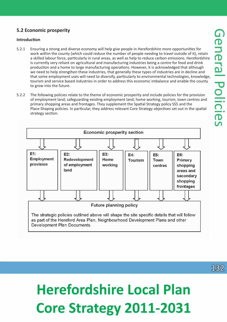
5.2 Economic prosperity
IntroducƟon
5.2.1 Ensuring a strong and diverse economy will help give people in Herefordshire more opportuniƟ es for work within the county (which could reduce the number of people needing to travel outside of it), retain a skilled labour force, parƟcularly in rural areas, as well as help to reduce carbon emissions. Herefordshire is currently very reliant on agricultural and manufacturing industries being a centre for food and drink
producƟon and a home to large manufacturing operaƟons. However, it is acknowledged that although we need to help strengthen these industries, that generally these types of industries are in decline and that some employment uses will need to diversify, parƟcularly to environmental technologies, knowledge, tourism and service based industries in order to address this economic imbalance and enable the county to grow into the future.
5.2.2 The following policies relate to the theme of economic prosperity and include policies for the provision of employment land; safeguarding exisƟng employment land; home working, tourism, town centres and primary shopping areas and frontages. They supplement the SpaƟal Strategy policy SS5 and the Place-Shaping policies. In parƟcular, they address relevant Core Strategy objecƟves set out in the spaƟal
strategy secƟon.
General Policies
132132
Herefordshire Local Plan Core Strategy 2011-2031
Gene
ral P
olic
ies
Policy E1 - Employment provision
The focus for new employment provision in Herefordshire is to provide a range of locaƟons, types and sizes of employment buildings, land and offices to meet the needs of the local economy. Larger employment proposals will be directed to the strategic employment sites of Hereford, the market towns and rural industrial estates where appropriate.
Development proposals which enhance employment provision and help diversify the economy of Herefordshire will be encouraged where:
• the proposal is appropriate in terms of its connecƟvity, scale, design and size; • the proposal makes beƩer use of previously developed land or buildings; • the proposal is an appropriate extension to strengthen or diversify an exisƟng business operaƟon; • the proposal provides for opportuniƟes for new office development in appropriate locaƟons.
The provision of viable live/work units as part of mixed use developments will also be encouraged.
Provision of employment land
5.2.3 In line with the objecƟves of the NaƟonal Planning Policy Framework, building a strong and compeƟƟve economy is an objecƟve that resonates in each of the policies concerning economic prosperity. Over the plan period, Herefordshire will conƟnue to diversify employment opportuniƟes, encourage the expansion of local business and reduce the need for travel. Already many employment areas in Herefordshire uƟlise links with the A49 trunk road, including sites in Hereford city centre, Ross on Wye, Leominster, Marlbrook and Moreton-on-Lugg. There will be a greater emphasis on extending and enlarging enterprise parks in Hereford and the market towns and allowing more flexibility in the rural areas for employment development such as home working and live/work units.
5.2.4 It is important that plan policies enable new, sustainable provision of employment land in locaƟ ons and of a scale that is appropriate. Whilst Herefordshire has a relaƟvely high employment rate, it is important to make sure that adequate opportuniƟes exist to improve the quality and range of employment available, so addressing the issue of low wages in the county.
5.2.5 A major element of the strategy for generaƟng new and beƩer paid jobs will be the provision of a deliverable range of land supply in appropriate locaƟons and in the right amounts. ‘Employment land’ in this instance refers to those uses falling within the planning B use classes, that is, offi ces (B1), manufacturing (B2) and warehousing and distribuƟon (B8). In addiƟon, employment land is considered an
appropriate locaƟon to accommodate waste faciliƟes and similar sui-generis employment uses.
5.2.6 The following is a summary of the main new and exisƟng strategic locaƟons which will provide for local and inward investment and contribute to the future employment provision in the county over the plan period. There is also potenƟal for smaller sites to come forward throughout the plan period away from these strategic locaƟons, which will also be encouraged where appropriate.
Hereford
5.2.7 The city of Hereford will conƟnue to provide a large proporƟon of the county’s employment supply.
133133
Herefordshire Local Plan Core Strategy 2011-2031
Hereford Enterprise Zone (HEZ)
The Rotherwas industrial estate is located south-east of Hereford and is over 120 hectares (ha) in size and has over 125 companies operaƟng within it.
Wesƞields Trading Estate
The Wesƞields trading estate is a 25 ha site located in the northern part of Hereford.
Three Elms Trading Estate
Three Elms Trading Estate is located north of Hereford and occupies 3 ha of land.
Holmer Road, Hereford
The industrial precinct on Holmer Road is located to the north of Hereford and is approximately 16 ha in size.
Market towns
5.2.8 The market towns of Leominster, Bromyard, Kington, Ross-on-Wye and Ledbury will also conƟ nue to support employment development through the rest of the county at exisƟng and/or new strategic employment sites, which will be the primary locaƟon of a range of employment premises providing a series of enterprise hubs to complement the Hereford Enterprise Zone. The main strategic employment
locaƟons in the market towns are as follows:
Leominster Enterprise Park, Leominster
5.2.9 The Leominster Enterprise Park is located to the south-east of Leominster and is designated by the Employment Land Study 2012 as of ‘best quality.’ The site is 15 ha in size and caters for B1, B2 and B8 uses. It is envisaged to be fully developed during the first half of the plan period. Given housing growth in Leominster, it is likely that during the second half of the plan period, an addiƟonal 5-10 ha of employment land will be required by extending the Leominster Enterprise Park to the south.
Southern Avenue, Leominster
5.2.10 This site is adjacent to the Leominster Enterprise Park and is 33 ha in size and is rated by the Employment Land Study 2012 as ‘good.’ The site has limited opportuniƟes to provide addiƟ onal employment opportuniƟes, however it is a significant contributor to exisƟng employment provision.
Land between LiƩle Marcle Road and Ross Road, Ledbury
5.2.11 This locaƟon is to the south-west of Ledbury and will comprise approximately 12 ha of employment land which will come forward to support the exisƟ ng populaƟon and proposed growth of Ledbury. The land
adjoins exisƟng employment land and is rated as ‘moderate’ and will cater for a mix of employment uses, parƟcularly smaller based business which may help to reduce the need to travel for the local community.
Model Farm, Ross-on-Wye
5.2.12 This site, carried forward from the Unitary Development Plan 2007, is approximately 10 ha in size and is located to the east of Ross-on-Wye. The site is envisaged to deliver innovaƟve knowledge based
General Policies
134134
Herefordshire Local Plan Core Strategy 2011-2031
Gene
ral P
olic
ies industries and a high quality mix of B1, B2 and B8 employment. The site has excellent access to the A40/
A49 and is classed as ‘good.’
Rural areas
5.2.13 The areas outside of market towns are also supported for conƟnuing economic growth, parƟ cularly in areas which allow for the diversificaƟon of uses either through strengthening food and drink producƟon, adding to new environmental technologies or those that allow for home based start-up businesses. Policy RA6 and its explanatory text guide employment development within these areas.
5.2.14 There is however a small number of larger employment locaƟons outside of Hereford and the market towns which will also conƟnue to contribute to the provision of Herefordshire’s employment needs, including:
Moreton Business Park, Moreton-on-Lugg
5.2.15 Moreton Business Park is a large employment site of 60 ha which is located on the A49 between Hereford and Leominster. The business park includes a mineral extracƟon site and other employment units which contain all employment classes. However it has recently seen an increase of B1 office use and B8 storage
and distribuƟon uses. There is also possibility to enhance rail infrastructure into the site for business use. The site is rated as ‘good’ with potenƟal to be rated as ‘best.’
Safeguarding exisƟng employment land
5.2.16 ‘Best and Good’ quality employment land in the county, as defined in the Employment Land Study 2012 will conƟnue to be safeguarded for employment generaƟng uses and general industry. In circumstances
where other employment land and sites are no longer viable, suffi cient jusƟficaƟon and evidence will need to be submiƩed - for example structural surveys demonstraƟng that the building is not fi t for
conƟnued employment use, and redevelopment of the site for employment use is not viable or feasible. Where possible, flexibility will be given to enable the business the opportunity to diversify to other
ancillary and complementary uses to enable the business to conƟnue. Uses such as fitness centres, child care centres, residenƟal and retail uses are generally not appropriate to be located within an employment site, unless they serve for the day-to day convenience needs of the site’s employees and any residenƟal use is part of a live/work scheme.
5.2.17 It is important that a range of employment land conƟnues to be available within Herefordshire. Means by which this can be achieved include: safeguarding exisƟng supply, enabling extensions to exisƟng employment land and the development of addiƟonal employment land where appropriate.
Policy E2 – Redevelopment of exisƟng employment land and buildings
Employment land and buildings rated as ‘best’ and ‘good’ using the methodology in the Employment Land Study 2012 (or successor document) will be safeguarded from redevelopment to other non-employment uses.
Proposals which would result in the loss of employment land rated as ‘moderate’ will be permiƩ ed where:
1. the development of the site for other uses would not result in an overall shortage in the quality and quanƟty of employment land supply in the area; or
135135
Herefordshire Local Plan Core Strategy 2011-2031
Policy E2 – Redevelopment of exisƟng employment land and buildings conƟnued
2. there would be a net improvement in amenity through the removal of a non-conforming use from within a residenƟal area, and where an alternaƟve use would offer amenity benefits. For sites in exisƟng
employment use, consideraƟon should also be given to the ability to relocate exisƟng occupiers where this is necessary; or
3. the proposal would not result in a piecemeal loss of employment land where there is potenƟal for a more comprehensive scheme;
In all cases: - the viability of the development proposal must be confirmed through a comprehensive assessment; and - there must be evidence of appropriate and acƟ ve markeƟng of at least 12 months for a change of use of
a B Class employment use and it can be shown that this markeƟng has been unsuccessful.
The provision of ancillary and complementary uses which help meet the day-to-day needs of employment sites and their employees and improve the sites’ aƩ racƟveness to businesses, will be permiƩed where they are of a scale which does not impact on the overall supply of employment land.
5.2.18 Policy E2 seeks to protect the best quality employment land in Herefordshire from being lost to other uses. The Employment Land Study 2012 undertaken as part of the evidence base classifi es employment land across Herefordshire in respect of its quality. The recommendaƟons from this study provide the basis for the development of Policy E1 on Employment provision. ApplicaƟons for the change of use of exisƟng employment land and buildings not currently included in the Employment Land Study 2012 will be assessed using the same methodology as if they were included.
Home working
5.2.19 In addiƟon to employment sites in predominately Class B employment areas; Herefordshire Council also encourages the development of live/work units and some material change of use in surrounding
residenƟal areas to allow for a small scale occupaƟon to be carried out at a person’s principal place of residence. Live/work units and allowing flexibility for home working enable small enterprises which are
compaƟble with the residenƟal environment to become established. If the business seeks to expand beyond what could be described as home working or a live/work unit, then larger faciliƟes in surrounding
areas, parƟcularly in enterprise parks in surrounding towns should be uƟlised.
General Policies
Policy E3 – Homeworking
The value of home working will be recognised by allowing some material change of use to part of a dwelling, where the dwelling remains as the principle place of residence for the home worker; and recognising the potenƟal to encourage and expand home working, by allowing small extensions or conversions where the proposed use and operaƟon would be compaƟble with its locaƟon and heritage value, and where it would not adversely affect the amenity of the neighbourhood by any of the following:
• changes to the appearance of any building; • noise disturbance from the use or any increased traffic and parking generated; • unsociable hours of operaƟ on; and • the storage of hazardous materials or emissions from the site.
136136
Herefordshire Local Plan Core Strategy 2011-2031
Gene
ral P
olic
ies Tourism
5.2.20 The Herefordshire STEAM Report 2011 shows that tourism makes an important contribuƟon to the county’s economy. Herefordshire has many historic and natural assets which are of naƟonal interest for example the Mappa Mundi and the Wye Valley and Malvern Hills Areas of Outstanding Natural Beauty. Hereford, the market towns and rural areas are popular desƟnaƟons for a range of different types of visits
and acƟviƟes. Tourism in Herefordshire can help to strengthen the economy through diversificaƟ on and new business development in both urban and rural areas.
Policy E4 – Tourism
Herefordshire will be promoted as a desƟnaƟon for quality leisure visits and sustainable tourism by uƟ lising, conserving and enhancing the county’s unique environmental and heritage assets and by recognising the intrinsic character and beauty of the countryside. In parƟcular, the tourist industry will be supported by a number of measures including:
1. recognising the unique historic character of Hereford and the market towns as key visitor aƩ racƟons and as locaƟons to focus the provision of new larger scale tourist development;
2. the development of sustainable tourism opportuniƟes, capitalising on assets such as the county’s landscape, rivers, other waterways and aƩ racƟve rural seƩlements, where there is no detrimental impact on the county’s varied natural and heritage assets or on the overall character and quality of the
environment. ParƟcular regard will be had to conserving the landscape and scenic beauty in the Areas of Outstanding Natural Beauty;
3. retaining and enhancing exisƟng, and encouraging new, accommodaƟon and aƩ racƟons throughout the county, which will help to diversify the tourist provision, extend the tourist season and increase the number of visitors staying overnight. In parƟcular proposals for new hotels in Hereford will be encouraged. Applicants will be encouraged to provide a ‘Hotel Needs Assessment’ for any applicaƟons for new hotels;
4. ensuring that cycling, walking and heritage tourism is encouraged by facilitaƟng the development of long distance walking and cycling routes, food and drink trails and heritage trails, including improvements to public rights of way, whilst having special regard for the visual amenity of such routes and trails, and for the seƫng of heritage assets in their vicinity; and
5. the safeguarding of the historic route of the Herefordshire and Gloucestershire Canal (shown on the Policies Map), together with its infrastructure, buildings, towpath and features. Where the original alignment cannot be re-established, a corridor allowing for deviaƟons will be safeguarded. New developments within or immediately adjoining the safeguarded corridor will be required to incorporate land for canal restoraƟon. Development not connected with the canal that would prevent or prejudice
the restoraƟon of a conƟnuous route will not be permiƩed.
5.2.21 By encouraging more overnight stays and associated increased expenditure, there is potenƟal for revenue from tourism to make a greater contribuƟon to the county’s economic well-being. The provision of new
accommodaƟon and the enhancement of exisƟ ng accommodaƟon will help achieve this goal. Many visitors to the county come to enjoy the beauƟful countryside and there is likely to be a demand for new
faciliƟes and accommodaƟons associated with this. Whilst some small scale tourism associated development may be appropriate in rural areas, any significant new development for accommodaƟ on and
faciliƟes should be focused in Hereford and the market towns to maximise sustainable transport opportuniƟes and to protect environmental amenity. Applicants will be encouraged to provide a ‘Hotel Needs Assessment Report’ to support their proposals. This assessment will inform whether the right standard of hotel is proposed with respect to market demand and need, so demonstraƟng its economic benefit to the area.
137137
Herefordshire Local Plan Core Strategy 2011-2031
5.2.22 The disused Herefordshire and Gloucestershire canal corridor is the subject of a long term restoraƟon project with the aim of re-opening the canal link between Hereford and the Severn at Gloucester,
terminaƟng in a canal basin in Hereford. Some secƟons have already been restored. The recreaƟon, tourism and economic potenƟal of the project are recognised and the canal corridor will conƟ nue to
receive protecƟon from development through Policy E4.
5.2.23 Policy E4 recognises the contribuƟon that tourism makes to the Herefordshire economy and seeks to ensure that this conƟnues and is enhanced through new developments which are of an appropriate scale, type and locaƟon.
Town centres
5.2.24 Policy E5 encourages appropriate town centre investment in Hereford and the market towns of Bromyard, Ledbury, Leominster, Kington and Ross-on-Wye which will contribute to and enhance the vitality and viability of these centres.
Policy E5 – Town centres
Town centres will be the focus for retail, commercial, leisure, cultural and tourism uses. Proposals for such uses which contribute to the vitality and viability of the town centres of Hereford and the market towns will be supported provided that they:
1. do not adversely affect the primary funcƟon of the town centres as shopping desƟnaƟ ons; and 2. are of a scale and design appropriate to the size, role, character and heritage of the centre.
Proposals for development outside the town centres will only be permiƩed if it can be demonstrated that the requirements of the sequenƟal test, as set out in paragraph 24 of the NPPF, have been met and that the proposal would not have a significant adverse impact on the vitality and viability of the centres. An applicaƟon will be refused if it fails the sequenƟal test or an impact assessment.
The sequenƟal test requires the above menƟoned uses to be located within town centres. Where it is proven there are no available and suitable town centre sites, preference will be given to edge of centre sites before any out of centre site is considered. Where a sequenƟal test adequately demonstrates that the only suitable and available site is an edge of centre or an out of centre locaƟon, preference will be given to sites that are well connected to the town centre and are easily accessible by sustainable transport modes.
An impact assessment for retail, leisure and commercial proposals outside of the town centres to assess their impact on investment in the area and on vitality and viability of the town centre may be required depending on the scale and locaƟon of the proposal, as specified in the policies in the Place Shaping secƟon.
The use of upper floors within town centres for residenƟal and office uses will be supported.
Within town centres, retail uses will be concentrated within the primary shopping areas (Policy E6).
General Policies
5.2.25 The town centre boundaries are defined in the Place Shaping secƟons of this document. A review of these boundaries will be undertaken as part of Neighbourhood Development Plans and the Hereford Area Plan.
5.2.26 Policy E5 has been informed by the findings of the Town Centres Study Update 2012 which outlines the retail, office and leisure needs of Hereford and the five market towns to 2031. The report idenƟfies
138138
Herefordshire Local Plan Core Strategy 2011-2031
Gene
ral P
olic
ies limited requirement for further retail and leisure development and advises that there is no need for out
of centre retail allocaƟons in Hereford or in the market towns. Where town centre uses are proposed in edge of centre or out of centre locaƟons, a sequenƟal approach to selecƟng sites will be adopted in accordance with the NaƟonal Planning Policy Framework. Evidence will be required to demonstrate that all available town centre opportuniƟes have been thoroughly assessed, and transparent reasons provided as to why the town centre sites are not suitable and available, before land and/or buildings in edge of centre and then out of centre locaƟons are considered. The sequenƟal approach will also apply to large scale extensions to exisƟng retail and town centre uses, as well as proposals to vary or remove
condiƟ ons restricƟng the range of goods that can be sold, where the site is located in an edge of centre or out of centre locaƟon. In considering the suitability and availability of sites, applicants will be required to demonstrate how they have adopted a flexible approach to the size, design and format of the proposal.
5.2.27 The NaƟonal Planning Policy Framework requires local planning authoriƟes to set thresholds to determine the requirement for an impact assessment for applicaƟons for retail, leisure and office development outside of town centres. Individual thresholds have been set for Hereford and the market towns as follows, and are included within the individual Place Shaping policies:
Hereford 700 m2
Bromyard 200 m2
Kington 200 m2
Ledbury 400 m2
Leominster 400 m2
Ross-on-Wye 400 m2
5.2.28 The council will seek to agree the scope of any impact assessment with the applicant in advance to ensure that the assessment is proporƟonate to the proposal under consideraƟon. Impact assessments will be expected to meet the requirements as set out in the NaƟonal Planning Policy Framework paragraph 26 and will also apply to extensions and proposals to vary or remove condiƟ ons restricƟng the range of goods that can be sold. Impact assessments should balance any idenƟfi ed benefits in terms of job
creaƟon, highways and accessibility improvements and so on against likely counter effects that may occur in the town centre as a result of the proposal.
5.2.29 The vitality and viability of town centres may also be enhanced by the use of upper floors over exisƟng shops, for residenƟal and offi ce accommodaƟon; and uses that assist in supporƟng the vibrancy of the town centres in the evenings such as restaurants and leisure faciliƟes. Such uses will assist in increasing
the fooƞall and general acƟvity in the town centre.
Retail
5.2.30 A successful retail funcƟon contributes to the vitality and viability of the town centre, the maintenance of its historic fabric and its role as a tourist desƟnaƟon. The aim of the policy is to improve vitality and viability of the centres by improving the variety, choice and quality of shops and other services, and enhancing the overall aƩ racƟon, safety, convenience and ambience of a town centre. Within the town centres, retail uses will be focused in the “primary shopping areas”. These will be defined in the Hereford Area Plan, Neighbourhood Development Plans or Development Plan Documents.
5.2.31 For edge of centre and out of centre retail locaƟons that have saƟsfied the sequenƟal test and impact assessments, condiƟons may be imposed where necessary to restrict the range of goods to be sold to
bulky goods only and/or restrict the net floorspace that can be devoted to non-bulky goods. CondiƟons
139139
Herefordshire Local Plan Core Strategy 2011-2031
may also be imposed seƫng a minimum size of unit and restricƟng the potenƟal for further verƟ cal or horizontal sub division. This is to prevent the proliferaƟon of smaller shop units outside of the town centre without seeking permission from the local planning authority and will protect the vitality and viability of exisƟ ng centres.
5.2.32 Regular markets in town centres can aƩ ract addiƟonal shoppers and enhance the vibrancy to town centres bringing addiƟ onal benefits for the exisƟng retailers. Most of these are of a temporary nature and use public spaces. They generally complement the character of the town centres and their retenƟon and enhancement will be encouraged.
Offices
5.2.33 The Employment Land Study Update 2012 found that the majority of demand for offices in Hereford is for small office premises (less than 100 m2) and in the market towns is generally from local companies in the town centres. In all places demand was found to be low and therefore it is expected that this can be met through exisƟng provision and the conversion of upper floors of properƟes.
Leisure
5.2.34 The Town Centres Study Update 2012 recommended that no further allocaƟons for leisure faciliƟ es and other town centre uses are made in Hereford or in the market towns. However the provision of new
leisure faciliƟes in locaƟons within town centres will be encouraged where they serve an idenƟfied community need or meet a shorƞall in exisƟ ng provision.
Primary shopping areas and primary and secondary shopping frontages
5.2.35 Primary shopping areas will be made up of primary and secondary shopping frontages (except in Bromyard and Kington) and will be reviewed in the Hereford Area Plan (including the Old Market Area) or Neighbourhood Development Plans/Development Plan Documents. UnƟl their review, the primary and secondary frontages as shown in the Place Shaping policies are carried forward from the Unitary Development Plan 2007 for development management purposes. Primary and secondary frontages will not be defined for Bromyard and Kington given the size of their centres and the distribuƟon of uses within them. In these towns retail uses will be focused in the primary shopping areas when defined.
General Policies
Policy E6 - Primary shopping areas and primary and secondary shopping frontages
The retail trading character of the primary shopping areas and primary and secondary shopping frontages will be protected and enhanced. Primary shopping frontages will conƟnue to be dominated by retail shops (Class A1) whilst secondary frontages may include a greater mix of uses.
Proposals for uses within Classes A2- A5 (non-retail) in ground floor premises in primary and secondary shopping frontages will be permiƩed where the proposed use will not result in:
1. a conƟnuous frontage of more than two non-retail units; and the overall proporƟon of non-retail uses exceeding 25% in primary shopping frontages and 50% in secondary shopping frontages.
ExcepƟons to the above thresholds may be considered where: • in primary and secondary frontages the proposal would lead to the appropriate use of vacant or
underused premises where it can be demonstrated that the premises are unlikely to be used for retailing and that a business case can be demonstrated for requiring such a locaƟ on; or
140140
Herefordshire Local Plan Core Strategy 2011-2031
Gene
ral P
olic
ies Policy E6 - Primary shopping areas and primary and secondary shopping frontages
conƟnued.
• in secondary frontages, the proposal results from an expansion of an exisƟng non-retail use or would fall within Class D1-D2; or
• it is demonstrated in the Hereford Area Plan and/or Neighbourhood Development Plans that an alternaƟve threshold would be appropriate.
2. detracƟon from the character of the shopping frontage concerned, for reasons of locaƟon, unit size or frontage width. The reinstatement of historic frontages will be encouraged.
5.2.36 The overall emphasis on retail trading should be retained in order to maintain character and to protect the vitality and viability of the primary shopping areas of Hereford and the market towns. The
concentraƟon of retail trading acƟvity within a limited area, with substanƟal runs of acƟve retail frontage will contribute to the busy and vibrant character of the county’s primary shopping areas. A variety of non-retail uses already exist within shopping areas and these can add to the diversity of uses in town
centres. Different but complementary uses during the day and evening can reinforce each other, making town centres more aƩ racƟve to local residents, shoppers and visitors. Non-retail uses include building socieƟes, banks, estate agents, insurance and beƫ ng offices (uses falling within Use Class A2, financial and professional services), together with restaurants and cafes (Class A3), drinking establishments (Class A4) and hot food takeaways (Class A5). However whilst one non-retail use alone may not detract from the vitality of a street, the cumulaƟve impact of such changes will do so. A concentraƟon of non-retail uses can have the effect of breaking up the shopping area, isolaƟng some shop units to the detriment of the centre as a whole. The further introducƟon of non-retail uses in the primary shopping areas therefore needs to be carefully balanced against the need to protect retail trading character.
5.2.37 The Hereford Area Plan and Neighbourhood Development Plans or Development Plan Document for Ledbury, Leominster and Ross-on-Wye will review the boundaries of the primary and secondary shopping frontages. However as stated above, only a primary shopping area will be defined in the Neighbourhood Plans/Development Plan Document for Bromyard and Kington as recommended in the Town Centre Study
Update 2012.
5.2.38 The introducƟon of non-retail uses falling outside Class A of the Use Classes Order will normally be opposed on the ground floor level of primary shopping areas so as to protect the combinaƟon of retail and associated services which characterise these frontages in the interest of protecƟng vitality and viability. However, secondary shopping frontages may provide an opportunity for some non-retail uses in Classes D1 and D2 in accordance with the NaƟonal Planning Policy Framework, subject to the criteria of
Policy E6.
5.2.39 Proposals will also be considered in terms of noise, appearance, traffi c generaƟon, servicing, parking and any other factors which may have a detrimental effect on the shopping street and residenƟ al amenity. Reference should be made to the Herefordshire Shop Front Design Guide 2011. Where historic frontages have been lost or degraded their repair and/or reinstatement will be encouraged. This can help to improve the quality and aƩ racƟveness of the centre and this contributes to its vitality and viability.
141141
Herefordshire Local Plan Core Strategy 2011-2031
Delivery and monitoring of economic prosperity policies
5.2.40 These policies will be delivered by:• the development management process • the Hereford Area Plan, Neighbourhood Development Plans and other Development Plan
Documents and • developer contribuƟons and the Community Infrastructure Levy.
Economic Prosperity Monitoring Indicators
5.2.41 The following indicators (in addiƟon to those set out at the end of the SpaƟal Strategy secƟon) will be used to monitor the effecƟveness of the policies through the Annual Monitoring Report:
• the amount of employment land commitments, compleƟons and reallocaƟons, as monitored through the council’s annual Employment Land Survey including expansions and relocaƟons;
• the amount of vacant land and premises for employment use in the county; • the amount of new employment development occurring in rural areas; • new business registraƟ on rates; • the amount of retail, office and leisure development completed within the monitoring period; • the amount of retail, offi ce and leisure fl oorspace permiƩed outside of city and town centres; • the amount of permissions granted for change of use from A2 to residenƟal or offices; • the number of vacant units within town centres; • the number of conversions of upper floors of retail and commercial premises to residenƟ al and
offi ce use; • the number and type of visits to Herefordshire, and associated expenditure; and • the number of people employed in the different tourism sectors.
General Policies
142142
Herefordshire Local Plan Core Strategy 2011-2031
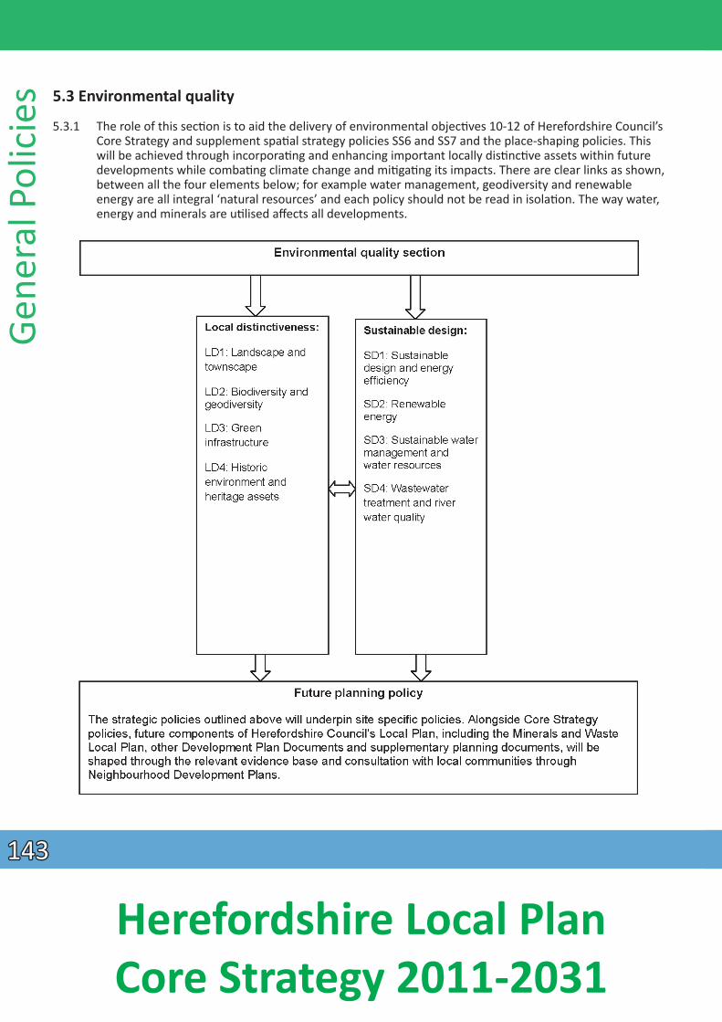
Gene
ral P
olic
ies 5.3 Environmental quality
5.3.1 The role of this secƟon is to aid the delivery of environmental objecƟves 10-12 of Herefordshire Council’s Core Strategy and supplement spaƟal strategy policies SS6 and SS7 and the place-shaping policies. This will be achieved through incorporaƟng and enhancing important locally disƟncƟve assets within future developments while combaƟng climate change and miƟgaƟng its impacts. There are clear links as shown, between all the four elements below; for example water management, geodiversity and renewable energy are all integral ‘natural resources’ and each policy should not be read in isolaƟon. The way water, energy and minerals are uƟ lised affects all developments.
143143
Herefordshire Local Plan Core Strategy 2011-2031
Local disƟncƟ veness
5.3.2 To successfully deliver the Core Strategy vision in respect of environmental quality and local disƟncƟveness, this secƟon provides a proacƟve strategy for the conservaƟ on, restoraƟ on and enhancement of environmental assets and the delivery of new green infrastructure to support policies SS6 and SS7.
5.3.3 Locally disƟncƟve assets both natural and man-made, are finite and irreplaceable and any detrimental impacts can carry cultural, environmental, economic and social costs. A number of assets benefi t from
statutory designaƟons within naƟonal and internaƟ onal legislaƟon. Statutory designaƟons range from large areas conserved for landscape, geodiversity or biodiversity importance, such as the Wye Valley and Malvern Hills Areas of Outstanding Natural Beauty and River Wye Special Area of ConservaƟ on, to individual statutory listed buildings which are protected for their architectural or historical signifi cance. Appendix 8 lists the designated sites in Herefordshire at the Ɵme of adopƟon.
5.3.4 Non-statutory designaƟons and locally determined features are equally important to Herefordshire’s local disƟncƟveness. Working with partner organisaƟons, Herefordshire Council has idenƟfied important assets such as local wildlife sites, local geological sites and areas and buildings of local interest which contribute to Herefordshire’s unique character. Non-statutory locally disƟncƟve buildings and green spaces will be idenƟfied through forthcoming Development Plan Documents or Neighbourhood Development Plans.
5.3.5 Conserving local disƟncƟveness is central to the purposes of designaƟons at all levels and achieved substanƟally through the producƟon and implementaƟon of management plans, conservaƟ on strategies and objecƟves and guidance resulƟng from best pracƟce and local assessments.
Landscape and townscape
5.3.6 The European Landscape ConvenƟ on defines landscape as “an area, as perceived by people, whose character is the result of the acƟon and interacƟon of natural and/or human factors”. Herefordshire has a disƟncƟve and varied landscape. Much of the area is rural in nature but varied in landscape character, including high hills, forest, commons and river meadows. Herefordshire contains a wide range of seƩ lement paƩ erns, different types of farmland and evidence of ancient landscape features. This diverse landscape is an integral element of Herefordshire’s local disƟncƟ veness.
5.3.7 Landscape is important, not just as scenery but because it links culture with nature, and the past with the present. It has many values, not all of them tangible (such as sense of place); and it maƩers to people – it is people who create and value landscape. All landscapes maƩer, not only those with naƟonal designaƟons. They provide a range of services such as food, water, climate regulaƟon and aestheƟc
enjoyment.
5.3.8 The concepts of conservaƟ on, restoraƟon and enhancement have been set out as a strategic approach to landscape and townscape management. The principles are relevant when considering the management of individual sites where the landscape character may be dependent upon unique landscape features. Landscape survey and analysis are proacƟve tools for allowing new build developments to address the three principles. For development proposals there are oŌ en opportuniƟes for measures to conserve landscape features such as trees, to restore features such as boundary hedges and to enhance the landscape character by other means such as woodland planƟ ng, creaƟon of wetland areas or restoraƟon of historic features. The preparaƟon of landscape schemes and management plans
General Policies
144144
Herefordshire Local Plan Core Strategy 2011-2031
should address these three aspects in relaƟon to the local landscape character and the relevant landscape type. Designated areas are detailed on the Policies Map. Specifi c conservaƟon area boundaries can be found on the council’s website at the planning/conservaƟ on pages.
Gene
ral P
olic
ies
Policy LD1 – Landscape and townscape
Development proposals should:
• demonstrate that character of the landscape and townscape has posiƟ vely influenced the design, scale, nature and site selecƟ on, protecƟon and enhancement of the seƫ ng of seƩlements and designated
areas; • conserve and enhance the natural, historic and scenic beauty of important landscapes and features,
including Areas of Outstanding Natural Beauty, naƟonally and locally designated parks and gardens and conservaƟon areas; through the protecƟon of the area’s character and by enabling appropriate uses,
design and management; • incorporate new landscape schemes and their management to ensure development integrates
appropriately into its surroundings; and • maintain and extend tree cover where important to amenity, through the retenƟon of important trees,
appropriate replacement of trees lost through development and new planƟng to support green infrastructure.
5.3.9 A number of landscape and townscape character assessments have been prepared supported by a Historic Landscape CharacterisaƟon and completed conservaƟon areas appraisals. The Landscape Character Assessment Supplementary Planning Guidance 2009 (SPD) will be reviewed during the plan period. The SPD will build upon the detailed evidence base documentaƟon; including Natural England’s Character Areas as well as more recently produced Urban Fringe SensiƟvity Analysis January 2010, Rapid
Townscape Assessments (various), Green Infrastructure Strategy February 2010 and other local studies covering the architectural and historic environment. In conjuncƟon with the above, relevant Areas of Outstanding Natural Beauty Management Plans and associated guidance also provide more place-specific guidance which should inform development proposals from the outset.
5.3.10 The parƟcular importance of trees is recognised within the planning system and the extent of tree cover is important to the county’s landscape and townscape. Tree surveys and arboricultural impact assessments may be necessary where it is important to assess and protect exisƟng trees on or adjacent to sites where development proposals are being advanced.
Biodiversity and geodiversity
5.3.11 Biodiversity can be defined as the variety of sites, habitats and species within a specified locality and is influenced by factors such as geology, topography and climate. Geodiversity refers to the natural processes and consƟtuent parts that have shaped the landscape and includes minerals, soils and water. Geodiversity is the variety of rock, minerals, fossils, soils, landforms and natural processes that have shaped the landscape.
5.3.12 Biodiversity and geodiversity assets provide an important contribuƟon to the disƟncƟveness of an area. Herefordshire has a diverse range of geological features and wildlife habitats such as the Malvern Hills, the River Wye, ancient woodlands and tradiƟonal orchards. Wildlife is not confined to designated sites and many features serve as wildlife corridors, links and stepping stones. Ecological networks are vital to
145145
Herefordshire Local Plan Core Strategy 2011-2031
the survival and dispersal of species. Herefordshire’s biodiversity and geodiversity make a major contribuƟon to the economy, supporƟng the tourism sector and providing a healthy and aƩ racƟve
environment for its residents.
Policy LD2 – Biodiversity and geodiversity
Development proposals should conserve, restore and enhance the biodiversity and geodiversity assets of Herefordshire, through the:
1. retenƟon and protecƟon of nature conservaƟon sites and habitats, and important species in accordance with their status as follows: a) Development that is likely to harm sites and species of European Importance will not be permiƩed; b) Development that would be liable to harm Sites of Special ScienƟfic Interest or naƟonally protected
species will only be permiƩed if the conservaƟon status of their habitat or important physical features can be protected by condiƟons or other material consideraƟons are suffi cient to outweigh nature conservaƟ on consideraƟons; c) Development that would be liable to harm the nature conservaƟon value of a site or species of local
nature conservaƟon interest will only be permiƩed if the importance of the development outweighs the local value of the site, habitat or physical feature that supports important species. d) Development that will potenƟally reduce the coherence and effecƟveness of the ecological network of sites will only be permiƩed where adequate compensatory measures are brought forward.
2. restoraƟon and enhancement of exisƟng biodiversity and geodiversity features on site and connecƟvity to wider ecological networks; and
3. creaƟon of new biodiversity features and wildlife habitats.
Where appropriate the council will work with developers to agree a management strategy to ensure the protecƟon of, and prevenƟon of adverse impacts on, biodiversity and geodiversity features.
General Policies
5.3.13 Areas of biodiversity and geological importance and sensiƟvity should be protected and development should enhance local habitats and ecological networks. Development within close proximity to
internaƟ onally, naƟonally and locally designated sites will need to incorporate sympatheƟ c design components to enhance their nature conservaƟon interests and to avoid or miƟgate any adverse impacts.
InternaƟonally important sites present within the county include Special Areas of ConservaƟ on (SACs); naƟonally important sites include Sites of Special ScienƟfic Interest (SSSIs) and NaƟonal Nature Reserves (NNRs); and locally important sites include Local Wildlife Sites and Local Geological Sites.
5.3.14 Dependent upon the scale and proximity of development proposals affecƟng biodiversity or geodiversity features, Herefordshire Council may require developers to produce a management strategy to ensure the
conƟ nued protecƟon of the features of interest. Such management strategies may include monitoring informaƟon. This will provide up-to-date informaƟon which will shape future policy reviews as well as
inform future site specifi c plans.
5.3.15 The Core Strategy objecƟves will be delivered through supporƟng development proposals that add to Herefordshire’s biodiversity. During the plan period Herefordshire Council will review its Biodiversity Supplementary Planning Guidance uƟlising in parƟcular the principles, opportuniƟes and constraints detailed within the Building Biodiversity into Herefordshire Council’s Local Development Framework 2009. Further areas of local biodiversity or geodiversity importance may be designated or extended during the
plan period.
146146
Herefordshire Local Plan Core Strategy 2011-2031
Gene
ral P
olic
ies 5.3.16 Details of the county’s biodiversity and geodiversity assets and features, some of which traverse the local
authority’s administraƟve boundaries, are listed in Appendices 8e-k and further informaƟon is held at the Herefordshire Biological Records Centre. Core areas have been idenƟfied where there are clusters of biodiversity and geodiversity features of high conservaƟon value as detailed in the Herefordshire Ecological Network Map 2012. Development within and adjacent to these core areas and associated buffer zones will need to be sympatheƟcally designed to ensure there are no adverse impacts upon them. Alongside this, Herefordshire Council will seek contribuƟons to enhance and link such core areas.
Green infrastructure
5.3.17 Green infrastructure is a mulƟ -funcƟonal network of green spaces, links and assets within and surrounding the built environment, and providing connecƟon to the wider countryside. As a major component of sustainable design it includes and contributes to health and wellbeing as well as biodiversity, culture and heritage across the county. It is not limited to urban areas and can be seen at
different strategic levels as shown in the table below and the accompanying concept diagram, Figure 5.3.
Figure 5.2: Hierarchy of Green Infrastructure Assets
Geographic Ɵer Example of green infrastructure asset County/Regional Strategy • Areas of Outstanding Natural Beauty
• Sites of naƟonal and internaƟonal nature conservaƟon importance (e.g. SAC, SSSI) • Verges of trunk roads, motorways and railways
District • Rivers and large streams and their floodplains • Local wildlife sites. Scheduled ancient monuments • Designed landscapes
Local • Public and private parks and gardens • RecreaƟonal grounds, cemeteries, playing fields and public green spaces • Public rights of way and cycle paths
147147
Herefordshire Local Plan Core Strategy 2011-2031
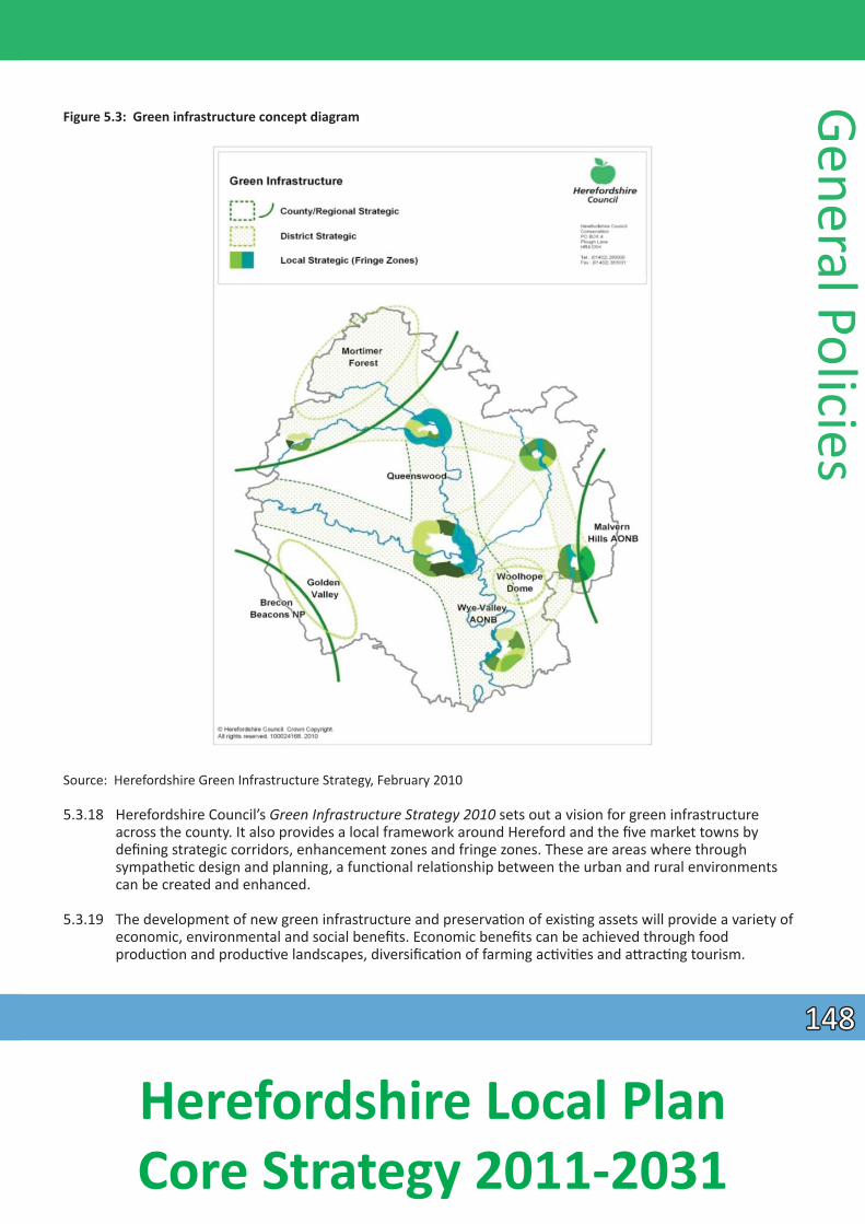
Figure 5.3: Green infrastructure concept diagram
General Policies
Source: Herefordshire Green Infrastructure Strategy, February 2010
5.3.18 Herefordshire Council’s Green Infrastructure Strategy 2010 sets out a vision for green infrastructure across the county. It also provides a local framework around Hereford and the five market towns by defining strategic corridors, enhancement zones and fringe zones. These are areas where through
sympatheƟc design and planning, a funcƟ onal relaƟonship between the urban and rural environments can be created and enhanced.
5.3.19 The development of new green infrastructure and preservaƟon of exisƟng assets will provide a variety of economic, environmental and social benefits. Economic benefits can be achieved through food
producƟon and producƟve landscapes, diversificaƟon of farming acƟviƟes and aƩ racƟ ng tourism.
148148
Herefordshire Local Plan Core Strategy 2011-2031
Gene
ral P
olic
ies Environmental benefits include habitat provision and connecƟvity, landscape protecƟ on, energy
conservaƟon and miƟgaƟon of climate change impacts. Social benefits of green infrastructure include places for leisure, garden food producƟ on, recreaƟon, sport and exercise, all of which make a major
contribuƟon to health and wellbeing. Development can include corridors for movement through foot and cycle paths. It provides opportuniƟes for improving the management of and interpreƟng natural and heritage assets and how they contribute to local disƟncƟveness. Increased access to green infrastructure can promote physical and mental health and well-being.
5.3.20 Green infrastructure can provide energy producƟon, fl ood aƩenuaƟon, maintenance of water quality, water resource management, cooling effects and many other benefits encompassed under the concept of ecosystem services. The council is commiƩed to working with Herefordshire Local Nature Partnership to bring forward a shared vision using green infrastructure to improve ecological networks and wider economic and social benefits as part of an “ecosystems approach”.
Policy LD3 – Green infrastructure
Development proposals should protect, manage and plan for the preservaƟon of exisƟng and delivery of new green infrastructure, and should achieve the following objecƟ ves:
1. idenƟficaƟon and retenƟon of exisƟng green infrastructure corridors and linkages; including the protecƟon of valued landscapes, trees, hedgerows, woodlands, water courses and adjoining fl ood plain; 2. provision of on-site green infrastructure; in parƟcular proposals will be supported where this enhances
the network; and 3. integraƟon with, and connecƟon to, the surrounding green infrastructure network.
5.3.21 Development proposals should idenƟfy and protect exisƟng green infrastructure. The Green Infrastructure Strategy 2010 and associated Study idenƟfy those features that contribute to the green infrastructure network. Proposals should take account of features within the site and also on adjacent sites as integraƟon and connecƟon with the surroundings is a key objecƟve. Proposals should incorporate
the retenƟon and enhancement of features such as trees and hedgerows, together with long term management.
5.3.22 The inclusion of new planƟng, wildlife enhancement, creaƟon and links, links to the countryside and river ways, green transport corridors, open spaces and recreaƟ onal faciliƟes and sustainable drainage systems within or associated with development proposals are important and valuable contribuƟons to green infrastructure. Landscaping of development sites should feature planƟng of appropriate naƟ ve species wherever possible, ensuring there is sufficient space for plants to grow to maturity. OpportuniƟ es for new elements include establishing grasslands, wildflower meadows, wetlands, orchards or woodland. New green infrastructure features could include promoƟng and extending the public rights of way network, increasing public access and providing interpreƟ ve informaƟon.
Historic environment and heritage assets
5.3.23 The historic environment is defined as all aspects of the environment resulƟng from the interacƟon between people and places through Ɵme, including all surviving physical remains of past human acƟ vity, whether visible, buried or submerged, and landscaped and planted or managed flora. Those elements of significance with statutory protecƟon are referred to as designated heritage assets. Policy LD4 is applicable to heritage assets throughout Herefordshire whether formally designated e.g. listed buildings
149149
Herefordshire Local Plan Core Strategy 2011-2031
and conservaƟon areas, or not, ranging from individual structures and their seƫ ngs, archaeological remains, to larger neighbourhoods of historic value, parks, gardens and other green spaces of local
interest.
5.3.24 The historic environment and heritage assets are significant contributors to sustainable development. Important local buildings have a social value and can act as focal points for local communiƟes. The historic environment is of cultural value as it illustrates the historical development of Herefordshire. Heritage assets also bring economic benefits as Herefordshire’s well preserved historic environment is a major factor in its tourism industry and the county’s quality of life can also serve to aƩract and retain investment. The sustainable re-use of exisƟng buildings can also help miƟgate climate change through reducing development pressures on greenfield sites, reducing demand for construcƟon energy and materials and by minimising construcƟ on waste.
Policy LD4 – Historic environment and heritage assets
Development proposals affecƟng heritage assets and the wider historic environment should:
1. Protect, conserve, and where possible enhance heritage assets and their seƫngs in a manner appropriate to their significance through appropriate management, uses and sympatheƟc design, in parƟcular emphasising the original form and funcƟon where possible;
2. where opportuniƟes exist, contribute to the character and local disƟncƟveness of the townscape or wider environment, especially within conservaƟ on areas;
3. use the retenƟon, repair and sustainable use of heritage assets to provide a focus for wider regeneraƟon schemes;
4. record and advance the understanding of the significance of any heritage assets to be lost (wholly or in part) and to make this evidence or archive generated publicly accessible and
5. where appropriate, improve the understanding of and public access to the heritage asset.
The scope of the works required to protect, conserve and enhance heritage assets and their seƫ ngs should be proporƟonate to their significance. Development schemes should emphasise the original form and funcƟ on of any asset and, where appropriate, improve the understanding of and public access to them.
General Policies
5.3.25 Where important heritage assets are at risk or underuƟlised, development proposals for alternaƟ ve uses which are sympatheƟc and contribute to the conservaƟon of the heritage asset and its wider environment will be supported. Due to the site-specific nature of heritage assets, the Core Strategy does not seek to sƟ pulate parƟcular uses and each proposal will be evaluated on its individual merits.
5.3.26 During the Core Strategy plan period, Herefordshire Council will review the Archaeology and Development Supplementary Planning Document (SPD) in parƟcular in the light of any changes to the
exisƟng evidence base, the Historic Landscape CharacterisaƟon, emerging farmstead assessment guidance and growing knowledge of heritage assets contained within the council’s historic environment record. This exisƟng data and evidence base together with the Rapid Townscape Assessments 2010 for the market towns and the Hereford Streetscape Design Strategy 2009 should be used to shape development proposals from the outset. The evidence base will also guide forthcoming Development Plan Documents and Neighbourhood Development Plans which should be supported where necessary, with careful appraisal of sites within or adjacent to those villages where development may be proposed - in terms of effect on archaeological remains and the seƫng of historic assets.
150150
Herefordshire Local Plan Core Strategy 2011-2031
Gene
ral P
olic
ies 5.3.27 Large scale developments should embrace the historic environment rather than regard it as a constraint.
UƟ lising exisƟng locally disƟncƟve heritage assets within wider regeneraƟon proposals can help create new developments that integrate posiƟvely with their surroundings, and can reinforce exisƟ ng cultural and social characterisƟcs. Where the loss of or substanƟal harm to a heritage asset or its significance is outweighed by the public benefits of a development proposal which is allowed to proceed, developers shall, in a manner proporƟonate to its importance, record and advance understanding of the heritage asset. This evidence shall be made publicly accessible normally through Herefordshire Historic Environment Record, a museum or other local archive as appropriate.
Sustainable design
5.3.28 Good design embraces more than simply the aestheƟcs of new development and includes how buildings are used, accessed and constructed. Equally, for development to be considered sustainable, it must embrace the move to a low carbon future through designing buildings that are more energy and water efficient and increase the use and supply of renewables. Herefordshire Council will seek to ensure that future developments are designed to enhance local disƟncƟveness but without sƟfl ing innovaƟ on and
creaƟ vity, parƟcularly with regard to energy effi ciency.
5.3.29 High quality design and well planned developments can enhance community cohesion through maintaining or creaƟng a sense of place. New development should be designed to preserve and enhance
locally disƟncƟ ve characterisƟcs and posiƟvely contribute to the appearance of the locality. To achieve this, it is important that new development is successfully integrated into the exisƟng built, natural and historic environment; however recognising that architectural styles change over Ɵme. Policy SD1 does not seek to sƟfle architectural innovaƟon, contemporary design or reject advances in design and technology.
Policy SD1 – Sustainable design and energy efficiency
Development proposals should create safe, sustainable, well integrated environments for all members of the community. In conjuncƟon with this, all development proposals should incorporate the following requirements:
• ensure that proposals make efficient use of land - taking into account the local context and site characterisƟcs; • new buildings should be designed to maintain local disƟncƟveness through incorporaƟ ng local
architectural detailing and materials and respecƟng scale, height, proporƟons and massing of surrounding development, while making a posiƟ ve contribuƟon to the architectural diversity and character of the area including, where appropriate, through innovaƟ ve design;
• safeguard residenƟal amenity for exisƟng and proposed residents; • ensure new development does not contribute to, or suffer from, adverse impacts arising from noise,
light or air contaminaƟon, land instability or cause ground water polluƟon; • where contaminated land is present, undertake appropriate remediaƟon where it can be demonstrated
that this will be effecƟ ve; • ensure that disƟncƟve features of exisƟng buildings and their seƫng are safeguarded and where
appropriate, restored; • uƟlise physical sustainability measures that include, in parƟ cular, orientaƟon of buildings, the provision
of water conservaƟon measures, storage for bicycles and waste including provision for recycling, and enabling renewable energy and energy conservaƟ on infrastructure;
• where possible, on-site renewable energy generaƟon should also be incorporated;
151151
Herefordshire Local Plan Core Strategy 2011-2031
General Policies Policy SD1 – Sustainable design and energy effi ciency conƟnued
• create safe and accessible environments, and that minimise opportuniƟes for crime and anƟ-social behaviour by incorporaƟng Secured by Design principles, and consider the incorporaƟ on of fi re safety
measures; • ensuring designs can be easily adapted and accommodate new technologies to meet changing needs
throughout the lifeƟme of the development; and • uƟlise sustainable construcƟon methods which minimise the use of non-renewable resources and
maximise the use of recycled and sustainably sourced materials;
All planning applicaƟons including material changes of use, will be expected to demonstrate how the above design and energy effi ciency consideraƟons have been factored into the proposal from the outset.
5.3.30 High quality design can significantly enhance the environment and amenity for new residents. Equally, the amenity and quality of life for exisƟng residents can be adversely affected by insensiƟ ve, poorly considered design. To address this, buildings, extensions and spaces must be designed with regard to overlooking, overshadowing and overbearing impacts. AddiƟonally, ensuring that new development is
compaƟble with the surrounding locality requires more than simply scale and aestheƟ c qualiƟ es, and includes consideraƟon of the impacts of noise and arƟficial light, ground condiƟons and air quality.
5.3.31 All developments must demonstrate how they have been designed and how they have incorporated measures to make them resilient to climate change in respect of carbon reducƟon, water effi ciency and flood risk. Carbon reducƟon should influence design from the outset by ensuring the fabric of the building is as energy efficient as possible, for example, aƩaining thermal effi ciencies through construcƟ on that achieves low U values and fuel efficiencies through the use of services such as efficient boilers. Good site planning can also aid greater energy efficiency in new development, for example, by seeking to maximise solar gain.
5.3.32 Revisions to the Building RegulaƟons are introducing progressive increases in the energy efficiency requirements for new buildings. In terms of energy conservaƟon, developments in sustainable locaƟons that achieve accredited standards of energy conservaƟon which cover a range of sustainability criteria will be supported, parƟcularly where the level achieved materially exceeds the relevant Building
RegulaƟons and other relevant standards in place at the Ɵme.
5.3.33 Large-scale developments should demonstrate how opportuniƟes for on-site renewable energy generaƟon and sustainable waste management have also been considered and addressed within the
design of the scheme. Such details should include an appraisal of all suitable renewable energy technology. Other developments will also be encouraged to consider whether on-site renewable energy opportuniƟes might be available. Alongside this, the council supports the provision of renewable and low carbon technologies within exisƟng developments, subject to such proposals according with other policies of the Core Strategy.
5.3.34 The efficient use of land is encouraged in the design policy; however it does not specify minimum development densiƟes; these are referenced in Policy SS2. It is recognised that in highly accessible locaƟons development proposals may be more sustainable and viable if constructed to higher densiƟes
than usually found elsewhere in the county, provided there is no detrimental impact upon exisƟ ng local amenity. However in most instances, appropriate density will primarily be informed by the local context as well as site opportuniƟes and constraints.
152152
Herefordshire Local Plan Core Strategy 2011-2031
Gene
ral P
olic
ies 5.3.35 Accessibility for all members of society is fundamental to achieving sustainable development and
inclusive design, and must be carefully considered in all development proposals. Development layouts should be designed to provide a high degree of permeability parƟcularly for sustainable modes of travel within the site, and provide safe connecƟons to adjoining land uses and local community faciliƟes.
5.3.36 Sustainable design principles can also contribute to reducing crime and the fear of crime. Developers should consider whether the locaƟon and form of their development should adopt the principles set out in the document ‘Secured by Design 2010 (AssociaƟon of Chief Police Offi cers)’ incorporaƟ ng design measures such as ensuring a high level of natural surveillance, sensiƟ ve consideraƟon of boundary treatments and clear delineaƟon of public and private spaces, in order to aid the creaƟon of a safer and more inclusive environment. In addiƟon, provision should be made to allow ease of access for emergency
services.
5.3.37 Council DirecƟve 96/82/EC (the Seveso II DirecƟve) requires that the objecƟves of the prevenƟ on of major accidents involving hazardous substances and limiƟng their consequences for man and the environment are taken into account in land use planning. Within the county, certain industrial sites and associated infrastructure fall within the scope of hazardous substances controls by virtue of the nature
and quanƟty of substances used or stored; in considering applicaƟons for development in the vicinity of such sites regard will also be had to the risks arising. It is important that the presence of hazardous substances is compaƟble with the exisƟng and proposed uses of the site and of land in the vicinity. In parƟcular, appropriate distances should be maintained between establishments where hazardous substances are present or proposed and exisƟng or proposed residenƟal areas, areas of public use and areas of parƟcular natural sensiƟvity or interest. Full account will be taken of advice from the Health and
Safety ExecuƟve and the Environment Agency in dealing with applicaƟons for both hazardous substances consent and for development at or in the vicinity of land where such substances are present.
5.3.38 The age structure of the county is rapidly changing with an increasing elderly populaƟon. Increasing fuel prices is resulƟng in residents, parƟcularly in rural areas, reviewing their home to work travel paƩerns,
furthermore conƟnual advances in technology means costly refurbishments of exisƟng buildings is oŌen required to meet modern requirements. It is therefore important that developments are fl exibly designed to be adaptable to different and future occupaƟonal and technological needs and demands. This can include measures such as meeƟ ng lifeƟme homes and equivalent standards in residenƟ al design, providing infrastructure to meet the growth in demand for electric vehicles, providing adequate space for internal and external plant and facilitaƟng home working and live/work opportuniƟes.
5.3.39 Design guidance will be prepared as a Supplementary Planning Document to provide baseline standards across Herefordshire; expanding on the above design principles and to inform the preparaƟ on of masterplans, other Development Plan Documents, Neighbourhood Development Plans, parish plans, village design statements and planning applicaƟons.
Renewable and low carbon energy generaƟon
5.3.40 An overarching principle of the planning system is to support the transiƟon to a low carbon future. A significant means of achieving this goal is through the use of renewable energy sources. Renewable energy covers energy generated directly from natural sources, be it sun, wind or water, or indirect sources such as biomass and geothermal heat. The Climate Change Act makes the UK the first country in the world to have a long term legally binding commitment to cut greenhouse gas emissions. The Act commits the UK to reduce carbon dioxide emissions by 80%, from a 1990 baseline, by 2050. The UK
153153
Herefordshire Local Plan Core Strategy 2011-2031
Renewable Energy Strategy (2009) sets a target for 15% of the UK’s energy to come from renewable resources by 2020, which represents a seven fold increase from 2008. In respect of wind energy, NaƟonal Planning Policy Guidance indicates that in order to gain planning permission suitable areas for wind energy development will need to have been allocated clearly in a Local or Neighbourhood Plan. Therefore, Herefordshire Council will consider whether to idenƟfy suitable areas for wind energy through
the preparaƟon of the Rural Areas Site AllocaƟon Development Plan Document or other appropriate development plan document. Neighbourhood Development Plans also have the ability to consider idenƟfying suitable sites for wind energy development.
5.3.41 Herefordshire is predominantly a rural county which benefits from the presence of many internaƟonal and naƟ onal designaƟons, alongside highly valued local landscapes. While these designaƟons limit the potenƟal for strategic renewable and low carbon energy generaƟ on, opportuniƟes are present in
Herefordshire to support such measures and the excepƟonal circumstance for such provision needs to be recognised. For example, farm diversificaƟon schemes can provide opportuniƟes for the
implementaƟon of renewable or low carbon energy projects. Neighbourhood Development Plans promoƟng community-led micro-generaƟon schemes will be supported where they are in accordance
with policy SD2 and other relevant policies of the Core Strategy.
Policy SD2 – Renewable and low carbon energy generaƟon
Development proposals that seek to deliver renewable and low carbon energy will be supported where they meet the following criteria:
1. the proposal does not adversely impact upon internaƟonal or naƟonal designated natural and heritage assets; 2. the proposal does not adversely aff ect residenƟ al amenity; 3. the proposal does not result in any significant detrimental impact upon the character of the landscape
and the built or historic environment and 4. the proposal can be connected effi ciently to exisƟ ng naƟonal grid infrastructure unless it can be
demonstrated that energy generaƟon would be used on-site to meet the needs of a specific end user.
In the case of energy generaƟon through wind power developments, permission will only be granted for such proposals where:
• the proposed site is idenƟfied in a Neighbourhood Development Plan or other Development Plan Document as a suitable site for wind energy generaƟ on; and
• following consultaƟon with local residents, it can be demonstrated that the planning impacts idenƟfied can be fully addressed, and therefore the proposal has the backing of the local community.
General Policies
Sustainable water management
5.3.42 Sustainable water management means minimising our impact on the healthy funcƟoning of the water cycle. Changes occurring to the climate mean that we are likely to experience an increase in the intensity, severity and frequency of extreme weather events such as droughts, storms and floods, which could
dramaƟcally impact on the way we need to manage water in the development of sustainable communiƟes. There is a finite capacity within the environment, and it cannot simply provide more and
more water as a result of increased consumpƟon rates or overall demand. Equally there is a limit to the amount of waste water that can be safely returned to rivers without having a detrimental effect.
154154
Herefordshire Local Plan Core Strategy 2011-2031
Gene
ral P
olic
ies 5.3.43 The issue of water management is especially important in Herefordshire with a number of watercourses
benefiƟng from different levels of protecƟon. The enƟre lengths of the River Wye and River Lugg are designated as Sites of Special ScienƟfic Interest, while the Wye and the Lugg from Hampton Court Bridge to its confluence are designated as a Special Area of ConservaƟon under European legislaƟ on. Alongside this, all watercourses and groundwater, are covered by the European Water Framework DirecƟve and are recognised as providing significant biodiversity, health and recreaƟ onal benefits. Delivery of the Water
Framework DirecƟve is proposed through a “Catchment Based Approach” and the Local Plan should play a part in achieving its objecƟves.
5.3.44 Changes in rainfall paƩerns, land management and land use, combined with more frequent occurrence of extreme weather events will present increased flood risk. Although flooding cannot be wholly prevented, its impacts can be avoided or reduced through good planning and land management. To this end the suscepƟbility of land to flooding and surface water management are material consideraƟons when assessing planning applicaƟons. Accordingly Herefordshire Council will support development proposals that accord with the principles of the Strategic Flood Risk Assessment 2009 (SFRA), as well as naƟonal technical guidance on the sequenƟal test and the excepƟon test, and ensure that surface water drainage is also properly managed. Where flood risk assessments are undertaken they should include all
sources of fl ooding, including fluvial flooding from ditches and water courses across the site.
5.3.45 The SFRA aims to ensure that planning policies and development land allocaƟons will not increase the risk of flooding both within the development and the surrounding area, and to idenƟfy and promote measures that will minimise flood-risk and/or enhance flood resilience. The SFRA for Herefordshire refines the county’s flood risk areas by taking into account other sources of flooding and other strategies, such as the Wye and Usk Catchment Flood Management Plan and the River Severn Catchment Flood
Management Plan.
Policy SD3 – Sustainable water management and water resources
Measures for sustainable water management will be required to be an integral element of new development in order to reduce flood risk; to avoid an adverse impact on water quanƟty; to protect and enhance groundwater resources and to provide opportuniƟes to enhance biodiversity, health and recreaƟon. This will be achieved by ensuring that:
1. development proposals are located in accordance with the SequenƟal Test and ExcepƟon Tests (where appropriate) and have regard to the Strategic Flood Risk Assessment (SFRA) 2009 for Herefordshire;
2. development is designed to be safe, taking into account the lifeƟme of the development and the need to adapt to climate change by seƫ ng appropriate floor levels, providing safe pedestrian and vehicular access, where appropriate, implemenƟ ng a fl ood evacuaƟon management plan and avoiding areas idenƟfied as being subject to Rapid InundaƟon from a breach of a Flood Defence;
3. where flooding is idenƟfied as an issue, new development should reduce flood risk through the inclusion of flood storage compensaƟon measures, or provide similar beƩerment to enhance the local fl ood risk
regime; 4. development will not result in the loss of open watercourse and culverts should be opened up where
possible to improve drainage and flood flows. Proposals involving the creaƟon of new culverts (unless essenƟal to the provision of access) will not be permiƩed;
5. development includes appropriate sustainable drainage systems (SuDS) to manage surface water appropriate to the hydrological seƫng of the site. Development should not result in an increase in runoff and should aim to achieve a reducƟon in the exisƟ ng runoff rate and volumes, where possible;
155155
Herefordshire Local Plan Core Strategy 2011-2031
General Policies Policy SD3 – Sustainable water management and water resources conƟnued
6. water conservaƟon and efficiency measures are included in all new developments, specifi cally: • residenƟal development should achieve Housing - OpƟonal Technical Standards - Water efficiency
standards. At the Ɵme of adopƟon the published water efficiency standards were 110 litres/person/ day; or • non-residenƟal developments in excess of 1,000 m2 gross floorspace to achieve the equivalent of BREEAM 3 credits for water consumpƟon as a minimum;
7. the separaƟon of foul and surface water on new developments is maximised; 8. development proposals do not lead to deterioraƟon of EU Water Framework DirecƟve water body
status; 9. development should not cause an unacceptable risk to the availability or quality of water resources; and 10. in parƟcular, proposals do not adversely affect water quality, either directly through unacceptable
polluƟon of surface water or groundwater, or indirectly through overloading of Wastewater Treatment Works.
Development proposals should help to conserve and enhance watercourses and riverside habitats, where necessary through management and miƟgaƟon measures for the improvement and/or enhancement of water quality and habitat of the aquaƟc environment. Proposals which are specifically aimed at the sustainable management of the water environment will in parƟcular be encouraged, including where they are required to support business needs such as for agriculture. InnovaƟve measures such as water harvesƟng, winter water storage and acƟve land use management will also be supported. In all instances it should be demonstrated that there will be no significant adverse landscape, biodiversity or visual impact.
5.3.46 The ‘SequenƟal Test’ is set out in paragraphs 100-104 of the NPPF. This aims to ensure inappropriate development does not take place in areas at high risk of flooding by direcƟng it away from areas at highest risk. Areas at risk of flooding are those falling within Flood Zones 2 and 3 as defined on the Environment Agency’s website. Flood Zone 1 is the area of low probability of flooding and should generally be used in preference to land in other zones. However land in Flood Zone 1 may also have
criƟcal land drainage problems which can be ascertained through Herefordshire Council’s Land Drainage team. Where no reasonable sites are available within Flood Zone 1 the ‘ExcepƟon Test’ may be applied. Where this test needs to be applied certain forms of development may be permiƩed in Flood Zones 2 and 3 depending upon their level of vulnerability. These are idenƟfied in Technical Guidance to the NaƟonal Planning Policy Framework.
5.3.47 Policy SD3 also provides criteria for developers to consider when proposing development within areas idenƟfied as being at risk of flooding within the district. The policy idenƟfies the need for development
proposed within flood risk areas to take account of a number of measures to ensure that the development is safe and remains safe, in Ɵ mes of fl ood including:
- seƫ ng appropriate floor levels which should be above the 1% predicted plus climate change design flood level, incorporaƟng an allowance for freeboard. Development should also consider in the
design the risk from more extreme events. Where it is not feasible or pracƟcable to set the floor levels, then other forms of flood resilience and resistance techniques may be considered as an alternaƟ ve;
- where overnight accommodaƟon is included, the development should include a safe pedestrian access route which would be available during a 1% plus climate change design flood event. In considering this, regard should be given to the evidence in the SFRA and for ‘defended areas’ including an assessment of Flood Defence breach/overtopping scenarios. Other development should consider this as a residual risk;
156156
Herefordshire Local Plan Core Strategy 2011-2031
Gene
ral P
olic
ies - consideraƟon of safe vehicular access; and
- for developments implemenƟ ng a fl ood evacuaƟon management plan, where appropriate, to manage the risk to the development site itself and future users/occupiers during all fl ood events along with any remaining residual risks.
5.3.48 A key component to reducing the risk of flooding is the implementaƟon of Sustainable Drainage Systems (SuDS) in all developments. Such systems can also assist in improving water quality. The Flood and Water Management Act 2010 introduces the mandatory inclusion of SuDS within developments alongside the ability for the seƫ ng of naƟonal standards. Development proposals are to accord with these standards and where appropriate be accompanied by surface water management plans detailing the drainage proposals. Advice is contained within the SFRA.
5.3.49 Government legislaƟon sets out the statutory introducƟon of Sustainable Drainage Advisory Bodies (SABs). SABs are designed to appraise and grant approval or refusal on proposed Sustainable Drainage Systems. Herefordshire Council will work in partnership with the SAB as well as the Environment Agency, to ensure that development proposals do not have adverse flood impacts.
5.3.50 With respect to water conservaƟon and efficiency of use, Policy SD3 sets out targets for reduced consumpƟon in associaƟon with new development, which in turn will result in decrease flow entering the
sewer system. This approach will also help to reduce flows entering waste water treatment infrastructure, thereby assisƟng to manage the level of nutrients in the River Wye Special Area of ConservaƟ on (see
Policy SD4). The Department for CommuniƟes and Local Government has published a ‘water efficiency calculator’ that applicants can use to demonstrate the water efficiency of proposed developments.
5.3.51 For employment development a standard of BREEAM 3 credits equivalent for water consumpƟ on is required. This equates to 40% reducƟon in water consumpƟon over current building regulaƟ ons. The Environment Agency has stated that all new non-residenƟal development should meet the ‘Good
PracƟce’ level of the AECB (AssociaƟon for Environment Conscious Building) Water Standards. These measures will complement the measures set out in Policy SD4 - Wastewater treatment and river water
quality.
5.3.52 The availability of water resources to meet demand during the plan period has been examined and Dwr Cymru-Welsh Water’s Water Resource Management Plan idenƟfies that there are suffi cient water resources available to meet demand during this plan period.
5.3.53 While agricultural water use lies largely outside planning control, it is a significant contributor to the water cycle condiƟons within Herefordshire and its impacts need to be taken into account in the Core Strategy and other Development Plan Documents and Neighbourhood Development Plans. There is
considerable potenƟal for farmers to capture and store surplus water for future use thereby reducing the need to abstract water from other sources, while enhancing biodiversity. However, reservoirs in parƟcular will alter landscapes and habitats on a permanent basis and care on siƟng and design is essenƟal.
5.3.54 Land management pracƟces can also play a vital role in managing flood risk and water quality at a local level; for example, the creaƟon and restoraƟon of wetlands and woodlands can reduce the level of flooding, and in some cases remove the risk of local flooding altogether. These pracƟces also improve water quality in addiƟon to producing wider environmental benefits, including encouraging an increase in wildlife species and habitats and reducing carbon.
157157
Herefordshire Local Plan Core Strategy 2011-2031
5.3.55 A Herefordshire Water Steering Group was established and aƩended by Herefordshire Council, Dwr Cymru-Welsh Water, the Environment Agency and Natural England, in order to invesƟ gate how development might be accommodated within the limits set by the Habitats RegulaƟons. It is expected that this group will be expanded in order to address issues arising from the preparaƟon of a Nutrient Management Plan. One of the areas that it might consider is idenƟfying best pracƟce in the reducƟ on of
water use.
Wastewater treatment and river water quality
5.3.56 The water quality of Herefordshire’s main rivers and their tributaries is of strategic importance and in parƟcular, current unacceptable levels of nutrients along part of the rivers need to be addressed. This is important to the overall environmental objecƟves of the Core Strategy.
5.3.57 The Rivers Wye, Lugg, Teme and Clun are Sites of Special ScienƟfic Interest (SSSIs), designated under the Wildlife and Countryside Act 1981 (as amended). Furthermore, the River Wye, including part of the River Lugg (downstream from Hampton Court Bridge), part of the River Clun (downstream of Marlow, Shropshire) and Downton Gorge on the River Teme are also designated as Special Areas of ConservaƟon
(SACs).
5.3.58 Both levels of designaƟon require efforts to be made to ensure the whole system, or catchment, achieves and then remains resilient in terms of supporƟng river habitats consistent with policy LD2 (Biodiversity and geodiversity). The Environment Agency has responsibility for water quality and ecological objecƟ ves set by European DirecƟve 2000/60/EC, the ‘Water Framework DirecƟve,’ which applies to surface waters and groundwater, and is preparing a River Basin Management Plan to deliver these. Natural England has responsibility for ensuring SSSIs and SACs achieve ‘favourable condiƟon.’ Currently all parts of the river SSSIs are in unfavourable condiƟon although some are recovering. All public bodies have a duty to contribute towards meeƟng these targets.
General Policies
Policy SD4 - Wastewater treatment and river water quality
Development should not undermine the achievement of water quality targets for rivers within the county, in parƟcular through the treatment of wastewater.
In the first instance developments should seek to connect to the exisƟng mains wastewater infrastructure network. Where this opƟon would result in nutrient levels exceeding conservaƟ on objecƟves targets, in parƟ cular addiƟonal phosphate loading within a SAC designated river, then proposals will need to fully miƟ gate the adverse effects of wastewater discharges into rivers caused by the development. This may involve:
• incorporaƟng measures to achieve water efficiency and/or a reducƟon in surface water discharge to the mains sewer network, minimising the capacity required to accommodate the proposal, in accordance with policy SD3;
• phasing or delaying development unƟl further capacity is available; • the use of developer contribuƟons/community infrastructure levy funds to contribute to improvements
to waste water treatment works or other appropriate measures to release capacity to accommodate new development; • in the case of development which might lead to nutrient levels exceeding the limits for the target
conservaƟ on objecƟves within a SAC river, planning permission will only be granted where it can be demonstrated that there will be no adverse effect on the integrity of the SAC in view of the site’s
conservaƟ on objecƟ ves; and
158158
Herefordshire Local Plan Core Strategy 2011-2031
Gene
ral P
olic
ies Policy SD4 - Wastewater treatment and river water quality conƟnued
• where the nutrient levels set for conservaƟ on objecƟves are already exceeded, new development should not compromise the ability to reduce levels to those which are defined as favourable for the site.
Where evidence is submiƩed to the local planning authority to indicate connecƟon to the wastewater infrastructure network is not pracƟ cal, alternaƟve foul drainage opƟons should be considered in the following order:
• provision of or connecƟon to a package sewage treatment works (discharging to watercourse or soakaway); • sepƟc tank (discharging to soakaway).
With either of these non-mains alternaƟves, proposals should be accompanied by the following:
• informaƟon to demonstrate there will be no likely signifi cant effect on the water quality, in parƟ cular of designated naƟonal and European sites, especially the River Wye SAC and the River Clun SAC; or
• where there will be a likely signifi cant effect upon a SAC river, informaƟon to enable the council, in its role as a competent authority, to ascertain that the development will have no adverse effect on the integrity of the SAC;
• in relaƟon to water courses with naƟonal or European nature conservaƟ on designaƟons, the inclusion of measures achieving the highest standard of water quality discharge to the natural drainage system including provision for monitoring.
The use of cesspools will only be considered in excepƟonal circumstances and where it can be demonstrated that suffi cient precauƟonary measures will ensure no adverse effect upon natural drainage water quality objecƟ ves.
5.3.59 There is a duty upon Herefordshire Council, so far as it is able, to further the conservaƟ on and enhancement of the river SSSIs within its area. Each SSSI has its own ‘conservaƟ on objecƟ ves,’ which include targets that form the baseline against which its favourable condiƟon is judged. The decisions the council takes can influence whether a site meets its targets or not. With respect to the river SSSI’s, this includes decisions on foul and surface water drainage from development. Developers can assist by
contribuƟng to the resilience of ecological networks through their efforts to deliver green infrastructure under policy LD4. Maintaining a high quality environment will assist markeƟng of homes and the aƩ racƟon of employment.
5.3.60 Herefordshire Council is a competent authority under the ConservaƟon of Habitats and Species RegulaƟons 2012 and there is a duty upon it to have regard to the requirements of the Habitats DirecƟve
in exercising any of its funcƟons. Furthermore, the LPA can only permit development which would have a likely signifi cant effect (either alone or in combinaƟon with other plans or projects) upon European sites aŌer having undertaken an Appropriate Assessment. Subject to certain derogaƟon tests, only development which can be shown to have no adverse effect on the integrity of European sites can be permiƩed.
5.3.61 In addiƟon, there is also a duty on the council to help deliver Water Framework DirecƟ ve (WFD) objecƟves. It is imperaƟve that proposals for growth do not adversely affect river water quality, and this includes that within associated watercourses flowing into the rivers and other ‘controlled waters’ (lakes, ponds and groundwater etc). Wastewater from most new development within the county will connect to sewage treatment works. Such treatment works are potenƟally point sources of polluƟon especially if
159159
Herefordshire Local Plan Core Strategy 2011-2031
they are unable to achieve acceptable standards of discharge, either directly or indirectly into rivers. SepƟc tanks and other acƟviƟes such as agricultural pracƟces form more diffuse sources of potenƟal polluƟon.
5.3.62 The county’s rivers have a finite capacity to accommodate discharges arising from development before their water quality is adversely affected, and improvements to the management of waste water will be required to ensure both the achievement of the watercourses conservaƟ on objecƟves and the ability to deliver the scale of growth set out in the Core Strategy.
5.3.63 The Environment Agency and Natural England have prepared a Nutrient Management Plan aimed to control and reduce phosphate within the River Wye SAC and in doing so seek to idenƟ fy acƟons to enable addiƟonal development. The Core Strategy will play a vital role in delivering the requirements of the Nutrient Management Plan, along with other mechanisms and measures. The Nutrient Management Plan and associated AcƟon Plan idenƟfies the management acƟons required to achieve the conservaƟon objecƟves target for phosphate by 2027. Planning guidance will be prepared where necessary to cover relevant measures included within the Nutrient Management Plan, or any revisions to it, comprising the need for planning advice, detailed phasing requirements, opƟons that might be funded through
developer contribuƟons, water quality and ecological condiƟon of stretches along the SAC rivers, and monitoring arrangements.
5.3.64 SecƟons of the River Wye SAC where the water quality targets are already exceeded will be subject to measures to reduce nutrients in line with the targets. New development must not compromise the ability of the Nutrient Management Plan to deliver the necessary overall reducƟons along these stretches.
5.3.65 SecƟons that are currently meeƟng their phosphate targets will be subject to measures to ensure that future inputs of nutrients will not lead to failures.
5.3.66 Figure 5.4 idenƟfies river sub-catchment areas within Herefordshire, set by the Water Framework DirecƟve. Development within these areas has the potenƟal to detrimentally affect water quality
standards. High levels of phosphates have been idenƟfied as parƟcular problems with concentraƟon levels exceeding targets.
5.3.67 Herefordshire Council will expect developments to connect to exisƟng sewage infrastructure. However, when this would compromise the ability to achieve favourable condiƟon, and potenƟally be contrary to the Habitats RegulaƟ ons, miƟgaƟon measures would be required if the development is to proceed.
5.3.68 Local water companies are responsible for providing and maintaining sewage treatment works at a standard to meet permiƩ ed condiƟons. Their asset management programmes will set out capital works to ensure compliance with discharge licences. Should such works be required then it may be necessary to phase new development within Ɵmescales set by these programmes. However, there may be an addiƟonal requirement for developer contribuƟons or community infrastructure levy funding to make
further improvements.
5.3.69 Increases in flows to sewage treatment works lead to increases in nutrients in watercourses, as discharges have set nutrient concentraƟons. Reducing flows to sewage treatment works through measures referred to in Policy SD3 can therefore contribute to reducing nutrient levels in the receiving watercourses. The
separaƟon of foul and storm water will have similar benefits.
General Policies
160160
Herefordshire Local Plan Core Strategy 2011-2031
Ge
nera
l Pol
icie
s 5.3.70 Development seeking to use non-mains drainage soluƟons will need to explain why this is necessary in the light of the Government advice on mains drainage and Herefordshire Council’s planning applicaƟon requirements in respect of non-mains drainage (see Herefordshire Council website). Herefordshire Council will wish to be assured that such proposals will not adversely affect the quality of water within watercourses and in parƟcular, will have no negaƟ ve effect upon SAC rivers and, in this regard, will undertake Habitat RegulaƟon Assessments where necessary using informaƟon required from and provided by developers. Measures proposed to miƟgate any effect will be rigorously scruƟ nised; and monitoring arrangements may need to be put in place to ensure the chosen system is effecƟ ve. Sustainable forms of water treatment such as reed beds may be used as alternaƟves to or in combinaƟon with foul water treatment and disposal. Full details should be provided to show these will achieve the required standard of discharge into the natural drainage system. The sensiƟvity of Herefordshire’s environment is such that the use of cesspools should be avoided, however if this is deemed to be the only opƟon then a rigorous assessment of potenƟ al effects will be required.
5.3.71 A number of rivers have water quality problems arising from sedimentaƟon. Where operaƟ ons requiring planning permission may cause or add to the problem then miƟgaƟon works such as trenches, wetlands,
retenƟon ponds, buffers, swales and other forms of sediment traps may need to be considered as part of sustainable water pracƟces under policy SD3.
161161
Herefordshire Local Plan Core Strategy 2011-2031
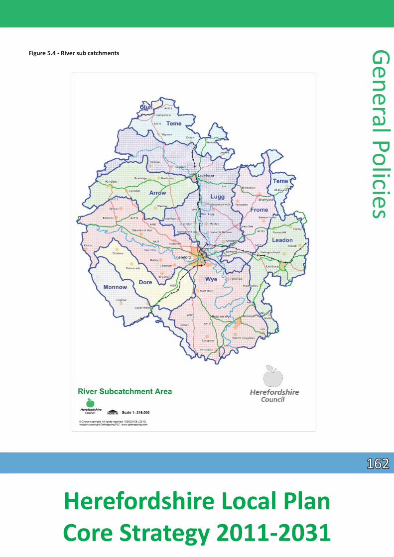
Figure 5.4 - River sub catchments
General Policies
162162
Herefordshire Local Plan Core Strategy 2011-2031
Gene
ral P
olic
ies Delivery and monitoring of the environmental quality policies
5.3.72 These policies will be delivered by:
• the Infrastructure Development Plan and developer contribuƟons/Community Infrastructure Levy • the development management process • other Development Plan Documents, Supplementary Planning Documents and Neighbourhood
Plans.
Environmental quality monitoring indicators:
5.3.73 In addiƟon to the indicators listed in previous secƟons, the following indicators will be used to measure the effecƟveness of the general policies (some are aspiraƟonal):
• changes in the areas of designated nature conservaƟon sites as a consequence of planning permission;
• proporƟon of local sites where posiƟ ve conservaƟon management has or is being implemented; • number of listed buildings and scheduled ancient monuments on buildings at risk register (Historic
England);• net change in condiƟon of SSSI’s (Natural England); • number of applicaƟons granted planning permission contrary to the advice of statutory agencies
(e.g. English Heritage, Natural England or the Environment Agency); • percentage of river length assessed as good biological or chemical quality (EA) in parƟcular so far as
they relate to the measures within the Nutrient Management Plan; • phosphate levels within the River Wye SAC and adjoining tributaries that receive increased
phosphates from Core Strategy growth; • completed development that has resulted in loss/restoraƟ on/creaƟon of Habitats of Principal
Importance (Priority Habitats); • percentage of total residenƟ al applicaƟons at below 30 dwellings per hectare; • number of residenƟ al applicaƟons at less than 1.5 parking spaces per unit; • the need for, frequency and outcomes of planning enforcement invesƟgaƟ ons/planning appeals
concerning the aspects of local loss of locally important buildings within a conservaƟ on area; • number of developments meeƟng and surpassing naƟonal design standards; • maintaining Herefordshire Council’s County Site and Monuments Register; and • summary of proposals contribuƟng to the Green Infrastructure Strategy from the above and any
other measures.
163163
Herefordshire Local Plan Core Strategy 2011-2031
Delivery, ImplementaƟon and Monitoring
Infrastructure contribuƟons
6.1 New development can place addiƟonal demands upon physical, social and green infrastructure, such as roads and sewers, community buildings and parks. It is a well-established principle, in naƟ onal guidance
and legislaƟon, that new development should contribute towards the provision of such infrastructure, to ensure exisƟ ng communiƟes are not disadvantaged by any increased pressure on faciliƟes from new
development.
6.2 Planning legislaƟon provides for the funding of infrastructure from developers. The legislaƟ ve framework is set out in secƟon 106 of the Town and Country Planning Act 1990, as amended by secƟon 12 of the 1991 Planning and CompensaƟon Act, Part 11 (Community Infrastructure Levy) of the Town and Country Planning Act 2008 and the Community Infrastructure Levy (CIL) RegulaƟons 2010 (as amended 2011, 2012 & 2013). Government policy on planning obligaƟons is also set out in paragraphs 203 to 205 of the NaƟonal Planning Policy Framework (NPPF) 2012.
6.3 Previously, Government made provision for a Community Infrastructure Levy (CIL) to be introduced in RegulaƟons that came into force in April 2010, now amended by the Community Infrastructure Levy (Amendment) RegulaƟons 2011, the Community Infrastructure Levy (Amendment) RegulaƟ ons 2012
and the Community Infrastructure Levy (Amendment) RegulaƟons 2013. Local authoriƟes will be empowered to charge a levy on new developments to help finance the infrastructure needed to support growth. However, local authoriƟes should have clear evidence about planned infrastructure, its cost, Ɵming and other likely sources of funding, to underpin their development strategies. This will be provided through an Infrastructure Delivery Plan (IDP) which will sit alongside the Core Strategy.
6.4 The IDP will need to be accompanied by a Charging Schedule for how the levy is calculated, which will be independently examined. In addiƟon, a list of community infrastructure projects that the council has prioriƟsed, for the infrastructure levy to be spent on, will be prepared (a CIL 123 list).
6.5 The use of planning obligaƟons, known as secƟon 106 contribuƟons, (which Herefordshire has tradiƟonally used) will sƟll remain, but will only relate to those infrastructure requirements required as a
direct result of the development and where they meet the following statutory tests:
1. necessary to make the development acceptable in planning terms; 2. directly related to the development; and 3. fairly and reasonably related in scale and kind to the development.
6.6 For clarity, CIL is a fi xed tariff intended to be used for general infrastructure contribuƟons whilst s106 obligaƟons will be for site-specifi c miƟgaƟon. For the avoidance of doubt, infrastructure is defi ned as;
those physical, social and green infrastructure projects required as a result of growth in the county. This includes housing, transport, sport and recreaƟon, community faciliƟes including educaƟon, health and emergency services, water and sewerage faciliƟes, flood risk management, renewable energy generaƟon, waste management, built environment and public realm improvements and green infrastructure.
Delivery, Implem
entaƟon and Monitoring
164164
Herefordshire Local Plan Core Strategy 2011-2031
Deliv
ery,
Impl
emen
taƟo
n an
d M
onito
ring Policy ID1- Infrastructure Delivery
Provision for new and/or the enhancement of exisƟng infrastructure, services and faciliƟes to support development and sustainable communiƟes, will be achieved through a co-ordinated approach.
Where necessary, in addiƟon to planning condiƟons for essenƟal on-site design requirements and criƟ cal infrastructure, developer contribuƟons towards strategic infrastructure through s106 agreements and/or a future Community Infrastructure Levy (CIL), will be secured in accordance with naƟonal planning policies and other relevant legislaƟon.
A Planning ObligaƟons Supplementary Planning Document (SPD) will provide details of the type and scale of obligaƟons that may apply.
6.7 All new development can impact on exisƟng services and faciliƟes in its local area, whether individually or cumulaƟvely. This can have a direct impact on the need for new faciliƟes either locally or on a larger,
strategic scale. For example, new development on a single large site or on lots of smaller sites will have the same overall impact on the demands placed on the exisƟng sewerage network. In this respect it is right to expect all new development to contribute to making communiƟes safe, healthy and aƩ racƟve places to live. Policy ID1 addresses this issue and will help to deliver a whole range of other policies in the Local Plan - Core Strategy.
6.8 The policy proposes that all new development is required to contribute to infrastructure needs. This will be achieved through a combined approach of using a set Community Infrastructure Levy (CIL) and
planning obligaƟ ons (secƟon 106) for all development types to bring forward affordable housing (in conjuncƟon with Policy H1) and other site specific infrastructure necessary for the development to take
place.
6.9 Individual developments will not be charged for the same items of infrastructure through both CIL and planning obligaƟons.
6.10 The CIL has been introduced to provide a fair and consistent mechanism for pooling contribuƟons from all eligible developments towards infrastructure. It provides certainty, so that developers can calculate in advance of submiƫng a planning applicaƟon, the level of contribuƟon required. Although the tariff will usually be a fi nancial contribuƟon, there is also the opƟon of transfer of land in lieu of a financial
payment.
6.11 The levy is a fixed rate charge, based on square metres of net addiƟ onal built floor space and is non-negoƟable. The charge is levied on one or more dwellings and developments of more than 100m2 of
floor space. ExempƟons include; affordable housing and chariƟes. The CIL regulaƟons allow the council to introduce charge variaƟons by geographical zone within its area, by land use, or both. These are set out in the Charging Schedule. Some uses may be set at zero in some zones, as the variaƟ ons reflect differences in viability.
6.12 The proceeds of the CIL will be spent on strategic and local infrastructure to support the development of the county. Developer contribuƟons on their own will not be able to meet the enƟre cost of a major infrastructure project. Core public funding will conƟnue to contribute.
165165
Herefordshire Local Plan Core Strategy 2011-2031
6.13 The type of infrastructure that the tariff will be used to service is set out in an Infrastructure Delivery Plan (IDP). The IDP provides robust evidence of infrastructure requirements through to 2031, but the focus is on the measures that are needed within the first 5 years from the date of adopƟon, in the context of the longer term plan set out in the Core Strategy. The IDP schedule and required infrastructure is set out on an area basis to include Strategic County-wide, The Hereford Area, the Market Towns and the Rural
Areas.
6.14 It is acknowledged that the IDP schedule cannot specify the enƟre infrastructure that will be provided in the county to 2031. Changed requirements may become apparent as new areas of development are designed in more detail and or ways of delivering services or faciliƟes are reviewed. The IDP schedule is not intended as a one-off document. Through the life of the Core Strategy, changes to the policies and strategies of service providers and the introducƟon of new technology will have implicaƟ ons for infrastructure requirements and their costs. Public funding levels are also likely to vary over the life Ɵme of the Plan. The informaƟon contained in the IDP schedule will be kept under review and updated. The council, together with its partners, will need to look for innovaƟve ways to fund and provide the necessary infrastructure. This is why it is called a “live document”.
6.15 A list of prioriƟsed infrastructure projects, which the council have commiƩed to, will be adverƟsed on the council’s website in the form of a RegulaƟon 123 list. This list will have been verified in terms of achievability and phasing of delivery through a separate evidence base dealing with Economic Viability, which will ensure that a balance is struck between the required infrastructure projects and the ability of the strategic sites to be delivered by the development industry.
6.16 Monies received in respect of the tariff and planning obligaƟons will be monitored and reported on through the LDF Annual Monitoring Report. Joint working with internal and external delivery partners will be necessary to keep the Charging Schedule and Infrastructure Delivery Plan up to date and relevant.
6.17 The council accepts that there are may be occasions where development proposals are unable to meet all the relevant policy requirements and sƟll remain viable. Where the council is saƟsfied that an otherwise desirable development cannot be fully compliant and remain viable, a reduced package of planning
obligaƟons may be recommended.
6.18 In order to enable the council to assess the viability of a proposal, the applicant will be required to provide any necessary cost and income figures to the council and pay the council’s full costs in appoinƟng an independent assessment of the viability proposal.
6.19 In all cases, the council requires viability to be undertaken using a residual land value approach. This means that the starƟng point for a viability assessment is to be the exisƟng use value (i.e. what the site is worth in its current condiƟon for the use that it has planning consent for). Viability claims based on an
over inflated price that has been paid for a site will not be accepted.
6.20 A Planning ObligaƟons Supplementary Planning Document will be prepared to give more details of the council’s requirements which are to be met through planning obligaƟons.
Delivery, Implem
entaƟon and Monitoring
166166
Herefordshire Local Plan Core Strategy 2011-2031
De
liver
y, Im
plem
entaƟo
n an
d M
onito
ring
Delivery
6.21 The policy will be delivered through:
• the development management process; • the neighbourhood planning process; • partnership working with infrastructure providers; • an Infrastructure Delivery Group to administer project proposals and propose prioriƟes; • a s106 Supplementary Planning Document; • a CIL Charging Schedule; and • a CIL 123 List.
ImplementaƟon and monitoring of the Core Strategy
6.22 The conƟnuous monitoring of policies and proposals is essenƟal to ensure that the Core Strategy achieves its objecƟves. The policies will be monitored principally through the Annual Monitoring Report (AMR), in
the manner described at the end of each secƟon of this document and in Appendix 3 – the ImplementaƟon, Monitoring and Delivery Plan. The AMR report will set out the basic achievements of the
main policies and contain details about the implementaƟon of the housing policies in parƟ cular.
6.23 If it appears that the policies are not being effecƟve, the following acƟons will be taken: • review of the policy or policies concerned and of the implementaƟon mechanisms which may
include a full or parƟal review of the plan; and • acƟons to speed up the delivery of land for development; and/or • idenƟficaƟon of alternaƟve or addiƟonal land through further Development Plan Documents and/or
Neighbourhood Development Plans.
6.24 The policies and proposals will also be assessed against key objecƟves and targets included in the Sustainability Appraisal to assess their contribuƟon towards promoƟng sustainable development. There will be a secƟon in the AMR dealing with this aspect.
6.25 Clearly, the Core Strategy must be able to respond to changing needs and circumstances. This will include assessing the potenƟal impacts of new or updated naƟonal and local policy and guidance. There will be a secƟon in the AMR dealing with this aspect.
167167
Herefordshire Local Plan Core Strategy 2011-2031
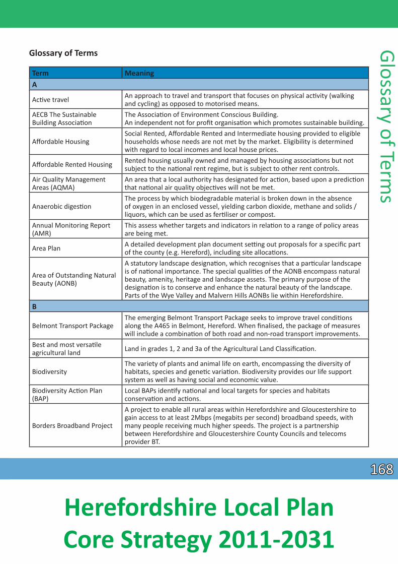
Glossary of Terms
Term Meaning A
AcƟ ve travel An approach to travel and transport that focuses on physical acƟ vity (walking and cycling) as opposed to motorised means.
AECB The Sustainable Building AssociaƟon
The AssociaƟon of Environment Conscious Building. An independent not for profi t organisaƟon which promotes sustainable building.
Aff ordable Housing Social Rented, Affordable Rented and Intermediate housing provided to eligible households whose needs are not met by the market. Eligibility is determined with regard to local incomes and local house prices.
Affordable Rented Housing Rented housing usually owned and managed by housing associaƟons but not subject to the naƟonal rent regime, but is subject to other rent controls.
Air Quality Management Areas (AQMA)
An area that a local authority has designated for acƟon, based upon a predicƟon that naƟonal air quality objecƟves will not be met.
Anaerobic digesƟon The process by which biodegradable material is broken down in the absence of oxygen in an enclosed vessel, yielding carbon dioxide, methane and solids / liquors, which can be used as ferƟliser or compost.
Annual Monitoring Report (AMR)
This assess whether targets and indicators in relaƟon to a range of policy areas are being met.
Area Plan A detailed development plan document seƫng out proposals for a specifi c part of the county (e.g. Hereford), including site allocaƟons.
Area of Outstanding Natural Beauty (AONB)
A statutory landscape designaƟon, which recognises that a parƟ cular landscape is of naƟonal importance. The special qualiƟes of the AONB encompass natural beauty, amenity, heritage and landscape assets. The primary purpose of the designaƟon is to conserve and enhance the natural beauty of the landscape. Parts of the Wye Valley and Malvern Hills AONBs lie within Herefordshire.
B
Belmont Transport Package The emerging Belmont Transport Package seeks to improve travel condiƟons along the A465 in Belmont, Hereford. When finalised, the package of measures will include a combinaƟon of both road and non-road transport improvements.
Best and most versaƟle agricultural land Land in grades 1, 2 and 3a of the Agricultural Land ClassificaƟon.
Biodiversity The variety of plants and animal life on earth, encompassing the diversity of habitats, species and geneƟ c variaƟon. Biodiversity provides our life support system as well as having social and economic value.
Biodiversity AcƟ on Plan (BAP)
Local BAPs idenƟ fy naƟonal and local targets for species and habitats conservaƟon and acƟons.
Borders Broadband Project
A project to enable all rural areas within Herefordshire and Gloucestershire to gain access to at least 2Mbps (megabits per second) broadband speeds, with many people receiving much higher speeds. The project is a partnership between Herefordshire and Gloucestershire County Councils and telecoms provider BT.
Glossary of Terms
168168
Herefordshire Local Plan Core Strategy 2011-2031
Glos
sary
of T
erm
s Term Meaning B ConƟnued
BREEAM Building Research Establishments Environmental Assessment Method is the most widely recognised method of assessing the environmental quality of a building design.
Brownfi eld Land
Both land and premises are included in this term, which refers to a site that has previously been used or developed. It may be vacant, derelict or contaminated. This excludes open spaces and land where the remains of previous use have blended into the landscape, or have been overtaken by nature conservaƟon value or amenity use.
C
Capacity (transport)
A measure of the volume of traffic that a point or link in transport infrastructure can accommodate, and oŌen an evaluaƟon of the extent to which that infrastructure is coping with the traffic that makes use of it; for example, underused, at or near capacity etc.
Carbon footprint A measure of the impact human acƟviƟes have on the environment in terms of the amount of greenhouse gases produced, measured in units of carbon dioxide.
Catchment Flood Management Plan
Produced by the Environment Agency; these give an overview of the fl ood risk across each river catchment and recommend ways of managing those risks now and over the next 50-100 years. They consider all types of inland fl ooding, from rivers, ground water, surface water and Ɵdal flooding and also take into account the likely impacts of climate change, the effects of how land is used and managed, and how areas could be developed.
Census An official count or survey of a populaƟon, typically recording various details of individuals. Last undertaken in 2011.
Climate Change
The term climate change is generally used when referring to changes in our climate, which have been idenƟfied since the early parts of the 1900’s. The changes that we have seen over recent years, and those which are predicted over the next 80 years, are thought by many to be mainly as a result of human behaviour, rather than due to natural changes in the atmosphere.
Community faciliƟes Land and buildings uses to help meet health, educaƟon and social needs in terms of developing and maintaining the health and wellbeing of all.
Community Infrastructure Levy (CIL)
A mechanism that empowers local authoriƟes to apply a levy or charge on new developments in their areas to support community infrastructure delivery.
Community Strategy
This is a pracƟcal tool for promoƟng or improving the economic, social and environmental wellbeing of the local authority area. Such strategies are prepared allowing for local communiƟes to idenƟfy and share their aspiraƟons, needs and prioriƟes.
Comparison retail
Clothing materials and garments, shoes and other footwear, materials for maintenance and repair of dwellings, furniture and furnishings, major household texƟles, books, audio visual equipment, hardware and DIY supplies, chemist goods, jewellery, watches and clocks, bicycles and recreaƟ on goods.
169169
Herefordshire Local Plan Core Strategy 2011-2031
Term Meaning C conƟnued
CondiƟon (of SSSIs)
The condiƟon of SSSIs is a reporƟng system for land with that designaƟon, assessed by Natural England and established by the Joint Nature ConservaƟon CommiƩee. There are six reportable condiƟons: favourable, unfavourable recovering, unfavourable no-change, unfavourable declining, part destroyed, and destroyed.
Connect2 The Hereford Connect2 Greenway proposal is for a shared use footway/cycleway between Hereford city centre, and the B4399 Holme Lacy Road via a new river crossing.
ConservaƟ on Areas An area defined in the Town and Country Planning Act (1990) as being of special architectural or historical interest, requiring extra protecƟon in planning terms, the character and appearance of which it is desirable to preserve or enhance.
ConservaƟ on ObjecƟ ves
ConservaƟ on objecƟves in relaƟon to Special Areas of ConservaƟon are those referred to in the ConservaƟon of Habitats and Species RegulaƟons 2010 (The Habitats RegulaƟons) and ArƟcle 6(3) of the European Union Habitats DirecƟve 1992. They are used when either the appropriate nature conservaƟ on body (here Natural England) or competent authority (e.g. Herefordshire Council; the Environment Agency) is required to make an Appropriate Assessment under the relevant parts of the respecƟ ve legislaƟ on. ConservaƟ on objecƟves for relevant sites can be viewed on the Natural England website.
ConservaƟon status (of EU Natura 2000 sites and species)
ConservaƟ on status is a definiƟon from the EU Habitats DirecƟve for reporƟng on the condiƟon of habitats and species idenƟfied as being of European Importance. In relaƟon to habitats these form part of the ‘Natura 2000 Network’ and in Herefordshire are represented by Special Areas of ConservaƟon. For both habitats and species various parameters are assessed and there are four levels of status: Favourable; Unfavourable – Inadequate; Unfavourable – Bad; and Unknown.
Convenience retail Goods bought frequently or out of necessity, requiring minimum eff ort in selecƟon and buying e.g. food, tobacco, newspapers and other goods of a standardised type for which there is a wide market.
CurƟlage The area, usually enclosed, encompassing the grounds and buildings immediately surrounding a home that is used in the daily acƟviƟes of domesƟc life. A slightly diff erent definiƟon relates to listed buildings – please check with the planning department.
Custom Build Custom build is when an individual or group of people work closely with a developer to build new homes. This could include fully commissioned homes or fiƫng out a previously constructed shell. (also see Self Build)
D
Demand management
The applicaƟon of strategies and policies to reduce or redistribute travel by road. A demand management approach has the potenƟal to deliver beƩer environmental outcomes, improved public health and stronger and more prosperous communiƟes.
DesƟnaƟ on Hereford A project promoƟng sustainable travel choices for geƫng to, or around, Hereford.
Glossary of Terms
170170
Herefordshire Local Plan Core Strategy 2011-2031
Glos
sary
of T
erm
s Term Meaning D ConƟnued
Developer ContribuƟons This includes secƟon 106 agreements and the Community Infrastructure Levy (CIL)
Development Plan Documents (DPD) Component parts of the Local Plan which makes up the Development Plan.
E
Economic output Output in economics is the quanƟty of goods or services produced in a given Ɵme period, by a firm, industry, county, region or country.
Edgar Street Grid (ESG) Masterplan
This sets out the principles for layout and design of the regeneraƟon area. It shows the relaƟonship between buildings and space; the connecƟ ons between streets, squares and open spaces; the movement paƩerns; the height, massing and bulk of buildings; the distribuƟon of uses; the locaƟon of street furniture and landscaping; and how well the new urban neighbourhood is integrated with the surrounding urban context.
Edge of centre (retail)
For retail development: a locaƟon that is well connected and up to 300 metres away from the primary shopping area. For all other main town centre uses, a locaƟon within 300 metres of a town centre boundary. For offi ce development, this includes locaƟons outside the town centre but within 50 metres of a public transport interchange.
Employment land Land used for office, industrial and warehousing purposes.
Energy efficiency
Making the best or the most efficient use of energy in order to achieve a given output of goods or services, and of comfort and convenience. This does not necessitate the use of less energy, in which respect it differs from the concept of energy conservaƟon.
Environmental assets Features in the physical environment that are valued for a variety of cultural and scienƟfi c reasons.
Environmental capacity The limit of acceptable environmental change within a defi ned area.
Enterprise Zone An area in which incenƟves such as tax and planning concessions are off ered to encourage investment and provide jobs.
European Landscape ConvenƟ on (ELC)
Is a treaty produced by the Council of Europe and voluntarily signed and raƟfied by the UK government in 2006; the provisions of the ELC came into eff ect in March 2007. ArƟcles 5 and 6 of the ELC highlight the need to develop policies and recognise in law the protecƟon, management and planning of all landscapes.
Evidence base The informaƟon and data gathered by local authoriƟes to jusƟfy the ‘soundness’ of the policy approach set out in Development Plan Documents, including physical, economic and social aspects of the area.
ExcepƟ on sites A locaƟon where development would not otherwise be granted planning permission under normal circumstances
ExcepƟon test (flooding)
In respect of flooding, if following the applicaƟon of the sequenƟal test, it is not possible for development to be located in zones with a lower probability of flooding, the excepƟon test can be applied. NPPF paragraph 102 outlines the elements that have to be passed for development to be allocated or permiƩed.
171171
Herefordshire Local Plan Core Strategy 2011-2031
Term Meaning F
Favourable condiƟon (conservaƟon)
When designated nature conservaƟon sites (e.g. Sites of Special ScienƟfic Interest) are managed in a way which maintains their nature conservaƟ on value, determined by reference to their ‘conservaƟ on objecƟves’, they are said to be in ‘favourable condiƟ on’.
Floodplain This is idenƟfied as the area of land at risk of flooding, when water flowing into a watercourse channel overtops its banks.
Flood zone An area idenƟfied by the Environment Agency as being at risk of fl ooding, flood zone 3 having the greatest risk.
Formal open space This refers to sites which have a clearly defined boundary, and which are ‘gardened’ frequently. Usually these are high profile or important sites and oŌen accommodaƟng high, or higher than average visitor usage.
Food web A local network of links between people who buy, sell, produce and supply food.
FuncƟonal Need Test
A requirement for the occupier to be present with close and conƟnual supervision at the business for the majority of the Ɵme and essenƟal for the economically sustainable enterprise. Businesses should be established for at least three years and be currently fi nancially sound.
G Geodiversity The range of rocks, minerals, fossils, soils and landforms. Greenfield land Land that has not been previously developed, oŌen in agricultural use.
Green infrastructure
A planned and delivered network of green spaces and other environmental features designed and managed as a mulƟfuncƟonal resource providing a range of environmental and quality of life benefits for local communiƟ es. Green infrastructure includes parks, open spaces, playing fields, woodlands, allotments and private gardens.
Green space A collecƟve term used to describe all parks, public gardens, playing fields, children’s play areas, woodlands, nature reserves, allotment gardens, linear and other open spaces.
GVA (Gross Value Added) A measure of the value of goods and services produced in Herefordshire, used as an indicator of the state of the county’s economy.
Gypsies and Travellers
When used in combinaƟon this means persons of a nomadic habit of life whatever their race or origin, including such persons who, on the grounds only of their own or their family’s or dependents’ educaƟonal or health needs or old age, have ceased to travel temporarily or permanently, but excluding members of an organised group of travelling showpeople or circus people travelling together as such.
H
Habitats RegulaƟon Assessment
A Habitats RegulaƟons Assessment is the assessment of the impacts of implemenƟng a plan or policy on a Natura 2000 site. Its purpose is to consider the impacts of a land use plan against conservaƟ on objecƟves of the site and to ascertain whether it would adversely affect the integrity of the site. Where signifi cant negaƟ ve effects are idenƟfi ed, alternaƟ ve opƟons should be examined to avoid any potenƟal damaging effects.
Glossary of Terms
172172
Herefordshire Local Plan Core Strategy 2011-2031
Glos
sary
of T
erm
s Term Meaning H conƟnued
Hereford Futures A partnership of public and private sector organisaƟons leading and co-ordinaƟng a range of regeneraƟon projects in Hereford.
Herefordshire Biological Records Centre
The local centre for the collaƟon, management and disseminaƟon of biodiversity data necessary for the consideraƟon of development proposals.
Herefordshire Economic Assessment
A comprehensive analysis of the local economy, including future prospects that may generate and aƩract inward investment into the county.
Herefordshire Learning Village
A purpose-built state of the art learning centre. The Learning Village will provide a co-ordinated range of courses that are specifically targeted to meet the needs of local employers, a business development unit and high technology engineering and craŌ workshop.
Herefordshire Local Nature Partnership
A partnership of organisaƟons working together to implement and review the Biodiversity AcƟ on Plan.
Heritage asset
A building, monument, site, place, area or landscape idenƟfied as having a degree of signifi cance meriƟ ng consideraƟon in planning decisions, because of its heritage interest. Heritage asset includes designated assets and assets idenƟfied by the local planning authority.
Historic Landscape CharacterisaƟon
Historic Landscape CharacterisaƟon is a new GIS-based archaeological method for defining the historic and archaeological dimension of the present-day landscape.
Historic parks and gardens Gardens, parks and designated landscapes which are of naƟ onal historical interest and which are included in English Heritage’s Register of Parks and Gardens of special historic interest in England.
Home & CommuniƟes Agency
A public body that supports and funds new affordable housing and regeneraƟon projects in England. Established by the Housing and RegeneraƟon Act 2008 as one of the successor bodies to the Housing CorporaƟon.
Housing aff ordability The ability of families and individuals to qualify for the purchase of a house which is especially dependent on wage levels and housing market prices in an area.
Housing Market Area Areas idenƟfied as local housing markets within Herefordshire, through an analysis of key indicators such as; tenure and housing type profi le, incomes, affordability, house prices, geographical proximity and travel to work paƩerns.
Housing quality indicators
A system used by the Homes & CommuniƟes Agency to measure the quality of housing schemes it funds. There are ten indicators which are used to assess the individual housing units and their design in detail, as well as assessing their context and surroundings.
Housing trajectory This idenƟfies how much potenƟal housing can be provided and at what point in the future.
I
Informal open space
Areas for unsupervised and unstructured outdoor play. These can consist of casual or informal playing space within housing estates, including safe shared space such as play streets or kick about areas. It includes outdoor equipped play areas for children of all ages, and play faciliƟes that off er specifi c opportuniƟes for outdoor play, such as BMX tracks.
173173
Herefordshire Local Plan Core Strategy 2011-2031
Term Meaning I conƟnued
Infrastructure A collecƟve term for services such as roads, electricity, sewerage, water, social services, health faciliƟes and recycling and refuse faciliƟes.
Infrastructure Delivery Plan This sets out details of the infrastructure required to support development in the future.
Intermediate housing Homes for sale and rent provided at a cost above social rent, but below market levels.
L
Land bank A means of implemenƟng proposals that involves the acquisiƟon, leasing or other method of land access; by which required parcels of land are assembled unƟl development can proceed.
Landfi ll sites The place where controlled waste is deposited. References to landfill may also refer to land raising and waste disposal.
Landscape Character Assessment (LCA)
Grouping landscape into areas with similar character, based on physical and human influences. The assessment describes the physical, cultural and perceptual character of the landscape and idenƟfies important or sensiƟve features. LCAs oŌ en idenƟ fy objecƟves in respect of landscape planning, design and management of the areas.
Lapse rates An esƟmate of the levels of planning permission which will expire without being implemented based upon an analysis of historic records.
LifeƟ me Homes
LifeƟme Homes are ordinary homes designed to incorporate 16 design criteria that can be universally applied to new homes at minimal cost. Each design feature adds to the comfort and convenience of the home and supports the changing needs of individuals and families at different stages of life. See hƩ p://www.lifeƟ mehomes.org.uk/
Listed Buildings
Buildings that are idenƟfied for their special architectural or historic interest. Listed building consent is required to ensure that these features are protected. There are three categories of lisƟng depending on the importance and special interest of the building: Grade l, Grade ll* and Grade II.
Locality Working
This involves Herefordshire Council working at a local level, in partnership with communiƟes, in order to:
• gain a fuller understanding of local needs and resources; • encourage service providers to work beƩ er together; • develop local soluƟons to improve the lives of residents.
Local Development Scheme (LDS)
This is a public statement of a local authority’s programme for the producƟ on of Local Development Documents.
Local Enhancement Zone Areas idenƟfied in the Green Infrastructure Strategy 2010, which would benefit from improvement in terms of green infrastructure
Local Geological Sites
Local Geological Sites are selected on a local or regional basis using naƟonally agreed criteria. These are based on the value of a site for educaƟ onal purposes as well as historical and aestheƟc value, parƟcularly in promoƟ ng public awareness and appreciaƟon of earth sciences.
Local Housing Market Assessment (LHMA) An area-wide analysis of housing demand and housing need.
Glossary of Terms
174174
Herefordshire Local Plan Core Strategy 2011-2031
Glos
sary
of T
erm
s Term Meaning L conƟnued
Herefordshire Local Housing Requirement Study
A study undertaken as an addendum to the Herefordshire Local Housing Needs Assessment to inform the developments for the Core Strategy including demographic projecƟons for populaƟon, households and dwellings, taking account of past trends and forecasted economic performance.
Local Needs
Local needs housing is the housing developed to meet the needs of exisƟ ng and concealed households living within the parish and surrounding parishes which is evidenced by the Housing Needs Survey for the parish, the Housing Register and the Local Housing Market Assessment.
Local Strategic Partnerships (LSP)
These are non-statutory, mulƟ-agency partnerships, within local authority boundaries, bringing together different parts of the public, private, community and voluntary sectors; allowing diff erent iniƟaƟves and services to work together more effecƟ vely.
Local Transport Plan 3 A five-year integrated transport strategy being prepared by the council as highway authority, in partnership with the community; which seeks funding to help provide local transport projects.
Local Wildlife Site Previously known as Sites of Importance for Nature ConservaƟon or County Wildlife Sites these are areas of land with significant wildlife value in a county.
M Market housing Housing sold or rented at full market value.
MiƟgaƟon Measures taken to reduce adverse impacts; for example, changing the way development is carried out to minimise adverse effects through appropriate methods or Ɵming.
Monitoring Process where outcomes of policies and proposals are checked on a conƟnuous or periodic basis in order to assess their effecƟveness and impact.
MulƟ ple deprivaƟon Where people are deprived in respect of a number of aƩributes such as income, housing, healthcare and educaƟon.
N
NHS Herefordshire In 2008, Herefordshire Council and NHS Herefordshire became the fi rst local authority and primary care trust to form a new kind of partnership to achieve more effi cient and beƩer value for money services Herefordshire residents.
NaƟonal Nature Reserve Designated by Natural England these are sites for wildlife and/or geology naƟonal importance with legal protecƟon.
NaƟonal Planning Policy Framework
This sets out the Government’s planning policies for England and is the framework within which Herefordshire Council has produced the Local Plan – Core Strategy.
Neighbourhood Development Plan
The development plan wriƩen by a community which has come together through a local parish council to shape new development by saying where a development should be located and what it should look like. Introduced via the Localism Act 2011.
175175
Herefordshire Local Plan Core Strategy 2011-2031
Term Meaning O
Open space All open space of public value, including not just land, but also areas of water (such as rivers, canals, lakes and reservoirs), which offer important opportuniƟes for sport and recreaƟon and can act as a visual amenity.
P
Park and Choose
FaciliƟes which seek to reduce town centre congesƟon and support more sustainable and acƟve travel modes by encouraging motorists to leave their vehicles on the edge of the urban area, and conƟnue their journey by a range of sustainable travel opƟons. This may be by regular bus service, walking, cycling or car-sharing.
Passivhaus
A standard where the heaƟng requirement is reduced to the point where a tradiƟ onal heaƟng system is no longer considered essenƟal. Cooling is also minimised by the same principles and through the use of shading and in some cases via the pre-cooling of the supply air. The Passivhaus standard can be applied to residenƟal dwellings, commercial, industrial and public buildings.
PermiƩ ed development rights
Rights to carry out certain limited forms of development without the need to make an applicaƟon for planning permission.
Perpetuity Meaning ‘forever’ regardless of changes in circumstances including land ownership.
Planning obligaƟons See secƟon 106 Agreements. Previously developed land (PDL) See Brownfi eld land.
Primary shopping areas These will be defined in the Area Plans and will include the primary and secondary shopping frontages.
Primary shopping frontages Defined areas in town centres; likely to include a high proporƟon of retail uses which may include food, drinks, clothing and household goods.
Public transport interchange A place where there are faciliƟes to allow people to change their method of transport from and to walking, cycling, buses and trains.
R
Rain garden A rain garden is a shallow depression, with absorbent, yet free-draining soil and planted with vegetaƟon that can withstand occasional temporary flooding.
RegeneraƟon The redevelopment of decaying or run-down parts of older urban or rural areas, in order to bring them new life and economic vitality.
Registered social housing providers
Either not for profit or profit making organisaƟons (subject to the same standards and address the same housing prioriƟes) providing social housing and regulated by the Homes and Community Agency.
Renewable energy
Power derived from a source that is conƟnually replenished, such as wind, wave, solar, hydroelectric and energy from plant material, but not fossil fuels or nuclear energy. Although not strictly renewable, geothermal energy is generally included.
Residual land value In the context of this plan this is defined as the difference between the total value of a development scheme and all the costs of the development, including land acquisiƟon.
Glossary of Terms
176176
Herefordshire Local Plan Core Strategy 2011-2031
Glos
sary
of T
erm
s Term Meaning R ConƟnued
Retail hierarchy A hierarchy of shopping centres ranging from regional and sub-regional centres through to town centres, district and local centres.
River Wye SAC Nutrient Management Plan
Prepared by Natural England and the Environment Agency the Plan for the River Wye, this will aim to control and reduce phosphates in the SAC to facilitate the delivery of the proposed development.
Rural housing market area (HMA)
A term used in rural housing secƟon to describe the rural element of each housing market area.
Rural RegeneraƟ on Zone A vehicle for bringing together partners from the public, private and voluntary sectors to develop and implement a programme of economic regeneraƟ on for the area.
S Scheduled Ancient Monument A naƟonally important archaeological site or monument given legal protecƟon.
Secondary shopping frontages
Defined areas within town centres where there is greater opportunity for a wider mix of uses than in primary shopping frontages such as restaurants, cinemas and businesses.
SecƟon 106 agreements An agreement by the local authority with a landowner/developer restricƟ ng or regulaƟng the development or use of land either permanently or temporarily, in accordance with the Town and Country Planning Act (1990).
Self-build housing Self-build projects are where an individual or group of people directly organise and commission the design and construcƟon of their new homes. (also see Custom Build)
Self-suffi ciency (waste management)
The European Community (EC) Framework DirecƟve on Waste and the EC Landfi ll DirecƟve set out a common framework for acƟon on waste. Waste management should protect human health and the environment by establishing an integrated network of waste faciliƟes. Member States should promote self-sufficiency by dealing with waste as close as possible to its point of origin and promoƟng waste avoidance by recycling, reclamaƟon and energy recovery.
SequenƟ al approach
A planning principle that seeks to idenƟfy, allocate or develop certain types of locaƟons of land before others. For example, town centre retail sites before out-of-centre sites. In terms of employment a sequenƟal approach would favour an employment use over mixed use and mixed use over non-employment uses.
SequenƟ al test In relaƟ on to flooding, this aims to steer new development to areas with the lowest probability of flooding.
SeƩ lement hierarchy SeƩ lements defined by their role and funcƟon in a specifi ed list. Significant urban extensions Large-scale housing growth on the periphery of towns. Sites of Special ScienƟfic Interest (SSSI)
These are legally protected sites, designated by Natural England in view of their wildlife and geological value.
Social well-being The provision of development to assist with medical or social support
Social rented housing Subsidised housing provided by a Registered Provider or local authority allocated on the basis of need.
177177
Herefordshire Local Plan Core Strategy 2011-2031
Term Meaning S ConƟnued
Soundness
LegislaƟon does not define the term ‘sound’, however, the Planning Inspectorate consider it in the context of its ordinary meaning - ‘showing good judgement’ and ‘able to be trusted’, and within the context of fulfilling the expectaƟ ons of legislaƟon.
Special Areas of ConservaƟ on (SAC)
SACs are sites designated under the Habitats DirecƟ ve (DirecƟve 92/43/EEC on the conservaƟon of natural habitats and of fauna and flora). Together with Special ProtecƟon Areas they form the Natura 2000 network of sites.
Stakeholders Groups, individuals or organisaƟons that may be affected by, or have a key interest in, a development proposal or planning policy. They may oŌ en be experts in their field or represent the views of many people.
Statement of Community Involvement (SCI)
This sets out the standards to be achieved by the local authority in involving the community in the preparaƟ on, alteraƟon and conƟnuing review of all Local Development Documents and planning applicaƟons. This SCI is a clear public statement enabling the community to know how and when they will be involved in the preparaƟon of Local Development Documents, and how they will be consulted on planning applicaƟons.
Strategic locaƟons For this Core Strategy defined as around 500 homes in Hereford, around 100 homes in the market towns and around 5ha of employment land.
Strategic Environmental Assessment (SEA)
A formal environmental assessment of certain plans and programmes which are likely to have signifi cant effects on the environment. Local authoriƟ es who prepare and adopt such a plan or programme must prepare a report on its likely environmental effects. They must consult environmental authoriƟes and the public, and take the report and the results of the consultaƟon into account during the preparaƟon process, before the plan or programme is adopted.
Strategic Highway Network A categorisaƟon of the road network into different categories determined by the funcƟons they perform.
Strategic Housing Land Availability Assessment (SHLAA)
A key component of the evidence base to support the delivery of suffi cient land for housing to meet the community’s need for more homes. The Herefordshire SHLAA assesses the potenƟal availability of land for housing across the county up to the end of the plan period, and explores any constraints that might affect their suitability, achievability or availability for development.
Strategic Housing Market Assessment
Sub regional market analysis of housing demand and housing need which idenƟfied the key drivers in the West Housing Market Area which covers Shropshire, Telford & Wrekin and Herefordshire.
Supplementary Planning Documents (SPD)
AddiƟonal planning documents to provide further details on selected policy areas. These are not subject to examinaƟon but will be available for public consultaƟon before being adopted. These can take the form of design guides or area development briefs and will be clearly cross-referenced to the relevant plan policy or proposal that it supplements.
Sustainable development In broad terms, this means development that meets the needs of the present without compromising the ability of future generaƟons to meet their own needs.
Sustainable drainage systems (SUDS)
Measures introduced in developments which aim to minimise surface water run-off and the level of waste water generated by the development. These can include use of reed beds to filter water and water storage areas.
Glossary of Terms
178178
Herefordshire Local Plan Core Strategy 2011-2031
Glos
sary
of T
erm
s Term Meaning S conƟnued
Sustainability Appraisal (SA)
The Planning and Compulsory Purchase Act (2004) requires Local Development Documents to be prepared with a view to contribuƟng to the achievement of sustainable development. Sustainability Appraisal is a systemaƟc process that is used to appraise the social, environmental and economic effects of the strategies and policies set within a Local Development Document from the outset of the preparaƟon process. This will ensure that decisions are made that accord with sustainable development.
South Hereford This comprises the two wards of Belmont and St MarƟns & Hinton T Town Centre Uses Retail, leisure and commercial uses.
Travellers When used on its own and for the purposes of planning policy ‘travellers’ means ‘gypsies and travellers’ and ‘travelling showpeople’ (see specifi c definiƟ ons for each of these).
Travelling showpeople
Members of groups organised for the purposes of holding fairs, circuses or shows (whether or not travelling together as such). This includes such persons who on the grounds of their own or their family’s or dependents’ more localised paƩern of trading, educaƟonal or health needs or old age have ceased to travel temporarily, but excludes Gypsies and Travellers (see specifi c definiƟon for these).
Traveller Sites Sites either for seƩ led occupaƟon, temporary stopping places, or transit sites for people of a nomadic way of life, such as Travellers.
U Unfavourable CondiƟon See ‘CondiƟ on’.
Unitary Development Plan Adopted on 23rd March 2007, it guides development within the county and will be in use with most of its policies ‘saved’ unƟl they are superseded by other emerging Local Plan documents.
W Waste Management FaciliƟes These include faciliƟes for waste treatment and disposal.
West Midlands Region
An official region of England, covering the western half of the area tradiƟonally known as the Midlands. It contains the second largest BriƟsh city, Birmingham, and the larger West Midlands conurbaƟon, which includes the city of Wolverhampton and large towns of Dudley, Solihull, Walsall and West Bromwich and a number of shire counƟes including Herefordshire.
Windfalls Sites which have not been specifi cally idenƟfied as available in the Local Plan process. They normally comprise previously-developed sites that have unexpectedly become available.
Z
Zero Carbon Development Development that achieves zero net carbon emissions from energy use on site, on an annual basis.
179179
Herefordshire Local Plan Core Strategy 2011-2031
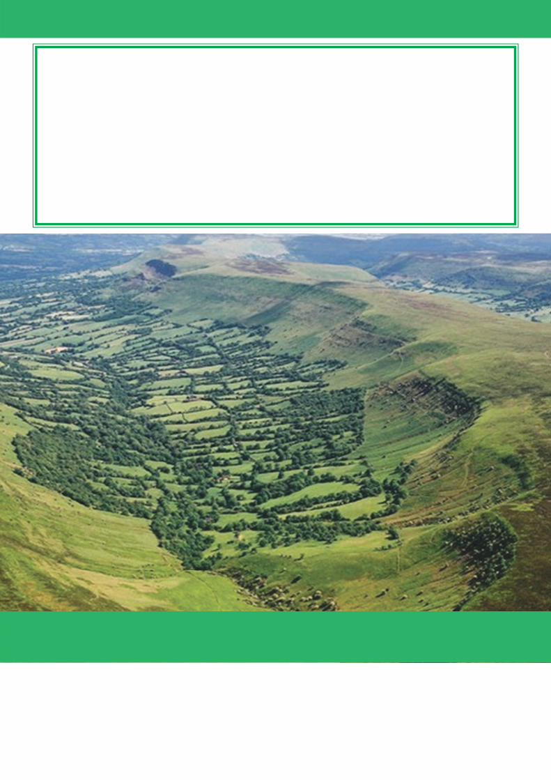
If you want help to understand this document, or would like it in another format or language, please call the Strategic Planning team on 01432 383357 or send an email to [email protected]


