ADDENDUM 10-Year Update, 2017 ~ Town of Herman Comprehensive Plan 2007-2027 Herman Town Board Jeffrey Sixel, Chairperson Supervisors Carl Maeuser James Raquet Town Officials Kathleen Koeser, Clerk George Marthenze, Treasurer Plan Commission James Schmitt, Chairman Jay Flegal Harold Herwig Frederick Marten James Meves James Raquet Bryan Koeser Town of Herman 2007-2027 Vision Statement “We envision the Town of Herman as a predominantly rural, agricultural area and place a high value on the preservation of farmland. To maintain harmony, carefully sited new single-family residences and small home businesses each year will be acceptable. Intergovernmental cooperation will continue to be important in helping to provide quality services for Town residents at a reasonable cost.” DRAFT
Transcript
ADDENDUM 10-Year Update, 2017
~ Town of Herman
Comprehensive Plan 2007-2027
Herman Town Board Jeffrey Sixel, Chairperson
Supervisors Carl Maeuser James Raquet
Town Officials Kathleen Koeser, Clerk
George Marthenze, Treasurer
Plan Commission James Schmitt, Chairman
Jay Flegal Harold Herwig Frederick Marten James Meves
James Raquet Bryan Koeser
Town of Herman 2007-2027 Vision Statement “We envision the Town of Herman as a predominantly rural, agricultural area
and place a high value on the preservation of farmland. To maintain harmony, carefully sited new single-family residences and small home businesses each year will be acceptable.
Intergovernmental cooperation will continue to be important in helping to provide quality services for Town residents at a reasonable cost.”
DRAFT
DRAFT
PLAN COMMISSION RESOLUTION (RESERVED)
DRAFT
DRAFT
COMPREHENSIVE PLAN UPDATE ORDINANCE (RESERVED)
DRAFT
DRAFT
TOWN OF HERMAN COMPREHENSIVE PLAN – 2017 ADDENDUM Page i
Public Participation . . . . . 2 Basic Information and Data Updates for 2017 Population Characteristics . . . . . 3 Housing Inventory . . . . . 6
Economic Information and Data . . . . . 8 Transportation . . . . . 10 Agriculture and Natural Resources . . . . . 12
Land Use Land Use Acreage Projections . . . . . 17 Amendment Policy . . . . . 19 Appendix A – Public Participation Plan for 2017 Plan Addendum Appendix B – Groundwater Quantity and Quality Data
LIST OF TABLES
Table 1a: Population Change, 1980-2010, Towns in Sheboygan County . . . . . 3 Table 1b: Density, 2010, Towns in Sheboygan County . . . . . 4 Table 3a: Number of Residents 60+ Years of Age . . . . . 5 Table 11a: Total Housing Units, 1980-2010, Towns in Sheboygan County . . . . . 6 Table 11b: Year Structure Built, Town of Herman and Similar Towns . . . . . 7 Table 13a: Housing Occupancy and Tenure, 2000 & 2010, Town of Herman . . . . . 7 Table 27: Recent History of Property Taxes Levied, Town of Herman . . . . . 8 Table 28: Recent History of Full Value and Public Indebtedness . . . . . 9 Table 29: Road Maintenance & Construction Expenditures, 2011-2015 . . . . . 10 Table 30: Short-Term Pedestrian/Bicycle Facilities Recommended for Herman . . . . . 11 Table 26a: Land Use Projections for Town of Herman . . . . . 17
LIST OF MAPS
Map 4a: Farmland Preservation Area (FPA), 2015 . . . . . 13 Map 1a: Future Land Use Plan, 2017 . . . . . 21
DRAFT
TOWN OF HERMAN COMPREHENSIVE PLAN – 2017 ADDENDUM Page ii
- THIS PAGE LEFT BLANK -
DRAFT
TOWN OF HERMAN COMPREHENSIVE PLAN – 2017 ADDENDUM Page 1
Purpose of 10-Year Update The Town of Herman Comprehensive Plan 2007 - 2027 was adopted as an ordinance on October 3, 2007 by the Herman Town Board. For the majority of the years since then, growth and development was slowed by the “Great Recession” of 2007 - 2009. Consequently, changes in population and land use have been minimal.
Nevertheless, during the period there has been a new U.S. Census (2010), an updated farmland preservation zoning ordinance was adopted by the Town, and a voluntary well water testing program was conducted for local well owners.
The purpose of this 10-year update, therefore, is to 1) incorporate new information related to the Census, farmland preservation, and well water testing into the Plan document, and 2) fulfill the statutory requirement stated below.
State Planning Law Wisconsin State Statute 66.1001(2)(i) states: Implementation element. A compilation of programs and specific actions to be completed in a stated sequence, including proposed changes to any applicable zoning ordinances, official maps, or subdivision ordinances, to implement the objectives, policies, plans and programs contained in pars. (a) to (h). The element shall describe how each of the elements of the comprehensive plan will be integrated and made consistent with the other elements of the comprehensive plan, and shall include a mechanism to measure the local governmental unit's progress toward achieving all aspects of the comprehensive plan. The element shall include a process for updating the comprehensive plan. A comprehensive plan under this subsection shall be updated no less than once every 10 years. [emphasis added] Why an Addendum Format? One of the standard methods of updating a plan involves updating the entire document, from the first page to the last. For the Town of Herman that would entail making changes to dates, wording, typos, and references within 68 pages of narrative text. Approximately 27 tables would have to be updated with more recent Census data or other data. Roughly 7 maps would need review and possible revisions. Most notably, 68 findings and recommendations; 43 goals, objectives, and policies; and 27 programs would have to be reviewed to determine whether they are still relevant.
Many of the items listed above were included in the Plan to satisfy statutory requirements rather than because they were related to critical issues. A substantial amount of time was spent compiling and reviewing this non-critical information. The Town believes its limited resources are now better spent on focusing solely on the
Introduction
DRAFT
TOWN OF HERMAN COMPREHENSIVE PLAN – 2017 ADDENDUM Page 2
updates mentioned on page 1. A separate addendum accomplishes this better than trying to revise a large comprehensive plan document.
Further, a separate addendum allows interested parties to access updated information in a concise and stand-alone format.
Comprehensive Plan Internal Consistency If any inconsistency between this Addendum and the Comprehensive Plan 2007 – 2027 is found, this Addendum shall take precedence. Public Participation The Town adopted a Public Participation Plan for this Addendum by resolution on April 5, 2017. See Appendix A for details.
No special public participation procedures or events were included in this 10-year update process because extensive public participation had recently occurred as part of the Town’s farmland preservation zoning recertification, an update with many similarities to this one.
DRAFT
TOWN OF HERMAN COMPREHENSIVE PLAN – 2017 ADDENDUM Page 3
There is a basic core of information that should be regularly updated regardless of priorities. These updates are included in this Basic Information & Data chapter.
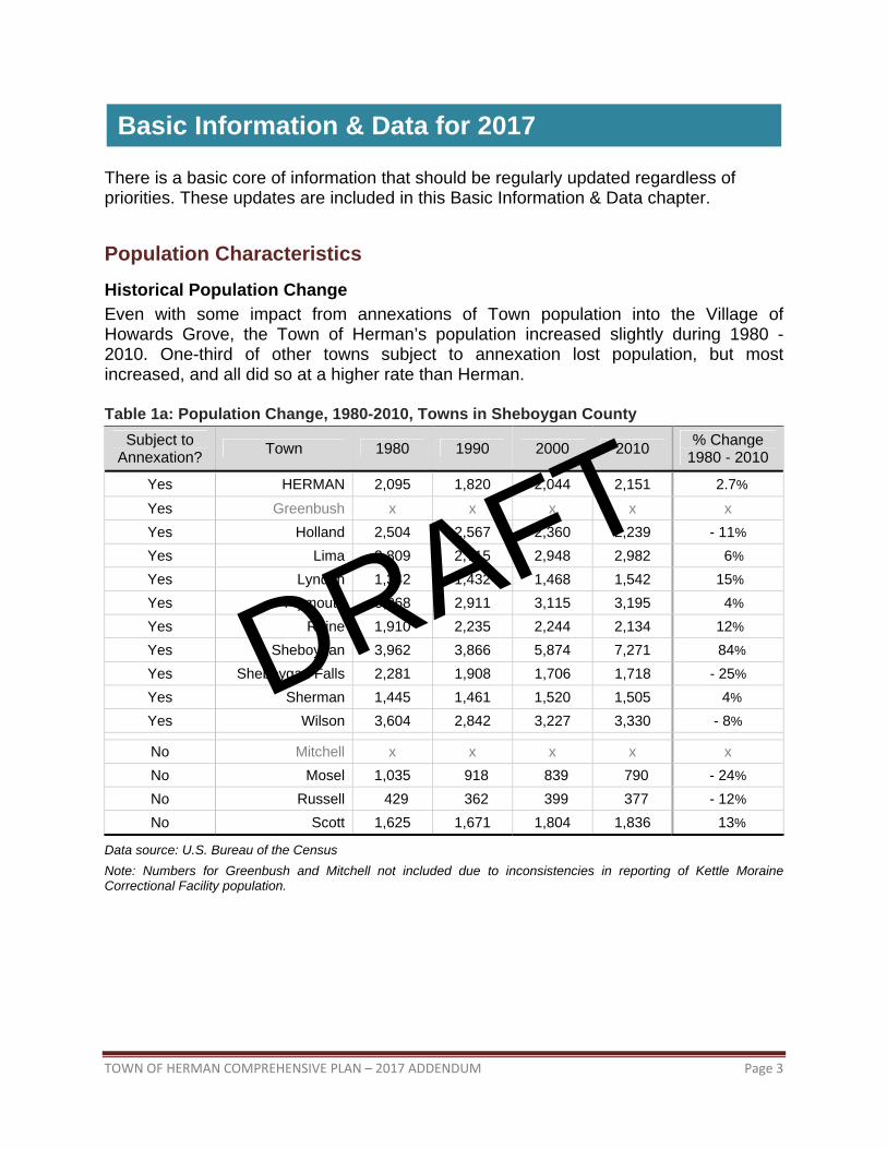
Population Characteristics Historical Population Change Even with some impact from annexations of Town population into the Village of Howards Grove, the Town of Herman’s population increased slightly during 1980 - 2010. One-third of other towns subject to annexation lost population, but most increased, and all did so at a higher rate than Herman.
Table 1a: Population Change, 1980-2010, Towns in Sheboygan County Subject to
Yes Greenbush x x x x x Yes Holland 2,504 2,567 2,360 2,239 - 11% Yes Lima 2,809 2,715 2,948 2,982 6% Yes Lyndon 1,342 1,432 1,468 1,542 15% Yes Plymouth 3,068 2,911 3,115 3,195 4% Yes Rhine 1,910 2,235 2,244 2,134 12% Yes Sheboygan 3,962 3,866 5,874 7,271 84% Yes Sheboygan Falls 2,281 1,908 1,706 1,718 - 25% Yes Sherman 1,445 1,461 1,520 1,505 4% Yes Wilson 3,604 2,842 3,227 3,330 - 8%
No Mitchell x x x x x No Mosel 1,035 918 839 790 - 24% No Russell 429 362 399 377 - 12% No Scott 1,625 1,671 1,804 1,836 13%
Data source: U.S. Bureau of the Census Note: Numbers for Greenbush and Mitchell not included due to inconsistencies in reporting of Kettle Moraine Correctional Facility population.
Basic Information & Data for 2017
DRAFT
TOWN OF HERMAN COMPREHENSIVE PLAN – 2017 ADDENDUM Page 4
Population and Housing Density An analysis of Table 1b shows that the Town of Herman is somewhere in the middle when it comes to comparing towns in the County, with a density about one-tenth that of an urban town like Sheboygan but about twice that of rural towns like Greenbush.
Although Herman’s population density ranks 7th among the County’s 15 towns, its housing density ranks only 10th. Whatever the reason, this likely gives the Town of Herman more of a rural look than might otherwise be expected.
Table 1b: Density, 2010, Towns in Sheboygan County
Category1 Town Average per Square Mile of Land
Population Density Housing Unit Density
Mixed HERMAN 64 19
Mixed Holland 55 28 Mixed Lima 84 32 Mixed Mitchell 65 14 Mixed Rhine 64 32 Mixed Scott 51 21 Mixed Sheboygan Falls 55 24
Data source: Wisconsin: 2010, Population and Housing Unit Counts; U.S. Department of Commerce 1Mixed = population density of 50-99 residents per square mile; Rural = density < 50; Urban = density > 100
DRAFT
TOWN OF HERMAN COMPREHENSIVE PLAN – 2017 ADDENDUM Page 5
Residents 60 Years of Age or Older The percentage of residents 60 years of age and older has increased far faster than the population as a whole (compare Table 3a to Table 1a).
In raw numbers there are more older residents in cities, but there has been a large percentage of increase in towns—even mixed and rural towns—which may not be as prepared to handle an aged population. Although the Town of Herman has not experienced as dramatic of an increase as other towns, this trend should still be considered when planning for the future needs of the Town. For example, residents in rural areas must drive several miles to grocery stores, health care facilities, and so forth, and this typically becomes more challenging as people age.
Table 3a: Number of Residents 60+ Years of Age, Town of Herman & Selected Areas
Geographic Area 1980 1990 2000 2010 Change 1980-2010
Town of Herman 244 230 265 292 48 (20%) Average of other mixed1 towns in the County 270 310 326 439 169 (63%)
Average of rural2 towns in the County 137 156 173 235 98 (72%)
Average of urban3 towns in the County 500 544 634 1,073 573 (115%)
Average of all villages in the County 178 197 240 302 124 (70%)
Average of all cities in the County 4,136 4,401 4,222 4,327 191 (5%)
Data source: U.S. Bureau of the Census, 2010, Table DP-1 1Mixed = density of 50-99 (Holland, Lima, Mitchell, Rhine, Scott, Sheboygan Falls) 2Rural = density < 50 (Greenbush, Lyndon, Mosel, Russell, Sherman) 3Urban = population density > 100 residents per square mile (Plymouth, Sheboygan, Wilson)
DRAFT
TOWN OF HERMAN COMPREHENSIVE PLAN – 2017 ADDENDUM Page 6
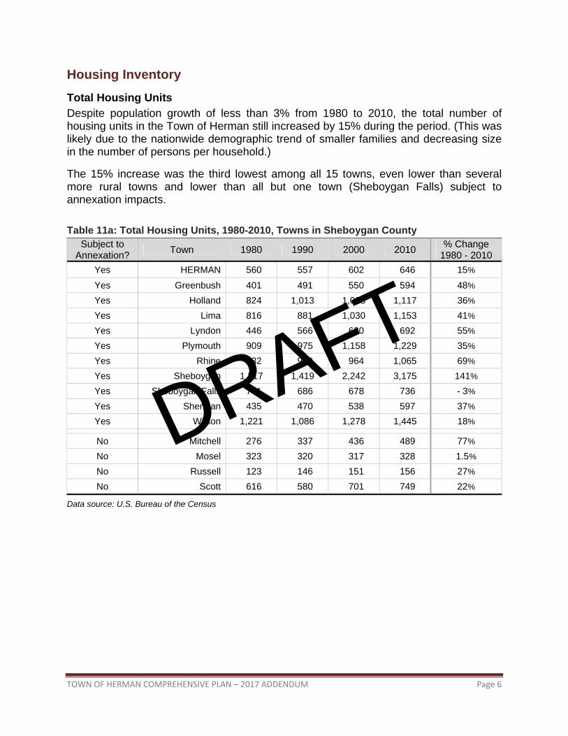
Housing Inventory Total Housing Units Despite population growth of less than 3% from 1980 to 2010, the total number of housing units in the Town of Herman still increased by 15% during the period. (This was likely due to the nationwide demographic trend of smaller families and decreasing size in the number of persons per household.)
The 15% increase was the third lowest among all 15 towns, even lower than several more rural towns and lower than all but one town (Sheboygan Falls) subject to annexation impacts. Table 11a: Total Housing Units, 1980-2010, Towns in Sheboygan County
Subject to Annexation? Town 1980 1990 2000 2010 % Change
No Mitchell 276 337 436 489 77% No Mosel 323 320 317 328 1.5% No Russell 123 146 151 156 27% No Scott 616 580 701 749 22%
Data source: U.S. Bureau of the Census
DRAFT
TOWN OF HERMAN COMPREHENSIVE PLAN – 2017 ADDENDUM Page 7
Age of Housing
About 45% of Herman’s housing units were built before 1940, which means they are at least 75 years old. This might indicate a high percentage of aged housing stock needing rehabilitation, refurbishment and/or additional maintenance. A high percentage of older homes in towns is not unusual, as Table 11b shows, but Herman’s is somewhat older than typical. Coupled with a higher than normal percentage of rental occupancy, as Table 13a indicates, this may signal a housing stock more prone to deterioration.
Table 11b: Year Structure Built, Town of Herman and Similar Towns
Year Structure Built Number of Units in Herman
% of Herman Housing Stock
% of Housing Stock in Average Mixed1 Town
April 2000 to March 2010 44 7% 9% 1990 to March 2000 76 12% 14% 1980 to 1989 37 6% 9% 1970 to 1979 89 14% 17% 1960 to 1969 49 8% 7% 1940 to 1959 60 9% 10% 1939 or earlier 291 45% 34%
Data source: U.S. Census Bureau, 2000 and 2010, DP-1 1Mixed = density of 50-99 (Holland, Lima, Mitchell, Rhine, Scott, Sheboygan Falls)
Housing Occupancy and Tenure
The percentage of owner-occupied housing in Herman is slightly lower than in similar towns in Sheboygan County. Over time this could lead to less attention given to maintenance and landscaping in a larger segment of the housing stock than normal. However, the higher rental occupancy may indicate Herman is more affordable than other towns to move into, at least initially.
Table 13a: Housing Occupancy and Tenure, 2000 & 2010, Herman and Similar Towns Town of Herman,
2000 Town of Herman,
2010 Mixed1 Towns, Average, 2000
Mixed1 Towns, Average, 2010
Units Number Number Number Percent Number Percent Number Percent Occupied 574 97% 611 95% 733 91% 781 88%
Data source: U.S. Census Bureau, DP-1 1Mixed = density of 50-99 (Holland, Lima, Mitchell, Rhine, Scott, Sheboygan Falls)
DRAFT
TOWN OF HERMAN COMPREHENSIVE PLAN – 2017 ADDENDUM Page 8
Economic Information and Data Economic Development Programs and Resources This section briefly updates some of the programs and resources available to the Town of Herman that are designed to help grow the local economy through the addition of businesses through development, recruitment, and expansion efforts.
Wisconsin Small Business Development Center at UW-Oshkosh The Wisconsin Small Business Development Center is a statewide network supporting entrepreneurs and business owners through no-cost, confidential consulting and targeted educational programs. Regional SBDC experts facilitate improvement and growth for small and emerging mid-size companies and help launch successful new enterprises. (www.wisconsinsbdc.org)
County Economic Development Officials/Contacts Sheboygan County has a County Economic Development Corporation (www.sheboygancountyedc.com) and a Chamber of Commerce (www.sheboygan.org) that oversee the community economic development needs of area towns and villages. The Planning and Economic Development Department within the City of Sheboygan handles the community economic development needs of the city.
Community Finances A community must be aware of its ability to generate sufficient public revenues to provide the types and levels of services expected by its citizens. Table 27 provides a recent history of the taxes levied in the Town of Herman. Overall, the Town’s tax base has remained fairly stable, despite local property tax fluctuations.
Table 27: Recent History of Property Taxes Levied, Town of Herman
Year Levied Town Share of Total Property Tax1
Total General Revenues2
Percent Change of Total General Revenues
from Prior Year 2012 $214,000 $398,600 - 3.7%
2013 $404,774 $409,600 2.8%
2014 $405,691 $400,600 - 2.2%
2015 $217,163 not yet available not yet available
Data source: Wisconsin Department of Revenue
1Town, Village, and City Taxes, for years cited.
2County and Municipal Revenues and Expenditures, for years cited. Includes taxes, intergovernmental revenues, and miscellaneous revenues.
DRAFT
TOWN OF HERMAN COMPREHENSIVE PLAN – 2017 ADDENDUM Page 9
Table 28: Recent History of Full Value and Public Indebtedness, Town of Herman
Year Full Value1 Debt Limit (5% of Full Value)
Total General Obligation Debt2 Debt Margin
2011 $116,124,700 $5,806,235 $0 $5,806,235 2012 $120,398,300 $6,019,915 $0 $6,019,915 2013 $122,536,900 $6,126,845 $0 $6,126,845 2014 $121,417,600 $6,070,880 $0 $6,070,880 2015 $122,870,600 $6,143,530 not yet available not yet available
Data source: Wisconsin Department of Revenue
1Town, Village, and City Taxes, for years cited.
2County and Municipal Revenues and Expenditures, for years cited. As shown in Table 28, the full equalized value of property within the Town increased for the period 2011 to 2015 (by 6%). For comparison’s sake, the full value of all towns in Wisconsin actually decreased 0.3% during this same period, as did the full value of all towns in Sheboygan County, coincidentally by the same percentage. For whatever reason, property values managed to hold their own in Herman.
The ability to finance community projects is measured in general obligation debt capacity. According to the Wisconsin Constitution, there are limits on how much a municipality may borrow. Municipalities are limited to an amount equal to 5% of the equalized value, or full value, of the unit of government. As indicated by Table 28, the Town of Herman’s total general obligation debt as of December 31, 2014 was $0, which was 0.0% of its full value, and 0% of the $6,070,880 it could legally borrow. Since WisDOR statistics for 2014 show that together towns in the state only owe 0.2% of their full equalized value, Herman’s low percentage is typical. Such conservative borrowing is a sound and legitimate financial strategy. However, it should also be noted that towns do have the capacity to more assertively invest in themselves by taking advantage of their substantial debt margin to upgrade local infrastructure, provide additional services, or create improvement programs.
DRAFT
TOWN OF HERMAN COMPREHENSIVE PLAN – 2017 ADDENDUM Page 10
Transportation Condition of the Town Road System The Town of Herman has 66 miles of roads, 42.3 miles of which are town roads. Based on data in the Pavement Surface Evaluation and Rating (PASER) system as of 2015, of the 42.3 miles of town roads, only 0.64 miles (1.5 percent) were rated as “Poor” or worse. Some towns in Sheboygan County have far more concerns—the Town of Lima, for instance, where 14.9 miles (40 percent) of town roadways were rated Poor or worse.
Funding for Town Roads The cost of constructing, maintaining and operating roads under local jurisdiction is defrayed through the provision of General Transportation Aids, which are distributed to all Wisconsin towns through a highway aids formula administered by the Wisconsin Department of Transportation. Under the formula, local aid is distributed either as a share of eligible highway-related expenditures incurred by the town or on a per-mile basis, whichever is higher.
Eligible expenditures generally include all road construction and maintenance within the right-of-way, as well as a percentage of eligible law enforcement, street lighting maintenance and construction, and storm sewer construction. The share of cost rate is determined by the available funding and the average costs reported by the town. Each town’s share of costs is determined by multiplying the six-year average costs by the percentage rate.
Transportation Aids for towns, as well as all other local units of government and counties, are derived primarily from motor fuel taxes and vehicle registration fees. Beginning in 2017, the Town of Herman has begun sharing in an annual portion (+/- $22,000) of the newly adopted Sheboygan County sales tax revenue, which must be used for transportation projects.
Table 29: Road Maintenance & Construction Expenditures, 2011-2015, Town of Herman
Year
Roadway Maintenance and
Construction Expenditures
Percent Change from
Prior Year State Highway Aids
Percent Change from
Prior Year
2011 $308,000 61% $88,800 3%
2012 $177,800 - 42% $88,800 0%
2013 $287,400 62% $88,800 0%
2014 $234,200 - 19% $88,800 0%
2015 not yet available not yet available
Data source: Wisconsin Department of Revenue, County and Municipal Revenues and Expenditures, for years cited.
DRAFT
TOWN OF HERMAN COMPREHENSIVE PLAN – 2017 ADDENDUM Page 11
Sheboygan County Non-Motorized Transportation Pilot Program (NMTPP) Bicycle and Pedestrian Transportation Planning Sheboygan County was selected to be one of four counties or metropolitan areas in the United States to participate in a Non-Motorized Transportation Pilot Program (NMTPP) as the result of the federal SAFETEA-LU act in 2005. As one of the four pilot communities, Sheboygan County was eligible for NMTPP funding to build bicycle and pedestrian facilities during federal fiscal years 2006 through 2009.
Recommendations Town officials provided input on the Town’s network priorities. Sheboygan County adopted the Sheboygan County Pedestrian & Bicycle Comprehensive Plan 2035 in 2007. The Plan recommended the following short-term improvements for the Town of Herman:
Table 30: Short-Term Pedestrian/Bicycle Facilities Recommended for Town of Herman
Facility Location Status
Paved Shoulder CTH A from CTH M to Howards Grove Village Limits Completed
Paved Shoulder CTH M from CTH A to Lakeland University Completed
Paved Shoulder STH 32 from Howards Grove Village Limits to Playbird Road Completed
Paved Shoulder STH 42 from Rangeline Road to Howards Grove Village Limits Unbuilt
Source: Town of Herman and Sheboygan County Pedestrian & Bicycle Comprehensive Plan 2035. DRAFT
TOWN OF HERMAN COMPREHENSIVE PLAN – 2017 ADDENDUM Page 12
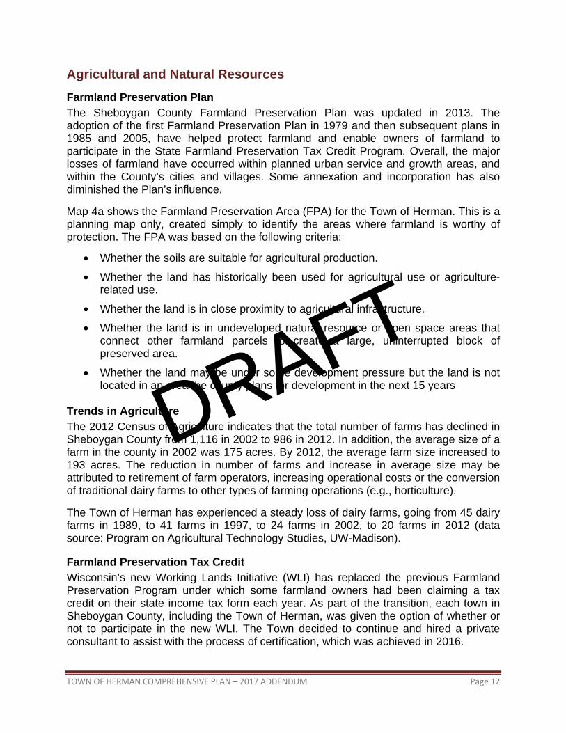
Agricultural and Natural Resources Farmland Preservation Plan The Sheboygan County Farmland Preservation Plan was updated in 2013. The adoption of the first Farmland Preservation Plan in 1979 and then subsequent plans in 1985 and 2005, have helped protect farmland and enable owners of farmland to participate in the State Farmland Preservation Tax Credit Program. Overall, the major losses of farmland have occurred within planned urban service and growth areas, and within the County’s cities and villages. Some annexation and incorporation has also diminished the Plan’s influence.
Map 4a shows the Farmland Preservation Area (FPA) for the Town of Herman. This is a planning map only, created simply to identify the areas where farmland is worthy of protection. The FPA was based on the following criteria:
• Whether the soils are suitable for agricultural production.
• Whether the land has historically been used for agricultural use or agriculture-related use.
• Whether the land is in close proximity to agricultural infrastructure.
• Whether the land is in undeveloped natural resource or open space areas that connect other farmland parcels to create a large, uninterrupted block of preserved area.
• Whether the land may be under some development pressure but the land is not located in an area the county plans for development in the next 15 years
Trends in Agriculture The 2012 Census of Agriculture indicates that the total number of farms has declined in Sheboygan County from 1,116 in 2002 to 986 in 2012. In addition, the average size of a farm in the county in 2002 was 175 acres. By 2012, the average farm size increased to 193 acres. The reduction in number of farms and increase in average size may be attributed to retirement of farm operators, increasing operational costs or the conversion of traditional dairy farms to other types of farming operations (e.g., horticulture).
The Town of Herman has experienced a steady loss of dairy farms, going from 45 dairy farms in 1989, to 41 farms in 1997, to 24 farms in 2002, to 20 farms in 2012 (data source: Program on Agricultural Technology Studies, UW-Madison).
Farmland Preservation Tax Credit Wisconsin’s new Working Lands Initiative (WLI) has replaced the previous Farmland Preservation Program under which some farmland owners had been claiming a tax credit on their state income tax form each year. As part of the transition, each town in Sheboygan County, including the Town of Herman, was given the option of whether or not to participate in the new WLI. The Town decided to continue and hired a private consultant to assist with the process of certification, which was achieved in 2016.
DRAFT
TOWN OF HERMAN COMPREHENSIVE PLAN – 2017 ADDENDUM Page 13
Map 4a: Farmland Preservation Area (FPA), 2015
DRAFT
TOWN OF HERMAN COMPREHENSIVE PLAN – 2017 ADDENDUM Page 14
Public Water Supply All Town of Herman residents own and maintain wells. Some homes have shared wells.
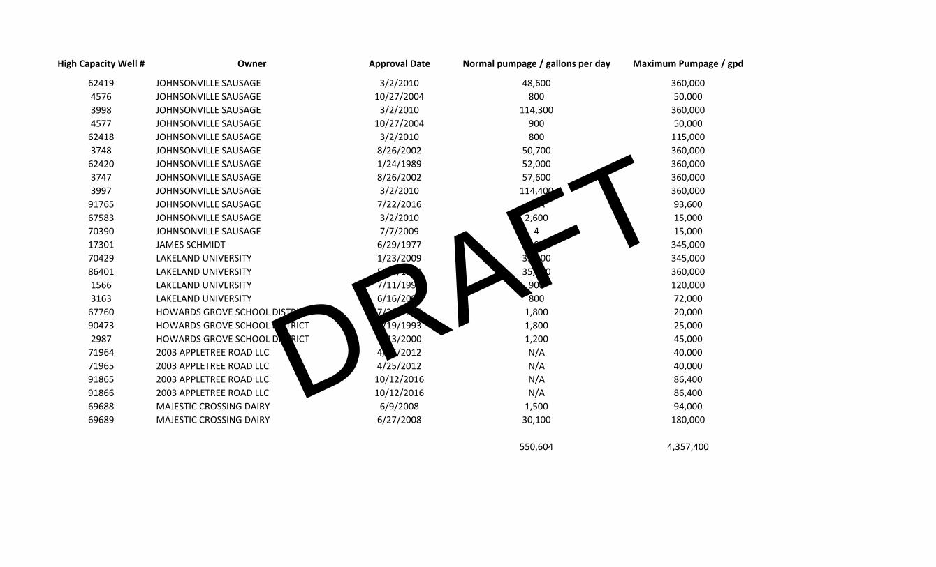
Groundwater Quantity A recent groundwater usage and recharge estimate for the Town of Herman that included the 26 high capacity wells inside Herman or within one mile of the Town, showed that recharge to the aquifer through precipitation each year exceeds the average rate of withdrawal for private and commercial uses by a factor of 12. Based on this estimate, it is unlikely that groundwater quantity will be a problem in the foreseeable future—unless there are substantial changes in precipitation and/or usage over several years. (See Appendix B for more details.)
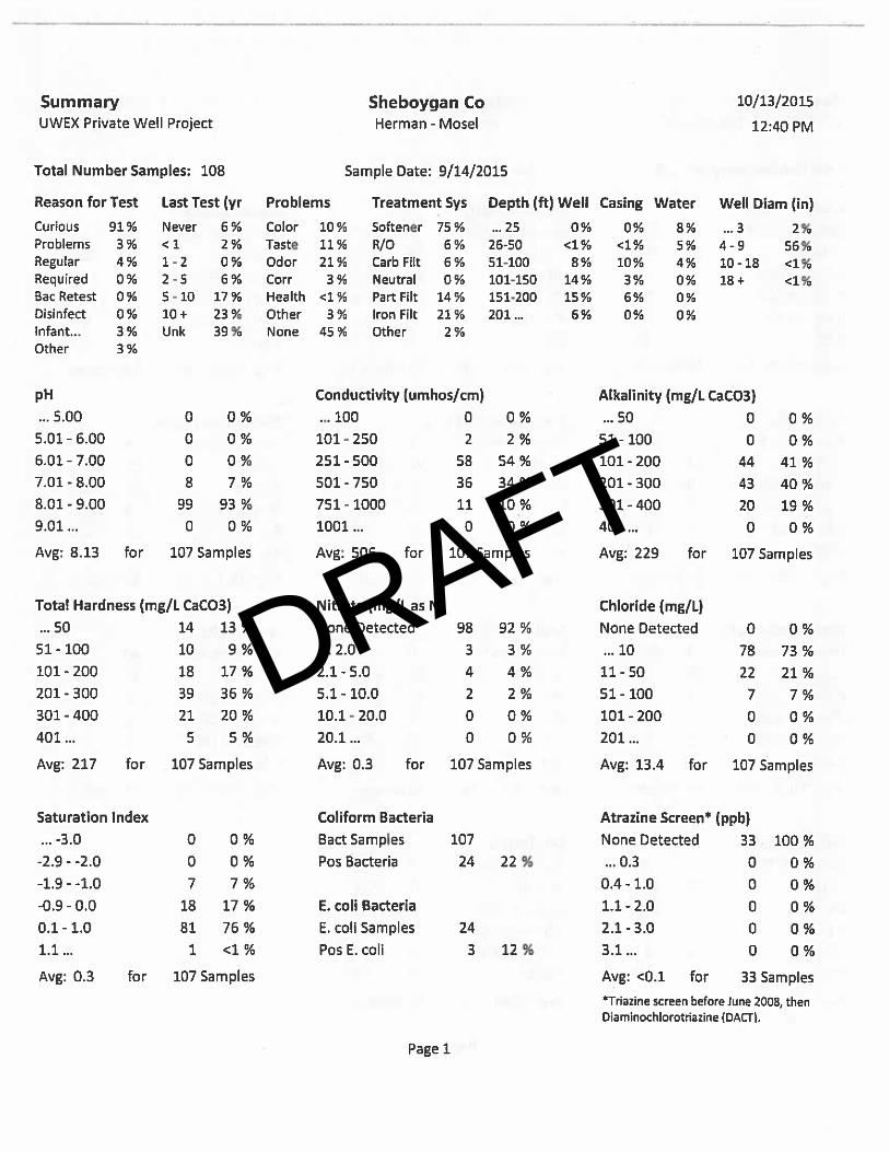
Groundwater Quality UW-Extension Sheboygan County, the state certified Water and Environmental Analysis Lab at UW-Stevens Point, and the Towns of Herman and Mosel partnered in 2015 to hold a voluntary well water testing program for interested landowners within the two towns. Appendix B summarizes the results for 108 samples. Key findings include:
Nitrate is a chemical commonly found in agricultural and lawn fertilizer. It is also formed when waste materials such as manure or septic effluent decompose. Elevated nitrate levels can be an indicator of other potential contaminants. There was no nitrate detected in any of the 127 samples.
Coliform bacteria are microorganisms that are found in surface water and soil. While coliform bacteria do not usually cause disease, their presence in a water sample indicates a potential pathway for fecal wastes and other disease causing organisms to enter a well. 24 of the 108 samples (22%) tested positive for coliform bacteria. The statewide average of positive samples is about 15 percent.
Atrazine is a common herbicide used in agriculture. There was no atrazine detected in the 33 samples screened for this chemical.
Arsenic is a naturally occurring element that can be found at levels of concern when groundwater dissolves arsenic contained in mineral deposits within the soil and bedrock of some aquifers. Out of 53 samples, 5 contained arsenic at levels slightly above the health standard. An additional 27 samples contained at least some arsenic, although at a level below the health standard.
Lead is not naturally occurring in Wisconsin groundwater, but it can be found in water systems with brass fixtures, lead pipes or lead solder. Only one of the 53 samples had lead present above the health standard.
Although these findings would seem to indicate an overall adequate level of water quality, the program only tested about 70 wells in Herman. Further, no tests were conducted for strontium, barium, cadmium, mercury, or other compounds that negatively impact water quality and public health.
DRAFT
TOWN OF HERMAN COMPREHENSIVE PLAN – 2017 ADDENDUM Page 15
County Shoreland Ordinance The Sheboygan County Shoreland Ordinance (Chapter 72) has been amended since the adoption of the Town of Herman Comprehensive Plan 2007 - 2027. Sheboygan County adopted new Shoreland Ordinance language in September 2016. Areas regulated by this Ordinance include all shorelands and wetlands of all navigable waters, as “navigable waters” is defined in Wis. Stat. § 281.31(2)(d) in the unincorporated areas of Sheboygan County which are:
(a) Within one thousand (1,000) feet of the Ordinary High Water Mark (OHWM) of navigable lakes, ponds, or flowages.
(b) Within three hundred (300) feet of the OHWM of navigable waterways, or to the landward side of a floodplain, whichever is greater.
The Ordinance specifies allowable permitted and conditional uses in the shoreland district; minimum lot sizes, widths, and setbacks; building height maximums; impervious surface maximums; restrictions on vegetation removal; and standards for filling, dredging, lagooning, grading, ditching, and excavating. In some cases, mitigation options may be available.
DRAFT
TOWN OF HERMAN COMPREHENSIVE PLAN – 2017 ADDENDUM Page 16
- THIS PAGE LEFT BLANK -
DRAFT
TOWN OF HERMAN COMPREHENSIVE PLAN – 2017 ADDENDUM Page 17
Land Use Acreage Projections Table 26a contains the existing and projected 2027 acreage totals, which have been designated on the Town of Herman Future Land Use Plan (Map 1a). The Town is not obligated to meet these projection totals, nor are landowners required to change their existing land use to make it match the projected use on the map.
In 2000 in the Town of Herman there were approximately 227 people per acre of commercial land, 47 people per acre of industrial land, and 4 people per acre of residential land. Continuing these proportions, the commercial/business acres projected for 2027 would support a Town population in 2027 of 11,120; the industrial acres projected for 2027 would support a population of 5,170; and the residential/rural acres projected for 2027 would support a population of 3,200. Since it is unlikely the Town will reach even the least of these population numbers by 2027, the projected acres are considered to be adequate.
Table 26a: Land Use Projections for Town of Herman
Land Use Category Existing Acres in 20021
Existing Acres in 20162
Potential Acres in 20273
Residential 489 663 663
Commercial / Business 9 13 49
Mixed Use4 n/a n/a 65
Industrial / Manufacturing 43 44 110
Utilities / Communication 2 2 9
Institutional / Governmental 105 105 182
Recreational 7 7 49
Conservation4 n/a n/a 242
Agricultural / Open Space5 16,470 16,291 13,437
Rural4 n/a n/a 2,319 1Based on Bay-Lake RPC 2002 land use inventory. 2Land use inventory updated by UW-Extension Sheboygan County using tax assessment data and 2016 orthophotography. 3Based on 2015 Farmland Preservation Zoning Map and input from Town of Herman Plan Commission in March 2017. 4Mixed Use, Conservation, and Rural are new categories created at the end of 2015 as part of the Farmland Preservation Zoning process. Uses in these new categories were classified as residential, commercial, industrial, or agricultural prior to 2016. 5Does not include WDNR wetlands.
Land Use
DRAFT
TOWN OF HERMAN COMPREHENSIVE PLAN – 2017 ADDENDUM Page 18
Residential Although there are no additional net acres allocated for small-lot residential use in the next 10 years, a substantial amount of the 174 acres allocated for residential between 2002 and 2016 has not yet been built on or is on lots large enough to be divided for additional houses. Most new single-family housing will be built in Ada or near already built-up areas like along Bittersweet Road. A few new two-family residences may be scattered throughout the Town, but most are anticipated in the Sunland Heights Subdivision east of Howards Grove.
Commercial / Business An additional 36 acres is allocated for commercial / business use. This is probably excessive, but it is better to have too much than too little. Most of these uses will likely occur along the STH 42 corridor or at roadway intersections at various places in the Town.
Mixed Use The Mixed Use category is also available for residential development, as well as for business development but only as conditional uses on small lots. A total of 65 acres has been allocated for mixed use, exclusively in the hamlets of Ada and Franklin.
Industrial / Manufacturing An additional 66 acres is allocated for industrial / manufacturing use. Most of this acreage is concentrated in the northeast quarter of Section 15, along STH 32.
Utilities / Communications An additional 7 acres is allocated for utilities / communications use. Most of this acreage is for possible expansions of existing utility / communication uses.
Institutional / Governmental An additional 77 acres is allocated for institutional / governmental. Most of this acreage is for the possible expansion of Lakeland University.
Recreational An additional 42 acres is allocated for recreational use. All of this acreage is either in the northeast quarter of Section 3 or the southwest corner of Section 17.
Conservation About 242 acres has been allocated for a category that focuses on forestry and open space but can also include a wide variety of agricultural uses, as well as offering the option of single-family residences. The minimum lot size is 3 acres. Parcels in this category are not subject to division.
Agricultural / Natural Areas Since other categories of new uses are typically established on undeveloped lands, the agricultural /open space category invariably decreases in towns, and Herman is no
DRAFT
TOWN OF HERMAN COMPREHENSIVE PLAN – 2017 ADDENDUM Page 19
exception, with a potential decrease of about 3,000 acres. That said, most of this loss is to the Rural category, which generally consists of large lots that still lend themselves to agricultural related uses such as hobby farms and cropland rentals.
Decreases in this category during the next 10 years, however, are expected to be limited. The land in this category corresponds to the Town’s Farmland Preservation Zoning District and cannot be rezoned or used for uses inconsistent with agriculture unless certain statutory criteria are met.
Rural About 2,300 acres has been allocated for a category that includes a wide variety of agricultural uses, as well as single-family residences. The minimum lot size is 5 acres. Some of the lands in this category, such as those in Section 6, have already been subdivided and developed, but a large amount of acreage surrounds the Village of Howards Grove on the east and south sides. The Village is aware of this and has the option of rejecting any proposed large lot or unsuitable subdivisions through its extraterritorial platting jurisdiction.
Amendment Policy Land Use Intensity Scale The Town of Herman reserves the right to review and approve, without going through the statutory plan/map amendment process, any development proposal for a use that is less intensive than that which is specified on the Future Land Use Map—but only if the development proposal is found to be appropriate under the goals and policies set forth in the Town of Herman Comprehensive Plan 2007 - 2027 and related Town ordinances. For example, if the Future Land Use Map indicates a potential commercial designation for a particular parcel, then a less intensive use, such as residential, may ultimately be approved for the parcel without amending the Plan/Map. The intensity range of land uses shall be as follows, with 1 being the most intensive and 10 the least intensive:
Intensity Rank Type of Land Use
1 Industrial 2 Commercial 3 Transportation, Communications, or Utility* 4 Institutional or Governmental 5 Mixed Use 6 Rural 7 Agricultural or Conservation 8 Recreational 9 Residential
10 Wetlands or Natural Areas * Transportation, Communication, or Utility uses that are integrated with and commonly associated and constructed with new development are not considered more intensive than the development, and therefore do not require a Plan amendment to be approved.
DRAFT
TOWN OF HERMAN COMPREHENSIVE PLAN – 2017 ADDENDUM Page 20
Comprehensive Plan 10-Year Update (2017) Town of Herman, Sheboygan County
Wisconsin’s Comprehensive Planning law requires public participation during the preparation of community comprehensive plans and subsequent amendments. Wisconsin Statutes, Section 66.1001(4)(a)
“The governing body of a local governmental unit shall adopt written procedures that are designed to foster public participation, including open discussion, communication programs, information services, and public meetings for which advance notice has been provided, in every stage of the preparation of a comprehensive plan. The written procedures shall provide for a wide distribution of proposed, alternative, or amended elements of a comprehensive plan and shall provide an opportunity for written comments on the plan to be submitted by members of the public to the governing body and for the governing body to respond to such written comments.”
The Town of Herman’s Plan and Zoning Commission and Town Board intend to work with UW-Extension Sheboygan County in developing the required 10-year update to the Town’s Comprehensive Plan (2007). Per 66.1001(4)(b), the Plan and Zoning Commission has the responsibility for recommending the draft 10-year update to the Town Board for approval. The Town Board has the authority to adopt an update to the Comprehensive Plan. The following outlines the public participation opportunities the Town of Herman will strive to provide during the update process. Revision Procedures
Plan and Zoning Commission Meetings: The Plan and Zoning Commission, joined by interested members of the Town Board, will meet at least twice during the project to create, review, and discuss revisions and updates.
Public Notice: Meeting times and agendas will be noticed in accordance with Town
procedures and State law. All Commission meetings will be open to the public, and attendees will be encouraged to share their ideas, opinions, and concerns.
DRAFT
Adoption Procedures
Draft Plan Distribution: An electronic copy of the draft 10-year update shall be sent to the entities required by 66.1001(4)(e)(f), providing 30 days for written comments. In addition, a copy of the draft 10-year update shall be available from the Town Clerk.
Plan and Zoning Commission: The Plan and Zoning Commission shall recommend the
draft 10-year update to the Town Board by adopting a resolution by a majority vote of the entire commission (66.1001(4)(b), Wis. Stats.)
Town Board: The Town Board, by majority vote, shall enact the ordinance adopting the recommended 10-year update (66.1001(4)(c), Wis. Stats.)
• Before Town Board adoption, a public hearing shall be held to offer citizens an
opportunity to formally comment on the draft 10-year update. This hearing must be preceded by a Class 1 meeting notice under ch. 985.
• At least 30 days prior to the public hearing, the Town of Herman shall provide written
notice to all of the following:
o An operator who has obtained, or made application for, a permit that is described under s. 295.12(3)(d).
o A person who has registered a marketable nonmetallic mineral deposit under s. 295.20.
o Any other property owner or leaseholder who has an interest in property pursuant to which the person may extract nonmetallic mineral resources, if the property owner or leaseholder requests in writing that the Town of Wilson provide the property owner or leaseholder notice of hearing.
o Any person who has submitted a request to receive notice of any proposed ordinance that affects the allowable use of property owned by the person.
• Any comments by the above-mentioned governing bodies, or public, shall be read into
the minutes during the public hearing, evaluated, and incorporated as necessary by the Town Board into the adopted 10-year update. A summary of comments and subsequent action will be provided upon request.
Other public participation activities may be added as deemed necessary by the Plan and Zoning Commission with approval of the Town Board. Contact information: Kevin Struck UW-Extension Sheboygan County 5 University Drive Sheboygan, WI 53081
Jim Raquet W3767 County Line Road Cleveland, WI 53015 920-565-3128 [email protected]
DRAFT
APPENDIX B
Groundwater Quantity and Quality Data
DRAFT
DRAFT
Groundwater Usage Per Year – Current Average
User Gallons per year Notes
Town of Herman, Howards Grove, etc. private well users, pop. 5,581 1,253 households x 2.5 avg. household size = 3,133 persons on public sewer system; 979 households x 2.5 avg. household size = 2,448 persons on private septic systems
109,780,320 +
8,577,792
Based on SEWRPC estimate of 96 gallons per day per person, which includes commercial and industrial. Adjustment made for water that returns to aquifer via onsite sewage disposal systems, estimated to be approximately 90%.
High capacity wells (26) in or within one mile of Town of Herman, Howards Grove
200,970,460 Based on normal pumping capacity during last 5 years as reported in WDNR High Capacity Well database
TOTAL 319,328,572
Groundwater Usage Per Year – Current Maximum Potential
User Gallons per year Notes
Town of Herman, Howards Grove, etc. private well users, pop. 5,581 2,232 households x 2.5 avg. household size = 5,580 persons
195,558,240
Based on Southeastern Wisconsin Regional Planning Commission (SEWRPC) estimate of 96 gallons per day per person, which includes commercial and industrial.
High capacity wells (26) in or within one mile of Town of Herman, Howards Grove
1,590,451,000 Based on maximum pumping capacity as reported in WDNR High Capacity Well database.
TOTAL 1,786,009,240
DRAFT
Aquifer Recharge Per Year The formula to compute recharge is as follows:
(Acres) x (Annual precipitation¹) x (Volume²) x (Percolation percentage3) ¹ Annual precipitation from Wisconsin State Climatology Office. Based on historical data from the weather station at Plymouth.
² This is a constant equal to the number of gallons produced by 1 inch of precipitation on 1 acre of land. 3 Based on estimates by SEWRPC, only about 10% of precipitation actually reaches the aquifer. The vast majority of the precipitation is lost to evapotranspiration and surface runoff.
For the Town of Herman study area, which includes lands within one mile of the Town’s borders, the calculation would be:
41,166 x 36 x 27,000 x 0.1 = 4,001,335,200 gallons per year
The Average Usage estimate of 319,328,572 gallons per year is 8% of the total recharge volume (4,001,335,200 gallons) that is replenishing the aquifer.
The Maximum Usage estimate of 1,786,009,240 gallons per year is 45% of the total recharge volume (4,001,335,200 gallons) that is replenishing the aquifer.
Data compiled and computations by Kevin Struck, University of Wisconsin-Extension Sheboygan County, April 2017. Notes: A) Since aquifers do not precisely correspond to municipal borders, the aquifer(s) beneath the Town of Herman may have more or less capacity than what is calculated here.
B) Normal aquifer recharge per year is almost entirely dependent on receiving normal precipitation. Drought conditions would severely limit annual recharge; on the other hand, an extremely wet year would likely significantly increase recharge.
C) It is important to remember that all aquifers in Wisconsin always have groundwater stored in them, and that groundwater is always flowing. The amount of groundwater storage is a reflection of the balance between recharge and baseflow discharge to streams. No recharge for a sustained period does not usually mean the aquifer will immediately dry up. However, if not replenished through recharge, groundwater levels would be expected to go down as groundwater stored in the aquifer is discharged to rivers, lakes, streams, and wetlands as baseflow..
D) In low lying areas on the landscape there may be limited ability for an aquifer to store additional groundwater during years when precipitation exceeds normal levels. If the level of groundwater rises above that of the land surface, it will result in ponding of water in those areas where the water table intersects the land.
DRAFT
High Capacity Well # Owner Approval Date Normal pumpage / gallons per day Maximum Pumpage / gpd